Soil Report for the Algoma Vegetation and Road Management...
36
Soil Report For the Algoma Vegetation and Road Management Project Shasta-McCloud Management Unit Shasta-Trinity National Forest November 5, 2007 Updated February 22, 2012 and March 23, 2012 Prepared by Peter Van Susteren (retired 2010) Soil Scientist – Shasta-McCloud Management Unit Updated by Brad Rust Forest Soil Scientist, STNF Headquarters
Transcript of Soil Report for the Algoma Vegetation and Road Management...
Soil Report
For the
Algoma Vegetation and Road Management Project
Shasta-McCloud Management Unit
Shasta-Trinity National Forest
November 5, 2007 Updated February 22, 2012 and March 23, 2012
Prepared by Peter Van Susteren (retired 2010) Soil Scientist – Shasta-McCloud Management Unit
Updated by Brad Rust
Forest Soil Scientist, STNF Headquarters

2
1. INTRODUCTION Report Summary: This report evaluates the effects of proposed activities on Soils Resources within the Algoma Vegetation and Road Management project (Algoma Project) area. The environmental consequences of the proposed action and alternatives as they pertain to soil resources are described. The background soils condition are estimated. Best Management Practices (BMPs) are identified for the project. Mitigation measures are specified.
2. REGULATORY FRAMEWORK Management actions must occur in conformance with applicable law, regulation, policy, guidance, and management direction. This regulatory framework determines the overall objectives and standards and guidelines applied to project activities and resource management. Elements specifically relevant to the soil resource are described here.
Specific measures, indicators, and thresholds are established in assessing soil condition, and for evaluating the effects of the proposed project on the soil resource- what gets looked at, why, and interpretation of what it means to soil quality and site productivity.
2.1 LAW, REGULATION, AND POLICY
2.1.1 National Forest Management Act The National Forest Management Act of 1976 (NFMA) recognized the fundamental need to protect, and where appropriate improve, the quality of soil, water, and air resources. With respect to soils, NFMA requires that the Forest Service manage lands so as not to impair their long-term productivity. Further, activities must be monitored to ensure that productivity is protected. This law led to subsequent regulation and policy to execute the law at various levels of management.
2.1.2 National Soil Management Handbook The National Soil Management Handbook defines soil productivity and components of soil productivity, and establishes guidance for measuring soil productivity. In determining a significant change in productivity, a 15% reduction in inherent soil productivity potential will be used as a basis for setting threshold values. Threshold values would apply to measurable or observable soil properties or conditions that are sensitive to significant change. The threshold values, along with areal extent limits, would serve as an early warning signal of reduced soil productive capacity, where changes to management practices or rehabilitation measures may be warranted.
Management activities have potential to cause various types and degrees of disturbance. Soil disturbance is categorized into compaction, displacement, puddling, severe burning, and erosion. Direction was established that properties, measures, and thresholds relative to these disturbance types would be developed at the Regional and Forest levels, known as Soil Quality Standards.
“Long-term plots established with Forest Service Research Units will be needed to establish or validate the correlation between threshold values and significant change.”
Region 5 Soil Quality Standards are detailed in the Regional handbook supplement.

3
2.1.3 Region 5 Soil Management Handbook Supplement The 1995 Region 5 Soil Management Handbook Supplement established Regional objectives for the Soil Management Program and Regional Soil Quality Analysis Standards (SQAS). These analysis standards were intended to help determine if ecosystem health and long-term productivity are being maintained. The mission of soil resource management has aspects in common with fuels management, watershed management, and water quality. The 1995 Supplement has been recently updated and is in the process of re-issuance.
SQAS provide measures and threshold values that indicate when changes in soil properties and soil conditions may result in significant change or impairment of key soil functions of soil productivity and hydrologic function. Soil disturbance is considered “detrimental” if thresholds are exceeded and subsequent impairment of soil functions is judged likely after a soil & site specific assessment. Detrimental disturbance refers to the severity of impacts, which may be very small scale in occurrence.
The extent of detrimental soil disturbance shall not be of a size or pattern that would result in a significant change in key soil functions for the activity area. Note that the activity area is the scale at which impacts are ultimately assessed, defined as the area where soil disturbing activities take place, such as a timber harvest unit in a sale area or a burn area within a prescribed burn project; system roads, trails, and other areas not dedicated to growing vegetation (other dedicated uses) are not included as part of an activity area.
Both severity and extent of detrimental disturbance are important considerations that must be evaluated together to assess potential adverse impacts on soils of the activity area. As such, detrimental disturbance can be allowed on a small portion of a unit- this does not constitute adverse impacts; conversely, minor disturbance can be allowed in most of a unit- this likewise does not constitute adverse impacts. Aerial extent limits for different disturbance types are not established in the R5 handbook supplement.
Application of specific practices and prescriptions to meet SQAS may be adjusted if necessary to meet multi-resource objectives.
2.2 MANAGEMENT DIRECTION, STANDARDS AND GUIDELINES
2.2.1 Shasta-Trinity National Forest Land and Resource Management Plan The Shasta-Trinity National Forest Land and Resource Management Plan (LRMP) establishes Forest-wide management direction, and Standards and Guidelines in carrying out project activities. Management direction pertaining to soils includes the following:
• Develop specific soil evaluation and mitigation measures for each project that has the potential to impact the soil resource.
• Develop and apply erosion control plans to road construction, mining, recreation developments, and other site disturbing projects. Use the Soils and Geologic Resource Inventories for predicting the need and extent for erosion control measures.
4
• Identify and evaluate areas of known or suspected instability as a part of project planning. Protect areas with a high probability of mass wasting from ground disturbing activities.
• Protect long-term soil productivity in controlled burn prescriptions through the use of ‘Shasta-Trinity National Forest Guidelines for Prescribed Burning of Chemise/Chaparral,” and by meeting aquatic conservation strategy objectives.
• Logging Systems: generally confine tractor logging to sustained slopes of less than 35 percent. When possible, limit skid trails to 15 percent of the harvest area and tractor slash piling to the dry season.
The LRMP has monitoring requirements pertaining to soils:
• Monitoring Objective- To evaluate the effectiveness of Forest Plan standards and guidelines in the prevention of loss in soil productivity.
• Method- Field sample and measurement of soil loss and compaction on one project area per Ranger District per year.
This project area would not be a candidate for soil monitoring, due to the lack of size and complexity, the low-moderate compaction risk rating, and low-moderate erosion potential.
2.2.2 Regional Forester Letter The Regional Forester’s letter of February 2007 provided clarification to Forest Supervisors on the appropriate use of the 1995 R5 Soil Management Handbook Supplement. The letter has several key points in considering SQAS:
• The intended use of thresholds and indicators in the FSH supplement are for analysis or evaluation purposes- a consistent means to analyze, describe, and report on soil condition throughout the Region.
• Thresholds and indicators are not a set of mandatory standards or requirements; they represent desired conditions but not necessary conditions for the soil resource.
• Recent science, such as findings from the Long-Term Soil Productivity Study and other studies, should be considered in conjunction with the guidance provided by the FSH supplement when evaluating management effects on the soil resource.
• Prescriptions to meet SQAS may be adjusted if necessary to meet multi-resource objectives (re-quoted from FSH supplement).
2.3 CURRENT SCIENCE Direction exists at virtually all levels to consider past monitoring, new information, and current science in the evaluation of resource management practices and the decision making framework. This was most recently reaffirmed with the Regional Forester’s letter specific to soil management.

5
Though it is not guidance, some current science in particular has a direct bearing on how the significance of soil impacts is evaluated. As such, this has become part of the overall framework for evaluating soil impacts, and is appropriate to include within this section.
2.3.1 Long-Term Soil Productivity Study The Long-Term Soil Productivity (LTSP) Study was borne in direct response to NFMA and the National Soil Management Handbook to help validate and refine indicators and thresholds used in the SQAS. This effort was cooperatively undertaken by Forest Service Research and Forest Service Systems, and is an ongoing nation-wide experimental study.
An extensive world-wide literature review was first conducted looking for real evidence of productivity declines and causes, beyond anecdotal and confounded studies. Where productivity declines were well documented, the causal factors commonly reported were compaction and/or organic matter removal from the site.
An experimental design was developed by Robert Powers and others to investigate these factors, peer-reviewed world-wide, and site installations began in 1990 in the southern coastal plain ecoregion. In brief, the study design involves 3 levels of compaction (none, intermediate, and severe) and 3 levels of organic matter removal (bole only, whole tree, and whole tree + all forest floor), in factorial combinations for 9 treatments. Sites were clearcut, treatments applied, and then planted with native conifer species. In addition, plots were split in half, where competing vegetation was controlled in one half but not the other. Some sites had additional “mitigation plots” where they were impacted and then rehabilitated by means such as subsoiling, to test effectiveness of rehab methods.
It is important to note with LTSP that “severe compaction” was experimental- approx. 90-95 percent of the area was heavily compacted (everywhere but stumps). Both in terms of extent and severity this greatly exceeds impacts of typical harvest operations; severity may be typical of landings. Intermediate compaction would be more typical in severity to well-used skid trails, though again much more extensive than typical operations (90-95 percent area). In terms of organic matter removal, fuel reduction projects such as the proposed action would be typified by whole tree + some forest floor removal.
California has 12 such installations, more than any other Region, established from 1991 to 1998. CA installations were purposely placed on a variety of major forest soils, to investigate relationships on different soil types. Total aboveground productivity has been measured at 5-year intervals. Results to date as they pertain to soils typical of the project area will be discussed in the environmental effects section.
2.4 Applicable Forest Direction Management of soil resources on the Shasta-Trinity National Forest is guided by the Land and Resource Management Plan (Shasta-Trinity National Forest Land and Resource Management Plan, 1994). Plan direction for soil resources is provided in the context of Forest Goals, Standards and Guidelines, and more specific Management Area direction.
Applicable Forest Goals Soils

6
• Maintain or improve soil productivity and prevent excessive surface erosion, mass wasting and cumulative watershed impacts. (LMP 4-6).
Applicable Standards and Guidelines from the Land Management Plan Soils and Water
- Implement Best Management Practices (BMP) as described in Appendix E of the LRMP. Determine specific practices or techniques during project level planning using information obtained from on-site soil, water and geology investigations.
- Implement Forest Soil Quality Standards as described in Appendix O of the LRMP. Protect Soil Productivity in relation to ground cover, soil organic matter and soil porosity.
- Give full recognition to the tendency for erosion, mass movement, and severe watershed damage potential when implementing vegetation management and related management activities.1
This report summarizes an analysis of the soils in the Algoma Project area. The analysis reviewed a soil survey that was conducted in 1980 (SRI)2 and an ecologic unit inventory conducted in 1991 (EUI).3 Field verification of soil map units was conducted in September to October of 2007, and June to July of 2010. The review included field verification of all soil map units. All proposed activity units were visited to confirm that the soil types were mapped accurately. The capabilities and limitations of soils in the project area were reassessed and confirmed. The interpretations and predictions of the soil’s response to management were deemed accurate and applicable to this project. Copies of the soil resource inventory (SRI) map and legend are included in the project record.
3. AFFECTED ENVIRONMENT: The EUI was a refinement of the SRI that incorporated concepts of lithology, geomorphology and potential natural vegetation communities in ecological mapping units. Many of the mapping unit concepts used in the SRI were revised and updated in the EUI Survey. The EUI also provided conformance to the National Hierarchy of Ecological Units.4 This hierarchy fit the EUI mapping concepts into landscape-scale mapping units. The Ecological Subregions of California5 depicts the project area as part of the Southern Cascades Section and the McCloud Flats Subsection. This subsection is characterized by basaltic lava flows and outwash deposits from Mt. Shasta. A more specific characterization of the project area describes it as the lower slopes of the Black Fox Upland and the flood plain of the McCloud River.6 The Black Fox Upland is a range of
1 Shasta-Trinity National Forest Land and Resources Management Plan, Chapter 4, Management Direction (4-5) 2 Soil Resource Inventory, Shasta-Trinity National Forest, 1980 3 Ecological Unit Inventory, Shasta-Trinity National Forest, 1991, unpublished 4 USDA, Forest Service, NRCS and USDI BLM 5 Ecological Subregions of California, Section and Subsection Descriptions, U.S. Department of Agriculture, Forest Service, R5-EM-TP-005, September 1997 6 Peter VanSusteren, personal opinion
7
tertiary-age volcanos consisting of basaltic andesite bedrock on low-relief uplands with andesitic tuffs that are exposed on drainage slopes and ridgetops. The floodplain of the McCloud River can be described as floodplain terraces associated with the river and the creeks that flow into it from the south.
The landscape can be described as parts of two Land Type Associations (LTA).7 These are broad-scale ecological map units that are used to characterize a landscape. The two LTAs that comprise the Algoma Project Area are: “Gently sloping volcanic uplands, mixed conifer” and “Fans and terraces, mixed conifer.” The “Gently sloping volcanic uplands, mixed conifer” map unit is characterized by slopes of 5 to 25 %. Soils are Humic Haploxerands and Typic Haploxerands.
The “Fans and terraces, mixed conifer” map unit includes the flood plain of the McCloud River and the outwash terraces and fans from Raccoon Creek and Bull Creek. It also includes the terraces and fans around Bear Wallow on the northwest corner of the project area. This map unit includes a component of low-relief ridges that make up 10 to 15% of the map unit. Parent material on fans and terraces is alluvium and on low-relief ridges it is andesitic basalt. Soils on the fans and terraces are Andic Xerumbrepts. Soils on the low-relief ridges are Humic Haploxerands.
Both of the LTAs support a very productive mixed conifer forest.
Numerous faults cross the project area but it is considered to be geologically stable because of its low relief. Mass wasting is not an issue.
3.1 Effects of Past Management on the Soils Resource Timber Management began in the project area prior to 1902.8 Two sawmills were constructed within the project area. The first operated between 1902 and 1909 and the second between 1930 and 1935.9 The project area was logged and logs were transported by draft animal and steam-powered traction engine until 1905, when the McCloud River Railroad was constructed through the project area. Main trunk railroad spurs were constructed through the project area between 1905 and 1917 along with sidings, landings, turn-arounds, and other features. These corridors were intensely impacted by soil compaction, ditching, debris burial, mounding, etc. Railroad spurs were also built off of the main trunks to harvest the timber from the south flank of the Black Fox Upland and the McCloud River Floodplain. Railroad logging in this area created severe disturbance impacts on a limited area and minor disturbance on an extensive area. Because almost every tree in the area was harvested by the 1940s, there was little impetus for re-entry to
7 Land Type Association Map, Peter VanSusteren, 1997, unpublished 8 Morgan, Esther and Peter K. Schmidt 2009. Archaeological Reconnaissance Report for the Algoma Vegetation and Road Management Project, Siskiyou County, California. Inventory Report No. R2006051400008. MS on file, McCloud Ranger District, Shasta-Trinity National Forest. 9 Morgan, Esther 2011. Archaeological Survey in the Vicinity of Swobe and Algomah Sawmills, “Old Bartle” and Camp Kinyon. Inventory Report No. R2011051400025. Draft MS on file, McCloud Ranger District, Shasta-Trinity National Forest.

8
these stands for many years.10 Most of the area has not been re-entered since the railroad logging days.
The portion of the project area that is north of Highway 89 (Gently sloping volcanic uplands LTA) exhibits relics of the railroad logging with several spurs that evolved into roads. Only faint outlines of constructed secondary spurs are evident now. These spurs are less than 20 feet wide and exhibit only slight compaction. Outside of the spurs, no residual soil compaction has been observed.11 The portion of the project area that lies south of Highway 89 (Fans and terraces LTA) exhibits much more evidence of railroad logging era disturbance. Aerial photographs from 1944 show extensive areas of severe disturbance in the areas of the mills. Highly impacted areas probably experienced impaired soil productivity.
The effects of historic-era logging diminish with the distance from the mill sites. Old roads and railroad grades associated with logging exhibit a greater soil density than the surrounding area. Field testing indicates that they have lost up to 10 percent of their inherent porosity. Transects indicate that such conditions affect up to 20 percent of the area of some proposed harvest units that are close to one of the mill sites. Proposed units that exceed soil quality thresholds are identified for remediation. However, discussions with the Silviculturist indicate that no loss of site productivity has been observed in terms of decreased height or diameter growth, even on sites that were highly impacted.12 Surveys of site productivity indicate that the site productivity of the proposed activity units has recovered from the historic era logging.13
In the 1970s Forest Service direction for timber management identified a primary objective to reforest under-stocked stands.14 Plantation records15 of the area around the Algoma sawmill show extensive plantations (windrowed) that were planted at that time. The records do not distinguish between stands that were clear-cut and planted because they were “culminated” stands and stands that were understocked. But, the areas that were severely impacted by old logging were clear-cut and planted to ponderosa pine plantations. The records indicate that most of these areas were planted by tractor-drawn machines. These mechanical planters include a ripper tooth to prepare a planting site. The conifers are planted in a furrow where any residual compaction is broken up. If the surrounding area is compacted, the competing vegetation has a less productive growth medium. This technique was very successful as is indicated by plantation record survival exams. These plantations exhibit highly productive growth today. The history of Forest Service management of lands that were impacted in the 1920s era logging is one of restoration of site productivity.
10 Between 1950 and 1964, McCloud River Lumber Company re-entered timbered lands within the project area, mostly on the south side of the McCloud River. By then, logging activities were done by motorized vehicles. Logs were still transported by rail (Morgan and Schmidt 2009). 11 Algoma Project Soil Survey 12 Fleming, Deborah, personal communication 13 ibid 14 Peter VanSusteren, personal recollection 15 McCloud Ranger District plantation records

9
4. Proposed Action and Alternatives The Algoma Vegetation Management Project plans to treat a total of 5,600 acres which includes timber harvesting (thinning treatments) on 4,530 acres (which includes 1,300 acres of fuels treatments) and plantation stand treatments on 1,070 acres. Landings needed for these activities will be 215 with 108 of these being new construction (average size of landings will be .50 to .75 acre) for a total of 54-81 acres.
The Environmental Impact Statement (EIS) for the Algoma Project evaluates five alternatives. Alternative 1 is the original proposed action. Alternative 2 is modified to exclude new road construction and would treat 230 fewer acres. Alternative 3 is modified to eliminate the sanitation component on 930 acres but will treat the same amount of acres as Alternative 1 with thinning. Alternative 4 is the No Action alternative. Alternative 5 would treat 934 fewer acres. Summary Tables for treatment units can be found in the EIS.
5. Environmental Consequences 5.1 Methodology and Priority of Unit Sampling and Evaluation of Current Conditions The analysis of effects on the soils of the project area from past management is focused on effects on site productivity. The factors affecting site productivity are soil compaction, soil erosion and levels of soil organic matter. The Shasta-Trinity National Forest (STNF) has adopted the new National Soil Disturbance Monitoring Protocol (Page-Dumroese, et. al. 2009) level one analysis (visual soil disturbance indicators) along with developing a level two analysis (validation sampling) using transects to measure erosion, disturbance, compaction, displacement, and cover (Rust 2007). All proposed activity units were visited and past effects on site productivity, as evidenced by roads, landings and areas of moderate-to-severe soil compaction, were evaluated (Appendix F). At the same time, proposed units were evaluated for evidence of soil erosion such as rills or gullies. A unit-by-unit evaluation of Erosion Hazard Rating (EHR) is included in this report as Appendix D. Proposed units were also evaluated in the field for levels of soil organic matter and soil organic cover (Appendix G). This was done by comparing site conditions with the Photo Series for Quantifying Natural Forest Residues in Common Vegetation Types of the Pacific Northwest 16 and the National Soil Disturbance Monitoring Protocol.17
Soil Compaction This assessment consisted of two parts, existing levels of soil compaction and predicted response to management. The first step in assessing existing levels of soil compaction was to determine the disturbance history of the proposed units. The disturbance history of proposed units was tracked using timber harvest records. On sites that have not been disturbed over the last 30 years, there was consideration of the studies by Froelich et al 1985 and Geist et al 1989 that project a recovery curve for soil compaction with full
16 Pacific Northwest Forest and Range Experiment Station, General Technical Report PNW 105U.S> Department of Agriculture, Forest Service, Portland, OR. May 1980 17 Page-Dumroese, et. al. 2009

10
recovery in about 30 years. (The US Forest Service R5 Cumulative Watershed Effects Model projects recovery from soil compaction in 30 years).
The second step was to determine if any of the proposed units currently exceed the threshold for loss of porosity that can indicate a loss of site productivity. This was done by taking bulk density core samples on two of the most common soil types in the project area; the other two most common soil types were too cobbly for the bulk density core sampler. Additionally, soil disturbance transects were taken on major non-rocky soils (Shasta and Holland Ashy) focusing on displacement, cover, compaction, and soil strength using the National Soil Disturbance Monitoring Protocol. Those samples where greater than 10% loss of pore space was indicated were considered severe; these sites were then probed with a hand-probe to calibrate the surveyor’s feel of severe compaction. Estimation of moderate-to-slight compaction was qualitative and quantitative based on two survey protocols. Notes on the compaction surveys are included in Appendix F to this report. All units were evaluated in the field with a soil compaction probe. The probe was ineffective on very gravelly or cobbly soils; on these sites, shallow soil pits were dug to look for platey structure, an indication of soil compaction.
The main focus of the soil compaction investigations was on sites that have been disturbed in the last 30 years and on sites that have had more than one entry in that time period. Results of the soils compaction surveys are listed in Appendix F to this report.
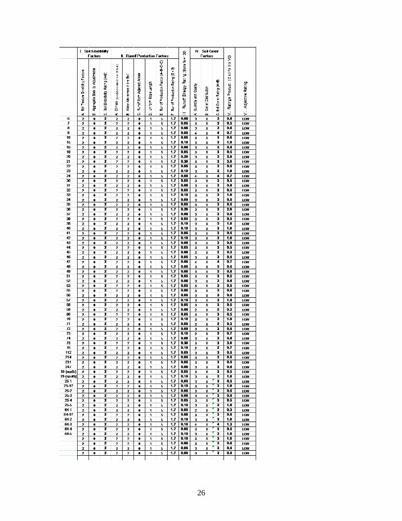
Soil Erosion During the evaluation of compaction in the proposed harvest units, observations for evidence of erosion were also made. Every proposed harvest unit was evaluated for evidence of erosion, such as rills or gullies. All proposed activity units were given a Soil Erosion Hazard Rating (EHR) in accordance with the California Soil Survey Committee EHR System (FSH 2950, Soil and Water Conservation Handbook). A table summarizing this evaluation is included in Appendix D of this report.
Soil Organic Matter and Soil Cover Proposed units were evaluated in the field for levels of soil organic matter and soil organic cover. This was done using the National Soil Disturbance Protocol looking at existing soil cover and soil displacement of the topsoil along with comparing site conditions with the Photo Series for Quantifying Natural Forest Residues in Common Vegetation Types of the Pacific Northwest.18 Results from this survey were also used in assessing background organic matter levels. A unit-by-unit assessment of organic matter and cover conditions are provided in Appendix G of this report.
5.2. Discussion of Potential Effects of the Proposed Activities Soil Organic Matter (SOM): In thinning operations approximately 50% of the forest canopy will be retained. Organic cycling is uninterrupted and organic cover quickly recovers. Prescribed levels of large woody debris (LWD) are identified in the planning process and retained during timber removal operations. The exception is old plantations
18 ibid

11
that were converted from brush fields to pine plantations. These areas lack LWD and have soil displacement affecting SOM.
Soil Compaction: Soil disturbance on thinning units is caused by mechanical cutters that fall and bunch trees to create a desired spacing. The mechanical cutters have a minimal ground compaction because they do not transport logs but merely cut and bundle. Skidder tractors drag the bundles of logs to the landings on designated skid trails. Bundled logs and designated skid trails greatly reduces the number of trips a skidder makes and reduces the total disturbed area. Log skidding causes most of the compaction forces resulting from timber harvest and shows up on main skid-trails.
Soil Erosion: The soils in this area have a very high infiltration capacity and low runoff potential. The SRI classifies all of the soils in the project area as being in Hydrologic Soil Group “A.”19 Slopes with a low runoff potential have a low erosion hazard.
Thousands of acres have been treated similarly on the McCloud Ranger District over the past twenty years. Informal and subjective monitoring on other areas that have been thinned in past years on these sales shows little evidence of any loss of productivity (Appendix F). An exception is landings and skid trail networks where they coalesce near landings. Skid trail networks within several hundred feet of landings bear many passes with loaded skidders. Although these areas are of limited areal extent, they often show considerable soil compaction. Landings and skid trails within 200 feet of landings are slated for soil rehabilitation with a winged subsoiler to alleviate soil compaction (Appendix B). Also, in areas that were windrowed, topsoil displacement occurred in the past (1950s-70s). Old windrowed plantations will have mitigations to rebuild lost topsoil (Appendix B).
5.3. Direct & Indirect Effects The conclusions about the effects of the proposed action were derived from the Soil Survey, field observation, transects, long-term experience in managing soils in this area and from Geographic Information System (GIS) files.
Soil Erosion: All proposed activity units were evaluated and given a Soil Erosion Hazard Rating (EHR) in accordance with the California Soil Survey Committee EHR System (FSH 2509.18, Soil Management Handbook). A table summarizing this evaluation is included as Appendix D to this report.
This evaluation led to the conclusion that the inherently high infiltration capacity of the soils in the project area and the very gentle slopes means that there is a very low potential for runoff and overland flow. There will be no effect from soil erosion to the soils of the project area as a result of implementation of the Proposed Action.
The overall Erosion Hazard for all Alternatives is the same.
Soil Compaction: The soils of the project area have medial or ashy surface textures.20 The potential for soil compaction from this project is low except where skidding traffic is
19 Soil Resource Inventory, Shasta-Trinity National Forest, 1980 20 Soil Resource Inventory 1981, Black Fox Ecological Unit Inventory 1991.

12
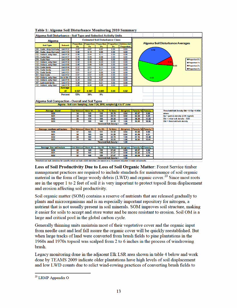
very high, such as skid trail networks near landings where the repeated number of passes can be expected (Table 1).
Four categories are used for classifying soil disturbance as outlined in the NSDMP21: Soil disturbance classes 0 though 3. Class SD0 is undisturbed, class SD1 is lightly disturbed (1 or 2 passes), class SD2 is moderately disturbed (secondary skid-trails or main skid-trails), and class SD3 is highly disturbed (primary skid-trails or landings). Table 1 shows low levels of legacy disturbance with only nine percent of the area in skid-trails and landings that are over the calculated 22 soil quality compaction threshold of 1.00 g/cc. This extent of compaction is below the Shasta-Trinity LMP standard of no more than 15% of the area in non-productive purposes like roads, main skid-trails, etc. (Appendix O of the land and Resource Management Plan). The other 91% is undisturbed or slightly disturbed below soil compaction threshold of 10% decrease in soil porosity. The majority of legacy compaction was found on the medium to fine textured ashy soils (Holland Ashy and Sadie soils - see Appendix F).
A Special Contract Provision (C6.422) is included to restrict operations when soils are in a moisture state when they are most susceptible to compaction damage.
On proposed activity units where the extent of pre-existing compaction exceeds the threshold described in Appendix O of the Land and Resource Management Plan, remediation of subsoiling is recommended (see Soil Mitigations, Soil Compaction notes and Algoma Soil Disturbance Monitoring 2010 in Appendix F of this report). Restoration of compacted sites may be limited due to their archaeological importance in some units near old mills.
21 National Soil Disturbance Monitoring Protocol 2009. 22 FSM Soil Management Handbook, threshold soil bulk density formula, pp7.
14
timber plantations. Additionally, these plantations have reduced topsoil in the surface horizons due to windrowing (see TEAMS 2009, Appendix H table and field notes). Similar conditions exist in older plantations for the Algoma Project.
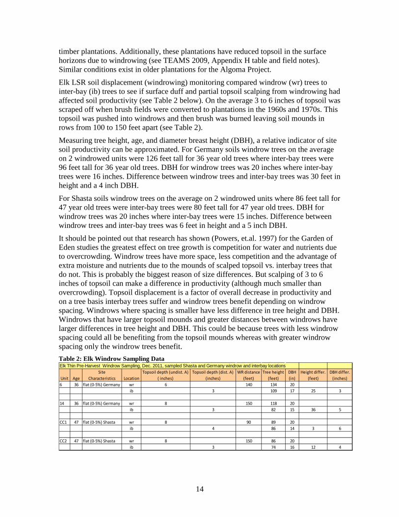
Elk LSR soil displacement (windrowing) monitoring compared windrow (wr) trees to inter-bay (ib) trees to see if surface duff and partial topsoil scalping from windrowing had affected soil productivity (see Table 2 below). On the average 3 to 6 inches of topsoil was scraped off when brush fields were converted to plantations in the 1960s and 1970s. This topsoil was pushed into windrows and then brush was burned leaving soil mounds in rows from 100 to 150 feet apart (see Table 2).
Measuring tree height, age, and diameter breast height (DBH), a relative indicator of site soil productivity can be approximated. For Germany soils windrow trees on the average on 2 windrowed units were 126 feet tall for 36 year old trees where inter-bay trees were 96 feet tall for 36 year old trees. DBH for windrow trees was 20 inches where inter-bay trees were 16 inches. Difference between windrow trees and inter-bay trees was 30 feet in height and a 4 inch DBH.
For Shasta soils windrow trees on the average on 2 windrowed units where 86 feet tall for 47 year old trees were inter-bay trees were 80 feet tall for 47 year old trees. DBH for windrow trees was 20 inches where inter-bay trees were 15 inches. Difference between windrow trees and inter-bay trees was 6 feet in height and a 5 inch DBH.
It should be pointed out that research has shown (Powers, et.al. 1997) for the Garden of Eden studies the greatest effect on tree growth is competition for water and nutrients due to overcrowding. Windrow trees have more space, less competition and the advantage of extra moisture and nutrients due to the mounds of scalped topsoil vs. interbay trees that do not. This is probably the biggest reason of size differences. But scalping of 3 to 6 inches of topsoil can make a difference in productivity (although much smaller than overcrowding). Topsoil displacement is a factor of overall decrease in productivity and on a tree basis interbay trees suffer and windrow trees benefit depending on windrow spacing. Windrows where spacing is smaller have less difference in tree height and DBH. Windrows that have larger topsoil mounds and greater distances between windrows have larger differences in tree height and DBH. This could be because trees with less windrow spacing could all be benefiting from the topsoil mounds whereas with greater windrow spacing only the windrow trees benefit. Table 2: Elk Windrow Sampling Data Elk Thin Pre-Harvest Windrow Sampling, Dec. 2011, sampled Shasta and Germany windrow and interbay locations
Unit AgeSite
Characteristics LocationTopsoil depth (undist. A)
( inches)Topsoil depth (dist. A)
(inches)WR distance
(feet)Tree height
(feet)DBH (in)
Height differ. (feet)
DBH differ. (inches)
6 36 flat (0-5%) Germany wr 6 140 134 20ib 3 109 17 25 3
14 36 flat (0-5%) Germany wr 8 150 118 20ib 3 82 15 36 5
CC1 47 flat (0-5%) Shasta wr 8 90 89 20ib 4 86 14 3 6
CC2 47 flat (0-5%) Shasta wr 8 150 86 20ib 3 74 16 12 4

15
Data of unpublished windrow respreading from Blacks Mountain Experimental Forest indicate that when displaced topsoil (windrowed soils) was respread across the unit, trees had a significant increase in growth. Germany soils on a whole are more productive than Shasta soils due to higher available water holding capacity and higher soil organic matter, explaining bigger trees at an earlier age. But in both cases when topsoil was scalped during windrowing, the windrow trees benefited from the topsoil and the inter-bay trees suffered.
Due to the above data on topsoil displacement, mitigations of mastication along with woody debris retention strategies are recommended (see Appendix B (soil mitigations)). Windrow respreading is also recommended depending on available KV funds for older plantations on selected sites.
5.4. Cumulative Effects All four action alternatives would remediate any resultant soil compaction, as well as some of the remnant soil compaction from past practices. These mitigation measures would be limited to areas used as landings, temporary roads and main skid trails for current proposed activities.
Cumulative effects for soil erosion are minimal for any action alternatives due to low levels of pre-existing erosion and low erosion potential in treatment units. Soil fertility is reduced for older plantations established in the 50’s to the 70’s due to prior topsoil displacement. With overcrowded plantations, thinning will greatly improve forest health and with soil mitigations proposed, topsoil will slowly rebuild to enhance productivity. The practices of converting brush fields to trees by windrowing is a past practice no longer used today. These past practices are an inherited situation of this project but will be addressed by appropriate measure to improve productivity. Additional opportunities may exist through other funds to do windrow respreading in appropriate areas.
Conclusion It is my conclusion that there will be no adverse direct or indirect impacts or cumulative effects on the soils or soil productivity within the project area as a result of these actions. Cumulative Watershed Impacts are addressed in the Algoma Project Hydrology Report. There will be no long-term adverse effect on soils or soil productivity as a result of this action.
MONITORING: Post project monitoring will include SQS compliance. The Best Management Practices (BMP) Monitoring Program requires that this project be revisited after the project is completion to monitor implementation and effectiveness of BMPs. Effects on soils will be monitored periodically during timber harvest by the Forest Soil Scientist.

16
Appendices: A. Criteria of Significance B. Mitigation Measures
C. Best Management Practices D. Erosion Hazard Rating E. Soil Map and Legend from SRI F. Soil Compaction Surveys G. Residual Soil Cover H. Bulk Density Sampling I. Soil Disturbance Monitoring Transects
Appendices: A. Criteria of Significance: Consideration of the ten significant elements is necessary in order to determine a finding of no significant impact (Council on Environmental Quality, 40 CFR Parts 1500-1508). The applicable criteria of significance as they pertain to the soils resource are discussed below.
1. Beneficial and Adverse Impacts 40 CFR 1508.27(b) (1)) Impacts may be both beneficial and adverse. A significant effect may exist even if the Federal agency believes that on balance the effect will be beneficial.
Proposed Action and Action Alternatives
Within the context of Significance, there are no adverse impacts to soil productivity as a result of implementing the proposed action or any of the action alternatives. Beneficial impacts to soil resources that will result from implementation of the action alternatives or the no action alternative include:
Alternatives 1, 2, 3, and 5: Action Alternatives
A post-sale program of alleviating soil compaction on old landings and skid trails will be implemented along with improving soil fertility by mastication of plantations and LWD retention.
Alternative 4: No Action
Under the No Action alternative, there would be no beneficial impacts resulting from the project.
2. Public Health and Safety (40 CFR 1508.27(b)(2)) Not applicable.
3. Unique Characteristics of the Area (40 CFR 1508.27(b)(3)) There are no unique features or characteristics in the project area from a soils perspective.

17
4. Degree of Controversy (40 CFR 1508.27(b)(4)) There is no indication that the effects of the proposed action or alternatives on the quality of the human environment are likely to be highly controversial with respect to soil resources.
5. Uncertain, Unique, or Unknown Risks (40 CFR 1508.27(b)(5)) None
6. Setting a Precedent for Future Actions (40 CFR 1508.27(b)(6)) Not applicable.
7. Cumulative Impacts (40 CFR 1508.27(b)(7)) No cumulative effects on soil productivity are foreseen as a result of this project. Best Management Practices and Soil Quality Standards are designed to avoid cumulative impacts.
8. Heritage Resources 40 (CFR 1508.27(b)(3) and (b)(8)) Not applicable.
9a. Threatened, Endangered, and Sensitive (TES) Species (40 CFR 1508.27(b)(9))
Not applicable
9b. Survey and Manage (S&M) Species Not applicable.
10. Consistency with Federal, State, or Local Laws or Requirements (40 CFR 1508.27(b)
The proposed action and each alternative comply with the National Forest Management Act by complying with the standards and guidelines in the Shasta-Trinity National Forest LRMP (refer to 2.2.1 for LRMP direction and Standards and Guidelines).
The proposed action and each alternative comply with the Clean Water Act by following the Best Management Practices outlined in the programmatic agreement with the State of California.
B. Mitigation Measures 1. Meet soil quality standards as referenced in Appendix O of Forest Plan.24 2. Prior to entering the harvest units with equipment, the sale administrator will
verify ground conditions are such that operations will not cause resource damage, using the current standard for soil conditions and operability (e.g. “Wet Weather Operation” guide and “Field Guide to Soil Moisture Conditions Relative to Operability”).
24 USDA Forest Service 1995, page O-1.
18
3. Till/sub-soil landings and main skid trails within 200 feet of landings with equipment such as a winged sub-soiler or other tilling device to a maximum depth of 18 inches so that the soil is lifted vertically and fractured laterally to alleviate detrimental compaction (where it occurs) following completion of all management activities. Tillage/sub-soiling will be completed outside of the tree drip line so as not to impact root systems.
4. Disturbed sites (e.g., tilled landings and skid trails, decommissioned roads/routes/temporary spurs) will be seeded with native grass and forb species for erosion control.
5. Where underrepresented (according to Forest Soil Quality Standards), in units proposed for thinning in natural stands, thinning with sanitation, and single tree selection, large woody debris in a variety of decay classes will be recruited by leaving additional logs and/or tops on site, where possible. Units slated for underburning will avoid ignition of large woody debris. Mastication will avoid existing large woody debris and leave additional coarse wood on the ground (i.e. not grind it into the ground.
6. In plantation units that have topsoil displacement due to relict windrowing practices (units 25-6, 7, 8, 9, 10, 64-4, 5, 17, 20, 21, 22, 23, 24, 112) no prescribed broadcast burning or machine piling of excess slash will be done. To the extent possible, retain available fine (< 3 in. diameter) woody material to rebuild topsoil soil organic matter and duff.
7. Retain existing down large woody debris whenever possible providing the amount of logs does not exceed fuel management objectives. At least 5 logs per acre should be retained with 6 to 20 tons/acre of fuel remaining for protection of soil fertility. Desired logs are at least 20 inches in diameter and 10 feet long. Other surface organic matter (3 inches to 20 inches in diameter), or amounts of fine organic matter and large woody material in excess of amounts described in detail above need not be retained to meet this standard.
8. Large woody material and fine organic matter amounts (except when needed for essential erosion control and fertility) may be reduced to meet fuel management objectives in strategic fuel treatment areas, on fuel breaks, and in other critical areas.
C. Best Management Practices
The following Best Management Practices (BMPs) would be applied for all activities occurring in the Algoma Vegetation Management Project Area. A complete description of each best management practice is provided in the publication 'Water Quality Management for National Forest System Lands in California' (USDA, 2000).25 While all applicable BMPs should be applied to each proposed activity, the following BMPs are emphasized in order to protect aquatic and riparian resources in and adjacent to Riparian Reserves. In addition to periodic inspections, implementation of BMPs will be monitored
25 USDA Forest Service, Pacific Southwest Region, Sept. 2000. Water Quality Management for Forest System Lands in California Best Management Practices.
19
under the timber harvest waiver described in Section 5b of the Hydrology Report for the Algoma Project.26
Timber Harvest BMPs 1-1: Timber sale planning process. The objective of Practice 1-1 is to incorporate water quality and hydrologic considerations into the timber sale planning process. This BMP was addressed by including a hydrologist and soil scientist on the ID Team for the Algoma Vegetation and Road Management Project. Representatives from the Central Valley Water Quality Control Board and the California Department of Fish and Game also were consulted during development of Riparian Reserve treatment recommendations. All recommendations developed during field reviews of the project area have been incorporated in the Sale Area Map and FEIS for the Algoma Project.
1-2: Timber harvest unit design. The objective of Practice 1-2 is to ensure that timber harvest unit design will secure favorable conditions of water quality and quantity while maintaining desirable stream channel characteristics and watershed conditions. This practice was implemented by ground verifying hydrologic conditions for all units that were in close proximity to or within Riparian Reserves and prescribing appropriate no-treatment buffers and equipment exclusion zones.
1-3: Determination of surface erosion hazard for timber harvest unit design. The objective of Practice 1-3 is to identify high erosion hazard areas in order to adjust treatment measures to prevent downstream water quality degradation. The erosion hazard for soils in the Algoma Project Area was assessed by a soil scientist using the Soil Resource Inventory for the project area and through ground verification of soil characteristics in each of the proposed harvest units. The soil survey was used to determine the soil mapping unit for each of the proposed treatment areas. The interpretations listed in the soil map unit description include an assessment of the Erosion Hazard Rating (EHR). The soil scientist also completed a unit by unit assessment of soil erosion hazard using the methodology provided in the USDA Forest Service Soil and Water Conservation Handbook (FSH 2509.22), Computation of Erosion Hazard Rating (2/90).27
1-4: Use of sale area maps (SAM) and/or project maps for designating water quality protection needs. The objective of Practice 1-4 is to ensure recognition and protection of areas related to water quality protection delineated on a Sale Area or Project Map. This practice will be accomplished by displaying all stream channels located adjacent to or within the units on the Sale Area Map for each timber sale area.
1-5: Limiting the operating period (LOP) of timber sale activities. The objective of Practice 1-5 is to ensure that the purchasers conduct their operations, including erosion control work and road maintenance in a timely manner and within the timeframe specified in the timber sale contract. The extent of the wet weather and snowmelt season in Northern California can be very unpredictable, therefore a fixed LOP for wet weather conditions will not be set for any of the proposed actions described in the Algoma FEIS. 26 Final Hydrology Report for the Algoma Road and Vegetation Management Project, February 9, 2011, on file with project record. 27 USDA Forest Service, 1990. USDA Forest Service Soil and Water Conservation Handbook (FSH 2509.22). Computation of Erosion Hazard Rating.

20
Timber sale contract provision B6.6 can be used to close down operations because of wet weather, high water, or other considerations in order to protect resources. Prior to entering the harvest units with equipment, the sale administrator will verify ground conditions are such that operations will not cause resource damage, using the current standard for soil conditions and operability (e.g. “Wet Weather Operation” guide and “Field Guide to Soil Moisture Conditions Relative to Operability”). The timber sale administrator will consult with the unit soil scientist and hydrologist if there is any doubt as to whether ground conditions are satisfactory for operation.
1-8: Streamside management zone designation. The objective of Practice 1-8 is to designate a zone along riparian areas, streams and wetlands that will minimize potential for adverse effects from adjacent management activities. This practice was accomplished by ground verifying all hydrologic features, excluding sensitive areas from proposed units and prescribing no-treatment and/or no equipment use buffers for each feature. Hill slopes exceeding 35 percent are rare within the Algoma Project area. All protected features will also be included on sale area maps.
1-9: Determining tractor loggable ground. The objective of Practice 1-9 is to minimize erosion and sedimentation resulting from ground disturbance of tractor logging systems. As a general guideline tractor logging should not occur on slopes greater than 35 percent. This objective was accomplished by using the Geographical Information System to identify areas in the Algoma assessment area where slopes averaged 35 percent or greater and ground verification. All ground disturbing equipment will be excluded from areas having slopes of 35% or greater. 1-10: Tractor skidding design. The objective of Practice 1-10 is to design skidding patterns to best fit the terrain, the volume, velocity, concentration, and direction of runoff water in order to minimize erosion and sedimentation. As a general guideline the skid trail network cannot exceed 15% of the area in each treatment unit. The sale administrator will accomplish this practice by reviewing and approving by agreement the skid trail design as provided by the purchaser (applicable contract provision C6.42# - Ground Based Skidding). 1-12: Log landing location. The objective of Practice 1-12 is to locate new landings in such a way as to avoid watershed impacts and associated water quality degradation. This objective will be accomplished by following guidelines for proper landing locations as described in Water Quality Management for National Forest System Lands in California (2000).28 All landings will be approved prior their use by the sale administrator. No new landing locations will be permitted within Riparian Reserves. Standard Provision B6.422 (Landing and Skid Trail Location) will apply to all units located within or partly within Riparian Reserves. All existing and new landings will be evaluated for restoration following completion of all harvest-related activities. Activities that may occur include ripping of landings (dependent on degree of compaction and runoff risk) and revegetation with native vegetation.
1-13: Erosion prevention and control measures during timber sale operations. The objective of Practice 1-13 is to ensure that the purchaser’s operations will be conducted 28 USDA Forest Service, Pacific Southwest Region, Sept. 2000. Water Quality Management for Forest System Lands in California, Best Management Practices, pgs. 31-32.

21
reasonably to minimize soil erosion. Drainage and erosion control work on temporary roads, skid trails, and permanent roads should be kept current during harvest activities. Equipment shall not be operated when ground conditions are such that excessive damage will result. The timber sale administrator will implement this practice through regular site visits and inspections.
1-16: Log landing erosion control. The objective of Practice 1-16 is to reduce the impacts of erosion and subsequent sedimentation associated with log landings by use of mitigating measures. The timber sale administrator will implement this practice through regular site visits and inspections. 1-17: Erosion control on skid trails. The objective of Practice 1-17 is to protect water quality by minimizing erosion and sedimentation derived from skid trails. Skid trail erosion control work should be kept current during implementation. Erosion control and drainage of skid trails should be complete prior to shutting down operations due to wet weather. The timber sale administrator will implement this practice through regular site visits and inspections.
1-19: Streamcourse and aquatic protection. The objective of Practice 1-19 is to control sediment and other pollutants entering streamcourses. This objective was accomplished by identifying all hydrologic features in the project area, excluding sensitive areas, and prescribing no-treatment buffers.
1-21: Acceptance of timber sale erosion control measures before sale closure. The objective of Practice 1-21 is to ensure adequacy of the required erosion control work on timber sales. The sale administrator will implement this practice. Prior to closure of the sale each unit will be inspected to ensure that skid trails and landings have water-bars in place and/or are properly drained.
Road and Building Site Construction BMPs 2-1: General guidelines for the location and design of roads. The objective of Practice 2-1 is to locate and design roads with minimal resource damage. This BMP is included to ensure that resource protection needs are factored into the design and layout of temporary roads. This practice is implemented through a combination of planning and implementation activities accomplished by the unit transportation planner and Algoma interdisciplinary team, as well as the timber sale administrator.
2-2: Erosion control plan. The objective of Practice 2-2 is to limit and mitigate erosion and sedimentation through effective planning prior to initiation of new construction and reconstruction activities and through effective contract administration during construction. This practice will be accomplished by the authorized individual(s) (i.e. transportation planner, engineering representative or sale administrator).
2-3: Timing of construction activities. The objective of Practice 2-3 is to minimize erosion by conducting operations during minimal runoff periods. This practice will be accomplished by the sale administrator, engineering representative, contract inspector, unit transportation planner, hydrologist and/or soil scientist who will make the determination of when conditions are dry enough to allow work to proceed in the project area.

22
2-7: Control of road drainage. The objective of Practice 2-7 is to minimize the erosive effects of water concentrated by road drainage features; to disperse runoff from disturbances within the road clearing limits; to lessen the sediment yield from roaded areas; and to minimize erosion of the road prism by runoff from road surfaces and from uphill areas. This objective will be accomplished by incorporating road drainage features (e.g. outsloping, dips) into the design of temporary roads and reconstructed roads.
2-9: Timely erosion control measures on incomplete roads and stream crossing projects. The objective of Practice 2-9 is to minimize erosion and sedimentation from disturbed ground on incomplete projects. This practice will be implemented through periodic inspections by the sale administrator or engineering contracting representative.
2-12: Servicing and refueling of equipment. The objective of Practice 2-12 is to prevent pollutants such as fuels, lubricants, bitumens and other harmful materials from being discharged into or near rivers, streams and impoundments, or into natural or man-made channels. The sale administrator will implement this practice by designating the location, size and allowable uses for service and refueling areas.
2-17: Bridge and culvert installation. The objective of Practice 2-17 is to minimize sedimentation and turbidity resulting from excavation for in-channel structures. Forest engineering contract representatives will monitor installation of all bridges and culverts. Mulching and other methods of erosion control will be utilized to prevent construction generated sediments from entering stream courses.
2-22: Maintenance of roads. The objective of Practice 2-22 is to maintain roads in a manner which provides for water quality protection by minimizing rutting, failures, sidecasting and blockage of drainage facilities all of which can cause erosion and sedimentation, and deteriorating watershed conditions. This practice will be accomplished by the purchaser and sale administrator.
2-23: Road surface treatment to prevent loss of materials. The objective of Practice 2-23 is to minimize the erosion of road surface materials and consequently reduce the likelihood of sediment production from those areas. This objective will be accomplished under direction specified by the sale administrator that can include watering roads for dust abatement during dry periods, restricting operations during wet periods and/or spot rocking portions of roads that could be degraded.
2-24: Traffic control during wet periods. The objective of Practice 2-22 is to reduce road surface disturbance and rutting of roads and to minimize sediment washing from disturbed road surfaces. The sale administrator in conjunction with Practices 1-5, 1-13, 1-16 and 1-17 will implement traffic control during wet periods. A soil scientist or hydrologist will assist in the determination of the need for wet weather restrictions as requested by the sale administrator.
2-26: Obliteration or Decommissioning of Roads. The objective of Practice 2-26 is to reduce sediment generated from temporary roads, unneeded system (classified) and non-system (unclassified) roads by obliterating or decommissioning them at the completion of intended use. This practice will be implemented by specifying in the Timber Sale Contract that all temporary roads will be completely obliterated (ripped and blocked) following the completion of their intended use. Sale area improvement dollars may also

23
be used to complete obliteration of roads that are not required for the sale. The District Hydrologist will oversee the decommissioning of roads located within Riparian Reserves including Road 39N11Y adjacent to Shady Gulch and Road 39N68 in the Raccoon Creek Riparian Reserve.

24
Vegetative Manipulation BMPs 5-2: Slope limitation for mechanical equipment operation. The objective of Practice 5-2 is to decrease sediment production and stream turbidity while mechanically treating slopes. As a general guideline, tractors should not be used on slopes exceeding 35 percent. Hillslopes exceeding 35% are rare within the Algoma project area. All steep slopes within inner gorge areas adjacent to water courses were excluded from proposed units.
5-6: Soil moisture limitations for mechanical equipment operations. The objective of Practice 5-6 is to prevent compaction, rutting, and gullying, with resultant sediment production and turbidity. The sale administrator or other Forest personnel (e.g. CORs) will normally make this determination. If they are unable to make the determination they will consult with a Forest Service soil scientist or hydrologist.
Fire Suppression and Fuels Management BMPs 6-2: Consideration of water quality in formulating fire prescriptions. Theo objective of Practice 6-2 is to provide for water quality protection while achieving the management objectives through the use of prescribed fire. Prescribed burn plans should consider potential water quality impacts that may arise as a result of increased erosion due to increased soil water repellency and loss of vegetative cover. This practice was implemented by incorporating soil and hydrologic input into the prescriptions for each unit during planning or the Algoma Project.
Compliance monitoring for Timber Harvest Waiver All timber sales occurring as a result of the Algoma FEIS will be enrolled in the Timber Harvest Waiver Program administered by the Central Valley Regional Water Quality Control Board (CVRWQCB) under Resolution No. R5-2010-0022.29 In order to comply with the timber harvest waiver the Forest Service will conduct implementation, effectiveness and in some cases forensic monitoring as described in Guidelines for Conducting Required Monitoring for Timber Harvest Related Discharges Enrolled Under the Waiver of Waste Discharge Requirements (CVRWQCB, 2007).30 Forensic monitoring activities are planned for the Lower McKay Creek HUC 8 watershed and will consist of photo photo-point monitoring and turbidity measurements in streams where management activities have the potential to affect water quality.
The monitoring program will accomplish the following objectives:31
Determine if best management practices, mitigations, and management measures have been properly put into place before the start of the winter period (November 15th through April 1st). 29 California Regional Water Quality Control Board, Central Valley Region, Order No. R5-2010-0022, Renewal of Conditional Waiver of Waste Discharge Requirements for Discharges Related to Timber Harvest Activities, 2010. . 30 Central Valley Regional Water Quality Control Board, January 2007. Guidelines for Conducting Required Monitoring for Timber Harvest Related discharges Enrolled under the Waiver of Waste Discharge Requirements. 44 p. 31CVRWQCB – Waiver Monitoring Guidelines, p. 1.

25
Determine if significant pollution occurs as a result of timber harvest activities during the winter period.
Determine if the management measures were effective in preventing significant pollution during the winter period.
Monitoring of implementation activities will be accomplished by District resources personnel including the hydrologist and the sale administrators. If problems are identified the Forest Service will consult with the CVRWQCB and take corrective actions (e.g. suspension of work, temporary closure, spot rocking).
D. Erosion Hazard Rating: In order to assess the potential risk of a given soil to erode, an erosion hazard rating (EHR) was developed (R-5 FSH 2505.22). The EHR system is designed to assess the relative risk of accelerated sheet and rill erosion.
26

27
This rating system is based on soil texture, depth, clay percent, infiltration of soil, amount of rock fragments, surface cover (vegetative and surface rocks), slopes, and climate. Risk ratings vary from low to very high with low ratings meaning low probability of surface erosion occurring. Moderate ratings mean that accelerated erosion is likely to occur in most years and water quality impacts may occur for the upper part of the moderate numerical range. High to very high EHR ratings mean that accelerated erosion is likely to occur in most years and that erosion control measures should be evaluated. These ratings assume varying amounts of vegetation cover depending on degree of vegetative management.
E. Soil Map Legend from Soil Resource inventory (SRI):
SRI Map unit EUI Map Unit This map unit is included in LTA
112: Holland family, ashy- Neer families association
7290: Wyntoon sandy loams and 6620: Wyntoon sandy loams, high water table
Fans and terraces
167: Ledmont family-rockoutcrop
2160: Jaystreet cobbly sqndy loams and 6610: Slagger sandy loams
Fans and terraces
201: Neer-Sadie Families association
2160: Jaystreet cobbly sandy loams
Fans and terraces
240: Oval, ponded-Morical-Aquic xerorthents complex
6620: Wyntoon sandy loams, high water table
Fans and terraces
278: Sadie-Neer families association
6440: Nitwit sandy loams, 6450: Coney Sandy loams, 6460: Coney Hunthill Complex
Gently sloping volcanic uplands
279: Sadie Family, deep 6130: Mermac-Swobe sandy loams
Gently sloping volcanic uplands
280 and 282:Sadie, deep-Germany families association
6440: Nitwit sandy loams and 6450: Coney sandy loams
Gently sloping volcanic uplands
29: Coyata family 7300: Redtank-Wimpy sandy loams complex
River and stream slopes
6: Aquolls-Xerolls complex Fans and terraces F. Soil Compaction Surveys: 1. Peter Van Susteren Notes on Soil compaction calculations for the Algoma Project.
The “Eroding Hill Slope”32 that lie south of the McCloud River are characterized as two soil types. These are: Andic Xerumbrepts, medial skeletal mixed, mesic on floodplain terraces and fans and Humic Haploxerands medial over medial-skeletal, mixed, mesic on low-relief ridges. The Andic Xerumbrepts are generally too cobbly in the surface horizon for a probe to assess soil compaction. Shallow test pits were dug on these sites to look for 32 Jasso, Abel, Geomorphology of the Black Fox EUI, 1992
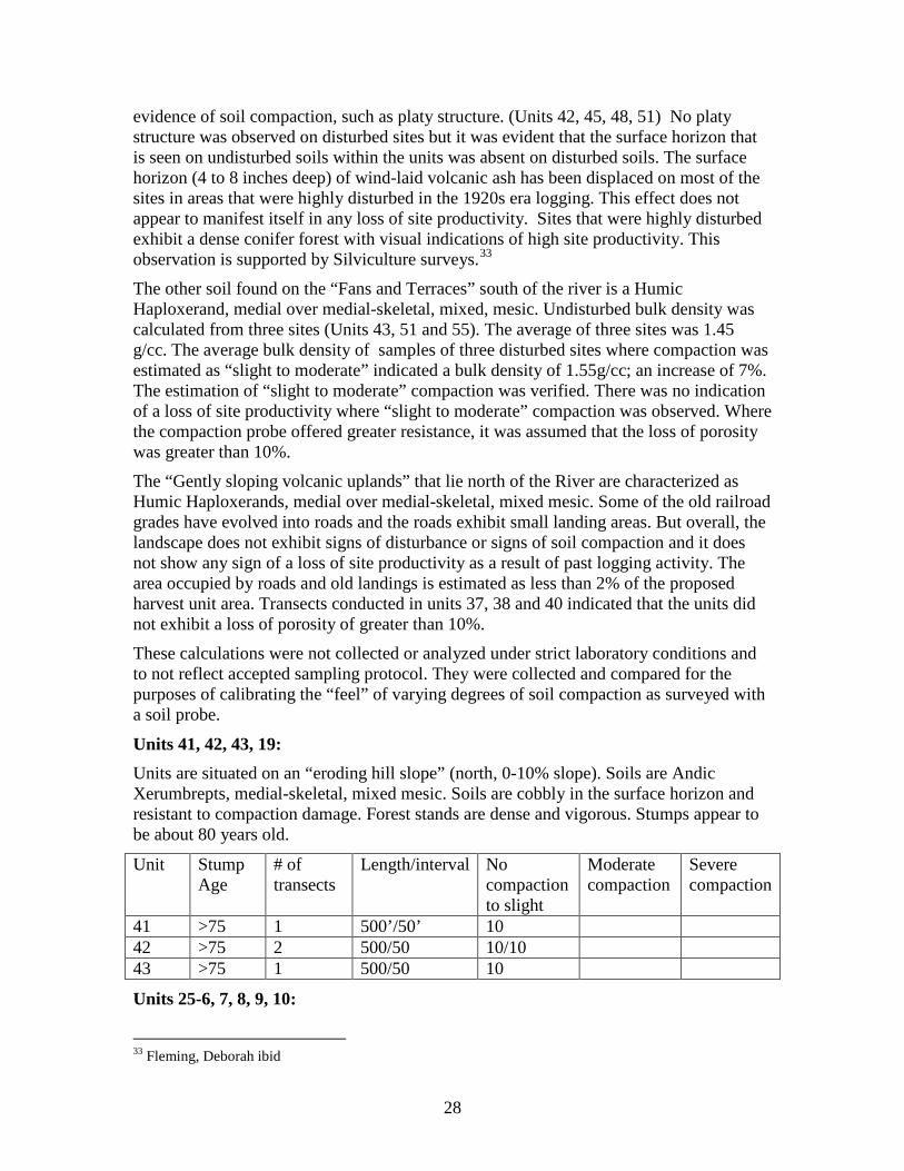
28
evidence of soil compaction, such as platy structure. (Units 42, 45, 48, 51) No platy structure was observed on disturbed sites but it was evident that the surface horizon that is seen on undisturbed soils within the units was absent on disturbed soils. The surface horizon (4 to 8 inches deep) of wind-laid volcanic ash has been displaced on most of the sites in areas that were highly disturbed in the 1920s era logging. This effect does not appear to manifest itself in any loss of site productivity. Sites that were highly disturbed exhibit a dense conifer forest with visual indications of high site productivity. This observation is supported by Silviculture surveys.33
The other soil found on the “Fans and Terraces” south of the river is a Humic Haploxerand, medial over medial-skeletal, mixed, mesic. Undisturbed bulk density was calculated from three sites (Units 43, 51 and 55). The average of three sites was 1.45 g/cc. The average bulk density of samples of three disturbed sites where compaction was estimated as “slight to moderate” indicated a bulk density of 1.55g/cc; an increase of 7%. The estimation of “slight to moderate” compaction was verified. There was no indication of a loss of site productivity where “slight to moderate” compaction was observed. Where the compaction probe offered greater resistance, it was assumed that the loss of porosity was greater than 10%.
The “Gently sloping volcanic uplands” that lie north of the River are characterized as Humic Haploxerands, medial over medial-skeletal, mixed mesic. Some of the old railroad grades have evolved into roads and the roads exhibit small landing areas. But overall, the landscape does not exhibit signs of disturbance or signs of soil compaction and it does not show any sign of a loss of site productivity as a result of past logging activity. The area occupied by roads and old landings is estimated as less than 2% of the proposed harvest unit area. Transects conducted in units 37, 38 and 40 indicated that the units did not exhibit a loss of porosity of greater than 10%.
These calculations were not collected or analyzed under strict laboratory conditions and to not reflect accepted sampling protocol. They were collected and compared for the purposes of calibrating the “feel” of varying degrees of soil compaction as surveyed with a soil probe.
Units 41, 42, 43, 19: Units are situated on an “eroding hill slope” (north, 0-10% slope). Soils are Andic Xerumbrepts, medial-skeletal, mixed mesic. Soils are cobbly in the surface horizon and resistant to compaction damage. Forest stands are dense and vigorous. Stumps appear to be about 80 years old.
Unit Stump Age
# of transects
Length/interval No compaction to slight
Moderate compaction
Severe compaction
41 >75 1 500’/50’ 10 42 >75 2 500/50 10/10 43 >75 1 500/50 10
Units 25-6, 7, 8, 9, 10:
33 Fleming, Deborah ibid
29
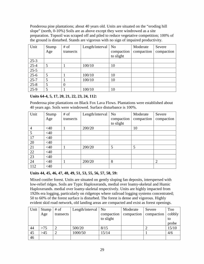
Ponderosa pine plantations; about 40 years old. Units are situated on the “eroding hill slope” (north, 0-10%) Soils are as above except they were windrowed as a site preparation. Topsoil was scraped off and piled to reduce vegetative competition; 100% of the ground is disturbed. Stands are vigorous with no sign of impaired productivity.
Unit Stump Age
# of transects
Length/interval No compaction to slight
Moderate compaction
Severe compaction
25-3 25-4 5 1 100/10 10 25-5 25-6 5 1 100/10 10 25-7 5 1 100/10 10 25-8 5 0 25-9 5 1 100/10 10
Units 64-4, 5, 17, 20, 21, 22, 23, 24, 112: Ponderosa pine plantations on Black Fox Lava Flows. Plantations were established about 40 years ago. Soils were windrowed. Surface disturbance is 100%.
Unit Stump Age
# of transects
Length/interval No compaction to slight
Moderate compaction
Severe compaction
4 <40 1 200/20 10 5 <40 17 <40 20 <40 21 <40 1 200/20 5 5 22 <40 23 <40 24 <40 1 200/20 8 2 112 <40
Units 44, 45, 46, 47, 48, 49, 51, 53, 55, 56, 57, 58, 59: Mixed conifer forest. Units are situated on gently sloping fan deposits, interspersed with low-relief ridges. Soils are Typic Haploxerands, medial over loamy-skeletal and Humic Haploxerands. medial over loamy-skeletal respectively. Units are highly impacted from 1920s era logging, particularly on ridgetops where railroad logging systems concentrated; 50 to 60% of the forest surface is disturbed. The forest is dense and vigorous. Highly evident skid road network, old landing areas are compacted and exist as forest openings.
Unit Stump Age
# of transects
Length/interval No compaction to slight
Moderate compaction
Severe compaction
Too cobbly to probe
44 >75 2 500/20 8/15 2 15/10 45 >45 2 1000/50 15/14 1 4/6 46

30
47 48 49 2 51 >75 1000/50 14/4 4/6 2/10 53 >75 1 200/20 7 2 1 55 >75 1 1000/50 16 2 2 56 >75 1 200/20 10 57 >75 1 200/20 10 58 >75 1 200/10 10 59 >75 1 200/20 8 2
Units 35, 71, 72, 73, 75, 76, 247: Black Fox Lava flows, Ponderosa pine/white fir forest. Soils are Andic xerochrepts, medial. Units were severely impacted in 1920s era logging but tree growth on disturbed sites appears unrestricted. About 60% of the ground shows signs of disturbance. There is no sign of impaired productivity.
Unit Stump Age
# of transects
Length/interval No compaction to slight
Moderate compaction
Severe compaction
Too cobbly to probe
35 >75 1 200/20 5 2 1 2 71 72 73 >75 1 200/20 4 2 4 75 >76 2 200/20 4/3 0/2 2/1 4/4 76 247
Units 19, 36, 37, 38, 39, 74, 231: Mixed conifer/black oak forest on Black Fox lava flows. Soils are Humic Haploxerands. Medial over medial-skeletal. 1920s era logging impacts are mostly limited to ridgetops; less than 10% of the forest surface appears disturbed in the form of old railroad grades.
Unit Stump Age
# of transects
Length/interval No compaction to slight
Moderate compaction
Severe compaction
Too cobbly to probe
19 >75 36 >75 2 1000/50 15/18 5/2 37 >75 1 1000/50 15 4 1 38 >75 2 1000/50 20/ 2 3 39 74 >75 1 1000/50 20 231
Units 40, 70, 214:
31
Mixed conifer/dogwood on Fan Deposits. Soils are Humic Haploxerands, medial, mesic. 1920 era logging is evident only from old railroad grades. Less than 10% of the surface exhibits signs of disturbance.
Unit Stump Age
# of transects
Length/interval No compaction to slight
Moderate compaction
Severe compaction
Too cobbly to probe
40 >75 1 1000/50 12 4 2 2 70 >75 1 1000/50 12 6 2 214
Units 30, 31, 32, 33: Ponderosa Pine/White fir forest on Black Fox Lava Flows. Soils are Typic Haploxerands medial over loamy-skeletal. 1920s era logging disturbance is estimated at 10-15% of the forest surface. The corridor along the Sheephaven Road was an arterial for logging activity; evidence of disturbance is widespread. The remainder of the area in these units show only limited evidence of disturbance.
Unit Stump Age
# of transects
Length/interval No compaction to slight
Moderate compaction
Severe compaction
Too cobbly to probe
30 >75 1 1000/50 14 2 2 2 31 32 >75 1 1000/50 10 2 8 33 >75 1 1000/50 15 2 3
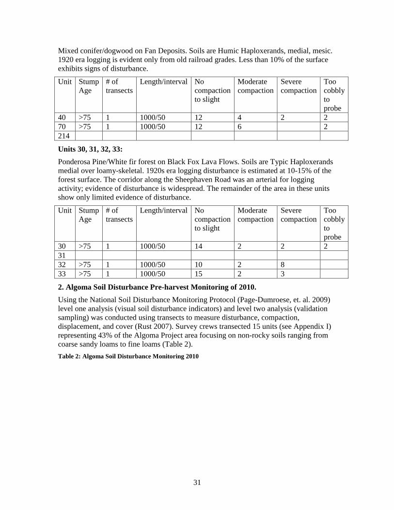
2. Algoma Soil Disturbance Pre-harvest Monitoring of 2010. Using the National Soil Disturbance Monitoring Protocol (Page-Dumroese, et. al. 2009) level one analysis (visual soil disturbance indicators) and level two analysis (validation sampling) was conducted using transects to measure disturbance, compaction, displacement, and cover (Rust 2007). Survey crews transected 15 units (see Appendix I) representing 43% of the Algoma Project area focusing on non-rocky soils ranging from coarse sandy loams to fine loams (Table 2). Table 2: Algoma Soil Disturbance Monitoring 2010

33
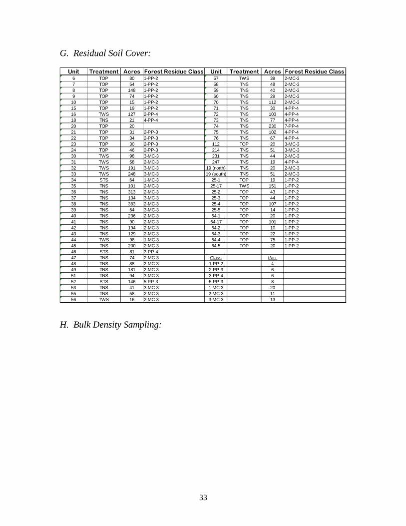
G. Residual Soil Cover:
Unit Treatment Acres Forest Residue Class Unit Treatment Acres Forest Residue Class6 TOP 80 1-PP-2 57 TWS 39 2-MC-37 TOP 54 1-PP-2 58 TNS 48 2-MC-38 TOP 148 1-PP-2 59 TNS 40 2-MC-39 TOP 74 1-PP-2 60 TNS 29 2-MC-3
10 TOP 15 1-PP-2 70 TNS 112 2-MC-315 TOP 19 1-PP-2 71 TNS 30 4-PP-416 TWS 127 2-PP-4 72 TNS 103 4-PP-418 TNS 21 4-PP-4 73 TNS 77 4-PP-420 TOP 20 74 TNS 230 7-PP-421 TOP 31 2-PP-3 75 TNS 102 4-PP-422 TOP 34 2-PP-3 76 TNS 67 4-PP-423 TOP 30 2-PP-3 112 TOP 20 3-MC-324 TOP 46 2-PP-3 214 TNS 51 3-MC-330 TWS 98 3-MC-3 231 TNS 44 2-MC-331 TWS 58 2-MC-3 247 TNS 19 4-PP-432 TWS 191 3-MC-3 19 (north) TNS 20 2-MC-333 TWS 248 3-MC-3 19 (south) TNS 51 2-MC-334 STS 64 1-MC-3 25-1 TOP 19 1-PP-235 TNS 101 2-MC-3 25-17 TWS 151 1-PP-236 TNS 313 2-MC-3 25-2 TOP 43 1-PP-237 TNS 134 3-MC-3 25-3 TOP 44 1-PP-238 TNS 383 2-MC-3 25-4 TOP 107 1-PP-239 TNS 64 3-MC-3 25-5 TOP 14 1-PP-240 TNS 236 2-MC-3 64-1 TOP 20 1-PP-241 TNS 90 2-MC-3 64-17 TOP 101 1-PP-242 TNS 194 2-MC-3 64-2 TOP 10 1-PP-243 TNS 129 2-MC-3 64-3 TOP 22 1-PP-244 TWS 98 1-MC-3 64-4 TOP 75 1-PP-245 TNS 200 2-MC-3 64-5 TOP 20 1-PP-246 STS 81 3-PP-447 TNS 74 2-MC-3 Class t/ac 48 TNS 88 2-MC-3 1-PP-2 449 TNS 181 2-MC-3 2-PP-3 651 TNS 94 3-MC-3 3-PP-4 652 STS 146 5-PP-3 5-PP-3 853 TNS 41 3-MC-3 1-MC-3 2055 TNS 58 2-MC-3 2-MC-3 1156 TWS 16 2-MC-3 3-MC-3 13
H. Bulk Density Sampling:

34
Disturbance Soil Moisture Moist Wt. Dry Wt. % Moist. Bd (g/cm) Porosity % Porosity ∆Unit # 32 soil type 280
0 25 147 108 36.26 0.81 66.75 0 001 31 170 130 30.87 0.98 59.94 10.202 36 174 149 18.41 1.13 54.06 19.00
Unit # 33 soil type 2800 44 160 120 33.31 0.91 62.88 0 001 42 159 118 34.32 0.89 63.50 -0.982 25 217 167 29.94 1.27 48.34 23.12
Unit # 35 soil type 1120 21 141 117 20.74 0.88 63.96 0 001 26 142 114 24.56 0.86 64.74 -1.212 18 169 137 23.84 1.03 57.77 9 67
Unit # 37 soil type 2780 34 132 101 31.36 0.76 68.91 0 001 27 155 122 27.86 0.92 62.26 9 652 43 176 134 31.66 1.02 58.55 15.04
Unit # 38 Soil type 2780 20 149 119 24.89 0.90 63.19 0 001 37 156 119 31.56 0.90 63.34 -0.24
Unit # 39 soil type 1120 25 126 98 28.63 0.74 69.68 0 001 27 153 118 29.68 0.89 63.50 8 882 28 172 134 28.44 1.02 58.55 15.98
Unit # 40 soil type 1120 26 137 106 29.82 0.80 67.36 0 001 30 159 124 28.31 0.94 61.80 8 272 41 160 126 26.41 0.95 61.02 9.41
Unit # 44 soil type 2790 55 129 99 30.16 0.75 69.38 0 001 61 169 126 34.33 0.95 61.02 12.042 72 181 135 34.55 1.02 58.24 16.053 78 185 140 32.25 1.06 56.85 18.06
Unit # 45 soil type 2790 46 150 111 35.29 0.84 65.82 0 001 38 171 128 33.66 0.97 60.56 7 992 56 168 124 35.03 0.94 61.64 6 34
Unit # 51 soil type 2790 30 158 122 30.07 0.92 62.42 0 001 43 173 130 33.06 0.98 59.94 3 962 56 162 120 35.00 0.91 62.88 -0.74
Unit # 52 soil type 2010 48 143 108 33.53 0.81 66.75 0 001 39 179 137 30.50 1.04 57.62 13.672 46 200 151 32.93 1.14 53.44 19.93
Unit # 64-17 soil type 1120 33 145 117 23.57 0.88 63.96 0 001 35 148 117 26.50 0.89 63.81 0 242 29 175 137 27.50 1.04 57.62 9 91
Unit # 70 soil type 1120 41 140 111 26.66 0.84 65.82 0 001 38 155 121 28.21 0.91 62.72 4.702 41 163 128 27.33 0.97 60.40 8 22
Unit # 72 soil type 1670 31 139 110 26.99 0.83 66.13 0 001 10 139 111 25.49 0.84 65.82 0.472 24 165 129 28.08 0.98 60.09 9.12
Unit # 76 soil type 1120 34 153 113 35.14 0.86 65.04 0 001 35 148 117 26.95 0.88 63.96 1 662 35 149 114 31.32 0.86 64.89 0 24
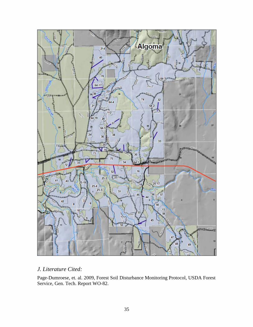
I. Soil Disturbance Monitoring Transects (15 ea blue):
35
J. Literature Cited: Page-Dumroese, et. al. 2009, Forest Soil Disturbance Monitoring Protocol, USDA Forest Service, Gen. Tech. Report WO-82.

36
Powers, R.F. and G.F. Ferrell. 1997. Moisture, nutrient, and insect constraints plantation growth: the "Garden of Eden" study. New Zealand J. For. Sci. 27
Rust, B. 2007. Soil Compaction Monitoring Protocol for the Shasta-Trinity National Forest, on file at Shasta-Trinity National Forest Headquarters.
USDA Forest Service, 1982 Shasta-Trinity National Forest, Soil Resource Inventory, Shasta-Trinity National Forest, Pacific Southwest Region
USDA Forest Service, 1982 Shasta-Trinity National Forest, Soil Management Handbook.
USDA Forest Service, 1994. Shasta-Trinity National Forest Land and Resource Management Plan, Shasta-Trinity National Forest, Pacific Southwest Region.
USDA Forest Service. 2000. Water Quality Management for National Forest System Lands in California - Best Management Practices. Pacific Southwest Region, Vallejo, California.
Young, D. 2012. Personal Communications on the Blacks Mountain Windrow Respreading Study. 2012