Soil Emissions and Removals Reporting in Portugal 2014 JRC LULUCCF Workshop 06/05/2014 Paulo...
20
Soil Emissions and Removals Reporting in Portugal 2014 JRC LULUCCF Workshop 06/05/2014 Paulo Canaveira
-
Upload
berniece-casey -
Category
Documents
-
view
217 -
download
3
Transcript of Soil Emissions and Removals Reporting in Portugal 2014 JRC LULUCCF Workshop 06/05/2014 Paulo...

Soil Emissions and Removals Reporting in Portugal 2014
JRC LULUCCF Workshop06/05/2014Paulo Canaveira


(Our) Objective for Soil Reporting (for now)
• Characterise emissions and removals in the soil pool associated with land-use changes – [changes in land remaining land are more
compicated to estimate]
• General Approach– Characterise average C Stock in each land-use – Emission Factor = difference in C stocks / 20 years
• Land remaining land = 0

Soil Data
• Lots of soil data but...– Mostly on Soil Organic
Matter• Almost no data on C
Stocks
– Not treated / consolidated into usable databases
4

(almost usable) Data Sources for Soil Data
• ICP Forests Level 2 Grid– 1995 (159 plots, forests and shrubland only)– 2005 (103 plots, forests and shrubland only)
• BioSoil – Based on ICP Forests Level 2 Grid– 1999 (102 plots, agriculture and grasslands only)
• LUCAS soil survey– 2009 (463 plots, almost all land uses)
• Total 828 plots

Challenges & “Solutions”
• Depth of soil sampling not constant– 0-20cm exist for all samples (828)– 20-40cm only exist in some (208)
• No data in LUCAS
– IPCC recommends 30cm (!)
• “Solution”– Data 0-40 cm used– “real data” for all plots where it exists– “gap filling” for missing data
• based on ratio 20-40 / 0-20 calculated on plots where both measurements exist (average 58%)

Challenges & “Solutions”
• Bulk density missing in many samples– Important to convert soil organic matter (%) into tonC/ha– No data in LUCAS samples– No data in Biosoil samples– Limited data in ICP Forests Level 2 samples
• “Solution”– “real data” for all plots where it exists– “gap filling” for missing data
• based on reference BD in JRC maps
Challenges & “Solutions”
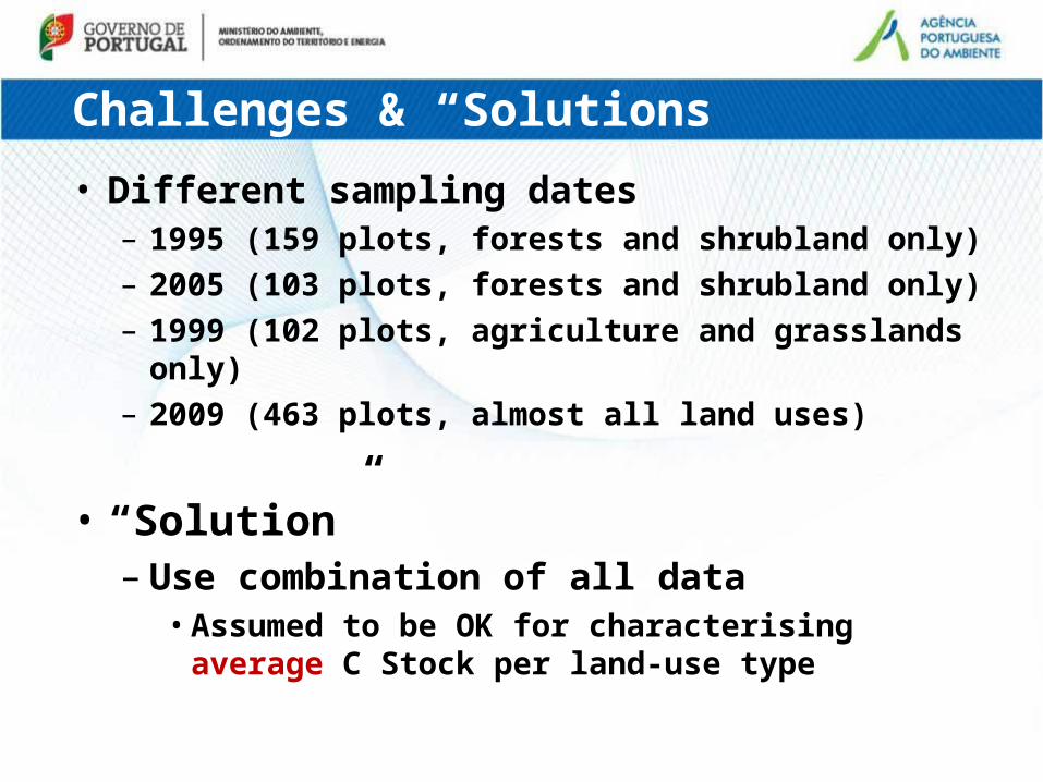
• Different sampling dates– 1995 (159 plots, forests and shrubland only)– 2005 (103 plots, forests and shrubland only)– 1999 (102 plots, agriculture and grasslands only)– 2009 (463 plots, almost all land uses)
• “Solution”– Use combination of all data
• Assumed to be OK for characterising average C Stock per land-use type

Challenges & “Solutions”
• Land-use data is missing for some plots– No data in LUCAS samples
• “Solution”– “gap filling” for missing data
• Use georeferenced location of the plot combined with land use map (2010)
Challenges & “Solutions”
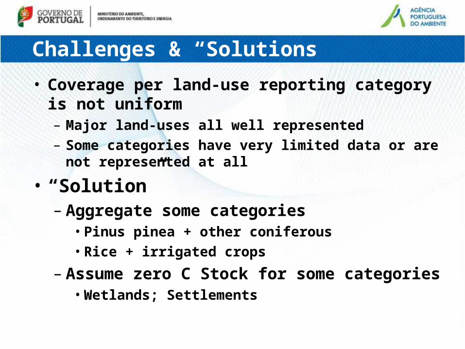
• Coverage per land-use reporting category is not uniform– Major land-uses all well represented– Some categories have very limited data or are not
represented at all
• “Solution”– Aggregate some categories
• Pinus pinea + other coniferous• Rice + irrigated crops
– Assume zero C Stock for some categories• Wetlands; Settlements

The Resulting Dataset
LUCAS
Legend KP 2009 1995/99 2005 Total01. Pinus pinaster 54 41 12 53 10702. Quercus suber 57 42 37 79 13603. Eucalyptus 46 21 8 29 7504. Quercus rotundifolia 30 25 23 48 7805. Other quercus 10 4 4 8 1806. Other broadleaves 5 19 17 36 4107. Pinus pinea + 08. Other coniferous 4 2 1 3 709. Rain-fed crops 78 21 21 9910. Irrigated crops + 11. Rice 22 26 26 4812. Vineyards 22 14 14 3613. Olive 39 12 12 5114. Other permanent 11 11 11 2215. Grassland 42 18 18 6016. Wetlands17. Settlements 7 718. Shrubland 36 5 1 6 4219. OtherTotal 463 261 103 364 828
ICP/BiosoilNo. Plots (measured)
Source
Total

The Resulting Dataset
LUCAS
Legend KP 2009 1995/99 2005 Average01. Pinus pinaster 111 116 110 115 11302. Quercus suber 73 67 56 62 6603. Eucalyptus 119 65 67 65 9804. Quercus rotundifolia 65 68 61 65 6505. Other quercus 92 81 91 86 8906. Other broadleaves 113 103 110 106 10707. Pinus pinea + 08. Other coniferous 117 35 113 61 9309. Rain-fed crops 63 46 46 5910. Irrigated crops + 11. Rice 61 67 67 6412. Vineyards 57 40 40 5113. Olive 77 53 53 7114. Other permanent 70 42 42 5615. Grassland 68 47 47 6116. Wetlands17. Settlements 87 8718. Shrubland 110 82 137 91 10719. OtherNational Average 82 71 76 73 78
Average C (0-40cm) ton/ha(measured + estimated)
Source
ICP/Biosoil Total Average

Used Soil DatasetLegenda KP Min <95% Average >95% Max
01. Pinus pinaster 10 96 113 129 41302. Quercus suber 13 61 66 72 20603. Eucalyptus 16 80 98 117 44404. Quercus rotundifolia 25 58 65 71 19005. Other quercus 20 60 89 119 23806. Other broadleaves 14 85 107 129 27107. Pinus pinea 19 34 93 152 22308. Other coniferous 19 34 93 152 22309. Rain-fed crops 13 51 59 68 25510. Irrigated crops 16 52 64 76 20411. Rice 16 52 64 76 20412. Vineyards 8 36 51 66 20613. Olive 11 53 71 89 38114. Other permanent 13 38 56 73 16415. Grassland 17 52 61 71 20816. Wetlands17. Settlements18. Shrubland 13 79 107 135 43119. Other 8 36 51 66 206
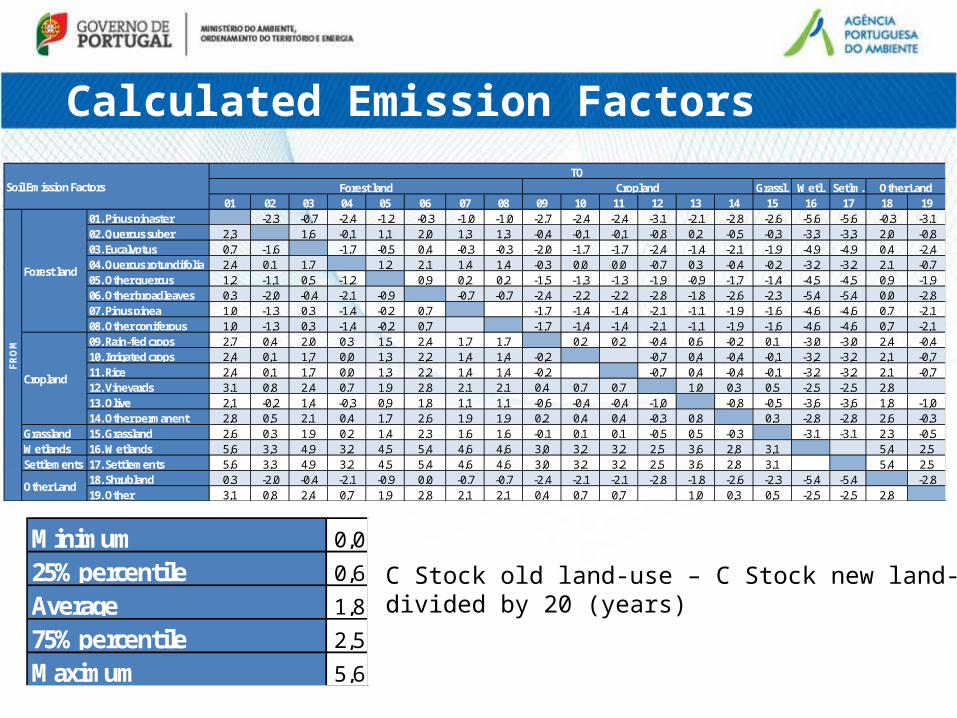
Calculated Emission Factors
Grassl. Wetl. Setlm.01 02 03 04 05 06 07 08 09 10 11 12 13 14 15 16 17 18 19
01. Pinus pinaster -2,3 -0,7 -2,4 -1,2 -0,3 -1,0 -1,0 -2,7 -2,4 -2,4 -3,1 -2,1 -2,8 -2,6 -5,6 -5,6 -0,3 -3,102. Quercus suber 2,3 1,6 -0,1 1,1 2,0 1,3 1,3 -0,4 -0,1 -0,1 -0,8 0,2 -0,5 -0,3 -3,3 -3,3 2,0 -0,803. Eucalyptus 0,7 -1,6 -1,7 -0,5 0,4 -0,3 -0,3 -2,0 -1,7 -1,7 -2,4 -1,4 -2,1 -1,9 -4,9 -4,9 0,4 -2,404. Quercus rotundifolia 2,4 0,1 1,7 1,2 2,1 1,4 1,4 -0,3 0,0 0,0 -0,7 0,3 -0,4 -0,2 -3,2 -3,2 2,1 -0,705. Other quercus 1,2 -1,1 0,5 -1,2 0,9 0,2 0,2 -1,5 -1,3 -1,3 -1,9 -0,9 -1,7 -1,4 -4,5 -4,5 0,9 -1,906. Other broadleaves 0,3 -2,0 -0,4 -2,1 -0,9 -0,7 -0,7 -2,4 -2,2 -2,2 -2,8 -1,8 -2,6 -2,3 -5,4 -5,4 0,0 -2,807. Pinus pinea 1,0 -1,3 0,3 -1,4 -0,2 0,7 -1,7 -1,4 -1,4 -2,1 -1,1 -1,9 -1,6 -4,6 -4,6 0,7 -2,108. Other coniferous 1,0 -1,3 0,3 -1,4 -0,2 0,7 -1,7 -1,4 -1,4 -2,1 -1,1 -1,9 -1,6 -4,6 -4,6 0,7 -2,109. Rain-fed crops 2,7 0,4 2,0 0,3 1,5 2,4 1,7 1,7 0,2 0,2 -0,4 0,6 -0,2 0,1 -3,0 -3,0 2,4 -0,410. Irrigated crops 2,4 0,1 1,7 0,0 1,3 2,2 1,4 1,4 -0,2 -0,7 0,4 -0,4 -0,1 -3,2 -3,2 2,1 -0,711. Rice 2,4 0,1 1,7 0,0 1,3 2,2 1,4 1,4 -0,2 -0,7 0,4 -0,4 -0,1 -3,2 -3,2 2,1 -0,712. Vineyards 3,1 0,8 2,4 0,7 1,9 2,8 2,1 2,1 0,4 0,7 0,7 1,0 0,3 0,5 -2,5 -2,5 2,813. Olive 2,1 -0,2 1,4 -0,3 0,9 1,8 1,1 1,1 -0,6 -0,4 -0,4 -1,0 -0,8 -0,5 -3,6 -3,6 1,8 -1,014. Other permanent 2,8 0,5 2,1 0,4 1,7 2,6 1,9 1,9 0,2 0,4 0,4 -0,3 0,8 0,3 -2,8 -2,8 2,6 -0,3
Grassland 15. Grassland 2,6 0,3 1,9 0,2 1,4 2,3 1,6 1,6 -0,1 0,1 0,1 -0,5 0,5 -0,3 -3,1 -3,1 2,3 -0,5Wetlands 16. Wetlands 5,6 3,3 4,9 3,2 4,5 5,4 4,6 4,6 3,0 3,2 3,2 2,5 3,6 2,8 3,1 5,4 2,5Settlements 17. Settlements 5,6 3,3 4,9 3,2 4,5 5,4 4,6 4,6 3,0 3,2 3,2 2,5 3,6 2,8 3,1 5,4 2,5
18. Shrubland 0,3 -2,0 -0,4 -2,1 -0,9 0,0 -0,7 -0,7 -2,4 -2,1 -2,1 -2,8 -1,8 -2,6 -2,3 -5,4 -5,4 -2,819. Other 3,1 0,8 2,4 0,7 1,9 2,8 2,1 2,1 0,4 0,7 0,7 1,0 0,3 0,5 -2,5 -2,5 2,8
Soil Emission FactorsTO
Forest land Cropland Other Land
FR
OM
Forest land
Cropland
Other Land
Minimum 0,025% percentile 0,6Average 1,875% percentile 2,5Maximum 5,6
C Stock old land-use – C Stock new land-usedivided by 20 (years)
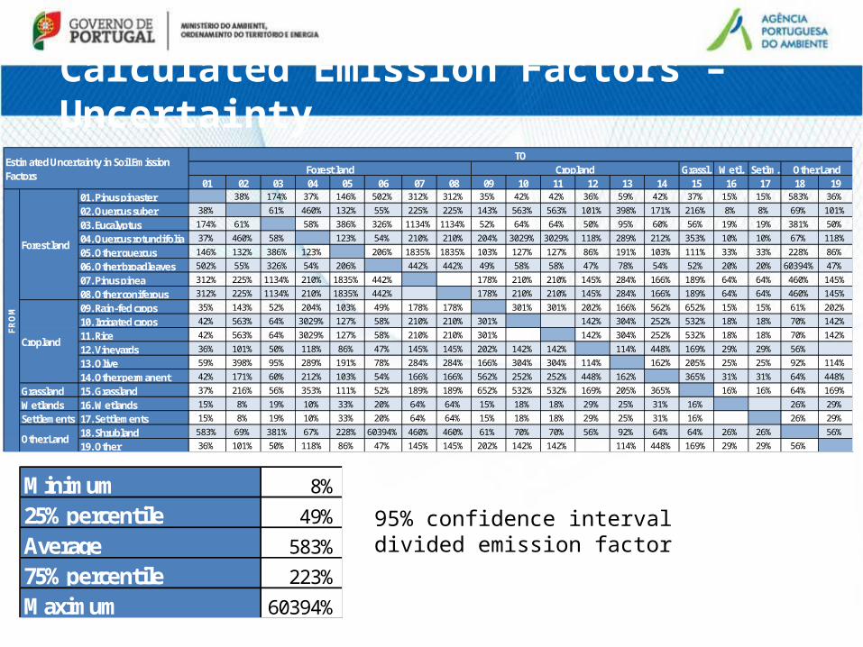
Calculated Emission Factors – Uncertainty
Grassl. Wetl. Setlm.01 02 03 04 05 06 07 08 09 10 11 12 13 14 15 16 17 18 19
01. Pinus pinaster 38% 174% 37% 146% 502% 312% 312% 35% 42% 42% 36% 59% 42% 37% 15% 15% 583% 36%
02. Quercus suber 38% 61% 460% 132% 55% 225% 225% 143% 563% 563% 101% 398% 171% 216% 8% 8% 69% 101%
03. Eucalyptus 174% 61% 58% 386% 326% 1134% 1134% 52% 64% 64% 50% 95% 60% 56% 19% 19% 381% 50%
04. Quercus rotundifolia 37% 460% 58% 123% 54% 210% 210% 204% 3029% 3029% 118% 289% 212% 353% 10% 10% 67% 118%
05. Other quercus 146% 132% 386% 123% 206% 1835% 1835% 103% 127% 127% 86% 191% 103% 111% 33% 33% 228% 86%
06. Other broadleaves 502% 55% 326% 54% 206% 442% 442% 49% 58% 58% 47% 78% 54% 52% 20% 20% 60394% 47%
07. Pinus pinea 312% 225% 1134% 210% 1835% 442% 178% 210% 210% 145% 284% 166% 189% 64% 64% 460% 145%
08. Other coniferous 312% 225% 1134% 210% 1835% 442% 178% 210% 210% 145% 284% 166% 189% 64% 64% 460% 145%
09. Rain-fed crops 35% 143% 52% 204% 103% 49% 178% 178% 301% 301% 202% 166% 562% 652% 15% 15% 61% 202%
10. Irrigated crops 42% 563% 64% 3029% 127% 58% 210% 210% 301% 142% 304% 252% 532% 18% 18% 70% 142%
11. Rice 42% 563% 64% 3029% 127% 58% 210% 210% 301% 142% 304% 252% 532% 18% 18% 70% 142%
12. Vineyards 36% 101% 50% 118% 86% 47% 145% 145% 202% 142% 142% 114% 448% 169% 29% 29% 56%
13. Olive 59% 398% 95% 289% 191% 78% 284% 284% 166% 304% 304% 114% 162% 205% 25% 25% 92% 114%
14. Other permanent 42% 171% 60% 212% 103% 54% 166% 166% 562% 252% 252% 448% 162% 365% 31% 31% 64% 448%
Grassland 15. Grassland 37% 216% 56% 353% 111% 52% 189% 189% 652% 532% 532% 169% 205% 365% 16% 16% 64% 169%
Wetlands 16. Wetlands 15% 8% 19% 10% 33% 20% 64% 64% 15% 18% 18% 29% 25% 31% 16% 26% 29%
Settlements 17. Settlements 15% 8% 19% 10% 33% 20% 64% 64% 15% 18% 18% 29% 25% 31% 16% 26% 29%
18. Shrubland 583% 69% 381% 67% 228% 60394% 460% 460% 61% 70% 70% 56% 92% 64% 64% 26% 26% 56%
19. Other 36% 101% 50% 118% 86% 47% 145% 145% 202% 142% 142% 114% 448% 169% 29% 29% 56%
Estimated Uncertainty in Soil Emission Factors
TOForest land Cropland Other Land
FR
OM
Forest land
Cropland
Other Land
Minimum 8%25% percentile 49%Average 583%75% percentile 223%Maximum 60394%
95% confidence intervaldivided emission factor
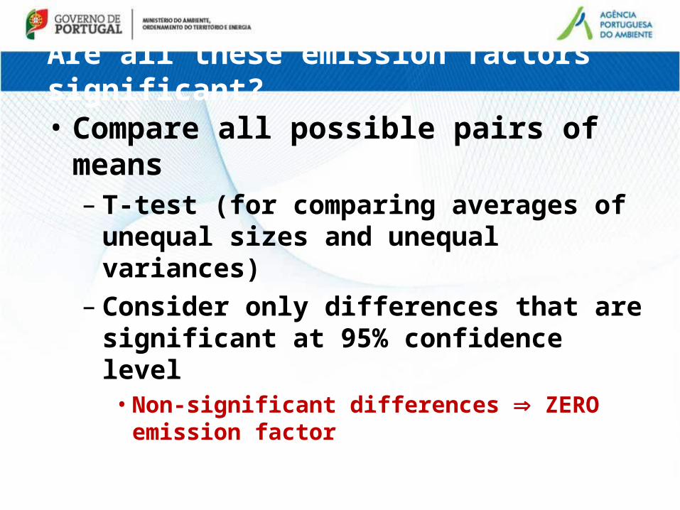
Are all these emission factors significant?
• Compare all possible pairs of means– T-test (for comparing averages of unequal sizes
and unequal variances)– Consider only differences that are significant at
95% confidence level• Non-significant differences ZERO emission factor
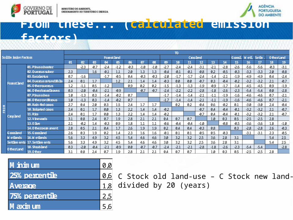
From these... (calculated emission factors)
Grassl. Wetl. Setlm.01 02 03 04 05 06 07 08 09 10 11 12 13 14 15 16 17 18 19
01. Pinus pinaster -2,3 -0,7 -2,4 -1,2 -0,3 -1,0 -1,0 -2,7 -2,4 -2,4 -3,1 -2,1 -2,8 -2,6 -5,6 -5,6 -0,3 -3,102. Quercus suber 2,3 1,6 -0,1 1,1 2,0 1,3 1,3 -0,4 -0,1 -0,1 -0,8 0,2 -0,5 -0,3 -3,3 -3,3 2,0 -0,803. Eucalyptus 0,7 -1,6 -1,7 -0,5 0,4 -0,3 -0,3 -2,0 -1,7 -1,7 -2,4 -1,4 -2,1 -1,9 -4,9 -4,9 0,4 -2,404. Quercus rotundifolia 2,4 0,1 1,7 1,2 2,1 1,4 1,4 -0,3 0,0 0,0 -0,7 0,3 -0,4 -0,2 -3,2 -3,2 2,1 -0,705. Other quercus 1,2 -1,1 0,5 -1,2 0,9 0,2 0,2 -1,5 -1,3 -1,3 -1,9 -0,9 -1,7 -1,4 -4,5 -4,5 0,9 -1,906. Other broadleaves 0,3 -2,0 -0,4 -2,1 -0,9 -0,7 -0,7 -2,4 -2,2 -2,2 -2,8 -1,8 -2,6 -2,3 -5,4 -5,4 0,0 -2,807. Pinus pinea 1,0 -1,3 0,3 -1,4 -0,2 0,7 -1,7 -1,4 -1,4 -2,1 -1,1 -1,9 -1,6 -4,6 -4,6 0,7 -2,108. Other coniferous 1,0 -1,3 0,3 -1,4 -0,2 0,7 -1,7 -1,4 -1,4 -2,1 -1,1 -1,9 -1,6 -4,6 -4,6 0,7 -2,109. Rain-fed crops 2,7 0,4 2,0 0,3 1,5 2,4 1,7 1,7 0,2 0,2 -0,4 0,6 -0,2 0,1 -3,0 -3,0 2,4 -0,410. Irrigated crops 2,4 0,1 1,7 0,0 1,3 2,2 1,4 1,4 -0,2 -0,7 0,4 -0,4 -0,1 -3,2 -3,2 2,1 -0,711. Rice 2,4 0,1 1,7 0,0 1,3 2,2 1,4 1,4 -0,2 -0,7 0,4 -0,4 -0,1 -3,2 -3,2 2,1 -0,712. Vineyards 3,1 0,8 2,4 0,7 1,9 2,8 2,1 2,1 0,4 0,7 0,7 1,0 0,3 0,5 -2,5 -2,5 2,813. Olive 2,1 -0,2 1,4 -0,3 0,9 1,8 1,1 1,1 -0,6 -0,4 -0,4 -1,0 -0,8 -0,5 -3,6 -3,6 1,8 -1,014. Other permanent 2,8 0,5 2,1 0,4 1,7 2,6 1,9 1,9 0,2 0,4 0,4 -0,3 0,8 0,3 -2,8 -2,8 2,6 -0,3
Grassland 15. Grassland 2,6 0,3 1,9 0,2 1,4 2,3 1,6 1,6 -0,1 0,1 0,1 -0,5 0,5 -0,3 -3,1 -3,1 2,3 -0,5Wetlands 16. Wetlands 5,6 3,3 4,9 3,2 4,5 5,4 4,6 4,6 3,0 3,2 3,2 2,5 3,6 2,8 3,1 5,4 2,5Settlements 17. Settlements 5,6 3,3 4,9 3,2 4,5 5,4 4,6 4,6 3,0 3,2 3,2 2,5 3,6 2,8 3,1 5,4 2,5
18. Shrubland 0,3 -2,0 -0,4 -2,1 -0,9 0,0 -0,7 -0,7 -2,4 -2,1 -2,1 -2,8 -1,8 -2,6 -2,3 -5,4 -5,4 -2,819. Other 3,1 0,8 2,4 0,7 1,9 2,8 2,1 2,1 0,4 0,7 0,7 1,0 0,3 0,5 -2,5 -2,5 2,8
Soil Emission FactorsTO
Forest land Cropland Other Land
FR
OM
Forest land
Cropland
Other Land
Minimum 0,025% percentile 0,6Average 1,875% percentile 2,5Maximum 5,6
C Stock old land-use – C Stock new land-usedivided by 20 (years)

...to these (calculated AND significant emission factors)
Minimum 0,025% percentile 0,6Average 1,875% percentile 2,5Maximum 5,6
C Stock old land-use – C Stock new land-usedivided by 20 (years)
Grassl. Wetl. Setlm.01 02 03 04 05 06 07 08 09 10 11 12 13 14 15 16 17 18 19
01. Pinus pinaster -2,3 -2,4 -2,7 -2,4 -2,4 -3,1 -2,1 -2,8 -2,6 -5,6 -5,6 -3,102. Quercus suber 2,3 1,6 2,0 -3,3 -3,3 2,003. Eucalyptus -1,6 -1,7 -2,0 -1,7 -1,7 -2,4 -1,4 -2,1 -1,9 -4,9 -4,9 -2,404. Quercus rotundifolia 2,4 1,7 2,1 -3,2 -3,2 2,105. Other quercus -1,9 -4,5 -4,5 -1,906. Other broadleaves -2,0 -2,1 -2,4 -2,2 -2,2 -2,8 -1,8 -2,6 -2,3 -5,4 -5,4 -2,807. Pinus pinea -4,6 -4,608. Other coniferous -4,6 -4,609. Rain-fed crops 2,7 2,0 2,4 -3,0 -3,0 2,410. Irrigated crops 2,4 1,7 2,2 -3,2 -3,2 2,111. Rice 2,4 1,7 2,2 -3,2 -3,2 2,112. Vineyards 3,1 2,4 1,9 2,8 -2,5 -2,5 2,813. Olive 2,1 1,4 1,8 -3,6 -3,6 1,814. Other permanent 2,8 2,1 2,6 -2,8 -2,8 2,6
Grassland 15. Grassland 2,6 1,9 2,3 -3,1 -3,1 2,3Wetlands 16. Wetlands 5,6 3,3 4,9 3,2 4,5 5,4 4,6 4,6 3,0 3,2 3,2 2,5 3,6 2,8 3,1 5,4 2,5Settlements 17. Settlements 5,6 3,3 4,9 3,2 4,5 5,4 4,6 4,6 3,0 3,2 3,2 2,5 3,6 2,8 3,1 5,4 2,5
18. Shrubland -2,0 -2,1 -2,4 -2,1 -2,1 -2,8 -1,8 -2,6 -2,3 -5,4 -5,4 -2,819. Other 3,1 2,4 1,9 2,8 -2,5 -2,5 2,8
TOForest land Cropland Other Land
Forest land
Cropland
Other Land
FR
OM
Soil Emission Factors
1,4
2,1
3,0
3,2
5,6

Minimum 8%25% percentile 49%Median 118%75% percentile 223%Maximum 60394%
Used Emission Factors – Uncertainty
95% confidence intervaldivided emission factor
Grassl. Wetl. Setlm.01 02 03 04 05 06 07 08 09 10 11 12 13 14 15 16 17 18 19
01. Pinus pinaster 38% 37% 35% 42% 42% 36% 59% 42% 37% 15% 15% 36%
02. Quercus suber 38% 61% 55% 8% 8% 69%
03. Eucalyptus 61% 58% 52% 64% 64% 50% 95% 60% 56% 19% 19% 50%
04. Quercus rotundifolia 37% 58% 54% 10% 10% 67%
05. Other quercus 86% 33% 33% 86%
06. Other broadleaves 55% 54% 49% 58% 58% 47% 78% 54% 52% 20% 20% 47%
07. Pinus pinea 64% 64%
08. Other coniferous 64% 64%
09. Rain-fed crops 35% 52% 49% 15% 15% 61%
10. Irrigated crops 42% 64% 58% 18% 18% 70%
11. Rice 42% 64% 58% 18% 18% 70%
12. Vineyards 36% 50% 86% 47% 29% 29% 56%
13. Olive 59% 95% 78% 25% 25% 92%
14. Other permanent 42% 60% 54% 31% 31% 64%
Grassland 15. Grassland 37% 56% 52% 16% 16% 64%
Wetlands 16. Wetlands 15% 8% 19% 10% 33% 20% 64% 64% 15% 18% 18% 29% 25% 31% 16% 26% 29%
Settlements 17. Settlements 15% 8% 19% 10% 33% 20% 64% 64% 15% 18% 18% 29% 25% 31% 16% 26% 29%
18. Shrubland 69% 67% 61% 70% 70% 56% 92% 64% 64% 26% 26% 56%
19. Other 36% 50% 86% 47% 29% 29% 56%
Estimated Uncertainty in Soil Emission Factors
TOForest land Cropland Other Land
FR
OM
Forest land
Cropland
Other Land
8%
25%
42%
60%
95%

Impact of Soil EF in Accounted Numbers
KP Accounting no soil3.3 Afforestation & Reforestation not harvested -25.380
3.3 Afforestation & Reforestation harvested 0
3.3 Deforestation 2.130
3.4 Forest Management -4.034
3.4 Cropland Management -1.340
3.4 Grassland Management -1.336
Total LULUCF 1st CP -29.961Annual -5.992
all EF-35.506
0
10.416
-4.034
-17.562
-6.954
-53.640-10.728
signficant EF-33.276
0
9.932
-4.034
-17.143
-6.542
-51.062-10.212