Software from an Industry Leader The best hydrogeologic ... · PDF filemodels in true 3D...
9
Software from an Industry Leader GMS is developed by Aquaveo, an engineering services company with many years of experience developing groundwater modeling solutions. ✓ Step-by-step tutorials and how-to videos ✓ Online community forum and product documentation ✓ Phone and email technical support ✓ Regularly scheduled training courses taught by expert modelers ✓ On-site training available ✓ Professional consulting services The best hydrogeologic modeling software! Get a quote now with ARRH: a [email protected] +55 (11) 97263-8002 Reseller in Brazil
Transcript of Software from an Industry Leader The best hydrogeologic ... · PDF filemodels in true 3D...

Software from an Industry Leader
GMS is developed by Aquaveo, an engineering
services company with many years of
experience developing groundwater modeling
solutions.
✓ Step-by-step tutorials and how-to videos
✓ Online community forum and product
documentation
✓ Phone and email technical support
✓ Regularly scheduled training courses
taught by expert modelers
✓ On-site training available
✓ Professional consulting services
The best hydrogeologic
modeling software!
Get a quote now with ARRH:
+55 (11) 97263-8002
Reseller in Brazil
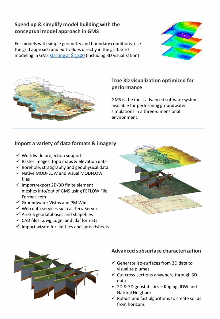
Speed up & simplify model building with the conceptual model approach in GMS
For models with simple geometry and boundary conditions, use the grid approach and edit values directly in the grid. Grid modeling in GMS starting at $1,800 (including 3D visualization)
True 3D visualization optimized for performance
GMS is the most advanced software system available for performing groundwater simulations in a three-dimensional environment.
Import a variety of data formats & imagery
Advanced subsurface characterization
✓ Generate iso-surfaces from 3D data to visualize plumes
✓ Cut cross-sections anywhere through 3D data
✓ 2D & 3D geostatistics – Kriging, IDW and Natural Neighbor
✓ Robust and fast algorithms to create solids from horizons
✓ Worldwide projection support✓ Raster images, topo maps & elevation data✓ Borehole, stratigraphy and geophysical data✓ Native MODFLOW and Visual MODFLOW
files✓ Import/export 2D/3D finite element
meshes into/out of GMS using FEFLOW File Format .fem
✓ Groundwater Vistas and PM Win✓ Web data services such as TerraServer✓ ArcGIS geodatabases and shapefiles✓ CAD files: .dwg, .dgn, and .dxf formats
✓ Import wizard for .txt files and spreadsheets.

MODPATHParticle Tracking with
MODFLOW & GMS
MODPATH is a particle tracking
code that is used in
conjunction with MODFLOW.
After running a MODFLOW
simulation, the user can
designate the location of a set
of particles. The particles are
GMS provides a custom interface to the MODPATH model offering a simple way to set model
parameters and a graphical user interface to run the model and visualize the results. Gather
background data from a variety of sources from GIS to CAD and access online data from
numerous databases of maps, images, and elevation data. GMS allows you to interact with
models in true 3D taking advantage of optimized OpenGL graphics and to create photo -realistic
renderings and animations for PowerPoint, print, and web presentations .
MODPATH was developed by the U.S. Geological Survey. Version 5.0 of MODPATH is supported in
GMS. The version of MODPATH distributed with GMS is the original public domain version
distributed by the USGS, with minor modifications to accommodate GMS.
then tracked through time assuming they are transported by advection using the flow field
computed by MODFLOW. Particles can be tracked either forward in time or backward in time.
Because of the user-friendly interface in GMS, an intimate knowledge of MODPATH is not
required to effectively do particle tracking in GMS. Particle tracking analyses are particularly
useful for delineating capture zones or areas of influence for wells.

MT3DMSTransport Modeling with
MODFLOW & GMS
MT3DMS is a modular three-
dimensional transport model
for the simulation of advection,
dispersion, and chemical
reactions of dissolved
constituents in groundwater
systems. MT3DMS uses
GMS provides a custom interface to the MT3DMS model offering a simple way to set model
parameters and a graphical user interface to run the model and visualize the results. Gather
background data from a variety of sources from GIS to CAD and access online data from
numerous databases of maps, images, and elevation data. GMS allows you to interact with
models in true 3D taking advantage of optimized OpenGL graphics and to create photo -realistic
renderings and animations for PowerPoint, print, and web presentations.
MT3DMS is a newer version of the MT3D model distributed with earlier versions of GMS.
MT3DMS differs from MT3D in that it allows for multi-species transport, supports additional
solvers, and allows for cell-by-cell input of all model parameters.
a modular structure similar to the structure utilized by MODFLOW. MT3DMS is used in
conjunction with MODFLOW in a two step flow and transport simulation. Heads and cell -by-cell
flux terms are computed by MODFLOW during the flow simulation and are written to a specially
formatted file. This file is then read by MT3DMS and utilized as the flow field for the transport
portion of the simulation.

RT3DReactive Transport
Modeling with GMS
RT3D is a multi-species
reactive transport model
developed by the Battelle
Pacific Northwest National
Laboratory. RT3D is a modified
version of MT3DMS that utilizes
GMS provides a custom interface to the RT3D and SEAWAT models offering a simple way to set
model parameters and a graphical user interface to run the model and visualize the results.
Gather background data from a variety of sources from GIS to CAD and access online data
from numerous databases of maps, images, and elevation data. GMS allows you to interact with
models in true 3D taking advantage of optimized OpenGL graphics and to create photo -realistic
renderings and animations for PowerPoint, print, and web presentations.
alternate Chemical Reaction packages. Numerous pre-defined reactions are available and an
option is provided for creating user-defined reactions. RT3D is well-suited for simulating
natural attenuation and bioremediation.
SEAWAT3D Variable-density
Groundwater Flow Coupled
with Multi-species Solute &
Heat Transport
SEAWAT is a three dimensional
variable density groundwater
flow and transport model
GMS supports SEAWAT as a pre- and post-processor. The interface to SEAWAT relies on the
interface to MODFLOW and MT3DMS. The input data for SEAWAT is generated by GMS and saved
to a set of files including a MODFLOW model, an MT3D model if transport is used, and a SEAWAT
model pointing to the MODFLOW and MT3D model's package files. These files are then read by
SEAWAT and executed. SEAWAT uses the MODFLOW and MT3D interfaces for boundary condition
display and for post-processing.
developed by the USGS based on MODFLOW and MT3DMS. SEAWAT v4 is based on MODFLOW
2000 and MT3DMS 5.2. SEAWAT includes two additional packages: Variable -Density Flow (VDF)
and Viscosity (VSC).

PHT3DReactive Transport
Modeling with GMS
PHT3D is a multicomponent
transport model for three-
dimensional reactive transport
in saturated porous media.
PHT3D is a combination of
MT3DMS and PHREEQC-2. The
PHREEQC component allows for a variety of low temperature aqueous geochemical reactions.
SEAM3DReactive Transport
Modeling with GMS
SEAM3D is a reactive transport
model used to simulate complex
biodegradation problems
involving multiple substrates
and multiple electron
acceptors. It is based on the
MT3DMS code. In addition to the regular MT3DMS modules, SEAM3D includes a Biodegradation
package and NAPL Dissolution package. SEAM3D was developed by Mark Widdowson at Virginia
Tech University.
MOADEMAnalytic Element Modeling with GMS
The MODAEM model is developed by Vic
Kelson of Wittman Hydro Planning
Associates in Bloomington, Indiana. Unlike
finite difference and finite element models,
analytic element models do not require a
discretization of the problem domain. Rather
the model is completely defined by boundary
conditions, source/sink terms, and material property zones represented by points, polylines (arcs), and
polygons. Since GMS users are already in the habit of building conceptual models in the Map Module using
points, arcs, and polygons, analytic element modeling is a natural fit for GMS.

FEFLOWFinite Element Groundwater Flow &
Transport in GMS
Import and export 2D and 3D finite element
meshes into and out of GMS using the FEFLOW
ASCII Model File Format (*.fem). This makes it
possible to build a mesh in GMS and export it
so it can be used to build a model in FEFLOW.
FEMWATERFinite Element Groundwater Flow &
Contaminant Transport in GMS
GMS provides a custom interface to the
FEMWATER model offering a simple way to set
model parameters and a graphical user interface
to run the model and visualize the results. Gather
background data from a variety of sources from
Also, the mesh from a FEFLOW model can be exported from FEFLOW and imported into GMS for viewing, examination and post-processing.
GIS to CAD and access online data from numerous databases of maps, images, and elevation
data. GMS allows you to interact with models in true 3D taking advantage of optimized OpenGL
graphics and to create photo-realistic renderings and animations for PowerPoint, print, and web presentations.
SEEP2DEarth Dam and Levee
Analysis with GMS
SEEP2D is a two-dimensional finite element groundwater model developed by Fred Tracy of the
U.S. Army Engineer Waterways Experiment Station (WES). SEEP2D is designed to be used on
profile models (XZ models) such as cross-sections of earth dams or levees .
SEEP2D can be used for either confined or unconfined steady state flow models. For
unconfined models, both saturated and unsaturated flow is simulated. The phreatic surface
can be displayed by plotting the contour line at where pressure head equals zero .
Contours of total head (equipotential lines) and flow vectors can be plotted. An option is also
available for computing flow potential values at the nodes. These values can be used to plot
flow lines. Together with the equipotential lines, the flow lines can be used to plot a flow net.

GMS 10.3 System Requirements
✓ Operating System : Windows® XP (Limited support), Windows Vista®, Windows 7, Windows 8/8. 1 or Windows 10
✓ RAM : 4 GB (8GB or more recommended)
✓ CPU: GMS software is CPU intensive. We recommend the fastest CPU your budget allows.
✓ Graphics Card : For all display features to be enabled, OpenGL 1.5 or higher must be supported. The use of a dedicated
graphics card is strongly recommended. Integrated graphics cards are often problematic.
✓ Display Resolution : 1920 x 1080 or greater
GMS 10.3 Editions & Pricing Community MODFLOW I MODFLOW II MODFLOW III Premium
GMS Core Components
- Ferramentas de Grid 3D ✓* ✓ ✓ ✓ ✓
- Ferramentas de Animação 3D ✓ ✓ ✓ ✓ ✓
- Ferramentas de Modelagem Conceitual ✓ ✓ ✓ ✓
- Mapas Online
Add-on ✓ ✓ ✓
- Ferramentas de GIS ✓ ✓ ✓ ✓
- CAD / Imagens / Suporte a DEM
✓ ✓ ✓ ✓
- Ferramentas de Anotações ✓ ✓ ✓ ✓
- Instalação 32 ou 64-bit ✓ ✓ ✓ ✓ ✓
MODFLOW Modeling
Traditional Grid
- Modelo & Interface MODFLOW ✓* ✓ ✓ ✓ ✓
- Modelo & Interface MODFLOW-LGR
Add-on ✓ ✓ ✓
- ZoneBudget Utility ✓ ✓ ✓ ✓
- Modelo & Interface MODPATH
✓ ✓ ✓ ✓
- Modelo & Interface MT3DMS ✓ ✓ ✓ ✓
- Modelo & Interface MT3D-USGS
✓ ✓ ✓ ✓
- Modelo & Interface RT3D Add-on ✓ ✓ ✓
- Modelo & Interface SEAWAT
Add-on ✓ ✓ ✓
- Modelo & Interface PHT3D Add-on ✓ ✓ ✓
- Modelo & Interface SEAM3D
Add-on Add-on Add-on ✓
Unstructured Grid
- Modelo & Interface MODFLOW-USG ✓ ✓ ✓ ✓
- mod-PATH3DU Model & Interface
✓ ✓ ✓ ✓
MODFLOW Utilities
- PEST - Single Core Add-on ✓ ✓ ✓
• PEST Paralelo - Multi Core
Add-on ✓ ✓ ✓
- Solucionador SAMG Std. & USG (serie) Add-on Add-on - -
- Solucionador SAMG Std. & USG (paralelo)
Add-on Add-on ✓ ✓
Site Characterization
- Geoestatistica & Ferrramentas para Dados Dispersos Add-on ✓ ✓ ✓
- Ferramentas para Caracterização do Subssolo
Add-on Add-on ✓ ✓
• Ferramentas para Modelagem Estocástica Add-on Add-on ✓ ✓
• T-PROGS
Add-on Add-on ✓ ✓
Additional Models
- Modelo & Interface MODAEM Add-on Add-on Add-on ✓
- Ferramentas para Malha de Elementos Finitos
Add-on Add-on Add-on ✓
• Modelo & Interface FEMWATER Add-on Add-on Add-on ✓
• Modelo & Interface SEEP2D
Add-on Add-on Add-on ✓
ArcGIS Extensions
- Analisador de Águas Aubsterrâneas para ArcGIS ✓ ✓ ✓ ✓
- Analisador de MODFLOW para ArcGIS
Add-on Add-on ✓ ✓
- Analisador de Subssolo para ArcGIS Add-on Add-on Add-on ✓
* Limitado por tamanho do grid períodos de estresse.

The best hydrogeologic
modeling software!
Get a quote now with ARRH:
+55 (11) 97263-8002
Reseller in Brazil