SNH Commissioned Report: Historical Survey of the River … · COMMISSIONED REPORT Summary....
59
COMMISSIONED REPORT For further information on this report please contact: East Highland Area Office Scottish Natural Heritage Fodderty Way, Dingwall Business Park Dingwall IV15 9XB Tel: 01349 865333 This report should be quoted as: Mountain Environments (2000). Historical Survey of the River Conon. Scottish Natural Heritage Commissioned Report F00PA40. This report or any part of it should not be reproduced without the permission of Scottish Natural Heritage which will not be unreasonably withheld. The views expressed by the author(s) of this report should not be taken as the views and policies of Scottish Natural Heritage. © Scottish Natural Heritage 2002. Historical Survey of the River Conon Report No. F00PA40
Transcript of SNH Commissioned Report: Historical Survey of the River … · COMMISSIONED REPORT Summary....

C O M M I S S I O N E D R E P O R T
For further information on this report please contact:
East Highland Area Office
Scottish Natural Heritage
Fodderty Way, Dingwall Business Park
Dingwall IV15 9XB
Tel: 01349 865333
This report should be quoted as:
Mountain Environments (2000). Historical Survey of the River Conon.
Scottish Natural Heritage Commissioned Report F00PA40.
This report or any part of it should not be reproduced without the permission of Scottish Natural Heritage
which will not be unreasonably withheld. The views expressed by the author(s) of this report should not be
taken as the views and policies of Scottish Natural Heritage.
© Scottish Natural Heritage 2002.
Historical Survey of the
River Conon
Report No. F00PA40


Historical Survey of the
River Conon
Report No. F00PA40
Abstract
Keywords: Conon, floodplain habitats, hydro-schemes, floodbanks, hydrology, floods
i) The floodplain of the River Conon is a residual alluvial woodland site, which has been
incorporated into the Wet Woods LIFE Project run by the Caledonian Partnership. The river
catchment has undergone numerous artificial modifications affecting the naturalness of the
river and its floodplain. These modifications include the construction of upstream reservoirs
for hydro-power generation, floodbanks to prevent flooding of the riparian areas and
drainage of the floodplain and surrounding hills for improved arable farming, grazing and
commercial forestry.
ii) Flow data from the River Conon catchment were collated to describe any hydrological
changes which occurred over the period of record. Since 1829 flood events causing
inundation of the Conon floodplain occurred approximately once every 10 years both prior to
and following the construction of the hydroelectric scheme. This suggests that the
hydroelectric scheme has not altered the frequency of the higher magnitude floods however
the increase in flood frequency in the 1980s and 1990s is not evident in the flood chronology
and could be attributable to the hydroelectric scheme.
iii) The flood embankments confine the mean annual flood on the Conon however the largest
flood events still inundate the floodplain. If the flood banks were removed then the Conon
floodplain would be subjected to more frequent flooding.
iv) Changes in the habitat mosaic below Dunglass Island are dominated by the expansion of
woodland closely related to the river, either in strips along the river bank or on the stable
sediment deposits forming islands.
v) From the information collected in this study it is clear that there are likely to have been
several significant changes in the hydrological regime of the River Conon and the adjacent
floodplain. These changes include:
C O M M I S S I O N E D R E P O R T
Summary

Historical Survey of the River Conon
• The Blackwater total flow is significantly reduced due to water transfers, this will affect the
river habitat at Contin Island which will be drier throughout the year;
• The Conon total flow at Moy Bridge is likely to be enhanced by the water transfer from the
Orrin, this will increase the wetness of the habitats between Moy Bridge and the Orrin
confluence;
• The Conon and Blackwater summer flood flows are reduced, this will result in the river and
river-estuary habitats being drier in summer;
• The major winter floods on the Conon and Blackwater are unchanged and so the resulting
inundation of all habitats will be unaffected;
• The medium flood events on the Blackwater are unchanged and so the inundation of Contin
Island will be unaffected;
• The medium events on the Conon are attenuated with a reduced peak flow hence all river
habitats below Moy Bridge will be drier.
Acknowledgements
Mountain Environments would like to thank the landowners for their help during the study and for
permission to work on their land. Similarly we would like to thank the hydrologists in the SEPA
Dingwall office for their comments and the data on flood levels and river flows. We would also like to
thank Suzanne Hay for her assistance in the production of the maps and illustrations.
All copied maps reproduced with permission from the Ordnance Survey under copyright licence
reference AL 100033117.
For further information on this project contact:
East Highland Area Office, Scottish Natural Heritage
Fodderty Way, Dingwall Business Park, Dingwall IV15 9XB. Tel: 01349 865333
For further information on the SNH Research & Technical Support Programme contact:
The Co-ordination Group, Advisory Services, 2 Anderson Place, Edinburgh. Tel: 0131 446 2400

Historical Survey of the River Conon
Contents
1. Background to the study 1
2. Catchment characteristics 2
2.1 General character 2
2.2 Character of the upper catchments 4
2.2.1 Orrin and Meig 4
2.2.2 Bran and Blackwater 5
2.3 Character of the floodplain corridor 6
3. Developments within the catchment 12
3.1 Deforestation 12
3.2 Hydro-electric scheme 12
3.3 Floodbanks and drainage of the floodplain 14
4. Hydrological assessment 16
4.1 Historical flood chronology of the Conon 16
4.2 Hydrological characteristics of the Conon: post Hydroelectric Scheme 24
4.3 Flood regime of the Conon: post flood embankment construction 27
4.4 Effects of the Hydroelectric Scheme and flood embankments: summary 28
5. Changes in floodplain habitats 30
5.1 Floodplain habitat mosaic 30
5.2 Changes in the hydrology of the floodplain habitats 31
6. Future management options 35
References 37
Appendix 1: Channel changes at the Conon-Blackwater and
Conon-Orrin confluences 39
Map 1 Conon Floodplain Survey, Moy Island – River Channel Present 40
Map 2 Conon Floodplain Survey, Moy Island – River Channel 1873 41
Map 3 Conon Floodplain Survey, Moy Island – River Channel 1904 42
Map 4 Conon Floodplain Survey, Conon-Orrin Confluence –
River Channel Present 43
Map 5 Conon Floodplain Survey, Conon-Orrin Confluence –
River Channel 1873 44
Map 6 Conon Floodplain Survey, Conon-Orrin Confluence –
River Channel 1904 45
Map 7 Conon Floodplain Survey, Dunglass Island –
River Channel Present 46
Map 8 Conon Floodplain Survey, Dunglass Island –
River Channel 1873 47
Map 9 Conon Floodplain Survey, Dunglass Island –
River Channel 1904 48
Historical Survey of the River Conon
Appendix 2: Results of the floodbank survey 49
Figure A.1 Floodbank assessment: Clashuile to Moy Island 49
Figure A.2 Floodbank assessment: Moy Island to Dunglass Island 50
Appendix 3: Changes in floodplain habitat mosaics below
Dunglass Island 51
Habitat Mosaics 1946 52
Habitat Mosaics 1977 53
Figures
Figure 2.1 Map of Scotland showing the location of the River Conon catchment 2
Figure 2.2 Map of the River Conon catchment 3
Figure 2.3 Long profile of Strathconon along the Meig and Conon 4
Figure 2.4 Cross section of the Meig catchment at Glenmeannie 5
Figure 2.5 Cross section of the Conon catchment at Moy Bridge including the
Orrin catchment to the south 7
Figure 2.6 Cross section of the Conon catchment at Dunglass Island 8
Figure 2.7 Locations of the surveyed cross sections 9
Figure 2.8 Cross section of the Conon floodplain at Fairburn 9
Figure 2.9 Cross section of the Conon floodplain at Moy Bridge 10
Figure 2.10 Cross section of the Conon floodplain below Moy Island 10
Figure 3.1 Sketch map of the Conon hydro schemes 13
Figure 3.2 Assessment criteria and checklist for the flood bank survey 15
Figure 4.1 Conon catchment monthly average runoff 25
Figure 4.2 Flow regimes from the Conon at Moy Bridge and Meig at Glenmeannie 26
Figure 4.3 Predicted flood inundation with floodbanks present 27
Figure 4.4 Predicted flood inundation with no floodbanks 28
Tables
Table 4.1 Annual maximum flood series on the Conon at Moy Bridge 21
Table 4.2 Historical flood chronology for the River Conon 23
Table 4.3 River flow gauging stations in the Conon catchment 24
Table 6.1 Summary of the likely impacts on floodplain habitats 33

Historical Survey of the River Conon
1
1. Background to the study
The floodplain of the River Conon is a residual alluvial woodland site, which has been incorporated
into the Wet Woods LIFE Project run by the Caledonian Partnership. Despite the River Conon being
a candidate Special Area of Conservation it has undergone numerous artificial modifications
affecting the naturalness of the river and its floodplain. These modifications include the construction
of upstream reservoirs for hydro-power generation, bunds to prevent flooding of the riparian areas
and drainage of the floodplain and surrounding hills for improved arable farming, grazing and
commercial forestry.
The extensive modifications to the river channel and the surrounding lands have affected the natural
vegetation communities and altered the hydrological regime of the River Conon. Many of the
floodplain habitats have been affected with the natural vegetation either removed during the
expansion of enclosed farmland or replaced by non-native species. Changes in the flood regime of
the river have had a direct impact on floodplain habitats with the frequency and duration of flooding
reduced by the hydro-schemes and bund systems. In addition, modifications to the drainage of the
surrounding hillslopes have affected the lateral flow of water into the floodplain and drainage has
been greatly modified to compensate for the construction of the floodbanks.
The overall vision of the River Conon Wet Woods LIFE Project is to understand the context in which
the floodplain woods originally developed and to use this information to restore, as far as possible,
the natural hydrology of the river system and hence the woodlands themselves. The Project aims to
achieve this by gathering information about the historical changes in land use and river engineering
and interpreting this information to develop a strategy for restoring the floodplain habitats. In May
2000 Scottish Natural Heritage, on behalf of the Project, commissioned Mountain Environments to
carry out an historical survey of the River Conon. The specific objectives of the survey were to:
1. Provide an overall description of the present state and evolution of the riparian habitat
mosaics and river dynamics of the River Conon and its floodplain;
2. Provide a detailed assessment of the historical trends of the geographical expansion or
reduction of the riparian woodlands.
The survey was carried out during June and July 2000; this report covers the results of that survey.

Historical Survey of the River Conon
2
2. Catchment characteristics
2.1 General character
The River Conon catchment is located in the Northern Highlands of Scotland (Figs.2.1 and 2.2) and
could be described as a typical Scottish highland glen with rugged mountains in the headwater areas
and glaciated valleys containing active gravel bed rivers feeding into a lowland floodplain. The long
profile of Strathconon along the rivers Meig and Conon (Fig.2.3) indicates three contrasting sections,
the steep upper section down to Loch Beannacharain, the moderate gradient of the middle section with
the steep fall below Loch Meig and the gentle gradient from Torr Achilty down to the estuary.
The bedrock geology of the upper catchments comprises granite and schist with the lower
catchment being mostly sandstone. This contrast of hard and soft rocks is reflected in the general
topography of the catchment with the high, steep sloped mountains in the west contrasting with the
low, gentle hills and floodplain in the east. The topography and landforms of the catchment have
also been modified by past glaciations. In the core mountain area the valleys are straight and deeply
incised with typical glacial features such as hanging valleys, truncated spurs and moraines. In the
lower catchment there are extensive deposition features on the valley sides and along the coastal belt.
The climate of the catchment is greatly modified by the mountain core with high precipitation and
cold temperatures in the west and lower precipitation and warmer temperatures in the east. Due to
the high rainfall, steep slopes and thin soils in the mountains, the headwater catchments have a
rapid surface runoff with the burns and rivers being very responsive to rainfall. Base-flows are
generally low because of both the hard rocks and thin soils which reduce the sub-surface storage
capacity. River flows in winter and spring are enhanced by snowmelt which affects both flood flows
and base-flows. The rivers in the lowland floodplain are dependent on sources in the mountain core
Figure 2.1 Map of Scotland showing the location of the River Conon catchment

Historical Survey of the River Conon
3
with relatively little input from lower valley sources due to the low rainfall and low topography.
Eight artificial reservoirs exist in the upper areas of the catchment (Section 3.2) which significantly
modify the downstream river flows (Section 4.2).
The natural land cover of the catchment would originally have been woodland, grassland and marsh
on the floodplain, extensive deer forest on the valley sides up to an altitude of some 450m with
heaths and moorland at the higher altitudes (Scottish Natural Heritage, undated). The importance of
the deer forests in the region is reflected in the original forest names still retained on contemporary
maps e.g. Strathconon Forest, Glencarron and Glenuig Forest, Cabaan Forest, and Strathgarve
Forest. Over past centuries much of the natural vegetation has been lost as a consequence of
agricultural development and the demand for fuel. The present day ground cover includes moorland
and bare-rock at high altitudes, small areas of non-native commercial forests and rough grazing at
medium altitudes, and improved pasture and arable land in the lower valley and floodplain.
There are no major towns in the valley although there are many small rural settlements in the upper
catchment, such as Strathconon, and several larger semi-urban settlements in the lower catchment,
such as Conon Bridge. Most of the settlements now have new houses reflecting the modern
demands for accommodation and the popularity of the area in residential terms. The valley of the
Conon is also the eastern end of two major communication routes joining the west and east coasts
of Scotland. A major road and railway link the coasts using Strathbran (the Bran catchment) while a
road uses the higher altitude route in upper Strathgarve (the Blackwater catchment).
Figure 2.2 Sketch map of the River Conon catchment

Historical Survey of the River Conon
4
2.2 Character of the upper catchments
The headwater areas of the Conon catchment can be divided into four sub-catchments: the deep
and rugged southern catchments of the Orrin and Meig and the more rounded northern catchments
of the Bran and Blackwater (Fig.2.2).
2.2.1 Orrin and Meig
The two southern catchments, Orrin and Meig, are similar in physical character being deep, narrow
glaciated valleys with steep, rocky slopes. A cross section of the Meig (Fig.2.4) shows the
topography to be steep sided with a narrow valley floor. The two catchments contrast in the extent of
human influence, the Orrin has no settlements in its upper parts but contains a major hydro-power
reservoir while the Meig contains a small loch, two relatively small reservoirs, numerous farms,
houses and estate buildings.
The upper areas of both catchments have thin soils and extensive bare rock on the hillslopes with
small areas of peat in ridge top hollows. This type of ground cover combines with the high rainfall
(>2000mm) in these headwater areas to give rapid surface runoff and highly responsive burns. The
main human activities in these areas are stalking and hillwalking although neither will significantly
affect the runoff. Some hill roads have been constructed to give easier access into the mountains
and small patches of native woodland exist, mainly in gullies.
Within the relatively sheltered glens the conditions are more suitable for agricultural developments
and commercial forestry. Most of the lower ground in the Meig is enclosed with the fields used for
winter grazing and summer silage production. On the lower slopes, above the floodplain of the Meig,
there has been some planting of non-native trees for commercial forestry. A public road exists in the
Meig enabling access into the core mountain area. The upper Orrin shows a significant contrast to
the developed Meig with no enclosed ground and no roads or houses.
Figure 2.3 Long profile of Strathconon along the rivers Meig and Conon

Historical Survey of the River Conon
5
On the floodplain of the Meig there is some artificial drainage, mainly in the form of a single large
open channel at the base of the valley side while on the lower slopes there has been minor drainage
associated with the forest plantations. This drainage in the Meig is unlikely to have affected the river
flows lower down the catchment.
Both the Orrin and Meig have high sediment loads, including fine material transported in suspension
and coarse sediment transported as bedload. There are extensive depositional features in the river
channels, which are likely to be highly dynamic due to the responsive nature of the rivers and the
large amount of material available from the numerous source areas. The sediment in both rivers
would have originally been transported down to the floodplain however with the construction of the
hydro-electric dams, a high proportion of the load will now be deposited in the reservoirs.
2.2.2 Bran and Blackwater
The two northern catchments, Bran and Blackwater, are similar in character being broad valleys with
relatively gentle slopes and extensive soil covers. In contrast to the southern catchments the Bran
and Blackwater have a lower relief with deeper soils and less areas of exposed rock. Although they
have approximately the same precipitation as the southern catchments the surface runoff will be
less rapid and the river flow regimes less responsive because of the additional soil storages. The
land cover in the northern catchments is mostly rough grazing and moorland with several patches of
plantation forestry. It is unlikely that the small areas of forestry have any significant influence on the
river flow regimes even though the trees extend onto the floodplains and in some cases to the
edges of the river channels. Below the confluence of the Bran and Blackwater the valley narrows
with the river tumbling down a steep rocky channel, the Rogie Falls, before reaching the Conon
floodplain.
Figure 2.4 Cross section of the Meig catchment at Glenmeannie

Historical Survey of the River Conon
6
The most significant influence on the flows in the burns and rivers is the infra-structure related to the
hydro schemes (Section 3.2). There are extensive aqueducts and tunnels in both catchments
which intercept many burns and divert their flows into the hydro-system. A proportion of the output
from Loch Vaich is released as compensation flow for the upper Blackwater while the total output
from Loch Glascarnoch is diverted into the Bran for hydropower generation. The river channel below
Loch Glascarnoch is dry during summer conditions but spill-waters from the reservoir generate river
flow during the winter. The coarse sediments in the Blackwater above Garve reflect the influence of
the hydro-schemes in terms of flood flows, sediment storage and mobility of the channel bed. The
lack of pebble size material in the channel indicates the trapping of sediments in the reservoirs and,
unlike the Orrin and Meig, there is a lack of sediment input from tributaries to compensate for the
reservoir storage. The growth of vegetation on unconsolidated sediment deposits in the channel,
again unlike the Orrin and Meig, indicates the lack of mobility during the spring and summer
probably due to the reservoirs altering the flood flow regimes in these seasons (Section 4.2).
2.3 Character of the floodplain corridor
The floodplain corridor down to Conon Bridge comprises the broad floodplain, the valley sides and the
two major river confluences. The floodplain is used for intensive arable farming growing mainly cereal
crops and also for grazing of dairy cattle. Flood banks were constructed in the 19th century to protect
this agricultural land (Section 3.3). There are several roads running along the valley but only two
crossing the river, one in the upstream part of the floodplain at Moy and the other at the downstream
end at Conon Bridge. There are several villages including Marybank, Contin Bridge, Maryburgh and
Conon Bridge and many individual houses. The fisheries interests on the river are highly acclaimed
and very important to the local economy. The river channel and banks are maintained by the
landowners and structures such as croys and weirs have been built to create sediment spawning
banks and deep-water pools. It is understood that the weirs at Dunglass Island were originally built to
trap migrating fish, which were then removed using nets; this is no longer practiced.
The cross section of the valley at Moy Bridge (Fig.2.5) shows the wide flood plain at this point and
the steep gradient of the northern valley side in contrast to the gentle gradient on the southern side
leading over into the Orrin catchment. Fig.2.5 also shows the steeper gradient of the southern valley
side of the Orrin and also the contrast in elevation, some 40m, between the Conon at Moy Bridge
and the Orrin due south of Moy. Unusually the floodplain corridor becomes slightly more constricted
down the valley with the floodplain below Dunglass Island being some 450m wide and the north and
south valley sides both moderately steep (Fig.2.6).
The floodplain of the Conon has been modified over geological time by a complex system of
geomorphic processes. The influence of human activities only covers the past two centuries and has
only made superficial changes to the natural structure of the floodplain. The complexity of the
system is due to the main stem of Strathconon being joined in the floodplain area by the Blackwater
and Orrin tributary catchments. The natural system, before the construction of the reservoirs and
flood banks, would have been the River Meig/Conon as the major artery feeding a highly responsive
gravel bed river into the piedmont zone. The river would have rapidly dispersed its energy, forming a
meandering channel with frequent flood flows overtopping the channel banks. Associated with
the loss of energy would have been the deposition of large quantities of the river’s sediment load in
the channel and over the floodplain. Siltation within the channel and over the floodplain adjacent to
the channel would have encouraged frequent channel switching leaving remnants of the previous
channels on the floodplain.

Historical Survey of the River Conon
7
Figure 2.5 Cross section of the Conon catchment at Moy Bridge including the Orrin catchment to
the south
As part of the study a series of micro-topographical surveys were undertaken across the Conon
floodplain to understand its structure and to develop a floodplain hydraulic model (Section 4.3). Four
cross sections were surveyed taking readings of the surface elevation at 10m intervals and to a
height discrimination of 1mm. The locations of the four cross sections are shown in Fig.2.7. Cross
sections 2 at Fairburn (Fig.2.8), 3 at Moy Bridge (Fig.2.9) and 4 below Moy Island (Fig.2.10) all show
similar micro-topographical features with a surface gradient sloping away from the river to the edge
of the floodplain. The sections at Fairburn and the right (looking downstream) floodplain below Moy
Island both had a decrease in elevation of some 1m while at Moy Bridge the decrease was some
2m. This is due to historical floods overtopping the river channel and spilling their high sediment
loads laterally across the floodplain. The highest deposition would have been adjacent to the river
channel building up this ground more than away from the channel. At the two downstream sections
the elevation of the water surface at the time of the survey (dry weather levels) were similar to the
ground surface elevations at the edges of the floodplain. At the upstream section the water level
was substantially below the ground surface elevation. Therefore it appears that the channel at Moy
Bridge and Moy Island is becoming unstable due to the agradation of sediment in the channel.
The three floodplain cross sections also show features super-imposed on the general slope away
from the river. These are depositional features, asymmetrical in shape with the steeper slope on the
river side and a gentler gradient “tail” on the landward side. On the section below Moy Island these
features were found on both the left and right floodplains and on both sides the steeper slope was
on the river side. These features were again formed by the sediment ladened floodwaters spilling
out of the channels and forming dune type of features in different flood conditions
The floodplain cross sections therefore contributed to the understanding of the development of the
floodplain. It is recommended that additional cross sectional surveys are carried out further
downriver in a future study.

Historical Survey of the River Conon
8
The two major river confluences affect the flow down the Conon, the channel form and the development
of the floodplain. As was previously mentioned, the flow regime of the Orrin, Meig and the Blackwater are
contrasting because of the runoff conditions in the headwater catchment areas and the storage within
the upstream reservoirs. At the confluences of the Conon-Blackwater and the Conon-Orrin the major
hydrological impacts will be when the flood peaks coincide. This is likely to produce the largest floods
downstream of the confluences and lead to the greatest inundation of the floodplain. It is difficult to
estimate the frequency of these occurrences because of the lack of river flow data below the Torr
Achilty reservoir on the Conon and on the River Orrin. It is therefore recommended that data from the
Scottish Environment Protection Agency (SEPA) level only station below Torr Achilty and the gauging
station at Contin Bridge are analysed to characterise the flood regimes and to determine the frequency
of coincident flood peaks at the Moy Bridge gauging station. It is also recommended that a level only
station is installed on the lower Orrin to similarly analyse flood peaks below the Conon-Orrin confluence.
Within the River Conon channel there are two major sediment deposits (islands) downstream of river
confluences which are now stabilised by vegetation. Moy Island downstream of the Conon-Blackwater
confluence and Dunglass Island downstream of the Conon-Orrin confluence are both typical of the
lower reaches of a gravel bed river where a tributary joins the main river and deposits its coarse
sediment load. This can be seen in many other gravel bed rivers throughout Scotland. In addition to
forming island habitats they also act as controls on the upstream water levels by forming a barrier or
“leaky plug” in the river. The location of these islands is usually on the reach immediately downstream
of a confluence, e.g. Moy Island. Dunglass Island is however some distance downstream of the Conon-
Orrin confluence and so does not appear to conform to the usual pattern. The reason is due to the
historical shift upstream of the confluence leaving behind the associated island. Historical 1:10000
maps of the area were obtained from the National Library for 1876 and 1904 and more recent maps,
dated 1971, supplied by SNH. Details of the river channels and deposition features were taken from
the historical maps and plotted on the contemporary maps (Appendix 1). It can be seen from the
diagrams in Appendix 1 that very little has changed since 1876 hence it can be assumed that the major
channel switching occurred prior to this date.
Figure 2.6 Cross section of the Conon catchment at Dunglass Island

Historical Survey of the River Conon
9
Figure 2.8 Cross section of the Conon floodplain at Fairburn
Figure 2.7 Locations of the surveyed cross sections

Historical Survey of the River Conon
10
Figure 2.9 Cross section of the Conon floodplain at Moy Bridge
Figure 2.10 Cross section of the Conon floodplain below Moy Island

Historical Survey of the River Conon
11
The historical maps also show that the channel of the River Orrin turns abruptly left just as the Orrin
enters the floodplain of the Conon (Appendix 1). An extrapolation of the line of the Orrin upstream of
this break would put its confluence just upstream of Dunglass Island, i.e. where it could have been
more expected. The River Orrin is naturally a moderately steep gravel bed river which is abruptly
changed when it meets the floodplain of the River Conon. The elevation of the Orrin channel relative
to the River Conon channel was previously shown to be some 40m higher (Fig.2.5) hence the
gradient of the Orrin down to the confluence with the Conon will be much greater than the Conon.
Large amounts of sediment will therefore be transported down the steeper Orrin and, throughout
historical times, will have been deposited and dispersed over the floodplain of the Conon. This has
formed a typical cone or fan shaped feature over which the river would have flowed. This is a
feature which is seen in other Scottish gravel bed rivers but in the case of the Orrin the river has
built up such a large cone of sediment that it has become unstable and switched course to the left
edge of the cone, moving the confluence with the Conon upstream of its previous position near
Dunglass Island.
The effect of the Orrin fan on the floodplain off the Conon will have been considerable. A textbook
example of a floodplain would show the topography widening out downstream. In the case of the
Conon the floodplain is restricted by the Orrin fan to the land around the Conon-Blackwater
confluence and then glacial deposits in the coastal area confine the river and restrict the floodplain
to a narrow strip down to Conon Bridge and Maryburgh.

Historical Survey of the River Conon
12
3. Developments within the catchment
3.1 Deforestation
Removal of the native forests is likely to have altered the hydrology of the upper catchments which
could have changed river flows and flooding of the lowland floodplain. The native forests would have
been open structures creating efficient interceptors of rain, snow and mist. The potential evaporation
in these exposed areas would have been significant and so the likely evaporation losses would have
been greater than at present with the moorland ground cover. The effect on river flows down the
catchment would have been a reduced volume of runoff, particularly in the summer season. Storm
runoff and flood flows in the early autumn period could also have been reduced as the drier soils
wetted up after a dry summer period however it is unlikely that runoff from winter rainfall events has
changed significantly. Winter snow storage and snow melt could have been affected by the loss of
forest cover with the trees protecting the snow pack until a major warm front crossed the area
causing rapid snow melt, enhancing the downstream flood.
The other possible effect of removal of the forest is in accelerated soil erosion. The original tree
canopy would have provided protection from rainfall impact and the roots would have helped to bind
the soils together. Removal of the tree cover would have accelerated the erosion processes and
also reduced the soil water storage. This could have caused more rapid runoff and greater
downstream flood peaks.
The combined downstream effects of the deforestation in the headwater areas are therefore likely to
be complex and it is difficult to quantify the effects especially when other possible scenarios, such
as changing snowfall patterns or seasonality of flooding, are also considered.
3.2 Hydro-electric scheme
The upper Conon hydroelectric scheme involves a large and complex system of water transfers,
storage, control and power generation (Payne, 1988). The scheme is likely to exert a considerable
effect on the downstream floodplain.
The Conon scheme includes eight dams, nine tunnels, numerous diversions and six power stations
with a total generating capacity of over 100mW (Fig.3.1). It also includes an unusual cascade
development with the water, which passes through the Mossford, Grundie Bridge and Achanalt
power stations channelled into Loch Luichart, through the Luichart power station into Loch
Achonachie and through the Torr Achilty power station. Torr Achilty receives all of the water involved
in the Conon scheme.
Construction of the Fannich part of the scheme was carried out in the period 1946 to 1951. It involved
the construction of numerous aqueducts and tunnels to increase the flow into Loch Fannich, the
raising of Loch Fannich and the transfer of water to the 24mW Grundie Bridge power station. The
construction to transfer water from the loch involved a complex sloping tunnel driven from the
hillside above the Grundie Bridge power station some 30m below the Loch. Above the power station
the water is conveyed by a single steel pipe which branches to feed two turbines in the power
station.

Historical Survey of the River Conon
13
The Glascarnoch-Luichart-Torr Achilty part of the scheme was constructed in the period 1951 to 1957.
It involved the construction of two dams, the Glascarnoch, a concrete gravity and earthfill dam, and the
Vaich, an earthfill with concrete core dam. This created two artificial lochs whose natural catchments
were supplemented by water transfers and in turn the water from Loch Vaich was transferred into Loch
Glascarnoch. An 8km long tunnel then took the water to the 24mW Mossford power station on Loch
Luichart. A small barrage was built on the River Bran at the eastern end of Loch Achanalt and the
water passed through the 2.4mW Achanalt power station. Water from the three power stations,
Grundie Bridge, Mossford and Achanalt, was discharged into Loch Luichart, which was created by the
construction of a mass gravity dam. A further artificial loch was created by the construction of the
concrete gravity, buttress and earthfill Meig dam and water was transferred from Loch Meig into Loch
Luichart. Below Loch Luichart the water was passed through the 34mW Luichart power station. Finally
a mass gravity dam and 15mW power station were constructed on the Conon at Torr Achilty creating
Loch Achonachie. The principal function of the Torr Achilty dam was to even out the flow of water
downstream, and as such is the only dam fitted with floodgates.
Figure 3.1 Sketch map of the Conon hydro scheme

Historical Survey of the River Conon
14
Construction of the Orrin part of the scheme was carried out in the period 1955 to 1961. It involved
the construction of a mass gravity dam some 15km upstream of the Conon-Orrin confluence. The
dam wall was some 300m long and created an artificial loch 8km in length. Water from the loch is
transferred through a 5km long concrete lined tunnel and steel pipeline to the 18mW Orrin power
station and discharged into Loch Achonachie. The Orrin dam also included four fish passes which
were also incorporated into the Torr Achilty, Luichart, Meig and Achanalt constructions. It is said
(Payne, 1988) that some of these fish passes have extended the migratory range of salmon in the
Conon catchment.
3.3 Flood banks and drainage of the flood plain
The system of flood banks throughout the catchment includes small-localised protection in the upper
catchments, a short length between Loch Meig and Loch Achonachie, an extensive length on the
Conon below Torr Achilty and on the Blackwater below Contin. The floodbanks were constructed in
1836 to protect Comrie farm but were raised and extended in 1856 to protect the Arcan Flats
(Fairburn Estates pers. comm., North of Scotland Hydro-electric Board, 1989). The banks are still in
generally good condition with a covering of vegetation, which helps to protect and stabilise them.
As part of this project a survey of the flood banks was carried out to gather information about their
condition and to map any potential problem sites. The survey was carried out by walking down the
banks and a check list, in the form of a simple flow chart (Fig.3.2), used to assess their condition.
The result of the survey (Appendix 2) shows that the floodbanks are in good condition with no
breaches and no places in need of repair. All the floodbanks along the south-side of the Conon
(Arcan Flats) and along Dunglas Island were given a Grade A classification. Only the banks
protecting the land upstream of the Conon-Blackwater confluence were given a Grade B, reflecting
their less stable condition in places.
As a consequence of the construction of the flood banks the natural drainage of the floodplain would
have been affected. Although there are few lateral burns flowing off the valley sides there is
significant seepage of water through the sandy soils and into the floodplain. The flood banks
effectively prevent drainage of this water into the river and so a deep drain was constructed in 1836
through the right flood plain from below Wester Balloan, near Marybank, parallel to the main river
and down to join the Conon just below the Orrin confluence. It is mostly a surface drain but as it
approaches the River Orrin and the cone of sediment, it enters a pipe, which takes the water under
the Orrin and into the Conon. This drain was crossed by two floodplain cross sections at Moy Bridge
and below Moy Island (Figs. 2.9 and 2.10). These surveys showed that the drain was 1.2m deep,
which was also below the water surface in the river at both points in the low flow conditions. The
drain is reported by the local farmers to be free flowing and hence clear of any obstructions.
In other parts of the floodplain, such as the meander downstream of Moy Island and near the
Cragget Woods, small burns drain over the flood plain and into the Conon. It is reported that during
flood flows these burns are unable to enter the river and so back up causing localised flooding.

Historical Survey of the River Conon
15
Figure 3.2 Assessment criteria and checklist for the flood bank survey
Is there a flood bank present
No Grade
D
Yes
Is the flood bank complete No Grade
without breaches C
Yes
Is the flood bank
established with:
(a) bank material, i.e.
consolidated or loose
No
Grade
(b) vegetation, i.e.
complete or incomplete
No
B
Yes
Grade
A

Historical Survey of the River Conon
16
4. Hydrological assessment
Flow data from the River Conon catchment were collated to describe any hydrological changes
which occurred over the period of record and to relate changes to either natural hydro-climatic
variability or the effects of human influences. A number of sources were utilised to obtain
information relating to river flow and flood regimes. SEPA operates several river flow gauging
stations in the Conon catchment, data for these stations were obtained from 1976. Historical flood
and flow information prior to 1976 was available in the form of previous reports, anecdotal records
and newspaper articles; these were accessed through the Chronology of British Hydrological Event
(Law et al., 1998) and from the National Library of Scotland.
While this study is not concerned with future changes which may affect the flood patterns it should
be noted that climatic change scenarios for the northern UK, developed by the Climate Change
Impacts Research Group (1996), indicate an increased autumn rainfall of up to 15-25% by the
2050s (Arnell, 1996). This suggests increasing flood flows in Scotland and there is already some
evidence of changes with exceptionally high winter flows during the 1980s and 1990s on some rivers
in the Highlands (Black, 1993).
4.1 Historical flood chronology of the Conon
One of the earliest records of flooding on the River Conon is for the flood of 1829. This event
received most attention for the flood on the River Spey (Robert H Cuthbertson & Partners, 1990).
Analysis of the flood, estimated the return period for the River Spey to be between 500 and 1000
years (Werrity and Acreman, 1985). For the Conon, the flood of 3rd-4th August 1829 is noted as:
‘On the estate of Moy, 23 houses were totally destroyed, and as many families
obliged to bivouac in the fields. One farm of 140 annual rent was completely ruined,
the river running through the centre of it’ (Anon, 1829).
Flood embankments were constructed on the Conon in 1836 to protect Comrie Farm (Fairburn
Estates pers. comm., North of Scotland Hydro-electric Board, 1989). The embankments were no
doubt constructed in response to the 1829 flood and also due to the demands for utilising the Conon
floodplain for agriculture purposes.
Following the establishment of the flood embankments major flooding occurred across much of
Scotland on the 29th September 1852. Reports of the flood noted:
‘The North of Scotland suffered much from the same storm, and its accompaniment
of heavy rain. The rivers and brooks were greatly flooded; bridges, building and farm-
stock were swept away’ (Anon, 1853).
Whether the flood embankments were successful in protecting the floodplain from inundation is
uncertain. However it is documented is that following the 1852 flood the Conon flood embankments
were raised in 1856 and extended downstream to protect the Arcan Flats, providing additional
protection to the agricultural lands (Fairburn Estates pers. comm., North of Scotland Hydro-electric
Board, 1989).

Historical Survey of the River Conon
17
The new flood embankments were overtopped during a series of flood events between 1870 and 1900.
Floods on 26th September 1872, 1st January 1874, 20th October 1874 and 29th January 1892 caused
flood inundation of the Conon floodplain. In particular the flood of 1892 caused much damage to
buildings, livestock and crops. In turn the floods have been recorded by a rainfall observer and by
Nairne (1895).
‘…Floods in Ross-shire, the rainfall of 27th being 1.38 inches and of 28th 1.16 inches;
at Strathconon rivers ran over their banks’ – rainfall observer on the flood of
26th September 1872 (Anon, 1873).
‘Very heavy rain, all surrounding country flooded’ – rainfall observer on the flood of
1st January 1874 (Anon, 1875).
‘1.37 inches of rain, country flooded’ – rainfall observer on the flood of 20th October
1874 (Anon, 1875).
‘In Mid-Ross all the streams, rivers and lochs were swollen to a tremendous height,
and a great amount of damage was done to roads, railways and house and
agricultural property… A large portion of the Contin district was inundated by the
overflow of the Blackwater. The manse and glebe, and the churchyard, which
practically form an island on the stream, as well as several of the houses in the
village and neighbourhood, were beset with 4 or 5 feet of water, and great alarm was
felt as to the safety of the people. On Friday night, three men on horseback
attempted to over the stream by one of the small bridges in the vicinity of the island,
which were almost covered by water. The rush of the flood, however, was too strong
for the horses to keep their feet, and they stumbled into the river, and were carried
down some distance, the riders barely saving themselves by clinging on to some
shrubbery… Conon valley was also submerged by the floods to a considerable
extent, and a great amount of damage sustained. Several stockyards in the Fairburn
district were swept away, and a flock of sheep was carried by the force of the river
down as far as Dingwall, where the most of them were rescued by the fishermen –
Nairne on the flood of 29th January 1892 (Nairne, 1895).
Nairne’s documentary of the 1892 flood provides some detailed description of the role of flood
embankments in the Conon floodplain. He explains the role of the newly built railway embankment in
protecting the village of Conon, where in previous floods, probably either 1872 or 1874, the village
was flooded:
‘At Conon, the lower part of the village was covered with 4 or 5 feet of water…Conon
village, in former times, used to be frequently flooded, but since the railway was
made it has been protected by the Conon embankment between the station and the
bridge. About 25 years ago, a house on the south side of the embankment was
washed away, but the village was fully protected by the bank.’

Historical Survey of the River Conon
18
The description of the 1892 flood continues with an explanation of how the village of Conon was flooded:
‘The east side of the river from the bridge downwards belongs to Seaforth, as the
original course passed further east than it now does, and the farm of Islandmore on
the Conon side therefore belongs to the Brahan estate and the parish of Fodderty.
Along this side, there was an embankment, and further down, a sluice to keep back
the sea from an older channel. When the flood was at its height it was also a spring
tide at high water, and the sluice broke, with the result that the sea rushed up and
considerably increased the danger to life and property. The result was that the bank
gave way immediately below the road bridge, and the water flowed along the Conon
Hotel, and, as we have said, flooded the lower part of the village, to a depth of over
four feet. It entered every house below the Post Office except two, and caused great
consternation…A considerable amount of water also oozed through the railway bank,
but the rear of the houses on that side of the village was comparatively dry, and three
cows and two horses were taken through a dwelling house from the flooded street to
the higher ground in rear. The people were taken very much by surprise, as they did
not expect the flood to come from below the bridge, and they did not, therefore, take
all the precautions they might.’
Finally, Nairne described the role of the flood around Dunglass Island, where the majority of the
floodwaters switched from the Conon channel to the Dunglass channel for a time:
‘Port of Dunglass farm, about 100 acres, consists of Dunglass Island in the river and
the embankment here broke, with the result that over twenty acres was covered with
a thick layer of gravel that renders it unfit for further tillage. The Conon channel used
to be the larger of the two but a gravel bank was thrown across above the Islands,
and the greatest part of the river, for a time flowed through the Dunglass channel.
The diversion of the river caused enormous damage to salmon ova, as the breeding
banks were left dry, and something like a million ova practically became useless.’
Major flooding throughout the north of Scotland occurred in 1903, only 11 years following the 1892
flood on the Conon. Many rivers in the northern Highlands experienced major flooding on the
30th March 1903 following prolonged heavy rainfall. Again, reports on the flooding prove
inconclusive as to whether the Conon floodplain suffered inundation. Newspaper reports state:
‘The heavy rains last week, and particularly Friday, the strong westerly gale, have
caused much flooding and damage in the north of Scotland, rivers have been swollen
to a height seldom known, but though the volume of water in all the rivers is almost
as large as in the floods eleven years ago (1892), the destructive effects, so far as
has yet been learned, have not been anything like so great.’ (Anon, 1903).
Although flooding was experienced on several occasions elsewhere in northern Scotland over the
next thirty years, 1932 was the next documented flood event for the Conon. On January 19th 1932,
heavy rainfall resulted in flooding in the Strathconon area and in particular the Conon floodplain. The
Inverness Courier noted:

Historical Survey of the River Conon
19
‘A storm of wind, accompanied by torrential rain, visited the district on Thursday, and
continued until the weekend. All the low-lying ground was flooded, and on Thursday
evening the flooding blocked the road between Muir of Ord and Strathconon, and cars
and travellers had to return to the Muir for the night. Marybank has also felt the brunt of
the storm, some houses flooded, and the road covered with water.’ (Anon, 1932).
In Scotland at this time, much debate was centred on the possibility of introducing hydropower
schemes to the Highlands. One such scheme that was suggested for development was in the Conon
catchment. In a paper by Newlands (1908), he attempts to describe the hydrological characteristics of
the Conon catchment and how the catchment would be suited for hydropower development. He states:
‘In the absence of information regarding rainfall it is sometimes possible to arrive at the
discharge from a catchment area, by observation and measurement of the flow of the
river draining that area. This, like a study of rainfall, requires long-continued
observation, and reliable figures are not easily got. I have however, been able to get
records of the flow of certain rivers in this country, and have reduced them to a
constant discharge in cubic feet per minute per square mile of catchment area…The
recorded flow of the Conon is probably characteristic of that from most of our highland
rivers, but for the purpose of this paper is must be pointed out that the ratio of the
ordinary discharge of the Conon is to its flood discharge as 1 is to 27.2, showing that a
very much increased ordinary flow could be got if the flood water, or part of it, were
impounded and brought under control, and this again applies to all out northern rivers.’
In Newlands’ paper he does not present how the figures were derived for the River Conon and it is
difficult to compare these figures with contemporary data due to the effects of the additional
catchwaters since Newlands’ work. However the present ratio of mean flow to the mean annual flood is
approximately 1 to 7.5 and the ratio of the 95th percentile flow to the mean annual flood is 1 to 38.
Newlands continues by comparing his calculations with some flow estimates performed for the Ness:
‘On the weir at Dochgarroch, Mr. Bateman, C.E., estimates the ordinary dry weather
discharge of the river at 250 cubic feet per second. During the flood of 1834 he
estimates the discharge of 29,000 cubic feet per second, and in the flood of 1849 –
which carried away the stone bridge – 52,000 cubic feet per second. His estimate of
250 cubic feet per second, as the ordinary summer discharge almost agrees with that
for the Conon, taking into account the relative size of the watersheds, and is equal to
about 20 cubic feet per minute per square mile of catchment area.’
Given Newlands’ catchment area for the Conon of 399 square miles it is possible to work out what
Newlands estimated the flood discharge to be for the Conon. Assuming Newlands earlier
understanding of the ordinary discharge was equivalent to his later ordinary summer discharge and
using his ratio of 1 to 27.2 – his flood discharge for the Conon would be approximately 102 cubic
metres per second. This estimate is significantly lower than the present mean annual flood recorded
on the Conon of 351 cubic metres per second. Although additional catchwaters have been
introduced through the hydroelectric scheme, it would seem unrealistic to associate such an
increase in the expected mean annual flood discharge to the additional catchment, indicating
Newlands’ figures to be underestimated.

Historical Survey of the River Conon
20
The Conon hydroelectric scheme was constructed between 1946 and 1961. During this period major
flooding was experienced in the Conon catchment. The Inverness Courier details the flood of
23rd November 1947:
‘The stormy conditions which ushered in the thaw on Wednesday night have
continued in the north generally, heavy rain and high winds experienced in many
districts, with the resultant flooding of many roads and fields…in Ross-shire the rapid
thaw also caused widespread damage, the rivers Orrin and Pefferey overflowing their
banks in parts. Substantial losses have been sustained by flockmasters, whose
sheep were trapped by rising waters. One Ross-shire farmer, it is understood, lost as
many as thirty sheep.’ (Anon, 1947)
The flood of 1947 was clearly severe enough to cause flooding on the Orrin and resultant damage to
the adjacent lands. However, no mention was made to flooding on the Conon which suggests that
the flooding was restricted to the Orrin tributary of the Conon only. This could be explained by either
the storm and snow-melt being concentrated on the Orrin catchment, or that the construction works
and raising of Loch Fannich resulted in much of the floodwaters being stored within the Loch or that
in the nature of newspaper reporting of such incidences, only the most news-worthy events were
recorded.
Flooding did not occur in the Conon floodplain again until the 1960s when two major flood events
occurred in the space of four years. The first flood of the two occurred on February 12th 1962 when
the Conon overflowed the flood embankments resulting in widespread floodplain inundation, as
described in the Inverness Courier article at the time:
‘The most exciting and alarming incident in the north took place yesterday, when,
after being marooned for several hours on the rooftops of three lorries, seven men
were rescued by boat after the river Conon had burst its banks near Marybank, on
the Muir-of-Ord-Garve road…the river which is spanned by a bridge about 50 yards
in length at that point has swollen to almost a mile wide, and many sheep and cattle
belonging to farms on its banks were drowned…Mr. James Forbes, manager of
Comrie, near Contin, had 14 young calves drowned in their steading when the river
Conon overflowed…he added that it was the first flooding he had seen in the area for
many years.’ (Anon, 1962)
The next flood to affect the Conon occurred only four years later in 1966. By then river flow
measurement was being undertaken by the Scottish Hydro-electric Board on the River Conon at
Moy Bridge. The station was in a different location to the present Moy Bridge station and some
doubt exists as to the accuracy of the data from this site (SEPA pers. comm.). The station was
assigned a grade B in the Flood Studies Report (NERC, 1975) indicating some doubt as to the stage
to flow rating. A flood occurred on the 17th December 1966, when the river gauging station recorded
a peak flow of 1076 m3 s
-1 (Anon, 1993). This flow was not exceeded while measurements
continued at the original station and, as the annual maximum flood data from the present Moy
Bridge station show (Table 4.1), have also not been exceeded in the period 1982 to 1999.

Historical Survey of the River Conon
21
Table 4.1 Annual maximum flood series on the Conon at Moy Bridge
Date Flood Peak
(m3 s
-1)
6 February 1989 703.9
2 January 1992 617.0
31 December 1983 556.4
11 March 1990 507.0
16 January 1993 491.6
6 December 1999 411.0
30 January 1982 408.2
1 January 1984 358.8
1 March 1997 351.5
27 February 1995 318.7
6 March 1994 276.8
28 December 1986 264.9
31 January 1985 239.9
17 October 1991 238.2
6 November 1996 228.4
9 October 1988 201.3
11 February 1998 190.8
21 January 1987 173.2
As Table 4.1 shows, the highest recorded flood in the period 1982 to 1999 was on the 6th February 1989.
Several reports were produced following this flood, one suggesting that the rainfall associated
with the peak flow had a 1 in 100 year return period (Law, 1989). Another more substantial report
(North of Scotland Hydro-electric Board, 1989) investigated the 1989 floods and the role of the hydro
schemes in the area. This report stated:
‘During January and the early part of February 1989, high rainfall in the north and west
of Scotland led to widespread flood damage. The monthly rainfall for January was
exceptional and in some locations the amount recorded is only expected to occur every
few hundred years. The two days of the 5th and 6th February were no less exceptional
and included the highest two day rainfall ever recorded in the UK. Most of the damage
was experienced during the storm in early February, although a few locations suffered
more in mid January.’ (North of Scotland Hydro-electric Board, 1989).
The North of Scotland Hydro-electric Board (NSHEB) report describes the flood management
operational procedures for the Conon scheme:
‘The management procedures incorporate positive measures which result in
significant reductions in peak flows and quantities of water discharged down rivers
with hydro developments; to operate main storage reservoirs with the objective of
keeping storage available so that, when heavy rain occurs, the water running off the
catchments is captured in reservoirs without spilling. In this way the Board can
provide substantial flood relief for downstream interests; to operate flood management
procedures which ensure, wherever possible, that peak river flows are less than the
corresponding peak flows would have been before the schemes were constructed; to

Historical Survey of the River Conon
22
anticipate floods and then to turn those catchments, which are normally diverted from
outside the natural basin of a scheme, back into their original water courses. By this
action the amount of water flowing into a scheme is reduced during floods.’
The report also gives an indication of the frequency of inundation in the previous 100 years. This
confirmed the occurrence of the flood events in the Conon in 1892, 1932 and 1947 and clarified that
inundation occurred in 1903 and 1916 when newspaper articles proved inconclusive. It also
introduced four new events which were not previously recorded (1922, 1928, 1936 and 1950):
‘The flood banks which have proved to be most vulnerable in times of flood are the
ones built…to protect Comrie Farm and the ones…to protect the Arcan Flats. In the
February floods these banks were breached in a number of places…it has been
suggested that the frequency of flooding in the Conon valley has increased since the
Hydro Scheme was built…Historical evidence does not support this suggestion. It is
well known that the flood banks at Arcan were breached in 1892 and 1922. However in
the period of 60 years between the 1892 flood and the early 1950s, when the scheme
was being constructed, there were many other notable events and on nine occasions
the district experienced extensive flooding, viz 1892, 1903, 1916, 1922, 1928, 1932,
1936, 1947 and 1950. The amount of damage sustained in these earlier floods is
difficult to determine in detail but it is very clear that on most occasions low lying land,
particularly in the Scatwell/Comrie area and in the Arcan Flats, was extensively
inundated by either breaching or overtopping of the flood banks. Since the scheme was
brought into operation, these areas have been inundated and flood banks breached on
four occasions in a period of nearly 40 years viz, 1962, 1966, 1983 and 1989.’
The NSHEB report presents results from a model established to assess how the Conon catchment
would have responded to the flood if the river were in its natural undeveloped state. No details are
presented as to the model structure and only their conclusions are presented; however the study
was validated by an independent audit, commissioned by NSHEB. The results and general findings
of the study were:
‘It was established that the peak recorded flow of 7400 cusecs – for the Blackwater –
would have been about 34% higher without the scheme…the integrity of the flood
banks protecting Arcan Flats depends on the combined flows of the rivers Conon and
Blackwater. The results from the computer model show that the overall effect of the
scheme was beneficial and that without the scheme the combined flow would have
been 13% higher than it actually was.’
Since the flooding in 1989, one more incidence of flood plain inundation has occurred. The flood of 2nd
January 1992 was recorded by the Moy Bridge river-gauging station; the peak flow being recorded at
617 m3 s
-1. This flood is the second highest for the period 1982 to 1999, second only to the 1989 flood.
The history of flooding of the River Conon is summarised in Table 4.2. The table plots the floods in
chronological order, listing the year of occurrence (column C), source of flood record (column D),
highlighting when the flood banks were constructed (column E), when the hydroelectric scheme was
introduced (column F) and highlighting the period of SEPA flood record (column G).

Historical Survey of the River Conon
23
Table 4.2 Historical flood chronology for the River Conon
A B C D E F G
Date of Conon Flood Source of Flood Record Flood Hydro SEPA
Banks Scheme Record
1800
1810
1820
Aug 1829 Inverness Courier
1830
Comrie
1840
1850 Sep 1852 Annual Register
Arcan
1860
1870 Sep 1872 British Rainfall
Jan 1874, Oct 1874 British Rainfall
1880
1890 Jan 1892 Nairne, NSHEB
1900 Mar 1903 Inverness Courier, NSHEB
1910
1916 NSHEB
1920 1922 NSHEB
1928 NSHEB
1930 Jan 1932 Inverness Courier, NSHEB
1940
Jan 1947 Inverness Courier, NSHEB
1950 1950 NSHEB
1960 Feb 1962 Inverness Courier, NSHEB
Dec 1966 Institute of Hydrology, NSHEB
1970
1980 Dec 1983 SEPA, NSHEB 3rd
Feb 1989 SEPA, NSHEB 1st
1990 Jan 1992 SEPA 2nd
2000

Historical Survey of the River Conon
24
4.2 Hydrological characteristics of the Conon: post hydroelectric scheme
SEPA monitors river flows at four locations in the Conon catchment, Table 4.3. As mentioned in the
previous section, the North of Scotland Hydro-electric Board originally operated the Moy Bridge
river-gauging station. The station was taken over by the Highland River Purification Board in 1976
and later by SEPA.
Table 4.3 River flow gauging stations in the Conon catchment
River Station Grid Reference Catchment Area Start of Record
Conon Moy Bridge NH482547 961.8 1 Jan 1976
Blackwater Contin NH455563 336.1 1 Sep 1981
Meig Glenmeannie NH286528 120.5 1 Nov 1985
Bran Dosmucheran NH205602 116.0 1 Nov 1989
The River Conon at Moy Bridge is downstream of the Conon catchment hydro scheme and is affected
by the operation of this scheme. The Moy Bridge station is described in the National Water Archive as:
‘The catchment at this point is enhanced by 20% by inter-basin transfers from the
catchments of the River Orrin, Ewe, Broom and Carron for power generation.
Extensive volumes of surface storage are controlled for power generation with the
hydrograph at Moy Bridge being dominated by the influence of Torr Achilty power
station.’ (Anon, 1993)
A short distance upstream of the Moy Bridge gauge, the river flow is monitored on the Blackwater at
Contin. Again the catchment at this point is influenced by the hydro scheme and is described as:
‘Within the Blackwater catchment runoff from 50% of the natural catchment along
with inter-basin transfers from the rivers Broom and Carron amounting to 20% of the
natural catchment bypass the station for power generation and discharge to Loch
Luichart. Storages in Loch Vaich and Loch Glascarnoch are controlled for power
generation.’ (Anon, 1993)
River flows are monitored on two rivers, Meig and Bran, further upstream within the Conon
catchment. Both gauging stations monitor flows which are not influenced by the hydro schemes. The
characteristics of the Meig at Glenmeannie, one of these stations, are:
‘There are no significant artificial influences in the catchment thereby providing a
useful indication of the natural runoff. The only significant surface storage is Loch
Beannacharain through which 70% of the catchment drains.’ (Anon, 1993)

Historical Survey of the River Conon
25
The location of gauging stations above and below the hydro-scheme presented the opportunity to
determine the influence of the scheme on river flows. Section 4.1 demonstrated the effects of the
hydro scheme on the major floods on the Conon, this section concentrates on the catchment runoff
and the flow regimes.
The flow records for all four river-gauging stations in the Conon catchment were analysed to
determine the monthly average runoff for each station. The results of this analysis are shown in
Fig. 4.1, with the data presented as cubic metres per second per square kilometre of catchment area.
The results in Fig.4.1 show that:
a. The monthly average runoff for the Blackwater at Contin is significantly less when compared
to the natural river regimes recorded at Glenmeannie and Dosmucheran. This reflects the
inter-basin water transfers from the Blackwater catchment into the hydro schemes;
b. The monthly average runoff for the Conon at Moy Bridge is very similar to the two natural
catchments from April to December. However the first three months of the year illustrate a
lower runoff for the Conon when compared to the natural catchment systems.
Figure 4.1 Conon catchment monthly average runoff

Historical Survey of the River Conon
26
The river flow patterns below the hydro schemes can also be analysed by comparison of the
hydrograph records (Fig.4.2). The hydrograph for the Meig at Glenmeannie shows a very responsive
reaction to rainfall events while the Conon at Moy Bridge shows little variation in flow due to the
dampening effect of the reservoir storage on the hydrograph.
Figure 4.2 Flow regimes from the Conon at Moy Bridge and Meig at Glenmeannie

Historical Survey of the River Conon
27
4.3 Flood regime of the Conon: post-flood embankment construction
From the flood chronology (Section 4.1) it appears that the establishment of the Conon floodplain
embankments has not prevented major flooding and inundation of the floodplain. However, the more
frequent floods, described by the mean annual flood, which may have caused inundation in the pre-
flood embankment era, now do not result in floodplain inundation. To demonstrate this, a hydraulic
model was constructed to show the effects of the embankments on the mean annual flood.
The model used was a one-dimensional backwater type model known as HEC-RAS (US Army
Corps, 1997). The model was constructed using river cross sectional surveys at points along the
River Conon (Section 2.3). Hydrological data from Moy Bridge gauging station were entered into the
model for the mean annual flood, the model was then calibrated using the observed levels at Moy
Bridge gauging station for the mean annual flood.
Outputs from the model are shown in Figs. 4.3 and 4.4. The model illustrates that the flood
embankments confine the mean annual flood within the main channel (Fig.4.3). However, if the
embankments are removed from the model, the same flood would inundate the floodplain. Hence,
prior to the floodbanks being constructed the floodplain would have been subjected to more frequent
flooding than occurs at present.
Figure 4.3 Predicted flood inundation with floodbanks present

Historical Survey of the River Conon
28
4.4 Effects of the hydroelectric scheme and flood embankments: summary
The previous sections have described the flow regimes of the rivers and have analysed the results
to determine whether the construction of hydropower dams and flood embankments altered
inundation of the Conon floodplain. The following summarises the results:
• A historical flood chronology for the Conon has been collated dating back to the earliest
record of flooding on the Conon in 1829. It can be summarised that events causing
inundation of the Conon floodplain occurred approximately once every 10 years both prior to
and following the construction of the hydroelectric scheme. This suggests that the
hydroelectric scheme has not altered the frequency of the higher magnitude floods and
contradicts the NSHEB (1989) report which suggested that the scheme had reduced the
frequency of flooding. However the increase in flood frequency in the 1980s and 1990s
which has been reported (Black, 1993 and Rowling, 1989) is not evident in the flood
chronology for the Conon. This could be attributable to the hydroelectric scheme.
• It is difficult to determine the effect of the hydroelectric scheme on the magnitude of flooding
in the Conon. Newlands’ river flow and flood calculations would have been useful to compare
with post-hydro scheme river flow measurements. However, the accuracy of Newlands’
figures is uncertain. The NSHEB report presents results of a modelling exercise for the 1989
flood event. The report suggests that the magnitude of the 1989 flood in the Conon would
Figure 4.4 Predicted flood inundation with no floodbanks

Historical Survey of the River Conon
29
have been 13% higher without the hydroelectric scheme. Indeed the operating rules of
NSHEB (now Scottish and Southern Energy) attempt to minimise the flood risk through
utilising reservoir storage for floodwaters and releasing waters prior to any potential
prolonged rainfall.
• In addition to the floods, the hydroelectric scheme has a major impact on the river flows of
the Conon and Blackwater. Gauged river flow records for the Blackwater suggest significantly
reduced runoff and reduced variability due to the storage and inter-basin water transfers.
• The effects of the flood embankments have been shown to confine the mean annual flood
on the Conon. If the flood banks were removed then the Conon floodplain would be
subjected to more frequent flooding.

Historical Survey of the River Conon
30
5. Changes in floodplain habitats
5.1 Floodplain habitat mosaic
Evidence for the changes in the floodplain habitats of the River Conon was obtained from a series of
aerial photographs covering the river below Dunglass Island. Aerial coverage of the complete
floodplain was only available for 2000. Other information about the floodplain habitats was available
from a ground survey of woodland vegetation carried out in 1995 (Tidswell, 1995).
The series of aerial photographs covering the lower floodplain includes the following years: 1946,
1954, 1962, 1967, 1977, 1988 and 2000. From these photographs the changes in habitats over the
past 54 years was determined. Each photograph was scanned and five different habitat types
classified:
1. Water
2. Un-vegetated river sediment deposits
3. Dense woodland
4. Sparse woodland or scrub
5. Agricultural or urban
The habitat classification for the floodplain between Dunglass Island and the estuary is shown in
Appendix 3. A similar classification, on a larger scale, was done for the 2000 image of Dunglass
Island. Appendix 3 also includes the results from the 1995 woodland survey.
From the series of aerial photographs it is evident that the changes in the habitat mosaic below
Dunglass Island are dominated by the expansion of woodland. The patches of woodland are closely
related to the river, either in strips along the river bank or on the stable sediment deposits forming islands.
The expanded woodland habitats have mainly replaced the un-vegetated river sediment deposits while
the agricultural and urban land adjacent to the river has limited expansion away from the river.
The woodland survey, carried out by Tidswell in 1995, concentrated on the northern side of the
floodplain. In the report on the survey, Tidswell comments that much of the woodland is associated
with certain physiological features including banks of river shingle, former river meanders, and river
terraces. The woodland on Contin Island is dominated by alder but variations in micro-topography
show that on the better drained ground alder and birch form a canopy above tussocky grasses and
mosses while on the poorly drained ground there is smooth grassy ground vegetation or
rushes/sedges below a canopy of larger multi-stemmed alder. At Easter Moy the woodland
represents a fragmented residue of oak dominated vegetation on sloping ground and alder swamp
woodland on the level ground and in the relict river channels. The woodland on the margins of
Dunglass Island and the adjacent floodplain is largely scrubby alder while on the islands close to the
mouth of the River Conon the woodland is open alder.
From the information collected in this study it is clear that there are likely to have been several
significant changes in the hydrological regime of the River Conon and the adjacent floodplain. These
changes will have affected the floodplain habitats, including the floodplain woods.

Historical Survey of the River Conon
31
The floodplain habitats, where remnants of the woods exist, can be divided into three groups in
terms of the hydrological controls and the likely management options:
• River habitats – including mid-channel islands and the immediate riparian zone, often
between the river and the flood bank. These are habitats where the wetness of the ground is
due to both natural channel overtopping during river floods and subsurface seepage from the
river;
• Floodplain habitats – areas away from the immediate riparian zone and often behind the
flood banks, including relict channel features and the insides of meanders. These are
habitats which are now rarely flooded by the main river but can be flooded by small burns or
drains and also have a high water table due to lateral seepage of water from the valley sides;
• River-estuary habitats – areas within the inter-tidal zone where the river channel bifurcates
as it meets the estuary. These are habitats which receive frequent flooding from the river as
it meets the estuary, in particular if the river flood is coincident with a high tide.
Because of their different hydrological controls the options for restoring these groups of habitats
would involve different management interventions. The practicalities in some cases are also limited
because of the extensive developments, which have taken place on the floodplain.
5.2 Changes in the hydrology of the floodplain habitats
The likely effects of historical deforestation on hillslope runoff characteristics can be described with
some confidence however there is more speculation in describing the effects on floodplain habitats.
Deforestation is likely to have increased headwater river flows and sediment loads and the storm
runoff could have become more rapid. It is therefore possible that the deforestation increased the
downstream river flows and the frequency of flooding. This would have also increased the frequency
of inundation over all three types of floodplain habitats and the seepage of water into the river and
river-estuary habitats. As there is unlikely to be extensive reforestation of upper Strathconon in the
coming decades, this might be of benefit to the floodplain habitats. A summary of the likely effects of
deforestation on the three different habitats is shown in Table 6.1.
The effects of the upstream hydro schemes were described in Chapter 4 by comparing gauged
catchments with different influences. The schemes were shown to have caused significant changes
to the river flow regimes with the following likely effects on the habitats:
• The Blackwater total flow is significantly reduced due to water transfers – this will affect the
river habitat at Contin Island which is likely to receive less seepage from the river and hence
this habitat will be drier throughout the year;
• The change in the Conon total flows at Moy Bridge could not be quantified however it will not
be affected by the Meig and Blackwater transfers but it is likely to be enhanced by the water
transfer from the Orrin – this will increase the seepage from the river in the habitats between
Moy Bridge and the Orrin confluence hence this could cause these habitats to be wetter;

Historical Survey of the River Conon
32
• The Conon and Blackwater summer flood flows are reduced because of water storage within
the reservoirs – this will affect all river and river-estuary habitats by reducing the frequency
of inundation and probably also the seepage from the river hence these habitats will be drier
in summer;
• The major winter floods on the Conon and Blackwater are unchanged and so the resulting
inundation of all habitats will be unaffected;
• The medium flood events on the Blackwater are unchanged and so the inundation of Contin
Island will be unaffected;
• The medium events on the Conon are attenuated with a reduced peak flow affecting all river
habitats below Moy Bridge hence the habitats will be drier;
• As neither the Orrin nor the Conon below the Orrin are gauged then the effects of the Orrin
water transfer is not included in most of this analysis.
A summary of the likely effects of the hydro-schemes on the three different habitats is shown in
Table 6.1.
A history of the flood banks was given in Chapter 3 and the hydrological evidence presented in
Chapter 4 showed that the construction significantly reduced floodplain inundation by moderate
floods but the large floods still caused extensive flooding. The topographic survey detailed in
Chapter 2 also showed that, without the flood banks, if overtopping of the natural channel occurred,
there would be a flow of water away from the river because of the gradient of the ground surface.
Drains in the floodplain were installed following the construction of the flood banks. One main drain in
particular was mentioned in Chapter 2 as being significant in affecting the wetness of the floodplain
habitats. Other drains have been constructed to take laterally draining burns through the floodplain and
into the river. Without these drains, the water table throughout the floodplain would be raised
expanding the areas of suitable habitats but causing the wetting up of many agricultural fields.
The flood banks and drains are likely to have the following impacts on the floodplain habitats:
• Floodplain habitats will only be flooded by the river in rare events hence habitats will be
much drier in most years;
• River habitats will be inundated to greater water depths and for longer durations because
flood flows will be confined to the channel between the flood banks rather than dispersing
over the floodplain. This effect could become more severe downstream and so would affect
Dunglass Island much more than Contin Island;
• River-estuary habitats could also be severely affected by the concentrated flood flows;
• Drains throughout the floodplain have lowered the water table hence all floodplain habitats
will be drier.

Historical Survey of the River Conon
33
A summary of the likely effects of the flood banks and drains on the three different habitats are
shown in Table 6.1.
Table 6.1 Summary of the likely impacts on floodplain habitats
Habitat
River Results of deforestation:
Blackwater Moy-Orrin Dunglass
Flood-
plain
River-
estuary
Increased flows ➚ ➚ ➚ ➝ ➚
Increased flooding ➚ ➚ ➚ ➚ ➚
Habitat
River Results of hydro-schemes:
Blackwater Moy-Orrin Dunglass
Flood-
plain
River-
estuary
Blackwater flow reduced ➘ ➝ ➝ ➝ ➝
Conon flow increased ➝ ➚ ➝ ➝ ➝
Summer floods reduced ➘ ➘ ➘ ➝ ➘
Major winter floods unchanged ➝ ➝ ➝ ➝ ➝
Blackwater medium winter floods
unchanged
➝ ➝ ➝ ➝ ➝
Conon medium winter floods
reduced
➝ ➘ ➘ ➝ ➘
Habitat
River Results of flood banks and drains:
Blackwater Moy-Orrin Dunglass
Flood-
plain
River-
estuary
Flooding over floodplain reduced ➝ ➝ ➝ ➘ ➝
Flood levels between flood banks
increased
➝ ➚ ➚ ➝ ➚
Flood levels downstream increased ➝ ➝ ➝ ➝ ➚
Drains reduce the water table over
the floodplain
➝ ➝ ➝ ➘ ➝
Key:
➚ Increased wetness
➘ Decreased wetness
➝ No change

Historical Survey of the River Conon
34
In summary of the previous sections the following hydrological changes are likely to have taken
place at each habitat:
• The wetness of the Blackwater river habitat (Contin Island) was increased by the
deforestation but later decreased by the hydro schemes;
• The wetness of the Moy-Orrin river habitat was increased by the deforestation, increased by
the flood banks but decreased by the hydro-schemes;
• The wetness of the Dunglass river habitat was increased by the deforestation, increased by
the flood banks but decreased by the hydro-schemes;
• The wetness of the floodplain was increased by the deforestation but decreased by the flood
banks and drains;
• The wetness of the river-estuary habitat was increased by the deforestation, increased by
the flood banks but decreased by the hydro schemes.
The history of change is therefore a complex sequence of events at each site.

Historical Survey of the River Conon
35
6. Future Management Options
The suggested approach to future management of the floodplain habitats is to first prioritise those
habitats where there would be most benefit for least disturbance and expense. Four significant
catchment management issues have been discussed in this report: deforestation, hydropower, flood
banks and drainage. Their potential for alternative management is discussed below.
The deforestation of the headwater catchments has had a significant effect on all floodplain habitats.
Although there are current initiatives to re-establish some native forests in other parts of Scotland
these schemes are unlikely to be extensive in the headwaters of Strathconon. Also as the
deforestation was considered to benefit the floodplain sites then afforestation is not considered as a
practical or desirable management option.
The hydro-power schemes have had a significant effect on the river habitats, particularly by reducing
the flood flows and also the total flow in the Blackwater. The options for releasing more water from
the reservoirs are limited as the only outflow, which is controllable, is the Torr Achilty. Water
transfers between the other reservoirs could be managed in alternative ways however this could
compromise the generating capacity of the whole Conon scheme. It is suggested that this
management option is not considered at present until other options have been further investigated.
The flood banks have had a significant effect on flooding in all habitats. River and river-estuary
habitats are likely to have had increases in inundation due to the confinement of floods between the
banks while the floodplain habitats have seen a major reduction in inundation events. The flood
banks offer significant protection to the valuable agricultural lands and their wholesale removal
would cause frequent devastation and disruption throughout the area. Other solutions could be
considered such as the installation of sluices or flap valves however there would still remain a high
risk of extensive damage. The only area where flood bank removal would not be a high risk is over
Dunglass Island. The banks only exist on the upstream section of the island and their removal would
increase the frequency of flooding of the immediate riparian zone, the relict river channel in the
centre of the island and, in major events, over the whole island. As there are no burns or drains on
the island this is the only option if this site is to be restored. Against this option are the fisheries
interests as the island and its banks provide an important facility for fishermen in this area. This may
be resolved by only removing those sections of the flood banks not used by the fishermen so
allowing the passage of flood waters while retaining them as a fishing facility.
Drainage of the central part of the floodplain has had a significant effect on the water table and
hence the floodplain habitats. The remnant wet woodland habitats, most notably the relict ox bow
lake to the south of Moy Island, indicate that the water table even during the summer season needs
to be close to the surface. The topographic surveys across the floodplain, which included the main
drains and the ox bow lake, indicated that the elevation difference between the ground surface of
the floodplain and the water table was some 100cm. To raise the water table by this amount all of
the artificial drains would have to be blocked. It is unlikely that this would be acceptable to the
landowners however a partial blockage of the drain could benefit some lower lying ground while still
being acceptable to the landowners. Therefore in the floodplain south of the river a slight raising of
the water table by a partial blocking of the main drain should be enough to enhance the areas, which
already exhibit wet conditions. This would also raise the water table in the relict ox bow lake.

Historical Survey of the River Conon
36
Alterations to the drainage in those isolated sections of floodplain, including the inside of the
meander downstream of Moy Island and the areas between the meander and the Orrin confluence,
could raise the water table in these areas. To enhance these habitats the channels of the small
burns and drains passing through the areas should be constricted so that a large portion of the flow
seeps into the soils within these sites. This should raise the water table and increase the wetness of
the ground. The advantage of these sites is that is that they are isolated from the rest of the
floodplain and so an increased wetness would not impact a larger area of agricultural land.
The effectiveness of the alternative management methods should be monitored at each stage and
any necessary adjustments made. It is strongly recommended that monitoring of the water table in
all priority locations be implemented as soon as possible. This would not only check the state of the
habitat but it would also provide information for the landowners on the changes to the drainage of
their fields.
As a conclusion to this study the authors recommend the following prioritisation for the sites:
• Sections between Moy Island and the Orrin confluence – alterations to the drains;
• Dunglass Island – partial removal of flood banks;
• Ox bow lake and other low lying areas in the central floodplain – partial blockage of the main
drain;
• Moy Island, Conon-Blackwater confluence and the Conon-Orrin confluence – alteration of
the flow regime;
• Section downstream of Conon Bridge – alteration of the flow regime;
• Contin Island – alteration of the flow regime.

Historical Survey of the River Conon
37
References
Anon. (1829) The Inverness Courier, Wednesday August 12th 1829.
Anon. (1853) Annual Register of the year 1852. Chronicle Section.
Published F. and J. Rivington, London.
Anon. (1873) British Rainfall for 1872.
Anon. (1875) British Rainfall for 1874.
Anon. (1903) The Inverness Courier, Tuesday February 3rd 1903.
Anon. (1932) The Inverness Courier, Tuesday January 19th 1932.
Anon. (1947) The Inverness Courier, Tuesday November 25th 1947.
Anon. (1962) The Inverness Courier, Tuesday February 13th 1962.
Anon. (1993) Hydrological Data United Kingdom: Hydrometric Register
and Statistics 1986-90. Institute of Hydrology, Wallingford.
Arnell, N. (1996) Global Warming, River Flows and Water Resources.
Wiley, Chichester.
Black, A. R. (1993) Climate change and its effects on Highland river flows.
The Effects of Global Warming on the Highlands of
Scotland. Proceedings from a seminar, Kingussie,
May 1993.
Climate Change Impacts Research Review of the Potential Effects of Climate Change in the
Group (1996) United Kingdom. London: HMSO.
Law, R. (1989) An Investigation of the Heavy Rainfall of 5-6th February
1989, in the Ness, Beauly and Conon Catchments.
A report to the North of Scotland Hydro-Electric Board,
Institute of Hydrology, Wallingford.
Law, F., Black, A. R., Scarrott, R. M. J. Chronology of British Hydrological Events.
and Millar, J. B. (1998) http://www.dundee.ac.uk/geography/chbe/
Nairne, D. (1895) Memorable Floods in the Highlands during the
Nineteenth Century…Part Fifth.
NERC (1975) Flood Studies Report. Natural Environment Research
Council, London, 5 Vols. (Reprinted with 16
supplementary reports, Institute of Hydrology, 1993).

Historical Survey of the River Conon
38
Newlands, A. (1908) The possibilities of power from highland lochs and rivers
– part II. The Inverness Courier, November 27 1908, pg 3.
North of Scotland Hydro-electric Board Final Report of Floods in the Northern Hydro Schemes,
(1989) January/February 1989. NSHEB.
Payne, P.L. (1988) The Hydro. Aberdeen University Press, Aberdeen.
Robert H Cuthbertson & Partners (1990) Flooding in Badenoch and Strathspey. Report to the
Highland Regional Council, Robert H. Cuthbertson and
Partners.
Rowling, P. (1989) Rainfall variation and some implications for flooding in
the Allan catchment, Central Scotland. Weather, 44,
No.4.
Scottish Natural Heritage (undated) The Natural Heritage of Scotland: an overview.
SNH Publications and Design.
Tidswell, R. J., (1995) A survey of the woodland vegetation on the River Conon
islands, Ross and Cromerty. Summary document for
Brahan Estate & Contin Island prepared by S Cohen, SNH.
US Army Corps (1997) HEC-RAS User Manual. US Army Corps of Engineers.
Werrity, A. and Acreman, M. C. (1985) The flood hazard in Scotland. In: Harrison, S. J.
Climatic Hazards in Scotland. Geo books, Norwich.

Historical Survey of the River Conon
39
Appendix 1: Channel changes at the Conon-Blackwater and
Conon-Orrin confluences
The following maps show the channel positions and shapes of the key features in the River Conon.
The selected locations are:
a. Conon-Blackwater confluence and Moy Island;
b. Conon-Orin confluence;
c. Dunglass Island.
For each location the positions of the channels and shape of the features are firstly highlighted on
the “present day” map and then the positions as shown on two historical maps (1873 and 1904) are
overlain on the present day map.

Historical Survey of the River Conon
40
Map 1 Conon Floodplain Survey, Moy Island – River Channel Present

Historical Survey of the River Conon
41
Map 2 Conon Floodplain Survey, Moy Island – River Channel 1873

Historical Survey of the River Conon
42
Map 3 Conon Floodplain Survey, Moy Island – River Channel 1904
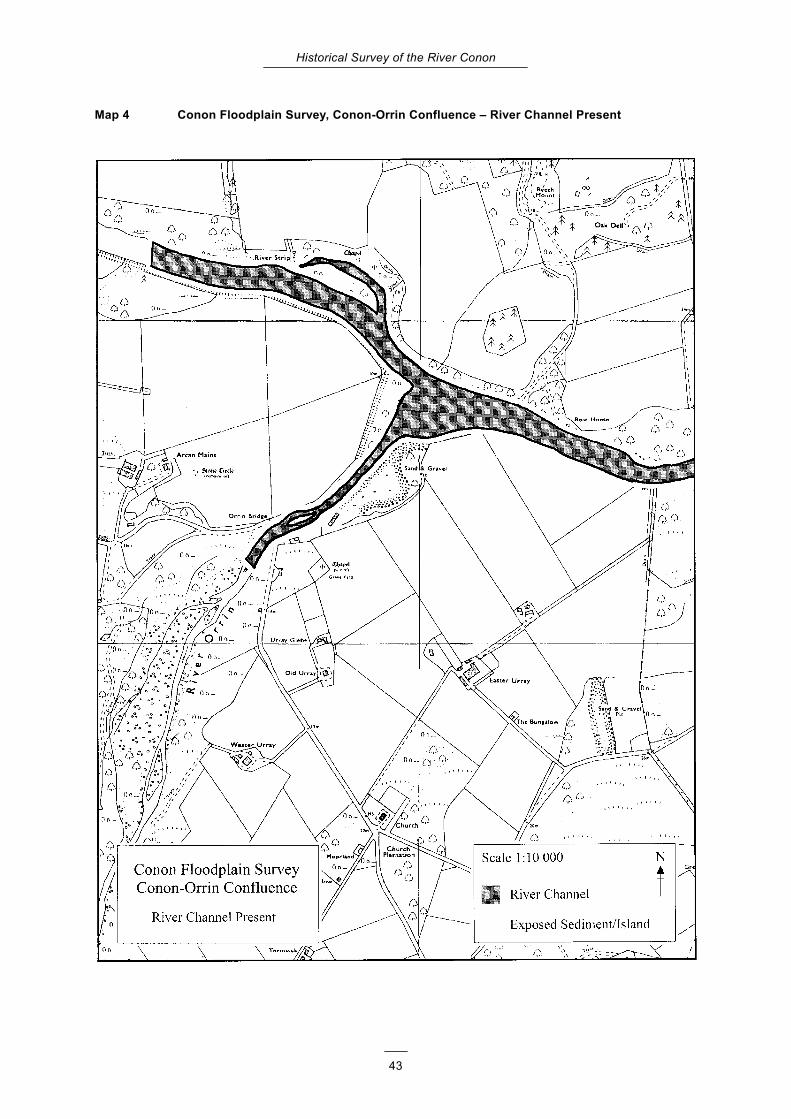
Historical Survey of the River Conon
43
Map 4 Conon Floodplain Survey, Conon-Orrin Confluence – River Channel Present

Historical Survey of the River Conon
44
Map 5 Conon Floodplain Survey, Conon-Orrin Confluence – River Channel 1873

Historical Survey of the River Conon
45
Map 6 Conon Floodplain Survey, Conon-Orrin Confluence – River Channel 1904

Historical Survey of the River Conon
46
Map 7 Conon Floodplain Survey, Dunglass Island – River Channel Present

Historical Survey of the River Conon
47
Map 8 Conon Floodplain Survey, Dunglass Island – River Channel 1873

Historical Survey of the River Conon
48
Map 9 Conon Floodplain Survey, Dunglass Island – River Channel 1904

Historical Survey of the River Conon
49
Appendix 2: Results of the floodbank survey
Figure A.1 Floodbank assessment: Clashuile to Moy Island
Key to flood bank assessment

Historical Survey of the River Conon
50
Figure A.2 Floodbank assessment: Moy Island to Dunglass Island

Historical Survey of the River Conon
51
Appendix 3: Changes in floodplain habitat mosaics below Dunglass Island
The habitat mosaic below Dunglass Island was mapped from aerial photographs. The following
maps show the extent of each classified area for the years 1946 and 1977.

Historical Survey of the River Conon
52
Conon Floodplain Survey Habitat Mosaics – Aerial Photographs 1946

Historical Survey of the River Conon
53
Conon Floodplain Survey Habitat Mosaics – Aerial Photographs 1977