Smiths Lake Boating Plan of Management · Smiths Lake Boating Plan of Management 2005 – 2010 1 1....
64
S S M M I I T T H H S S L L A A K K E E B B O O A A T T I I N N G G P P L L A A N N O O F F M M A A N N A A G G E E M M E E N N T T 2 2 0 0 0 0 5 5 - - 2 2 0 0 1 1 0 0
Transcript of Smiths Lake Boating Plan of Management · Smiths Lake Boating Plan of Management 2005 – 2010 1 1....
SSMMIITTHHSS LLAAKKEE BBOOAATTIINNGG PPLLAANN OOFF MMAANNAAGGEEMMEENNTT
22000055 -- 22001100

Smiths Lake Boating Plan of Management 2005 - 2010
Smiths Lake Boating Plan of Management 2005 - 2010
SMITHS LAKE BOATING PLAN OF MANAGEMENT
TABLE OF CONTENTS
1. OVERVIEW ........................................................................................................... 1
1.1 Introduction.................................................................................................... 1 1.2 Objectives...................................................................................................... 2 1.3 Guiding Principles .......................................................................................... 2 1.4 Governing Legislation..................................................................................... 2 1.5 Holistic Management Context ......................................................................... 3 1.6 Values Based Approach ................................................................................. 4
2 SMITHS LAKE AND ENVIRONS.............................................................................. 6 2.1 Site Description.............................................................................................. 6 2.2 Attractions ..................................................................................................... 7 2.3 Facilities ........................................................................................................ 8 2.4 Navigational Restrictions ................................................................................ 9
3 LAKE MANAGEMENT ........................................................................................... 12 3.1 Management Roles ...................................................................................... 12 3.2 Management Responsibilities ....................................................................... 13
4 USAGE PATTERNS AND BOATING SAFETY .......................................................... 16 4.1 Recreational Use.......................................................................................... 16 4.2 Commercial Use........................................................................................... 17 4.3 Aquatic Events ............................................................................................. 19 4.4 Boating Safety ............................................................................................. 19 4.5 Compliance History ...................................................................................... 20
5 COMMUNITY CONSULTATION ............................................................................. 22
6 MANAGEMENT PLAN STRUCTURE .................................................................... 23 6.1 Management Sections .................................................................................. 23 6.2 Timeframe ................................................................................................... 23 6.3 Review Period .............................................................................................. 24
7 LAKE-WIDE CONCEPTS AND STRATEGIES .......................................................... 25 7.1 Lake Health: ................................................................................................ 25 7.2 Vessel Noise: ............................................................................................... 28 7.3 Vessel wash................................................................................................. 28 7.4 Personal watercraft ...................................................................................... 29 7.5 Permanent mooring sites .............................................................................. 29

Smiths Lake Boating Plan of Management 2005 - 2010
7.6 Safe plying limits .......................................................................................... 30 7.7 Aquatic licences ........................................................................................... 30 7.8 Submerged hazards and snags ..................................................................... 31 7.9 Protection of Seagrasses.............................................................................. 31
8 EASTERN BASIN ..............................................................................................35
9 MIDDLE BASIN .................................................................................................43
10 WESTERN BASIN .............................................................................................53

Smiths Lake Boating Plan of Management 2005 - 2010
Smiths Lake Boating Plan of Management 2005 – 2010 1
1. OVERVIEW
1.1 Introduction
In line with the objectives of the Intergovernmental Agreement on the Environment
(1992), the NSW Maritime Authority is committed to promoting the sustainable and
equitable use of NSW waterways for all users. The Authority’s emphasis in relation to
sustainable environmental management is on inter-agency co-operation, sharing
responsibilities and developing a consultative approach to sustainable waterway
management.
The Intergovernmental Agreement is based on a broad set of principles for ecologically
sustainable development including, inter alia:
♦ Inter-generational equity – the present generation should ensure that the health,
diversity and productivity of the environment are maintained or enhanced for the
benefit of future generations;
♦ Precautionary principle – Where there are threats of serious or irreversible
environmental damage, lack of full scientific certainty should not be used as a reason
for postponing measures to prevent environmental degradation;
♦ Conservation of biological diversity and ecological integrity should be a fundamental
consideration.
NSW maritime embraces these principles and adopts this partnership approach to
environmental management by using a mix of regulation, enforcement and education as
the primary tools to manage the environmental impact of vessels on the State’s navigable
waters. This approach to environmental management is implemented through:
♦ the development and implementation of boating management plans for individual
waterways;
♦ educating the community about practices which can minimise boating impacts; and
♦ increased compliance powers under the Protection of the Environment Operations Act
1997.
Boating plans of management seek to ensure that boating procedures and practices
maximise user safety, responsibility and enjoyment; identify and protect the recreational
and environmental values of the waterway; and provide a consistent approach to existing
and anticipated future issues.
The purpose of this boating management plan is to provide a framework for the
management and administration of boating activities on Smiths Lake and to establish more
effective controls for boating and related activities where required

Smiths Lake Boating Plan of Management 2005 – 2010 2
1.2 Objectives
This Boating Plan of Management (BPOM) is a 5 year plan designed to:
♦ be responsive to changing priorities and conditions on the lake and to acknowledge
boating and community expectations.
♦ ensure boating management practices maximise user safety and enjoyment while
minimising adverse impacts on the environment.
♦ promote the provision of appropriate infrastructure.
Once developed, the plan is to provide a comprehensive body of information regarding
boating and related activities on Smiths Lake, and the administrative structures within
which these activities take place.
1.3 Guiding Principles
This plan is underpinned by the following principles, and as such will seek to:
♦ develop strategies that promote the safety of all waterway users.
♦ promote sustainable and equitable use of the waterway with the minimum of
regulatory measures necessary to achieve this aim.
♦ manage boating activities to minimise detrimental environmental impacts and protect
aquatic flora and fauna in accordance with the principles of Ecologically Sustainable
Development as defined in the Environmental Planning and Assessment Act 1979.
♦ ensure best use of Government and community investment.
♦ contribute to sustainable resource management.
Strategies and actions identified in this Boating Plan of Management are to be consistent
with those responsibilities for which NSW Maritime has jurisdiction. In accordance with
the Ports Corporatisation and Waterways Management Act 1995, NSW Maritime has
jurisdiction over navigable waters. The Act defines navigable waters as “… all waters that
are from time to time capable of navigation and are open to or used by the public for
navigation”.
1.4 Governing Legislation
Activities on Smiths Lake are controlled by a range of statutory instruments which are
administered by a number of agencies.
The following instruments, State Government policies and directives apply to NSW
Maritime in its administration of on-water activities on the lake:
♦ Maritime Services Act 1935
♦ Commercial Vessels Act 1979

Smiths Lake Boating Plan of Management 2005 – 2010 3
♦ Marine (Boating Safety – Alcohol and Drugs) Act 1991
♦ Marine Pilotage Licensing Act 1971
♦ Navigation Act 1901
♦ Ports Corporatisation and Waterways Management Act 1995
♦ Environmental Planning and Assessment Act 1979
♦ Marine Pollution Act 1987
♦ Protection of the Environment Operations Act 1997
♦ Protection of the Environment Administration Act 1991
♦ Rivers and Foreshores Improvement Act 1948
♦ Uniform Shipping Laws Code
♦ Coastal Protection Act 1979
♦ NSW Coastal Policy
♦ Threatened Species Conservation Act 1995
♦ NSW Biodiversity Policy
♦ Fisheries Management Act 1994
♦ Fish Habitat Protection Plans
♦ State Rivers and Estuaries Policy
♦ Environment Protection and Biodiversity Conservation Act 1999
1.5 Holistic Management Context
The NSW Government’s Estuary Management Policy recognises the ecological, social and
economic importance of the State’s estuaries. The general goal of this policy is to achieve
integrated, balanced, responsible and ecologically sustainable use of these estuaries.
NSW Maritime embraces these principles, and in-line with the objectives of the
Intergovernmental Agreement on the Environment (1992), adopts a partnership approach
to the management of Smiths Lake.
The NSW Maritime Authority shares the responsibility for protecting the environment in
connection with the use of vessels on the State’s waterways with other natural resource
and environment management agencies. However, the Authority’s direct responsibilities
relate primarily to the management of commercial and recreational vessels on navigable
waters. NSW Maritime carries out this responsibility with a view to achieving the highest
possible standards of safety while protecting the marine and foreshore environment. In
addition, NSW Maritime assists in providing essential boating infrastructure.

Smiths Lake Boating Plan of Management 2005 – 2010 4
1.6 Values Based Approach
A “values based” approach to the preparation of the Smiths Lake Boating Plan of
Management enables the consideration of the important features, or the uniqueness, of
the lake and its immediate environment. This “values based” approach will ensure that,
even though new issues may arise during the life of the plan, the plan itself will remain
valid. This is based on the assumption that community values change relatively slowly
(Department of Land and Water Conservation, 1996).
Submissions from the public consultation process provided NSW Maritime with a broad
range of information relating to the characteristics which the community values about the
lake and the associated issues which impinge upon those values.
The values and issues identified in the Smiths Lake Boating Plan of Management are those
taken from the public consultation phase as well as those identified in the various plans,
reports and documents produced by other government agencies, in particular the Smiths
Lake Estuary Management Plan [SLEMP – Great Lakes Council (GLC), 2001].
All identified issues, together with desired outcomes and proposed strategies and actions,
are addressed in the body of this plan.
In reviewing those features of Smiths Lake that are held to be of high value, three major
categories become evident: Safety; Environment and Equity.
Safety - (eg. Speeding, bow riding, “distance-off” compliance, types & locations of navigational aids, channel hazards).
Being a shallow, closed system the waterway provides a relatively safe environment
that appeals to a variety of users. Boater compliance levels on the Lake are generally
high, and accident/incident levels extremely low. Maintaining this standard of safety
on Smiths Lake is considered of high value and is one of the major objectives of this
plan.
Environment - (eg. Noise, wash, erosion, pollution, habitat).
Smiths Lake is a relatively unspoilt waterway in terms of its water quality and
surrounds. There are pristine aspects to the natural setting of the lake with its National
Park boundary and SEPP 14 wetlands, encapsulating significant flora and fauna.
Extensive seagrass beds have also been identified for protection. Maintaining the
environmental integrity of Smiths Lake through sustainable use is of high importance
in this planning document.
Retention of the ‘coastal village’ appeal of Smiths Lake township and surrounding
urban areas was also put forward as a valuable consideration in future planning for the
Smiths Lake intermittently closed or open lake or lagoon (ICOLL) (SLEMP, 2001). The
bordering lands are largely undeveloped; tourism is low key and residential
development minimal at this point in time. The waterway is also unique in that most

Smiths Lake Boating Plan of Management 2005 – 2010 5
of the shoreline is zoned in such a way as to prevent the future clearing of vegetation
from the banks.
Equity – (eg. User conflict, impacts of safety & environmental protection on commercial operators, infrastructure demands).
The Coastal Lakes Final Report (Healthy Rivers Commission, 2002) asserts that
compromise between recreational and commercial users of the State waterways is an
important goal in planning. Currently there is a viable commercial fishing industry
licensed to fish the waters of Smiths Lake. This commercial activity is somewhat
intermittent and is subject to seasonal catch variations.
Further to this report, SLEMP (GLC, 2001) identifies the need to provide for passive
users of the waterway. There is a long history of use by ski boats, and the area is
equally important to visitors and to those that work or reside by the Lake. Given that
the Lake extends over 11 km2 there is ample area of waterway available for a range of
recreational pursuits commensurate with current levels of visitation.
Maintaining equity in use while minimising conflict will be an ongoing challenge in the
formulation of management strategies for the Lake.
Smiths Lake Boating Plan of Management 2005 – 2010 6
2 SMITHS LAKE AND ENVIRONS
2.1 Site Description
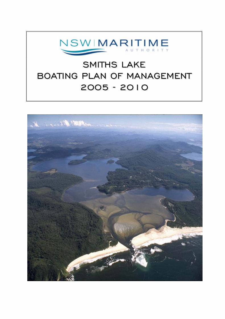
Smiths Lake is approximately 25km south of Forster on the NSW Mid North Coast, between
Wallis Lake and the Myall Lakes. The Smiths Lake catchment falls within the Great Lakes
Council Local Government area. “The catchment is small (33 square kms including the
lake) and relatively undeveloped. Some three quarters of the catchment is forested or
waterway. Over one quarter of the catchment is within the boundaries of Myall Lakes
National Park or the Wallingat State Forest. The only significant developments within the
catchment are around the lake foreshores, namely the village of Smiths Lake, part of
Neranie, the settlement at Tarbuck Bay, and minor ribbon development along The Lakes
Way.” (Smiths Lake Estuary Management Study and Draft Management Plan, September
1999, pg 1 - Webb, McKeown & Associates Pty.Ltd).
The lake is of a type known as an intermittently closed or open lake or lagoon (ICOLL),
with 10km2 of waterway consisting of three deeper basins. The average depth of the lake
is around two metres and there is an extensive build up of sediment in the area adjacent
to the ocean entrance.
The lake is mechanically opened at Sandbar Beach in accordance with an opening regime
adopted by the Great Lakes Council. Opening occurs approximately every 18 months, or
as dictated by the lake water height (reaching a maximum 1.7m before opening). Regular
opening is designed to assist in flushing of the lake waters and in preventing the flooding
of low lying properties. Once opened the lake may remain tidal for a few weeks or several
months before the entrance closes off with the natural deposition of sand.
There is a 40 metre strip designated Crown Foreshore Reserve along the perimeter of the
lake adjoining residential properties fronting the lake. This reserve helps buffer residents
from summer vessel activity whilst allowing the general public access along the foreshore.
Three wetlands of SEPP 14 Coastal Wetlands classification adjoin the western and southern
edges of the lake, and as many as sixteen vulnerable species of fauna have been identified
in these habitat areas. The perimeter of the lake is vegetated in areas by saltmarsh
communities, and up to 20% of the lake supports seagrass habitat.
The navigability of Smiths Lake is influenced by the conditions of its entrance, its state of
opening, effects of rainfall, and evaporation. Whilst in its non-tidal condition almost the
entire surface area of the lake is navigable. This area is greatly reduced immediately after
opening and during filling, or following extended periods of low rainfall. The lake then
becomes divided into two main basins accessible for use by power vessels. Extreme
caution is required while navigating at these times. It should be noted that long periods
of hot and dry weather can cause water levels on the closed Lake to fall below mean sea
level.
Smiths Lake Boating Plan of Management 2005 – 2010 7
The eastern basin in Symes Bay is set apart from the main western body of the lake by an
extensive sand delta of less than 0.5 metre depth. Toward the centre of the lake a long
shallow sand spit protrudes from Simons Point in a northerly direction. Of the three
islands within the Lake (Big Island, Little Island and Bull Island) there are significant rock
bars extending from both Big Island and Little Island.
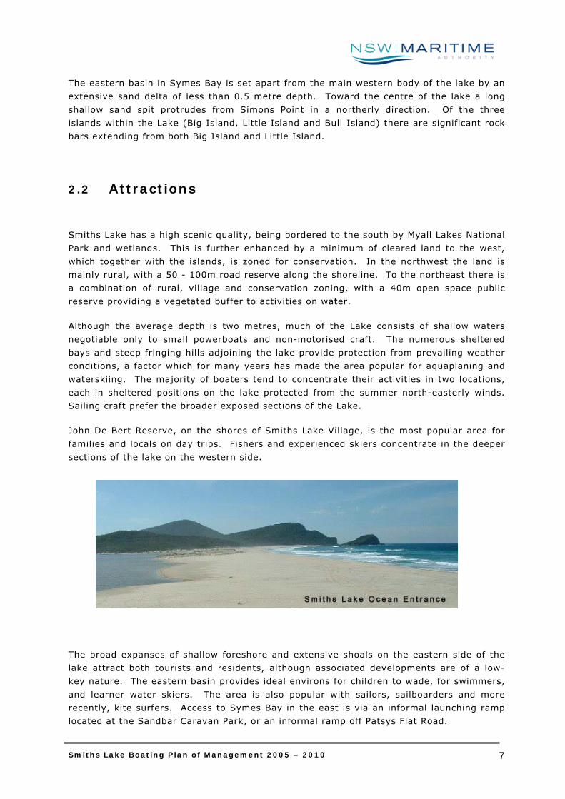
2.2 Attractions
Smiths Lake has a high scenic quality, being bordered to the south by Myall Lakes National
Park and wetlands. This is further enhanced by a minimum of cleared land to the west,
which together with the islands, is zoned for conservation. In the northwest the land is
mainly rural, with a 50 - 100m road reserve along the shoreline. To the northeast there is
a combination of rural, village and conservation zoning, with a 40m open space public
reserve providing a vegetated buffer to activities on water.
Although the average depth is two metres, much of the Lake consists of shallow waters
negotiable only to small powerboats and non-motorised craft. The numerous sheltered
bays and steep fringing hills adjoining the lake provide protection from prevailing weather
conditions, a factor which for many years has made the area popular for aquaplaning and
waterskiing. The majority of boaters tend to concentrate their activities in two locations,
each in sheltered positions on the lake protected from the summer north-easterly winds.
Sailing craft prefer the broader exposed sections of the Lake.
John De Bert Reserve, on the shores of Smiths Lake Village, is the most popular area for
families and locals on day trips. Fishers and experienced skiers concentrate in the deeper
sections of the lake on the western side.
The broad expanses of shallow foreshore and extensive shoals on the eastern side of the
lake attract both tourists and residents, although associated developments are of a low-
key nature. The eastern basin provides ideal environs for children to wade, for swimmers,
and learner water skiers. The area is also popular with sailors, sailboarders and more
recently, kite surfers. Access to Symes Bay in the east is via an informal launching ramp
located at the Sandbar Caravan Park, or an informal ramp off Patsys Flat Road.

Smiths Lake Boating Plan of Management 2005 – 2010 8
Vessels also travel across the lake in order to reach the unpatrolled ocean beach at
Sandbar to swim and surf, the beach being located a short distance across the eastern
sand dunes.
Recreational use of the waterway outside of weekends and school holidays is relatively
infrequent, creating a predominantly natural and pristine environment with minimal
recreational visitation for most of the year, particularly on the southern shores.
2.3 Facilities
Smiths Lake provides the services of a small shopping centre, bowling club, holiday
accommodation, a caravan park, public toilets and recreational areas. The nearest major
centre is Forster-Tuncurry to the north along the Lakes Way. A significant proportion of
the residential development in Smiths Lake village consists of holiday homes, the owners
of whom reside permanently in other major centres.
Smiths Lake has two recognised public boat launching facilities, Brambles Reserve and
John De Bert Reserve, both situated in the western lake basin. A private informal
launching facility is available to residents and visitors of the Sandbar Caravan Park on the
eastern-most shore of the lake, and a fourth informal ramp is located at Patsys Flat near
Sandpiper Lodges.
The John De Bert Reserve boat ramp is the significant point of origin around which Smiths
Lake village developed, and is now the most popular location for boaters due to its central
position. The ramp consists of a concrete pad construction making it easy for the
conventional sedan to launch and retrieve. However, parking facilities are severely limited
and many local boaters elect to return home to store their trailers for the day after
launching. The public toilet amenities, children’s playground and picnic tables available at
the reserve further contribute to the popularity of the area for daytime activities.
John De Bert Reserve

Smiths Lake Boating Plan of Management 2005 – 2010 9
In contrast, Brambles Reserve ramp is under utilised due to its rocky foreshore and
exposure to southerly wind conditions. Being of an informal arrangement with unstable
shoreline material the ramp can at times require the use of four wheel drive vehicles for
the launching and retrieving of vessels.
The Patsys Flat launching area could at best be described as primitive since it has no real
designated ramp facility; rather it is merely an access point to the eastern basin providing
an alternative to Sandbar Caravan Park. Patsys Flat Road allows additional access to
Symes Bay when the lake level is low, and is generally used by a few residents and
licensed fishing boats. There is no designated parking at this site.
All the Smiths Lake boat ramps are subject to difficult launching conditions during periods
of low water or lake opening, and there are numerous informal access points available
along the foreshores of the Lake.
There are no slipways, fuelling points, pump-outs, public wharves, jetties or marinas on
Smiths Lake, and no oyster leases, dredges or work boats of any description, other than
the small commercial fishing fleet.
There is at this time provision for the permanent mooring of one recreational vessel on the
Lake by way of an ‘occupation licence’ issued by the NSW Maritime Authority in 1997.
Traditionally a few licensed fishing vessels have also kept net boats moored around Smiths
Lake Village and on the southern shore. In some instances the vessels are ‘holding shot’
at recognised fishing sites.
2.4 Navigational Restrictions
The Smiths Lake system is a small waterway with naturally occurring restrictions mostly
arising during the tidal or open state when water levels fall. Vessel activities are further
contained on the estuary by a number of legislated restrictions. These restrictions have
been subject to recent change on a trial basis as a result of zoning recommendations made
under the SLEMP (Great Lakes Council, 2001).
Brambles Reserve Patsys Flat Road
Smiths Lake Boating Plan of Management 2005 – 2010 10
2.4.1 Naturally Occurring Limitations
The natural characteristics limiting vessel activity include the shallow waters around the
opening point to the east of the lake, and the submerged hazards (rocks and tree snags)
near the foreshores and islands. An east cardinal mark has been installed on the eastern
extremity of the rock bar that extends about 150 metres from the foreshore of Little
Island, and a north cardinal marker buoy has been installed near the southern shore at
Neranie to identify the position of several submerged logs. These logs located off
Tramline Beach are hazardous to navigation, particularly when the lake level falls.
The navigation dynamics of the lake are largely determined by its entrance opening regime
adopted by the Great Lakes Council. Tidal flow through the narrow ocean entrance is
extreme when the Lake is manually opened, and at these times is considered by NSW
Maritime to present a potential danger for swimmers and small craft alike. There has been
no signage to indicate this hazard on the estuary, however when notified, yellow floating
markers have been installed by NSW Maritime at regular intervals around a 200m radius
near the Lake entrance. The markers provide swimmers and vessels with an indication of
the dangerous and changing conditions when approaching the ocean entrance.
Three small tributaries - Wamwarra Creek, Tarbuck Creek and an unnamed channel flowing
into Symes Bay - are considered unsuitable for navigation by conventional power craft due
to submerged snags. They are however suitable for exploration with human powered craft
such as canoes and kayaks, although fallen trees may limit access to their extremities.
A long shallow sand spit has formed off Simons Point, and when water levels fall the
channel between Simons Point and Smiths Lake Village allows approximately 80-100m of
navigable water for vessels travelling between the ramp and the western basin. This area
is subject to congestion during the peak boating season as ski boats utilise the corridor.
2.4.2 Legislated Restrictions
There has traditionally been a concentration of interaction between swimmers, passive
craft and power craft in the waters near the reserve at Smiths Lake Village. The first
speed restriction dates back to a 1987 gazettal that applied only to waters in the vicinity
of John De Bert Reserve ramp and Pelican Point, and came about to address the issue of
congestion. In December 2001 the NSW Waterways Authority made an amendment to the
4 knot area by way of Government Gazette to allow the waterway zoning recommendations
of SLEMP (Great Lakes Council, 2001) to be effectively trialed. The area was expanded to
include Ski Cove, and applied to the body of water bordered by a line extending 750m in a
southerly direction from Eagle Nest Parade, to 900m east-north-east, to 900m in a
northerly direction, to a limit approximately 100m off the bank near Sandpiper Lodge.
Signs and floating markers indicating the 4 knot limit were also installed over the trial
period.
In December 2002 the ‘zoning plan’ underwent review by the Great Lakes Estuary
Management Committee and a number of problem areas were identified. As a result signs
Smiths Lake Boating Plan of Management 2005 – 2010 11
were relocated to apply the speed restriction across the Lake to the opposite shore,
extending from Simons Point to Bull Island. The existing speed gazettal was not altered
as it was determined that any further changes would be implemented on finalisation of the
Smiths Lake Boating Plan of Management.
The interaction between powerboats, swimmers and non-motorised craft is managed by
the application of existing legislation controlling boating activities. In the absence of a
designated speed or skiing restriction, the master of a vessel is not exonerated from the
requirement to maintain a ‘proper lookout’, always travel at a ‘safe speed’ with regard to
prevailing conditions and to comply with the ‘distance off’ regulations. It is also an
offence to cause annoyance, nuisance or danger with the use of a vessel. Generally these
regulations together with collision prevention regulations are sufficient to manage
interaction where it does occur, and vessels adhering to these requirements are capable of
manoeuvring with safety near swimmers.
Personal Watercraft (PWC – commonly known as jet skis) are not specifically prohibited
from operating on Smiths Lake. However, their speed and activity is managed under
maritime legislation by gazetted speed limits, additional ‘distance off’ regulations, the
requirement to hold a specific PWC licence, and the offence of ‘irregular driving’ whilst in
the vicinity of residential areas. The towing of skiers and use of PWCs outside of daylight
hours is prohibited under maritime legislation.

Smiths Lake Boating Plan of Management 2005 – 2010 12
3 LAKE MANAGEMENT
Smiths Lake is at present subject to several specific planning documents:
The ‘Smiths Lake Estuary Management Plan’, Great Lakes Council Estuary Management
Committee, SLEMP, (May 2001)
The ‘Coastal Lakes Final Report’, Healthy Rivers Commission (April, 2002)
The ‘NSW Coastal Policy’, Coastal Council (1997)
‘NSW Fisheries Habitat Protection Plan’, NSW Fisheries (1997)
‘Great Lakes Local Tourism Plan’, Great Lakes Council (1993)
Under the NSW Coastal Policy (1997), the NSW Estuary Management Program provides
funding assistance to Local Government Authorities for the production of Estuary
Management Plans. The Smiths Lake Estuary Management Committee (EMC), a body
consisting of community, government and commercial representatives, was formed at the
initial stages of that planning process. EMC member input was therefore considered
integral to the consultation process when formulating the Smiths Lake Boating Plan of
Management. The Boating Plan also adopts the values and issues identified in the Smiths
Lake Estuary Management Plan (SLEMP, 2001).
The Coastal Lakes Final Report (2002) provides a system of classification for coastal lakes
and identifies Smiths Lake under the management orientation classification of ‘Significant
Protection’. This classification prescribes a management orientation which has been taken
into consideration when formulating this boating plan.
Aboriginal issues and concerns together with heritage issues have also been identified in
the planning process in order to determine any impacts with regard to vessel use on the
waterway.
Finally, consideration has also been given to the nature of the waterway, usage patterns
and general levels of activity. An estuary that encounters low level use would not
warrant an overly detailed plan or legislative regime. Management strategies in the
Smiths Lake Boating Plan of Management reflect current usage, and the Boating Plan is
subject to periodic review, producing a living document that can be adapted to changing
conditions over time. The standard review timeframe is 5 years.
3.1 Management Roles
As stated in the Smiths Lake Estuary Management Plan, there are a large number of
government authorities involved in the management of the Smiths Lake catchment. The
roles of these government authorities are as follows:

Smiths Lake Boating Plan of Management 2005 – 2010 13
NSW Maritime Authority for commercial and recreational boating regulation and
management, navigation and boating safety considerations, promoting the sustainable
use of the State’s waterways by vessels, and the investigation of marine incidents.
Great Lakes Council is the major management and control authority within the
catchment. Council’s responsibilities arise under the Local Government Act (1993) and
under the provisions of the Environmental Planning and Assessment Act (1979).
Department of Infrastructure, Planning and Natural Resources, which has a
general overview role under the planning provisions of the Environmental Planning and
Assessment (EPA) Act 1977.
Department of Lands for management of the bed and banks of rivers, lakes and
other waterways under the Rivers and Foreshores Act (1984), for Crown Lands under
the Crown Lands Act (1989), for the coastal zone generally under the Coastal
Protection Act (1979), and for catchment management and soil conservation and
erosion under the Catchment Management Act (1989) and Soil Conservation Act
(1938).
NSW Fisheries (Department of Primary Industries) for management of the
fishery, commercial and recreational fishing conditions under the Fisheries
Management Act (1994). Fisheries are also an important approval authority under the
EPA Act, as well as having a major role in the preservation and maintenance of coastal
wetlands, seagrasses and mangroves.
National Parks and Wildlife Service (Department of Environment and
Conservation) through their responsibilities for heritage matters, threatened species
conservation, migratory bird management, and ownership and management of National
Parks.
Environment Protection Authority (Department of Environment and
Conservation) for water quality and the prevention of environmental damage.
3.2 Management Responsibilities
3.2.1 Navigation
The interaction between powerboats, swimmers and other passive craft is managed by the
NSW Maritime Authority, and by the application of maritime legislation, through licensing,
registration and the ‘rules of the road’. Compliance is monitored by two Boating Service
Officers (BSOs) stationed at Forster and covering an area from Seal Rocks to Crowdy
Head. Additional BSOs, as required, are transferred into the area during the peak boating
periods (Easter Long Weekend, October – February) to help with boater compliance.

Smiths Lake Boating Plan of Management 2005 – 2010 14
3.2.2 Environment
Environmental impacts of activities on and around the estuary are the responsibility of
several State and local government authorities, all of whom have been consulted during
the development of this Boating Plan of Management. The values, goals and objectives of
these authorities have been incorporated in this final plan.
Dredging: Where dredging is proposed for the purpose of maintaining a navigable
channel, approvals are required from the following relevant authorities:
Department of Lands; Great Lakes Council; and NSW Fisheries.
Management of snags and fallen trees: NSW Fisheries is the lead agency in
relation to the management of snags and fallen trees. Submerged vegetation is
considered to be an important fish habitat and removal is considered as a last
resort, only after all other options have been reviewed. The Fisheries Management
Act 1994, through the Fish Habitat Protection Plan 1 underpins all strategies in
relation to snags and fallen trees.
Pollution from vessels: Under the Protection of the Environment Operations Act
1997(POEO), the discharge of raw sewage and other wastes from vessels into the
waters of NSW is prohibited. The NSW Maritime Authority recognises that pollution
from vessels is a relatively small contribution to water quality problems in Smiths
Lake. However, in line with other State Government agencies, NSW Maritime
maintains a commitment to conserving and enhancing the environmental qualities
of NSW waters.
NSW Maritime’s environmental initiatives have been enhanced by its designation as
an Appropriate Regulatory Authority (ARA) under the POEO Act. This ARA status
gives the Authority power to regulate environmental impacts of vessels. In cases
where the legislative requirements are not met the Smiths Lake Boating Service
Officer may issue a verbal or formal warning, an infringement notice, or a summons
for court attendance, depending on the severity of the offence. The Authority can
also take preventative action by issuing an Environment Protection Notice under the
POEO Act.
3.2.3 Provision of Boating Infrastructure
As part of the integrated management of the State’s waterways, the Authority’s Boating
Facilities Programme enables NSW Maritime, by assisting councils and other agencies to
fund waterway infrastructure, to greatly improve amenities for the boating public and
marine sector on New South Wales waterways.
During 2002 – 2003, program expenditure totalled $1,001,248 on projects valued at over
$4 million. Contributions from vessel registration fees fund approximately half of the
Smiths Lake Boating Plan of Management 2005 – 2010 15
program. Grants are usually allocated on a 50:50 basis with local councils and other
groups.
Boating and community organisations, industry, local and state government authorities are
invited to submit applications for projects that contribute to the objective of the program.
Eligible projects funded could include: boat ramps; public wharves/jetties/pontoons;
installation of public moorings and pump out facilities.
In addition, funding for boating and waterway related infrastructure can also be sourced
through Department of Lands and NSW Fisheries funding programs.

Smiths Lake Boating Plan of Management 2005 – 2010 16
4 USAGE PATTERNS AND BOATING SAFETY
The NSW Maritime Authority’s Management Information System records specific boating
related information in the form of incident and complaint reports, records of compliance
activity, data on registered vessels and licences issued, as well as limited recording of
observations made during routine patrol duties. The data contained within the
Management Information System is utilised for the purpose of monitoring estuary usage
patterns and in the ongoing review of boating management strategies.
4.1 Recreational Use
Smiths Lake lends itself to the pursuit of a variety of activities including swimming,
waterskiing, canoeing, kayaking, kite surfing, fishing and the occasional PWC operations.
With the majority of these activities there tends to be a preferred set of conditions or
locations in which each is undertaken.
Peak use occurs in the warmer months and during holiday periods, generally from
December through to January and again during Easter and school holidays. For the
remainder of the year it is generally local residents utilising the waterway with a
concentration of activity on weekends. This pattern culminates in very little to no activity
through the winter months.
There is a direct correlation between vessel use, swimmers and holiday visitors, although
peak activity is dictated by the state of the lake opening, with highest use during closed
periods. At these times water depths usually enable access to all areas of the lake. A
maximum of up to 40 vessels has been noted at any one time during the height of the
boating season. Again, such peaks are limited in their total number of days and occur in
ideal conditions during the main holiday periods. High level activity quickly declines for
the remainder of the year.
The area south of John De Bert Reserve to the opposite shore, that is, from Ski Cove
extending east to Bull Island, remains the most intensively utilised section of the Lake, as
has been the case for many years. All manner of craft: windsurfers; sail craft; canoes;
catamarans; powerboats, and to a lesser extent PWCs, operate through this section.
Most high-powered boats on the Lake are used for the purpose of water skiing, generally
family groups towing aquaplaners in Symes Bay and around Simons Point in the stretch
referred to as Ski Cove.
Smiths Lake Boating Plan of Management 2005 – 2010 17
4.2 Commercial Use
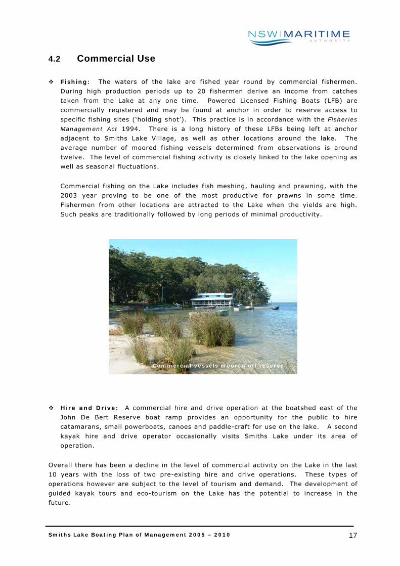
Fishing: The waters of the lake are fished year round by commercial fishermen.
During high production periods up to 20 fishermen derive an income from catches
taken from the Lake at any one time. Powered Licensed Fishing Boats (LFB) are
commercially registered and may be found at anchor in order to reserve access to
specific fishing sites (‘holding shot’). This practice is in accordance with the Fisheries
Management Act 1994. There is a long history of these LFBs being left at anchor
adjacent to Smiths Lake Village, as well as other locations around the lake. The
average number of moored fishing vessels determined from observations is around
twelve. The level of commercial fishing activity is closely linked to the lake opening as
well as seasonal fluctuations.
Commercial fishing on the Lake includes fish meshing, hauling and prawning, with the
2003 year proving to be one of the most productive for prawns in some time.
Fishermen from other locations are attracted to the Lake when the yields are high.
Such peaks are traditionally followed by long periods of minimal productivity.
Hire and Drive: A commercial hire and drive operation at the boatshed east of the
John De Bert Reserve boat ramp provides an opportunity for the public to hire
catamarans, small powerboats, canoes and paddle-craft for use on the lake. A second
kayak hire and drive operator occasionally visits Smiths Lake under its area of
operation.
Overall there has been a decline in the level of commercial activity on the Lake in the last
10 years with the loss of two pre-existing hire and drive operations. These types of
operations however are subject to the level of tourism and demand. The development of
guided kayak tours and eco-tourism on the Lake has the potential to increase in the
future.
Commercial vessels moored off reserve
Smiths Lake Boating Plan of Management 2005 – 2010 18
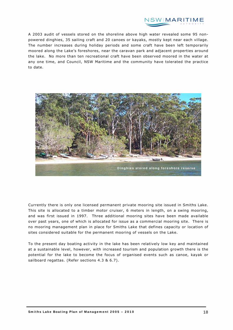
A 2003 audit of vessels stored on the shoreline above high water revealed some 95 non-
powered dinghies, 35 sailing craft and 20 canoes or kayaks, mostly kept near each village.
The number increases during holiday periods and some craft have been left temporarily
moored along the Lake’s foreshores, near the caravan park and adjacent properties around
the lake. No more than ten recreational craft have been observed moored in the water at
any one time, and Council, NSW Maritime and the community have tolerated the practice
to date.
Currently there is only one licensed permanent private mooring site issued in Smiths Lake.
This site is allocated to a timber motor cruiser, 6 meters in length, on a swing mooring,
and was first issued in 1997. Three additional mooring sites have been made available
over past years, one of which is allocated for issue as a commercial mooring site. There is
no mooring management plan in place for Smiths Lake that defines capacity or location of
sites considered suitable for the permanent mooring of vessels on the Lake.
To the present day boating activity in the lake has been relatively low key and maintained
at a sustainable level, however, with increased tourism and population growth there is the
potential for the lake to become the focus of organised events such as canoe, kayak or
sailboard regattas. (Refer sections 4.3 & 6.7).
Dinghies stored along foreshore reserve
Smiths Lake Boating Plan of Management 2005 – 2010 19
4.3 Aquatic Events
Under the Water Traffic Regulations–NSW, the NSW Maritime Authority may, upon
application, grant an aquatic licence, either conditionally or unconditionally, permitting
specific use of a section of waterway for a designated period of time. An aquatic licence is
essential in order to conduct a race, display, regatta or an exhibition of waterskiing or
similar activities, or where the use of a vessel restricts navigation.
In some cases the aquatic licence may authorise the holder to have exclusive use of the
waterway and/or operate contrary to the regulations for that section of estuary. The
approval process includes notification to NSW National Parks and Wildlife Service, the local
council, NSW Fisheries and any associated landholder from where the activity takes place,
prior to such activities being promoted. This notification allows for the interests of those
bodies to be addressed. NSW Maritime will also conduct an environmental assessment of
the activity under Part V of the Environmental Planning and Assessment Act 1979 as part
of the approval process.
4.4 Boating Safety
Smiths Lake falls within the Forster operational area. The NSW Maritime Authority has two
permanent full-time Boating Service Officers (BSOs) and two permanent part-time and one
casual Customer Service Officers (CSOs) located in this operational area. The Customer
Service Centre now operates on a full-time basis having recently been upgraded to 5 day,
year-round status. The Forster Operational Centre also provides an outreach program by
providing customer service in Taree on one Saturday morning each month.
The Forster operational area comprises the waterways of the Manning River, Crowdy Head,
the Wallis Lake estuary and river system, and Smiths Lake. The Boating Service Officers
have responsibilities across all operational aspects of boating in these many and varied
waterways.
Regular on-water patrols are one of the primary functions of the BSO. These involve the
BSO undertaking patrols and inspections of recreational and commercial vessels to ensure
continuing compliance with the requirements of licensing, registration, speed limits,
aquatic events, noise and other forms of pollution. In cases where the legislative
requirements are not met the BSO may issue a verbal or formal warning, an infringement
notice, or a summons for court attendance, depending on the severity of the offence.
The officer also provides community education by way of education programs covering the
broad spectrum of recreational boating matters, with particular emphasis on boating
safety, pollution control and management of waterways to improve the standard of boating
safety awareness and waterways amenities in the general community.
The Boating Service Officer is also responsible for recommending the placement and
maintenance of navigation aids and systems to assist safe navigation; completing boating
Smiths Lake Boating Plan of Management 2005 – 2010 20
incident and accident reports, undertaking investigations; mooring placement and
management; and undertaking environmental assessments for wetland lease applications.
4.5 Compliance History
4.5.1 Complaints and Compliance
The levels of complaints in relation to vessel activity on the Lake have remained relatively
consistent over the past three years, with the majority of these resulting from conflict
between waterway users and residents. A notable increase in complaints was recorded
over the 2001 - 2002 boating season (October 2001 to Easter 2002), and related to new
waterway zoning restrictions being trialed in accordance with recommendations of the
SLEMP (GLC, 2001).
The majority of complaints resulting from the’ zoning’ trial related to skiing, the 3pm to
8am curfew on the towing of skiers, and the extension of the existing 4 knot speed
restriction. The community’s complaints in response to the trial highlighted the
importance and popularity of waterskiing to residents and visitors alike. The extension of
the 4 knot speed restriction meant the loss of the shallow sandy beach area at Ski Cove
that has traditionally been used for water ski tuition.
The unrestricted channel, allowing craft to pass between the east and west basin at high
speed has also been a cause for concern. The narrowing of this channel at low water is
perceived by stakeholders to present a potential risk for collision.
Other complaints from local residents highlight their concern over ski activities on the
Lake, in particular around John De Bert Reserve, Patsys Flat Road and Symes Bay. In the
majority of cases the complaints are non-specific in terms of identifying vessels or
offenders, limiting NSW Maritime’s capacity to respond on a case by case basis. These
reports tend to relate to speed, distance off swimmers and vessel noise emissions, each of
which could be managed under existing regulations where the offending craft is identified.
It is worthy of note that complaints do not appear to emanate from the interaction
between fishing, sailing, paddle craft, ski boats or PWCs on the water. This may be due to
the fact that in most cases fishing and sailing vessels tend to seek areas away from the
recognised family day use areas and participate at times outside of those favoured by
social skiers. Also, PWC use on the Lake is relatively rare and rowers have a preference
for the more scenic, natural shoreline. In these cases congestion does not appear to be a
source of conflict for on-water users, either motorised or non-motorised.
In contrast, the recognised family day use areas are frequented by both swimmers and
skiers, and complaints in relation to the mooring of fishing vessels at the John De Bert
Reserve ramp has been ongoing. Council Reserves tend to be situated in central locations
near urban zones and as such receive high level visitation.

Smiths Lake Boating Plan of Management 2005 – 2010 21
There have been unconfirmed reports of vessels skiing well after sunset and into the night.
Perpetrators of acts such as this are dealt with in terms relative to the dangers they pose
to others and themselves.
Every season it is commonplace for swimmers to express a general concern in regard to
vessel speed around John De Bert Reserve. Speeding is a targeted compliance issue on
the estuary and enforcement action has ensued wherever offences have been detected.
4.5.2 Accidents and Incidents
Smiths Lake, with its combination of passive and active recreational pursuits, has an
impressively low record of reported incidents. The most serious have involved swimmers
and small underpowered vessels being caught in the strong run out tide at the Lake
opening. It is not uncommon for swimmers to underestimate the force of the runout and
be dragged into the surf zone.
Smiths Lake has no record of reported collisions. The general rules of navigation in
relation to right of way, steering to starboard, ‘proper lookout’, ‘safe speed’, and ‘distance
off’ appear sufficient to manage vessel interactions where they do occur.
4.5.3 Infringements and Formal Warnings
Analysis of formal warnings and fixed penalties issued over the last three years reveal that
most offences relate to the registration of craft. Analysis of safety related offences
reveals a relatively even distribution of infringements. Failure to carry the required
lifejackets being the most significant offence, with infringements also issued for speed,
bow riding, vessels exceeding capacity and failure to carry an observer while towing.
While all these matters are considered by NSW Maritime to be of a serious nature, overall
compliance is high. Such issues are managed on a case by case basis via routine patrol,
inspection and ongoing education campaigns.

Smiths Lake Boating Plan of Management 2005 – 2010 22
5 COMMUNITY CONSULTATION
NSW Maritime is acutely aware that this Boating Plan of Management must reflect
community values, address community issues and have broad community endorsement.
As a result, January 2003 saw the commencement of a community consultation program
inviting interested stakeholders to be involved in the planning process. Key government
agencies were also consulted and invited to make written submissions outlining values and
issues peculiar to their area of expertise.
The community consultation phase involved:
A media release and Public Notice in 2003 aimed at advising the community of the
planning process and identifying interested parties and stakeholders for inclusion on a
mailing list.
The presentation of a Discussion Paper to members of the Smiths Lake Estuary
Management Committee seeking input on values and issues via written submissions.
The release of a Draft Smiths Lake Boating Plan of Management distributed to
stakeholders and displayed for public comment. The closing date for submissions on
the draft plan was 31st August 2003.
As a result of the consultation process, 18 submissions were received from the public, one
from a key government agency, and 137 form letters (58 with comments) were received
from the Smiths Lake community in relation to the boat ramp at John DeBerts Reserve.
The key values and issues arising from the submissions included:
Ability to pursue activities on the lake in a fair and equitable manner
Adequacy of boating infrastructure
Safety
Amenity of foreshore residents
Zoning
Smiths Lake Boating Plan of Management 2005 – 2010 23
6 MANAGEMENT PLAN STRUCTURE
The management plan structure adopted in this Smiths Lake Boating Plan of Management
aligns itself to the physical features of the lake itself and reflects the values and issues
identified through the public consultation phase.
The ten square kilometres of the Smiths Lake waterway consists of three adjoining basins-
eastern, middle and western basin. The boating activity in each basin is largely governed
by its physical characteristics.
The Smiths Lake Boating Plan of Management will align itself to these three basins, with
all values, issues and resultant management strategies and actions, being addressed
within each basin.
6.1 Management Sections
Eastern Basin: The eastern basin is a 2km body of water running from
Symes Bay in the north to the Myall Lakes National Park 2.25km to the south. Its
widest point runs from the sandbar that separates the lake from the Pacific Ocean
to the western shore 1.3km away.
Middle Basin: This section of the lake comprises the stretch of water that
connects the eastern and western basins. It extends from Simons Point in the west
to Bull Island 1.3km to the east, and from John De Berts Reserve and Frothy Coffee
Boatshed in the north to the Myall Lakes National Park approximately 700 metres to
the south.
Western Basin: The Western basin is a 7.5 km body of water running from
Tarbuck Bay in the north to the Myall Lakes National Park 3 km to the south. Its
widest point runs from Simons Point and Smiths Lake Village in the east to
Wamwarra Bay on the western shore 3.5 km away. The basin has two small
islands, Big Island and Little Island, with a total area of around 0.4 km.
6.2 Timeframe
From the values and issues obtained during the consultation phase of the development of
this plan of management, a series of desired outcomes for Smiths Lake were developed.
The strategies and actions presented in the following sections of this plan have been
developed in order to achieve these desired outcomes.
Smiths Lake Boating Plan of Management 2005 – 2010 24
The implementation of these strategies and actions will be staged over the five year life of
the plan in accordance with the following timeframes:
• Short Term: The initiative is anticipated to be implemented within one year of
the adoption of this plan.
• Medium Term: The initiative is anticipated to be implemented within three years of the adoption of this plan.
• Long Term: The initiative is anticipated to be implemented within the first five-year cycle of this plan.
• Ongoing: This relates to projects which will be implemented on a recurring and/or “as required” basis.
6.3 Review Period The strategies and actions adopted in this Smiths Lake Boating Plan of Management are
designed to be responsive to changing priorities and conditions on the estuary, and as
such will be subject to ongoing review during the five year life of the plan.
The subsequent five year planning cycle will commence with NSW Maritime undertaking a
formal review of all strategies and actions adopted in this plan.
Smiths Lake Boating Plan of Management 2005 – 2010 25
7 LAKE-WIDE CONCEPTS AND STRATEGIES
Unless well managed, increased boating may result in increased pollution of the waterway,
significant impacts on marine and riparian flora and fauna, impacts on existing fish stocks,
and heightened safety and equity issues.
The community’s concern in relation to these potential impacts was clearly reflected in the
public submissions received by NSW Maritime.
NSW Maritime appreciates this concern, and through its management plan, seeks to
ensure that boating procedures and practices maximise user safety, protect environmental
values and provide a consistent approach to existing and anticipated future issues.
The following values and issues were identified through the public consultation phase and
are common to the entire lake. These identified values and issues, and the resultant
management strategies and actions are addressed in this section of the plan and, where
applicable, detailed in the location-specific management sections.
7.1 Lake Health:
All stakeholder groups value Smiths Lake as one of the Great Lakes Local Government
areas greatest assets. They view the health of this asset as being vital to its ability to
support the environmental, economic and social values of the community.
Issue:
Without appropriate management strategies, increased boating on the lake has the
potential to result in increased pollution of the waterway. Community concerns relate
primarily to potential increases in the discharge of sewage, and general litter, both in
the water and around foreshore areas.
While there is no current use of vessels suitable for overnight stay on the Lake,
sewage and other waste from vessels does have the potential to become an issue as no
provision for pump-out currently exists, and such facilities are unlikely to become
available. The shore based public toilet facilities around the Lake are also limited to
two sites, John De Bert Reserve and Brambles Reserve.
Management Strategies:
The management strategies adopted in this boating plan are aimed, inter alia, at
eliminating effluent discharges from vessels and encouraging the provision of
appropriate infrastructure such as a pump out facility when deemed necessary.
Smiths Lake Boating Plan of Management 2005 – 2010 26
No Discharge Zone
Smiths Lake has been classified by the NSW Maritime Authority as a ‘No Discharge
Zone’ for both treated and untreated sewage. ‘No Discharge Zones’ are classified
on the basis of the recreational attributes of the waterway, and in the case of
Smiths Lake, the environmental concerns associated with it being an ICOLL. The
discharge of either treated or untreated sewage into Smiths Lake is an offence
under the POEO legislation.
Compliance Program
NSW Maritime’s environmental initiatives have been enhanced by its designation as
an Appropriate Regulatory Authority (ARA) under the Protection of the Environment
Operation Act 1997 (POEO Act). This ARA status gives the Authority power to
regulate environmental impacts of vessels.
In cases where the legislative requirements are not met the Boating Service Officer
may issue a verbal or formal warning, an infringement notice, or a summons for
court attendance, depending on the severity of the offence.
“Sewage Pollution from Vessels” Strategy
Although it is recognised that the greatest contributors to poor water quality are
the stormwater, septic and sewerage systems, discharge of sewage and other
pollutants from vessels may contribute to poor water quality. Water quality
degradation due to the impacts of boating is being addressed through NSW
Maritime’s “Sewage Pollution from Vessels” strategy.
The Marine Pollution Regulation 2001 has been recently amended to improve the
management of sewage pollution from vessels. These new statutory requirements
came into effect on 1 July 2003 and are the culmination of an extensive public
consultation process arising from NSW Maritime’s Sewage Pollution from Vessels
Discussion Paper.
The key initiatives include:
• a recognition of the fact that, under the Protection of the Environment
(Operations) Act 1997, the discharge of untreated sewage into NSW waters is
prohibited;
• a requirement under the Marine Pollution Regulation 2001 that passenger-
carrying commercial vessels and houseboats install toilets and holding tanks to
prevent the discharge of sewage in all NSW waterways;
• prevention of the discharge of treated sewage into certain environmentally
sensitive waters (so-called ‘no discharge zones’). (This includes Smiths Lake.)

Smiths Lake Boating Plan of Management 2005 – 2010 27
• the designation, under the Marine Pollution Regulation 2001, of a 500 metre
buffer from environmentally sensitive areas for the discharge of treated
sewage; and
• an education campaign to inform the boating community of its responsibilities
in managing sewage pollution from vessels.
NSW Maritime has implemented the holding tank requirements and is working with
vessel operators and other stakeholders to ensure compliance and world’s best
practice.
Moorings
All mooring applications are subjected to a rigorous environmental assessment
process to promote the environmentally responsible management of sewage
wastes.
No vessels on Smiths Lake with toilet or shower facilities fitted will be issued a
mooring licence in the absence of wastewater and sewage holding tanks on board,
and an approved plan for disposal (eg, by road tanker).
Overnight stays on the lake will also be discouraged unless an approved sewage
and garbage management plan is in place.
Education
As the majority of boating related pollution results from carelessness, a greater
public awareness and understanding would reduce potential water quality problems
significantly. NSW Maritime’s education campaign is one of its primary strategies
in relation to protection of the marine environment. The education program is
designed to highlight to the boating and wider community the potential impacts
that boating can have on the aquatic environment and what can be done to
minimise those impacts. NSW Maritime provides environmental information
through the Internet, as well as through brochures (eg. Leave Only Water In Your
Wake, and Take Charge of Your Discharge), the print media, radio and seminars.
In 2003 it worked with the Environment Protection Authority to produce the “It’s a
Living Thing” television campaign designed to promote care and protection of the
environment.
The NSW Maritime Authority has also provided material to schools through the
Australian and New Zealand Safety Boating Education Group. This program,
entitled Kids and Water, has introduced marine safety and environment education
to over 270 NSW primary schools including schools in the Forster area.

Smiths Lake Boating Plan of Management 2005 – 2010 28
7.2 Vessel Noise:
All stakeholder groups value the pleasant, village-like appeal and peaceful amenity of the
Smiths Lake area.
Issue:
Noise from power boats and activities concentrated in a restricted area such as around
a picnic site are a source of annoyance to water users and residents around Smiths
Lake village. The problem mainly occurs during the holiday periods, and on weekends.
NSW Maritime acknowledges that noise disturbances need to be controlled to provide a
suitable balance between recreational boating activities and other users, without
destroying the ambience of the lake.
Management Strategies:
NSW Maritime will continue to use its legislative power to manage nuisance behaviour
or unreasonably noisy vessels on the lake.
Noise complaints will be continually monitored with the view to reducing, if deemed
necessary, the acceptable noise limits to lower than the generally recognised 85dB(A)
restriction.
7.3 Vessel wash
The ‘Coastal Lakes Final Report’, (HRC, 2002) makes an overall recommendation to limit
the effects of wash in all lake systems. Vessel wash is not a major issue on Smiths Lake
due to the characteristics of the lake foreshore. The lake consists mainly of rock or
shallow sand flats and is not greatly affected by vessel wash above and beyond wind
generated wave action.
Issue:
The Proprietors of the Frothy Coffee Boatshed have expressed concern in relation to
vessel wash when the lake entrance is closed and nearing maximum capacity prior to
opening. High water levels make the property most vulnerable to wash and wind
generated waves.
Management Strategies:
The management strategies peculiar to this location specific issue are addressed in the
“Middle Basin” section of this report.
Smiths Lake Boating Plan of Management 2005 – 2010 29
7.4 Personal watercraft
There are very few complaints or offences relating specifically to Personal Watercraft use
on Smiths Lake, however, in the long term PWCs may be considered unsuitable.
Issue:
With the general increase in boating activity, residents have expressed their concern in
relation to the safety and environmental impacts of an increase in the number of
personal watercraft users on the lake.
Management Strategies:
Prohibition of these craft from the lake is viewed as unreasonable and unnecessary at
this time since their impact is well managed under existing legislation.
Driving PWCs other than generally in a straight line, not including necessary turns or
diversions, is known as ‘irregular riding’. Irregular riding is not permitted within 200m
of the shore in built up areas and operators are required to maintain an additional
distance of 60m from all swimmers and non-motorised craft. Unlike other vessels,
PWC riders are required to be licensed regardless of the speed at which they operate,
and two significant sets of legislation change in the last five years has made a
considerable impact on the general behaviour of these craft.
NSW Maritime will continue to monitor the number of PWC users and assess their
impacts on the safety, equity and environmental values of the lake.
7.5 Permanent mooring sites
Stakeholders value the safe and equitable and uncluttered use of the entire lake.
Issue
The NSW Maritime Authority has a record of four mooring licences being issued in the
past; however, only one licensed private mooring site is currently active. Given the
environmental sensitivities of the Smiths Lake ICOLL, allocation of permanent mooring
sites for the future is an important issue.
Permanent mooring of commercial vessels, particularly fishing vessels near John
DeBert Reserve, has long been an issue of conflict on the Lake, as the village of Smiths
Lake and use of the reserve has grown.
Management Strategies:
Currently there is only one authorised private mooring on Smiths Lake. Once
relinquished, the existing mooring entitlement will be extinguished. Given the
environmental values of the waterway, no further private moorings will be issued
during the life of this plan.

Smiths Lake Boating Plan of Management 2005 – 2010 30
The permanent mooring location for fishing vessels will be relocated in consultation
with the commercial fisherman from the area near John De Berts Reserve to a suitable
location adjacent to Brambles Reserve. At this stage twelve sites are considered ample
to accommodate the licensed fishing boats normally left permanently on anchor around
the Lake. It is accepted that demand for these moorings will vary in accordance with
seasonal fluctuations in productivity.
No other commercial moorings will be considered in the Lake. Commercial vessels
associated with the Frothy Coffee Boatshed are to be contained within the boatshed
leasing arrangements.
7.6 Safe plying limits
To date there has been no safe plying limits gazetted for Hire and Drive craft on the lake.
With increased activity on the lake and safety being of paramount importance to all
stakeholders, a safe plying limit will be gazetted for all Hire and Drive craft on the lake.
Issue:
When the lake is opened it is possible for small vessels to traverse the lake’s entrance
to open waters exposing the operator to great potential risk.
Management Strategies:
A safe plying limit will be gazetted for all Hire and Drive vessels which will restrict all
vessel activity to the western side of the normal entrance beach location.
When the lake is opened yellow aquamarks carrying “No vessels beyond this point”
signage will be installed at appropriate locations to warn all vessels of the dangerous
conditions experienced in the area.
7.7 Aquatic licences
Consideration must be given to the types of events, displays or regattas suitable for
licensing on the waters of Smiths Lake.
Issue:
High-powered events with a large number of participants, or events of long duration,
may create an intolerable impact on the Lake environment.
Management Strategies:
An aquatic licence will only be approved for events commensurate with the natural
setting of the lake, with preference given to passive type activities. Issuing of aquatic
licences for high-powered vessel activities will not be considered. NSW Maritime will
Smiths Lake Boating Plan of Management 2005 – 2010 31
be guided by this principle when completing the environment assessment for all future
aquatic licence applications on the lake.
7.8 Submerged hazards and snags
The boating community values the ability to transit the lake free of any obstructions to navigation.
Issue:
Submerged hazards and snags impact on navigation.
Management Strategies:
NSW Maritime has a responsibility to deal with submerged hazards by way of marking
or removal.
NSW Fisheries highlights the importance of snags (fallen trees) in providing for fish
habitat and recommend that where they occur, snags be left in situ. It is only on the
small tributaries feeding the Lake that snags impact upon navigation. NSW Maritime
considers these areas unsuitable to navigation by power craft and in the interest of
preserving habitat, trees will not be considered for removal in the tributaries.
Current marking of prominent obstructions will be maintained, however, it is important
to note that marking of hazards does not eliminate the vessel master’s responsibility to
maintain a ‘proper lookout’. Vessel masters need to be mindful of the lake dynamics in
respect to the vastly differing conditions experienced when the lake is open and water
levels are low. Extra care must be exercised at these times, particularly in the eastern
parts of the lake, and the ‘low water’ advisory signs are intended to contribute to
safety.
7.9 Protection of Seagrasses
All stakeholder groups recognise the value of protecting habitat areas vital to a variety of
aquatic, avian and terrestrial species.
Seagrass beds provide food and shelter for a wide variety of fish and invertebrates. Many
popular angling species use seagrasses as their nursery, before moving to other habitats
as they grow. Seagrasses also help bind the riverbed and improve water quality.
Issue:
Increased boating, if not managed appropriately, can have damaging impacts on the
lake’s seagrasses and wetland vegetation.

Smiths Lake Boating Plan of Management 2005 – 2010 32
Management Issues:
To help preserve seagrasses NSW Maritime works closely with NSW Fisheries. Boaters
are educated to comply with the NSW Fisheries ‘Fish Habitat Protection Plan No.2:
Seagrasses’. Of particular importance to boating and related activities are the
following key provisions:
• vessel operators should avoid driving their boat across shallow, weedy areas, as
boat propellers act like harvesters on seagrass;
• vessel operators should avoid anchoring on seagrass beds, as anchors can dislodge
seagrass plants.
Moorings can also damage seagrass beds and, where damage is likely, a permit is
required from NSW Fisheries. NSW Maritime will generally not approve any moorings
over seagrass beds. During the life of this plan the Authority is working with NSW
Fisheries to develop seagrass-friendly moorings.
NSW Maritime will continue to educate, monitor and review compliance concerning
mooring, anchoring and power boating in seagrass sensitive areas.
Signage will be installed at vessel access points identifying sensitive wetland and
seagrass areas.
NSW Maritime will liaise with NSW Fisheries and National Parks and Wildlife Services to
organise periodic compliance programs.

Smiths Lake Boating Plan of Management 2005 – 2010 33
References
SLEMP, 2001 Smiths Lake Estuary Management Study and Management
Plan Great Lakes Council (GLC), May 2001 Webb, McKeown & Associates Pty Ltd
IPICL, 2000 Independent Public Inquiry into Coastal Lakes: Final Report Healthy Rivers Commission of NSW (HRC), April 2002
FISHERIES, 1999 Policy and Guidelines Aquatic: Habitat Management and Fish Conservation Port Stephens Research Centre, 1999 Eds AK Smith and DA Pollard, NSW Fisheries (FISHERIES)
DLWC, 2000 www.dlwc.nsw.gov.au now Department of Infrastructure, Planning and Natural Resources (www.dipnr.nsw.gov.au)
CC, 1997 NSW Coastal Policy Coastal Council (CC), New South Wales Government, 1997
GLLTP, 1993 Great Lakes Local Tourism Plan Great Lakes Council (GLC), September 1993 Mandidis Roberts Consultants
GLWRSS, 1998 Great Lakes Waterways Recreation Strategy Study Great Lakes Council (GLC), August 1998 Jelliffe Environmental Pty Ltd
AMPSL, 1993 Area Management Plan – Smiths Lake NSW Maritime Authority (WA), 1993
SSMMIITTHHSS LLAAKKEE
EEAASSTTEERRNN BBAASSIINN
Smiths Lake Boating Plan of Management 2005 – 2010 35
Smiths Lake Boating Plan of Management 2005 – 2010 36
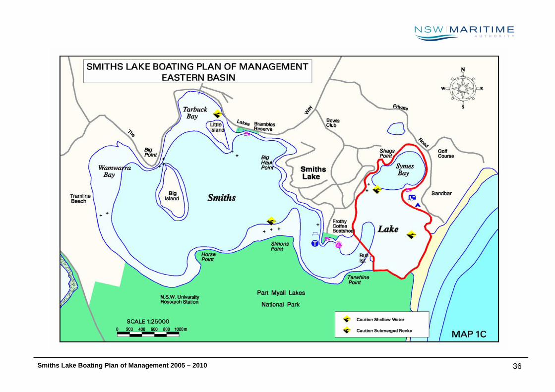
8 EASTERN BASIN
8.1 Description:
The eastern basin is a 2 km2 body of water running from Symes Bay in the north to the Myall Lakes National Park 2.25km to the south. Its widest point
runs from the sandbar that separates the lake from the Pacific Ocean to the western shore 1.3km away. Symes Bay is set apart from the main western
body of the lake by an extensive sand delta of less than 0.5 metre in depth and is negotiable only to small powerboats and non-motorised craft.
The broad expanses of shallow foreshore and extensive shoals attract both tourists and residents, although associated developments are of a low-key
nature. The eastern basin provides ideal environs for children to wade, for swimmers, and learner water skiers. The area is also popular with sailors,
sailboarders and more recently, kite surfers.
Access to Symes Bay in the east is via an informal launching ramp located at the Sandbar Caravan Park, or an informal ramp off Patsys Flat Road. Vessels
also travel across the lake in order to reach the unpatrolled ocean beach at Sandbar to swim and surf, the beach being located a short distance across the
eastern sand dunes.
8.2 Navigational Restrictions Etc
The navigation dynamics of the lake are largely determined by its entrance opening regime adopted by the Great Lakes Council. Tidal flow through the
narrow ocean entrance is extreme when the Lake is manually opened, and at these times is considered by the Authority to present a potential danger for
swimmers and small craft alike. There is no signage to indicate this hazard on the estuary, however when notified, yellow floating markers are installed by
NSW Maritime at regular intervals around a 200m radius near the Lake entrance. The markers provide swimmers and vessels with an indication of the
dangerous and changing conditions when approaching the ocean entrance.
A natural navigation restriction is evidenced by an extensive sand delta less than 0.5 metre in depth separating Symes Bay from the rest of the lake. In
fact, it becomes possible to walk over this area during times of low water brought about by long periods without substantial rain or after opening of the
lake to the ocean.
Smiths Lake Boating Plan of Management 2005 – 2010
37
The current SLEMP zoning includes a four knot area extending from Patsy Flat along the western shore of the basin, south to Bull Island and west to
Simons Point.
8.3 Infrastructure
A private informal launching facility is available to residents and visitors of the Sandbar Caravan Park on the eastern-most shore of the lake, and another
informal ramp is located at Pastys Flat near Sandpiper Lodges. Patsys Flat Road allows additional access to Symes Bay when the lake level is low, and is
generally used by a few residents and licensed fishing boats. There is no designated parking at this site.
There are no slipways, fuelling points, pump-outs, public wharfs, jetties or marinas on the Eastern Basin, and no oyster leases, dredges or work boats of
any description, other than the small commercial fishing fleet.
8.4 Compliance History
Analysis of formal warnings and fixed penalties issued over the last three years reveal that most offences relate to the registration of craft. The breakdown
of safety related offences shows a relatively even distribution with no single feature outstanding. Failure to carry the required lifejackets has been the
most significant offence. Other infringements include speed, bow riding, vessels exceeding capacity and failure to carry an observer while towing.
Complaints from local residents expressed concern over ski activities on the Eastern Basin, in particular around Patsys Flat Road and Symes Bay. These
reports tend to relate to speed, distance off swimmers and vessel noise emissions.
It is important to note that complaints do not appear to emanate from the interaction between fishing, sailing or paddle craft and ski boats or PWCs on the
water. This may be due to the fact that in most cases fishing and sailing vessels (including wind and kite surfing) tend to seek areas away from the
recognised family day use areas and participate at times outside of those favoured by social skiers. Also, PWC use on the Lake is relatively rare and
rowers have a preference for the more scenic, natural shoreline. In these cases congestion does not appear to be a source of conflict for on-water users,
be they motorised or non-motorised.
Smiths Lake Boating Plan of Management 2005 – 2010
38

8.5 Values
♦ Stakeholders value the Eastern Basin of Smiths Lake as an environmentally sensitive and important habitat area for a variety of aquatic, avian and
terrestrial species. Of particular importance is the Myall Lakes National Park bordering its southern perimeter.
♦ Stakeholders enjoy the amenity of lakeside living.
♦ Visitors and residents alike enjoy a wide range of aquatic activities on the eastern basin. The varying conditions permit similar activities to be
undertaken without conflict with other less compatible activities. For example, the shallow sand delta area is ideal for small sailing vessels and wind
and kite surfers, but too shallow for faster and larger powered activities such as water skiing.
♦ The deeper Symes Bay area is valued as an ideal area for water skiing, aquaplaning and other motorised activities.
♦ Passive and non-powered vessel users enjoy the amenity of the eastern basin. The western foreshore in particular is valued as an area in which to
swim, canoe and kayak.
♦ NSW Fisheries and the professional fishing industry value the eastern basin for its importance in terms of seagrasses and the density and diversity of
marine species found there.
♦ Stakeholders also value the sandbar area separating the lake from the ocean. It is used by boaters and PWC riders as a base from which to swim,
pickup and set down, as well as an access point to the beach.
8.6 Issues
♦ The SLEMP zoning plan recommended a 4 knot area that extended into the eastern basin as far as Patsys Flat. This zone was designed to reduce the
amount of powered craft, especially those water skiing, in areas that conflict with non-powered and passive activity. Some submissions received
agreed with the zoning while others saw it as being overly regulatory. This is essentially a safety and equity issue.
♦ Stakeholders expressed concern over siltation, periods of low water and the opening and closing regime of the lake, causing a transit problem for
vessels.
Smiths Lake Boating Plan of Management 2005 – 2010
39

♦ Stakeholders expressed concern over apparent incompatible activities such as swimming and power boating in the Patsys Flat area.
♦ Stakeholders expressed differing views concerning the scattering of dinghies on the foreshores. Some suggested the dinghies added to the village
atmosphere and rustic characteristics of the lake, while others considered them an eye-sore. NSW Maritime saw potential safety issues especially
during periods of high water. Vessels could float out into the lake and present navigation hazards. Additionally, the proliferation of vessels may also
contribute to degradation of shoreline vegetation by shading grasses and encouraging weeds and a spread in human impact.
♦ Stakeholders have expressed concern over noise from the occasional inboard ski boat and personal watercraft. However, the shallow nature of much
of the eastern basin results in fewer noise complaints and is not as big an issue as it is around De Berts Reserve and the western basin.
8.7 Management Strategies and Action Plan
Outcome Strategies Actions Timeframe
Improved management of the
shallow areas of the eastern basin,
particularly during lake opening or
periods of low rainfall
Periodic installation of buoys and shallow water
signage
Liaise with Great Lakes Council to ensure prior
knowledge of lake opening.
Prior to lake opening and during periods of low
water, install yellow aquamarks adjacent to the
eastern side of the basin near the opening to warn
vessels of dangerous conditions. Install “caution -
shallow water” signage on the foreshore at Sandbar
and the southern side of the opening and to be
activated when the lake is open.
Short term
Short term
Smiths Lake Boating Plan of Management 2005 – 2010
40

Reduce the risk of accidents or
incidents involving powered vessels
and those undertaking non-
powered activities, particularly in
the Patsys Flat area.
Reconfigure vessel restrictions, resulting in a
significant reduction in waterskiing activity on
the western shore of the eastern basin.
Education
Remove existing 4 knot trial zone.
Introduce a No Skiing or Aquaplaning zone in the
area between the eastern and western basins (see
MIDDLE BASIN section for details).
Install an east cardinal mark adjacent to Patsys Flat
indicating vessels should keep east of the area
thereby reducing the risk of collision with swimmers
and non-powered craft.
Install signage at the various launching facilities
indicating:
o A code of conduct for powered vessels especially
those involved in towing activities on the lake
o “Avoid high traffic Areas”
o “Help reduce noise – avoid offensive behaviour”
Regular compliance programs
Short term
“
“
“
Ongoing
Help to ensure equitable use of the
waterway for all stakeholders while
at the same time maintaining the
relatively peaceful ambience and
village atmosphere of the Smiths
Lake foreshore.
Educate, monitor and review. Install signage at vessel access points indicating:
o A code of conduct for powered vessels
o “Avoid high traffic Areas”
o “Help reduce noise – avoid offensive behaviour”
Regularly monitor through patrolling and periodic
Short term
Ongoing
Smiths Lake Boating Plan of Management 2005 – 2010
41
noise testing of vessels
Regularly review strategies and assess
effectiveness.
“
Mitigate the risk of damage to
sensitive areas and seagrass
habitat near the shoreline on the
western side of the basin and in the
north-east corner of Symes Bay.
SLEMP (GLC, 2001) identified the location of
seagrass beds in the eastern basin, noting the
need for protection when lake levels are less
than 1.0 metre. These areas are generally too
shallow for most powered craft and therefore
damage may be kept to a minimum. However,
an education strategy and a ban on anchoring
and/or laying buoys in such areas are to be
implemented.
Signage and/or buoyage identifying the location of
seagrass beds to be located at vessel access points
in consultation with NSW Fisheries.
Liaise with NSW Fisheries to organise periodic
compliance programs.
Short term
Ongoing
Smiths Lake Boating Plan of Management 2005 – 2010
42

Smiths Lake Boating Plan of Management 2005 – 2010 43
SSMMIITTHHSS LLAAKKEE
MMIIDDDDLLEE BBAASSIINN
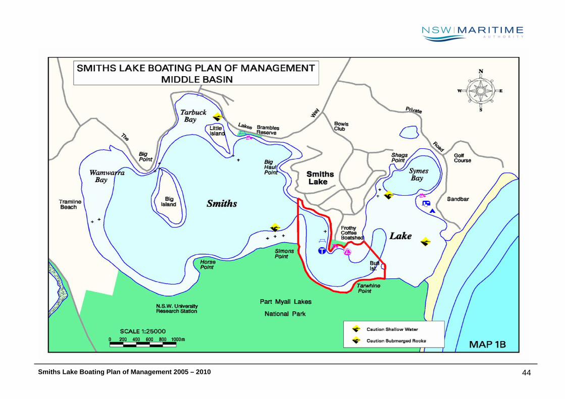
Smiths Lake Boating Plan of Management 2005 – 2010 44
Smiths Lake Boating Plan of Management 2005 – 2010 45
9 MIDDLE BASIN
9.1 Description:
This section of the lake comprises the stretch of water that connects the eastern and western basins. It extends from Simons Point in the west to Bull
Island 1.3km to the east, and from John De Bert Reserve and Frothy Coffee Boatshed in the north to the Myall Lakes National Park approximately 700
metres to the south. It is the most intensely utilised section of the lake and is popular for canoes, sail craft, windsurfers, powerboats and to a lesser
extent PWCs. The central point is John De Berts Reserve on the shores of Smiths Lake village. It has a public boat launching facility and is the most
popular location for boaters, tourists and residents due to the sandy beach area, park and other public facilities. A commercial hire and drive operation at
the boatshed east of the boat ramp provides an opportunity for the public to hire catamarans, small powerboats, canoes and paddle craft for use on the
lake.
9.2 Navigational Restrictions Etc
The Smiths Lake Estuary Management Plan (GLC, 2001) ‘zoning plan’ proposed an extensive 4 knot speed limit along the foreshore of this area from the
eastern basin through to the western basin, being the most highly populated section of the lake. Due to the issues associated with implementing irregular
buoyed zones it was recommended that any variations to the 4 knot area should, as far as possible, utilise prominent land marks as boundaries.
In November 2002 an alternative to the ‘trial zoning’ was proposed and subsequently implemented. The mid-stream buoys were removed, and the
landmarks of Bull Island and Simons Point used to establish boundaries.
9.3 Infrastructure
The John De Bert Reserve boat ramp is very much the point of origin around which Smiths Lake village developed, and now finds itself in the most popular
location for boaters due to its central position. The ramp consists of a concrete pad construction making it easy for the conventional sedan to launch and
retrieve. However, parking facilities are severely limited and many local boaters elect to return home to store their trailers for the day after launching. The
Smiths Lake Boating Plan of Management 2005 – 2010 46
public toilet amenities, children’s playground and picnic tables available at the reserve further lend themselves to the popularity of the area for daytime
activities.
Signage and yellow aquamarks indicating the limits of a four knot restriction are evidenced in this area.
There are no slipways, fuelling points, pump-outs, public wharfs, jetties or marinas on the Middle Basin, and no oyster leases, dredges or work boats of
any description, other than the small commercial fishing fleet.
9.4 Compliance History
The Authority has historically received consistent levels of complaint in relation to vessel activity on the Lake, mostly resulting from conflict between
waterway users and residents. A notable increase in complaints was recorded over the 2001/2002 boating season (being October 2001 to Easter 2002),
and related to new waterway zoning restrictions being trialed in accordance with recommendations of the SLEMP (GLC, 2001).
The majority of complaints resulting from the’ zoning’ trial related to skiing, the curfew, and the extension of the existing 4 knot speed restriction. The
public response highlighted the popularity of waterskiing with residents and in particular, visitors.
The unrestricted channel, allowing craft to pass between the east and west basin at high speed, was also a cause for concern. The narrowing of this
channel at low water was perceived to present a potential risk for collision.
Other complaints from local residents expressed concern over ski activities on the Lake, in particular around John DeBert Reserve. These reports tend to
relate to speed, distance off swimmers and vessel noise emissions, each of which could be managed under existing regulations where the offending craft is
identified.
It is important to note that complaints do not appear to emanate from the interaction between fishing, sailing or paddle craft and ski boats or PWCs on the
water. This may be due to the fact that in most cases fishing and sailing vessels tend to seek areas away from the recognised family day use areas and
participate at times outside of those favoured by social skiers. Also, PWC use on the Lake is relatively rare and rowers have a preference for the more
scenic, natural shoreline. In these cases congestion does not appear to be a source of conflict for on-water users, be they motorised or non-motorised.

Smiths Lake Boating Plan of Management 2005 – 2010 47
In contrast, the recognised family day use areas are frequented by both swimmers and skiers, and complaints in relation to the mooring of fishing vessels
at the John DeBert Reserve ramp are ongoing. Council Reserves tend to be situated in central locations near urban zones and as such receive high level
visitation.
Every season it is commonplace for swimmers to express a general concern in regard to vessel speed around John De Bert Reserve. Speeding is an
important compliance issue on the estuary and enforcement action has ensued wherever offences have been detected.
Analysis of formal warnings and fixed penalties issued over the last three years reveal that most offences relate to the registration of craft. The breakdown
of safety related offences shows a relatively even distribution with no single feature outstanding. Failure to carry the required lifejackets being the most
significant offence, with infringements issued for speed, bow riding, vessels exceeding capacity and failure to carry an observer while towing.
While all these matters are considered by the Authority to be of a serious nature, overall compliance is high. Such issues are managed on a case by case
basis via routine patrol, inspection and ongoing education campaigns.
9.5 Values
♦ The John De Bert Reserve is valued by families as an area for pursuing recreational activities, such as picnics and swimming, as well as passive
aquatic activities including canoeing, kayaking and paddle boating.
♦ Stakeholders enjoy the amenity of lakeside living.
♦ The boat ramp at John De Bert Reserve is the most popular launching facility on the lake. Visitors and residents alike enjoy a wide range of powered
aquatic activities emanating from this area.
♦ NSW Fisheries and the professional fishing industry value an area along the southern shore for its importance in terms of seagrasses and the density
and diversity of marine species found there.
♦ Stakeholders value the safe and equitable use of this section of the lake, especially the safe co-existence of the varying recreational activities carried
out around John De Bert Reserve.

Smiths Lake Boating Plan of Management 2005 – 2010 48
9.6 Issues
♦ Stakeholders expressed deep concern over any suggestion to remove the boat launching facility from De Bert Reserve in favour of upgraded facilities
at Brambles Reserve.
♦ The SLEMP zoning plan recommended a 4 knot area that extended into the eastern basin as far as Patsys Flat. This zone was designed to reduce the
amount of powered craft, especially those water skiing, in areas that conflict with non-powered and passive activity. Submissions received agreed
with the zoning while others saw it as being overly regulatory. This is essentially a safety and equity issue.
♦ Stakeholders expressed concern over apparent incompatible activities such as swimming and power boating in the De Bert Reserve area.
♦ Stakeholders expressed differing views concerning the scattering of dinghies on the foreshores. Some suggested the dinghies added to the village
atmosphere and rustic characteristics of the lake, while others considered them an eye-sore. Waterways saw potential safety issues especially during
periods of high water. Vessels could float out into the lake and present navigation hazards. Additionally, the proliferation of vessels may also
contribute to degradation of shoreline vegetation by shading grasses and encouraging weeds and a spread in human impact.
♦ Stakeholders have expressed concern over noise from the occasional inboard ski boat and personal watercraft.
♦ Wash is of most concern to the proprietors of the Frothy Coffee Boatshed when the lake entrance is closed and nearing maximum capacity prior to
opening. High water levels make the property most vulnerable to wash and wind generated waves.
♦ Permanent mooring of commercial vessels, particularly fishing vessels near John De Bert Reserve, has long been an issue of conflict on the Lake, as
the village of Smiths Lake and use of the reserve has grown.
♦ Stakeholders expressed concern that aquatic licences issued by the Authority, especially for high-powered events, may create an intolerable impact
on the lake environment.
♦ The protection of sensitive areas, eg. SEPP 14 wetlands and seagrass habitat is an issue on the Lake. NSW Fisheries highlights the importance of
seagrass to ecologically sustainable fishing (Fisheries, 1999), and SLEMP (GLC, 2001) reflects this value by recommending measures such as boater
education and the marking of seagrass beds to minimise the risk of damage by propellers. Additionally, National Parkes and Wildlife Services express
concern of the impact increased vessel activity could have on Ramsar wetlands located in the area and the Myall Lakes National Park in general.

Smiths Lake Boating Plan of Management 2005 – 2010 49
9.7 Management Strategies and Action Plan
Outcome Strategies Actions Timeframe
Reduce the risk of accidents or
incidents involving powered vessels
and those undertaking non-
powered activities in the John De
Bert Reserve / Frothy Coffee area.
Also, reduce the effects of wash
generated by vessels particularly
when water levels are high.
Reconfigure vessel restrictions, resulting in a
significant reduction in waterskiing and other
power boating activity. No skiing zones will
reduce power boating activity due to less
passes being undertaken. Also, irregular
driving (freestyling) of Personal Water Craft
(PWC) will not be permitted in this area. As a
result, vessels will tend to use this area only as
a conduit between the eastern and western
basins.
Introduce safer launch and retrieve measures
for vessel operators using the De Berts Reserve
boat ramp.
Reduce congestion near John De Bert Reserve
Remove existing 4 knot trial zone and replace it with
a “No Skiing or Aquaplaning” zone. It will extend
from Oyster Point to Bull Island then south to the
Myall Lakes National Park, then west to Simons
Point and back to Oyster Point. Additionally,
institute a “No Irregular Driving (freestyling)” PWC
restriction in the same area. (See map 2 at end of
this section)
Reintroduce a 4 knot zone as originally gazetted in
1987. That is from Oyster Point to Frothy Coffee
Boatshed. (See map 2 at end of this section).
Install appropriate signage and 4 knot aqua buoys.
Restrict vessel operators to launch and retrieval in
an area extending from the ramp to an existing pvc
pole immediately west of the ramp.
Create a “No Vessel” zone west of the pvc pole to
enable the safe use of the sandy beach by those
involved in passive recreational activities.
Install appropriate signage
Implement above “No Vessel” zone restrictions at
Short term
Short term
Short term
Short term
Short term
Short term
Smiths Lake Boating Plan of Management 2005 – 2010 50
by encouraging the relocation of commercial
vessels, particularly fishing vessels to Brambles
Reserve.
Liaison and discussion with relevant Agencies
Education
the sandy beach area.
Liaise with the commercial fishers with a view to the
selective positioning of the mooring of commercial
fishing vessels at Brambles Reserve.
Liaise with Great Lakes Council to encourage the
upgrading of Brambles Reserve boat ramp.
NSW Maritime will support application made by
Great Lakes Council for maintenance dredging to
remove unconsolidated marine sediment in the
vicinity of the boat ramp as required.
Install signage at the various launching facilities
indicating:
o New zoning arrangements
o A code of conduct for powered vessels especially
those involved in towing activities on the lake
o Messages such as “Avoid high traffic Areas” and
“Help reduce noise – avoid offensive behaviour”
Regular compliance programs
Short term
Short term
Short term
Short term
Short Term
Ongoing
Mitigate the risk of damage to
sensitive wetland, seagrass
national park areas adjoining this
section of the lake.
Educate, monitor and review compliance
concerning mooring, anchoring and power
boating in these areas.
Install signage at vessel access points identifying
sensitive wetland and seagrass areas.
Refuse requests for aquatic licences to hold high-
powered aquatic events in this section of the lake.
Liaise with NSW Fisheries and National Parks and
Short term
Ongoing

Smiths Lake Boating Plan of Management 2005 – 2010 51
Wildlife Services to organise periodic compliance
programs.
Ongoing
Minimise the potential risk and
visual or environmental impact of
unsecured craft around the lake
shore.
Liaison and consultation with relevant
government agency(s).
Recommend that Great Lakes Council give
consideration to the potential hazard posed by the
unsecured dinghies and the establishing of
designated storage areas with basic facilities in the
form of securing posts or communal storage racks.
Short term
Help to ensure equitable use of the
waterway for all stakeholders while
at the same time maintaining the
relatively peaceful ambience and
village atmosphere of the Smiths
Lake foreshore.
Educate, monitor and review. Regularly monitor through patrolling and periodic
noise testing of vessels
Install signage at vessel access points indicating:
o A code of conduct for powered vessels
o Messages such as “Avoid high traffic Areas” and
“Help reduce noise – avoid offensive behaviour”
Regularly review strategies and assess
effectiveness.
Ongoing
Short term
Ongoing
Help achieve the best possible
result for all stakeholders in terms
of the provision of appropriate
boating infrastructure.
Liaison with Great Lakes Council. Stakeholders
have expressed a strong desire for the existing
De Bert Reserve boat launching facility to
remain and be improved. Additionally, there is
also a need to develop the Brambles Reserve
area which could result in relieving some of the
heavy use and congestion experienced at De
Bert Reserve.
Liaise with Great Lakes Council and inform them of
the feedback received during the consultation
process. Offer assistance in formulating a
Waterways Asset Development and Management
Program (WADAMP) application for 50% grant
funding of any proposed improvements to launching
facilities.
Medium Term
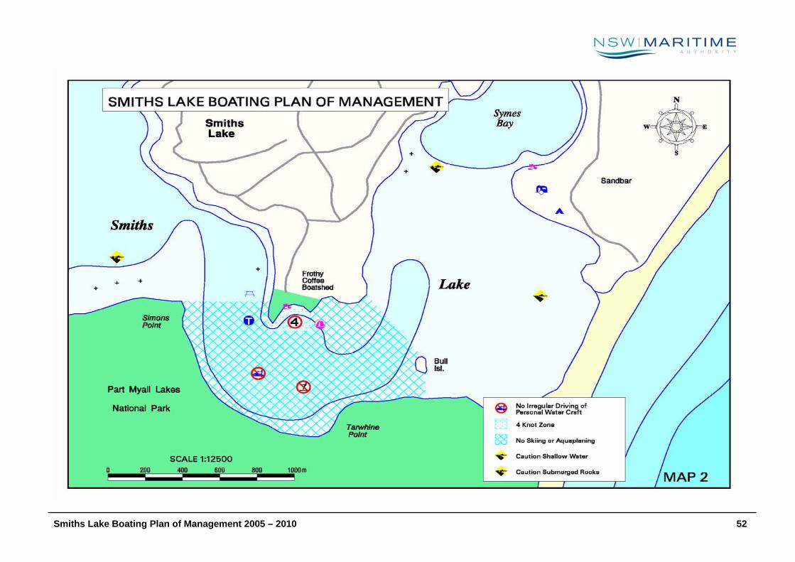
Smiths Lake Boating Plan of Management 2005 – 2010 52
Smiths Lake Boating Plan of Management 2005 – 2010
53
SSMMIITTHHSS LLAAKKEE
WWEESSTTEERRNN BBAASSIINN
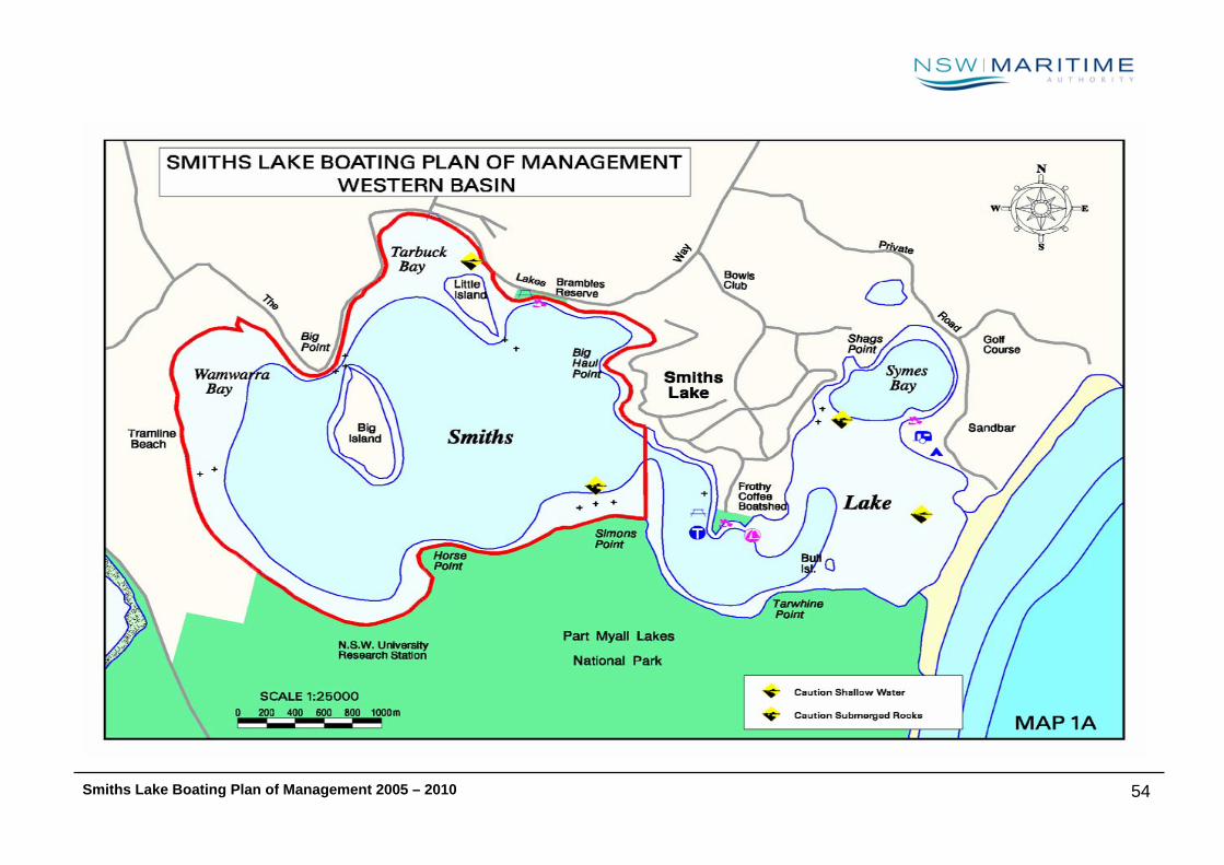
Smiths Lake Boating Plan of Management 2005 – 2010
54

Smiths Lake Boating Plan of Management 2005 – 2010
55
10 WESTERN BASIN
10.1 Description:
The Western basin is a 7.5 km2 body of water running from Tarbuck Bay in the north to the Myall Lakes National Park 3 km to the south. Its widest point
runs from Simons Point and Smiths Lake Village in the east to Wamwarra Bay on the western shore 3.5 km away. The basin has two small islands, Big
Island and Little Island, with a total area of around 0.4 km2.
The settlements of Smiths Lake and Tarbuck are the only significant developments adjoining the western basin. The Myall Lakes National Park runs along
most of the southern shoreline. Wetlands of SEPP 14 Coastal Wetlands classification adjoin the western and southern edges of the lake and as many as
16 vulnerable species of fauna have been identified in these habitat areas.
Activity on the western basin includes water skiing along the eastern shore adjacent to Smiths Lake village, sailing and windsurfing towards the centre of
the basin and around Big Island, and fishing – both recreational and commercial.
10.2 Navigational Restrictions Etc
The navigation dynamics of the lake are largely determined by its entrance opening regime adopted by the Great Lakes Council. Tidal flow through the
narrow ocean entrance is extreme when the Lake is manually opened, and at these times is considered by the Authority to present a potential danger for
swimmers and small craft alike.
Rock ledges surrounding both Big and Little Islands present navigational restrictions particularly during periods of low water. Also, several submerged
logs located off Tramline Beach are hazardous to navigation, particularly when the lake level falls. Other restrictions include the remnants of an old farm
fence extending from Myall Lakes National Park at Horse Point to approximately 50 metres into the lake.
The small estuaries of Wamwarra and Tarbuck Creeks are considered unsuitable for navigation by conventional power craft due to submerged hazards in
the form of snags. They are however, suitable for exploration with human powered craft such as canoes and kayaks, although fallen trees may limit
access to their extremities.

Smiths Lake Boating Plan of Management 2005 – 2010
56
10.3 Infrastructure
Brambles Reserve Boat Ramp is located adjacent to Little Island but is under-utilised due to its rocky foreshore and exposure to southerly wind conditions.
During periods of low water access for the launching and retrieving of vessels can be limited to four wheel drive vehicles.
There are no slipways, fuelling points, pump-outs, public wharfs, jetties or marinas on the Western Basin, and no oyster leases, dredges or work boats of
any description, other than the small commercial fishing fleet.
10.4 Compliance History
Analysis of formal warnings and fixed penalties issued over the last three years reveal that most offences relate to the registration of craft. The breakdown
of safety related offences shows a relatively even distribution with no single feature outstanding. Failure to carry the required lifejackets has been the
most significant offence. Other infringements include speed, bow riding, vessels exceeding capacity and failure to carry an observer while towing.
Complaints from local residents expressed concern over noise from ski activities on the eastern shoreline, in particular when vessels are involved in
learning to ski activities. Other complaints tend to relate to speed and distance off swimmers.
It is important to note that complaints do not appear to emanate from the interaction between fishing, sailing or paddle craft and ski boats or PWCs on the
water. This may be due to the fact that in most cases fishing and sailing vessels (including wind and kite surfing) tend to seek areas away from the
recognised family day use areas and participate at times outside of those favoured by social skiers. Also, PWC use on the Lake is relatively rare and
rowers have a preference for the more scenic, natural shoreline. In these cases congestion does not appear to be a source of conflict for on-water users,
be they motorised or non-motorised.
Smiths Lake Boating Plan of Management 2005 – 2010
57
10.5 Values
♦ Stakeholders value the Western Basin of Smiths Lake as an environmentally sensitive and important habitat area for a variety of aquatic, avian and
terrestrial species. Of particular importance is the Myall Lakes National Park bordering its southern perimeter and Wetlands of SEPP 14 Coastal
Wetlands classification adjoining the western and southern edges of the lake. As many as 16 vulnerable species of fauna have been identified in
these habitat areas.
♦ Stakeholders enjoy the amenity of lakeside living.
♦ The area adjacent to the eastern shoreline is valued as an ideal area for water skiing, aquaplaning and other motorised activities.
♦ Passive and non-powered vessel users enjoy the amenity of the western basin. The basin’s large expanses in particular are valued as areas in which
to sail and windsurf.
♦ NSW Fisheries and the professional fishing industry value the western basin for its importance in terms of seagrasses and the density and diversity of
marine species found there.
10.6 Issues
♦ Stakeholders expressed concern over apparent incompatible activities such as swimming, kayaking, canoeing and power boating in the area from Big
Haul Point to Brambles Reserve and Tarbuck Bay.
♦ Stakeholders have expressed concern over noise from the occasional inboard ski boat and personal watercraft along the eastern shoreline of the
basin.
♦ The upgrading of Brambles Reserve and boat ramp has been suggested by stakeholders to help alleviate congestion at John De Bert Reserve and aid
in reducing the risk of accidents and/or incidents occurring there.
♦ The use of Brambles Reserve and boat ramp as a suitable area for the mooring of commercial vessels, particularly professional fishing vessels, is an
issue raised by stakeholders.

Smiths Lake Boating Plan of Management 2005 – 2010
58
♦ Stakeholders expressed concern that aquatic licences issued by the Authority, especially for high-powered events, may create an intolerable impact
on the lake environment.
♦ The protection of sensitive areas, eg. SEPP 14 wetlands and seagrass habitat, is an issue on the Lake. NSW Fisheries highlights the importance of
seagrass to ecologically sustainable fishing (Fisheries, 1999), and SLEMP (GLC, 2001) reflects this value by recommending measures such as boater
education and the marking of seagrass beds to minimise the risk of damage by propellers. Additionally, National Parks and Wildlife Services express
concern of the impact increased vessel activity could have on Ramsar wetlands located in the area and the Myall Lakes National Park in general.
♦ Concern has been expressed regarding navigational obstructions such as submerged logs off Tramline Beach and the old farm fence off the Myall
Lakes National Park on the southern end of the basin.
♦ Stakeholders expressed differing views concerning the scattering of dinghies on the foreshores. Some suggested the dinghies added to the village
atmosphere and rustic characteristics of the lake, while others considered them an eye-sore. Waterways saw potential safety issues especially during
periods of high water. Vessels could float out into the lake and present navigation hazards. Additionally, the proliferation of vessels may also
contribute to degradation of shoreline vegetation by shading grasses and encouraging weeds and a spread in human impact.
Smiths Lake Boating Plan of Management 2005 – 2010
59
10.7 Management Strategies and Action Plan
Outcome Strategies Actions Timeframe
Mitigate the risk of damage to
sensitive wetland, seagrass and
national park areas adjoining this
section of the lake.
Educate, monitor and review compliance
concerning mooring, anchoring and power
boating in these areas.
Install signage at vessel access points identifying
sensitive wetland and seagrass areas in consultation
with NSW Fisheries.
Refuse requests for aquatic licences to hold high-
powered aquatic events in this section of the lake.
Liaise with NSW Fisheries and National Parks and
Wildlife Services to organise periodic compliance
programs.
Short term
Ongoing
Ongoing
Help to ensure equitable use of the
waterway for all stakeholders while
at the same time maintaining the
relatively peaceful ambience and
village atmosphere of the Smiths
Lake foreshore.
Educate, monitor and review. Regularly monitor through patrolling and periodic
noise testing of vessels
Install signage at vessel access points indicating:
o A code of conduct for powered vessels
o Messages such as “Avoid high traffic Areas” and
“Help reduce noise – avoid offensive behaviour”
Regularly review strategies and assess
effectiveness.
Ongoing
Short term
Ongoing
Smiths Lake Boating Plan of Management 2005 – 2010
60
Help achieve the best possible
result for all stakeholders in terms
of the provision of appropriate
boating infrastructure.
Liaison with local government agencies.
Stakeholders have expressed a strong desire
for the existing De Berts Reserve boating
launching facility to remain and be improved.
Additionally, there is also a need to develop the
Brambles Reserve area which could result in
relieving some of the heavy use and congestion
experienced at De Berts Reserve.
Liaise with Great Lakes Council and inform them of
the feedback received during the consultation
process. Offer assistance in formulating a
Waterways Asset Development and Management
Program (WADAMP) application for 50% grant
funding of any proposed improvements to launching
facilities.
Medium Term
Mitigate the risk of accidents or
incidents, particularly during
periods of low water, involving the
submerged logs off Tramline Beach
and the remnant farm fence at the
southern end of the basin.
Use of navigation aids and education. Install an east cardinal mark at the eastern
extremity of the submerged logs area.
Install a north cardinal mark at the remnant fence.
Liaise with the NPWS with a view to removal of the
fence
Include these areas on signage indicating navigation
restrictions to be located at vessel access points.
Short term
Short term
Short term
Short term
Minimise the potential risk and
visual or environmental impact of
unsecured craft around the lake
shore.
Liaison and consultation with relevant
government agency(s).
Recommend that Great Lakes Council give
consideration to the potential hazard posed by the
unsecured dinghies and the establishing of
designated storage areas with basic facilities in the
form of securing posts or communal storage racks.
Short term