Skydio X2E Color
2
Skydio X2E Color Unmatched autonomy meets enterprise performance Skydio X2E Color is the ultimate UAS solution for aerial asset inspection and incident scene reconstruction. X2E is powered by Skydio Autonomy Enterprise, an AI-driven autonomous flight engine that enables unparalleled 360° obstacle avoidance, autonomous tracking, GPS-denied navigation, and complete workflow automation. X2E is designed with a ruggedized, foldable airframe, GPS-based night flight, strobing lights in visible and IR wavelength, and a single sensor payload with a 12MP/4K60P HDR color camera with a wide angle lense optimized for close capture. Built for enterprises and first responders, Skydio X2E is designed and assembled in the USA, and is compliant with the National Defense Authorization Act (NDAA). Advanced software add-ons Skydio 3D Scan TM : Adaptive scanning to automate the image capture process to document complex structures and generate 3D models with comprehensive coverage and ultra-high resolution. Perform higher quality inspections and documentation faster and with minimal pilot training. Skydio Cloud: Enables federated fleet management and seamless upload of flight media. No more manual handling of SD cards and hard drives. CYBERSECURITY AES-128 wireless encryption WIRELESS RANGE FLIGHT TIME Up to 35 min Up to 3.7 mi / 6 km VISION-BASED NA VIGA TION FOR GPS-DENIED OPERATIONS CAPTURE DOWN TO 0.65 MM GROUND SAMPLE DIST ANCE Rugged, Portable, Deploys in Under 75 Seconds
Transcript of Skydio X2E Color

Skydio X2E Color
Unmatched autonomymeets enterprise performanceSkydio X2E Color is the ultimate UAS solution for aerial asset inspection and incident scene reconstruction. X2E is powered by Skydio Autonomy Enterprise, an AI-driven autonomous flight engine that enables unparalleled 360° obstacle avoidance, autonomous tracking, GPS-denied navigation, and complete workflow automation. X2E is designed with a ruggedized, foldable airframe, GPS-based night flight, strobing lights in visible and IR wavelength, and a single sensor payload with a 12MP/4K60P HDR color camera with a wide angle lense optimized for close capture. Built for enterprises and first responders, Skydio X2E is designed and assembled in the USA, and is compliant with the National Defense Authorization Act (NDAA).
Advanced software add-onsSkydio 3D ScanTM: Adaptive scanning to automate the image capture process to document complex structures and generate 3D models with comprehensive coverage and ultra-high resolution. Perform higher quality inspections and documentation faster and with minimal pilot training.
Skydio Cloud: Enables federated fleet management and seamless upload of flight media. No more manual handling of SD cards and hard drives.
CYBERSECURITY
AES-128 wireless encryption
WIRELESS RANGE FLIGHT TIME
Up to 35 minUp to 3.7 mi / 6 km
VISION-BASED NAVIGATION FOR GPS-DENIED OPERATIONS
CAPTURE DOWN TO 0.65 MM GROUND SAMPLE DISTANCE
Rugged, Portable, Deploys in Under 75 Seconds
Contact [email protected] today to learn more about integrating Skydio X2.Designed and assembled in the USA
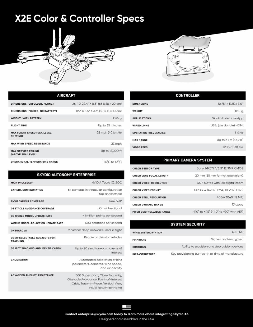
X2E Color & Controller Specs
Controller
Dimensions
WEIGHT
APPLICATIONS
WIRED LINKS
OPERATING FREQUENCIES
MAX RANGE
VIDEO FEED
10.75” x 5.25 x 3.0”
1130 g
Skydio Enterprise App
USB, (via dongle) HDMI
5 GHz
Up to 6 km (5 GHz)
720p at 30 fps
AIRCRAFT
Dimensions (Unfolded, FLYING)
Dimensions (Folded, no battery)
Weight (with battery)
FLIGHT TIME
MAX FLIGHT SPEED (SEA LEVEL, NO WIND)
MAX WIND SPEED RESISTANCE
MAX SERVICE CEILING (ABOVE SEA LEVEL)
OPERATIONAL TEMPERATURE RANGE
26.1” X 22.4“ X 8.3” (66 x 56 x 20 cm)
11.9“ X 5.5” X 3.6“ (30 x 15 x 10 cm)
1325 g
Up to 35 minutes
25 mph (40 km/h)
23 mph
Up to 12,000 ft
-10°C to 43°C
SKYDIO AUTONOMY Enterprise
Main Processor
CAMERA CONFIGURATION
ENVIRONMENT COVERAGE
OBSTACLE AVOIDANCE COVERAGE
3D WORLD MODEL UPDATE RATE
WORLD MODEL-TO-ACTION UPDATE RATE
ONBOARD AI
USER-SELECTABLE SUBJECTS FOR TRACKING
OBJECT TRACKING AND IDENTIFICATION
CALIBRATION
ADVANCED AI-PILOT ASSISTANCE
NVIDIA Tegra X2 SOC
6x cameras in trinocular configuration top and bottom
True 360°
Omnidirectional
> 1 million points per second
500 iterations per second
9 custom deep networks used in flight
People and motor vehicles
Up to 20 simultaneous objects of interest
Automated calibration of lensparameters, cameras, wind speed,
and air density
360 Superzoom, Close Proximity,Obstacle Avoidance, Point-of-Interest
Orbit, Track-in-Place, Vertical View, Visual Return-to-Home
SYSTEM SECURITY
WIRELESS encryption
Firmware
Controls
InfrastructurE
AES-128
Signed and encrypted
Ability to provision and deprovision devices
Key provisioning burned-in at time of manufacture
Primary Camera System
COLOR SENSOR TYPE
COLOR LENS FOCAL LENGTH
COLOR VIDEO RESOLUTION
COLOR VIDEO FORMAT
COLOR STILL RESOLUTION
COLOR DYNAMIC RANGE
PITCH CONTROLLABLE RANGE
Sony IMX577 1/2.3” 12.3MP CMOS
20 mm (35 mm format equivalent)
4K / 60 fps with 16x digital zoom
MPEG-4 (AVC/H.264, HEVC/H.265)
4056x3040 (12 MP)
13 stops
-110° to +45° (-110° to +90° with AEF)


![FACULTY OF ARTS AND SCIENCE - » Department of …€¦ · · 2015-05-07FACULTY OF ARTS AND SCIENCE University of Toronto ... 1 1 x2e xdx (b) [6 marks]Z 3x 2 x3 + 2x2 dx Page 12](https://static.fdocuments.us/doc/165x107/5afb78647f8b9a2d5d8faacb/faculty-of-arts-and-science-department-of-2015-05-07faculty-of-arts-and.jpg)