SKINT W S U W PLANNING ACROSS...
88
SKINT WATER S ERIES S USTAINABLE URBAN WATER PLANNING ACROSS BOUNDARIES J. de Beer, A. Christensson, F. Boogaard (eds.)
Transcript of SKINT W S U W PLANNING ACROSS...

SKINT WATER SERIES
SUSTAINABLE URBAN WATER PLANNING ACROSS BOUNDARIES
J. de Beer, A. Christensson, F. Boogaard (eds.)

2
CONTENTSPREFACE 3
SUMMARY 4
NORTH SEA SKILLS INTEGRATION AND NEW TECHNOLOGIES – SKINT 5
CASE STUDIES: THE JOURNEY TO SUSTAINABLE DEVELOPMENT 8SUSTAINABLE OR NOT SUSTAINABLE, THAT’S THE QUESTION! 8DRAINAGE IMPROVEMENTS TO FACILITATE EXPANSION OF EASTERN DUNFERMLINE, SCOTLAND 16THE WATER THAT BUOYS UP BRYGGEN IN BERGEN, NORWAY 24HEUCKENLOCK NATURE RESERVE – A HAMBURG CASE STUDY, GERMANY 34FLOOD ALLEVIATION AT DEVONSHIRE PARK AND MAYFIELD ROAD, BRADFORD, WEST YORKSHIRE, ENGLAND 45FLOOD MAPPING AND FLOOD CONTROL IN BERGEN, THE NETHERLANDS 56SOLAR CITY, A SUSTAINABLE CITY DEVELOPMENT, HEERHUGOWAARD, THE NETHERLANDS 62
THE TRANSNATIONAL EXPERIENCE: LEARNING BY SHARING 70TRANSNATIONAL ANALYSIS: LESSONS LEARNED ON THE INTEGRATION OF LAND AND WATER MANAGEMENT 70 LEGISLATIVE ISSUES AND FUNDING MECHANISMS 70 STAKEHOLDER PARTICIPATION AND COMMUNICATION 70 WATER MANAGEMENT REGULATIONS AND PROCEDURES 76 KEY SUCCESS FACTORS 77
APPENDIX A: SKINT PARTNERS 78HOOGHEEMRAADSCHAP HOLLANDS NOORDERKWARTIER (LEAD BENEFICIARY) 78RESEARCH AND TRANSFER CENTRE “APPLICATIONS OF LIFE SCIENCES” OF THE HAMBURG UNIVERSITY OF APPLIED SCIENCES 79URBAN WATER TECHNOLOGY CENTRE (UWTC), UNIVERSITY OF ABERTAY DUNDEE 80BRADFORD CITY COUNCIL 81PENNINE WATER GROUP, UNIVERSITY OF SHEFFIELD 82TECHNICAL UNIVERSITY DELFT (TU) 83NORWEGIAN INSTITUTE FOR WATER RESEARCH (NIVA) AND SUB-PARTNERS 84 DIRECTORATE FOR CULTURAL HERITAGE IN NORWAY (RIKSANTIKVAREN) 85 THE GEOLOGICAL SURVEY OF NORWAY (NGU) 86 NORWEGIAN INSTITUTE FOR URBAN AND REGIONAL RESEARCH (NIBR) 87

3
PREFACENorth Sea Skills Integra on and New Technologies – SKINT – raises awareness amongst decision-makers about sustainability in general and the environment in par cular. This will help ensure that be er decisions are made about measures to improve water quality and reduce fl ooding in urban areas. However, it is important to realise that the successful integra on of land and water management and real sustainable water management yield much more than just the direct benefi ts of improving surface water quality or reducing fl oods. The benefi ts are manifold.
One of the most controversial, yet crucial aspects for the integra on of land and water management is how sustainability is considered and assessed. The ques on of sustainability of op ons is one with many facets. There is no clear agreed defi ni on of sustainability; rather, there are many defi ni ons, principles, objec ves and ideas. Sustainability has become a devalued term due to overuse, misuse and abuse by poli cians and others, where everything is now presented as being sustainable or part of sustainable development. The term “sustainable”, embodied in the Lisbon and Gothenburg Agendas, has been used and misused by decision-makers. SKINT has been given unique opportuni es, not least thanks to the inclusion of Cultural Heritage, to challenge the “tradi onal” percep on of sustainability that relate to mul ple benefi ts, defi ni on of scale and conceptual boundaries. A second SKINT publica on will present and evaluate a new opera onal tool that will allow teams of users to produce integrated sustainability assessments for fl ood risk and water management applica ons.
This publica on addresses past, current and upcoming approaches to sustainability and sustainability assessments based on a selec on of real life exemplary transna onal cases. The aim is to provide professionals and decision-makers with good examples, be er procedures and tools to demonstrate the need for and benefi ts of adop ng more sustainable solu ons to a wider public, which, although it has heard of the need for sustainability, is not quite sure of what it is.
Summer 2012 The Editors

4
SUMMARYThis publica on illustrates how diff erent aspects of integra ng land and water management processes are dealt with in urban planning. Innova ve solu ons are presented through real world exemplary case studies; organisa onal structures, legisla on, stakeholder roles and communica on tools, diffi cul es as well as key success factors are discussed and analysed. Based on the case studies, the following lessons can be learned:
• Integra on of land and water management is hindered by a lack of long-term economic agreements and stable funding mechanisms for construc on and maintenance of sustainable solu ons.
• Integra on of land and water management requires open communica on and long-term contracts between stakeholders.
• Communica on and educa on on water management, sustainable drainage solu ons and their wider, mul ple benefi ts to environmental and cultural assets is crucial for their acceptance and integra on in urban planning.
• Modern technology can signifi cantly improve communica on and cost-effi cient decision-making, thereby facilita ng a be er integra on of urban land and water management.
• Local champions, coupled with consistent poli cal support, long-term working rela onships and mutual trust are key success factors for the integra on of land and water management.
• Unmanaged media a en on may lead to false percep ons of solu ons. A mely, ac ve and open dialogue with the media will contribute to awareness and support for sustainable water management solu ons.
• Mul ple benefi ts are lost or become drawbacks when there is a lack of knowledge and awareness among professionals, and procedures and regula ons are unclear or too narrowly formulated.
• Successful integra on of land and water management and real sustainable water management yields mul ple benefi ts, rather than just the direct benefi ts of improving surface water quality or reducing fl oods.

5
NORTH SEA SKILLS INTEGRATION AND NEW TECHNOLOGIES
SKINT and the EU Interreg programme NSRThe EU Interreg programmes aim at s mula ng transna onal coopera on in the EU. One of the programmes is the North Sea Region (NSR) Programme. The NSR focuses on encouraging and suppor ng transna onal coopera on in the North Sea Region. SKINT stands for North Sea Skills Integra on and New Technologies. In short, SKINT is about speaking a mul disciplinary language to integrate the worlds of spa al planning and water management, and about encouraging the implementa on of innova ve and sustainable technical solu ons which have already proved to be successful.
Ra onale for the SKINT projectThe Water Framework Direc ve (WFD) and the Floods Direc ve (FD) have clear goals to improve water quality and to regulate water quan ty. When coupled with the eff ects of climate change and increased urbanisa on these create increasing pressures on water management, especially in urban areas.
Objec ves of SKINTThe use of appropriate spa al planning processes can address many urban water management problems. SKINT facilitates the implementa on of sustainable urban land and water management by improving the integra on of water management in spa al planning processes. SKINT gathers knowledge and experience from successful ini a ves and provides (communica on) tools for water managers and spa al planners. These will provide an improved skills base to enable eff ec ve integrated management of ground and surface water quality and quan ty.
SKINT will:• Facilitate the involvement of water managers and spa al planners in mul disciplinary processes by
improving communica on;• Create and apply an interna onal knowledge base of best processes and prac ces of water management
integrated with urban land use;• Integrate water management in urban land use processes to facilitate the implementa on of technical water
solu ons;• Provide informa on to professionals to help decision-makers to select more sustainable solu ons;• Share the fi ndings from SKINT with water and urban land use professionals in ways specifi ed by those
professionals;• Conduct a specially developed training programme for water and urban land use professionals.
Results of SKINTSKINT raises awareness amongst decision-makers about sustainability in general and the environment in par cular to help ensure that be er decisions are made about measures to improve water quality and reduce fl ood risk in urban areas.
The results from the project will be used for a permanent water web portal and a web-based and face-to-face training programme for water and urban land use professionals. The permanent portal for urban water and land use in Europe will be complementary to, and will interact with, portals developed by other projects. A er the comple on of the SKINT project, the water portal will con nue to be a dynamic user-driven website for mul disciplinary stakeholders and a source of communica on about truly sustainable urban water management.

6
The training programme will increase the ability of professional staff in key public bodies to manage the built environment of exis ng urban areas so that the needs of integrated land and water planning are be er met. The target group for the training will be prac oners from a range of disciplines involved in water management and spa al planning/development control who, as end users, will be the champions of sustainability.
Ul mately, SKINT will improve the implementa on of the WFD and FD to contribute to the improvement of water quality in urban areas and, inter alia, the reduc on of fl ood risk. The project runs from 01.10.2008 to 31.10.2012 and aims to provide an enduring legacy.
SKINT work packagesThe project will be carried out in a series of transna onal SKINT work packages (WP) mee ng the requirements of transna onal objec ves. The work packages are:
WP 1: Communica on, par cipa on and dissemina onA transna onal analysis of communica on between stakeholders in mul disciplinary urban land and water management processes, supported by the transna onal exchange of professionals. In the course of the SKINT project the partner consor ums and their regional and na onal networks will be trained with the help of a communica ons consultant. Results will be used for the SKINT water portal and the training programme.
WP 2: SKINT water portalThe crea on of a web portal dedicated to water that will be used during the project as a medium for communica on between the partners and their networks and as a permanent web portal for urban water and land use in Europe. The portal will be complementary to and will interact with portals being developed by other projects. A er SKINT the water portal will con nue to be a dynamic user-driven website for future mul disciplinary stakeholders and a source of communica on about truly sustainable urban water management.
WP 3: Placing water earlier in the planning processA transna onal analysis about integra ng water in urban land use projects from the start in order to improve the integra on of the land and water management processes. The aim is to iden fy, to enhance and to test the current and emerging water management procedures and solu ons available for the integra on of land and water management within urban areas.
WP 4: Selling sustainabilityEquipping professionals with procedures and tools to understand and demonstrate the need for more sustainable solu ons for urban water management. Drawing on previous work such as NORIS and Urban Water, mul disciplinary discussion is facilitated by a framework for sustainability assessment developed within SKINT and tailored for integrated and inclusive urban land and water management.
WP 5: Training the champions of changeThe crea on of a web-based and face-to-face training programme for future water and urban land use professionals. The training will provide detailed and up-to-the-minute knowledge for professionals involved with the built environment, ensuring the needs of integrated land and water planning are be er met. The training programme will pay special a en on to our fi ndings with respect to mul disciplinary coopera on. The target group for the training will be prac oners from a range of disciplines involved in water management and spa al planning/development control who, as end users, will be the champions of sustainability. This training will link to other training programmes on mul disciplinary work.

7
Regional SKINT projectsBesides the transna onal work packages, there are also regional SKINT projects. Each partner will undertake at least one regional or na onal, but transna onally oriented project that will contribute to the above-men oned transna onal ac vi es. The ac vi es of the partners are directly linked to the work packages and will involve the fi nal users of the project results. During the project the regional and na onal networks will serve as demonstra on and implemena on sites for the more theore cal approaches of the work packages. Their involvement in the running of the SKINT project will also guarantee follow-up of the SKINT results a er the project has ended. The results of all ac vi es will be used in the water portal and in the training programme.
The SKINT partnersThe SKINT partners are:• Hoogheemraadschap Hollands Noorderkwar er (HHNK, lead partner)• Hamburg University of Applied Sciences (HAW Hamburg)• Urban Water Technology Centre, University of Abertay Dundee (UWTC)• Bradford City Council• Pennine Water Group, University of Sheffi eld (PWG)• Technical University Del (TU Del )• Norwegian Ins tute for Water Research (NIVA) o Directorate for Cultural Heritage in Norway (Riksan kvaren, sub-partner under NIVA) o Geological Survey of Norway (NGU, sub-partner under NIVA) o Norwegian Ins tute for Urban and Regional Research (NIBR, sub-partner under NIVA)
Detailed descrip ons of the roles, ac vi es, mo va on and contact informa on of all SKINT partners can be found in Appendix A.
Project contact informa onAll informa on on the SKINT project can be found at the SKINT website at www.skintwater.eu. The lead benefi ciary of the SKINT project is the Hoogheemraadschap Hollands Noorderkwar er, a water authority in the north-western part of the Netherlands.
Project contact informa on:Hoogheemraadschap Hollands Noorderkwar erP.O. Box 2501700 AG HeerhugowaardThe NetherlandsTel.: +31.72.5828282E-mail: [email protected]: www.skintwater.eu

8
CASE STUDIES: THE JOURNEY TO SUSTAINABLE DEVELOPMENT
SUSTAINABLE OR NOT SUSTAINABLE, THAT’S THE QUESTION!
J. de Beer*, Prof. R. Ashley** and A. Christensson**** Geological Survey of Norway** University of Sheffi eld*** Directorate for Cultural Heritage in Norway
INTRODUCTIONThe ques on of sustainability of op ons has many facets. There is no clear agreed defi ni on of sustainability; rather, there are many defi ni ons, principles, objec ves and ideas. Sustainability has become a devalued term due to overuse, misuse and abuse by poli cians and others, where everything is now presented as being sustainable or part of sustainable development. The term “sustainable”, embodied in the Lisbon and Gothenburg Agendas, has been used and misused by decision-makers. The SKINT project, par cularly with the inclusion of cultural heritage, provides unique opportuni es to challenge the “tradi onal” percep on of sustainability that relates to mul ple benefi ts, defi ni on of scale and conceptual boundaries. This paper addresses past, current and upcoming approaches to sustainability and sustainability assessments based on a selec on of transna onal cases, and proposes an ini al descrip on and defi ni on of a common strategy for sustainability and sustainability assessment in land and water management processes in future projects. The aim is to provide professionals and decision-makers with be er procedures and tools to demonstrate the need for and the benefi ts of adop ng more sustainable op ons to a wider public, which, although it has heard of the need for sustainability, is not quite sure of what it is.
DRIVERS FOR SUSTAINABLE MEASURESThere is a growing recogni on that we cannot sustain our current way of life based on current technologies. Climate change and increasing urban pressures for example increase urban storm runoff , with the result that conven onal piped solu ons for urban drainage are becoming increasingly overloaded. The eff ects of fl ooding have been well documented for over 40 years.1 It has been stated that the percentage of impervious cover that follows from urbanisa on has become “the most pervasive, relevant characteris c leading to hydrological impacts”2 and therefore an important driver for sustainable urban design. However, there are also very signifi cant altera ons to the urban subsurface, aff ec ng groundwater levels and chemistry.3 Although the common assump on is that groundwater recharge decreases because of the increased amount of impervious cover and loss of direct recharge, it has been shown that city-wide recharge in large developing ci es is mostly increasing.4 However, recharge is decreasing in established ci es with effi cient infrastructure and high natural
1 Leopold L.B. (1968), “Hydrology for Urban Land Planning: A Guidebook on the Hydrological Eff ects of Urban Land Use”, USGS Circular 554, p. 18.2 Arnold C.L. jr. and Gibbons, C.J. (1996), “Impervious surface coverage: The emergency of a key environmental indicator”, Journal of the American Planning Associa on, Vol. 62, No 2, pp. 243–258. 3 Hibbs, B.J. and Sharp, J.M. jr. (2012), “Hydrogeological Impacts of Urbaniza on”, Environmental & Engineering Geoscience, Vol. XVIII, No. 1, Feb. 2012, pp. 3–24.4 Garcia-Fresca, B. and Sharp, J.M. jr. (2005), “Hydrogeologic considera ons of urban development – urban-induced recharge”, In: Humans as Geologic Agents: GSA, Reviews in Engineering Geology, Boulder, CO, Vol. 16, pp. 123–136.

9
recharge, such as those in the North Sea area.5,6 The pping point beyond which the expected levels of service are no longer provided7 is diffi cult to quan fy, and varies both geographically within the urban area and in me. The consequences of subsurface altera ons on groundwater are, however, important for human ac vi es and the environment and should be considered in urban land and water management. In SKINT, this is illustrated by the inclusion of cultural heritage preserva on, which is highly dependent on soil water content and groundwater chemistry. Because groundwater is “out of sight”, it is some mes “out of mind”3.
In order to cope with the dynamic changes in developing urban areas, it will be necessary for water to play a more prominent role in the urban development and planning process. Changing condi ons demand innova ve water management solu ons, par cularly in dense urban areas, and these can only be implemented when water issues are taken into considera on in the early stages of urban planning and holis c development design. The need here is not simply to call in the tradi onal urban drainage professionals at an early stage; it is to integrate the land and water management processes (e.g. Po er et al., 2011).8
However, the responses to the change drivers will come through urban design, and this will require the earlyengagement of professionals such as highway engineers, landscape architects, planners and regenera on experts (e.g. Digman et al., 2012).9 It is therefore necessary to build capacity in, and engage with, a much wider group of professionals, many of whom will have li le or no formal training in hydrology, hydrogeology, hydrochemistry, hydraulics and water purifi ca on processes, or have li le awareness of new threats or opportuni es that may arise as a consequence of changes in how water and land are managed. A be er integra on of the land and water management processes requires ac ve communica on of the opportuni es, mul ple benefi ts and impacts of our decisions to a wide group of professionals and beyond.
Climate change and hard economic reali es mean that we have to reduce waste in all aspects of life as we manage the transi on from current to new energy sources. Land use and water management planning are no excep on. There are requirements to• Improve economic compe veness by reducing cost;• Increase inward investment by improving the local environment;• Maintain and improve the quality of life.
These three requirements are synonymous with the three pillars (economy, environment and society) of sustainability, which are embodied in the Lisbon and Gothenburg Agendas and are relevant to a wide range of cross-cu ng applica ons such as:• Reducing energy use, and especially the use of energy from carbon sources in order to face up to deple ng
energy reserves and climate change;• Assessing the benefi ts to urban communi es of increasing knowledge and awareness of historical values; • Flood risk and water management.
5 Jeppesen, J., Christensen, S., and Ladekari, U.L. (2011), “Modelling the historical water cycle of the Copenhagen area 1850–2003”, Journal of Hydrology, Vol. 404, pp. 117–129.6 Knipe, C.V., Lloyd, J.W., Lerner, D.N. and Greswell, R. (1993), Rising Groundwater Levels in Birmingham and the Engineering Implica ons, CIRIA Special Publica on 92, p. 114.7 Gersonius B. (2012), The Resilience Approach to Climate Adapta on, PhD thesis, TU Del , ISBN 978-0-415-62485-5.8 Po er, K., War, S., Shaw, D. MacDonald, N., White, I., Fisher, T., Butler, D. & Kellagher, R. (2011), Engineers and Planners: Sustainable Water Management Alliances, ICE Engineering Sustainability, 164, ES4, pp. 239–247.9 Digman, C., Ashley, R., Balmforth, D., Balmforth, D., Stovin, B., and Glerum, J. (2012), Retrofi ng to manage surface water, CIRIA C713, London, United Kingdom.

10
SUPPORTING THE IMPLEMENTATION OF SUSTAINABLE MEASURESCurrently it is o en the case that innova ve water op ons are available, but their implementa on is hindered by barriers to mul disciplinary working and ins tu onal regimes.10 Lack of mul disciplinary working hinders iden fi ca on, apprecia on and delivery of mul ple benefi ts and therefore hinders delivery of measures that are as sustainable as possible. There is thus a need to foster awareness of the changing and evolving roles of diff erent disciplines and of how these can work be er together, and to build capacity within individual disciplines to make the required contribu ons. Water and land management prac ces need to become more integrated so that water management becomes an everyday part of the spa al planning and development processes, even in their early stages. This will enable more sustainable responses to problems. Recently, formal “alliances” of professionals, working with decision-makers in ”learning alliances”, have been shown to be very eff ec ve in bringing about innova on and co-formula on of outcome measures that are as sustainable as possible.11,12
The perceived high costs of sustainable op ons play an important role in decision-making and o en hinderimplementa on. There is a need to show the importance of the mul ple benefi ts that can be obtained in diff erent disciplines compared with these costs. Mul ple benefi ts can only be fully appreciated if professionals succeed in looking beyond their own disciplines and consider wide conceptual boundaries in space, me and content. In order to assess and consequently “sell” the benefi ts and impacts of our decisions we need to consider all aspects of sustainability and to apply weigh ngs to take account of the specifi c circumstances relevant to each decision.
In this publica on, selected transna onal cases are presented that illustrate how they have dealt with diff erent aspects of integra ng the land and water management processes. Innova ve solu ons are presented; organisa onal structures, communica on tools and diffi cul es, as well as key success factors are discussed. One of the most important aspects for integra on of land and water management is how sustainability is considered and assessed. A new method and tool for sustainability assessment and consequent improved promo on of solu ons that really are more sustainable in terms of the accrued mul -benefi ts is presented in the SKINT publica on “Selling Sustainability in SKINT (SSIS)” (Ashley R.M., Christensson A., De Beer J., Walker L.,Moore S. and Saul A. (2012), Selling Sustainability in SKINT (SSIS) – Evalua ng the benefi ts of sustainability [WP4]).
CURRENT APPROACHES TO SUSTAINABILITYThere is a considerable body of research and development work in the fi eld of sustainability, and it is not our inten on to reproduce it here. Certainly, there are well-documented, long-established na onal procedures for economic assessment and cost benefi t analysis and there is a growing body of research into the integra on of the economic, environmental and social aspects of sustainability. However, because sustainability covers many topics, many of which are not easily quan fi ed, it is diffi cult to carry out assessments, and also diffi cult to convey appropriate messages to decision-makers and the public.
10 Brown R.R., Ashley R.M., and Farrelly M. (2011), “Poli cal and Professional Agency Entrapment: An Agenda for Urban Water Research”, Water Resources Management, Vol. 23, No.4, European Water Resources Associa on (EWRA) ISSN 0920-4741. DOI 10.1007/s11269-011-9886-y.11 Bu erworth J. et al (Eds.) (2011), SWITCH in the city, IRC Interna onal water and sanita on centre, The Netherlands, ISBN 9798066870789.12 S. van Herk., Zevenbergen C., Rijke J., Ashley. R. (2011), “Collabora ve research to support transi on towards integra ng fl ood risk management in urban development”, Journal of Flood Risk Management, Vol. 4, Issue 4, pp. 306–317, December 2011. Ar cle fi rst published online: 11 OCT 2011. DOI: 10.1111/j.1753-318X.2011.01113.

11
The cases presented in this publica on show that there are considerable diff erences in the defi ni on of sustainability in the fi rst place, dependent on the viewpoint and scope of the professionals and decision-makers. In most cases, and certainly the earlier ones such as Devonshire Park case (UK) and DEX regenera on case (UK), the sustainability of an op on is considered in direct comparison with tradi onal op ons, and mostly towards environmental aspects. Notably, much considera on of “sustainability” is included in the conversa ons, narra ves and discourses surrounding the fi nalisa on of measures in response to a problem or opportuni es (Ce ner et al, subm.).13
“...the problems caused (…) were not compliant with the emerging legisla on (Water Framework Direc ve). It was clearly not socially or economically acceptable to con nue to pollute a major estuary (…) through badly opera ng combined sewer overfl ows or diff use pollu on. (…) [This] led to a policy drive to address the problems of diff use pollu on in a more sustainable way” (DEX case).
“The main aim (…) was to alleviate known fl ooding problems, reducing economic damage (…) and improving the well-being of community members. (…) at no detriment to the local environment, (…) enhancing its value to the community. (…) comparing the impacts of the chosen op on with those of the alterna ves (…) the chosen op on was both socially and economically more sustainable” (Devonshire Park case).
The sustainability of op ons in these cases is not quan fi ed or mone sed, but assessed qualita vely in comparison with tradi onal op ons through dialogue and discourse. The success of these projects is very much dependent upon local champions, the clear need to solve an urgent and clearly “non-sustainable” problem, and good stakeholder communica on processes.
In the Egmond case (NL), the sustainability of the proposed solu ons was visualised in a more systema c and semi-quan fi ed manner, using the triangle People - Planet - Profi t. The visualisa on was used to show decision-makers that the chosen op ons are sustainable because they score high on 16 selected aspects or criteria within the People-Planet-Profi t triangle.
“The solu ons (…) should be sustainable, which is an easy word to use but raises a lot of ques ons in work-groups. Discussions about the sustainability of the diff erent solu ons have their origin in the diff erent interest and ambi ons of diff erent stakeholders. To rate the sustainability (…) diff erent categories are rated by ‘expert judgement’ and visualised in the spider web” (Egmond case).
The fact that the sustainability assessment was performed by “expert judgement” may have biased the results, as not all stakeholders may have been heard or even iden fi ed nor do they share the same frames of reference as to what “‘sustainability” comprises (e.g. Fraser et al, 2006; Ce ner et al, subm.).14,13 The expert judgement may have overlooked, amongst other things, wider scale benefi ts or drawbacks. To overcome this, it is essen al to defi ne the scale and conceptual boundaries of the assessment beforehand, based on the opinions of a wide group of professionals.
13 Ce ner A., Ashley R M., Hedströma A., Viklander M. (subm.), “Sustainable development and urban stormwater prac ce”, Urban Water Journal.14 Fraser, E.D.G., Dougill, A.J., Mabee, W.E., Reed, M., and McAlpine, P., (2006), “Bo om up and top down: analysis of par cipatory processes for sustainability indicator iden fi ca on as a pathway to community empower-ment and sustainable environmental management”, Journal of environmental management, 78, pp. 114–127.

12
The Bryggen case (NO) and Heuckenlock cases (GER) illustrate the challenge to tradi onal ways of assessing sustainability (e.g. Malmqvist et al., 2006)15 that relate to the required scale and conceptual boundaries to be applied. Cultural heritage and natural resources can be regarded as vulnerable, non-renewable resources. For natural resources, such as nature reserves, European legisla on protects these resources and doing so is therefore a commonly accepted considera on in selec ng the ‘sustainable op on”. This is illustrated by the Heuckenlock case (GER).
“The designa on as a nature reserve and the determina ons of the EU Habitats Direc ve requires sustainable measures with three main goals: to preserve the natural func on of the area, to carry out interven ons if necessary and to remove and prevent disturbing infl uences. Sustainability in nature preserva on means that measures have to be con nuously implemented. (…) The legal status (…) the ‘Heuckenlock’ is sustainably protected from interference. (…) This is a key factor in achieving the main goal of the nature reserve: keeping the natural dynamics of the area. (…) A key point to ensuring sustainability of measures is the coopera on of stakeholders. The more consensus a measure receives, the more reliable are the implementa on and the long-term eff ect” (Heuckenlock case).
For cultural heritage, diff erent interpreta ons of the European Conven on for Cultural Heritage (Vale a Conven on) have led to diff eren a ons in land and water management development. Norway wholeheartedly endorses the principle of cultural heritage protec on, and has based its na onal policy on the Vale a and Faro Conven ons. Since Norway’s Directorate for Cultural Heritage (Riksan kvaren) comes under and reports to the Ministry of the Environment, endeavouring to realise the government’s na onal targets for cultural heritage is one of the foremost tasks, with sustainability as one of the keywords.
“Archaeological deposits were classifi ed (…) as a non-renewable resource, and thereby eligible for sustainable management. (…) The purpose of the Cultural Heritage Act is preserva on of archaeological heritage and cultural environments with their individuality and diversity, as part of the na on’s cultural heritage and in accordance with a holis c environmental and resource management. It is a na onal responsibility to safeguard these resources and their value (…) as a las ng basis for living and future genera ons’ apprecia on, understanding, well-being and development” (Bryggen case).
Finally, the Solar City case (NL) shows a unique example of sustainable energy development, “zero-emission development”. The focus here has very much been on energy effi ciency and CO2 neutrality. But this focus has led to many other innova ve sustainable developments related to economic, social and even cultural heritage benefi ts. It is interes ng to note that the scale and focus on energy effi ciency and the drive to build an economically sound “green” development has produced a crea ve atmosphere that has led to a much wider range of benefi ts than simply environmental. The fact that Solar City became a showcase for sustainable urban development has led to other small-scale ini a ves, crea ng mul ple benefi ts. Water has been put at the forefront of the development – not by a par cular ini a ve, but based on the physical necessity to handle water in a proper way when developing a polder below sea level. The development area lies in the lowest part of the polder, giving rise to immediate consequences that have to be dealt with up front, such as ground and surface water quality and pumping.
TOWARDS A COMMON STRATEGY FOR SUSTAINABILITY AND SUSTAINABILITY ASSESSMENTIn the above sec on, past, current and upcoming approaches to sustainability and sustainability assessments from the selec on of transna onal cases in this publica on have been highlighted. The cases illustrate the fact that the defi ni on of “sustainability” is interpreted slightly diff erently in all cases, based on alterna ve frames,16 and that there is no clear consensus on how it can be a ained; rather, it is a journey on which we will learn more about the des na on as we go along.17 There is no clear agreed defi ni on of sustainability; rather there are many defi ni ons, principles, objec ves and ideas. Sustainability is a devalued term due to overuse, misuse

13
and abuse by poli cians and others, where everything is now presented as being sustainable or part of sustainable development.
Prac oners in the water and other sectors usually have a vision of sustainability that is both personal and held within their ins tu onal culture and is based on established principles, such as:(1) Substances from the lithosphere must not systema cally increase in the ecosphere; (2) Substances produced by society must not systema cally increase in the ecosphere; (3) The physical basis for the produc vity and diversity of Nature must not be systema cally deteriorated;(4) Fair and effi cient use of resources with respect to mee ng human needs.
There is also the acceptance that the ”sustainable city” is in fact not an en ty that can be defi ned once and for all, but is considered as “an issue in con nuous transforma on and evolu on”; hence sustainable development is a process or a journey rather than a des na on or a defi ned goal.17
Despite the above, it is s ll a common approach to u lise indicators, criteria and/or a ributes to determine whether or not an interven on, op on or response to changing infrastructure systems is likely to create more or less sustainability. This is because no be er alterna ve has yet emerged. This approach can be defi ned as the POCIA method: Principles-Objec ves-Criteria-Indicators-A ributes.18
In order to compare diff erent op ons and cases with regards to sustainability, there is a need for a clearer defi ni on of the conceptual boundaries of the visions of sustainability. These boundaries will depend on the context of the applica on and could include addi onal groups or addi onal objec ves and criteria. For example, considera ons of sustainability issues related to water systems in New Zealand require specifi c cultural grounding in Maori (e.g. Morgan, 2006).19 This can also be illustrated by the need to consider western cultural heritage in greater detail in certain applica ons (see textbox). The inclusion of cultural heritage in sustainability assessment raises challenges to tradi onal ways of sustainability assessment, par cularly considering the required scale and conceptual boundaries to be applied, as illustrated in the Bryggen case and in New Zealand.19
To iden fy and recognise the value of mul ple benefi ts, and use them to subsequently disseminate sustainabil-ity thinking and outcomes, a star ng point for the appraisal of an op on should be to challenge the drivers: are they suffi ciently broad and with conceptual boundaries defi ned as widely as possible? For instance, what are the drivers in rela on to society as a whole – be er quality environment, dual func onal land etc.? Widely set boundaries are needed to fully exploit the mul -value poten al, for instance of ecosystem services.20
15 Malmqvist, P-A., Kärrman, E., and Heinicke, G., eds. (2006), Strategic planning of sustainable urban water management, IWA Publishing, London. 16 Brugnach, M., Dewulf, A., Pahl-Wostl, C. and Taillieu, T., (2008), Toward a rela onal concept of uncertainty: about knowing too li le, knowing too diff erently, and accep ng not to know [online]. Available from: www.ecologyandsociety.org/vol13/iss2/art30 [Accessed 30 June 2012].17 Beck, M B (2011), Ci es as Forces for Good in the Environment: Sustainability in the Water Sector, Warnell School of Forestry and Natural Resources, University of Georgia, Athens, Georgia (ISBN: 978-1-61584-248-4).18 Ashley R M., Blackwood D., Butler D., Jowi P., Davies J., Smith H., Gilmour D., Oltean-Dumbrava C. (2008), “Making Asset Investment Decisions For Wastewater Systems That Include Sustainability”, ASCE J Env. Engineering, Vol. 161, no. 3, March 1. DOI: 10.1061/ ASCE 0733-9372 2008 134:3 200.19 Morgan T.K.K.P. (2006), “Decision-support tools and the indigenous paradigm. Proceedings of the Ins tu on of Civil Engineers”, Engineering Sustainability 159, December 2006 Issue ES4, pp. 169–17720 Everard M. (2011), “Why does good ecological status ma er?”, Water and Environment journal. ISSN 1747-6585, pp. 1–10.

14
A careful defi ni on of the following boundary types is required: (1) Space boundary: local, neighbourhood, city, catchment, na onal, Europe, world.(2) Time boundary: one needs to consider the life me of the measures proposed as well as how external
factors might change, such as climate change.(3) Benefi ts boundary: at the outset of the study the presumed boundaries (usually set by policy makers) need
to be reviewed and challenged as necessary to ensure that all poten al benefi ts are included – benefi ts to society as a whole rather than to a specifi c “client”
(4) Criteria boundary: in evalua on it is almost impossible to avoid overlaps and double coun ng of benefi ts; for example, reduc ons in fl ows by using source control Green Infrastructure (GI) benefi ts fl ooding, water quality and many other criteria, some of which overlap – less fl ooding leads to less associated water pollu on when the fl oods drain down. It is not clear yet whether or not such double-coun ng problems are signifi cant or if they balance out when comparing one op on with another.
Boundary defi ni ons: an example
The signifi cance of the defi ni on the conceptual boundary condi ons is illustrated by the Bryggen case. On a global and na onal (spa al) scale, Bryggen has a high cultural heritage value, being a World Heritage Site, but what does it mean for Bryggen to be “sustainable”? When seen within the scale of recent history (< 1000 years), Bryggen also has signifi cant cultural value. However, changing the spa al and me scales changes the signifi cance: at an individual property level (the smallest boundary) the cultural heritage value is probably small, as is the value of Bryggen over millennia. This illustrates that where boundaries are set is crucial; e.g. should the paving be blocks or (older) planks? It is likely that Bryggen really needs to be resilient (con nues to func on) not “sustainable”, but what this means needs to be defi ned in context and scale.
How best to create and elicit the mul func onal value of the cultural heritage that is embodied in a case like Bryggen? What if Bryggen were a replica? The value may possibly be expressed as an equivalent to a non-renewable resource (cultural deposits). The Bryggen buildings have already survived in the present form for some 300 years. The subsurface archaeological remains survived about 1000 years. It is a very unstable environment, near the sea, but the underground remains are a defi ned part of the World Heritage Site, and thus valued highly worldwide. The competencies to maintain it were largely lost andin the 1950s and 1960s it was not valued (it was known as the German wharf).
Green infrastructural solu ons at Bryggen (SUDS) to restore and maintain the water balance are by themselves regarded as environmentally sustainable, but in this case they also support a greater good, the preserva on of an extremely highly valued heritage site. There are alterna ve technical solu ons to green infrastructure to preserve Bryggen, which in the tradi onal approach would fall into the “less sustainable” category. However, seen from a wide value perspec ve, the safeguarding of Bryggen s ll is the most sustainable op on for land and water management. If SUDS and other green infrastructure had not been the most cost-eff ec ve and best solu on for safeguarding Bryggen, other water management solu ons could just as well achieve the greater sustainable good: preserva on of Bryggen. In other words: if a er a mul -criteria analysis it was concluded that the best solu on to safeguard Bryggen would be permanent pumping, this would s ll result in the most sustainable result from a holis c urban planning and heritage management perspec ve, namely the preserva on of Bryggen and its world-wide recognised cultural heritage value.

15
CONCLUSIONSustainability has become a devalued term, with everything now being presented as being sustainable or part of sustainable development. Today, a common approach to sustainability assessment is to u lise indicators, criteria and/or a ributes to determine whether or not an interven on, op on or response to changing infrastructure systems is likely to create more or less sustainability. Improvement in the form of a clearer defi ni on of the conceptual boundaries of the visions of sustainability is needed. Nevertheless, it is s ll possible to use the concept in discourse in framing op ons, despite the lack of a commonly shared defi ni on.
To iden fy and recognise the value of mul ple benefi ts, and use them to subsequently move towards measures that are more sustainable, a star ng point for the appraisal of an op on should be to challenge the drivers: are they suffi ciently broad and with conceptual boundaries defi ned as widely as possible? Boundaries that are as wide as possible are needed to fully exploit the mul -value poten al of ecosystem services. A careful defi ni on of space, me, benefi ts and criteria boundary types is required.
In order to cope with the dynamic changes in developing urban areas, water needs to take a more prominent role in the urban development and planning process. Changing condi ons demand innova ve water management solu ons, par cularly in dense urban areas, and these can only be implemented when water issues are taken into considera on in the early stages of urban planning and holis c development design. Responses to the change drivers will come through urban design, which will require the early engagement of diverse professionals. A wide group of professionals needs to be engaged, many of whom will have li le or no formal training in hydrology, hydrogeology, hydrochemistry, hydraulics and water purifi ca on processes, or have li le awareness of new threats that may occur as a consequence of changing water and land management. A be er integra on of the land and water management processes requires ac ve dissemina on of the mul ple benefi ts and impacts of our decisions to a wide group of professionals.
The perceived high costs of op ons that are more sustainable play an important role in decision-making and o en hinder implementa on. Individual so-called “sustainable water management solu ons” within a wider spa al or me scale do not per se result in the most sustainable op on when the widest possible boundaries and diff erent disciplines are considered, as is illustrated when including cultural heritage within sustainability assessments. The importance of the mul ple benefi ts that will be obtained in diff erent disciplines compared with these “high” costs needs to be shown and be er acknowledged.
Mul ple benefi ts can only be fully appreciated if professionals succeed in looking beyond their own disciplines and consider as wide conceptual boundaries in space, me and content as possible. In order to assess and consequently “sell” the benefi ts and impacts of our decisions we need to take all aspects of sustainability and the specifi c circumstances relevant to each decision into account.

16
DRAINAGE IMPROVEMENTS TO FACILITATE EXPANSION OF EASTERN DUNFERMLINE
FIGURE 1. NORTH SEA REGION, AND THE DEX DEVELOPMENT, FIFE, SCOTLAND
A. Duff y*,a, N. Berwick*, C. Jeff eries** Urban Water Technology Centre, University of Abertay Dundee, Bell Street, Dundee, DD1 1HG, United Kingdom. Tel.: (44) 1382 308170 Fax: (44) 1382 308117. Contact: a.duff [email protected] , [email protected] , c.jeff [email protected] corresponding author
INTRODUCTIONThis case study inves gates the drainage strategy within the development of the eastern area of Dunfermline, a historic town located in eastern Scotland. The development, known as Dunfermline Eastern Expansion (DEX), is located within an area of what was formerly predominantly Greenfi eld land, comprising some 350 hectares, within which 3500 houses, schools, commercial and industrial areas were to be developed over a ten-year period.
The development, highlighted within the Local Authority’s 1994 development plan for the region, was intended to regenerate the area’s economy following the demise of the coalmining and shipbuilding industries as well as catering for an increase in demand for housing as a result of rising house prices in the nearby capital city, Edinburgh.
Concern was raised regarding the drainage of the development area and its impact on the receiving watercourses both in terms of fl ood risk and water quality.
The site master-planning coincided with the emergence of new “green” technologies for managing surface water drainage in the UK. These were being ac vely promoted by the Environmental Regulator; the principal driver of this was the imminent Water Framework Direc ve (2000/60/EC). This new surface water management process would eventually be known as sustainable urban drainage systems (SUDS) within the UK.

17
MAIN STAKEHOLDERS AND THEIR INVOLVEMENTPlanning consent was granted in 1995 to Wilcon Homes and Alfred Stewart Proper es for a development area. A planned total of 3,500 new homes, a leisure park, industrial units, schools, library, and a shopping centre were to be built over 15 years.
The main decision-making consor um comprised Fife Council (parks and environment, transporta on and planning), Fife Enterprise Board (the local development agency) and two statutory bodies: East of Scotland Water (now Sco sh Water) and the Sco sh Environment Protec on Agency (SEPA). These statutory bodies would play a key part in drawing up the drainage master plan for the site.
Technical design was carried out by two local consultants (W.A. Fairhurst & Partners and Ironside Farrar Ltd.) under the expert guidance of Larry Roesner from Camp Dresser McKee, an American consultancy. Meedhurst Project Management (now CEIMA Ltd) was the project manager for the design and construc on process for site infrastructure.
Two Sco sh academic ins tu ons, the University of Abertay Dundee and the University of Edinburgh, were contracted to carry out condi on and performance monitoring of the development. This was required as a condi on of the planning consent. Other stakeholders included the local community and wildlife organisa ons including the World Wildlife Fund (WWF) and the Royal Society for the Protec on of Birds (RSPB). All stakeholders and their roles are summarised in Table 1.
FIGURE 2. AERIAL IMAGE OF PART OF THE DEX DEVELOPMENT.

18
Stakeholder Role Interest
-De
cisio
nm
aker
Advi
sor
Deve
lope
rs
Long
term
owne
rshi
p Regulators and interest groups Planning bodies Others
W
ildlif
e
Herit
age
Envi
ronm
ent
W
ater
qual
ity
W
ater
quan
�ty
Loca
l co
mm
uni�
es
St
rate
gypl
anne
rs
Deve
lopm
ent
cont
rol
Build
ing
cont
rol
Road
/Tra
nspo
rt
Taylor Wimpey Homes x x x x x
Alfred Stewart Proper�es x x x x
Fife Council x x x x x x x x x
Sco�sh Enterprise x x
Sco�sh Water
Sco�sh Environment Protec�on Agency (SEPA)
x x x x
Fairhurst and partners x x x x x x
Ironside Farrar x x x x
Camp Dresser McKee x x x x
CEIMA Ltd x x
University of Abertay Dundee x x x x x
University of Edinburgh x x x x x x
Local community x x x x x x x x
World Wildlife Fund (WWF) x x x x
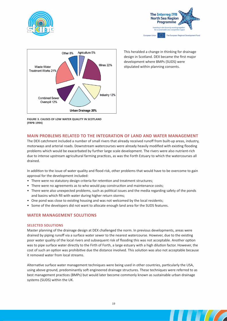
WATER MANAGEMENT PROCEDURESIn the mid-1990s the Forth River Purifi ca on Board (FRPB, now SEPA) ac vely promoted surface water BMPs as an alterna ve to tradi onal drainage methods. This change in approach was predominantly driven by a realisa on that a change in drainage paradigm was needed to address chronic long-term downgrading of receiving water bodies.
In 1994 a review of river water quali es within the Forth catchment was published by the FRPB. This report iden fi ed that diff use pollu on from storm water runoff was responsible for 22% of degrada on to classifi ed watercourses. Amongst the recommenda ons of this report, which coincided with the master planning of DEX, was that “Best management prac ce must be adopted, comprising source control and treatment”.21
TABLE 1. STAKEHOLDERS AND THEIR ROLES
21 Forth River Purifi ca on Board (1994), A Clear Future for Our Waters, FRPB, Edinburgh.
19
FIGURE 3. CAUSES OF LOW WATER QUALITY IN SCOTLAND (FRPB 1994)
This heralded a change in thinking for drainage design in Scotland. DEX became the fi rst major development where BMPs (SUDS) were s pulated within planning consents.
MAIN PROBLEMS RELATED TO THE INTEGRATION OF LAND AND WATER MANAGEMENTThe DEX catchment included a number of small rivers that already received runoff from built-up areas, industry, motorways and arterial roads. Downstream watercourses were already heavily modifi ed with exis ng fl ooding problems which would be exacerbated by further large scale development. The rivers were also nutrient-rich due to intense upstream agricultural farming prac ces, as was the Forth Estuary to which the watercourses all drained.
In addi on to the issue of water quality and fl ood risk, other problems that would have to be overcome to gain approval for the development included:• There were no statutory design criteria for reten on and treatment structures;• There were no agreements as to who would pay construc on and maintenance costs;• There were also unexpected problems, such as poli cal issues and the media regarding safety of the ponds
and basins which fi ll with water during higher return storms;• One pond was close to exis ng housing and was not welcomed by the local residents; • Some of the developers did not want to allocate enough land area for the SUDS features.
WATER MANAGEMENT SOLUTIONS
SELECTED SOLUTIONSMaster planning of the drainage design at DEX challenged the norm. In previous developments, areas were drained by piping runoff via a surface water sewer to the nearest watercourse. However, due to the exis ng poor water quality of the local rivers and subsequent risk of fl ooding this was not acceptable. Another op on was to pipe surface water directly to the Firth of Forth, a large estuary with a high dilu on factor. However, the cost of such an op on was prohibi ve due the distance involved. This solu on was also not acceptable because it removed water from local streams.
Alterna ve surface water management techniques were being used in other countries, par cularly the USA, using above ground, predominantly so engineered drainage structures. These techniques were referred to as best management prac ces (BMPs) but would later become commonly known as sustainable urban drainage systems (SUDS) within the UK.

20
INTEGRATION OF WATER MANAGEMENT SOLUTIONS IN THE PLANNING PROCESSStakeholder consulta on was a cri cal part of the implementa on process, with more than 40 diff erent people and organisa ons involved including: statutory bodies, consultants, private developers, landscape architects, NGOs and the public. SUDS were an almost unheard-of concept within the UK and educa on would play an important part in breaking down barriers within the various stakeholder groups.
A series of workshops was organised over a period of six months to promote the SUDS approach, how they func on and how they can integrate and benefi t communi es. Since SUDS were an imported technology and the process driven by an American consultant, one of the fi rst tasks of these workshops was to agree on the defi ni ons and technical terminology to be used, transla ng terms used in US English to UK English. For example, in the US the area contribu ng surface water runoff to a drainage system or watercourse is referred to as the watershed, whereas in the UK it is known as the catchment.
Other decisions made in these workshops included items such as determina on of catchment areas, deriva on of (local) pre-development runoff rates, acceptable forward fl ow rates and volume from the new (developed) catchments, impervious areas, return storms, prac cality of porous surfaces, treatment volume calcula ons, design criteria for each SUDS technique, etc. An interim output from the consor um workshops was the development of a “rule book” for the drainage design.
The loca on of the SUDS within each catchment was carefully considered so that they would provide a rac ve features, integra ng within public open space (both parkland and residen al areas). SUDS were designed so that they could be accessed and enjoyed by local residents. Where SUDS, par cularly ponds, were located in close proximity to housing they were designed so that they were overlooked by houses or public roadways, so that anyone in diffi culty could be easily seen (Figure 4).
FIGURE 4. IMPLEMENTATION OF THE DEX PROCESS (SOURCE: W.A. FAIRHURST & PARTNERS).

21
Local media and poli cians were ini ally concerned over the risk of children drowning within the proposed ponds and cri cised the drainage design. The perceived level of risk was raised by nega ve publicity, ignoring common sense, in contrast to examples of similar schemes or water features used in other parts of the UK and the world at the me.
Subsequently, a safety audit of the design was agreed with local planning offi cials. Recommenda ons included encouraging local schools to use the SUDS areas for prac cal “show and tell” classes and specifying dense low lying vegeta on to deter access to permanent water SUDS. However, despite these measures, there was s ll much concern over safety voiced by local Councillors. As a result, Fife Council insisted that 1m high metal fences be erected around the SUDS to prevent access by young children but be low enough in height to allow an adult to gain access in the case of an emergency.
The most conten ous item of the process was not in fact safety, but cost, in par cular where the balance would lie between involved par es. The ques on of who should pay for the design, construc on and a ercare of the scheme presented a signifi cant challenge and one that to date is not fully resolved.
An ini al agreement was reached whereby East of Scotland Water would adopt all underground drainage and Fife Council would adopt all above ground drainage, with the developer contribu ng to the overall cost. Under the Roads (Scotland) Act 1984, Fife Council as the Roads Authority was responsible for maintenance of road drainage (pipes or above ground structures). Similarly, under the Sewerage (Scotland) Act 1968, there was an obliga on for East of Scotland Water (now Sco sh Water) to fi nance in part or total the surface water and foul drainage from the site within reasonable costs.
FIGURE 5. CASCADE BASIN AND HALBEATH POND – BOTH OVERLOOKED BY RESIDENTIAL HOUSING.
The consulta on process for did not fully address the ques on of cost, ownership and ongoing responsibili es. The lead developer had agreed to provide land for the SUDS and to fi nance the ini al implementa on costs and did not think that any further contribu on (commuted sum) was necessary. The developer was also of the opinion that as the SUDS drained diff erent areas of responsibility (i.e. road, residen al and commercial areas) it was reasonable to expect that the public bodies should be responsible for future maintenance. Legal arguments ensued, the outcome of which has not been fully resolved to date.
Fife Council has adopted road drainage for the site, and two SUDS: a wetland and the landscaping area of one pond. Both adopted structures have public obliga ons in that the wetland is the central a rac on of a district park and the pond was implemented at a loca on where council owned homes already existed. Developers either con nue to maintain the SUDS within their ownership or contract the work to factoring agents. There

22
are also a small number of SUDS (and surrounding public open space) which have been legally transferred to private owner-maintainers within the site.
Knowledge gained from DEX has since informed changes in ownership and maintenance responsibili es within Scotland. This, together with legisla ve changes and the amendment to the legal defi ni on of sewer to include SUDS now means that there is an obliga on for Sco sh Water to adopt SUDS. As of November 2007 Sco sh Water will adopt SUDS which are designed in accordance to the new technical standard Sewers for Scotland 2nd Edi on.
DIFFICULTIES AND HOW THEY WERE OVERCOMEIn a number of loca ons, local residents have taken “ownership” of the SUDS, and one deten on basin is maintained like a garden by people living in the adjacent houses. This shows that barriers to social acceptance can be overcome with careful considera on of design and plan ng specifi ca ons.
It is s ll an ongoing ques on who should be responsible for owning and maintaining SUDS in Scotland. Sco sh Water will now adopt a range of SUDS if designed in accordance to the revised technical standard, but is only responsible for in-cur lage drainage, i.e. water from within the property boundary, and not road drainage which is the responsibility of the Local Authority.
To overcome the poten al problem of separate drainage systems (to drain diff erent areas) within new developments there has been an amendment to the Sewerage Scotland Act (1968), referred to as a Sec on 7 Agreement. This agreement “makes provision for Sco sh Water to enter into agreement with the Roads Authority to allow the use of their sewers for the conveyance of water from the surface of a road or to allow the use of road drains for the conveyance of surface water from premises”.22
KEY SUCCESS FACTORSThe drainage master planning at DEX was achieved through a fl exible and pragma c approach. Coopera on between, and educa on of, the statutory bodies, authori es and the developers was key to the success of the holis c approach to sustainable urban drainage. Early considera on of SUDS in the master plan was also crucial to the success of the strategy.
FIGURE 6. HALBEATH POND; LOCATED WITHIN A LOCAL AUTHORITY HOUSING AREA AND CONSEQUENTLY MAINTAINED BY FIFE COUNCIL

23
22 SUDS Sco sh Working Party (2010), SUDS for Roads [online]. Available from: h p://scots.sharepoint.app x.net/suds/General%20Publica ons/Forms/AllItems.aspx23 Woods-Ballard, B. et al. (2007), The SUDS Manual, C697, CIRIA, London.
SUSTAINABILITY ASSESSMENTAt the me the drainage issues of DEX were fi rst considered (about 1992), the extent to which SUDS were sustainable was not known. However, what was certain was that the problems caused by inadequate urban drainage systems were not compliant with the emerging legisla on (Water Framework Direc ve). It was clearly not socially or economically acceptable to con nue to pollute a major estuary (Firth of Forth) which supports a salmonid fi shery and contact-based water sports through badly opera ng combined sewer overfl ows or diff use pollu on. The FRPB report (1994) led to a policy drive to address the problems of diff use pollu on in a more sustainable way.
Rather than focusing merely on drainage issues, DEX was seen as being a showcase to encourage greater sustainability in a wide range of construc on and development ac vi es. There was much debate about whether SUDS were actually sustainable or just how much “more sustainable” they would be, but there was li le evidence at the me to answer the ques on. It was decided to use DEX as a large scale test site which would be intensively monitored by a range of universi es to try to establish the extent to which the new drainage systems were sustainable. In this way, the full range of sustainability issues – environment, economy, responsibility, social value – could be evaluated in the long term. Knowledge gained from the design and implementa on, and importantly from the post-project monitoring, has informed legisla on and current best prac ce for SUDS within the UK.
DISCUSSION AND CONCLUSIONSAlthough DEX is by no means perfect, it is accepted as a success da ng back to a me when there were no precedents. This showcase development set a standard for drainage master planning on a large scale in Scotland and the rest of the UK. Design philosophy has progressed since the implementa on of DEX, and some of the structures implemented are now not considered best prac ce. However, the SUDS designed and implemented at DEX, and subsequent monitoring of their opera on and performance, have informed what we now consider best prac ce.
An example of this is the concept of treatment volume and method of volume calcula ons for ponds, which were derived during the workshop process. The treatment volume (the permanent pond volume) is a func on of local hydrological characteris cs, soil type and the level of impermeability of the catchment.23 Ponds were ini ally designed to a treatment volume of 4Vt to ensure adequate treatment of runoff . However, subsequent studies have shown that residen al catchments are generally considered low risk (for nutrient and contaminants) and a treatment volume mul ple of one (1Vt) is acceptable. This change in hydraulic design is replicated in the new Sco sh Water technical standard which s pulates 1Vt ponds.
Other large-scale developments in the UK have built upon the success of the DEX example. These include:
• Edinburgh South East Wedge development, Scotland.• Ravenscraig re-development in Lanarkshire, Scotland.• Waterlooville development in Hampshire, England.
All of these developments would have been seriously constrained without the use of SUDS drainage to achieve both water quality and fl ood a enua on criteria.

24
THE WATER THAT BUOYS UP BRYGGEN IN BERGEN, NORWAYA. Christensson*,a, J. de Beer**, R. Dunlop***, Henning Ma hiesen***** Directorate for Cultural Heritage Norway (Riksan kvaren)** Geological Survey of Norway (NGU)*** Norwegian Ins tute for Cultural Heritage Research (NIKU)**** Na onal Museum Denmarka corresponding author
INTRODUCTIONBeneath the suite of picturesque historic buildings of the Bryggen World Heritage Site in Bergen (Figure 1) lies a unique archaeological environment. When excava ons started a er the fi re of 1955, which consumed the northern half of the remaining se lement built a er the fi re of 1702, the archaeologists were unprepared for the enormity of the task awai ng them, and they were generally unaware that the archaeological remains below their feet were among the best preserved in Europe. The excava ons brought to light a formidable array of mainly wooden construc ons, including houses, thoroughfares, wells and quays, along with myriad artefacts of both perishable and inorganic material. So why is it that preserva on condi ons at Bryggen are so good?
Vågen, Bergen’s harbour, has been the key to Bryggen’s existence for a thousand years. Da ng from around 1030, the fi rst town-like se lement grew up along Vågen’s north-eastern shore. The 11th century shoreline actually runs up to 160 metres inland from today’s harbour front, and it didn’t take long before the se lement started expanding into the harbour in order to create more building land. This process of infi lling – which involved the construc on of massive boxes of interlocking mbers weighted down with enormous volumes of occupa on refuse – con nued in a series of steps down through medieval and post-medieval mes. The majority of these expansion steps took place more or less immediately following the numerous catastrophic fi res that periodically burnt parts or even the whole of the town to ashes.
On this reclaimed land were built the characteris c wooden tenements running perpendicular to the waterfront, just like the building pa ern we see today. But all through the successive steps of expansion, the posi on of the property boundaries –which were mainly marked by the eavesdrops, the narrow open areas that
FIGURE 1. BUILDINGS AND LOCATION OF BRYGGEN IN BERGEN, NORWAY (SOURCE: E. ROTEVATN, RIKSANTIKVAREN)

25
lay between the tenements (and which also served to lead away surface water in the direc on of the harbour) – has remained rela vely unaltered.
Since 2001, an intensive monitoring scheme at the World Heritage site of Bryggen in Bergen has shown damaging se ling rates caused by deteriora on of underlying, man-made deposits. Low phrea c groundwater levels caused by redevelopment of the area next to the heritage site in the late 1970s have led to an increased fl ux of oxygen in the subsurface. This currently threatens the heritage site due to decomposi on of organic material and consequent se ling. A large restora on project is running from 2001 to 2031, covering all the buildings and their founda ons. The strategic project aims to bring Bryggen to a state of repair that is in accordance with its status as a World Heritage Site, and where only regular maintenance is necessary. Bryggen has since 2001 received considerable funding from the government for restora on of buildings and monitoring of the cultural deposits. In 2011, the government granted an extraordinary endowment of 45 million NOK for re-establishing the groundwater balance.
Cultural heritage buildings o en reside on extensive archaeological remains, also known as cultural deposits. Depending on the natural environment, the cultural deposits at many sites consist of highly organic material such as wooden or other natural degradable founda ons (Figure 2). Preserva on condi ons of natural degradable archaeological remains are strongly dependent on water quality and par cularly the presence or absence of groundwater. Deteriora on of archaeological materials o en occurs as a consequence of change in the groundwater level. Both mechanical se ling of the terrain and oxida on of organic material occur, thereby not only removing
archaeological values, but also taking away the bearing structure of the cultural heritage buildings above. One of the main goals at Bryggen is therefore to establish a stable hydrological environment, so that the heritage site can be safeguarded for future genera ons.
MAIN STAKEHOLDERS AND THEIR INVOLVEMENTThe protec on of the archaeological heritage is based upon eff ec ve collabora on between professionals drawn from many disciplines. It also requires the coopera on of government authori es, academics, private and public sector enterprises and, not least, the general public.
The project is led by the Norwegian Directorate for Cultural Heritage (Riksan kvaren), in coopera on with regional and local heritage authori es of Hordaland County Council and the City of Bergen. The heritage authori es need to comply with the UNESCO requirements of repor ng and preserving the site. Riksan kvaren has a coordina ng and guiding role for subordinate authori es in order to preserve Bryggen, both the buildings and the underlying archaeological remains, as a na onal and interna onal heritage site. The Bryggen Founda on (S elsen Bryggen), established in 1962 by private owners, is responsible for implemen ng
FIGURE 2. BURIED QUAY FRONT, OVER 800 YEARS OLD (© BERGEN MUSEUM, MIDDELALDERSAMLINGEN. FOTO: ASBJØRN HERTEIG).

26
conserva on measures and restora on work on the historic buildings. The objec ve of the Founda on is to preserve Bryggen in close coopera on with the authori es. The founda on owns 35 of 61 buildings and supervises the buildings on behalf of the authori es and has its own staff of cra smen, care-takers and architect. In addi on to the above men oned stakeholders who are directly involved in research and restora on processes, other important stakeholders are private owners of 26 buildings, o en used for commercial purposes (shops, offi ces) as well as neighbours, of which the hotel on the redeveloped area next to Bryggen is the most relevant due to its eff ect on the groundwater situa on.
Bergen Municipality has a special stakeholder role, as it is responsible for development plans at Bryggen and surrounding areas. Diff erent sec ons within the municipality need to take into account the restric ons that are being placed upon the water and land use in and around the heritage site. An open and construc ve communica on with regular mee ngs has been established with the water and sewage sec on, in which changes to the storm and sewage water system were discussed in an early phase in order to avoid confl icts of interests later on in the development process.
A range of research disciplines is involved in the project in order to fi nd op mal solu ons for the preserva on of both the buildings and the archaeological remains. At Bryggen, this involved the par cipa on of, at one me or another, archaeologists, architects, carpenters, chemists, conservators, engineering and geotechnical
consultants, microbiologists, mycologists, tree scien sts, wood anatomists and hydrogeologists. The researchers themselves are not direct stakeholders in the heritage site, but form a crucial advisory group for the authori es and other stakeholders to make the right decisions to preserve Bryggen for future genera ons. The mul disciplinary research groups are able to iden fy problems, risks and opportuni es and explain those to the general public. One of these issues is how to manage the water system at Bryggen in a sustainable way, as well as to explain a complex system of surface- and groundwater related interac ons to stakeholders with no professional background in this fi eld of exper se. Besides the role of “technical” experts, this research group is used to create support for new water management solu ons that benefi t not only the (re)distribu on of surface and ground water, but also the preserva on of archaeological remains and heritage buildings.
The most important stakeholders and their roles are summarised in Table 1.

27
Stakeholder Role Interest
-De
cisio
nm
aker
Advi
sor
Deve
lope
rs
Long
term
owne
rshi
p
Regulators and interest groups Planning bodies Others
W
ildlif
e
Herit
age
Envi
ronm
ent
W
ater
qual
ity
W
ater
quan
�ty
Lo
cal
com
mun
i�es
St
rate
gypl
anne
rs
De
velo
pmen
tco
ntro
l Bu
ildin
gco
ntro
l
Road
/Tra
nspo
rt
Riksan�kvaren x x x x
Hordaland County Council x x x x x x x
City of Bergen x x x x x x x x x x
UNESCO x x x
State building society(Statsbygg) x x x
Bryggen Founda�on x x x
Private building owners’ass. x x
Vital x x x
Norwegian Inst. for Cult.Heritage Research (NIKU) x x
Geological Survey ofNorway (NGU) x x x x
Na�onal Museum ofDenmark x x x x
Mul�consult AS x x x x
Norconsult AS x x x x x
Instanes x x
PAST x x x x
University of AbertayDundee x x x x x
TU Del� x x x x
VU University Amsterdam x x x x x
TABLE 1. MOST IMPORTANT STAKEHOLDERS LINKED TO THE BRYGGEN PROJECT
LAND AND WATER MANAGEMENT PROCEDURESBryggen, as well as the rest of the medieval town of Bergen, is protected under the provisions of Norway’s Cultural Heritage Act. Automa c protec on is extended by law to all standing monuments da ng to before 1649 and archaeological remains da ng to before 1537. The foremost aim for the last 20 years has been to protect the archaeological remains, as recommended in the Charter for Protec on and Management for Archaeological Heritage (ICOMOS 1990). As protec on of the archaeological remains is largely dependent on the groundwater level, the Water Resources Act (2001) is of relevance. The Water Resources Act is intended to ensure that river systems and groundwater are used and managed in accordance with the interests of society. The main objec ves of the Water Resources Act are to promote sustainable development and to maintain biological

28
diversity and natural processes in river systems. Water resources themselves are renewable, but parts of the ecological system along and within watercourses are not.
Archaeological remains can be seen as such a non-renewable resource. Before the Water Resources Act entered into force in 2001, there were no provisions on the abstrac on of groundwater. Abstrac on of groundwater must not contravene the provision on the minimum permi ed rate of fl ow. A licence has been made mandatory for abstrac ng groundwater or for ac vi es with an impact on groundwater. There was no similar provision in earlier legisla on, which can be considered one of the main reasons that urban redevelopment, including groundwater drainage, at Bryggen in the late 1970s has led to unsustainable hydrological condi ons for the preserva on of the archaeological remains at Bryggen. Other relevant regula ons are the Planning and Building Act and the Pollu on Act. The EU Water Framework Direc ve is of less direct importance for Bryggen, but the Flood Direc ve is, as Bryggen is prone to fl ooding due to increased rainfall and sea water level.
MAIN PROBLEMS RELATED TO THE INTEGRATION OF LAND AND WATER MANAGEMENT
FRESH WATERDespite Bryggen’s proximity to the sea, it is not salt water that cons tutes the primary preserva on-promo ng agent. Rather, it is fresh water: the water that percolates down into the ground beneath Bryggen – most of it coming from the hillside above the site – and becomes the area’s reservoir of groundwater. Sea-water intrusion in the cultural deposits is only to be found in the zone extending from, roughly speaking, the buildings’ seaward gables and out to the quay front.
MONITORINGMonitoring is the systema c gathering of data over me. The specifi c methods employed depend on and are tailored to the diff erent kinds of heritage – archaeological and architectural – and the various environmental factors. Monitoring of the cultural deposits at Bryggen started in 2001, and in the decade since then numerous inves ga ons have been undertaken to map the problems and iden fy causal rela onships. In 2002 it was found that the buildings and the ground surface in the northern corner of the World Heritage Site were se ling at a drama c rate (it was expected that this problem would aff ect the front of Bryggen to a greater extent instead, but such was not the case). When the pa ern from the se ling data was compared with the
FIGURE 3. GROUNDWATER LEVELS AND THICKNESS OF THE UNSATURATED ZONE (SOURCE: NGU)
map of groundwater levels, the conclusion was very clear – the worst se ling resulted from a substan al lowering of the groundwater table. Based on earlier records, it was possible to ascertain that the groundwater

29
level in the aff ected area had been stable up un l 1980, but the construc on of a building with an underground basement and associated drainage system subsequently caused the level to drop by almost three metres.
ATTRITION OF CULTURAL DEPOSITSOnce this had been determined, it was vital to ini ate a monitoring project capable of making sense of the complex interplay of the factors and mechanisms that govern preserva on condi ons underground.
The cultural deposits in the Bryggen area reach thicknesses in excess of 10 metres and contain a very high propor on of organic material. The deposits consist of varying mixtures of refuse such as woodchips, twigs, moss, leather off -cuts and tex le strips, along with the remains of buildings, quays, passages, latrines and wells – and all manner of artefacts. As long as these organic materials remain permanently inundated in water, preferably fresh and with as li le throughfl ow as possible, the outlook for their preserva on is good. But if the water is removed, oxygen concentra ons skyrocket and the microorganisms that break down organic ma er can go into a feeding frenzy, accelera ng the process of decomposi on to an alarming degree. As a result, the cultural deposits are literally eaten away. A variety of methods for monitoring the cultural deposits have been developed, and at the same me the authori es have invested heavily in the formula on of proposals for mi ga on strategies aimed at reducing the dewatering of the Bryggen area. Given that with each passing year a considerable volume of irreplaceable archaeological heritage is lost to decomposi on – as is the case in certain parts of Bryggen – there is no me to waste in ge ng these mi ga on strategies started.
WATER MANAGEMENT SOLUTIONS
SELECTED SOLUTIONSCurrently, the biggest problem is to stop the loss of groundwater towards the redeveloped hotel area next to Bryggen. The research group has presented a range of diff erent technical solu ons to the authori es. The solu ons are all based on crea ng a hydrological division between the hotel area and the heritage site, ranging from improving and extending the exis ng sheet piling to hydrological controls to ac vely control ground and surface water fl ow. Currently, discussions with involved stakeholders are underway to explain the solu ons and create support. The exis ng groundwater quality and quan ty monitoring net is being extended and automated to create a direct, on-line monitoring system to follow up eff ects of solu ons and at the same me act as an early warning system.
In close coopera on with Bergen municipality, restora on and improvement of the storm water and sewage system in the upstream area of Bryggen is being done in such a way that it will not damage Bryggen, but instead creates opportuni es to increase infi ltra on rates. SUDS with infi ltra on facili es are considered as a technical solu on that may off er opportuni es to stabilise the water balance at Bryggen.
Today, mi ga on solu ons are being implemented. A stepwise-approach was chosen, in which the eff ects of each step are monitored before the next measure is implemented. It is expected that this approach will lead to the most sustainable and long-las ng package of solu ons that will reduce the loss of cultural deposits to a minimum and reduce the se ling to a natural rate.
The fi rst step was to raise the ar fi cial drainage overfl ow level below the underground parking by about 0.5 metres (September 2011). The groundwater level however rose only about 0.25 m because of this measure, as other unknown leakages in the surface water drainage system were ac vated and thus discovered during the process. Currently these leakages are being repaired, which will likely be followed by a further increase of the groundwater level.

30
The next steps will be to further increase the drainage level, up to the technical maximum of 1 metre. Parallel to this process, the surface water drainage system will be changed from a piped solu on to a sustainable urban drainage system with infi ltra on facili es (SUDS) in the upstream part of Bryggen. A transna onal knowledge exchange programme has been set up with other SKINT partners in order to ensure that the design of SUDS is done according to best interna onal prac ces. As stated earlier, the implementa on of SUDS is expected to increase and stabilise the recharge of groundwater towards
the cultural deposits and recreate the “natural” hydrological balance before construc on of the underground parking. SUDS are implemented in two phases. The fi rst phase contains the construc on of quick-wins, which are easy to implement measures in the area where they are most needed. Infi ltra on facili es are implemented (see Figure 4) and knowledge exchange is achieved through workshops and fi eldtrips.
In phase two further measures in the greater area around Bryggen will be designed and implemented. All measures will be monitored and evaluated. If con nued monitoring shows that the hydrological situa on is not eff ec vely restored, further geotechnical measures will be necessary to physically divide Bryggen from the neighbouring underground construc ons, such as repair or renewal of the exis ng sheet piling.
INTEGRATION OF WATER MANAGEMENT SOLUTIONS IN THE PLANNING PROCESSThe preserva on of Bryggen requires a stable hydrological environment, hence groundwater condi ons that are favourable to the preserva on of archaeological remains and a minimal impact of fl ooding on the above ground heritage buildings. It is thus necessary to consider the whole urban water cycle at diff erent me and spa al scales. Precipita on is high with an average of 2250 mm per year, but most rainwater generates rapid surface runoff towards the harbour. Before 2007, regular fl ooding at the front of Bryggen occurred due to overfl owing mixed sewage systems, causing nuisance and contamina on at the front of Bryggen, where most shops are located. In 2007, improvements in the storm water system as well as groundwater level controls have been executed by the municipality. No fl ooding incidents have occurred since.
For Norway, climate change scenarios indicate an increase in yearly precipita on on the average of about 20% towards the year 2100, with the rela vely highest precipita on increase during autumn (up to 30%). Temperature is expected to increase by 2–3 degrees Celsius. As precipita on is highly wind- and mountain-driven in Bergen, the frequency of heavy rainfall intensity is dependent on the frequency increase of south-western winds. This frequency is expected to increase, which will lead to a two- to threefold increase in heavy rainfalls (50–100 mm) during autumn. Due to the temperature increase, a doubling of heavy “tropical” rainfall events during summer me can be expected (source: Storm Weather Center, 2006). Based on the described scenarios, one may expect a regional groundwater level rise and an increased pressure on surface water discharge systems. The rising sea water level complicates this by limi ng discharge possibili es and increasing fl ooding risks.
FIGURE 4. CONSTRUCTION OF SUBSURFACE INFILTRATION SYSTEM (PHOTO: R. DUNLOP, NIKU).

31
As previously stated, throughout the project con nuous mul disciplinary discussions and regular mee ngs between researchers, authori es and other stakeholders have been taken place. Yearly seminars are organised in order to communicate the state of knowledge and to receive feedback on proposed solu ons. Although this is not formalised, Bergen municipality now takes early ini a ves by contac ng the heritage authori es if it has development plans that may interfere with the goals of preserving Bryggen, such as changes to the storm-water runoff or sewage system. A guideline “monitoring manual” has been developed based on the knowledge gathered at Bryggen. The guideline is used to ensure that vulnerable sites such as Bryggen are monitored in a standardised way and that hydrology is considered. Parts of the monitoring manual are formalised in a Norwegian standard. Preliminary inves ga ons following the Norwegian standard for environmental monitoring in protected heritage areas is now mandatory for (urban) planners and contractors in order to get permission for (re)development plans.
DIFFICULTIES AND HOW THEY WERE OVERCOMEThe main problems hindering implementa on of land and water management solu ons at Bryggen are that stakeholders do not have knowledge, or are not aware, of the implica ons of urban land and water development solu ons on the preserva on condi ons at Bryggen. A problem here is also the fact that currently the largest problems are “hidden” below the terrain surface, which makes communica on diffi cult.
A third problem that can be seen as a hindrance is the fact that many stakeholders, including authori es, are not aware or convinced of the intrinsic value and importance of the archaeological remains. At Bryggen this is less of a problem, as the archaeological remains are part of the UNESCO World Heritage Site, and are thus protected. Nonetheless, a lot of eff ort was required to convince stakeholders and engineers that technical solu ons to preserve Bryggen cannot include modern measures within the heritage site that disturb the authen city of the cultural remains, both below and above the ground. Restora on of the buildings has to be based on tradi onal methods, cra smanship and materials. The underlying archaeological strata are defi ned en masse as a non-renewable resource, and are to be protected in-situ.
Preserving Bryggen is thus by principle a challenge on how to re-establish the water balance using a combina on of tradi onal (read: mediaeval) water management solu ons at the site itself, and using new solu ons in the surrounding area that has undergone an urbanisa on process, in order to create the right boundary condi ons.
KEY SUCCESS FACTORSOpen discussions with all stakeholders have been the most important means to overcome the above-men oned problems. Organisa on of and par cipa on at seminars and congresses to present the Bryggen case and explain the challenges Bryggen is facing have been very important to raise awareness and to convince stakeholders to take the right measures. Use of modern visualisa on techniques and tools in order to show what lies below the terrain surface has been, and s ll is, important.
In addi on to the above-men oned dissemina on ac vi es, a Norwegian standard (NS 9451:2009 “Cultural property: Requirements on environmental monitoring and inves ga on of cultural deposits”) has been created to ensure that cultural heritage and proper inves ga on of the burial environment, including ground and surface water handling, is taken care of early in the planning process. The standard is mostly based on the knowledge and experience gathered at Bryggen and is a binding document for urban developers in areas with cultural heritage, which currently includes the automa cally protected mediaeval ci es of Trondheim, Oslo, Tønsberg, Skien, Sarpsborg, Hamar, Stavanger and Bergen. In addi on to the Norwegian standard, a manual for monitoring urban archaeological deposits has been developed (The Monitoring Manual, Procedures & Guidelines for the Monitoring, Recording and Preserva on/Management of Urban Archaeological Deposits, Norwegian Directorate for Cultural Heritage and Norwegian Ins tute for Cultural Heritage Research).

32
SUSTAINABILITY ISSUESAs Norway’s Directorate for Cultural Heritage, Riksan kvaren comes under and reports to the Ministry of the Environment. Endeavouring to realise the government’s na onal targets for cultural heritage is therefore one of the Directorate’s foremost tasks, with sustainability one of the keywords. The sustainability principle was introduced by the Brundtland Commission in 1987: “Sustainable development is development that meets the needs of the present without compromising the ability of future genera ons to meet their own needs”.
“The concept of sustainability conjures up a number of diverse images, from energy conserva on and the reduc on of air pollu on, through preserva on of natural resources such as old growth forests and clean waterways, to the preserva on of ecosystem biodiversity. This diversity of scope extends in a logically natural way to socio-economic ‘environmental’ problems such as urban air pollu on, industrial accidents and poverty traps. The corresponding appropriate policy responses are to reduce pollu on, injury and inequity. These policy problems are commonly presented in the form of a nega ve impact” (Brinsmead and Hooker (2005), Sustainabili es: A systema c framework and compara ve analysis, Coopera ve Research Centre for Coal in sustainable development, Research Report 53, The University of Newcastle Queensland, Australia).
Archaeological deposits were classifi ed in Report to the Stor ng No. 16 ((Leve med kulturminner, St.meld. nr. 16, 2004-2005)) as a non-renewable resource, and thereby eligible for sustainable management. Riksan kvaren’s Strategic Plan for the Management of Archaeological Heritage and Cultural Environments 2011-2020 (Riksan kvaren 2011) contains a number of important premises. The following statements are taken from this plan:
“The purpose of the Cultural Heritage Act is:The preserva on of archaeological heritage and cultural environments with their individuality and diversity, as part of the na on’s cultural heritage and in accordance with a holis c environmental and resource management.”
And furthermore:“It is a na onal responsibility to safeguard these resources and their value as well-springs of scien fi c informa on and as a las ng basis for living and future genera ons’ apprecia on, understanding, well-being and development.”
It is important to emphasise that the contemporary management of archaeological heritage and cultural environments in Norway func ons well, with a high level of exper se and professionalism. All the same, there is room for improvement in a number of areas, such as increased effi ciency, and clearer communica on of the reasons for the priori es and choices that are taken. We must con nue to strive to make the past interes ng to the general public, and to raise awareness and create a feeling of shared responsibility for the management and preserva on of the remains of the past. Raising the level of general awareness of these remains’ historical value is a good place to start in order to reduce the loss of cultural heritage, much of this loss being the result of unwi ng ac ons rather than malicious intent. With greater awareness and knowledge we stand a much be er chance of achieving the na onal target that the annual rate of loss of protected archaeological heritage not exceed 0.5%.
Through its ra fi ca on of the Valle a Conven on, Norway has undertaken to “implement measures for the physical protec on of the archaeological heritage by making provision for the conserva on and maintenance of the archaeological heritage, preferably in situ”, otherwise through archaeological excava ons and documenta on.

33
The Faro Conven on – The Council of Europe’s Framework Conven on on the Value of Cultural Heritage for Society was ra fi ed by Norway in 2008. Important elements in this conven on include the right of every ethnic grouping to have its cultural heritage preserved, the sustainable use of cultural heritage in the development of society, universal right of access to cultural heritage, and the democra c management of cultural heritage.
Strategic central principles are thus in place for the management of all kinds of archaeological heritage, irrespec ve of age or loca on. Concerning the country’s world heritage sites, the State Budget 2010-11 contains the following: “The subsidy funding is earmarked for the preserva on programme for the seven Norwegian locali es on UNESCO’s World Heritage Sites list and is meant as a contribu on to their safeguarding and restora on. The Norwegian world heritage sites are to be managed in a sa sfactory manner and are to be given formal protec on through legisla on. Restora on and/or maintenance work is on-going at all seven world heritage sites, none of which is in an op mal state of maintenance“.
DISCUSSION AND CONCLUSIONSThe current condi on of World Heritage Site Bryggen in Bergen is not sa sfactory. The principal cause of the problems is leakages of groundwater, which contribute to se ling damage, among other things. Numerous buildings are subsiding at an annual rate of several millimetres, and about 30 m3 of organic cultural deposits are lost to decomposi on each year. Bryggen is protected under the Cultural Heritage Act, and the heritage site together with a buff er zone is designated a preserva on area with reference to the Planning and Building Act.
There are many interested par es involved in World Heritage Site Bryggen. Major ins tu onal collabora ons are under way. Planning of measures to improve preserva on condi ons for the cultural deposits at Bryggen started in 2009. A general exper se-building process concerning the current state of preserva on of and preserva on condi ons for the cultural deposits in selected towns is taking place with a view to developing suitable methods for the re-establishment of good preserva on condi ons and the stabilisa on of the state of preserva on of these deposits. Restora on and safeguarding of the buildings is a con nuous process.
In order to maintain a long-term integra on of land (including cultural heritage) and water management at Bryggen, an informal working group has been established with par cipants from Bergen municipality (Water and Sewage), the Directorate for Cultural Heritage and the Geological Survey of Norway in order to hold early discussions on regional and local water management measures and plans with the heritage authori es. This ensures an early iden fi ca on of problems and opportuni es to be er integrate land and water management. A sugges on could be to formalise these working groups in areas that have specifi c vulnerable aspects, such as cultural heritage, not only at Bryggen, but also at areas outside of the case study area.
It is o en noted that sustainable water management solu ons come into the planning process too late, not because of unwillingness, but mostly because of communica on failures. A regular discussion forum with diff erent disciplines could prevent this. The mul disciplinary approach developed at Bryggen has a very high poten al for replica on in other areas with cultural deposits. This is facilitated by the strong Cultural Heritage Act, which gives the heritage authori es the possibility to intervene and enforce communica on between diff erent disciplines, amongst others urban land and water planners/developers, water managers and cultural heritage managers. The newly developed Norwegian standard clearly states that hydrogeological issues, and par cularly groundwater fl ow, have to be considered and monitored. This has a direct replica ng eff ect for be er integra on of land and water management in the protected mediaeval ci es of Trondheim, Oslo, Tønsberg, Skien, Sarpsborg, Hamar, Stavanger and Bergen.

34
HEUCKENLOCK NATURE RESERVE – A HAMBURG CASE STUDY
Prof. Dr. W. Leal*,a J. Vogt*, N. Fischer*, F. Mannke** Hamburg University of Applied Sciences, Faculty of Life Sciences, Research and Transfer Centre “Applica ons of Life Sciences”, Lohbruegger Kirchstraße 65, 21033 Hamburg, Germany. Contact: [email protected] corresponding author
The text is based on informa on and text material from Kai Schmille, Gesellscha für ökologische Planung e.V.
INTRODUCTIONThe Heuckenlock nature reserve, situated within the city state of Hamburg in northern Germany, is an exemplary case-study area due to its specifi c loca on in the fl oodplain of the Elbe, which off ers various points of reference for nature and water protec on and exposure to the most diverse interest groups. The case study will focus on the ecological features of the nature reserve, its role as a recrea onal area, the statutory condi ons governing its status and confl icts of interest and use.
With a length of more than 1,094 km, the River Elbe is the fourteenth longest river in Europe. It rises in the Czech Republic, fl ows in a north-westerly direc on through Germany and fi nally into the North Sea. The Heuckenlock area in northern Germany, which is the subject of this case study, has an area of 120 ha and is located close to the end of the river. It lies in a par cular sec on of the Elbe valley known as the “Stromspaltungsgebiet” (area where the river splits). With the post-glacial rise of the sea level and the resul ng dal backwater, a large dal fl oodplain landscape emerged, of which the Heuckenlock is now the main remaining sec on. The name “Heuckenlock” means “ deway of the Heucke“, Heucke being the name of a family which is s ll one of the landowners in the nature reserve.
The nature reserve is situated on the Elbe undercut slope and is an area with a high level of natural vitality and constantly changing vegeta on. Since the river gorge on the undercut bank is close to the bank of the river, there is a lack of shallow water areas upstream. The area is nowadays fl ooded up to a height of 3.5 m as many as a hundred mes a year (the highest storm surge occurred in 1976). The mean dal range (diff erence between the mean high and low des) of the Elbe is today approximately 3.3 m. The nature reserve is located in the lee of the Harburg hills to the south, which rise to an al tude of 155 m.
It extends for three kilometres along the bank of the Southern Elbe and has a width of up to 400 m (Figure 1).
The driver for developing the nature reserve is to maintain its natural vitality and to restore disturbed sec ons.
FIGURE 1: THE NATURE RESERVE HEUCKENLOCK FROM A BIRD’S EYE VIEW (© GÖP E.V.).

35
BACKGROUND
FLOODING POTENTIALThe Heuckenlock is a freshwater dal area with remnants of an alluvial forest and exhibits a characteris c variety of terrain (Figures 2 and 3): areas of water ( deway), freshwater mud fl ats which dry out at low de, reed beds, shrub land, the so wood fl oodplain comprising above all willows and poplars, and the remains of the hardwood fl oodplain with ash, oak and elm trees, including an old white elm with a trunk circumference of almost 4.5 m. Apart from the young roots of hybrid poplar trees, there are very few young trees, and hardly any hardwood varie es.
The frequency of fl ooding and the soil structure are the decisive loca onal factors for vegeta on. The area is rich in mud, while the preponderance of sand deposits increases towards the river, partly in the form of an extensive sand embankment on which primarily the alluvial forest grows. The value of nature protec on is par cularly high in the middle sec on, while the eastern sec on and areas around the former castle off er less variety of relief.
VEGETATIONThe shrubbery (containing willow species, hawthorn, guelder rose and spindle trees, including one example es mated to be 300 years old) and weed beds exhibit a high diversity. The richness of nutrients due to fl ooding gives rise to almost impenetrable primeval-forest-like vegeta on and a unique landscape. The shrub land and reed beds are partly characterised by overgrowth, with reed heights of four to fi ve metres. The marsh marigolds are also extremely overgrown. The lush vegeta on creates a clearly measurable fi ltering eff ect on the water of the Elbe as it fl ows in and, six hours later, out of the area. Such pre-embankment areas are an important pillar of the river’s self-cleaning power.
FIGURES 2 AND 3: FRESHWATER TIDAL AREA WITH REMNANTS OF AN ALLUVIAL FOREST (© HAW HAMBURG).

36
BIODIVERSITYThe area exhibits considerable biodiversity. 700 plant species have been iden fi ed in the past, but changes in the area mean that the number is probably much lower nowadays. The diffi culty of surveying the area, the frequent natural reshaping of the terrain and the introduc on of seeds by the Elbe and shipping make it virtually impossible to obtain a precise lis ng.
FloraThe plant species include the following: Elbe hair grass and Elbe water dropwort (Figure 4), which only occur in the freshwater dal area of the Elbe, wheat sedge, which only grows at this loca on in Germany, and species at the edge of their natural range of distribu on. Plant species of eastern origin have also se led here, such as the long-leaf speedwell and black poplar. Rare or eye-catching species include broad-leaved ragwort, danewort, bu erbur, common fl eabane, various allium species, calamus, purple loosestrife, bistort, other sedge and scipus species, fl owering
rushes and snake’s head fri llary, whose decline can only be warded off by their being cut back to prevent overgrowth and disappearance. The Elbe water dropwort is found in its greatest numbers in the Heuckenlock. A project by the Botanical Associa on, which has received fi nancing from the Federal Ministry of the Environment for a period of fi ve years, is concerned with the chances of survival and propaga on of these plants along the Elbe in Hamburg. A new embankment has been constructed in Overhaken (Vierlande).
FaunaDue to the frequent fl ooding, there are only a few ground-nes ng birds in the nature reserve. Tree/reed-nes ng birds predominate. Breeding birds include the penduline t (Figure 5) with its dis nc ve hanging nest, the nigh ngale, the long-eared owl, the lesser spo ed woodpecker, the great reed warbler and the reed bun ng. Large bird colonies of grey heron and cormorant can no longer be found in the alluvial forest; these birds only come to the nature reserve to feed and rest. The area does serve as a roost during bird migra on: as many
as 20,000 barn swallows and 42,000 starlings have been counted. If north-westerly winds are strong, up to 20 other seabird species appear along the Elbe in Hamburg.
FIGURE 4: THE WATER DROPWORT ONLY GROWS IN THE FRESHWATER TIDAL AREA OF THE ELBE AND IS A HIGHLY ENDANGERED SPECIES (© GÖP E.V.).
FIGURE 5: THE PENDULINE TIT AND ITS HANGING NEST (© GÖP E.V.).

37
The deways in the nature reserve off er a good calm-water refuge for Elbe fi sh, but can also be a death trap if water levels are extremely low.
NATURAL VITALITY OF THE RIVER ELBEThe development of vegeta on is essen ally dependent on the area’s natural vitality. There is no forest use, and only at two places has an a empt been made to push back cul vated poplar. Deadwood is removed from the nature reserve only if it threatens embankments. To maintain stocks of snake’s head fri llary in par cular, three areas are cut back at least once a year. Willow trees are regularly cut in the area of the footpath by the River and Port Development Offi ce (known since 2005 as the Hamburg Port Authority) and, in the western sec on of the nature reserve, by the Society for Ecological Planning (GÖP), an associa on concerned with nature conserva on. There has been li le plan ng in recent decades: willow cu ngs have been planted, mainly close to the embankment, by the River and Port Development Offi ce, a few hawthorn bushes by the hun ngleaseholder and a group of oaks and white elm trees at the former castle by the associa on which looks a er it.
Surrounding the nature reserve are a number of smaller dike forelands with freshwater dal habitats, giving rise to the possibility of cross-linking with other areas along the river, although these are poten ally opento development. The Society for Ecological Planning has produced a catalogue of measures for biotope improvement in these areas.
Inside the embankment, the Society for Ecological Planning, Friends of the Earth Germany (BUND) and the Founda on for Nature Protec on have a empted to establish be er linkage by restoring and rehabilita ng small biotopes. However, intensive market gardening and the lowering of trench water levels have had a nega ve impact on the natural diversity of species there.
MAIN STAKEHOLDERS AND THEIR INVOLVEMENT
AUTHORITIES
Hamburg City, Authority of Urban Development and Environment (BSU)In Hamburg the governmental nature preserva on is executed by the Authority of Urban Development and Environment (BSU). Hamburg is divided into seven districts, each with its own district authority that is responsible for local nature preserva on. The BSU is responsible for defi ning areas as legal nature reserves. Specifi c measures for each reserve are defi ned within various individual plans, the so-called PEP plans (“Pfl ege- und Entwicklungsmaßnahmen”, care and development measures). The district authori es carry out the PEP in coopera on with local partners. Currently the BSU is fi nalising a special management planning for the Tideelbe region called IBP (“Integrierter Bewirtscha ungsplan Elbe-Ästuar”, Integrated Management Plan Elbe-Estuary).
It includes very specifi c measures to save diff erent sorts of habitats in the en re Tideelbe region, according to Ar cle 6 of the EU Habitat Direc ve. All plans are focused on communica on and coopera on between diff erent stakeholders: the neighbouring states of Niedersachsen and Schleswig-Holstein, various associa ons for nature protec on, other authori es such as HPA and residents and companies that operate in shore areas. The IBP is accompanied by a funding programme from the Federal Ministry of the Environment (BMU) to ensure that the measures can be fi nanced.
Harburg District Authority (“Bezirksamt”)Harburg is a district in the south of Hamburg. Un l 2008, the Hamburg-Harburg District Authority was responsible for the Heuckenlock nature reserve. In that year responsibility was transferred to the Hamburg Central District Authority, due to a reform of the administra ve organisa on. Nevertheless, Hamburg-Harburg

38
s ll co-operates in the administra on of Heuckenlock as the district authority is responsible for the neighbouring Schweensand nature reserve. Both nature reserves are managed by the Society for Ecological Planning (GÖP e.V.).
Hamburg Central District AuthorityHamburg Central District Authority is responsible for the Heuckenlock nature reserve. The district authorityexecutes measures defi ned in the local PEP in coopera on with its main local partner for the Heuckenlock nature reserve, the Society for Ecological Planning (GÖP e.V.). The PEP includes general instruc ons. Most of the smaller measures do not change from year to year. To ensure that measures also match the changing situa ons, regular mee ngs take place in order to devise an up-to-date plan. In case extended measures are necessary, other stakeholders are also invited to join the mee ngs, for example the Authority of Urban Development and Environment of the City of Hamburg (BSU) and Hamburg Port Authority (HPA).
River and Port Development Offi ce (known since 2005 as the Hamburg Port Authority)The Hamburg Port Authority (HPA) was established in October 2005 during the merging of the port-related ac vi es of various Hamburg authori es. The HPA is the central contact partner for all inquiries related to infrastructure, naviga onal and opera onal safety and port security, property management and economic condi ons in the port.
The essen al aim of the HPA is to develop the port of Hamburg for economical purposes. However, there is also awareness that this development can only be sustainable if it takes the natural dynamics of the Tideelbe into considera on. Further planning, therefore, takes a more integrated and sustainable approach which also considers the interests of the various stakeholders.
In 2006, HPA published the Tideelbe Concept. The main goal is to harmonise ecological and economic demands within this area. The measures planned to secure the Elbe for economical use are aligned as far as possible with current guidelines for nature conserva on. Measures for a be er fl ood protec on are also detailed. HPA is a coopera on partner for the Heukenlock, as described above. HPA also assists the work of GÖP e.V. by execu ng small measures such as regularly cu ng willow trees within the area of the footpaths.
ASSOCIATIONS FOR NATURE PRESERVATION/NGOS
The Society for Ecological Planning (GÖP e.V.)The Society for Ecological Planning (GÖP e.V.) handles various nature reserves in Hamburg, in the context of care contracts with the Authority of Urban Development and Environment (BSU) and the district authori es. Therefore GÖP executes a wide range of measures which are defi ned in offi cial plans, so-called PEP plans (“Pfl ege- und Entwicklungsmaßnahmen”, care and development measures). GÖP also provides detailed reports on the situa on of habitats and off ers recommenda ons for measures to the local authori es. GÖP is a member of the Community for Nature Protec on (Arbeitsgemeinscha Naturschutz), a union of several established associa ons. This community reviews and comments on current federal plans which may have a signifi cant eff ect on nature in Hamburg.
Currently, the development and conserva on of the Hamburger Elbauen is one of their largest projects. GÖP therefore runs a public informa on centre at Bunthäuser Spitze in Hamburg-Wilhelmsburg including informa on and educa on services. It also supports coopera on and dialogue between the stakeholders.
As described above, GÖP executes measures in Heuckenlock according to the PEP and in close coopera on with the Hamburg-Harburg District Authority. There is also a close coopera on and exchange of prac cal experience with other associa ons for nature protec on on an informal level. Inside the Heuckenlock embankment, the

39
Society for Ecological Planning, Friends of the Earth Germany (BUND) and the Founda on for Nature Protec on (NABU) have a empted to establish be er links by restoring and rehabilita ng small biotopes. These biotopes are not offi cially part of the nature reserve but nevertheless worth saving.
Friends of the Earth Germany (BUND)Friends of the Earth Germany (BUND) is a non-profi t non-governmental organisa on (NGO) that handles its own project on nature preserva on for the river Elbe. The goal is to restore fl ood areas and habitats for fl ora and fauna and improve the water quality of the Elbe. BUND is not formally handling the Heuckenlock; however, it takes part in coopera on and exchange with the diff erent associa ons to support the parent goal of nature preserva on.
Founda on for Nature Protec on (NABU)The Founda on for Nature Protec on (NABU) is a non-profi t NGO which handles several nature reserves along the Tideelbe, for example Mühlenberger Loch/Neßsand and Elbinsel Pagensand. The goal is to conserve rare habitats for fl ora and fauna. NABU is also commi ed to preven ng further deepening of the Elbe shipping channel. NABU is not formally handling the Heuckenlock; however, it also co-operates with the diff erent associa ons to support the parent goal of nature preserva on.
Botanical Associa on Hamburg (Botanischer Verein zu Hamburg e.V.)The Botanical Associa on is a non-profi t NGO that handles various natural monuments and nature reserves in Hamburg. Members of the Botanical Associa on Hamburg also support the work of GÖP in an informal way, as partners and counsellors, especially in ma ers of the endangered Elbe water dropwort species. The Botanical Associa on has received fi nancing from the Federal Ministry of the Environment.
The greatest numbers of Elbe water dropworts are found in the Heuckenlock and are classifi ed as a priority species in the EU Habitats Direc ve. Therefore, a tes ng and development project (E+E-Vorhaben/Erprobungs- und Entwicklungsvorhaben) was run from 2000 to 2004. The aim of the project was to develop appropriate measures for the se lement of the Elbe water dropwort. The results support the aim to sustainably establish and maintain the Elbe water dropwort in this area as set in the EU Habitats Direc ve.
OTHER NATURE RESERVES
Schweenssand nature reserveSchweensand is a nature reserve neighbouring Heuckenlock. It is protected by a separate municipal decree. It is under the responsibility of Hamburg-Harburg District Authority and is also handled by the Society for Ecological Planning (GÖP e.V.).
PARENT ORGANISATIONS
UNESCOUNESCO biosphere reserves are model regions for sustainable development. They strike a balance between the interests of environmental protec on and of social and economic development. Biosphere reserves are proposed by member states, and are designated and regulated on the basis of na onal legisla on.
Territories must be characteris c of important ecosystems and specifi c landscapes. Biosphere reserves must combine nature conserva on with the promo on of sustainable social and economic modes of u lisa on of natural resources. As model regions they are outdoor laboratories for tes ng innova ve methods which harmonise preserva on and u lisa on. Biosphere reserves are the only category of “protected areas” set up according to globally consistent criteria by an intergovernmental organisa on.

40
In 1979 the Elbe River Landscape was designated a biosphere reserve (extended in 1997). The designa on broadly strengthens the exis ng legal guidelines (EU Habitats Direc ve and nature reserve) and validates the importance of nature protec on in this region.
CITIZENS
Ci zens/residentsAll described plans and concepts are always open to dialogue between stakeholders and the public. Informa on about current measures is provided on the web (for example the special HPA website www. deelbe.de) and par cularly at the public informa on centre at Bunthäuser Spitze in Hamburg-Wilhelmsburg, run by GÖP. Where comprehensive measures are planned, the public is regularly informed by the media. This approach has already led to a much be er apprecia on amongst the public for environmental measures, for example amongst neighbouring farmers, who might naturally be scep cal of these issues.The Heuckenlock is located in a reasonably remote area, so that measures generally do not directly aff ect ci zens. The main stakeholders and their roles are summarised in Table 1.
TABLE 1. MOST IMPORTANT STAKEHOLDERS LINKED TO HEUCKENLOCK

41
MAIN PROBLEMS RELATED TO THE INTEGRATION OF LAND AND WATER MANAGEMENTConfl icts of interest and use arise wherever nature protec on, economic use and ci zens, as both residents and users, come into contact with each other. Some of the main aspects rela ng to the use of the site are described below:
Economic useThe alluvial areas were extensively exploited in the Middle Ages, and there was agricultural ac vity in what is now the nature reserve, such as cu ng and grazing, mber harves ng, fruit growing, reed cu ng, tree cu ng to obtain willow rods and, a er 1945, market gardening. All such use was suspended at the beginning of the 1970s because of the diffi cult terrain and frequent fl ooding.
Bank stabilisa on The river bank has been largely stabilised with a stone edge. If this were to disintegrate as a result of the present-day fl ow velocity and water level, this would lead to rapid fl oodplain loss.
Extension of naviga on channels and embankment construc onThe extension of naviga on channels and embankment construc on have permanently changed the frequency and height of fl ooding and thus impacted on the microclimate and vegeta on.
Transport infrastructureThe present-day nature reserve was split in two by the construc on of the motorway back in 1939.The area east of the motorway suff ered the most damage, with a deway being fi lled in. A er 1945, the hardwood trees were felled to be supplied as repara ons to Great Britain, and they were later replaced with fast-growing balsam poplar trees.
Changes to the water levelHowever, the greatest problems for the nature reserve result from water-level changes caused by the deepening of the Elbe shipping channel, the closing of barriers on Elbe tributaries due to storm surges and the construc on of embankments closing off former dal areas. While the dal range at the Bunthäuser Spitze was indicated as being 2.21 m in 1959, it had risen to 3.22 m by 1989. Further deepening of the shipping channel from 13.50 m to 14–15 m will again aff ect water levels and would inevitably impact the vegeta on.
WATER MANAGEMENT SOLUTIONS
SELECTED SOLUTIONSThe main aim in developing the nature reserve is to maintain its natural vitality and to restore disturbed sec ons. A number of water management solu ons have been applied, such as lowering the bank revetment at a number of addi onal points in order to encourage the forma on of further inlets and natural and diverse river banks. There had previously been four 8–15 metre-wide openings behind which troughs formed. However, the erosive force at the undercut bank of the river is so high that, over long stretches away from inlets, the bank reinforcement can be lowered but not completely dismantled.
In order to restore the fl ow diversion, the Heuckenlock deway has been extended and is again connected to the Elbe on both sides, which might reduce sil ng in the deway.
In order to maintain a minimum water level for fi sh in the main deway, remains of old bank reinforcements have been removed and deep-water drums have been dredged at a depth of 1.5–2 m.

42
Higher fl ooding has made it necessary in recent decades to raise the level of embankments and strengthen them. Considerable encroachment occurred in 1965 as a result of the embankment being moved inland, and the most recent raising and widening of the embankment in the 1990s took up further land in the nature reserve. It was ini ally agreed between the environmental and building authori es to leave out the sec on of the embankment situated in the nature reserve in order to examine further the possibility of shi ing it towards the river so as to reduce fl oodplain encroachment to a minimum. However, shortly a er, the turf was removed over the full length of the embankment on the nature reserve, and it was only a er the environmental authori es intervened that the works in ques on were suspended. In view of the fait accompli and the fact that the embankment had to be fi nished by the autumn in order for it to perform its protec ve func on, it was agreed to con nue the works. Nevertheless, a steeper embankment with a paved exterior was built in the Heuckenlock in order to protect the fl oodplain. Although embankment construc on was not subject to compensa on measures under the (legally contested) Hamburg Nature Protec on Act, the authori es agreed to act in accordance with the impact rules for the purposes of the €180 million programme to raise the Elbe embankment. The replacement of embankments planned as a subs tute measure at other loca ons was only par ally implemented, primarily because of legal problems, which meant that there was a defi cit of compensa on measures.
Other problems for the nature reserve are the water quality of the Elbe, which is s ll not op mal, and the large-scale washing-up of refuse with the de, which gets caught in the lush vegeta on and accumulates. Recrea onal ac vi es are limited in the nature reserve because the area is not accessible beyond a footpath that has been built. At the end of 2003 a new bridge was inaugurated over the deway, which means that the circular route can again be walked. The lush fl ora in the freshwater dal area off ers the possibility of nature watching.
The water bodies in the nature reserve are closed to boat traffi c.
SUSTAINABILITY OF THE SOLUTIONSThe designa on as a nature reserve (na onal legisla on) and the determina ons of the EU Habitats Direc ve (interna onal legisla on) requires sustainable measures with three main goals: to preserve the natural func on of the area, to carry out interven ons if necessary (such as the promo on of se lements of endangered species) and to remove and prevent disturbing infl uences.
Sustainability in nature preserva on means that measures have to be con nuously implemented. The coopera on between partners such as the BSU, the district authori es and GÖP are, therefore, based on long-term contracts. Agreements are legally set in the PEP. Short-term issues can be quickly resolved as a result of con nuous coopera on between the partners.
The legal status of the nature reserve does not allow building and forest use, and the water bodies in the area are closed to boat traffi c, so the Heuckenlock is sustainably protected from interference of this kind. This is a key factor in achieving the main goal of the nature reserve: keeping the natural dynamics of the area. Small interven ons such as cu ng and plan ng and larger interven ons such as lowering embankments also support this aim.
A key point to ensuring sustainability of measures is the coopera on of stakeholders. The greater the consensus that a measure receives, the more reliable are the implementa on and the long-term eff ect. In the past, there already has been a good coopera on between stakeholders, o en on an informal basis. Newer concepts and plans such as the IBP and the Tideelbe Concept bring all partners together with a single aim, which in turn means that short-term, unilateral solu ons are avoided. The focus lies on measures which are supported by all. Thus confl icts of interest and harmful ac ons can be avoided.

43
INTEGRATION OF WATER MANAGEMENT SOLUTIONS IN THE PLANNING PROCESSAn important factor to the success of the preserva on of the Heuckenlock was, above all, the compe on between Hamburg and Harburg. The channel fl ow for the North and South Elbe rivers could be par ally regulated at the Bunthäuser Spitze, which meant that the rela ve importance of both ports could be shi ed. Hamburg succeeded in concentra ng port development on the North Elbe. The confl ict was not resolved un l 1937, with the passing of the Greater Hamburg Act, which ended Harburg’s autonomy. Up to that point, the boundary between the two ci es was disputed at the Heuckenlock, so that parts of the territory were not even used for agriculture and the alluvial forest could be preserved. Protec on of the area was already envisaged by Harburg, then part of Prussia, as early as 1935. In 1948, Hamburg issued a decree establishing a nature reserve. This was revised in 1977 to extend the nature reserve, primarily to areas to the west of the motorway. Up to 2008, the Hamburg-Harburg District Authority was responsible for the nature reserve, but responsibility was transferred in that year to Hamburg Central District Authority.
As a unique area in Europe, the nature reserve has been incorporated into the network of biogene c reserves, a worldwide programme of UNESCO. The Heuckenlock is also a European protected area under the EU Habitats Direc ve.
The decree se ng up the nature reserve does not restrict hun ng, and the District Authority is therefore able to issue a normal hun ng lease. The nature reserve also includes many small, narrow privately owned plots of land, largely on the meadowland behind the embankment. On the opposite bank of the Elbe is the Schweenssand nature reserve, which is also protected by its own decree.
All of the upstream dike forelands have also been no fi ed to the European Commission under the Habitats Direc ve, but have not yet been designated as a nature reserve by the Hamburg Senate. The new Auenlandscha Norderelbe nature reserve borders directly on the Heuckenlock to the east.
Of the plant species to be found in the Heuckenlock, the Elbe water dropwort is one of the priority species covered by the EU Habitats Direc ve.
DIFFICULTIES AND HOW THEY WERE OVERCOMEThe main issues were the economic use of the Elbe, the need for protec on against fl oods and the need for nature protec on. Changing water levels due to constant extension of naviga on channels and embankment construc on have had a deep impact on the habitat. On the other hand, higher fl ooding has made it necessary in recent decades to raise the level of embankments and strengthen them. For example, in order to restore the natural dal vitality of the area, a lowering of the bank revetment has taken place wherever possible.
The issue does not only have a physical aspect. In previous years, it was legal prac se to comprehensively seal the river banks of the Elbe. Nowadays, there is a be er understanding of environmental needs and the aim of planning is to achieve agreements with a broad consensus. The HPA, responsible for economic river management, has become more sensi ve to nature issues and has integrated them into the Tideelbe Concept. As neighbours at the Tideauen-Zentrum (informa on centre, run by GÖP), coopera on and exchange between HPA and GÖP has greatly improved over the years.
New measures such as the IBP (developed by the BSU) aim to carry out projects that take environmental and economic needs into considera on and fi nd a balance between these contrary interests. Issues may also arise due to unforeseen costs. For example, the lowering of revetments exposes contaminated material such as rubble and stones. The disposal of this is problema c and expensive. Problems of this kind should be solved more easily in the future when more fi nancial funding is provided, as announced in the IBP.

44
KEY SUCCESS FACTORSThe confl ict between Hamburg and Harburg can defi nitely be seen as the key factor. The Heuckenlock was not aff ected by any economic factors. Neither planners nor environmentalists have been par cularly interested in the area. As a consequence, it has been le to itself, and habitats could fl ourish undisturbed.
DISCUSSION AND CONCLUSIONSAs it is so mul -faceted, the Heuckenlock nature reserve is well suited as a case-study area. The fl ora and fauna at this site are excep onal and worthy of protec on. This is legally achieved by the site’s designa on as a nature reserve.
The nature reserve touches on the specifi c interests of a wide variety of groups: economic, poli cal, ecological and residents. The Society for Ecological Planning, through its on-site informa on centres and ac vi es, promotes dialogue enabling these o en confl ic ng interests to be voiced and reconciled.
In this context, this case promotes awareness among experts and the public of the value of the Heuckenlock nature reserve and the need for sustainable water management. An integrated approach to spa al planning and water management and the interac on between the various stakeholder groups involved in planning off er important opportuni es for guaranteeing the preserva on of this area so worthy of protec on.
REFERENCESFree and Hansea c City of Hamburg (1977). Regula ons about the Nature Protec on Area Heuckenlock (19.07.1997). City Document 202. Hamburg (in German).
Free and Hansea c City of Hamburg (1999). Maintenance Plan of the Free and Hansea c City of Hamburg. Ministry of Environment of the City of Hamburg, Hamburg (in German).
Free and Hansea c City of Hamburg (1990). Basic Assessment of the Nature Protec on Area Heuckenlock, Dyke Area “Schweensand”. Ministry of Environment of the City of Hamburg, Nature Protec on Offi ce, Hamburg (in German).

45
FLOOD ALLEVIATION AT DEVONSHIRE PARK AND MAYFIELD ROAD, BRADFORD, WEST YORKSHIRE, ENGLAND
J. Blanksby*,a, T. Poole**, S. Simpson* University of Sheffi eld** Metropolitan District Councila corresponding author
INTRODUCTIONSeveral fl ooding incidents in recent years have caused considerable concern over fl ooding in the vicinity of Devonshire Park. Apart from the physical damage, local ci zens suff er from the mental stress each me it rains, especially when thunderstorms are forecast in summer, even though a storm forecast does not necessarily mean that fl ooding will occur. There is a long standing history of fl ooding in the area; however, the percep on amongst residents is that both the frequency and intensity is increasing.
Devonshire Park is located immediately to the north-west of Keighley town centre. The ground slopes from west to east. The area is served predominantly by a combined drainage system, but there is also a complex, though poorly defi ned natural drainage system, much of which has been culverted and some of which has been destroyed. During extreme rainfall, water from the park and adjacent housing fl ows down the hill and into the area around Spring Gardens Lane and North Street. This causes fl ooding to proper es along Spring Gardens Lane and North Street, and also to proper es in lower-lying areas to the east of
North Street. There is also fl ooding in the urban area to the south of Devonshire Park, but this problem is not described here. The area around Devonshire Park is iden fi ed in Figure 1.
Water fl ows from the hillside to the west of North Street. This is shown in Figure 2, in which the principal fl ow paths are shown in blue, public sewers in red and known loca ons of property fl ooding with red stars. In recent years, prolonged wet weather and/or extreme rainfall has caused water to fl ow from Devonshire Park and Mayfi eld Road (Loca ons 1 and 2 in Figure 2) and areas to the north and west of these. The main fl ooding problems occur at the junc on of Spring Gardens Lane and North Street (Loca on 3 in Figure 2), where property owners have constructed upstands at the entrance to their proper es to minimise ingress of water, and to the east of North Street culmina ng in the fl ooding of Tonson Court, which is a sheltered housing scheme operated by a housing associa on (Loca on 4 in Figure 2).
FIGURE 1. LOCATION PLAN

46
FIGURE 2. SOURCES, PATHWAYS AND RECEPTORS
MAIN STAKEHOLDERS AND THEIR INVOLVEMENTIt was immediately recognised that CBMDC had a major role to play in the fl ood risk management within the area. Notwithstanding the many other priori es rela ng to statutory responsibili es, and the lack of funding, there was a clear need for leadership and for the council to set an example as a key stakeholder. The role was to work with other key stakeholders to defi ne the problems, facilitate the appor onment of responsibili es and iden fy appropriate adap ve responses to which it could contribute. It was evident that there was a need for more than a cursory inves ga on, and so steps were taken to reveal the loca on, size and condi on of key watercourses and surface water drainage systems and to carry out GPS surveys in key loca ons to supplement the Lidar data which had been acquired in 2004.
Analysis of the rainfall data showed that the situa on throughout the area was tolerable for rainfall return periods of up to 10 years. Above this there was a real risk of fl ooding somewhere in the area. It was also recognised that without an expensive and disrup ve renewal programme, there was li le benefi t in increasing the capacity of the sewerage system. Even if that was done, it would s ll be necessary to manage the runoff from permeable areas and to compensate for the loss of capacity in the major drainage system. Finally, it was evident that infi ltra on was not the solu on as the permeable surfaces were saturated when fl ooding occurred.
Community engagement has taken place throughout the dura on of the inves ga on process. This has involved visits during and a er the fl ood events, for the compila on of the ques onnaires and whilst further inves ga ons were being undertaken. Once an apprecia on of the problems had been gained, a mee ng was held with the local community to confi rm that this apprecia on was correct and to test the ini al ideas for solu ons. At this mee ng further fl ood loca ons were iden fi ed and addi onal informa on on fl ood pathways and the drainage system was obtained.

47
Engagement with individual householders and landowners has con nued where appropriate and, given that a stream of funding may emerge, it is now me to go back to the community to present the more detailed proposals worked up since the fi rst mee ng for assistance with priori sa on and to iden fy the focus of further inves ga ons within the area.
The main stakeholders and their roles are summarised in Table 1.
Stakeholder Role Interest
Deci
sion-
mak
er
Advi
sor
Deve
lope
rs
Long
term
owne
rshi
p Regulators and interest groups Planning bodies Others
W
ildlif
e
Herit
age
Envi
ronm
ent
W
ater
qual
ity
W
ater
quan
�ty
Lo
cal
com
mun
i�es
Stra
tegy
plan
ners
De
velo
pmen
tco
ntro
l Bu
ildin
gco
ntro
l
Road
/Tra
nspo
rt
City of Bradford Metropolitan District Council x x x x x x x x x x x x x x
University of Sheffield x
Householders andlandowners x x x x
TABLE 1. MAIN STAKEHOLDERS AND THEIR ROLES
THE INVESTIGATION PROCESS
DOCUMENT INCIDENTSIn addi on to the archive of photographs of the fl ooding, the incidents were documented in the CBMDC drainage incident database and many householders responded to the fl ood incident ques onnaires that were sent out. The response was further improved following public mee ngs held to consult about the problems.
DATA COLLECTION The data immediately available for the inves ga on was as follows:• OS master map• Sewer data• Combined sewers• Surface water sewers• Terrain data (1 m horizontal and ± 150 mm ver cal resolu on).• LIDAR eleva on model• LIDAR terrain model• LIDAR terrain model with buildings• Rainfall data• 15 minute data from EA gauge sites within 10 km of Keighley• 2 minute data from CBMDC rain gauge network commissioned August 2005• 2 minute data from Yorkshire Water short term sewer fl ow survey rain gauge network installed May–July 2002• Flood archives• CBMDC drainage incident database• CBMDC fl ood ques onnaires• Yorkshire Water incident database and Keighley High Level model build report

48
INITIAL REVIEW – CURRENT PRESSURESThe City of Bradford MDC took on the responsibility to lead the inves ga ons. Not only does it have responsibili es of Civil Con ngencies, it is also the highway authority and has responsibili es for drainage and as a major landowner in the area.
RAINFALLReports of fl ooding have been received on several occasions, but the major event aff ec ng all of the area occurred on 11 August 2003. This was caused by extreme short dura on rainfall superimposed upon rela vely low return period longer dura on rainfall. Nevertheless, the 2-day rainfall was signifi cant enough to saturate the ground and with up to 40 mm of rainfall falling within 3 hours, a return period of 25 years, the resultant runoff caused widespread fl ooding in the area.
DRAINAGE SYSTEMThis area of Keighley is predominantly drained by a combined sewer system operated by Yorkshire Water. The natural drainage system is poorly defi ned, but inves ga ons have revealed a piped surface water drainage system fl owing from Devonshire Park, down Spring Gardens Lane, through the area aff ected by fl ooding and then eastwards to join the River Aire (Figure 3). When Tonson Court was constructed, the piped system was severed and the upstream sec on was diverted into the public sewer in Holker Street. Downstream, the culvert became blocked. Inves ga ons have been carried out and the route of the watercourse has now been traced for some distance downstream, and work will con nue un l the en re route down to the river Aire is proven. As a result of the inves ga on, riparian owners are being contacted and work is now ongoing to clean the culvert and to check its structural condi on.
The current challenge is to maximise the eff ec ve capacity of the minor drainage system and to compensate for the loss of the major drainage system, allowing members of the local community to take appropriate measures to minimise the residual risk to their own proper es without causing problems to others. Given that there are signifi cant fl ooding problems within the en re area, and that thoughtless ac ons in one loca on can cause problems further down the hillside, it was evident that the solu ons developed should avoid the rapid conveyance of fl ows through the aff ected areas.
FIGURE 3. ROUTE OF THE DRAINAGE SYSTEM

49
TONSON COURTTonson Court was constructed on a former school playing fi eld and provides sheltered accommoda on for more vulnerable members of the community.
FIGURE 4. FLOODING AT TONSON COURT
The development has been constructed in a hollow and fl ooding frequently occurs. When the development was constructed, the surface water drain was severed and was connected to the combined sewer in Holker Street together with the drainage from the site. The ground level in Holker Street is signifi cantly higher than that in Tonson Court, and so, as the sewer surcharges in normal opera on, Tonson Court fl oods prematurely. The problem is exacerbated by the overland fl ow from the area to the west of North Street which migrates to the low point. There is evidence of fl ooding to a depth of approximately 300mm (Figure 4). The fl ooding has nor-mally occurred in the summer months as a result of intense rainfall, and the physical damage is compounded by the distress caused to occupants.
INITIAL REVIEW – FUTURE PRESSURES
URBANISATIONThere has been a signifi cant amount of development within the catchment since the 1960s. This is illustrated in Figure 5.

50
Figure 5 shows that in the 1960s the area to the north and west of Devonshire Park was largely farmland with some areas of predominantly low-density housing. During the intervening period, much of the farmland has been developed, mainly with medium-density housing, and a school has also been constructed
In addi on to planned development, there has been a considerable amount of development within the cur lages of proper es, and it is an cipated that this will increase into the future. This is known as urban creep or intensifi ca on. A study was commissioned in order to quan fy the amount of creep over the past 20 years and to es mate the poten al for creep into the future. Typical increases in impermeability are presented in Table 2, which shows the propor on of permeable area, paved area, pitched roofs and total impermeable area as a percentage of the total area within the cur lages of proper es. The study only considered proper es that were constructed prior to 1971.
FIGURE 5. STUDY AREA AROUND 1960 AND IN 2000
Low Density Medium Density
Permeable Paved Pitched Impermeable Permeable Paved Pitched Impermeable Year Area Areas Roofs Area Area Areas Roofs Areas
1971 72.9 11.8 15.3 27.1 65.5 15 19.5 34.51989 60.8 22.8 16.4 39.2 46.1 26.4 27.5 53.92002 55.5 27 17.5 44.5 44.2 27.3 28.5 55.8
TABLE 2. GROWTH OF IMPERMEABILITY 1971–2001

51
The main inferences that can be drawn from this informa on are that there was a signifi cant increase in paved areas in both low and medium density dwellings during the period from 1971 to 1989 and that signifi cant increases in the roof area of medium density proper es also took place during the same period. The increase in both paved and roof areas slowed during the period 1989–2002, but did not stop. It is an cipated that a steady but slow increase in overall roof and paved areas within cur lages will con nue as addi onal parking spaces are provided and those houses currently without extensions are further developed, and that low density development will tend to a peak of 55% impermeability, while medium density development will peak at 70%.
CLIMATE CHANGEThe impact of climate change is diffi cult to predict. As the amount of CO2 emissions is dependent on global socio-economic responses, they are not within the control of local communi es. The eff ect on precipita on is likely to be seasonal. During winter, the intensity and volume of rainfall is predicted to increase, whereas in summer, intensity is predicted to increase but overall volume to decrease. Because the change in precipita on are dependent on the CO2 emissions this is diffi cult to predict, but a pragma c approach of hoping for the best but preparing for the worst is being adopted and provision is being made for increasing the volume of storage should this prove necessary. In the mean me, a 10% increase in rainfall intensity and volume is being factored into the design. This equals the guideline allowance in PPS 25 up to 2055.
DRAINAGE ASSETSDrainage assets have a long life, and it is not possible to “ nker” with them as small changes occur. From the perspec ve of the asset, major changes should only occur as the serviceable life of the asset ends.
WATER MANAGEMENT SOLUTIONS
SELECTED SOLUTIONS
RATIONALE BEHIND SOLUTIONFuture urbanisa on and climate change will con nue to increase the annual probability of fl ooding, unless something is done to increase the capacity of the drainage assets. A strategic fl ood risk assessment of the Keighley area has shown that disconnec on and source control are the most cost-eff ec ve way of reducing the impact, which means that solu ons are required at source rather than at end of pipe. In addi on, all available assets should be u lised. The blocked and severed culverts should be restored, and where capacity is exceeded, storage should be distributed throughout the upstream catchment.
The ra onale behind the design for Devonshire Park and Mayfi eld Road is to u lise the full capacity of the surface water drainage system which runs through the area and to store excess fl ows from Devonshire Park and Mayfi eld Road when the capacity is exceeded. The reality of this is that the greater the fl ow that can be passed down the culvert, the less the storage requirement. However, the culvert serves an area larger than Devonshire Park and Mayfi eld Road and in the long term, its capacity should be appor oned across the whole area that it serves.

52
ELEMENTS OF SOLUTIONThe elements of the solu on are shown in Table 3.
Element
Trace route of downstream culvert to river Aire, clean and reinstate to provide drainage outlet at Tonson Court.
Reconstruct severed culvert at Tonson Court.
Connect Tonson Court surface water drainage and upstream culvert to new sec on.
Provide high level pumped connec on to sewer for Tonson Court foul drainage.
Storage pilot project to reduce runoff from council owned land.
Ac on
Inves ga on by Bradford MDC. Cleaning and rein-statement by culvert owners.
Design by Bradford MDC. Reconstruc on by Housing Associa on.
Design by Bradford MDC. Connec ons by Housing Associa on.
Specifi ca on by Yorkshire Water. Connec on by Housing Associa on.
Specifi ca on and design by Bradford MDC.
TABLE 3. ELEMENTS OF SOLUTION
As a temporary measure, Yorkshire Water is diver ng the surface water drainage system into the sewer upstream of the point where it enters Tonson Court.
DIMENSIONS OF THE SOLUTIONExtreme rainfall eventsThe Flood Es ma on Handbook was used to obtain rainfall parameters for the Keighley area. These parameters were then used to produce synthe c summer rainfall profi les for events of diff erent dura ons and probabili es.
Storage depthBecause fl ooding only occurs during extreme rainfall, it can be assumed that a combina on of infi ltra on, surface ponding and the local drainage systems provide adequate capacity for low level fl ooding. Historical evidence suggests that the capacity is suffi cient to contain fl ows from an event of 10% annual probability. Therefore the storage capacity required to contain an event with annual probability of 1% will be found by subtrac ng the volume of water generated by the 10% annual probability event from the water generated by the 1% annual probability event. This was determined for events with dura ons ranging between 15 minutes and 12 hours, and the peak volume occurred for an event of 2 hours dura on. Making an allowance of 10% addi onal rainfall as a result of climate change, the storage volume was determined to be 220 cubic metres per hectare.
Storage volumeThe area of Devonshire Park is 6 ha. Mul plying this by 220, the storage volume is 1,320 cubic metres and that in Mayfi eld Road is 220 cubic metres. Storage in the form of SUDS was provided in Devonshire Park using a series of “trench-trough” structures (known as Mulde Rigole in Germany and wadis in the Netherlands, where they are widely used); see Figure 6. These take the form of troughs or depressions (swales), with gently sloping sides, set over trenches containing underground infi ltra on tanks or infi ltra on trenches with high void space.

53
The water from the troughs percolates into the infi ltra on tanks which are protected from sediment by a geotex le layer. The infi ltra on tanks provide subsurface land drainage to the troughs, thus improving their performance and reducing the general water logging of the ground that used to occur. Ground profi les were managed to direct the majority of fl ows into the trench troughs, and residual fl ows are collected in swales which are also connected to the drainage system. Controlled discharge from the infi ltra on tank units is directed to the drainage system in the park.
A stepped trench system was constructed on land owned by the City of Bradford MDC on the south verge of Mayfi eld Road with a capacity for 110 m3 storage. There is an op on for another trench on the northern verge should this be required. Although benign with respect to the local environment, the trench-trough system on Mayfi eld Road is striking and brings a en on to the drainage works that were undertaken in the area. The wadis in Devonshire Park look much like depressions in the landscape, and they neither add to nor detract from the previous aesthe cs of the grassed parkland which existed previously.
FIGURE 6. TRENCH-TROUGH SYSTEM OR “WADI“ IN DEVONSHIRE PARK
FIGURE 7. COMPLETED STEPPED TRENCH SYSTEM ON MAYFIELD ROAD

54
FIGURE 8. NOTATIONAL LOCATION OF TRENCH-TROUGH STRUCTURE
INTEGRATION OF WATER MANAGEMENT SOLUTIONS IN THE PLANNING PROCESSAs well as the fl ood abatement aspects of the storage pilots, their purpose is also to demonstrate how source control and disconnec on measures can be built into the urban environment without detriment to the local community.
KEY SUCCESS FACTORSThe cri cal success factors enabling this scheme to go ahead were the presence of a strong driver, an overloaded drainage network causing fl ooding, and the presence of a local champion at the council who was able to provide the impetus behind the inves ga ons and secure funding. A key part of the success of the project was the engagement of the community, which provided informa on on historical fl ooding and on drainage features no longer in use or fi lled in and helped to iden fy the required focus of inves ga ons. The champion also worked in an enabling environment, with consistent poli cal support (from Cllr Anne Hawksworth, who remained in offi ce over a period of more than a decade) that allowed him to exercise interven ons based on permissive powers, rather than through any regulatory duty.
SUSTAINABILITY ASSESSMENTThe main aim of the chosen op ons was to alleviate known fl ooding problems, reducing economic damage to local communi es and improving the well-being of community members. This was achieved at no detriment to the local environment and minor improvements were made to the amenity value of Devonshire Park by reducing the water logging of the ground and hence enhancing its value to the community. Other benefi ts in terms of sustainability were found when comparing the impacts of the chosen op on with those of the alterna ves, all of which required considerable disrup on within the local communi es, either through work to

55
be undertaken to provide storage or disconnect surface water drainage within proper es or wide scale sewer capacity enhancements. In addi on to the disrup on, the alterna ve solu ons would have required a much greater administra ve and community engagement input because of the number of people and organisa ons that would be aff ected by the solu ons and involved in the works. Also, the alterna ves would involve signifi cantly greater costs in terms of materials and reinstatement. Hence the chosen op on was both socially and economically more sustainable.
DISCUSSION AND CONCLUSIONSThe scheme u lises the full capacity of the surface water drainage system which runs through the area and stores excess fl ows from Devonshire Park and Mayfi eld Road when the capacity is exceeded. As well as the fl ood abatement aspects of the storage pilots, the purpose of the design was also to demonstrate how source control and disconnec on measures can be retrofi ed into the urban environment with minimal disrup on and without detriment to the local community. Since the works were undertaken the new drainage system appears to be working well, and there have been no reported fl ooding incidents despite signifi cant rainfall in June 2007 and January 2008, when problems could have been expected to arise.
A strategic fl ood risk assessment of the Keighley area showed that disconnec on and source control would be the most cost-eff ec ve way of reducing the impact, meaning that responses were required at source rather than at end of pipe. However, a large propor on of the surface water runs off the steep fi elds to the west of Keighley, and here the lack of capacity to infi ltrate at source is a problem. The scheme considered the most effi cient ways to use funding to provide the greatest fl ood mi ga on benefi ts, and by u lising a por on of the open space available was able to achieve this.

56
SUDS AND FLOOD MAPPING URBAN FLOODS IN BERGEN, THE NETHERLANDS
F.C. Boogaard*,**,a, G. Stockel**** Del University of Technology, Department of Sanitary Engineering, Faculty of Civil Engineering and Geosciences, Del University of Technology, P.O. Box 5048, NL-2600 GA, Del , the Netherlands** TAUW bv, Zekeringstraat 43 g, 1014 BV Amsterdam, the Netherlands *** Bergen Municipality, the Netherlandsa corresponding author; e-mail: fl [email protected]
INTRODUCTIONThe increase of the paved area and the eff ect of climate change can have a considerable impact on urban areas. One of the eff ects is the increase of storm water peak intensi es and an increase in the frequency of these showers. These extreme events cause the sewer system to be overloaded and fl ood the streets and pose a possible health risk.
The popular beach resort Egmond aan Zee in the north-west of the Netherlands experienced two extreme storm water events in August 2006. The storm water events had an intensity of 60 mm/hour, which sta s cally should occur once in 50–100 years, and led to fl ooding of the area. The storm water fl owed from the higher parts to the lower-lying centre and fl ooded shops (see photo), with damage to property and much (poli cal) unhappiness. This fl ooding and the possible health risks could occur more o en due to climate change and needed to be resolved immediately.
FIGURE 1. INTENSIVE STORM WATER EVENTS IN AUGUST 2006 LED TO FLOODING IN THE MAIN SHOPPING STREET IN EGMOND AAN ZEE
It is becoming commonly accepted that these problems need to be resolved by providing more space for water at ground level. The European Flood Risk Direc ve (EU, 2007) promotes fl ood risk management plans with non-structural measures aiming at resilience of urban infrastructures and preparedness of the social system. SUDS can be used as an eff ec ve way to reduce fl ooding. There is a growing consensus that sewer capacity is limited and that there is a need to consider all aspects of water drainage during extreme rainfall events.
MAIN STAKEHOLDERS AND THEIR INVOLVEMENTThe fl ooding problems had to be solved, and solu ons using sustainable urban drainage systems would have a large impact in this area. Therefore a lot of stakeholders had to be involved:

57
• The municipality of Bergen; several departments were involved: urban planning, civil engineering, green, infrastructure;
• Consultancy agency TAUW; planning and implementa on of sustainable urban drainage systems in several stages: long -and short-term measures;
• The water authority Hoogheemraadschap Hollands Noorderkwar er; guides municipali es regarding water quan ty and water quality problems;
• The water authority Rijkswaterstaat; guides a er-fl ood protec on and the quality of water in the beach area;• Residents; people par cipa on is needed for the large-scale implementa on of SUDS. Basins of 3000 m³
were implemented, which have a large impact in a dense urban area; • Province Noord Holland; guides the municipality in Bergen on deeper groundwater level impact.
All stakeholders and their roles are summarised in Table 1.
Stakeholder Role Interest
Deci
sion-
mak
er
Advi
sor
Deve
lope
rs
Long
term
owne
rshi
p Regulators and interest groups Planning bodies Others
W
ildlif
e
Herit
age
Envi
ronm
ent
W
ater
qual
ity
W
ater
quan
�ty
Lo
cal
com
mun
i�es
Stra
tegy
plan
ners
De
velo
pmen
tco
ntro
l Bu
ildin
gco
ntro
l Ro
ad/T
rans
port
Municipality of Bergen x x x x x x x x x x
Consultancy agency Tauw x x
Water authority HHNK x x x x
Water authority Rijkswaterstaat x x
Province Noord Holland x x
Local community x x
TABLE 1. STAKEHOLDERS AND THEIR ROLES
WATER MANAGEMENT PROCEDURESThe European Water Framework Direc ve (WFD) aims at reduc on of fl ooding and an enhanced protec on of the aqua c environment. As a consequence, the WFD requires municipali es to address the emission from wastewater systems properly and to take ac on when these emissions aff ect the quality of receiving waters. Sustainable Urban Drainage Systems (SUDS) can play an important role in achieving this goal.
WATER MANAGEMENT SOLUTIONSThe implementa on of SUDS in the densely populated polders (low-lying tracts of land with generally high groundwater tables and low permeable soil enclosed by embankments) of the Netherlands requires specifi c guidelines for design, construc on and maintenance to prolong the lifespan of SUDS. However, the techniques used in the Netherlands can also be used in more undula ng landscapes, adding fl ood risk management opportuni es to the list of water quality applica ons that is already well established.
In order to make areas fl ood resilient and achieve Dutch quality ambi ons there is a large variety of SUDS to choose from, such as: infi ltra on trenches and basins, (slow) sand fi lters, soakaways, ponds, swales, wetlands, bio-reten on, fi lter strips, sedimenta on basins, fi lters and pervious pavements.

58
SELECTED SOLUTIONSFor Egmond a wide variety of SUDS was available, choosing which systems were implemented was based on the following criteria: • (removal) effi ciency and reducing fl oods • cost (building and maintenance)• required space• experience maintenance• sustainability• aesthe cs• robustness• life cycle analyses
Experiences in designing, building and maintaining SUDS were gathered through an interna onal literature review, interviews and fi eldtrips.
In Egmond aan Zee several SUDS were implemented: • swales• improving the sewer capacity • infi ltra on trenches• infi ltra on basins• pervious pavements• water barriers to guide water
FIGURE 2. WATER BARRIERS TO PREVENT WATER FROM FLOWING TO THE LOWER CENTRE WERE INSTALLED. THE WATER IS STORED AND INFILTRATES TO REDUCE FLOODS
To implement SUDS in the right loca ons, fl ood mapping was used to establish the water fl ows in the Egmond area during storm water events. This method was used to search for above-ground measures against fl ooding.
In order to maximise the possibili es of interac on between professionals of diff erent spa al fi elds (water, green, road) the maps were presented in a workshop using a touch table. Showing pictures and a visualisa on of storm water fl ooding provides a rela vely easily interpretable insight into the problem and the cause, making this tool ideal for mul disciplinary decision-making and the implementa on of solu ons like SUDS. Because the measures are implemented at street level, it is necessary for sewer specialists to discuss possible areas for ground level measures with professionals responsible for roads and green areas. These professionals from fi elds unrelated to water joined the discussion on how to solve the problem.

59
FIGURE 3. LEFT: RESULT OF FLOOD MAPPING; RIGHT: USING VISUAL TOOLS TO UNDERSTAND AND INTERACT WITH DIFFERENT STAKEHOLDERS
In order for the managers of the urban area in Bergen to take full advantage of the visual power of the maps a mul -disciplinary workshop was organized. In this workshop the results of fl ood mapping, showing the problems and possible solu ons, were presented on the touch table. The touch table is used to:• iden fy areas of interest;• analyse the model output at those areas;• decide whether to solve the iden fi ed problem;• decide to fi nd and discuss solu ons;• allow non-water professionals and specialists to understand easily interpretable visual maps; • direct input from mul ple disciplines to use in the decision-making.
This leads to fast decisions that are commonly accepted by the municipality and the par es involved.
DIFFICULTIES AND HOW THEY WERE OVERCOMEImplemen ng solu ons in a dense urban area like Egmond aan Zee is a challenge. The area was developed over years, leaving li le space for water to be stored or to infi ltrate in the ground. To restore the natural water balance and make this area fl ood-resilient, numerous measures had to be implemented in a short me.
Plan of approachFirst, a short list of quick and cost-eff ec ve measures was drawn up and discussed with all stakeholders. To prevent water from fl owing from the higher parts to the lower centre, speed bumps were built and SUDS implemented to store the storm water and let it infi ltrate where it lands. During the construc on of these “simple” solu ons, long-term plans were made which are highly eff ec ve but have a large impact on special planning and the community. Two large infi ltra on basins were designed for storing more than 6500 m³ of storm water in the lower areas and prevent fl ooding. The basins’ volume was op mised by using innova ve technical building solu ons, construc ng the walls above ground and lowering them during construc on. This leads to lower space requirements, op mises the storage volume and minimises the obstruc on for local residence in their daily lives.
To reduce the health risks, storm water sewers were inspected for foul water connec ons using temperature loggers. Wastewater from houses (e.g. water from showers, with a higher temperature) connected to storm water sewers were located and the systems were separated, reducing the risk of contact with wastewater and reducing emissions to the surface and groundwater.

60
KEY SUCCESS FACTORSThere are many factors that contributed to making the quick implementa on of solu ons to make Egmond aan Zee fl ood-resilient a success. Having so called “champions of change” in the municipality, consultants and a good coopera on from the water authori es was one determining factor. Using interna onal technical and communica on innova ons and solu ons was another.
The project Skills Integra on and New Technologies (SKINT) encourages transna onal knowledge exchange and the implementa on of innova ve technical and sustainable solu ons which have already proved to be successful around the North Sea region. The problems and solu ons in Egmond contributed to this transna onal knowledge exchange. The municipality of Bergen in the Netherlands visited the municipality of Bergen in Norway and spoke at an interna onal congress about the key success factors and lessons learned from this case study. Egmond aan Zee is also one of the districts in the transna onal serious game WaterTown designed by the University of Abertay. The game is used to share knowledge about the problems and solu ons whether they arise in the Netherlands, in Norway, in UK or in Scotland.
FIGURE 4. FLOODING IN EGMOND IN THE SERIOUS GAME WATERTOWN; RIGHT: APPLYING THE GAME AT DIFFERENT INTERACTIVE SEMINARS USING EGMOND AS A SUSTAINABLE EXAMPLE
SUSTAINABILITY ASSESSMENTThe solu ons in Egmond aan Zee should be sustainable. This is an easy word to use but it raises a lot of ques ons in workgroups. Discussions about the sustainability of the diff erent solu ons have their origin in the diff erent interests and ambi ons of the various stakeholders. To rate the sustainability of this project, diff erent categories are rated (“expert judgement”) and visualised in the spider web in Figure 5.
FIGURE 5. SPIDER DIAGRAM TO VISUALISE SUSTAINABILITY SCORE

61
DISCUSSION AND CONCLUSIONSFollowing the fl oods in Egmond aan Zee several solu ons were implemented. With tools like fl ood mapping and interna onal knowledge about sustainable urban drainage systems, in a short period of me this area was transformed into one of the most fl ood-resilient places on the globe.
The GIS-based method of modelling and mapping urban storm water fl ooding is an eff ec ve tool for deciding how to prevent urban storm water fl ooding in a cost-eff ec ve way. The output of the model is generated in a manner that allows specialists of various disciplines involved in determining measures at ground level to comprehend the process. The urban storm water fl ood maps visualised on the touch table improve the communica on between various disciplines, genera ng an environment for fast, successful and cost-eff ec ve decision-making in the preven on of urban storm water fl ooding. Together with the serious game WaterTown from the University of Abertay, these communica on tools will be used in several projects, like SKINT, which emphasise the need for speaking a mul disciplinary language to integrate the worlds of spa al planning and water management.
Transna onal knowledge exchange is needed to raise awareness of the func oning of SUDS in diff erent circumstances or countries. The monitoring and evalua on of SUDS in diff erent European countries has yielded a wealth of experience which allows us to review and expand our guidelines of SUDS to guarantee their performance over me.

62
SOLAR CITY, HEERHUGOWAARD, THE NETHERLANDS
E. Swolfs*,a, A. Grent** Hoogheemraadschap Hollands Noorderkwar er, the Netherlandsa corresponding author; e-mail: [email protected]
INTRODUCTIONSolar City is a 118 ha new urban area with about 1,400 houses southwest of the municipality of Heerhugowaard. Solar City is the world’s largest carbon neutral community. The energy-effi cient houses use solar and wind power.
In the early 1990s the Fourth White Paper on Spa al Planning iden fi ed the area of the municipali es of Heerhugowaard, Alkmaar and Langedijk in the province Noord-Holland as a future urban development area. Besides the large housing task there were tasks for recrea on, water storage and aqua c biodiversity as well. On top of that, the province and the three municipali es had high ambi ons for CO2 reduc on.
FIGURE 1. LOCATION OF SOLAR CITY

63
In a shared spa al planning vision the three municipali es combined housing, energy neutrality, water storage, aqua c biodiversity, nature and recrea on in the ambi ous plans for Solar City in Heerhugowaard – all at the lowest part of the polder of Heerhugowaard, which dates from 1630. The planning of the project lasted from 1992 to 2006. Ever since, residents have been moving into their new homes.
FIGURE 2. ARTIST’S IMPRESSION OF SOLAR CITY
MAIN STAKEHOLDERS AND THEIR INVOLVEMENTA development like Solar City requires many diff erent fi elds of knowledge as well as the skills to integrate and to harmonise all these fi elds. The municipality of Heerhugowaard is the project manager of the development plan for Solar City. Throughout the planning period Heerhugowaard cooperated closely with the Water Board of Hoogheemraadschap Hollands Noorderkwar er. Heerhugowaard invited Hollands Noorderkwar er as the municipality wanted to use the exper se of the water managers to make a so-called waterproof spa al plan.

64
This ini a ve of Heerhugowaard to cooperate with the water board was taken long before the water board’s involvement could be enforced by legisla on, the so-called Water Assessment as we know it nowadays in the Netherlands.
As a water manager, Hoogheemraadschap Hollands Noorderkwar er was responsible for the fl ood risk management, the water quality and the aqua c ecology of the area. This led to a water system with hardly any water supply or discharge of excess rainwater, and a naturally purifi ed water system in the Luna Park. A er comple on of the project Hollands Noorderkwar er will con nue to manage the water in Solar City and Luna Park.
FIGURE 3. ARTIST’S IMPRESSION OF LUNA PARK
The province Noord-Holland helped in dividing and combining the large na onal housing task with the other na onal and regional tasks, especially in the fi eld of renewable energy. This led to coopera on between public bodies.
Ashok Bhalotra, the world-renowned urban developer from Kuiper Compagnons, was the fi rst to introduce the sketches for a city largely based on photovoltaic energy. The energy u lity company NUON is the owner of most of the photovoltaic systems. Urban planning consultancies, energy consultancies, architects, landscapers, etc. created new plans, new views and new solu ons. The recrea on authority manages the Luna Park. The main stakeholders, their roles and interests, are summarised in Table 1.

65
Stakeholder Role Interest
Deci
sion-
mak
er
Advi
sor
Deve
lope
rs
Long
term
owne
rshi
p
Regulators and interest groups Planning bodies Others
W
ildlif
e
Herit
age
Envi
ronm
ent
W
ater
qual
ity
W
ater
quan
�ty
Lo
calc
omm
uni�
es
St
rate
gypl
anne
rs
De
velo
pmen
tco
ntro
l Bu
ildin
gco
ntro
l
Road
/Tra
nspo
rt
Subs
idie
s
Heerhugowaard x x x x x x x x x x x x
Hollands Noorderkwar�er x x x
Province of Noord-Holland x x x x x x
Dutch Government x x
European Union x
Kuiper Compagnons x x x x
PWN water company x x x x
Nuon Energy x x x
-Recrea�on authority Noord Holland x x x
Housing associa�on Woonwaard x x
Private project developers x x
Real estate developers x x
Property owners x x
TABLE 1. MOST IMPORTANT STAKEHOLDERS LINKED TO SOLAR CITY DEVELOPMENT
MAIN PROBLEMS RELATED TO THE INTEGRATION OF LAND AND WATER MANAGEMENTUn l 1630 the current polder of Heerhugowaard used to be a lake. This lake was part of the water storage in Noord-Holland. Since the reclama on started in 1600 the percentage of surface water in Noord-Holland decreased from 50% to only 8% nowadays. Urbanisa on caused further surface run off to the remaining water system.
More specifi cally, the area to be built for Solar City was in the lowest part of the polder. Solving water management problems at the lowest part of a polder will cause severe water management problems elsewhere in the polder.
Besides the fl ooding problems there are also serious water quality problems. Birds discovered the lakes around Solar City from the start. The bacteria in their excrements some mes cause problems for swimmers. Unfortunately, the be er the weather condi ons are for swimming, the more likely it is that poor water condi ons occur.
Another water quality problem is caused by sport fi shermen when evic ng fi sh. Sport fi shermen evict fi sh, which is hardly ever ecologically sound as they usually want to catch the heavyweights. These heavyweights like carp dig the sediment, causing turbid water and free nutrients resul ng in algae. A downward spiral is created as the declining water quality decreases the numbers of ecologically sound fi sh like pike, since hun ng is more diffi cult in turbid water.

66
The communica on on the principles of Solar City generally went well. However, communica on on an important issue, the use of the water system, was not as smooth. It was agreed with the municipality of Heerhugowaard that the water quality would be suffi cient for recrea on purposes but not for swimming. However, the municipality created a small beach and talked about swimming water in the newspapers. The water quality does not always meet the requirements for swimming, especially during warmer periods. This some mes leads to resentment as ci zens counted on swimming possibili es.
More than once, the above-men oned water management solu ons were threatened by fi nancial limita ons.
FIGURE 4. RECREATIONAL ACTIVITIES IN WINTERTIME
FIGURE 5. LAND RECLAMATION MAP „HEER-HUYGHEN-WAERT“

67
WATER MANAGEMENT SOLUTIONSTo preserve Solar City from fl ooding a lot of surface water was dug: over 30% of the project’s area consists of surface water. Furthermore, a lot of fl exibility in the water level is allowed. During summer the water level can drop to 0.40 metres below the average level. In winter the water level might rise up to 0.30 metres above average. This permi ed level fl uctua on of 0.70 metres enables the water system to be more or less self-suffi cient. Only in very dry periods is a small water supply needed, and in very wet periods water is discharged by an automated weir. These results are really excep onal for a polder more than 3 metres below sea level, given the Dutch climate.
Ini ally a fl exible water level seemed to be impossible because of the exis ng buildings. Eventually, it was decided to raise small dikes around the historical farms in the surrounding area to protect them from high water levels. The newly built houses have no crawl space underneath to enable the water level to fl uctuate.
A reasonable water quality is achieved by using the natural purifying water system in Luna Park. Here the water is circulated through a wetland area. This rids the water of most of its nutrients. However, the required water quality for swimming can hardly be met, especially not when the weather condi ons for swimming persist.
From design to blueprint, there was always a tension between func onality, safety, experience, construc on costs and maintenance costs of the water system. In the end, an acceptable balance between the water management requirements and the fi nancial means was found.
FIGURE 6. RECREATIONAL ACTIVITIES IN SUMMER TIME
FIGURE 7. LIVING CLOSE TO THE WATERFRONT

68
FIGURE 8. OVERVIEW OF LUNA PARK, A COMBINED WATER TREATMENT AND RECREATIONAL AREA
DIFFICULTIES AND HOW THEY WERE OVERCOMEThe instability of the Dutch subsidy policy and the bureaucra c procedures caused numerous problems. The realisa on of the project was heavily dependent on a Dutch na onal subsidy programme, as photovoltaic systems could not otherwise compete with conven onal or other renewable energy systems. The termina on of this subsidy programme required innova ve fi nancing schemes.
The rigidity of the European Commission with regards to the me frame and planning of the project also caused major concerns. The me frame was too narrow for a project of this scale. This was solved by holding an offi cial opening of Solar City when only two thirds of the project had been realised.
The project developer was very demanding; he wanted to avoid future claims on uncertain and unproven construc on methods. Furthermore, many of the architects had no experience with, and hardly any knowledge about photovoltaic systems. But in the end, all the purely technical problems in the design and in the realisa on of the project were solved.
KEY SUCCESS FACTORSAs in most such ambi ous projects, success relied on the enthusiasm of individuals working in public bodies. They are the ones that need to convince the decision-makers. Here they were able to do so because they believed in the principles of the project, they trusted their colleagues from the other public bodies and they cooperated whenever possible.

69
SUSTAINABILITY ASSESSMENTMany areas of the Netherlands lie below sea level. This means that all the excess rain water needs to be pumped out to sea. This is mainly true during the winter; in summer fresh water from the rivers supplies the regional water systems. The fl exible water system in Solar City leads to less fuel consump on at the pumping sta ons.
A posi ve side eff ect of this fl exible water system is that more local water is available in the area. This is interes ng from an ecological point of view. Thanks to the natural purifying water system in Luna Park, the water quality is also much higher than could be expected with a tradi onal water system.
The photovoltaic systems, together with the power of the three windmills, supply enough energy for Solar City and its residents to be fully carbon neutral.
DISCUSSION AND CONCLUSIONSSolar City is a sustainable neighbourhood. It is designed to be climate proof, as solar and wind power generate the needed electricity for almost 1,400 households. The neighbourhood and its surroundings have an excellent water quality and aqua c biodiversity, promo ng water-related recrea on and nature. To achieve a good aqua c environment, rainwater is retained and circulated through an integrated purifi ca on labyrinth. The water banks and aqua c plants purify the water in a natural way.
FIGURE 9. HOUSING IN SOLAR CITY: ALL THE ROOFS HAVE SOLAR PANELS

70
THE TRANSNATIONAL EXPERIENCE: LEARNING BY SHARING
In this chapter, the presented cases are compared and key factors for the successful integra on of land and water management are reviewed to see what can be learnt.
TRANSNATIONAL ANALYSIS: LESSONS LEARNED ON THE INTEGRATION OF LAND AND WATER MANAGEMENT
LEGISLATIVE ISSUES AND FUNDING MECHANISMSThe case studies presented here discussed a range of diff erent problems related to the integra on of land and water management. Some of these hindrances are clearly rooted in na onal ins tu onal arrangements such as funding mechanisms or legisla ve issues.
In the Netherlands, the subsidy policy for environmentally friendly products such as photovoltaic cells was ended during the construc on of the carbon neutral urban development Solar City. This funding was crucial to the economic viability of the project and new fi nancing mechanisms had to be found in order to be able to fulfi l the original development plan without compromising the space for water.
In Scotland, the DEX development struggled with similar issues of fi nancing innova ve sustainable development as no economic agreements were at hand. This issue of long-term maintenance responsibility is s ll being debated in Scotland. The local water authority, Sco sh Water, will now adopt maintenance of a range of SUDS within property boundaries if they are designed in accordance to a technical standard. Public road drainage is the responsibility of the Local Authority.
Integra on of land and water management is hindered by a lack of long-term economic agreements and stable funding mechanisms for construc on and maintenance of sustainable solu ons.
STAKEHOLDER PARTICIPATION AND COMMUNICATIONAll the cases described here show that early stakeholder involvement and clear communica on are essen al for crea ng awareness and support. They also enable stakeholders to adapt and acknowledge innova ve sustainable water management solu ons and ac vely contribute to their long-term maintenance.
In the DEX development area, stakeholder consulta on was a cri cal part of the implementa on process, with more than 40 diff erent people and organisa ons involved. As SUDS were almost unheard of in the UK, educa on played an important part in breaking down barriers within various stakeholder groups. Through workshops, the func on and design of SUDS were worked out, and their benefi ts promoted. Unexpected problems occurred when local media and poli cians ini ally raised concerns over safety issues and cri cised the design. This perceived level of risk ignored common sense and the examples of similar schemes in other parts of the world at the me. Finally, several addi onal safety measures had to be taken in order to sa sfy the local authority.
The Heukenlock case shows that for sustainable nature preserva on, measures have to be con nuously implemented. This requires long-term coopera on and formal contracts between stakeholders. The more common consent a measure receives, the more reliable are the implementa on and the long-term eff ects. New

71
concepts and plans bring all stakeholders together with a single sustainable aim, namely to develop the nature reserve by maintaining its natural vitality and restoring disturbed sec ons. In order to deal with confl ic ng interests of diff erent stakeholders, such as the economic, poli cal, ecological and other interests of residents, a Society for Ecological Planning was developed at Heuckenlock to promote dialogue between stakeholders and reconcilia on of diff erent interests.
Integra on of land and water management requires open communica on and long-term contracts between stakeholders.
The Bryggen case shows that awareness of the value of archaeological heritage needs to be communicated, as many stakeholders, including authori es, are not aware or convinced of the intrinsic value and importance of archaeological remains, even when na onal and European legisla on describes them as such. The Norwegian government describes the remains as “non-renewable resources”, similar to natural limited resources such as oil, which underlines the value that is assigned to the remains on a na onal level. Among professionals in urban planning and other stakeholders, there is even less knowledge and awareness of the vulnerability of these non-renewable resources to land and water management. The fact that the remains are “hidden” below the terrain surface does not make communica on easier. The fact that modern technical solu ons should not disturb the authen city of the cultural remains both above and below the ground is also challenging to communicate. Regular informa on mee ngs with stakeholders, including residents, are held to promote dialogue and increase awareness and understanding of the special condi ons in this heritage area. Open dialogue with all stakeholders and ac ve contact with the local press are seen as important elements in the communica on strategy in order to fi nd long-las ng and widely accepted solu ons.
Communica on and educa on on water management, sustainable drainage solu ons and their wider, mul ple benefi ts to environmental and cultural assets are crucial for their acceptance and integra on in urban planning.
In the Egmond case, measures had become drama cally urgent a er two fl oods, and stakeholders were eager to implement solu ons. In contrast to the Heuckenlock and Bryggen cases, stakeholders did not have to be convinced of the need to take ac on, but consensus was nevertheless needed on the type of solu on. In the later years, it has become commonly accepted in the Netherlands that the kind of fl ooding problems described in the Egmond case need to be solved by providing more space for water at ground level and that Sustainable Urban Drainage Systems (SUDS) are an eff ec ve way to reduce urban storm water fl ooding. New innova ve tools such as GIS fl ood-mapping and serious gaming presented on a large touch table improved communica on between various stakeholders and provided an environment where decisions on urban drainage solu ons could be taken in a fast and cost-eff ec ve manner.
Modern technology can signifi cantly improve communica on and cost-effi cient decision-making, thereby facilita ng a be er integra on of urban land and water management.

72
The Yorkshire case is generally comparable with the Egmond case. A cri cal driver, namely an urgent fl ooding problem, needed to be solved, and suitable sustainable solu ons had to be chosen. In Yorkshire, a more tradi onal stakeholder engagement process was followed than in Egmond, with ques onnaires followed by mee ngs with the local community to test ini al ideas for solu ons and to detail the extent of the problem. A challenge here was to enable members of the local community to take appropriate individual measures to minimise the residual risk to their own proper es without causing problems for others. The cri cal success factor in the stakeholder communica on of the Yorkshire case was the presence of a local champion at the council, who was able to provide the impetus behind inves ga ons and secure funding, and who received consistent poli cal support from a person at the Council offi ce over many years.
A similar success factor is men oned in the Solar City development case. Local champions working for diff erent public authori es were seen as the key to success through their ability to convince decision-makers. Mutual trust is men oned as a key success factor for champions. Mutual trust requires consistent working rela ons and open communica on.
Local champions, supported by consistent poli cal support, long-term working rela onships and mutual trust are key success factors for the integra on of land and water management.
The Solar City development case shows that the project manager ini ated an ac ve coopera on with the regional water authori es to develop a so-called “waterproof” spa al plan. Nowadays, this involvement of the water authori es in development projects is enforced by legisla on. Although communica on between diff erent stakeholders generally went well, an important excep on was the communica on about the water quality. Although it was agreed that the surface water quality could be good enough for recrea onal purposes, but not for swimming, the local municipality created a small beach and communicated (unrealis cally) high expecta ons for swimming to the local press. This has led to resentment by ci zens.
Unmanaged media a en on may lead to false percep ons of solu ons. A mely, ac ve and open dialogue with the media will contribute to awareness and support for sustainable water management solu ons.
Looking at the diff erent roles and interests of stakeholders, we o en see a dominant posi on for the municipality, which fi lls mul ple roles at the same me, such as a decision-maker, developer and in many cases land owner. Certainly in large ci es, the city council does have many diff erent interests as well as diff erent roles to fulfi l. A good example is the CBMDC illustrated by the Devonshire park case study. Depending on the project and the op ons, this may facilitate the integra on of urban land and water planning processes, but there is a danger that the solu ons are not widely accepted among the minority of stakeholders with a long-term ownership role, the local community. In those cases, it seems to be of major importance that an independent advisor is taken into the project in order to secure an objec ve and transparent process. For the CBMDC case, the University of Sheffi eld played this role. In most other cases, there are many diff erent stakeholders involved, and many of them have an advisory role on diff erent interests

73

74

75

76
The previous diagrams show the diff eren a on of the main stakeholder interests for all case studies. In all diagrams, the stakeholders that represent interests in environment, water quality and water quan ty are most dominant. In the Bryggen case heritage is clearly important and in the Heukenlock case wildlife interests are signifi cant. The CBMDC Devonshire park case has a very equal distribu on because only 3 stakeholders groups are represented, namely the CBMDC, University of Sheffi eld and the local community. The District Council embodies almost all interests. The number of stakeholders for each case are summarised in Table 1.
Case study Number of stakeholder groups
Heuckenlock, Germany 10
Bryggen, Norway 18
DEX, Scotland, United Kingdom 14
Devonshire Park, United Kingdom 3
Egmond, the Netherlands 6
Solar City, the Netherlands 13
TABLE 1. NUMBER OF STAKEHOLDER GROUPS
WATER MANAGEMENT REGULATIONS AND PROCEDURESThe presented cases show a wide range of regula ons and procedures that infl uence the integra on of land and water management. These have evolved over me. The DEX case in Scotland, one of the fi rst major developments where SUDS were s pulated within planning permissions, was ini ated due to ac ve promo on of surface water BMPs as an alterna ve to tradi onal drainage by the Forth River Purifi ca on Board (FRPB, now SEPA) in the mid-1990s. This was predominantly driven by a realisa on that a change in drainage paradigm was
FIGURE 1. DISTRIBUTION OF STAKEHOLDER ROLES
Figure 1 summarises the distribu on of stakeholder roles in fi ve cases. The distribu on refl ects the number of stakeholders, although some stakeholders have mul ple roles, such as for example advisor and developer. One may observe that the amount of advisors increases linearly with the amount of stakeholders. Par cularly in complex cases with many stakeholders, such as Bryggen, the trend is that each stakeholder is represented by its own advisor.

77
needed to address chronic long-term qualita ve downgrading of receiving water bodies. Over me, the applica on of SUDS in redevelopment plans has become mandatory in Scotland.
The Bryggen case shows that in exis ng urban areas, regula ons that are not directly related to land and water management, such as the Cultural Heritage Act, may be important drivers and regulators for the integra on of land and water management. At Bryggen, the foremost aim for the last 20 years has been to protect the subsurface archaeological remains, as recommended in the Charter for Protec on and Management for Archaeological Heritage (ICOMOS 1990). Since protec on is largely dependent on the groundwater level, one should expect that the Water Resources Act (WRA, 2001) should be applicable. The WRA should ensure that groundwater is used and managed in accordance with the interests of society. However, the WRA unfortunately is mainly focused on groundwater as a drinking water resource and does not provide clear regula ons for avoiding stability (se ling) problems or the protec on of archaeological remains due to drawdown of groundwater, for instance through drainage or pumping. Instead, the Planning and Building Act and the Neighbouring Act are (sporadically) used to avoid damage to neighbouring plots caused by improper water management. A problem is that local authori es have insuffi cient (technical) knowledge and awareness of possible consequences caused by water balance changes. Possible confl icts are not detected in ordinary planning consent, and there is therefore a risk that problems will not be detected before damage has occurred.
Mul ple benefi ts are lost or become drawbacks when there is a lack of knowledge and awareness among professionals, and procedures and regula ons are unclear or too narrowly formulated.
The Solar City case shows that problems related to the integra on of land and water management may be dictated by already exis ng water management restric ons of the development area. Solar City was planned at the lowest part of a polder, which, as an ar fi cial hydrological en ty, per defi ni on already has a strictly regulated water management challenge, namely permanent pumping of water to the sea. Further urbanisa on without compensa ng hard surfaces with surface water area would increase the pressure on the water system drama cally. At the same me, the crea on of larger surface water bodies does pose water quality issues, threatening the proposed mul ple recrea onal benefi ts.
Successful integra on of land and water management and real sustainable water management is characterised by mul ple benefi ts, rather than by the direct benefi ts of improving surface water quality or reducing fl oods alone.
KEY SUCCESS FACTORSThe key success factors that emerge from the case studies are illustrated in the Wordle® on the right hand side. In all cases, stakeholder communica on, educa on and coopera on are key elements. But the appearance of a local champion, either in the municipal planning department, in the poli cal system or in involved consultancy organisa ons, is also men oned as a key success factor for the projects.

78
APPENDIX A: SKINT PARTNERS
HOOGHEEMRAADSCHAP HOLLANDS NOORDERKWARTIER (LEAD BENEFICIARY)Hoogheemraadschap Hollands Noorderkwar er (HHNK) is the water authority in the north-western part of the Netherlands. Most of its management area is below sea level. To keep the country habitable the water authority maintains dikes, manages a system of canals and ditches and maintains pumping sta ons. This water system enables the discharging if excess water into the North Sea during the winter and to supply fresh water from Lake IJssel in the summer. It also manages the water quality and the aqua c biodiversity. Furthermore, HHNK purifi es the domes c and industrial sewage water at a number of purifi ca on plants and manages rural (access) roads. It makes it possible for 1.1 million people to live, work and relax in an area of about 200,000 ha.
To ensure current land use and a habitable environment for future genera ons it is necessary to keep the fragile balance between land use and water management in the Netherlands intact. This balance is mainly threatened in the exis ng or future urban areas. To overcome this threat, all spa al plans in the Netherlands require a Water Assessment. In theory, the Water Assessment ensures sustainable water management. In prac ce misunderstandings some mes lead to poorer rela onships and less construc ve coopera on with the municipali es. But the worst misunderstandings lead to less sustainable water systems for future genera ons.
To overcome the misunderstandings, HHNK is par cipa ng in the SKINT project. Being the lead benefi ciary indicates the importance of this subject for HHNK.
Contact informa on:Hoogheemraadschap Hollands Noorderkwar erP.O. Box 2501700 AG HeerhugowaardThe Netherlands
Arjen GrentT: +31.72.5828282F: +31.72.5827010E: [email protected] I: www.hhnk.nl

79
RESEARCH AND TRANSFER CENTRE “APPLICATIONS OF LIFE SCIENCES” OF THE HAMBURG UNIVERSITY OF APPLIED SCIENCES
The Research and Transfer Centre “Applica ons of Life Sciences” of the Hamburg University of Applied Sciences is the German partner within the SKINT partner consor um.
The river Elbe, as the river Alster and some smaller streams run through the city of Hamburg. Protec on and conserva on of surface water is a central topic for the city. Par cularly in Wilhelmsburg, one of the poorest districts with a high immigrant rate, the integra on of environmental protec on and water management into urban planning is of great importance. The popula on on the island of Wilhelmsburg is growing, while the quality of life is decreasing due to noise and a loss of green spaces. Only 25% of the natural fl ood plains remain because large areas have been dredged for construc on projects. Wilhelmsburg may therefore be at risk of fl ooding from heavy rainfall events and storms.
The University of Applied Sciences par cipates in SKINT in order to disseminate successful ini a ves and tools gathered from regional projects dealing with the protec on and conserva on of surface water in the city of Hamburg. Hamburg benefi ts in several ways from the SKINT project. SKINT off ers water managers and university staff access to special training sessions organised by the Hamburg University of Applied Sciences. Furthermore, interdisciplinary teams can use the project pla orm and SKINT events to get and share informa on about innova ve technologies, approaches and processes. Moreover, the project results will be available to stakeholders from spa al planning and water management beyond the project’s life me via the SKINT Internet portal and specially designed training programs to foster sustainable water management and eff ec ve urban planning prac ces.
Contact informa on:Hamburg University of Applied SciencesFaculty of Life Sciences Research and Transfer Centre “Applica ons of Life Sciences” Lohbruegger Kirchstraße 6521033 Hamburg, Germany
Prof. Dr. (mult.) Dr. h.c. (mult.). Walter LealT: +49.40.428 75-6313F: +49.40.428 75-6079 E: [email protected]: www.skint-hamburg.de

80
URBAN WATER TECHNOLOGY CENTRE (UWTC), UNIVERSITY OF ABERTAY DUNDEE
The Urban Water Technology Centre (UWTC) was established in August 1993 within the School of Contemporary Sciences at the University of Abertay Dundee. It developed from the ac vi es of a group of staff carrying out research and consultancy work associated with wastewater and environmental management. This has resulted in valuable links being established between academia and industry, which con nue to be expanded and reinforced.
The Centre is also fortunate in that it can obtain support from other specialists in the school and from elsewhere in the university, for example in chemistry, compu ng, microbiology and electronics, as well as a broad range of civil and environmental engineers. The Centre‘s stated mission is to provide a service to the water industry (in the UK and overseas) in three main areas: research, academics and consultancy. In the many projects carried out to date the Centre has been highly successful in combining academic skills with commercial exper se. A broad range of clients has approached the Centre for advice and assistance, including water companies and authori es, local authori es, manufacturers and private sector companies involved in the construc on and civil engineering industry. Typically the Centre has a turnover of some £0.3 million per annum.
Professor Chris Jeff eries is recognised interna onally for his experience in the planning, design, opera on and maintenance of sustainable urban drainage systems (SUDS). He is ac vely involved with and maintains a high profi le for the Centre within interna onal and na onal bodies.
The UWTC par cipa on in SKINT provides an opportunity to work with a diverse group of European partner organisa ons engaged with up-to-the–minute, cu ng-edge water management issues. These challenging projects provide opportuni es to develop understanding of new and innova ve solu ons, contribute shared experience, and inform the development of new training and guidance material. The UWTC is a recognised centre of excellence for water management within the UK and provides a range of academic and professional development courses. One of the key outputs of the project is the development of an interac ve learning computer game – WaterTown. The game refl ects current water management challenges within the North Sea Region and has been developed in close partnership with SKINT partner organisa ons.
In this volume, the exemplary case study “Drainage Improvements to Facilitate Expansion of Eastern Dunfermline” is presented. This case study marks the emergence of new “green” technologies for managing surface water drainage in the UK, ac vely promoted by the imminent implementa on of the Water Framework Direc ve. This new surface water management process would eventually be known as sustainable urban drainage systems (SUDS) within the United Kingdom.
Contact informa on:Urban Water Technology CentreUniversity of Abertay Dundee,Bell Street, DundeeDD11HG United Kingdom
Prof. Dr. Chris Jeff eriesT: +44.1382.308170, F: +44.1382.308117E: c.jeff [email protected] I: www.abertay.ac.uk, h p://www.uwtc.tay.ac.uk

81
BRADFORD CITY COUNCIL
The City of Bradford lies at the administra ve heart of the fourth largest metropolitan district in England, and is located in the county of West Yorkshire, in northern England. It is situated in the foothills of the Pennines, 14 km west of Leeds and 26 km northwest of Wakefi eld. Bradford became a municipal borough in 1847, and received its charter as a city in 1897. Following local government reform in 1974, city status was bestowed upon the wider metropolitan borough. Bradford has a popula on of 293,717, making it the fourteenth-most populous se lement in the UK. Bradford forms part of the West Yorkshire Urban Area conurba on, which in 2001 had a popula on of 1.5 million and is part of the Leeds-Bradford Larger Urban Zone (LUZ), the third largest in the UK a er London and Manchester, with an es mated popula on in the 2004 Urban Audit of 2.4 million (source: Wikipedia).
The Bradford City Council, Drainage Services Unit is engaged in SKINT and Flood Resilience City (FRC) to help be er understand the future fl ood risk management needs for the wider Bradford Metropolitan District. The par cipa on in both projects will provide the Council with prac cal and useful informa on to inform residents at risk of fl ooding where to seek help in the event of a fl ood and how to recover a erwards. One of the tasks is to deliver case studies to produce a water resources web portal and web-based training programme for water and land use professionals, which will be of benefi t to local poli cians, professionals and the public (source: www.bradford.gov.uk).
Contact informa on:City of Bradford Metropolitan District CouncilCity HallCentenary SquareBradfordBD1 1HYUnited Kingdom
Mr. Tony PooleT: +44.1274 433904E: [email protected]: www.bradford.gov.uk

82
PENNINE WATER GROUP, UNIVERSITY OF SHEFFIELD
The Pennine Water Group (PWG) is an Engineering and Physical Sciences Research Council (EPSRC) funded Pla orm Grant centre at the University of Sheffi eld, dedicated to research into water and wastewater. PWG aims to advance engineering and scien fi c knowledge across all aspects of potable water, storm water and wastewater service provision and management of associated assets. The strategic vision of PWG is to maintain and extend the breadth and depth of group ac vi es at home, in Europe and overseas. Crossing boundaries is the group’s key strength and it is crucial that PWG facilitate the con nuing exchange of its research and perspec ves. PWG sees opportuni es to be er link mathema cs to engineering and to improve understanding in bio-, eco- and human-related engineering, asset management and sustainability of water services.
PWG is in the process of widening its ac vi es to include the interac ons of other types of service and infrastructure provision, such as energy and waste, with the water cycle. As part of this, PWG sees new opportuni es in u lising cyber infrastructure for more eff ec ve and robust water system management.
The Pennine Water Group comprises academics from a broad range of disciplines, including ecology, social sciences and economics in addi on to engineering. PWG has an ac ve research programme, ranging from theory-driven fundamental research, through numerical modelling to industry-led applied research and consultancy. PWG has strong links with a number of UK industrial and European partners, and its work is steered by an Interna onal Advisory Group. New ini a ves include a recent strategic partnership with Yorkshire Water, which is funding mutually benefi cial research over the next 5 years.
PWG is par cipa ng in SKINT to help disseminate the outputs of relevant research to a wide audience of prac oners. It is working in collabora on with Bradford City Council to help in the establishment of a community of prac oners associated with urban design and management to share knowledge and experience in drawing land and water management together.
In this volume, the case study developed by Bradford City Council and the University of Sheffi eld is about fl ood allevia on. “Devonshire Park and Mayfi eld Road” is an exemplary case on fl ooding caused by excessive overland fl ow and a steep-sided valley. The chosen solu ons have been implemented.
Contact informa on:Pennine Water GroupDepartment of Civil and Structural Engineering The University of Sheffi eldSir Frederick Mappin BuildingMappin StreetSheffi eld S1 3JD United Kingdom
Mr. John BlanksbyT: +44.114.222.5750F: +44.114.222.5700I: www.sheffi eld.ac.uk

83
TECHNICAL UNIVERSITY DELFT (TU)The main ac vi es of the Water Resources Sec on of the Technical University Del are the analysis of water movements on and through the ground and to make these water resources available for human use. The sec on consists of a Chair of Hydrology and a Chair of Water Resources Management (WRM); the la er is par cipa ng in SKINT.
WRM conducts research on irriga on systems, polders, urban areas and complete river basins. Its aim is to support water management prac ces by increasing understanding of water management processes, providing know-how and exper se, and off ering an independent view. To this end, the Chair collaborates closely with water managers and stakeholders.
The Chair of WRM applies a broad, interdisciplinary approach to water management issues. The tools that are used in research range from data assimila on and remote sensing to real- me control and legal and stakeholder analysis. The issues studied include fl oods and droughts, climate change, water pollu on, performance, interna onal confl icts and IWRM.
In this volume, the innova ve case study “Flood mapping in Bergen, the Netherlands” is presented. Due to climate change, urban areas will fl ood more frequently. In order to make ci es more resilient to fl ooding, more space for water at ground level is needed. The main problem is how to convince professionals concerned with planning and maintenance of urban areas of the importance of space for water. To improve this situa on, a novel method for mapping urban storm water has been developed in close coopera on with the consul ng agency Tauw. It provides easily understandable insight into the above ground fl ow and storage of water. Due to its straigh orward concept the method is understandable for all stakeholders in the urban management process. This, together with the research outcomes from extensive research on Sustainable Urban Drainage Systems, promotes the collabora on of those stakeholders in fi nding and maintaining solu ons.
Contact informa on:Technical University Del Civil Engineering and GeosciencesWater Management DepartmentWater Resources Sec onBuilding 23Stevinweg 12628 CN Del
Ir. F.C (Floris) Boogaard,T: +31.15.27.82168F: +31. 15.27.85559E: f.c.boogaard@tudel .nl, fl [email protected] I: www.tudel .nl

84
NORWEGIAN INSTITUTE FOR WATER RESEARCH (NIVA) AND SUB-PARTNERS
NIVA is Norway’s leading mul disciplinary centre of exper se in water-related issues. NIVA contributes towards water-related competence building and distributes informa on to academics, poli cians and the public. NIVA is to an increasing degree contribu ng to solu ons to water-related issues interna onally. NIVA’s research and work comprise feasibility studies and evalua ons of the state of rivers, lakes, groundwater, ords and coastal waters. Also, NIVA conducts environmental technical research related to water purifi ca on, industrial processes and biotechnology aiming to fi nd prac cal solu ons to environmental problems in water. The ins tute is also working to improve the methods of complete management and use of water resources (integrated water resource management), and develops ac on plans to improve the environment. NIVA is a founda on established on 1 July 1958.
NIVA par cipates in SKINT because it provides a unique opportunity for a na onal and interna onal collabora ve approach to increase knowledge and awareness regarding the rela on between urban water management and preserva on of cultural heritage. To strengthen the mul disciplinary approach for the SKINT project, and to address the link between water management and cultural heritage protec on, a na onal consor um has been established with the following organisa ons: the Norwegian Ins tute for Water Research (NIVA), the Directorate for Cultural Heritage (Riksan kvaren), the Geological Survey of Norway (NGU) and the Norwegian Research Ins tute for Urban and Regional Research (NIBR). Riksan kvaren, NGU and NIBR are formally par cipa ng in SKINT as sub-partners under NIVA. The sub-partner ins tu ons are described in the following pages.
The main goals for the Norwegian team are:• to link groundwater, surface water and sustainable management of cultural heritage in urban areas, early in
the urban planning process;• to develop guidelines for management of ground and surface water in urban areas with water-sensi ve
cultural heritage;• to iden fy methods for surface water management that are suitable for use in areas with cultural heritage,
and take into account groundwater level, water quality and climate change;• to improve na onal guidelines and work for a na onal direc ve for urban surface water management.
In this volume, the case study “The water that buoys up Bryggen” is presented. This case study clearly illustrates the strong rela on between cultural heritage preserva on and water management. It highlights the necessity of increasing knowledge and awareness about this rela onship among urban land and water planners, to protect our non-renewable cultural heritage resources.
Contact informa on:Norwegian Ins tute for Water ResearchGaustadalléen 21NO-0349 Oslo Norway
Dr. Tone Merete MuthannaT: +47.22.185100F: +47.22.185200E: [email protected]: www.niva.no

85
DIRECTORATE FOR CULTURAL HERITAGE IN NORWAY (RIKSANTIKVAREN) SUB-PARTNER UNDER NIVA
The Directorate for Cultural Heritage in Norway (Riksan kvaren) is responsible for the prac cal implementa on of the Norwegian Cultural Heritage Act and the objec ves laid down by the Norwegian Parliament (Stor nget) and the Ministry of the Environment. The Directorate’s task is to facilitate sound and effi cient heritage management throughout the country. Cultural heritage monuments and sites da ng prior to 1537 and standing structures da ng prior to 1650 are automa cally protected through the Cultural Heritage Act.
The Directorate for Cultural Heritage is responsible for the management of all archaeological and architectural monuments and sites and cultural environments in accordance with relevant legisla on. It is responsible for ensuring that a representa ve selec on of monuments and sites from all periods is preserved for present and future genera ons. The selec on of monuments and sites must provide an overview of historical developments, the way of life and the range of works of art and cra smanship of each period. It ensures that cultural heritage considera ons are taken into account in all planning processes, and that the interests of cultural heritage are safeguarded at all levels in the same way as the interests of society as a whole.
The Directorate for Cultural Heritage comes under the environmental management umbrella, and answers to the Ministry of the Environment. The Directorate collaborates with other directorates in the environmental sector wherever appropriate. Through educa on and informa on it is responsible for increasing awareness among the general public about the value of cultural heritage. It is also the appeals body for decisions made by cultural heritage authori es at county and regional levels.
The Directorate for Cultural Heritage par cipates in SKINT to increase knowledge and awareness among urban land and water planners and other professionals on the role of water in the preserva on of cultural heritage. Cultural heritage is regarded as a non-renewable resource that in many cases is threatened by changes in the water balance. The Norwegian government states that it wishes to “preserve the ‘underground archives’ and at the same me establish condi ons for con nued use of the per nent areas and the development of the vital inner ci es”. In order to achieve this, a more holis c and integrated approach to urban land and water management is necessary, where water needs to be considered early on in the development process.
The Directorate for Cultural Heritage in Norway is responsible for the implementa on of a research and development and a maintenance programme at the World Heritage Site of Bryggen in Bergen, Norway. In this volume, the exemplary case study “The water that buoys up Bryggen” is presented.
Contact informa on:Directorate for Cultural Heritage in NorwayDronningensgate 13NO-0152 OSLO Norway
Mrs. Ann ChristenssonT: +47.22.940400F: +47.22.940404E: [email protected]: www.ra.no

86
THE GEOLOGICAL SURVEY OF NORWAY (NGU)SUB-PARTNER UNDER NIVA
NGU is the na onal ins tu on for knowledge on bedrock, mineral resources, surfi cial deposits and groundwater. NGU is a government agency under the Ministry of Trade and Industry (NHD).
NGU’s mission is to ac vely contribute to ensuring that geoscien fi c knowledge is u lised for the eff ec ve and sustainable management of the na on’s natural resources and environment. As a research-based agency, NGU also advises other ministries concerning geoscien fi c ma ers. NGU’s main tasks are to collect, process and distribute knowledge of the physical, chemical and mineralogical proper es of the country’s bedrock, surfi cial deposits and groundwater.
NGU is the na onal ins tu on for knowledge on groundwater, with responsibility for mapping groundwater resources, the Na onal Groundwater Database, applied research and method development. As the na onal authority for water basins since the Water Resources Act, NGU collects well data and reports on groundwater inves ga ons, conducts research and disseminates knowledge about groundwater to users in the public and private sectors, as well as to the general public.
NGU’s mo va on to par cipate in SKINT is to increase knowledge and awareness on the role of groundwater in urban land and water management. Urbanisa on and (re)development lead to larger impervious areas. This changes the character of drainage basins and the water balance, posing new challenges that need to be addressed. Important, but o en underes mated hydrological eff ects are reduced infi ltra on and lowering of the groundwater level. To quan fy and address possible adverse eff ects, systema c urban hydrological data collec on and a more holis c data interpreta on are necessary. The strong rela on between cultural heritage preserva on and (ground)water is one of the drivers for a be er integra on of water in urban land development processes, which includes cultural heritage management.
NGU is one of the par cipants in the research and development project at the World Heritage Site of Bryggen in Bergen, Norway. In this volume, the case study “The water that buoys up Bryggen” is presented. NGU was responsible for research related to groundwater fl ow analysis and modelling, in coopera on with other par cipants in the Bryggen project. See also NIVA, main partner for the SKINT Norway team.
Contact informa on:Geological Survey of NorwayLeiv Eirikssons vei 39NO-7491 TRONDHEIMNorway
Johannes de Beer, Msc.T: +47.73.904303F: +47.73.921620E: [email protected]: www.ngu.no, www.grunnvann.no

87
NORWEGIAN INSTITUTE FOR URBAN AND REGIONAL RESEARCH (NIBR) SUB-PARTNER UNDER NIVA
The Norwegian Ins tute for Urban and Regional Research (NIBR) is an independent social science research centre whose mission is to develop and publicise research-based insights for the benefi t of decision-makers and other members of society.
NIBR’s vision is to further develop urban and regional research as an inter- and mul disciplinary fi eld of study with a global perspec ve, thereby strengthening the Ins tute’s posi on as one of the foremost Norwegian and leading European environments for urban and regional research. The Ins tute aims to be a compe ve contributor to research programmes under the auspices of the Research Council of Norway as well as to interna onal research programmes, e.g. the EU framework programmes.
NIBR’s core competency is in urban and regional research. This is a wide inter- and mul disciplinary fi eld of social science research, encompassing inter alia:
• analyses of social condi ons and societal changes in urban and rural areas, and across regions, sectors and levels;
• analyses of regional development and innova on, planning and management, and the development of democracy and welfare within and across local communi es;
• territorial analyses of society, coupled with studies of sustainable development.
NIBR is one of the environmental research ins tutes of Norway. Through its competence in the fi eld of social science, the Ins tute strives to contribute to the growing knowledge base required to be er meet environmental challenges and the problems entailed by social development.
NIBR par cipates in SKINT because it links up to other similar projects: together with NIVA and other partners at CIENS, NIBR has for instance been involved in a large project ini a ve for adapta on to climate change in urban and sub-urban areas in the greater Oslo region.
Contact informa on:Norwegian Ins tute for Urban and Regional ResearchGaustadalléen 21NO-0349 OSLONorway
Dr. Kjell Harvold T: +47 22958974 F: +47. 22607774E: [email protected]: www.nibr.no