Skid Resistance Policy November 2011 - … · DOCUMENT TITLE: Skid Resistance Policy ......
17
Safer Roads, Better Journeys DOCUMENT TITLE: Skid Resistance Policy DOCUMENT OWNER: Asset Manager – Scott Tompkins DOCUMENT LOCATION: S:\AssetManagement\General Asset Management\POLICIES & GUIDANCE\Skidding Resistance Policy Website: Rev 3 Revisions 12/09/11 JCB/AT AT ST LCM 19 th March 2012 Rev 2 Final AT KH ST Rev 1 1 st Draft AT KH Revision Purpose Description Originate Checked Review Authorised Date Skid Resistance Policy November 2011
Transcript of Skid Resistance Policy November 2011 - … · DOCUMENT TITLE: Skid Resistance Policy ......

Safer Roads, Better Journeys
DOCUMENT TITLE: Skid Resistance Policy
DOCUMENT OWNER: Asset Manager – Scott Tompkins
DOCUMENT LOCATION: S:\AssetManagement\General Asset Management\POLICIES & GUIDANCE\Skidding Resistance Policy Website:
Rev 3 Revisions 12/09/11 JCB/AT AT ST LCM 19
th March
2012
Rev 2 Final AT KH ST
Rev 1 1st Draft AT KH
Revision Purpose Description
Originate Checked Review Authorised Date
Skid Resistance Policy
November 2011
Safer Roads, Better Journeys
Gloucestershire Highways Skid Resistance Policy Page 1 o f 17
Contents
1. Introduction ................................................................................................ 2
2. Skid Resistance ......................................................................................... 2
3. Objectives .................................................................................................. 3
4. Current Guidance ...................................................................................... 3
5. Operation ................................................................................................... 4
6. Network ...................................................................................................... 6
7. Test Equipment .......................................................................................... 6
8. Method of Survey ....................................................................................... 6
9. Investigatory Levels ................................................................................... 7
10. Site Investigations ...................................................................................... 9
11. Remedial actions ....................................................................................... 9
12. Skid Resistance Management on Roads outside the Defined Network ... 10
13. Records ................................................................................................... 10
14. Early life skid resistance .......................................................................... 10
15. Responsibilities ........................................................................................ 11
Figures
Figure 2.2: The difference between macro- and micro-texture and between positive and negative texture (after Walsh (2000). “Out of the skidpan...” Surveyor pp12-15, 9 November 2000) ... . . . . . . . . . . . . . . . . . . . . . . . . . . . 2
Tables Table 9.2 Investigatory Levels ... . . . . . . . . . . . . . . . . . . . . . . . . . . . . . . . . . . . . . . . . . . . . . . . . . . . . . . . . . . . . . . . . . . . . . . . . . . . . . . . . . . . . 8
Safer Roads, Better Journeys
Gloucestershire Highways Skid Resistance Policy Page 2 o f 17
1. Introduction 1.1 The purpose of this document is to define a skid resistance policy for
Gloucestershire. The design and maintenance of adequate levels of skidding resistance is an important aspect of asset management and contributes significantly to the safe usage of the network.
1.2 This policy will identify the practice and procedures adopted by Gloucestershire Highways from the guidance that is currently available and local experience. This will relate to the collection of condition data, the analysis and subsequent interpretation of the data, and the implementation of appropriate measures to improve network safety.
2. Skid Resistance 2.1 Skidding resistance can be defined as the measurement of the road surface
friction under controlled conditions. This term refers to measurements of friction made on wet roads unless stated otherwise. These measurements are used to monitor the road surface and assess any need for maintenance against established criteria and practices. They cannot be directly related to the friction available to a road user when making a particular manoeuvre at a particular time on the same road.
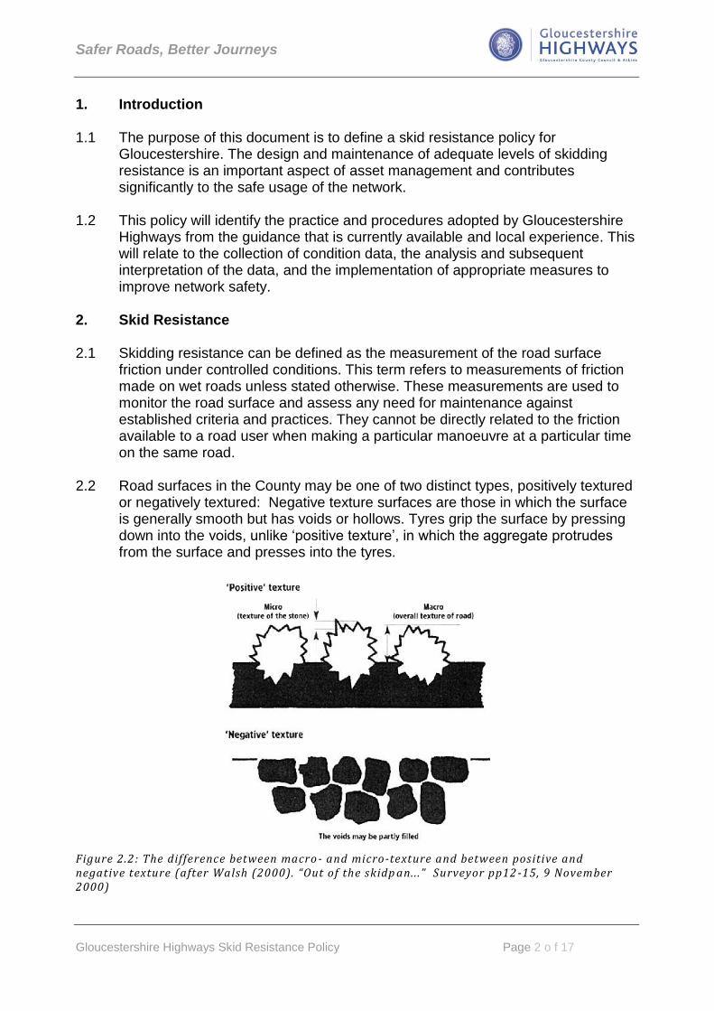
2.2 Road surfaces in the County may be one of two distinct types, positively textured or negatively textured: Negative texture surfaces are those in which the surface is generally smooth but has voids or hollows. Tyres grip the surface by pressing down into the voids, unlike „positive texture‟, in which the aggregate protrudes from the surface and presses into the tyres.
Figure 2.2: The difference between macro - and micro-texture and between positive and negative texture (after Walsh (2000). “Out of the skidp an.. .” Surveyor pp12 -15, 9 November 2000)

Safer Roads, Better Journeys
Gloucestershire Highways Skid Resistance Policy Page 3 o f 17
2.3 The skidding resistance of the road is measured indirectly using one of a number
of testing devices that pass over the road surface, The high speed (>40kph ) skidding resistance of the road is also a function of the macrotexture of the road surface
2.4 The relative resistance of roadstone to polishing by traffic is measured under controlled laboratory conditions in the Polished Stone Value (PSV) Test. The relative resistance of roadstone to abrasion by traffic is measured under controlled laboratory conditions in the Aggregate Abrasion Value (AAV) test. PSV and AAV requirements for new road surfaces are detailed in the GCC Surface & Structural Maintenance Policy.
3. Objectives
3.1 Identify potential wet-skidding related collision sites and apply appropriate
measures to reduce the risk of such collisions. 3.2 Investigate the skidding resistance at reported collision sites involving wet-
skidding and take appropriate measures to remedy the situation where found necessary.
4. Current Guidance 4.1 The current Highways Agency standard for the management of skidding
resistance is HD28/04, volume 7 of the Design Manual for Roads and Bridges. This guidance was developed for, and is provided for use on the Trunk Road network of England, Scotland, Northern Ireland and Wales, it is considered to be the default policy for the management of skidding resistance on a local authority network if no local policy is in place. A CSS (County Surveyors Society) technical note published in May 2005 provides more relevant guidance for local authority roads. The principle of HD28 is to broadly equalise the risk of skidding accidents across the network by providing a level of (wet road) skid resistance that is appropriate to each location. A key part of the Standard is therefore to identify locations where a greater level of friction is likely to reduce the risk of skidding accidents.
4.2 It is recognised that there can be issues associated with the “early life” skidding
resistance of newly laid asphalt surfaces. Management of these surfaces is currently addressed in Interim Advice note IAN 49/03, this guidance was again issued for the UK trunk roads network.
4.3 Interim Advice Note 98/07 provides guidance to facilitate the effective application
of the Skid Resistance Policy (HD28/04) by the Highways Agency and its Service Providers.
Safer Roads, Better Journeys
Gloucestershire Highways Skid Resistance Policy Page 4 o f 17
4.4 The County Surveyors Society (CSS) guidance note on how HD28/04 can be implemented on local roads is summarised in Section 9.8 of the code of practice for Highway Maintenance – Well-maintained Highways.
4.5 HD 36/06 (volume 7 of the Design Manual for Roads and Bridges) provides a
table to enable the highway engineer to select a PSV appropriate to the traffic loading and site category. This table however is derived from studies undertaken on Trunk Roads rather than on roads that are representative of a rural county network. It is therefore reasonable to assume that the PSV requirements in HD36/06 may be over-specified.
HD36/06 states:
“On an existing site, if the life that has been achieved by the aggregates, the skid resistance and the skidding accident rate have all been satisfactory, then the continued use of the same aggregate source, albeit with a lower PSV (than that given in Table 3.1) may be considered.”
Thus local experience with lower PSVs performing adequately can be encompassed within an effective skidding policy.
Gloucestershire has a significant number of roads where lower PSV stone has successfully performed with respect to wet skidding accident records and this experience has led to the creation of the modified „PSV Table‟ included in the GCC Surface & Structural Maintenance Policy.
5. Operation 5.1 In Gloucestershire skid resistance testing is carried out annually on the network
defined in Appendix A.
5.2 The procedures for making and interpreting skid resistance measurements will be in accordance with HD 28/04 Chapter 2. A summary of the overall process is shown below:

Safer Roads, Better Journeys
Gloucestershire Highways Skid Resistance Policy Page 5 o f 17
Process for making and interpreting skid resistance measurements
Undertake annual
skidding resistance survey (SCRIM)
Process SCRIM results
Analyse results. Identify
and categorise investigation sites
Analysis of collision data to
identify wet skidding sites
Undertake site investigations
Determine sites for
remedial action
Erect slippery road
warning signs if appropriate
Document erection of warning signs
Prioritised treatments
included in maintenance programme
Safer Roads, Better Journeys
Gloucestershire Highways Skid Resistance Policy Page 6 o f 17
6. Network 6.1 The Gloucestershire network tested are roads assigned a hierarchy value of 2
(Strategic) or 3a (Main Distributor), as defined in section 8.8 of Well-maintained Highways. This currently (October 2011) equates to 1223 lane kms of carriageway and comprises all Principal roads and B class roads with significant traffic flows. See appendix 1 for a map and listing of the existing network.
6.2 The network hierarchy will be reviewed annually prior to the survey commencing and any changes identified will be incorporated as necessary.
7. Test Equipment 7.1 The annual routine skidding resistance testing of the network will be undertaken
using SCRIM (Sideway-force Coefficient Routine Investigation Machine). The SCRIM survey will be undertaken in accordance with the requirements of HD 28/04 and the contractor will be accredited to ISO 9001.
7.2 Road condition data is routinely collected by the SCANNER surveys that are
carried out annually on the classified network. This data will be used during the site investigation process once specific sites have been identified.
7.3 On occasion, localised areas of the network may be tested using the Griptester 2
machine to determine if there is a deficiency in skidding resistance 8. Method of Survey 8.1 SCRIM surveys are currently undertaken annually from 1st May to 30th
September. The survey year is split into three seasons - Early (1st May to 20th June), Middle (21st June to 10th August) and Late (11th August to 30th September). For the past three years the surveys in Gloucestershire were undertaken during the following seasons;
2008 Late season survey
2009 Early season survey
2010 Mid season survey
8.2 During these years, the MSSC (Mean Summer SCRIM Co-efficient) values were
calculated by the Annual Survey with Benchmark Method. This method allows a single run survey to be undertaken with survey data also collected from benchmark sites during each of the three seasons. This benchmark data was used to correct the main survey for seasonal variations.

Safer Roads, Better Journeys
Gloucestershire Highways Skid Resistance Policy Page 7 o f 17
8.3 By 2011, full network survey data had been collected during each survey season of the proceeding three years. This historic data now enables CSC (Characteristic SCRIM Co-efficient) to be derived using the Single Annual Survey Method. This survey method is more preferable to others as it allows between year variations in the survey data to also be taken into account when calculating the CSC. The survey regime will now continue in the following cyclical manner;
2011 Late season survey
2012 Early season survey
2013 Mid season survey
2014 Late season survey
9. Investigatory Levels 9.1 The investigatory level (I.L.) represents a level of wet skidding resistance, given
in terms of an Equilibrium SCRIM Co-efficient value, above which the risk of a wet skidding accident is no higher than the baseline wet skidding accident risk for the network (typically that of single carriageway non-event sections). The higher the CSC value, the greater the measured skidding resistance. The risk of a wet skidding accident is certainly more pronounced at sites such as bends, gradients, junctions and pedestrian crossings; hence these locations are assigned higher I.L.‟s. The method for the calculation of the Equilibrium SCRIM Coefficient (ESC) is given in HD28/04 Annex 3.
9.2 To set an investigatory level, a site category is initially selected that is considered most appropriate to the road layout at any given part of the network. This category is then assigned the relevant investigatory level from the table below. This table is derived from table 4.1 from HD 28/04 chapter 4 and the initial investigatory levels assigned to the Gloucestershire County network are shown in dark grey. These investigatory levels are at the lower end of the ranges applicable to Highways Agency maintained roads (with the exception of category Q). Category Q has been subdivided, with Q1 (approaches to and across minor and major junctions) being set to the lower IL range and Q2 (approaches to roundabouts) adopting the mid range IL value.
9.3 Should local circumstances dictate, (i.e. increased risk to the road user) a higher IL may be assigned to specific sites and this is indicated by light grey shading. Additionally, for certain categories, a lower than default IL may be appropriate in low risk situations such as low traffic levels or where the risks present are well mitigated and there is a low incidence of accidents. Lower IL‟s are indicated by red shading in the following table. In both instances, a revised IL will only be justified by low incidence accident records and following a local risk assessment.

Safer Roads, Better Journeys
Gloucestershire Highways Skid Resistance Policy Page 8 o f 17
Table 9.2 Investigatory Levels
Site category & definition
Investigatory Level at testing speed of 50km/h (Duals 50mph+ tested at 80kph)
0.30 0.35 0.40 0.45 0.50 0.55 0.60 0.65
B Dual carriageway non-event
C Single carriageway non-event
Q1 Approaches to & across minor and major junctions,
Q2 Approaches to roundabouts
K Approaches to pedestrian crossings & other high risk situations
R Roundabout
G1 Gradient 5-10% longer than 50m
G2 Gradient > 10% longer than 50m
S1 Bend Radius <500m – dual carriageway
S2 Bend Radius <500m – single carriageway
Site categories G and S will be determined from the geometric data collected
by the SCANNER vehicle. Categories will only be assigned should the feature exist for more than 20 metres.
S1 and S2 categories will only be applied to roads with a speed limit of 50mph and above.
Only one site category can be assigned to each site. If more than one category applies, then the higher investigatory level will be selected or, if they are both equal, then the one highest up the table.
The categories assign to the network will vary in length depending on the nature of the site. Q and K will typically start 50 metres before a feature, (such as a junction or pedestrian crossing), unless local circumstances justify extending or reducing this distance.
9.4 Investigatory levels will be reviewed every three years. A review will also be
undertaken when a significant change to the network is made, for example the provision of a new junction, the construction of a new roundabout or the installation of a new pedestrian crossing.
Safer Roads, Better Journeys
Gloucestershire Highways Skid Resistance Policy Page 9 o f 17
10. Site Investigations 10.1 Once the annual survey is completed, the results will be processed to determine
the parts of the network where the CSC is at or below investigatory level (I.L.). This is achieved by comparing the derived CSC value with the assigned investigatory level. Only sites that have test results at or below the I.L. (i.e. are SCRIM deficient) shall initially be considered for further investigation.
10.2 Where such instances exist, a prioritised listing will be created to identify sites
requiring further investigation. The site listing will be ordered by the diminishing SCRIM deficiency. This list will then be categorised and investigations will be undertaken in the following order;
Category 1 - any site more than 0.15 below the I.L.
Category 2 - any site more than 0.10 below the I.L.
Category 3 - any other site at or below the I.L. 10.3 Site investigations solely prompted by collision statistics, rather than a SCRIM
deficiency, will also be included in the priority list. The top ten ranked collision sites where wet skidding has been identified as a contributory factor in accidents will be included at the top of the category 2-site site listing.
10.4 If a number of sites are of equal SCRIM deficiency then they will be ordered on
the basis of highest I.L. and then by the speed limit of the road, high I.L, high speed limit sections being the highest priority.
10.5 The objective of a site investigation is to determine the following;
Whether a surface treatment is justified to reduce the risk of collisions, especially those in wet conditions or involving loss of control;
Whether some other form of action is required;
Whether the investigatory level is appropriate; 10.6 Site investigations will be undertaken following a standard procedure and utilising
the form detailed in appendix B. They will be carried out by an engineer with appropriate experience.
11. Remedial actions 11.1 Sites identified as requiring treatment will be prioritised on the basis of the
severity of the SCRIM deficiency, collision data and speed limit. Sites not able to be programmed in the forthcoming year will be re-examined in the following year to determine if action is still required.

Safer Roads, Better Journeys
Gloucestershire Highways Skid Resistance Policy Page 10 o f 17
11.2 Remedial actions may include, but are not limited to:
Planing and resurfacing of the existing carriageway;
Application of a surface dressing treatment;
Mechanical retexturing of the existing surface;
Erection of slippery road surface signs. 11.3 Surface treatments are seasonal; many cannot be laid outside of the May to
September period. Therefore in some cases it will be necessary to provide warning signs as soon as it has been decided that treatment is necessary, as a warning to road users during the period before treatment can be carried out. A record of the location and date of erection/removal of signs will be maintained.
Surface texture depth will also be considered when determining remedial actions as this is known to have an influence on the skidding resistance afforded to road users especially at moderate and high speeds.
12. Skid Resistance Management on Roads outside the Defined Network 12.1 On parts of the network not subject to routine SCRIM testing, sites will be
identified for further investigation by the Accident Investigation Team. The method for determination will be sites which exhibit a significant incidence of wet skidding accidents above what is normal for that class and environment.
13. Records 13.1 Records of the annual SCRIM results and the outcome of investigations
(including remedial actions) will be maintained for a period of 10 years. 14. Early life skid resistance 14.1 It can take a period of time for the frictional properties of a newly laid asphalt road
surface to be realised. During construction, the aggregate in the road surface is coated in a film of binder and this needs a period of trafficking before the surface “wears in” and the binder film has worn away or weathered to enable direct contact between tyre and aggregate. During this time, skidding resistance can be affected in both wet and dry conditions.
14.2 Highways Agency Interim Advice Note IAN 49/03 (written for highly trafficked
Trunk Roads) recommends that slippery road signs are erected and kept in place for a period of 6 months. Local experience suggests that the period before full skidding resistance is achieved can exceed this time and is dependent on the traffic volumes using the road.

Safer Roads, Better Journeys
Gloucestershire Highways Skid Resistance Policy Page 11 o f 17
14.3 In Gloucestershire all new asphaltic surfaces placed on roads with a speed limit
greater than 40mph, shall have warning signs in place for a period of not less than 12 months after construction (or until such time as routine SCRIM testing indicates that in-service skid resistance levels have been met).
14.4 A record of the location and date of erection/removal of signs will be maintained.
15. Responsibilities 15.1 Responsibility for the management of the skid resistance policy and procedure
within Gloucestershire Highways is as follows:
Asset Manager – management of Skid Resistance Policy Pavement Assessment Engineer – survey procurement, site categorisation, determination of site investigatory levels, maintenance of SCRIM survey records, management of site investigation process, policy development Forward Programme Manager – programming of remedial works Accident Investigation Team Leader – review of accident data, support of site investigation process
Safer Roads, Better Journeys
Gloucestershire Highways Skid Resistance Policy Page 12 o f 17
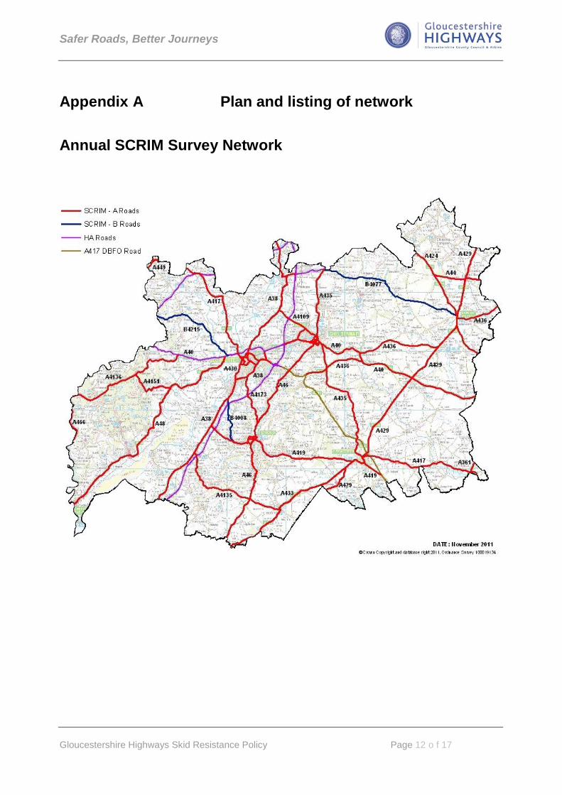
Appendix A Plan and listing of network
Annual SCRIM Survey Network

Safer Roads, Better Journeys
Gloucestershire Highways Skid Resistance Policy Page 13 o f 17
ROAD FROM TO
A361 Lechlade on Thames County Boundary
A38 County Boundary (South) Junc. 1 M50 (via Gloucester & Tewkesbury)
A40 C&G Roundabout Churchdown Roundabout
A40 Golden Valley Bypass/M5 (via Cheltenham) County Boundary
A4013 Benhall Roundabout, Cheltenham A4019 Junc. Swindon Village
A4015 Montpellier, Cheltenham Cheltenham town centre
A4019 Coombe Hill Cheltenham
A4135 A38 Junction, Dursley Tetbury
A4136 A40 Huntley County Boundary
A4151 Elton Steam Mills
A417 Kingsholm County Boundary (via Staunton)
A417 Barnwood C&G Roundabout
A417 Cirencester County Boundary (Lechlade on Thames)
A4171 Stroud Stroud
A4172 Preston Cross County Boundary
A4173 Pitchcombe A38 Junction, Tuffley
A419 Junction with A38 Cirencester
A424 Junction with A44 County Boundary (Upper Rissington)
A429 County Boundary (via Moreton-in Marsh, Stow-on-the-Wold, Cirencester)
County Boundary
A430 A38 Junction, Quedgeley Alney Island/Westgate
A430 Kingsholm St. Paul‟s/Bristol Road Junction
A4301 St. Paul‟s/Bristol Road Junction Westgate Junction
A4302 Barton Coney Hill
A433 Cirencester County Boundary
A435 Northway (Tewkesbury) Cirencester
A436 Birdlip Bourton-on-the-water
A436 Stow-on-the-Wold County Boundary
A438 County Boundary M5 Junc. 9
A44 County Boundary (Broadway) County Boundary (Moreton-in-Marsh)
A449 County Boundary Preston Cross
A46 M5 Junc. 9 Teddington
A46 Cheltenham County Boundary (via Stroud)
A466 Redbrook County Boundary
A48 A40 Junc. Highnam Roundabout County Boundary (Chepstow)
B4008 Hardwicke A419 Junction Stonehouse
B4077 Stow-on-the-Wold Teddington
B4215 Highnam Newent
B4221 Newent County Boundary (Gorsley)
The following roads are displayed on the above map but are not currently maintained by Gloucestershire Highways. ROAD FROM TO
A417 Cirencester Gloucester
A40 Golden Valley Bypass/M5 (via Gloucester) County Boundary (West)
A46 M5 Junc. 9 Junction with A435/B4077

Safer Roads, Better Journeys
Gloucestershire Highways Skid Resistance Policy Page 14 o f 17
Appendix B - SCRIM Site Investigation Report For use in the investigation of sites in accordance with HD 28/04
General Information
Y / N
Date site last surfaced: Y / N
Survey Data
Y / N
Y / N
AADT: HGV:
Accident Data
To: Total: km:
Y / N
Other comments on accident data (time?) :
Accident/Year/100km
Accidents/ 108 veh-km
Investigator:
Investigatory level(s):
Speed Limit:
PMS Section Reference(s):
Length of Site:
Does SCANNER data indicate low macro texture depth ?
Traffic Volume
Date investigation commenced:
Location
Nature of Site:
Site Category:
Has site changed since I.L. set ?
DfT Road Number:
How much below I.L.is the CSC ?
What is the average RCI value of the site ?
% Wet
% Wet skid
Accidents linked to
surface condition ?
From:
Accidents / Year
Do other SCANNER defects exist that could
affect the site ?
Is the lowest CSC in locations where vehicles have a
specific need to stop or manoeuvre ?
Site Start:
End:
E
E
Has the site been previously investigated ?
If yes, when ?
Investigation
Reference No.
Survey Year
SCRIM Site investigation Report
Average for site category
N
N
Site Data
Period Number of accidents Analysis Length
Wet: Wet Skid:

Safer Roads, Better Journeys
Gloucestershire Highways Skid Resistance Policy Page 15 o f 17
Site Inspection
Visual Assessment
Y / N
Y / N
Y / N
Y / N
Y / N
Road Users
Y / N
Road Layout
Y / N
Y / N
Y / N
Markings, Signs and Visibility
Y / N
Y / N
Other observations
Recommendations
Date: Y / N
Retexture
Could these localised areas cause
uneven skidding resistance ?
Presence of debris or
contamination ?
Traffic Conditions
Clean Drains
Inspected byDate Weather Conditions
Replace/Upgrade Signs or Road markings.
Resurface / Surface dress
Please indicate if any:
Traffic speeds in relation to road layout:
Evidence of Accident/ near miss ?
Does drainage appear adequate ?
Are markings and signs clear and
effective in all conditions ?
Clear sight lines / visibility of
queues / vegetation etc ?
If junctions exist, are they appropriate for
turning manoeuvres ?
Is the layout appropriate to venerable
road users ?
Does it appear to meet the current
design specification ?
Is further action required ?
If no, why Not ?
If yes, please indicate what is required ?
Redesign Junction
Change Investigatory Level
Other (i.e. Warning Signs etc):
Type and condition of
surfacing:
Is condition consistent
across the C/way ?
Localised defects (polishing, low
texture, patching) ?

Safer Roads, Better Journeys
Gloucestershire Highways Skid Resistance Policy Page 16 o f 17
Site Plan
Additional Comments