SIXTH INTERNATIONAL CONFERENCE ON ... - geomorfologia… Mallorca Island.pdf · Mallorca Island:...
44
Transcript of SIXTH INTERNATIONAL CONFERENCE ON ... - geomorfologia… Mallorca Island.pdf · Mallorca Island:...

SIXTH INTERNATIONAL CONFERENCE ON GEOMORPHOLOGY
MALLORCA ISLAND:GEOMORPHOLOGICAL EVOLUTION AND NEOTECTONICS.
P.G. Silva; J.L. Goy; C. Zazo; J. Jiménez; J. Fornós; A.Cabero; T. Bardají; R. Mateos; F.M. González Hernández; Cl. Hillaire-Marce and Bassam, G.
FIELD TRIP GUIDE - A7

SIXTH INTERNATIONAL CONFERENCE ON GEOMORPHOLOGY MALLORCA ISLAND: GEOMORPHOLOGICAL EVOLUTION AND NEOTECTONICS. P. G. Silva (1), J. L. Goy (2), C. Zazo (3), J. Giménez (4), J. Fornós (5), A.Cabero (3), T. Bardají (6), R. Mateos (7) , F. M. González Hernández (2) Hillaire-Marcel, Cl. (8) and Bassam, G. (8); (1) Depto. Geología, Universidad de Salamanca, Escuela Politécnica Superior de Ávila. 05003-Avila (Spain) [email protected] Teléfono: 920353500; Fax: 920353501 (2) Depto. Geología, Universidad de Salamanca, Fac. Ciencias. 37008- Salamanca (Spain). (3) Depto. Geología, Museo Nac. CC. Naturales (CSIC), Gutiérrez Abascal, 2. 28006-Madrid (Spain). (4) D. G. Recursos Hídrics, Conselleria Medi Ambient, Gov. Illes Balears, Via Asima 4, 1er-der,, 07009, Palma de
Mallorca. (5) Dept. Ciènces de la Terra, Universitat de les Illes Balears, Ctra. Valldemosa km7.5, 07071, Palma de Mallorca, (Spain) (6) Depto. Geología, Facultad de Ciencias, Universidad de Alcalá de Henares, Madrid (Spain). (7) Instituto Geológico y Minero de España (IGME). Ciudad de Querétaro s/n, 07071, Palma de Mallorca (Spain). (8) Université du Québec à Montréal, GEOTOP-UQAM, Montreal, QC, Canada H3C 3P8 1. Introduction to the Geology and Geomorphology of the Mallorca Island. The island of Mallorca covers an area of 3640 km2 and is located in the middle of the Western Mediterranean Sea (Fig. 1). It has a typical Mediterranean climate with hot dry summers and mild wet winters. The mean annual temperature is approximately 17 °C, with mean winter and summer values of 10 and 25 °C. The mean annual precipitation is about 500 mm and is mostly concentrated in autumn, although maximum precipitation can range from 1400-1600 mm in the northern sector of Tramuntana Range (Guijarro, 1986: Fig. 2). The vegetation is typically Mediterranean with two clear community types: holm oaks, Cyclamini-Quercetum ilicis, with boreal characteristics abundant at the lowest altitudes and macchia and garrigue bushes, Oleo-Ceratonion, Hypericion balearici, Rosmarino-Ericion mainly in the drier lowlands (Bolòs, 1996). The island constitutes the most important emerged segment of the so-called Balearic Promontory, which constitutes the North-eastern prolongation of the external zones of the Betic Cordillera (East Spain) into the Mediterranean sea (Fontboté et al., 1990). This orogenic promontory consists of Paleozoic to Middle Miocene materials deformed in a thrust and fold system during the Late Oligocene–Middle Miocene (Fallot, 1922; Sabat et al., 1988 and Gelabert et al., 1992). Seismic reflection profiles show that the Alpine thrust front is located NW of the Balearic Promontory constituting the southern margin of the so-called Valencia Through (Sábat et al., 1995). The promontory constitutes a main continental shelf segmented in two zones, Ibiza-Formentera to the South and Mallorca-Menorca to the North. This second one is relatively narrow (ca. 17 km mean) and shallow (ca 90 m depth) with a mean shelf-break at 139 m depth (Acosta et al., 2003). To the south, the promontory shelf terminates in the so-called Emile Baudot Scarp. This is a NE-SW linear scarp of ca. 380 km length that develops from 200 to 800 m in its shallowest part, to more than 2000 m depth at its base. This scarp has a tectonic origin, corresponding to an old fault scarp that suffered extensive erosion during the Mediterranean Messinian crisis (Acosta et al., 2003). In detail the ESCI Profile data indicate that the Emile Baudot Scarp is a crustal extensional fracture that separates the Balearic continental crust from the thinned oceanic crust of the Argelian Basin (Sàbat et al., 1995). The overall structure of the island comprises a set of NE-SW trending basin and ranges developed during a period of tectonic extension active since at least the Late Miocene (Alvaro, 1987, Benedicto et al., 1993). Three main ranges can be distinguished from NW to SE: Tramuntana
Mallorca Island: Geomorphological evolution and neotectonics
2
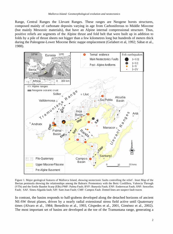
Range, Central Ranges the Llevant Ranges. These ranges are Neogene horsts structures, composed mainly of carbonate deposits varying in age from Carboniferous to Middle Miocene (but mainly Mesozoic materials), that have an Alpine internal compressional structure. Thus, positive reliefs are segments of the Alpine thrust and fold belt that were built up in addition to folds by a pile of thrust sheets not bigger than a few kilometres long but hundreds of meters thick during the Paleogene-Lower Miocene Betic nappe emplacement (Gelabert et al, 1992; Sábat et al., 1988).
0 10 20 kms
SJF
Ll e
v a
n t
R a
n g
e sBY
F.
PMF
PalmaBasin
Inca Basin
Alcud iaBasin
CamposBasin
T r a m
u n t a n a R
a n g e
SNF
SAF Randa
Termal evidence
Post - Alpine Antiforms
Main Neotectonics Faults
Plio-Quaternary
Upper Miocene-Pliocene
Pre-Alpine Basement
I=VIII=VII=VI=IV
Felt earthquakes
Sóller
Manacor
CMF
ENF
Santanyì
Artá
Andratx
Valldemosa
Lluc
Sa Pobla
Alpine rangesNeogene oceanic crust
Iberia
Eurasia10ºW
40ºN
10ºE
0 300 kmAfrica
Betics
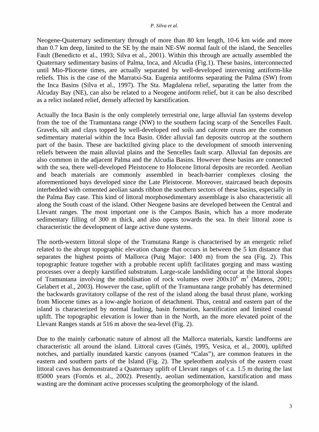
Figure 1. Major geological features of Mallorca Island, showing neotectonic faults controlling the relief . Inset Map of the Iberian peninsula showing the relationships among the Balearic Promontory with the Betic Cordillera, Valencia Through (VTh) and the Emile Baudot Scarp (EBs) PMF: Palma Fault; BYF: Bunyola Fault; ENF: Enderrocat Fault; SNF: Sencelles Fault; SAF. Sineu-Algaida fault; SJF: Sant Joan Fault; CMF: Campos Fault. Dotted lines are suspect fault traces In contrast, the basins responds to half-grabens developed along the detached horizons of ancient NE-SW thrust planes, driven by a nearly radial extensional stress field active until Quaternary times (Alvaro et al., 1984; Benedicto et al., 1993, Céspedes et al., 2001, Giménez et al., 2002). The most important set of basins are developed at the toe of the Tramuntana range, generating a
P. Silva et al.
3
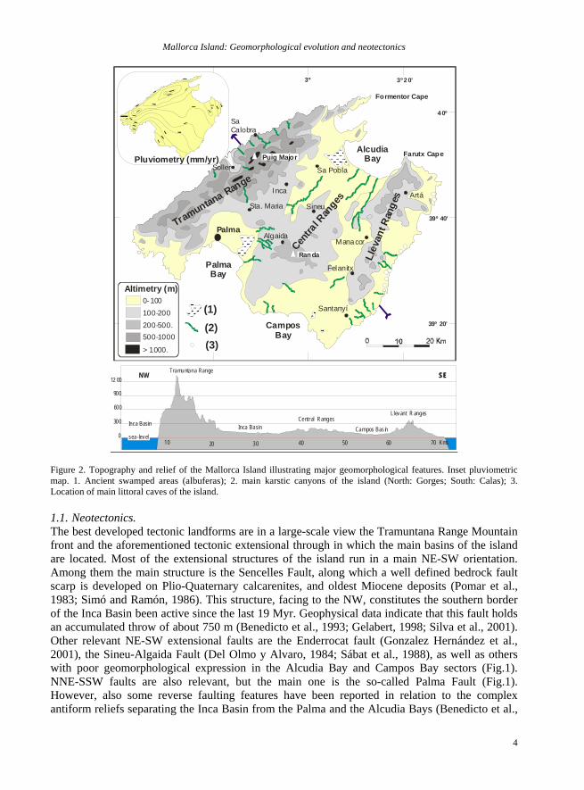
Neogene-Quaternary sedimentary through of more than 80 km length, 10-6 km wide and more than 0.7 km deep, limited to the SE by the main NE-SW normal fault of the island, the Sencelles Fault (Benedicto et al., 1993; Silva et al., 2001). Within this through are actually assembled the Quaternary sedimentary basins of Palma, Inca, and Alcudia (Fig.1). These basins, interconnected until Mio-Pliocene times, are actually separated by well-developed intervening antiform-like reliefs. This is the case of the Marratxi-Sta. Eugenia antiforms separating the Palma (SW) from the Inca Basins (Silva et al., 1997). The Sta. Magdalena relief, separating the latter from the Alcuday Bay (NE), can also be related to a Neogene antiform relief, but it can be also described as a relict isolated relief, densely affected by karstification. Actually the Inca Basin is the only completely terrestrial one, large alluvial fan systems develop from the toe of the Tramuntana range (NW) to the southern facing scarp of the Sencelles Fault. Gravels, silt and clays topped by well-developed red soils and calcrete crusts are the common sedimentary material within the Inca Basin. Older alluvial fan deposits outcrop at the southern part of the basin. These are backtilted giving place to the development of smooth intervening reliefs between the main alluvial plains and the Sencelles fault scarp. Alluvial fan deposits are also common in the adjacent Palma and the Alcudia Basins. However these basins are connected with the sea, there well-developed Pleistocene to Holocene littoral deposits are recorded. Aeolian and beach materials are commonly assembled in beach-barrier complexes closing the aforementioned bays developed since the Late Pleistocene. Moreover, staircased beach deposits interbedded with cemented aeolian sands ribbon the southern sectors of these basins, especially in the Palma Bay case. This kind of littoral morphosedimentary assemblage is also characteristic all along the South coast of the island. Other Neogene basins are developed between the Central and Llevant ranges. The most important one is the Campos Basin, which has a more moderate sedimentary filling of 300 m thick, and also opens towards the sea. In their littoral zone is characteristic the development of large active dune systems. The north-western littoral slope of the Tramutana Range is characterised by an energetic relief related to the abrupt topographic elevation change that occurs in between the 5 km distance that separates the highest points of Mallorca (Puig Major: 1400 m) from the sea (Fig. 2). This topographic feature together with a probable recent uplift facilitates gorging and mass wasting processes over a deeply karstified substratum. Large-scale landsliding occur at the littoral slopes of Tramuntana involving the mobilisation of rock volumes over 200x106 m3 (Mateos, 2001; Gelabert et al., 2003). However the case, uplift of the Tramuntana range probably has determined the backwards gravitatory collapse of the rest of the island along the basal thrust plane, working from Miocene times as a low-angle horizon of detachment. Thus, central and eastern part of the island is characterized by normal faulting, basin formation, karstification and limited coastal uplift. The topographic elevation is lower than in the North, an the more elevated point of the Llevant Ranges stands at 516 m above the sea-level (Fig. 2). Due to the mainly carbonatic nature of almost all the Mallorca materials, karstic landforms are characteristic all around the island. Littoral caves (Ginés, 1995, Vesica, et al., 2000), uplifted notches, and partially inundated karstic canyons (named “Calas”), are common features in the eastern and southern parts of the Island (Fig. 2). The speleothem analysis of the eastern coast littoral caves has demonstrated a Quaternary uplift of Llevant ranges of c.a. 1.5 m during the last 85000 years (Fornós et al., 2002). Presently, aeolian sedimentation, karstification and mass wasting are the dominant active processes sculpting the geomorphology of the island.
Mallorca Island: Geomorphological evolution and neotectonics
4
3º 3º 2 0’2 º 40’
4 0º
39º 20’
39º 40’
0
300
600
900
12 00
10 20 30 40 50 60 70 Kms
Tramuntana Range
Llevant R angesCentral Ranges
Inca Basin Campos Basin
NW SESE
Inca Basin
sea-level
Palma
Inca
Sineu
Manacor
Artá
Santanyí
Tramuntana Range
Llev
ant R
ange
s
Formentor Cape
Farutx Cape
Centra
l Ran
ges
PalmaBay
AlcudiaBay
CamposBay
Algaida
Felanitx
0-100100-200200-500.500-1000
> 1000.
Altimetry (m)
Sa Calobra
Sa Pobla
Sta. Maria
SollerPluviometry (mm/yr)
(1) (2) (3)
Puig Major
Randa
Figure 2. Topography and relief of the Mallorca Island illustrating major geomorphological features. Inset pluviometric map. 1. Ancient swamped areas (albuferas); 2. main karstic canyons of the island (North: Gorges; South: Calas); 3. Location of main littoral caves of the island. 1.1. Neotectonics. The best developed tectonic landforms are in a large-scale view the Tramuntana Range Mountain front and the aforementioned tectonic extensional through in which the main basins of the island are located. Most of the extensional structures of the island run in a main NE-SW orientation. Among them the main structure is the Sencelles Fault, along which a well defined bedrock fault scarp is developed on Plio-Quaternary calcarenites, and oldest Miocene deposits (Pomar et al., 1983; Simó and Ramón, 1986). This structure, facing to the NW, constitutes the southern border of the Inca Basin been active since the last 19 Myr. Geophysical data indicate that this fault holds an accumulated throw of about 750 m (Benedicto et al., 1993; Gelabert, 1998; Silva et al., 2001). Other relevant NE-SW extensional faults are the Enderrocat fault (Gonzalez Hernández et al., 2001), the Sineu-Algaida Fault (Del Olmo y Alvaro, 1984; Sábat et al., 1988), as well as others with poor geomorphological expression in the Alcudia Bay and Campos Bay sectors (Fig.1). NNE-SSW faults are also relevant, but the main one is the so-called Palma Fault (Fig.1). However, also some reverse faulting features have been reported in relation to the complex antiform reliefs separating the Inca Basin from the Palma and the Alcudia Bays (Benedicto et al.,
P. Silva et al.
5
1993; Silva et al., 1997; 1999; Giménez, 2003). Most of the Neogene faults are still active, since they can be related to recent-historical seismicity (Imax = VIII MSK, 1851 Palma Earthquake) and geothermal anomalies such as thermal springs and wells (Fig.1). 1.2. Climate and Sea-level changes. sea-level changes induced by the large climatic oscillations occurred during the Quaternary has been recorded in the Mallorca Islands by means of the analysis of marine terraces and accompanying faunas (i.e. Cuerda 1989; Goy et al., 1997; Zazo et al., 2003), the analysis of aeolian deposits and correlative soils (Rose and Watson, 1998; Gonzalez Hernández et al., 2001b; Nielsen et al., 2004), and littoral speleothems (Vesica et al., 2004). The most complete sequence of staircased Quaternary marine terraces is recorded in the Palma Basin. In a Northwest-Southeast transect (Son Pelat Nou- East Casa Branca) marine levels occur between +60m to +15m asl (above the mean sea-level). A tentative chronology based on faunal content and marine-terrestrial deposits relationship suggests an Early Pleistocene age for the two marine terraces at +60m and +45m; and a middle Pleistocene age for marine terraces located at +38m, +25m and +15m. Towards the coast, the only marine deposits that can be observed are those from the upper Pleistocene (Last Interglacial- OIS 5) outcropping at Campo de Tiro site, probably linked to the genesis of a subsiding area where a lagoonal environment was developed since the Late Pleistocene (Goy et al., 1997). The most outstanding feature is that OIS 5e records three highstands centered at ca 135 (one) and 117 (two) ka. In addition, a high marine level is associated to OIS5c/5a (at ca 100 ka) is also recorded (Zazo et al., 1993). Phreatic overgrowths on speleothems of various littoral caves along the eastern coast of the island also record sea levels highstands during OIS 9 or older, 7 (ca 231 ka), 5e (ca. 130 to 112-119 ka), 5c (ca 107 ka) and 5a (ca. 83 ka) (Vesica et al., 2004). Terrestrial, aeolian deposits and soils were extensively developed during OIS 4 and 2 (Rose et al., 1999). In summary, the most important environmental consequences are recorded during the transit from warmer to colder climates, when soils are eroded, littoral sands are available for aeolian transport, and rivers become effective erosive agents inland (Rose et al., 1999). Moreover, no relevant data are available to asses the position of sea-level since intervening tectonic movements along major extensional faults dislocated the height of marine terraces at different points of the island. 2. 1ST Day: The Palma Basin and Southern littoral of Mallorca. Coastal geomorphology littoral karst and sea levels changes. This first journey will be devoted to the analysis of coastal geomorphology of the SW sector of the Mallorca Island. We will explore the different landform assemblages linked to low coastal zones and cliffy coast separated by transverse faults. The last part of the journey in the southern coast of the island we will visit relevant aeolian landforms and sediments as well as typical littoral karst landforms, such as “Calas” (inundated karstic canyons), and evidences of paleokarst. 2.1. Stop1.1. Castell de Bellver (Palma de Mallorca City). Panoramic view of the Palma Basin and Bay and introduction to the geology and geomorphology of the Island (see introduction).
Mallorca Island: Geomorphological evolution and neotectonics
6
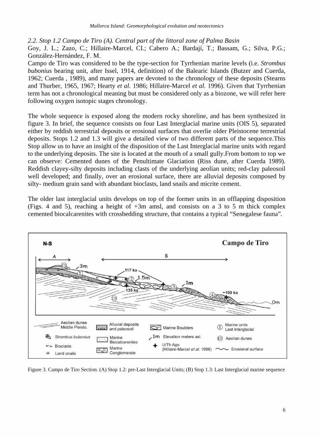
2.2. Stop 1.2 Campo de Tiro (A). Central part of the littoral zone of Palma Basin Goy, J. L.; Zazo, C.; Hillaire-Marcel, CI.; Cabero A.; Bardají, T.; Bassam, G.; Silva, P.G.; González-Hernández, F. M. Campo de Tiro was considered to be the type-section for Tyrrhenian marine levels (i.e. Strombus bubonius bearing unit, after Issel, 1914, definition) of the Balearic Islands (Butzer and Cuerda, 1962; Cuerda , 1989), and many papers are devoted to the chronology of these deposits (Stearns and Thurber, 1965, 1967; Hearty et al. 1986; Hillaire-Marcel et al. 1996). Given that Tyrrhenian term has not a chronological meaning but must be considered only as a biozone, we will refer here following oxygen isotopic stages chronology. The whole sequence is exposed along the modern rocky shoreline, and has been synthesized in figure 3. In brief, the sequence consists on four Last Interglacial marine units (OIS 5), separated either by reddish terrestrial deposits or erosional surfaces that overlie older Pleistocene terrestrial deposits. Stops 1.2 and 1.3 will give a detailed view of two different parts of the sequence.This Stop allow us to have an insight of the disposition of the Last Interglacial marine units with regard to the underlying deposits. The site is located at the mouth of a small gully.From bottom to top we can observe: Cemented dunes of the Penultimate Glaciation (Riss dune, after Cuerda 1989). Reddish clayey-silty deposits including clasts of the underlying aeolian units; red-clay paleosoil well developed; and finally, over an erosional surface, there are alluvial deposits composed by silty- medium grain sand with abundant bioclasts, land snails and micrite cement. The older last interglacial units develops on top of the former units in an offlapping disposition (Figs. 4 and 5), reaching a height of +3m amsl, and consists on a 3 to 5 m thick complex cemented biocalcarenites with crossbedding structure, that contains a typical “Senegalese fauna”.
Figure 3. Campo de Tiro Section. (A) Stop 1.2: pre-Last Interglacial Units; (B) Stop 1.3: Last Interglacial marine sequence
P. Silva et al.
7
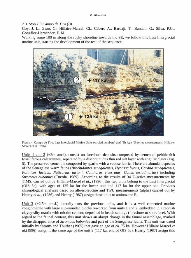
2.3. Stop 1.3 Campo de Tiro (B). Goy, J. L.; Zazo, C.; Hillaire-Marcel, CI.; Cabero A.; Bardají, T.; Bassam, G.; Silva, P.G.; González-Hernández, F. M. Walking some 100 m along the rocky shoreline towards the SE, we follow this Last Interglacial marine unit, starting the development of the rest of the sequence.
Figure 4. Campo de Tiro. Last Interglacial Marine Units (circled numbers) and Th Age (U-series measurements, Hillaire-Marcel et al. 1996) Units 1 and 2 (+3m amsl), consist on foreshore deposits composed by cemented pebble-rich fossiliferous calcarenites, separated by a discontinuous thin red silt layer with angular clasts (Fig. 5). The preserved cement is composed by sparite with a vadose fabric. There are abundant species of the Senegalese warm fauna (Brachidontes senegalensis, Hyotissa hyotis, Cardita senegalensis, Polinices lacteus, Naticarius turtoni, Cantharus viverratus, Conus testudinarius) including Strombus bubonius (Cuerda, 1989). According to the results of 34 U-series measurements by TIMS, carried out by Hillaire-Marcel et al., (1996), this two units belong to the Last Interglacial (OIS 5e), with ages of 135 ka for the lower unit and 117 ka for the upper one. Previous chronological analyses based on allo/isoleucine and Th/U measurements (alpha) carried out by Hearty et al., (1986) and Hearty (1987) assign these units to aminozone E. Unit 3 (+2.5m amsl.) laterally cuts the previous units, and it is a well cemented marine conglomerate with large sub-rounded blocks reworked from units 1 and 2, embedded in a reddish clayey-silty matrix with micrite cement; deposited in beach settings (foreshore to shoreface). With regard to the faunal content, this unit shows an abrupt change in the faunal assemblage, marked by the disappearance of Strombus bubonius and part of the Senegalese fauna. This unit was dated initially by Stearns and Thurber (1965) that gave an age of ca. 75 ka. However Hillaire Marcel et al.(1996) assign it the same age of the unit 2 (117 ka, end of OIS 5e). Hearty (1987) assign this
Mallorca Island: Geomorphological evolution and neotectonics
8
unit also to aminozone E but suggesting the possibility that may be younger (OIS 5c or 5a). The lithologic nature of this unit, together with the faunal content, suggests an intensification of storms and a change in SST (some how cooler) by the end of OIS 5e. The occurrence of two different highstands (Unit 2 and Unit 3) with the same age (117 ka) also points to rapid sea-level change and instability at the end of this isotopic substage.
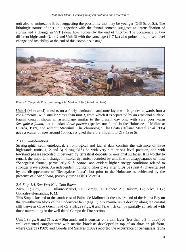
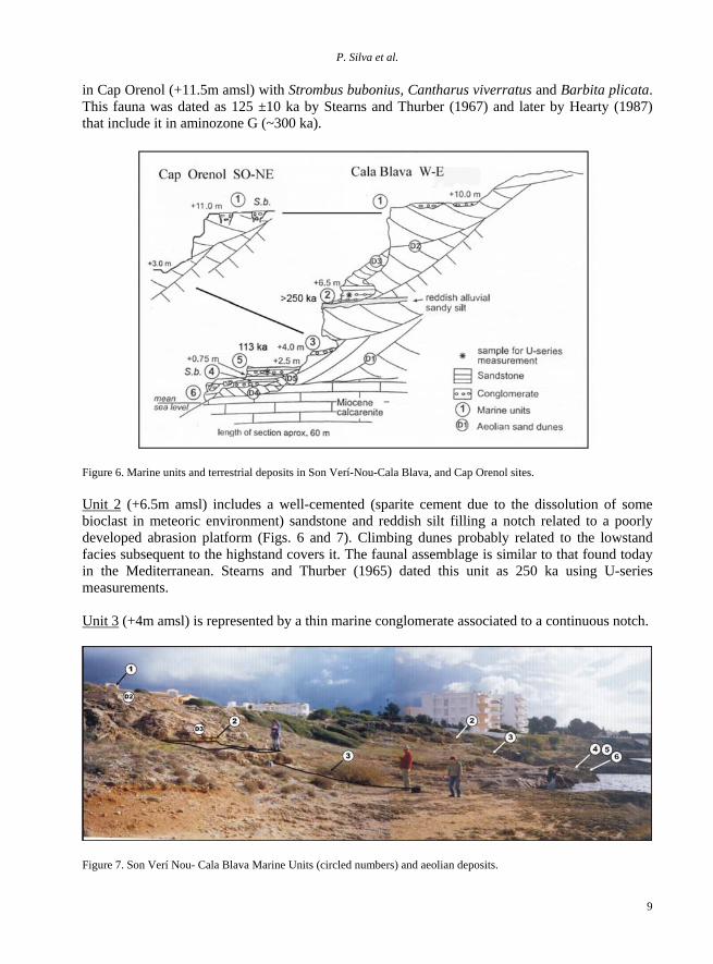
Figure 5. Campo de Tiro. Last Interglacial Marine Units (circled numbers) Unit 4 (+1m amsl) consists on a finely laminated sandstone layer which grades upwards into a conglomerate, with smaller clasts than unit 3, from which it is separated by an erosional surface. Faunal content shows an assemblage similar to the present day one, with very poor warm Senegalese fauna, but abundant Acar plicata (species not found in the Holocene of Mallorca; Cuerda, 1989) and without Strombus. The chronologic Th/U data (Hillaire Marcel et al.1996) gave a scatter of ages around 100 ka, assigned therefore this unit to OIS 5a or 5c 2.3.1. Considerations Stratigraphic, sedimentological, chronological and faunal data confirm the existence of three highstands (units 1, 2 and 3) during OISs 5e with very similar sea level position, and with lowstand phases recorded in between by terrestrial deposits or erosional surfaces. It is worthy to remark the important change in littoral dynamics recorded by unit 3, with disappearance of most “Senegalese fauna”, particularly S .bubonius, and evident higher energy conditions related to stronger wave action. An independent highstand takes place after OISs 5e (Unit 4) characterized by the disappearance of “Senegalese fauna”, but prior to the Holocene as evidenced by the presence of Acar plicata, possibly during OISs 5c or 5a. 2.4. Stop 1.4. Son Verí Nou-Cala Blava. Zazo, C.; Goy, J. L.; Hillaire-Marcel, CI.; Bardají, T.; Cabero A.; Bassam, G.; Silva, P.G.; González-Hernández, F. M. This Stop is located to the south-east of Palma de Mallorca at the eastern end of the Palma Bay on the downthrown block of the Enderrocat fault (Fig. 1). Six marine units develop along the coastal cliff between Cape Orenol and Cala Blava (Figs. 6 and 7), which can be partially correlated with those outcropping in the well dated Campo de Tiro section. Unit 1 (Figs. 6 and 7) is at +10m amsl, and it consists on a thin layer (less than 0.5 m thick) of well cemented conglomerate with marine bioclasts developed in top of an abrasion platform, where Cuerda (1989) and Cuerda and Sacarés (1992) reported the occurrence of Senegalese fauna
P. Silva et al.
9
in Cap Orenol (+11.5m amsl) with Strombus bubonius, Cantharus viverratus and Barbita plicata. This fauna was dated as 125 ±10 ka by Stearns and Thurber (1967) and later by Hearty (1987) that include it in aminozone G (~300 ka).
Figure 6. Marine units and terrestrial deposits in Son Verí-Nou-Cala Blava, and Cap Orenol sites.
Unit 2 (+6.5m amsl) includes a well-cemented (sparite cement due to the dissolution of some bioclast in meteoric environment) sandstone and reddish silt filling a notch related to a poorly developed abrasion platform (Figs. 6 and 7). Climbing dunes probably related to the lowstand facies subsequent to the highstand covers it. The faunal assemblage is similar to that found today in the Mediterranean. Stearns and Thurber (1965) dated this unit as 250 ka using U-series measurements. Unit 3 (+4m amsl) is represented by a thin marine conglomerate associated to a continuous notch.
Figure 7. Son Verí Nou- Cala Blava Marine Units (circled numbers) and aeolian deposits.
Mallorca Island: Geomorphological evolution and neotectonics
10
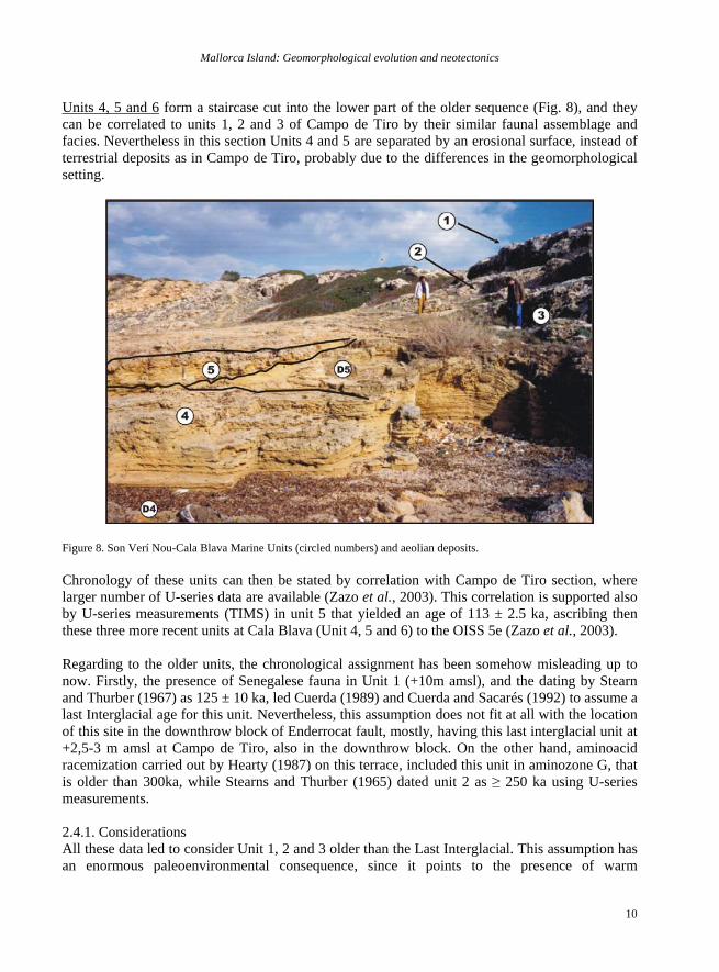
Units 4, 5 and 6 form a staircase cut into the lower part of the older sequence (Fig. 8), and they can be correlated to units 1, 2 and 3 of Campo de Tiro by their similar faunal assemblage and facies. Nevertheless in this section Units 4 and 5 are separated by an erosional surface, instead of terrestrial deposits as in Campo de Tiro, probably due to the differences in the geomorphological setting.
Figure 8. Son Verí Nou-Cala Blava Marine Units (circled numbers) and aeolian deposits.
Chronology of these units can then be stated by correlation with Campo de Tiro section, where larger number of U-series data are available (Zazo et al., 2003). This correlation is supported also by U-series measurements (TIMS) in unit 5 that yielded an age of 113 ± 2.5 ka, ascribing then these three more recent units at Cala Blava (Unit 4, 5 and 6) to the OISS 5e (Zazo et al., 2003). Regarding to the older units, the chronological assignment has been somehow misleading up to now. Firstly, the presence of Senegalese fauna in Unit 1 (+10m amsl), and the dating by Stearn and Thurber (1967) as 125 ± 10 ka, led Cuerda (1989) and Cuerda and Sacarés (1992) to assume a last Interglacial age for this unit. Nevertheless, this assumption does not fit at all with the location of this site in the downthrow block of Enderrocat fault, mostly, having this last interglacial unit at +2,5-3 m amsl at Campo de Tiro, also in the downthrow block. On the other hand, aminoacid racemization carried out by Hearty (1987) on this terrace, included this unit in aminozone G, that is older than 300ka, while Stearns and Thurber (1965) dated unit 2 as ≥ 250 ka using U-series measurements. 2.4.1. Considerations All these data led to consider Unit 1, 2 and 3 older than the Last Interglacial. This assumption has an enormous paleoenvironmental consequence, since it points to the presence of warm
P. Silva et al.
11
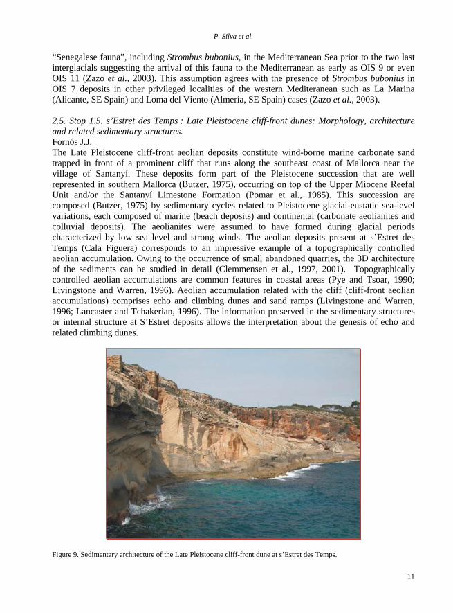
“Senegalese fauna”, including Strombus bubonius, in the Mediterranean Sea prior to the two last interglacials suggesting the arrival of this fauna to the Mediterranean as early as OIS 9 or even OIS 11 (Zazo et al., 2003). This assumption agrees with the presence of Strombus bubonius in OIS 7 deposits in other privileged localities of the western Mediteranean such as La Marina (Alicante, SE Spain) and Loma del Viento (Almería, SE Spain) cases (Zazo et al., 2003). 2.5. Stop 1.5. s’Estret des Temps : Late Pleistocene cliff-front dunes: Morphology, architecture and related sedimentary structures. Fornós J.J. The Late Pleistocene cliff-front aeolian deposits constitute wind-borne marine carbonate sand trapped in front of a prominent cliff that runs along the southeast coast of Mallorca near the village of Santanyí. These deposits form part of the Pleistocene succession that are well represented in southern Mallorca (Butzer, 1975), occurring on top of the Upper Miocene Reefal Unit and/or the Santanyí Limestone Formation (Pomar et al., 1985). This succession are composed (Butzer, 1975) by sedimentary cycles related to Pleistocene glacial-eustatic sea-level variations, each composed of marine (beach deposits) and continental (carbonate aeolianites and colluvial deposits). The aeolianites were assumed to have formed during glacial periods characterized by low sea level and strong winds. The aeolian deposits present at s’Estret des Temps (Cala Figuera) corresponds to an impressive example of a topographically controlled aeolian accumulation. Owing to the occurrence of small abandoned quarries, the 3D architecture of the sediments can be studied in detail (Clemmensen et al., 1997, 2001). Topographically controlled aeolian accumulations are common features in coastal areas (Pye and Tsoar, 1990; Livingstone and Warren, 1996). Aeolian accumulation related with the cliff (cliff-front aeolian accumulations) comprises echo and climbing dunes and sand ramps (Livingstone and Warren, 1996; Lancaster and Tchakerian, 1996). The information preserved in the sedimentary structures or internal structure at S’Estret deposits allows the interpretation about the genesis of echo and related climbing dunes.
Figure 9. Sedimentary architecture of the Late Pleistocene cliff-front dune at s’Estret des Temps.
Mallorca Island: Geomorphological evolution and neotectonics
12
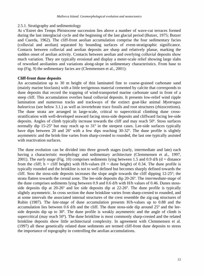
2.5.1. Stratigraphy and sedimentology At s’Estret des Temps Pleistocene succession lies above a number of wave-cut terraces formed during the last interglacial cycle and the beginning of the last glacial period (Butzer, 1975; Butzer and Cuerda, 1962). The cliff-front aeolian accumulation comprise the four sedimentary facies (colluvial and aeolian) separated by bounding surfaces of event-stratigraphic significance. Contacts between colluvial and aeolian deposits are sharp and relatively planar, marking the sudden onset of aeolian activity. Contacts between aeolian and overlying colluvial deposits show much variation. They are typically erosional and display a meter-scale relief showing large slabs of reworked aeolianites and variations along-slope in sedimentary characteristics. From base to top (Fig. 9) the sedimentary facies are (Clemmensen et al., 2001): Cliff-front dune deposits An accumulation up to 30 m height of thin laminated fine to coarse-grained carbonate sand (mainly marine bioclasts) with a little terrigenous material cemented by calcite that corresponds to dune deposits that record the trapping of wind-transported marine carbonate sand in front of a steep cliff. This accumulation overlies basal colluvial deposits. It presents low-relief wind ripple lamination and numerous tracks and trackways of the extinct goat-like animal Myotragus balearicus (see below 3.1.) as well as invertebrate trace fossils and root structures (rhizocretions). The dune strata are arranged in large-scale, critical to supercritical climbing dune cross-stratification with well-developed seaward facing stoss-side deposits and cliffward facing lee-side deposits. Angles of climb typically increase towards the cliff and may reach 50º. Stoss surfaces normally dip 15-25º but may reach up to 31º in the steepest cases. Lee-side surfaces typically have dips between 20 and 26º with a few dips reaching 30-32º. The dune profile is slightly asymmetric and the brink-line varies from sharp-crested to rounded, the last one typically assisted with reactivation surfaces. The dune evolution can be divided into three growth stages (early, intermediate and late) each having a characteristic morphology and sedimentary architecture (Clemmensen et al., 1997, 2001). The early stage (Fig. 10) comprises sediments lying between 1.5 and 0.9 d/h (d = distance from the cliff; h = cliff height) with H/h-values (H = dune height) of 0.34. The dune profile is typically rounded and the brinkline is not to well defined but becomes sharply defined towards the cliff. Stoo the stoss-side deposits increases the slope angle towards the cliff dipping 12-25º; the strata flatten towards the crestal zone. The lee-side deposits dip 20-26º. The intermediate-stage of the dune comprises sediments lying between 0.9 and 0.6 d/h with H/h values of 0.46. Dunes stoss-side deposits dip at 20-26º and lee side deposits dip at 22-26º. The dune profile is typically slightly asymmetric. In cross section the dune brinkline varies from sharp-crested to rounded, and at some intervals the associated internal structures of the crest resemble the zig-zag structures of Rubin (1987). The late-stage of dune accumulation presents H/h-values up to 0.88 and the accumulation lies between 0.6 d/h and the cliff. The dune stoss-side dip around 25º and the lee-side deposits dip up to 30º. The dune profile is weakly asymmetric and the angle of climb is supercritical (may reach 50º). The dune brinkline is most commonly sharp-crested and the related brinkline deposits show little architectural complexity. In agreement with Clemmensen et al. (1997) all these genetically related dune sediments are termed cliff-front dune deposits to stress the importance of topography in controlling the aeolian accumulations.
P. Silva et al.
13
Figure 10. Idealized stratigraphy and growth stages of the cliff-front dune (modified of Clemmensen et al., 1997).
Colluvial-ramp deposits This deposits consists of red matrix-supported breccias, matrix consisting of silt-rich carbonate sand with some terrigenous material. Clasts correspond to Miocene calcarenites or lithified aeolian sediment. Depositional packages slope away from the cliff and typically thicken downslope. They lie at the foot of the fossil sea cliff or drape underlying aeolian deposits and slope away from the cliff. They have a sharp and mostly erosional contact with underlying aeolian deposits, and a gradational to sharp contact with overlying aeolian deposits. Root casts are common at the upper contacts. They correspond to intense periods of rainfall with the reworking of aeolian sand, soil products and rock-fall material on ramp during debris flow events. Sand-ramp deposits These deposits form 1-3 m thick sheet-like packages of aeolian sand that overlie stratified cliff-front dune and colluvial deposits. Climbing sand ramp deposits at s’Estret des Temps develop as sand sheet that slope away from the fossil sea-cliff with angles between 20 and 30º. They are composed of fine to coarse-grained carbonate sand with some terrigenous material. They present wind-ripple lamination, Myotragus tracks and root casts and, seaward sloping, even, parallel
Mallorca Island: Geomorphological evolution and neotectonics
14
lamination. They represent the trapping of the carbonate sand on a ramp developed in front of the cliff of the material transported by the southeastern winds. Ascending-dune deposits These deposits correspond to the uppermost part of the cliff-front accumulations. They are formed by fine to coarse-grained carbonate sand, showing wind-ripple and sandflow lamination. They present thick (1-2 m) sets of large-scale landward dipping cross-stratification. The deposits of this unit record two closely related events of ascending-dune formation on the colluvial ramp. They primarily developed at places where the colluvial ramp was significantly lower than the cliff. The dunes were relatively small and present sinuous-crested bedforms due to the influence of the vegetation. 2.5.2. Tracks and tackways of Myotragus balearicus, Bate 1909 Described originally from Late Pleistocene cliff-front dune and sand ramp deposits in a small quarry in the souhteastern part of Mallorca (Fornós and Pons-Moyà, 1982), Myotragus tracks are a common feature in all Late Pleistocene littoral aeolianites in Mallorca, specially those that correspond to the OIS 3 (Fornós et al., 2002). They have been identified in the greater part of the Pleistocene and Early Holocene aeolianites, increasing their presence with time until 5000-4000 BP when the extermination of Myotragus occurred with the Homo arrival (Alcover, 2004). Myotragus balearicus is a fossil ruminant goat endemic trough a process of insular evolution (Alcover et al., 1981) of the Middle Pleistocene to Holocene of the Gymnesic islands (Mallorca, Menorca and Cabrera). Their ancestors presumably colonized the the Balearic islands during the Uppermost Miocene, and then evolve rapidly during insular conditions and in absence of mammalian predators. Adult specimens reached approximately 45 cm at the shoulder and their estimated weight varies between 20 kg for the smallest individuals to 50 for the largest specimens (Alcover et al., 1999). In s’Estret des Temps quarry, the tracks can be observed in all the aeolian units. Their distribution is more frequent in the basal cliff-front dune deposits, where tracks are abundant in the crestal zone deposits, common in the stoss-side deposits and rare in the lee-side deposits. There are thousands of laminae in the lithified aeolianites that have been tracked by Myotragus balearicus. The extensive sections, parallel and perpendicular to the bedding, provided by the quarry allow seeing them in vertical as well as in horizontal sections. The sediment disturbance caused by the trace maker involves both plastic deformation and microtectonic rupture in the form of microfaults and microthrusts (Fig. 11). 2.6. Stop 1.6 (optional). Punta des Savinar: Karst collapse phenomena in the Upper Miocene and their role in coastal morphology Fornós, J. J. During the Late Miocene, reef-rimmed carbonate platforms fringed many of the islands and margins of the Mediterranean basin. In all the islands of the Balearics, carbonate platforms prograded, in some cases, more than 20 km away from its basement in the core of the island (Pomar, 1991). Cliff sections near Santanyí in the SE of the island provides near continuous cross sections parallel to the reef-rimmed margin. Several facies occur within these late Tortonian-Messinian carbonates (the Reef Unit). These limestone rocks were transformed to dolomite with the movement of Mg-rich fluids causing dolomitization on the marginal carbonate platforms during the Messinian salinity crises with the evaporite formation in the Mediterranean Sea. This major event is represented in the Santanyí area stratigraphy by an irregular (mostly karstic)
P. Silva et al.
15
unconformity cutting into the upper Miocene platform that is overlaid by another carbonate unit called Terminal Complex (Santanyí Limestones), Messinian in age, and characterised by shallow marine carbonate platform deposits with sand bars (oolitic sand shoals), mangrove swamps and stromatolitic facies.
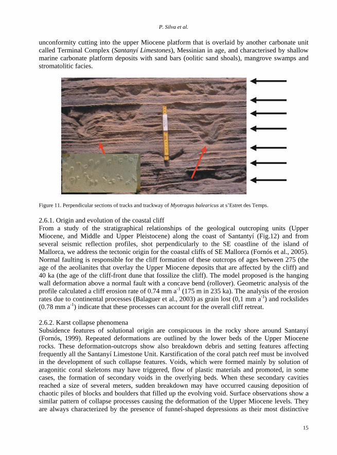
Figure 11. Perpendicular sections of tracks and trackway of Myotragus balearicus at s’Estret des Temps. 2.6.1. Origin and evolution of the coastal cliff From a study of the stratigraphical relationships of the geological outcroping units (Upper Miocene, and Middle and Upper Pleistocene) along the coast of Santantyí (Fig.12) and from several seismic reflection profiles, shot perpendicularly to the SE coastline of the island of Mallorca, we address the tectonic origin for the coastal cliffs of SE Mallorca (Fornós et al., 2005). Normal faulting is responsible for the cliff formation of these outcrops of ages between 275 (the age of the aeolianites that overlay the Upper Miocene deposits that are affected by the cliff) and 40 ka (the age of the cliff-front dune that fossilize the cliff). The model proposed is the hanging wall deformation above a normal fault with a concave bend (rollover). Geometric analysis of the profile calculated a cliff erosion rate of 0.74 mm a-1 (175 m in 235 ka). The analysis of the erosion rates due to continental processes (Balaguer et al., 2003) as grain lost (0,1 mm a-1) and rockslides (0.78 mm a-1) indicate that these processes can account for the overall cliff retreat. 2.6.2. Karst collapse phenomena Subsidence features of solutional origin are conspicuous in the rocky shore around Santanyí (Fornós, 1999). Repeated deformations are outlined by the lower beds of the Upper Miocene rocks. These deformation-outcrops show also breakdown debris and setting features affecting frequently all the Santanyí Limestone Unit. Karstification of the coral patch reef must be involved in the development of such collapse features. Voids, which were formed mainly by solution of aragonitic coral skeletons may have triggered, flow of plastic materials and promoted, in some cases, the formation of secondary voids in the overlying beds. When these secondary cavities reached a size of several meters, sudden breakdown may have occurred causing deposition of chaotic piles of blocks and boulders that filled up the evolving void. Surface observations show a similar pattern of collapse processes causing the deformation of the Upper Miocene levels. They are always characterized by the presence of funnel-shaped depressions as their most distinctive
Mallorca Island: Geomorphological evolution and neotectonics
16
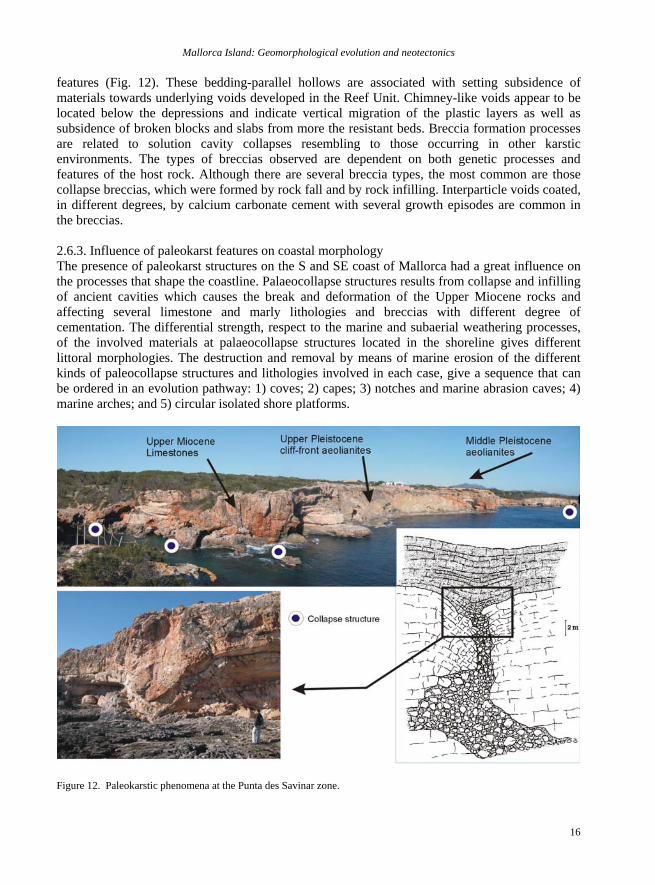
features (Fig. 12). These bedding-parallel hollows are associated with setting subsidence of materials towards underlying voids developed in the Reef Unit. Chimney-like voids appear to be located below the depressions and indicate vertical migration of the plastic layers as well as subsidence of broken blocks and slabs from more the resistant beds. Breccia formation processes are related to solution cavity collapses resembling to those occurring in other karstic environments. The types of breccias observed are dependent on both genetic processes and features of the host rock. Although there are several breccia types, the most common are those collapse breccias, which were formed by rock fall and by rock infilling. Interparticle voids coated, in different degrees, by calcium carbonate cement with several growth episodes are common in the breccias. 2.6.3. Influence of paleokarst features on coastal morphology The presence of paleokarst structures on the S and SE coast of Mallorca had a great influence on the processes that shape the coastline. Palaeocollapse structures results from collapse and infilling of ancient cavities which causes the break and deformation of the Upper Miocene rocks and affecting several limestone and marly lithologies and breccias with different degree of cementation. The differential strength, respect to the marine and subaerial weathering processes, of the involved materials at palaeocollapse structures located in the shoreline gives different littoral morphologies. The destruction and removal by means of marine erosion of the different kinds of paleocollapse structures and lithologies involved in each case, give a sequence that can be ordered in an evolution pathway: 1) coves; 2) capes; 3) notches and marine abrasion caves; 4) marine arches; and 5) circular isolated shore platforms.
Figure 12. Paleokarstic phenomena at the Punta des Savinar zone.
P. Silva et al.
17
All this kind of features can be observed at different heights above the present sea level. The responsible of these phenomena are the Pleistocene glacio-esutatic sea-level oscillation, as well as the tectonic tilting that affect the eastern coast of Mallorca (Fornós et al., 2002). 3. 2ND Day. The Tramuntana Range: Landslides and karstic landforms their role in the relief and recent activity. This second journey will be dedicated to explore the geomorphology of the Serra de Tramuntana, the major range of the island. Recent, historical, giant and Quaternary landslide events are recorded in the different slopes of the range. In addition, during the journey we will have the opportunity of observe the more outstanding exokarstic features sculpting the mountain including large karren slopes, doline fields, and giant karstic gorges (Fig. 13). The Tramuntana mountain range is constituted of carbonates deposited during the Mesozoic, together with Lower Cenozoic detritic-carbonatic materials. The only non carbonatic materials are Lower Triasic red sandstone (Bundsandstein), Upper Triasic gypsum and clays (Keuper), and small outcrops of subvolcanic rocks. Taking into account the outcropping materials, the Tramuntana mountain range can be divided into a northern zone (Soller-Formentor) where hard Liasic carbonates are dominant, forming high cliffs, and a southern sector (Soller-Andratx), where the presence of soft materials determines a more gentle relief. On the other hand, the alpine geologic structure of Tramuntana mountain range of Majorca, consisting of a NW vergent imbricated system of thrust faults formed during Lower Miocene times, determines the existence of a south-eastern smooth face and a north-western abrupt face (Fig. 1). Tramuntana is characterised by a Mediterranean climate, where intense rainfall episodes are common. Moreover, the important topographic differences determine a great variability in mean annual temperature and rainfall (Fig. 2). Thus, in the highest zone of the central sector (Lluc) mean annual precipitation reaches 1200 mm, and at the South-western sector (Andratx), average rainfall does not exceed 400 mm per year. 3.1. Stop 2.1. Mass movements in the Tramuntana range. Mateos Ruíz, R.M and Giménez, J. Rock falls and soil movements are frequent today within the Tramuntana Range and numerous historic registers have been found. On the other hand, historic records related to rock slides, which are commonly of greater dimensions, do not exist. The mass movement historical record indicates that the majority of movement events are concentrated in autumn, where the intense rainfall episodes are common, this indicates that intense rainfall episodes are the main triggering factor leading to a mass movement. 3.1.1. Fornalutx Complex Soil movement. Complex soil movements occur when the material involved in a rotational slide becomes a fluid mass. These kinds of movements are common in the SW sector of Tramuntana mountain range, but also occur at its central zone. Two important complex soil movements during the 20th century have affected Fornalutx village, located at the Soller valley,: 1924 and 1974 (Mateos, 2001, 2002). The most important soil movement was in the 17/12/1924 one (Darder, 1924), which destroyed olive-trees, and stone fences of an area of approximately 150000 m2, but fortunately nobody was injured. Thus, the colluvial Quaternary sediments that constitute all the outcrops of the hillside on the left margin of the Fornalutx creek have been mobilised at different times. Quaternary materials, composed of fine sediments together with carbonate heterometric boulders can reach up to a few meters thick and are exposed over the soft and waterproof Keuper clays and
Mallorca Island: Geomorphological evolution and neotectonics
18
gypsum’s (Fig. 14). The impermeable character of the Keuper facies and the sediment characteristics of the Quaternary colluvial materials are the intrinsic causes of those chronic complex movements. On the other hand, intense rainfall episodes are extrinsic causes, thus all the registered mass movements have occurred after a rainfall episode. The convergence of these three factors (Colluvial Quaternary sediments over the Keuper clays, and intense rainfall episodes) can be observed in other zones of the Tramuntana range, and in each case we find complex soil movements associated with them.
2.2
2.3
2.4
2.1
2.5B
A
M
C
D
E FG
H
I JK
L
N
500 m500 m
200 m
500 m
500 m
1000 m
1000 m
N
0 3 6 Km
Selva
Fornalutx
Biniarroi
Inca
SantaMaria
Lluc
Sa Calobra
Sa Costera
Bàlitx
Deià
Valldemossa
Sencelles
Sóller
Puig Major
SonRamis
Karren fields
Doline fields
Closed karstic DepressionOpen karstic Depression
Inland gorges
Large landslides
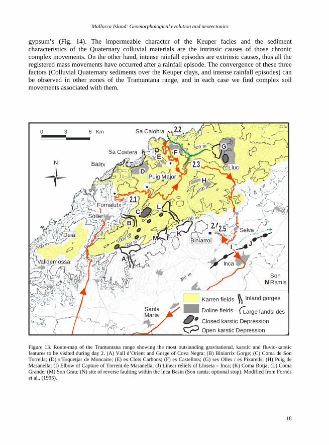
Figure 13. Route-map of the Tramuntana range showing the most outstanding gravitational, karstic and fluvio-karstic features to be visited during day 2. (A) Vall d’Orient and Gorge of Cova Negra; (B) Biniarrix Gorge; (C) Coma de Son Torrella; (D) s’Esquetjar de Moncaire; (E) es Clots Carbons; (F) es Castellots; (G) ses Olles / es Pixarells; (H) Puig de Masanella; (I) Elbow of Capture of Torrent de Masanella; (J) Linear reliefs of Lloseta – Inca; (K) Coma Rotja; (L) Coma Grande; (M) Son Grau; (N) site of reverse faulting within the Inca Basin (Son ramis; optional stop). Modified from Fornós et al., (1995).
P. Silva et al.
19
500 m
Keuper
UpperTriassic10
0 m
Quaternary
SE-NW
FornalutxCreek
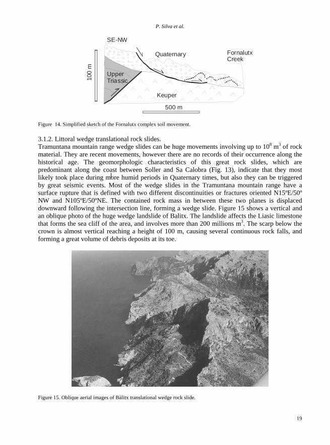
Figure 14. Simplified sketch of the Fornalutx complex soil movement. 3.1.2. Littoral wedge translational rock slides. Tramuntana mountain range wedge slides can be huge movements involving up to 108 m3 of rock material. They are recent movements, however there are no records of their occurrence along the historical age. The geomorphologic characteristics of this great rock slides, which are predominant along the coast between Soller and Sa Calobra (Fig. 13), indicate that they most likely took place during more humid periods in Quaternary times, but also they can be triggered by great seismic events. Most of the wedge slides in the Tramuntana mountain range have a surface rupture that is defined with two different discontinuities or fractures oriented N15ºE/50º NW and N105ºE/50ºNE. The contained rock mass in between these two planes is displaced downward following the intersection line, forming a wedge slide. Figure 15 shows a vertical and an oblique photo of the huge wedge landslide of Balitx. The landslide affects the Liasic limestone that forms the sea cliff of the area, and involves more than 200 millions m3. The scarp below the crown is almost vertical reaching a height of 100 m, causing several continuous rock falls, and forming a great volume of debris deposits at its toe.
Figure 15. Oblique aerial images of Bàlitx translational wedge rock slide.
Mallorca Island: Geomorphological evolution and neotectonics
20
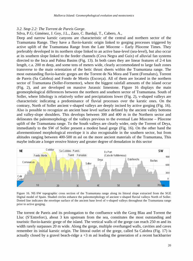
3.2. Stop 2.2: The Torrent de Pareis Gorge. Silva, P.G; Giménez, J. Goy, J.L., Zazo, C. Bardají, T., Cabero, A., Deep and narrow karstic canyons are characteristic of the central and northern sector of the Tramuntana Range. They have a fluvio-karstic origin linked to gorging processes triggered by active uplift of the Tramuntana Range from the Late Miocene – Early Pliocene Times. They preferably developed in its northern slope linked to an active base-level (sea-level), but also occur at its southern slope linked to the feeder channels (Cova Negra and Guix) of alluvial fan systems directed to the Inca and Palma Basins (Fig. 13). In both cases they are linear features of 2-4 km length, c.a. 200 m deep, and some tens of meters wide, clearly accommodated to large fault zones transverse to the main orientation of the betic thrust sheets within the Tramuntana range. The most outstanding fluvio-karstic gorges are the Torrent de Na Mora and Tuent (Fornalutx), Torrent de Pareis (Sa Calobra) and Fondo de Mortix (Escorça). All of them are located in the northern sector of Tramuntana (Soller-Formentor), where the biggest rainfall amounts of the island occur (Fig. 2), and are developed on massive Jurassic limestone. Figure 16 displays the main geomorphological differences between the northern and southern sector of Tramuntana. South of Soller, where lithology is relatively softer and precipitations lower (Fig. 2), v-shaped valleys are characteristic indicating a predominance of fluvial processes over the karstic ones. On the contrary, North of Soller ancient v-shaped valleys are deeply incised by active gorging (Fig. 16). Also is possible to recognize an ancient base level surface defined by the ancient valley bottoms and valley-slope shoulders. This develops between 300 and 400 m in the Northern sector and delineates the paleomorphology of the valleys previous to the eventual Late Miocene – Pliocene uplift of the Tramuntana range. To the South valleys are clearly wider, only the Torrent of Deya, immediately to the SW of Soller present a modest basal gorge (Fig. 16). On the other hand the aforementioned morphological envelope it is also recognisable in the southern sector, but from altitudes ranging between 400-500 m asl on the more ancient materials of the Tramuntana, This maybe indicate a longer erosive history and greater degree of denudation in this sector
BachasEstellenchs
Es Port(Cala de Valldemosa)
DeyaSoller
Fornalutx
18
TuentSa Calobra - Pareís
21
Codolar
Cornavacas
Cala Castell
300
600
900
0
10 20 30 40 50 60 70 Kms
Fondo MortixNE SW
Figure 16. NE-SW topographic cross section of the Tramuntana range along its littoral slope extracted from the SGE Digital model of Spain. Shaded circles enhance the paleomorphology of ancient v-shaped fluvial valleys North of Soller. Dotted line indicates the envelope surface of the ancient base level of v-shaped valleys throughout the Tramuntana range prior to active gorging. The torrent de Pareis and its prolongation to the confluence with the Gorg Blau and Torrent the Lluc (S’Entreforc), about 3 km upstream from the sea, constitutes the most outstanding and touristic fluvio-karstic gorge of the island. The vertical walls of the gorge can reach 250 m and its width rarely surpasses 20 m wide. Along the gorge, multiple overhanged walls, cavities and caves remember its initial karstic origin. The littoral outlet of the gorge, called Sa Calobra (Fig. 17) is actually closed by a gravel beach-ridge a +3 m asl leading the generation of a recent backbarrier

P. Silva et al.
21
depression subject to be inundated by NW stroms. Bordering this littoral depression remains of an Holocene terrace occurs at +1 m asl, with an 14C age of 4.430±110 years BP (Goy et al., 1997), suggesting a higher position of the sea for this period.
Figure 17. View of the littoral outlet of the Torrent de Pareis (Sa Calobra). In the SE sector of the island minor gorging also occur. Shallow karstic canyons furrow the tabular Miocene deposits (reef carbonates) conforming the named “Calas”. These calas rarely surpass 40 metres height. They are related to the extensive littoral karst of the SE coast of the island and surely most of them to littoral cave-development and collapse. In spite of all the information on endokarstic and paleokarstic features of this sector of the island (i.e. Ginés and Ginés, 1995, Fornós et al., 1995; Vesica, et al., 2000), gorge or “cala” development has not been subject of a deep study. Nevertheless Giménez et al, 2002 indicates that due to the fact that there is a great correlation between the orientation of the fractures that affect the upper Miocene reef deposits and the drainage and coast orientation, most of the calas and gorges of these part of Mallorca must be related to Mio-Pliocene fracturation. However gorge development in the Tramuntana range somewhat resemble the impressive gorges developed in the southern coast of Crete, where are related to major normal faulting or gravitatinal collapse in intense karstified coast over the forearc zone of the Aegean subduction zone (Fassoulas, 2001). Keeping in mind the great difference between tectonic contexts of Crete and Mallorca, the northern coast of Mallorca also is over a major compressional thrust zone, the Betic Cordillera thrust front, south to the Valencia Through (Fig. 1) and large gravitational landsliding involving minimum displacements of 150 – 125 metres occurred during the Late Miocene-Pliocene times (Mateos Ruíz, 2001; Gelabert et al., 2003) 3.3. Stop 2.3: Panoramic view of the Torrent de Pareis from Escorça. Silva, P.G; Giménez, J. Goy, J.L., Zazo, C. Bardají, T., Cabero, A., From this panoramic viewpoint there is an excellent view over the headwater zone of the Pareis Gorge, in the confluence zone of the torrents of Lluc (NE) and Gorg Blau (SW) called the s’Entreforc. This is characterized by the occurrence of subvertical valley walls affected by subvertical karrens. The Gorg Blau constitutes the fluviokarstic outlet of the ancient Tectonic andkarstic depression actually occupied by the Gorg Blau Dam (Fig. 13).
Mallorca Island: Geomorphological evolution and neotectonics
22
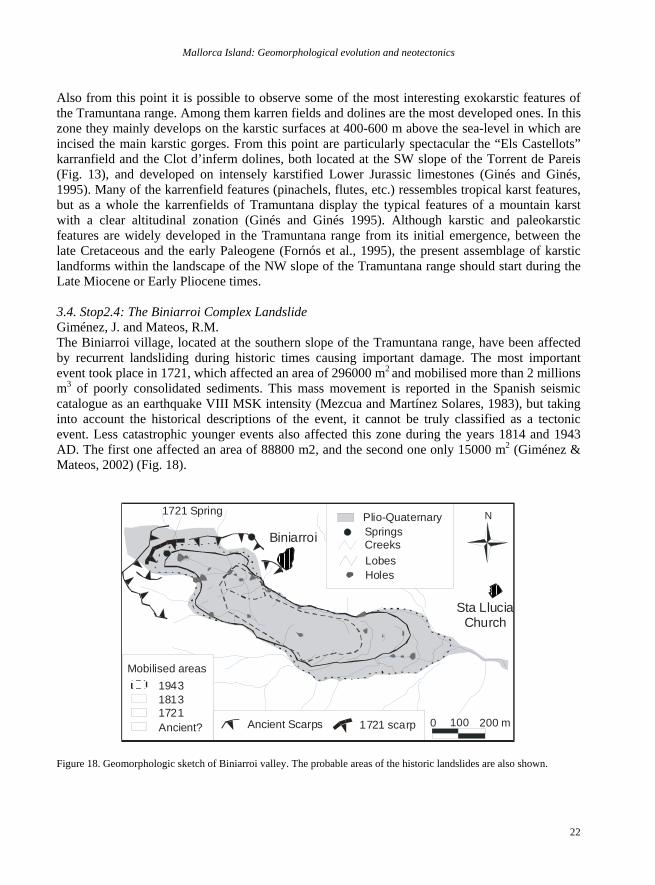
Also from this point it is possible to observe some of the most interesting exokarstic features of the Tramuntana range. Among them karren fields and dolines are the most developed ones. In this zone they mainly develops on the karstic surfaces at 400-600 m above the sea-level in which are incised the main karstic gorges. From this point are particularly spectacular the “Els Castellots” karranfield and the Clot d’inferm dolines, both located at the SW slope of the Torrent de Pareis (Fig. 13), and developed on intensely karstified Lower Jurassic limestones (Ginés and Ginés, 1995). Many of the karrenfield features (pinachels, flutes, etc.) ressembles tropical karst features, but as a whole the karrenfields of Tramuntana display the typical features of a mountain karst with a clear altitudinal zonation (Ginés and Ginés 1995). Although karstic and paleokarstic features are widely developed in the Tramuntana range from its initial emergence, between the late Cretaceous and the early Paleogene (Fornós et al., 1995), the present assemblage of karstic landforms within the landscape of the NW slope of the Tramuntana range should start during the Late Miocene or Early Pliocene times. 3.4. Stop2.4: The Biniarroi Complex Landslide Giménez, J. and Mateos, R.M. The Biniarroi village, located at the southern slope of the Tramuntana range, have been affected by recurrent landsliding during historic times causing important damage. The most important event took place in 1721, which affected an area of 296000 m2 and mobilised more than 2 millions m3 of poorly consolidated sediments. This mass movement is reported in the Spanish seismic catalogue as an earthquake VIII MSK intensity (Mezcua and Martínez Solares, 1983), but taking into account the historical descriptions of the event, it cannot be truly classified as a tectonic event. Less catastrophic younger events also affected this zone during the years 1814 and 1943 AD. The first one affected an area of 88800 m2, and the second one only 15000 m2 (Giménez & Mateos, 2002) (Fig. 18).
Biniarroi
Sta LluciaChurch
N
1721 scarpAncient Scarps
1721 Spring
1721
19431813
Ancient?
Mobilised areas
0 100 200 m
HolesLobes
Plio-Quaternary
CreeksSprings
Figure 18. Geomorphologic sketch of Biniarroi valley. The probable areas of the historic landslides are also shown.
P. Silva et al.
23
3.4.1. Historical descriptions of the 1721 landslide Two different historic sources has been used: a description of the mass movement with a schematic picture of the area, and a more extended anonymous description transcribed by Gabriel Fiol Mateu (2002). These two descriptions indicate that the first evidences of the movement began the 24/3/1721 and the mass movement did not stop until the day 29. The first evidence of the mass movement was a hole that appeared the 24/03/1721 early in the morning at the highest point of the valley. In the afternoon different water springs (small pools) appeared in the orchards located below the first hole occurred and follow-up a great strike alarmed the Biniarroi citizens who observed the upper zone of the valley was moving down, and that trees and houses “walked” down slope. Next morning, at the highest sector of the movement, the terrain subsided 40 m and a hole of 55 m diameter and 20 m depth appeared. The 26/3/1721 almost all the houses and trees crashed down, and the 29 the landslide stopped. The historical descriptions relates that the destroyed area was near 0,3 km2 and 1000 m long, and that some houses moved 250 m downslope.
Figure 19. Digital elevation model of the Biniarroi valley. 1721 landslide is also indicated.
3.4.2. Geology and geomorphology of the area Three different materials can be observed in the Biniarroi valley: Cretacic marls, Oligocene conglomerates, and Plio-Quaternary poorly consolidated colluviums. Mesozoic and Paleogene materials are intensely deformed and the Plio-Quaternary rest unconformably over them. Plio-Quaternary deposits outcrop along the entire valley slopes and also are present at the highest zone, which indicates that formerly they probably constituted a thick colluvial wedge at the Tramuntna piedmont. These deposits are mainly made of silts with big boulders of Oligocene conglomerates. It has a high concentration of carbonates, with a low degree of plasticity. The great percentage of fine elements of the matrix, made this material impermeable enabling the possibility to reach great pore pressures. On the other hand, the geomorphologic analysis of the zone has been done using aerial photograph and with a Digital Elevation Model (Fig. 19). The scarp related to the 1721 event has been identified using historical descriptions, field study and aerial photographs analysis (Fig. 18). The great scarp located at the uppermost zone must be related to an ancient landslides indicating that landslides phenomenon has been recurrent also during Quaternary times.
Mallorca Island: Geomorphological evolution and neotectonics
24
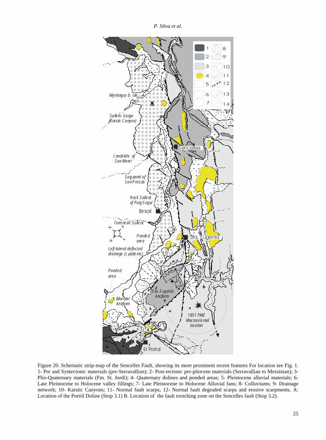
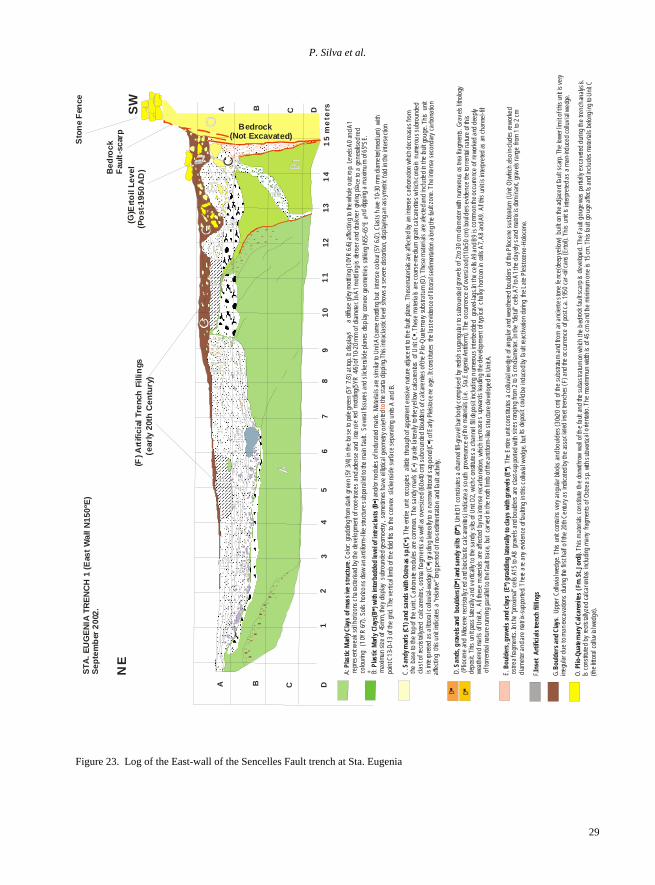
3.4.3. Triggering factors According to the geomorphologic features and historic reports Biniarroi movement must be classified as a complex rotational mass movement event with flux at the frontal part. Since the movement extends several days, the involved materials should behave as a semi-plastic soil and did not attain the Liquid Limit. Considering an affected area of 0.29 km2 and a mean thickness of 10 m, we obtain that nearly 3 million m3 were mobilised during the 1721 landslide. Three main causes are the responsible for recurrent landsliding at Biniarroi valley: nature of the Plio-Quaternary materials; presence of water springs at the contact between Cretacic marls and Oligocene materials; and intense rainfall episodes. The poor mechanic parameters of the soil and occurrence of water springs are the intrinsic causes. Triggering factor must be the chronic intense rainfall episodes. In fact, historic chronics relate that before the 1721 event an intense rainfall period took place, and also three days before a great snowfall took place (Fiol Mateu, 2002). Mateos (2001) analysed the frequencies of those intense rainfall episodes in Tramuntana range, and concluded that the area located near Biniarroi could attain storm episodes with rainfall intensity up to 250 mm in 24 hours each 25 years, and of 300 m each 100 years. These returns periods fairly match with the recurrence of landsliding at Biniarroi, that is one event per century (1721, 1814 and 1943 AD). It also can be concluded that the Plio-Quaternary materials shift to the semi-plastic state during rainfall episodes with intensity up to 300 mm/day. 3.5. Stop2.5: Panoramic view of the Inca Basin from the Tramuntana Range. Silva, P.G. Goy, J.L., Zazo, Giménez, J., Bardají, T., Cabero, A. From Santa Lucia Church, located at the top of Mancor de la Vall village, is also possible to examine the overall geomorphology of the northern border of the Inca Basin. The basin is a half-graben feed from the north by relevant alluvial fan systems such as Solleric and Rafal Garcés, nowadays dissected throughout their length. To the South-west the Cova Negra fan (Sta. Maria del Camí) is also dissected and its feeder channel goes towards the Palma Basin throughout the antiform of Marratxí. To the East the ancient fan of Inca is actually abandoned and beheaded. Their ancient feeder channel, the present NW-SE trending Torrent of Masanella, was subject of fluvial capture by NE-SW trending drainage of the Alcudia Basin (Torrent the Búger). From this point we can observe the large-scale elbow of capture formed by the aforementioned process of fluvial piracy. The ancient apex of the Inca fan was totally eroded. Actually, anomalous linear relieves on deformed cretacic and paleogene materials behead the ancient fan system and it is no rejected the participation of faulting in the beheading process, although the characterization as faults of the linear relief is problematic. Whatever the case the distal part of the Inca fan is tilted towards the Tramuntana Range (Silva et al., 2001) and apparent reverse faulting affects their deposits at mid fan locations (Giménez, 2003). If time enough after this stop we can optionally visit faulting features at Son Ramis. 4. 3RD Day. The Inca Basin: Tectonic landforms and neotectonics. This last journey will be dedicated to the analysis of the landforms and landscapes generated by tectonic activity at different spatial and temporal scales (Late Neogene to Late Quaternary). Landforms linked to reverse faulting and normal faulting will be analyzed, including the bedrock fault scarp of the Sencelles fault, the major fault of the island, subject to recent fault-trenching studies.
P. Silva et al.
25
Binialí
Torrent de Solleric
Solleri c Gorge(Karstic Canyon)
Myotragus b. site
Sta. Eugenia Ant iform
1851 PMEMacroseismal location
Rock Salientof Puig Seguí
Sag-pond ofSon Pericás
Landslide of Son Morei
El Portol
Sencelles
1
2
3
4
5
6
7
8
9
10
11
12
13
14
MarratxíAntiform
Ponded area
Ponded area
Left -lateral deflecteddrainage (z patterns)
Sta. Eugenia
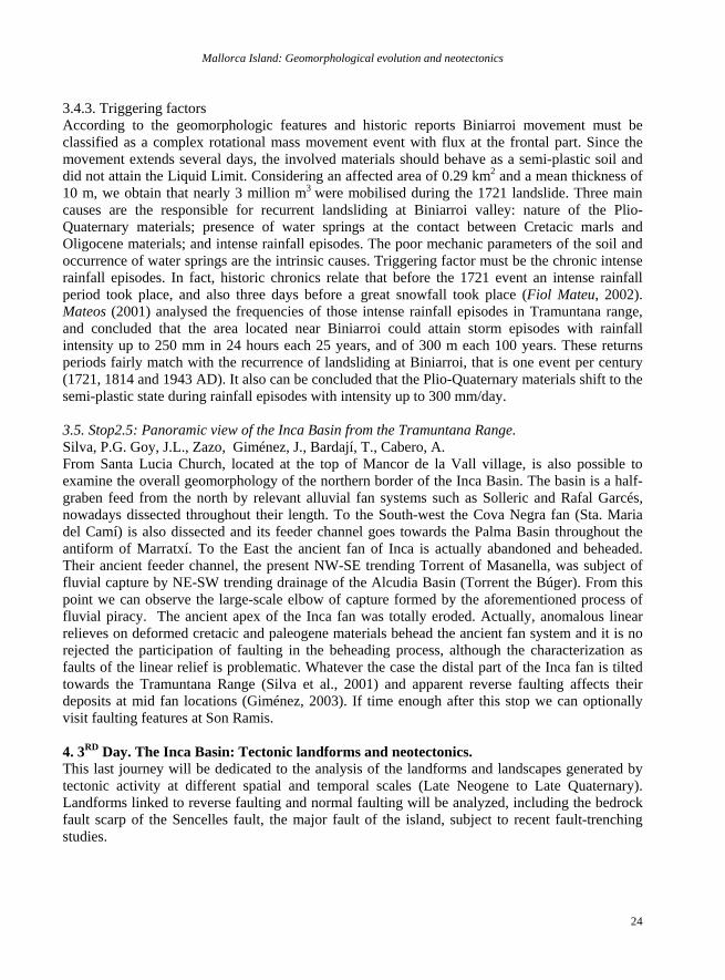
Figure 20. Schematic strip-map of the Sencelles Fault, showing its more prominent recent features For location see Fig. 1. 1- Pre and Syntectonic materials (pre-Serravallian); 2- Post-tectonic pre-pliocene materials (Serravallian to Messinian); 3- Plio-Quaternary materials (Fm. St. Jordi); 4- Quaternary dolines and ponded areas; 5- Pleistocene alluvial materials; 6- Late Pleistocene to Holocene valley fillings; 7- Late Pleistocene to Holocene Alluvial fans; 8- Colluviums; 9- Drainage network; 10- Karstic Canyons; 11- Normal fault scarps; 12- Normal fault degraded scarps and erosive scarpments. A: Location of the Portòl Doline (Stop 3.1) B. Location of the fault trenching zone on the Sencelles fault (Stop 3.2).
Mallorca Island: Geomorphological evolution and neotectonics
26
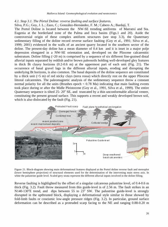
4.1. Stop 3.1. The Pòrtol Doline: reverse faulting and surface features. Silva, P.G.; Goy, J. L.; Zazo, C.; González-Hernández, F. M.; Cabero A.; Bardají, T. The Portol Doline is located between the NW-SE trending antiforms of Marratxí and Sta. Eugenia at the borderland zone of the Palma and Inca basins (Figs.1 and 20). Aside the controversial origin of these complex antiform structures (see stop 3.3), the Quaternary sedimentary filling of the doline record reverse surface faulting (Goy et al., 1991; Silva et al., 1999; 2001) evidenced in the walls of an ancient quarry located in the southern sector of the doline. The present-day doline has a mean diameter of 0.4 km and it is inset in a major polje depression elongated in a NW-SE orientation and, developed on the Pliocene calcarenitic substratum. Doline filling (>20 m) is comprised by a sequence of six different fine-grained distal alluvial inputs separated by reddish and/or brown paleosoils holding well-developed gley features in thick Bt clayey horizons (0.2-0.6 m) at the uppermost part of each unit (Fig. 21). The occurrence of basal gravel lags in the different alluvial inputs, eroding and disrupting the underlying Bt horizons, is also common. The basal deposits of the doline sequence are constituted by a thick unit (>5 m) of red sticky clays (terra rossa) which directly rest on the upper Pliocene littoral calcarenites. The paleomagnetic analysis of the sedimentary sequence throw a constant normal polarity for all the units (Brunhes epoch < 0.78 Ma) indicating that main faulting events took place during or after the Midle Pleistocene (Goy et al., 1991, Silva et al., 1999). The entire Quaternary sequence is tilted 25- 20o SE, and truncated by a thin unconformable alluvial veneer, constituting the present ground surface. This supports a recent and weakly developed brown soil, which is also dislocated by the fault (Fig. 21).
00 5m
5m
Protruded Fault scarp
Damaged fence
Contorted tree
Colluvial wedge
Palus trine Guide-level
Deep wea theredbasal calcarenite s
Fault plane hypothet ical pro longat ion
recent ponded zonere cent marmorised deposits
Figure 21. Block-diagram showing main deformational features displayed at the Portol doline reverse fault and stereoplot (lower hemisphere projection) of structural elements used for the determination of the intervening main stress axis. In white the palustrine guide level. Scaled grey strata represent the different alluvial inputs involved in the doline filling. Reverse faulting is highlighted by the offset of a singular calcareous palustrine level, of 0.4-0.6 m thick (Fig. 3.2). Fault throw measured from this guide-level is of 2.56 m. The fault strikes in an N140-130oE trend, and dips between 55 to 23o SW. The palustrine guide-level is strongly disrupted in the upthrusted block, displaying a deformational style similar to those showed by fold-limb faults or coseismic low-angle pressure ridges (Fig. 3.2). In particular, ground surface deformation can be described as a protruded scarp facing to the NE and ranging 0.88-0.20 m
P. Silva et al.
27
height (Silva et al., 1999). The scarp is partially buried. An colluvial wedge of 27o mean slope connects both fault blocks. This includes large calcarenitic blocks (40x20 cm) from an ancient stone fence severely damaged on the fault line. The fault scarp crest strikes in an N158-163oE orientation and dies out 197 m away from the quarry, however trigonometric estimations predicts a total scarp length of ca. 535 m. The contrasting values of displacement showed by fault throw (2.56m) and the present surface faulting ground dislocation (0.88 m), seem to indicate the occurrence of at least two different events. The first during the Middle-Late Pleistocene and the second one during presumably historic times. Damaged stone fences, stone-blocks including in the colluvial wedge and contorted and tilted (40º) ancient tree-trunks let to relate this ground deformations with the 1851 Mallorca Earthquake (VIII MSK) as suggested by Silva et al. (1999). In any case, this anomalous compressional feature can not be considered as true surface faulting, but as a secondary or sympathetic surface faulting (INQUA Scale, 2005). This was probably triggered by the occurrence of subsidiary near surface roll-over processes along the major extensional faults bordering the south margin of the polje-depression or simply by karstic ground failure promoted by seismic shaking.
CementerySta. Eugenia
SCALE: 1:3.000
0 50 100 150m
VLF-1 + Dd1
VLF-2
VLF-3
VLF-4
VLF-5
PM5
PM4
PM3
PM1-L1
PM
2-L2
PM2-L1
E lectric logs (SEV)
Seismic Re fractionLines (PM)
Electromagnet ic ABMProfiles (VLF)
Tracks
Dipole-dipole Pro file
Trench site
Fences
Plio-QuaternaryCa lcarenites
Co lluvial wedge
Valley-floo rdeposits
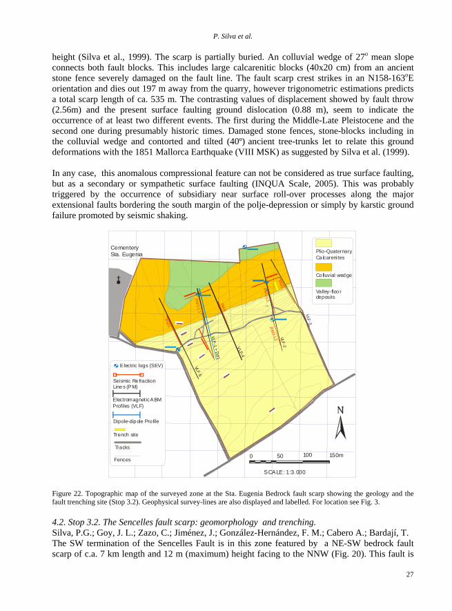
Figure 22. Topographic map of the surveyed zone at the Sta. Eugenia Bedrock fault scarp showing the geology and the fault trenching site (Stop 3.2). Geophysical survey-lines are also displayed and labelled. For location see Fig. 3. 4.2. Stop 3.2. The Sencelles fault scarp: geomorphology and trenching. Silva, P.G.; Goy, J. L.; Zazo, C.; Jiménez, J.; González-Hernández, F. M.; Cabero A.; Bardají, T. The SW termination of the Sencelles Fault is in this zone featured by a NE-SW bedrock fault scarp of c.a. 7 km length and 12 m (maximum) height facing to the NNW (Fig. 20). This fault is
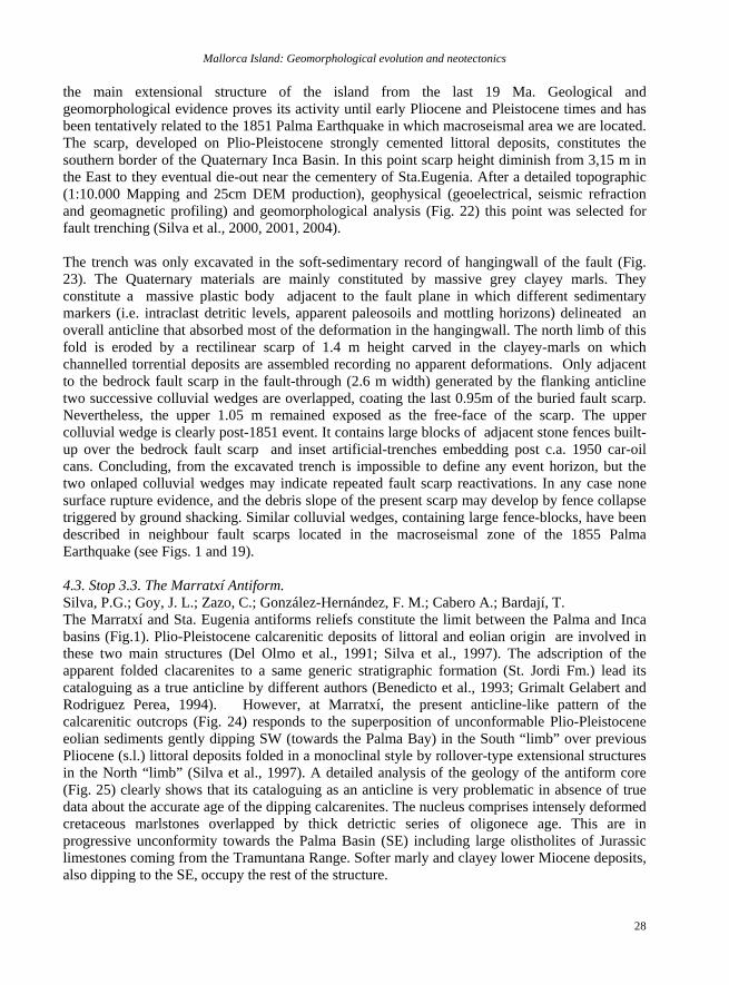
Mallorca Island: Geomorphological evolution and neotectonics
28
the main extensional structure of the island from the last 19 Ma. Geological and geomorphological evidence proves its activity until early Pliocene and Pleistocene times and has been tentatively related to the 1851 Palma Earthquake in which macroseismal area we are located. The scarp, developed on Plio-Pleistocene strongly cemented littoral deposits, constitutes the southern border of the Quaternary Inca Basin. In this point scarp height diminish from 3,15 m in the East to they eventual die-out near the cementery of Sta.Eugenia. After a detailed topographic (1:10.000 Mapping and 25cm DEM production), geophysical (geoelectrical, seismic refraction and geomagnetic profiling) and geomorphological analysis (Fig. 22) this point was selected for fault trenching (Silva et al., 2000, 2001, 2004). The trench was only excavated in the soft-sedimentary record of hangingwall of the fault (Fig. 23). The Quaternary materials are mainly constituted by massive grey clayey marls. They constitute a massive plastic body adjacent to the fault plane in which different sedimentary markers (i.e. intraclast detritic levels, apparent paleosoils and mottling horizons) delineated an overall anticline that absorbed most of the deformation in the hangingwall. The north limb of this fold is eroded by a rectilinear scarp of 1.4 m height carved in the clayey-marls on which channelled torrential deposits are assembled recording no apparent deformations. Only adjacent to the bedrock fault scarp in the fault-through (2.6 m width) generated by the flanking anticline two successive colluvial wedges are overlapped, coating the last 0.95m of the buried fault scarp. Nevertheless, the upper 1.05 m remained exposed as the free-face of the scarp. The upper colluvial wedge is clearly post-1851 event. It contains large blocks of adjacent stone fences built-up over the bedrock fault scarp and inset artificial-trenches embedding post c.a. 1950 car-oil cans. Concluding, from the excavated trench is impossible to define any event horizon, but the two onlaped colluvial wedges may indicate repeated fault scarp reactivations. In any case none surface rupture evidence, and the debris slope of the present scarp may develop by fence collapse triggered by ground shacking. Similar colluvial wedges, containing large fence-blocks, have been described in neighbour fault scarps located in the macroseismal zone of the 1855 Palma Earthquake (see Figs. 1 and 19). 4.3. Stop 3.3. The Marratxí Antiform. Silva, P.G.; Goy, J. L.; Zazo, C.; González-Hernández, F. M.; Cabero A.; Bardají, T. The Marratxí and Sta. Eugenia antiforms reliefs constitute the limit between the Palma and Inca basins (Fig.1). Plio-Pleistocene calcarenitic deposits of littoral and eolian origin are involved in these two main structures (Del Olmo et al., 1991; Silva et al., 1997). The adscription of the apparent folded clacarenites to a same generic stratigraphic formation (St. Jordi Fm.) lead its cataloguing as a true anticline by different authors (Benedicto et al., 1993; Grimalt Gelabert and Rodriguez Perea, 1994). However, at Marratxí, the present anticline-like pattern of the calcarenitic outcrops (Fig. 24) responds to the superposition of unconformable Plio-Pleistocene eolian sediments gently dipping SW (towards the Palma Bay) in the South “limb” over previous Pliocene (s.l.) littoral deposits folded in a monoclinal style by rollover-type extensional structures in the North “limb” (Silva et al., 1997). A detailed analysis of the geology of the antiform core (Fig. 25) clearly shows that its cataloguing as an anticline is very problematic in absence of true data about the accurate age of the dipping calcarenites. The nucleus comprises intensely deformed cretaceous marlstones overlapped by thick detrictic series of oligonece age. This are in progressive unconformity towards the Palma Basin (SE) including large olistholites of Jurassic limestones coming from the Tramuntana Range. Softer marly and clayey lower Miocene deposits, also dipping to the SE, occupy the rest of the structure.
P. Silva et al.
29
O.
. Thi
s mate
ri als
cons
titute
the d
o nwt
hr ow
w all o
f the f
ault
a nd t
h e su
bastr
atum
on w
hich t
he b
edroc
k fau
lt sca
rp is
d eve
lo ped
. The
Fau
lt gou
g e w
a s pa
r tially
exc
a vete
d duri
ng th
e tre
n ch a
nalys
is.I s
con s
titute
d by r
ecr is
tall yz
ed ca
lcare
nites
in clud
in g m
a ny
fr agm
e nts
o f Os
trea s
p. wi t
h su b
vert i
cal o
rienta
tio. T
he m
axim
mun
w idth
is o
f 45
cm a
nd th
e m i
nimum
one
is 15
cm. T
h is fa
u lt go
uge a
ffect s
and
inclu
d es m
a ter
ia ls b
el ong
i ng t
o Unit
C
( the l
it tora
l coll
uvial
wed
ge).
Plio-
Qua te
rna r
y Calc
aren
ites (
Fm. S
t . Jor
d i)
G..
Uppe
r Coll
uvia
l wed
ge. T
his un
it con
ta ins
v ery
a ngu
lar bl
o cks
a nd b
ould
ers (3
0x20 c
m) of
the
sub s
tratu
m an
d fro
m an
anci e
nte s
tone
fenc
e(de
ep ye
llow)
bui
l t on t
he ad
jace n
t fau lt
sc a
rp. T
he lo
wer l
imit o
f this
unit i
s ve ry
i rregu
lar d
u e to
man
exca
vatio
n s du
ring t
he fir
st ha
lf of t h
e 20
th C e
ntur y
as in
dica
ted b
y the
ass
oci at
ed in
set t
renc h
es ( F
) and
the o
ccurr
ence
of po
st c.a
. 195
0 ca
r-oil c
a ns (
E rtoi
l). Th
is un
it is i
nterp
reted
as a
man
-indu
ced
c ollu
v ial
w edg
e .
B ould
ers a
nd C
lays
NE
S TA
. EU
GE N
IA T
REN
CH
1 (E
a st W
all N
1 50 º
E)S e
ptem
ber 2
0 02.
AA
BB
CC
DD
12
34
56
78
91 0
11
1 213
14
15
me
tersSW
()E
rtoil
L eve
l(P
ost -1
9 50
AD
)G
Bedrock(Not Excavated)
Bed
rock
Fa
ult-
sca r
p
() A
rti fi
cial
Tre
n ch
Fill i
ngs
(
e arl y
20t
h C
e ntu
ry)
F
C
Sto
ne F
ence
A:
. Colo
r: gra
dding
from
dark
gre e
n (5 Y
3/4 )
in th
e ba s
e to
pale
gree
n (5Y
7/3)
at to
p. It
d ispl
a ys
a
diffus
e gle
y mo tt
ling (
10Y R
6/ 6)
affe
ctin g
to t h
e wh o
le o u
tcro
p. Le
vels
A0 an
d A1
repr e
sen t
wea
k soi
l hor
iz ons
cha
ra cte
r ised
b y th
e dev
elopm
ent o
f roo
t-trac
es a n
d ad e
nse
and
inte
nse
red m
ot tlin
g(5YR
4/6)
o f 1
0- 20 m
m of
diam
eter. I
n A1 m
ott lin
g is d
ense
r and
drak
ner g
iv ing
p la c
e to
a ge
n eral
is ed r
e d co
lourin
g (1
0YR
6/ 7).
S oils
h oriz
o ns d
r aw a
n ant
iform
-like s
truct u
re s u
bpa r
alle l
to th e
ma in
fau lt
. Sev
eral fi
ssure
s and
s lick
e nsli
d e p
lanes
d isp
la y co
n vex
g eom
etrie
s strik
ing N
55-6 5
ºE a
nd di
ppin g
a m
axim
um of
65º S
E. +
Plas
tic M
arly C
lays o
f mas
s ive
s truc
t ure
B :
and /o
r nod
ules o
f i ndu
ra ted
mar
ls . M
ateri
als a
re si
mil a
r to U
nit A
(sam
e mott
ling b
ut in
ten s
e col
our (
5Y 6 /
2). C
last s
hav e
10 -3
0 m m
diam
eter(
medi
um)
with
ma x
imu n
siz e
of 4 5
mm ,
the y
disp
lay s
ubro
unde
d ge o
moe tr
y, s
ome t
ime s
hav e
elli pt
ical g
eom
etry o
rient
e d
t he st
arta
d ippi
n g.T
h is in
t racla
stic l
e vel
s how
s a se
vere
disto
rtion
, disp
layin g
an a
ssym
etric
fo ld i
n the
inte
rsecti
onpo
in t C
13-D
-13 o
f the
grid.
The
vertic
al lim
b of th
e fold
fits t
o the
conv
ex s
licke
nside
surf
a ce
s epa
ratin
g un
its A
and
B.
Pla s
tic M
arly C
la ys(B
) wi th
inter
bedd
ed le
vel o
f intr
a clas
t s (B
)to
C.
The
enti re
unit
occu
pies
a littl
e t hr
oug h
of ap
patre
nt e
rosive
n atur
e adja
c ent
t o th
e fau
lt pla
n e.
The
san d
y marl
s ( C
)S a
ndy m
ar ls (
C1) a
n d sa
nds w
ith O
stre a
s sp.(
C).
Thes
emate
r ials
a re a
ff ecte
d by
a n in
t ense
carb o
nati o
n wh
ich d
ecre
ases
from
the
bas e
to th
e to p
of th
e u n
it. C a
rbona
te no
dules
are
com m
on.
gra
de la
te rall
y to
the y
ello w
calca
re nites
of U
nit C
. Th e
se m
ateri
als a
re co
arse
-med
i um g r
ain ca
lcare
nite s
wh ic
h con
tain
nume
rous
subro
u nde
d cl
ast o
f recri
stally
zed
calca
renit
es, o
strea
fragm
e nts
a s w
el l as
o ver
si zed
( 60x
4 0 cm
) sub
roun
d ed
b lould
e rs o
f cal
c are
n ites
of th
e Plio
-Qua
terna
r y su
b stra
t um
(O). T
h ese
mate
r ials
are a
fecte
d and
inclu
ded
in the
fault
goug
e . Th
is un
it i s
inte
rpret
ed a s
a lit t
oral
collu
vial-w
edge
(C) g
rad in
g la te
rally
to a
nar ro
w l itt
oral s
ag- p
ond (
C) o
f Ea r
ly P le
isto c
ene
age .
It co
nstitu
tes
t he la
st ev
i denc
e of li
ttora
l sed
imen
t atio
n alon
g the
fault
zone
. The
inten
s e se
c ond
a ry ca
rbona
tion
affe c
ting
this u
nit i n
dica t
es a
“rela
tive”
long p
erio d
of no
-sedim
e ntat
io n a
n d fa
u lt ac
ti vity
.
D.. U
nit D
1 con
st iute
s a ch
anne
l fill-
g rave
l bar
b ody
com
p rise
d by
redis
h su
gang
u lar to
subr o
und e
d gra
v els
o f 2 t
o 30 c
m di
a met
e r wit
h nu
mero
u s os
t rea f
r agm
e nts.
Gra
v els
lit holo
g y (P
lioce
ne a
n d M
iocen
e rec
r istal
l yzed
and
bioc
la stic
calca
renit
e s) i
n dica
t e a
south
pro
vena
nce o
f the m
at eria
ls (i.
e. S
ta .E
uge n
ia A n
tiform
). The
occu
rr enc
e of o
v ersi
z ed (
1 10x
5 0 c
m ) b
ould
ers ev
id enc
e the
t orr
entia
l nat
ure of
this
d epo
s it. T
h is un
it pas
s lat
e rall
y and
ver
tic ally
t o th
e san
d y s
il ts o
f Unit
D2,
w ich
con
stit ut
es a
cha n
nel f
ill de
posit
inclu
ding
num
erous
inte
r bedd
ed g
rave l-
lags .I
n th e
cells
A9 a
nd B
9 is c
omm
on th
e occ
urre
n ce
o f re
w ork
ed a
nd d
eep ly
we
a the
red
marls
o f U
nit A
. All t
hese
mate
rials
are a
ffecte
d by
n a in
te nse
reca
r bona
tion,
which
incr
ease
s u p
ward
s le a
ding
the d
eve lo
pmen
t of ty
p ica
l cha
lky h
orizo
n i n
cell s
A7,
A8 a n
d A9 .
All t
his u
ni t is
inter
pret
ed as
an ch
anne
l- fill
o f to
rr enti
a l na
tu re r
u nnin
g pa
r alle
l t o th
e fau
lt tra
ce, b
ut ca
rv ed i
n the
noth
l imb
o f th
e ant
if orm
- like s
tructu
re de
velo p
ed in
Uni t
A.
Sa n
ds, g
ra vels
and
bould
ers(
D) a
nd s a
ndy s
ilts
(D)
DD
E .
. The
Enti
r e un
i t con
s titu
te s a
c ollu
v ial w
e dge
of a
n gula
r and
wea
t hered
bou ld
ers of
the P
lioce
ne su
s btra
tu m (U
nit O
)whic
h als o
inc lu
des
rewor
ked
os tr
ea f ra
gmen
ts. In
the
“pro x
ima l”
cells
A15 t
o A 8
grav
els a
nd b
oulde
rs ar
e clas
t-sup
porte
d with
siz e
s ra n
ging
from
2 to
5 cm
diam
eter .
In th
e “di
stal”
cells
A7 t
o A1 t
he cla
yely
sand
matr
ix is
dom
i nan
t, gra
v els
rang
e fro
m 1
to 2
cm d
iamete
r and
are m
atrix -
sup p
orte d
. Th e
re a r
e an y
evi de
nce o
f f ault
in g in
t his
c ollu
vi al w
e dge
, but
i ts de
posit
cou
l d b e
ind u
ced b
y fa u
lt re a
ctiv a
tion d
urin g
the L
ate P
leis to
cene
-Holo
cene
.
Bould
e rs,
g rav
el s an
d clay
s (E
) gr a
ddi ng
late
rally
to cl
ays w
it h gr
a vels
(E)
F.Ins
et A
rtific
ials t
renc
h fil
l ings
Figure 23. Log of the East-wall of the Sencelles Fault trench at Sta. Eugenia
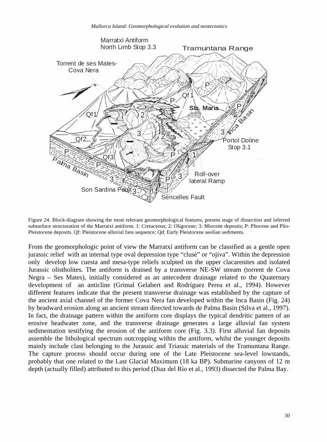
Mallorca Island: Geomorphological evolution and neotectonics
30
Tramuntana Range
Torrent de ses Mates- Cova Nera
Inca B
asin
Palma Basin
Portol Doline Stop 3.1
Qf 1
Qf1
Qf2
Qf3
2
Roll-overlateral Ramp
Sencelles Fault
Sta. Maria
1
23
33 3
PP
P
P
P
P
3
P
Son Sardina Fault
Marratxì AntiformNorth Limb Stop 3.3
Figure 24. Block-diagram showing the most relevant geomorphological features, present stage of dissection and inferred subsurface structuration of the Marratxí antiform. 1: Cretaceous; 2: Oligocene; 3: Miocene deposits; P: Pliocene and Plio-Pleistocene deposits. Qf: Pleistocene alluvial fans sequence; Qd: Early Pleistocene aeolian sediments. From the geomorphologic point of view the Marratxí antiform can be classified as a gentle open jurassic relief with an internal type oval depression type “clusè” or “ojiva”. Within the depression only develop low cuesta and mesa-type reliefs sculpted on the upper clacarenites and isolated Jurassic olistholites. The antiform is drained by a transverse NE-SW stream (torrent de Cova Negra – Ses Mates), initially considered as an antecedent drainage related to the Quaternary development of an anticline (Grimal Gelabert and Rodríguez Perea et al., 1994). However different features indicate that the present transverse drainage was established by the capture of the ancient axial channel of the former Cova Nera fan developed within the Inca Basin (Fig. 24) by headward erosion along an ancient stream directed towards de Palma Basin (Silva et al., 1997). In fact, the drainage pattern within the antiform core displays the typical dendritic pattern of an erosive headwater zone, and the transverse drainage generates a large alluvial fan system sedimentation testifying the erosion of the antiform core (Fig. 3.3). First alluvial fan deposits assemble the lithological spectrum outcropping within the antiform, whilst the younger deposits mainly include clast belonging to the Jurassic and Triassic materials of the Tramuntana Range. The capture process should occur during one of the Late Pleistocene sea-level lowstands, probably that one related to the Last Glacial Maximum (18 ka BP). Submarine canyons of 12 m depth (actually filled) attributed to this period (Diaz del Río et al., 1993) dissected the Palma Bay.
P. Silva et al.
31
Sv
c
c
cQd
QdQd
Qf
Qf
J
Ol
OlMotorway
Sa CabanetaSta. Maria
7km
Mi
Mi
200
100
0m
200
100
0m
Can Borras (FFCC: Stop 3.3)Verí
Son Sar dina Fault
2
1
NS
SE NW
1
1
2
22
33
33
P
P
P
3P
Extensional Faults
SvQdQf Qf
QdJ Ol
5km
Mi Mp
0 1 2 3km
200
100
0m
Portòl Can TorresSa Cova
3
SENW
3 322
P
33
P
Figure 25. Geological cross-section of the Marratxì Antiform from the NW (1) to SE (3). Symbols and labels as in figure 3.5. Acknwoledgements Spanish Projects BTE 2002-1691, BTE 2002-1065 and REN2001-3378; INQUA Commission on Coastal and Marine Processes, and Palaeosismicity Subcommission; IGU Coastal Systems Commission; and IGCP 495.
Mallorca Island: Geomorphological evolution and neotectonics
32
References
Acosta, J. Canals, M., López-Martínez, J., Muñoz, A., Herranz, P. Urgeles, R. Palomo, C. and Casamor, J.L. (2003). The Balearic Promontory geomorphology (western Mediterranean): morphostructure and active processes. Geomorphology, 49, 177-204.
Alcover, J.A. (2004). Disentangling the Balearic first settlement isues. Endins, 26, 143-156.
Alcover, J.A., Moyà-Solà, S. and Pons, J. (1981). Les quimeres del passat. Els vertebrats fòssils del Plio-Quaternari de les Balears i Pitiüses. Ciutat de Mallorca. Mon. Científica. Editorial Moll, 1, pp. 1-260.
Alcover, J.A., Pérez-Obiol, R., Yll, E.I. and Bover, P. (1999). The diet of Myotragus balearicus Bate 1909 (Artiodactyla, : Caprinae), an extinct bovid from the Balearic Islands : evidence from coprolites. Biological Jornal of the Linnnean Society, 66, 57-74.
Alvaro, M. (1987). La tectónica de cabalgamientos de la Sierra Norte de Mallorca (islas Baleares). Bol. Geol. y Min., 98: 34-41.
Alvaro, M., Barnolas, A., Del Olmo, P., Ramírez del Pozo, J., Simó, A. (1984). El Neógeno de Mallorca: Caracterización sedimentológica y bioestratigráfica. Bol. Geol. y Min., 95: 3-25.
Balaguer, P. and Fornós, J.J. 2003. Processos erosius als penya-segats costaners del surest de Mallorca (Illes Balears, Mediterrània Occidental): dades preliminars. Boll. Soc. Hist. Nat Balears, 46: 37-50.
Barón, A., and González Casanovas, C. (1984). Distribución espacial del Mio-Plioceno en la isla de Mallorca. Actas I Cong. Geol. Esp., Segovia, 1: 137-148.
Benedicto, A., Ramos, E., Casas, A. Sabat, E. and Barón, A. (1993). Evolución tectosedimentaria de la cubeta neógena de Inca (Mallorca). Rev. Soc. Geol. España, 6: 167-176.
Bolòs, O. (1996). La vegetació de les Illes Balears. Comunitats de plantes. Institut d’Estudis Catalans. CXIV Secció de Ciències Biològiques. 267 pp.
Butzer, K.W. (1975). Pleistocene littoral-sedimentary cycles of the Mediterranean Basin: A Mallorquin view. In: After the Austrolopithecines (K.W. Butzer and G. Isaac eds.) Mouton Press. The Hague.
Butzer, K. W. and Cuerda, J. (1962) Coastal stratigraphy of southern Mallorca and its implications for the Pleistocene chronology of the Mediterranean Sea. J. Geol., 70,398-416.
Céspedes, A, Giménez, J and Sàbat, F (2001). Caracterización del campo de esfuerzos neógenos en Mallorca mediante el análisis de poblaciones de fallas. Geogaceta, 30, 199-202.
Clemmensen, L.B., Fornós, J.J. and Rodríguez-Perea, A. (1997). Morphology and architecture of a late Pleistocene cliff-front dune, Mallorca, Western Mediterranean. Terra Nova, 9, 251-254.
Clemmensen, L.B., Lisborg, T., Fornós J.J. and Bromley, R.G. (2001). Cliff-front aeolian and colluvial deposits, Mallorca, Western Mediterranean : a record of climatic and environmental change during the last glacial period. Bulletin of the Geological Society of Denmark, 48, 217-232.
Cuerda, J. (1989). Los Tiempos Cuaternarios de las Baleares. Dir. Gral. Cultura, Conselleria de Cultura, Educació i Esports, Govern Balear. Mallorca, 305 pp.
Cuerda, J. and Sacarés, J. (1992) El Quaternari al Migjorn de Mallorca. Dir. Gral. Cultura, Conselleria de Cultura, Educació i Esports, Govern Balear. Mallorca, 130 pp.
Darder, B. (1924). Desprendimiento de tierras en Fornalutx. Majorica. Vida, Arte, 13. Diciembre 1924. 3-6
P. Silva et al.
33
Díaz del Río, V., Somoza, L., Goy, J.L., Zazo, C., Rey, J., Hernández Molina, J., Mateu, G. (1993). Estudio fisiográfico de las bahías de Palma y Alcudia (Mallorca, España). Bol. Geol. y Min., 158: 123-149.
Fassoulas, C.G. (2004). Field guide to the Geology of Crete. Natural History Museum of Crete, Publ., 104p, 3rd Ed, Heraklio (Greece).
Fiol Mateu, G.(2002). Mancor, Massanella, Biniarroi, Biniatzent: Notícies històriques 1601-1800. Ed. Ajuntament de Mancor de la Vall.
Fontboté, J.M., Guimerá, J., Roca, E., Sabat, F., Santanach, P., Fernández-Ortigosa, F. (1990). The Cenozoic evolution of Valencia trough (Western Mediterranean). Rev. Soc. Geol. Esp., 3: 249-259.
Fornós, J.J (1999). Karst collapse phenomena in the Upper Miocene of Mallorca (Balearic Islands, Western Mediterranean). Acta Geologica Hungarica, 42, 2, 237-250.
Fornós, J.J., Bromley, R.G., Clemmensen, L.B. and Rodríguez-Perea, A. (2002). Tracks and trackways of Myotragus balearicus Bate (Artiodactyla, Caprinae) in Pleistocene aeolianites from Mallorca (Balearic Islands, Western Mediterranean). Palaeogeography, Palaeoclimatology, Palaeoecology, 180, 277-313.
Fornós, J.J., Balaguer, P., Gelabert, B. and Gómez-Pujol, L. (2005).Pleistocene formation, evolution, retreat rates and processes in a carbonate coastal cliff (Mallorca Is., Western Mediterranean). Journal of Coastal Research, in press.
Fornós, J.J., Gelabert, B., Ginés, A., Ginés, J., Tuccimei, P. and Vesica, P. 2002. Phreatic overgrowths on speleothems: a useful tool in structural geology in littoral karstic landscapes. The example of eastern Mallorca (Balearic Islands). Geodinamica Acta, 15: 113-125.
Fornós, J.J., Ginés, A., Ginés, J. and Rodríguez Perea, A. (1995). Paleokarst in Mallorca. In: Karst and Caves in Mallorca (A. Ginés and J. Ginés, Eds.). Edins, 20(3), 113-124, Plama de Mallorca (Spain).
Gelabert, B. (1998). La Estructura Geológica de la Mitad Occidental de la Isla de Mallorca. Tesis Doctoral. I.T.G.E. Colección Memorias. 129 p.
Gelabert, B., Sabat, E., Rodriguez-Perea, A. (1992). A estructural outline of the Serra de Tramuntana of Mallorca (Balearic Islands). Tectonophysics, 203: 167-183.
Gelabert, B., Fornós, J.J. and Gómez-Pujol, L. (2003). Geomorphological characteristics and slope processes associated with different basins: Mallorca (Western Mediterranean). Geomorphology, 52, 253 –268.
Giménez, J. (2003). Nuevos datos sobre la actividad post-Neógena en la Isla de Mallorca. Geogaceta, 33, 79-82.
Giménez, J., Fornós, J.J. and Gelabert B. (2002). Análisis de la fracturación de los materiales calcáreos neógenos de la costa sudoriental de Mallorca. Geogaceta, 31, 91-96.
Giménez, J. and Mateos, R.M. (2002). Analysis of the Biniarroi (Mallorca) complex landslide. Procedings of the 4th EGS Plinius Conference on Mediterranean Storms.
Ginés, J. (1995). Mallorca’s endokarst: The Speleogenethic mechanisms. In : Karst and Caves in Mallorca (A. Ginés and J. Ginés, Eds.). Edins, 203, 71-86, Plama de Mallorca (Spain).
Ginés, A. and Ginés, J. (1995). The exokarstic landforms of Mallorca island. In: Karst and Caves in Mallorca (A. Ginés and J. Ginés, Eds.). Edins, 20(3), 56-70, Plama de Mallorca (Spain).
González Hernández, F.M., Goy, J.L., Zazo, C. and Silva, P.G. (2001). Tectónica Cuaternaria en la Bahía de Palma (Isla de Mallorca): Análisis Geomorfológico y Neotectónico de la Falla de Enderrocat. Actas V Reunión Cuaternario Ibérico, Lisboa (Portugal) ,41-44.
González Hernández F.M., Goy, J.L., Zazo, C. and Silva, P.G. (2001). Actividad eólica – cambios del Nivel del Mar durante los últimos 170.000 años (litoral de Mallorca, Islas Baleares). Cuaternario y Geomorfología, 15 (3-4), 67-75.
Mallorca Island: Geomorphological evolution and neotectonics
34
Goy, J.L., Zazo, C., Mörner, N.A. (1991). Reverse fault in continental sedimentary deposits on Mallorca. Abstract Vol., XIII Int. INQUA Congress, Beijing (China).
Goy, J.L., Zazo, C. and Cuerda, J. (1997). Evolución de las áreas margino-litorales de la Costa de Mallorca (I. Baleares) durante el Último y Presente Interglacial Nivel del mar Holoceno y clima. Bol. Geol. Min. 108, 127–135.
Goy, J.L., Hillaire-Marcel, C., Zazo, C. and Cuerda, J. (1993). The Last Interglacial in the Baleares Islands: Morphosedimentary record and neotectonic implications. INQUA Mediterr. Black Sea Shorelines Subc. Newsl. 15, pp. 23–25.
Guijarro, A. (1986). Contribución a la bioclimatología de Baleares. Ph D. Thesis Universitat de les illes Baleares, 253pp. (unpublished).
Hearty, P.J., Miller, G.H., Stearns, Ch.E. and Szabo, B.J. (1986). Aminostratigraphy of Quaternary shorelines in the Mediterranean basin. Geological Society of America Bulletin, 97, 850-858.
Hearty, P.J., Hollin, J.T. and Dumas, B. (1987). Geochronology of Pleistocene littoral deposits on the Alicante and Almeria coasts of Spain. Trabajos sobre el Neógeno-Cuaternario, 10, 95-107.
Hillaire-Marcel, C., Gariepy, C., Ghaleb, B., Goy, J.L., Zazo, C. and Cuerda, J. (1996). U-series measurements in Tyrrhenian deposits from Mallorca. Further evidence for two last interglacials high sea-levels in the Balearic Islands. Quaternary Science Review, 15, 53–62.
Lancaster, N. and Tchakerian, V.P. (1996). Geomorpholog and sediments of sand ramps in the Mojave desert. Geomorphology, 17, 151-165.
Livingstone, I. and Warren, A. (1996). Aeolian geomorphology. An Introduction. Addison Wesley Longman, Essex.
Mateos Ruiz, R.M. (2001). Los movimientos de ladera en la Sierra de Tramuntana (Mallorca). Caracterización geomecánica y análisis de peligrosidad. Unpublished PhD Thesis, Universidad Complutense de Madrid, Madrid. 299 p
Mateos, R.M. (2002). Slope movements in the Majorca Island (Spain). Hazard Analysis. Instability, Planning and Management. Seeking Sustainable Solutions to Ground Movements Problems. International Conference on Instability-Planning and Management. Ventnor, UK. Mayo 2002. 339-346.
Mezcua, J. and Martínez Solares, J.M (1983). Sismicidad del área Ibero-mogrebí. Presidencia del Gobierno, Instituto Geográfico Nacional, Publicación 203.
Nielsen, K.A., Clemmensen, L.B. and Fornós, J.J. (2004). Middle Pleistocene magnetostratigraphy and susceptibility stratigraphy: data from a carbonate aeolian system, Mallorca, Western Mediterranean. Quaternary Science Review, 23, 1733-1756.
Pomar, L. (1991). Reef geometries, erosion surfaces and high-frequency sea-level changes, Upper Miocene reef complex, Mallorca, Spain. Sedimentology, 38, 243-269.
Pomar, L., Marzo, M. and Barón, A. (1983). El Terciario de Mallorca. In: L. Pomar, A. Orador, J.J. Fornós, A. Rodríguez-Perea (eds.). El Terciario de las Baleares (Mallorca-Menorca). Inst. Est. Baleáricos, Palma de Mallorca, 21-45.
Pomar, L., Fornós, J.J. and Rodríguez-Perea, A. (1985). Reef and shallow carbonate facies of the Upper Miocene of Mallorca. IAS 6th European Regional Meeting, Excursion Guidebook, 494-518.
Pye, K. and Tsoar,H. (1990). Aeolian Sand and Sand Dunes. Unwin Hyman, London.
Rose, J., Meng, X. and Watson, C. (1999). Palaeoclimate and palaeoenvironmental responses in the western Mediterranean over the
P. Silva et al.
35
last 140 ka: evidence from Mallorca, Spain. J. Geol. Soc. London 150, pp. 435–448.
Rubin, D. (1987). Cross-bedding, Bedforms and Paleocurrents. SEPM Concepts in Sedimentology and Paleontology. SEPM, Tulsa, OK.
Sabat, F., Muñoz, J.A. and Santanach, P. (1988). Transversal and oblique structures at the serres de Llevant thrust belt (Mallorca Island). Geol. Rundsch., 77(2): 529-538.
Sabat, F., Roca, E., Muñoz, J.A., Vergés, J., Santanach, P., Sans, M., Massana, E., Estévez, A., and Santiesteban, C. (1995). Extension and compression in the evolution of the eastern margin of Iberia: the ESCI-Valencia Trough seismic profile. In P. Santanach (ed.). ECSCI – Estudios Sísmicos de la Corteza Ibérica. Rev. Soc. Geol. España, 8 (4): 431-448.
Silva, P.G. González-Hernández, F.M., Goy, J.L. and Zazo, C. (1997). Origen y desmantelamiento del Antiforme Plio-Cuaternario de Marratxí (Mallorca, España). Geogaceta, 22 : 143-147.
Silva, P.G. González-Hernández, F.M., Goy, J.L., Zazo, C. and Mörner (1999). Quaternary reverse surface faulting in Mallorca Island (Baleares, Spain). Geogaceta, 26: 99-102.
Silva. P.G., Carrasco, P., González Hernández, F.M., Goy, J.L., Zazo, C., Luque, L., Santos, G., Delgado, M. and Poza. (2000). Prospección geofísica de la Falla de Sencelles (Mallorca, España): Una metodología preliminar para la realización de trincheras de falla. Geotemas, 1:
Silva. P.G., González Hernández, F.M., Goy, J.L. and Zazo C. and Carrasco, P. (2001). Paleoseismicity and historical seismicity in the Mallorca Island (Baleares, Spain): A preliminary approach. Acta Geológical Hispánica, 36, 245-266.
Silva. P.G., González Hernández, F.M., Jiménez, J., Santos, G., Delgado, M., Carrasco, P., Goy, J.L. Zazo, C. and De Luque, L. (2004). Fault trenching analysis of the Sencelles Fault (Mallorca Island, Spain). Abstracts 32nd
Internarional Geological Congress, Firenze (Italy).
Stearns, Ch. and Thurber, D. (1965). 230Th/234U dates of late Pleistocene marine fossils from the Mediterranean and Moroccan littorals. Cuaternaria, 7, 29-41.
Stearns, Ch. and Thurber, D. (1967). 230Th/234U dates of late Pleistocene marine fossils from the Mediterranean and Moroccan littorals. Prog. Oceanog. 4, 293-305.
Vesica, P.L., Tuccimei, P., Turi, B., Fornós, J.J., Ginés, A. and Ginés, J. (2000). Late Pleistocene paleoclimates and sea-level changes in the Mediterranean as inferred from stable isotope and U-Series studies of overgrowths on spelothems, Mallorca, Spain. Quaternary Science Review., 19, 865-879.
Zazo, C., Goy, J.L., Dabrio, C.J., Bardají, T., Hillaire-Marcel, C., Ghaleb, B., González-Delgado, J.A. and Soler, V. (2003). Pleistocene raised marine terraces of the Spanish Mediterranean and Atlantic coasts: record of coastal uplift, sea-level highstands and climate changes. Marine Geology, 194, 103-133.
Zazo, C., Goy, J.L., Bardají, T., González-Delgado, J.A., Hillaire-Marcel, CI., Dabrio, C.J., Lario, J., Civis, J., Luque, L., Ghaleb, B., Borja, F., Silva, P.G., González-Hernández, F., Soler, V. and Gillot, P.Y. (2004). El efecto de los ciclos climáticos en las variaciones del nivel del mar. In: Miscelánea en homenaje a Emiliano Aguirre. Volumen I. Geología. Museo Arqueológico Regional, Número 4, Alcalá de Henares, 157-167.
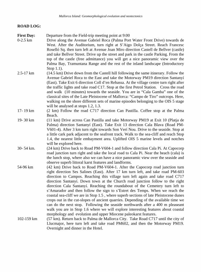
Mallorca Island: Geomorphological evolution and neotectonics ROAD LOG: First Day: Departure from the Field-trip meeting point at 9:00 0-2.5 km Drive along the Avenue Gabriel Roca (Palma Port Water Front Drive) towards de
West. After the Auditorium, turn right at S’Aigo Dolça Street. Reach Francesc Roselló Sq. then turn left at Avenue Joan Miro direction Castell de Bellver (castle) and take Bellver Street. Drive up the street and park in the castle Parking. From the top of the castle (free admittance) you will get a nice panoramic view over the Palma Bay, Tramuntana Range and the rest of the inland landscape (Introductory Stop 1.1).
2.5-17 km (14.5 km) Drive down from the Castell hill following the same itinerary. Follow the Avenue Gabriel Roca to the East and take the Motorway PM19 direction Santanyí (East). Take Exit 6 direction Coll d’en Rebassa. At the village centre turn right after the traffic lights and take road C17. Stop at the first Petrol Station. Cross the road and walk (10 minutes) towards the seaside. You are in “Cala Gamba” one of the classical sites of the Late Pleistocene of Mallorca: “Campo de Tiro” outcrops. Here, walking on the shore different sets of marine episodes belonging to the OIS 5 stage will be analysed at stops 1.2, 1.3.
17- 19 km (2 km) Follow the road C717 direction Can Pastilla. Coffee stop at the Palma Beach.
19- 30 km (11 km) Drive across Can Pastilla and take Motorway PM19 at Exit 10 (Platja de Palma) direction Santanyí (East). Take Exit 13 direction Cala Blava (Road PM-V601-4). After 3 km turn right towards Son Verí Nou. Drive to the seaside. Stop at a little cark park adjacent to the seafront track. Walk to the sea-cliff and reach Stop 1.4, the nearest little embayment area. Uplifted OIS 5 marine levels and notches will be explored here.
30- 54 km. (24 km) Drive back to Road PM-V604-1 and follow direction Cala Pi. At Capocorp road junction turn right and take the local road to Cala Pi. Near the beach (cala) is the lunch stop, where also we can have a nice panoramic view over the seaside and observe superb littoral karst features and landforms.
54-96 km (42 km) Drive back to Road PM-V604-1. After the Capocorp road junction turn right direction Ses Salines (East). After 17 km turn left, and take road PM-603 direction to Campos. Reaching this village turn left again and take road C717 direction Santanyí. Down town at the Church road junction follow to the right direction Cala Santanyí. Reaching the roundabout of the Cemetery turn left to s’Amarador and then follow the sign to s’Estret des Temps. When we reach the coastal sea-cliff we are in Stop 1.5 , where superb sections of late Pleistocene dunes crops out in the cut-slopes of ancient quarries. Depending of the available time we can do the next stop. Following the seaside northwards after a 400 m pleaseant walk you are in Stop 1.6 where we will explore interesting features about coastal morphology and evolution and upper Miocene paleokarst features.
102-159 km (57 km). Return back to Palma de Mallorca City. Take Road C717 until the city of Llucmajor, here turn left and take road PM602, and then the Motorway PM19. Overnight and dinner in the Hotel.

P. Silva et al.
37
Second Day: Departure from the Field-trip meeting point at 8:30 0-23 km Leave Palma by the Sóller Avenue and take Road C711 direction Sóller (North). At
Sóller you should turn right and cross the entire village (cross the bridge) to take the local road PM-V212-1 direction Fornalutx. In this touristic little village we can observe the landscape and effects of historical landslide events (Stop 2.1). We will have some free time to walk around the village.
23-50 km (32 km) Follow by the local road PM-V212-1 direction Lluc. At the road junction turn right and take road C710. This is a small mountain road crossing the Tramuntana range, so although a short distance the travel-time may be long (1-1.5 hours). During the travel we will stop at several “scenic points” (i.e. Ses Barques, Cúber, Gorg Blau…) to observe different landscape features about large landslides and karst. At Sa Calobra junction turn right and take the amazing and waving descend towards the Sea by the road PM-V214-1(Coaches can not descend from 13:00 h) . At Sa Calobra, follow the park signs. Time to lunch in one of the different tourist restaurants. After lunch we will walk to the Torrent de Pareis and trek upstream during 3 km (ca 1.5 hours) to reach the s’Entreforc, a gorge segment of 3 m wide and 300 m deep (Stop 2.2). Walk down to the Sa Calobra site will take (40-45 minutes).
50-68 km (18 km) Drive back by the road PM-V214-1 uphill, at the Sa Calobra Junction turn left and take the road C710. Before the Village Escorca Stop 2.3 for panoramic view of the Torrent de Pareis Gorge.
68-93 km (25 km) Follow the road C710 until the Lluc Junction, and take the road PM-V213 to Selva. In this city turn right and take Road PM-V211-2 direction Mancor de la Vall. Cross this village following the signs to the Ermita Santa Llúcia. Again, in the top of the mountain we will observe a gigantic landslide occurred in 1721 AD (Stop 2.4) and introduces a panoramic view to the Inca Basin (Stop 2.5).
93-122 km (39 km). Drive down to Mancor and take the road PM-V211-1 direction Inca. Cross the city of Inca following the Via Colom Street. Reaching the Square Carritxeres (a large roundabout) take the motorway PM27 to Palma de Mallorca City. Overnight and dinner in the Hotel.
Third Day: Departure from the Field-trip meeting point at 8:30 0 – 19 km. (19km). Leave Palma City direction Inca by the motorway PM27. Take exit 11 to
Sa Cabaneta following the road PM301 until the Village of Pòrtol. Stop at the west-end of the village at the bus-stop site. Opposite to the bus stop you can observe the remains of and ancient quarry excavated in a doline (Stop 3.1).
19-28 km. (9 km) Follow PM301 direction Sta. Maria del Camí. In the first roundabout go to the right and take road PM302 direction Sencelles. After 2.5 km take the detour (right) to Sta. Eugènia by the road PM304. In Sta. Eugènia follow the signs to the Cemetery. Stop at the Cemetery car park, and walk (10 minutes) following the little track at the west end of the parking. Step down the bedrock fault scarp after the little white house. This is the site of the fault trenching performed in the year 2002 (Stop 3.2)*.
28-36 km. (8 km). Return back to road PM302 direction Palma. At the large roundabout go right (over the motorway) and take the road PM301 direction Sta. María del Camí. Cross the city and follow the road PM202 direction Bunyola. After railway cross, take the third street to the left (opposite to Camino de Alaró). Follow the track during 1,5 km and stop in a double track near a house. You are in the Covanera-Ses
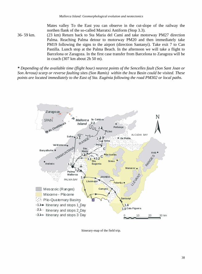
Mallorca Island: Geomorphological evolution and neotectonics
38
Mates valley To the East you can observe in the cut-slope of the railway the northen flank of the so-called Marratxí Antiform (Stop 3.3).
36- 59 km. (23 km) Return back to Sta Maria del Camí and take motorway PM27 direction Palma. Reaching Palma detour to motorway PM20 and then immediately take PM19 following the signs to the airport (direction Santanyí). Take exit 7 to Can Pastilla. Lunch stop at the Palma Beach. In the afternoon we will take a flight to Barcelona or Zaragoza. In the first case transfer from Barcelona to Zaragoza will be in coach (307 km about 2h 50 m).
* Depending of the available time (flight hour) nearest points of the Sencelles fault (Son Sant Joan or Son Arrosa) scarp or reverse faulting sites (Son Ramis) within the Inca Basin could be visited. These points are located immediately to the East of Sta. Eugènia following the road PM302 or local paths.
SollerSa Pobla
Pollença
IncaSelva
Val ldemo sa
Manacor
F elan tix
Banyalbufar
And rat x
PALMA BAY
ALCUDIA BAY
PalmaMallorca
A rtá
0 10 20 30 km
Mesozoic (Ranges)Miocene - Pliocene Pl io-Quaternary Basins
Campos
SPAIN
Be tic Cordilleras
Mallorca Island
ZaragozaZaragoza
Sta.Maria
Sta.Eugenia
Lluc
TRAMUNTANA R
ANGE
Sa Calob ra
Se ncelles
Santanyí
LLEVA
NT
R
ANGES
RANDA
Llucmajor
1.31.2
1.51.6
1.1
2.1
2.22.3
2.5
3.1 3.23.3
Sineu
2.4
1.4
Itinerary and stops 1 Dayst
1.1
Itinerary and stops 2 Daynd
2.1
Itinerary and stops 3 Dayrd
3.1
C
C
Cala Figuera
Itinerary-map of the field trip.