Sites & Policies Draft Sites and Policies 2013 Site ... · RB2011/1244 - erection of 369...
20
Sites & Policies Draft Sites and Policies 2013 Site Summary Sheets Thurcroft www.rotherham.gov.uk
Transcript of Sites & Policies Draft Sites and Policies 2013 Site ... · RB2011/1244 - erection of 369...

Sites & Policies
Draft Sites and Policies 2013
Site Summary SheetsThurcroft
www.rotherham.gov.uk

Rotherham Local Plan : Site Plan
© Crown copyright. Rotherham MBC Licence No. 100019587 NOT TO SCALE
Ref: LDF0432
Name: NORTH OF THURCROFT INDUSTRIAL ESTATE
Address: KINGSFORTH LANE
Hectares: 6.17
This site is allocated as Green Belt. It has been suggested for re-allocation to employment uses as an extension to Thurcroft Industrial Estate. In the 2010 Employment Land Review the site (ELR86) scored moderately (2) with a recommendation that it be allocated as an employment development site.The site is within the Green Belt and therefore re-allocation would impact on the character and openness of the Green Belt. However the existing industrial estate is fully developed and there would appear to be demand for some additional land for economic development purposes given the site allocation suggestion. There are no major constraints to development, although some overhead power lines cross the site, and if a new junction with Kingsforth Lane is required this would require a reduction of the speed limit. The impact on J1, M18 will also need to be considered. The expansion of the industrial estate into the Green Belt would increase the level of employment land in Thurcroft, however the further expansion beyond the suggested allocation would not be desirable.
Having regard to the above it is proposed that the site is allocated for industry and business and is also identified as a development site.
Site Allocation: Employment Development Site
Stage 1 Exclusion or taken to Sustainability Appraisal stage?
Taken to next stage
Town: THURCROFT
Sustainability Appraisal Socio-Economic Score
green
Dwellings: 0 Employment Land: 6.17
Net Hectares: 0.00
Sustainability Appraisal Environment Score
red
Development Site?

Rotherham Local Plan : Site Plan
© Crown copyright. Rotherham MBC Licence No. 100019587 NOT TO SCALE
Ref: LDF0433
Name: SOUTH OF BRAMPTON MEADOWS,, WEST OF ST WITHOLD AVENUE
Address: BRAMPTON MEADOWS
Hectares: 2.46
This site is currently allocated as urban greenspace. During its appraisal, a number of sustainability factors and constraints have been evaluated to establish its potential to accommodate future development. Specifically, the application of the site selection methodology at stage 2 (the Sustainability Appraisal of individual sites) and stage 3 (the prioritisation of sites) summarises the site selection process, the results of which are included within the Integrated Impact Assessment. The best performing sites when assessed against these criteria and based on current knowledge of constraints have been recommended for allocation for future development, subject to reaching the targets set out for each settlement grouping within the Core Strategy. As part of this process, consideration has also been given to designating Safeguarded Land.
In accordance with Central Government advice and policy CS5 of the Core Strategy, Safeguarded Land is removed from the Green Belt and set aside to be considered for the next Local Plan. The purpose of Safeguarded Land is to ensure that having reviewed the Green Belt boundary as part of this Local Plan we do not have to do so again before the end of the Plan period or immediately after. During this plan period (2013-2028) the land set aside as Safeguarded Land is not allocated for development nor will it be released.
Site Allocation: Safeguarded land for residential
Stage 1 Exclusion or taken to Sustainability Appraisal stage?
Taken to next stage
Town: THURCROFT
Sustainability Appraisal Socio-Economic Score
amber
Dwellings: 79 Employment Land: 0.00
Net Hectares: 1.97
Sustainability Appraisal Environment Score
amber
Development Site?

Rotherham Local Plan : Site Plan
© Crown copyright. Rotherham MBC Licence No. 100019587 NOT TO SCALE
Ref: LDF0434
Name: GREEN ARBOUR SCHOOL PLAYING FIELD (SOUTH)
Address: GREEN ARBOUR ROAD
Hectares: 0.78
This site is currently allocated as a residential development site. During its appraisal, a number of sustainability factors and constraints have been evaluated to establish this site’s potential to accommodate future development. Specifically, the application of the site selection methodology at stage 2 (the Sustainability Appraisal of individual sites) and stage 3 (the prioritisation of sites) summarises the site selection process, the results of which are included within the Integrated Impact Assessment.
It is proposed that this site be retained as a residential development site in recognition of its positive attributes, such as its relationship to the existing built settlement, its highway & public transport accessibility and it meeting the settlements role established in the Spatial Strategy (detailed in policy CS1 of the Core Strategy). No significant constraints to development have been identified.
The site is designated as a residential development site (DVU0068) in the current UDP. There are no significant constraints to development and therefore it is proposed that the site remains allocated for residential use.
Site Allocation: Residential Development Site
Stage 1 Exclusion or taken to Sustainability Appraisal stage?
Taken to next stage
Town: THURCROFT
Sustainability Appraisal Socio-Economic Score
green
Dwellings: 20 Employment Land: 0.00
Net Hectares: 0.66
Sustainability Appraisal Environment Score
amber
Development Site?

Rotherham Local Plan : Site Plan
© Crown copyright. Rotherham MBC Licence No. 100019587 NOT TO SCALE
Ref: LDF0435
Name: GREEN ARBOUR SCHOOL PLAYING FIELD (NORTH)
Address: GREEN ARBOUR ROAD
Hectares: 0.82
This site is currently allocated as Community Facilities and is the site of former playing fields once belonging to a now replaced school. The new school to the north of the site has established its own recreation areas and has no requirements for the use of the site. During its appraisal, a number of sustainability factors and constraints have been evaluated to establish this site’s potential to accommodate future development. Specifically, the application of the site selection methodology at stage 2 (the Sustainability Appraisal of individual sites) and stage 3 (the prioritisation of sites) summarises the site selection process, the results of which are included within the Integrated Impact Assessment.
It is proposed that this site be allocated as a residential development site in recognition of its positive attributes, such as its relationship to the existing built settlement, its highway & public transport accessibility (mitigated by the relationship to LDF434) and it meeting the settlements role established in the Spatial Strategy (detailed in policy CS1 of the Core Strategy). Whilst it is acknowledged that there are identified constraints including access it is anticipated that these will be suitably mitigated within any future resolutions to grant planning permission.
Site Allocation: Residential Development Site
Stage 1 Exclusion or taken to Sustainability Appraisal stage?
Taken to next stage
Town: THURCROFT
Sustainability Appraisal Socio-Economic Score
amber
Dwellings: 20 Employment Land: 0.00
Net Hectares: 0.67
Sustainability Appraisal Environment Score
amber
Development Site?

Rotherham Local Plan : Site Plan
© Crown copyright. Rotherham MBC Licence No. 100019587 NOT TO SCALE
Ref: LDF0436
Name: SOUTH OF IVANHOE ROAD
Address: IVAHOE ROAD
Hectares: 1.21
This site is currently allocated as a combination of residential and urban greenspace . During its appraisal, a number of sustainability factors and constraints have been evaluated to establish this site’s potential to accommodate future development. Specifically, the application of the site selection methodology at stage 2 (the Sustainability Appraisal of individual sites) and stage 3 (the prioritisation of sites) summarises the site selection process, the results of which are included within the Integrated Impact Assessment.
It is proposed that this site be allocated as a residential development site in recognition of its positive attributes, such as its relationship to the existing built settlement, its highway & public transport accessibility and it meeting the settlements role established in the Spatial Strategy (detailed in policy CS1 of the Core Strategy). Whilst it is acknowledged that there are identified constraints including the proximity to LWS27 (Brampton Common), it is anticipated that these will be suitably mitigated within any future resolutions to grant planning permission.
Site Allocation: Residential Development Site
Stage 1 Exclusion or taken to Sustainability Appraisal stage?
Taken to next stage
Town: THURCROFT
Sustainability Appraisal Socio-Economic Score
green
Dwellings: 39 Employment Land: 0.00
Net Hectares: 0.97
Sustainability Appraisal Environment Score
amber
Development Site?
Rotherham Local Plan : Site Plan
© Crown copyright. Rotherham MBC Licence No. 100019587 NOT TO SCALE
Ref: LDF0437
Name: OFF SAWN MOOR ROAD
Address: SAWN MOOR ROAD
Hectares: 12.94
This site is currently allocated as a residential development site. During its appraisal, a number of sustainability factors and constraints have been evaluated to establish this site’s potential to accommodate future development. Specifically, the application of the site selection methodology at stage 2 (the Sustainability Appraisal of individual sites) and stage 3 (the prioritisation of sites) summarises the site selection process, the results of which are included within the Integrated Impact Assessment.
It is proposed that this site be retained as a residential development site in recognition of development commencing to implement application RB2011/1244 - erection of 369 dwellinghouses.
Site Allocation: Residential Development Site
Stage 1 Exclusion or taken to Sustainability Appraisal stage?
Taken to next stage
Town: THURCROFT
Sustainability Appraisal Socio-Economic Score
green
Dwellings: 369 Employment Land: 0.00
Net Hectares: 9.06
Sustainability Appraisal Environment Score
amber
Development Site?

Rotherham Local Plan : Site Plan
© Crown copyright. Rotherham MBC Licence No. 100019587 NOT TO SCALE
Ref: LDF0438
Name: NORTH OF RECREATION AVENUE
Address: RECREATION AVENUE
Hectares: 0.84
The site is allocated as urban greenspace and has been given a value of high quality and high value by the greenspace audit. The site forms part of a larger recreation ground within the centre of Thurcroft.
Site Allocation: No
Stage 1 Exclusion or taken to Sustainability Appraisal stage?
Taken to next stage
Town: THURCROFT
Sustainability Appraisal Socio-Economic Score
green
Dwellings: 20 Employment Land: 0.00
Net Hectares: 0.67
Sustainability Appraisal Environment Score
red
Development Site?

Rotherham Local Plan : Site Plan
© Crown copyright. Rotherham MBC Licence No. 100019587 NOT TO SCALE
Ref: LDF0439
Name: NORTH OF STEADFOLDS LANE (WEST)
Address: STEADFOLDS LANE
Hectares: 5.44
The allotments (at the southern end of the site) and sports ground have existing recreational functions. Accessibility issues are significant owing to a limited frontage onto Sandy Lane and New Orchard Lane not being an adopted highway. Accordingly, the Transportation team rate the site red. Trustees do not wish to see the site developed so the site would not be deliverable until well beyond the plan period (current lease runs until 2122).
Site Allocation: No
Stage 1 Exclusion or taken to Sustainability Appraisal stage?
Taken to next stage
Town: THURCROFT
Sustainability Appraisal Socio-Economic Score
red
Dwellings: 114 Employment Land: 0.00
Net Hectares: 3.81
Sustainability Appraisal Environment Score
red
Development Site?

Rotherham Local Plan : Site Plan
© Crown copyright. Rotherham MBC Licence No. 100019587 NOT TO SCALE
Ref: LDF0440
Name: NORTH OF STEADFOLDS LANE (EAST)
Address: STEAFOLDS LANE
Hectares: 6.77
The allotments are well used and thus performing a recreational function. Trustees do not wish to see the site developed so the site would not be deliverable until well beyond the plan period (current lease runs until 2122).
Site Allocation: No
Stage 1 Exclusion or taken to Sustainability Appraisal stage?
Taken to next stage
Town: THURCROFT
Sustainability Appraisal Socio-Economic Score
green
Dwellings: 142 Employment Land: 0.00
Net Hectares: 4.74
Sustainability Appraisal Environment Score
red
Development Site?
Rotherham Local Plan : Site Plan
© Crown copyright. Rotherham MBC Licence No. 100019587 NOT TO SCALE
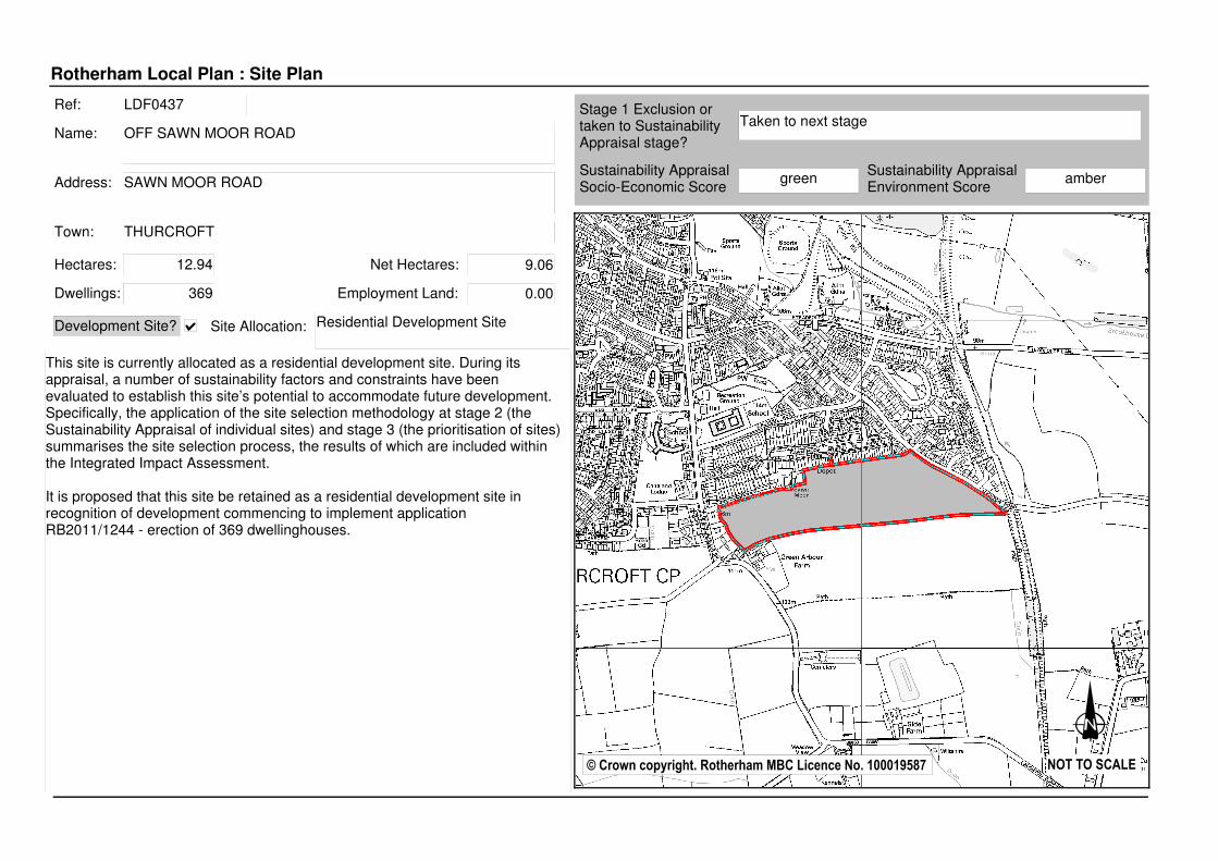
Ref: LDF0441
Name: OFF NEW ORCHARD LANE
Address: NEW ORCHARD LANE
Hectares: 1.07
Protected species (Great Crested Newts) are found on the site which would prejudice against development. Transportation rate the site red due to New Orchard Lane not being adopted. Furthermore, the site is not in a highly accessible location as defined by the South Yorkshire Passenger Transport Executive.
Site Allocation: No
Stage 1 Exclusion or taken to Sustainability Appraisal stage?
Taken to next stage
Town: THURCROFT
Sustainability Appraisal Socio-Economic Score
red
Dwellings: 26 Employment Land: 0.00
Net Hectares: 0.85
Sustainability Appraisal Environment Score
red
Development Site?

Rotherham Local Plan : Site Plan
© Crown copyright. Rotherham MBC Licence No. 100019587 NOT TO SCALE
Ref: LDF0442
Name: NORTH OF SANDY LANE
Address: SANDY LANE
Hectares: 1.17
The site forms part of a wider recreation ground which has been designated as high quality and high value by the greenspace audit. Trustees do not wish to see the site developed so the site would not be deliverable until well beyond the plan period (current lease runs until 2122).
Site Allocation: No
Stage 1 Exclusion or taken to Sustainability Appraisal stage?
Taken to next stage
Town: THURCROFT
Sustainability Appraisal Socio-Economic Score
green
Dwellings: 28 Employment Land: 0.00
Net Hectares: 0.93
Sustainability Appraisal Environment Score
green
Development Site?
Rotherham Local Plan : Site Plan
© Crown copyright. Rotherham MBC Licence No. 100019587 NOT TO SCALE
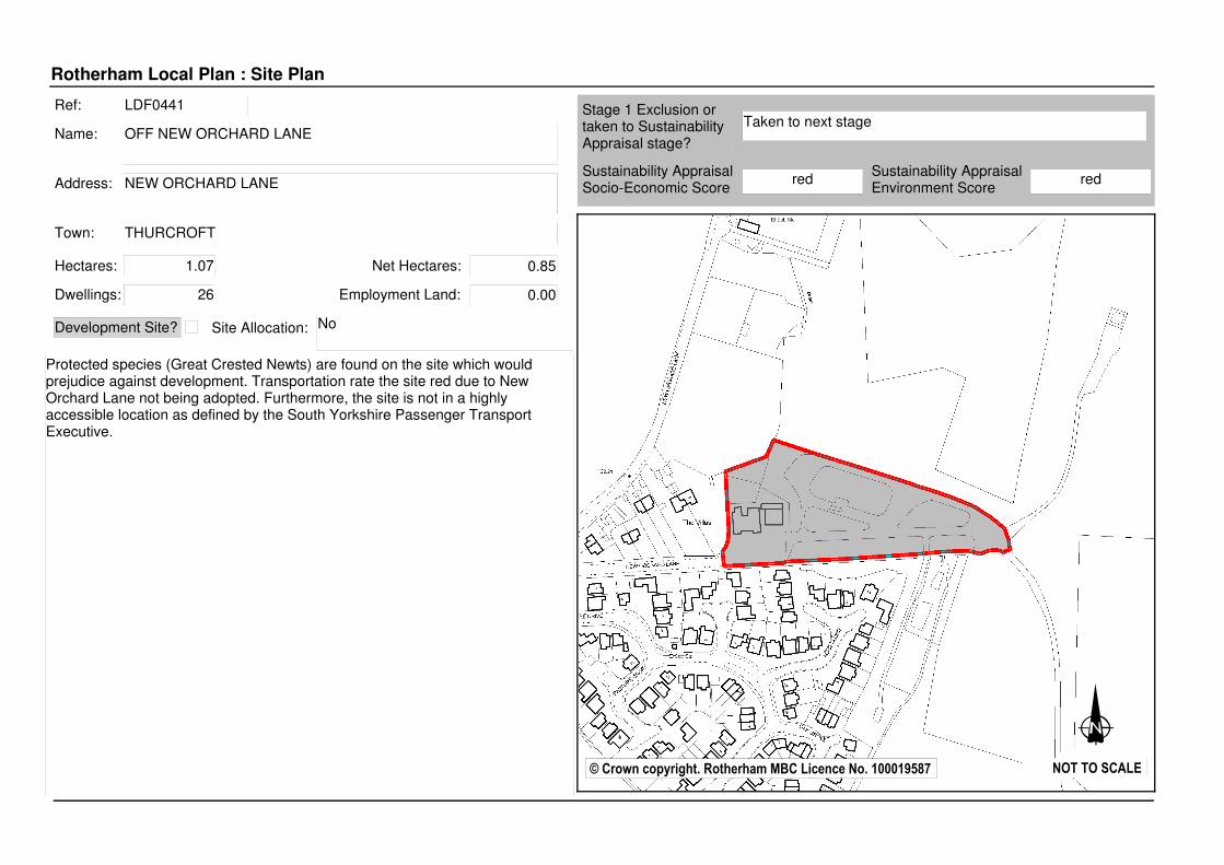
Ref: LDF0443
Name: THURCROFT ENGINEERED LANDFILL
Address: NEW ORCHARD LANE
Hectares: 40.91
Site Allocation: n/a
Stage 1 Exclusion or taken to Sustainability Appraisal stage?
Thurcroft Landfill Site - retain as existing
Town: THURCROFT
Sustainability Appraisal Socio-Economic Score
Dwellings: 0 Employment Land: 0.00
Net Hectares: 0.00
Sustainability Appraisal Environment Score
Development Site?
Rotherham Local Plan : Site Plan
© Crown copyright. Rotherham MBC Licence No. 100019587 NOT TO SCALE
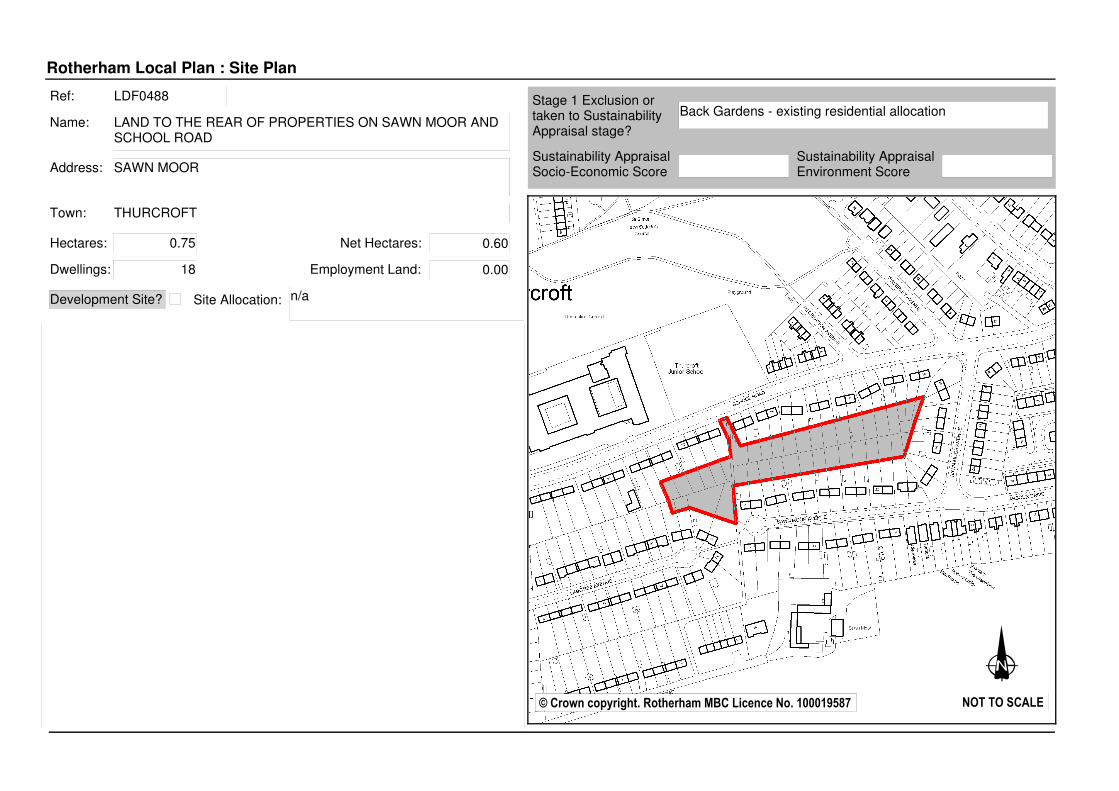
Ref: LDF0488
Name: LAND TO THE REAR OF PROPERTIES ON SAWN MOOR AND SCHOOL ROAD
Address: SAWN MOOR
Hectares: 0.75
Site Allocation: n/a
Stage 1 Exclusion or taken to Sustainability Appraisal stage?
Back Gardens - existing residential allocation
Town: THURCROFT
Sustainability Appraisal Socio-Economic Score
Dwellings: 18 Employment Land: 0.00
Net Hectares: 0.60
Sustainability Appraisal Environment Score
Development Site?
Rotherham Local Plan : Site Plan
© Crown copyright. Rotherham MBC Licence No. 100019587 NOT TO SCALE
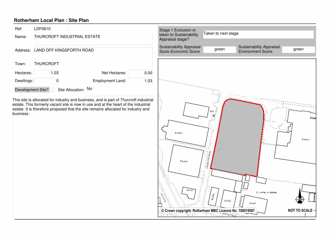
Ref: LDF0610
Name: THURCROFT INDUSTRIAL ESTATE
Address: LAND OFF KINGSFORTH ROAD
Hectares: 1.03
This site is allocated for industry and business, and is part of Thurcroft industrial estate. This formerly vacant site is now in use and at the heart of the industrial estate. It is therefore proposed that the site remains allocated for industry and business.
Site Allocation: No
Stage 1 Exclusion or taken to Sustainability Appraisal stage?
Taken to next stage
Town: THURCROFT
Sustainability Appraisal Socio-Economic Score
green
Dwellings: 0 Employment Land: 1.03
Net Hectares: 0.00
Sustainability Appraisal Environment Score
green
Development Site?

Rotherham Local Plan : Site Plan
© Crown copyright. Rotherham MBC Licence No. 100019587 NOT TO SCALE
Ref: LDF0724
Name: LAND OFF STEADFOLDS LANE
Address: THURCROFT
Hectares: 10.32
The Transportation team rate the site red owing to the site being remote from facilities and good public transport links. The now disused railway line which forms the western boundary of the site, acts as a strong defenceable border between the existing built form in the settlement of Thurcroft and the wider countryside. Removal of this site from the Green Belt would encourage the creation of an incongruous tongue of development that would not appropriately integrate with the adjacent land-uses. This allied to the difficult topography and the presence of a significant number of mature trees and bushes, further justifies this stance.
Site Allocation: No
Stage 1 Exclusion or taken to Sustainability Appraisal stage?
Taken to next stage
Town: ROTHERHAM
Sustainability Appraisal Socio-Economic Score
red
Dwellings: 0 Employment Land: 0.00
Net Hectares: 0.00
Sustainability Appraisal Environment Score
red
Development Site?

Rotherham Local Plan : Site Plan
© Crown copyright. Rotherham MBC Licence No. 100019587 NOT TO SCALE
Ref: LDF0725
Name: LAND OFF LAUGHTON ROAD
Address: THURCROFT
Hectares: 4.78
The Transportation team rate the site red owing to the site being remote from facilities and good public transport links. The now disused railway line which forms the western boundary of the site, acts as a strong defenceable border between the existing built form in the settlement of Thurcroft and the wider countryside. Removal of this site from the Green Belt would encourage the creation of an incongruous tongue of development that would not appropriately integrate with the adjacent land-uses. This allied to the potential for it to negatively impact upon the setting of the designated conservation area village of Laughton-en-le-Morthen, adds weight to the conclusion and recommendation drawn to retain this site in the Green Belt.
Site Allocation: No
Stage 1 Exclusion or taken to Sustainability Appraisal stage?
Taken to next stage
Town: ROTHERHAM
Sustainability Appraisal Socio-Economic Score
red
Dwellings: 0 Employment Land: 0.00
Net Hectares: 0.00
Sustainability Appraisal Environment Score
amber
Development Site?

Rotherham Local Plan : Site Plan
© Crown copyright. Rotherham MBC Licence No. 100019587 NOT TO SCALE
Ref: LDF0726
Name: LAND OFF GREEN ARBOUR ROAD (1)
Address: THURCROFT
Hectares: 16.28
The topography is such that the impact of development upon the openness of the Green Belt would be significant in this specific locality, with its location on the crest of a hill compounding the potential for invasiveness into the countryside. Concerns also exist regarding possible access arrangements. The site is remote from facilities and good public transport links and the configuration of the site appears to preclude the possibility of creating two points of vehicular access. Accordingly, the Transportation Team rate the site red.
Site Allocation: No
Stage 1 Exclusion or taken to Sustainability Appraisal stage?
Taken to next stage
Town: ROTHERHAM
Sustainability Appraisal Socio-Economic Score
red
Dwellings: 0 Employment Land: 0.00
Net Hectares: 0.00
Sustainability Appraisal Environment Score
amber
Development Site?

Rotherham Local Plan : Site Plan
© Crown copyright. Rotherham MBC Licence No. 100019587 NOT TO SCALE
Ref: LDF0727
Name: LAND OFF GREEN ARBOUR ROAD (2)
Address: THURCROFT
Hectares: 0.69
This site forms part of the curtilage of the adjacent Green Arbour Farm, with it operating as grazing land for livestock. Development for alternative uses would not be desirable as it would form an incongruous tongue of development, that would fail to integrate with the existing built environment and create a form of ribbon development along Green Arbour Road. Furthermore, advocating alternative uses would not serve to enhance the approach into Thurcroft from Dinnington, with the site occupying a prominent point within the access route. The Transportation team rate the site red owing to the site being remote from facilities and good public transport links.
Site Allocation: No
Stage 1 Exclusion or taken to Sustainability Appraisal stage?
Taken to next stage
Town: ROTHERHAM
Sustainability Appraisal Socio-Economic Score
red
Dwellings: 0 Employment Land: 0.00
Net Hectares: 0.00
Sustainability Appraisal Environment Score
amber
Development Site?

Rotherham Local Plan : Site Plan
© Crown copyright. Rotherham MBC Licence No. 100019587 NOT TO SCALE
Ref: LDF0773
Name: EAST OF BRAMPTON ROAD
Address: BRAMPTON ROAD
Hectares: 4.37
This site is currently allocated as green belt. During its appraisal, a number of sustainability factors and constraints have been evaluated to establish its potential to accommodate future development. Specifically, the application of the site selection methodology at stage 2 (the Sustainability Appraisal of individual sites) and stage 3 (the prioritisation of sites) summarises the site selection process, the results of which are included within the Integrated Impact Assessment. The best performing sites when assessed against these criteria and based on current knowledge of constraints have been recommended for allocation for future development, subject to reaching the targets set out for each settlement grouping within the Core Strategy. As part of this process, consideration has also been given to designating Safeguarded Land.
In accordance with Central Government advice and policy CS5 of the Core Strategy, Safeguarded Land is removed from the Green Belt and set aside to be considered for the next Local Plan. The purpose of Safeguarded Land is to ensure that having reviewed the Green Belt boundary as part of this Local Plan we do not have to do so again before the end of the Plan period or immediately after. During this plan period (2013-2028) the land set aside as Safeguarded Land is not allocated for development nor will it be released.
Site Allocation: Safeguarded land for residential
Stage 1 Exclusion or taken to Sustainability Appraisal stage?
Taken to next stage
Town: THURCROFT
Sustainability Appraisal Socio-Economic Score
green
Dwellings: 140 Employment Land: 0.00
Net Hectares: 3.50
Sustainability Appraisal Environment Score
green
Development Site?