Site Profile of the Guana Tolomato Matanzas National ... · Guana Tolomato Matanzas National...
163
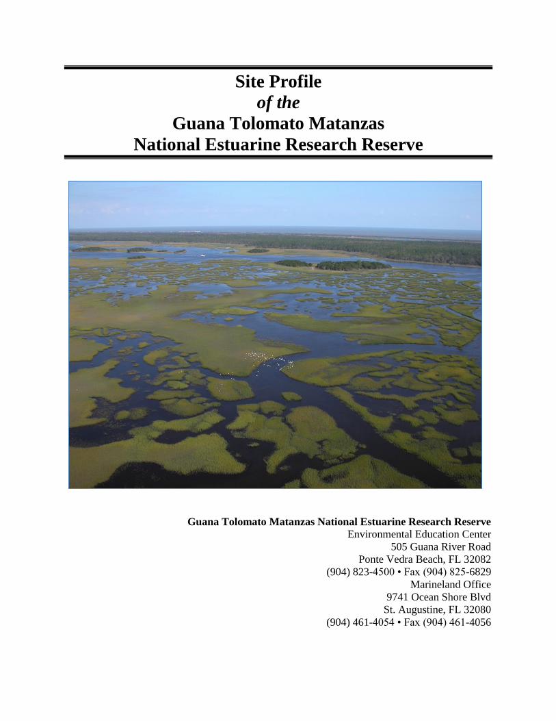
Site Profile of the Guana Tolomato Matanzas National Estuarine Research Reserve Guana Tolomato Matanzas National Estuarine Research Reserve Environmental Education Center 505 Guana River Road Ponte Vedra Beach, FL 32082 (904) 823-4500 • Fax (904) 825-6829 Marineland Office 9741 Ocean Shore Blvd St. Augustine, FL 32080 (904) 461-4054 • Fax (904) 461-4056
Transcript of Site Profile of the Guana Tolomato Matanzas National ... · Guana Tolomato Matanzas National...
Site Profile
of the
Guana Tolomato Matanzas
National Estuarine Research Reserve
Guana Tolomato Matanzas National Estuarine Research Reserve
Environmental Education Center
505 Guana River Road
Ponte Vedra Beach, FL 32082
(904) 823-4500 • Fax (904) 825-6829
Marineland Office
9741 Ocean Shore Blvd
St. Augustine, FL 32080
(904) 461-4054 • Fax (904) 461-4056
Site Profile
of the
Guana Tolomato Matanzas
National Estuarine Research Reserve
Prepared for: The Guana Tolomato Matanzas National Estuarine Research Reserve
Prepared by: Denis W. Frazel, Ph.D.
Frazel, Inc.
233 Estrada Avenue
St. Augustine, FL 32084
For more information about this report or to obtain additional copies, contact: Guana Tolomato Matanzas National Estuarine Research Reserve
Environmental Education Center
505 Guana River Road
Ponte Vedra Beach, FL 32082
(904) 823-4500 • Fax (904) 825-6829
Marineland Office
9741 Ocean Shore Blvd
St. Augustine, FL 32080
(904) 461-4054 • Fax (904) 461-4056
Internet: http://www.gtmnerr.org Citation: D. Frazel. 2009. Site Profile of the Guana Tolomato Matanzas National Estuarine
Research Reserve. Ponte Vedra, FL. 151pp.
August 2009
i
Guana Tolomato Matanzas National Estuarine Research Reserve
(GTMNERR) is a partnership between the US Department of
Commerce, National Oceanic and Atmospheric Administration,
and the State of Florida, Department of Environmental Protection.
This site profile has been developed in accordance with National
Oceanic and Atmospheric Administration regulations. It is
consistent with the congressional intent of Section 315 of the
Coastal Zone Management Act of 1972, as amended, and the
provisions of the Florida Coastal Management Program. August,
2009
The views, statements, findings, conclusions, and
recommendations expressed herein are those of the author and do
not necessarily reflect the views of the State of Florida, National
Oceanic and Atmospheric Administration, or any of its sub-
agencies. August, 2009.
August 2009
Guana Tolomato Matanzas National Estuarine Research Reserve 505 Guana River Road, Ponte Vedra Beach, FL 32082
ii
Preface
The Guana Tolomato Matanzas National Estuarine Research Reserve (GTMNERR),
designated in 1999, is one of 27 estuarine reserves included within the National Oceanic and
Atmospheric Administration‟s National Estuarine Research Reserve System (NERRS). As
part of the NERRS program, each reserve is required to develop a site profile, which
describes the estuarine and terrestrial ecosystems represented within the site; outlines
ongoing research and monitoring; and identifies site-specific research needs and priorities.
This site profile includes an introduction to the Reserve; an environmental overview of the
GTMNERR estuaries; a description of biotic habitats; an overview of the Reserve‟s programs
and partnerships; a summary of research conducted within the Reserve; and suggestions for
future research and monitoring.
This document is intended to provide guidance for the future direction of the GTMNERR‟s
research and monitoring programs and will be made available to all potential users, including
scientists, environmental managers, local planners, elected officials, and environmental
educators.
The GTMNERR site profile was prepared by Frazel, Inc., under Contract #949045 from the
Florida Department of Environmental Protection. Links to Web sites were accurate at the
time of publication.
iii
ACKNOWLEDGEMENTS
The GTMNERR site profile project was edited by Rick Gleeson, Ph.D., GTMNERR Research
Coordinator and reviewed by Mike Shirley, Ph.D., GTMNERR Director. Denis W. Frazel, Ph.D.
(Frazel, Inc.) prepared the site profile through the collaborative efforts of the following
GTMNERR and St. Johns River Water Management District (SJRWMD) staff members.
GTMNERR Staff
Rachel Endicott, Biologist
Matt Love, Biological Scientist
SJRWMD Staff
Paul Haydt, SJRWMD NCB Interagency Program Manager
Ron Brockmeyer, Ph.D., Environmental Scientist IV
Marvin Williams, GIS Analyst III
Jan Miller, Environmental Scientists III
Lori Morris, Ph.D., Environmental Scientist III
Special thanks are due to the following individuals for their individual and collective efforts:
Edward Phlips, Ph.D., Professor, Department of Fisheries and Aquatic Sciences,
University of Florida
Nikki Dix, Doctoral Candidate, Research Associate, Department of Fisheries and
Aquatic Sciences, University of Florida
Peter Sheng, Ph.D., Professor, Coastal and Oceanographic Engineering, University of
Florida
Clay Montague, Ph.D., Associate Professor, Environmental Engineering Sciences,
University of Florida

iv
LIST OF ACRONYMS
ATV All Terrain Vehicle
BMP Best Management Practices
BMAP Basin Management Action Plan
CAMA Coastal and Aquatic Managed Areas
CDMO Centralized Data Management Office
CFR Code of Federal Regulations
CICEET Cooperative Institute for Coastal and Estuarine Environmental Technology
CRCP Coral Reef Conservation Program
CZM Coastal Zone Management
CZMA Coastal Zone Management Act
DHR Division of Historical Resources
DNR Department of Natural Resources (now FDEP)
EEC Environmental Education Center
ERD Estuarine Reserves Division
F Fahrenheit
F.A.C. Florida Administrative Code
F.A.W. Florida Administrative Weekly
FCMP Florida Coastal Management Program
FDACS Florida Department of Agricultural and Consumer Services
FDEP Florida Department of Environmental Protection
FDOF Florida Department of Agricultural and Consumer Services, Division of
Forestry
FIU Florida Institute of Technology
FLUCCS Florida Land Use Cover and Forms Classification System
FNAI Florida Natural Area Inventory
F.S. Florida Statutes
FWC Florida Fish and Wildlife Conservation Commission
FWRI Fish and Wildlife Research Institute
GPS Global Positioning System
GIS Geographic Information System
GRF Graduate Research Fellowship
GRMAP Guana River Marsh Aquatic Preserve
GRWMA Guana River Wildlife Management Area
GTMNERR Guana Tolomato Matanzas National Estuarine Research Reserve
IWRMN Integrated Water Resources Monitoring Network
IWW Intracoastal Waterway
LAMP Lighthouse Archeological Maritime Program
NCB Northern Coastal Basin
NERR National Estuarine Research Reserve
NERRS National Estuarine Research Reserve System
NIH National Institute of Health
NMS National Marine Sanctuary
NOAA National Oceanic and Atmospheric Administration
OFW Outstanding Florida Water
v
PCAP Pellicer Creek Aquatic Preserve
ppt Parts Per Thousand
SCS Soil Conservation Service
SJRWMD St. Johns River Water Management District
SR State Road
STORET Storage and Retrieval Database
SWAMP Surface Water Ambient Monitoring Program
SWIM Surface Water Improvement and Management Plan
SWMP System-wide Monitoring Program
TMDL Total Maximum Daily Load
UCF University of Central Florida
UF University of Florida
UM University of Miami
UNH University of New Hampshire
U.S.C. United States Code
USDA United States Department of Agriculture
USFWS United States Fish and Wildlife Service
USGS United States Geological Survey
WMD Water Management District
vi
TABLE OF CONTENTS
PREFACE ...................................................................................................................................... ii
ACKNOWLEDGEMENTS ........................................................................................................ iii
LIST OF ACRONYMS ............................................................................................................... iv
INTRODUCTION..........................................................................................................................1
Overview ..............................................................................................................................1
Estuarine Habitats at the Reserve ........................................................................................4
Historical and Cultural Resources .......................................................................................6
National Estuarine Research Reserve Program ...................................................................7
Reserve Mission and Site Description ...............................................................................11
Ecological Significance and Designations of the Reserve .................................................12
Major Reserve Management Priorities ..............................................................................12
Reserve Protection Efforts .................................................................................................13
ENVIRONMENTAL SETTING ................................................................................................14
Estuarine Geomorphology .................................................................................................14
Climate and Weather..........................................................................................................16
Hydrology (watershed and tidal conditions) ......................................................................17
Physical Processes .............................................................................................................19
Land Use ............................................................................................................................22
Water Use...........................................................................................................................22
Water Quality .....................................................................................................................23
Pollution Impacts ...............................................................................................................28
BIOLOGICAL SETTING...........................................................................................................35
vii
Introduction ........................................................................................................................35
Biotic Habitats ...................................................................................................................35
Biological Community Profiles .........................................................................................48
Plankton .................................................................................................................48
Vegetation ..............................................................................................................49
Invertebrates ...........................................................................................................53
Fishes .....................................................................................................................57
Reptiles and Amphibians .......................................................................................60
Birds .......................................................................................................................62
Mammals................................................................................................................65
GTMNERR RESEARCH AND MONITORING ACTIVITIES .............................................69
Research Facilities .............................................................................................................69
Ancillary Facilities .............................................................................................................70
Monitoring Activities .........................................................................................................71
Graduate Research Fellowship Program ............................................................................77
CICEET Program ...............................................................................................................82
Other Research Activities ..................................................................................................84
ASSESSMENT OF RESEARCH AND MONITORING NEEDS ...........................................88
Research Facility Needs .................................................................................................................88
Research Gaps ................................................................................................................................88
Monitoring Priorities and Needs ....................................................................................................89
Research Priorities and Needs .......................................................................................................90
REFERENCES .............................................................................................................................92
viii
LIST OF TABLES
Table 1. Total fresh groundwater use, and change in water use by County for 2000 and 2006 in
million gallons per day (mgd) ........................................................................................................23
Table 2. Municipalities adjacent to the GTMNERR with MS4 NPDES permits .........................29
Table 3. 303(d) Waterbodies Status for the Northern Coastal Basin extracted from the FDEP
Revised Draft Verified Lists of Impaired Waters for the Group 5 Basins .....................................31
ix
LIST OF FIGURES
Figure 1. Map of the Guana Tolomato Matanzas National Estuarine
Research Reserve-northern component ...............................................................................2
Figure 2. Map of the Guana Tolomato Matanzas National Estuarine
Research Reserve-southern component ...............................................................................3
Figure 3. Estuarine geomorphology of the GTMNERR ...............................................................14
Figure 4. Hydrologic features of the GTMNERR.........................................................................18
Figure 5. Times series for wind speed/direction and rainfall for the Pellicer Creek weather
station together with water depth and salinity time series for Fort Matanzas, Pellicer Creek, Pine
Island and San Sebastian water quality stations during Tropical Storm Frances in 2004 .............25
Figure 6. Trends comparison of the Matanzas River Site (Selection A) vs. All Sites in Florida
(Selection B) for Lead (PB) concentration (µg/dry g) in oyster tissue ..........................................33
Figure 7. Trends comparison of the Matanzas River Site (Selection A) vs. All Sites in Florida
(Selection B) for Copper (Cu) concentration (µg/dry g) in oyster tissue ......................................34
x
APPENDICES
Appendix A. GTMNERR Species List .......................................................................................105
Appendix B. List of Water Quality Sampling Stations ...............................................................140
Appendix C. Biological and Water Quality Data for the GTMNERR, collected by the University
of Florida ......................................................................................................................................148
Appendix D. Scientific Studies and References Relevant to the GTMNERR ............................151
1
INTRODUCTION
Overview
Florida conjures up romantic visions of warm breezes, sandy beaches and sunny skies. With
more than 1,100 miles of shoreline, and 2,500 miles of navigable waters, including lakes, bays,
and estuaries, it is easy to see why Florida is considered one the Nation‟s premier destinations
for those interested in natural outdoor activities. The Guana Tolomato Matanzas National
Estuarine Research Reserve (GTMNERR or Reserve) in northeast Florida contains those features
that attract tourists to Florida. Most important though, are the many species of subtropical and
temperate plants and animals that co-inhabit the Reserve, making it a key location to study
climate change and other global ecological processes. The Reserve‟s relatively pristine condition
and unique climate and biodiversity are ideal for scientific research and study.
The Reserve serves as an important habitat for migrating species including calving North
Atlantic right whales and serves as a critical feeding and resting location for migrating shorebirds
along the North American Atlantic flyway. Manatees, wood storks, roseate spoonbills, bald
eagles and peregrine falcons find refuge in the GTMNERR.
In addition, the Reserve is located in a region with the oldest record of European occupation and
has a rich assortment of cultural resources dating to the pre-Columbian era, thereby providing a
valuable resource for archeological research and interpretation.
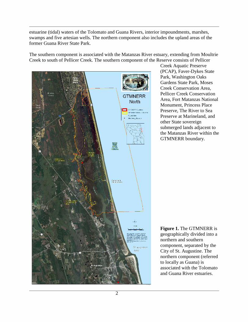
The GTMNERR is located south of the City of Jacksonville, in St. Johns and Flagler Counties,
on the northeast coast of Florida.The GTMNERR is geographically divided into a northern
(Figure 1) and southern component (Figure 2), separated by the City of St. Augustine. The
Reserve is connected to the Atlantic Ocean via the St. Augustine Inlet and the Matanzas Inlet.
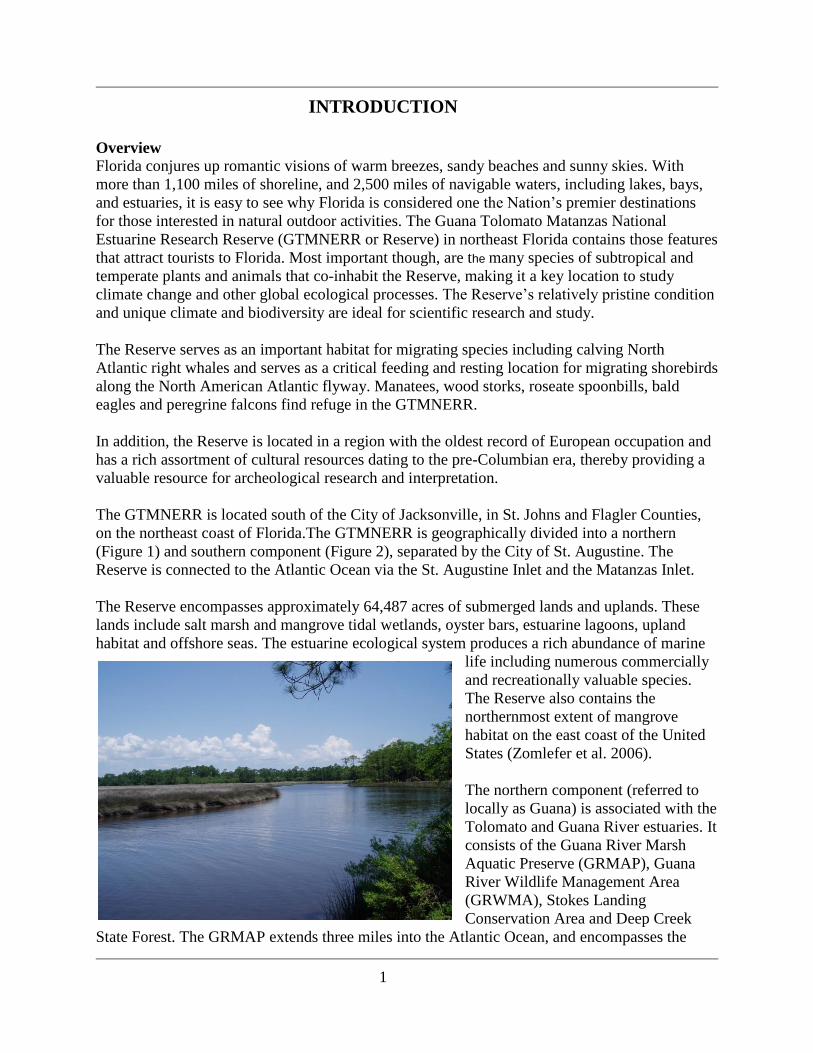
The Reserve encompasses approximately 64,487 acres of submerged lands and uplands. These
lands include salt marsh and mangrove tidal wetlands, oyster bars, estuarine lagoons, upland
habitat and offshore seas. The estuarine ecological system produces a rich abundance of marine
life including numerous commercially
and recreationally valuable species.
The Reserve also contains the
northernmost extent of mangrove
habitat on the east coast of the United
States (Zomlefer et al. 2006).
The northern component (referred to
locally as Guana) is associated with the
Tolomato and Guana River estuaries. It
consists of the Guana River Marsh
Aquatic Preserve (GRMAP), Guana
River Wildlife Management Area
(GRWMA), Stokes Landing
Conservation Area and Deep Creek
State Forest. The GRMAP extends three miles into the Atlantic Ocean, and encompasses the
2
estuarine (tidal) waters of the Tolomato and Guana Rivers, interior impoundments, marshes,
swamps and five artesian wells. The northern component also includes the upland areas of the
former Guana River State Park.
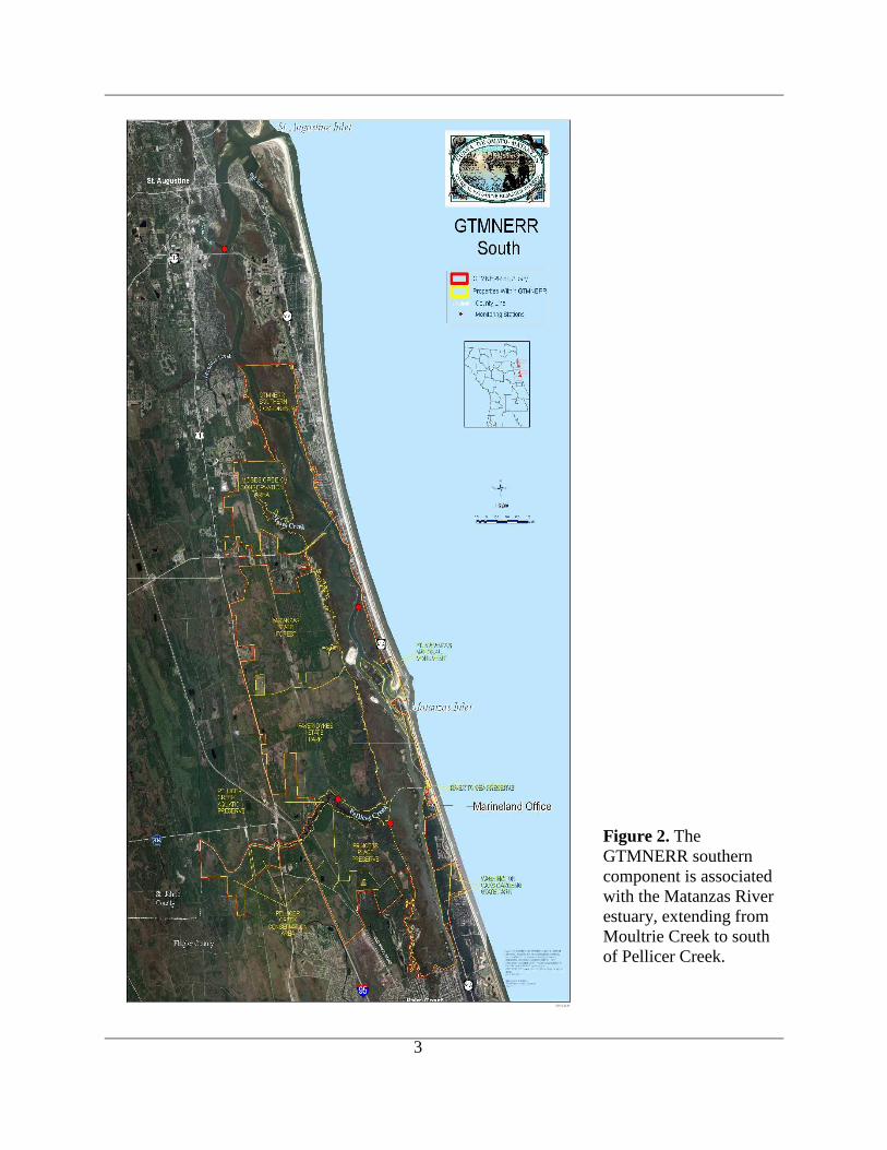
The southern component is associated with the Matanzas River estuary, extending from Moultrie
Creek to south of Pellicer Creek. The southern component of the Reserve consists of Pellicer
Creek Aquatic Preserve
(PCAP), Faver-Dykes State
Park, Washington Oaks
Gardens State Park, Moses
Creek Conservation Area,
Pellicer Creek Conservation
Area, Fort Matanzas National
Monument, Princess Place
Preserve, The River to Sea
Preserve at Marineland, and
other State sovereign
submerged lands adjacent to
the Matanzas River within the
GTMNERR boundary.
Figure 1. The GTMNERR is
geographically divided into a
northern and southern
component, separated by the
City of St. Augustine. The
northern component (referred
to locally as Guana) is
associated with the Tolomato
and Guana River estuaries.
3
Figure 2. The
GTMNERR southern
component is associated
with the Matanzas River
estuary, extending from
Moultrie Creek to south
of Pellicer Creek.
4
Estuarine Habitats at the Reserve
The Guana Tolomato Matanzas (GTM) River estuarine ecosystem exhibits a wide variety of
habitat types. Pinelands (30%) are the predominant upland habitat type within the drainage basin,
followed by shrub and brushlands (14%), and hardwood hammocks (10%). Barren (mostly
disturbed) lands make up only 10% of the watershed. Coastal salt marsh and open water habitat
comprise nearly 15% of the watershed.
Salt marsh is the major estuarine habitat in the GTMNERR, and occurs along the boundaries of
the estuaries throughout the Reserve. This habitat type occupies more than 20% of the total land
cover of the Reserve. Dominant plants include Glasswort (Salicornia spp.), saltwort (Batis
maritima), saltmarsh cordgrass (Spartina alterniflora), and black needlerush (Juncus
roemerianus).
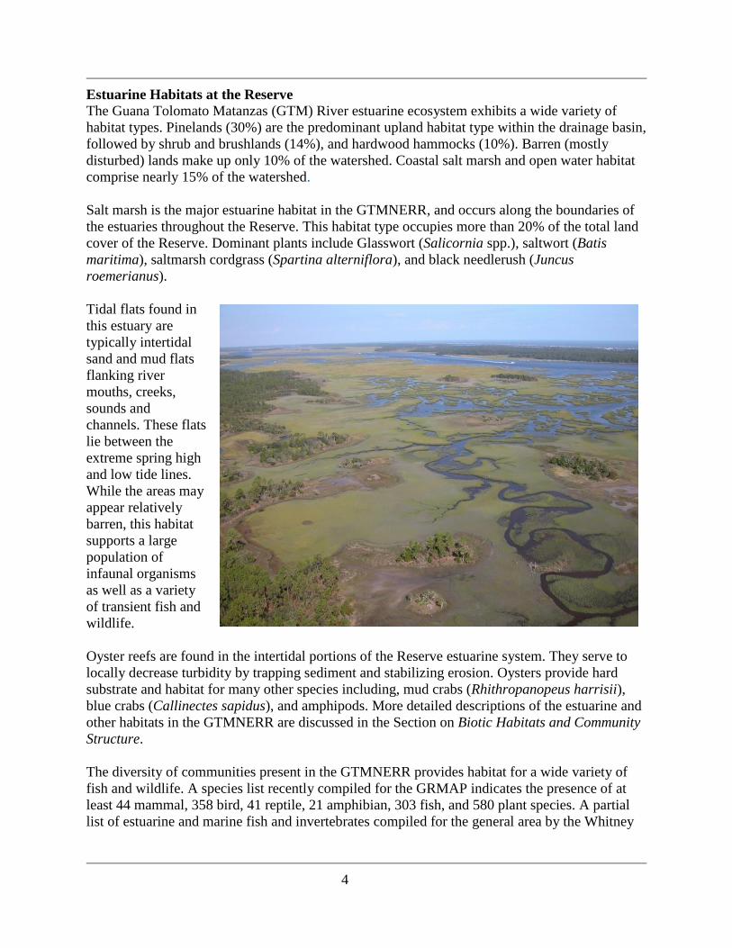
Tidal flats found in
this estuary are
typically intertidal
sand and mud flats
flanking river
mouths, creeks,
sounds and
channels. These flats
lie between the
extreme spring high
and low tide lines.
While the areas may
appear relatively
barren, this habitat
supports a large
population of
infaunal organisms
as well as a variety
of transient fish and
wildlife.
Oyster reefs are found in the intertidal portions of the Reserve estuarine system. They serve to
locally decrease turbidity by trapping sediment and stabilizing erosion. Oysters provide hard
substrate and habitat for many other species including, mud crabs (Rhithropanopeus harrisii),
blue crabs (Callinectes sapidus), and amphipods. More detailed descriptions of the estuarine and
other habitats in the GTMNERR are discussed in the Section on Biotic Habitats and Community
Structure.
The diversity of communities present in the GTMNERR provides habitat for a wide variety of
fish and wildlife. A species list recently compiled for the GRMAP indicates the presence of at
least 44 mammal, 358 bird, 41 reptile, 21 amphibian, 303 fish, and 580 plant species. A partial
list of estuarine and marine fish and invertebrates compiled for the general area by the Whitney

5
Laboratory records 270 species. The most current comprehensive species list for the GTMNERR
is found in Appendix A.
The variety of habitats within the GTMNERR are essential to many protected species (eight
plants and forty-eight animals) including the Anastasia Island beach mouse (Peromyscus
polionotus phasma), gopher tortoise (Gopherus polyphemus), least tern (Sterna antillarum),
marine turtles: loggerhead (Caretta caretta), leatherback (Dermochelys coriaciea) and green
turtle (Chelonia mydas), and North Atlantic right whale (Eubalaena glacialis). In addition, the
striped newt (Notopthalmus perstriatus), one of Florida‟s rarest vertebrate species, occurs within
the GTMNERR. Some of the many rare listed birds of the GTMNERR include: great egret
(Ardea alba), white ibis (Eudocimus albus), black-crowned night heron (Nycticorax nyticorax),
least tern (Sterna antillarum), bald eagle (Haliaeetus leucocephalus), tricolored heron (Egretta
tricolor), wood stork (Mycteria americana) and roseate spoonbill (Ajaia ajaja).
Commercially valuable species of organisms that occur in the GTMNERR for all or part of their
life cycle include oysters (Crassostrea virginica), quahog clams (Mercenaria spp.), blue crabs
(Callinectes sapidus), stone crabs (Menippe mercenaria), white shrimp (Penaeus setiferus),
brown shrimp (Penaeus aztecus), striped and white mullet (Mugil cephalus and M. curema), gag
grouper (Myctoperca microlepis), black seabass (Centropristis striata), gray snapper (Lutjanus
griseus), lane snapper (L. synagris), flounder (Paralichthys lethostigma and P. dentatus),
bluefish (Pomatomus saltatrix), menhaden (Brevoortia tyrannus) and thread herring
(Opisthonema oglinum).
6
Recreationally valuable sport fishing species present include tarpon (Tarpon atlanticus), spotted
sea trout (Cynoscion nebulosus), weakfish (C. regalis), snook (Centropomus undecimalis), red
drum (Sciaenops ocellata), black drum (Pogonias cromis), spot (Leiostomous xanthurus),
croaker (Micropogon undulatus), sheepshead (Archosargus probatocephalus), crevalle jack
(Carynx hippos), gag grouper (Myctoperca microlepis), black seabass (Centropristis striata),
gray snapper (Lutjanus griseus), lane snapper (L. synagris), pinfish (Lagodon rhomboides),
whiting (Menticirrus americanus), Florida pompano (Trachinotus carolinus), flounder
(Paralichthys spp.), striped mullet (Mugil cephalus), and sailor‟s choice (Haemulon parri).
The State of Florida has five surface water classifications (62-302.400 Florida Administrative
Code (F.A.C.)), with specific criteria applicable to each class of water. In addition selected
waters may be designated as an Outstanding Florida Water (OFW; 62-302.700 F.A.C.) worthy of
special protection because of its natural attributes. This special designation is applied to certain
waters, and is intended to protect existing good water quality. In the northern section of the
GTMNERR, surface waters within the GRMAP are designated as an OFW, while in the southern
portion, Pellicer Creek has OFW status. National, state and county conservation areas surround
Pellicer Creek making it one of the last undisturbed tidal marsh creek systems along the east
coast of Florida.
Historical and Cultural Resources
The first inhabitants of northeast Florida adapted to Late Glacial conditions with a technology
and settlement pattern suited to the hunting of scarce and large animals in a dry climate. Even at
quite low population densities the environmental influences of these Paleo Native Americans
may have included hunting to extinction a number of large vertebrate species (Miller 1991).
Between 10,000 and 5,000 years ago, the most fundamental changes to the environment were
natural in origin. As sea level rise slowed to its pre-industrial rate, water resources, small game,
and plant resources became more accessible. This condition enhanced settlement in coastal
locations. By about 5,000 years ago the coastal environment of Florida had become similar to the
present day situation. Native Americans living on the coast took advantage of the relatively
stable and abundant seafood, an important source of protein. As human populations became
more sedentary in response to stable conditions, opportunities for specialized collection and
domestication of plants increased along with the duration of settlements.
The GTMNERR region is of special sociological and archeological interest because of the
comprehensive documentary record of human settlement and landscape modifications. There are
detailed records commencing in the mid-sixteenth century of Native American, Spanish, French,
British and American inhabitants and their cultures.
A total of 22 recorded archaeological sites occur within the boundaries of the area directly
managed by the Reserve. Known sites include a burial mound, numerous shell middens, a
Spanish mission (probably La Natividad de Nuestra Senora de Tolomato), and homestead sites
from the British, Second Spanish and Territorial Periods (Newman 1995).
Other areas of exceptional historical significance within the GTMNERR include:
7
Faver-Dykes State Park has five identified sites with artifacts from the full range of cultural
periods: Orange, St. Johns, Saint Augustine and Second Spanish from the Hepworth Carter
Plantation site.
Washington Oaks Gardens State Park has several nineteenth and early twentieth century sites
associated with the Bella Vista Plantation, as well as sites associated with the ornamental
gardens dating from the late 1930s--1950s. In addition the area has several middens in fair to
good condition.
Princess Place Preserve has Florida‟s oldest commercial orange groves planted in the early
1800‟s. The land is part of the original land grant from the Spanish Government in the late
1700‟s; it may be the only contiguous land grant remaining from that time period. The site
contains one of Florida‟s first in-ground swimming pools.
Matanzas Inlet, at Fort Matanzas National Monument, was the scene of crucial events in
Spanish colonial history. The defeat of French soldiers here in 1565 initiated Spain‟s
establishment of its first permanent colony in Florida. The construction of Fort Matanzas in
1740-42 was Spain‟s attempt to stop British encroachments on St. Augustine (Smith 2006).
Underwater archeological resources in the GTMNERR are lesser known. A systematic maritime
archaeological survey in St. Augustine waters was conducted by Southern Oceans
Archaeological Research, Inc between 1994 and 1997, and focused on locating offshore
shipwrecks surrounding St. Augustine's inlet (Franklin and Morris 1996). The most significant
discovery of this survey was the shipwreck Industry, a British supply ship lost May 6, 1764. This
wreck remains the oldest yet located in St. Augustine's waters (Morris et al. 1998). The St.
Augustine Lighthouse and Museum began funding maritime archaeology in St. Johns County, in
1997, and in 1999, established the Lighthouse Archaeological Maritime Program, or LAMP. In
both 2007 and 2009 the GTMNERR co-sponsored, along with LAMP, the Annual Northeast
Florida Symposium on Underwater Maritime Archaeology, a symposium on underwater
archaeology to bring together experts in this field and to promote collaboration on future
research and educational initiatives within the Reserve.
National Estuarine Research Reserve Program
The National Estuarine Research Reserve (NERR) System was created by the Coastal Zone
Management Act (CZMA) of 1972, as amended, 16 U.S.C. Section 1461, to augment the Federal
Coastal Zone Management (CZM) Program. The CZM Program is dedicated to comprehensive,
sustainable management of the Nation‟s coasts.
The Reserve system is a network of protected areas established to promote informed
management of the Nation‟s estuaries and coastal habitats. The Reserve system currently
consists of 27 reserves in 22 states and territories, protecting over one million acres of estuarine
lands and waters.
The Reserves serve as living laboratories for agency staff, visiting scientists and students. They
serve as platforms for long-term research and monitoring as well as reference sites for
comparative studies. The integration of research and monitoring provides a scientific basis to
improve the understanding of coastal systems.
8
As stated in the NERR regulations, 15 Code of Federal Regulations (CFR) Part 921.1(a), the
NERR System mission is:
“the establishment and management, through Federal-state cooperation, of a national system of
Estuarine Research Reserves representative of the various regions and estuarine types in the
United States. Estuarine Research Reserves are established to provide opportunities for long-
term research, education, and interpretation.”
Federal regulations, 15 CFR Part 921.1(b), provide five specific goals for the NERR System:
1. Ensure a stable environment for research through long-term protection of NERR
resources;
2. Address coastal management issues identified as significant through coordinated
estuarine research within the System;
3. Enhance public awareness and understanding of estuarine areas and provide suitable
opportunities for public education and interpretation;
4. Promote federal, state, public and private use of one or more Reserves within the System
when such entities conduct estuarine research; and
5. Conduct and coordinate estuarine research within the System, gathering and making
available information necessary for improved understanding and management of
estuarine areas.
There are three major elements of the Reserve System:
1. Research on estuarine habitats and processes,
2. Education and interpretation of estuarine processes and
3. Resource stewardship.
These elements are implemented through a variety of national programs summarized below:
NERR System Research and Monitoring Program
The Reserve System provides a mechanism for addressing scientific and technical aspects of
coastal management problems through a comprehensive, interdisciplinary, and coordinated
approach. Research and monitoring programs, including the development of baseline
information, form the basis of this approach. Reserve research and monitoring activities are
guided by national plans that identify goals, priorities, and implementation strategies for these
programs. This approach, when used in combination with the education and outreach programs,
will help ensure the availability of scientific information that has long-term, system-wide,
consistency and utility for managers and members of the public to use in protecting or improving
natural processes in their estuaries.
NERR System-Wide Monitoring Program (SWMP)
The System-wide Monitoring Program provides standardized data on national estuarine
environmental trends while allowing the flexibility to assess coastal management issues of
regional or local concern. The principal mission of the monitoring program is to develop
quantitative measurements of short-term variability and long-term changes in the integrity and
biodiversity of representative estuarine ecosystems and coastal watersheds for the purposes of
9
contributing to effective coastal zone management. The program is designed to enhance the
value and vision of the reserves as a system of national reference sites.
NERR System Education Program
The Reserve System provides a vehicle to increase understanding and awareness of estuarine
systems and improve decision-making among key audiences to promote stewardship of the
nation‟s coastal resources. Education and interpretation in the reserves incorporate a range of
programs and methodologies that are systematically tailored to key audiences around priority
coastal resource issues and incorporates science-based content. Reserve staff members work with
local communities and regional groups to address coastal resource management issues, such as
non-point source pollution, habitat restoration and invasive species. Through integrated research
and education programs, the reserves help communities develop strategies to deal successfully
with these coastal resource issues.
Formal and non-formal education and training programs in the NERRS target K-12 students,
teachers, university and college students and faculty, as well as coastal decision-maker audiences
such as environmental groups, professionals involved in coastal resource management, municipal
and county zoning boards, planners, elected officials, landscapers, eco-tour operators and
professional associations.
K-12 and professional development programs for teachers include the use of established coastal
and estuarine science curricula aligned with state and national science education standards and
frequently involve both on-site and in-school follow-up activity. Reserve education activities are
guided by national plans that identify goals, priorities, and implementation strategies for these
programs. Education and training programs, interpretive exhibits and community outreach
programs integrate elements of NERRS science, research and monitoring activities and ensure a
systematic, multi-faceted, and locally focused approach to fostering stewardship.
NERR System Coastal Training Program
The Coastal Training Program (CTP) provides up-to-date scientific information and skill-
building opportunities to coastal decision-makers who are responsible for making decisions that
affect coastal resources. Through this program, National Estuarine Research Reserves can ensure
that coastal decision-makers have the knowledge and tools they need to address critical resource
management issues of concern to local communities.
Coastal training programs offered by reserves relate to coastal habitat conservation and
restoration, biodiversity, water quality and sustainable resource management and integrate
reserve-based research, monitoring and stewardship activities. Programs target a range of
audiences, such as land-use planners, elected officials, regulators, land developers, community
groups, environmental non-profits, business and applied scientific groups. These training
programs provide opportunities for professionals to network across disciplines and develop new
collaborative relationships to solve complex environmental problems.
Additionally, the CTP provides a critical feedback loop to ensure that professional audiences
inform local and regional science and research agendas. Programs are developed in a variety of
formats ranging from seminars, hands-on skill training, participatory workshops, lectures and

10
technology demonstrations. Participants benefit from opportunities to share experiences and
network in a multidisciplinary setting, often with a reserve-based field activity.
Partnerships are important to the success of the Program. Reserves work closely with state
coastal programs, Sea Grant College extension and education staff, and a host of local partners in
determining key coastal resource issues to address, as well as the identification of target
audiences. Partnerships with local agencies and organizations are critical in the exchange and
sharing of expertise and resources to deliver relevant and accessible training programs that meet
the needs of specific groups.
The Coastal Training Program requires a systematic program development process, involving
periodic review of the reserve niche in the training provider market, audience assessments, and
development of a three to five year program strategy, a marketing plan and the establishment of
an advisory group for guidance, program review and perspective in program development. The
CTP implements a performance monitoring system, wherein staff report data in operations
progress reports according to a suite of performance indicators related to increases in participant
understanding, applications of learning and enhanced networking with peers and experts to
inform programs.
Designated in 1999, the Guana Tolomato Matanzas National Estuarine Research Reserve
(GTMNERR) is one of three NERRs in Florida. It is a part of this system because of its
outstanding representation of the east Florida sub-region of the Carolinian bioregion and its
unique combination of natural and cultural resources. The GTMNERR is a federal/state
partnership with the Florida Department of Environmental Protection (FDEP) as the state
program administrator.
The GTM Research Reserve is managed compatibly with the NERR‟s Program vision and 2005-
2010 Strategic Goals. The issue topic areas of the GTM Research Reserve‟s management plan
(Watershed Landuse, Cultural Resource Preservation and Interpretation, Public Use, Habitat and
Species Management and Global Processes) have a direct linkage with the National Program‟s
priority management issues of land use and population growth, habitat loss and alteration, water
quality degradation and changes in biological communities.
The GTM Research Reserve and other Reserves share the National Program‟s 2005- 2010
Strategic Plan- guiding Principles (http://www.nerrs.noaa.gov/Background_StrategicPlan.html)
including:
Strong partnerships between NOAA, state agencies and universities, and other local partners
are critical to the success of the reserve system.
The reserve system integrates science, education and stewardship on relevant topics to
maximize the benefits to coastal management.
Reserves serve as a catalyst and a focal point for demonstrating and facilitating objective
problem solving and best management practices.
Reserves engage local communities and citizens to improve stewardship of coastal areas.
Reserves implement an ecosystem-based management approach.
The Florida NERRs are administered on behalf of the State by the FDEP Office of Coastal and
Aquatic Managed Areas (CAMA) as part of a network that includes forty-one Aquatic Preserves,
11
three NERRs, a National Marine Sanctuary (NMS), the Coral Reef Conservation Program
(CRCP), and the Florida Oceans and Coastal Resources Council. This provides for a system of
significant protections to ensure that our most popular and ecologically important underwater
ecosystems are cared for in perpetuity. Each of these special places is managed with strategies
based on local resources, issues, and conditions.
Reserve Mission and Site Description
The primary role of the GTMNERR is to serve as a platform for research and education and as a
clearinghouse for science based information to guide the conservation of natural and cultural
resources within the region. This is accomplished by conducting and facilitating scientific studies
and symposia which in turn are used to guide the Reserve‟s environmental education and
stewardship programs. This process ensures that the best available information is provided to
citizens, coastal managers, scientists and elected officials making decisions affecting coastal
habitats. These activities also provide a mechanism for coordinated ecosystem management of
lands within the GTMNERR boundary and its watershed.
The Reserve‟s primary mission is to achieve the conservation of natural biodiversity and cultural
resources by using the results of research and monitoring to guide science-based stewardship and
education.
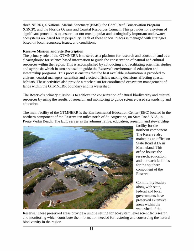
The main facility of the GTMNERR is the Environmental Education Center (EEC) located in the
northern component of the Reserve ten miles north of St. Augustine, on State Road A1A, in
Ponte Vedra Beach. The EEC serves as the administrative, education, research, and stewardship
facility for the
northern component.
The Reserve also
maintains an office on
State Road A1A in
Marineland. This
office houses the
research, education,
and outreach facilities
for the southern
component of the
Reserve.
Community leaders
along with state,
federal and local
governments have
preserved extensive
areas within the
watershed of the
Reserve. These preserved areas provide a unique setting for ecosystem level scientific research
and monitoring which contribute the information needed for restoring and conserving the natural
biodiversity in the region.

12
Compatible consumptive and nonconsumptive uses of the Reserve‟s natural resources provide
valuable assets for the local community. Ecotourism and recreational uses within and adjacent to
the Reserve including boating, picnicking, swimming, sport fishing, cast netting, hunting,
camping, hiking, biking, horseback riding, canoeing, kayaking and nature study are outstanding.
Wildlife viewing, especially birds, is excellent. Washington Oaks Gardens State Park has an
extensive plant garden for viewing along the Matanzas River and a unique coquina rock outcrop,
the Anastasia Formation. Fort Matanzas National Monument provides exhibits and tours of
historical significance. Faver-Dykes State Park provides for nature study, camping, picnicking
and canoeing. Princess Place Preserve has many unique cultural features and is managed by
Flagler County for its historical preservation and recreational value. The GRWMA provides
outstanding resources for hunters and nature enthusiasts.
Ecological Significance and Designations of the Reserve
NOAA has identified eleven distinct biogeographic regions and 29 subregions in the U.S., each
of which contains several types of estuarine ecosystems (15 CFR Part 921, for NERR typology
system).
The GTMNERR is within the Carolinian biogeographic region within the east Florida subregion.
The location‟s relatively pristine condition and unique climate and biodiversity are well suited to
being designated as a Research Reserve. Community leaders along with state, federal and local
governments have preserved extensive areas in the watershed of the GTM Research Reserve
resulting in some of the country‟s most pristine freshwater, tidal creek and estuarine habitats.
Consequently, the GTM Research Reserve provides a unique setting to conduct research and
monitoring and to set goals for protecting and restoring other estuaries in the region.
Major Reserve Management Priorities
St. Johns County is one of the most rapidly growing counties in Florida. As the population
increases as much as 20% by 2015 (Economic and Demographic Research 2009), the demand for
new and expanded water dependent use facilities such as marinas and boat ramps will rise as
well and is a major issue for the GTMNERR. This potentially massive urban growth will likely
impact both the water quality and water resources within the Reserve.
A Water Dependent Uses and Marine Study by St. Johns County (2002) reported the following:
In 2000/2001, there were a total of 10,073 registered vessels in St. Johns County. That
number is predicted to increase to 15,564 vessels by 2015, an increase of nearly 65%.
There are currently 1,054 wet slips at marinas located within St. Johns County. Based on
current boat registration and population trends, an increase of 575 slips will be needed to
keep up with the existing level of availability by 2015.
Based on current permitting trends, it is estimated that an additional 375 private residential
docks will be constructed by 2015, bringing the total from approximately 1200 in 2000 to
1575 in the year 2015.
Dock construction, increased boating traffic associated with increases in population, and poor
boating practices are impacting benthic resources and shoreline habitat within the Reserve.
13
Effective mitigation of these issues is necessary to maintain the status quo of natural conditions
within the Reserve.
Perhaps the most important all-encompassing management priority is to foster ecosystem-based
conservation and restoration of the natural habitats supporting sustainable populations of the
diverse array of organisms within the Reserve.
Reserve Protection Efforts The Reserve encompasses a variety of different local, regional and state regulatory jurisdictional
lands, each governed by specific protective rules and regulations. The Reserve has direct
jurisdiction over the Guana River Marsh Aquatic Preserve (GRMAP), the upland areas of the
former Guana River State Park, and the Pellicer Creek Aquatic Preserve (PCAP). Pellicer Creek
itself is designated as a State Canoe Trail, promoting a passive, low-impact form of recreation
within the Preserve.
The Florida Fish and Wildlife Conservation Commission (FWC), manages the Guana River
Wildlife Management Area (GRWMA).
Deep Creek State Forest and Matanzas State Forest are managed by the Florida Division of
Forestry (FDOF) in cooperation with the FWC and St. Johns River Water Management District.
Both Faver-Dykes State Park and Washington Oaks Gardens State Park are managed through
FDEP‟s Division of Recreation and Parks. The mission of the park service is to provide resource-
based recreation while preserving, interpreting and restoring natural and cultural resources.
Fort Matanzas National Monument is managed and protected by the US National Park Service.
The original national monument site consisted of only the fort on Rattlesnake Island, northwest
of the Matanzas Inlet. Through the years, however, the National Park Service has been able to
acquire additional land both on Rattlesnake and Anastasia Island and begin to set aside a slice of
an intact barrier island ecosystem.
Princess Place Preserve and the River to Sea Preserve at Marineland fall under the jurisdiction of
Flagler County. Princess Place Preserve is an important and critical ecological asset protecting
saltwater marshes, Pellicer Creek and the Matanzas estuary. The River to Sea Preserve is owned
jointly by Flagler County and the Town of Marineland. Beginning at the beach of the Atlantic
Ocean and reaching west to the Matanzas River; the River to Sea Preserve protects a rapidly
disappearing maritime scrub environment.
The St. Johns River Water Management District has jurisdiction over the Stokes Landing
Conservation Area, Moses Creek Conservation Area, and Pellicer Creek Conservation Area. The
District management goals for these areas are generally to:
1. Improve water quality, maintain natural hydrological regime, and increase flood
protection by preserving important floodplain areas.
2. Restore, maintain, and protect native natural communities and diversity.
3. Provide opportunities for recreation where compatible with the above listed goals.

14
ENVIRONMENTAL SETTING
Estuarine Geomorphology
The GTMNERR‟s coastal estuaries are bounded to the west by the Pamlico Terrace (Figure 3),
which has an elevation of 1.5 to 7.5 meters above sea level. The topography present today was
formed over the last 10,000 years and is composed of remnant beach and dune ridges, swamps,
marshes, tidal flats, creeks, rivers, and estuarine lagoon
bottoms. The elevation within the GTMNERR ranges
from sea level to 12 meters on the dunes at the north end
of the Reserve and in the central regions of the Pellicer
Creek Conservation Area.
The GTMNERR is located in the lower part of the
Atlantic Coastal Plain. The coastal region occupies a
physiographic division known as the Coastal Lowlands.
This region of the Florida Plateau is described by Cooke
(1945) as a belt of land along the coast, extending 48 to
96 kilometers inland, that is flat, poorly drained, and
characterized by ancient marine terraces and dune
ridges.
In St. Johns and Flagler counties, thick limestone beds
of the Eocene age underly the area at depths ranging
from sea level to more than 90 meters below sea level.
Miocene or Pliocene deposits directly overlie the
Eocene limestone formations. The surface area is
blanketed by Pleistocene and Recent deposits in varying
depths.
There are seven or possibly eight marine terraces, each
formed at different sea levels during the Pleistocene
epoch (White 1970). These terraces were formed
prehistorically by waves, currents, and the rise and fall
of sea levels. When the sea level remained stationary for
long periods, the waves and currents would erode the
sea floor to form a fairly level surface. Each time the sea
level dropped, a part of the sea floor was exposed as
a level plain or terrace. The terraces tend to be parallel
to the present Atlantic shoreline and become
progressively higher from east to west (Kojima andHunt
1980). Over time the level plains of the terraces were
modified or destroyed by stream erosion.
Figure 3. Estuarine geomorphology of
the GTMNERR.
15
The GTMNERR overlies typical Floridian coastal geologic strata. The ground is covered with
Holocene epoch sediments (< 10,000 years old) including sand, clay and shell fragments. Older
limestone from the Anastasia formation is exposed on the southern beach in the GRMAP (east of
Sombrero Creek). These rocks date from the Pleistocene epoch, which occurred from 1.8 million
years ago (MYA) to 10,000 years ago (Florida Geological Survey [FGS] Lithologic Database).
Beneath these surface sediments lies the Hawthorn group (Miocene epoch, 24-5.3 MYA). The
Hawthorn group is made up of clays and dolomite, and acts as a semi-confining layer atop the
Floridan Aquifer. The Hawthorn group is thickest under the GRMAP ranging in depth from 39 to
90 meters. It is thinner to the south, where it ranges in depth from 33 to 41 meters under the
southern portion of the Reserve (FGS Lithologic Database).
There are a total of 42 soil types occurring within the boundaries of the GTMNERR. The varying
depth of the water table within the soils at the GTMNERR limits the land use abilities. While the
region is relatively flat, the soils types are influenced by surface water flow, waves, currents and
tidal forces. Relief is not pronounced, yet a few feet can mean the difference between dry,
habitable, cultivable land and freshwater swamp or coastal marsh.
The soils of the uplands within the GTMNERR are primarily derived from sandy marine
sediments. There are five general soil map units outlined by the Soil Conservation Service
(SCS). The sand ridges, coastal dunes and flatwoods areas of the Guana peninsula consist of the
Astatula-Tavares soils. These soils are nearly level to sloping, excessively drained and
moderately well-drained soils that are sandy throughout. They are located throughout the
hammock-sand ridge and flatwoods areas west of Guana Lake and extend to the estuarine
marshes.
The Holopaw-Riviera-Pompano soils are represented in a small area along the north GRWMA
boundary west of Guana Lake. They are nearly level and poorly drained; some types are sandy to
a depth of 20 to 40 inches or more and loamy below, while others are sandy throughout. They
provide fair conditions for growth of grasses, legumes, herbaceous plants, hardwoods and pines.
The coastal dunes along State Road A1A are made up of the Fripp-Satellite-Paola map unit. This
unit consists of soils on narrow, rolling sandy ridges interspersed with narrow swales. These soils
are excessively drained sandy soils in the primary and secondary dunes and somewhat poorly
drained in the swales.
The Riviera-Holopaw-Winder association is found on a small portion of the GRWMA area in the
northwest section of the property. These soils are nearly level and poorly drained; some are
sandy to a depth of 20 to 40 inches or more and loamy below, while others are sandy to a depth
of fewer than 20 inches and loamy below. They are considered "fair" producers of open land,
woodland and wetland wildlife habitat, and migratory bird species utilize these areas extensively.
The Pellicer-Tisonia soils are derived from the deposition of estuarine clay sediment and organic
detritus, and are found along the boundary of the Tolomato River, the Intracoastal Waterway
(IWW) (estuarine tidal marshes), and within the area of the Pellicer Creek Aquatic Preserve.
They are nearly level, very poorly drained soils subject to frequent tidal flooding; some are
16
loamy, while others are organic, underlain by clays. These soils are rated as fair producers of
wetland wildlife habitat. Resident and migratory bird species utilize these wetlands extensively.
The Reserve‟s beaches consist of quartz sand, shells, shell fragments, and pebbles derived from
exposures of the Anastasia Formation (Tanner 1960). This formation consists of a sandy coquina
held together by calcareous cement, and obtained its name from Anastasia Island opposite St.
Augustine (Cooke 1945). In the area of the Matanzas Inlet beaches, samples also yielded quartz
sand and shell. Offshore samples yielded fine grained sediments (0.055 – 0.516 mm mean
diameter), with fine to very coarse sediments on the barrier island, and clay and silt in the lagoon
areas (Burnson 1972).
In the upland areas surrounding the Pellicer Creek Aquatic Preserve, sandy soil types are
represented in the sand ridge, coastal dune and flatwoods communities. More information on soil
types in the Reserve can be found on the USDA Web site at
http://websoilsurvey.nrcs.usda.gov/app/.
Climate and Weather
The climate of the northeast Florida coastal region is under a pronounced maritime influence
(NOAA 1982). The heat of summer and cold of winter are moderated by the close proximity of the
Gulf Stream. As a result, this area experiences a humid, subtropical marine climate characterized by
long, warm, humid summers with heavy rainfall and mild, dry winters.
Specifically, the annual average minimum and maximum temperatures range from 58 to 81o
Fahrenheit (F), respectively. The mean annual temperature is about 70oF near the coast and about
72oF inland. Temperatures are moderated by close proximity to the ocean. Summer afternoon
temperatures regularly reach 90°F or higher and nighttime temperatures drop to the low 70s.
Average winter temperatures range from morning lows in the 30s to afternoon highs in the 70s.
Relative humidity ranges from 40 to 50% in the afternoon to 90 or 95% in the early morning.
The average annual rainfall is about 55 inches, of which 50-60% occurs from June through mid-
October as afternoon and evening thundershowers. Ocean breezes tend to retard the movement of
rainstorms moving west to east, so the amount of rain falling directly on the coast is less than in the
interior regions (Jones and Mehta 1978).
Prevailing winds are easterly, but northwest or southwest winds are common. Summer westerly
winds can last for several days, particularly during the early morning hours. Storm events at
GTMNERR include thunderstorms, northeasters, tropical storms, and hurricanes. Information
collected by Taylor Engineering (2008) showed that on average, northeasters affect the area
about five times per year, and tropical storms/hurricanes pass the area about once every three
years. With the exception of the September 9, 1964 landfall of category 2 Hurricane Dora in St.
Augustine, the areas now comprising the GTMNERR have not experienced a hurricane‟s eye
wall landfall (Winsberg 2003).
During Hurricane Dora surge elevations approached 12 ft. above mean sea level and wave
heights reached 20-30 ft along Anastasia Island.In 2001, Tropical Storm Gabrielle moved east
across the Florida peninsula exiting just to the south of the Reserve. While maximum winds of
17
only 59 mph were recorded, nearly 12 inches of rain caused localized flooding and a short-term
decrease in salinity throughout the Reserve estuaries.
In 2004, St. Johns County experienced three tropical storms (Charley, Frances and Jeanne), all of
which were hurricanes but that had slowed to tropical storms by the time they hit the county. The
result was extensive shoreline erosion on the coast that essentially eliminated the sand that had
previously been deposited as part of a beach renourishment project in the St. Augustine Beach
area.
Hydrology
The GTMNERR is located in the Upper East Coast Drainage Basin (part of the Florida East
Coast Basin) which covers 467,196 acres. The basin has been further divided into four “planning
units”, which can be an individual, usually large tributary basin, or a group of small adjacent
primary tributary basins with similar characteristics. The Reserve covers three of these planning
units, from north to south: Tolomato River, Matanzas River and Pellicer Creek. The fourth
planning unit, the Halifax River is south of the GTMNERR boundary.
The natural hydrodynamics of this system have been altered by various water control structures,
including dikes, inland wells, drainage ditches and a dam placed across the headwaters of the
Guana River Estuary (Figrue 4). The Guana Dam was built in 1957, along with other smaller
dams and canals in an attempt to improve hunting and fishing. The system has been further
altered by the IWW which bisects the estuary.
The Tolomato, Guana and Matanzas River estuaries form a system of "bar-bounded" estuaries
that extend from northern St. Johns County to below Marineland in Flagler County, behind the
barrier island system. The Guana River estuary runs parallel to that of the Tolomato River
estuary on the seaward side, with the two lagoons joining together six miles north of the St.
Augustine Inlet. Oceanic exchange occurs through the St. Augustine Inlet.
The Matanzas River estuary stretches approximately 21 miles southward from the St. Augustine
Inlet, with its southernmost section located about seven miles south of the Matanzas Inlet. Moses
Creek and Pellicer Creek are the major contributors of freshwater drainage to the Matanzas River
in the southern component of the Reserve.
Northern Components
The Tolomato River basin has a drainage area encompassing 84 square miles. The River is a
component of the IWW and hence maintained, in part, as a public navigation channel. Dredging
has straightened the course of the river at some points and established spoil islands which are
now partially or entirely vegetated. Smith Creek, Deep Creek, Sweetwater Creek, Marshall
Creek, Stokes Creek, and Casa Cola Creek all drain into the Tolomato River from the west.
These six creeks are included in the Reserve boundaries upstream to the extent of tidal influence.
Capo Creek, Jones Creek, and Sombrero Creek flow west into the Tolomato River and are
entirely within the Reserve boundaries. Smith, Deep, and Sweetwater Creeks drain a large
wetland area to the west of the Reserve known as Cabbage Swamp.
18
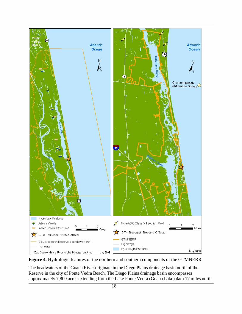
Figure 4. Hydrologic features of the northern and southern components of the GTMNERR.
The headwaters of the Guana River originate in the Diego Plains drainage basin north of the
Reserve in the city of Ponte Vedra Beach. The Diego Plains drainage basin encompasses
approximately 7,800 acres extending from the Lake Ponte Vedra (Guana Lake) dam 17 miles north
19
into Jacksonville Beach. The natural hydrology of the Guana River was significantly altered by the
construction of the dam in 1957. Inland wells, water control structures, dikes, and drainage ditches
have also altered the natural hydrology of the system. From the dam the river flows south to join the
Tolomato River.
Southern Components
Moses Creek and the Matanzas River support extensive undisturbed areas of tidal marsh. Moses
Creek drains a large area of wet flatwoods and swamps in western St. Johns County. As the
creek forms, it flows east and enters the Moses Creek Conservation Area in the northwestern
portion of the property. The creek continues southwest, eventually emptying into the Matanzas
River. Moses Creek lies within the Matanzas River Basin, a sub-basin of the Northern Coastal
Basin (NCB).
The majority of the watershed in the Pellicer Creek basin is drained by relatively small creeks or
branches. The Hulett Branch, Pringle Branch, Stevens Branch, Dave Branch, and Schoolhouse
Branch all drain into the PCAP from the west. Styles Creek flows from the south into Pellicer
Creek, near the Matanzas River. To the north, Rootan Branch flows southward through Faver-
Dykes State Park and drains into Pellicer Creek (DNR 1991). The SJRWMD is responsible for
surface and groundwater resources in the watershed of this aquatic preserve as well as adjacent
drainage basins.
Pellicer Creek is the only natural drainage feature in the general area that cuts through the marine
terraces and ridges to flow east into the Matanzas River. From the Matanzas River lagoonal area
the flow of water eventually empties into the Atlantic Ocean by way of the Matanzas Inlet.
Surface water hydrology in this area is influenced by the interaction of the brackish water of the
Matanzas River with the freshwater inputs from both tidal branches, and overland flow (DNR
1991)
Physical Processes
St. Augustine Inlet
The shallow estuaries of the Reserve are connected to the Atlantic Ocean by the St. Augustine
and Matanzas Inlets that collectively form a barrier island estuarine system. Both inlets are the
focal points for oceanic exchange with the estuarine ecosystem. St. Augustine Inlet is an
improved tidal inlet connecting the Tolomato and Matanzas Rivers to the Atlantic Ocean.
Originally a natural inlet located approximately 120 meters south of its current location; the inlet
channel was relocated in 1940 as part of the federal St. Augustine Harbor Navigation Project in
response to public interests. Efforts to stabilize the inlet and improve navigation, between 1941
and 1957, resulted in the construction of a north jetty structure approximately 1,880 feet(573
meters) in length and a 3,695 foot (1126 meter) southern structure. The inlet channel and
associated structures are maintained by the U. S. Army Corps of Engineers (USACE), as well as
the authorized 16 foot (4.8 meter) entrance channel which is maintained at the best natural
alignment requiring infrequent dredging. USACE and others have prepared numerous surveys,
reports and documents related to the inlet area, including USACE (1965, 1975, 1976, 1998, and
2004a), Taylor Engineering (1989, 1992) and Taylor and McFeteridge (1991). Maintenance
20
dredged material from the navigation channel has typically been disposed of offshore, however,
a 1996 dredging event resulted in the placement of suitable material on the downdrift beaches
located south of the inlet (Srivinas et al. 1997).
Beginning in 1993, Taylor Engineering of Jacksonville initiated a study to develop a St.
Augustine Inlet Management Plan. Part one of the study consisted of an in-depth literature search
to identify information relevant to plan development. The resulting document (Abramian et al.
1994) presents information sources on morphologic, hydraulic, and coastal conditions in the inlet
and adjacent areas; the influence of the inlet and nearby structures on the adjacent beaches and
navigation; characteristics of weather and sea conditions at the inlet; and natural resources at the
inlet and adjacent areas. The second part of the study consisted of a comprehensive delineation
of inlet physical characteristics. The study provided both an historical bathymetric analysis as
well as modeling of inlet hydraulics (Srinivas et al. 1996) from which the final management plan
(Srivinas et al. 1997) was developed.
While barrier island estuarine systems like that associated with the Reserve are common along
the East and Gulf coasts of Florida, there are very few observational studies of their
hydrodynamic properties. Webb et al. (2007) observed hydrography and current velocity at a
tidally driven coastline trifurcation, adjacent to the St. Augustine Inlet, over nearly a semidiurnal
period on February 2, 2006. The results of the study showed that mean inflow occurs through the
central deep channel and mean outflow over the shoals.
Matanzas Inlet
Matanzas Inlet is one of only two unimproved inlets on the east coast of Florida. It is
characterized by a significant offshore bar that is transitory in nature, and the presence of
appreciable inner shoals (Mehta and Jones 1977). There have historically been tidal channels and
shoals at the mouth of the Matanzas Inlet through which there is considerable sediment transport
(Gallivan and Davis 1981). The creation of the IWW has changed the dynamics of sediment
transport such that reductions in current velocity at the junction of the Matanzas River and the
Matanzas Inlet north of Rattlesnake Island cause suspended sediments to settle, necessitating the
frequent dredging and removal of spoil to maintain IWW navigational depths. A variety of
studies of dynamic processes, sediment transport, and littoral drift of the Matanzas Inlet area
have been conducted, including those by Davis and Fox (1980, 1981), Marion and Mehta (1986),
Mehta and Shepard (1979), and Gallivan (1979).
Shoreline Erosion
Shoreline erosion and concomitant loss of shoreline habitat is occurring at relatively high rates in
many places along the margin of the IWW which runs through the Reserve (Price 2006). GIS
analysis of aerial photographs showed essential habitats including oyster bars and salt marshes
reduced to intertidal sand flats. Exposure to boat wakes was found to be the causal factor most
strongly correlated with the rate of lateral margin movement. Margin movement rates were also
found to vary significantly with exposure to wind waves and with the type of channel margin
eroded. A reduction in nearshore wave energy appears to be necessary to allow the recovery of
impacted ecosystems.

21
In 2006, GTMNERR completed a shoreline stabilization and restoration project of 300 meters of
eroding shoreline on the Guana River adjacent to the Environmental Education Center. Shoreline
erosion continues to be a problem in other areas of the GTMNERR, and represents a threat to
resources at several locations. Most significantly, shoreline erosion along the eastern shore of the
Tolomato River is undermining natural and cultural resources on the western bank of the Guana
Peninsula. This shoreline includes 2 significant known archeological sites at Wrights‟ Landing
and Shell Bluff Landing. Rising sea levels and wakes from recreational boat traffic appear to be
the primary factors contributing to this erosion. Any stabilization efforts on this shore will be
challenging to implement in an environmentally sensitive manner, due to the high wave energy
created by boat wakes.
The Summerhaven area south of the Matanzas Inlet has been the site of increased beach erosion
as well as actual breaches of the dune system and destruction of paved roadway. The resulting
overwash fans have isolated the properties of a number of homeowners in the area.The USACE
has deposited material obtained from maintenance dredging of the IWW channel at Matanzas
Inlet along this stretch which has the secondary benefit of helping to stabilize the beach (USACE
2004b).
Modeling Efforts
Multiple modeling efforts have been undertaken or are ongoing within the Reserve to evaluate
circulation, flushing, water quality conditions, and ecosystem health to meet water quality and
habitat protection goals. To meet the data needs for these modeling efforts, SJRWMD completed
a bathymetric survey to obtain bottom topography of NCB waterways (SJRWMD 2004a), which
included the bathymetry of the Reserve. The project was conducted between 1999 and 2001 with
bathymetric transects primarily spaced at 500 or 1000 foot intervals, and depth data obtained at
approximately 66 foot intervals along each track line. The survey included both lateral and
longitudinal depth transects.
These bathymetric data were used by Camp, Dresser & McKee (CDM) to prepare a two-
dimensional finite-difference, curvilinear orthogonal numerical grid model for tidal waters in the
NCB (CDM/DHI 2002). This grid is the basis for an ongoing project to estimate land surface
runoff and non-point source pollution loading into the IWW and Tolomato-Matanzas estuary
using an HSPF (Hydrological Simulation Program FORTRAN) watershed model. The watershed
model runs will generate time series of runoff, sediment, and nutrient loads to be used as inputs
to the NCB hydrodynamic/water quality model, and hence assist in the determination of the
Pollution Load Reduction Goals (PLRGs) and Total Maximum Daily Load (TMDL) criterion
(Mao et al. 2007). By coupling the model information with a GIS land use database, the effects
of the change of the land use among historical, current and future build-out conditions can be
assessed.
GTMNERR has a large coverage (~15 km2) of tidal flats and tidal marshes which are generally
within the tidal range. A study by Tutak and Sheng (2008) used the 3-D hydrodynamic model,
CH3D, with non-flooding/drying and flooding/drying versions, to quantify the effects of tidal
marshes and tidal flats on the hydrodynamics of the estuarine system. Simulated flow rates at the
Matanzas and St. Augustine Inlets were compared with observed data collected using an ADCP
for a 12 hour period.
22
The study showed that using a numerical model capable of flooding/drying improved the tidal
simulations for stations located in regions with larger marsh coverage or shallower channels. The
simulations of total flow rates through the inlets were also improved. Future work will
investigate the overland flow through tidal marshes by using an enhanced vegetation model
which incorporates friction introduced by submerged and emerged vegetation. The model may
also be useful for studying the effects of tidal marshes and tidal flats on the water level, currents
and salinity during extreme events (e.g. hurricanes). The three-dimensional modeling approach
can also be used to provide guidance on the development of sampling strategies for
biogeochemical studies in the Reserve (Sheng et al. 2008).
Finally, Powell et al. (2006) used the closure of a land barrier breach at Matanzas Inlet as a case
study to illustrate the application of morphodynamic relationships between prism, inlet throat
area, and sand transport associated with ebb delta volume.
Land Use
The populations of St. Johns County and the adjacent Duval, Flagler, Putnam, and Volusia
Counties have grown an average of 23 % between 2000 and 2006 (US Bureau of the Census
2008) and are projected to grow an additional 20 % by 2010 (BEBR, University of Florida
2002). The St. Johns County resident population increased by more than 66% between 2000 and
2006, representing one of the highest growth rates in Florida for that time period. More than
1,660,000 people reside within 50 miles of the Reserve, which includes the cities of Jacksonville,
St. Augustine, Palatka, Daytona and New Smyrna (US Bureau of the Census 2008).
Surrounding land use as of 2004 for the watershed of the northern portion of the Reserve is
dominated by forest and wetland cover classifications with a continuing increase in urban
development from previous land use classifications. The following comprised the watershed land
use classifications compiled by the SJRWMD in 2004: forests covered 33.5%, wetlands 47.4%,
urban development 19.6%, water 16.1%, agriculture 9.7%, upland non-forested 5.3%, and
transportation/communication/utilities 2.0%. Since 2004 several developments of regional
impact have begun within the watershed. The town of Nocatee adjoins the Reserve‟s
northwestern boundary along the Tolomato River. Nocatee has a 25-year projected build out
totaling 30,000 to 35,000 people and 14,200 homes. Future analyses will reflect the changes in
land use, further shifting the forest and agriculture classifications to more urban development.
Within the southern component of the Reserve, the Pellicer Creek planning unit is dominated by
forestland (55%), and wetlands (35%), according to SRJWMD land use estimates from 2000.
Pellicer Creek itself has been maintained as an aquatic preserve and has been left largely
undisturbed. However, there is commercial and residential development to the north and south of
the creek. Based on current growth, and the future land use plan for Pellicer Creek, residential
developments could potentially increase to 22% of the total area. Most of the western portions of
the unit remain under silvicultural use.
Water Use
Potable water can be obtained from either the Floridan Aquifer or from surficial aquifers. These
aquifers are primarily shallow lenses of fresh water floating on saline water in near-surface sand

23
and shell sediments. There is a deeper lens of fresh water (chloride ≤ 250 milligrams per liter
[mg/l]) in the surficial sediments of the Guana peninsula, and a shallower lens below the beach
dunes. In addition, water flows freely from deep artesian wells at several locations throughout
the GTMNERR. The artesian discharge has an average chloride concentration of 120 mg/l.
In the GTMNERR, the depth of the top of the Floridan Aquifer is shallowest in the south (175
ft.(53 meters), PCAP) and gradually deepens towards the north (350 ft. (107 meters), GRMAP)
(Scott and Hajishafie 1980). The aquifer has a thickness of approximately 2,000 feet (610
meters) throughout the GTMNERR (Miller 1986). There is a submarine spring off the coast of
Crescent Beach that originates from this aquifer (Kinnaman 2006). Groundwater along the coast
is subject to a low to high degree of lateral salt intrusion. Barrier island ground water supplies are
severely limited in St. Johns County, and increased use is likely to increase salinity intrusion into
the shallow aquifer during the next twenty years.
Total fresh groundwater use for St. Johns County and the surrounding counties increased by 23%
between 2000 and 2006 (Table 1) and is projected to increase as development in the area
expands. This water consumption includes ground, surface water, and reuse water that is used for
domestic, commercial and agricultural purposes. The water supply planning program of the
SJRWMD addresses future water demands, traditional and alternative water sources, and water
supply infrastructure improvements required to meet future water supply needs without causing
harm to water resources or water dependent natural systems.
Table 1. Total fresh groundwater use, and change in water use by County for 2000 and
2006 in million gallons per day (mgd)
County 2000 Total Water
Use (mgd)*
2006 Total Water
Use (mgd)**
Change in Water
Use (%)
Duval 154.33 180.19 14%
Flagler 24.55 29.11 16%
Putnam 40.35 63.80 37%
St. Johns 52.55 59.81 12%
Volusia 97.16 106.56 9%
Total 368.94 479.01 23% *SJRWMD (2004b)
**SJRWMD (2007)
Water Quality
Water quality research and monitoring is conducted in the Reserve on a national level by
Reserve scientists and on a state and regional level by FDEP, FDACS, and SJRWMD to
facilitate the sustainable protection of water quality.
System-wide Monitoring Program
The GTMNERR participates in the NERR System-wide Monitoring Program (SWMP),
established in 1995 to track short-term variability and long-term changes in estuarine
environments within the NERR system. The GTMNERR program has three main elements:
water quality, weather and nutrient/chlorophyll analyses. The water quality component is
comprised of four water quality monitoring stations (listed in Appendix B) at which YSI 6600

24
EDS datasondes are deployed. Measures of the water temperature, conductivity/salinity,
dissolved oxygen, turbidity, water level, and pH are collected at 15 minute intervals (30 minute
intervals prior to 2007). The weather component consists of a weather station located at the
mouth of Pellicer Creek from which measures of temperature, relative humidity, atmospheric
pressure, rainfall, wind speed and direction, and photosynthetically active radiation (PAR) are
collected at 15 minute intervals. Both the weather station and the water quality station at Pellicer
Creek have satellite telemetry which provides near real-time data availability. The third SWMP
element involves
nutrient/chlorophyll
analysis of water
samples collected
monthly at each of
the four water quality
stations, in addition
to a diel sampling
regime carried out
once a month at the
Pellicer Creek site.
Water samples
collected at each site
are analyzed for
nitrite, nitrate,
ammonium, total
nitrogen, total soluble
nitrogen,
orthophosphate, total
phosphorus, total
soluble phosphorous,
silica, particulate
organic carbon, total suspended solids, chlorophyll a, phaeophytin and color.
All SWMP data is housed and served through the NERRS Centralized Data Management Office
(CDMO), which provides quality assurance and quality control for the Reserve system. The
CDMO is also responsible for maintaining and updating the NERRS standard operating
procedures so that all SWMP data are collected in the same way across the nation. Archived and
near-real time water quality, weather, and nutrient/chlorophyll data may be accessed directly via
an interactive map at: http://cdmo.baruch.sc.edu/QueryPages/googlemap.cfm.
SWMP is a backbone component of the Integrated Ocean Observing System (IOOS), a nation-
wide organization of ocean and coastal observations, data streams, data management and
analysis. The IOOS goal is to bring together these elements from all sources - federal, state, and
local - to create synergy across programs. The ultimate purpose is to improve understanding and
management of our coastal waters.
Examples of SWMP data generated at each of the water quality stations and from the weather
station during the passing of Tropical Storm Frances are illustrated in Figure 5 (from Brucker
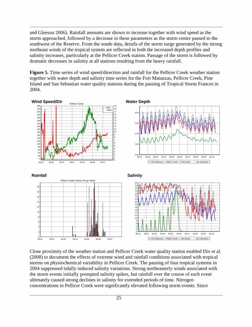
25
and Gleeson 2006). Rainfall amounts are shown to increase together with wind speed as the
storm approached, followed by a decrease in these parameters as the storm center passed to the
southwest of the Reserve. From the sonde data, details of the storm surge generated by the strong
northeast winds of the tropical system are reflected in both the increased depth profiles and
salinity increases, particularly at the Pellicer Creek station. Passage of the storm is followed by
dramatic decreases in salinity at all stations resulting from the heavy rainfall.
Figure 5. Time series of wind speed/direction and rainfall for the Pellicer Creek weather station
together with water depth and salinity time series for the Fort Matanzas, Pellicer Creek, Pine
Island and San Sebastian water quality stations during the passing of Tropical Storm Frances in
2004.
Pellicer Creek
09-0709-0609-0509-0409-0309-0209-01
Wdir (d
eg)
360
340
320
300
280
260
240
220
200
180
160
140
120
100
80
60
40
20
0
WS
pd (m
/s)
19
18
17
16
15
14
13
12
11
10
9
8
7
6
5
4
3
2
1
0
Wdir
WSpd
Pellicer Creek Hourly Precip Totals
09-0709-0609-0509-0409-0309-0209-01
Tota
l Pre
cip
itatio
n (m
m)
20
18
16
14
12
10
8
6
4
2
0Fort Matanzas Pellicer Creek Pine Island San Sebastian
09-1009-0909-0809-0709-0609-0509-0409-0309-0209-01
Salin
ity (p
pt)
36
34
32
30
28
26
24
22
20
18
16
14
12
10
8
6
4
2
0
Fort Matanzas Pellicer Creek Pine Island San Sebastian
09-1009-0909-0809-0709-0609-0509-0409-0309-0209-01
Depth
(m
)
4.00
3.00
2.00
1.00
0.00
HURRICANE FRANCES Salinity Rainfall
Water Depth Wind Speed/Dir
Close proximity of the weather station and Pellicer Creek water quality station enabled Dix et al.
(2008) to document the effects of extreme wind and rainfall conditions associated with tropical
storms on physiochemical variability in Pellicer Creek. The passing of four tropical systems in
2004 suppressed tidally induced salinity variations. Strong northeasterly winds associated with
the storm events initially prompted salinity spikes, but rainfall over the course of each event
ultimately caused strong declines in salinity for extended periods of time. Nitrogen
concentrations in Pellicer Creek were significantly elevated following storm events. Since
26
primary production in many coastal environments is nitrogen limited, increases in nitrogen input
represent a potential for enhanced algal production and biomass.
Phlips et al. (2004) compared data from the four GTMNERR SWMP water quality sites from
May 2002 through August 2003, to four sites in the Indian River Lagoon (IRL) to assess regional
differences in physical and chemical characteristics, and phytoplankton abundance. These sites
were chosen because they both include estuaries with water residence times ranging from days to
months and watersheds with widely differing nutrient load characteristics. The results of the
study suggest that spatial and temporal trends in phytoplankton standing crop in much of the
GTMNERR and IRL are closely tied to water exchange characteristics and the nutrient-limiting
status of the community.
FDEP Surface Water Ambient Monitoring Program (SWAMP)
The SWAMP effort is an interagency collaborative effort that is FDEP‟s primary surface water
quality monitoring program and central repository for surface water quality data. The intent of
the program is to screen water bodies to provide a broad assessment of water quality.
Information generated from this program is used to develop total maximum daily loads
(TMDLs), identify water bodies for more detailed studies, and potentially identify water bodies
for restoration and rehabilitation. Sample locations within proximity of the Reserve are listed in
Appendix B.
SWAMP is part of the state‟s Integrated Water Resource Monitoring Network (IWRMN).
Within this network, the FDEP Ambient Monitoring Program samples freshwater lakes, streams
and groundwater and estuaries, although the Inshore Marine Monitoring and Assessment
Program (IMAP) discussed below, sampled estuaries between 2000 and 2004.
Data collected through this program are entered into the STORage and RETrieval database
(STORET), the central repository for biological, chemical, and physical data for ground and
surface waters. The STORET Web site at http://storet.dep.state.fl.us/WrmSpa/ allows a variety of
data.
FWC IMAP
IMAP was a collaborative project between EPA and the FWC Florida Marine Research Institute
(FMRI) designed to assess the ecological condition of Florida‟s inshore waters using a set of
ecological indicators. The indicators chosen for IMAP were divided into two broad categories:
physical/chemical and biological.
Physical/chemical indicators chosen for IMAP included the traditional water quality
measurements such as temperature, salinity, dissolved oxygen, and pH, in addition to nutrients
and chlorophyll a. IMAP biological indicators integrate environmental stressors over larger
spatial and temporal scales. Fish, crabs and shrimp were sampled with trawls and seines;
seagrass community composition (where present) were assessed; and benthic macroinvertebrates
were sampled to determine community composition and the occurrence of pollution tolerant or
intolerant species. Summary reports of the IMAP program can be found at the Florida Fish and
Wildlife Research Institute (FWRI) Web site at

27
http://research.myfwc.com/features/category_sub.asp?id=3448. Sample locations are listed in
Appendix B.
Florida Department of Agriculture and Consumer Services (FDACS) Division of Aquaculture
The FDACS Division of Aquaculture is responsible for the regulation of aquaculture facilities
and the opening or closing of shellfish harvesting waters to protect human health. The Division
also ensures the continued productivity of oyster reefs through a restoration program and issues
leases of submerged state lands for aquaculture.
The Shellfish Environmental Assessment Section (SEAS) of FDACS monitors water quality in
the two conditionally approved shellfish areas within the Reserve boundaries on a quarterly basis
to ensure that bacteria levels are safe for shellfish consumption. A conditionally approved area
must meet fecal coliform water quality standards and the area must be a sufficient distance from
pollution sources for shellfish to be wholesome while the area is open for harvesting.
A management plan developed for these areas uses local rainfall and/or river discharge to predict
when the levels of fecal coliform bacteria in the water are unacceptably high. When the rainfall
level and/or river level of the management plan is exceeded, the area will be temporarily closed
to shellfish until water quality sample results demonstrate that the levels of bacteria have
returned to safe levels for shellfishing to resume. Data is collected by the Division (locations
listed in Appendix B) and is transmitted to the FDEP for inclusion in the STORET database.
SJRWMD Surface Water Quality Monitoring (SWQM) Program
SJRWMD monitors water quality from 5 primary stations (listed in Appendix B) located either
within, or directly adjacent to the GTMNERR. Data on 25 different constituents are derived from
samples collected on at least a monthly basis and can be accessed at
http://sjrwmd.com/archydro/factPages. Using GIS mapping technology, these measurements are
evaluated in the context of population density, geology, rainfall, and aquifer recharge. SJRWMD
produces a general water quality synopsis from this collected data (SJRWMD 2008) from which
the following descriptions are derived.
The northernmost sampling site is located on the Tolomato River, just north of Pine Island in
northeastern St. Johns County. When compared to other estuarine sites, conductivity and major
ion concentrations are elevated, resulting in very hard water. The median dissolved oxygen
concentration is above the FDEP standard for Class 3 surface waters. The water is well-buffered
and slightly alkaline. Total organic carbon concentrations are lower than generally found. Total
suspended solids and turbidity are both elevated. Total nitrogen and chlorophyll concentrations
are lower than in other estuarine areas.
A second station is located at SR312 and the Matanzas River, and is sampled monthly. When
compared to other estuarine sites, conductivity is high with correspondingly high major ion
concentrations, resulting in very hard water. The median dissolved oxygen concentration is well
above the FDEP standard for Class 3 surface waters. The water is well-buffered and slightly
alkaline. Concentrations of total organic carbon, color, total nitrogen, chlorophyll, and coliform
counts are lower than those found in other estuarine systems.
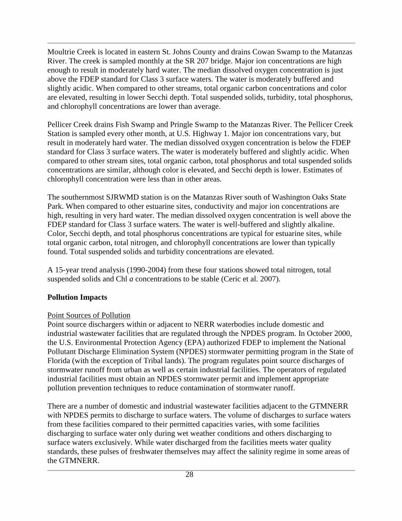
28
Moultrie Creek is located in eastern St. Johns County and drains Cowan Swamp to the Matanzas
River. The creek is sampled monthly at the SR 207 bridge. Major ion concentrations are high
enough to result in moderately hard water. The median dissolved oxygen concentration is just
above the FDEP standard for Class 3 surface waters. The water is moderately buffered and
slightly acidic. When compared to other streams, total organic carbon concentrations and color
are elevated, resulting in lower Secchi depth. Total suspended solids, turbidity, total phosphorus,
and chlorophyll concentrations are lower than average.
Pellicer Creek drains Fish Swamp and Pringle Swamp to the Matanzas River. The Pellicer Creek
Station is sampled every other month, at U.S. Highway 1. Major ion concentrations vary, but
result in moderately hard water. The median dissolved oxygen concentration is below the FDEP
standard for Class 3 surface waters. The water is moderately buffered and slightly acidic. When
compared to other stream sites, total organic carbon, total phosphorus and total suspended solids
concentrations are similar, although color is elevated, and Secchi depth is lower. Estimates of
chlorophyll concentration were less than in other areas.
The southernmost SJRWMD station is on the Matanzas River south of Washington Oaks State
Park. When compared to other estuarine sites, conductivity and major ion concentrations are
high, resulting in very hard water. The median dissolved oxygen concentration is well above the
FDEP standard for Class 3 surface waters. The water is well-buffered and slightly alkaline.
Color, Secchi depth, and total phosphorus concentrations are typical for estuarine sites, while
total organic carbon, total nitrogen, and chlorophyll concentrations are lower than typically
found. Total suspended solids and turbidity concentrations are elevated.
A 15-year trend analysis (1990-2004) from these four stations showed total nitrogen, total
suspended solids and Chl a concentrations to be stable (Ceric et al. 2007).
Pollution Impacts
Point Sources of Pollution
Point source dischargers within or adjacent to NERR waterbodies include domestic and
industrial wastewater facilities that are regulated through the NPDES program. In October 2000,
the U.S. Environmental Protection Agency (EPA) authorized FDEP to implement the National
Pollutant Discharge Elimination System (NPDES) stormwater permitting program in the State of
Florida (with the exception of Tribal lands). The program regulates point source discharges of
stormwater runoff from urban as well as certain industrial facilities. The operators of regulated
industrial facilities must obtain an NPDES stormwater permit and implement appropriate
pollution prevention techniques to reduce contamination of stormwater runoff.
There are a number of domestic and industrial wastewater facilities adjacent to the GTMNERR
with NPDES permits to discharge to surface waters. The volume of discharges to surface waters
from these facilities compared to their permitted capacities varies, with some facilities
discharging to surface water only during wet weather conditions and others discharging to
surface waters exclusively. While water discharged from the facilities meets water quality
standards, these pulses of freshwater themselves may affect the salinity regime in some areas of
the GTMNERR.
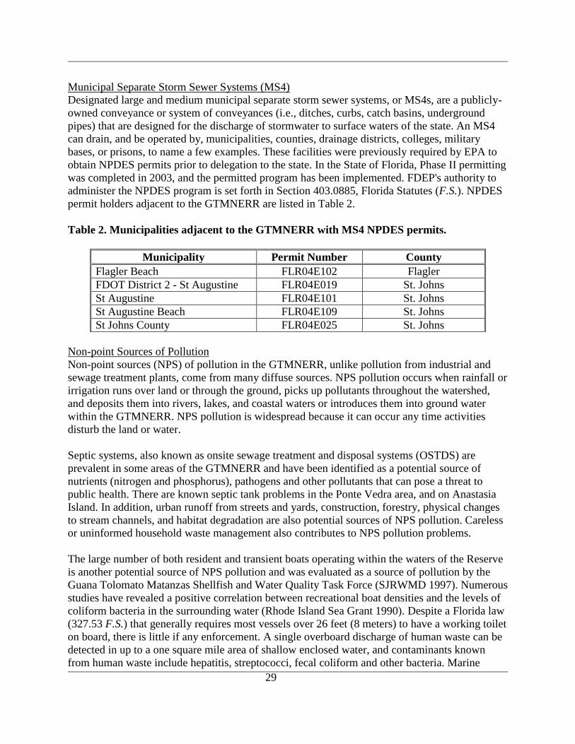
29
Municipal Separate Storm Sewer Systems (MS4)
Designated large and medium municipal separate storm sewer systems, or MS4s, are a publicly-
owned conveyance or system of conveyances (i.e., ditches, curbs, catch basins, underground
pipes) that are designed for the discharge of stormwater to surface waters of the state. An MS4
can drain, and be operated by, municipalities, counties, drainage districts, colleges, military
bases, or prisons, to name a few examples. These facilities were previously required by EPA to
obtain NPDES permits prior to delegation to the state. In the State of Florida, Phase II permitting
was completed in 2003, and the permitted program has been implemented. FDEP's authority to
administer the NPDES program is set forth in Section 403.0885, Florida Statutes (F.S.). NPDES
permit holders adjacent to the GTMNERR are listed in Table 2.
Table 2. Municipalities adjacent to the GTMNERR with MS4 NPDES permits.
Municipality Permit Number County
Flagler Beach FLR04E102 Flagler
FDOT District 2 - St Augustine FLR04E019 St. Johns
St Augustine FLR04E101 St. Johns
St Augustine Beach FLR04E109 St. Johns
St Johns County FLR04E025 St. Johns
Non-point Sources of Pollution
Non-point sources (NPS) of pollution in the GTMNERR, unlike pollution from industrial and
sewage treatment plants, come from many diffuse sources. NPS pollution occurs when rainfall or
irrigation runs over land or through the ground, picks up pollutants throughout the watershed,
and deposits them into rivers, lakes, and coastal waters or introduces them into ground water
within the GTMNERR. NPS pollution is widespread because it can occur any time activities
disturb the land or water.
Septic systems, also known as onsite sewage treatment and disposal systems (OSTDS) are
prevalent in some areas of the GTMNERR and have been identified as a potential source of
nutrients (nitrogen and phosphorus), pathogens and other pollutants that can pose a threat to
public health. There are known septic tank problems in the Ponte Vedra area, and on Anastasia
Island. In addition, urban runoff from streets and yards, construction, forestry, physical changes
to stream channels, and habitat degradation are also potential sources of NPS pollution. Careless
or uninformed household waste management also contributes to NPS pollution problems.
The large number of both resident and transient boats operating within the waters of the Reserve
is another potential source of NPS pollution and was evaluated as a source of pollution by the
Guana Tolomato Matanzas Shellfish and Water Quality Task Force (SJRWMD 1997). Numerous
studies have revealed a positive correlation between recreational boat densities and the levels of
coliform bacteria in the surrounding water (Rhode Island Sea Grant 1990). Despite a Florida law
(327.53 F.S.) that generally requires most vessels over 26 feet (8 meters) to have a working toilet
on board, there is little if any enforcement. A single overboard discharge of human waste can be
detected in up to a one square mile area of shallow enclosed water, and contaminants known
from human waste include hepatitis, streptococci, fecal coliform and other bacteria. Marine
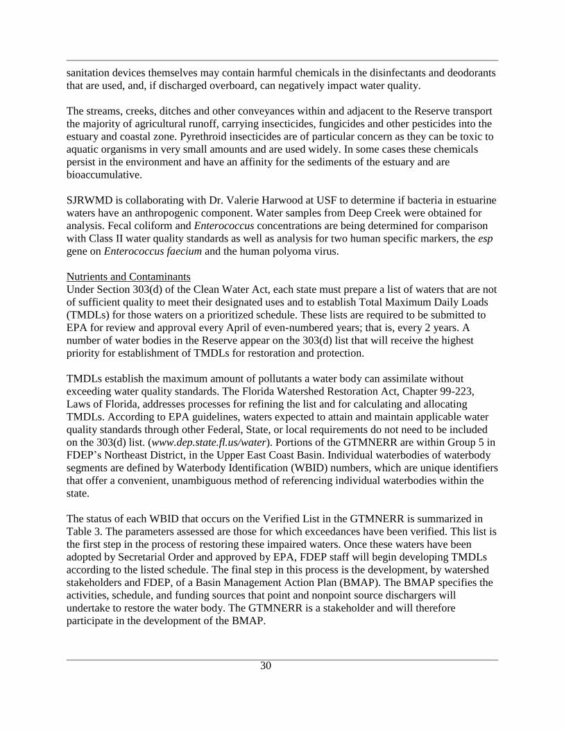
30
sanitation devices themselves may contain harmful chemicals in the disinfectants and deodorants
that are used, and, if discharged overboard, can negatively impact water quality.
The streams, creeks, ditches and other conveyances within and adjacent to the Reserve transport
the majority of agricultural runoff, carrying insecticides, fungicides and other pesticides into the
estuary and coastal zone. Pyrethroid insecticides are of particular concern as they can be toxic to
aquatic organisms in very small amounts and are used widely. In some cases these chemicals
persist in the environment and have an affinity for the sediments of the estuary and are
bioaccumulative.
SJRWMD is collaborating with Dr. Valerie Harwood at USF to determine if bacteria in estuarine
waters have an anthropogenic component. Water samples from Deep Creek were obtained for
analysis. Fecal coliform and Enterococcus concentrations are being determined for comparison
with Class II water quality standards as well as analysis for two human specific markers, the esp
gene on Enterococcus faecium and the human polyoma virus.
Nutrients and Contaminants
Under Section 303(d) of the Clean Water Act, each state must prepare a list of waters that are not
of sufficient quality to meet their designated uses and to establish Total Maximum Daily Loads
(TMDLs) for those waters on a prioritized schedule. These lists are required to be submitted to
EPA for review and approval every April of even-numbered years; that is, every 2 years. A
number of water bodies in the Reserve appear on the 303(d) list that will receive the highest
priority for establishment of TMDLs for restoration and protection.
TMDLs establish the maximum amount of pollutants a water body can assimilate without
exceeding water quality standards. The Florida Watershed Restoration Act, Chapter 99-223,
Laws of Florida, addresses processes for refining the list and for calculating and allocating
TMDLs. According to EPA guidelines, waters expected to attain and maintain applicable water
quality standards through other Federal, State, or local requirements do not need to be included
on the 303(d) list. (www.dep.state.fl.us/water). Portions of the GTMNERR are within Group 5 in
FDEP‟s Northeast District, in the Upper East Coast Basin. Individual waterbodies of waterbody
segments are defined by Waterbody Identification (WBID) numbers, which are unique identifiers
that offer a convenient, unambiguous method of referencing individual waterbodies within the
state.
The status of each WBID that occurs on the Verified List in the GTMNERR is summarized in
Table 3. The parameters assessed are those for which exceedances have been verified. This list is
the first step in the process of restoring these impaired waters. Once these waters have been
adopted by Secretarial Order and approved by EPA, FDEP staff will begin developing TMDLs
according to the listed schedule. The final step in this process is the development, by watershed
stakeholders and FDEP, of a Basin Management Action Plan (BMAP). The BMAP specifies the
activities, schedule, and funding sources that point and nonpoint source dischargers will
undertake to restore the water body. The GTMNERR is a stakeholder and will therefore
participate in the development of the BMAP.
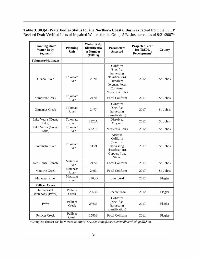
31
Table 3. 303(d) Waterbodies Status for the Northern Coastal Basin extracted from the FDEP
Revised Draft Verified Lists of Impaired Waters for the Group 5 Basins current as of 9/21/2007*
Planning Unit/
Water Body
Segment
Planning
Unit
Water Body
Identificatio
n Number
(WBID)
Parameters
Assessed
Projected Year
for TMDL
Development2
County
Tolomato/Matanzas
Guana River Tolomato
River 2320
Coliform
(Shellfish
harvesting
classification),
Dissolved
Oxygen, Fecal
Coliform,
Nutrients (Chla)
2012 St. Johns
Sombrero Creek Tolomato
River 2470 Fecal Coliform 2017 St. Johns
Ximanies Creek Tolomato
River 2477
Coliform
(Shellfish
harvesting
classification)
2017 St. Johns
Lake Vedra (Guana
Lake)
Tolomato
River 2320A
Dissolved
Oxygen 2012 St. Johns
Lake Vedra (Guana
Lake)
Tolomato
River 2320A Nutrients (Chla) 2012 St. Johns
Tolomato River Tolomato
River 2363I
Arsenic,
Coliform
(Shellfish
harvesting
classification),
Copper, Iron,
Nickel
2017 St. Johns
Red House Branch Matanzas
River 2472 Fecal Coliform 2017 St. Johns
Moultrie Creek Matanzas
River 2493 Fecal Coliform 2017 St. Johns
Matanzas River Matanzas
River 2363G Iron, Lead 2012 Flagler
Pellicer Creek
Intracoastal
Waterway (IWW)
Pellicer
Creek 2363E Arsenic, Iron 2012 Flagler
IWW Pellicer
Creek 2363F
Coliform
(Shellfish
harvesting
classification)
2017 Flagler
Pellicer Creek Pellicer
Creek 2580B Fecal Coliform 2011 Flagler
*Complete dataset can be viewed at http://www.dep.state.fl.us/water/tmdl/verified_gp5R.htm.
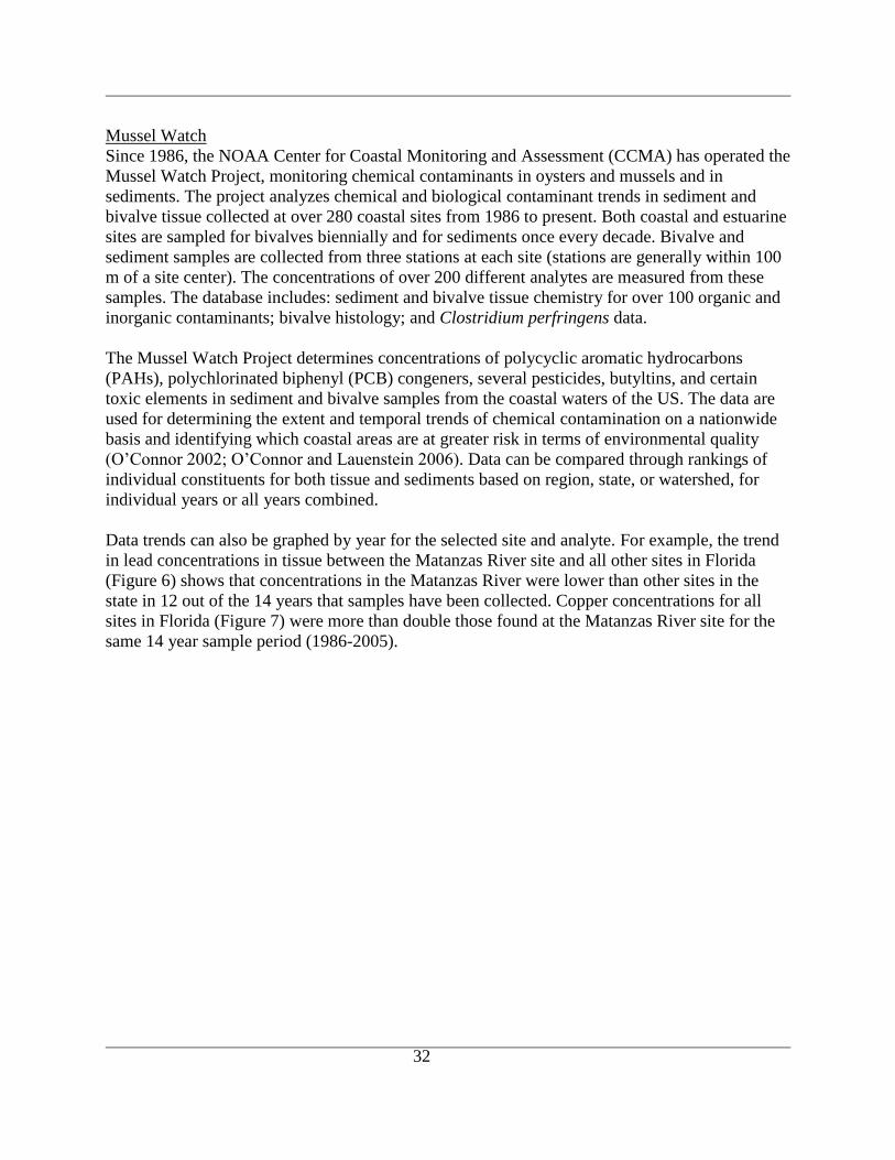
32
Mussel Watch
Since 1986, the NOAA Center for Coastal Monitoring and Assessment (CCMA) has operated the
Mussel Watch Project, monitoring chemical contaminants in oysters and mussels and in
sediments. The project analyzes chemical and biological contaminant trends in sediment and
bivalve tissue collected at over 280 coastal sites from 1986 to present. Both coastal and estuarine
sites are sampled for bivalves biennially and for sediments once every decade. Bivalve and
sediment samples are collected from three stations at each site (stations are generally within 100
m of a site center). The concentrations of over 200 different analytes are measured from these
samples. The database includes: sediment and bivalve tissue chemistry for over 100 organic and
inorganic contaminants; bivalve histology; and Clostridium perfringens data.
The Mussel Watch Project determines concentrations of polycyclic aromatic hydrocarbons
(PAHs), polychlorinated biphenyl (PCB) congeners, several pesticides, butyltins, and certain
toxic elements in sediment and bivalve samples from the coastal waters of the US. The data are
used for determining the extent and temporal trends of chemical contamination on a nationwide
basis and identifying which coastal areas are at greater risk in terms of environmental quality
(O‟Connor 2002; O‟Connor and Lauenstein 2006). Data can be compared through rankings of
individual constituents for both tissue and sediments based on region, state, or watershed, for
individual years or all years combined.
Data trends can also be graphed by year for the selected site and analyte. For example, the trend
in lead concentrations in tissue between the Matanzas River site and all other sites in Florida
(Figure 6) shows that concentrations in the Matanzas River were lower than other sites in the
state in 12 out of the 14 years that samples have been collected. Copper concentrations for all
sites in Florida (Figure 7) were more than double those found at the Matanzas River site for the
same 14 year sample period (1986-2005).

33
Figure 6. Trends Comparison of the Matanzas River Site (Selection A) vs All Sites in Florida
(Selection B) for Lead (Pb) concentration (µg/dry g) in Oyster Tissue.
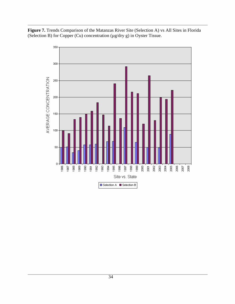
34
Figure 7. Trends Comparison of the Matanzas River Site (Selection A) vs All Sites in Florida
(Selection B) for Copper (Cu) concentration (µg/dry g) in Oyster Tissue.
35
BIOLOGICAL SETTING
Introduction
The habitat classification system used to describe biotic habitats was developed by the Florida
Natural Areas Inventory (FNAI) and the FDEP. The community types are characterized and
defined by a combination of physiognomy, vegetation structure and composition, land form,
substrate, climate, hydrology, fire regime, topography and soil type. The community types are
named for the most characteristic biological or physical feature (FNAI and FDEP 1990). The
Reserve contains twenty-three distinct FNAI-classified natural communities (FNAI 1991) as well
as open water and ruderal areas. The habitats are roughly organized as a progression from
estuarine, to upland, to freshwater aquatic habitats. Each of these biotic habitats is described
below. In addition, descriptions of community structure of some of the FNAI habitats have been
completed for the CAMA managed units within the Reserve. These have been included in the
GTMNERR Management Plan, and relevant sections of those descriptions are also presented
below.
Biological community profiles are presented separately, and describe the major biological
components and species within the Reserve. Both important species and past and present
research (through 2009) associated with each component is presented. Appendix A contains a
complete listing of all species known to occur within the Reserve.
Biotic Habitats
Estuarine Tidal Marsh – (synonyms: Saltmarsh, Brackish Marsh, Coastal Wetlands, Coastal
Marshes, Tidal Wetlands).
Marine and estuarine tidal marshes are floral based natural communities generally characterized
as expanses of grasses, rushes and
sedges along coastlines of low
wave energy and river mouths.
They are most abundant and most
extensive in Florida north of the
normal freeze line, being largely
displaced by and interspersed
among tidal swamps below this
line.
Estuarine tidal marsh plants live
under conditions which would
stress most plants. High salt
content in the soil, poor soil
aeration, frequent submersion and
exposure, intense sunlight, and
occasional fires make the estuarine
tidal marsh community
inhospitable to most plants and
requires a wide tolerance limit for its inhabitants. The landward extent of estuarine tidal marsh
along the shoreline is directly related to the degree of bottom slope; the more gradual the slope
36
the broader the community band. Typical zonation in this community includes smooth cordgrass
in the deeper edges, grading to salt tolerant plants such as black needlerush that withstand less
inundation.
The vegetation of this marsh community consists of a number of species in the grass (Poaceae),
sedge (Cyperaceae), and rush (Juncaceae) families. The marsh area within the Reserve is
dominated by smooth cordgrass (Spartina alterniflora). Smooth cordgrass is well adapted to sea-
strength salinity, 35 parts per thousand (ppt), and occurs in the regularly flooded or low marsh
(zone between mean low water (MLW) and mean high water (MHW)). Smooth cordgrass
becomes mixed with glasswort (Salicornia sp), saltwort (Batis maritima), sea purslane (Sesuvium
portulacastrum), and salt grass (Distichlis spicata) on sandy substrates near the high water mark.
Areas of high marsh (zone between MHW and MLW spring tide) occur where tidal flow is
restricted and are dominated by black needlerush (Juncus roemerianus). Other commonly
occurring species in the high marsh include sea oxeye (Borrichia frutescens), sea lavender
(Limonium carolinianum), marsh elder (Iva frutescens), and groundsel tree (Baccharis
halimifolia). Brackish marshes are found in the northern component of the Reserve, and include
the managed Diego Pond, and north-central portions of Guana Lake. Brackish marshes have
salinity levels of about one-third sea strength. Salinity is strongly influenced by rain water
runoff. Vegetation consists mainly of species endemic to the saltmarsh, but includes additional
species less tolerant of higher salinity levels. Some representatives are: cattail (Typha
domingensis), dwarf spikerush (Eleocharis parvula), saltmarsh bulrush (Scirpus robustus), rush
(Juncus spp.), and muhly grass (Muhlenbergia capillaris).
Tidal fluctuation is one of the most important ecological factors in these communities, cycling
nutrients and allowing marine and estuarine fauna access to the marsh. This exchange helps to
make estuarine tidal marsh one of the most biologically productive natural communities in the
world. In fact, primary productivity surpasses that of most intensive agricultural practices. The
former operates at no cost because of free energy subsidies from tides, while the latter requires
costly energy subsidies in the form of fuels, chemicals, and labor. A myriad of invertebrates and
fish, including most of the commercially and recreationally important species such as shrimp,
blue crab, oysters, sharks, grouper, snapper and mullet, also use these marshes throughout part or
all of their life cycles.
Estuarine tidal marshes are also extremely important because of their storm buffering capacity
and their pollutant filtering actions. The dense roots and stems hold the unstabilized soils
together, reducing the impact of storm wave surge. The plants, animals, and soils filter, absorb,
and neutralize many pollutants before they can reach adjacent marine and estuarine communities.
Adverse impacts of urban development on estuarine tidal marshes include degradation of water
quality, filling of marshes, increased erosion, and other alterations such as bulkheading, and dock
construction. Offshore and watershed based pollution from oil spills, litter and polluted storm-
water runoff can also have detrimental impacts to estuarine tidal marsh habitats.
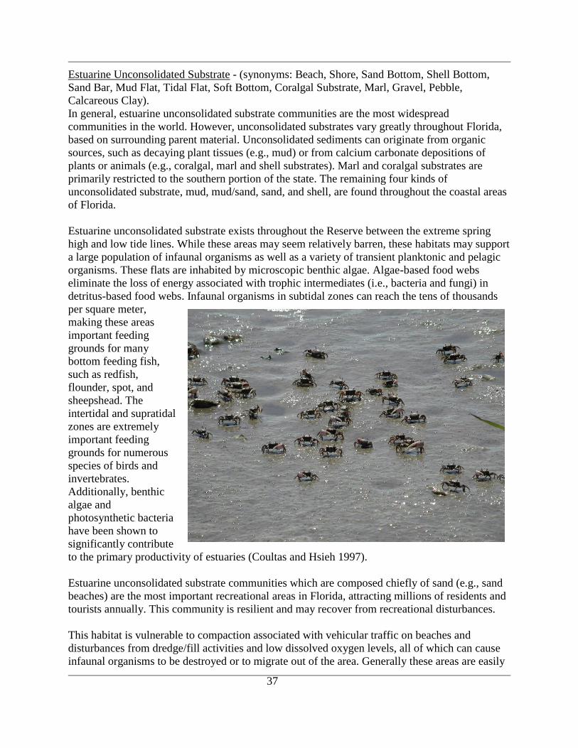
37
Estuarine Unconsolidated Substrate - (synonyms: Beach, Shore, Sand Bottom, Shell Bottom,
Sand Bar, Mud Flat, Tidal Flat, Soft Bottom, Coralgal Substrate, Marl, Gravel, Pebble,
Calcareous Clay).
In general, estuarine unconsolidated substrate communities are the most widespread
communities in the world. However, unconsolidated substrates vary greatly throughout Florida,
based on surrounding parent material. Unconsolidated sediments can originate from organic
sources, such as decaying plant tissues (e.g., mud) or from calcium carbonate depositions of
plants or animals (e.g., coralgal, marl and shell substrates). Marl and coralgal substrates are
primarily restricted to the southern portion of the state. The remaining four kinds of
unconsolidated substrate, mud, mud/sand, sand, and shell, are found throughout the coastal areas
of Florida.
Estuarine unconsolidated substrate exists throughout the Reserve between the extreme spring
high and low tide lines. While these areas may seem relatively barren, these habitats may support
a large population of infaunal organisms as well as a variety of transient planktonic and pelagic
organisms. These flats are inhabited by microscopic benthic algae. Algae-based food webs
eliminate the loss of energy associated with trophic intermediates (i.e., bacteria and fungi) in
detritus-based food webs. Infaunal organisms in subtidal zones can reach the tens of thousands
per square meter,
making these areas
important feeding
grounds for many
bottom feeding fish,
such as redfish,
flounder, spot, and
sheepshead. The
intertidal and supratidal
zones are extremely
important feeding
grounds for numerous
species of birds and
invertebrates.
Additionally, benthic
algae and
photosynthetic bacteria
have been shown to
significantly contribute
to the primary productivity of estuaries (Coultas and Hsieh 1997).
Estuarine unconsolidated substrate communities which are composed chiefly of sand (e.g., sand
beaches) are the most important recreational areas in Florida, attracting millions of residents and
tourists annually. This community is resilient and may recover from recreational disturbances.
This habitat is vulnerable to compaction associated with vehicular traffic on beaches and
disturbances from dredge/fill activities and low dissolved oxygen levels, all of which can cause
infaunal organisms to be destroyed or to migrate out of the area. Generally these areas are easily
38
recolonized either by the same organisms or a series of organisms which eventually results in the
community returning to its original state once the disturbance has ceased. In extreme examples,
significant alterations of elevation or sediment grain size distribution can also cause long-term
impacts to this habitat.
Estuarine unconsolidated habitat is also susceptible to the accumulation of toxic levels of heavy
metals, oils, and pesticides associated with fine-grained sediments and organic matter.
Significant amounts of these compounds in the sediments will harm the infaunal organisms,
thereby eliminating or contaminating a food source for certain fishes, birds, and other organisms.
Such problems primarily occur in some of the major cities, in areas where there is heavy
industrial development, near sewage treatment plant outfalls, and along major shipping channels
where oil spills are more likely to occur. Improperly treated stormwater runoff from residential
areas is becoming a progressively more important source of pollutants as human population
densities increase along the coast.
Estuarine Mollusk Reef - (synonyms: Oyster Bar, Oyster Reef, Oyster Bed, Oyster Rock, Oyster
Grounds, Mussel Reef).
Marine and estuarine mollusk reefs are faunal based natural communities typically characterized
as expansive concentrations of sessile mollusks occurring in intertidal and subtidal zones. The
most common type of mollusk reef in the GTMNERR, oyster reef, is common in the low-energy,
sedimentary environment characteristic of the continuous strands of tidal marsh occurring along
the Tolomato, Guana and Matanzas Rivers. It occurs in water salinities from just above fresh
water to just below full strength sea water, but develops most frequently in estuarine water with
salinities between 15 and 30 ppt. Their absence in marine water is largely attributed to the many
predators, parasites, and diseases of oysters that occur in higher salinities. Prolonged exposure to
low salinities (less then 2 ppt) is also known to be responsible for massive mortality of oyster
reefs. Thus, significant increases or decreases in salinity levels through natural or unnatural
alterations of freshwater inflow can be detrimental to oyster mollusk reef communities. The
condition of this community provides a valuable performance indicator for restoring natural
freshwater inflows to altered estuarine habitats.
The extensive surface area of an oyster reef provides essential habitat for a wide variety of
organisms. Every square meter of oyster bed provides up to 50 square meters of hard substrate
(Bahr and Lanier 1981). This substrate is colonized by many suspension- and deposit-feeding
macrofaunal consumers such as barnacles, polychaetes, amphipods, and mud crabs. These are
preyed upon by carnivores, such as the blue crab and black drum. Oyster reefs that are exposed
during low tides are frequented by a multitude of shorebirds, wading birds, raccoons, and other
vertebrates.
One of the functions of the mollusk reef inhabitants in a tidal marsh ecosystem is to mineralize
organic carbon and release nitrogen and phosphorus in forms usable by the primary producers
(phytoplankton and benthic algae). Oyster reefs also affect the physiography and hydrology of
the estuary by modifying current velocities and changing sedimentation rates and patterns.
Oyster reefs trap sediment, stabilize erosional processes, and provide a stable island of hard
substrate.
39
The major threats to mollusk reefs continue to be pollution and substrate degradation due, in
large part, to upland development. Mollusks are filter feeders, filtering up to 100 gallons of water
a day. In addition to filtering food, they also filter and accumulate toxins from polluted waters.
Sources of these pollutants can be from considerably distant areas, but are often more damaging
when nearby. Substrate degradation occurs when silts, sludge and dredge spoils cover and bury
the mollusk reefs.
Marine Unconsolidated Substrate - (synonyms: Beach, Shore, Sand Bottom, Shell Bottom, Sand
Bar, Mud Flat, Tidal Flat, Soft Bottom, Coralgal Substrate, Marl, Gravel, Pebble, Calcareous
Clay).
Unconsolidated substrates are marine mineral-based communities found along the shoreline of
the Atlantic Ocean. The beach substrate is mainly coquina with white quartz sand. Although the
turbulent wave conditions appear to result in an unstable and harsh environment, the surf zone is
an important habitat for a variety of animal life. For species adapted to this environment, the
wave energy may provide a subsidy by supplying plankton and detritus to secondary filter
feeders, exposing prey to fishes, and concentrating plankton along the swash zone (Ross 1983).
Swash zones also act as biological purification systems for coastal water.
Organic matter from the ocean, especially macroscopic algae, is acted upon by bacteria in the
beach sands. The bacteria are, in turn, eaten by nematodes, flatworms, protozoa, and amphipods.
In the high energy zone of the beach, permanent residents are primarily burrowing marine life
such as ghost shrimp, polychaetes, and sea cucumbers. At low tide, shore birds actively feed on
the many burrowing organisms.
For some fish species, the surf zone is used only by larval stages, with juveniles occurring in
other, primarily lower salinity, environments. Other species spawn offshore and utilize the surf
zone as a juvenile nursery area. A third group spawns offshore and nearshore and may be found
in the surf zone as larvae, juveniles, or even adults.
Marine Consolidated Substrate - (synonyms: Hard Bottom, Rock Bottom, Limerock Bottom,
Coquina Bottom, Relic Reef).
This community is represented by an outcrop of coquina rock called the Anastasia Formation
that is supratidal to subtidal. Zonation of the plants and animals is driven by the tides, with the
supratidal zone labeled the black zone, followed by the yellow zone, the green zone, and the red
zone. Colors are the result of the dominant alga. Well over 100 species of plants and animals
have been identified from this formation in Washington Oaks State Garden. The resilience of this
habitat to anthropogenic disturbance requires further study.
Open Water - This is a non-FNAI categorized marine habitat consisting of coastal rivers, tidal
creeks and estuarine open water areas, as well as the pelagic water areas of marine habitat within
state waters that extend three nautical miles off the coast.
Beach Dune – (synonyms: Sand Dunes, Pioneer Zone, Upper Beach, Sea Oats Zone, Coastal
Strand).
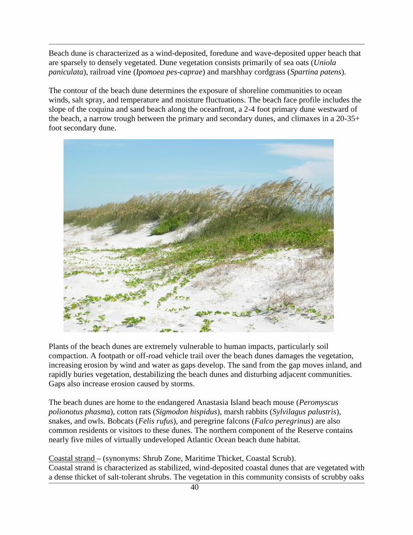
40
Beach dune is characterized as a wind-deposited, foredune and wave-deposited upper beach that
are sparsely to densely vegetated. Dune vegetation consists primarily of sea oats (Uniola
paniculata), railroad vine (Ipomoea pes-caprae) and marshhay cordgrass (Spartina patens).
The contour of the beach dune determines the exposure of shoreline communities to ocean
winds, salt spray, and temperature and moisture fluctuations. The beach face profile includes the
slope of the coquina and sand beach along the oceanfront, a 2-4 foot primary dune westward of
the beach, a narrow trough between the primary and secondary dunes, and climaxes in a 20-35+
foot secondary dune.
Plants of the beach dunes are extremely vulnerable to human impacts, particularly soil
compaction. A footpath or off-road vehicle trail over the beach dunes damages the vegetation,
increasing erosion by wind and water as gaps develop. The sand from the gap moves inland, and
rapidly buries vegetation, destabilizing the beach dunes and disturbing adjacent communities.
Gaps also increase erosion caused by storms.
The beach dunes are home to the endangered Anastasia Island beach mouse (Peromyscus
polionotus phasma), cotton rats (Sigmodon hispidus), marsh rabbits (Sylvilagus palustris),
snakes, and owls. Bobcats (Felis rufus), and peregrine falcons (Falco peregrinus) are also
common residents or visitors to these dunes. The northern component of the Reserve contains
nearly five miles of virtually undeveloped Atlantic Ocean beach dune habitat.
Coastal strand – (synonyms: Shrub Zone, Maritime Thicket, Coastal Scrub).
Coastal strand is characterized as stabilized, wind-deposited coastal dunes that are vegetated with
a dense thicket of salt-tolerant shrubs. The vegetation in this community consists of scrubby oaks
41
(Quercus geminata, Q. myrtifolia, Q. chapmanii.), redbay (Persea borbonia), saw palmetto
(Serenoa repens), yaupon holly (Ilex vomitoria), wild olive (Osmanthus americana), scattered
cabbage palm (Sabal palmetto) and southern magnolia (Magnolia grandiflora). The overall
physical shaping of this community is maintained in part by the shearing effect of salt winds
coming across the dunes and sculpturing the oak-dominated vegetation.
Coastal strand dunes are generally quite stable but are susceptible to severe damage if the
vegetation is disturbed. Shrubs in the coastal strand are frequently dwarfed and pruned as a result
of the salt spray-laden winds that kill twigs on the seaward side, producing a smooth, dense
upward-slanting canopy resembling a sheared hedge. Coastal strand is actually an ecotonal
community that generally lies between beach dune and maritime hammock. It may also grade
into scrub, and it often shares many of the same species that occur in coastal berm. Fire may
reduce succession towards maritime hammock. However, maritime influences alone will often
suffice to inhibit succession to forest.
Coastal strand is one of the most rapidly disappearing community types in Florida. It is most
extensive along the Atlantic Coast where, being elevated and next to the coast, it is prime resort
or residential property. Coastal strand originally occurred as a nearly continuous band along the
Atlantic shorelines. Now it occurs largely as broken and isolated small stretches. Along with
other coastal communities, coastal strand protects inland communities from the severe effects of
storms.
This habitat is utilized by migrating birds such as gray catbird (Dumetella carolinensis), painted
bunting (Passerina ciris), wood warblers, and resident species such as northern cardinal
(Cardinalis cardinalis), northern mockingbird (Mimus polyglottos), Carolina wren (Thryothorus
ludovicianus), marsh rabbit, six-lined racerunner (Cnemidophorus sexlineatus), gopher tortoise
(Gopherus polyphemus) and eastern coachwhip (Masticophis flagellum).
Maritime Hammock - (synonyms: Coastal Hammock, Maritime Forest, Tropical Hammock).
Maritime hammock is characterized as a narrow band of hardwood forest lying just inland of the
coastal strand community.
The maritime hammock community is represented in both barrier island and interior portions of
the Reserve and is composed of an over-story of live oak (Quercus virginiana), laurel oak (Q.
laurifolia), pignut hickory (Carya glabra), southern magnolia, and redbay. The understory is
very open, consisting of saplings of the above mentioned species, yaupon, a variety of sedges,
and saw palmetto. White-tailed deer (Odocoileus virginianus), bobcats, raccoons (Procyon
lotor), opossums (Didelphis virginiana), gopher tortoises, rattlesnakes and migratory songbirds
all use this extensive area.
The generally mesic conditions and insular locations of well-developed maritime hammock
communities inhibit natural fires, which occur no more frequently than once every 26 to 100
years. In mature maritime hammock, fire may alter the original appearance, obscuring former
beach ridge vegetation patterns and creating a diversity of plant sub-associations. Nutrient
recycling is generally accomplished by biological based processes instead of by fire.
42
Maritime hammock is the terminal stage of succession in coastal areas. Maritime hammock is
prime resort and residential property because of its relatively protected location along the coast.
Although it originally occurred in virtually continuous bands with coastal strand, maritime
hammock is now dissected into fragments by development and is rapidly disappearing. Maritime
hammock is reasonably resilient so long as the canopy remains intact and the landform stable.
Xeric Hammock – (synonyms: Xeric Forest, Sand Hammock, Live Oak Forest, Oak Woodland,
Oak Hammock).
Xeric hammock is characterized as either a scrubby, dense, low canopy forest with little
understory other than palmetto, or a multi-storied forest of tall trees with an open or closed
canopy.
Xeric hammock is an advanced successional stage of scrub or sandhill and occurs on sand ridges
along former shorelines. The variation in vegetation structure is predominantly due to the
original community from which it developed. As with maritime hammocks, an important factor
in the development and maintenance of the hammock is the canopy. The species composition is
often similar to maritime hammock, composed of an over-story of live oak, sand live oak (Q.
geminata), laurel oak, pignut hickory, southern magnolia, and redbay. In all cases, however, the
soils consist primarily of deep, well-drained sands that were derived from old dune systems.
Soils are the best measure to delineate these relict scrubby ridges, and therefore the distribution
of this community follows closely to that of Astatula fine sands. The sparsity of herbs and the
relatively incombustible oak litter preclude most fires from invading xeric hammock. When fire
does occur, it is nearly always catastrophic and may revert xeric hammock into another
community type. Xeric hammock only develops on sites that have been protected from fire for
30 or more years.
Scrub – (synonyms: Sand Pine Scrub, Florida Scrub, Sand Scrub, Rosemary Scrub, Oak Scrub).
Scrub occurs in many forms, but is often characterized as a closed to open canopy forest of sand
pines with dense clumps or vast thickets of scrub oaks and other shrubs dominating the
understory.
Patches of maturing scrub are mixed in with the xeric hammock community. These small
patches, which are dominated by sand live oak, myrtle oak (Q. myrtifolia), Chapman‟s oak (Q.
chapmanii), staggerbush (Lyonia ferruginea), fetterbush (L. lucida) and several other ericaceous
plants, comprise one twelve-acre parcel plus several smaller areas scattered throughout the
interior of the Reserve‟s northern component.
Scrub is essentially a fire maintained community. Ground vegetation is extremely sparse and leaf
fall is minimal, thus reducing the chance of frequent ground fires. As the sand pines mature,
however, they retain most of their branches and build up large fuel supplies in their crowns.
When a fire does occur, this fuel supply, in combination with the resinous needles and high stand
density, ensures a hot, fast burning fire. Such fires allow for the regeneration of the Scrub
community which might otherwise succeed to xeric hammock. The minerals in the vegetation are
deposited on the bare sand as ashes, and the heat of the fire generally facilitates the release of
pine seeds. As discerned from the life histories of the dominant plants, scrub probably burns
catastrophically once every 20 to 80 years or longer. Scrub is also readily damaged by off-road

43
vehicle traffic or even foot traffic, which destroys the delicate ground cover and allows the loose
sand to erode. Once disturbed, ground lichens may require 50 years or more to recover. These
scrub areas have been fire excluded long enough that future management will undoubtedly
require mechanical treatment to knock back the aging scrub oaks.
Mesic Flatwoods - (synonyms: Pine Flatwoods, Pine Savannahs, Pine Barrens).
Mesic Flatwoods are characterized as an open canopy forest of widely spaced pine trees with
little or no understory but a dense ground cover of herbs and shrubs.
Mesic flatwoods occur on relatively flat, moderately to poorly drained terrain. The soils typically
consist of 1-3 feet (.3 to 1 meters) of acidic sands generally overlying an organic hardpan or
clayey subsoil. The hardpan substantially reduces the percolation of water below and above its
surface. During the rainy seasons, water frequently stands on the hardpan's surface and briefly
inundates much of the flatwoods; while during the drier seasons, ground water is unobtainable
for many plants whose roots fail to penetrate the hardpan. Thus, many plants are under the stress
of water saturation during the wet seasons and under the stress of dehydration during the dry
seasons.
The mesic flatwood community is dominated by slash pine and pond pine (Pinus serotina). The
understory consists of saw palmetto, gallberry (Ilex glabra), tarflower (Befaria racemosa),
grasses such as wiregrass (Aristida beyrichiana), and a variety of sedges.
As a pyrogenic community, this pineland stand must be prescribed burned on a two-five year
rotation in order to control hardwood encroachment and to prevent accumulation of excessive
fuel loads. Nearly all plants and animals inhabiting this community are adapted to periodic fires;
several species depend on fire for their continued existence. Without relatively frequent fires,
mesic flatwoods succeed into hardwood-dominated forests whose closed canopy can essentially
eliminate the ground cover herbs and shrubs. Additionally, the dense layer of litter that
accumulates on unburned sites can eliminate the reproduction of pines which require a mineral
soil substrate for proper germination. Conversely fires that are too frequent or too hot would
eliminate pine recruitment and eventually transform mesic flatwoods into dry prairie.
Shell Mound - (synonyms: Midden, Indian Mound, Tropical Hammock, Maritime Hammock,
Coastal Hammock).
Shell mound is unusual among the biological communities in that it is largely a result of the
activities of Native Americans, instead of natural physical factors. Shell mounds are small hills,
usually in coastal locations, composed entirely of shells (clams, oysters, whelks) which support
an assemblage of calciphilic plant species. A rich calcareous soil develops on the deposited
shells which supports a diverse hardwood, closed-canopy forest habitat on undisturbed mounds.
The unique shell mound hardwood forest habitat is located at Shell Bluff and several other areas
along much of the perimeter of the Guana peninsula (e.g., Wright‟s Landing). Shell Bluff was
homesteaded in the past and was devoid of vegetation until recently. Today, it is covered almost
exclusively by southern red cedar (Juniperus silicicola), scattered slash pine (Pinus elliottii) and
an understory of grasses and sedges.
44
The greatest threat to this habitat is erosion by tidal currents (Baker 1988), wave action from
boats along the IWW, and sea level rise. A restoration project, completed in 1992 prior to
Reserve designation, attempted to stabilize the Shell Bluff shoreline using coquina rocks. A
recent engineering evaluation (Taylor Engineering, 2007) indicates that inappropriate placement,
size and density of these rocks have worsened the situation. Erosion also continues to be a major
threat to the Shell Mound at the Wright‟s Landing area to the south, where large trees, including
slash pines and some mature sand pines (Pinus clausa) are washing into the Tolomato River.
Coastal Interdunal Swale
This is a habitat that occurs where 1) dune and swale topography has developed within the past
5000 years, 2) a lens of groundwater intersects the bottom of the swales, and 3) extensive
flooding by saltwater is infrequent. Critical to the existence of this habitat is a subsurface
hydraulic connection with the barrier island's water table. The water levels in the interdunal
wetlands are strongly tied to local rainfall events. Consequently, the community varies from
flooded to completely dry depending on rainfall, as well as area and elevation of the surrounding
dunes.
A large expanse of this community type is located within the northern portion of the Reserve.
For all practical purposes, it is the southern portion of an adjacent wetland system managed as
Big Savannah Pond by the Florida Fish and Wildlife Conservation Commission (FWC). Both
wetlands currently function reciprocally because of the hydrologic connection between them and
a large ditch that bisects them. In addition, similar depressional wetlands exist throughout the
barrier island within the coastal strand community; although they are much smaller in size. Two
known sites are located just north of the Reserve‟s central and northern parking areas.
Coastal interdunal swale wetlands are dominated by sand cordgrass (Spartina bakeri),
maidencane (Panicum hemitomon), cinnamon fern (Osmunda cinnamomea), royal fern (O.
regalis) and a rich variety of other herbaceous plants. It is also particularly rich in wildlife,
possessing large numbers of macroinvertebrates, fish, amphibians such as the mole salamander
(Ambystoma talpoideum), snakes, turtles, alligator (Alligator mississippiensis), rodents, river
otter (Lutra canadensis), waterfowl and wading birds like wood stork (Mycteria americana),
roseate spoonbill (Ajaia ajaja), and raptors like American kestrel (Falco sparverius). Striped
newts also use this wetland, usually just following drought conditions when ephemeral pools
begin filling with rainfall. This species has a complex life cycle (Johnson 2002) and appears to
only reproduce in ponds where predatory fish are absent (Moler and Franz 1987).
Little in the way of active management is required for this habitat other than to prevent
disruption by vehicles or excessive foot traffic or disruption of natural hydrology. Fires
occasionally burn through the swales but the dominant factor in this community's development
and maintenance is hydrology.
Sandhill - Sandhill - (synonyms: Longleaf Pine, Turkey Oak, Xerophytic Oak, Deciduous Oak,
High Pine).
Sandhill habitats are characterized as a forest of widely spaced pine trees with a sparse
understory of deciduous oaks and a fairly dense ground cover of grasses and herbs on rolling
hills of sand.
45
Fire is a dominant factor in the ecology of this community. Sandhills are a fire climax
community, being dependent on frequent ground fires to reduce hardwood competition and to
perpetuate pines and grasses. The natural fire frequency appears to be every 2 to 5 years. Without
frequent fires, sandhills may eventually succeed to xeric hammock. Unburned sandhills may be
dominated by turkey oak.
Coastal Berm – (synonyms: Shell Ridge, Coastal Levee, Coastal Forest, Buttonwood
Embankment, Mangrove Hammock).
Coastal berm applies to a variety of plant associations that develop on ridges of storm deposited
sand, shells, and debris. These associations include dense thickets of large shrubs and small trees,
hammocks, or sparse shrubby vegetation with spiny xerophytic plants. Coastal berm habitats are
similar to coastal strand habitats in their physiography and resilience.
Scrubby Flatwood - (synonyms: Xeric Flatwoods, Dry Flatwoods).
Scrubby Flatwoods are characterized as an open canopy forest of widely scattered pine trees with
a sparse shrubby understory and numerous areas of barren white sand. The vegetation is a
combination of scrub and mesic flatwoods species; scrubby flatwoods often occupy broad
transitions or ecotones between these communities.
Scrubby flatwoods generally occur intermingled with mesic flatwoods along slightly elevated
relictual sandbars and dunes. The white sandy soil is several feet deep and drains rapidly.
However, the water table is unlikely to be very deep. Scrubby flatwoods normally do not flood
even under extremely wet conditions. The temperature and humidity of air and soil in scrubby
flatwoods fluctuates substantially more than in most other communities because the scattered
overstory, sparse understory, and barren sands of scrubby flatwoods do not buffer daily and
seasonal changes very well.
Although the elevated, deeper sandy soils of scrubby flatwoods engender a drier environment
than the surrounding mesic flatwoods, the general sparsity of ground vegetation and the greater
proportion of relatively incombustible scrub-oak leaf litter reduce the frequency of naturally
occurring fires. Only after a long absence of fire and during periods of drought does the leaf litter
become sufficiently combustible and concentrated enough to support an ecological burn. Several
species of plants in scrubby flatwoods are typical scrub plants which endure only when long
intervals between fires occur. Thus, a periodicity of approximately 8 to 25 years between fires
appears to be natural for this community.
Upland Mixed Forest - Upland Hardwood Forest and Upland Mixed Forest - (synonyms: Mesic
Hammock, Climax Hardwoods, Upland Hardwoods, Beech-Magnolia Climax, Oak-Magnolia
Climax, Pine-Oak Hickory Association, Southern Mixed Hardwoods, Clay Hills Hammocks,
Piedmont Forest).
Upland mixed forests are characterized as well-developed, closed canopy forests of upland
hardwoods on rolling hills
Soils of upland mixed forests are generally sandy-clays or clayey sands with substantial organic
and often calcareous components. The topography and clayey soils increase surface water runoff,
46
although this is counterbalanced by the moisture retention properties of clays and by the often
thick layer of leaf mulch which helps conserve soil moisture and create mesic conditions.
Furthermore, the canopy is densely closed, except during winter in areas where deciduous trees
predominate. Thus, air movement and light penetration are generally low, making the humidity
high and relatively constant. Because of these conditions upland mixed forests rarely burn.
Upland mixed forests are climax communities for their respective geographic locations. They are
often associated with and grade into upland pine forest, slope forest or xeric hammock.
Occasionally, upland mixed forests may also grade into maritime hammock or prairie hammock.
During early stages of succession, upland mixed forest may be difficult to distinguish from
upland pine forests that have not been burned for several years. Disturbed sites may require
hundreds of years to reach full development with species compositions representative of climax
conditions.
Depression Marsh – (synonyms: Isolated Wetland, Flatwoods Pond, St. John's Wort Pond,
Pineland Depression, Ephemeral Pond, Seasonal Marsh).
Depression marsh is characterized as a shallow, usually rounded depression in sand substrate
with herbaceous vegetation often in concentric bands. A number of small isolated wetlands are
scattered throughout the interior portion of the northern component. These wetlands are
dominated by sand cordgrass, maidencane, and a rich variety of other herbaceous plants. As with
swale wetlands, these depressional marshes possess a rich diversity of associated animals. One
listed species found here is the striped newt (Notophthalmus perstriatus).
Depression marshes occur where sand has slumped and created a conical depression
subsequently filled by direct rain fall, runoff, or seepage from surrounding uplands. The substrate
is usually acid sand with deepening peat toward the center. Some depressions may have
developed or be maintained by a subsurface hardpan. Hydrological conditions vary, with most
depression marshes drying in most years. Hydroperiods range widely from as few as 50 days or
less to more than 200 days per year.
Fire is important to maintaining this community type by restricting invasion of shrubs and trees
and the formation of peat. Fire frequency is often greatest around the periphery of the marsh and
least toward the center. Severe peat fire can lower the ground surface and create a pond at the
center of the marsh. Hydrologic conditions and species composition must be monitored and used
to assess ecological targets to guide fire management.
Dome Swamp - (synonyms: Isolated Wetland Cypress Dome, Cypress Pond, Gum Pond,
Bayhead, Cypress Gall, Pine Barrens Pond).
Dome swamps are characterized as shallow, forested, usually circular depressions that generally
present a domed profile because smaller trees grow in the shallower waters at the outer edge,
while bigger trees grow in the deeper water in the interior. Pond cypress, swamp tupelo, and
slash pine are common plants.
Dome swamps typically develop in sandy flatwoods areas where sand has slumped creating a
conical depression. Soils are composed of peat, which becomes thickest toward the center of the
47
dome, and are generally underlain with acidic sands and then limestone, although other subsoils
may also occur. Some domes have a clay lens that helps retain water levels.
Dome swamps often derive much of their water through runoff from surrounding uplands, but
they may also be connected with underground channels, in which case subterranean flows would
dominate the hydrological regime. Dome swamps generally function as reservoirs that recharge
the aquifer. The normal hydroperiod for Dome swamps is 200 to 300 days per year with water
being deepest and remaining longest near the center of the dome.
Fire is essential for the maintenance of a cypress dome community. Without periodic fires,
hardwood invasion and peat accumulation would convert the dome to Bottomland Forest or Bog.
Dome swamps dominated by bays are close to this transition. Fire frequency is greatest at the
dryer periphery of the dome and least in the interior where long hydroperiods and deep peat
maintain high moisture levels for most of the year. The normal fire cycle might be as short as 3
to 5 years along the outer edge and as long as 100 to 150 years towards the center. The profile of
a Dome swamp (i.e., smaller trees at the periphery and largest trees near the center) is largely
attributable to this fire regime. The shorter hydroperiods along the periphery permit fires to burn
into the edge more often, occasionally killing the outer trees. Cypress is very tolerant of light
surface fires, but muck fires burning into the peat can kill them, lower the ground surface, and
transform the dome into a pond.
Floodplain Swamp - (synonyms: River Swamp, Bottomland Hardwoods, Seasonally Flooded
Basins or Flats, Oak-Gum-Cypress, Cypress-Tupelo, Slough, Oxbow, Back Swamp).
Floodplain swamps occur on flooded soils along stream channels and in low spots and oxbows
within river floodplains.
Soils of floodplain swamps are highly variable mixtures of sand, organic, and alluvial materials,
although some sites, especially within sloughs or on smaller streams, may have considerable peat
accumulation. Floodplain swamps are flooded for most of the year, with sites along channels
inundated by aerobic flowing water while those of sloughs and backswamps are naturally
flooded with anaerobic water for extensive periods of time. Soils and hydroperiods determine
species composition and community structure. Seasonal and often prolonged inundations restrict
the growth of most shrubs and herbs, leaving most of the ground surface open or thinly mantled
with leaf litter. Floods redistribute detritus to other portions of the floodplain or into the main
river channel. This rich organic debris is essential to the functional integrity of downriver
ecosystems such as estuaries. These swamps are usually too wet to support fire.
Flatwoods/Prairie/Marsh Lake - (synonyms: Flatwoods Pond, Ephemeral Pond, Grass Pond, St.
John's Wort Pond, Freshwater Lake, Pineland Depression, Swale, Prairie Pond).
The distinctions between these communities, and from depression marsh, are often quite subtle,
because of their successional interrelationships.
Water for this habitat is derived mostly from runoff from the immediately surrounding uplands.
This habitat functions as aquifer recharge areas by acting as reservoirs. Water generally remains
throughout the year in a flatwoods/prairie lake or a marsh lake, although water levels may
48
fluctuate substantially. Alterations in natural hydrologic conditions and water quality are the
primary disturbances to this habitat.
Blackwater Stream - (synonyms: Blackwater River, Blackwater Creek).
Blackwater streams are characterized as perennial or intermittent seasonal watercourses
originating deep in sandy lowlands where extensive wetlands with organic soils function as
reservoirs, collecting rainfall and discharging it slowly to the stream. The tea-colored waters of
blackwater streams are laden with tannins, particulates, dissolved organic matter and iron derived
from drainage through swamps and marshes.
Blackwater streams are the most widely distributed and numerous riverine systems in the
southeast coastal plain. Very few, however, have escaped major disturbances and alteration.
Clearcutting adjacent forested lands and disruptions to natural hydrology are two of the more
devastating alterations for this community. Additionally, limited buffering of blackwater streams
from development intensifies the detrimental impacts of agricultural, residential and industrial
polluted runoff.
Ruderal
This habitat consists of areas where natural ground cover is severely disturbed by human
influence. Developed land within the Reserve consists of the maintenance and office facilities,
parking lots, trails, roads, nature centers, restrooms and other structures found within the
boundary. To minimize the environmental impact of these structures, careful planning is needed
to limit impervious surfaces, select environmentally friendly landscaping, construction and
maintenance materials and monitor the surrounding natural environment for unintentional harm.
Biological Community Profiles
Plankton
Little research has been done on plankton communities within the GTMNERR up to this point.
However, Dr. Edward Phlips (University of Florida) has investigated phytoplankton structure,
and phytoplankton bloom density and spread, an important issue related to animal and human
health. Though the focus of this research is on phytoplankton dynamics, whole samples for
phytoplankton and zooplankton enumeration and identification have been collected and
preserved.
Karenia brevis, the „red tide‟ organism, is a common, unarmored, photosynthetic dinoflagellate
found year-round throughout the Gulf of Mexico at background concentrations of 1,000 cells per
liter or less and is occasionally found in Atlantic coastal waters. K. brevis produces brevetoxins
that are capable of killing fish, birds, and other marine animals. Bottom-dwellers such as
groupers and grunts are usually the first fish to die in a Florida red tide, although most fish are
probably susceptible. Mortality, in terms of numbers killed and species affected, can be severe
and is dependent upon factors such as bloom density and the length of time animals are exposed
to the toxins.
There are periodic blooms on the east coast of Florida, with a bloom recently occurring in
October 2007 within the waters of the GTMNERR. The bloom began in the coastal waters
49
between the mouths of the St. Johns and Nassau Rivers. The bloom persisted, moving south
along the coast and entering both the St. Augustine and Matanzas Inlets. Cell counts as high as 5
million cells/L were recorded in the Matanzas River south of the 206 bridge (Hitchcock and
Frazel, unpublished raw data). Net community production and respiration rates from „light-dark‟
bottle incubations of K. brevis populations revealed the „red tide‟ along Florida‟s northeast coast
was predominantly autotrophic (Production > Respiration) (Hitchcock and Frazel, unpublished
raw data).
Dr. James Fourqurean, with Florida International University (FIU), and Dr. Gary Hitchcock from
the University of Miami (UM), have assessed red tide toxins in sediments and epiphyte
communities, including marsh grasses and seagrasses throughout the state. Several sample sites
within the Reserve were included in the survey. The joint FIU/UM project, co-sponsored by the
National Science Foundation and the National Institutes of Health, has investigated ecological
linkages between epiphytes and K. brevis through DNA analysis.
Vegetation
There are currently 580 plant species identified within the GTMNERR (Appendix A). The
diverse plant community covers marine, littoral, estuarine, wetland and upland habitats.
Listed Species
The following plant species are those that are listed by the USFWS as endangered, threatened
or of special concern within the Reserve.
The sand-dune spurge (Chamaesyce cumulicola), also known as the coastal dune
sandmat, is fairly common in areas where the groundcover is discontinuous. It is low
growing, as opposed to other more erect species. It blooms in spring, summer, and fall,
and is found in dune and scrub habitat.
Coastal vervain (Glandularia maritima) is designated as an endangered species by the
State of Florida. It is a small, lavender-flowered member of the Verbenaceae family. It
inhabits dunes and coastal ridges.
Crested coralroot (Hexalectris spicata) is a small, ground-dwelling member of the orchid
family. Crested coralroot is known to inhabit calcareous hammocks and shell middens,
and it blooms in the spring and summer.
Angle pod (Matelea gonocarpa) is a perennial, twisting vine that is found in hammocks.
Angle pod flowers have yellow or greenish-brown petals, when it blooms during the
spring and summer.
Pygmy-pipes (Monotropsis odorata) are small perennial herbs that are conspicuous for
their lack of chlorophyll. They compensate by being parasitic on underground fungi
associated with tree roots.
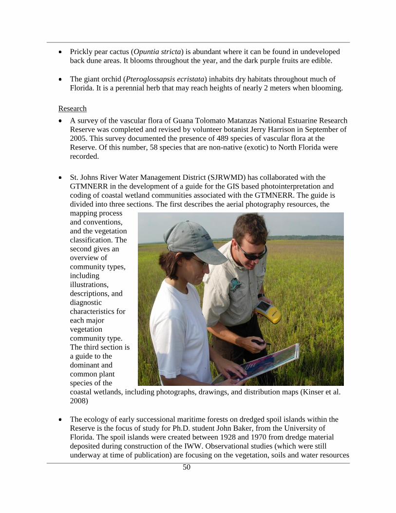
50
Prickly pear cactus (Opuntia stricta) is abundant where it can be found in undeveloped
back dune areas. It blooms throughout the year, and the dark purple fruits are edible.
The giant orchid (Pteroglossapsis ecristata) inhabits dry habitats throughout much of
Florida. It is a perennial herb that may reach heights of nearly 2 meters when blooming.
Research
A survey of the vascular flora of Guana Tolomato Matanzas National Estuarine Research
Reserve was completed and revised by volunteer botanist Jerry Harrison in September of
2005. This survey documented the presence of 489 species of vascular flora at the
Reserve. Of this number, 58 species that are non-native (exotic) to North Florida were
recorded.
St. Johns River Water Management District (SJRWMD) has collaborated with the
GTMNERR in the development of a guide for the GIS based photointerpretation and
coding of coastal wetland communities associated with the GTMNERR. The guide is
divided into three sections. The first describes the aerial photography resources, the
mapping process
and conventions,
and the vegetation
classification. The
second gives an
overview of
community types,
including
illustrations,
descriptions, and
diagnostic
characteristics for
each major
vegetation
community type.
The third section is
a guide to the
dominant and
common plant
species of the
coastal wetlands, including photographs, drawings, and distribution maps (Kinser et al.
2008)
The ecology of early successional maritime forests on dredged spoil islands within the
Reserve is the focus of study for Ph.D. student John Baker, from the University of
Florida. The spoil islands were created between 1928 and 1970 from dredge material
deposited during construction of the IWW. Observational studies (which were still
underway at time of publication) are focusing on the vegetation, soils and water resources

51
of these islands. The composition and abundance of the herbaceous subcanopy, and
canopy vegetative communities are being sampled. Experiments are exploring the ability
of spoil islands to support maritime forests and determine what environmental factors are
preventing trees from growing in spoil fields.
Ho et al. (2005) tested the biogeographic theory predicting that plant-herbivore
interactions are more intense at low versus high latitudes, using a site within the Reserve
as one of the low-latitude sites. Results from the testing of hypotheses demonstrated that
herbivore density is indeed higher at low versus high latitudes; and that damage to plants
by herbivores is greater at low versus high latitudes. More details of the study, funded
through the Reserve‟s Graduate Research Fellowship Program are given in the
description of that program under the Section on Research and Monitoring Activities.
The northern extent of both the red mangrove (Rhizophora mangle) and black mangrove
(Avicennia germinans) occurs within the GTMNERR. However, changes in climate may
in turn alter the distribution of the red mangrove. Leitholf and Weishampel (2007) were
testing the hypothesis that increasing temperatures and a reduction in the freeze
frequency, will result in a northward expansion of mangroves into the salt marsh zone in
the GTMNERR. The goals of the project were to determine the importance of abiotic
processes such as temperature and salinity on mangrove demography, and to create a
computer model simulating mangrove dynamics under different climate changes and
invasion scenarios.
A study by Leitholf (2008) documented the phenology of the mangroves and the invasive
Brazilian pepper (Schinus terebinthifolius) along the northern ecotone of the species and
determined that temperature was a correlating factor in the growth and distribution S.
terebinthifolius.
A simulation model was also developed which focused on the establishment and
competition among the three mangrove species and the invading S. terebinthifolius. This
model was run under various invasion and/or climate change scenarios to determine
possible outcomes under global climate change with or without the presence of S.
terebinthifolius. It was concluded that under all scenarios of invasion, other than sea level
rise as part of global climate change, S. terebinthifolius would dominate the landscape if
allowed to invade and establish in areas in which it is not currently present.
It is generally believed that tidal marshes are nitrogen limited systems and that marsh
plants solely utilize the inorganic forms of nitrogen, ammonium and nitrate. Recent
research has demonstrated the ability of S. alterniflora to take up dissolved organic
nitrogen (DON) directly; however, DON has been neglected by scientists and is poorly
characterized in temperate salt marshes. To evaluate the existence of latitudinal gradients
in the availability of dissolved organic nitrogen in S. alterniflora salt marshes along the
Atlantic coast, Mozdzer et al. (2007) sampled porewater from 8 field sites from Maine to
Florida, with the Florida site being located within the GTMNERR. By combining
information on the availability and utilization of DON, Mozdzer and colleagues from the
52
University of Virginia hope to create a better understanding of nutrient utilization within
salt marshes of the North American Atlantic coast.
The vascular flora of five Florida shell middens, including the Shell Ring at the former
Guana River State Park showed that over 95% of the flora was native species (Stalter and
Kincaid (2004). Calcareous soils were determined to be a major influence on species
distribution at such upland shell midden sites.
Reserve scientists, along with Jacksonville University researchers are assessing the
effects of coastal strand habitat management on existing and future invasive plant
populations in the GTMNERR. The size and extent of invasive populations of exotic
species such as tropical soda apple (Solanum viarium), Brazilian pepper (Schinus
terebinthifolius), and Chinese tallow (Sapium sebiferum) is unknown and will be
evaluated through vegetation surveys. The team will also assess the impact of
management activities/techniques on the suppression and eradication of invasive plants,
as well as the impact of vegetation control on wildlife.
A study of plant colonization on dead margins in the GTM estuaries was initiated in 2008
by University of Central Florida graduate student, Shannon Segelsky (Dr. Linda Walters,
advisor). Dead margins are piles of disarticulated oyster shells that result from boat and
wind wakes. The study is examining at what elevation/tidal range dead margins are
colonized by saltmarsh vegetation. Vertical profiles of reefs with and without dead
margins have been carried out together with mapping/marking the associated vegetation.
This mapping will be redone periodically and all data compared to results of similar
studies in Mosquito Lagoon.
A project initiated in 2009 within the GTMNERR by Christy Crace, graduate student at
the University of North Florida (Dr. Daniel Moon, advisor), is examining how different
insect feeding guilds react to salt-stressed coastal plants. The project has both ecological
and molecular components. The responses of six coastal plant species to induced salt-
stress are being assessed by measuring growth, leaf production, and flowering. Herbivore
responses are determined by visual herbivore counts, indirect visual evidence of insects
(e.g., stem boring), and sweep netting. The molecular component of the project will aid in
quantifying plant stress by measuring foliar nitrogen as well as the activity of certain
stress enzymes; particularly catalase and superoxide dismutase. With rising sea levels,
understanding the effects of salt stress in salt marsh food webs should provide
information for future management of these complex systems.
Reserve staff initiated a collaboration with Dr. Nisse Goldberg (Jacksonville University)
in 2009 to pilot a mangrove-mapping strategy in the GTMNERR. The project utilizes a
GIS-based algorithm developed by NOAA‟s Coastal Services Center for fine-scale
delineation of mangrove habitat using a supervised-classification mapping approach. If
the strategy proves successful, information generated from the project will provide
important baseline maps for subsequent change analyses and ecological studies of
mangrove.
53
Invertebrates
More than 95% of the Earth's animal species are invertebrates, and representative phyla can be
found in some form or another in all of the habitats within the Reserve. More than 500 different
invertebrates have been identified within the Reserve; they are listed in Appendix A. As
integrators of environmental condition, the abundance, diversity, biomass and species
composition of invertebrates can be useful metrics for assessing estuarine health.
(USEPA 2009)
Some of the more prominent invertebrate species are discussed below.
American oyster (Crassostrea virginica)
The American oyster occupies estuarine habitats throughout the eastern and Gulf of Mexico
coasts of the United States. The remains of shell middens in the Reserve show that this animal
has supported a subsistence fishery for inhabitants well before the establishment of St.
Augustine. In addition to its direct economic importance, the oyster also provides important
habitat for many estuarine fish and invertebrate species. In the Reserve, oysters occur along the
full length of the estuary.
Limited recreational oyster and hard clam harvesting occurs within two delineated shellfish
harvest areas in the GTMNERR. In addition, there are currently four aquaculture leases within
the Reserve for oysters and two aquaculture leases for hard clams totaling 42 acres. A brief
description and maps of each of the shellfish areas, including the management status is available
online at http://www.floridaaquaculture.com/pdfmaps.
Shellfish harvesting is managed through the Department of Agriculture and Consumer Services
(FDACS) Division of Aquaculture. The Department routinely monitors fecal coliform and water
quality parameters at established stations in each of Florida's shellfish harvesting areas. Sub-
surface water samples are collected and shipped overnight to a certified laboratory. The analysis
for fecal coliform takes 24 hours, and numbers of bacteria are expressed in the units of Most
Probable Number (MPN) per 100 milliliters (ml). FDACS Division of Aquaculture
(http://www.floridaaquaculture.com/seas/seas_intro.htm).
White and brown shrimp (Penaeus setiferus and Penaeus aztecus)
The white shrimp and brown shrimp are both commercially harvested in northeast Florida and
spend part of their lifecycles within the estuaries of the Reserve. Both species are important in
estuarine and saltmarsh environments as they convert detritus, plant material, microorganisms,
macroinvertebrates, and fish parts into useful protein for higher trophic level organisms.
The white shrimp is generally found in waters that are turbid, shallower, and more brackish than
those in which brown shrimp are found. The white shrimp was the first species of commercial
importance in the U.S., with the fishery for this species dating back to 1709 (Muncy 1984).
Shrimp are also the most economically important fishery in Florida (Seaman 1985).
Blue crab (Callinectes sapidus)
Blue crabs are harvested both recreationally and commercially within the Reserve using crab
traps or pots as the primary method of harvest. Blue crabs spend most of their life cycle within
54
estuarine habitats, although the larval stages develop in the open ocean. Young crabs will move
within estuaries to mid and low salinity waters and grow quickly. Blue crabs reach maturity and
the five inch legal harvest size in one to two years.
Blue crabs play an important role in the marine and estuarine trophic system, as prey and
predators. Florida pompano and other large fish and planktivores (Steele1991) consume larval
blue crabs (Murphy et al. 2001), while juvenile blue crabs are eaten by larger fish such as spotted
seatrout and red drum. The primary predators of adults include raccoons and large wading birds.
Fiddler crabs (Uca sp)
Fiddler crabs are found in the intertidal zone and within salt marshes and are recognized by their
square body and marked difference in size between the right and left claws of males. Two
common species of fiddler crab occur within the GTMNERR; the Atlantic mud fiddler, Uca
pugnax, and the sand fiddler, Uca pugilator. Mud fiddlers are a brownish-yellowish color, and
prefer muddy areas, whereas sand fiddlers inhabit sandy habitats. Fiddler crabs have no directly
quantifiable commercial value but constitute an important food source for marsh birds, blue
crabs and many other species (NOAA 2008).
Marsh periwinkle (Littorina irrorata)
The marsh periwinkle is a small gastropod that can range in color from dark brown to an almost
bleached white. It is an important component of the intertidal salt marsh community. Periwinkles
may be a major participant in the decomposition of cordgrass, Spartina alterniflora, leaves
through a mutualistic association with leaf fungi (Silliman and Newell 2003). Marsh periwinkles
can serve as an indicator species of the health of salt marsh, a habitat that is critical for many
species.
The marsh periwinkle is an obligate salt marsh resident for which cordgrass may be considered a
critical habitat. Individuals can be found inhabiting high-marsh areas around freshwater seeps
and low-marsh stems submerged in full strength seawater (greater than 25 parts per thousand).
Marsh periwinkles feed on microalgae and detritus; they may also garden and consume fungal
decomposers found on the surface of marsh plants (Silliman and Newell 2003).
Research
The bacteria Vibrio vulnificus is an opportunistic pathogen now recognized as the leading
cause of food-associated deaths in Florida. Infections are most frequently contracted after
raw oyster consumption. Gordon et al. (2005) enumerated V. vulnificus in oysters and
waters of the GTMNERR from a series of more than 300 isolates obtained during warm
months. Gordon et al. (2008) have since been able to develop real-time PCR assays that
were sensitive, specific, and quantitative in water samples and could also differentiate the
Vibrio strains in oysters without requiring isolation of V. vulnificus. The assay may
therefore be useful for rapid detection of the pathogens in shellfish and water, as well as
for further investigation of its population dynamics.
Hare (2008) performed genetic analyses on adult and newly-settled oysters collected
within lagoons and near ocean inlets along the Florida coast in 2007 to assess the oyster
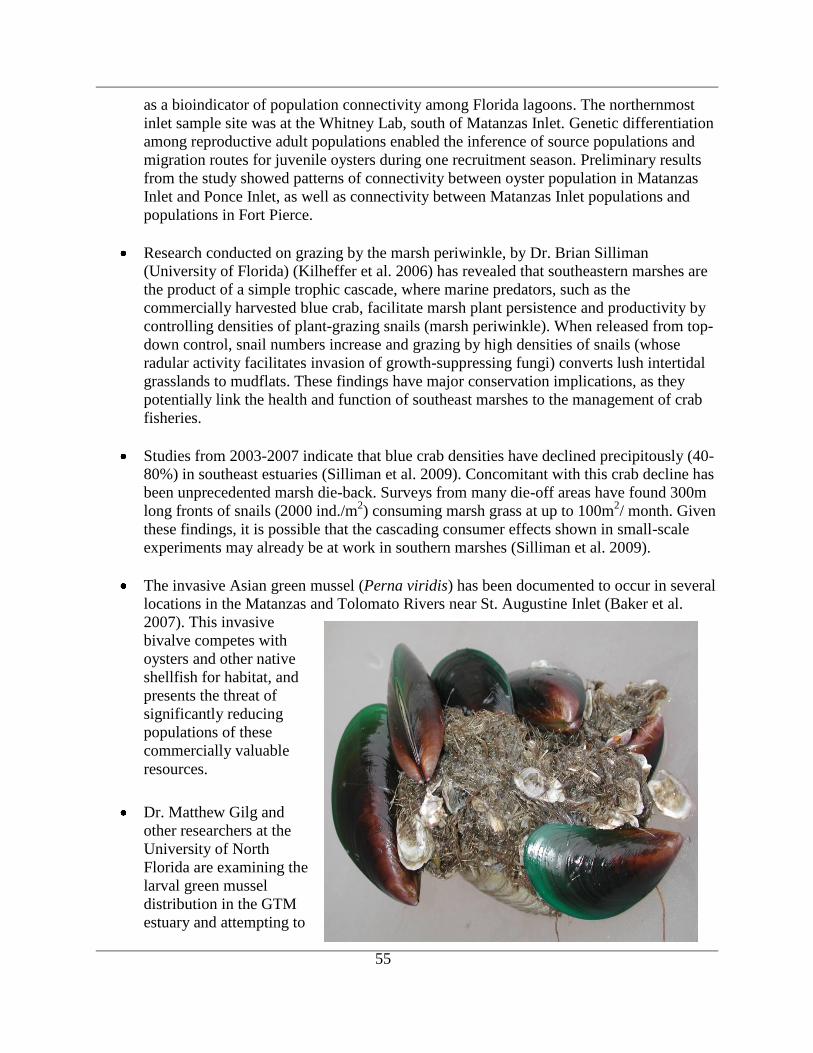
55
as a bioindicator of population connectivity among Florida lagoons. The northernmost
inlet sample site was at the Whitney Lab, south of Matanzas Inlet. Genetic differentiation
among reproductive adult populations enabled the inference of source populations and
migration routes for juvenile oysters during one recruitment season. Preliminary results
from the study showed patterns of connectivity between oyster population in Matanzas
Inlet and Ponce Inlet, as well as connectivity between Matanzas Inlet populations and
populations in Fort Pierce.
Research conducted on grazing by the marsh periwinkle, by Dr. Brian Silliman
(University of Florida) (Kilheffer et al. 2006) has revealed that southeastern marshes are
the product of a simple trophic cascade, where marine predators, such as the
commercially harvested blue crab, facilitate marsh plant persistence and productivity by
controlling densities of plant-grazing snails (marsh periwinkle). When released from top-
down control, snail numbers increase and grazing by high densities of snails (whose
radular activity facilitates invasion of growth-suppressing fungi) converts lush intertidal
grasslands to mudflats. These findings have major conservation implications, as they
potentially link the health and function of southeast marshes to the management of crab
fisheries.
Studies from 2003-2007 indicate that blue crab densities have declined precipitously (40-
80%) in southeast estuaries (Silliman et al. 2009). Concomitant with this crab decline has
been unprecedented marsh die-back. Surveys from many die-off areas have found 300m
long fronts of snails (2000 ind./m2) consuming marsh grass at up to 100m
2/ month. Given
these findings, it is possible that the cascading consumer effects shown in small-scale
experiments may already be at work in southern marshes (Silliman et al. 2009).
The invasive Asian green mussel (Perna viridis) has been documented to occur in several
locations in the Matanzas and Tolomato Rivers near St. Augustine Inlet (Baker et al.
2007). This invasive
bivalve competes with
oysters and other native
shellfish for habitat, and
presents the threat of
significantly reducing
populations of these
commercially valuable
resources.
Dr. Matthew Gilg and
other researchers at the
University of North
Florida are examining the
larval green mussel
distribution in the GTM
estuary and attempting to
56
genetically track the source of the adult populations. Related to this work is the joint
development of a tool by Peter Sheng‟s group at UF‟s Civil and Coastal Engineering
Department, along with the UF Advanced Computing and Information Systems Lab and
SJRWMD‟s Peter Sucsy and Tim Cera, that can be used to examine how green mussel
larvae would be distributed from particular spawning points in the estuary. The tool is a
cyber-infrastructure system which essentially accesses appropriate data sets and
computing assets over the internet through a user-friendly interface to run a 3-D
hydrodynamic model of the GTMNERR.
The utility of dactyls for inferring evolutionary patterns were evaluated by Agnew (2007)
as part of his dissertation project at Louisiana State University. Dactyls are the moveable
part of the claw of the crab. Because of their high preservation potential and uses in foraging
and defense, crab dactyls are potentially excellent test subjects for an ongoing debate
concerning the relative importance of top-down (predators) and bottom-up (prey) controls on
morphologic diversification and evolution. Both living and subfossil xanthoid crabs were
sampled from the southeast U.S. Atlantic and Gulf of Mexico coasts, including intertidal
locations within the GTMNERR. Statistically significant differences in the wear patterns
between live collected crabs and those from death assemblages, indicating more wear in
the death assemblage than the living assemblage. It was suggested that the wear patterns
are caused by shell crushing and that there may have been a fairly recent shift in the diet
of the mud cab (Panopeus sp.). Wear patterns on modern Panopeus on either side of the
Florida peninsula were also different.
This research demonstrated that the relative influence of top-down and bottom-up
controls on dactyl evolution can be identified by correlating dactyl morphologies with
evidence of predation either by crabs (wear patterns) or on crabs (handedness reversals
and predatory fractures) using the most commonly preserved remains of living and/or
fossil taxa.
The Golden apple snail (Pomacea sp.) is an invasive species that has only recently been
documented in the Reserve. Live specimens and photographs of adults and eggs in a
retention pond have been collected near Moultrie Creek. The proximity of this population
to Pellicer Creek Aquatic Preserve presents a serious threat to the aquatic ecosystem
there. They consume almost every submerged aquatic plant species in the Preserve and
have a high reproductive rate. This species has become well established throughout much
of south and central Florida in recent years.
Pristine Florida wildlife habitats are being lost to development and ecosystems are being
threatened more than ever by human encroachment. Published accounts of Florida non-
marine molluscan communities are few in number, brief, not based on strategized
sampling protocol, and scattered in the scientific literature. The relatively intact natural
ecosystems present within the boundaries of the northern component of the GTMNERR
undoubtedly support most of the species of land, aquatic, and estuarine mollusks known
to occur in northeastern Florida. No systematic survey of the non-marine mollusks of the
GTMNERR has ever been undertaken. Harry G. Lee, M.D., Field Associate, Florida
Museum of Natural History initiated such a survey in 2008. A total of 65 species,
57
including 56 native, and 9 introduced species have been identified as of Januay 2009.
(http://www.jaxshells.org/northeas.htm).
Ethan Nash, a graduate student at the University of Central Florida (Dr. Linda Walters,
advisor) commenced research in 2008 to examine the associations of three non-native
species [charru mussel (Mytella charruana), green mussel (Perna viridis), and pink
barnacle (Megabalanus coccopoma)] with different oyster reef types in both Mosquito
Lagoon and the GTM estuarine system. These studies will be complemented by field and
laboratory studies of air exposure and thermal tolerance for Mytella/Perna as this relates
to the ability of the mussels to invade intertidal oyster reefs.
Fishes
The fish communities within the Reserve are a mixed assemblage with freshwater, estuarine and
coastal marine species often coexisting together depending on salinity, temperature, and time of
year. A total of 303 fish species have been identified in GTMNERR habitats including
freshwater, brackish and marine waters. Recreational and commercial fishing are major activities
within the GTMNERR with most effort focused on edible game fishes. Descriptions of some of
the major species are listed below.
Red drum (Sciaenops ocellatus)
Red drum are popular recreational game and food fish found in estuarine areas and nearshore
waters of the Reserve. Red drum prefer shallow waters (0.5-1 meters deep) and are found over
all bottom types. These fish are also commonly found around oyster reefs, though breaks in
continuity of shorelines such as coves, points, jetties, and old pier pilings attract them. During
cold spells large numbers of red drum can be found in tidal creeks and rivers. They can live in
fresh water and have been found well up Pellicer Creek.
Spawning occurs in nearshore waters from August to November. Young red drum feed on small
crabs, shrimp, and marine worms. Adults tend to feed on larger crabs, shrimp, and small fish. A
stock assessment of Red Drum in Florida through 2003, showed that angling success, as
measured by total catch rates increased in 2003, reversing a downward trend seen since the mid
to late 1990‟s (Murphy 2005).
Black drum (Pogonias cromis)
The black drum is a member of the croaker family and is related to both, red drum, and spotted
seatrout. A characteristic of this family of fish is the ability to produce croaking or drumming
sounds with the air bladder, which is the reason for the common names croaker and drum. This
ability is most developed in the black drum and anglers can sometimes hear sounds from schools
passing near their boats. Black drum, the largest members of the family Sciaenidae, can reach
over 46 inches (116 cm) and 120 pounds (54 kg). Long-lived fish, black drum can reach almost
60 years of age (FWC 2006a).
Drum are found in a wide range of habitats in the Reserve, from right at the water‟s edge along
the coast, to the deepest holes (>21 m) in the IWW near St. Augustine. Young drum feed on
marine worms, small shrimp, crabs and small fish. Larger drum eat small crabs, worms, algae,
small fish and mollusks. Barbels under the lower jaw are used to find food by feel and smell.
58
Drum often dig or root out buried mollusks and worms while feeding in a head-down position.
The black drum has no canine teeth like those of the spotted seatrout, but does have highly
developed pharyngeal teeth, which are used to crush mollusks and crabs before swallowing
(Texas Wildlife and Parks Department (TWPD 2007)).
Spotted seatrout (Cynoscion nebulosus)
Spotted seatrout range throughout Florida‟s bays and coastal waters. In northeast Florida adult
spotted seatrout are found over a wide range of estuarine habitats. They are common around
oyster reefs, in deep holes, on sand bottom, and in areas where structure exists.
Maximum ages reached in Florida are 9 years for males and 8 years for females. Spotted seatrout
first spawn between 0 and 2 years old and 11.8–15.7 inches (5.34-7.11 cm) total length (TL).
Spawning occurs within estuaries and in nearshore waters during spring, summer, and fall. The
diet of juvenile seatrout (< 1.2 inches (0.54 cm) TL) includes amphipods and other small
crustaceans. Larger juveniles and adults feed primarily on shrimp and a variety of finfishes,
including other young spotted seatrout (FWC 2007a).
Flounder (Paralichthys sp.)
Nearly all flounders landed by anglers in Florida are one of three species in the genus
Paralichthys: gulf flounder P. albigutta; southern flounder, P. lethostigma; or summer flounder,
P. dentatus. All three species occur within the waters of the GTMNERR. The distributions of
gulf and southern flounder appear to be substrate-related. Southern flounder are found on silt and
mud, and gulf flounder are found mostly on sand. Female southern flounder mature at age 3 or 4,
and female gulf flounder mature at age 1. Both species spawn in offshore waters during late fall–
winter (65 ft–200 ft) (20-60m). Gulf flounders are benthic carnivores. Large juveniles feed
primarily on small fish and crustaceans (shrimp and crabs). Adults feed on schooling fish such as
menhaden, bay anchovy, pinfish, grunts, pigfish, Atlantic croaker, and mullet (FWC 2006b)
Striped mullet (Mugil cephalus)
Striped mullet, are perhaps the most widespread and abundant inshore teleost (Odum 1970).
They are an ecologically important component in the flow of energy through estuarine
communities and occur in both the estuaries and nearshore coastal waters of the Reserve.
Diet and feeding behavior of juvenile and adult striped mullet may vary by location, but they
primarily feed on epiphytic and benthic microalgae, macrophyte detritus, or inorganic sediment
particles. Sediment particles function as a grinding paste in the gizzard-like pyloric portion of the
stomach (Odum 1970). Larval and post-larval mullet feed on zooplankton (Nash et al. 1974).
The major predators of juvenile and adult mullet are fishes and birds (Thomson 1963). Among
fishes, spotted seatrout, red drum, hardhead catfish, and southern flounder will prey on mullet in
the Reserve. Wading birds also prey on mullet
Striped mullet is one of the most important inshore finfish fisheries in Florida as both a food fish
and for roe exported overseas. In 2004, commercial landings of striped mullet (7.6 million
pounds) (3.4 million kg) constituted fourteen percent of total finfish landings (53 million pounds)
(24 million kg) and eight percent of total commercial finfish dockside dollar value (Mahmoudi
2005).
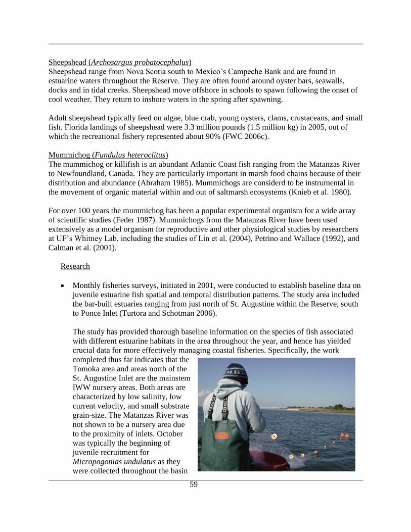
59
Sheepshead (Archosargus probatocephalus)
Sheepshead range from Nova Scotia south to Mexico‟s Campeche Bank and are found in
estuarine waters throughout the Reserve. They are often found around oyster bars, seawalls,
docks and in tidal creeks. Sheepshead move offshore in schools to spawn following the onset of
cool weather. They return to inshore waters in the spring after spawning.
Adult sheepshead typically feed on algae, blue crab, young oysters, clams, crustaceans, and small
fish. Florida landings of sheepshead were 3.3 million pounds (1.5 million kg) in 2005, out of
which the recreational fishery represented about 90% (FWC 2006c).
Mummichog (Fundulus heteroclitus)
The mummichog or killifish is an abundant Atlantic Coast fish ranging from the Matanzas River
to Newfoundland, Canada. They are particularly important in marsh food chains because of their
distribution and abundance (Abraham 1985). Mummichogs are considerd to be instrumental in
the movement of organic material within and out of saltmarsh ecosystems (Knieb et al. 1980).
For over 100 years the mummichog has been a popular experimental organism for a wide array
of scientific studies (Feder 1987). Mummichogs from the Matanzas River have been used
extensively as a model organism for reproductive and other physiological studies by researchers
at UF‟s Whitney Lab, including the studies of Lin et al. (2004), Petrino and Wallace (1992), and
Calman et al. (2001).
Research
Monthly fisheries surveys, initiated in 2001, were conducted to establish baseline data on
juvenile estuarine fish spatial and temporal distribution patterns. The study area included
the bar-built estuaries ranging from just north of St. Augustine within the Reserve, south
to Ponce Inlet (Turtora and Schotman 2006).
The study has provided thorough baseline information on the species of fish associated
with different estuarine habitats in the area throughout the year, and hence has yielded
crucial data for more effectively managing coastal fisheries. Specifically, the work
completed thus far indicates that the
Tomoka area and areas north of the
St. Augustine Inlet are the mainstem
IWW nursery areas. Both areas are
characterized by low salinity, low
current velocity, and small substrate
grain-size. The Matanzas River was
not shown to be a nursery area due
to the proximity of inlets. October
was typically the beginning of
juvenile recruitment for
Micropogonias undulatus as they
were collected throughout the basin
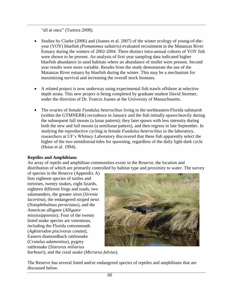
60
“all at once” (Turtora 2008).
Studies by Clarke (2006) and (Juanes et al. 2007) of the winter ecology of young-of-the-
year (YOY) bluefish (Pomatomus saltatrix) evaluated recruitment in the Matanzas River
Estuary during the winters of 2002-2004. Three distinct intra-annual cohorts of YOY fish
were shown to be present. An analysis of first year sampling data indicated higher
bluefish abundance in sand habitats where an abundance of mullet were present. Second
year results were more variable. Results from the study demonstrate the use of the
Matanzas River estuary by bluefish during the winter. This may be a mechanism for
maximizing survival and increasing the overall stock biomass.
A related project is now underway using experimental fish trawls offshore at selective
depth strata. This new project is being completed by graduate student David Stormer,
under the direction of Dr. Francis Juanes at the University of Massachusetts.
The ovaries of female Fundulus heteroclitus living in the northeastern Florida saltmarsh
(within the GTMNERR) recrudesce in January and the fish initially spawn heavily during
the subsequent full moons (a lunar pattern); they later spawn with less intensity during
both the new and full moons (a semilunar pattern), and then regress in late September. In
studying the reproductive cycling in female Fundulus heteroclitus in the laboratory,
researchers at UF‟s Whitney Laboratory discovered that these fish apparently select the
higher of the two semidiurnal tides for spawning, regardless of the daily light-dark cycle
(Hsiao et al. 1994).
Reptiles and Amphibians
An array of reptile and amphibian communities exists in the Reserve, the location and
distribution of which are primarily controlled by habitat type and proximity to water. The survey
of species in the Reserve (Appendix A)
lists eighteen species of turtles and
tortoises, twenty snakes, eight lizards,
eighteen different frogs and toads, two
salamanders, the greater siren (Sirenia
lacertina), the endangered striped newt
(Notophthalmus perstriatus), and the
American alligator (Alligator
mississippiensis). Four of the twenty
listed snake species are venomous,
including the Florida cottonmouth
(Agkistrodon piscivorus conant),
Eastern diamondback rattlesnake
(Crotalus adamentius), pygmy
rattlesnake (Sistrurus miliarius
barbouri), and the coral snake (Micrurus fulvius).
The Reserve has several listed and/or endangered species of reptiles and amphibians that are
discussed below.

61
Sea turtles
Three listed species of sea turtles: the loggerhead (Caretta caretta), the leatherback
(Dermochelys coriacea) and the green turtle (Chelonia mydas) utilize the sandy beach between
the high tide line and the base of the Reserve‟s beach dunes for nesting. The nesting season
generally occurs between May and October. Florida statewide nesting beach survey data for the
2006 season (FWRI: http://research.myfwc.com/features/view_article.asp?id=11812) shows 205
loggerhead nests and 10 green turtle nests in St. Johns County. Of those, a total of 101 nests
occurred within the Reserve. There were no reported leatherback nests in 2006.
An updated analysis of Florida‟s long-term loggerhead sea turtle nesting data, carried out as part
of the FWC Index Nesting Beach Survey, reveals a continuing decline in loggerhead nest
numbers around the state. Nest counts have decreased nearly 50 % from 1998 to 2007. In
contrast, nest counts for green turtles and leatherbacks are increasing. A record number of nests
of these two species were recorded during the 2007 season
(http://research.myfwc.com/features/view_article.asp?id=27537).
Gopher tortoise
The gopher tortoise (Gopherus polyphemus), a keystone species and a species listed as
threatened, lives in sandy habitats in the Reserve. A keystone species is one whose very presence
contributes to a diversity of life and whose extinction would consequently lead to impacts on
other forms of life. They have been designated a keystone species because its burrows provide
refuge to hundreds of other species, including opossums, rabbits, gopher frogs, Florida mice,
eastern diamondback rattlesnakes and gopher crickets (FWC 2007b).
The prime sandhill habitats within the Reserve are open areas with abundant food and relatively
deep, sandy soils for burrowing, and sunny spots for laying eggs. The long, burrows they dig
offer refuge from cold, heat, drought, forest fires and predators. The record burrow was over 47
feet (14 meters) long. They feed on low-growing plants like wiregrass, broadleaf grasses, and
legumes. They also eat prickly pear cactus, blackberries, and other seasonal fruits.
In 2006, the Florida Fish and Wildlife Commission agreed that reclassification of the gopher
tortoise from Species of Special Concern to Threatened is warranted. The change in status is
pending (http://myfwc.com/imperiledspecies/petitions/gopher-tortoise.htm). Reserve volunteers
conduct biennial Gopher Tortoise Burrow Surveys which are described in detail in Section V.
Indigo snake
The Eastern indigo snake (Drymarchon corais couperi) is listed as threatened by both FWC and
USFWS. It is the largest nonvenomous snake in North America. Individuals have been measured
from six to eight and half feet (1.8 to 2.6 meters) long. Unlike the color indigo or indigo
buntings, this snake is much more black than blue. It has smooth, shiny scales and a reddish chin
and throat. The young are lighter in color and have a faint banded pattern. It readily moves
through a variety of habitats, especially those that border marshes and swamps, in search of prey
such as birds, young turtles, frogs, and other snakes, including rattlesnakes. The indigo has been
reported in the area of the GRMAP.
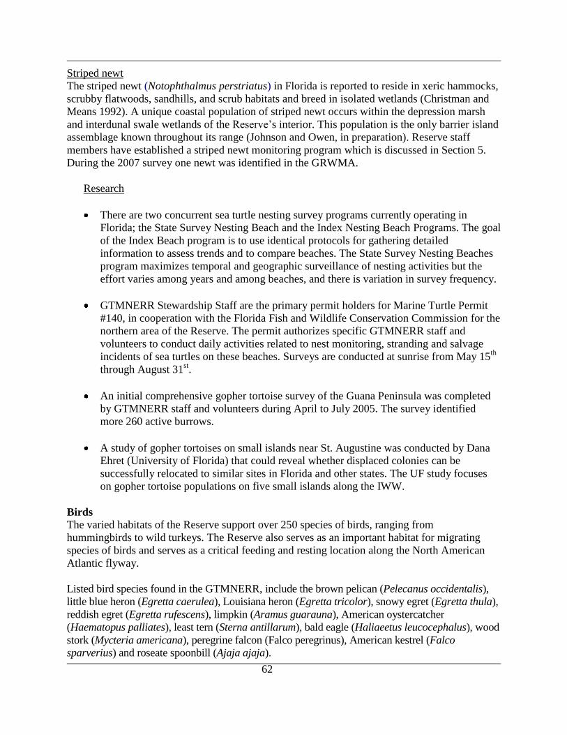
62
Striped newt
The striped newt (Notophthalmus perstriatus) in Florida is reported to reside in xeric hammocks,
scrubby flatwoods, sandhills, and scrub habitats and breed in isolated wetlands (Christman and
Means 1992). A unique coastal population of striped newt occurs within the depression marsh
and interdunal swale wetlands of the Reserve‟s interior. This population is the only barrier island
assemblage known throughout its range (Johnson and Owen, in preparation). Reserve staff
members have established a striped newt monitoring program which is discussed in Section 5.
During the 2007 survey one newt was identified in the GRWMA.
Research
There are two concurrent sea turtle nesting survey programs currently operating in
Florida; the State Survey Nesting Beach and the Index Nesting Beach Programs. The goal
of the Index Beach program is to use identical protocols for gathering detailed
information to assess trends and to compare beaches. The State Survey Nesting Beaches
program maximizes temporal and geographic surveillance of nesting activities but the
effort varies among years and among beaches, and there is variation in survey frequency.
GTMNERR Stewardship Staff are the primary permit holders for Marine Turtle Permit
#140, in cooperation with the Florida Fish and Wildlife Conservation Commission for the
northern area of the Reserve. The permit authorizes specific GTMNERR staff and
volunteers to conduct daily activities related to nest monitoring, stranding and salvage
incidents of sea turtles on these beaches. Surveys are conducted at sunrise from May 15th
through August 31st.
An initial comprehensive gopher tortoise survey of the Guana Peninsula was completed
by GTMNERR staff and volunteers during April to July 2005. The survey identified
more 260 active burrows.
A study of gopher tortoises on small islands near St. Augustine was conducted by Dana
Ehret (University of Florida) that could reveal whether displaced colonies can be
successfully relocated to similar sites in Florida and other states. The UF study focuses
on gopher tortoise populations on five small islands along the IWW.
Birds
The varied habitats of the Reserve support over 250 species of birds, ranging from
hummingbirds to wild turkeys. The Reserve also serves as an important habitat for migrating
species of birds and serves as a critical feeding and resting location along the North American
Atlantic flyway.
Listed bird species found in the GTMNERR, include the brown pelican (Pelecanus occidentalis),
little blue heron (Egretta caerulea), Louisiana heron (Egretta tricolor), snowy egret (Egretta thula),
reddish egret (Egretta rufescens), limpkin (Aramus guarauna), American oystercatcher
(Haematopus palliates), least tern (Sterna antillarum), bald eagle (Haliaeetus leucocephalus), wood
stork (Mycteria americana), peregrine falcon (Falco peregrinus), American kestrel (Falco
sparverius) and roseate spoonbill (Ajaja ajaja).
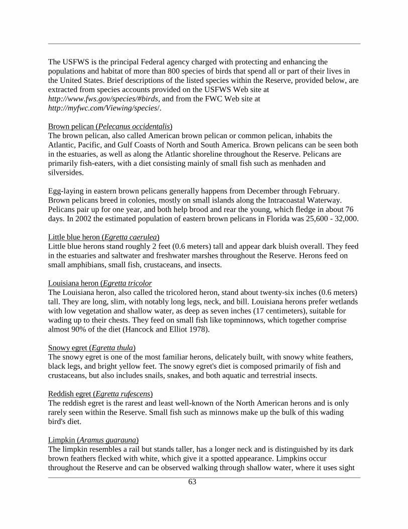
63
The USFWS is the principal Federal agency charged with protecting and enhancing the
populations and habitat of more than 800 species of birds that spend all or part of their lives in
the United States. Brief descriptions of the listed species within the Reserve, provided below, are
extracted from species accounts provided on the USFWS Web site at
http://www.fws.gov/species/#birds, and from the FWC Web site at
http://myfwc.com/Viewing/species/.
Brown pelican (Pelecanus occidentalis)
The brown pelican, also called American brown pelican or common pelican, inhabits the
Atlantic, Pacific, and Gulf Coasts of North and South America. Brown pelicans can be seen both
in the estuaries, as well as along the Atlantic shoreline throughout the Reserve. Pelicans are
primarily fish-eaters, with a diet consisting mainly of small fish such as menhaden and
silversides.
Egg-laying in eastern brown pelicans generally happens from December through February.
Brown pelicans breed in colonies, mostly on small islands along the Intracoastal Waterway.
Pelicans pair up for one year, and both help brood and rear the young, which fledge in about 76
days. In 2002 the estimated population of eastern brown pelicans in Florida was 25,600 - 32,000.
Little blue heron (Egretta caerulea)
Little blue herons stand roughly 2 feet (0.6 meters) tall and appear dark bluish overall. They feed
in the estuaries and saltwater and freshwater marshes throughout the Reserve. Herons feed on
small amphibians, small fish, crustaceans, and insects.
Louisiana heron (Egretta tricolor
The Louisiana heron, also called the tricolored heron, stand about twenty-six inches (0.6 meters)
tall. They are long, slim, with notably long legs, neck, and bill. Louisiana herons prefer wetlands
with low vegetation and shallow water, as deep as seven inches (17 centimeters), suitable for
wading up to their chests. They feed on small fish like topminnows, which together comprise
almost 90% of the diet (Hancock and Elliot 1978).
Snowy egret (Egretta thula)
The snowy egret is one of the most familiar herons, delicately built, with snowy white feathers,
black legs, and bright yellow feet. The snowy egret's diet is composed primarily of fish and
crustaceans, but also includes snails, snakes, and both aquatic and terrestrial insects.
Reddish egret (Egretta rufescens)
The reddish egret is the rarest and least well-known of the North American herons and is only
rarely seen within the Reserve. Small fish such as minnows make up the bulk of this wading
bird's diet.
Limpkin (Aramus guarauna)
The limpkin resembles a rail but stands taller, has a longer neck and is distinguished by its dark
brown feathers flecked with white, which give it a spotted appearance. Limpkins occur
throughout the Reserve and can be observed walking through shallow water, where it uses sight
64
and touch to search for apple snails, mussels, worms and insects. The sharp and twisted end of its
curved bill fits perfectly into a snail shell, allowing the limpkin to deftly extract the mollusk.
American oystercatcher (Haematopus palliates)
The American oystercatcher is one of the largest and heaviest of American shorebirds, easily
identified by dark-brown wings, and black head, with a bright red bill. Oystercatchers get their
name from their habit of snatching oysters from slightly open shells. They also use their
powerful bills to open mollusks and to sort through heavy shells in search of food.
Oystercatchers are periodically seen on sandbars and mudflats within the Reserve estuaries, as
well as along the beaches.
Least tern (Sterna antillarum)
The least tern is a migratory bird that returns to the Reserve from wintering grounds in Latin
America during April and May. The least tern has long, pointed wings and a deeply forked tail. It
is the smallest of our terns, and bears outer wing feathers that edge the light-gray wings in black.
The breeding adult is gray above, white below, with a black cap.
The Reserve‟s beach habitats provide nesting sites for the threatened least tern. The shorebirds
nest in very shallow depressions on broad expanses of bare sand, which camouflage the eggs.
Nesting areas along the Reserve‟s beaches are posted to alert people using the beach of this
important habitat.
Data collected for 2005 from volunteer monitoring (discussed in Section V) identified an average
of 63 least tern adults at the nesting site, with a peak of 82 adults during the height if the nesting
season. The nest site was located on the beach approximately three quarters of a mile south of the
GTMNERR south parking area. The survey group counted 30 actual nesting pairs during the
season.
Bald eagle (Haliaeetus leucocephalus)
Bald eagles, officially declared the National Emblem of the United States by the Second
Continental Congress in 1782, are distinctive large dark brown birds with a white head and tail,
and yellow eyes, bill and feet. Southern bald eagles, which occur in the Reserve, are
considerably smaller than their northern counterparts. Juvenile eagles are chocolate brown, but
with varying degrees of mottled white on their tails, bellies and wing linings. It is not until their
fourth year that the birds acquire the white head and tail feathers identifying them as adults. The
principal food for bald eagles is fish, which the birds seize by using their strong talons to take
their prey from the water. Ducks, coots and other water birds also are major food sources for
eagles, as well as small animals, reptiles and carrion.
Once bald eagles mate, they form long-term pair bonds that can persist for many years. If one
member of the pair dies the surviving partner will select a new mate. In Florida, eagles mate in
the winter, laying their eggs between late November and early February.
There are several active bald eagle nests within the Reserve. One active bald eagle nest across
the Guana River from the EEC has been monitored by Reserve volunteers since 2005. Two
65
chicks were successfully fledged in 2006, and one chick was fledged in 2007. Bald eagle
monitoring throughout the Reserve is discussed in the Section on Monitoring Activities.
Wood stork (Mycteria americana)
The wood stork is the largest wading bird native to America. It is white with black flight
feathers, distinctive because of its dark, featherless head (down to the upper neck) and thick,
down-curved bill. Wood storks fly with neck and legs extended, interrupting strong wing beats
with brief glides.
Wood storks forage, or feed in drying wetlands, which concentrate prey. They usually feed
within 16 miles of their colony but often fly great distances in search of feeding grounds,
sometimes as much as 60-80 miles. One breeding colony occurs at the St. Augustine Alligator
Farm, from which individuals fly throughout the Reserve in search of prey.
Peregrine falcon (Falco peregrinus)
Peregrine falcons don't breed in Florida, but are regularly spotted along the coastal shorelines
and wetlands of the Reserve during spring and fall migrations as they move between northern
breeding grounds and wintering areas in Central and South America.
The peregrine falcon is distinguished by its typical falcon silhouette - long, pointed wings and
long thin tail - and by the dark feathers on its head and nape, which resemble a hood or helmet. A
distinctive black wedge extends below the eye. Falcons prey on doves, shorebirds and ducks.
American kestrel (Falco sparverius)
The kestrel is the smallest and most common of the falcons. Two subspecies of American kestrel
(Falco sparverius) occur in Florida: a northern subspecies (Falco sparverius sparverius) that
winters here between September and April, and a resident, non-migratory subspecies, the
southeastern American kestrel (Falco sparverius paulus). Kestrels seen in Florida during May-
June are resident southeastern American kestrels.
American kestrels often perch on telephone wires at the edge of a field or other open area. From
this vantage they hunt for insects (especially grass-hoppers and dragonflies), lizards and small
mammals.
Roseate spoonbill (Ajaja ajaja)
The roseate spoonbill is easily identified by the luminous pale pink plumage with red highlights
and the long bill with the spoon shaped tip. The spoon-shaped (spatulate) bill of this species has
sensitive nerve endings that help the spoonbill detect prey. As it sweeps the bill from side to side
through shallow water, the spoonbill encounters, captures and swallows small fish, shrimp,
crayfish, fiddler crabs and aquatic insects.
Mammals
Mammals fill a wide range of ecological roles within the terrestrial, freshwater and marine
habitats of the Reserve. A total of forty-five species of mammals have been identified within the
Reserve (Appendix A), five of which are non-native species. Terrestrial herbivores such as
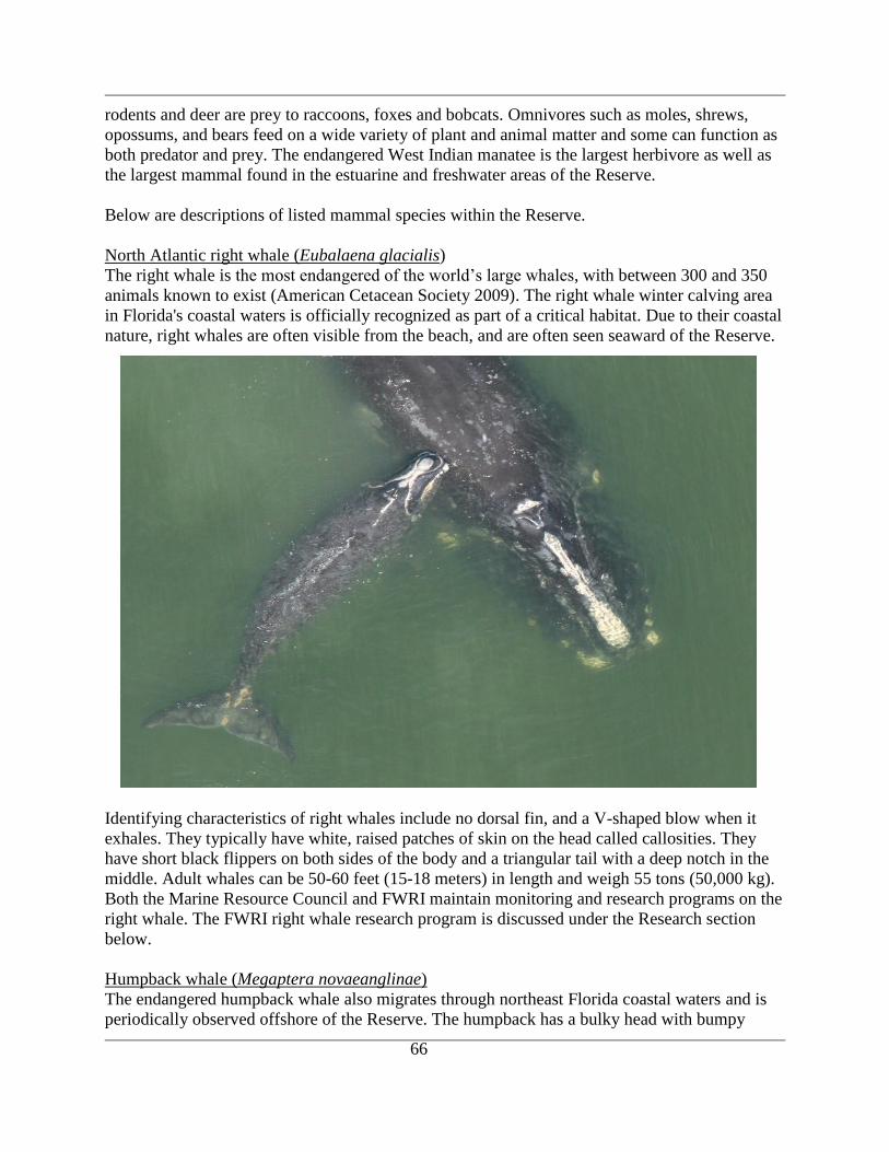
66
rodents and deer are prey to raccoons, foxes and bobcats. Omnivores such as moles, shrews,
opossums, and bears feed on a wide variety of plant and animal matter and some can function as
both predator and prey. The endangered West Indian manatee is the largest herbivore as well as
the largest mammal found in the estuarine and freshwater areas of the Reserve.
Below are descriptions of listed mammal species within the Reserve.
North Atlantic right whale (Eubalaena glacialis)
The right whale is the most endangered of the world‟s large whales, with between 300 and 350
animals known to exist (American Cetacean Society 2009). The right whale winter calving area
in Florida's coastal waters is officially recognized as part of a critical habitat. Due to their coastal
nature, right whales are often visible from the beach, and are often seen seaward of the Reserve.
Identifying characteristics of right whales include no dorsal fin, and a V-shaped blow when it
exhales. They typically have white, raised patches of skin on the head called callosities. They
have short black flippers on both sides of the body and a triangular tail with a deep notch in the
middle. Adult whales can be 50-60 feet (15-18 meters) in length and weigh 55 tons (50,000 kg).
Both the Marine Resource Council and FWRI maintain monitoring and research programs on the
right whale. The FWRI right whale research program is discussed under the Research section
below.
Humpback whale (Megaptera novaeanglinae)
The endangered humpback whale also migrates through northeast Florida coastal waters and is
periodically observed offshore of the Reserve. The humpback has a bulky head with bumpy
67
protuberances (tubercles), each with a bristle. The name humpback describes the motion it makes
as it arches its back out of the water in preparation for a dive. Humpbacks also have huge,
mottled white flippers with rough edges that are up to one-third of its body length; these are the
largest flippers of any whale.
Humpbacks have a small dorsal fin toward the flukes and grow to be about 52 feet (17 meters)
long, weighing 35-50 tons (31,000-45,000 kg) (Marine Mammal Center 2002).
Anastasia Island beach mouse (Peromyscus polionotus phasma)
The Anastasia Island beach mouse is listed as an endangered species, and is restricted to
Anastasia Island and an introduced population within the beach dunes of the northern component
of the Reserve. This subspecies historically occupied about 50 linear miles of beach habitat. In
1992, the USFWS funded the translocation of 28 males and 27 females from Anastasia Island to
the Reserve (USFWS 1993). However, the population numbers at the Reserve‟s beach dunes
remain very low. Quarterly monitoring at both Anastasia State Park and GTMNERR are
discussed in the Section on Monitoring Activities.
West Indian manatee (Trichechus manatus latirostris)
Manatees are large, somewhat seal-shaped gray to brown mammals with flat, rounded tails.
Adults are typically about 9 to 10 feet (3-3.5 meters) long and weigh around 1,000 pounds (453
kg). They are herbivores, spending up to eight hours a day grazing on seagrasses and other
aquatic plants. A manatee can consume up to 20% of its body weight in aquatic vegetation daily
(Zieman 1982). The manatee uses its muscular lips to tear plants much like an elephant uses its
trunk.
Manatees are occasionally observed in the vicinity of both Guana River and Pellicer Creek
during their seasonal migrations along the IWW. They also use the Tolomato and Matanzas
River estuaries, and seem to congregate on the mainland side of the estuary.
Florida black bear (Ursus americanus floridanus)
The black bear is the largest native terrestrial animal in Florida, and is in danger of becoming
extinct because of extensive habitat loss (FNAI 2001). They prefer forested areas with dense
understory vegetation and swampy areas, such as within the Twelve Mile Swamp and Snowden
Bay drainage basins, within the Reserve. Florida black bears are one of three distinct subspecies
of the American black bear recognized in the southeastern United States. They are large,
powerful mammals weighting up to 600 pounds (182 kg), with rounded ears, short tails, five-
toed feet, and large canine teeth. Though they travel with a slow-shuffling gait, they can run up
to 30 miles an hour (48 km/hr), and with their stout, heavily-curved claws, climb trees
exceptionally well.
Black bears are omnivorous, mostly consuming tubers, bulbs, berries, nuts, and young shoots.
The food items eaten most often and in the greatest volumes are seasonally available fruits and
colonial insects (Schaefer and Sargent 1990).
68
Research
From December through March, Fish and Wildlife Research Institute (FWRI) researchers
fly aerial surveys to locate right whale mothers as they migrate to the warm protected
waters off Florida and Georgia to have their calves. Approximately 60 surveys are flown
each calving season; each survey lasts approximately six hours. Surveys are flown in a
small, twin-engine plane at an altitude of 1000 feet (300 meters) to distances of up to 30
miles (48 km) offshore. The primary mission of these surveys is to locate right whales
within and adjacent to the Southeast Critical Habitat and pass that information on to
mariners.
Researchers at FWRI use the following methods to keep track of whales:
Each right whale that is located is photographed by the aerial survey team.
The photo is then compared to the photo catalog of right whales. Each right
whale has a page with a collection of photographs and a unique number or
name.
The photo is then matched to a whale in the photo catalog.
The information is added to the individual sighting history.
The ability to identify individual whales allows researchers to collect an entire life history
of each right whale and to track their movements and associations with other whales. In
the 1980s, photo-ID allowed researchers to determine that the whales sighted in northern
areas, such as Cape Cod Bay, the Bay of Fundy, and the Great South Channel, were the
same whales migrating to the waters of Florida to have their offspring.
(http://research.myfwc.com/features/view_article.asp?id=7511)
The Marineland Right Whale Project begun in 2001 includes about 200 volunteers that
search for and sight right whales along the coastline from the St. Augustine to Ponce
Inlets. The purpose of the project is to supplement the observational capabilities of aerial
surveys. The Project also utilizes an AirCam, a twin-engine, slow-flight aircraft
developed for National Geographic wildlife surveys, for both aerial surveys and
sighting/photo responses. The monitoring effort is coordinated by Dr. Jim Hain
(Associated Scientists of Woods Hole) and Joy Hampp (Marineland).

69
RESEARCH AND MONITORING ACTIVITIES
One of the primary objectives of the ecosystem science program at the GTMNERR is to promote
research and monitoring within and adjacent to the Reserve. To date, much of this has been
accomplished by both Reserve staff and by facilitating and/or collaborating with outside
investigators from universities, government agencies, and private institutions. The benefits of
encouraging outside investigations include high quality research, a broad range of expertise,
interdisciplinary approaches, potential participation of graduate and undergraduate students and
volunteers and a wide range of funding sources that may otherwise be unavailable through
NOAA or the FDEP. Hence, the work has included a very diverse array of studies (e.g., ranging
from the development of molecular probes to hydrodynamic modeling) that have significantly
contributed to our baseline information and insights on the complex structure and dynamics of
natural processes in the GTM estuarine system. These studies have provided an important
foundation for the development of the current GTM Research Reserve‟s Management plan,
through which future research and monitoring efforts will be guided.
Research facilities The main facility is the Environmental Education Center (EEC), located off State Road A1A in
Ponte Vedra Beach. The 21, 282 square foot building contains a 250 person auditorium, office
space, classrooms, a 30 student teaching laboratory designed for hands-on study of the
environment, as well as a separate laboratory prep area. The facility also houses 2,000 sq ft of
static and interactive environmental exhibits, interpretive exhibits, aquariums, a nature store and
an outdoor amphitheater overlooking the Guana River.
The EEC houses a Geographic Information Systems (GIS) resource center with ArcInfo access.
A Hewlett Packard Model 800 plotter is available for mapping needs. There is a separate
working lab for visiting scientists and Reserve staff, as well as a locker room and shower
facilities. A separate aquarium room is available for research purposes, although running
seawater is not available.
The GTM Research Reserve's office in Marineland includes a classroom/meeting room with full
audio/visual equipment, a resource library, a 23 foot Carolina Skiff for research and educational
use, and an adjoining field station. The field station includes a small laboratory used to support
research and monitoring efforts by Reserve staff and visiting investigators. In addition to the
work and storage space of the laboratory, lockers and a restroom/shower are also part of this
facility. Adjacent sleeping quarters with a restroom/shower, small refrigerator and a microwave
are available for researchers, students and educators. The Reserve‟s office at Marineland is in
close proximity to the Marineland Oceanarium, River to Sea Preserve and the University of
Florida‟s Whitney Laboratory for Marine Bioscience.
The laboratory facilities at both Reserve offices have dissecting scopes, refrigeration, freezers,
and fume hoods. Both facilities also have networked PC computers linked to the internet via an
FDEP server.
70
Ancillary Facilities
The Reserve estuaries are easily accessible to several universities and community colleges in the
region including the University of North Florida, Jacksonville University, and Community
College of Jacksonville in Jacksonville, the University of Florida (UF) in Gainesville, Flagler
College in St. Augustine, St. Johns River Community College in Palatka and Daytona Beach
Community College in Daytona Beach. The institutons having facilities and programs of direct
relevance to the GTMNERR are described below.
Jacksonville University (JU) is a co-educational, private institution located on 198 acres adjacent
to the St. Johns River. In addition to laboratories and classrooms, the university houses an
extensive vertebrate and invertebrate collection, the Maggie Wheldon Shell Collection, a fossil
collection and herbarium concentrating on the flora of the southeast. Analytical laboratory
computer facilities and small vessels for research are available.
JU has also established a new Marine Science Research Institute (MSRI) on the banks of the St.
Johns River. The completed MSRI will house the St. Johns Riverkeeper office, along with the
FWC, Northeast Florida Fisheries Laboratory, the JU Sailing Program and a new high school
marine education program in conjunction with Duval County Public Schools.
The University of North Florida is a four-year college in the State University System. Several
faculty and students in the Department of Biology have conducted research within the
GTMNERR, and this activity should be further advanced by the department‟s recently
established Master‟s Degree Program in Biology. Laboratory facilities, several small research
vessels and field equipment are available for research. Faculty from the University of North
Florida‟s College of Computing, Engineering and Construction have also been active in the
Reserve, developing experimental telemetry systems for transmitting environmental data.
Environmental research is expanding at the University as reflected by the recent establishment of
a flagship Coastal Biology Program and the Taylor Engineering Research Institute.
The University of Florida (UF), located in Gainesville, has many collegiate, departmental and
interdisciplinary programs in education and research in oceanography and marine related fields.
Special marine-related facilities include; the Coastal Engineering Laboratory with wind and
wave tank, model slabs, wave generators, automatic tide level generator, sand tracer laboratory
and extensive field and remote sensing equipment; The Florida Museum of Natural History with
research collections of fish, birds, mollusks and mammals; the Coastal Engineering Archives,
which provides information on beach erosion, coastal protection and historical shoreline changes
in Florida. UF operates a fully certified QA/QC Nutrient Lab, under the direction of Dr. Edward
Phlips, through which nutrient samples from both the GTMNERR and the Appalachicola NERR
are processed.
UF also maintains an extensive research program through the Whitney Laboratory for Marine
Bioscience located at Marineland. Located near the Matanzas Inlet on the border of St. Johns and
Flagler Counties, the laboratory presently occupies five acres, with over 20,500 square feet of
laboratory and office space. Extensive aquaria, holding tanks and an excellent sea water system
can support a variety of marine life studies. Housing is available for visiting scientists and
71
graduate students. Whitney Laboratory facilities were recently expanded with the opening of a
17,000 square foot Center for Marine Studies.
SJRWMD provides the scientific, technical, and regulatory support required to identify and
assess habitat and biological resources deemed critical to the ecological integrity of the NCB
system which includes the GTMNERR. The District‟s laboratory support services, headquartered
in Palatka, Florida include in-house water quality analysis, logistical support for field sample and
data collection, and quality assurance.
The District maintains an extensive GIS database, containing districtwide data layers that are
managed by staff in the Department of Information Resources (IR), and project-specific data
layers managed jointly by project and IR staff.
GTMNERR Monitoring Activities
Water Quality Monitoring
The GTMNERR participates in the System-wide Monitoring Program (SWMP), described
previously in the section on Water Quality which provides standardized data on national
estuarine environmental trends while allowing the flexibility to assess coastal management issues
of regional or local concern. The principal mission of the SWMP is to develop quantitative
measurements of short-term variability and long-term changes in the integrity and biodiversity of
representative estuarine ecosystems and coastal watersheds for the purposes of contributing to
effective coastal zone management. The program is designed to enhance the value and vision of
the Reserves as a system of national references sites.
Coastal Strand Transect Monitoring
Coastal strand is found on storm deposited ridges of sand, shell, and debris that parallel the shore
behind the dune ridge. This community exists only on the east coast of Florida, and the northern
component of the GTMNERR contains 595 acres of this habitat. The goal of the monitoring
program is to utilize vegetation surveys to monitor changes through time of species occurrence,
dominance, and composition. A series of 4 transects located just north of the GTMNERR Guana
River entrance are sampled every April by Reserve volunteers. The transects are located in the
field of view of permanent photopoints to provide supplemental data to the transect survey. Data
recorded along each transect include species occurrence, percent cover of each species, and
average height of the canopy and midstory species.
Vegetation Plot Monitoring
The vegetation plot monitoring program is intended to provide quantitative data to monitor the
effects of the prescribed fire program at the Reserve. The monitoring program is designed to
document the response of vegetation to prescribed fire through the analysis of species
composition and species percent cover. The goal is to understand the vegetative composition
changes of each community when fire is re-introduced to each of 4 target areas. The general
schedule of monitoring is for Reserve volunteers to sample each plot during April. Data recorded
within each plot include species occurrence, percent cover of each species, and average height of
shrub and tree species.
72
Dune Transect Monitoring
Dune vegetation on the Reserve beaches is defined as those plant communities found on the
stretch of land between the Atlantic Ocean and U.S. Highway A1A. The goal of this program is
to monitor changes through time of species occurrence, dominance, and composition. The
schedule of monitoring is for Reserve volunteers to sample six line transects during April. Data
recorded within each plot include species occurrence, percent cover of each species, and average
height of shrub and tree species using the line intercept method. The transects are permanently
located concurrent with survey areas for the Anastasia Island beach mouse.
Prickly Pear (Opuntia sp.) Population Monitoring
Reserve staff are monitoring the population of prickly pear cactus and assessing the impacts of
the exotic invasive cactus moth (Cactoblastis cactorum) on the population contained in the beach
dune strand. Goals of the monitoring are to quantify the numbers of active and previously
infested plants, assess the ecological impact to other species in the beach dune system if the
majority of cacti are destroyed, and to consider the implementation of control eradication
measures.
Laurel Wilt Monitoring
Laurel wilt is a deadly disease of redbay (Persea borbonia) and other tree species in the Laurel
family (Lauraceae). The disease is caused by a fungus (Raffaelea sp.) that is introduced into host
trees by a non-native insect, the redbay ambrosia beetle (Xyleborus glabratus). The fungus plugs
the water-conducting cells of an affected tree and causes it to wilt. Laurel wilt has caused
widespread and severe levels of redbay mortality in the Southeastern coastal plain. Reserve staff
members are monitoring the rate of spread of the disease and will be assessing the impacts on the
Reserve ecosystem if the species disappears. Reserve staff are also monitoring for possible
genetic resistance to the effects of the fungus (Raffaelea sp.) with UF and FDOF researchers.
Prescribed Burning Photo-point Monitoring
Permanent photo-points have been established at each of the burn units within the northern
component of the Reserve to monitor the progress of the Reserve‟s prescribed fire program.
Images at each unit are acquired every six months and analyzed to track the community response
to the prescribed burn cycle for each unit. Five photo-points have been established to date.
Butterfly Biodiversity Census
Reserve volunteers undertake the annual butterfly biodiversity census in conjunction with the
Florida Butterfly Monitoring Network. Butterflies are excellent indicators of biodiversity and
ecosystem health. The monitoring of adult butterflies is possible as adults of most species are
relatively easy to identify and species may be observed in a variety of habitats. Except for some
migrant species, the presence of adult butterflies also shows that all other life stages were
successfully achieved in the area.
Exotic Crab Monitoring
The GTMNERR was one of nine NERRs involved in a pilot study to detect exotic (non-
indigenous) crabs in local waters. The GTM estuary has been invaded by at least two exotic crab
species, including the Indo-Pacific swimming crab, Charybdis hellerii, and the porcelain crab,
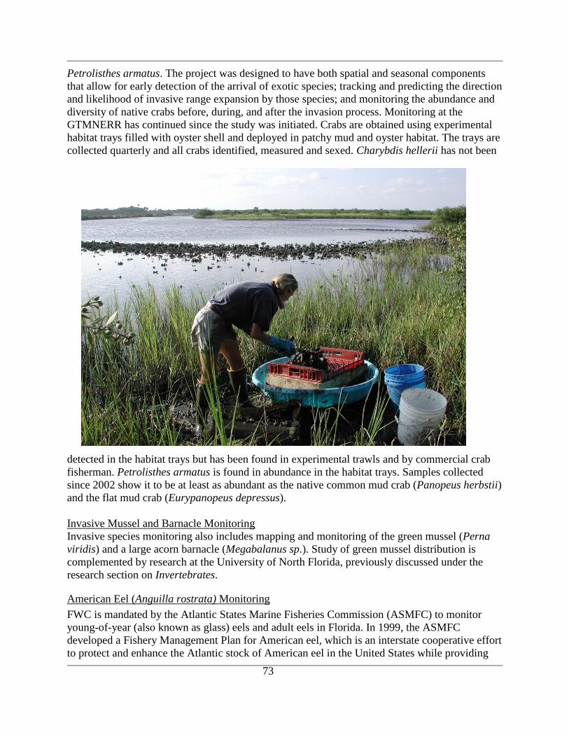
73
Petrolisthes armatus. The project was designed to have both spatial and seasonal components
that allow for early detection of the arrival of exotic species; tracking and predicting the direction
and likelihood of invasive range expansion by those species; and monitoring the abundance and
diversity of native crabs before, during, and after the invasion process. Monitoring at the
GTMNERR has continued since the study was initiated. Crabs are obtained using experimental
habitat trays filled with oyster shell and deployed in patchy mud and oyster habitat. The trays are
collected quarterly and all crabs identified, measured and sexed. Charybdis hellerii has not been
detected in the habitat trays but has been found in experimental trawls and by commercial crab
fisherman. Petrolisthes armatus is found in abundance in the habitat trays. Samples collected
since 2002 show it to be at least as abundant as the native common mud crab (Panopeus herbstii)
and the flat mud crab (Eurypanopeus depressus).
Invasive Mussel and Barnacle Monitoring
Invasive species monitoring also includes mapping and monitoring of the green mussel (Perna
viridis) and a large acorn barnacle (Megabalanus sp.). Study of green mussel distribution is
complemented by research at the University of North Florida, previously discussed under the
research section on Invertebrates.
American Eel (Anguilla rostrata) Monitoring
FWC is mandated by the Atlantic States Marine Fisheries Commission (ASMFC) to monitor
young-of-year (also known as glass) eels and adult eels in Florida. In 1999, the ASMFC
developed a Fishery Management Plan for American eel, which is an interstate cooperative effort
to protect and enhance the Atlantic stock of American eel in the United States while providing
74
for a sustainable harvest of the species. As part of this requirement, FWC and University of
Florida personnel conduct routine monitoring of glass eels at the Guana River Dam (St. Johns
County) and juvenile eels at Rodman Reservoir or Kirkpatrick Dam (Putnam County), from
January to March. Over an eight-week period in January and February, dip-net sweeps are made
twice every half-hour during flood tide at the Guana River Dam site on four randomly selected
nights each week. During February and March, lift nets are used to sample juvenile eels twice
per week at Rodman Reservoir Dam during randomly selected periods at night. In addition to
obtaining catch data, the eels‟ length, weight, and pigmentation stage are recorded. These data
have been collected since 2001 and, along with data from the other participating states, were
used in the 2005 coast-wide stock assessment (Bonvechio 2008). However, the most current
published report is that detailing the 2003-2004 assessment years (Bonvechio et al. 2004)
FWC biologists also conducted a pilot study at three locations along Pellicer Creek to determine
if and when glass eels migrate into this freshwater system. Attempts to collect eels were made
using a special fyke (or hoop) net, that was set overnight for at least two separate nights each
week during January and February of 2005. The method, however, yielded very few eels.
Sea Turtle Monitoring
The Reserve staff monitors sea turtle nesting activity, previously discussed in the section on
Reptiles. The Reserve‟s beach habitat is an active nesting beach that is part of the statewide
Index Nesting Beach Survey compiled annually by the FWC. Most of the nests are deposited by
loggerhead sea turtles, but nests of the endangered green and leatherback sea turtles have also
been documented.
Gopher Tortoise Population Surveying
The Reserve has established a biennial gopher tortoise survey program to assess the current
population status of the tortoise within the Guana peninsula. The survey data is also used to
document trends in population status in response to management activities. Volunteer-led
surveys were completed in 2005 and 2007 in which borrows were identified, classified as active
or inactive, and geographically located using a differential GPS unit.
Striped Newt Surveying
The striped newt survey is an annual survey conducted by volunteers during April. Survey areas
include a number of pond sites within the northern component of the Reserve.
Bald Eagle (Haliaeetus leucocephalus) Monitoring
The bald eagle is a threatened species both in Florida and nationally and expanding development
is decreasing suitable habitat. There are several nests within the Reserve boundaries, most
prominently an active nest located southwest across the Guana River from the EEC. This nest
has been monitored by onsite staff since 2005. The goals of the monitoring program are to
encourage public interest in the conservation of bald eagles; participation in a statewide program
monitoring nest disturbance and success; documentation of eagle nest locations to avoid
disrupting nesting; and collection of data on mated pairs and their nest success each year.
Monitoring by volunteers begins in October and continues until eaglets are completely fledged,
as late as May. Data on the nest site at the EEC is collected at the beginning of each season and
adult and eaglet behavior is recorded at least bi-weekly for twenty minutes.
75
Least Tern Nesting Surveys
A Reserve volunteer conducts weekly surveys throughout the nesting season (weather
permitting) from April-August. The surveys are conducted using an all terrain vehicle (ATV)
during low tides and usually in the morning, and are conducted in conjunction with the shorebird
surveys discussed below.
Other Shorebird Monitoring
Numerous species of listed shorebirds are known to frequent the relatively undisturbed beaches
of the Reserve. Regular shorebird surveys began at the Reserve in 2006 and are conducted
weekly throughout the year. Volunteer or staff members use an ATV to traverse the 4.1 miles of
beach to observe shorebird activity. Surveys are usually performed in the morning during low
tides and are conducted in conjunction with the least tern nesting survey during nesting season.
All species and numbers are recorded. Unusual birds are photographed and identified later.
Beginning in 2007, data is also collected for the International Shorebird Survey which provides
data to national and international agencies.
Marsh Bird Monitoring
The monitoring of both short-term variation and long-term trends in marsh bird populations
throughout the Reserve is being accomplished with volunteers following the protocol outlined in
the Standardized North American Marsh Bird Monitoring Program (Conway 2005). The primary
bird groups addressed through this monitoring effort include rails, bitterns, grebes, gallinules,
moorhens, wrens, and sparrows.
This standardized monitoring protocol, which uses broadcast calls to elicit vocalizations, is
designed to address a series of issues relating to the monitoring and conservation of marsh birds.
Specifically, the goals of this program are:
1. Determine the population status and breeding distribution of marsh birds;
2. Determine species-habitat associations of marsh birds;
3. Determine population trends of marsh birds at local (e.g., NERR Site), regional (e.g.,
Gulf Coast), and national geographic scales as well as various temporal scales;
4. Determine the environmental factors that influence the distribution of marsh birds;
5. Increase local volunteer (birders or bird-watchers) participation in research and
monitoring programs.
Understanding marsh bird populations within the Reserve is important because they: (1) may be
affected by the accumulation of environmental contaminants in wetland substrates; (2) are
vulnerable to invasive plants; (3) potentially serve as “indicator species” for assessing wetland
ecosystem quality; (4) can be used to evaluate the success of wetland restoration efforts; (5) have
high recreational value (many species are highly sought-after by recreational birders); and (6)
several rails are game species in many states (NERRS 2007).
St. Johns Audubon Fall Migration Peregrine Falcon Count
Peregrines from northern North America migrate in the fall to Central and South America. They
often hunt along the barrier islands on the Atlantic and Gulf of Mexico coasts during this time.
The goal of the Audubon monitoring effort is to document the population trends of fall migrating
76
peregrine falcons and merlins. Audubon Society volunteers have been counting peregrines,
merlins, and kestrels during the fall migration period extending from September 27 – October
12th,
since 1997. The location of the count is at the north beach access overlook of the Reserve.
Data are submitted by Audubon to www.hawkcount.org and www.hawkwatch.org for national
and international coordination.
Anastasia Island Beach Mouse Monitoring
Monitoring of the Anastasia Island Beach Mouse by the Reserve is intended to ascertain the
population viability and recovery. The population located at the Reserve is one of only 3
populations of this sub-species. Mouse populations are monitored quarterly in conjunction with
the monitoring program at Anastasia Island State Park. Trapping is conducted for two nights
each quarter. Three transects are set with 2 traps every 15m for a total of 40 traps per transect.
Volunteers record general weather conditions and captured mouse condition. Mouse data
collected includes sex, pelage condition, weight, reproductive condition, ear tag number, and tail
clip for genetic analysis. Unmarked mice receive ear tags placed in the left ear for subsequent re-
identification.
National Water Level Observing Network
The National Water Level Observation Network (NWLON) is the fundamental observational
component of the National Water Level Program (NWLP). The NWLON is a network of 175
long-term, continuously operating water-level stations throughout the USA. There are additional
stations within the GTMNERR boundaries that are not currently operating but for which
archived data and predicted tide data are available. The data continuity, the vertical stability and
careful referencing of NWLON stations have enabled the data to be used to estimate relative sea-
level trends for the Nation. Both current and historical tide data can be accessed from the
NWLON Web site at http://tidesandcurrents.noaa.gov/nwlon.html.
National Data Buoy Center
The NOAA National Data Buoy Center (NDBC), designs, develops, operates, and maintains a
network of data collecting buoys and coastal stations. NDBC provides hourly observations from
a network of about 90 buoys and 60 Coastal Marine Automated Network (C-MAN) stations to
help meet these needs. All stations measure wind speed, direction, and gust; barometric pressure;
and air temperature. In addition, all buoy stations, and some C-MAN stations, measure sea
surface temperature and wave height and period. Conductivity and water current are measured at
selected stations.
There are two NDBC stations in proximity to the Reserve; one is on the St. Augustine Beach
Pier, with near real-time data available at
http://seaboard.ndbc.noaa.gov/station_page.php?station=sauf1. The other station is a weather
buoy 40 nautical miles ENE of the St. Augustine Inlet, with near real-time data available at
http://www.ndbc.noaa.gov/station_page.php?station=41012. The NDBC also carries the data
generated from the GTMNERR‟s Pellicer Creek stations at
http://www.ndbc.noaa.gov/station_page.php?station=gtqf1 and
http://www.ndbc.noaa.gov/station_page.php?station=gtxf1.

77
The NERR Graduate Research Fellowship Program
The National Estuarine Research Reserve System‟s (NERRS) Graduate Research Fellowship
Program was established in 1997 to support graduate students interested in coastal and estuarine
sciences. By providing stipends, a living laboratory and a broad network of fellow scientists, the
reserve system aims to encourage and enable talented young scientists to contribute to the
knowledge base, provide the science to support coastal decision- making and train future coastal
scientists and policy-makers.
The Graduate Research
Fellowship Program
provides master‟s degree
students and Ph.D.
candidates with an
opportunity to conduct
research of local and
national significance that
focuses on enhancing
coastal zone
management. Fellows
conduct their research
within a National
Estuarine Research
Reserve and gain hands-
on experience by
participating in their host
reserve's research and monitoring programs.
Graduate Research Fellowship projects are based on the reserves' local needs, the reserve
system's national priorities and the students' interest. A majority of the projects funded to date
have addressed the pressing issues of non-point source pollution and habitat conservation and
restoration. All fellowship projects address issues important to coastal zone management and
enhance our understanding of estuarine ecosystems. National Estuarine Research Reserve
Fellows are the leaders for the next generation of estuarine scientists; they are influencing the
decisions made today for a better coast tomorrow.
GRF projects support the reserve system by studying pressing estuarine management topics with
local, regional and/or national significance. Fellows also engage with reserve staff members to
contribute to their host reserves‟ research and monitoring programs, while gaining hands-on
skills to complement their academic studies.
As of August 2009, 8 research projects have been completed or were currently underway within
the GTMNERR. One of the projects was funded through the ACE Basin NERR, with portions of
the research being conducted in the GTMNERR.
Summaries of the abstracts of the research projects, as well as the name of the researcher,
fellowship date, and academic affiliation are given below. More details of the fellowship
78
program can be found on the NERR Web site at
http://www.nerrs.noaa.gov/Fellowship/welcome.html.
Describing human uses, evaluating existing management and delineating ecological
resources, the formulation of an estuarine planning strategy: A case study of the
GTMNERR Ashley Murphy (Johnson), Graduate Research Fellow 2001-2004
University of Florida
The research combined the best of land use zoning and protection strategies to create an
estuary plan that identifies areas for natural resource protection, while enhancing water-
dependent uses. This research has resulted in a scientifically defensible method for creating
estuarine zones based on resource presence and human use patterns, integrating the
ecological, sociological, and political components of a coastal area to create zones of marine
use and space.
Estuary planning in particular is needed in the GTMNERR as this coastal area is under
development pressure. The results of this research contribute to coastal and marine resource
management through the development of a methodology for inventorying important coastal
and estuarine resources, subsequently leading to a better understanding of how humans
interact with the coastal and marine environment.
How estuaries respond to nutrient load: the Guana Tolomato Matanzas National
Estuarine Research Reserve as a model case Nicole Dix, Graduate Research Fellow 2006-2009
University of Florida
Predicting the consequences of eutrophication in coastal ecosystems has become a major
priority for marine researchers. Estuaries are difficult to empirically model, however, due to
their highly dynamic nature. This three-year research project is using the Reserve as a model
system for comparing the effects of different nutrient load scenarios in highly flushed
estuaries. The objective of the research effort is to determine the differences in the response
of selected components of the benthic and attached biota to the nutrient load scenarios in the
San Sebastian and Matanzas regions of the GTMNERR. Water quality analyses will provide
spatial and temporal nutrient gradients, which can be related to benthic macroinvertebrate
community structure and periphyton colonization rates. In addition, the results will add to the
baseline knowledge of the GTMNERR and can ultimately be used to create more effective
management plans for the conservation of estuarine systems around the world.
Winter recruitment of young-of-the-year bluefish, Pomatomus saltatrix, into Northeast
Florida estuaries: Aspects of distribution, essential habitat, diet and condition Peter Clarke, Graduate Research Fellow 2004-2005
University of Massachusetts
Juvenile bluefish, Pomatomus saltatrix, spend their first summer in Mid-Atlantic Bight
estuaries and coastal waters. A southerly fall migration takes places in coastal waters in the
79
western Atlantic during the fall to over wintering grounds in the Southern Atlantic Bight.
Very little is known about the wintertime distribution and trophic dynamics of juvenile
bluefish in southern waters at the edge of their geographical range.
The collection of bluefish and their potential prey during the winter in Northeast Florida was
focused around estuarine and coastal waters from two sites. The Matanzas Inlet which is
unique in Northeast Florida as one of the last remaining natural and least environmentally
impacted inlets within Florida, and St. Augustine Inlet which suffers from results of human
land development. The comparison of two disparate sampling locations with similar habitat
and species assemblage within the same geographical location provided an opportunity to
examine dependent variables responsible for bluefish winter recruitment. Further discussion
of this project is included in the research section on Fishes.
Assessing and modeling mangrove forest dynamics along the temperate-subtropical
ecotone in eastern Florida Susan E. Leitholf, Graduate Research Fellow 2004-2008
University of Central Florida
Mangrove communities are adapted to intertidal flooding regimes and have historically been
found along the entire east coast of Florida. Mangroves are freeze intolerant and hence are
restricted to subtropical environments. The Reserve is home to the northernmost extent of
mangroves along the Atlantic coast, which have been recovering from a series of freezes in
the 1970s and 80s. This research hypothesized that increasing temperatures and a reduction
in the freeze frequency and intensity would result in a northward expansion of mangrove into
the salt marsh zones in the GTMNERR. Such an expansion represents a major landscape
change that will have significant impacts on birds, fish, and other species relying on coastal
vegetation. In addition to mangrove spreading into its historic range, Brazilian pepper
(Schinus terebinthifolius), an exotic species that competes with mangrove in nearby estuaries
will benefit under a warming trend. The vagility of this bird-dispersed exotic may permit it to
establish more rapidly than mangrove.
The dynamics of these species along this ecotone were investigated by mapping the current
and historic distributions of mangrove in the GTMNERR using field surveys, GPS, GIS,
aerial photography and satellite imagery. To understand the growth patterns of the three
native mangrove species and Brazilian pepper, the growth and demography of leaf and
reproductive tissues was monitored for two years across the ecotone. With these and related
environmental measures, a forest gap succession (FORMAN) model was developed to
simulate mangrove recruitment, growth and competition in the GTMNERR. The model was
coupled to a dispersal model to make predictions of rate and location of spread of these
species in the Reserve under different climate and sea level rise scenarios.
80
Estuarine Response to Extreme Events – The GTMNERR Case Study
Bilge Tutak, Graduate Research Fellow 2007-2009
University of Florida
This project will assess the response of the Reserve, a representative estuary in the
Southeastern US, to extreme events (e.g., tropical cyclones, strong coastal upwelling events,
and Northeasters). Extreme events bring sharp changes in environmental conditions (e.g.,
salinity, water temperature, and wave-induce sediment resuspension), which adversely affect
estuarine resources (e.g., habitat and benthos). In the summer of 2003, the GTMNERR
experienced a rapid and persistent water temperature drop (>7oC) due to a persistent coastal
upwelling event in the South Atlantic Bight (SAB). In August through October, 2004, the
Reserve experienced an extreme salinity drop (>20 PSU) due to four major hurricanes in
August and September. It is hypothesized that the extended low salinity period in the Reserve
was due to the heavy rainfall and poor exchange in the St. Augustine and Matanzas Inlets
which prevented the saline ocean water from entering the estuary during the hurricanes. This
project will quantify the exchange patterns at the two inlets and within the Reserve during
non-extreme and extreme events. In-situ and satellite data during past and subsequent
extreme events will be gathered, and numerical models of estuarine hydrodynamics will be
used to synthesize the data and to assess the system-wide response of the GTM to extreme
events. Validated numerical models will be used to simulate synoptic-scale environmental
conditions and to identify regions of sharp changes and gradients, where appreciable impact
on habitat and benthos are expected.
The effect of salt spray, freshwater supply and forest seed source on ecological
succession on dredge spoil islands along the intracoastal waterway in northeastern
Florida John Baker, Graduate Research Fellow 2001-2004
University of Florida
In this study, the effect of salt spray, freshwater supply and forest seed source on ecological
succession on different aged dredge spoil islands along the IWW in Northeastern Florida was
determined. The study provided basic knowledge about spoil island habitat, evaluated the
presence of patterns in the primary succession of maritime forests and spoil islands, provided
information on the ability of spoil islands to support tree growth and provided information on
how size, shape and location of spoil islands determine specific vegetation patterns. The
study, when published, will contribute to developing methods for estuarine ecosystem
restoration and provide information on mechanisms for sustaining resources. It will help
determine how quickly maritime forest can be restored through primary succession and
natural seed dispersal mechanisms given certain environmental and spatial variables. Soil
characteristics measurements included organic matter content, soil moisture and soil particle
size. The Point-Centered Quarter Method and the Braun-Blanquet Scale was used to measure
abundance and cover for plant species on randomly located east-west transects. Soil moisture
and relative elevation were estimated at each vegetation sampling point. Soil cores for
percent organic matter determination and salt spray were sampled on one-east-west transect
for each spoil island. Maritime forest tree seeds and seedlings were planted in different
vegetation zones. Tree growth and survivorship was measured.
81
Using the reserve system to explore plant-herbivore interactions: Latitudinal variation
and impacts of climate change Chuan-Kai Ho, Graduate Research Fellow 2004-2007 (with ACE Basin)
University of Houston
This project focused on biodiversity, one of the research focus areas for the NERR system.
This project used an existing suite of 13 reserves and 3 Long Term Ecological Research
(LTER) sites along the Atlantic Coast as a network to examine latitudinal variation in plant-
herbivore interactions. This geographic variation is driven in part by different traits of
populations in different geographic locations. In addition, this project tested the potential
impacts of climate change on plant-herbivore interactions by examining the importance of
differing shifts in plant and herbivore population ranges.
Using a combination of greenhouse experiments (focusing on growth of herbivores from
different geographic regions feeding on plants from different geographic regions) and field
sampling (of herbivore abundances, size and damage to plants), the project focused on four
plant species and their most common 6 herbivores. All of the species are widely distributed
along the Atlantic Coast of the U.S. Working with multiple species ensured that the results
are general and not idiosyncratic to a single plant or herbivore species. The ACE Basin
Reserve was the host reserve.
Do grazers and drought stress interact to drive die-off and foundation plant species
shifts in Florida marshes?
Schuyler van Montfrans, Graduate Researh Fellow, 2009
Universitry of Florida
Evidence from salt marshes along the eastern coast of the U.S. suggests that grazers in salt
marshes have been substantially overlooked as important drivers of changes in community
structure, as well as large-scale die-off of Spartina, and that these effects are exacerbated by
drought stress. Droughts have increased in both frequency and intensity, and may be acting to
accelerate the effects of increasing grazer populations.
This project focuses on the role of the purple marsh crab, Sesarma reticulatum, and its role as
a consumer in driving foundation species shifts (specifically from Spartina alterniflora to the
succulent plant, Salicornia virginica). The goal of this research is to determine the singular
and relative (vs snails and simulated drought stress) impacts of S. reticulatum grazing on
marsh productivity, marsh die off expansion and shifts in marsh plant species dominance. To
test how grazing by S.reticulatum impacts S. alterniflora and the shift in foundation species
to the succulent S. virginica, crab exclusion cages will be deployed in both healthy and
heavily-grazed marsh areas, as well as along the borders of S. alterniflora and S. virginica.
To test whether physical stress and marsh periwinkle grazing exacerbate the effects of S.
reticulatum grazing, caging experiments will be conducted to manipulate densities of S.
reticulatum and snails, as well as the salt content of the soil. This study will be the first to
quantify these effects, and will be vital to the long-term monitoring and management of these
habitats.
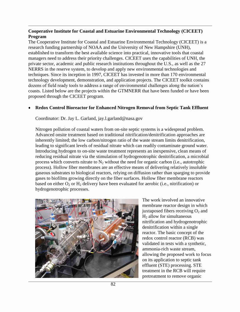
82
Cooperative Institute for Coastal and Estuarine Environmental Technology (CICEET)
Program
The Cooperative Institute for Coastal and Estuarine Environmental Technology (CICEET) is a
research funding partnership of NOAA and the University of New Hampshire (UNH),
established to transform the best available science into practical, innovative tools that coastal
managers need to address their priority challenges. CICEET uses the capabilities of UNH, the
private sector, academic and public research institutions throughout the U.S., as well as the 27
NERRS in the reserve system, to develop and apply new environmental technologies and
techniques. Since its inception in 1997, CICEET has invested in more than 170 environmental
technology development, demonstration, and application projects. The CICEET toolkit contains
dozens of field ready tools to address a range of environmental challenges along the nation‟s
coasts. Listed below are the projects within the GTMNERR that have been funded or have been
proposed through the CICEET program.
Redox Control Bioreactor for Enhanced Nitrogen Removal from Septic Tank Effluent
Coordinator: Dr. Jay L. Garland, [email protected]
Nitrogen pollution of coastal waters from on-site septic systems is a widespread problem.
Advanced onsite treatment based on traditional nitrification/denitrification approaches are
inherently limited; the low carbon/nitrogen ratio of the waste stream limits denitrification,
leading to significant levels of residual nitrate which can readily contaminate ground water.
Introducing hydrogen to on-site waste treatment represents an inexpensive, clean means of
reducing residual nitrate via the stimulation of hydrogenotrophic denitrification, a microbial
process which converts nitrate to N2 without the need for organic carbon (i.e., autotrophic
process). Hollow fiber membranes are an effective means of delivering relatively insoluble
gaseous substrates to biological reactors, relying on diffusion rather than sparging to provide
gases to biofilms growing directly on the fiber surfaces. Hollow fiber membrane reactors
based on either O2 or H2 delivery have been evaluated for aerobic (i.e., nitrification) or
hydrogenotrophic processes.
The work involved an innovative
membrane reactor design in which
juxtaposed fibers receiving O2 and
H2 allow for simultaneous
nitrification and hydrogenotrophic
denitrification within a single
reactor. The basic concept of the
redox control reactor (RCB) was
validated in tests with a synthetic,
ammonia-rich waste stream,
allowing the proposed work to focus
on its application to septic tank
effluent (STE) processing. STE
treatment in the RCB will require
pretreatment to remove organic
83
material so that fast growing heterotrophs will not out compete the slowly growing nitrifiers
for space on the hollow fibers within the RCB.
The major product of the work is conclusive results of the system performance under actual
field conditions, allowing for a clear decision regarding the potential development of a
commercial unit.
Start Date: 2006-07-15
End date: 2008-09-15
Funding Amount: $339,059
Status: Final report submitted 2009 (Garland and Smith 2009)
Real-Time Detection of Specific Pathogens with a Fiber Optic Biosensor and
Determination of the Source of Bacterial Contamination Using Antibiotic Resistance
Analysis and Ribotyping of E. coli in the GTMNERR
Coordinator: Dr. Valerie (Jody) Harwood, [email protected]
As coastal areas are increasingly impacted by development and pollution from stormwater
runoff and sewer discharges, there is an increasing need to rapidly and specifically identify
microbial pathogens that can affect human health. An ideal water test should be able to: (1)
detect specific disease-causing human pathogens (not simply indicator organisms) in real
time (within a few minutes or few hours of sampling), (2) quantitate and differentiate
between viable and nonviable microorganisms, (3) be performed on a compact portable
platform that can be operated by minimally trained field personnel, and (4) be automated or
adapted to process numerous samples for multiple target pathogens simultaneously. An
innovative fiber optic biosensor system developed in our laboratory has these capabilities.
The national significance of rapid detection of pathogens is difficult to overestimate, and will
have a positive impact on our ability to forestall incidences of human illness related to the
use of Florida water resources.
The project objectives were as follows:
Develop biosensor assays for representative waterborne pathogens Vibrio vulnificus and
indicator organisms (Enterococcus spp) for use in marine and estuarine waters.
Evaluate the use of the Analyte 2000 biosensor for real-time detection of pathogens and
indicator organisms (Enterococcus spp.) in marine and estuarine waters of the
GTMNERR. Sample sites included San Sebastian Creek, a watershed that is heavily
impacted by the shipping industry, Marshall Creek, which empties into the Tolomato
River and which is the site of a large housing development, and the relatively pristine
Pellicer Creek, which empties into Matanzas inlet. As many as five sites per watershed
were sampled on a monthly basis over twelve months.
Start Date: 2001-09-01
End Date: 2004-09-01
Funding Amount: $198,433
Status: Final Report 2005
84
This work suggests that fiber optic biosensors/immunosensors with the sensitivity and
specificity needed to detect low numbers of target bacteria in environmental samples may
eventually be developed; however, the instrument used in this study could not achieve that
goal given the antibodies and fluorophores available. Sample enrichment improved the
sensitivity of detection for V. vulnificus, and ultimately 100 CFU could be detected in
saltwater in one working day. The differences between the assays conducted with enterococci
vs. V. vulnificus illustrate the necessity of a high-affinity antibody preparation for success of
immunosensors. Because antisera are a biological product, they are generally a less
reproducible ligand or identifier than other types such as oligonucleotides. Furthermore, as
proteins, they are subject to degradation over time, and may not be ideal for use in remote
platforms. However, in many instances high-affinity antiserum preparations have proven
useful in the medical field, and the goal of optimization of biological ligands for use in
sensor technology remains worthwhile. (Harwood and Lim 2005).
Multichannel Handheld Sensor for Microbial Contaminants
Coordinator: Dr. John Paul, [email protected]
Harmful algal blooms (HABs) such as red tide threaten human and ecological health, and are
responsible for an estimated $50 million in medical expenses and losses in the shellfish,
finfish, recreation, and tourist industries. Current red tide monitoring methods are labor-,
skill-, and equipment-intensive, and sometimes inaccurate. This project's investigators have
already developed a faster, more sensitive method of detecting Florida's red tide microbe.
Working with the State of Florida's Bureau of Aquaculture Environmental Services,
investigators adapted this costly, sophisticated technology into a field-ready, fast acting,
handheld sensor for use by non-technical personnel. The objectives of the research were to
develop a multichannel handheld analyzer to detect microbial contaminants based upon
Nucleic Acid Sequence Based Maplification (NASBA), and to develop a simple method for
field nucleic acid extraction from environmental samples.
Start Date: 2005-09-01
End Date: 2008-09-01
Funding Amount: $300,956
Status: Final Report 2009 (Paul and Fries 2009)
Other research activities
The Reserve also sponsors or supports a variety of other research activities. Listed below are
brief descriptions of other research that is either completed or underway within the Reserve.
Investigation of Sympatric Speciation by Host-Race Formation in the Gall Midge
Asphondylia borrichae (Rossi & Strong)
Keith Stokes from the UNF‟s Department of Biology is using the gall midge (Asphondylia
borrichiae) to investigate sympatric speciation. The gall midge oviposits in the shoot apical
meristem of three species of coastal plants with overlapping ranges. Ovipositing results in the
formation of galls, nearly sphericalgrowths of plant tissues surrounding the eggs. He will be
collecting galls from three geographically disparate sites, one of which is within the

85
GTMNERR. The galls will be held in vials while the flies complete their development. DNA
analysis of the flies will be used to evaluate relationships between the flies and the different
host species.
Ecology of Tick-borne Pathogens in the Southeastern USA
Lyme disease is caused by several species of spirochete bacteria within the Borrelia
burgdorferi genogroup but very little is known about their ecologyin the Southeast. Dr. Kerry
Clark with UNF‟s Department of Public Health has proposed to gain a more thorough
understanding of the unique ecology of Borrelia in the southeast to clarify ecologcial
determinants of the presence, geographic distribution, genetic variability, reservoir hosts, tick
vectors, and human disease transmission risk for this pathogen. The sampling protocol
includes the collection of organisms within the GTMNERR.
Assessment of Water Quality in the Guana-Tolomato-Matanzas Estuary: A first
application of the ACES workbench (Fox et al. 2007)
To better assess water quality at estuarine sites, the Surface Water Quality Monitoring
Program at the St. Johns River Water Management District (Florida) created a new approach
using the Analytical Framework for Coastal and Estuarine Study (ACES), a GIS-based
toolset and geodatabase schema (presented by Bourne et al. 2007; at ERF 2007). The
methodology focuses on first-principles-analysis of the estuary. First, the relative importance
of tidal versus terrestrial flow on estuarine hydrodynamics is assessed using bulk parameters
derived from geomorphology and measured flows in the estuary. Then, a control volume is
defined by intersecting the tidal-plane and estuary bathymetry. Boundaries of the control
volume are user-defined through qualitative knowledge of the flow field. Regression or other
model approaches aimed at finding the correlative relationships between the influential
factors of upstream riverine drainage, coastal drainage, and estuarine non-point source
pollution are subsequently derived.
A case study applying the methodology to the GTM estuary indicates that while the estuary
is heavily affected by tide, there is significant correlation between land-based pollutants and
water quality. The ACES tool has been designed to augment the successful ArcHydro data
model that falters in coastal applications, by creating an environment where data from
diverse sources can be synthesized.
Northern Coastal Basin 2006 Oyster Mapping
SJRWMD‟s NCB SWIM Plan (Haydt and Frazel 2003) identified the mapping of the extent
of oyster habitat as an important data need for developing habitat protection and restoration
in the basin. Spatial data regarding the extent of intertidal oyster habitat and subsequent GIS
mapping of oyster habitat within the NCB, including the GTMNERR, was completed by
Linda Walters and Paul Sacks from UCF. The GIS-based oyster coverage and maps were
created by analyzing aerial imagery taken at low tides. The final product also included
ground truthing and an assessment of accuracy. SJRWMD staff members are continuing to
ground truth the existing map in order to expand the coverage.
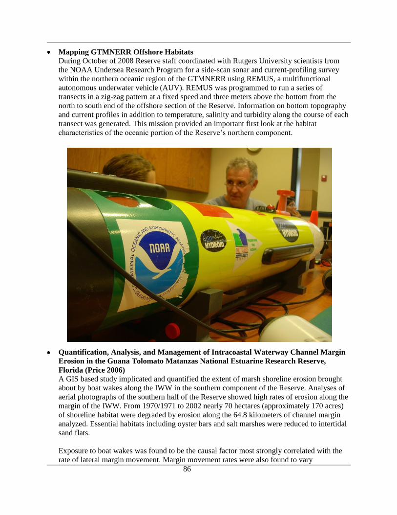
86
Mapping GTMNERR Offshore Habitats
During October of 2008 Reserve staff coordinated with Rutgers University scientists from
the NOAA Undersea Research Program for a side-scan sonar and current-profiling survey
within the northern oceanic region of the GTMNERR using REMUS, a multifunctional
autonomous underwater vehicle (AUV). REMUS was programmed to run a series of
transects in a zig-zag pattern at a fixed speed and three meters above the bottom from the
north to south end of the offshore section of the Reserve. Information on bottom topography
and current profiles in addition to temperature, salinity and turbidity along the course of each
transect was generated. This mission provided an important first look at the habitat
characteristics of the oceanic portion of the Reserve‟s northern component.
Quantification, Analysis, and Management of Intracoastal Waterway Channel Margin
Erosion in the Guana Tolomato Matanzas National Estuarine Research Reserve,
Florida (Price 2006) A GIS based study implicated and quantified the extent of marsh shoreline erosion brought
about by boat wakes along the IWW in the southern component of the Reserve. Analyses of
aerial photographs of the southern half of the Reserve showed high rates of erosion along the
margin of the IWW. From 1970/1971 to 2002 nearly 70 hectares (approximately 170 acres)
of shoreline habitat were degraded by erosion along the 64.8 kilometers of channel margin
analyzed. Essential habitats including oyster bars and salt marshes were reduced to intertidal
sand flats.
Exposure to boat wakes was found to be the causal factor most strongly correlated with the
rate of lateral margin movement. Margin movement rates were also found to vary
87
significantly with exposure to wind waves and with the type of channel margin eroded. A
reduction in nearshore wave energy appears to be necessary to allow the recovery of
impacted ecosystems.
Linking Atmospheric Mercury Deposition to Methylmercury Bioaccumulation in
Estuarine Fish at Atlantic NERR Sites
The transport and transformation processes connecting atmospheric deposition of mercury to
its bioaccumulation in fish are many, complex and uncertain. In 2009 a collaborative study
with the Center for Coastal Fisheries and Habitat Research in Beaufort, NC [one of NOAA‟s
National Centers for Coastal Ocean Science (NCCOS)] was initiated to investigate links
between atmospheric mercury deposition and bioaccumulation of methylmercury in estuarine
biota at selected east coast NERR sites. GTM staff are collecting oysters (Crassostrea
virginica) and fish (Fundulus heteroclitus) at strategic locations within tidal creeks of the
Reserve for subsequent chemical analyses at the NCCOS laboratory in Beaufort. The project
will examine whether or not a latitudinal gradient in mercury concentration in estuarine
sentinel organisms parallels the latitudinal gradient in atmospheric mercury deposition.
88
ASSESSMENT OF RESEARCH AND MONITORING NEEDS
Interviews with Reserve staff, academic scientists, outside agency personnel, and other interested
parties have identified the following research facility needs, research gaps, monitoring priorities
and needs, and research priorities and needs for the GTMNERR.
Research Facility Needs
Several investigators have indicated the desire for an additional water quality sampling
station in the vicinity of the SR 206 bridge that crosses the IWW. This region of
theMatanzas estuary is tidally influenced by both the St. Augustine and Matanzas Inlets
and is reltively narrow by virtue of the causeway and bridge structure. It therefore
representing an interesting choke point in the estuary worthy of water quality monitoring;
moreover, this area is one of the NOAA sites for the Mussel Watch program. Ideally, this
station would be equipped with the same SWMP water quality sampling devices as the
Pellicer Creek station.
An expansion of sleeping accommodations at both Reserve locations will enable larger
groups of researchers to work in close proximity to the Reserve.
The installation of an auxiliary sampling platform at the Pellicer Creek site would
provide space for additional sampling equipment such as an ISCO sampler and
periphyton samples.
Research Gaps
Ideally, biological monitoring should focus on multiple trophic levels (e.g.,
phytoplankton, zooplankton, macroinvertebrates, fishes, and marine mammals) and
habitats incorporating measures of both species/habitat biodiversity and condition. This
multiple trophic level monitoring is not yet in place. It will complement the expansion of
the national SWMP effort to include assessments of habitat changes in biodiversity,
population structure, and productivity in coastal communities related to anthropogenic
and climate change impacts.
The GTMNERR submerged habitats are not well characterized. An up-to-date baseline
inventory of habitats and species together with the development of protocols for
conducting change analyses and predictive modeling is needed. In addition, mapping of
submerged habitat sediment grain size, bathymetry and hard-bottom resources to serve as
baseline for future change analyses and habitat suitability modeling efforts is needed.
There is a need for information concerning the status and trends in recreational and
commercial fisheries within the Reserves boundary.
Storms are often the cause of major coastal shoreline changes, exacerbating the impact of
anthropogenic influences, such as sea level rise, inlet management, beach renourishment
and channel dredging, on natural sediment dynamics (Michener 1997). Sediment

89
transport modeling is necessary to quantify these processes and predict the outcome of
anthropogenic and natural events.
Our understanding of coastal circulation in the nearshore and offshore waters of the
Reserve is lacking due to very few observations, except at NDBC buoy 41012
approximately 40 nautical miles offshore, and NDBC 41009 at about 20 nautical miles
offshore of Cape Canaveral. The proximity of these waters to estuarine outflows from St.
Augustine Inlet and the Matanzas Inlet heightens the potential for serious impacts to the
integrity of all elements of the coastal environment, including plankton, invertebrate and
fish communities, as well as the quality of recreational resources, such as beaches.
Installation of a chain of offshore buoys and associated sampling equipment would
enable researchers to begin to develop a hydrodynamic understanding of the offshore
environment. This basic research could then be used to study the effects of nutrient flows
from the estuary and offshore, as well as the bio-physical interactions between the two
environments.
Previous analysis of erosive trends of shoreline suggests that increased nearshore wave
energy caused by boat wakes is the primary cause; however, further research may be
necessary to accurately relate wake energy to erosion rates. Such work should be
followed by the development and implementation of a plan intended to address the
problem of erosion in the Reserve.
Monitoring Priorities and Needs
There is an immediate need to evaluate existing ecosystem science information to
establish baseline conditions in order to evaluate and prioritize future management
activities. Long-term systematic monitoring of pollutants, habitats, and estuarine species
has not been initiated throughout the GTMNERR, and in particular in the Reserve‟s
CAMA managed boundaries.
Long-term standardized monitoring is needed to assess trends in the condition of the
Reserve‟s water quality and biological resources. Monitoring has been initiated through
the SWMP but data collected from other entities needs to be collated and analyzed.
Analysis and monitoring of the composition of estuarine and oceanic species is needed to
track short-term variability and long-term trends.
The initial GRMAP and PCAP management plans include habitat and species inventories
(DNR 1991) that should be updated, or a general GTMNERR inventory should be
conducted using standardized methods to facilitate change detection.
Basic biological monitoring of phytoplankton, zooplankton, and macroinvertebrate
communities is needed to develop an understanding of the basic trophic status of the
estuarine ecosystem.
90
Establishing long-term baseline mapping of the Reserve‟s upland habitats is necessary to
track short-term variability and long-term trends. Habitat change monitoring is necessary
to set management priorities and to assess the resiliency of the Reserve‟s habitats.
The influence of long-term climate change, particularly global warming and sea level
rise, on the Reserve‟s habitat and species composition will need to be monitored closely
to guide future long-term management strategies.
Consolidating research and monitoring information from a variety of local, state and
national programs is needed to produce a comprehensive watershed plan for sustainable
protection of the water quality and coastal habitats of the Reserve.
Research Priorities and Needs
There is aneed for continued coordination with the GTM Research Reserve‟s CTP and
Education programs to facilitate translation and communication of the Reserve‟s research
results. The GTM Research Reserve‟s Management Plan emphasizes such educational
linkages and particularly the use of research and monitoring information in guiding
adaptive management decisions.
Climate change is predicted to strongly affect coastal areas due to sea level rise, increase
in storm frequency, and changes in weather patterns. Since human populations are
increasingly drawn to coastal areas, the continued interactions of human activities with
the natural environment need to be understood, especially in light of a changing climate,
which may alter these interactions (NERR 2007).
As the national effort develops, the SWMP program is being expanded to include
assessments of habitat loss and changes in biodiversity, population structure, and
productivity in coastal communities as a result of climate change impacts. One of the
main objectives of the climate change assessment will be to establish a surface elevation
table (SET) network within wetland habitats (e.g. marsh, mangroves, etc.) of the
Reserves to support long-term monitoring and research of factors affecting the elevation
of coastal wetlands with respect to sea level. SET data will be analyzed to develop
surface elevation trajectories which will allow the evaluation of whether the wetland
surfaces are keeping pace with sea level. Coupled with other components of SWMP, this
information could be used to investigate processes resulting in elevation change, and
community responses to this change.
Primary production, respiration and the balance between the two, or net ecosystem
metabolism (NEM), has been assessed for many of the NERR estuaries (Caffrey 2003).
The GTMNERR was not included as sufficient data for the system had not been acquired.
Sufficient data is now available such that the NEM for the GTMNERR can be assessed.
This assessment is consistent with the NERR SWMP goal to examine short-term
variability and long-term changes in representative estuarine ecosystems (Wenner et al.
2001).
91
Habitat suitability modeling or similar efforts should be implemented as a predictive tool
to guide management decisions affecting natural biodiversity.
The influence of anthropogenic water diversions from aquifers for drinking water,
irrigation and lake management on the Reserve‟s natural resources requires further study
Researchers from UF have numerous biological samples collected in conjunction with
ongoing projects that have been archived, but have yet to be analyzed. Analysis and
characterization of the samples would greatly expand the knowledge base of basic
biological information in the Reserve. A catalog of samples collected is included in
Appendix C.
More in-depth work aimed at establishing a stronger causal correlation to shoreline
erosion and boat wakes could involve field measurement of wave energy and an attempt
to correlate wave energy with fetch, nearshore bathymetric profile, local sediment type,
and erosion rates. Such a study could develop a comparison of the net volumes of
sediment transported by relatively small but frequent wind waves and larger but less
frequent boat wakes.

92
REFERENCES
Abraham, B. J. 1985. Species profiles: life histories and environmental requirements of coastal
fishes and invertebrates (Mid-Atlantic)--mummichog and striped killifish. U.S. Fish and
Wildlife Service Biological Reports 82(11.40). U.S. Army Corps o f Engineers, TR EL-
82-4. 23 pp.
Agnew, J.G. 2007. Dactyls Reveal Evolutionary Patterns in Decapod Crustaceans. Ph.D.
Dissertation, Department of Geology and Geophysics. Louisiana State University.
American Cetacean Society. 2009. Right Whale Fact Sheet. Accessed at
http://www.acsonline.org/factpack/RightWhale.htm, August 4, 2009.
Bahr, L. M. and W. P. Lanier. 1981. The ecology of intertidal oyster reefs of the south
Atlantic coast: a community profile. U. S. Fish and Wildlife Service, Office of
Biological Services, Washington, D.C. FWS/OBS-81/15. 105 pp.
Baker, H.A. 1988. Erosion at the Shell Bluff Landing Site (8SJ32). Florida Bureau of
Archaelogical Research, Division of Historical Research Tallahassee, Fl.
Baker, P., Fajans, J. S., Arnold, W. S., Ingrao, D. A., Marelli, D. C. and Shirley M. Baker. 2007.
Range and dispersal of tropical marine invader, the Asian green mussel, Perna viridis, in
subtropical waters of the southeastern United States. Journal of Shellfish Research.
26:345-355.
Bonvechio, K. 2008. American Eel Anguilla rostrata Monitoring in Florida. Accessed on the
FWRI Web site at http://research.myfwc.com/features/search_results.asp.
Bonvechio, K. I., Crumpton, J., and W. E. Johnson. 2004. Annual American Eel, Anguilla
Rostrata, Compliance Report to the Atlantic States Marine Fisheries Commission for
Florida, 2003-2004 Submitted by: Fish and Wildlife Research Institute Fresh Water
Fisheries Research Section, Florida Fish and Wildlife Conservation Commission, 601
West Woodward Avenue, Eustis, FL 32726, September 1, 2004. Accessed at the FWRI
Web Site at http://research.myfwc.com/features/view_article.asp?id=25548, May 7,
2008.
Bourne, S.; Fox, S.; Sucsy, P.; Montague, C.; Ceric, A.; and P. Kinser. 2007. ACES: Building a
GIS-based Analytical Framework for Coastal and Estuarine Study. Estuarine Research
Federation Conference, November 2007, Providence Rhode Island.
Brucker, J. and R. Gleeson. 2006. Water Quality Profiles in the Guana Tolomato Matanzas
National Estuarine Research Reserve, presented at the Southeast Estuarine Research
Society Meeting (SEERS), St. Augustine, FL. October 2006
Burnson, T. Q. 1972. Sedimentological Study of Matanzas Inlet, Florida and Adjacent Areas.
M.S. Thesis. University of Florida, Gainesville, FL.
93
Caffrey, J.M. 2003. Production, respiration and net ecosystem metabolism in U.S. estuaries.
Environmental Monitoring and Assessment 81:207-219.
Calman, B., Lin, Y.W., and R.A. Wallace. 2001. Preparation and use of specific antibodies to the
beta-I and beta-II subunits of gonadotropic hormone from Fundulus heteroclitus pituitary
General and Comparative Endocrinology Volume 123 (2):203-9
CDM/DHI. 2002. Generation of a Curvilinear-orthogonal Grid and Tidal Model for the Northern
Coastal Basin. Final Report to the St. Johns River Water Management District, Palatka,
FL.
Ceric, A., Winkler, S., and E.Lowe. 2007. Status and Trends in Water Quality at the St. Johns
River Water Management District: Trophic State Assessment. Poster. AWRA Annual
Meeting, New Mexico, 2007.
The Clean Water Act (as Amended), 33 U.S.C. § 1251-1387 (1972).
Christman, S.P., and D. B. Means. 1992. Striped newt, Notophthalmus perstriatus. Pages 62–65
in P. E. Moler, ed. Rare and endangered biota of Florida. Vol. III. Amphibians and
reptiles. Univ. Presses of Fla., Gainesville.
Clarke, P.J. 2006. Winter Ecology of Young-Of-The-Year and Age 1+ Bluefish, Pomatomus
saltatrix, in a Northeast Florida Estuary. Master‟s Thesis. University of Massachusetts,
Amherst. 95pp.
Coastal Zone Management Act of 1972, as Amended (CZMA), 16 U.S.C. ss 1451-1464 et seq.
(West 1982 & Supp. 1988).
Conway, C. C. 2005. Standardized North American Marsh Bird Monitoring Protocols. Wildlife
Research Report 2005-04, U.S. Geological Survey, Arizona Cooperative Fish and
Wildlife Research Unit, Tucson, Az.
Cooke, C. W. 1945. Geology of Florida, Florida. Geological Survey Bulletin 29. Tallahassee,
FL. 339 pp.
Coultas, C. L. & Y. Hsieh. (editors) 1997. Ecology and Management of Tidal Marshes: A Model
from the Gulf of Mexico. St. Lucie Press, Delray Beach, FL. 355 pp.
Davis, R. A. and W.T. Fox. 1980. A Dynamic Process Model for the Beach-Inlet Transition
Zone.
Davis, R. A. and W.T. Fox. 1981. Interaction between wave- and tide-generated processes at the
mouth of a microtidal estuary: Matanzas River, Florida. Marine Geology 40(1-2): 49-68.
94
Dix, N. G., Phlips, E. J., and R.A. Gleeson. 2008. Water Quality Changes within the Guana
Tolomato Matanzas National Estuarine Research Reserve, Fl Associated with Four
Tropical Storms. Journal of Coastal Research. 55:(26-37).
Economic and Demographic Research (EDR). 2009. St. Johns County Profile. Office of
Economic and Demographic Resreach. The Florida Legislature, Tallahassee, FL.
Accessed at http://edr.state.fl.us/county%20profiles/stjohns.pdf. August 4, 2009.
Feder, M. E. 1987. New Directions in Ecological Physiology. Cambridge University Press. 364
pp.
Florida Department of Natural Resources (DNR). 1991. Pellicer Creek Aquatic Preserve
Management Plan. 94 pp. Accessd at the FDEP Web site at
http://www.dep.state.fl.us/coastal/downloads/management_plans/aquatic/PellicerCreek.p
df. April 20, 2008.
Florida Fish and Wildlife Conservation Commission (FWC). 2005. Blue Crab-Beautiful savory
Swimmer. Florida Fish and Wildlife Conservation, 100 8th Avenue SE, St. Petersburg,
FL 33701 4pp. Accessed at the FWC Fish and Wildlife Research Institute Web site at
http://research.myfwc.com/, April 7, 2008.
FWC. 2006a. Black Drum, Pogonias cromis. Florida Fish and Wildlife Conservation, 100 8th
Avenue SE, St. Petersburg, FL 33701 9pp. Accessed at the FWC Fish and Wildlife
Research Institute Web site at
http://research.myfwc.com/features/view_article.asp?id=4910, April 26, 2008.
FWC. 2006b. Flounder Paralichthys spp. Florida Fish and Wildlife Conservation, 100 8th
Avenue SE, St. Petersburg, FL 33701 10pp. Accessed at the FWC Fish and Wildlife
Research Institute Web site at
http://research.myfwc.com/features/view_article.asp?id=5114, April 7, 2008.
FWC. 2006c. Sheepshead, Archosargus probatocephalus. Florida Fish and Wildlife
Conservation, 100 8th Avenue SE, St. Petersburg, FL 33701 10pp. Accessed at the FWC
Fish and Wildlife Research Institute Web site at
http://research.myfwc.com/features/view_article.asp?id=5318, May 2, 2008.
FWC. 2007a. Spotted Seatrout, Cynoscion nebulosus. Florida Fish and Wildlife Conservation,
100 8th Avenue SE, St. Petersburg, FL 33701 10pp. Accessed at the FWC Fish and
Wildlife Research Institute Web site at
http://research.myfwc.com/features/view_article.asp?id=5624, April 7, 2008.
FWC. 2007b. Gopher Tortoise Management Plan, Gopherus polyphemus. Florida Fish and
Wildlife Conservation Commission. 620 South Meridian Street, Tallahassee, FL.
Accessed at http://myfwc.com/docs/WildlifeHabitats/GT_Mgmt_Plan.pdf, August 4,
2009.
95
Florida Natural Areas Inventory (FNAI). 1990. Guide to the Natural Communities of Florida.
Tallahassee, FL. 111 pp.
Florida Natural Areas Inventory. 1991. Matrix of Habitats and Distribution by County of
Rare/Endangered Species in Florida. Tallahassee, FL. 92 pp.
Florida Natural Areas Inventory (FNAI). 2001. Florida Black Bear (Ursus americanus
floridanus). Field Guide to the Rare Plants and Animals of Florida. Accessed at
http://www.fnai.org/FieldGuide/pdf/Ursus_americanus_floridanus.pdf, August 4, 2009.
Florida Statistical Abstract. 2002. Gainesville, FL: University of Florida, Bureau of Economic
and Business Research [BEBR].
Franklin, Marianne, and John W. Morris III. 1996. A Remote Sensing Survey of St. Augustine,
Florida. Southern Oceans Archaeological Research, Survey Report No. 2, SOAR, PO
Box 13512, Pensacola, Florida 32591.
Fox, S.; Ceric, A.; Bourne, S.; Sucsy, P.; Montague, C.; Kinser, P. 2007. Assessment of Water
Quality in the Guana-Tolomato-Matanzas Estuary: A first application of the ACES
workbench. Estuarine Research Federation Conference, November 2007, Providence,
Rhode Island.
Gallivan, L.B. 1979. Sediment Transport in a Mesotidal Inlet; Matanzas Inlet, Florida. University
of Florida Coastal Engineering Archives. Gainesville, Florida.
Gallivan, L. B. and Richard A. Davis, Jr. 1981. Sediment transport in a microtidal estuary:
Matanzas River, Florida (USA). Marine Geology, 40(1-2):69-83.
Garland, J. L., and D. P. Smith. 2009. Redox control bioreactor for enhanced nitrogen removal
from septic tank effluent. Final Report submitted to the NOAA/UNH Cooperative
Institute for Coastal and Estuarine Technology. 29pp.
Gordon, K., Gandhi, J. P. and V. J. Harwood. 2005. Determining the Levels of Vibrio
vulnificusin Oysters and Waters of the GTMNERR. Poster at the GTMNERR
headquarters.
Gordon, K., Vickery, V., DePaola, M.C., Staley, C.A. and V.J. Harwood. 2008. Real-Time PCR
Assays for Quantification and Differentiation of Vibrio vulnificus Strains in Oysters and
Water. Applied and Environmental Microbiology. 74(6):1704-1709.
Hancock, J., and H. Elliott. 1978. The Herons of the World. New York: Harper and Row
Publishers. NY.
Hare, M. P. 2008. The Oyster as Bioindicator of Population Connectivity among Southeastern
Florida Lagoons. Presentation at February 2008 Ocean Sciences Meeting, American
Society of Limnology and Oceanography, Orlando, FL.
96
Harwood, V. J. and D. V. Lim. 2005. Real-Time Detection of Human Pathogens in the Guana-
Tolomato-Matanzas National Estuarine Research Reserve. A Final Report Submitted to
the NOAA/UNH Cooperative Institute for Coastal and Estuarine Environmental
Technology (CICEET), Durham, NH. 53pp.
Haydt, P. J. and Frazel, Inc. 2003. Northern Coastal Basin Surface Water Improvement and
Management Plan. St. Johns River Water Management District, Palatka, FL. 99pp.
Hitchcock, G. and D. Frazel. Unpublished raw data. Studies of Karenia brevis in northeast
Florida. Chlorophyll, primary productivity, nutrient, and oxygen samples collected.
October 16, 17, 2007.
Ho, C., C.S. Salgado, N.B. Dave and S.C. Pennings. 2005. Latitudinal variation in herbivore
densities and damage to plants in coastal salt marshes. Poster at GTMNERR. Department
of Biology and Biochemistry, University of Houston.
Hsiao, S. M., Greeley M. S. Jr and R. A. Wallace. 1994. Reproductive Cycling in Female
Fundulus heteroclitus. The Biological Bulletin, 186(3): 271-284.
Johnson, S. A. 2002. Life History of the Striped Newt at a North-Central Florida Breeding Pond.
Southeastern Naturalist. 1(4):381-402.
Jones, C. P. and A.J. Mehta. 1978. Glossary of Inlets: Ponce de Leon Inlet. (Report No. 23, p.
57) Gainesville, FL: Florida Sea Grant.
Juanes, F., Murt, J., and P. Clarke. 2007. Winter recruitment of young-of-the-year bluefish:
habitat use, feeding ecology, and energetics. Presented at Reproductive and Recruitment
Processes of Exploited Marine Fish Stocks, 1-3 October, 2007. Lisbon Portugal.
Accessed at http://www.nafo.int/science/research/conferences/2007/abstract-booklet.pdf,
August 4, 2009.
Juliano, S. A. and Lounibos, L. P. 2005. Ecology of Invasive Mosquitoes: Effects on Resident
Species and Human Health. Ecology. Letters 8(5):558-574.
Kautz, R. S. and Cox, J. A. 2001. Strategic Habitats for Biodiversity Conservation in Florida.
Conservation Biology, 15(1):55-77.
Kilheffer, J., Gustafson, D. J. and B. R. Silliman. 2006. Relative impacts of Littoraria irrorata
and Prokelisia marginata on Spartina alterniflora growth. Estuaries 26:639- 644.
Kinnaman, S. L. 2006. Potentiometric surface of the upper Floridan Aquifer in the St. Johns
River Water Management District and vicinity, Florida. (Open-File Report) U. S.
Geological Survey.
97
Kinser, P., Curtis, D., Beck, J. and C. Yates. 2008. Coastal Wetlands of the Guana-Tolomato-
Matanzas National Estuarine Research Reserve in Northeast Florida. Technical
Publication SJ2008-in press. St. Johns River Water Management District. Palatka, FL.
Kneib, R.T., Stiven, A.E., and E.B. Haines. 1980. Stable carbon isotope ratios in Fundulus
heteroclitus muscle tissue and gut contents from a North Carolina Spartina alterniflora
marsh. Journal of Experimental Marine Biology and Ecology 46(1):89-98.
Kojima, H., and S. D. Hunt. 1980. Fort George Inlet. Glossary of Inlets Report No. 10, Rep. No.
23. Florida Sea Grant, Gainesville, Florida. 52 pp.
Kushlan, J. A. 1990. Freshwater marshes. In Myers, R. L. & Ewel, J. J., (Eds.), Ecosystems of
Florida. (pp. 324–363). Orlando, FL: University of Central Florida Press.
Laegdsgaard, P., and C. R. Johnson. 1995. Mangrove habitats as nurseries – unique assemblages
of juvenile fish in subtropical mangroves in eastern Australia. Marine Ecology Progress
Series 126(1-3):67-81.
Leitholf, S. 2008. Assessing and Modeling Mangrove Forest Dynamics Along the Temperate-
Subtropical Ecotone in Eastern Florida. Master‟s Thesis. University of Central Florida,
Orlando, FL. 83 pp.
Leitholf, S. and J. Weishampel. 2007. Mangroves on the Move: The Northern Expansion of
Mangroves into the Salt Marsh of the GTMNERR. Presentation at the Southeastern
Estuarine Research Society Meeting, Pine Knoll Shores, NC. March 2007.
Lin, Y. W., Petrino, T. R. and R. A. Wallace. 2004. Fundulus heteroclitus gonadotropins.5:
Small scale chromatographic fractionation of pituitary extracts into components with
different steroidogenic activities using homologous bioassays. Reproductive Biology and
Endocrinology (2)14.
Mahmoudi, B. 2005. The 2005 update of the stock assessment for striped mullet, Mugil
cephalus, in Florida. Florida Fish and Wildlife Conservation Commission Fish and
Wildlife Research Institute, 100 Eighth Ave SE St. Petersburg, Florida. 43pp.
Mao, L. T. M., Freeman, R. and C. Basci. 2007. Hydrological Watershed Model for the Northern
Coastal Basin North Project - Intracoastal Waterway (3I), Tolomato River (9D), and
Matanzas River (9C) Planning Units. Technical Memorandum. Department of Water
Resources, St. Johns River Water Management District Palatka, Florida.
Marine Mammal Center. 2002. Humpback Whale (Megaptera novaeangliae) Fact Sheet. The
Marine Mammal Center. Sausalito California. Accessed at
http://www.tmmc.org/learning/education/whales/humpback.asp, August 4, 2009.
Marino, J. N. and A. J. Mehta. 1986. Sediment Volumes Around Florida’s East Coast Tidal
Inlets.
98
Mehta, A. J. and C.P. Jones, 1977. Matanzas Inlet – Glossary of Inlets Report #5, Florida Sea
Grant Program.
Mehta, A. J. and D.M. Sheppard. 1979. Performance Study at Matanzas Closure, COEL Report
No. 79/007.
Michener, W. K., Blood, E. R., Bildstein, K. L., Brinson, M. M. and L. R. Gardner. 1997.
Climate change, hurricanes and tropical storms, and rising sea level in coastal wetlands.
Ecological Applications. 7(3):770-801.
Milanich, J. and S. Proctor. 1980. Tacachale: Essays on the Indians of Florida and Southeastern
Georgia during the Historic Period. The Western Historical Quarterly, 11(2):205-206.
Milanich, J.T. 1994. Archaeology of Pre-Columbian Florida. University Press of Florida,
Gainesville. 476pp.
Milanich, J.T. 1995. Florida Indians and the Invasion from Europe. University of Florida:
Gainesville, Florida. 290 pp. Newman, C. 2003. Field Notes: Matanzas State.
Milanich, J.T. and C.H. Fairbanks. 1980. Florida Archaeology. Academic Press: New York, New
York. 290pp.
Miller, J. A. 1986. Hydrogeologic Framework of the Florida Aquifer System in Florida and in
Parts of Georgia, Alabama, and South Carolina. (Professional Paper 1403-B). Reston,
VA: U.S. Geological Survey.
Miller, J. D., and G.C. Sigua. 2003 Status and trends of water quality in the Northern Coastal
Basins. (draft) Technical memorandum. Palatka, FL: St. Johns River Water Management
District.
Miller, J.J. 1991. The Fairest, Frutefullest and Pleasantest of All the World: An Environmental
History of the Northeast Part of Florida. Ph.D. Dissertation, University of
Pennsylvania.
Montague, C.L. and Wiegert, R.G. 1990. Salt Marshes. In Myers, R. L. & Ewel, J. J., (Eds.),
Ecosystems of Florida. (pp. 481–516). Orlando, FL: University of Central Florida Press.
Morris, J.W., M. Franklin and N. Carroll 1998 "The St. Augustine Maritime Survey 1997",
Southern Oceans Archaeological Research, Survey Report No. 2, SOAR, PO Box 13512,
Pensacola, Florida 32591.
Mozdzer, T. M., J. C. Zieman, and K. J. McGlathery. 2007. Latitudinal variation in the availability and
utilization of dissolved organic nitrogen by Spartina alterniflora. Estuarine Research Federation Conference.
99
Muncy, R. J. 1984. Species profiles: life histories and environmental requirementsof coastal
fishes and invertebrates (south Atlantic): white shrimp. U.S. Fish andWildlife. Service
FWS/OBS-82/11.27. U.S. Army Corps of Engineers, TR EL-82-4. 19 pp.
Murphy, M.D. 2005. A stock assessment of red drum, Sciaenops ocellatus, in Florida: status of
stocks through 2003. Florida Fish and Wildlife Conservation Commission. Florida
Marine Research Institute. St. Petersburg, Florida, 5 May 2005. 35pp.
Murphy, M.D., Meyer, C.A. and Anne L. McMillen-Jackson. 2001. A stock assessment for blue
crab, Callinectes sapidus, in Florida waters. Report to the Florida Fish and Wildlife
Commission Division of Marine Fisheries, July 9, 2001. Florida Fish and Wildlife
Conservation Commission. Florida Marine Research Institute. St. Petersburg, Florida.
Accessed at the FWRI Web site at http://research.myfwc.com/, April 7, 2008.
Murphy, M.D., Guenther, C. B. and Behzad Mahmoudi. 2006. An assessment of the status of
spotted seatrout in Florida waters through 2005 Florida Fish and Wildlife Conservation
Commission Fish and Wildlife Research Institute, 100 Eighth Ave SE St. Petersburg,
Florida. Accessed at the FWRI Web site at http://research.myfwc.com/, April 7, 2008.
Nash, C.E., Kuo, C.M., and S.C. McConnel. 1974. Operational procedures for rearing larvae of
the grey mullet, Mugil cephalus. Aquaculture 3(1):15-24.
National Estuarine Research Reserve System (NERRS). 2007. The national estuarine research
reserve‟s system-wide monitoring program (SWMP): A scientific framework and plan for
detection of short-term variability and long-term change in estuaries and coastal habitats
of the United States (2002; revised august 2007). Estuarine Reserves Division, N/ORM5,
Office of Ocean and Coastal Resource Management, NOAA Ocean Service, 1305 East
West Highway, Silver Spring, MD 20910. Accessed at the NERRS Web site at
http://nerrs.noaa.gov/pdf/SWMPPlan.pdf, May 1, 2008.
National Oceanic and Atmospheric Administration (NOAA). 1982. Local Climatological Data,
Annual Summary and Comparative Data 1982, Jacksonville, Florida. NOAA, Asheville,
N.C.
NOAA. 2008. Fiddler Crab. Accessed at NOAA Estuaries Web site at
http://www.estuaries.gov/pdf/FiddlerCrab07.pdf, on May 7, 2008.
Newman, C. L. 1995. Of Crabs, Rice Plantations, and Shell Middens: The Guana Tract. St.
Augustine Archaelogical Association. Newsletter 10(3):1.
The Randall Act, Chapter 67-393 Laws of Florida (1967).
O‟Connor, T.P. 2002. National distribution of chemical concentrations in mussels and oysters in
the USA. Marine Environmental Research. 53(2):117-143.
100
O‟Connor, T.P., and G. G. Lauenstein. 2006. Trends in chemical concentrations in mussels and
oysters collected along the US Coast: Update to 2003. Marine Environmental Research.
64(4):261-285.
Odum, W. E. 1970. Utilization of the direct grazing and plant detritus food chains by the striped
mullet, Mugil cephalus, Pages 222-240 in J.J Steele, ed. Marine food chains. Oliver and
Boyd Ltd. Edinburgh, Scot1and.
Owen, B. and S. White. 2007. National Estuarine Research Reserve System10 Anniversary
Report on the System-wide Monitoring Program (SWMP) Data Applications: 1995 –
2005. NOAA Estuarine Reserves Division. 1305 East-West Highway N/ORM5. Silver
Spring, MD 20910
Paul, J. H. and D. Fries, J. 2009. A multichannel handheld analyzer for detection of microbial
nutrients. Final Report submitted to the NOAA/UNH Cooperative Institute for Coastal
and Estuarine Technology. 22pp.
Petrino, T. R., Lin, Y. W., and R. A. Wallace. 1992. Steroidogenesis in Fundulus heteroclitus.
IV. Dichotomous effects of a phorbol ester on ovarian steroid production and oocyte
maturation. Experimental Zoology. 1(263):254-64
Phlips, E. J.; Love, N.; Badylak, S.; Hansen, P.; John, C.V., and Gleeson, R., 2004. A
Comparison of Water Quality and Hydrodynamic Characteristics of the Guana Tolomato
Matanzas National Estuarine Research Reserve and the Indian River Lagoon in Florida.
Journal of Coastal Research, Special Issue No. 45, 93-109.
Powell, M.A., Thieke, R.J. and A.J. Mehta. 2006. Morphodynamic relationships for ebb and
flood delta volumes at Florida‟s tidal entrances. Ocean Dynamics (56):295-307.
Price, Franklin D. 2006. Quantification, Analysis, and Management of Intracoastal Waterway
Channel Margin Erosion in the Guana Tolomato Matanzas National Estuarine Research
Reserve, Florida. NERRS Technical Report Series 2006:1.
Schaefer, J. and M. Sargent. 1990. Florida black bear: A threatened species, Department of
Wildlife Ecology & Conservation, Florida Cooperative Extension Service, Institute of
Food and Agricultural Sciences, University of Florida. Fact Sheet SS-WIS-25. Accessed
at the UF/IFAS Web site at http://edis.ifas.ufl.edu, May 1, 2008.
Scott, T. M., & Hajishafie, M. 1980. Top of Floridan Aquifer in the St. Johns River Water
Management District. Map Series Tallahassee, 1980, Issue 95. Tallahassee, FL: Florida
Department of Natural Resources, Division of Resource Management, Bureau of
Geology.
Scott. T. 1992. A geological overview of Florida. Tallahassee, FL: Florida Geological Survey.
101
Seaman, W. 1985. Florida Aquatic Habitat and Fishery Resources. Florida Chapter of
American Fisheries Society. Gainesville, Fl. 153pp.
Sheng, Y. P., Tutak, B., Davis, J.R, and V. Paramygin. 2008. Circulation and flushing in the
lagoonal system of the Guana-Tolomato-Matanzas National Estuarine Research Reserve
(GTMNERR), Florida. Journal of Coastal Research, 55(9-25).
Silliman, B. R. and S. Y. Newell. 2003. Fungal farming in a snail. Proceedings of the National
Academy of Sciences of the US. 100(26):16643-16648.
Silliman, B. R., M. D. Bertness and M. Thomsen. 2009. “Top-down control and human
intensification of consumer pressure in U.S. southern salt marshes.” in B. R. Silliman, T.
Grosholtz, and M. D. Bertness, editors. Accepted. Human Impacts on Salt Marshes: A
Global Perspective. University of California Press.
Smith, D. 2006. Fort Matanzas National Monument. In About U.S. Parks. Retrieved November
21, 2006, from http://usparks.about.com/library/miniplanner/blfortmatanzasnm.htm.
Snell, L.J. and Warren Anderson. 1970. Water Resources of Northeast Florida. Report of
Investigation No. 54. Florida Department of Natural Resources, Bureau of Geology.
Tallahassee, FL. 77pp.
Sovereignty Submerged Lands Management, F.A.C. § 18-21 (2007).
Stalter, R., and D. Kincaid. 2004. The Vascular Flora of five Florida Shell Middens. Journal of
the Torrey Botanical Society 131(1): 93-103.
St. Johns County Planning Division. 2003. Habitat Conservation Plan: A Plan for the Protection
of Sea Turtles and Anastasia Island Beach Mice on the Beaches of St. Johns County,
Florida. St. Johns County Planning Division. St. Johns County, FL.
St. Johns River Water Management District (SJRWMD). 1997. Guana, Tolomato, Matanzas
Shellfish and Water Quality Task Force Progress Report. May 1997. St. Johns River
Water Management District, Palatka, FL.
SJRWMD. 2004a. Northern Coastal Basin Bathymetric Survey. Technical Memorandum No. 49.
St. Johns River Water Management District, Palatka, FL.
SJRWMD. 2004b. Annual Water Use Data 2000. Technical Fact Sheet SJ2004-FS1. St. Johns
River Water Management District, Palatka, FL.
SJRWMD. 2007. Annual Water Use Data 2006. Technical Fact Sheet SJ2007-FS1. St. Johns
River Water Management District, Palatka, FL.
102
SJRWMD. 2008. Watershed Facts: Integrating environmental science and computer mapping
technology. Accessed at the SJRWMD Web site at
http://www.sjrwmd.com/archydro/factsindex.html. April 7, 2008.
Stanton, W. 2001. Memo on file. Tallahassee, Florida: Florida Department of Environmental
Protection.
Steele, P. 1991. Population Dynamics and Migration of the Blue Crab, Callinectes sapidus
(Rathbun), in the Eastern Gulf of Mexico. Proceedings of the Gulf and Caribbean
Fisheries Institute. 40:241-244.
Surface Water Quality Standards, F.A.C. § 62-302 (2006).
Tanner, W. F. 1960. Florida Coastal Classification. Transactions of the Gulf Coast Association
of Geological Societies, (10)259-266.
Taylor Engineering, Inc. 1989. Long-Range Dredged Material Management Plan for the
Intracoastal Waterway in St. Johns County, Florida.
Taylor Engineering. 1997. St. Augustine Inlet Management Plan. Prepared for Florida
Department of Environmental Protection, Parks and Recreation. Jacksonville, Fla. Taylor
Engineering, Inc.
Taylor Engineering, Inc. 1992. Management Plan SJ-1 Disposal Area
Taylor Engineering. 2003. South Amelia Island Structure Evaluation. Prepared for Florida
Department of Environmental Protection, Parks and Recreation. Jacksonville, Fla.:
Taylor Engineering, Inc.
Taylor, R.B., and W.F. McFeteridge. 1991. Management Plan: Matanzas Inlet Beach Disposal
Area Site SJ-MB. Florida Inland Navigation District. Jacksonville, Florida.
Texas Wildlife and Parks Department (TWPD). 2007. Black Drum (Pogonias cromis).
Texas Parks and Wildlife Department, 4200 Smith School Road, Austin, TX 78744.
Accessed at the TWPD Web site at
http://www.tpwd.state.tx.us/huntwild/wild/species/blackdrum/, May 1. 2008.
Thomson, J. M. 1963. Synopsis of biological data on the grey mu1le t Mugi1 cephalus Linnaeus
1758. Aust. CSIRO, Division of Fisheries Oceanography, Fisheries Synopsis (1)66 pp.
Turtora, M. 2008. Two heads with three mouths: juvenile fisheries habitat in the Northern
Coastal Basins. Presentation made at the Matanzas Inlet Workshop, Whitney Marine
Laboratory, Marineland, FL. February 13, 2008.
103
Turtora, M. and E. M. Schotman. 2006. Seasonal and spatial distributions of finfish and selected
invertebrates in bar-built estuaries of northeast Florida, 2002-2004. Open-file Report
2006. U.S. Department of the Interior, USGS. Washington, D. C.
Tutak, B. and Sheng, Y.P. 2008. Effects of tidal flats and marshes on estuarine circulation in
GTMNERR, FL. Presentation at February 2008 Ocean Sciences Meeting, American
Society of Limnology and Oceanography, Orlando, FL.
U.S. Army Corps of Engineers (USACE). 1965. Beach Erosion Control Study on St. Johns
County, Florida.
USACE. 1976, Feb. Intracoastal Waterway, Jacksonville to Miami Florida, Closure of Dike
Break through Vicinity of Matanzas Inlet.
USACE. 1975. Plan of Survey, St. Johns County, Florida – 13010 Beach Erosion Control Study
USACE. 1998. St. Johns County, Florida Shore Protection Project: General Reevaluation
Report with Final Environmental Assessment.
USACE. 2004a. Reconnaissance Report Section 905(b) Analysis, St. Johns County, Florida,
Shore Protection
USACE. 2004b. St. Johns County, Florida: Regional Approach to Sediment Management. In:
Regional Sediment Management Vol. 2, 2004. USACE, Coastal and Hydraulics
Laboratory (CEERD-HC-S), 3909 Halls Ferry Road, Vicksburg, MS. Accessed as the
USACE Web site at http://www.wes.army.mil/rsm/pubs/pdfs/RSM-2-WS04.pdf May 1,
2008.
United States.Bureau of the Census. 2008. State and County Quickfacts. Washington, D.C.
Accessed at the U.S. Census Web site at http://quickfacts.census.gov/qfd/states/ on April
28, 2008.
United States Environmental Protection Agency (USEPA). 2009. Biological Indicators of
Watershed Health. Accessed at http://epa.gov/bioindicators/html/invertebrate.html,
August 4, 2009.
Water Quality Standards, F.A.C. § 17-3 (2007).
Warburton, K. and S. J. M Blaber. 1992. Patterns of recruitment and resource use in a shallow
water fish assemblage in Moreton, Bay, Queensland. Marine Ecology Progress Series.
90:113-126.
Webb, B. M., King, J. N., Tutak, B. and A. Valle-Levinson. 2007. Flow Structure at a
Trifurcation near a North Florida Inlet. Continental Shelf Research 27(10-11):1528-1547.
104
Wenner, E. L, Holland, A. F., Arendt, M. D., Edwards, D. and Caffrey, J. M. 2001. A synthesis
of water quality data from the NERR SWMP, Report to NOAA Estuarine Reserve
Division.
White, A. W. 1970. The Geomorphology of the Florida Peninsula. Geological Bulletin No. 51.
Florida Department of Natural Resources, Bureau of Geology. Tallahassee, FL.
Winsberg, Morton D. 2003. Florida Weather; Second Edition. University Press of Florida,
Gainesville. 218 pp.
Zomlefer, W. B., Judd, W. S. and Giannasi, D. E. 2006. Northernmost limit of Rhizophora
mangle (Red Mangrove; Rhizophoraceae) in St. Johns County, Florida. Castanea 71(3):
239-244.

105
APPENDIX A. LIST OF SPECIES Common Name Scientific Name
Kingdom Plantae
Phylum Pterophyta (ferns)
Carolina Mosquito Fern Azolla caroliniana
Cinnamon Fern Osmunda cinnamomea
Royal Fern Osmunda regalis
Golden Polypody Phlebodium aureum
Resurrection Fern Pleopeltis polypodioides var. michauxiana
Lacy Bracken Pteridium aquilinum var. caudatum
Water fern Salvinia auriculata
Southern Shield Fern Thelypteris kunthii
Shoestring Fern Vittaria lineata
Netted Chain Fern Woodwardia areolata
Virginia Chain Fern Woodwardia virginica
Phylum Pinophyta (cone-bearing plants)
Red Cedar Juniperus virginiana
Sand Pine Pinus clausa
Slash Pine Pinus elliottii
Longleaf pine Pinus palustris
Pond Pine Pinus serotina
Loblolly Pine Pinus taeda
Pond cypress Taxodium ascendens
Phylum Magnoliophyta (flowering plants)
Blue Maidencane Amphicarpum muhlenbergianum
Florida Bluestem Andropogon floridanus
Purple Bluestem Andropogon glomeratus var. glaucopsis
Bushy Bluestem Andropogon glomeratus var. pumilus
Broomsedge Andropogon longiberbis
Splitbeard Bluestem Andropogon ternarius
Broomsedge Bluestem Andropogon virginicus var. virginicus
Green Dragon Arisaema dracontium
Wiregrass Aristida beyrichiana
Woollysheath Three-awn Aristida lanosa
Bottlebrush Three-awn Aristida spiciformis
Switchcane Arundinaria gigantea
Switch cane Arundinaria tecta
Common Oat Avena fatua
Bamboo Bambusa spp.
Capillary Hairsedge Bulbostylis ciliatifolia
Sandyfield Hairsedge Bulbostylis stenophylla
Greenwhite sedge Carex albolutescens
Sandywoods Sedge Carex dasycarpa
Hammock Sedge Carex fissa var. aristata
Long's Sedge Carex longii

106
Common Name Scientific Name
Blackedge Sedge Carex nigromarginata
Southern Sandspur Cenchrus echinatus
Coastal Sandspur Cenchrus incertus
Sanddune Sandspur Cenchrus tribuloides
Class Magnoliopsida (woody flowering plants)
Slender Woodoats Chasmanthium laxum var. laxum
Spanglegrass Chasmanthium laxum var. sessiliflorum
Sawgrass Cladium jamaicense
Whitemouth Dayflower Commelina erecta
Spring Coralroot Corallorhiza wisteriana
Bermudagrass Cynodon dactylon
Cyperus brevifolius
Baldwin's Flatsedge Cyperus croceus
Swamp Flatsedge Cyperus distinctus
Yellow Nutgrass Cyperus esculentus
Umbrella sedge Cyperus filicinus
Globe sedge Cyperus globulosus
Haspan Flatsedge Cyperus haspan
Fragrant Flatsedge Cyperus odoratus
Manyspike Flatsedge Cyperus polystachyos
Pinebarren Flatsedge Cyperus retrorsus
Nutgrass Cyperus rotundus
Strawcolored Flatsedge Cyperus strigosus
Tropical Flatsedge Cyperus surinamensis
Fourangle Flatsedge Cyperus tetragonus
Crowfootgrass Dactyloctenium aegyptium
Panicum Dicanthelium erectifolium
Variable Witchgrass Dichanthelium commutatum
Forked Witchgrass Dichanthelium dichotomum
Hemlock Witchgrass Dichanthelium portoricense
Dichanthelium sabulorum
Southern Crabgrass Digitaria ciliaris
Slender Crabgrass Digitaria filiformis var. filiformis
Shaggy crabgrass Digitaria villosa
Saltgrass Distichlis spicata
Coast Cockspur Echinochloa walteri
Baldwin's Spikerush Eleocharis baldwinii
Yellow Spikerush Eleocharis flavescens
Sand Spikerush Eleocharis montevidensis
Viviparous Spikerush Eleocharis vivipara
Indian Goosegrass Eleusine indica
Green-fly Orchid Epidendrum magnoliae var. magnoliae
Purple Lovegrass Eragrostis spectabilis
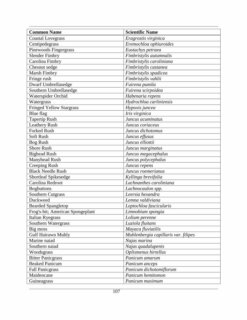
107
Common Name Scientific Name
Coastal Lovegrass Eragrostis virginica
Centipedegrass Eremochloa ophiuroides
Pinewoods Fingergrass Eustachys petraea
Slender Fimbry Fimbristylis autumnalis
Carolina Fimbry Fimbristylis caroliniana
Chesnut sedge Fimbristylis castanea
Marsh Fimbry Fimbristylis spadicea
Fringe rush Fimbristylis vahlii
Dwarf Umbrellasedge Fuirena pumila
Southern Umbrellasedge Fuirena scirpoidea
Waterspider Orchid Habenaria repens
Watergrass Hydrochloa carliniensis
Fringed Yellow Stargrass Hypoxis juncea
Blue flag Iris virginica
Tapertip Rush Juncus acuminatus
Leathery Rush Juncus coriaceus
Forked Rush Juncus dichotomus
Soft Rush Juncus effusus
Bog Rush Juncus elliottii
Shore Rush Juncus marginatus
Bighead Rush Juncus megacephalus
Manyhead Rush Juncus polycephalus
Creeping Rush Juncus repens
Black Needle Rush Juncus roemerianus
Shortleaf Spikesedge Kyllinga brevifolia
Carolina Redroot Lachnanthes caroliniana
Bogbuttons Lachnocaulon spp.
Southern Cutgrass Leersia hexandra
Duckweed Lemna valdiviana
Bearded Spangletop Leptochloa fascicularis
Frog's-bit; American Spongeplant Limnobium spongia
Italian Ryegrass Lolium perenne
Southern Watergrass Luziola fluitans
Big moss Mayaca fluviatilis
Gulf Hairawn Muhly Muhlenbergia capillaris var. filipes
Marine naiad Najas marina
Southern naiad Najas quadalupenis
Woodsgrass Oplismenus hirtellus
Bitter Panicgrass Panicum amarum
Beaked Panicum Panicum anceps
Fall Panicgrass Panicum dichotomiflorum
Maidencane Panicum hemitomon
Guineagrass Panicum maximum
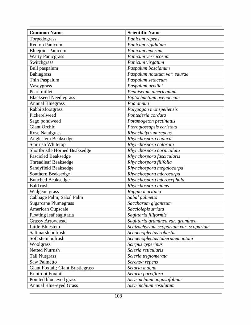
108
Common Name Scientific Name
Torpedograss Panicum repens
Redtop Panicum Panicum rigidulum
Bluejoint Panicum Panicum tenerum
Warty Panicgrass Panicum verrucosum
Switchgrass Panicum virgatum
Bull paspalum Paspalum boscianum
Bahiagrass Paspalum notatum var. saurae
Thin Paspalum Paspalum setaceum
Vaseygrass Paspalum urvillei
Pearl millet Pennisetum americanum
Blackseed Needlegrass Piptochaetium avenaceum
Annual Bluegrass Poa annua
Rabbitsfootgrass Polypogon monspeliensis
Pickerelweed Pontederia cordata
Sago pondweed Potamogeton pectinatus
Giant Orchid Pteroglossapsis ecristata
Rose Natalgrass Rhynchelytrum repens
Anglestem Beaksedge Rhynchospora caduca
Starrush Whitetop Rhynchospora colorata
Shortbristle Horned Beaksedge Rhynchospora corniculata
Fascicled Beaksedge Rhynchospora fascicularis
Threadleaf Beaksedge Rhynchospora filifolia
Sandyfield Beaksedge Rhynchospora megalocarpa
Southern Beaksedge Rhynchospora microcarpa
Bunched Beaksedge Rhynchospora microcephala
Bald rush Rhynchospora nitens
Widgeon grass Ruppia maritima
Cabbage Palm; Sabal Palm Sabal palmetto
Sugarcane Plumegrass Saccharum giganteum
American Cupscale Sacciolepis striata
Floating leaf sagittaria Sagittaria filiformis
Grassy Arrowhead Sagittaria graminea var. graminea
Little Bluestem Schizachyrium scoparium var. scoparium
Saltmarsh bulrush Schoenoplectus robustus
Soft stem bulrush Schoenoplectus tabernaemontani
Woolgrass Scirpus cyperinus
Netted Nutrush Scleria reticularis
Tall Nutgrass Scleria triglomerata
Saw Palmetto Serenoa repens
Giant Foxtail; Giant Bristlegrass Setaria magna
Knotroot Foxtail Setaria parviflora
Pointed blue eyed grass Sisyrinchium angustifolium
Annual Blue-eyed Grass Sisyrinchium rosulatum
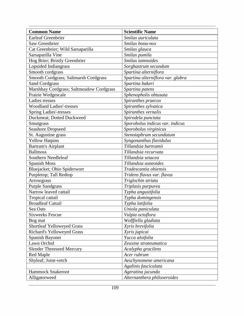
109
Common Name Scientific Name
Earleaf Greenbrier Smilax auriculata
Saw Greenbrier Smilax bona-nox
Cat Greenbrier; Wild Sarsaparilla Smilax glauca
Sarsaparilla Vine Smilax pumila
Hog Brier; Bristly Greenbrier Smilax tamnoides
Lopsided Indiangrass Sorghastrum secundum
Smooth cordgrass Spartina alterniflora
Smooth Cordgrass; Saltmarsh Cordgrass Spartina alterniflora var. glabra
Sand Cordgrass Spartina bakeri
Marshhay Cordgrass; Saltmeadow Cordgrass Spartina patens
Prairie Wedgescale Sphenopholis obtusata
Ladies tresses Spiranthes praecox
Woodland Ladies'-tresses Spiranthes sylvatica
Spring Ladies'-tresses Spiranthes vernalis
Duckmeat; Dotted Duckweed Spirodela punctata
Smutgrass Sporobolus indicus var. indicus
Seashore Dropseed Sporobolus virginicus
St. Augustine grass Stenotaphrum secundatum
Yellow Hatpins Syngonanthus flavidulus
Bartram's Airplant Tillandsia bartramii
Ballmoss Tillandsia recurvata
Southern Needleleaf Tillandsia setacea
Spanish Moss Tillandsia usneoides
Bluejacket; Ohio Spiderwort Tradescantia ohiensis
Purpletop; Tall Redtop Tridens flavus var. flavus
Arrowgrass Triglochin striata
Purple Sandgrass Triplasis purpurea
Narrow leaved cattail Typha angustifolia
Tropical cattail Typha domingensis
Broadleaf Cattail Typha latifolia
Sea Oats Uniola paniculata
Sixweeks Fescue Vulpia octoflora
Bog mat Wolffiella gladiata
Shortleaf Yelloweyed Grass Xyris brevifolia
Richard's Yelloweyed Grass Xyris jupicai
Spanish Bayonet Yucca aloifolia
Lawn Orchid Zeuxine strateumatica
Slender Threeseed Mercury Acalypha gracilens
Red Maple Acer rubrum
Shyleaf; Joint-vetch Aeschynomene americana
Agalinis fasciculata
Hammock Snakeroot Ageratina jucunda
Alligatorweed Alternanthera philoxeroides
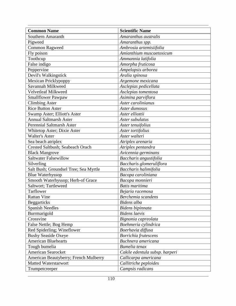
110
Common Name Scientific Name
Southern Amaranth Amaranthus australis
Pigweed Amaranthus spp.
Common Ragweed Ambrosia artemisiifolia
Fly poison Amianthium muscaetoxicum
Toothcup Ammannia latifolia
False indigo Amorpha fruticosa
Peppervine Ampelopsis arborea
Devil's Walkingstick Aralia spinosa
Mexican Pricklypoppy Argemone mexicana
Savannah Milkweed Asclepias pedicellata
Velvetleaf Milkweed Asclepias tomentosa
Smallflower Pawpaw Asimina parviflora
Climbing Aster Aster carolinianus
Rice Button Aster Aster dumosus
Swamp Aster; Elliott's Aster Aster elliottii
Annual Saltmarsh Aster Aster subulatus
Perennial Saltmarsh Aster Aster tenuifolius
Whitetop Aster; Dixie Aster Aster tortifolius
Walter's Aster Aster walteri
Sea beach atriplex Atriplex arenaria
Crested Saltbush; Seabeach Orach Atriplex pentandra
Black Mangrove Avicennia germinans
Saltwater Falsewillow Baccharis angustifolia
Silverling Baccharis glomeruliflora
Salt Bush; Groundsel Tree; Sea Myrtle Baccharis halimifolia
Blue Waterhyssop Bacopa caroliniana
Smooth Waterhyssop; Herb-of Grace Bacopa monnieri
Saltwort; Turtleweed Batis maritima
Tarflower Bejaria racemosa
Rattan Vine Berchemia scandens
Beggarticks Bidens alba
Spanish Needles Bidens bipinnata
Burrmarigold Bidens laevis
Crossvine Bignonia capreolata
False Nettle; Bog Hemp Boehmeria cylindrica
Red Spiderling; Wineflower Boerhavia diffusa
Bushy Seaside Oxeye Borrichia frutescens
American Bluehearts Buchnera americana
Tough bumelia Bumelia tenax
American Searocket Cakile edentula subsp. harperi
American Beautyberry; French Mulberry Callicarpa americana
Matted Waterstarwort Callitriche peploides
Trumpetcreeper Campsis radicans

111
Common Name Scientific Name
Bitter cress Cardamine hirsuta
Pennsylvania Bittercress Cardamine pensylvanica
Thistle Carduus spp.
Vanillaleaf Carphephorus odoratissimus
Pignut Hickory Carya glabra
Wild sensitive plant Cassia nictitans
Sicklepod Cassia obtusifolia
Sugarberry; Hackberry Celtis laevigata
Spadeleaf; Coinwort Centella asiatica
Spurred Butterfly Pea Centrosema virginianum
Buttonbush Cephalanthus occidentalis
Florida Rosemary; Sand Heath Ceratiola ericoides
Coontail Ceratophyllum spp.
Partridge Pea Chamaecrista fasciculata
Sensitive Pea Chamaecrista nictitans var. aspera
Dixie Sandmat Chamaesyce bombensis
Eye-bane; Hyssopleaf Sandmat Chamaesyce hyssopifolia
Spotted Sandmat Chamaesyce maculata
Lamb's-quarters Chenopodium album
Mexican Tea;Pigweed Chenopodium ambrosioides
Bull Thistle; Yellow Thistle Cirsium horridulum
Nuttall's Thistle Cirsium nuttallii
Sour Orange Citrus aurantium
Butterfly Pea; Atlantic Pigeonwings Clitoria mariana
Stinging Nettle; Tread-softly; Finger-rot Cnidoscolus stimulosus
Dwarf Canadian Horseweed Conyza canadensis var. pusilla
Golden Tickseed Coreopsis tinctoria
Swamp dogwood Cornus stricta
Pursh's Rattlebox Crotalaria purshii
Rabbitbells Crotalaria rotundifolia
Showy Rattlebox Crotalaria spectabilis
Hogwort; Woolly Croton Croton capitatus
Vente Conmigo Croton glandulosus
Beach Tea; Gulf Croton Croton punctatus
Colombian Waxweed Cuphea carthagenensis
Compact Dodder Cuscuta compacta
Bigseed Alfalfa Dodder Cuscuta indecora
Gulfcoast Swallowwort Cynanchum angustifolium
Western Tansymustard Descurainia pinnata
Hoary Ticktrefoil; Beggarweed Desmodium incanum
Panicledleaf Ticktrefoil Desmodium paniculatum
Dixie Ticktrefoil Desmodium tortuosum
Threeflower Ticktrefoil Desmodium triflorum
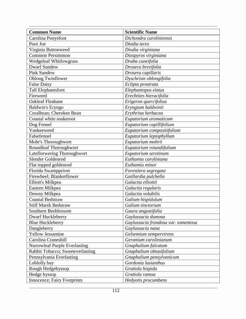
112
Common Name Scientific Name
Carolina Ponysfoot Dichondra caroliniensis
Poor Joe Diodia teres
Virginia Buttonweed Diodia virginiana
Common Persimmon Diospyros virginiana
Wedgeleaf Whitlowgrass Draba cuneifolia
Dwarf Sundew Drosera brevifolia
Pink Sundew Drosera capillaris
Oblong Twinflower Dyschriste oblongifolia
False Daisy Eclipta prostrata
Tall Elephantsfoot Elephantopus elatus
Fireweed Erechtites hieracifolia
Oakleaf Fleabane Erigeron quercifolius
Baldwin's Eryngo Eryngium baldwinii
Coralbean; Cherokee Bean Erythrina herbacea
Coastal white snakeroot Eupatorium aromaticum
Dog Fennel Eupatorium capillifolium
Yankeeweed Eupatorium compositifolium
Falsefennel Eupatorium leptophyllum
Mohr's Thoroughwort Eupatorium mohrii
Roundleaf Thoroughwort Eupatorium rotundifolium
Lateflorwering Thoroughwort Eupatorium serotinum
Slender Goldenrod Euthamia caroliniana
Flat topped goldenrod Euthamia minor
Florida Swampprivet Forestiera segregata
Firewheel; Blanketflower Gaillardia pulchella
Elliott's Milkpea Galactia elliottii
Eastern Milkpea Galactia regularis
Downy Milkpea Galactia volubilis
Coastal Bedstraw Galium hispidulum
Stiff Marsh Bedstraw Galium tinctorium
Southern Beeblossom Gaura angustifolia
Dwarf Huckleberry Gaylussacia dumosa
Blue Huckleberry Gaylussacia frondosa var. tomentosa
Dangleberry Gaylussacia nana
Yellow Jessamine Gelsemium sempervirens
Carolina Cranesbill Geranium carolinianum
Narrowleaf Purple Everlasting Gnaphalium falcatum
Rabbit Tobacco; Sweeteverlasting Gnaphalium obtusifolium
Pennsylvania Everlasting Gnaphalium pensylvanicum
Loblolly bay Gordonia lasianthus
Rough Hedgehyssop Gratiola hispida
Hedge hyssop Gratiola ramoa
Innocence; Fairy Footprints Hedyotis procumbens
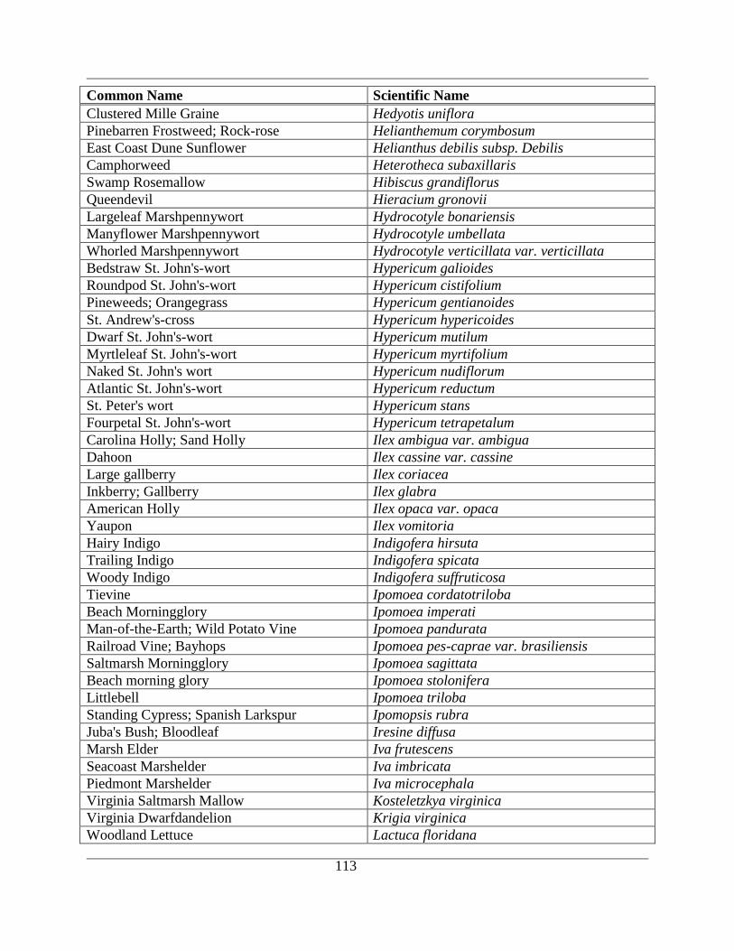
113
Common Name Scientific Name
Clustered Mille Graine Hedyotis uniflora
Pinebarren Frostweed; Rock-rose Helianthemum corymbosum
East Coast Dune Sunflower Helianthus debilis subsp. Debilis
Camphorweed Heterotheca subaxillaris
Swamp Rosemallow Hibiscus grandiflorus
Queendevil Hieracium gronovii
Largeleaf Marshpennywort Hydrocotyle bonariensis
Manyflower Marshpennywort Hydrocotyle umbellata
Whorled Marshpennywort Hydrocotyle verticillata var. verticillata
Bedstraw St. John's-wort Hypericum galioides
Roundpod St. John's-wort Hypericum cistifolium
Pineweeds; Orangegrass Hypericum gentianoides
St. Andrew's-cross Hypericum hypericoides
Dwarf St. John's-wort Hypericum mutilum
Myrtleleaf St. John's-wort Hypericum myrtifolium
Naked St. John's wort Hypericum nudiflorum
Atlantic St. John's-wort Hypericum reductum
St. Peter's wort Hypericum stans
Fourpetal St. John's-wort Hypericum tetrapetalum
Carolina Holly; Sand Holly Ilex ambigua var. ambigua
Dahoon Ilex cassine var. cassine
Large gallberry Ilex coriacea
Inkberry; Gallberry Ilex glabra
American Holly Ilex opaca var. opaca
Yaupon Ilex vomitoria
Hairy Indigo Indigofera hirsuta
Trailing Indigo Indigofera spicata
Woody Indigo Indigofera suffruticosa
Tievine Ipomoea cordatotriloba
Beach Morningglory Ipomoea imperati
Man-of-the-Earth; Wild Potato Vine Ipomoea pandurata
Railroad Vine; Bayhops Ipomoea pes-caprae var. brasiliensis
Saltmarsh Morningglory Ipomoea sagittata
Beach morning glory Ipomoea stolonifera
Littlebell Ipomoea triloba
Standing Cypress; Spanish Larkspur Ipomopsis rubra
Juba's Bush; Bloodleaf Iresine diffusa
Marsh Elder Iva frutescens
Seacoast Marshelder Iva imbricata
Piedmont Marshelder Iva microcephala
Virginia Saltmarsh Mallow Kosteletzkya virginica
Virginia Dwarfdandelion Krigia virginica
Woodland Lettuce Lactuca floridana
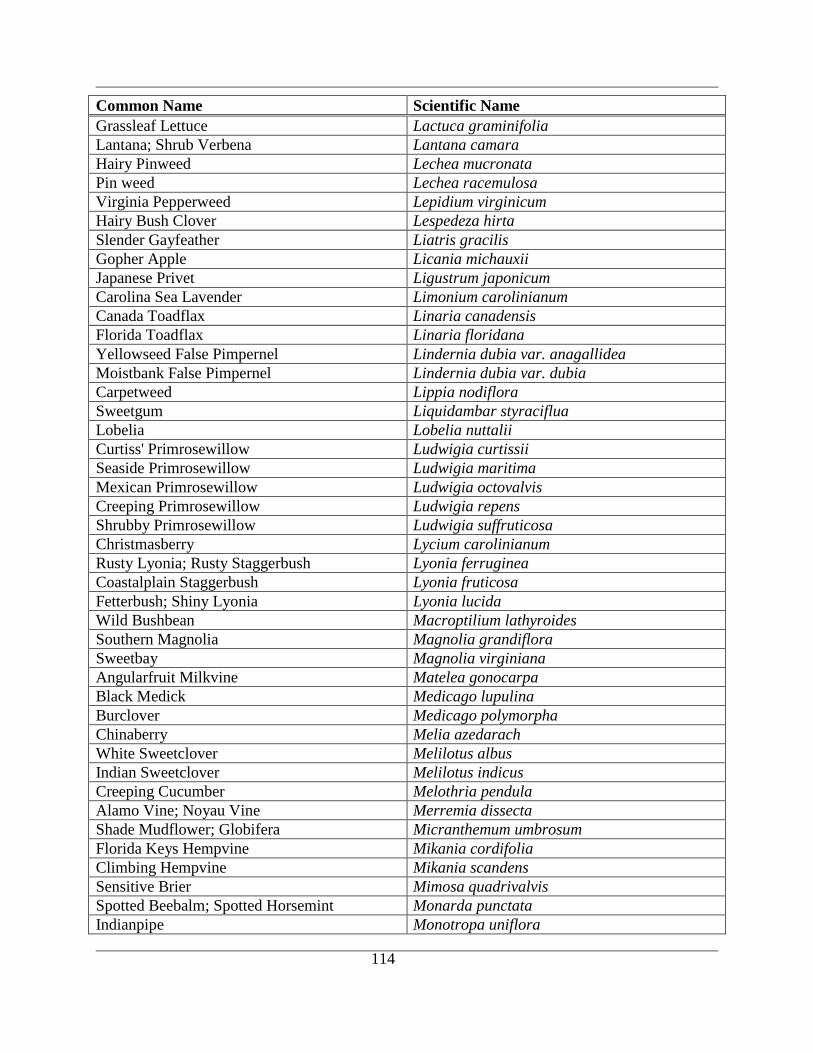
114
Common Name Scientific Name
Grassleaf Lettuce Lactuca graminifolia
Lantana; Shrub Verbena Lantana camara
Hairy Pinweed Lechea mucronata
Pin weed Lechea racemulosa
Virginia Pepperweed Lepidium virginicum
Hairy Bush Clover Lespedeza hirta
Slender Gayfeather Liatris gracilis
Gopher Apple Licania michauxii
Japanese Privet Ligustrum japonicum
Carolina Sea Lavender Limonium carolinianum
Canada Toadflax Linaria canadensis
Florida Toadflax Linaria floridana
Yellowseed False Pimpernel Lindernia dubia var. anagallidea
Moistbank False Pimpernel Lindernia dubia var. dubia
Carpetweed Lippia nodiflora
Sweetgum Liquidambar styraciflua
Lobelia Lobelia nuttalii
Curtiss' Primrosewillow Ludwigia curtissii
Seaside Primrosewillow Ludwigia maritima
Mexican Primrosewillow Ludwigia octovalvis
Creeping Primrosewillow Ludwigia repens
Shrubby Primrosewillow Ludwigia suffruticosa
Christmasberry Lycium carolinianum
Rusty Lyonia; Rusty Staggerbush Lyonia ferruginea
Coastalplain Staggerbush Lyonia fruticosa
Fetterbush; Shiny Lyonia Lyonia lucida
Wild Bushbean Macroptilium lathyroides
Southern Magnolia Magnolia grandiflora
Sweetbay Magnolia virginiana
Angularfruit Milkvine Matelea gonocarpa
Black Medick Medicago lupulina
Burclover Medicago polymorpha
Chinaberry Melia azedarach
White Sweetclover Melilotus albus
Indian Sweetclover Melilotus indicus
Creeping Cucumber Melothria pendula
Alamo Vine; Noyau Vine Merremia dissecta
Shade Mudflower; Globifera Micranthemum umbrosum
Florida Keys Hempvine Mikania cordifolia
Climbing Hempvine Mikania scandens
Sensitive Brier Mimosa quadrivalvis
Spotted Beebalm; Spotted Horsemint Monarda punctata
Indianpipe Monotropa uniflora
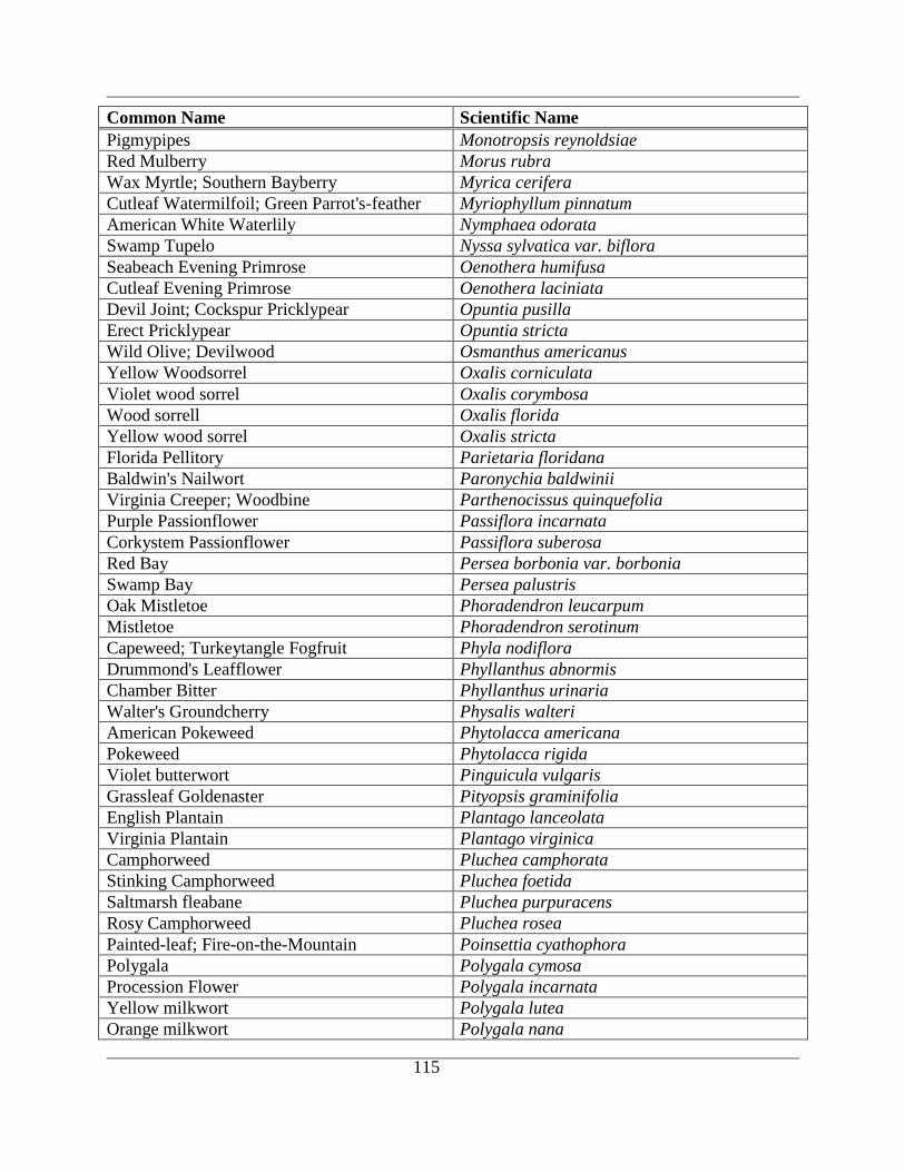
115
Common Name Scientific Name
Pigmypipes Monotropsis reynoldsiae
Red Mulberry Morus rubra
Wax Myrtle; Southern Bayberry Myrica cerifera
Cutleaf Watermilfoil; Green Parrot's-feather Myriophyllum pinnatum
American White Waterlily Nymphaea odorata
Swamp Tupelo Nyssa sylvatica var. biflora
Seabeach Evening Primrose Oenothera humifusa
Cutleaf Evening Primrose Oenothera laciniata
Devil Joint; Cockspur Pricklypear Opuntia pusilla
Erect Pricklypear Opuntia stricta
Wild Olive; Devilwood Osmanthus americanus
Yellow Woodsorrel Oxalis corniculata
Violet wood sorrel Oxalis corymbosa
Wood sorrell Oxalis florida
Yellow wood sorrel Oxalis stricta
Florida Pellitory Parietaria floridana
Baldwin's Nailwort Paronychia baldwinii
Virginia Creeper; Woodbine Parthenocissus quinquefolia
Purple Passionflower Passiflora incarnata
Corkystem Passionflower Passiflora suberosa
Red Bay Persea borbonia var. borbonia
Swamp Bay Persea palustris
Oak Mistletoe Phoradendron leucarpum
Mistletoe Phoradendron serotinum
Capeweed; Turkeytangle Fogfruit Phyla nodiflora
Drummond's Leafflower Phyllanthus abnormis
Chamber Bitter Phyllanthus urinaria
Walter's Groundcherry Physalis walteri
American Pokeweed Phytolacca americana
Pokeweed Phytolacca rigida
Violet butterwort Pinguicula vulgaris
Grassleaf Goldenaster Pityopsis graminifolia
English Plantain Plantago lanceolata
Virginia Plantain Plantago virginica
Camphorweed Pluchea camphorata
Stinking Camphorweed Pluchea foetida
Saltmarsh fleabane Pluchea purpuracens
Rosy Camphorweed Pluchea rosea
Painted-leaf; Fire-on-the-Mountain Poinsettia cyathophora
Polygala Polygala cymosa
Procession Flower Polygala incarnata
Yellow milkwort Polygala lutea
Orange milkwort Polygala nana
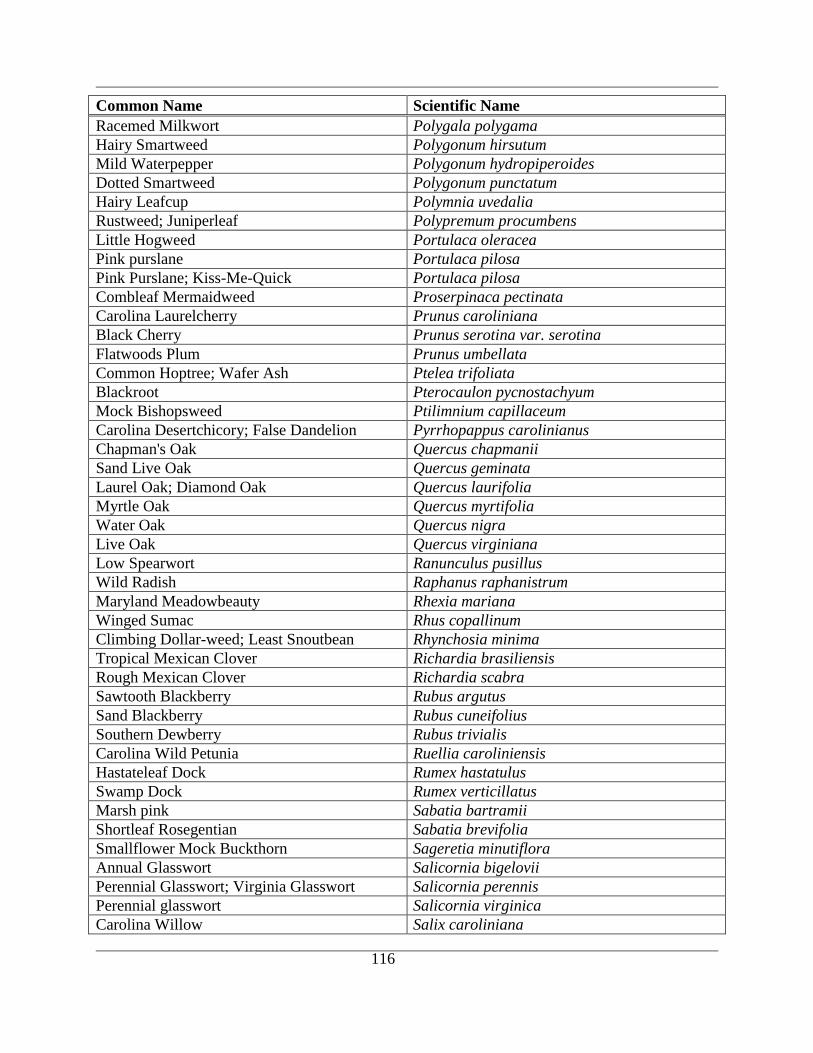
116
Common Name Scientific Name
Racemed Milkwort Polygala polygama
Hairy Smartweed Polygonum hirsutum
Mild Waterpepper Polygonum hydropiperoides
Dotted Smartweed Polygonum punctatum
Hairy Leafcup Polymnia uvedalia
Rustweed; Juniperleaf Polypremum procumbens
Little Hogweed Portulaca oleracea
Pink purslane Portulaca pilosa
Pink Purslane; Kiss-Me-Quick Portulaca pilosa
Combleaf Mermaidweed Proserpinaca pectinata
Carolina Laurelcherry Prunus caroliniana
Black Cherry Prunus serotina var. serotina
Flatwoods Plum Prunus umbellata
Common Hoptree; Wafer Ash Ptelea trifoliata
Blackroot Pterocaulon pycnostachyum
Mock Bishopsweed Ptilimnium capillaceum
Carolina Desertchicory; False Dandelion Pyrrhopappus carolinianus
Chapman's Oak Quercus chapmanii
Sand Live Oak Quercus geminata
Laurel Oak; Diamond Oak Quercus laurifolia
Myrtle Oak Quercus myrtifolia
Water Oak Quercus nigra
Live Oak Quercus virginiana
Low Spearwort Ranunculus pusillus
Wild Radish Raphanus raphanistrum
Maryland Meadowbeauty Rhexia mariana
Winged Sumac Rhus copallinum
Climbing Dollar-weed; Least Snoutbean Rhynchosia minima
Tropical Mexican Clover Richardia brasiliensis
Rough Mexican Clover Richardia scabra
Sawtooth Blackberry Rubus argutus
Sand Blackberry Rubus cuneifolius
Southern Dewberry Rubus trivialis
Carolina Wild Petunia Ruellia caroliniensis
Hastateleaf Dock Rumex hastatulus
Swamp Dock Rumex verticillatus
Marsh pink Sabatia bartramii
Shortleaf Rosegentian Sabatia brevifolia
Smallflower Mock Buckthorn Sageretia minutiflora
Annual Glasswort Salicornia bigelovii
Perennial Glasswort; Virginia Glasswort Salicornia perennis
Perennial glasswort Salicornia virginica
Carolina Willow Salix caroliniana
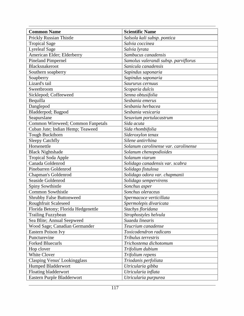
117
Common Name Scientific Name
Prickly Russian Thistle Salsola kali subsp. pontica
Tropical Sage Salvia coccinea
Lyreleaf Sage Salvia lyrata
American Elder; Elderberry Sambucus canadensis
Pineland Pimpernel Samolus valerandi subsp. parviflorus
Blacksnakeroot Sanicula canadensis
Southern soapberry Sapindus saponaria
Soapberry Sapindus saponaria
Lizard's tail Saururus cernuus
Sweetbroom Scoparia dulcis
Sicklepod; Coffeeweed Senna obtusifolia
Bequilla Sesbania emerus
Danglepod Sesbania herbacea
Bladderpod; Bagpod Sesbania vesicaria
Seapurslane Sesuvium portulacastrum
Common Wireweed; Common Fanpetals Sida acuta
Cuban Jute; Indian Hemp; Teaweed Sida rhombifolia
Tough Buckthorn Sideroxylon tenax
Sleepy Catchfly Silene antirrhina
Horsenettle Solanum carolinense var. carolinense
Black Nightshade Solanum chenopodioides
Tropical Soda Apple Solanum viarum
Canada Goldenrod Solidago canadensis var. scabra
Pinebarren Goldenrod Solidago fistulosa
Chapman's Goldenrod Solidago odora var. chapmanii
Seaside Goldenrod Solidago sempervirens
Spiny Sowthistle Sonchus asper
Common Sowthistle Sonchus oleraceus
Shrubby False Buttonweed Spermacoce verticillata
Roughfruit Scaleseed Spermolepis divaricata
Florida Betony; Florida Hedgenettle Stachys floridana
Trailing Fuzzybean Strophostyles helvula
Sea Blite; Annual Seepweed Suaeda linearis
Wood Sage; Canadian Germander Teucrium canadense
Eastern Poison Ivy Toxicodendron radicans
Puncturevine Tribulus terrestris
Forked Bluecurls Trichostema dichotomum
Hop clover Trifolium dubium
White Clover Trifolium repens
Clasping Venus' Lookingglass Triodanis perfoliata
Humped Bladderwort Utricularia gibba
Floating bladderwort Utricularia inflata
Eastern Purple Bladderwort Utricularia purpurea
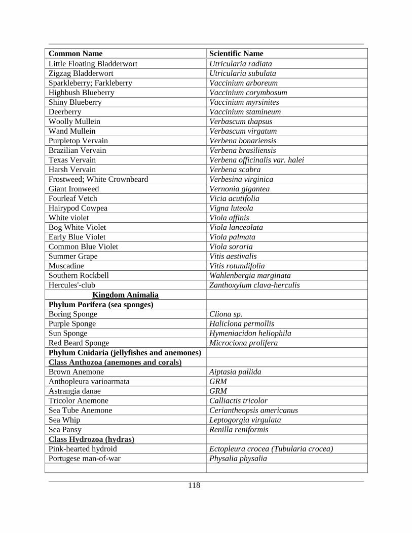
118
Common Name Scientific Name
Little Floating Bladderwort Utricularia radiata
Zigzag Bladderwort Utricularia subulata
Sparkleberry; Farkleberry Vaccinium arboreum
Highbush Blueberry Vaccinium corymbosum
Shiny Blueberry Vaccinium myrsinites
Deerberry Vaccinium stamineum
Woolly Mullein Verbascum thapsus
Wand Mullein Verbascum virgatum
Purpletop Vervain Verbena bonariensis
Brazilian Vervain Verbena brasiliensis
Texas Vervain Verbena officinalis var. halei
Harsh Vervain Verbena scabra
Frostweed; White Crownbeard Verbesina virginica
Giant Ironweed Vernonia gigantea
Fourleaf Vetch Vicia acutifolia
Hairypod Cowpea Vigna luteola
White violet Viola affinis
Bog White Violet Viola lanceolata
Early Blue Violet Viola palmata
Common Blue Violet Viola sororia
Summer Grape Vitis aestivalis
Muscadine Vitis rotundifolia
Southern Rockbell Wahlenbergia marginata
Hercules'-club Zanthoxylum clava-herculis
Kingdom Animalia
Phylum Porifera (sea sponges)
Boring Sponge Cliona sp.
Purple Sponge Haliclona permollis
Sun Sponge Hymeniacidon heliophila
Red Beard Sponge Microciona prolifera
Phylum Cnidaria (jellyfishes and anemones)
Class Anthozoa (anemones and corals)
Brown Anemone Aiptasia pallida
Anthopleura varioarmata GRM
Astrangia danae GRM
Tricolor Anemone Calliactis tricolor
Sea Tube Anemone Ceriantheopsis americanus
Sea Whip Leptogorgia virgulata
Sea Pansy Renilla reniformis
Class Hydrozoa (hydras)
Pink-hearted hydroid Ectopleura crocea (Tubularia crocea)
Portugese man-of-war Physalia physalia
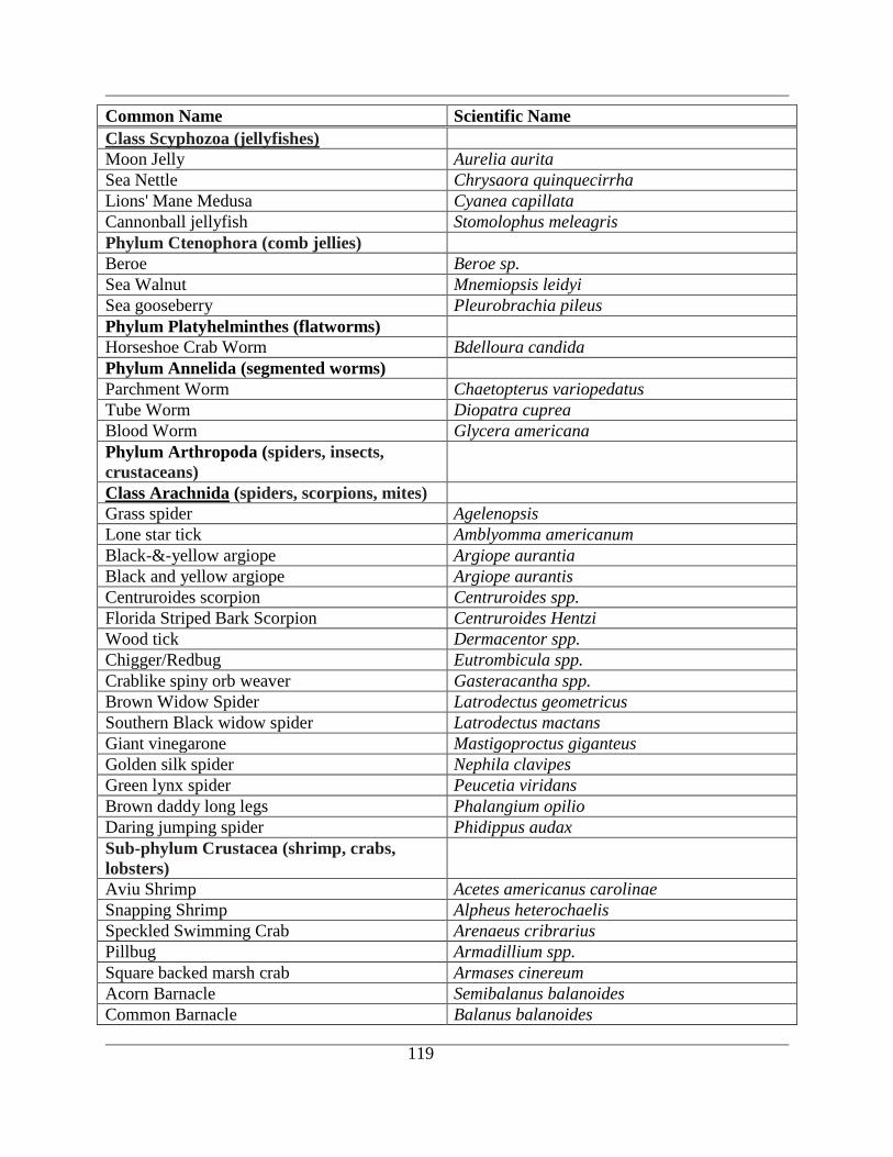
119
Common Name Scientific Name
Class Scyphozoa (jellyfishes)
Moon Jelly Aurelia aurita
Sea Nettle Chrysaora quinquecirrha
Lions' Mane Medusa Cyanea capillata
Cannonball jellyfish Stomolophus meleagris
Phylum Ctenophora (comb jellies)
Beroe Beroe sp.
Sea Walnut Mnemiopsis leidyi
Sea gooseberry Pleurobrachia pileus
Phylum Platyhelminthes (flatworms)
Horseshoe Crab Worm Bdelloura candida
Phylum Annelida (segmented worms)
Parchment Worm Chaetopterus variopedatus
Tube Worm Diopatra cuprea
Blood Worm Glycera americana
Phylum Arthropoda (spiders, insects,
crustaceans)
Class Arachnida (spiders, scorpions, mites)
Grass spider Agelenopsis
Lone star tick Amblyomma americanum
Black-&-yellow argiope Argiope aurantia
Black and yellow argiope Argiope aurantis
Centruroides scorpion Centruroides spp.
Florida Striped Bark Scorpion Centruroides Hentzi
Wood tick Dermacentor spp.
Chigger/Redbug Eutrombicula spp.
Crablike spiny orb weaver Gasteracantha spp.
Brown Widow Spider Latrodectus geometricus
Southern Black widow spider Latrodectus mactans
Giant vinegarone Mastigoproctus giganteus
Golden silk spider Nephila clavipes
Green lynx spider Peucetia viridans
Brown daddy long legs Phalangium opilio
Daring jumping spider Phidippus audax
Sub-phylum Crustacea (shrimp, crabs,
lobsters)
Aviu Shrimp Acetes americanus carolinae
Snapping Shrimp Alpheus heterochaelis
Speckled Swimming Crab Arenaeus cribrarius
Pillbug Armadillium spp.
Square backed marsh crab Armases cinereum
Acorn Barnacle Semibalanus balanoides
Common Barnacle Balanus balanoides
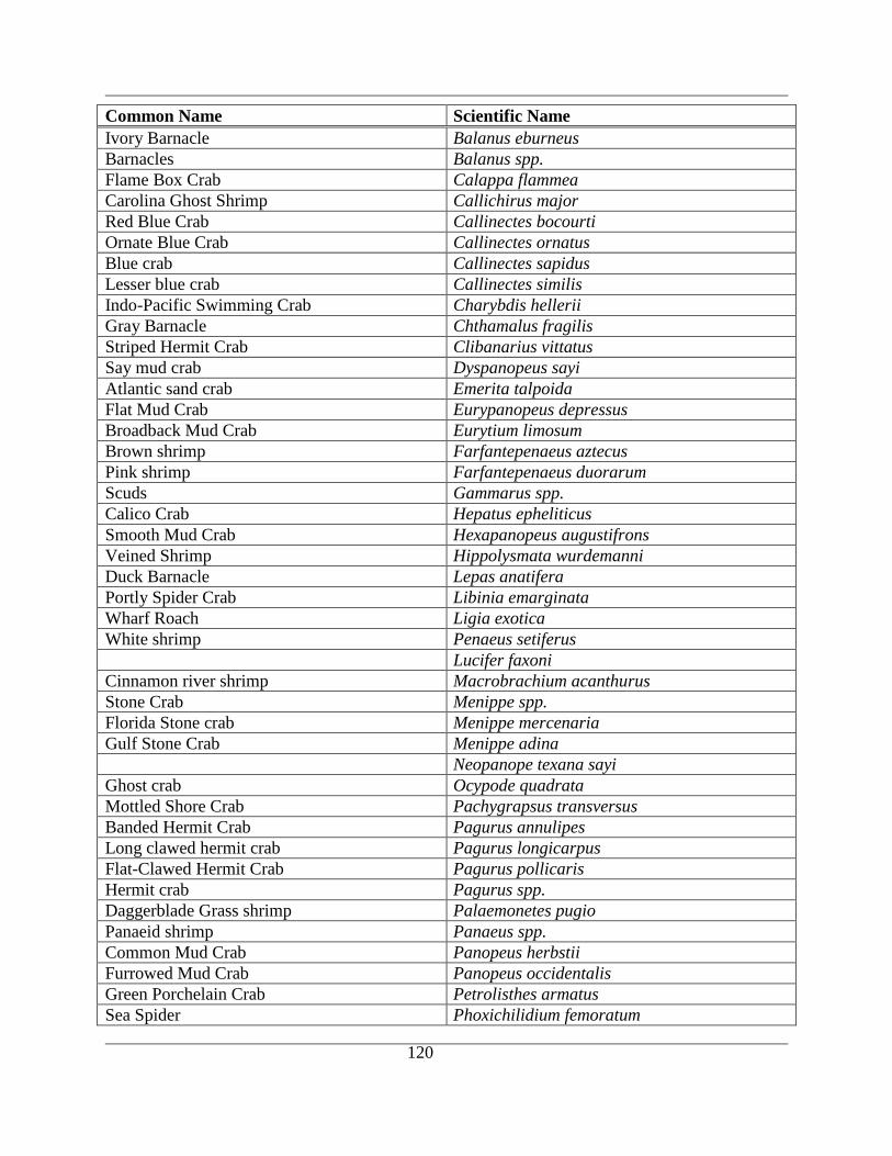
120
Common Name Scientific Name
Ivory Barnacle Balanus eburneus
Barnacles Balanus spp.
Flame Box Crab Calappa flammea
Carolina Ghost Shrimp Callichirus major
Red Blue Crab Callinectes bocourti
Ornate Blue Crab Callinectes ornatus
Blue crab Callinectes sapidus
Lesser blue crab Callinectes similis
Indo-Pacific Swimming Crab Charybdis hellerii
Gray Barnacle Chthamalus fragilis
Striped Hermit Crab Clibanarius vittatus
Say mud crab Dyspanopeus sayi
Atlantic sand crab Emerita talpoida
Flat Mud Crab Eurypanopeus depressus
Broadback Mud Crab Eurytium limosum
Brown shrimp Farfantepenaeus aztecus
Pink shrimp Farfantepenaeus duorarum
Scuds Gammarus spp.
Calico Crab Hepatus epheliticus
Smooth Mud Crab Hexapanopeus augustifrons
Veined Shrimp Hippolysmata wurdemanni
Duck Barnacle Lepas anatifera
Portly Spider Crab Libinia emarginata
Wharf Roach Ligia exotica
White shrimp Penaeus setiferus
Lucifer faxoni
Cinnamon river shrimp Macrobrachium acanthurus
Stone Crab Menippe spp.
Florida Stone crab Menippe mercenaria
Gulf Stone Crab Menippe adina
Neopanope texana sayi
Ghost crab Ocypode quadrata
Mottled Shore Crab Pachygrapsus transversus
Banded Hermit Crab Pagurus annulipes
Long clawed hermit crab Pagurus longicarpus
Flat-Clawed Hermit Crab Pagurus pollicaris
Hermit crab Pagurus spp.
Daggerblade Grass shrimp Palaemonetes pugio
Panaeid shrimp Panaeus spp.
Common Mud Crab Panopeus herbstii
Furrowed Mud Crab Panopeus occidentalis
Green Porchelain Crab Petrolisthes armatus
Sea Spider Phoxichilidium femoratum
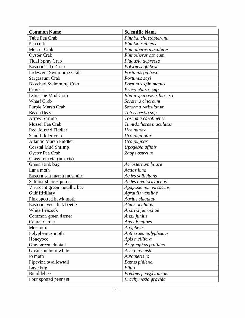
121
Common Name Scientific Name
Tube Pea Crab Pinnixa chaetopterana
Pea crab Pinnixa retinens
Mussel Crab Pinnotheres maculatus
Oyster Crab Pinnotheres ostreum
Tidal Spray Crab Plagusia depressa
Eastern Tube Crab Polyonyx gibbesi
Iridescent Swimming Crab Portunus gibbesii
Sargassum Crab Portunus sayi
Blotched Swimming Crab Portunus spinimanus
Crayish Procambarus spp.
Estuarine Mud Crab Rhithropanopeus harrisii
Wharf Crab Sesarma cinereum
Purple Marsh Crab Sesarma reticulatum
Beach fleas Talorchestia spp.
Arrow Shrimp Tozeuma carolinense
Mussel Pea Crab Tumidotheres maculatus
Red-Jointed Fiddler Uca minax
Sand fiddler crab Uca pugilator
Atlantic Marsh Fiddler Uca pugnax
Coastal Mud Shrimp Upogebia affinis
Oyster Pea Crab Zaops ostreum
Class Insecta (insects)
Green stink bug Acrosternum hilare
Luna moth Actias luna
Eastern salt marsh mosquito Aedes sollicitans
Salt marsh mosquitos Aedes taeniorhynchus
Virescent green metallic bee Agapostemon virescens
Gulf fritillary Agraulis vanillae
Pink spotted hawk moth Agrius cingulata
Eastern eyed click beetle Alaus oculatus
White Peacock Anartia jatrophae
Common green darner Anax junius
Comet darner Anax longipes
Mosquito Anopheles
Polyphemus moth Antheraea polyphemus
Honeybee Apis mellifera
Gray green clubtail Arigomphus pallidus
Great southern white Ascia monuste
Io moth Automeris io
Pipevine swallowtail Battus philenor
Love bug Bibio
Bumblebee Bombus pensylvanicus
Four spotted pennant Brachymesia gravida

122
Common Name Scientific Name
Fiery searcher Calosoma scrutator
Black carpenter ant Camponotus pennsylvanicus
Halloween pennant Celithemis eponina
Double ringed pennant Celithemis verna
Deerflies Chrysops
Mosquito Coquillettidia
Goldsmith beetle Cotalpa lanigera
Sand flies Culicoides
Monarch Danaus plexippus
Virginia creeper sphinx Darapsa myron
Cow killer Dasymutilla occidentalis
Northern walking stick Diapheromera femorata
Rosy maple moth Dryocampa rubicunda
E. pond hawk Erythemis simplicicollis
Blue dragonlet Erythrodiplax connata
Little sulphur Eurema lisa
Chigger Futrombicula spp.
Field cricket Gryllus pennsylvanicus
Small whirligig beetle Gyrinus spp.
Ceraunus blue Hemiargus ceraunus
Riparian earwig Labidura riparia
Silverfish Lepisma saccharina
Giant waterbug Lethocerus americanus
Marl pennant Macrodiplax balteata
Tent caterpillar moth Malacosoma americanum
Freshwater mosquitos Mansonia spp.
American carrion beetle Necrophila americana
Northern mole cricket Neocurtilla hexadactyla
Roseate skimmer Orthemis ferruginea
Blue dasher Pachydiplax longipennis
Wandering glider Pantala flavescens
Giant swallowtail Papilio cresphontes
E. Tiger swallowtail Papilio glaucus
Palamedes swallowtail Papilio palamedes
American cockroach Periplaneta americana
Scarab beetle Phanaeus vindex
Cloudless sulphur Phoebis sennae
Phaon crescent Phyciodes phaon
Paper wasp Polistes spp.
Giant root borer Prionus spp.
Flood-water Mosquito Psorophora spp.
Black ground beetle Pterostichus spp.
Brown water scorpion Ranatra fusca
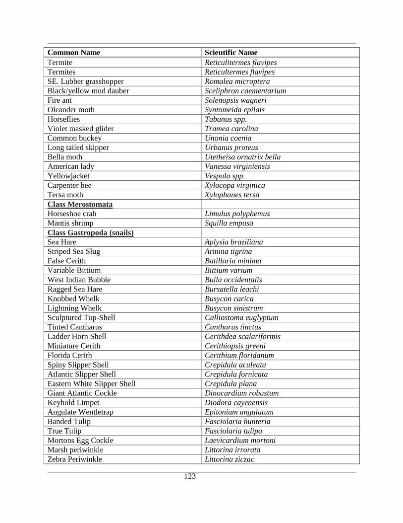
123
Common Name Scientific Name
Termite Reticulitermes flavipes
Termites Reticultermes flavipes
SE. Lubber grasshopper Romalea microptera
Black/yellow mud dauber Sceliphron caementarium
Fire ant Solenopsis wagneri
Oleander moth Syntomeida epilais
Horseflies Tabanus spp.
Violet masked glider Tramea carolina
Common buckey Unonia coenia
Long tailed skipper Urbanus proteus
Bella moth Utetheisa ornatrix bella
American lady Vanessa virginiensis
Yellowjacket Vespula spp.
Carpenter bee Xylocopa virginica
Tersa moth Xylophanes tersa
Class Merostomata
Horseshoe crab Limulus polyphemus
Mantis shrimp Squilla empusa
Class Gastropoda (snails)
Sea Hare Aplysia braziliana
Striped Sea Slug Armina tigrina
False Cerith Batillaria minima
Variable Bittium Bittium varium
West Indian Bubble Bulla occidentalis
Ragged Sea Hare Bursatella leachi
Knobbed Whelk Busycon carica
Lightning Whelk Busycon sinistrum
Sculptured Top-Shell Calliostoma euglyptum
Tinted Cantharus Cantharus tinctus
Ladder Horn Shell Cerithdea scalariformis
Miniature Cerith Cerithiopsis greeni
Florida Cerith Cerithium floridanum
Spiny Slipper Shell Crepidula aculeata
Atlantic Slipper Shell Crepidula fornicata
Eastern White Slipper Shell Crepidula plana
Giant Atlantic Cockle Dinocardium robustum
Keyhold Limpet Diodora cayenensis
Angulate Wentletrap Epitonium angulatum
Banded Tulip Fasciolaria hunteria
True Tulip Fasciolaria tulipa
Mortons Egg Cockle Laevicardium mortoni
Marsh periwinkle Littorina irrorata
Zebra Periwinkle Littorina ziczac
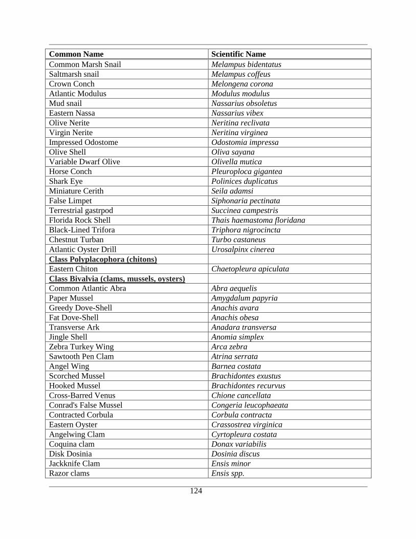
124
Common Name Scientific Name
Common Marsh Snail Melampus bidentatus
Saltmarsh snail Melampus coffeus
Crown Conch Melongena corona
Atlantic Modulus Modulus modulus
Mud snail Nassarius obsoletus
Eastern Nassa Nassarius vibex
Olive Nerite Neritina reclivata
Virgin Nerite Neritina virginea
Impressed Odostome Odostomia impressa
Olive Shell Oliva sayana
Variable Dwarf Olive Olivella mutica
Horse Conch Pleuroploca gigantea
Shark Eye Polinices duplicatus
Miniature Cerith Seila adamsi
False Limpet Siphonaria pectinata
Terrestrial gastrpod Succinea campestris
Florida Rock Shell Thais haemastoma floridana
Black-Lined Trifora Triphora nigrocincta
Chestnut Turban Turbo castaneus
Atlantic Oyster Drill Urosalpinx cinerea
Class Polyplacophora (chitons)
Eastern Chiton Chaetopleura apiculata
Class Bivalvia (clams, mussels, oysters)
Common Atlantic Abra Abra aequelis
Paper Mussel Amygdalum papyria
Greedy Dove-Shell Anachis avara
Fat Dove-Shell Anachis obesa
Transverse Ark Anadara transversa
Jingle Shell Anomia simplex
Zebra Turkey Wing Arca zebra
Sawtooth Pen Clam Atrina serrata
Angel Wing Barnea costata
Scorched Mussel Brachidontes exustus
Hooked Mussel Brachidontes recurvus
Cross-Barred Venus Chione cancellata
Conrad's False Mussel Congeria leucophaeata
Contracted Corbula Corbula contracta
Eastern Oyster Crassostrea virginica
Angelwing Clam Cyrtopleura costata
Coquina clam Donax variabilis
Disk Dosinia Dosinia discus
Jackknife Clam Ensis minor
Razor clams Ensis spp.

125
Common Name Scientific Name
Comb Bittersweet Glycymeris pectinata
Marsh Mussel Guekensia demissa
Ribbed mussel Ischadium demissum
Mahogany Date Mussel Lithophaga bisulcata
Calico clam Macrocallista maculata
Wedge-Shaped Martesia Martesia cuneiformis
Southern Quahog Mercenaria campechiensis
Quahog Mercenaria mercenaria
Lunar Dove-Shell Mitrella lunata
Dwarf Surf Clam Mulinia lateralis
Pondersous Ark Noetia ponderosa
Crested Oyster Ostrea equestris
Carolina Marsh Clam Polymesoda caroliniana
Florida Marsh Clam Pseudocyrena floridana
Common Rangia Rangia cuneata
Purplish Tagelus Tagelus divisus
Stout Tagelus Tagelus plebius
Rose Petal Tellin Tellina lineata
Class Cephalopoda (squids and octopus)
Squid Loligunculus brevis
Atlantic Octopus Octopus vulgaris
Phylum Bryozoa (Ectoprocta, moss animals)
Zoobotryon verticillatum
Rubber bryozoan Alcyonidium hauffi
Anguinella palmata
Bugula neritina
Common sea mat Membranipora tenuis
Schizoporella errata
Phylum Echinodermata
Common Starfish Asterias forbesi
Margined Sea Star Astropecten articulatus
Lines Sea Star Luidea clathrata
Class Echnioidea (sea urchins)
Purple Spined Sea Urchin Arbacea punctulata
Variable Urchin Lytechinus variegatus
Sand Dollar Mellita quinquesperforata
Class Holothuroidea (sea cucumbers)
Common Thyone Thyone briatus
Class Ophiuroidea (brittle stars)
Angular brittle star Ophiothrix angulata
Phylum Hemichordata (acorn worms)
Southern acorn worm Ptychodera bahamensis
Phylum Chordata (vertebrates and
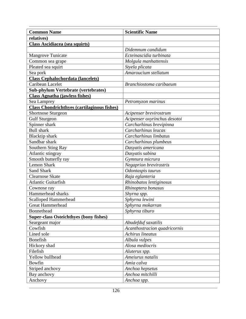
126
Common Name Scientific Name
relatives)
Class Ascidiacea (sea squirts)
Didemnum candidum
Mangrove Tunicate Ecteinascidia turbinata
Common sea grape Molgula manhattensis
Pleated sea squirt Styela plicata
Sea pork Amaroucium stellatum
Class Cephalochordata (lancelets)
Caribean Lacelet Branchiostoma caribaeum
Sub-phylum Vertebrate (vertebrates)
Class Agnatha (jawless fishes)
Sea Lamprey Petromyzon marinus
Class Chondrichthyes (cartilaginous fishes)
Shortnose Sturgeon Acipenser brevirostrum
Gulf Sturgeon Acipenser oxyrinchus desotoi
Spinner shark Carcharhinus brevipinna
Bull shark Carcharhinus leucas
Blacktip shark Carcharhinus limbatus
Sandbar shark Carcharhinus plumbeus
Southern Sting Ray Dasyatis americana
Atlantic stingray Dasyatis sabina
Smooth butterfly ray Gymnura micrura
Lemon Shark Negaprion brevirostris
Sand Shark Odontaspis taurus
Clearnose Skate Raja eglanteria
Atlantic Guitarfish Rhinobatos lentiginosus
Cownose ray Rhinoptera bonasus
Hammerhead sharks Shyrna spp.
Scalloped Hammerhead Sphyrna lewini
Great Hammerhead Sphyrna mokarran
Bonnethead Sphyrna tiburo
Super-class Osteichthyes (bony fishes)
Seargeant major Abudefduf saxatilis
Cowfish Acanthostracion quadricornis
Lined sole Achirus lineatus
Bonefish Albula vulpes
Hickory shad Alosa mediocris
Filefish Aluterus spp.
Yellow bullhead Ameiurus natalis
Bowfin Amia calva
Striped anchovy Anchoa hepsetus
Bay anchovy Anchoa mitchilli
Anchovy Anchoa spp.
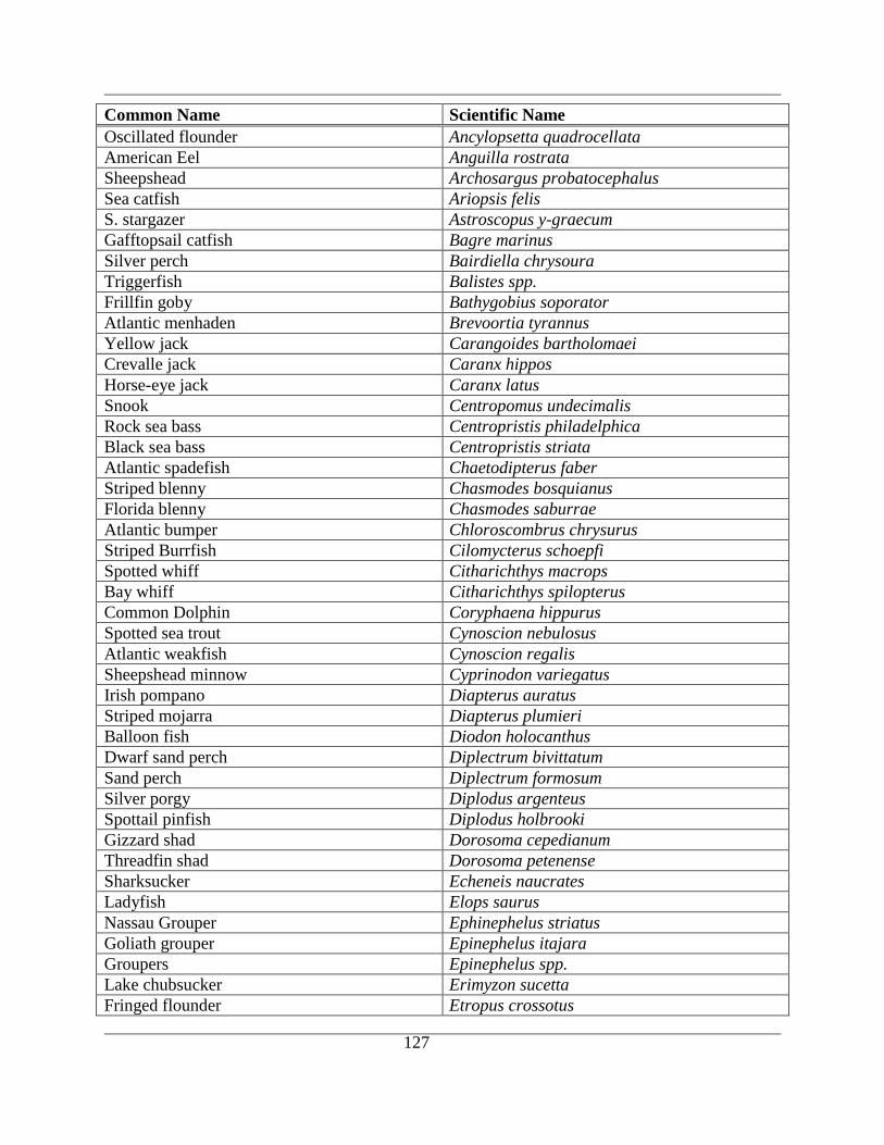
127
Common Name Scientific Name
Oscillated flounder Ancylopsetta quadrocellata
American Eel Anguilla rostrata
Sheepshead Archosargus probatocephalus
Sea catfish Ariopsis felis
S. stargazer Astroscopus y-graecum
Gafftopsail catfish Bagre marinus
Silver perch Bairdiella chrysoura
Triggerfish Balistes spp.
Frillfin goby Bathygobius soporator
Atlantic menhaden Brevoortia tyrannus
Yellow jack Carangoides bartholomaei
Crevalle jack Caranx hippos
Horse-eye jack Caranx latus
Snook Centropomus undecimalis
Rock sea bass Centropristis philadelphica
Black sea bass Centropristis striata
Atlantic spadefish Chaetodipterus faber
Striped blenny Chasmodes bosquianus
Florida blenny Chasmodes saburrae
Atlantic bumper Chloroscombrus chrysurus
Striped Burrfish Cilomycterus schoepfi
Spotted whiff Citharichthys macrops
Bay whiff Citharichthys spilopterus
Common Dolphin Coryphaena hippurus
Spotted sea trout Cynoscion nebulosus
Atlantic weakfish Cynoscion regalis
Sheepshead minnow Cyprinodon variegatus
Irish pompano Diapterus auratus
Striped mojarra Diapterus plumieri
Balloon fish Diodon holocanthus
Dwarf sand perch Diplectrum bivittatum
Sand perch Diplectrum formosum
Silver porgy Diplodus argenteus
Spottail pinfish Diplodus holbrooki
Gizzard shad Dorosoma cepedianum
Threadfin shad Dorosoma petenense
Sharksucker Echeneis naucrates
Ladyfish Elops saurus
Nassau Grouper Ephinephelus striatus
Goliath grouper Epinephelus itajara
Groupers Epinephelus spp.
Lake chubsucker Erimyzon sucetta
Fringed flounder Etropus crossotus
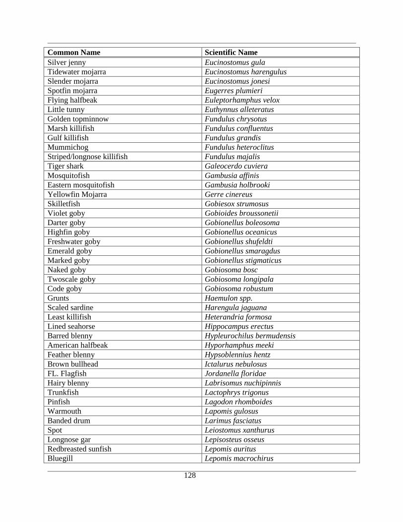
128
Common Name Scientific Name
Silver jenny Eucinostomus gula
Tidewater mojarra Eucinostomus harengulus
Slender mojarra Eucinostomus jonesi
Spotfin mojarra Eugerres plumieri
Flying halfbeak Euleptorhamphus velox
Little tunny Euthynnus alleteratus
Golden topminnow Fundulus chrysotus
Marsh killifish Fundulus confluentus
Gulf killifish Fundulus grandis
Mummichog Fundulus heteroclitus
Striped/longnose killifish Fundulus majalis
Tiger shark Galeocerdo cuviera
Mosquitofish Gambusia affinis
Eastern mosquitofish Gambusia holbrooki
Yellowfin Mojarra Gerre cinereus
Skilletfish Gobiesox strumosus
Violet goby Gobioides broussonetii
Darter goby Gobionellus boleosoma
Highfin goby Gobionellus oceanicus
Freshwater goby Gobionellus shufeldti
Emerald goby Gobionellus smaragdus
Marked goby Gobionellus stigmaticus
Naked goby Gobiosoma bosc
Twoscale goby Gobiosoma longipala
Code goby Gobiosoma robustum
Grunts Haemulon spp.
Scaled sardine Harengula jaguana
Least killifish Heterandria formosa
Lined seahorse Hippocampus erectus
Barred blenny Hypleurochilus bermudensis
American halfbeak Hyporhamphus meeki
Feather blenny Hypsoblennius hentz
Brown bullhead Ictalurus nebulosus
FL. Flagfish Jordanella floridae
Hairy blenny Labrisomus nuchipinnis
Trunkfish Lactophrys trigonus
Pinfish Lagodon rhomboides
Warmouth Lapomis gulosus
Banded drum Larimus fasciatus
Spot Leiostomus xanthurus
Longnose gar Lepisosteus osseus
Redbreasted sunfish Lepomis auritus
Bluegill Lepomis macrochirus
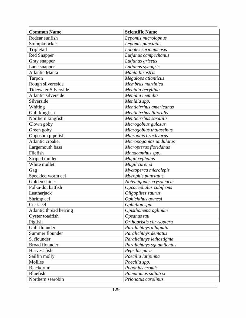
129
Common Name Scientific Name
Redear sunfish Lepomis microlophus
Stumpknocker Lepomis punctatus
Tripletail Lobotes surinamensis
Red Snapper Lutjanus campechanus
Gray snapper Lutjanus griseus
Lane snapper Lutjanus synagris
Atlantic Manta Manta birostris
Tarpon Megalops atlanticus
Rough silvereside Membras martinica
Tidewater Silverside Menidia beryllina
Atlantic silverside Menidia menidia
Silverside Menidia spp.
Whiting Menticirrhus americanus
Gulf kingfish Menticirrhus littoralis
Northern kingfish Menticirrhus saxatilis
Clown goby Microgobius gulosus
Green goby Microgobius thalassinus
Opposum pipefish Microphis brachyurus
Atlantic croaker Micropogonias undulatus
Largemouth bass Micropterus floridanus
Filefish Monacanthus spp.
Striped mullet Mugil cephalus
White mullet Mugil curema
Gag Myctoperca microlepis
Speckled worm eel Myrophis punctatus
Golden shiner Notemigonus crysoleucus
Polka-dot batfish Ogcocephalus cubifrons
Leatherjack Oligoplites saurus
Shrimp eel Ophichthus gomesi
Cusk-eel Ophidion spp.
Atlantic thread herring Opisthonema oglinum
Oyster toadfish Opsanus tau
Pigfish Orthopristis chrysoptera
Gulf flounder Paralichthys albigutta
Summer flounder Paralichthys dentatus
S. flounder Paralichthys lethostigma
Broad flounder Paralichthys squamilentus
Harvest fish Peprilus paru
Sailfin molly Poecilia latipinna
Mollies Poecilia spp.
Blackdrum Pogonias cromis
Bluefish Pomatomus saltatrix
Northern searobin Prionotus carolinus
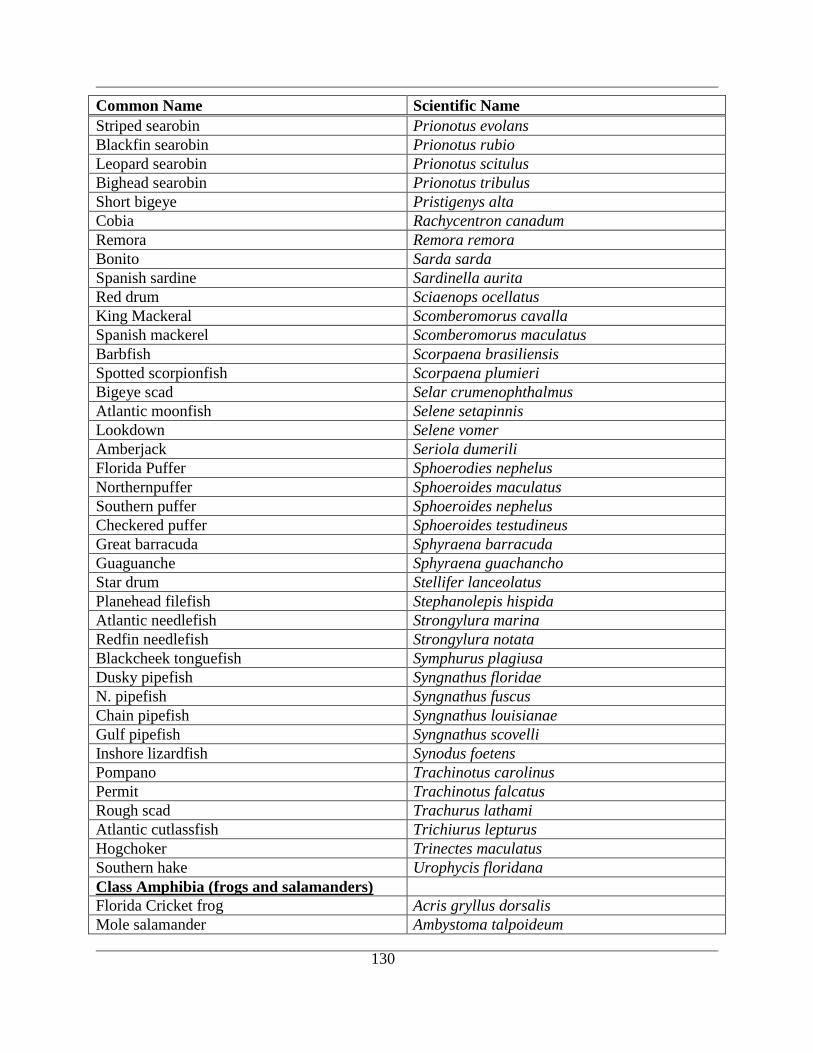
130
Common Name Scientific Name
Striped searobin Prionotus evolans
Blackfin searobin Prionotus rubio
Leopard searobin Prionotus scitulus
Bighead searobin Prionotus tribulus
Short bigeye Pristigenys alta
Cobia Rachycentron canadum
Remora Remora remora
Bonito Sarda sarda
Spanish sardine Sardinella aurita
Red drum Sciaenops ocellatus
King Mackeral Scomberomorus cavalla
Spanish mackerel Scomberomorus maculatus
Barbfish Scorpaena brasiliensis
Spotted scorpionfish Scorpaena plumieri
Bigeye scad Selar crumenophthalmus
Atlantic moonfish Selene setapinnis
Lookdown Selene vomer
Amberjack Seriola dumerili
Florida Puffer Sphoerodies nephelus
Northernpuffer Sphoeroides maculatus
Southern puffer Sphoeroides nephelus
Checkered puffer Sphoeroides testudineus
Great barracuda Sphyraena barracuda
Guaguanche Sphyraena guachancho
Star drum Stellifer lanceolatus
Planehead filefish Stephanolepis hispida
Atlantic needlefish Strongylura marina
Redfin needlefish Strongylura notata
Blackcheek tonguefish Symphurus plagiusa
Dusky pipefish Syngnathus floridae
N. pipefish Syngnathus fuscus
Chain pipefish Syngnathus louisianae
Gulf pipefish Syngnathus scovelli
Inshore lizardfish Synodus foetens
Pompano Trachinotus carolinus
Permit Trachinotus falcatus
Rough scad Trachurus lathami
Atlantic cutlassfish Trichiurus lepturus
Hogchoker Trinectes maculatus
Southern hake Urophycis floridana
Class Amphibia (frogs and salamanders)
Florida Cricket frog Acris gryllus dorsalis
Mole salamander Ambystoma talpoideum
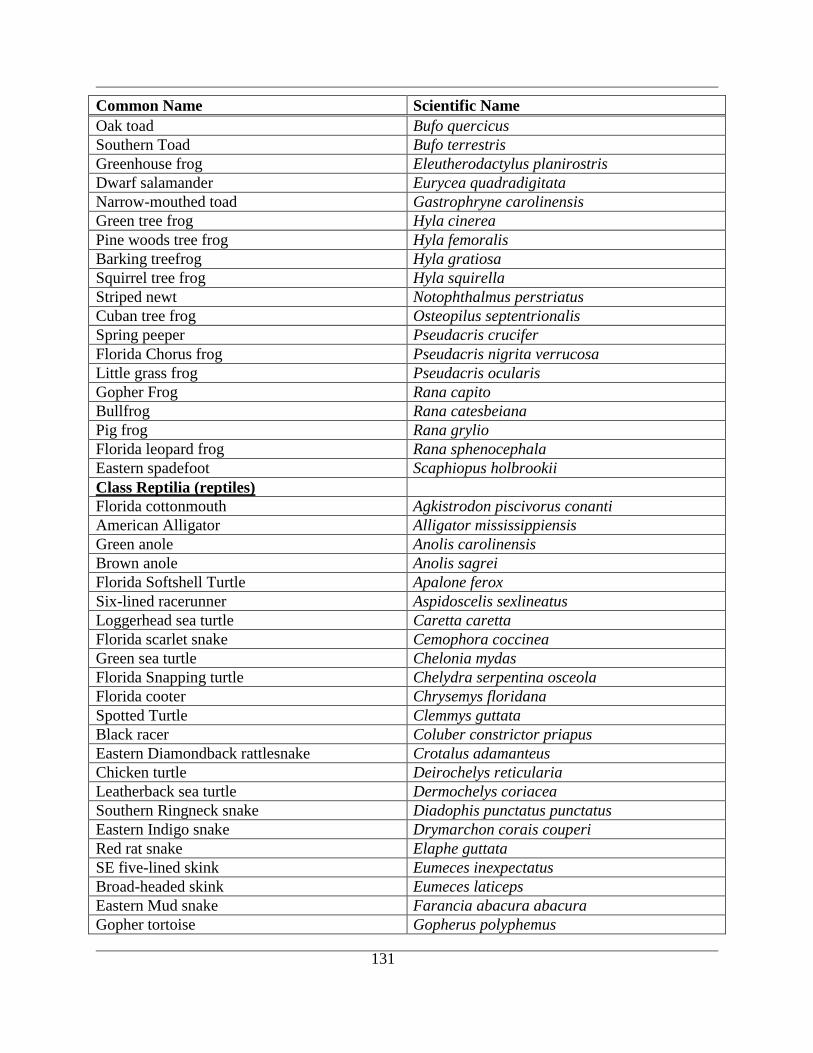
131
Common Name Scientific Name
Oak toad Bufo quercicus
Southern Toad Bufo terrestris
Greenhouse frog Eleutherodactylus planirostris
Dwarf salamander Eurycea quadradigitata
Narrow-mouthed toad Gastrophryne carolinensis
Green tree frog Hyla cinerea
Pine woods tree frog Hyla femoralis
Barking treefrog Hyla gratiosa
Squirrel tree frog Hyla squirella
Striped newt Notophthalmus perstriatus
Cuban tree frog Osteopilus septentrionalis
Spring peeper Pseudacris crucifer
Florida Chorus frog Pseudacris nigrita verrucosa
Little grass frog Pseudacris ocularis
Gopher Frog Rana capito
Bullfrog Rana catesbeiana
Pig frog Rana grylio
Florida leopard frog Rana sphenocephala
Eastern spadefoot Scaphiopus holbrookii
Class Reptilia (reptiles)
Florida cottonmouth Agkistrodon piscivorus conanti
American Alligator Alligator mississippiensis
Green anole Anolis carolinensis
Brown anole Anolis sagrei
Florida Softshell Turtle Apalone ferox
Six-lined racerunner Aspidoscelis sexlineatus
Loggerhead sea turtle Caretta caretta
Florida scarlet snake Cemophora coccinea
Green sea turtle Chelonia mydas
Florida Snapping turtle Chelydra serpentina osceola
Florida cooter Chrysemys floridana
Spotted Turtle Clemmys guttata
Black racer Coluber constrictor priapus
Eastern Diamondback rattlesnake Crotalus adamanteus
Chicken turtle Deirochelys reticularia
Leatherback sea turtle Dermochelys coriacea
Southern Ringneck snake Diadophis punctatus punctatus
Eastern Indigo snake Drymarchon corais couperi
Red rat snake Elaphe guttata
SE five-lined skink Eumeces inexpectatus
Broad-headed skink Eumeces laticeps
Eastern Mud snake Farancia abacura abacura
Gopher tortoise Gopherus polyphemus

132
Common Name Scientific Name
Florida red bellied turtle Grysemys nelsoni
Mediteranian gecko Hemidactylus garnotii
Striped mud turtle Kinosternon bauri
Florida Mud turtle Kinosternon subrubrum steindachneri
Eastern Mud turtle Kinosternon subrubrum subrubrum
Eastern King snake Lampropeltis getula getula
Scarlet king snake Lampropeltis triangulum elapsoides
Kemp's Ridley Lepidochelys kempii
Diamondback terrapin Malaclemys terrapin centrata
E. Coachwhip Masticophis flagellum flagellum
Coral Snake Micrurus fulvius
Fl. water snake Nerodia fasciata pictiventris
Rough green snake Opheodrys aestivus
E. Glass lizard Ophisaurus ventralis
Corn snake Pantherophis guttata guttata
Yellow rat snake Pantherophis obsoleta quadrivittata
FL. Redbelly turtle Pseudemys nelsoni
Peninsula cooter Pseudemys peninsularis
Pine woods snake Rhadinaea flavilata
Ground skink Scincella lateralis
Greater siren Siren lacertina
Dusky pigmy rattlesnake Sistrurus miliarius barbouri
FL. Box turtle Terrapene carolina bauri
Peninsula ribbon snake Thamnophis sauritus nitae
E. Garter snake Thamnophis sirtalis
Yellow-bellied slider Trachemys scripta
Florida softshell Apalone ferox
Class Aves (birds)
Cooper's hawk Accipiter cooperii
Sharp-shinned Hawk Accipiter striatus
Spotted Sandpiper Actitis macularia
Red-winged Blackbird Agelaius phoeniceus
Wood Duck Aix sponsa
Roseate Spoonbill Ajaia ajaja
Saltmarsh Sharp-tailed Sparrow Ammodramus caudacutus
Seaside Sparrow Ammodramus maritimus
Nelson's Sharp-tailed Sparrow Ammodramus nelsoni
Grasshopper Sparrow Ammodramus savannarum
Northern Pintail Anas acuta
American Widgeon Anas americana
Northern Shoveler Anas clypeata
Green-winged Teal Anas crecca
Blue-winged Teal Anas discors
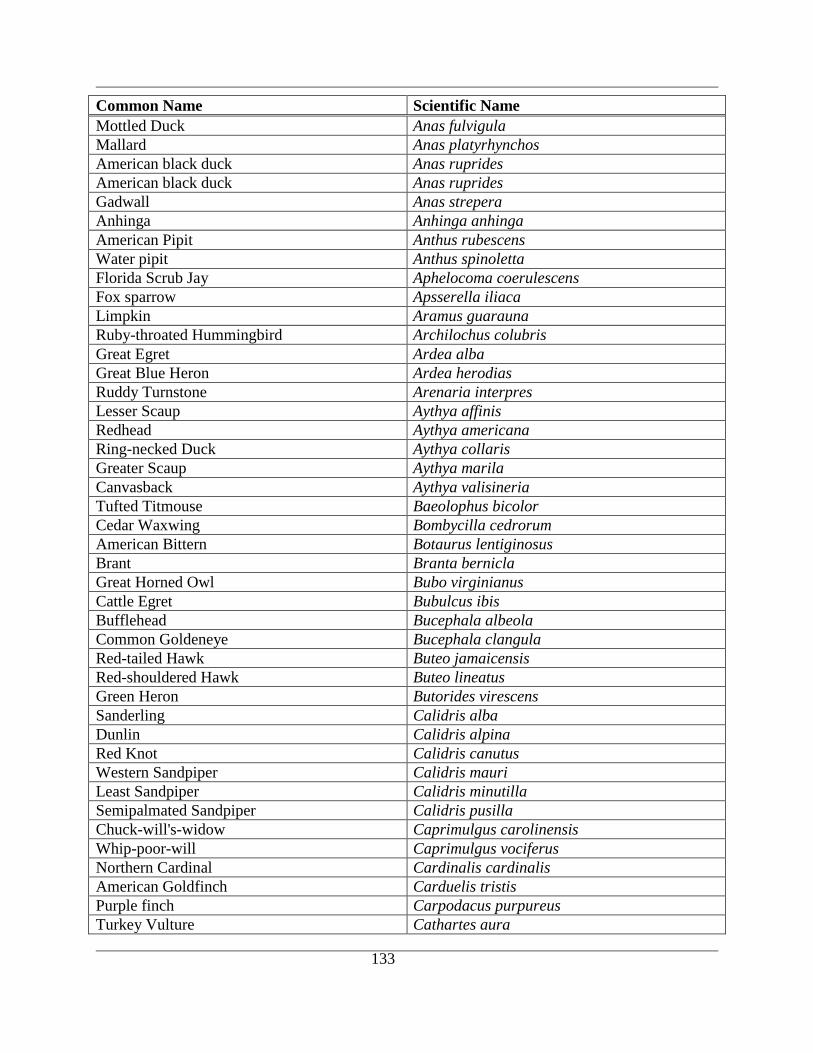
133
Common Name Scientific Name
Mottled Duck Anas fulvigula
Mallard Anas platyrhynchos
American black duck Anas ruprides
American black duck Anas ruprides
Gadwall Anas strepera
Anhinga Anhinga anhinga
American Pipit Anthus rubescens
Water pipit Anthus spinoletta
Florida Scrub Jay Aphelocoma coerulescens
Fox sparrow Apsserella iliaca
Limpkin Aramus guarauna
Ruby-throated Hummingbird Archilochus colubris
Great Egret Ardea alba
Great Blue Heron Ardea herodias
Ruddy Turnstone Arenaria interpres
Lesser Scaup Aythya affinis
Redhead Aythya americana
Ring-necked Duck Aythya collaris
Greater Scaup Aythya marila
Canvasback Aythya valisineria
Tufted Titmouse Baeolophus bicolor
Cedar Waxwing Bombycilla cedrorum
American Bittern Botaurus lentiginosus
Brant Branta bernicla
Great Horned Owl Bubo virginianus
Cattle Egret Bubulcus ibis
Bufflehead Bucephala albeola
Common Goldeneye Bucephala clangula
Red-tailed Hawk Buteo jamaicensis
Red-shouldered Hawk Buteo lineatus
Green Heron Butorides virescens
Sanderling Calidris alba
Dunlin Calidris alpina
Red Knot Calidris canutus
Western Sandpiper Calidris mauri
Least Sandpiper Calidris minutilla
Semipalmated Sandpiper Calidris pusilla
Chuck-will's-widow Caprimulgus carolinensis
Whip-poor-will Caprimulgus vociferus
Northern Cardinal Cardinalis cardinalis
American Goldfinch Carduelis tristis
Purple finch Carpodacus purpureus
Turkey Vulture Cathartes aura
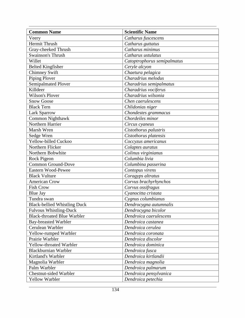
134
Common Name Scientific Name
Veery Catharus fuscescens
Hermit Thrush Catharus guttatus
Gray-cheeked Thrush Catharus minimus
Swainson's Thrush Catharus ustulatus
Willet Catoptrophorus semipalmatus
Belted Kingfisher Ceryle alcyon
Chimney Swift Chaetura pelagica
Piping Plover Charadrius melodus
Semipalmated Plover Charadrius semipalmatus
Killdeer Charadrius vociferus
Wilson's Plover Charadrius wilsonia
Snow Goose Chen caerulescens
Black Tern Chlidonias niger
Lark Sparrow Chondestes grammacus
Common Nighthawk Chordeiles minor
Northern Harrier Circus cyaneus
Marsh Wren Cistothorus palustris
Sedge Wren Cistothorus platensis
Yellow-billed Cuckoo Coccyzus americanus
Northern Flicker Colaptes auratus
Northern Bobwhite Colinus virginianus
Rock Pigeon Columbia livia
Common Ground-Dove Columbina passerina
Eastern Wood-Pewee Contopus virens
Black Vulture Coragyps altratus
American Crow Corvus brachyrhynchos
Fish Crow Corvus ossifragus
Blue Jay Cyanocitta cristata
Tundra swan Cygnus columbianus
Black-bellied Whistling Duck Dendrocygna autumnalis
Fulvous Whistling-Duck Dendrocygna bicolor
Black-throated Blue Warbler Dendroica caerulescens
Bay-breasted Warbler Dendroica castanea
Cerulean Warbler Dendroica cerulea
Yellow-rumped Warbler Dendroica coronata
Prairie Warbler Dendroica discolor
Yellow-throated Warbler Dendroica dominica
Blackburnian Warbler Dendroica fusca
Kirtland's Warbler Dendroica kirtlandii
Magnolia Warbler Dendroica magnolia
Palm Warbler Dendroica palmarum
Chestnut-sided Warbler Dendroica pensylvanica
Yellow Warbler Dendroica petechia
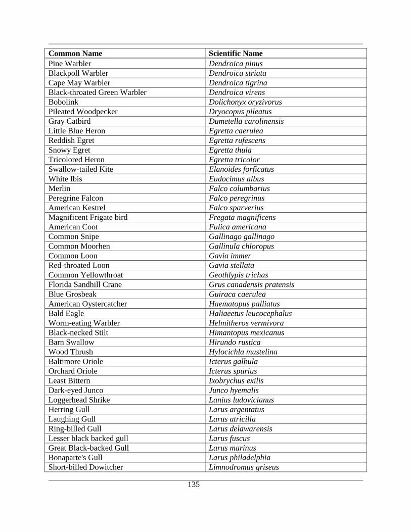
135
Common Name Scientific Name
Pine Warbler Dendroica pinus
Blackpoll Warbler Dendroica striata
Cape May Warbler Dendroica tigrina
Black-throated Green Warbler Dendroica virens
Bobolink Dolichonyx oryzivorus
Pileated Woodpecker Dryocopus pileatus
Gray Catbird Dumetella carolinensis
Little Blue Heron Egretta caerulea
Reddish Egret Egretta rufescens
Snowy Egret Egretta thula
Tricolored Heron Egretta tricolor
Swallow-tailed Kite Elanoides forficatus
White Ibis Eudocimus albus
Merlin Falco columbarius
Peregrine Falcon Falco peregrinus
American Kestrel Falco sparverius
Magnificent Frigate bird Fregata magnificens
American Coot Fulica americana
Common Snipe Gallinago gallinago
Common Moorhen Gallinula chloropus
Common Loon Gavia immer
Red-throated Loon Gavia stellata
Common Yellowthroat Geothlypis trichas
Florida Sandhill Crane Grus canadensis pratensis
Blue Grosbeak Guiraca caerulea
American Oystercatcher Haematopus palliatus
Bald Eagle Haliaeetus leucocephalus
Worm-eating Warbler Helmitheros vermivora
Black-necked Stilt Himantopus mexicanus
Barn Swallow Hirundo rustica
Wood Thrush Hylocichla mustelina
Baltimore Oriole Icterus galbula
Orchard Oriole Icterus spurius
Least Bittern Ixobrychus exilis
Dark-eyed Junco Junco hyemalis
Loggerhead Shrike Lanius ludovicianus
Herring Gull Larus argentatus
Laughing Gull Larus atricilla
Ring-billed Gull Larus delawarensis
Lesser black backed gull Larus fuscus
Great Black-backed Gull Larus marinus
Bonaparte's Gull Larus philadelphia
Short-billed Dowitcher Limnodromus griseus
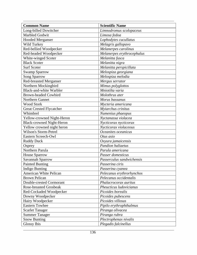
136
Common Name Scientific Name
Long-billed Dowitcher Limnodromus scolopaceus
Marbled Godwit Limosa fedoa
Hooded Merganser Lophodytes cucullatus
Wild Turkey Melagris gallopavo
Red-bellied Woodpecker Melanerpes carolinus
Red-headed Woodpecker Melanerpes erythrocephalus
White-winged Scoter Melanitta fusca
Black Scoter Melanitta nigra
Surf Scoter Melanitta perspicillata
Swamp Sparrow Melospiza georgiana
Song Sparrow Melospiza melodia
Red-breasted Merganser Mergus serrator
Northern Mockingbird Mimus polyglottos
Black-and-white Warbler Mniotilta varia
Brown-headed Cowbird Molothrus ater
Northern Gannet Morus bassanus
Wood Stork Mycteria americana
Great Crested Flycatcher Myiarchus crinitus
Whimbrel Numenius phaeopus
Yellow-crowned Night-Heron Nyctanassa violacea
Black-crowned Night-Heron Nycticorax nycticorax
Yellow crowned night heron Nycticorax violaceous
Wilson's Storm-Petrel Oceanites oceanicus
Eastern Screech-Owl Otus asio
Ruddy Duck Oxyura jamaicensis
Osprey Pandion haliaetus
Northern Parula Parula americana
House Sparrow Passer domesticus
Savannah Sparrow Passerculus sandwichensis
Painted Bunting Passerina ciris
Indigo Bunting Passerina cyanea
American White Pelican Pelecanus erythrorhynchos
Brown Pelican Pelecanus occidentalis
Double-crested Cormorant Phalacrocorax auritus
Rose-breasted Grosbeak Pheucticus ludovicianus
Red-Cockaded Woodpecker Picoides borealis
Downy Woodpecker Picoides pubescens
Hairy Woodpecker Picoides villosus
Eastern Towhee Pipilo erythrophthalmus
Scarlet Tanager Piranga olivacea
Summer Tanager Piranga rubra
Snow Bunting Plectrophenax nivalis
Glossy Ibis Plegadis falcinellus

137
Common Name Scientific Name
Black-bellied Plover Pluvialis squatarola
Horned grebe Podiceps auritus
Red-necked Grebe Podiceps grisegena
Pied-billed Grebe Podilymbus podiceps
Carolina Chickadee Poecile carolinensis
Blue-gray Gnatcatcher Polioptila caerulea
Vesper Sparrow Pooecetes gramineus
Purple Gallinule Porphyrula martinica
Sora Porzana carolina
Purple Martin Progne subis
Prothonotary Warbler Protonotaria citrea
Boat-tailed Grackle Quiscalus major
Common Grackle Quiscalus quiscula
King rail Rallus elegans
Virginia Rail Rallus limicola
Clapper Rail Rallus longirostris
American Avocet Recurvirostra americana
Ruby-crowned Kinglet Regulus calendula
Golden-crowned Kinglet Regulus satrapa
Black Skimmer Rynchops niger
Eastern Phoebe Sayornis phoebe
American Woodcock Scolopax minor
Ovenbird Seiurus aurocapillus
Louisiana Waterthrush Seiurus motacilla
Northern Waterthrush Seiurus noveboracensis
American Redstart Setophaga ruticilla
Eastern Bluebird Sialia sialis
Red breasted nuthatch Sitta canadensis
Brown-headed Nuthatch Sitta pusilla
Yellow-bellied Sapsucker Sphyrapicus varius
Chipping Sparrow Spizella passerina
Field sparrow Spizella pusilla
Northern Rough-winged Swallow Stelgidopteryx serripennis
Least Tern Sterna antillarum
Caspian Tern Sterna caspia
Roseate Tern Sterna dougallii
Forster's Tern Sterna forsteri
Common Tern Sterna hirundo
Royal Tern Sterna maxima
Gull-billed Tern Sterna nilotica
Sandwich Tern Sterna sandvicensis
Eurasian Collared-Dove Streptopelia decaocto
Barred owl Strix varia
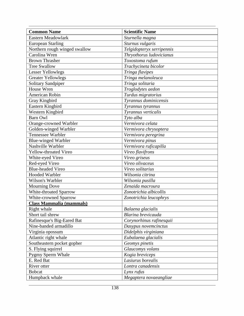
138
Common Name Scientific Name
Eastern Meadowlark Sturnella magna
European Starling Sturnus vulgaris
Northern rough winged swallow Telgidopteryx serripennis
Carolina Wren Thryothorus ludovicianus
Brown Thrasher Toxostoma rufum
Tree Swallow Trachycineta bicolor
Lesser Yellowlegs Tringa flavipes
Greater Yellowlegs Tringa melanoleuca
Solitary Sandpiper Tringa solitaria
House Wren Troglodytes aedon
American Robin Turdus migratorius
Gray Kingbird Tyrannus dominicensis
Eastern Kingbird Tyrannus tyrannus
Western Kingbird Tyrannus verticalis
Barn Owl Tyto alba
Orange-crowned Warbler Vermivora celata
Golden-winged Warbler Vermivora chrysoptera
Tennessee Warbler Vermivora peregrina
Blue-winged Warbler Vermivora pinus
Nashville Warbler Vermivora ruficapilla
Yellow-throated Vireo Vireo flavifrons
White-eyed Vireo Vireo griseus
Red-eyed Vireo Vireo olivaceus
Blue-headed Vireo Vireo solitarius
Hooded Warbler Wilsonia citrina
Wilson's Warbler Wilsonia pusilla
Mourning Dove Zenaida macroura
White-throated Sparrow Zonotrichia albicollis
White-crowned Sparrow Zonotrichia leucophrys
Class Mammalia (mammals)
Right whale Balaena glacialis
Short tail shrew Blarina brevicauda
Rafinesque's Big-Eared Bat Corynorhinus rafinesquii
Nine-banded armadillo Dasypus novemcinctus
Virginia opossum Didelphis virginiana
Atlantic right whale Eubalaena glacialis
Southeastern pocket gopher Geomys pinetis
S. Flying squirrel Glaucomys volans
Pygmy Sperm Whale Kogia breviceps
E. Red Bat Lasiurus borealis
River otter Lontra canadensis
Bobcat Lynx rufus
Humpback whale Megaptera novaeangliae
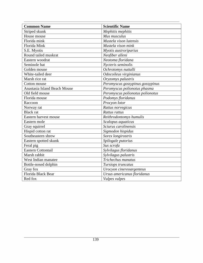
139
Common Name Scientific Name
Striped skunk Mephitis mephitis
House mouse Mus musculus
Florida mink Mustela vison lutensis
Florida Mink Mustela vison mink
S.E. Myotis Myotis austroriparius
Round tailed muskrat Neofiber alleni
Eastern woodrat Neotoma floridana
Seminole bat Nycteris seminolis
Golden mouse Ochrotomys nuttalli
White-tailed deer Odocoileus virginianus
Marsh rice rat Oryzomys palustris
Cotton mouse Peromyscus gossypinus gossypinus
Anastasia Island Beach Mouse Peromyscus polionotus phasma
Old field mouse Peromyscus polionotus polionotus
Florida mouse Podomys floridanus
Raccoon Procyon lotor
Norway rat Rattus norvegicus
Black rat Rattus rattus
Eastern harvest mouse Reithrodontomys humulis
Eastern mole Scalopus aquaticus
Gray squirrel Sciurus carolinensis
Hispid cotton rat Sigmodon hispidus
Southeastern shrew Sorex longirostris
Eastern spotted skunk Spilogale putorius
Feral pig Sus scrofa
Eastern Cottontail Sylvilagus floridanus
Marsh rabbit Sylvilagus palustris
West Indian manatee Trichechus manatus
Bottle-nosed dolphin Tursiops truncatus
Gray fox Urocyon cinereoargenteus
Florida Black Bear Ursus americanus floridanus
Red fox Vulpes vulpes

140
APPENDIX B. LIST OF WATER QUALITY SAMPLING STATIONS
Organization
Name ID Latitude Longitude Station ID Station Name WBID
FDACS 21FLSEAS 30 1 19.7998 81 19 41.3998 92SEAS600 Tip of Guana River at
dam 2320
FDACS 21FLSEAS 30 0 2.3998 81 19 34.1998 92SEAS617 Smith's lease mid-way
up Guana River 2320
FDACS 21FLSEAS 30 0 2.3998 81 19 34.1998 92SEAS617 Smith's lease mid-way
up Guana River 2320
FDACS 21FLSEAS 29 58 41.3998 81 19 20.3999 92SEAS205 Up Sombrero Creek as
far as possible 2470
FDACS 21FLSEAS 29 57 57.6 81 19 28.7998 92SEAS021
Northernmost marker
Lease 1088 in
XimaniesC.
2477
FDACS 21FLSEAS 29 57 31.1998 81 20 8.9999 92SEAS010 W end of basin adjacent
to St. Aug. Airport 2363I
FDACS 21FLSEAS 29 57 43.7998 81 19 43.7999 92SEAS015 ICWW CM 48 2363I
FDACS 21FLSEAS 29 56 6 81 18 25.7998 92SEAS065 Creek mouth E shore
north of ICWW CM 55 2363I
FDACS 21FLSEAS 29 56 11.9998 81 18 45.5998 92SEAS081 Mouth of Robinson
Creek 2363I
FDACS 21FLSEAS 29 56 25.8 81 18 49.7999 92SEAS091 Mouth of Pancho Creek 2363I
FDACS 21FLSEAS 29 56 56.9998 81 18 38.3998 92SEAS111 Fishing pier E of
ICWW CM 52 2363I
FDACS 21FLSEAS 29 57 28.8 81 18 54 92SEAS141 Creek on E shore north
of ICWW CM 51 2363I
FDACS 21FLSEAS 29 57 20.9999 81 18 50.4 92SEAS145 ICWW CM 51 2363I
FDACS 21FLSEAS 29 57 31.7999 81 19 32.3998 92SEAS161 Mouth of airport canal 2363I
FDACS 21FLSEAS 29 58 34.7999 81 19 54.5999 92SEAS190 Mouth of Casa Cola
Creek 2363I
FDACS 21FLSEAS 29 58 44.9998 81 19 40.1999 92SEAS200 Mouth of Sombrero
Creek 2363I
FDACS 21FLSEAS 29 58 50.9999 81 19 43.1998 92SEAS201 Midway between #200
and Guana R. 2363I
FDACS 21FLSEAS 29 58 25.7999 81 19 43.7999 92SEAS210 ICWW CM 47 2363I
FDACS 21FLSEAS 30 3 40.2 81 21 22.2 92SEAS602 2363I
FDACS 21FLSEAS 29 59 25.1999 81 19 46.7998 92SEAS606 ICWW CM 45 2363I
FDACS 21FLSEAS 29 59 55.1998 81 19 55.2 92SEAS609
Mouth of creek on E
shore N of ICWW CM
44
2363I
FDACS 21FLSEAS 29 59 45.6 81 19 57.5998 92SEAS610 ICWW CM 44 2363I
FDACS 21FLSEAS 30 0 5.9998 81 20 37.1998 92SEAS612 ICWW CM 38 2363I
FDACS 21FLSEAS 30 0 46.1999 81 20 56.4 92SEAS613 Mouth of Stokes Creek 2363I
FDACS 21FLSEAS 30 1 21 81 20 55.7999 92SEAS614 Creek E of ICWW CM
35 2363I
FDACS 21FLSEAS 30 1 47.3999 81 21 40.7999 92SEAS615 Spartina flats NE of
ICWW CM 33 2363I
FDACS 21FLSEAS 29 59 4.7998 81 19 37.7998 92SEAS618 Mouth of Guana River 2363I
FDACS 21FLSEAS 30 2 13.2 81 21 54 92SEAS620 Midway between
ICWW CMs 28 & 29 2363I
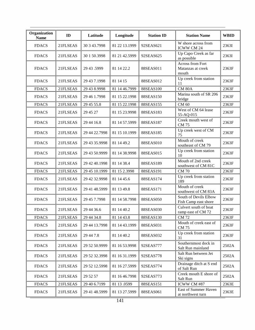
141
Organization
Name ID Latitude Longitude Station ID Station Name WBID
FDACS 21FLSEAS 30 3 43.7998 81 22 13.1999 92SEAS621 W shore across from
ICWW CM 24 2363I
FDACS 21FLSEAS 30 1 50.3998 81 21 42.5999 92SEAS625 Up Capo Creek as far
as possible 2363I
FDACS 21FLSEAS 29 43 .5999 81 14 22.2 88SEAS011
Across from Fort
Matanzas at creek
mouth
2363F
FDACS 21FLSEAS 29 43 7.1998 81 14 15 88SEAS012 Up creek from station
11 2363F
FDACS 21FLSEAS 29 43 8.9998 81 14 46.7999 88SEAS100 CM 80A 2363F
FDACS 21FLSEAS 29 46 1.7998 81 15 22.1998 88SEAS150 Marina south of SR 206
bridge 2363F
FDACS 21FLSEAS 29 45 55.8 81 15 22.1998 88SEAS155 CM 60 2363F
FDACS 21FLSEAS 29 45 27 81 15 23.9998 88SEAS183 West of CM 64 lease
55-AQ-015 2363F
FDACS 21FLSEAS 29 44 16.8 81 14 57.5999 88SEAS187 Creek mouth west of
CM 75 2363F
FDACS 21FLSEAS 29 44 22.7998 81 15 10.1999 88SEAS185 Up creek west of CM
75 2363F
FDACS 21FLSEAS 29 43 35.9998 81 14 49.2 88SEAS010 Mouth of creek
southeast of CM 79 2363F
FDACS 21FLSEAS 29 43 50.9999 81 14 38.9998 88SEAS015 Up creek from station
10 2363F
FDACS 21FLSEAS 29 42 40.1998 81 14 38.4 88SEAS189 Mouth of 2nd creek
southwest of CM 81C 2363F
FDACS 21FLSEAS 29 45 10.1999 81 15 2.3998 88SEAS191 CM 70 2363F
FDACS 21FLSEAS 29 42 32.9998 81 14 45.6 88SEAS174 Up creek from station
189 2363F
FDACS 21FLSEAS 29 41 48.5999 81 13 49.8 88SEAS171 Mouth of creek
southwest of CM 83A 2363F
FDACS 21FLSEAS 29 45 7.7998 81 14 58.7998 88SEAS050 South of Devils Elbow
Fish Camp east shore 2363F
FDACS 21FLSEAS 29 44 36.6 81 14 40.2 88SEAS030 Culvert south of boat
ramp east of CM 72 2363F
FDACS 21FLSEAS 29 44 34.8 81 14 43.8 88SEAS130 CM 72 2363F
FDACS 21FLSEAS 29 44 13.7998 81 14 43.1999 88SEAS031 Mouth of creek east of
CM 75 2363F
FDACS 21FLSEAS 29 44 7.8 81 14 40.2 88SEAS032 Up creek from station
31 2363F
FDACS 21FLSEAS 29 52 50.9999 81 16 53.9998 92SEAS777 Southernmost dock in
Salt Run mainland 2502A
FDACS 21FLSEAS 29 52 32.3998 81 16 31.1999 92SEAS778 Salt Run between Jet
Ski signs 2502A
FDACS 21FLSEAS 29 52 12.5998 81 16 27.5999 92SEAS774 Drainage ditch at S end
of Salt Run 2502A
FDACS 21FLSEAS 29 52 57 81 16 46.7998 92SEAS773 Creek mouth E shore of
Salt Run 2502A
FDACS 21FLSEAS 29 40 6.7199 81 13 .0599 88SEAS151 ICWW CM #87 2363E
FDACS 21FLSEAS 29 41 48.5999 81 13 27.5999 88SEAS061 East of Summer Haven
at northwest turn 2363E
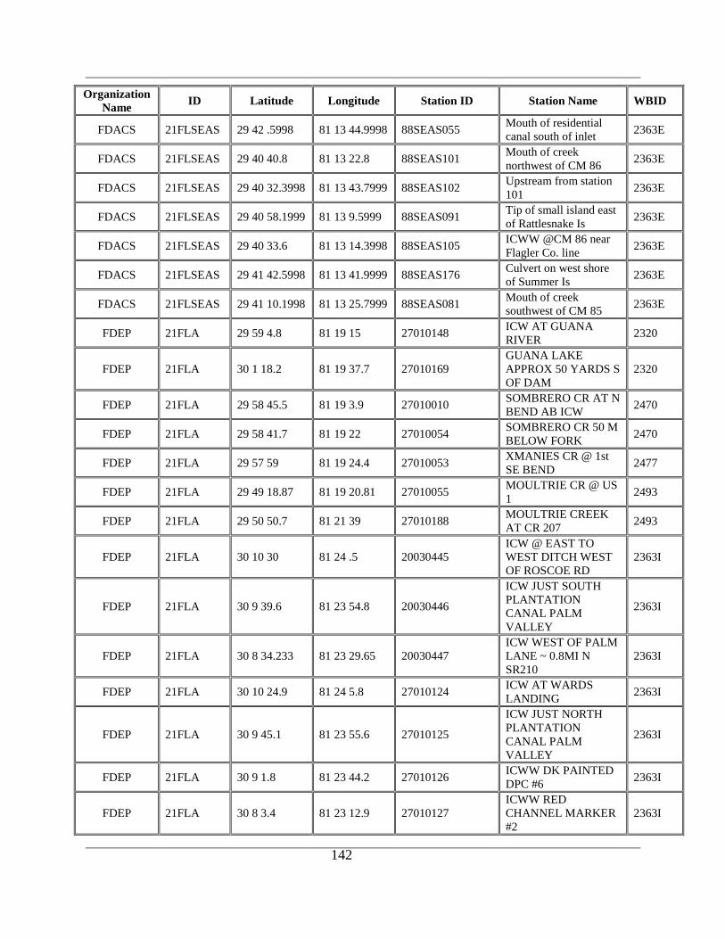
142
Organization
Name ID Latitude Longitude Station ID Station Name WBID
FDACS 21FLSEAS 29 42 .5998 81 13 44.9998 88SEAS055 Mouth of residential
canal south of inlet 2363E
FDACS 21FLSEAS 29 40 40.8 81 13 22.8 88SEAS101 Mouth of creek
northwest of CM 86 2363E
FDACS 21FLSEAS 29 40 32.3998 81 13 43.7999 88SEAS102 Upstream from station
101 2363E
FDACS 21FLSEAS 29 40 58.1999 81 13 9.5999 88SEAS091 Tip of small island east
of Rattlesnake Is 2363E
FDACS 21FLSEAS 29 40 33.6 81 13 14.3998 88SEAS105 ICWW @CM 86 near
Flagler Co. line 2363E
FDACS 21FLSEAS 29 41 42.5998 81 13 41.9999 88SEAS176 Culvert on west shore
of Summer Is 2363E
FDACS 21FLSEAS 29 41 10.1998 81 13 25.7999 88SEAS081 Mouth of creek
southwest of CM 85 2363E
FDEP 21FLA 29 59 4.8 81 19 15 27010148 ICW AT GUANA
RIVER 2320
FDEP 21FLA 30 1 18.2 81 19 37.7 27010169
GUANA LAKE
APPROX 50 YARDS S
OF DAM
2320
FDEP 21FLA 29 58 45.5 81 19 3.9 27010010 SOMBRERO CR AT N
BEND AB ICW 2470
FDEP 21FLA 29 58 41.7 81 19 22 27010054 SOMBRERO CR 50 M
BELOW FORK 2470
FDEP 21FLA 29 57 59 81 19 24.4 27010053 XMANIES CR @ 1st
SE BEND 2477
FDEP 21FLA 29 49 18.87 81 19 20.81 27010055 MOULTRIE CR @ US
1 2493
FDEP 21FLA 29 50 50.7 81 21 39 27010188 MOULTRIE CREEK
AT CR 207 2493
FDEP 21FLA 30 10 30 81 24 .5 20030445
ICW @ EAST TO
WEST DITCH WEST
OF ROSCOE RD
2363I
FDEP 21FLA 30 9 39.6 81 23 54.8 20030446
ICW JUST SOUTH
PLANTATION
CANAL PALM
VALLEY
2363I
FDEP 21FLA 30 8 34.233 81 23 29.65 20030447
ICW WEST OF PALM
LANE ~ 0.8MI N
SR210
2363I
FDEP 21FLA 30 10 24.9 81 24 5.8 27010124 ICW AT WARDS
LANDING 2363I
FDEP 21FLA 30 9 45.1 81 23 55.6 27010125
ICW JUST NORTH
PLANTATION
CANAL PALM
VALLEY
2363I
FDEP 21FLA 30 9 1.8 81 23 44.2 27010126 ICWW DK PAINTED
DPC #6 2363I
FDEP 21FLA 30 8 3.4 81 23 12.9 27010127
ICWW RED
CHANNEL MARKER
#2
2363I

143
Organization
Name ID Latitude Longitude Station ID Station Name WBID
FDEP 21FLA 30 7 39.9 81 22 57.1 27010128
CREEK 1/2 MILE
FROM BRIDGE
ICWW
2363I
FDEP 21FLA 30 6 1 81 22 2 27010145 ICWW St Johns #9 2363I
FDEP 21FLA 30 3 57 81 22 11.7 27010146
ICWW 10 MARKER
21 TOLOMATO
RIVER
2363I
FDEP 21FLA 30 1 58 81 21 55 27010147 ICWW St Johns #11
MARKER 30 2363I
FDEP 21FLA 30 9 39.8 81 22 37.6 27010167
PONTE VEDRA
LAKE AT MICKLERS
CUTOFF
2363I
FDEP 21FLA 30 0 46 81 20 56.7 27010172 STOKES CR AT
MOUTH 2363I
FDEP 21FLA 29 57 43.6 81 19 14.6 27010175
ICW @ UNNAMED
CR SE OF XIMANIES
CR
2363I
FDEP 21FLA 29 57 34.9 81 20 8.7 27010176
ST AUG AIRPORT
BASIN @ W
CULVERT
2363I
FDEP 21FLA 29 57 29 81 19 36 27010177 ICW @ DITCH SE OF
AIRPORT 2363I
FDEP 21FLA 30 1 41.9 81 21 45.8 27010202 ICW AT CM 32 2363I
FDEP 21FLA 29 42 15.1 81 14 1.5 27010098 ICWW AT CHANNEL
CUT TO MATANZAS 2363F
FDEP 21FLA 29 49 50 81 18 4 27010155
INTRACOASTAL
WATERWAY AT
EAST CREEK
2363G1
FDEP 21FLA 29 51 58 81 18 18 27010154
INTRACOASTAL
WATERWAY AT STP
II OUTFALL
2363G1
FDEP 21FLA 29 52 27 81 18 15 27010153
INTRACOASTAL
WATERWAY AT
OUTFALL OF STP 1
2363G1
FDEP 21FLA 29 53 8.4 81 18 18.6 27010139 MATANZAS R 1/2 MI
S OF BRIDGE 2363G1
FDEP 21FLA 29 51 26.8 81 18 40 27010140
MATANZAS R BY
CHANNEL MARKER
NO
2363G1
FDEP 21FLA 29 51 58.8 81 18 32.3 27010200 ICW 100 FT. SOUTH
OF SR 312 2363G1
FDEP 21FLA 29 51 10.1 81 18 12.1 27010158 ICW AT ASD WWTP
POD 2363G1
FDEP 21FLA 29 50 48.8 81 17 59.6 27010157 ICW AT CM 21 2363G1
FDEP 21FLA 29 52 33.3 81 18 30 27010162 ST AUGUSTINE
WWTP #1 EFF. 2363G1
FDEP 21FLA 29 51 25.9 81 18 44.2 27010201 ICW AT CM 17 2363G1
FDEP 21FLA 29 52 46.4 81 18 11.6 27010161 ICW AT CM 12 2363G1
FDEP 21FLA 29 52 4.2 81 18 23.5 27010160 ICW 50 FEET NORTH
OF SR 312 2363G1
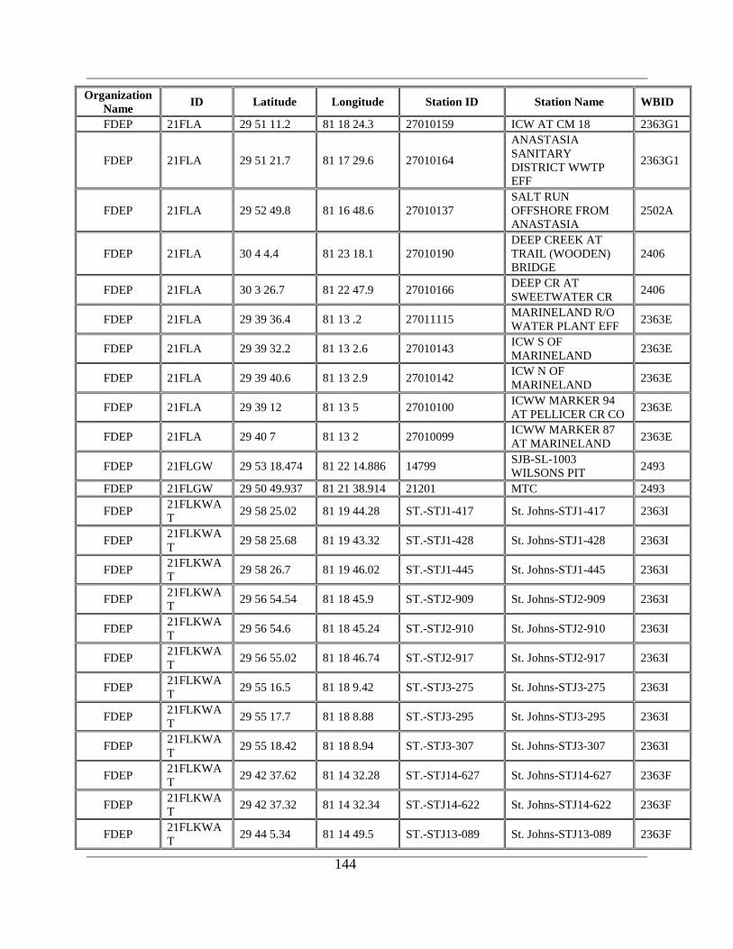
144
Organization
Name ID Latitude Longitude Station ID Station Name WBID
FDEP 21FLA 29 51 11.2 81 18 24.3 27010159 ICW AT CM 18 2363G1
FDEP 21FLA 29 51 21.7 81 17 29.6 27010164
ANASTASIA
SANITARY
DISTRICT WWTP
EFF
2363G1
FDEP 21FLA 29 52 49.8 81 16 48.6 27010137
SALT RUN
OFFSHORE FROM
ANASTASIA
2502A
FDEP 21FLA 30 4 4.4 81 23 18.1 27010190
DEEP CREEK AT
TRAIL (WOODEN)
BRIDGE
2406
FDEP 21FLA 30 3 26.7 81 22 47.9 27010166 DEEP CR AT
SWEETWATER CR 2406
FDEP 21FLA 29 39 36.4 81 13 .2 27011115 MARINELAND R/O
WATER PLANT EFF 2363E
FDEP 21FLA 29 39 32.2 81 13 2.6 27010143 ICW S OF
MARINELAND 2363E
FDEP 21FLA 29 39 40.6 81 13 2.9 27010142 ICW N OF
MARINELAND 2363E
FDEP 21FLA 29 39 12 81 13 5 27010100 ICWW MARKER 94
AT PELLICER CR CO 2363E
FDEP 21FLA 29 40 7 81 13 2 27010099 ICWW MARKER 87
AT MARINELAND 2363E
FDEP 21FLGW 29 53 18.474 81 22 14.886 14799 SJB-SL-1003
WILSONS PIT 2493
FDEP 21FLGW 29 50 49.937 81 21 38.914 21201 MTC 2493
FDEP 21FLKWA
T 29 58 25.02 81 19 44.28 ST.-STJ1-417 St. Johns-STJ1-417 2363I
FDEP 21FLKWA
T 29 58 25.68 81 19 43.32 ST.-STJ1-428 St. Johns-STJ1-428 2363I
FDEP 21FLKWA
T 29 58 26.7 81 19 46.02 ST.-STJ1-445 St. Johns-STJ1-445 2363I
FDEP 21FLKWA
T 29 56 54.54 81 18 45.9 ST.-STJ2-909 St. Johns-STJ2-909 2363I
FDEP 21FLKWA
T 29 56 54.6 81 18 45.24 ST.-STJ2-910 St. Johns-STJ2-910 2363I
FDEP 21FLKWA
T 29 56 55.02 81 18 46.74 ST.-STJ2-917 St. Johns-STJ2-917 2363I
FDEP 21FLKWA
T 29 55 16.5 81 18 9.42 ST.-STJ3-275 St. Johns-STJ3-275 2363I
FDEP 21FLKWA
T 29 55 17.7 81 18 8.88 ST.-STJ3-295 St. Johns-STJ3-295 2363I
FDEP 21FLKWA
T 29 55 18.42 81 18 8.94 ST.-STJ3-307 St. Johns-STJ3-307 2363I
FDEP 21FLKWA
T 29 42 37.62 81 14 32.28 ST.-STJ14-627 St. Johns-STJ14-627 2363F
FDEP 21FLKWA
T 29 42 37.32 81 14 32.34 ST.-STJ14-622 St. Johns-STJ14-622 2363F
FDEP 21FLKWA
T 29 44 5.34 81 14 49.5 ST.-STJ13-089 St. Johns-STJ13-089 2363F
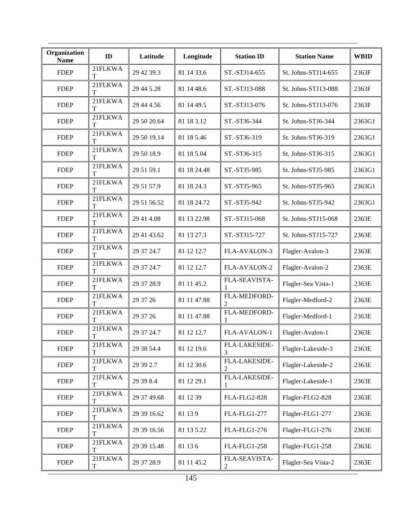
145
Organization
Name ID Latitude Longitude Station ID Station Name WBID
FDEP 21FLKWA
T 29 42 39.3 81 14 33.6 ST.-STJ14-655 St. Johns-STJ14-655 2363F
FDEP 21FLKWA
T 29 44 5.28 81 14 48.6 ST.-STJ13-088 St. Johns-STJ13-088 2363F
FDEP 21FLKWA
T 29 44 4.56 81 14 49.5 ST.-STJ13-076 St. Johns-STJ13-076 2363F
FDEP 21FLKWA
T 29 50 20.64 81 18 3.12 ST.-STJ6-344 St. Johns-STJ6-344 2363G1
FDEP 21FLKWA
T 29 50 19.14 81 18 5.46 ST.-STJ6-319 St. Johns-STJ6-319 2363G1
FDEP 21FLKWA
T 29 50 18.9 81 18 5.04 ST.-STJ6-315 St. Johns-STJ6-315 2363G1
FDEP 21FLKWA
T 29 51 59.1 81 18 24.48 ST.-STJ5-985 St. Johns-STJ5-985 2363G1
FDEP 21FLKWA
T 29 51 57.9 81 18 24.3 ST.-STJ5-965 St. Johns-STJ5-965 2363G1
FDEP 21FLKWA
T 29 51 56.52 81 18 24.72 ST.-STJ5-942 St. Johns-STJ5-942 2363G1
FDEP 21FLKWA
T 29 41 4.08 81 13 22.98 ST.-STJ15-068 St. Johns-STJ15-068 2363E
FDEP 21FLKWA
T 29 41 43.62 81 13 27.3 ST.-STJ15-727 St. Johns-STJ15-727 2363E
FDEP 21FLKWA
T 29 37 24.7 81 12 12.7 FLA-AVALON-3 Flagler-Avalon-3 2363E
FDEP 21FLKWA
T 29 37 24.7 81 12 12.7 FLA-AVALON-2 Flagler-Avalon-2 2363E
FDEP 21FLKWA
T 29 37 28.9 81 11 45.2
FLA-SEAVISTA-
1 Flagler-Sea Vista-1 2363E
FDEP 21FLKWA
T 29 37 26 81 11 47.88
FLA-MEDFORD-
2 Flagler-Medford-2 2363E
FDEP 21FLKWA
T 29 37 26 81 11 47.88
FLA-MEDFORD-
1 Flagler-Medford-1 2363E
FDEP 21FLKWA
T 29 37 24.7 81 12 12.7 FLA-AVALON-1 Flagler-Avalon-1 2363E
FDEP 21FLKWA
T 29 38 54.4 81 12 19.6
FLA-LAKESIDE-
3 Flagler-Lakeside-3 2363E
FDEP 21FLKWA
T 29 39 2.7 81 12 30.6
FLA-LAKESIDE-
2 Flagler-Lakeside-2 2363E
FDEP 21FLKWA
T 29 39 8.4 81 12 29.1
FLA-LAKESIDE-
1 Flagler-Lakeside-1 2363E
FDEP 21FLKWA
T 29 37 49.68 81 12 39 FLA-FLG2-828 Flagler-FLG2-828 2363E
FDEP 21FLKWA
T 29 39 16.62 81 13 9 FLA-FLG1-277 Flagler-FLG1-277 2363E
FDEP 21FLKWA
T 29 39 16.56 81 13 5.22 FLA-FLG1-276 Flagler-FLG1-276 2363E
FDEP 21FLKWA
T 29 39 15.48 81 13 6 FLA-FLG1-258 Flagler-FLG1-258 2363E
FDEP 21FLKWA
T 29 37 28.9 81 11 45.2
FLA-SEAVISTA-
2 Flagler-Sea Vista-2 2363E

146
Organization
Name ID Latitude Longitude Station ID Station Name WBID
FDEP 21FLKWA
T 29 37 31.44 81 11 42.9
FLA-
NANTUCKET-3 Flagler-Nantucket-3 2363E
FDEP 21FLKWA
T 29 37 31.44 81 11 42.9
FLA-
NANTUCKET-2 Flagler-Nantucket-2 2363E
FDEP 21FLKWA
T 29 37 31.44 81 11 42.9
FLA-
NANTUCKET-1 Flagler-Nantucket-1 2363E
FDEP 21FLKWA
T 29 37 50.58 81 12 41.16 FLA-FLG2-843 Flagler-FLG2-843 2363E
FDEP 21FLKWA
T 29 37 50.4 81 12 40.44 FLA-FLG2-840 Flagler-FLG2-840 2363E
FDEP 21FLKWA
T 29 38 17.04 81 12 58.86 FLA-FLG5-284 Flagler-FLG5-284 2363E
FDEP 21FLKWA
T 29 41 6.06 81 13 22.68 ST.-STJ15-101 St. Johns-STJ15-101 2363E
FDOH 21FLDOH 29 51 56.8742 81 16 10.4786 St Johns244 FL300583 2502A
FMRI 21FLFMRI 30 5 24 81 21 36 HAL200101 Halifax - Tolomato
River 2363I
FMRI 21FLFMRI 29 59 24 81 19 48 HAL200102 Halifax - Tolomato
River 2363I
FMRI 21FLFMRI 29 57 0 81 18 36 HAL200103 Halifax - Tolomato
River 2363I
FMRI 21FLFMRI 30 7 12 81 22 12 HAL200128 Halifax - SE Side CR
210 2363I
FMRI 21FLFMRI 29 43 48 81 14 24 HAL200106 Halifax - Intracoastal
Waterway 2363F
FMRI 21FLFMRI 29 52 48 81 16 48 HAL200104 Halifax - Salt Run 2502A
GTMNERR 21FLGTM 30 3 3 81 22 3 GTMPINUT Pine Island Channel
Marker 25 2363I
GTMNERR 21FLGTM 29 44 13.2 81 14 45.6 GTMFMNUT Matanzas River
Channel Marker 75 2363F
GTMNERR 21FLGTM 29 52 6 81 18 16.8 GTMSSNUT
San Sebastian &
Matanzas River
confluence Channel
Marker 1
2363G1
GTMNERR 21FLGTM 29 40 9 81 15 22.2 GTMPCNUT Pellicer Creek 2580A
SJRWMD 21FLSJWM 30 1 15.17 81 19 38.19 GAR
GUANA RIVER 100
meters south of the
Dam
2320
*SJRWMD 21FLSJWM 29 49 40 81 18 46 MCICW MOULTRIE CREEK
OFF ICWW 2493
*SJRWMD 21FLSJWM 29 50 49.94 81 21 38.91 MTC Moultrie Creek @ SR
207 2493
SJRWMD 21FLSJWM 29 53 18.474 81 22 14.886 SJB-SL-1003 WILSONS PIT 2493
SJRWMD 21FLSJWM 29 59 5 81 19 42 JXTR17
Confluence of
Tolomato and Guana
Rivers - ICWW
2363I
SJRWMD 21FLSJWM 30 5 25 81 22 15 SMITHSCR Smith's Creek 2363I
*SJRWMD 21FLSJWM 30 3 43.86 81 22 9.03 TOL
TOLOMATO R 1 MI
N DEEP CR @
SPANISH LNDG
2363I

147
Organization
Name ID Latitude Longitude Station ID Station Name WBID
*SJRWMD 21FLSJWM 29 51 58.28 81 18 21.27 MR312 MATANZAS RIVER
AT CR 312 2363G1
*SJRWMD 21FLSJWM 29 39 53 81 13 5 MRT Confluence of Pellicer
Creek and ICWW 2363E
*Primary SJRWMD Stations
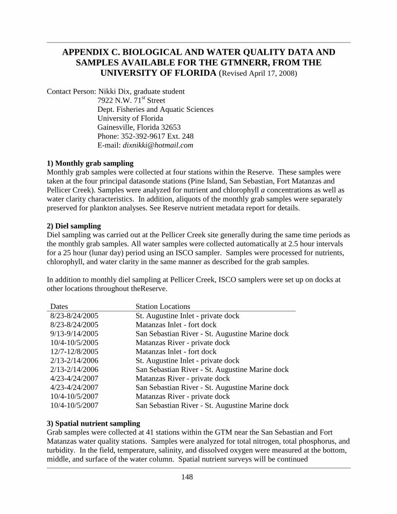
148
APPENDIX C. BIOLOGICAL AND WATER QUALITY DATA AND
SAMPLES AVAILABLE FOR THE GTMNERR, FROM THE
UNIVERSITY OF FLORIDA (Revised April 17, 2008)
Contact Person: Nikki Dix, graduate student
7922 N.W. 71st Street
Dept. Fisheries and Aquatic Sciences
University of Florida
Gainesville, Florida 32653
Phone: 352-392-9617 Ext. 248
E-mail: [email protected]
1) Monthly grab sampling Monthly grab samples were collected at four stations within the Reserve. These samples were
taken at the four principal datasonde stations (Pine Island, San Sebastian, Fort Matanzas and
Pellicer Creek). Samples were analyzed for nutrient and chlorophyll a concentrations as well as
water clarity characteristics. In addition, aliquots of the monthly grab samples were separately
preserved for plankton analyses. See Reserve nutrient metadata report for details.
2) Diel sampling
Diel sampling was carried out at the Pellicer Creek site generally during the same time periods as
the monthly grab samples. All water samples were collected automatically at 2.5 hour intervals
for a 25 hour (lunar day) period using an ISCO sampler. Samples were processed for nutrients,
chlorophyll, and water clarity in the same manner as described for the grab samples.
In addition to monthly diel sampling at Pellicer Creek, ISCO samplers were set up on docks at
other locations throughout theReserve.
Dates Station Locations
8/23-8/24/2005 St. Augustine Inlet - private dock
8/23-8/24/2005 Matanzas Inlet - fort dock
9/13-9/14/2005 San Sebastian River - St. Augustine Marine dock
10/4-10/5/2005 Matanzas River - private dock
12/7-12/8/2005 Matanzas Inlet - fort dock
2/13-2/14/2006 St. Augustine Inlet - private dock
2/13-2/14/2006 San Sebastian River - St. Augustine Marine dock
4/23-4/24/2007 Matanzas River - private dock
4/23-4/24/2007
10/4-10/5/2007
10/4-10/5/2007
San Sebastian River - St. Augustine Marine dock
Matanzas River - private dock
San Sebastian River - St. Augustine Marine dock
3) Spatial nutrient sampling
Grab samples were collected at 41 stations within the GTM near the San Sebastian and Fort
Matanzas water quality stations. Samples were analyzed for total nitrogen, total phosphorus, and
turbidity. In the field, temperature, salinity, and dissolved oxygen were measured at the bottom,
middle, and surface of the water column. Spatial nutrient surveys will be continued

149
approximately every four months through 2008.
Dates Station Locations
2/22/2007, 6/28/2007,
10/4/2007
Matanzas region, south of 206 bridge to
Summerhaven (20 stations)
2/23/2007, 6/29/2007,
10/5/2007
San Sebastian region, south of Bridge of Lions,
up San Sebastian River, and south to Moultrie
and East Creeks (21 stations)
4) Periphyton sampling
Periphyton collection trays were tied to docks and channel markers throughout the GTM and left
to float just under the surface of the water for various time periods corresponding to diel water
quality sampling events. Samples were processed for chlorophyll a and biomass (i.e., dry weight
and ash-free dry weight).
Dates Station Locations
8/22-9/1/2005 Matanzas Inlet - fort dock
10/3-10/10/2005 Matanzas River - private dock
10/3-10/10/2005 Pellicer Creek - Faver Dykes dock
11/14-11/28/2005 Pellicer Creek - Faver Dykes dock
11/22-12/20/2005 Matanzas Inlet - fort dock
2/13-3/14/2006 San Sebastian River - St. Augustine Marine dock
4/23-5/15/2007 San Sebastian River - St. Augustine Marine dock
4/23-5/4/2007
3/10-3/24/2008
Matanzas River - private dock
Matanzas River – channel marker #74
5) Infauna sampling
Infaunal organisms were collected with petite ponar grabs at various locations near the GTM San
Sebastian and Fort Matanzas water quality stations. Samples were sieved and sorted at the lab
and preserved for identification. Presently, organisms in all samples from three of the five
stations have been identified to the lowest possible taxonomic level.
Dates Station Locations
2/23/2007 29°49‟49.9”N 81°18‟0.2”W – mouth of East Creek
6/7/2007 29°44‟16.2”N 81°14‟52.9”W – west side of ICW near marker #75
6/7/2007 29°42‟39.9”N 81°13‟53.2”W – mud flat between Fort Matanzas and
Matanzas Inlet
6/8/2007 29°52‟40.0”N 81°18‟55.7”W – San Sebastian River across from St.
Augustine Marine
6/8/2007 29°52‟07.7”N 81°18‟29.2”W – south side of San Sebastian River near the
mouth
6) Sediment grain size analysis
Sediment was collected with three replicate petite ponar grabs at the infauna sampling stations.
In the lab, sediment was sieved to determine grain size composition.
150
7) Oyster community sampling
Oysters were collected from 0.25-m2 quadrats by hand at 8 reefs near the GTM San Sebastian
and Fort Matanzas water quality stations during February 2008. Living oysters were classified
by size to be used in density measurements. Condition indices will be measured for a subset of
oysters from each collection quadrat. Percent cover of living oysters was also determined in the
field at six 1.0-m2 quadrats per transect (one transect at the highest elevation and one at the
lowest elevation of each reef). Additional reefs will be sampled in the summer of 2008.
151
APPENDIX D. ADDITIONAL SCIENTIFIC STUDIES AND REFERENCES
RELEVANT TO THE GTMNERR
The Board of Trustees of the Internal Improvement Trust Fund, F.S. § 253.03 (1967).
Deagan, K. 1978. Cultures in Transition: Fusion and Assimilation among the Eastern Timuca.
Pp.89-119 In J. T. Milanich and S. Proctor, eds., Tacachale--Essays on the Indians of
Florida and Southeast Georgia. University Presses of Florida, Gainesville.
Deagan, K. 1981. Downtown Survey: The Discovery of Sixteenth-Century St. Augustine in and
Urban Area. American Antiquity. 46(3).
Deagan, K. 1987. Artifacts of the Spanish Colonies of Florida and the Caribbean 1500-1800,
Vol. 1. Ceramics, Glassware and Beads. Washington, DC: Smithsonian Institution Press.
244 pp.
Durako, M.J., M.D. Murphy, and J.D. Haddad. Assessment of fisheries habitat: Northeast
Florida. Fla. Mar. Res. Publ. No. 45. Florida Department of Natural Resources Bureau
Marine Science, St. Petersburg. 51pp.
Florida Coastal Engineers, Inc. 1976. St. Johns County Beach Erosion Study.
Florida Department of Natural Resources. 1985. Guana River State Land Conceptual Plan. 52
pp.
Foster, E. R., Spurgeon, D. L., and Cheng, J. 2000. Shoreline Change Rate Estimates, St. Johns
County, June 2000, Report No. BCS-00-03.
Goggin, J. 1952. Space and Time Perspective in Northern St. Johns Archeology, Florida. Yale
University Publications in Anthropology, No. 47. Yale University Press, New Haven. 147
pp.
Hann, J. 1990. Summary Guide to Spanish Florida Missions and Vistas, with Churches in the
Sixteenth and Seventeenth Centuries. The Americas. 46(4).
HDR Engineering, Inc. 2008. Hydrology Assessment of the Guana River Wildlife Management
Area. Report prepared for the FWC. Tallhassee, FL.
Johnson, D.W. et al. (2001). Effects of Elevated Carbon Dioxide on Soils in a Florida Scrub Oak
Ecosystem. Journal of Environmental Quality. 30:501-507.
Ross, S. T. 1983. A review of surf zone icthyofaunas in the Gulf of Mexico. U.S. Department of
the Interior, National Park Service SE Reg. Off. Proceedings of the northern Gulf of
Mexico Estuaries and Barrier Islands Research Conference Atlanta, GA, 25-34.
The Randall Act, Chapter 67-393 Laws of Florida (1967).