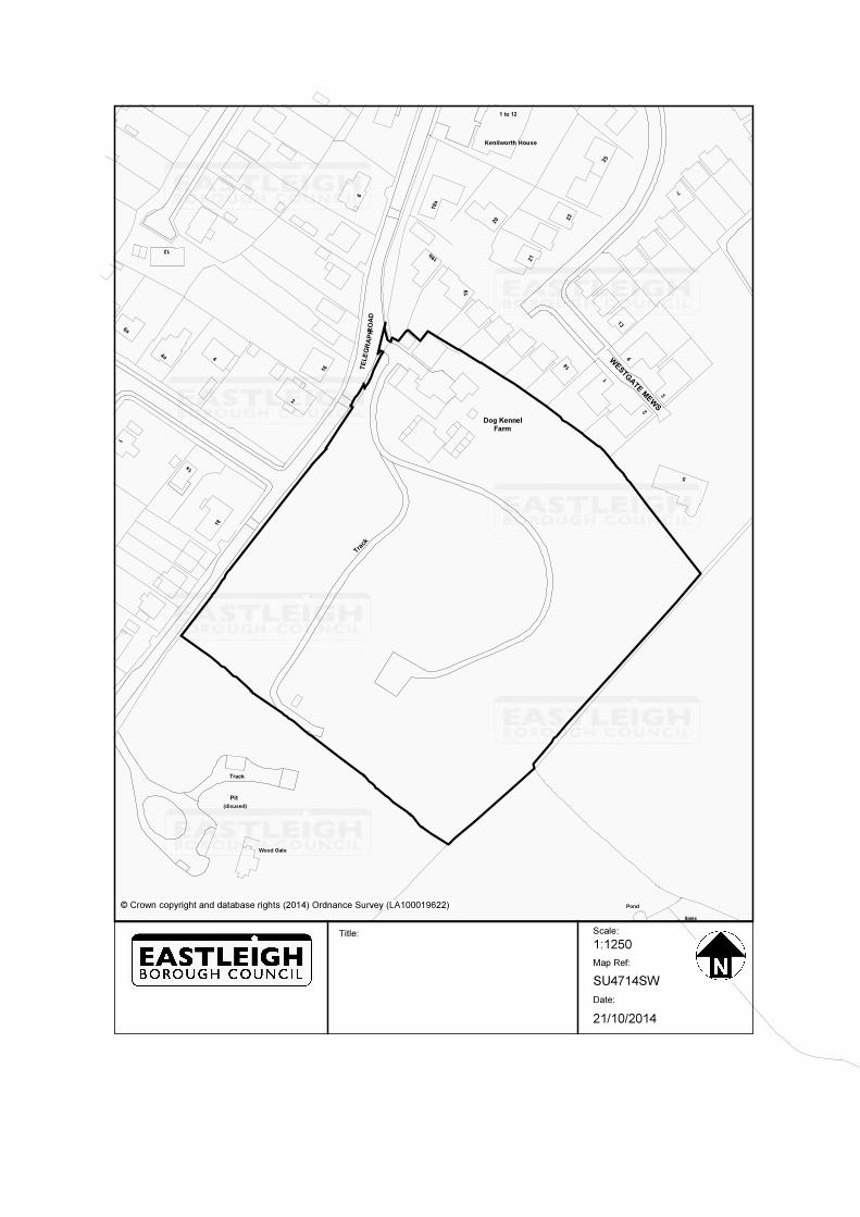
SITE: Dog Kennel Farm and land adjacent, Telegraph Road ...
30
HEDGE END, WEST END & BOTLEY Monday 10 November 2014 Case Officer Dawn Errington SITE: Dog Kennel Farm and land adjacent, Telegraph Road, West End, Southampton, SO30 3EX Ref. F/14/74943 Received: 14/07/2014 (30/11/2014) APPLICANT: Hemdean Builders Limited PROPOSAL: Construction of 14no. dwellings, public open space, parking, landscaping and new access off Telegraph Road following demolition of all buildings on site and closure of the existing access AMENDMENTS: 09/10/2014 RECOMMENDATION: Subject to the Section 106 terms detailed in the report: PERMIT CONDITIONS AND REASONS: (1) The development hereby permitted shall be implemented in accordance with the following plans numbered: 13001 A P 00 G2 110 Rev A, 13001 A P 00 G2 111 Rev A, 13001 A P 00 G2 115 Rev B, 13001 A P 00 G2 120 Rev A, 13001 A P 00 G2 125 Rev A, 13001 A P 00 G2 126 Rev A, 13001 A P 00 G2 127 Rev A, 13001 A P 00 G2 130 Rev B, 13001 A P 00 G7 101 Rev A, 13001 A P 00 G7 105 Rev B, 13001 A P 00 G7 106 Rev B, 13001 A P 00 G7 108 Rev A, 13001 AP G7 109 Rev B, 13001 A P 00 G7 100 Rev A, 13001 A P 00 G7 107 Rev B, H 115/3A, H 115/4A, H 115/5, TM 613 03 04 Rev B Sheets 1 & 2, TM 647 01 Reason: For the avoidance of doubt and in the interests of proper planning. (2) The development hereby permitted must be begun within a period of two years beginning with the date on which this permission is granted. Reason: To comply with Section 91 of the Town and Country Planning Act 1990. (3) Plans and particulars showing the proposals for all the following aspects of the development must be submitted to and approved in writing by the Local Planning Authority before the development is commenced. The development must then
Transcript of SITE: Dog Kennel Farm and land adjacent, Telegraph Road ...
HEDGE END, WEST END & BOTLEY Monday 10 November 2014 Case Officer Dawn Errington
SITE: Dog Kennel Farm and land adjacent, Telegraph Road,
West End, Southampton, SO30 3EX Ref. F/14/74943 Received: 14/07/2014 (30/11/2014) APPLICANT: Hemdean Builders Limited
PROPOSAL: Construction of 14no. dwellings, public open space,
parking, landscaping and new access off Telegraph Road following demolition of all buildings on site and closure of the existing access
AMENDMENTS: 09/10/2014
RECOMMENDATION: Subject to the Section 106 terms detailed in the report: PERMIT
CONDITIONS AND REASONS: (1) The development hereby permitted shall be implemented in accordance with the
following plans numbered: 13001 A P 00 G2 110 Rev A, 13001 A P 00 G2 111 Rev A, 13001 A P 00 G2 115 Rev B, 13001 A P 00 G2 120 Rev A, 13001 A P 00 G2 125 Rev A, 13001 A P 00 G2 126 Rev A, 13001 A P 00 G2 127 Rev A, 13001 A P 00 G2 130 Rev B, 13001 A P 00 G7 101 Rev A, 13001 A P 00 G7 105 Rev B, 13001 A P 00 G7 106 Rev B, 13001 A P 00 G7 108 Rev A, 13001 AP G7 109 Rev B, 13001 A P 00 G7 100 Rev A, 13001 A P 00 G7 107 Rev B, H 115/3A, H 115/4A, H 115/5, TM 613 03 04 Rev B Sheets 1 & 2, TM 647 01 Reason: For the avoidance of doubt and in the interests of proper planning.
(2) The development hereby permitted must be begun within a period of two years
beginning with the date on which this permission is granted. Reason: To comply with Section 91 of the Town and Country Planning Act 1990.
(3) Plans and particulars showing the proposals for all the following aspects of the
development must be submitted to and approved in writing by the Local Planning Authority before the development is commenced. The development must then
accord with these approved details for that phase. Reason: In order that these matters may be considered by the Local Planning Authority.
a: The provision to be made for street lighting and/or external lighting and bat sensitive lighting b: Details of rainwater goods. c: Details and location of meter boxes. d: Colour and materials for fascias and soffits. e: Proposed ground levels and relationship to existing levels both within the site and on immediately adjoining land. f: Boundary wall, railing and fence design. g The final levels above ordnance datum of all ground floor levels of buildings, gardens and tops of retaining walls h: The provision of street trees. i: Window details and designs.
(4) No construction or demolition work shall start until a Construction Management
Plan has been submitted to, and approved in writing by, the Local Planning Authority. Demolition and construction work shall only take place in accordance with the approved Construction Management Plan which shall include: a) a programme and phasing of the demolition and construction work, including roads, landscaping and open space and timings in relation to the bird nesting season b) location of temporary site buildings, compounds, construction material and plant storage areas used during demolition and construction; c) the arrangements for the routing/ turning of lorries and details for construction traffic access to the site; d) the arrangements for deliveries associated with all construction works, loading/ unloading of plant & materials and restoration of any damage to the highway [including vehicle crossovers and grass verges]. e) provision for storage, collection, and disposal of rubbish from the development during construction period; f) measures to prevent mud and dust on the highway during demolition and construction; g) the erection and maintenance of security hoarding including decorative displays and facilities for public viewing, where appropriate; h) temporary lighting; i) measures to control noise, vibration and dust impacts for neighbours to comply with the Best Practise Guidance - The Control of Dust and Emissions from Construction; j) details and times of any piling works. k) No burning of materials from site clearance or development shall take place within or adjoining the site. l) measures to protect trees and ecology during construction as required by the Habitats Regulations Assessment Reason: To limit the impact the development has on the amenity of the locality.
(5) Development shall not begin until the developer has provided a noise assessment
scheme that demonstrates that the impacts of noise from The Ageas Bowl and Hampshire Tennis and Health Club affecting the site, and external and internal
layout and orientation of residential dwellings and gardens have been considered. The report shall include a scheme of mitigation measures for protecting the development from noise and vibration, this scheme must be submitted for approval by the Local Planning Authority. All works, which form part of the scheme approved by the Local Planning Authority, must be completed before any of the permitted dwellings is occupied (5) The scheme shall be fully implemented, unless varied with the written permission of the Local Planning Authority in advance of implementation. Reason: In the interests of residential amenity
(6) Before construction commences a further emergence survey shall be undertaken
on any tree with bat potential that is to be lost or impacted due to increases of light. If bats are found then mitigation shall be agreed in writing with the Local Planning Authority in consultation with Natural England and included in any bat licence application. Reason To ensure any bat roosts are protectected
(7) Prior to the commencement of the development hereby approved (or in
accordance with a timetable to be agreed in writing with the Local Planning Authority), a BREEAM or Code for Sustainable Homes interim stage certificate and report highlighting how all of the essential requirements of the Eastleigh Borough Council adopted Supplementary Planning Document ‘Environmentally Sustainable Development’ are to be met for all elements of the development shall be submitted to and approved in writing by the Local Planning Authority. Reason: To ensure the development meets the requirements of the adopted Supplementary Planning Document ‘Environmentally Sustainable Development’.
(8) Prior to the occupation of buildings hereby approved, a BREEAM or Code for
Sustainable Homes final stage certificate and report highlighting how all of the essential requirements of the Eastleigh Borough Council adopted Supplementary Planning Document ‘Environmentally Sustainable Development’ have been met for all elements of the development shall be submitted to and approved in writing by the Local Planning Authority. Reason: To ensure the development meets the requirements of the adopted Supplementary Planning Document ‘Environmentally Sustainable Development’
(9) Details and samples of all external facing and roofing materials must be
submitted to and approved in writing by the Local Planning Authority before each phase of development commences. The development of that phase must then accord with these approved details. Reason: To ensure that the external appearance of any building is satisfactory.
(10) Final detailed proposals for the disposal of foul and surface water shall be
submitted to and approved in writing by the Local Planning Authority before the commencement of the development hereby permitted. The surface water drainage scheme shall include details of how the water will be filtered to exclude contaminants that may have a detrimental impact upon water quality. The approved details shall be fully implemented before the buildings hereby approved are occupied. Reason: To ensure satisfactory provision of foul and surface water drainage and to ensure that there is no detrimental impact on biodiversity
(11) Details of the type of construction proposed for the roads and footways including all relevant horizontal cross sections and longitudinal sections showing the existing and proposed levels together with details of street lighting and the method of disposing of surface water and details of the programme for the making up of the roads and footways must be submitted to and approved by the Local Planning Authority in writing before development of each phase commences. Reason: To ensure that the roads are constructed to a standard which will enable them to be taken over as publicly maintainable highways.
(12) Before development commences, details of all crime prevention measures
associated with the dwellings and public open space must be submitted to and agreed in writing by the Local Planning Authority. Reason. In the interest of crime prevention.
(13) Before the development commences, or by such later date as the Local
Planning Authority may determine, a final landscape scheme comprising planting, details of hard surfacing, all boundary treatments and landscape management and maintenance provisions shall be submitted to, and approved in writing by the Local Planning Authority. Such a scheme must include a planting specification and schedule, and shall indicate the position, size, number, planting density and species of shrubs, hedges and trees. A seed or turf specification must be provided for areas to be grassed. The landscape managament and planting scheme shall include details of phasing, timing and provision for management and maintenance during the first ten years from the date of planting. The landscape proposals shall include fencing to the boundary of the Ageas Bowl site and fencing as shown on Plan reference 13001-A-P-00-G7-109-RevB. Reason: To ensure that the appearance of the development is satisfactory and to protect amenity and security.
(14) The approved landscape scheme must be completed within 12 months from the
completion of the last building shell in each part of the development, or by such later date as the Local Planning Authority may determine. Any trees or plants which die, are removed or become seriously damaged or diseased during the first ten years must be replaced during the next planting season with others of similar size and species unless the Local Planning Authority gives written consent to any variation. Reason: To ensure that the appearance of the development is satisfactory.
(15) The garages shall not be converted to living accommodation without the prior
written permission of the Local Planning Authority. Reason: In order to provide adequate on-site car parking.
(16) The areas defined on the approved plans for public open space/amenity land
must be retained for those uses and shall not be incorporated into private garden land or other uses without the prior consent in writing of the Local Planning Authority. Reason: To ensure that these areas are not fragmented and remain to fulfil their original functions.
(17) No construction or demolition work must take place except between the hours 0800 to 1800 Mondays to Fridays or 0900 to 1300 on Saturdays and not at all on Sundays or Bank Holidays. Reason: To protect the amenities of the occupiers of nearby dwellings.
(18) The boundary enclosures shown on the approved drawings and those approved
pursuant to conditions 3f and 13 above must be constructed before the adjacent development is occupied and must be subsequently retained. Reason: To enhance the appearance of the development and/or to provide privacy and security.
(19) Each phase of the development hereby permitted must not be brought into use
until the areas shown on the approved plan for that phase for the parking of vehicles shall have been made available, surfaced and marked out, and the areas must be retained in perpetuity for those dwellings to which each parking bay is allocated. The unallocated parking areas must also be retained as such in perpetuity and in a condition to the satisfaction of the Local Planning Authority, and reserved for those purposes at all times. Reason: In the interests of highway safety/amenity.
(20) Full details of the cycle and bin storage shown on the approved plans must be
submitted to and approved in writing by the Local Planning Authority prior to the commencement of development and the approved works shall be provided before first occupation of the dwellings to which the associated storage relates. Reason: To ensure cycle and bin storage is available in the interests of properly planned development.
(21) In the event that contamination is found at any time when carrying out the
approved development, it must be reported in writing immediately to the Local Planning Authority. The following steps are then required to be undertaken in accordance with current best practice and shall be submitted to and approved in writing by the Local Planning Authority; i. An appropriate investigation and risk assessment, and where necessary; ii. A remediation scheme, and; iii. A verification report validating the measures in (ii) on the completion of the works. Reason: To protect residents from potential contamination
(22) All development related works within or adjoining the site shall comply with the
recommendations of the submitted Arboricultural Impact Assessment and Tree Survey (T P Marsh July 2014). Reason To protect existing trees
(23) No development shall commence until a site meeting has taken place with the
site manager, the retained consulting arboriculturalist and a representative from the Local Planning Authority. Work cannot commence until the LPA officer has inspected and approved the protective fencing and ground protection. Once approved no access by vehicles or placement of goods, chemicals, fuels, soil or other materials shall take place within the fenced area. The fencing shall be retained in its approved form for the duration of the work. All other aspects of the
Arboricultural Implications Assessment and Method Statement will be addressed at this meeting. Reason: To protect trees
(24) No development shall take place until the applicant has secured the
implementation of a programme of archaeological evaluation in accordance with a Written Scheme of Investigation that has been submitted to and approved by the Planning Authority. Reason: To assess the extent, nature and date of any archaeological deposits that might be present and the impact of the development upon these heritage assets.
(25) No development shall take place until the applicant has secured the
implementation of a programme of archaeological mitigation of impact in accordance with a Written Scheme of Investigation that has been submitted to and approved by the Planning Authority. The first phase of this programme of work should comprise a trenched evaluation of the area of impact. Reason: To mitigate the effect of the works associated with the development upon any heritage assets and to ensure that information regarding these heritage assets is preserved by record for future generations.
(26) The development must be carried out in accordance with the Method Statement
prepared to accompany any Natural England EPS Licence application in respect of bats (Hampshire Ecological Services Ltd October 2014), and as recommended by the Local Planning Authority's Biodiversity Officer. The method statement shall include all measures recommended Reason: To protect the common pipistrelle roost within building 1
(27) The development must be carried out in accordance with the Reptile Survey and
Mitigations Strategy Report (Hampshire Ecological Services Ltd June 2014), and as recommended by the Local Planning Authority's Biodiversity Officer. Translocation to the on-site receptor area will not exceed 50 individuals. If further individuals are caught, Telegraph Wood or another off-site receptor site shall be identified and agreed in writing by the Local Planning Authority. Reason: To ensure reptiles are protected from harm
(28) Before occupation of any dwelling hereby permitted, a Woodland Management
Plan shall be submitted to and agreed in writing by the Local Planning Authority detailing the habitat enhancement management and monitoring proposed in the short and longer term. Reason To ensure the biodiversity value of Dog Kennel Farm woodlands is enhanced and managed.
(29) The new access shall not be brought into use until the existing site access has
been stopped up and abandoned in accordance with details to be approved by the Local Planning Authority in conjunction with the Highway Authority. Reason: To ensure that there is only one vehicular access to the property and in the interests of visual amenity and highway safety
NOTE TO APPLICANT: A formal application for connection to the water supply is required in order to service this development.
NOTE TO APPLICANT: The applicant/developer should enter into a formal agreement with Southern Water to provide the necessary sewerage infrastructure required to service this development.
NOTE TO APPLICANT - This permission is also subject to a legal agreement.
In accordance with paragraphs 186 and 187 of the National Planning Policy Framework, Eastleigh Borough Council takes a positive approach to the handling of development proposals so as to achieve, whenever possible, a positive outcome and to ensure all proposals are dealt with in a timely manner.
______________________________________________________________ Report: This application has been referred to Committee because it is a major development which is contrary to the Development Plan and is controversial. The site and its surroundings 1. The site and buildings of Dog Kennel Farm lie to the east of Telegraph Road
and form a 2.13ha parcel of land contained by the road, the dwellings of Westgate Mews and Kenilworth Gardens to the north and the Ageas Bowl land to the east. Historically the land was used for horticulture, and more recently for the storage of machinery and building materials but is now disused and very overgrown.
2. The ground is very undulating but generally slopes steeply upwards from the
north to the south with a fall of approximately 8m across the site. The site is also inhabited by a number of protected animal species and the dense tree coverage is protected by a Tree Protection Order.
Description of application 3. After a lengthy pre-application and consultation process that began with
proposals for 28 dwellings on this site, the plans have been reduced to a proposal to demolish all the existing buildings on the site and construct 14 dwellings (4 x 2-beds houses, 6 x 3-beds houses and 4 x 4-beds houses) on the developable area of the site (0.93ha) whilst transferring the ownership of the 1.2ha remainder of the site to the Council for future use as woodland public open space.
4. Six traditionally designed detached houses are proposed to the street frontage
(three either side of the new access point). The houses would be set back and separated from the road with a hedge and footpath. A building containing four flats would be positioned behind this row with a further four detached dwellings situated further into the site. These four dwellings would be accessed from a drive that negotiates a path into the site, around two very fine trees and away from the sunken dell in the northern part of the site. One of the dwellings would be sunk into the slope on the southern side of the drive with the other three dwellings located on the northern side of the drive adjacent to
the existing properties in Westgate Mews. The two houses nearest the boundary at this point are designed with garage flank walls and roofing at lower level and have also been pulled away from the boundary to reduce the impact on existing dwellings.. A cross section has been prepared to indicate the relationship and separation distances between the existing and proposed dwellings as the topography is so steep at this point.
5. The existing vehicular access point onto Telegraph Road would be closed and
a safer access point formed approximately 20 metres to the south with better sight lines to reflect local road speed. The existing traffic calming features within the highway would be retained as would the good quality roadside oak tree. A pedestrian access would also be formed through the site to link up with the public open space and Telegraph Woods.
6. The application is accompanied by the following reports and technical assessments which have been updated as necessary throughout the course of the application:-
• Arboricultural Impact Appraisal & Tree Survey
• Transport Statement
• Sustainability Statement
• Planning Statement incorporating Community Involvement
• Design & Access Statement
• Ecological Assessment
• Badger Report
• Reptile Survey Mitigation Report
• Method Statement to accompany Natural England EPS Licence in respect of bats
• Construction Method Statement
• Topographical Survey 7. The proposal has been screened out under the Town and Country Planning
(Environmental Impact Assessment) (England) Regulations 2011 due to its scale being significantly under the thresholds set out in Schedule 2. The LPA concludes that an Environmental Statement is not required.
8. Screening was also undertaken to establish whether a Habitats Regulations Assessment is required. It was concluded that, with the mitigation proposed and conditions to control impacts, no significant likely impacts on any European Designated sites would occur as a result of the development and a full HRA is not required.
Relevant planning history 9. The site has been left derelict for some time following a previous horticultural
use. More recently a planning application for a 66 bedroom, three storey dementia care home was submitted in 2011 on land to the south of the existing farm buildings. It was refused planning permission on the grounds of its location within countryside, loss of trees, not meeting sustainability
requirements, prominence within the landscape and lack of provision of developer contributions for transport and public art.
Representations received
10. 33 letters of objection were received from adjoining residents and those living locally with concerns relating to
• Planning Application is in Conflict with the current and submitted EBC Local Plans and policies
• Loss of Strategic Gap Loss of designated Countryside
• Traffic Generation (impact on Telegraph Road) current road is inadequate especially during rush hours which results in cars using the side roads as a “rat run” to avoid the speed humps.
• Prejudice to highway safety (increased traffic accident risk) due to the narrow road it can become hazardous for pedestrians and new junction not safe
• Loss of important wildlife habitat and associated loss of bird nesting sites, loss of bat roosting sites, loss & disturbance of active badger setts
• Loss of trees, plants & vegetation
• Loss of privacy, including overlooking of gardens due to elevated new development and conflict with Human Rights
• Visual impact/development too urbanising and close to road
• Risk of flooding or creation of Flood Risk
• Contrary to Government Planning Policy Guidance
• Previous applications refused and no change in circumstances
• Impact of headlights (plans since amended)
• Construction noise impacts for shift workers
• No parking provision for POS and resultant parking in road impacts
• Conflict between public use of woodland and wildlife interests
• Inadequate infrastructure (schools and surgery)
11. Following minor changes to the plans on 9.10.14, residents were re-notified and a further 10 written comments received (as at 30.10.14). New issues raised:
• Need for fence on Ageas Bowl site boundary (condition recommended)
• Plans need to show retained and fenced woodland belt to rear of Westgate Mews properties (plans now amended)
• Assurance sought that speed bumps are not to be removed (confirmed)
Consultation responses 12. Head of Housing Services – No objection subject to construction of 20%
affordable housing to Lifetime Homes standards in rented and shared ownership tenure.
13. Head of Environmental Health – conditions recommended in respects of noise from Ageas Bowl and construction period
14. Head of Countryside and Trees - Open Space – supports transfer of 1.2ha of woodland open space into public ownership which can be used and properly managed in association with adjoining Telegraph Woods. Biodiversity – following submission of further information and discussions between ecologists no objection subject to conditions in respect of wildlife protection and mitigation of impacts, including translocation. Advise that there is no Ancient Woodland affected. Trees – no objection subject to conditions to protect trees– satisfied that all arboricultural issues have been raised and addressed within the Arboricultural Impact Assessment produced by T P Marsh dated July 2014.
15. Head of Regeneration and Planning Policy – The starting point for the consideration of this application is the Eastleigh Borough Local Plan Review 2001-2011 - the development plan for Eastleigh Borough. Other material considerations include the NPPF and the submitted Eastleigh Borough Local Plan 2011-2019. (See Policy Context text below for details of relevant policies and policy guidance).
16. Planning law requires that applications for planning permission must be determined in accordance with the development plan unless material considerations indicate otherwise. In this case, other material considerations include relevant emerging local plan policies, the NPPF and the benefits and disbenefits of this particular application.
17. The saved policies of the adopted local plan are the relevant part of the development plan for determining this application. This plan defines the site as countryside and as being in a strategic gap. As such, the proposed development would be contrary to development plan policy on the basis that it is not appropriate development in the countryside and would physically and visually diminish the strategic gap in this location. On this basis, an objection is made to this application.
18. Are there other material considerations which would justify not determining the application in accordance with the development plan?
19. Other material considerations in this case include the emerging local plan, the NPPF and in terms of the particular characteristics of the application, whether the potential benefits outweigh the adverse effects.
20. Given that emerging plan policy continues to propose the protection of countryside/countryside gap provided by the adopted local plan, there does not appear to be a basis on the grounds of emerging policies to set aside the “in principle” policy objection to the proposed development. Similarly, the policies of the NPPF do not provide a basis for determining the application other than in accordance with the development plan.
21. The decision maker for this planning application will have a fuller perspective
of the material planning considerations relating to this application. From a policy perspective the most significant material planning consideration appears to be the provision of additional open space for nearby residents. This will need to be carefully weighed against the landscape impact (including loss of trees) of developing housing in this location. Comments relating to the detailed design, layout and scale/size of the proposed development are provided by the design officer:
• Trees in front of plots 1-6 and 12-13 too close - would be better in hedges as standards.
• Trees need to have adequate solid volumes (ideally 15m3 for medium trees and 25m3 for large trees). Where in hard surfaces, e.g. car parks this needs to be structural soil such as 'silva cell'.
• Foundation depths must comply with NHBC guidance where near trees, depending on tree type, distance and soil type.
• Third tree needed to mitigate car parking for units 7-10. #Blank southern elevations should have fenestration that takes advantage of S-aspect and views over open space.
• Rear/side garden boundaries within site that abut public or semi-public realm (including car park courts) (but not main open space to south) must be brick structures (as per page 23 of EBC Quality Places SPD).
• Flats above ground level need private amenity in the form of properly dimensioned balconies (as per p.30 of the QP SPD) or roof terraces.
• S boundary with open space needs to be a fence reinforced with appropriate native hedge planting.
22. Summary: Although general layout is acceptable, some design issues still
need addressing (NB amended plans submitted in response).
23. Sustainability - No information submitted. The applicant needs to conform to the EBC Environmentally Sustainable Development SPD.
24. Head of Transportation and Engineering (Eastleigh) – No objection
subject to conditions to maintain visibility splays, parking and the provision of sustainable transport contributions
25. Hampshire County Council Archaeologist – no objection subject to
conditions to include a trenched evaluation.
26. Hampshire County Council Minerals – No objection – the quantity of material sterilised is relatively small.
27. Crime Prevention officer – no comments received.
28. Natural England – Natura 2000 site: satisfied that, subject to the imposition
of conditions/advice and the development being undertaken in strict accordance with the submitted proposals and the conditions these
development proposals will avoid impacts upon the interest features of the Lee on Solent to Itchen Estuary SSSI. Protected Species: NE Standing Advice in respect of protected species should be applied. Green Infrastructure: The proposed development is within an area that could benefit from enhanced green infrastructure (GI) provision. Multi-functional green infrastructure can perform a range of functions including improved flood risk management, provision of accessible green space, climate change adaptation and biodiversity enhancement. Natural England would encourage the incorporation of GI into this development. Priority Habitat: development includes an area of priority habitat, as listed on Section 41 of the Natural Environmental and Rural Communities (NERC) Act 2006 and NPPF advice is that LPAs should aim to conserve and enhance biodiversity. If significant harm resulting from a development cannot be avoided (through locating on an alternative site with less harmful impacts), adequately mitigated, or, as a last resort, compensated for, then planning permission should be refused. The development will result in a partial loss of deciduous woodland priority habitat. We advise that the applicant provides further detail on how this loss will be avoided, mitigated or compensated prior to the granting of any permission.
29. Southern Water Services - No objection subject to a condition requiring details of foul and surface water drainage.
30. West End Parish Council – no objection subject to following concerns:
• Levels of access road into the development to be re-visited to ensure headlights do not shine into existing properties in Telegraph Road
• Additional access to public open space with provision of small gravel car park area
• Suitability of Telegraph Road for additional traffic
• Construction traffic should only access/leave site from Botley Road end of Telegraph Road
It was noted that WEPC would consider devolvement of the public open space subject to developers’ contributions.
Developer Consultation 31. The developer sent 25 leaflets to local residents adjoining the site and all
information was also sent to West End parish council. A meeting was also held with the parish which was also attended by a number of members of the public. A site visit was also carried out with the parish and a number of members of the public. The issues raised at those meetings and in correspondence have been addressed in the planning submission.
Local Plan policy designation Countryside and Strategic Gap Policy Context:
National Planning Policy Framework 32. The NPPF states that applications for planning permission must be
determined in accordance with the development plan unless material considerations indicate otherwise. Para 14 sets out a general presumption in favour of sustainable development and states that development proposals which accord with the development plan should be approved without delay. Where the development plan is absent, silent, or relevant policies are out-of-date planning permission should be granted unless the adverse impacts of the development would outweigh the benefits; or specific policies in the Framework indicate development should be restricted (paragraph 14). Local plan policies that do not accord with the NPPF are now deemed to be “out-of-date”. The NPPF requires that due weight should be given to relevant policies in existing plans according to their degree of consistency with the NPPF. In other words the closer the policies in the plan accord to the policies in the Framework, the greater the weight that may be given.
33. Three dimensions of sustainability given in paragraph 7 are to be sought jointly: economic (supporting economy and ensuring land availability); social (providing housing, creating high quality environment with accessible local services); and environmental (contributing to, protecting and enhancing natural, built and historic environment) whilst paragraph 10 advises that plans and decisions need to take local circumstances into account, so they respond to the different opportunities for achieving sustainable development in different areas.
34. Para 17 sets out 12 core planning principles that include;
• proactively drive and support sustainable economic development to deliver
the homes, infrastructure and thriving local places that the country needs.
Every effort should be made to identify and then meet the housing and
other development of an area and respond positively to wider
opportunities needs
• ensuring that the local plan meets the full, objectively assessed needs for
market and affordable housing in the housing market area, including
identifying key sites which are critical to the delivery of the housing strategy
over the plan period
• housing applications should be considered in the context of the
presumption in favour of sustainable development
• always seeking to secure high quality design and a good standard of amenity for all existing occupiers of land
• actively manage patterns of growth to make the fullest possible use of public transport, walking and cycling, and focus significant development ion locations which are or can be made sustainable
35. Para. 32 advises that for traffic impact development should only be refused if
cumulative impacts are severe. Sustainable modes of transport should be maximised.
36. Para. 47 requires local authorities to meet local needs for affordable and
market housing, and identify a 5-year supply of housing.
37. Para. 49 states that housing applications should be considered in the context of the presumption in favour of sustainable development. Relevant policies for the supply of housing should not be considered up-to-date if the local planning authority cannot demonstrate a five-year supply of deliverable housing sites
38. Para. 56 – Requirement for good design.
39. Para. 58 – Policies and decisions should aim to ensure developments establish a strong sense of place; optimise the potential of the site; respond to local character and history; create safe and accessible environments; are visually attractive as result of good architecture and appropriate landscaping
40. Para. 60 – Policies and decisions should not attempt to impose architectural styles or particular tastes. It is proper to seek to promote or reinforce local distinctiveness
41. Para. 61 – Securing high quality and inclusive design goes beyond aesthetic considerations. Planning decisions should address the connections between people and places and the integration of new development into the natural built and historic environment
42. Para 69 – Decisions should aim to achieve places which promote meetings between members of the community, safe and accessible environments and developments containing clear and legible pedestrian routes, high quality public space which encourages the active and continual use of public areas.
43. Para. 70 – Decisions should plan for the provision and use of shared space, community facilities etc. and ensure an integrated approach to the location of housing and other uses.
44. Para.73 – Access to high quality open spaces and opportunities for sport and recreation can make an important contribution to the health and well-being of communities. Information gained from assessments should determine what open space, sports and recreational provision are needed.
45. Para. 103 – Ensure flood risk is not increased elsewhere.
46. Para. 109 – Seeks to minimise impacts on biodiversity and protect
unacceptable levels of soil, air, water or noise pollution and remediating contaminated land where appropriate.
47. Para. 118 – Decisions should aim to conserve and enhance biodiversity. If significant harm cannot be avoided, mitigated or compensated for, then planning permission should be refused. If development is likely to have an adverse effect on a SSSI, an exception should only be made where the benefits clearly outweigh the impacts. Opportunities to incorporate biodiversity in and around development should be encouraged. Permission should be refused for proposals resulting in the loss or deterioration of irreplaceable habitats, including ancient woodland unless the need for and benefits of development clearly outweigh the loss.
48. Para. 120 – Decisions should ensure that sites are suitable for their new use taking into account ground conditions, any pollution from former activities and any pollution to general amenity.
49. Para. 121 – Ensure sites are suitable for their new use in terms of ground conditions, land stability, etc.
50. Para 123 – Avoid, mitigate and reduce noise which gives rise to significant adverse impacts on health and quality of life.
51. Para. 128 – Where a site on which development is proposed includes or has the potential to include heritage assets with archaeological interest, local planning authorities should require developers to submit an appropriate desk-based assessment, and where necessary a field evaluation.
52. Para. 192 – The right information is crucial to good decision-taking, particularly where formal assessments are required (such as EIA/HRA/FRA).
53. Para 196 indicates that planning law requires that planning applications are dealt with in accordance with the development plan unless material considerations indicate otherwise. The NPPF is such a material consideration.
54. Para 203 - LPAs should consider whether otherwise unacceptable development could be made acceptable through the use of conditions or planning obligations.
55. Para 204 – Obligations should only be sought where they are necessary, directly related, related fairly and reasonably in scale and kind to the development.
56. Para 216 - Decision-takers can give weight to relevant policies in emerging plans according to the stage of preparation, the extent to which there are unresolved objections to relevant policies and the degree of consistency to the relevant policies in the emerging plan to the policies in the NPPF.
National Planning Practice Guidance 57. Where material, this guidance should be afforded weight in the consideration
of planning applications. 58. Determining a planning application – To the extent that development plan
policies are material, a decision must be taken in accordance with the development plan unless there are material considerations that indicate otherwise. Where the plan is absent, silent or out of date, an application must be determined in accordance with the presumption in favour of sustainable development.
59. Travel Plans, transport assessment and statements in decision taking –
supports the provision of Transport Assessments where a Local Planning Authority makes a judgement as to whether a proposal would generate significant amounts of movement.
60. Design – Good quality design is an integral part of sustainable development.
Achieving good design is about creating places, buildings or spaces that work well for everyone, look good, will last well and adapt for the needs of future generations. Good design responds in a practical and creative way to both the function an identity of a place. It puts land, water, drainage, energy, community, economic, infrastructure and other such resources to the best possible use over the long as well as the short term.
61. Contamination – Local Planning Authorities need to be satisfied that they
understand the contaminated condition of the site and that the development proposed is appropriate as a means of remediation and it has sufficient information to be confident that it will be able to grant permission in full at a later stage bearing in mind the need for the necessary remediation to be viable and practicable.
62. Natural Environment – Local Planning Authorities should take into
consideration various publications when taking biodiversity into account and should look for net gains. Sufficient information should be sought through ecological surveys etc.
63. Planning Obligations – these should mitigate the impact of unacceptable
development in order to make it acceptable. Obligations should be directly related to the development and fairly and reasonably related in scale and kind.
64. Water Supply, wastewater and water quality – adequate water and wastewater infrastructure is needed to support sustainable development. Conditions can be used to ensure adequate infrastructure.
Saved Policies of the Adopted Eastleigh Borough Local Plan Review (EBLP 2001-2011)
65. The key policies of the adopted local plan are;
• 1CO - seeks to limit development in the countryside to a range of appropriate uses - the site adjoins the urban edge as defined on the proposals map.
• 2CO - planning permission will not be granted for development which would physically or visually diminish a strategic gap as identified on the proposals map
• 18CO – seeks to limit development which has an adverse effect on the character of the landscape – it is noted that the site is heavily wooded – would the proposed development lead to an unacceptable loss of trees
• 23NC – land adjacent to the site is covered by the Site of Importance for Nature Conservation notation and protection of SINCs.
• 25.NC – promotion of biodiversity
• 45.ES – Sustainable Drainage requirements
• 59.BE - seeks to ensure the high quality design of new development, taking full and proper account of the context of the site including the character and appearance of the locality
• 72.H – Density – minimum 35 dwellings per hectare unless local circumstances and context indicate otherwise.
• 74.H – Affordable housing.- on site requirement
• 100.T – Requires development to be well served by sustainable forms of transport, to provide measures to minimize impact on the network, minimize travel demand, provide a choice of transport modes
• 101.T - development to provide contributions towards sustainable transport.
• 102.T – Requires new development to provide safe accesses that do not have adverse environmental implications and are to adoptable standard.
• 190.IN – Infrastructure provision
• 191.IN – Developer contributions 66. Hampshire Minerals and Waste Plan 2013 - The application site lay within a
Minerals Safeguarding Area.
Submission Eastleigh Borough Local Plan 2011-2019 67. Government planning guidance indicates that emerging development plans
can be accorded increased weight as they progress towards adoption. The emerging local plan has now been submitted for examination greater weight can be accorded to relevant policies. The most relevant policies are;
• S1 – promoting sustainable development
• S2 – support for residential and other development including the presumption in favour of new development within the main built-up areas as defined by the urban edge - the site is adjacent to, but outside the urban edge
• S3 – seeks to focus as much new housing development as possible within the existing urban area
• S5 – the council will seek to achieve the provision of publicly accessible open space including amenity spaces
• S8 – Footpath, cycleway, bridleway links supported
• S9 – there is a presumption against new development in the countryside (all areas outside the urban edge). Development which physically or visually diminishes a countryside gap, or has an urbanising effect detrimental to the openness of the gap, the character of the countryside or the separate identity of the adjoining settlements will not be permitted
• S11/DM9 – the land to the south of the site is significant for nature conservation interest
• S12 – Heritage assets including archaeology protected
• DM1 – includes general criteria for development including that it should not have an unacceptable impact on the character and appearance of urban areas and the countryside and that proposals should take full account of the context of the site (character, appearance, compatible with adjoining uses, scale, materials, density, design etc.)
• DM2 – sets out detailed requirements for development to be environmentally sustainable
• DM5 – Sustainable surface water management
• DM9 – seeks to protect Sites of Nature Conservation Interest from development which may have a direct or indirect adverse effect. Where the benefits of development clearly outweigh the adverse effects on the conservation value of the site, measures can be taken to mitigate or, if this is not possible to compensate for the adverse effects.
• DM23 – Transport – general development criteria
• DM24 – Parking criteria given
• DM28 – Affordable housing requirement given
• DM29 – Minimum internal space standards specified
• DM33 – New and enhanced recreation and open space facilities requirements
• DM37 – Funding infrastructure through planning obligations
Supplementary Planning Guidance
• Supplementary Planning Document: Quality Places (November 2011)
• Supplementary Planning Document: Environmentally Sustainable Development (March 2009)
• Supplementary Planning document : Biodiversity (December 2009)
• Supplementary Planning Document: Residential Parking Standards (January 2009)
• Supplementary Planning Document: Planning Obligations (July 2008, updated 2010)
• Supplementary Planning Document: Affordable Housing (July 2009)
Assessment of proposal: 68. Section 38 (6) of the Planning and Compulsory Purchase Act 2004 states “If
regard is to be had to the development plan for the purpose of any determination to be made under the Planning Acts the determination must be made in accordance with the plan unless material considerations indicate otherwise”. The development plan in this case comprises the saved policies of the Eastleigh Borough Local Plan Review 2001-2011, and the Hampshire Minerals and Waste Plan (adopted October 2013). The Submitted Eastleigh Local Plan 2011-2019 (comprising: the Revised Pre-submission Eastleigh Borough Local Plan 2011 - 2029, published February 2014; and the Schedule of Proposed Minor Changes) was submitted to the Secretary of State in July 2014. Whilst not considered at inquiry to date, the plan and its policies can be afforded some weight by virtue of its consistency with the NPPF and its current status.
69. In terms of “other material planning considerations”, the National Planning Policy Framework and Guidance constitute material considerations of significant weight.
The Principle of Development 70. Neither the saved policies of the adopted Local plan nor the new policies
within the emerging plan support development on this site with its current and future designation as both countryside and strategic gap which are the strongest protection policies of the Local Plan.
71. If the proposals were to be supported, there would need to be ‘material
considerations’ that would support a decision other than in accordance the adopted plan. These might be an identified shortfall in housing supply, a classification of the site as brownfield within the countryside, or other site specific factors and potential public benefits. In addition to this, Members must also keep in mind the NPPF presumption in favour of sustainable development whereby planning permission should be granted unless the adverse impacts of granting planning permission would outweigh the planning benefits.
72. Whilst working towards adoption of the emerging Local Plan, the Council has
produced an interim document – the “Housing Implementation Strategy” which concludes that there is a five year housing land supply within the borough of
Eastleigh. This is kept under review and updated to give the latest Council position which is that the Council has a 5 year supply of housing. .
73. In terms of whether the site can be considered to be brownfield rather than
greenfield, this is arguable. The site’s last permitted use was horticultural although it could be said that that use has long since been abandoned and parts of the site have been used for storage. But what is clear is that the site contains an abandoned residential building and some other derelict storage/horticultural buildings and this proposal would result in their removal and would also end the uncertainty as to the future of the site.
74. In terms of policy and site specific matters, a consideration of location is
necessary. Currently the site lies on the edge of the urban edge. However its future position on the policy ‘map’ will be between residential development on its north and west sides and employment development to the east. Any development would be hidden from wider views by the steeply rising topography to the site’s southern side. Therefore the physical diminution of the Hedge End West End Southampton gap area would have no clear impact on the gap’s robustness for the next plan period. Furthermore the remaining area of gap and countryside on the site would be protected through the transfer of the remaining space to the council. If development were to be considered acceptable, these circumstances are not repeatable and therefore no precedent would be set.
75. In conclusion with regard to the principle of development, it is considered that
there are other material considerations that could support a decision other than in accordance with the development plan.
Sustainable Development
76. In investigating whether this site can be said to be sustainable, the NPPF sets
out three ‘threads’ to sustainability: economic; social; and environmental. It goes on to state that “These roles should not be taken in isolation, because they are mutually dependent.” Therefore, the main planning issues need to be considered under these headings:
Economic Sustainability
77. One of the core planning principles of the NPPF is to proactively drive and
support sustainable economic development to deliver, amongst other things, the homes that the country needs.
78. As with any new housing, it’s would bring people into the area which would be
a continuing economic benefit that would support growth in the local economy. A New Homes Bonus would also be paid and the development would create construction jobs.
79. In addition to this development comes the ability to collect financial developer
contributions to offset certain impacts of the development, such as transport
contributions towards improvements to the local network and contributions towards the provision of enhanced community infrastructure.
80. These are all considered benefits in the planning balance and overall, the
proposals are considered to be economically sustainable.
Social Sustainability 81. The proposal, as well as providing market housing, also includes agreement
for the provision of 20% affordable housing which would support social wellbeing through the provision of a mixed and balanced community. The NPPF aspiration to “deliver a wide choice of high quality homes in inclusive and mixed communities to meet the needs of different people” is met by this provision and weighs in favour of the scheme.
82. The proposal also includes the provision of a large area of public open space
which can be used by all local residents. It is therefore considered that the necessary infrastructure would be in place to ensure a successful development in line with paragraph 17 of the NPPF, saved policies 74.H, 147.OS and 191.IN of the adopted Local Plan and policies S1, DM28, DM32 and DM37 of the emerging Local Plan. These are considered benefits in the overall planning balance.
83. The location of the site, adjacent to the existing built up area and within a short
walk to bus connections to nearby town centres, is considered sustainable in terms of accessibility and therefore in accordance with Policy 100.T of the adopted Local Plan.
84. The proposal, in terms of both its location and its opportunities for social
connectivity both in itself and within the wider locality, is therefore considered to be socially sustainable.
Environmental Sustainability
Form, Layout and Design
85. Constraints to development on this site, such as site levels and slopes,
existing protected trees, biodiversity, existing residential properties and drainage constraints have all be taken into account and addressed in the form, layout and design of the proposals.
86. It is proposed that the dwellings are laid out at a very low density in order to
take account of these constraints (14dph) and fits in with the overall grain and low density character of development in the surrounding area. The density is well below the normal minimum of 35dph sought by the Local Plan, but there are site and location specific circumstances which require a lower number of dwellings on this particular site. A mix of property types and tenures are proposed leaving sufficient land for an attractive soft landscaping scheme within the public realm in addition to sufficient and often generous garden sizes. The layout has been carefully considered in order to ensure the lowest
housing density on the edges of the development where the slope and the tree cover limit opportunities for development whilst the higher housing density is located along the roadside. The scheme has been reduced from the original 28 dwelling scheme submitted at pre-application stage to ensure the retention of the most sensitive areas and maximise the benefits of the scheme.
87. In terms of legibility, the proposals ‘make sense’ with a character that takes
reference from the more traditional housing found along Telegraph road, whilst also creating its own identity. A footpath links through the site to the proposed open space to the south and follows the most direct route. The frontages of houses overlook the main road as one might traditionally expect with hedging softening the roadside spaces.
88. In terms of boundary treatments, it is recommended that a condition is
imposed upon any approval to ensure that the public boundaries are softly demarcated with railings and hedging in order to maintain a sylvan setting. Private boundaries will be more robust with fencing and retained new planting, including a retained woodland strip outside of private gardens to the rear of Westwood Gardens and new fencing to the boundary of the Ageas Bowl.
89. The architecture of the dwellings is proposed to be predominantly traditional
with facing brick construction but enhanced with attractive detailing reminiscent of the best examples within the local area, including lintels, corbels and a variety of roof forms. One of the dwellings would be set within the slope and benefit from a green roof.
90. In terms of the 1.2ha of wooded public open space, this would be transferred
to the Borough Council with a sum for future maintenance and would be managed as part of the wider Telegraph Woods site and would have managed public access which also protects biodiversity whilst enhancing and improving this woodland.
91. In terms of landscape and visual impact, the combination of existing
vegetation, topography and existing development significantly restricts views of the site from wider publicly accessible viewpoints. However care has been taken with the proposals to retain the best quality trees and allow space for new hedge planting to allow the filtering of views were glimpses are achieved. Although private views are not a planning consideration, these will also be filtered through the retention of existing vegetation and proposed boundary treatments and planting. It is recognised that the new private gardens could result in overlooking of lower neighbours over existing boundary fences unless mitigation is provided.
92. Overall the proposed layout and general design meets the requirements of the
Council’s ‘Quality Places’ SPD, saved Policy 59.BE of the current Local Plan and DM1 of the Revised Pre-submission Plan.
Access, Parking and Highway Safety 93. The site lies to the east of Telegraph Road, which is lit and therefore subject to
a 30 miles per hour limit. As this limit is often exceeded, the road is traffic calmed with speed humps. Immediately south of the site access, the road is narrowed to allow one-way only traffic. Vehicles southbound have priority over vehicles northbound. The highway carriageway immediately adjacent to the site has a width of 5.5 metres and a footway on its west side of 1.3 metres in width. This footway is continuous.
94. The nearest shops are 900 m walking distance with bus routes running along
Botley Road 400m away. 95. In terms of traffic accident data, there have been four accidents along this
road in 5 years but no pattern which requires remedial action in relation to the proposed development.
96. A new site access would be formed some 20 metres south of the existing site
access and would be 4.8 metres wide. Visibility splays at the site access are 2.4m by 33m. This meets requirements for visibility on this type of road. The Head of Transportation and Engineering has no objection to the access point and the existing access point would be closed off.
97. Internally the access road is planned to adoptable standards ensuring
sufficient width for the manoeuvring of refuse and other large vehicles. 98. The concern with regard to headlight glare from vehicles exiting the site has
been addressed through the access levels ensuring that headlights would be pointing downwards towards the road on exit rather than across the road and into the windows of the houses opposite the access.
99. The parking court for 3 houses to the front and the four flats behind provides
seven unallocated spaces for the four flats (1.75 spaces per dwelling) and six allocated spaces for the 3 houses (2 spaces per dwelling). To the rear of the remaining 3 houses to the front, 8 spaces are provided. Each of the detached houses further into the site has 4 parking spaces each. Cycle parking has also been provided.
100. The access and parking therefore meets the requirements of Local Plan
policies DM1, DM23 and DM24 and the Residential Parking Standards SPD and is acceptable in planning terms.
101. The need for additional parking for the public open space has been considered, but given the space afforded in the new access road and desire to discourage people from driving to the site to use the public open space, it has not been required.
Residential Amenity 102. Within the development itself all of the necessary residential amenity
requirements set out in the ‘Quality Places’ SPD are met. The site layout and elevational configurations raise no issues in terms of loss of privacy, light and outlook. All private gardens meet and in most cases exceed the minimum 60% of floor area requirement and include at least one tree as set out in the SPD. Therefore in terms of residential amenity, the application is considered to be acceptable and meets the requirements of the Council’s ‘Quality Places’ SPD, saved Policy 59.BE of the current Local Plan and DM1 of the Revised Pre-submission Plan.
103. However amenity issues have been raised by neighbours who are concerned
about the proximity of the development to shared boundaries and the added overbearing impact relating to the differing levels between the existing properties surrounding the site and the new proposals. The level differences have been carefully considered and cross sections provided to indicate how the relationships between existing and proposed properties have been taken into account in their designs. In addition and in response to individual neighbour concerns from residents in Westgate Mews and Kenilworth Gardens, a fenced and retained tree belt is now proposed between Westgate Mews and proposed new gardens and a hedge is provided to the rear of Kenilworth Gardens.
104. Overall the proposals are considered to accord with policy 59.BE of the
adopted plan and DM2 of the emerging plan and the Quality Places SPD and are therefore acceptable in residential amenity terms.
Drainage and Flood Risk 105. On a sloping site, it is important to consider surface water drainage carefully.
The test is to ensure that surface water run-off from a developed site is no worse than would have been the case if the site had not been developed. The applicants have stated that a scheme of Sustainable Urban Drainage System (SUDS) would be used to ensure that this test is met. Subject to a condition requiring details of this system, Southern Water have no objection to these proposals and they have also recommended a condition with regard to foul drainage to ensure the development can feed into the existing foul drainage system. As such the proposals are considered in accordance with saved policy 45.ES of the adopted Local Plan and Policy DM5 of the Submission Local Plan.
Trees and Biodiversity 106. There are many trees on this site, all of which are protected by a group Tree
Preservation Order. The applicant has carried out a detailed tree survey examining the condition of each of the trees on the site. This tree survey has been interrogated by the Council’s own tree officer who agrees with its findings and has no objection to the proposals subject to the imposition of
conditions regarding tree protection on any decision to approve the application. All the best trees are proposed to be retained.
107. In terms of biodiversity, the application is accompanied by a number of
ecological reports as the site supports a number of protected species. The initial ecological report identified a need for badger, bat, dormice and reptile surveys and further work has been undertaken during the course of the application.
108. Bats - All bat emergence surveys have now been completed on site. All trees containing bat potential have been surveyed with no bats emerging from any of the trees. To ensure no colonisation of trees within the development footprint between now and construction a condition is recommended that a further emergence survey be undertaken during this time with mitigation agreed with the Council and Natural England if bats are found.
109. Building 1 was confirmed as containing a small pipistrelle roost with a maximum count of 3 bats recorded. To ensure the bats are protected from harm within the build and appropriate mitigation is provided a licence will need to be obtained from Natural England. The Council’s Biodiversity Officer’s view that the mitigation proposed within section E of the Additional Bat Report October 2014 provides adequate mitigation for impact and will ensure that the three derogation tests laid out within the Conservation of Habitats and Species Regulations 2010 (as amended) can be met and a licence could be issued by Natural England and planning permission can be granted.
110. Badgers - there are 7 active badger setts on the sites. Only one of these is a main sett and is located off the main development site. The development would not have a direct impact on either the off-site main sett or the two partially used outlying setts on the development site. However, four active outlying setts and two disused setts are within the development footprint and would require closure under licence from Natural England. It is considered unlikely that the licence would not be granted as mitigation is to be provided in the form of the creation of short grassland swards within the public open space and retention of green badger commuting corridors around the development to the main sett. Mitigation is also proposed during construction works to ensure the protection of badgers.
111. Reptiles - there have been further discussions regarding reptile protection on site. It has been agreed that Telegraph woods may be an appropriate translocation site if the reptile population exceed 50 individuals. It is felt that the on-site habitat will support a population of 50 reptiles. To ensure the on-site receptor does not exceed its carrying capacity an appropriate condition is recommended.
112. Ancient Woodland - the only areas of woodland which are thought to possibly be ancient in origin, though this is not confirmed, are Hanger Copse along the northern boundary of the SINC and Round Copse a small area in the east of the SINC. In certain areas where conifer stands are thought to have been planted over heath in the 1800s the Council are now felling to
restore heathland and wooded heath. In respect of the application for Dog Kennel Farm, the existing woodland is being retained in its entirety. This provides a natural buffer of around 100m from the proposed development to the possible Ancient woodland. On-site woodland is to be managed for biodiversity with some public access and therefore biodiversity should be increased within the site.
113. The only other indirect impact from this development could be increases in recreational pressure onto Telegraph Woods SINC. However there is a natural woodland buffer of 100m between development and the SINC.
114. Woodland Management and Monitoring plan - to ensure the management of the woodland is sympathetic to ecology and the ecological value of the habitat is increased a Woodland Management Plan condition is recommend.
115. Dormice – Despite extensive search, no evidence of dormice was found. 116. Birds – Many birds are nesting and using the site during the nesting and
breeding season and a condition is recommended in the event of an approval that the bird nesting season is avoided for any clearance of the site.
117. With conditions to ensure the protection of the various protected species and
subject to mitigation measures in respect of on and off site biodiversity, it is considered that the impact upon wildlife would not be unacceptable. Natural England’s and Biodiversity advice is followed, with no adverse impact on other designated sites, and the application is considered to accord with the requirements of the NPPF/NPPG, saved adopted and Submitted Local Plan policies as well as those sought by relevant consultees.
Sustainability Measures 118. Saved Policy 34.ES of the current Local Plan, Policy DM2 of the Submitted
Plan and the Council’s ‘Environmentally Sustainable Development’ SPD requires any new housing development to meet a minimum environmental performance standard based on the nationally recognised Code for Sustainable Homes. Currently the Council’s requirement is that new residential development should meet code level 4, together with a number of other additional requirements on energy and water conservation. An Energy statement has been submitted in support of the planning application which demonstrates that the proposed dwellings can meet these necessary requirements. If approved, conditions could be applied to ensure that the final development meets the necessary code standards.
Impact on Countryside 119. Under the existing saved policies of the adopted Local Plan, the application
site sits outside the urban edge within designated countryside where the principle of new development is not considered acceptable unless for genuine agricultural or recreational purposes. Clearly the development of this site for housing would run contrary to any of the accepted uses within designated
countryside and therefore would be contrary to adopted policy. However there is no public access to the site at the moment and the only views available are glimpsed through the dense vegetation through to the derelict buildings although the level of public objection to the proposals is testament to the site’s largely undeveloped value. However the visual impact of the development of this site from publicly accessible viewpoint is negligible. Together with the retention of all of the best trees and generous areas available for soft landscaping, it is considered that there is sufficient capacity within the local landscape for the absorption of this development.
120. The fact that there is housing development to the north and to the west and
that the emerging plan proposes employment development to the east will mean that in the long term, the site will be wrapped around three sides by development and hidden from view by topography on the southern side.
121. The conclusion with regard to sustainability is that this is a sustainable
development both economically, socially and environmentally. The main impacts of the development which would not be fully mitigated would be:
• Loss of countryside and strategic gap land
• Additional traffic on network
• Amenity impacts for immediate neighbours Principal benefits include:
• Public ownership of large additional area of open space with public access and enhanced management and maintenance
• Early provision of additional housing including affordable housing to meet need
• Removal of existing derelict buildings
Planning obligation /considerations 122. In accordance with the guidance contained within the NPPF, Saved Policies
74.H, 101.T, 147.OS and 191.IN of the adopted Eastleigh Borough Local Plan Review (2001-2011), Policies DM32 and DM37 of the Submission Eastleigh Borough Local Plan 2011-2029, the Council’s ‘Planning Obligations’ SPD and the requirements of Regulation 122 of the Community Infrastructure Regulations, there is a requirement for developers’ contributions to ensure on and off-site provision for facilities and infrastructure made necessary by the development, or to mitigate against any increased need/pressure on existing facilities. This is in addition to the requisite on-site provision of affordable housing.
123. Contributions / Obligations towards the provision of the following infrastructure
have been agreed and would be secured via a Section 106 agreement index linked as per the Planning Obligations SPD and HCC requirements.
• Community Infrastructure
• Public open space provision and maintenance
• 20% on-site affordable housing
• Sustainable Transport contributions
• Public art contributions
• Solent Disturbance Mitigation Project contributions
• TRO for measures to keep access clear of parked vehicles
• Section 106 monitoring and legal fees 124. The projects and measures identified for contribution expenditure will comply
with the 3 tests set out in Regulation 122 of the Community Infrastructure Levy 2010, in that the monies would go towards the projects which are directly related to the development, and are fairly and reasonably related in scale and kind to the proposed development. The contributions would be index-linked to ensure the contributions rise in line with the costs of providing the identified projects/measures. The obligations sought are necessary to make the development acceptable in planning terms and to meet the needs generated by the new residents and the potential impact on existing services and facilities.
Conclusion 125. The NPPF seeks to boost the supply of housing and states that this must be
undertaken in a sustainable way; economically, socially and environmentally. This application is considered sustainable and therefore the presumption in favour of sustainable development unless the adverse impacts of allowing development would outweigh the benefits is engaged. In planning terms
126. The main benefits of the proposal are the provision of a substantial area of public open space and 14 new dwellings including 3 affordable units, as well as the redevelopment of derelict buildings. Other benefits include the provision of construction jobs and financial contributions towards local services and infrastructure. The adverse impacts of the development are the urbanisation of the countryside and the physical erosion of the strategic gap (as defined in the saved policies of the adopted Local Plan and in the emerging policies of the new plan). Biodiversity impacts can be mitigated.
127. The proposed development is not in accordance with the Council’s planned strategy for development as set down in both versions of the Eastleigh Borough Local Plan and Members will need to consider carefully the weight to be attributed to the provision of housing and open space versus the erosion of the countryside and gap in this particular area. Officers consider that in weighing up all the relevant material planning considerations the development is sustainable and well-designed and that its specific benefits do, on balance, outweigh its impacts once mitigated.
128. Therefore the recommendation is to grant permission subject to a Section 106 legal agreement and the conditions detailed above.
129. If, however, the necessary Section 106 agreement is not completed by 31 January 2015, delegated authority to refuse due to lack of provision for affordable housing and the other planning obligations is sought.
7
2
Wood Gate
4a
Dog Kennel
5
Sinks
12
TELEGRAPH
1
18
6
ROAD
Pit
21
Kenilworth House
20
4
23
13
19a
16
Track
25
6a
3
(disused)
19
4
2
Pond
1 to 12
1
WESTG
ATE M
EW
S
1a
Track
14
19b
Farm
© Crown copyright and database rights (2014) Ordnance Survey (LA100019622)
Scale:
Map Ref:
Date:
1:1250
21/10/2014
SU4714SW
Title: