SITE BASED DATA MODELLING FOR INDIGENOUS …ceur-ws.org/Vol-1323/paper31.pdfSITE BASED DATA...
8
SITE BASED DATA MODELLING FOR INDIGENOUS LAND TENURE SYSTEMS Simon Watkinson 1,2 [email protected] Bert Veenendaal 1 [email protected] 1 Department of Spatial Sciences, Curtin University, Perth, Western Australia 2 Anthropology Branch, Northern Land Council, Darwin, Northern Territory Abstract The Native Title Act (1993) and the Aboriginal Land Rights Act (NT) (1976) add an extra layer of consideration to land tenure interests in Northern Australia. Traditional Indigenous perspectives follow a site based ontology which is still practiced across most parts of Northern Australia. This paper presents preliminary research into a site based spatial data model for tracking Indigenous Land Tenure. 1 Introduction Research into Aboriginal land tenure systems in Australia have been largely confined to the anthropological disciplines (for example, see Peterson & Rigsby, 2014), which generally deal in qualitative and theoretical analysis. Ethnographers working within the legal framework of Aboriginal Land Rights Act (1976) (ALRA) and the Native Title Act (1993) ( NTA) use Geographic Information Systems (GIS) to produce maps of Indigenous Land Tenure, however much ethnographic information is decoupled from the map and must be accessed through related ethnographic reports. The spatial sciences have thus far produced very little in the literature to assist GIS practitioners working in this field. Specialised published GIS toolsets are typically focused around the practicalities of western interests, such as the management or the exploitation of natural resources and offer little assistance to the problem space. This paper presents core spatial elements of indigenous land tenure established from a review of ethnographic materials in the study region. The elements are mapped to a relational structure using Unified Modelling Language (UML) modelling techniques. The data model presented here forms the spatial foundation for a much larger, integrated ethnographic GIS which can incorporate and map linguistic, ecological and social organisation factors. 2 Review of Ethnographic Literature Selection of appropriate ethnographic material had two basic requirements, firstly, that the material covered a broad enough geographic area that it could capture variations in land tenure systems in the research area and secondly, the material had to be relevant to the legal framework of ALRA and NTA. The selection process thus consisted of a spatial review of ALRA land claim material. This material was preferable as most ALRA claims were undertaken in a hostile political environment, hotly contested by the Northern Territory Government. Thus the land tenure models presented in these reports were considered to be sufficiently robust and Copyright © by the paper’s authors. Copying permitted only for private and academic purposes. In: B. Veenendaal and A. Kealy (Eds.): Research@Locate'15, Brisbane, Australia, 10-12 March 2015, published at http://ceur-ws.org Research@Locate '15 13
-
Upload
nguyendieu -
Category
Documents
-
view
220 -
download
1
Transcript of SITE BASED DATA MODELLING FOR INDIGENOUS …ceur-ws.org/Vol-1323/paper31.pdfSITE BASED DATA...

SITE BASED DATA MODELLING FOR INDIGENOUS LAND TENURE SYSTEMS
Simon Watkinson 1,2
Bert Veenendaal1
1Department of Spatial Sciences, Curtin University, Perth, Western Australia 2Anthropology Branch, Northern Land Council, Darwin, Northern Territory
Abstract
The Native Title Act (1993) and the Aboriginal Land
Rights Act (NT) (1976) add an extra layer of consideration
to land tenure interests in Northern Australia. Traditional
Indigenous perspectives follow a site based ontology
which is still practiced across most parts of Northern
Australia. This paper presents preliminary research into a
site based spatial data model for tracking Indigenous Land
Tenure.
1 Introduction
Research into Aboriginal land tenure systems in Australia have been largely confined to the anthropological disciplines (for example, see Peterson & Rigsby, 2014), which generally deal in qualitative and theoretical analysis. Ethnographers working within the legal framework of Aboriginal Land Rights Act (1976) (ALRA) and the Native Title Act (1993) ( NTA) use Geographic Information Systems (GIS) to produce maps of Indigenous Land Tenure, however much ethnographic information is decoupled from the map and must be accessed through related ethnographic reports. The spatial sciences have thus far produced very little in the literature to assist GIS practitioners working in this field. Specialised published GIS toolsets are typically focused around the practicalities of western interests, such as the management or the exploitation of natural resources and offer little assistance to the problem space.
This paper presents core spatial elements of indigenous land tenure established from a review of ethnographic materials in the study region. The elements are mapped to a relational structure using Unified Modelling Language (UML) modelling techniques. The data model presented here forms the spatial foundation for a much larger, integrated ethnographic GIS which can incorporate and map linguistic, ecological and social organisation factors.
2 Review of Ethnographic Literature
Selection of appropriate ethnographic material had two basic requirements, firstly, that the material covered a broad enough geographic area that it could capture variations in land tenure systems in the research area and secondly, the material had to be relevant to the legal framework of ALRA and NTA. The selection process thus consisted of a spatial review of ALRA land claim material. This material was preferable as most ALRA claims were undertaken in a hostile political environment, hotly contested by the Northern Territory Government. Thus the land tenure models presented in these reports were considered to be sufficiently robust and
Copyright © by the paper’s authors. Copying permitted only for private and academic purposes.
In: B. Veenendaal and A. Kealy (Eds.): Research@Locate'15, Brisbane, Australia, 10-12 March 2015, published at http://ceur-ws.org
Research@Locate '15 13
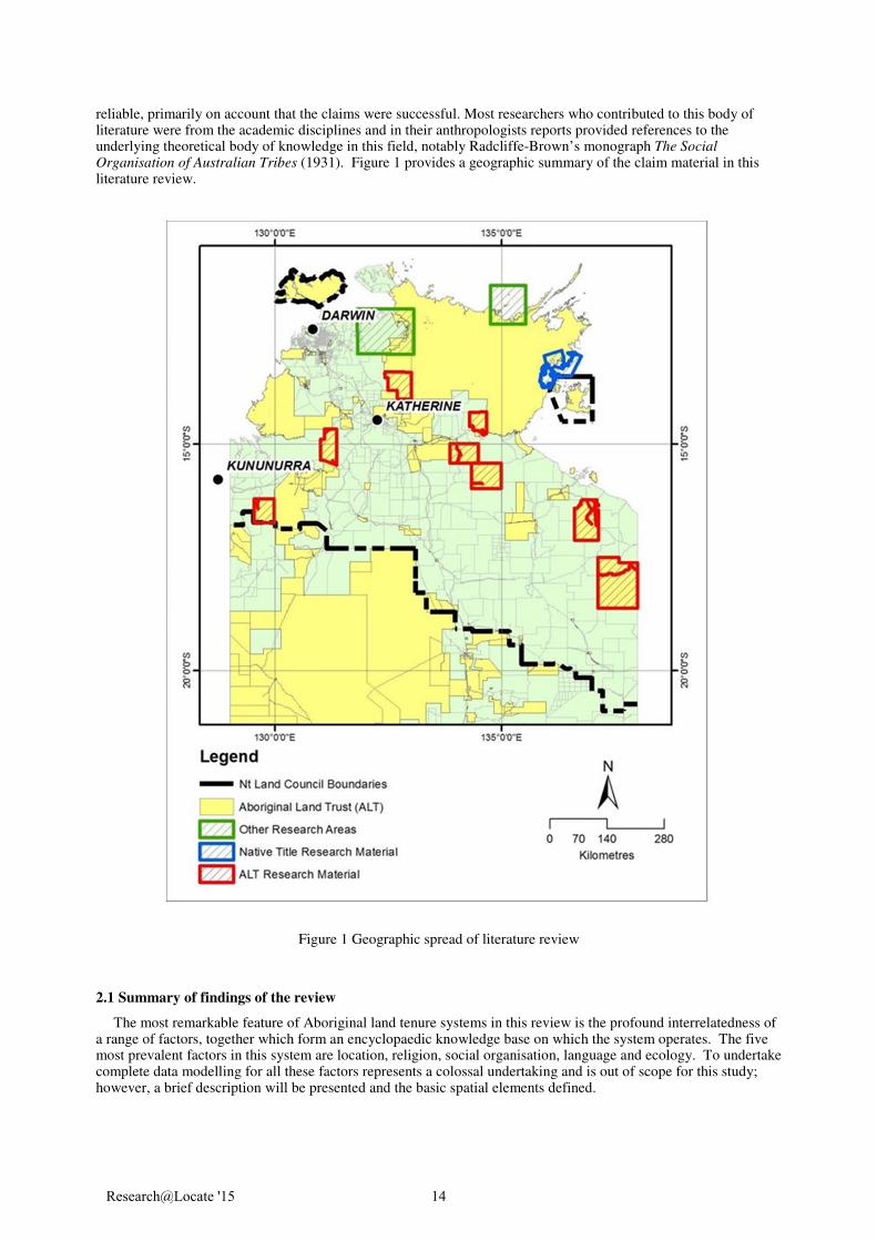
reliable, primarily on account that the claims were successful. Most researchers who contributed to this body of literature were from the academic disciplines and in their anthropologists reports provided references to the underlying theoretical body of knowledge in this field, notably Radcliffe-Brown’s monograph The Social Organisation of Australian Tribes (1931). Figure 1 provides a geographic summary of the claim material in this literature review.
2.1 Summary of findings of the review
The most remarkable feature of Aboriginal land tenure systems in this review is the profound interrelatedness of a range of factors, together which form an encyclopaedic knowledge base on which the system operates. The five most prevalent factors in this system are location, religion, social organisation, language and ecology. To undertake complete data modelling for all these factors represents a colossal undertaking and is out of scope for this study; however, a brief description will be presented and the basic spatial elements defined.
Figure 1 Geographic spread of literature review
Research@Locate '15 14

2.2 Basic social organisation
Radcliffe-Brown (1931) provides the baseline research into group organisation of Australian aboriginal groups, and it’s that basic structure which formed a common reference point for research throughout the reviewed literature. Radcliffe-Brown (1931) defines the important local group as the horde, that being a small group of persons owning territory with known boundaries, and possessing common proprietary rights over the land, and everything on or in it. This primary land owning group is often named the clan or the Local Descent Group (LDG) and it is the latter acronym that will be used here.
Membership of the group is primarily determined by descent through the father’s line (the patriline). Male members enter the group by birth and remain in it forever. Women are born into the group, or incorporated through exogamous marriage from another group, with the former case having to join another group upon marriage.
Radcliffe-Brown (1931) provides a description of a larger territorial unit, the tribe. The unity of the tribe is
primarily linguistic, that being the tribe consists of people who speak a common language or dialects of a common language. The name of the tribe and the language are usually the same, and with the common linguistic affiliation comes a unity of custom throughout the tribe (Radcliffe-Brown, 1931). Radcliffe-Brown (1931) clearly states the tribe, while occupying the combined territory of its member descent groups, is not a land owning unit. Land ownership is by the LDG and the LDG is independent and autonomous.
There is often some blurring between tribes and local descent groups. For example, a local descent group could
be a subdivision of a tribe, or large enough that it is a tribe. Palmer and Brady (1991) grouped all claimants of the Amanbidji Land Claim together as a single group based on linguistic affiliation, however more recent analysis of the claim genealogies reveals there are in fact several LDG’s who consider themselves autonomous from each other. In the Alligator Rivers Stage II Land Claim, Keen et al (1980) found that groups in the East of the claim area followed Radcliffe-Brown’s basic model, with distinctly named LDG’s occupying distinctly named country areas, affiliating with each other through a common language, forming Radcliffe-Brown’s tribe. However Keen et al (1980) found the Western groups identified themselves through language only, referring to themselves and their country by the language name. Regardless of this differing strategy of identification, Keen et al (1980) reported that the LDG existed in effect as there were several patrilineal descent groups occupying differing areas of the language country, but these groups do not seek to identify themselves as separate at the LDG level.
The tribe, the LDG (the clan or horde) and descent membership are useful starting points in building a model of
indigenous land tenure. While the discussion of social organisation ends here, it is important to note the land tenure model remains simplistic without further exploration and inclusion of kinship. Some kin relations are very important as individuals inherit rights and responsibilities to land through them. For Example Layton and Bauman (1996) explain that men who relate to country through their mother and father’s mother, while not identified as men with primary spiritual responsibility (i.e. land owners), hold ceremonial and ritual responsibilities for that country (land managers). Morphy and Morphy (2003) identify kin relations manifest as both ego-centric (individuals relating to individuals), and socio-centric (groups relating to groups) both of which include relationships denoting rights and responsibilities to country.
2.3 The religious perspective
The problem space in this paper is scoped around legal definitions of indigenous land tenure. The practitioners of anthropology and mapping of land tenure operates from definitions of land ownership in the ALRA and the NTA. The earliest of these definitions comes from the Woodward report, quoting Ronald Bernt, who asserts that ‘there are for aborigines two levels of ownership, the primary or religious level and the secondary or economic level’ (Woodward, 1974). During the Gove land rights case, Mr Justice Blackburn remarked ‘..the fundamental truth about the aboriginals’ relationship to the land is that whatever else it is, it is a religious relationship’ (Northern Territory Supreme Court et al, 1971).
The term dreaming used in this paper is the generalised term for ancestral beings which created the landscape.
Taking from Devitt & Martin (1996), who describe the Wardaman tribal traditions, the dreamings were human-like figures active as ancestors in the past. They travelled and created the landscape, seasons, animals,plants and people in it. The ancestral beings did not die, but they remain present in geographic locations or in species of plants and animals. People trace their origins to specific dreamings, and from those dreamings they inherit land, identity and spiritual power. With that inheritance comes spiritual responsibilities for the dreamings at the places in which they travelled and created, and a topology of spiritual connection to other groups and places can be drawn. James and Baymarrwangga (2013) aptly describe this religious landscape as a site based ontology.
Research@Locate '15 15

2.4 Spatial primitives of Indigenous Land Tenure Systems
2.4.1 Sites and named places
The site represents the finest grain of land interest in the literature. The site is a named place, which often (but not always) represents a distinct topographic feature such as a hill or a creek. Sometimes it is a grove of trees or even an individual tree. The size of a named place (like anywhere) can vary considerably, sometimes occupying an areas large enough to engulf other places, and with a core centre somewhere within it. These named places can be of value because of their carrying capacity for game and other food sources, and of course for the spiritual power imbued within it from the ancestors.
The site can be mapped into a coordinate space as a simple primitive, the point. This of course reveals nothing
about the size of the place or its shape. For example, the site “i” shown in Figure 2 is actually a tributary to the Victoria River. It’s assumed full extent is shown in shading. When originally mapped from a Northern perspective, Site “i” was mapped as the headwaters of the tributary. However, travelling along the river, it was identified and named at the mouth. Further interrogation of the matter by Anthropologist John Laurence with senior informants reveal the focal point is usually the river mouth however the place name extends and includes areas up to the headwaters (John Laurence, personal communication, August, 2014).
2.4.2 Site vs Estates
As was discussed above, the LDC owns in company a common territory with known boundaries. This territory is often referred to in the reviewed literature as the estate. The concept of boundedness creates some difficulties in mapping. Indeed sometimes Aboriginal land owners remark on a natural feature which forms a distinct end of one estate and the beginning of another. Also, there are ‘handover sites’, where ceremonial management of a travelling dreaming is transferred from one group to another which enables the establishment of a boundary (at least in part). Very rarely can these factors provide enough data to form reliable enclosed estate boundaries. Keen & Lewis (2007) remark the estate boundary is a concept which received more attention from western researchers than indigenous subjects when thinking about land ownership. From the experience of the author, TAOs give less attention to the boundary of an estate; rather, it is the loci of spiritual power within the estate which carries importance.
Sutton (1983) describes the estate as being a collection of sites in which the LDG have primary rights, thus the
site collection is a more desirable option as it presents a finer grained representation of land and provides a list of named places which are talking points with informants and more accurate mapping of land interests. Nonetheless,
Figure 2 Site example
Research@Locate '15 16
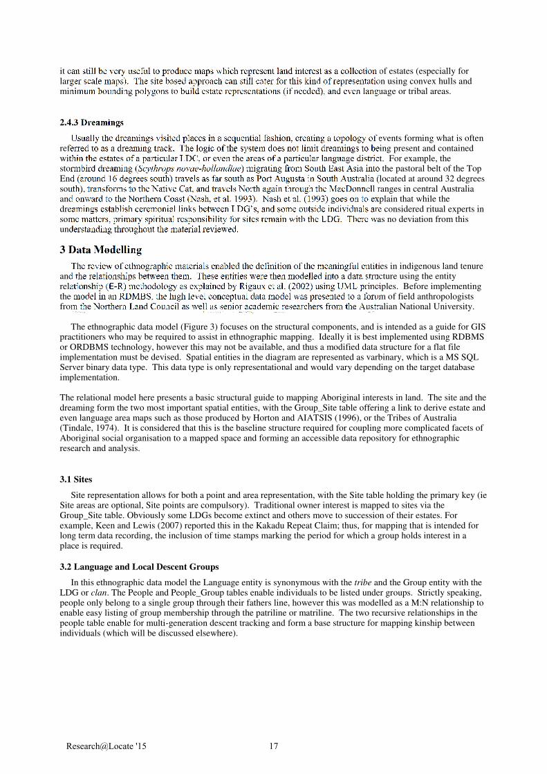
it can still be very useful to produce maps which represent land interest as a collection of estates (especially for larger scale maps). The site based approach can still cater for this kind of representation using convex hulls and minimum bounding polygons to build estate representations (if needed), and even language or tribal areas.
2.4.3 Dreamings
Usually the dreamings visited places in a sequential fashion, creating a topology of events forming what is often referred to as a dreaming track. The logic of the system does not limit dreamings to being present and contained within the estates of a particular LDC, or even the areas of a particular language district. For example, the stormbird dreaming (Scythrops novae-hollandiae) migrating from South East Asia into the pastoral belt of the Top End (around 16 degrees south) travels as far south as Port Augusta in South Australia (located at around 32 degrees south), transforms to the Native Cat, and travels North again through the MacDonnell ranges in central Australia and onward to the Northern Coast (Nash, et al. 1993). Nash et al. (1993) goes on to explain that while the dreamings establish ceremonial links between LDG’s, and some outside individuals are considered ritual experts in some matters, primary spiritual responsibility for sites remain with the LDG. There was no deviation from this understanding throughout the material reviewed.
3 Data Modelling
The review of ethnographic materials enabled the definition of the meaningful entities in indigenous land tenure and the relationships between them. These entities were then modelled into a data structure using the entity relationship (E-R) methodology as explained by Rigaux et al. (2002) using UML principles. Before implementing the model in an RDMBS, the high level conceptual data model was presented to a forum of field anthropologists from the Northern Land Council as well as senior academic researchers from the Australian National University.
The ethnographic data model (Figure 3) focuses on the structural components, and is intended as a guide for GIS
practitioners who may be required to assist in ethnographic mapping. Ideally it is best implemented using RDBMS or ORDBMS technology, however this may not be available, and thus a modified data structure for a flat file implementation must be devised. Spatial entities in the diagram are represented as varbinary, which is a MS SQL Server binary data type. This data type is only representational and would vary depending on the target database implementation.
The relational model here presents a basic structural guide to mapping Aboriginal interests in land. The site and the dreaming form the two most important spatial entities, with the Group_Site table offering a link to derive estate and even language area maps such as those produced by Horton and AIATSIS (1996), or the Tribes of Australia (Tindale, 1974). It is considered that this is the baseline structure required for coupling more complicated facets of Aboriginal social organisation to a mapped space and forming an accessible data repository for ethnographic research and analysis.
3.1 Sites
Site representation allows for both a point and area representation, with the Site table holding the primary key (ie Site areas are optional, Site points are compulsory). Traditional owner interest is mapped to sites via the Group_Site table. Obviously some LDGs become extinct and others move to succession of their estates. For example, Keen and Lewis (2007) reported this in the Kakadu Repeat Claim; thus, for mapping that is intended for long term data recording, the inclusion of time stamps marking the period for which a group holds interest in a place is required.
3.2 Language and Local Descent Groups
In this ethnographic data model the Language entity is synonymous with the tribe and the Group entity with the LDG or clan. The People and People_Group tables enable individuals to be listed under groups. Strictly speaking, people only belong to a single group through their fathers line, however this was modelled as a M:N relationship to enable easy listing of group membership through the patriline or matriline. The two recursive relationships in the people table enable for multi-generation descent tracking and form a base structure for mapping kinship between individuals (which will be discussed elsewhere).
Research@Locate '15 17
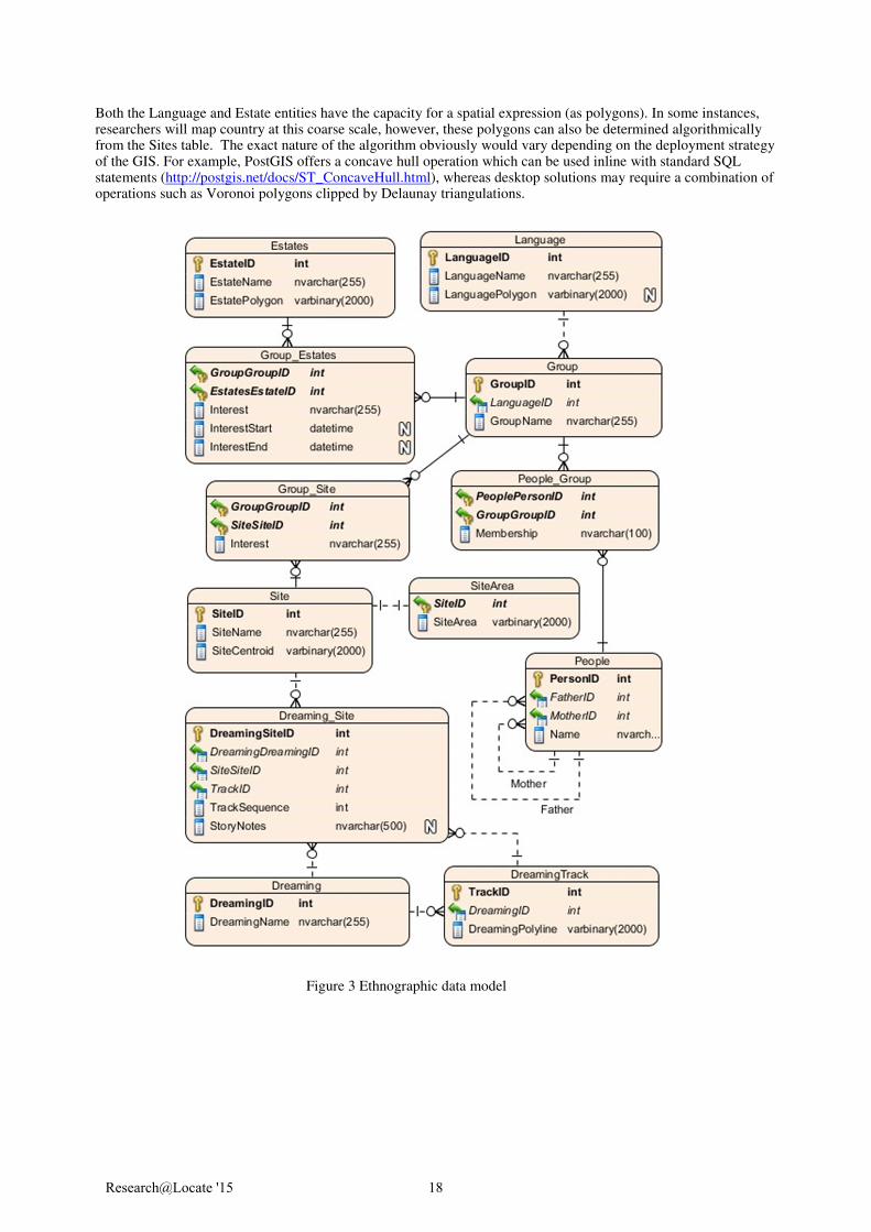
Both the Language and Estate entities have the capacity for a spatial expression (as polygons). In some instances, researchers will map country at this coarse scale, however, these polygons can also be determined algorithmically from the Sites table. The exact nature of the algorithm obviously would vary depending on the deployment strategy of the GIS. For example, PostGIS offers a concave hull operation which can be used inline with standard SQL statements (http://postgis.net/docs/ST_ConcaveHull.html), whereas desktop solutions may require a combination of operations such as Voronoi polygons clipped by Delaunay triangulations.
Figure 3 Ethnographic data model
Research@Locate '15 18

3.3 Dreamings
To properly model how dreaming relates to place, four entities are required The Dreaming table simply acts as an index of individual dreamings which can be linked to any Site via the Dreaming_Site table. It’s often that a dreaming may visit a site, continue to other places and then return to that site later on, thus the composite Primary Key consisting of SiteID and DreamingID must be disregarded and replaced with a simple identity column. In the case that a researcher wishes to list sites in a specific sequence (ie, form a track) then the TrackID and SequenceID fields must be populated. The TrackID and SequenceID combinations must be unique in these instances. These sequenced Dreaming_Site records can be computed into polylines and stored in the DreamingTrack table. Multiple tracks per dreaming are possible. Alternatively, DreamingTrack entities can be directly drafted into the GIS software as polylines, and the Dreaming_Site table populated via linear referencing techniques. It is also common that some dreamings do not travel at all, and remain at a single locus. In these instances , the TrackID and SequenceID must be set to a null value, which removes the possibility of the TrackID and the SequenceID being concretely defined as a unique constraint using DDL.
4 Expanding the Data Model
The expansion of this data model to include kinship is the first obvious step toward enabling more sophisticated
research potential. For example, Trigger (1982) found the subsection system, along with totemic affiliation formed a conspicuous part of land and group identification. Morphy and Morphy (2003) report in Eastern Arnhem land, that marriage preferences are flagged within the kinship system, that exagomous marriage is not symmetrical (groups do not directly swap wives), and that some kin relations are manifest on a group to group level. James & Baymarrwangga (2014), adapting Keen (1978) provide very clear insights as to how these kin relations might be modelled.
A second direction for expansion is the incorporation of a dictionary structure. There are two main reasons for
this, firstly, while language changes from one place to another, the social and spiritual connections do not. The same entity can have a name in many different languages. Without the ability for this data model to properly model when a thing is truly different, as opposed to only being different in name, then any one instance of the data model has limited geographic applicability, and broadscale ethno-geographic analysis becomes compromised.
The second reason for dictionary modelling is to assist in data collection. It is important to understand that there
is always a divide between the ethnographer and the culture he/she researches. The divide is not only cultural, but it is also linguistic, It is highly likely that the research ethnographer is liaising with people who speak English as a second or third language, and due to their historical circumstances, probably do not have a high level of schooling. Including fields for the linguistic interpretation of named things in the database prompts the researcher to understand the meaning of what is being said to them(adding a failsafe to mapping too many places called “what there?”), and then also provides an inroad into uncovering possible connections that may have otherwise been overlooked.
Research@Locate '15 19
5 References
Aboriginal Land Rights (Northern Territory) Act. (1976). (Cth).
Devitt, J. and Martin, D. (1996). Wardaman Claim to Innesvale pastoral lease: Anthropologists report. Darwin, Northern Land Council.
Graham, R., Holcombe, S., Stead, J., Bern, J., and Wells, S. (2002). Urapunga Station Land Claim: Anthropologists Report. Darwin: Northern Land Council.
Horton, R.D., Australian Institute of Aboriginal and Torres Strait Islander Studies, Auslig/Sinclair, Knight, Merz. (1996). Aboriginal Australia. Canberra: Aboriginal Studies Press.
James, B. and Baymarrwangga, L. (2014). The Yan-nhangu Atlas and Illustrated Dictionary of the Crocodile Islands. Singapore: Tien Wah Press.
Keen, I. (1978). One Ceremony, One Song: An Economy of Religious Knowledge among the Yolngu of northeast Arnhem Land, PhD thesis. Canberra: Australian National University.
Keen, I., Barker, G., Chaloupka, G., Fraser, R., Haritos, A. and Mobbs, R. (1980). Alligator Rivers Stage II Land Claim. Darwin: Northern Land Council.
Keen, I., and Lewis, G. (2007). Kakadu Repeat Claim: Anthropologists’ Statement. Darwin: Northern Land Council.
Morphy, H., and Morphy, F. (2003). An Anthropological report on the Yolngu people of Blue Mud Bay, in relation to their claim to native title in the land and sea. Darwin: Northern Land Council.
Nash, D., Sutton, P., and Morel, P. (1993). Muckaty Pastoral Lease Land Claim: Anthropologists Report. Darwin: Northern Land Council.
Native Title Act (1993). (Cth).
Northern Territory Supreme Court., Blackburn, R.A., Milirrpum, and Nabalco Pty. Ltd. (1971). Milirrpum v. Nabalco Pty. Ltd and the Commonwealth of Australia (Gove land rights case) : a claim by Aborigines that their interests in certain land had been invaded unlawfully by the defendants. Sydney : Law Book Co.
Palmer, K. and Brady, M. (1991). Amanbidji Land Claim. Anthropologists report on behalf of the claimants. Darwin. Northern Land Council.
Peterson, N., & Rigsby, B. (Eds.). (2014). Customary marine tenure in Australia. Sydney University Press.
Radcliffe-Brown, A. R. (1931). The Social Organisation of Australian Tribes. The Oceania Monographs. No 1. Melbourne. Macmillan and Co. Limited.
Rigaux, P., Scholl, M.O., and Viosard, A. (2002). Spatial Databases: With applications to GIS. Morgan Kaufmann Publishers.
Tindale, N. B. (1974). Aboriginal Tribes of Australia. Berkeley, Calif. : University of California Press.
Trigger, D. (1982). Nicholson River (Waanyi/Garawa) Land Claim Submission: Land Claim Book. Northern Land Council.
Woodward, E. (1974). Australian Aboriginal land rights commission: reports, Aboriginal Land Rights Commission, viewed 05 December 2014, (http://apo.org.au/node/36136).
Research@Locate '15 20