Site assessment audit of St Kilda Road/Kings Way … · John Gregson 340002 Healthy Communities 14...
11
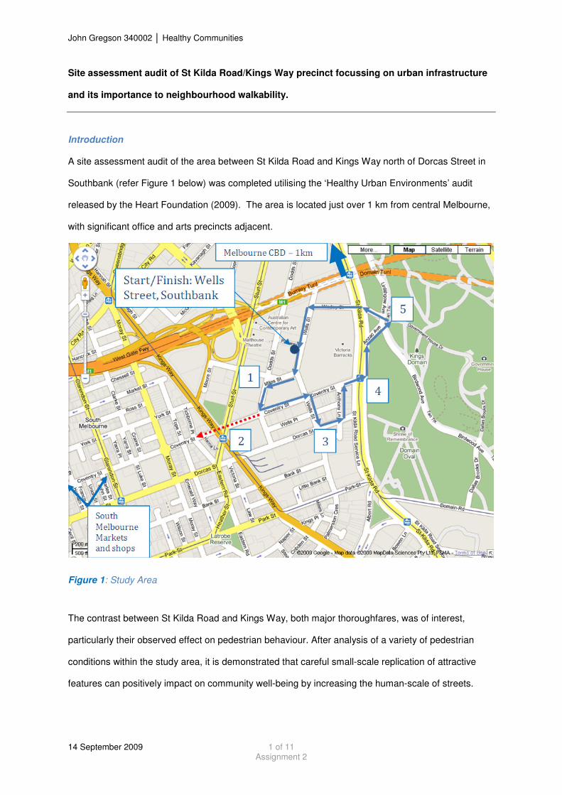
John Gregson 340002 Healthy Communities 14 September 2009 1 of 11 Assignment 2 Site assessment audit of St Kilda Road/Kings Way precinct focussing on urban infrastructure and its importance to neighbourhood walkability. Introduction A site assessment audit of the area between St Kilda Road and Kings Way north of Dorcas Street in Southbank (refer Figure 1 below) was completed utilising the ‘Healthy Urban Environments’ audit released by the Heart Foundation (2009). The area is located just over 1 km from central Melbourne, with significant office and arts precincts adjacent. Figure 1: Study Area The contrast between St Kilda Road and Kings Way, both major thoroughfares, was of interest, particularly their observed effect on pedestrian behaviour. After analysis of a variety of pedestrian conditions within the study area, it is demonstrated that careful small-scale replication of attractive features can positively impact on community well-being by increasing the human-scale of streets.
Transcript of Site assessment audit of St Kilda Road/Kings Way … · John Gregson 340002 Healthy Communities 14...
John Gregson 340002 � Healthy Communities
14 September 2009 1 of 11 Assignment 2
Site assessment audit of St Kilda Road/Kings Way precinct focussing on urban infrastructure
and its importance to neighbourhood walkability.
Introduction
A site assessment audit of the area between St Kilda Road and Kings Way north of Dorcas Street in
Southbank (refer Figure 1 below) was completed utilising the ‘Healthy Urban Environments’ audit
released by the Heart Foundation (2009). The area is located just over 1 km from central Melbourne,
with significant office and arts precincts adjacent.
Figure 1: Study Area
The contrast between St Kilda Road and Kings Way, both major thoroughfares, was of interest,
particularly their observed effect on pedestrian behaviour. After analysis of a variety of pedestrian
conditions within the study area, it is demonstrated that careful small-scale replication of attractive
features can positively impact on community well-being by increasing the human-scale of streets.

John Gregson 340002 � Healthy Communities
14 September 2009 2 of 11 Assignment 2
Particular assessment focus was placed on urban infrastructure and whether it supports and
encourages walking. The Department of Human Services states that “a strong link exists between the
built environment, health and wellbeing” (2001, p.17). A focus on walking was taken for a number of
reasons.
Firstly, the location of the study area is such that significant employment opportunities exist within 3
kms, a short walking distance for residents. EDAW (2009, p.4) states that Southbank has only
recently become a residential suburb and its residential population is characterised by young
professionals aged 20-34. Similarly, the area caters to large numbers of office workers, many of
whom walk from Flinders Station, the major arrival point of the suburban train network.
Secondly, walking provides essential physical exercise and facilitates unplanned social contact,
contributing to happiness. In high-income societies such as Melbourne, four diseases represent 80%
of the total disease burden; cardio-vascular disease, diabetes, chronic lung diseases, and some forms
of cancer. Lack of physical exercise is one of three key risk factors (Whitzman 2007, p.146).
Montgomery (date unknown, p.1) adds that Paris is reclaiming streets for pedestrians, with the belief
that cities can become engines of happiness.
Finally, Morabito (2001, p.13) highlights that transport, particularly provision of ‘walkable’
environments, is the number one priority of low-income earners to removing perceived physical and
locational barriers and improving their daily lives. Although Southbank is characterised by young
urban professionals, attempts to increase the population of common mobility disadvantaged groups
such as children and the elderly, must consider pedestrian infrastructure closely.
Study Area Analysis
Four main sites were chosen for close analysis, which all provide prescient insight into the
weaknesses and strengths of this focus area:
1. Triangle Park – Intersection of Dodds/Miles Street.
2. Kings Way – Intersection with Sturt Street.
3. [Wells Street/Dorcas Street/Anthony Lane – removed due to space restrictions].

John Gregson 340002 � Healthy Communities
14 September 2009 3 of 11 Assignment 2
4. St Kilda Road – Between Coventry Street and Anzac Avenue.
5. ‘Tan’ Track – Adjacent St Kilda Road.
1: Triangle Park
This ‘micro’ park is nestled between a fork in Miles Street and its intersection with Dodds Street. It
appears targeted towards those who live and work in the immediate vicinity, with connectivity only
directly provided by Dodds Street, a low traffic street, reflected by observed low-usage (two people at
lunch hour). However it contains well designed tables and bench seats, along with maintained
landscaped gardens and accessible footpath access.
Figure 2: Triangle Park
The park environment is attractive and quite interesting, with the curious feeling that it is ‘hidden’ due
to low-lying vegetation at its edge. Fortunately, the road environment on Miles Street is low-speed
due to its curvature, which ensures disruption and feelings of unease from passing traffic is kept to a
minimum. This is important as a study into ‘delightful places’ highlighted that 80% of respondents
associated relaxation with delightful places (O’Brien 2006, p.5). Interestingly, more than 60% of

John Gregson 340002 � Healthy Communities
14 September 2009 4 of 11 Assignment 2
delightful places identified were in urban environments, with peaceful, beautiful and visibly green
areas most popular.
Good passive surveillance is provided by residential apartments adjacent (refer Figure 2), however
one criticism of this block is that the ground floor is dedicated to a private car park (refer Figure 3).
On other adjacent sides, passive surveillance is less effective with a dedicated office building, and
residential apartments with restricted views.
Figure 3: Triangle Park
2: Kings Way
Kings Way presents an overwhelmingly car-dominated thoroughfare with eight lanes of automobile
traffic, two separated tram lanes along the median and two footpaths hard up against either side of
the road, with no buffer between pedestrians and traffic except a standard kerb. The road alignment
either side of the Sturt Street intersection is straight and flat, encouraging higher speeds than the 60

John Gregson 340002 � Healthy Communities
14 September 2009 5 of 11 Assignment 2
km/hr limit, and is patently unwelcoming and intimidating for pedestrians, creating a chasm between
neighbourhoods located on either side.
There is a large capture of residents from the study area who rely on the Sturt Street crossing of
Kings Way in order to access the Markets, café’s and shops of South Melbourne located a short
distance away (refer Figure 1: Study Area ).
Figure 4: Kings Way/Sturt Street Intersection
Figure 4 highlights the skewed alignment on approach from Coventry Street, requiring pedestrians to
undertake a zig-zag crossing of the intersection, reinforcing the lack of connectivity either side of
Kings Way. Due to traffic light sequencing, two minute waits for pedestrian lights is common, with
feelings of isolation and exposure experienced while waiting on the traffic island. The intersection
alignment creates a dangerous crossing for pedestrians who naturally want to take the shortest route
(illustrated in Figure 5) while driver behaviour turning into Kings Way can be unpredictable with four
lanes to choose from.

John Gregson 340002 � Healthy Communities
14 September 2009 6 of 11 Assignment 2
Figure 5: Kings Way/Sturt Street Intersection
4. St Kilda Road
St Kilda Road is a grandly proportioned boulevard catering for pedestrians, cyclists, public transport
and vehicular traffic. A feature is attractive greenery, with adjacent parks, monuments and heritage
buildings (Victoria Barracks). Four rows of trees and grass nature strips along the road reserve
ensure greenery features prominently despite adjoining land uses.
The six-eight lanes of vehicular traffic are divided up effectively by on-road bike lanes, parking, two
tram lines and nature strips. Along with the gentle curvature, the road environment is much calmer
than Kings Way, despite the same speed limit of 60 km/hr, with lower vehicular traffic volume
observed. Thus, crossing the road is relatively stress-free for able-bodied people, while pedestrian
lights, dropped kerbs and tactile paving is provided at trams stops.
Despite a lack of active street frontages, a combination of an attractive, interesting environment and
surrounding land-use contribute to a high-use of the shared path by pedestrians, which is pleasantly
separated from vehicular traffic by a row of mature trees, nature strip, parking lane and on-road bike
lane.

John Gregson 340002 � Healthy Communities
14 September 2009 7 of 11 Assignment 2
5. ‘Tan’ Track
The ‘Tan’ (refer Figure 6) is a highly popular and well maintained sandy track that encircles the Royal
Botanical Gardens and described as iconic to Melbourne (Only Melbourne, 2009). It is wide (3-4m)
catering to a variety of users, including recreational/fitness users (walking, running, cycling) and more
leisurely users such as families accessing the adjacent gardens.
Figure 6: ‘Tan’ Track
Popularity of the ‘Tan’ is very high immediately before and after work in particular as office workers
and nearby residents alike socialise and exercise, often in groups. Many people were also observed
driving to the ‘Tan’ to exercise, suggesting it offers facilities and attraction lacking in other suburbs.
Indeed, attractive gardens, monuments, water fountains, distance markers, prominent seating, lighting
and maintenance of a smooth track are inviting to all.

John Gregson 340002 � Healthy Communities
14 September 2009 8 of 11 Assignment 2
Yet, does this fully explain the overwhelming popularity of a simple sandy track like the ‘Tan’? Is it
also the pleasing aesthetics? The good location, with large numbers of office workers and an
increasing resident population nearby? These undoubtedly play a major role. However, is there
something else that attracts us, more on the human scale?
As stated by Montgomery when describing the Champs-Elysees in Paris, the main attraction is not the
shopping, it is “for people to see each other” (unknown date, p.5). Drawing on evolutionary
psychology that has shown humans fare better through co-operation, and juxtaposing this with
modern cities, it is stated that “encounters we have on foot or by bike tend to build trust. It’s in the
eye contact we make as we choreograph our movements” (Montgomery, p.3). This has the simple
effect of making us feel good, possibly due to release of the hormone oxytocin when we feel calm and
connected (O’Brien 2006, p.9).
Could a similar effect occur around the ‘Tan’? Could it be that the popularity of this sandy track
among recreational and leisure users alike is not as much due to the pleasant leafy surrounds, but
instead the chance to mix and interact, however passively, with other people – “the electric possibility
of a thousand simultaneous stolen glances”? (Montgomery p.5). From the authors past use of the
‘Tan’, this is a valid theory.
Perhaps there exists a critical mass of pedestrian numbers that, once reached, results in pedestrians
themselves becoming the feature attraction. Can this be planned and replicated elsewhere, in
particular, to space constrained areas?
Recommendations
Reaching this significant pedestrian mass would appear, on the positive evidence of the ‘Tan’ and St
Kilda Road, to require basic infrastructure such as space and proportion, well maintained and
accessible paths, attractive green landscaping, trees, seating and lighting. Adequate space is the
most vital component, as the others may be retrofitted if need be, and is the primary focus of
recommendations.
John Gregson 340002 � Healthy Communities
14 September 2009 9 of 11 Assignment 2
1. Side roads in the study area such as Dodds and Wells Street are commonly low traffic, yet
disproportionately large. Traffic lanes should be narrowed to minimum requirements, while
investigation of a one-way street system could further reduce pavement width, both reducing
the speed environment. Re-forming this additional space presents the opportunity to create
attractive pedestrian walkways of similar proportions to the ‘Tan’.
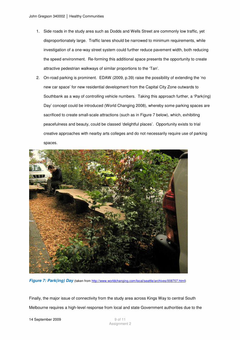
2. On-road parking is prominent. EDAW (2009, p.39) raise the possibility of extending the ‘no
new car space’ for new residential development from the Capital City Zone outwards to
Southbank as a way of controlling vehicle numbers. Taking this approach further, a ‘Park(ing)
Day’ concept could be introduced (World Changing 2008), whereby some parking spaces are
sacrificed to create small-scale attractions (such as in Figure 7 below), which, exhibiting
peacefulness and beauty, could be classed ‘delightful places’. Opportunity exists to trial
creative approaches with nearby arts colleges and do not necessarily require use of parking
spaces.
Figure 7: Park(ing) Day (taken from http://www.worldchanging.com/local/seattle/archives/008707.html)
Finally, the major issue of connectivity from the study area across Kings Way to central South
Melbourne requires a high-level response from local and state Government authorities due to the
John Gregson 340002 � Healthy Communities
14 September 2009 10 of 11 Assignment 2
importance of Kings Way to vehicular mobility. Options appear limited without a reduction of vehicular
traffic and freight on Kings Way, unless major road tunnelling works are considered, possibly creating
significant parkland space where the existing road lies.
Conclusion
It has been highlighted that people associate ‘delightful places’ with peaceful, beautiful and visibly
green spaces. When surrounded by people on foot (or by bike), we have the opportunity to interact
and build trust, which, based on evolutionary psychology, produces feelings of calm and
connectedness leading to release of the hormone oxytocin, improving our well-being.
The ‘Tan’, as an iconic pedestrian attraction, and St Kilda Road generally exhibit peacefulness,
beauty and greenery. Replicating these characteristics to space-constrained streets within the study
area generally requires additional space, with a width reduction of low-vehicle trafficked roads and
use of innovative small-scale treatments such as those captured during Park(ing) Day proposed.

John Gregson 340002 � Healthy Communities
14 September 2009 11 of 11 Assignment 2
References Department of Human Services, Victoria. 2001 (updated 2006). Municipal Public Health Planning Framework: Environments for Health, Local Government Planning for Health and Wellbeing (Melbourne: Government of Victoria). http://www.health.vic.gov.au/localgov/mphpfr/index.htm EDAW 2009. “Southbank Structure Plan”, Background Report. Heart Foundation 2009, Healthy Urban Environments: Site Assessment Audit. Accessed 4 September 2009. http://www.heartfoudation.org.au Montgomery, C. [date unknown], The Happy City, accessed 11 September 2009, http://www.walkandbikeforlife.org/Articles.html Morabito, D. 2001, Snapshots of Life: exploring the barriers faced by people experiencing disadvantage, (Melbourne: Victorian Council of Social Services). O’Brien, C. 2006, A footprint of delight: Exploring sustainable happiness, (National Centre for Bicycling and Walking), accessed 11 September 2009, http://www.walkandbikeforlife.org/Articles.html Only Melbourne 2009, The Tan Track, accessed 11 September 2009, http://www.onlymelbourne.com.au/melbourne_details.php?id=11442 Wade, S., Bowerman, N. 2009, Southbank Precinct Strategic Planning Study. Healthy Communities
Seminar, 7 September 2009. University of Melbourne. Whitzman, C. 2007, “Barriers to Planning Healthier Cities in Victoria”, International Journal of Environmental, Cultural, Economic and Social Sustainability, 3(1). World Changing 2008, Park(ing) Day and the bigger picture of small spaces. Accessed 11 September 2009. http://www.worldchanging.com/local/seattle/archives/008707.html