Single-Family Residential Design Guidelines Instruction Manual
32
Design Guidelines Instruction Manual Single-Family Residential Text Version City of Surprise Community Development Department November 14, 2004
Transcript of Single-Family Residential Design Guidelines Instruction Manual
n
4
November 14, 200Design GuidelinesInstruction Manual
Family Residential
Text Versio
City of Surprise
Community Development DepartmentSingle-

Surprise City Council Joan Shafer, Mayor Tomas Allen, Vice Mayor Martha Bails Danny Arismendez Gary “Doc” Sullivan Joe Johnson Cliff Elkins Surprise Planning and Ken Senft, Chairman Zoning Commission Janelle Blair, Vice Chariman Robert Gonzalez Antonio Segarra Daniel Morris Randy Nachtigall Skip Hall Staff James Atkins, Urban Designer
The material contained in this manual developed by the members of the City of Surprise Community Development Department, Planning and Zoning Division. This manual represents the City’s best effort to illustrate as clearly as possible, the intent of the Single-Family Residential Design Guidelines Ordinance. All drawings, sketches, diagrams and photographs are illustrative in nature and are intended to demonstrate a possible approach to achieving a planning and/or design objective. The City of Surprise, the Surprise City Council, the Planning and Zoning Commission and City Staff are not responsible for any errors or inconsistencies in this manual. Page layout, photographs and designs (illustrated version) by James Atkins, Urban Designer, unless otherwise noted.
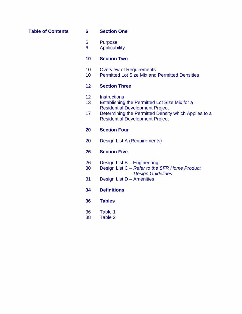
Table of Contents 6 Section One 6 Purpose 6 Applicability 10 Section Two 10 Overview of Requirements 10 Permitted Lot Size Mix and Permitted Densities 12 Section Three 12 Instructions
13 Establishing the Permitted Lot Size Mix for a Residential Development Project
17 Determining the Permitted Density which Applies to a Residential Development Project
20 Section Four 20 Design List A (Requirements) 26 Section Five 26 Design List B – Engineering
30 Design List C – Refer to the SFR Home Product Design Guidelines
31 Design List D – Amenities 34 Definitions 36 Tables 36 Table 1 38 Table 2

Purpose It is the goal of the City of Surprise to possess an aesthetically pleasing, natural and built environment by promoting responsible and creative development. The purpose of the Single-Family Residential Design Guidelines (SFR DG’s) is to ensure that all Low Density Residential (LDR) development, conform to the goals, objectives and requirements adopted and contained in the Surprise General Plan. Furthermore, this ordinance establishes the required minimum and maximum lot size diversity for new residential development and sets forth specific amenities required for any given development relative to its achieved density. Applicability Unless otherwise noted herein, this ordinance shall apply to all new LDR development within the City of Surprise; and to existing development that is modified to the extent that it includes uses or site design features that were not specifically shown on previous plans. This manual is a supplement to the City of Surprise General Plan, the City of Surprise Municipal Code, Single Family Residential Design Guidelines Ordinance No. 00-01 and all approved development plans. Information on this document and other information regarding development in the City of Surprise are available through the Community Development Department’s Current Planning Division.
Overview of requirements The following general requirements and procedures apply to Design List A (Requirements), Table 1, Table 2, and Design Lists B and D. In order to proceed in the design of any development, a fundamental understanding of these requirements and how they relate to one another is essential. Further instructions on how to assemble these requirements are outlined in the Instructions section of this manual. Permitted Lot Size Mix and Permitted Density In order to achieve the purposes stated above, these Guidelines regulate two different aspects of residential development: Permitted Lot Size Mix - the percentage of lots in a Residential Development Project which may be created within each Lot Category, as determined by applying Table 1 and Item A of Design List A (Requirements). Permitted Density - the maximum Density at which Residential Building Lots may be created in a Residential Development Project, as determined by applying Table 2 to the Project. These two criteria are to be used to determine the project’s scope and the manner in which it will be designed. Central to the design process is Design List A (Requirements). These include: • Percentage of Lot Sizes • Housing Product Variation (see Home Product Design Guidelines) • Required Open Space • Setbacks • Project entry • Elevations and Color Schemes • Roof Lines • Garage Configuration

Table 1 - Permitted Lot Size Mix
• The Base Permitted Lot Size Mix is established by Line 1 of Table 1 and Item A of Design List A (Requirements).
• In order to provide a greater percentage of lots in a given Lot Category than allowed under the Base Permitted Lot Size Mix, additional Points must be obtained from Design Lists B and D.
• Item A of Design List A (Requirements) establishes important mandatory limits on the number of Residential Building Lots which can be concentrated in the Lot Categories with the three smallest Minimum Lot Size requirements, and requires that a certain percentage of Lots must fall within the Lot Categories with the three highest Minimum Lot Size requirements.
Table 2 - Permitted Density • The Base Permitted Density is 3.0 D.U./Ac., as shown on Table 2. • In order to increase densities above 3.0 D.U./Ac., additional Points must obtained
from Design Lists B and D, as shown on Table 2. • If a Residential Development Project contains more large lots, fewer Points are
required to obtain an increase in the Project’s overall Density. • If a Residential Development Project contains more small lots, more Points are
required to obtain an increase in the Project’s overall Density. Design Lists B and D. Some items within Design Lists B and D are worth more Points than others. In order to encourage innovative subdivision design and to provide flexibility in meeting the purposes of these Guidelines, Design Lists B and D permit a Developer to obtain additional Points by providing unique or different design elements which are not specified in the Design Lists.

INSTRUCTIONS The criteria established in Design List A (Requirements) is mandatory for all Residential Development Projects. Design Lists B and D contain additional design elements for which a Developer may elect to include in a Residential Development Project. The number of Points awarded for including each design element is shown in parentheses at the end of the paragraph statement. If a Point-range is shown, the number of Points allowed will be decided by the City Council, and must be discussed with the Planning Staff. In order to encourage innovative Residential Development Projects and to provide a mechanism for adapting to changes in the housing market, Developers are encouraged to propose unique or different design elements and standards which are not included on the Design Lists for inclusion in a particular Residential Development Project. The Planning Staff will engage in discussions with the Developer regarding the proposed use of such unique or different design elements and standards and the Points to be awarded, if any. The City Council, in its discretion, must make the final decision as to these matters. The procedure described in this paragraph may not be used for the purpose of relieving a Developer of the obligation to comply with these Guidelines. In order to obtain Points: • The Developer must commit to include in the constructed Residential Development
Project design elements from Design Lists B and D, and the City Council must approve the assortment of design elements provided by, and the Points awarded to, the Developer.
• The City Council must also approve the Permitted Lot Size Mix and Permitted
Density which will apply to the Residential Development Project. No person has a right to receive any particular Point total, Permitted Lot Size Mix, Permitted Density or assortment of design elements. The City Council has the sole discretion to grant or withhold such approvals. Statements or representations made by the City Staff or the Planning and Zoning Commission with respect to these matters are recommendations only and do not bind the City Council or the City of Surprise. The Developer’s commitment to include various design elements in the Residential Development Project must be made legally binding. This will ordinarily be accomplished by including the selected elements in a PAD, or in a zoning narrative which is made enforceable through a stipulation in a zoning ordinance, or in some other manner which is satisfactory to the City Attorney. The ordinance which applies an R1-5 zone, R1-8 zone, or PAD zone with an R1-5 or R1-8 land use designation to a parcel must specify the Permitted Lot Size Mix and Permitted Density which apply to the parcel.
If a Residential Development Project is located within a public school district which is a political subdivision of the State of Arizona, and if the public school district in which the Residential Development Project is located notifies the City in writing that: 1) the public school district does not need a school site within the Residential
Development Project; and 2) the Developer of the Residential Development Project has executed a contract with
the public school district which commits the Developer to make a voluntary monetary contribution to the public school district in an amount not less than $1,000 per Residential Building Lot within the Residential Development Project, then the Maximum Permitted Density of the Residential Development Project shall be increased by 0.07 D.U./Ac.
In the event of a conflict between the provisions of these Guidelines, and those of Chapter 17.32 of the Code of Ordinances, these Guidelines shall control. Establishing the Permitted Lot Size Mix for a Residential Development Project Step 1: Getting to know the requirements and tables. Initially, a Developer must become familiar with of Design List A (Requirements) and the Design Lists so that the different requirements and options are understood. The Developer must then review Table 1, and Table 2, keeping in mind the different Point requirements and options from the Design Lists. The Developer must evaluate the various combinations of Densities, Lot Size Mixes, and Points and determine the particular combination(s) of these variables which would be most beneficial to the Residential Development Project. After this analysis is complete, the Developer must proceed to calculate the Permitted Lot Size Mix and Permitted Density which the Developer will propose for the Project, as follows. Step 2: Determine whether or not to use the Base Permitted Lot Size Mix. Table 1 establishes seven Lot Categories designated A through G, and must be used to determine the Permitted Lot Size Mix applicable to a particular Residential Development. Line 1 establishes the Base Permitted Lot Size Mix for all Residential Development Projects, e.g. 15% of the lots may be within Lot Category A (6380 sq.ft. Minimum Lot Size), 15% within Lot Category B (6930 sq.ft. Minimum Lot Size), and so on. Item A of Design List A (Requirements) imposes further mandatory restrictions on the Base Permitted Lot Size Mix.

Step 3: Establishing your Determination Lot Category and the number of Points that must be obtained from Design Lists B and D. If the Developer decides not to use the Base Permitted Lot Size Mix, the Developer must present a proposal for the percentage of Residential Building Lots in the Project that will fall within each Lot Category. In that case, some Lot Categories will contain a greater percentage of Lots than the percentage shown in Line 1 of Table 1, and some will contain fewer. The Developer’s proposed Lot Size Mix must comply with the Lot Size Mix requirements of Item A of Design List A (Requirements). The Developer must then determine the Determination Lot Category, which is the Lot Category: 1) for which the percentage of Lots planned by the Developer exceeds the percentage
shown for that Lot Category in Line 1 of Table 1; and 2) which has the smallest Minimum Lot Size, as shown on Table 1, of all of the Lot
Categories for which 1) is true. If the Developer proposes to use the Base Permitted Lot Size Mix, the Determination Lot Category is Lot Category G. The following examples illustrate 5 distinctly different Lot Mix configurations and their Determination Lot Category (These requirements are outlined in further detail in the Design List A (Requirements), Item A): Example 1): illustrates the Base Permitted Lot Size Mix taken directly from Table 1:
A B C D E F G 15% 15% 15% 15% 15% 15% 10%
Determination Lot Category
The number and distribution of Points required to obtain the Developer’s proposed Permitted Lot Size Mix is determined using Lines 2 through 5 under Lot Category E in Table 1. Therefore using the Base Permitted Lot Size Mix, the Developer must obtain a minimum of 12 Points from Design List B and a minimum of 6 Points from Design List D, for a total of 18 Points. Example 2): Determination Lot Category

A B C D E F G 0% 30% 25% 25% 20% 0% 0%
• Starting with category A and reading left to right, the smallest lot category to exceed the Base Permitted Lot Size Percentage established in Table 1 and illustrated above in Example 1, is the Determination Lot Category.
• No one Category, (A or B) exceeds 30%
• Total of categories E, F, and G combined is not less than 10% combined.
The number and distribution of Points required to obtain the Developer’s proposed Permitted Lot Size Mix is determined using Lines 2 through 5 under Lot Category B in Table 1. Therefore using Lot Category B, the Developer must obtain a minimum of 24 Points from Design List B and a minimum of 12 Points from Design List D, for a total of 36 Points. Example 3): A B C D E F G 0% 15% 15% 50% 0% 0% 20% ThPeTaPo28 Ex
• Same requirements as in
Determination Lot Category
•
Same requirements as in example 2).e number and distribution of Points required to obtain the Developer’s proposed rmitted Lot Size Mix is determined using Lines 2 through 5 under Lot Category D in ble 1. Therefore using Lot Category D, the Developer must obtain a minimum of 20 ints from Design List B and a minimum of 8 Points from Design List D, for a total of Points.
ample 4):
example 2).
Determination Lot Category

A B C D E F G 20% 20% 20% 20% 20% 0% 0%
• Same requirements as in example 2).
• Same requirements as in example 2). The number and distribution of Points required to obtain the Developer’s proposed Permitted Lot Size Mix is determined using Lines 2 through 5 under Lot Category A in Table 1. Therefore using Lot Category A, the Developer must obtain a minimum of 28 Points from Design List B and a minimum of 14 Points from Design List D, for a total of 42 Points. Example 5): A B C D E F G 0% 15% 25% 40% 20% 0% 0%
• Same requirements as in example 2).
Determination Lot Category
• Same requirements as in example 2).
The number and distribution of Points required to obtain the Developer’s proposed Permitted Lot Size Mix is determined using Lines 2 through 5 under Lot Category C in Table 1. Therefore using the Lot Category C, the Developer must obtain a minimum of 22 Points from Design List B and a minimum of 10 Points from Design List D, for a total of 32 Points. Once the Determination Lot Category has been established, the number of Points required to obtain the Lot Size Mix proposed by the Developer must be calculated by using Lines 2 through 5 of Table 1 for the Lot Category which is the Determination Lot Category. The total number of required Points is stated in Line 5, and the required distribution of those Points is stated in Lines 2 through 4. The total and distribution of Points stated in Lines 2 through 5 of the Determination Lot Category are mandatory. If Lot Category G is the Determination Lot Category, then the Developer will be required to obtain the fewest number of Points, 18. If Lot Category A is the Determination Lot Category, then the Developer will be required to obtain the greatest number of Points, 42. If the Developer obtains the required number and distribution of Points by committing to provide design elements listed in Design Lists B and D (and also complies with Item A of Design List A (Requirements)), then the Developer’s proposed Lot Size Mix, if

approved by the City Council, becomes the Permitted Lot Size Mix for the Developer’s Residential Development Project. If the Developer does not obtain the required number and distribution of Points (or does not comply with Item A of Standard Design Requirements List), then the Base Permitted Lot Size Mix shall apply. In all cases, the requirements of Design List A (Requirements) as modified by Item A and Design Lists B and D, shall apply to the Project. Determining the Permitted Density which applies to a Residential Development Project. Step 4: Determine whether or not to use the Base Permitted Density. The Base Permitted Density is 3.0 D.U./Ac. The Base Permitted Density applies to a Residential Development Project which utilizes the Base Permitted Lot Size Mix. It also applies to a Residential Development Project which utilizes a different Permitted Lot Size Mix, if the Developer obtains only the minimum required number and distribution of Points from Design Lists B and D, as described above. If the Developer decides to use the Base Permitted Density, then Step 2 does not apply. Step 5: If the Base Permitted Density will not be used, calculate the applicable Permitted Density. If the Developer decides not to use the Base Permitted Density, then the Developer must use Table 2 to calculate the applicable Permitted Density. Table 2 sets out the various Point totals which must be obtained from Design Lists B and D, in order to obtain a Permitted Density higher than the Base Permitted Density. The Determination Lot Category determined by using Table 1, as described above, governs the number of Points which are needed to obtain a higher Permitted Density. In reading Table 2, the column headed by the Determination Lot Category is the column which applies to the Residential Development Project. The applicable Permitted Density is established by finding the number of Points obtained from Design Lists B and D in the Points column on the left, and then reading across the chart to the corresponding place in the column headed by the Determination Lot Category. The number shown in this column for that Point total is the Permitted Density expressed in D.U./Ac. Example 1): In the second example given above, the Determination Lot Category is B, and the minimum number of required Points is 36. Reading down the Points column of Table 2

to 36, and then reading across to the column headed by Determination Lot Category B, yields a Permitted Density of 3.0 D.U./Ac. If the Developer proposes an increased Permitted Density, then the Developer must obtain more Points from Design List B and D. In this example, if the Developer obtains 46 Points, then the Permitted Density would be 3.5 D.U./Ac. A Point total of 46 would yield a Permitted Density of 4.0 D.U./Ac., and so on Example 2): The fifth example given above works the same way. The Determination Lot Category is C. Therefore, a Point total of 32 yields a Permitted Density of 3.0 D.U./Ac., 52 Points produce 4.0 D.U./Ac., and 62 Points yields 4.5 D.U./Ac. In no instance can the Permitted Density exceed 4.5 D.U./Ac. Blank spaces in each column of Table 2 below the number 4.5 are a continuation of that number. Blank spaces above the number 3.0 are a continuation of that number.

REQUIREMENTS Design List A (Requirements) The following requirements shall apply to all land to which these Guidelines apply. A. Percentage of Lot Sizes: If the width of any one or more lots in a Residential
Development Project is less than 70 feet and the size of the lot is less than 7700 sq. ft., the following requirements apply to the entire Residential Development Project:
1) The percentage of the total number of lots in the Residential Development
Project that falls within Lot Categories A and B in Table 1 shall not exceed 30 percent in any one of such Lot Categories.
2) The percentage of the total number lots in the Residential Development Project
that falls within Lot Categories E, F and G in Table 1 shall be not be less than 10 percent in these three Lot Categories combined.
B. Required Open Space: Not less than 10 percent of the Gross Acreage of a
Residential Development Project shall be open space, and not less than 5 percent of such Gross Acreage shall be open space which meets the requirements of Subsection 2 below. For purposes of meeting this requirement, open space shall include the following:
1) A storm water retention area; 2) A tract, other than a private street, which is owned and maintained by a
homeowners association; 3) A power line corridor if the corridor is improved and maintained by a homeowners
association; 4) A lake; 5) A golf course; 6) A site on which a public school will be constructed, if the site is actually
conveyed, and not merely reserved, to the entity responsible for construction of the public school; and
7) Any other similar area which, in the opinion of the City Council, provides a recreational, aesthetic, or other valuable benefit to the City of Surprise or to the Residential Development Project.
C. Project Entry: The Developer of a Residential Development Project shall construct
features which provide a sense of neighborhood arrival, such as monument signage, decorative landscaping, specialty pavement, enhanced wall detail, immediate accessibility to open space/trail system, etc., at all points at which a Residential Development Project may be entered from an arterial street.
D. Staggered Perimeter Wall: The Developer of a Residential Development Project shall construct a wall at the perimeter of the Project abutting an arterial street which contains staggered or offset sections and/or other breaks to relieve the linear character of the perimeter wall abutting the arterial street.
E. Housing Product Variation: Refer to the SFR Home Product Design Guidelines. F. Adjacent Elevations and Color Schemes: No house or structure shall have the same
elevation or color scheme as those houses or structures located immediately to either side or directly across the street.
G. Adjacent Roof Lines: If two or more houses or structures abut an arterial street in the
rear, then the rear elevations of such houses or structures shall be geometrically varied and not more than two adjacent houses or structures shall have the same roof line.
H. Garage Configuration: All garages constructed in a Residential Development Project
shall be configured as follows: 1) the garage must contain an interior space which is 20 feet x 20 feet or greater and is centered on the center of the garage door; 2) the space required by 1) must be completely free of all obstructions and intrusions, e.g. water heaters, air conditioning units, storage cabinets, etc. and must be accessible for the parking of automobiles; and 3) the back or one side of the garage must contain an additional work/storage space at least four feet wide which extends along the entire length of the back or side.
I. Off-street Parking/Driveway: There shall be space for two 20 foot parking spaces off-
street and outside of the garage. Notwithstanding the above, no driveway shall be less than 22 feet in length, as measured from the back of sidewalk, nor less than 25 feet in length as measured from back of curb.
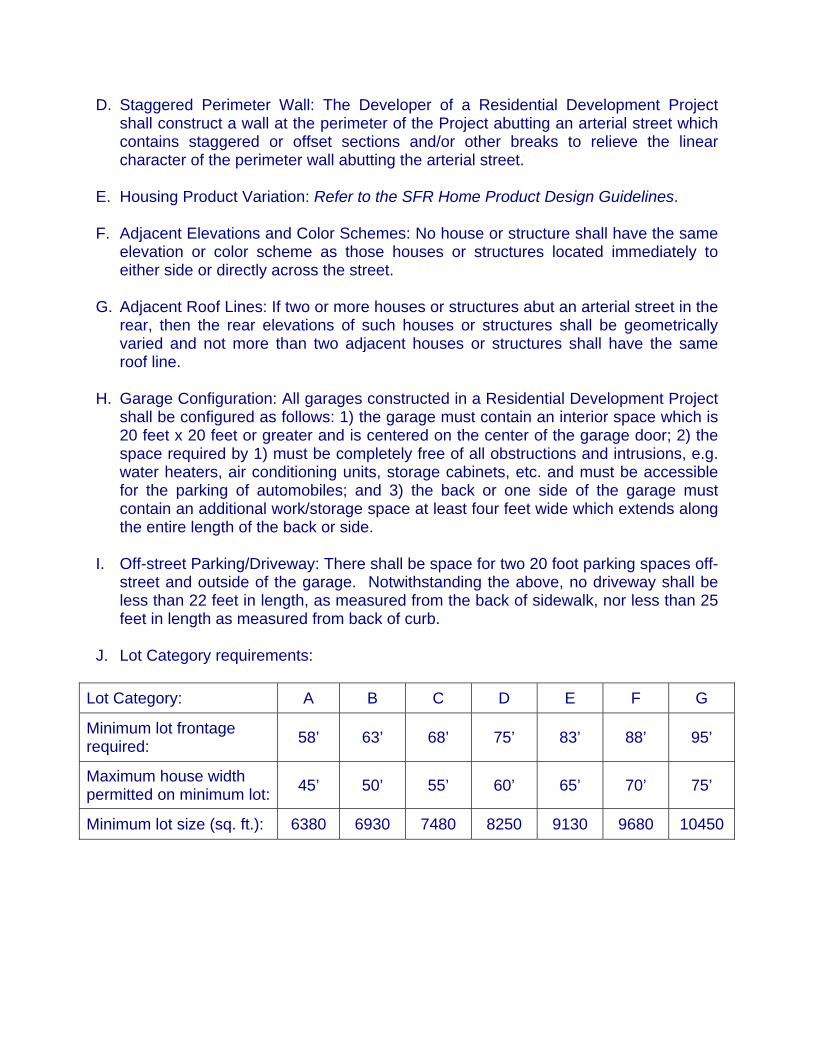
J. Lot Category requirements:
Lot Category: A B C D E F G
Minimum lot frontage required: 58’ 63’ 68’ 75’ 83’ 88’ 95’
Maximum house width permitted on minimum lot: 45’ 50’ 55’ 60’ 65’ 70’ 75’
Minimum lot size (sq. ft.): 6380 6930 7480 8250 9130 9680 10450

K. Setbacks: Dwelling Unit Distance in feet Front (all lot categories) Home 12’ Garage 18’ 45-degrees or more 12’ Side (lot categories A, B, C and D) Single-story 5’/8’ Mulit-story 5’/8’
*Two adjacent multi-story houses must be separated by not less than 14 feet, and a multi-story house and an adjacent single-story house must be separated by not less than 12 feet. **If any portion of a multi-story house has only one story adjacent to the side yard property line, the single-story setbacks will apply.
Side (lot categories E, F and G) Single-story 8’/10’ Multi-story 8’/10’ Corner side Single-story 13’ Mulit-story 20’ Rear Home 15’
*Non-structural architectural features such as fireplaces, bay windows, pop-outs, or patio covers may encroach into the rear setback, provided however, that a patio cover may not encroach more than 10 feet into the rear setback.
Rear Abutting an Arterial Single-story 20’ Multi-story 25’
*If the portion of a multi-story house or structure which abuts an arterial street in the rear is single-story, then the rear setback shall be not less than 20 feet as measured from the property line. If two adjacent houses or structures abut an arterial street in the rear, then the rear setbacks shall be staggered as follows: (a) if the adjacent houses or

structures are both single-story, then the rear setback shall be 20 feet for one and 25 feet for the other; or (b) if the adjacent house or structures are both multi-story, then the rear setback shall be 25 feet for one and 30 feet for the other; or (c) if a multi-story house is adjacent to a single-story house, then the setbacks established in subsections 1 and 2 shall apply; and (d) if three or more adjacent houses or structures abut an arterial street in the rear, then the rear setbacks shall be staggered as provided above so that not more than two adjacent houses or structures may have the same rear setback. A non-structural element such as a fireplace, bay window, pop out, or patio cover may encroach into a rear setback, provided however, that a patio cover may not extend to a point closer than 10 feet from the rear property line for single-story house or structure, or 15 feet from the rear property line for a multi-story house or structure. If a landscape tract with the following dimensions is constructed between the rear property lines of adjacent lots which abut an arterial street in the rear, and the right-of-way of the arterial street, then the rear setbacks established in subsection D of this section shall apply. The average width of such landscape tract shall be not less than 15 feet. The narrowest part of the tract must be10 feet or greater in width. Not less than 50 percent of the landscape tract, as measured along the lineal boundary between the tract and the adjacent lots, must be 15 feet in width or greater. If a house or other structure abuts an arterial street on the side, then the wider of the two side setbacks applicable to the house or structure shall be on the side which abuts the arterial street and shall be increased by 5 additional feet. For example, if the side setbacks of a house or structure which abuts an arterial street on the side would ordinarily be 8 feet and 5 feet, then the 8 feet setback shall be increased to 13 feet and shall apply to the side of the house or structure which abuts the arterial street, and the other side setback shall remain 5 feet.


DESIGN LISTS (OPTIONS) Design List B – Engineering The following requirements shall apply to all land to which these Guidelines apply. A. For each 40 Gross Acres included in a Residential Development Project, provide at
least three cul-de-sacs (or other street feature such as a knuckle or single-loaded street) with a diversity feature such as a landscaped island, access to common open space, etc. (1 Pt.)
B. Design all corner lots so that the minimum width of each corner lot is at least 10 feet
greater than the Minimum Lot Frontage applicable to that lot as shown in line 2 of Table 1; or alternatively; Or, On all corner lots, construct an 8 foot wide landscaped tract between the property line of the lot and the abutting street right of way. Convey such landscape tracts to a homeowners association and require the association to maintain the tracts and the adjacent rights-of-way to the same standard as other tracts and common areas maintained by the homeowners association. (2 Pts.)
C. On not less than 20 percent of the lots which fall within Lot Categories A, B, C and
D, provide a mix of driveway orientations, e.g. elbow, circular, angled, split, or Hollywood, such that not more than 80 percent of driveways in the Residential Development Project are alike. (3 Pts.)
D. Stagger the front yard setback lines of houses and other structures constructed on
lots within Lot Categories A, B, C, D, and E in increments of 3 feet, so that the front setbacks vary among 18 feet, 21 feet, and 24 feet. Garage setbacks must comply with the requirements of Design List A. (2 Pts.) Points may not be awarded for both Paragraphs D and E.
E. Stagger the front yard setback lines of houses and other structures constructed on
lots within Lot Categories A, B, C, D, and E to achieve a range of variation in front setbacks of at least 10 feet. When calculating the range of variation, the front setbacks of side entry garages and houses in which the living area is in front of the garage may be used. (3 Pts.) Points may not be awarded for both Paragraphs D and E.
F. Design and construct storm water retention areas which meander through the
Residential Development Project as greenbelt, as opposed to constructing a series of separate and distinct basins, and require a homeowners association to maintain the retention areas to the same standard as other tracts and common areas maintained by the homeowners association. (4 Pts.)
G. Design and construct landscaped open spaces which are visible from both
residential and arterial streets, and require a homeowners association to maintain

the landscaped open spaces to the same standard as other tracts and common areas maintained by the homeowners association. (2 Pts.)
H. Along arterial streets, provide at least 600 feet of open space per mile, as measured
along the linear boundary between the Residential Development Project and the adjacent arterial street right of way. If the Residential Development Project does not abut the right of way, then the measurement shall be taken along the linear boundary between the Residential Development Project and the intervening tract. The open spaces must be visible from the arterial street, and the Developer must require a homeowners association to maintain the open spaces to the same standard as other tracts and common areas maintained by the homeowners association. (3 Pts).
I. Design and construct some or all of the following in any combination.
1) Provide a minimum six feet of separation between the curb and the sidewalk on all arterial and collector streets, and install an 8-foot wide sidewalk; (2 Pts.)
2) Install in all arterial and collector streets a raised landscaped median, and
require a homeowners association to maintain the landscaped medians to the same standard as other tracts and common areas maintained by the homeowners association; (2 Pts.)
3) Plant enhanced landscaping along the sidewalk adjacent to all arterial and
collector streets, with a canopy tree planted every 50 feet on both sides of the sidewalk. The trees on opposite sides of the sidewalk must be offset to give the appearance that the trees are planted every 25 feet on center. Fifty percent of the trees must be 24-inch box trees or larger. Require a homeowners association to maintain the enhanced landscaping and trees to the same standard as other tracts and common areas maintained by the homeowners association. (4Pts).
4) In order to obtain Points for subsections 1, 2, and/or 3, the Developer of a
Residential Development Project must meet the requirements of subsections 1, 2, and/or 3 on both halves of the street, if the land on which both halves of the street was constructed was previously owned by the Developer, or on one half, if only that half was constructed on land previously owned by the Developer. In addition, if the Developer meets the requirements of subsections 1,2, and/or 3 on the half of a street which was or will be constructed on land which was not previously owned by the Developer, then the Developer shall receive double the number of Points shown. Alternatively, the Developer may obtain double the number of Points shown by depositing with the City sufficient funds to meet the requirements of subsections 1, 2, and/or 3 with respect to a street or portion thereof which was constructed on land not previously owned by the Developer, and by requiring a homeowners association to maintain the improvements, when

the City causes them to be constructed, to the same standard as other tracts and common areas maintained by the homeowners association.
J. Incorporate view corridors with open space areas throughout the development to
take advantage of the mountain views; utilize view fences around houses abutting these view corridors so that the open space and mountain views are visible from the houses; and require a homeowners association to maintain the open space areas to the same standard as other tracts and common areas maintained by the homeowners association. (4 Pts.)
K. Design the Residential Development Project so that, at T intersections, no
Residential Building Lot is centered directly across the intersection from the end of the street which dead ends at the intersection (the “stem of the T”). In place of such centered lots, at all points which are directly across an intersection from the end of the stem of a T, place one or a combination of the following: 1) a landscaped open space area at least as wide as the paved portion of the stem of the T, and require a homeowners association to maintain the open space areas to the same standard as other tracts and common areas maintained by the homeowners association; or 2) the side yard boundary between two Residential Building Lots; or 3) the back of a Residential Building Lot, buffered from the street by an eight foot wide landscaped area installed by the Developer, and require a homeowners association to maintain the landscaped areas to the same standard as other tracts and common areas maintained by the homeowners association. (4 Pts.)
L. Establish pedestrian and bicycle access between residential and non-residential
portions of the Project, or similar areas adjacent to the Project, including schools, libraries, shopping areas, etc., by incorporating fence and landscape penetrations into the pedestrian circulation element. Each penetration shall consist of a tract at least 30 feet wide and shall contain a trail to accommodate both pedestrian and bicycle traffic. Vehicular traffic inhibitors such as bollards, maze gates, etc. must be installed at both ends of each tract, and the Developer must require a homeowners association to maintain the tracts to the same standard as other tracts and common areas maintained by the homeowners association. (2 Pts. per access tract, maximum 6 points)
M. Install traffic calming devices such as traffic circles, decorative raised paving,
landscaped diverters, traffic chokers and other landscaping devices. (2 Pts. for every three devices; maximum 6 Pts.)
N. Design and construct paths and trails separate from roadways, which connect all
open space areas and arterial roadways, and which enable bicyclists and pedestrians to travel throughout the development. (6 Pts.)
O. Construct decorative hardscape features at the entrance to each major section of
the Residential Development Project; at all major pedestrian crossings of arterial and

collector roads; and at all points where a trail system crosses the road system trail system crossings. (2 Pts.)
P. Donate land to the City for municipal purposes such as fire station sites, police
station sites, City parks, libraries, etc. (2 Pts for each 15,000 square feet of donated land including any adjacent half streets; total of 10 points possible)
Q. On perimeter walls, provide berms, tree lines, hedgerows, and/or other similar
means of breaking up the linear nature of the perimeter walls. Such features must be in addition to open space areas along the perimeter and enhanced architectural features on the wall itself. (6 Pts., plus the ability to construct perimeter walls to a height of 7 feet adjacent to arterial roadways)
R. Throughout a Residential Development Project, utilize neo-traditional planning
concepts, such as detached garages, alleys, internal commercial areas, commercial areas which are highly accessible by pedestrians, distinct streetscapes which focus on the social interaction of the street and neighborhood, and other similar concepts approved by the City Council. The City Council must approve any resulting variations to the required setbacks. (1-8 Pts.)
S. Points may be awarded for any other element of subdivision design which will create
a unique neighborhood environment, or otherwise benefit the City of Surprise or the Residential Development Project. (1-4 Pts.)

Design List C – Architecture For all houses constructed within a Residential Development Project to which these Guidelines apply: Refer to the SFR Home Product Design Guidelines
Design List D – Amenities Within a Residential Development Project to which these Guidelines apply, provide the following which are sufficient in size, quantity, and quality to meet the needs of the residents of the Project: A. Provide a trail system that connects all open space areas within the Residential
Development Project and creates pedestrian linkages with surrounding residential and commercial developments. Along the trail system, construct rest areas at every quarter mile, consisting of a substantial seating area which accommodates at least 4 persons and a shade area composed of an architectural shade structure, or mature landscaping such as a canopy of trees, or a combination of both. Require a homeowners association to maintain the trail system to the same standard as other common areas maintained by the homeowners association. (4 Pts.)
B. Construct and convey to a homeowners association a clubhouse which includes an
outdoor recreation area with low-key recreational activities such as a putting green, shuffleboard courts, horseshoe pits, etc., and an indoor area for meetings, exercise, and entertainment. Require the homeowners association to maintain the clubhouse to the same standard as other common areas maintained by the homeowners association. (4 Pts.)
C. Construct and convey to a homeowners association active outdoor recreational
facilities for adults, such as full court basketball courts, tennis courts, volleyball courts, and other similar recreational facilities. Require the homeowners association to maintain these recreational facilities to the same standard as other common areas maintained by the homeowners association. (4 Pts.)
D. Construct and convey to a homeowners association community swimming pool(s)
which are sufficient in size and number to serve the needs of the residents of the Residential Development Project. Require the homeowners association to maintain the swimming pool(s) to the same standard as other common areas maintained by the homeowners association. (6 Pts.)
E. Construct and convey to a homeowners association a large open space corridor,
with a minimum width of 75 feet, and an average width of 100 feet, through the Residential Development Project. The corridor must be planted with mature trees and other plants listed on the City’s approved plant list, and must provide view corridors and a trail system. Lots which back up to the corridor on at least one side shall be bordered by view fences which create view corridors. The view fences may be constructed either completely of wrought iron or of wrought iron and masonry, and must comply with the City’s ordinance relating to swimming pool fences. Restrict the use of the corridor to pedestrian and bicycle access by residents of the Project. Require a homeowners association to maintain the corridor to the same standard as other common areas maintained by the homeowners association. (4 Pts., however,

Points will be doubled each time the minimum and average corridor widths are doubled, up to a maximum of 12 Pts.)
F. Provide common area lakes and/or open space natural wetlands, using a source of
water other than the City’s water system, for active or passive use and enjoyment. Require a homeowners association to maintain the lakes/wetlands to the same standard as other common areas maintained by the homeowners association. (3 Pts. for each 40,000 sq. ft. of lake/wetlands area, up to maximum of 12 Pts.)
G. Provide a golf course with native desert landscaping and view fencing bordering
adjacent lots, constructed as provided in subsection E. Provide for maintenance and operation of the golf course at no cost to the City. (4 Pts. for each 9 holes, up to 16 points).
H. Provide open space in excess of 10 percent of the Gross Acreage of a Residential
Development Project. Require a homeowners association to maintain the excess open space to the same standard as other common areas maintained by the homeowners association. (2 Pts. for each full 1 percent of the Gross Acreage of the Residential Development Project which is provided as open space in addition to the required 10 percent minimum, up to a maximum of 10 Pts.)
I. Provide neighborhood amenities that encourage meetings and interaction such as
amphitheaters, major public promenades, or similar significant neighborhood attractions apart from recreational areas. Require a homeowners association to maintain the amenities to the same standard as other common areas maintained by the homeowners association. (4 Pts.)
Points may be awarded for any other major amenity which will create a unique neighborhood environment or otherwise benefit the City of Surprise or the Residential Development Project. (2 - 5 Pts.)

DEFINITIONS In these Guidelines, the following terms have the meanings set forth below: “Base Permitted Density” means the maximum Permitted Density at which a Residential Development Project may be developed without obtaining additional Points, as provided in Table 2, and is established as 3.0 D.U./Ac. “Base Permitted Lot Size Mix” means the Lot Size Mix set forth in Line 1 of Table 1, the Standard Design Requirements List, and Item A of the Standard Design Requirements List. “Density” means the result obtained by dividing the total number of Residential Building Lots in a Residential Development Project by the Gross Acreage of the Project, expressed in Dwelling Units Per Acre (D.U./Ac.) rounded down to the nearest one-tenth. “Determination Lot Category” means the Lot Category which must be used 1) to determine the number of Points required to obtain a Permitted Lot Size Mix, as provided in Table 1; and 2) to determine the Permitted Density, as provided in Table 2. If the Base Permitted Lot Size Mix applies to a Residential Development Project, then the Determination Lot Category is Lot Category G. If the Base Permitted Lot Size Mix does not apply to a Project, then the Determination Lot Category is the Lot Category in Table 1, 1) for which the percentage of Lots proposed by the Developer exceeds the percentage shown for that Lot Category in Line 1 of Table 1; and 2) which has the smallest Minimum Lot Size, as shown in Table 1, of all of the Lot Categories for which 1) is true. “Developer” means any person with an ownership interest in a Residential Development Project and the agent of such a person. “D.U./Ac. or Dwelling Units Per Acre” has the meaning stated in the definition of Density. “Gross Acreage” means the area of all portions of a Residential Development Project that are or will be zoned R1-5, R1-8, or PAD with an R1-5 or R1-8 land use designation. Gross Acreage includes all roads, rights of way, open spaces, retention areas, common area tracts, school sites, well sites, and other similar areas lying within the Project. If a road or right of way abuts the perimeter of a parcel which is or will be zoned as set forth above, then Gross Acreage includes the portion of the road or right of way lying between the edge of the parcel and the centerline of the road or right of way. All other portions of the Project, including all portions of the Project which are or will be zoned within any zoning classification other than those set forth above, are excluded from the Gross Acreage of the Project. “Lot Category” means a grouping of Residential Building Lots based on the Minimum Lot Size of each lot as shown in Table 1. The lots within a given Lot Category shall

include all lots which are equal in area to, or greater in area than, the Minimum Lot Size for that Lot Category, but smaller in area than the Minimum Lot Size for the next higher Lot Category, provided however, that if necessary to accommodate reasonable street geometry conflicts created by the use of cul-de-sacs, knuckles, curvilinear streets, or other similar design features, not more than ten percent of the lots within a Lot Category may be smaller than the Minimum Lot Size for that Lot Category. Any such smaller lot must meet the Minimum Lot Frontage Required for that Lot Category. “Maximum Permitted Density” means the greatest density at which a Residential Development Project may be developed, and is established as 4.5 D.U./Ac. “Minimum Lot Frontage Required” means the width of any lot measured at the front setback line. The Minimum Lot Frontage Required for each lot in each Lot Category is shown Table 1. “Minimum Lot Size” means the minimum square footage for each lot within a Lot Category as shown on Table 1 and in item J of the Standard Design Requirements List. “Minimum Standards” means the design standards that apply to all land and subdivisions of land to which this Manual applies, regardless of the Permitted Lot Size Mix or Permitted Density of a Residential Development Project. The Minimum Standards are outlined in the Standard Design Requirements List. “Permitted Density” means the maximum Density at which Residential Building Lots may be created in a Residential Development Project, as determined by applying Table 2 to the Project. “Permitted Lot Size Mix” means the percentage of lots in a Residential Development Project which may be created within each Lot Category, as determined by applying Table 1 and Item A of the Standard Design Requirements List to the Project. “Points” are used in Table 1, and Table 2 to establish the Permitted Lot Size Mix and Permitted Density and are calculated using Design Options Lists 1, 2, and 3. “Residential Building Lot” means a parcel of land on which a single-family dwelling may be constructed. “Residential Development Project” means any subdivision, or proposed subdivision, of land to which these Guidelines apply and which has the effect of creating one or more Residential Building Lots.


TABLE 1
PERMITTED LOT SIZE MIX
LOT CATEGORY A B C D E F G
MINIMUM LOT FRONTAGE REQUIRED 58’ 63’ 68’ 75’ 83’ 88’ 95’
MINIMUM SIDE YARD SETBACKS 5’ / 8’ 5’ / 8’ 5’ / 8’ 5’ / 8’ 8’ / 10’ 8’ / 10’ 8’ / 10’
MAXIMUM HOUSE WIDTH PERMITTED ON MINIMUM LOT
45’ 50’ 55’ 60’ 65’ 70’ 75’
MINIMUM LOT SIZE (S.F.) 6380 6930 7480 8250 9130 9680 10450 MINIMUM STANDARDS FROM DESIGN LIST A REQ. REQ. REQ. REQ. REQ. REQ. REQ.
LOT PERCENTAGE PERMITTED WITHOUT INCURRING ADDITIONAL PERFORMANCE STANDARDS
15% 15% 15% 15% 15% 15% 10%
ADDITIONAL SUBDIVIDSION STANDARDS REQUIRED IF PERCENTAGE EXCEEDS PERCENTAGE ABOVE
28 POINTS FROM
DESIGN LIST B
24 POINTS FROM
DESIGN LIST B
22 POINTS FROM
DESIGN LIST B
20 POINTS FROM
DESIGN LIST B
18 POINTS FROM
DESIGN LIST B
14 POINTS FROM
DESIGN LIST B
12 POINTS FROM
DESIGN LIST B
REFER TO THE SFR HOME PRODUCT DESIGN GUIDELINES DESIGN LIST C
ADDITIONAL AMENITIES REAQUIRED IF PERCENTAGE OF LOTS EXCEEDS PERCENTAGE ABOVE
14 POINTS FROM
DESIGN LIST D
12 POINTS FROM
DESIGN LIST D
10 POINTS FROM
DESIGN LIST D
8 POINTS FROM
DESIGN LIST D
8 POINTS FROM
DESIGN LIST D
6 POINTS FROM
DESIGN LIST D
6 POINTS FROM
DESIGN LIST D
MINIMUM REQUIRED NUMBER OF POINTS IF PERCENTAGE OF LOTS EXCEEDS PERCENTAGE ABOVE
42 36 32 28 24 20 18


TABLE 2
PERMITTED DENSITIES
POINTS A B C D E F G 18 3 20 3 3.1 22 3.1 3.2 24 3 3.2 3.3 26 3.1 3.3 3.4 28 3 3.2 3.4 3.5 30 3.1 3.3 3.5 3.6 32 3 3.2 3.4 3.6 3.7 34 3.1 3.3 3.5 3.7 3.8 36 3 3.2 3.4 3.6 3.8 3.9 38 3.1 3.3 3.5 3.7 3.9 4 40 3.2 3.4 3.6 3.8 4 4.1 42 3 3.3 3.5 3.7 3.9 4.1 4.2 44 3.1 3.4 3.6 3.8 4 4.2 4.3 46 3.2 3.5 3.7 3.9 4.1 4.3 4.4 48 3.3 3.6 3.8 4 4.2 4.4 4.5 50 3.4 3.7 3.9 4.1 4.3 4.5 52 3.5 3.8 4 4.2 4.4 54 3.6 3.9 4.1 4.3 4.5 56 3.7 4 4.2 4.4 58 3.8 4.1 4.3 4.5 60 3.9 4.2 4.4 62 4 4.3 4.5 64 4.1 4.4 66 4.2 4.5 68 4.3 70 4.4 72 4.5