Silviculture Prescription Sheep Ranch Rendezvous - Mass.gov · Silviculture Prescription Sheep...
20
` Silviculture Prescription Sheep Ranch Rendezvous Massachusetts Department of Conservation and Recreation Bureau of Forestry Western Connecticut Valley District H.O. Cook State Forest Heath, MA Prepared by: Nicholas Anzuoni – Management Forester – Western Connecticut Valley District Massachusetts Department of Conservation and Recreation P.O. Box 1433, 740 South Street, Pittsfield - MA 01004 [email protected] – 413 442 8928 x129 August 18, 2017 Approved by: Management Forestry Program Supervisor ______________________________ Date:___________ William N. Hill, CF August 18, 2017
Transcript of Silviculture Prescription Sheep Ranch Rendezvous - Mass.gov · Silviculture Prescription Sheep...
`
Silviculture Prescription
Sheep Ranch Rendezvous
Massachusetts Department of Conservation and Recreation
Bureau of Forestry
Western Connecticut Valley District
H.O. Cook State Forest
Heath, MA
Prepared by:
Nicholas Anzuoni – Management Forester – Western Connecticut Valley District
Massachusetts Department of Conservation and Recreation
P.O. Box 1433, 740 South Street, Pittsfield - MA 01004
[email protected] – 413 442 8928 x129
August 18, 2017
Approved by:
Management Forestry
Program Supervisor ______________________________ Date:___________
William N. Hill, CF
August 18, 2017
Overview:
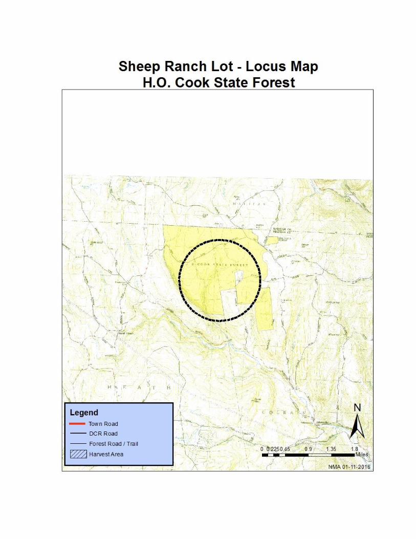
The H.O. Cook State Forest is located in northern Franklin County along the Vermont border in the
towns of Heath and Colrain. It is currently over 1600 acres and was originally purchased under the
Massachusetts Reforestation Law in 1909 with the purchase of 450 acres from Ira Lowe, a wholesale
meat dealer in Gardner, MA. He had operated a sheep ranch on the property and had pastured around
400 sheep but was unable to remain profitable due to the depredation of dogs which preyed on the
lambs. It was due to this past land usage that at least 70% of the land in the original purchase was open
field. Plantations of Norway spruce (Picea abies), Eastern white pine (Pinus Strobus) and White ash
(Fraxinus americana) were established in 1910 and 1911. Later plantings were established in 1915-1921
and the final plantings were carried out during the 1930’s by the Civilian Conservation Corps which
had established a camp on the forest. The stands chosen for this forest management project consists of
approximately 164 acres of Norway spruce plantation, 25 acres of adjacent White pine- Hardwoods and
10 acres of White pine plantation. This project will continue silvicultural practices which have been
ongoing in this forest for over 100 years.
The conditions that led to selecting this project for forest management are:
This project area offers an excellent opportunity to demonstrate and fulfill objectives for DCR
Woodlands.
It contains large acreage of non-native plantations.
Weather events have adversely affected the project area.
The Sheep Ranch Rendezvous Forest Management Project proposes to:
Demonstrate harvesting techniques and best management practices that protect forest
productivity, soil and water resources.
Produce wood products that are ecologically and economically sustainable that benefit local
communities.
Protection and enhancement of local water supplies.
Produce diverse habitats.
Increase carbon sequestration.
Begin regeneration in areas of Norway spruce that have had minimal silvicultural treatments.
Provide an opportunity to repair drainage and erosion issues on Newton Road.
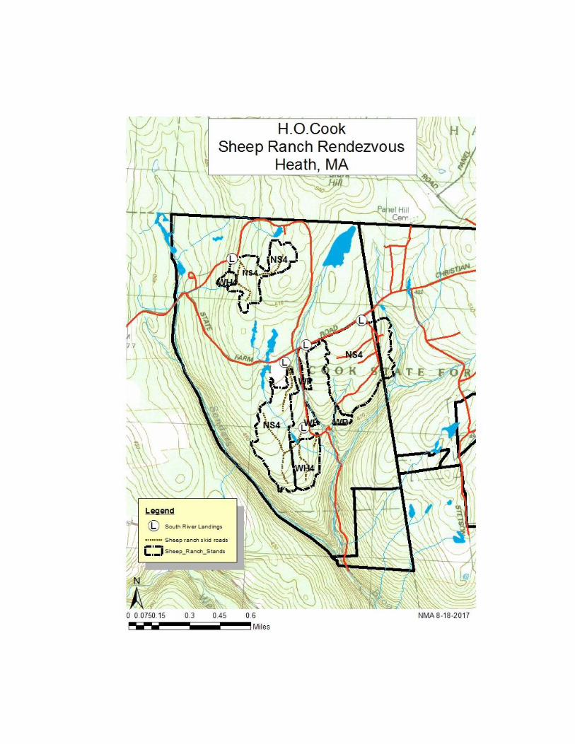
1.) Site Data
Geology and Landforms: The H.O. Cook State Forest sits on a plateau at the eastern edge of the
Berkshire Hills. The bulk of the forest sits on moderately level to gentle slopes with the eastern and
southern portions dropping off to the West branch of the North River and Saunders Brook. It was
these flat uplands that encouraged agricultural use and homesteading. The soils in the project area of
the forest developed from glacial deposits derived mainly from micaceous schist. The well-drained
Berkshire and Marlow soil types are sandy loams with varying amounts of stones while the Lyman
soils are slightly droughty and tend to have mores stones, rocks and bedrock outcroppings.
Soils: Berkshire (BbC,BcC) fine and very stony sandy loam, Lyman (LxC) extremely rocky loam
and Marlow (MeB)very stony loam are the dominant soil types. The Berkshire and Marlow are well-
drained soils suitable for growing crops and trees while the Lyman soil is somewhat shallow to
bedrock and does not have the water holding capacity of the other soils. Northern hardwoods, white
pine and red spruce grow very well on these soils while the productivity of the Lyman soils is much
lower due to the amount of rocks and stones. Another important factor to consider is that the
operability of the area is determined by the ability of the soil to dry out when saturated such as in the
spring or in periods of heavy rain. Care must be taken in the Berkshire and Marlow soils when
operating equipment to only do so when the ground is dry, frozen or otherwise stabile. This can also
be mitigated through the use of low-ground pressure equipment.
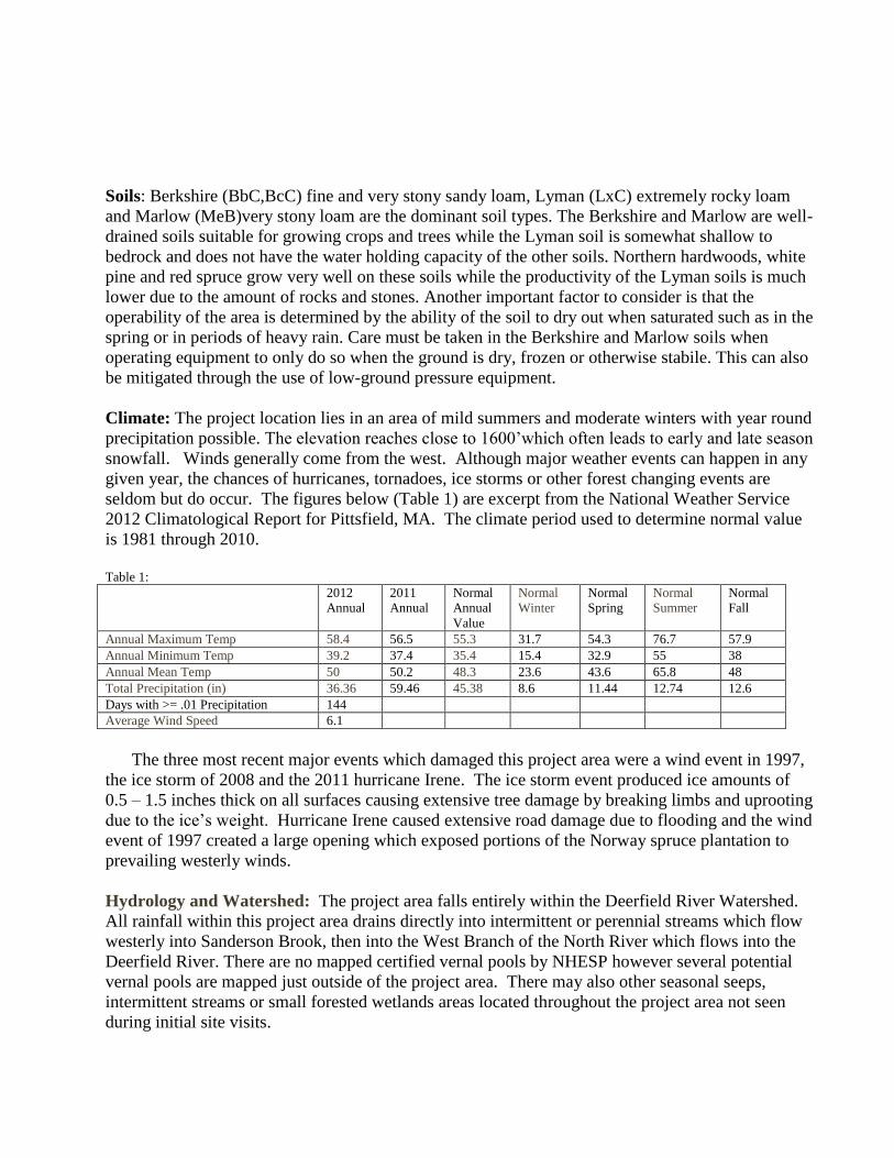
Climate: The project location lies in an area of mild summers and moderate winters with year round
precipitation possible. The elevation reaches close to 1600’which often leads to early and late season
snowfall. Winds generally come from the west. Although major weather events can happen in any
given year, the chances of hurricanes, tornadoes, ice storms or other forest changing events are
seldom but do occur. The figures below (Table 1) are excerpt from the National Weather Service
2012 Climatological Report for Pittsfield, MA. The climate period used to determine normal value
is 1981 through 2010.
Table 1:
2012
Annual
2011
Annual
Normal
Annual
Value
Normal
Winter
Normal
Spring
Normal
Summer
Normal
Fall
Annual Maximum Temp 58.4 56.5 55.3 31.7 54.3 76.7 57.9
Annual Minimum Temp 39.2 37.4 35.4 15.4 32.9 55 38
Annual Mean Temp 50 50.2 48.3 23.6 43.6 65.8 48
Total Precipitation (in) 36.36 59.46 45.38 8.6 11.44 12.74 12.6
Days with >= .01 Precipitation 144
Average Wind Speed 6.1
The three most recent major events which damaged this project area were a wind event in 1997,
the ice storm of 2008 and the 2011 hurricane Irene. The ice storm event produced ice amounts of
0.5 – 1.5 inches thick on all surfaces causing extensive tree damage by breaking limbs and uprooting
due to the ice’s weight. Hurricane Irene caused extensive road damage due to flooding and the wind
event of 1997 created a large opening which exposed portions of the Norway spruce plantation to
prevailing westerly winds.
Hydrology and Watershed: The project area falls entirely within the Deerfield River Watershed.
All rainfall within this project area drains directly into intermittent or perennial streams which flow
westerly into Sanderson Brook, then into the West Branch of the North River which flows into the
Deerfield River. There are no mapped certified vernal pools by NHESP however several potential
vernal pools are mapped just outside of the project area. There may also other seasonal seeps,
intermittent streams or small forested wetlands areas located throughout the project area not seen
during initial site visits.
Map: 1
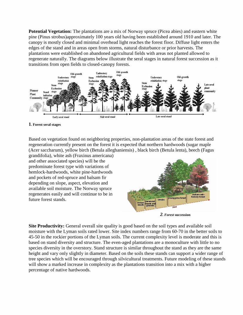
Potential Vegetation: The plantations are a mix of Norway spruce (Picea abies) and eastern white
pine (Pinus strobus)approximately 100 years old having been established around 1910 and later. The
canopy is mostly closed and minimal overhead light reaches the forest floor. Diffuse light enters the
edges of the stand and in areas open from storms, natural disturbance or prior harvests. The
plantations were established on abandoned agricultural fields with areas not planted allowed to
regenerate naturally. The diagrams below illustrate the seral stages in natural forest succession as it
transitions from open fields to closed-canopy forests.
1. Forest seral stages
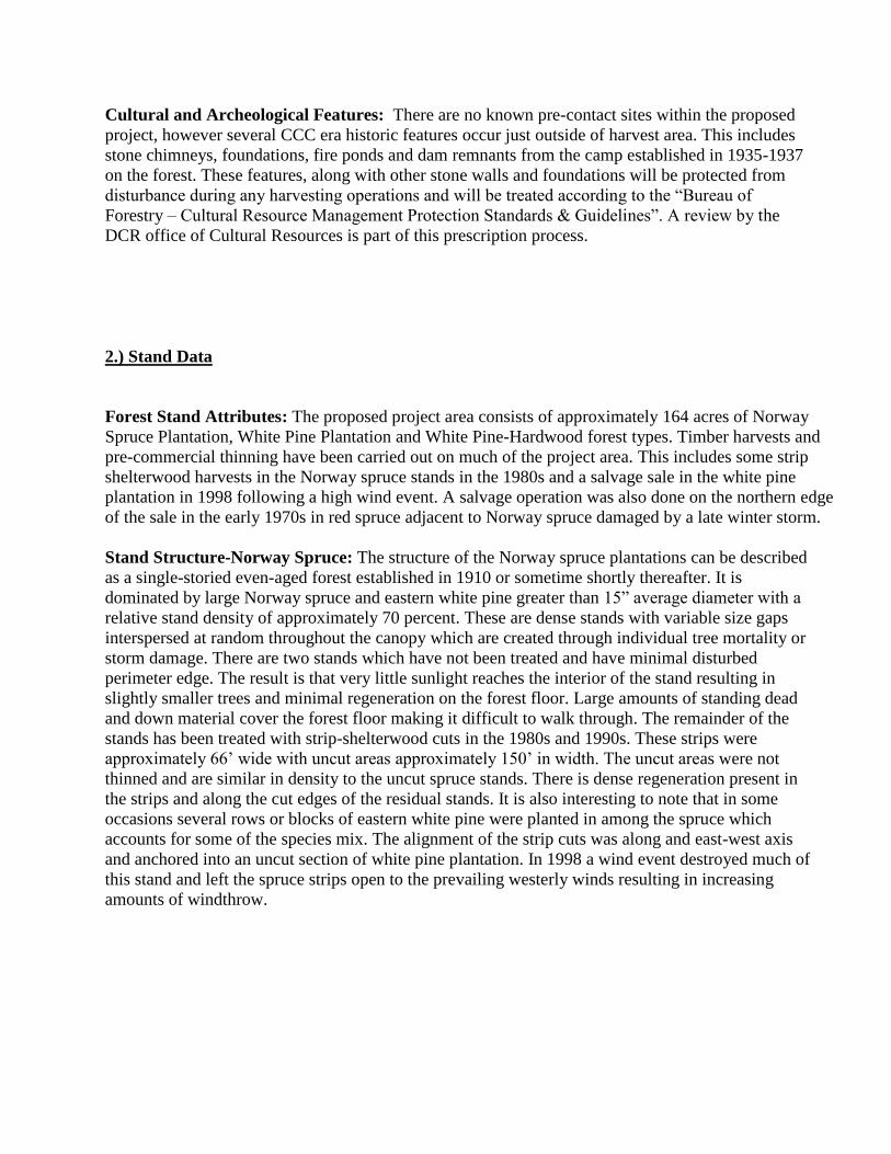
Based on vegetation found on neighboring properties, non-plantation areas of the state forest and
regeneration currently present on the forest it is expected that northern hardwoods (sugar maple
(Acer saccharum), yellow birch (Betula alleghaniensis) , black birch (Betula lenta), beech (Fagus
grandifolia), white ash (Fraxinus americana)
and other associated species) will be the
predominate forest type with variations of
hemlock-hardwoods, white pine-hardwoods
and pockets of red-spruce and balsam fir
depending on slope, aspect, elevation and
available soil moisture. The Norway spruce
regenerates easily and will continue to be in
future forest stands.
Site Productivity: General overall site quality is good based on the soil types and available soil
moisture with the Lyman soils rated lower. Site index numbers range from 60-70 in the better soils to
45-50 in the rockier portions of the Lyman soils. The current complexity level is moderate and this is
based on stand diversity and structure. The even-aged plantations are a monoculture with little to no
species diversity in the overstory. Stand structure is similar throughout the stand as they are the same
height and vary only slightly in diameter. Based on the soils these stands can support a wider range of
tree species which will be encouraged through silvicultural treatments. Future modeling of these stands
will show a marked increase in complexity as the plantations transition into a mix with a higher
percentage of native hardwoods.
2. Forest succession
Cultural and Archeological Features: There are no known pre-contact sites within the proposed
project, however several CCC era historic features occur just outside of harvest area. This includes
stone chimneys, foundations, fire ponds and dam remnants from the camp established in 1935-1937
on the forest. These features, along with other stone walls and foundations will be protected from
disturbance during any harvesting operations and will be treated according to the “Bureau of
Forestry – Cultural Resource Management Protection Standards & Guidelines”. A review by the
DCR office of Cultural Resources is part of this prescription process.
2.) Stand Data
Forest Stand Attributes: The proposed project area consists of approximately 164 acres of Norway
Spruce Plantation, White Pine Plantation and White Pine-Hardwood forest types. Timber harvests and
pre-commercial thinning have been carried out on much of the project area. This includes some strip
shelterwood harvests in the Norway spruce stands in the 1980s and a salvage sale in the white pine
plantation in 1998 following a high wind event. A salvage operation was also done on the northern edge
of the sale in the early 1970s in red spruce adjacent to Norway spruce damaged by a late winter storm.
Stand Structure-Norway Spruce: The structure of the Norway spruce plantations can be described
as a single-storied even-aged forest established in 1910 or sometime shortly thereafter. It is
dominated by large Norway spruce and eastern white pine greater than 15” average diameter with a
relative stand density of approximately 70 percent. These are dense stands with variable size gaps
interspersed at random throughout the canopy which are created through individual tree mortality or
storm damage. There are two stands which have not been treated and have minimal disturbed
perimeter edge. The result is that very little sunlight reaches the interior of the stand resulting in
slightly smaller trees and minimal regeneration on the forest floor. Large amounts of standing dead
and down material cover the forest floor making it difficult to walk through. The remainder of the
stands has been treated with strip-shelterwood cuts in the 1980s and 1990s. These strips were
approximately 66’ wide with uncut areas approximately 150’ in width. The uncut areas were not
thinned and are similar in density to the uncut spruce stands. There is dense regeneration present in
the strips and along the cut edges of the residual stands. It is also interesting to note that in some
occasions several rows or blocks of eastern white pine were planted in among the spruce which
accounts for some of the species mix. The alignment of the strip cuts was along and east-west axis
and anchored into an uncut section of white pine plantation. In 1998 a wind event destroyed much of
this stand and left the spruce strips open to the prevailing westerly winds resulting in increasing
amounts of windthrow.
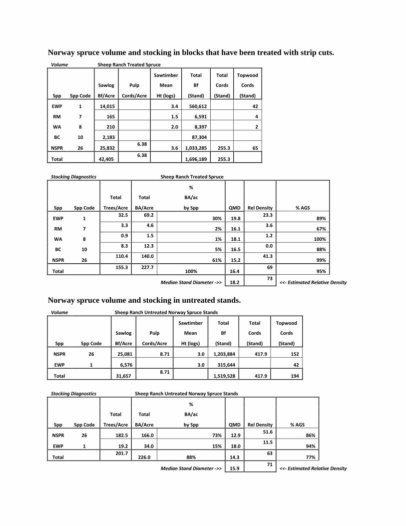
Norway spruce volume and stocking in blocks that have been treated with strip cuts.
Volume Sheep Ranch Treated Spruce
Sawtimber Total Total Topwood
Sawlog Pulp Mean Bf Cords Cords
Spp Spp Code Bf/Acre Cords/Acre Ht (logs) (Stand) (Stand) (Stand)
EWP 1 14,015 3.4 560,612 42
RM 7 165 1.5 6,591 4
WA 8 210 2.0 8,397 2
BC 10 2,183 87,304
NSPR 26 25,832 6.38
3.6 1,033,285 255.3 65
Total 42,405 6.38
1,696,189 255.3
Stocking Diagnostics
Sheep Ranch Treated Spruce
%
Total Total BA/ac
Spp Spp Code Trees/Acre BA/Acre by Spp QMD Rel Density % AGS
EWP 1 32.5 69.2
30% 19.8 23.3
89%
RM 7 3.3 4.6
2% 16.1 3.6
67%
WA 8 0.9 1.5
1% 18.1 1.2
100%
BC 10 8.3 12.3
5% 16.5 0.0
88%
NSPR 26 110.4 140.0
61% 15.2 41.3
99%
Total 155.3 227.7
100% 16.4 69
95%
Median Stand Diameter ->> 18.2
73 <<- Estimated Relative Density
Norway spruce volume and stocking in untreated stands.
Volume Sheep Ranch Untreated Norway Spruce Stands
Sawtimber Total Total Topwood
Sawlog Pulp Mean Bf Cords Cords
Spp Spp Code Bf/Acre Cords/Acre Ht (logs) (Stand) (Stand) (Stand)
NSPR 26 25,081 8.71 3.0 1,203,884 417.9 152
EWP 1 6,576 3.0 315,644 42
Total 31,657 8.71
1,519,528 417.9 194
Stocking Diagnostics
Sheep Ranch Untreated Norway Spruce Stands
%
Total Total BA/ac
Spp Spp Code Trees/Acre BA/Acre by Spp QMD Rel Density % AGS
NSPR 26 182.5 166.0 73% 12.9 51.6
86%
EWP 1 19.2 34.0 15% 18.0 11.5
94%
Total 201.7
226.0 88% 14.3 63
77%
Median Stand Diameter ->> 15.9
71 <<- Estimated Relative Density
Regeneration tables.
Ground cover table.
Ground Cover Species `` Norway Spruce
Species: Ferns Canada Indian Lady slipper Rubus spp.
Mayflower Cucumber
% cover: 20 20 10 20 20
Stand Structure-White Pine- The structure of the white pine plantation can be described as a single-
storied even-aged forest established in 1910 or sometime shortly thereafter. It is dominated by large
eastern white pine greater than 15” average diameter with a relative stand density of approximately 70
percent. These are dense stands with variable size gaps interspersed at random throughout the canopy
which are created through individual tree mortality or storm damage. There are three stands which have
seen some past treatments or are adjacent to areas that have had silvicultural treatments. Regeneration is
variable due to diffuse sunlight reaching the forest floor from adjacent stands and a lack of ground
disturbance to scarify the soil. Coarse woody debris can be heavy due to the stand mortality incurred
from dense stands of conifers
Volume Sheep Ranch WP
Sawtimber Total Total Topwood
Sawlog Pulp Mean Bf Cords Cords
Spp Spp Code Bf/Acre Cords/Acre Ht (logs) (Stand) (Stand) (Stand)
EWP 1 46,403 3.4 464,026 35
WA 8 1,091 10,913
BC 10 523 1.5 5,229 3
Total 48,017
0.00 480,167 0.0 38
Stocking Diagnostics Sheep Ranch WP
%
Total Total BA/ac
Spp Spp Code Trees/Acre BA/Acre by Spp QMD Rel Density % AGS
EWP 1 112.2 215.0 96% 18.7 72.9
98%
WA 8 2.8 5.0 2% 18.3 0.0
100%
BC 10 3.7 5.0 2% 15.7 3.9
100%
Total 118.7 225.0
100% 18.6 77
98%
Median Stand Diameter ->>
20.3 79 <<- Estimated Relative Density
Stand: EWP NS SM BB RM BC WA BE YB HK ASP
Norway Spruce
Stem Count 34 288
202 31 24 18 44 4 1
Stems/Acre 600 5082
3564 547 423 317 776 70 17
White pine - Regeneration table.
SPECIES: RM WA NS BC HK WP RO BE WB YB
Stem Count 14
5
2 6
2
Stems/Acre 1050
375
150 450
150
White pine - Ground cover table.
Ground Cover Species:
Species: Ferns Canada Partridge berry Starflower Clubmoss
Mayflower
% cover 10 40 10 10 10
Stand Structure: White Pine- Hardwoods. This stand is an even-aged white pine stand with associate
species of red maple, sugar maple and hemlock. It developed at the same time as the plantations but
may have been on rockier sites and not planted. The overall form is fair to good with some multiple-
stemmed white pine in the overstory. In areas adjacent to the Norway spruce stands it has ample
amounts of spruce in the understory in addition to red maple, beech and some yellow birch. White pine
dominates the overstory with the hardwood species filling the gaps. The red maple is of poor quality
with large quantities of rot present in the stems. The site quality is good but the presence of rocks and
stones detract from the amount of growing space available to ensure proper root development. Relative
stand density numbers indicate dense stands with a mostly closed canopy.
White Pine- Hardwoods
Volume and Stocking
Stocking Diagnostics
Sheep Ranch WH
%
Total Total BA/ac
Spp
Spp Code Trees/Acre BA/Acre by Spp
QMD
Rel Density
% AGS
EWP 1
144.4 190.0 86%
15.5 66.8 92%
HEM 3
11.3 10.0 5%
12.7 4.6 100%
SM 6
4.1 5.0 2%
14.9 0.0 100%
RM 7
14.6 15.0 7%
13.7 11.9 33%
Total
174.4 220.0 100%
15.2 83 89%
Median Stand Diameter ->>
18.8 85 <<- Estimated Relative Density
White pine hardwood - Regeneration table.
Ground cover table.
Ground Cover Species:
Species: Ferns Partridge Canada Rubus sp. Starflower Grass
berry mayflower
% Cover 10 10 20 20 10 10
White Pine –Hardwood Stand
Cavity Trees per Acre Species
Group <12" 12.1" to 15"
15.1" or
more Total
Softwood 0.0
Hardwood 4.7 4.7
Total 0.0 4.7 0.0 4.7
Forest Protection Concerns: A variety of insect pests and tree diseases are
found in the state forest. These include Black knot fungus (Apiosporina
morbosa) on Black cherry, Cytospora canker (Cytospora kunzei) on Norway
spruce, White pine Weevil (Pissodes strobi Peck) and Emerald ash borer
(Agrilus planipennis Fairmaire). The Black knot fungus attacks the twigs and
stem of Black Cherry and can be fatal to the tree. Some trees are more resistent
to the disease and should be selected as residuals while those tree heaviliy
infected should be removed to prevent additional spread. The Cytospora
canker is a fungus that enters the tree through branch stubs and wounds. The
best prevention is the removal of environmentally stressed trees (drought, excess shading) and
promotion of trees with healthy crowns and vigorous appearance. The White pine weevil is a native
insect that feeds on the terminal shoots of white pine and Norway spruce. It is mostly a problem in
field-grown trees without any overstory or in low density patches of regeneration. The most practical
defence against this insect is to use some form of the shelterwood regeneration system in order to
keep the regeneration partially shaded. Research has shown that as the stems exceed 16-20’ they
become much less susceptible to this insect. The Emerald Ash Borer is a non-native invasive insect
Species: RM WA BC NS BE WP RO YB
Stem count 25
1 5 7
1 2
Stems/Acre 1875
75 375 525
75 300
3. Black Knot on cherry
that is decimating stands of white ash. This will impact the regeneration in the management area as it
will contain an ash component. While the harvest is going to treat mainly spruce and pine stands it
will also be promoting northern hardwood regeneration such as beech, birch, maple and ash. These
species will be affected by additional insect and diseases that may not be readily apparent for many
years. These will include Sugar Maple Borer(Glycobius speciosus), Eutypella Canker in Sugar
maple (Eutypella parasiticus) and Beech Bark Disease(an insect/fungal complex). Storm damage is
common on this forest due to the elevation and its effects on temperature, exposure to prevailing
westerly winds and winter storms out of the north. This will influence what types of silvicultural
treatments are used and how openings are oriented towards prevailing winds. It should be noted that
in many cases storm damge will occur and very little can done to counter it. Maintaining aquedate
infrastructure in order to allow timely salvage will help recover damaged trees and prevent
additional damage from increased fire risk. Other protection concerns are illegal dumping,
unauthorized vehicle access, illegal tree cutting and non-permited campfires. Wildfire is not a
common occurrence on the forest but several small fires have been started by untended campfires.
There are five CCC era fire ponds on the forest that were created with the intent of providing fire
suppression capability for local fire departments. Flooding and road washouts occurred during
Tropical Storem Irene which have damaged some of the secondary roads.
Recreational and Aesthetic Resources: The main access to the state forest is State Farm Road in
Heath and it becomes Forestry Road in Colrain. This road is owned by the towns of Heath and Colrain
and is not a designated scenic byway. A secondary gravel road, Newton Road, is owned by DCR and
will provide access to the northern portion of the management area. Additional access will be from
Truck Trail Road to the south of State Farm Road, which is also owned by the DCR and was built by
the Civilian Conservation Corps in the 1930s. H.O.Cook State Forest is open to all legal passive
recreation activities that are allowed on DCR properties including hunting, fishing, snowshoeing, hiking
and birding. There is an official snowmobile trail on the eastern portion of the forest maintained by the
Colrain Sno-Drifters. The project area has no authorized hiking, biking or horseback riding trails
present.
Wildlife Habitat Conditions: The majority of the project area is in closed forest canopy with scattered
openings from previous silvicultural activity and natural
disturbances. The gradual transition of the monoculture Norway
spruce to a mixed hardwood and softwood stand will add to both
the diversity of plant species and wildlife. Within the project
area a minimum of 1-2 trees per acre at least 18 inches in
diameter will be left that show characteristics favorable to
wildlife such as large holes and dead branches. Large standing
dead snags that will not pose a danger to the operator will be
retained. These are important as nesting habitat to more than 60
cavity nesting birds and mammals. Current conditions show large quantities, 16-18 tons per acre, of
coarse woody debris (cwd) in the form of dead trees on the
ground. This material is important to a variety of species for denning habitat as well as suitable habitat
for mammals foraging for invertebrates. Research has shown that CWD of diameters greater than 10”
and lengths greater than 12’ to begin to be useful and there is currently large amounts of this material
present.. Areas that have been previously treated are covered in dense regeneration useful to wildlife in
terms of browse and cover. The planned treatments will add additional regeneration to maintain this
valuable habitat.
3.) Evaluation of Data, Silviculture and Projected Results
Primary/Secondary goals: The primary goal of treatment in these stands will be to ensure future
diversity of age, size and species mixture of these stands by demonstrating several types of
silviculture. This is being accomplished by creating a well planned and balanced science based
forestry plan.
Secondary goals of this project are to capture value of damaged and/or diseased trees and to
provide raw materials to the forest products industry. This project will also assist the community by
repairing the forest roads / trails and provide income to the town from the Forest Product Trust Fund.
White Pine Plantation: Silvicultural practices in these stands will demonstrate the irregular
shelterwood method of managing white pine to provide additional space, light and water resources for
remaining overstory trees and regeneration. These stands will be managed for optimal growth of high
quality sawlog trees. Forest management efforts will also be aimed at retaining wildlife trees and
ensuring adequate course woody debris.
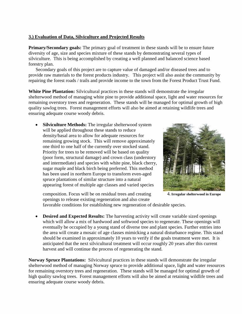
Silviculture Methods: The irregular shelterwood system
will be applied throughout these stands to reduce
density/basal area to allow for adequate resources for
remaining growing stock. This will remove approximately
one third to one half of the currently over stocked stand.
Priority for trees to be removed will be based on quality
(poor form, structural damage) and crown class (understory
and intermediate) and species with white pine, black cherry,
sugar maple and black birch being preferred. This method
has been used in northern Europe to transform even-aged
spruce plantations of similar structure into a natural
appearing forest of multiple age classes and varied species
composition. Focus will be on residual trees and creating
openings to release existing regeneration and also create
favorable conditions for establishing new regeneration of desirable species.
Desired and Expected Results: The harvesting activity will create variable sized openings
which will allow a mix of hardwood and softwood species to regenerate. These openings will
eventually be occupied by a young stand of diverse tree and plant species. Further entries into
the area will create a mosaic of age classes mimicking a natural disturbance regime. This stand
should be examined in approximately 10 years to verify if the goals treatment were met. It is
anticipated that the next silvicultural treatment will occur roughly 20 years after this current
harvest and will continue the process of regenerating the stand.
Norway Spruce Plantations: Silvicultural practices in these stands will demonstrate the irregular
shelterwood method of managing Norway spruce to provide additional space, light and water resources
for remaining overstory trees and regeneration. These stands will be managed for optimal growth of
high quality sawlog trees. Forest management efforts will also be aimed at retaining wildlife trees and
ensuring adequate course woody debris.
4. Irregular shelterwood in Europe
The primary goal of treatment in these spruce plantations is to reduce competition in the
overstory and increase growth of spruce and other preferred tree species for high quality wood products
in the future. Secondary goals of this project are to capture the commercial value of low vigor,
damaged and/or diseased trees for low grade forest products and pulpwood markets.
Silviculture Methods: The irregular shelterwood system will be applied throughout these
stands to reduce density/basal area to allow for adequate resources for remaining growing stock.
This will remove approximately one third to one half of the currently over stocked stand.
Priority for trees to be removed will be based on quality (poor form, structural damage) and
crown class (understory and intermediate) and species. This method has been used in northern
Europe to transform even-aged spruce plantations of similar structure into a natural appearing
forest of multiple age classes and varied species composition. Focus will be on residual trees
and creating openings to release existing regeneration and also create favorable conditions for
establishing new regeneration of desirable species.
Desired and Expected Results: This harvest should lead to stands of high quality Norway
spruce and other northern hardwood species. The stand will be fully stocked with desirable
regeneration and residual trees will have ample opportunity to grow. As the stand matures
wildlife trees will become larger and provide more habitat opportunities. This stand should be
examined in approximately 5 years to verify if the treatment goals were met. It is anticipated
that the next silvicultural treatment will occur roughly 20 years after this current harvest and
will continue the process of regenerating the stand.
White Pine-Hardwoods: Silvicultural practices in these stands will demonstrate the irregular
shelterwood method of managing white pine-hardwood to provide additional space, light and water
resources for remaining overstory trees and regeneration. These stands will be managed for optimal
growth of high quality sawlog trees. Forest management efforts will also be aimed at retaining wildlife
trees and ensuring adequate course woody debris.
Silviculture Methods: An irregular shelterwood will be applied throughout the stands where
the basal area or density of the stand will be reduced to allow for adequate resources for
remaining growing stock. This will remove approximately one third to one half of the currently
over stocked stand. Priority for trees to be removed will be based on quality (poor form,
structural damage) and crown class (understory and intermediate) and species. This method has
been used in northern Europe to transform even-aged plantations of similar structure into a
natural appearing forest of multiple age classes and varied species composition. While this stand
is not a plantation, it has developed adjacent to several plantations and is also an even-aged
stand. The focus will be on improving the quality of the forest by removing poorly formed stems
and providing space for regeneration. Portions of this stand have Norway spruce and native red
spruce regeneration which will factor into the future development of the forest.
Desired and Expected Results: The residual stand will have a higher proportion of quality
overstory trees. Existing regeneration will be released from completion and growing into a stand
of high-quality mixed-wood species. The next entry into the stand will be when it is time to
release the saplings from overstory completion. This would be in approximately 20 years but
will be determined by future forest inventory work.
Logging System Requirements: The harvesting of these stands can be accomplished with a cut-to-
length harvester and an eight-wheel forwarder to ensure safety, lower ground pressure and
efficiency. This will also permit the use of smaller landings and have less impact on the residual
trees. Coarse woody debris (CWD) will be retained to meet minimum standards of 2-3 tons per acre.
Many portions of the plantations exceed this amount and may hamper harvesting operations. These
areas will be treated to disperse heavy fuel conditions while allowing CWD resource objectives to be
met. This type of harvesting system will allow for adequate CWD retention as opposed to systems
that remove the entire tree from to site.
Project Access and landings: Access to the proposed project area will be from Colrain (Ed Clark
Road) or Heath (Route 8A) Road to State Farm Road in the town of Heath. Several existing
landings will be utilized be along State Farm Road and Newton Road. Tractor trailers will be
allowed for log transport out of the forest. Upon completion of all harvesting activity landings will
be free of debris and graded to prevent erosion. Cleared portions that are not graveled will be seeded
with “Berkshire Conservation Mix” grass seed and mulched with straw. Where possible, boulders
will block access to the forwarder / skid trails from illegal vehicles.
Forwarder Road and Skid Trails: Throughout the project area forwarder / skid
trails will be laid out to avoid water features and to avoid slopes. Primary skid trails will be
laid out and marked prior to the project being placed out to bid. Any unavoidable stream or
wetland crossing will be designed at or above the standards of the “Massachusetts Forestry
Best Management Practices”. Upon completion of all harvesting activity all forwarder / skid
road will be left in a stable state and water bars will be installed according the
“Massachusetts Forestry Best Management Practices”. All stream/wetland crossing will be
stabilized and entrances will be blocked to prevent illegal access.
Wildlife Resources: Current snags will be retained; however operators have the right to
remove any snag that poses a safety hazard to themselves or equipment. Operators will not
be required to utilize cull trees, if left behind they will add to the amount of large diameter
CWD. Limbs and tops (slash) will also be left in place to augment existing CWD and add
soil nutrients through decomposition.
In-kind Services: Upon final tally of product the extent of in-kind services will be
determined. These may include repair and restoration of drainage features on Newton Road
and several unnamed access roads installation of metal pipe gates in multiple locations to
limit unauthorized access by motor vehicles. This should also limit illegal dumping on the
state forest, gravel and grading on several state roads in the project area And beech control in
areas to be regenerated as needed.
Climate Change and Potential Impacts
Climate change will present challenges and opportunities for accomplishing the management
objectives of this project. The degree of change is uncertain, however based on current predictions
and recent weather events it would be prudent to plan for future climate shifts. The DCR forester
responsible for preparing this timber sale used the Adaptation Workbook to develop identify how the
proposed timber sale could help the area to adapt to climate change.
Challenges
Conditions may become wetter during the period when operations are likely to occur, which
would increase the potential for soil erosion or damage and limit the success of the project.
Climate change will accelerate the spread of Hemlock woolly adelgid, which will impact an
important species in the riparian zone.
Warmer temperatures or more open canopy conditions as a result of stress on the overstory
trees may allow for invasive and undesirable species to increase in the understory.
Warmer temperatures will favor different a species composition. Those more tolerant of
warmer temperatures and increased rainfall will slowly dominate the landscape.
Opportunities
The proposed activities reduce risks to the site from extreme precipitation events and other changes
in climate. Anticipated changes in climate only increase the need to implement these activities
sooner rather than later. The following matrix is taken from the Forest Adaptation Workbook and is
focused on protecting riparian zones from expected climate change and also to enhance species
diversity throughout the project area. The proposed silviculture will shift the species composition by
increasing species diversity and both horizontal and vertical structure.
Area/Topic Approach Tactics
Stream
crossings
1.3. Maintain or restore riparian
areas.
Remove failing culverts and replace with bridges.
Ensure stream connectivity and a naturalized
stream bottom.
Riparian
forest
1.4. Reduce competition for
moisture, nutrients, and light.
2.2. Prevent the introduction and
establishment of invasive plant
species and remove existing
invasive species.
Control of invasive plants using herbicides pre- and
post-harvest.
5.1. Promote diverse age classes.
5.2. Maintain and restore diversity
of native species.
9.5. Disfavor species that are
distinctly maladapted.
Use of uneven-aged silviculture to promote age and
species diversity. Remove hemlock and ash because
of susceptibility to insect pests and encourage
regeneration of a diversity of tree species.
5.2. Maintain and restore diversity
of native species.
5.3. Retain biological legacies.
Maintain at least 50% of the basal area along
streams, per current regulations.
5.2. Maintain and restore diversity
of native species.
Consider the use of artificial regeneration to shift
the composition in the riparian zone, using species
Area/Topic Approach Tactics
9.1. Favor or restore native
species that are expected to be
adapted to future conditions.
9.2. Establish or encourage new
mixes of native species.
such as northern red oak, hickory species, or
American chestnut.
Prescription Documentation:
Project Marking Guidelines: Follow the directions below for marking instructions of sale and
stand level features.
1. Locate, flag (blue wetlands) and paint with two red diagonal stripes the buffers and filter
strips along all wetland and associated streams.
2. Locate, flag and paint with two red diagonal stripes the remaining wooded project boundary
line. This will not be done where the project boundary is a road.
3. Flag temporary layout of the primary forwarder trail network with orange flagging. Using
blue paint mark small non commercial stems or stems already marked for removal located
along adjusted skid trails upon completion of marking.
4. Flag temporary layout of any unavoidable wetland and stream crossing with labeled orange
flagging. Using Red paint mark and label each crossing upon completion of marking and any
final adjustment to location.
5. Locate and mark perimeter of landing with one red diagonal stripe.
6. General tree marking guide:
Marking type Type of Tree Tally Method Mark Type
Leave Tree Leave Tree As needed Red Horizontal Line
Cut Tree Cut Saw Log Individual tally DBH + height Blue Horizontal Line
Cut Tree Cut Pulp/Cord Wood Individual tally DBH + height Blue Diagonal Stripe
Cut Tree Cut Live Cull Tree No tally Blue X
Cut Tree Dead Tree Warning No tally Blue X
Norway Spruce Plantations: Irregular Shelterwood: Remove 30 to 50% of the basal area reducing
the stand to approximately 140-160sq/ft
by following the prioritized guide below. Remove no more
than 50% of the basal area within the road buffer.
1. Unacceptable growing stock* \ Understory Norway spruce
2. Any Diseased spruce or black cherry
3. Unacceptable red maple, American beech or birch
4. Unacceptable black cherry
Retention of mature seed producing black cherry, sugar maple, black and yellow birch within the
stand is preferable.

* Defined in terms of high enough quality to produce a sawlog. Stem shape, form and crown asre
part of the characteristics used in making this determination.
White Pine Plantations: Irregular Shelterwood: Remove 30 to 50% of the basal area reducing the
stand to approximately 140-160sq/ft
by following the prioritized guide below. Remove no more than
50% of the basal area within the road buffer.
1. Unacceptable white pine
2. Any Diseased black cherry
3. Unacceptable red maple, American beech or birch
4. Unacceptable Black Cherry
Retention of mature seed producing black cherry, sugar maple, black and yellow birch within the
stand is preferable.
White Pine/Hardwood Forest Type: Irregular Shelterwood: Remove 30 to 50% of the basal area
reducing the stand to approximately 140-160sq/ft
by following the prioritized guide below.
1. Unacceptable white pine
2. Any Diseased black cherry
3. Unacceptable red maple, American beech or birch
4. Unacceptable Black Cherry
5. Other Acceptable Hardwood
Retention of mature seed producing black cherry, sugar maple, black and yellow birch within the
stand is preferable.
Attached: Stand Map and Locus Map showing location of Forest Products Sale Area
References
Smallidge, P.J. and R.D. Nyland. 2009. Woodland Guidelines for the Control and Management of
American Beech. Cornell Univeristy Cooperative Extension Forest Connect Fact Sheet. P.
Smallidge, ed. 6pgs.
Kochenderfer, Jeffrey D.; Kochenderfer, James N. 2009. Effects of Herbicide Concentration and
Application Timing on the Control of Beech Root and Stump Sprouts Using the Cut-stump
Treatment. Gen. Tech. Rep. NRS-48. Newtown Square, PA: U.S. Department of Agriculture, Forest
Service, Northern Research Station. 10 pgs.
Houston, David R. and O’Brien, James T. 1983. Beech Bark Disease. Forest Insect & Disease
Leaflet 75. U.S. Department of Agriculture, Forest Service.
Leak, William B. 2003. Best Density and Structure for Uneven-Aged Northern Hardwood
Management in New England. Northern Journal of Forestry, Vol. 20, No. 1
Malcolm, D.C. (1992). The development of a transformation from even-aged plantations to an
irregularly-structure forest. Report to the Scottish Forestry Trust. School of Forestry, Institute of
Ecology and Resource Management, University of Edinburgh, Edinburgh.
Wilson, E. R., McIver, H. W. and Malcolm, D. C. (1999). Transformation to irregular structure of an
upland conifer forest. Forestry Chronicle 75, 407-412.
Massachusetts Department of Conservation & Recreation. 2012. Landscape Designations for DCR
Parks and Forests: Selection Criteria and Management Guidelines.
Massachusetts Department of Conservation & Recreation. 2015. Western Connecticut Valley District
Forest Resource Management Plan (Revised).
Kerr, G., Morgan, M., Blyth, J.F. and Stokes, V. (2010). Transformation from even aged plantations
to an irregular forest: the world's longest running trial area at Glentress, Scotland. Forestry 83, 329-
344.
Kittredge Jr., David B. and Parker, Michael. 2000. Massachusetts Forestry Best Management
Practices Manual. Massachusetts Department of Environmental Protection, Office of Watershed
Management and U.S. Environmental Protection Agency, Region I, Water Division, Water Quality
Section.
Goodwin, D.W. and W.N. Hill. 2012. Forest Productivity and Stand Complexity Model [A GIS Grid
Analysis using ArcGIS®]. Massachusetts Department of Conservation and Recreation, Amherst,
MA.

Hoffard, William H. and Marshall, Philip T. 1978. How To Identify and Control the Sugar Maple
Borer. United States Department of Agriculture, Northeastern Area State & Private Forestry. NA-
GR-1
Janowiak, Maria K, et al. 2014. A Practical Approach for Translating Climate Change Adaptation
Principles into Forest Management Actions. J.For112(5):424-433.
Jensen, Sandra. Updated 2011. Plant Disease Fact Sheet: Black Knot. Cornell University, Plant
Disease Diagnostic Clinic
Frank, Robert M. and Bjorkbom, John C. 1973. A Silvicultural Guide for Spruce-Fir in the
Northeast. USDA Forest Service General Technical Report NE-6.
Bottorff, Jim. 2009 Revised. Snags, Coarse Woody Debris, and Wildlife. Washington State
Department of Natural Resources.