Transgressive Migrations: Gender Roles, Space, and Place ...

Sidewalks informality: Impacts of transgressive informal practices on people’s perceived walkability The case of Downtown, Cairo in time of a pandemic
A Thesis submitted in the Partial Fulfillment for the Requirement of the Degree of Master of Science in Integrated Urbanism and Sustainable Design
By Dina Alaa Ali Abdallah
Supervised by
Examiners Committee
Title, Name & Affiliation
Prof. (external examiner)
Professor of (…)
University of (…)
Prof. (Title/Name)
Professor of (…)
University of (…)
Prof. (Title/Name)
Professor of (…)
University of (…)
Prof. (Title/Name)
Professor of (…)
University of (…)
23/08/2020
Signature
Prof. Mohamed A. Salheen Professor of Regional Planning Ain Shams University
Prof. Hassan Elmouelhi Professor of Professor of Planning Building environment University of Berlin

2

3
Disclaimer
This dissertation is submitted to Ain Shams University (ASU) for the degree of
Integrated Urbanism and Sustainable Design (IUSD), in accordance to IUSD-
ASU regulations.
The work included in this thesis was carried out by the author during the period
from February – August 2020.
The author confirms that the work submitted is his/her own and that
appropriate credit has been given where reference has been made to the work of
others.
Any disputes regarding the copy right of the content is the sole responsibility of
the author.
Ain Shams University holds the right to publicly distribute this thesis in the
current university standard format. The author holds the right to publish the
content in any other format.
23/08/2020
Dina Alaa
Signature

4

5
Acknowledgements
I would like first to express my gratefulness to my supervisor: Prof. Mohamed
Salheen for his patience, motivation, enthusiasm, and immense knowledge.
Your guidance helped me a lot in all the time of the research and the writing
process.
I would also like to thank my second supervisor: Dr. Hassan Elmouelhi for his
continuous support. Without your passionate participation and input, the
research could not have been successfully done.
I am extremely grateful to my family whom their support and patience always
gave me the strength to continue and to do the best I can to please them. I would
like specially to thank my father encouraging me to pursue my master’s degree,
and his support along the way.
My deep and sincere gratitude to a very special person, my life time partner and
husband to be, Ahmed for his continued and unfailing love, support and
understanding. You were always around at times I thought that it is impossible to
continue, you helped me to keep things in perspective. This accomplishment
would not have been possible without you; I am forever grateful to your endless
encouragement through the difficult times.
Last but not least, I would like to express my appreciation to the IUSD staff and
professors for giving me this opportunity to do my master’s degree. I greatly
appreciate being part of this program, that has given me the chance to develop my
knowledge, and meet great friends. I would like to thank: Sara Abuhenedy,
Hassan Mohamed, and Amr Salah whom gave me true friendship, without
them the journey would have been much harder. And special thanks to my
beloved friend Rana Assem, the one with whom I started and was able to
continue the whole journey. What made the past two years great was working
alongside of you.

6
Acknowledgements
I would like to express my appreciation and thanks to two dissertations from
which I got totally inspired as they both put me on the right track of studying this
topic as it was not easy to find relevant data especially in the crucial time of during
the pandemic phase.
The first is Salsabil Fahmy dissertation: “Re-thinking the vibrant life on the
sidewalk: mapping the spatial relations of informal practices on Cairo sidewalks”.
The way the researcher mapped and presented the phenomenon was used as she
mastered the tools of spotting the different practices in normal cases, how she
traced the changes throughout history and simplified the presentation of the
gathered data in a unique visual schemes. And since it was a remarkable and
successful chains of thinking leading to tangible results; following her criteria and
frame for reaching an output in time of a pandemic and compare it with the
previously studied case by her side lead to present the same phenomenon in a
different context and different circumstances (corona pandemic).
The second is Sahar El Ghandour dissertation: “Towards more pedestrian-
friendly streets in Cairo”. The researcher highlighted the integration of the
different aspects that a pedestrian can face throughout a daily walk with the
perception he gets and how this affects his decision to choose a specific route. This
highlight was inspiring and acted as a main guidance in studying the term
walkability in terms of other practices, in this case named informal practices. The
simplification of the complex scientific terminologies were used as they were
presented through uncomplicated diagrams and terms.

7
Abstract
Informality in Cairo is always approached in terms of informal settlements
neglecting the fact that urban informality could exist in many other forms.
However, scholars usually focus on urban informality in terms of planning and
regulations. Other forms of informality prevailed in public spaces affecting
people’s everyday life as sidewalks informality in terms of practices. which
represent a vital and growing aspect of the urban informal sector, interrupting
pedestrians’ paths as well as their walking experience.
According to the current conditions, with the prevalence of corona pandemic,
informal practices by law become less present on Cairo’s sidewalks. There is an
overall social strict which prevent shops and other activities to exhibit their
products outside the borders of their territory. Which make the pandemic plays
an important role in reshaping the relationship between people and public spaces.
Therefore, the perception of sidewalks’ users is affected, which lead them to use
the sidewalks differently.
The main aim of the research is to explore the phenomenon of sidewalks
informality through studying the spatial nature of daily informal practices,
investigating how they interact with the physical form of downtown streets and
their impacts on people’s walkability and perception of using the sidewalks before
and after the imposition of the curfew which might be the new normal. Aiming at
the end to give some expectations, projections on what might be long-term
impacts and what might just vanish and being faced out from our culture, social
practices, and economic behavior.
Key words: Sidewalks, Informal practices, appropriation, walkability,
walking experience, perception, public spaces, Corona pandemic

8

9
Table of contents
Table of contents……………………………………………………………………………………….9
List of figures……………………………………………………………………………………………19
List of tables…………………………………………………………………………………………….20
Chapter 1……………………………………………………………………………………………….25
1.Introduction……………………………………………………………………………………… 25
1.1. Framing the issue of the research…………………………………………………….25
1.1.1. The issue of the research in terms of corona pandemic……………….28
1.2. Rational of the study………………………………………………………………………29
1.3. Hypothesis…………………………………………………………………………………….31
1.4. Objectives………………………………………………………………………………………31
1.5. Research questions…………………………………………………………………………33
1.6. Methodology………………………………………………………………………………….33
1.6.1. Research design………………………………………………………………………33
1.6.2. Data collection tools……………………………………………………………….36
1.6.3. Data analysis………………………………………………………………………….38
1.7. Research limitation…………………………………………………………………………39
Chapter 2……………………………………………………………………………………………....42
2. Public spaces and informality: between behavior and perception…
2.1. Introduction……………………………………………………………………………………….42
2.2. Evolution of streets and sidewalks in terms of history and terminologies…42
2.2.1. Historical background on streets/ sidewalks evolution………………………42
2.2.2. Recent literature on streets/ sidewalks……………………………………………45
2.2.3 Evolution of the research terms and their significance……………………...47
2.2.3.1 Streets …………………………………………………………………………………….47
2.2.3.2. Sidewalks……………………………………………………………………………….49
2.2.3.3. Informal practices on the sidewalks………………………………………….52
2.2.3.4. Walkability/walkable sidewalks……………………………………………….53

10
2.3. Streets and sidewalks: informal practices vs walkability in urban spaces before and during the pandemic…..............................................................54 2.3.1 Physical configuration: streets and sidewalks as urban public spaces….54
2.3.1.1. Urban public spaces before the pandemic………………………………….55
2.3.1.2. Key attributes of walkable streets and sidewalks with the presence of informal practices before the pandemic…………………………………57 A. Living streets and sidewalks before the pandemic………………….….57
B. Streets and sidewalks as shared zones before the pandemic………58
C. The 5Cs approach of walkable sidewalks before the pandemic…..59 2.3.1.3. Urban public spaces and key attributes of streets/sidewalks during the pandemic…………………………………………………………….…60
A. Mayor’s streetscape and sidewalks approach during the pandemic…………………………………………………………………………...62
B. Slow streets and sidewalks approach during the pandemic……….63 2.3.2. Behavior patterns: uses and activities …………………………………………….64
Sidewalks’ patterns of uses and their impact on people’s walkability before and during the pandemic………………………………………………………………….64 2.3.2.1. Activity patterns on the sidewalks & buildings’ ground floor use…..64
2.3.2.2. Activity permeability……………………………………………………………….65
2.3.2.3. Territoriality and personalization before the pandemic……………...66
2.3.2.4. People’s behavior and territoriality during the pandemic……………68
2.3.3. Personal preferences: users’ perception and human behavior while using the streets and sidewalks before and during the pandemic ...70 2.3.3.1. Environmental perception……………………………………………………….70
2.3.3.2. Pedestrians’ image and perception of the streets…………………….….71
2.3.3.3. Pedestrians’ needs, motives, and perceptions…………………………… 72
2.4. Summary……………………………………………………………………………………………75

11
Chapter 3……………………………………………………………………………………………….78
3. Cairo streets and sidewalks: informality vs walkability…………….78
3.1. Historical Evolution of streets and sidewalks’ patterns in Cairo……………….78
3.1.1. Historical role of alleys as important walkable public spaces………………83
3.2. Tracing changes: Informal practices vs walkability ……………………………….86
3.2.1. Cairo sidewalks before the pandemic………………………………………………86
3.2.2. Cairo sidewalks during the pandemic…………………………………………….88
3.3. Summary………………………………………………………………………………………….93
Chapter 4………………………………………………………………………………………………96
4. Downtown Case study…………………………………………………………………….96
4.1. Area study selection……………………………………………………………………………96
4.1.1. Street selection…………………………………………………………………………….99
4.2. Sidewalks surveyed: Data collection………………………………………………….100
4.2.1. Sidewalks’ patterns…………………………………………………………………….103
4.2.1.1. Online questionnaire………………………………………………………………103
4.2.1.2. Observation through video recording……………………………………….104
4.2.1.3. Observation through photos documentation………………………….…106
4.2.1.4. Time sampling………………………………………………………………………107
4.2.1.5. Interviews…………………………………………………………………………….107
4.2.2. Pedestrians’ perceived walkability………………………………………………….110
4.2.2.1. Cognitive mapping/ walkability audit tool…………………………………111
Chapter 5…………………………………………………………………………………………….114
5. Empirical Data and preliminary findings……………………………….114
5.1. Site Analysis………………………………………………………………………………………114
5.1.1. A brief historical evolution of Downtown streets………………………………114
5.1.1.1. The establishment of a new quarter (1867-1952)………………………..114
5.1.1.2. Socio-economic status (1960-2017)………………………………………....116
5.1.2. The case study analysis……………………………………………………………….119

12
5.2. Sidewalk patterns before and during the pandemic……………………………....121
5.2.1. Ground floor uses…………………………………………………………………….….121
5.2.2. Informal practices typologies……………………………………………………...126
5.2.3. Time sampling of different activities……………………………………………135
5.2.3.1. Duration and frequency of informal practice…… …………………....135
5.2.4. Gender of sidewalks’ users………………………………………………………….138
Chapter 6……………………………………………………………………………………….…….152
6. Understanding the push & pull factors before and during the pandemic……………………………………………………………………………….152
Sidewalks characteristics………………………………………………………………………….152
6.1. Physical characteristics……………………………………………………………………..152
6.1.1. Impacts of sidewalk pavement………………………………………………………152
6.1.2. Impacts of sidewalk division…………………………………………………………156
6.1.3. Impacts of metro pipelines……………………………………………………….…162
6.2. Social characteristics………………………………………………………………….…….168
6.2.1. Impacts of sidewalk appropriation………………………………………….…..168
6.3. Pedestrian’s perceived walkability…………………………………………….…….….171
6.4. Reflections……………………………………………………………………………………….179
Chapter 7…………………………………………………………………………………………….184
7. Conclusion and recommendations…………………………………….…184
7.1. Conclusion…………………………………………………………………………….…………184
7.2. Recommendations………………………………………………………………….……….190
7.3. Further research……………………………………………………………………………….191
References……………………………………………………………………………………193
Appendices………………………………………………………………………………….200

13
List of figures
Figure 1- Understanding of Informal Practices and activities process in Cairo’s
street. Source: reproduced by the researcher based on “spatial relations of
informal practices” paper……………………………………………………………………….…27
Figure 2- The proposed working area (downtown streets).
Source: Researcher……………………………………………………………………………………31
Figure 3- Conceptual understanding of the pull and push factors affected by the
informal Practices-Defining the scope. Source: Based on integrating (Salsabil
Fahmy) frame and (Mariela A. Alfonzo, walking needs hierarchy), (Mehta,
pedestrians’ behavior and perception in walkable …………………………………….…32
Figure 4- Literature review diagram –conceptual framework. Source:
Researcher, based on “the walkability experience theory in terms of different
interaction aspects” by (Mariela A. Alfonzo, 2005), (Shi, et al., 2019) ……………34
Figure 5- Research tools (data collection). Source: Informal practices mapping
tools developed based on Salsabil Fahmy dissertation.……………………...............36
Figure 6- Sidewalks and street markets in the 16th century. Source: Lucas van
valckenborch…………………………………………………………………………………………….43
Figure 7- Sidewalks and streets in the 19th century. Source: Lucas van
valckenborch…………………………………………………………………………………………….43
Figure 8- At the end of the 19th century where sidewalks started to be used as a
platform for shop merchandises. Source: Canton street scene……………………….45
Figure 9- 20th century streets, where sidewalks started to be used as a platform
for shop merchandises. Source: Beth Hatefutsoth………………………………………..45
Figure 10- Sidewalks creating a gathering point because of the comfort aspects
Source: Michel de Certeau………………………………………………………………………….51
Figure 11- 15-minute city planning framework Paris en commun. Source:
micaëla…………………………………………………………………………………………………….61
Figure.12-12’- Applying the “slow streets and sidewalks” approach in Oakland
Source: (Schaaf, 2020) ……………………………………………………………………………..63
Figure 13- Queuing method as a response behavior for the pandemic in pick-up
daily needs and transit. Source: Represented by the researcher based on Sadik
Khan……………………………………………………………………………………………………….68

14
Figure 14- Restaurants’ sitting elements along streets and sidewalks. Source:
Represented by the researcher based on Sadik Khan……………………………………69
Figure 15- Extra services as streets’ markets. Source: Represented by the
researcher based on Sadik Khan…………………………………………………………………69
Figure.16-17-Shops loading their merchandises using only one zone of the
sidewalks/ organizing shared streets while keeping the social distancing.
Source: Represented by the researcher based on Sadik Khan………………………..69
Figure 18- Maslow’s hierarchy of needs. Source: Maslow, 1943……………………..73
Figure 19- Hierarchy of walking needs. Source: Mariela A. Alfonzo, 2005………73
Figure 20- Cairo streets and physical elements structure. Source: represented by
the researcher based on (Nezar Al-Sayyad, 1981)…………………………………………79
Figure 20’- Cairo major streets, where the commercial activities started to
appear. Source: represented by the researcher based on (Nezar Al-Sayyad, 1981).
Figure 20’’- Cairo minor streets, narrow in between blocks streets, used for
interaction. Source: represented by the researcher based on (Nezar Al-Sayyad,
1981)………………………………………………………………………………………………………..79
Figure 21- Cairo streets development illustrating the development of street
activities in Fatimid era. Source: represented by the researcher based on (Nezar
Al-Sayyad, 1981) explanation…………………………………………………………………….80
Figure 22- Cairo streets development illustrating the development of street
activities in ayyubid era. Source: represented by the researcher based on (Nezar
Al-Sayyad, 1981) explanation……………………………………………………………………..81
Figure 23- Cairo streets development illustrating the development of street
activities in the ottoman era and the rise of the role of alleys. Source:
represented by the researcher based on (Nezar Al-Sayyad, 1981) explanation…82
Figure 24- The role of alleys in supporting walkability before the integration of
activities. Source: Humphrey Spender………………………………………………………..84
Figure 25- Section of a Cairene alley illustrating its role at the morning
(commercial activities). Source: represented by the researcher based on
(Abdelmonem, 2012)…………………………………………………………………………………85
Figure 25’- Section of a Cairene alley illustrating its role at the evening (social
interaction). Source: represented by the researcher based on (Abdelmonem,
2012)…………………………………………………………………………………………………….…85

15
Figure 25’’- Section of a Cairene alley illustrating its role at night (people
walkability). Source: represented by the researcher based on (Abdelmonem,
2012)……………………………………………………………………………………………………….85
Figure 26- Sidewalks appropriation-1930. Source: (Egyptian streets, 2013)……87
Figure 27- Scene of Cairo sidewalks activities -1954. Source: (Egyptian streets,
2013) ……………………………………………………………………………………………………...87
Figure 28- scene of Cairo sidewalks activities-after 2011. Source: Maria
Fedotova………………………………………………………………………………………………….88
Figure 29- Al Attaba street at the beginning of corona pandemic spread. Source:
Al-Ahram…………………………………………………………………………………………………92
Figure 30- Al Attaba street at end of April after issuing the rule of evacuation
streets from vendors. Source: Omar Al Razaz photography, edited by the
researcher………………………………………………………………………………………….….…92
Figure 31- Pedestrians use the streets freely instead of the sidewalks. Source:
Omar Al Razaz photography, edited by the
researcher………………………………………………………………………………………………..93
Figure 32- Suggested streets for the case study. Source: The researcher…………97
Figure 33- Selection criteria matrix. Source: The researcher…………………………98
Figure 34- Case study street with the intersection nodes. Source: The
researcher………………………………………………………………………………………………100
Figure 35- Case study street with the intersection nodes. Source: The
researcher……………………………………………………………………………………………...101
Figure 36- The path of video recorded in 26 July street. Source: Researcher…104
Figure 37- The path of video recorded in the three sections of the street. Source:
Researcher…………………………………………………………………………………………….105
Figure 38- Highlighting the buildings through which the top view shots were
photographed. Source: Researcher…………………………………………………………...106
Figure 39- Total number and gender of interviewees of each informal practices
typology. Source: Researcher…………………………………………………………….….….109
Figure 40- Total number and gender of interviewees. Source: Researcher…….110
Figure 41- Khedevial Cairo vs old Islamic Cairo. Source: Al-Sayyed, 2011…..…115

16
Figure 42,43- Downtown maps illustrating the increase of economic and
entertainment activities in Al-Twfikeya zone from 1900 to 1919. Source: (Ismail,
2014)……………………………………………………………………………………………………..116
Figure 44- Downtown maps illustrating the commercial activities hub in (1919-
1952). Source: Represented by the researcher based on (Kadi, 2012)……………117
Figure 45- Downtown maps illustrating the main commercial activities streets in
(1980-today). Source: Represented by the researcher based on (Kadi, 2012) ..117
Figure 46- Different users’ issues on downtown streets and proposed solutions.
Source: (Ismail, 2014), (Raymond, 2002), (Zakaria, 2010) ………………………...118
Figure 47- Zooming out and zooming in on the sidewalks ‘investigation area.
Source: Researcher………………………………………………………………………………….120
Figure 48- Ground floor uses of 26 July streets and its intersections. Source:
Researcher………………………………………………………………………………………………121
Figure 49, 49’- Ground floor uses and sidewalks’ encroachment of section A-A
before and during the pandemic. Source: Researcher………………………………….123
Figure 50, 50’- Ground floor uses and sidewalks’ encroachment of section B-B
before and during the pandemic. Source: Researcher…………………………………124
Figure 51-51’- Ground floor uses and sidewalks’ encroachment of section C-C
before and during the pandemic. Source: Researcher…………………………………125
Figure 52- Ground floor uses and sidewalks’ encroachment of section B-B before
and during the pandemic. Source: Researcher……………………………………………124
Figure 53,53’- Informally parked motorcycle. Source: Researcher……………….126
Figure 54-Cafes sitting elements over 26July street’ corners. Source:
Researcher…………………………………………………………………………………………….126
Figure 55-55’-Metro pipelines in 26 July street. Source: Researcher…………….127
Figure 56- Manholes in 26 July street. Source: Researcher………………………….127
Figure 57-58- Shoe polishing man and censer man as a movable service.
Source: Researcher…………………………………………………………………………………127
Figure 59- Movable furniture in 26 July street. Source: Researcher……….…….128
Figure 60- Extensions towards the sidewalk. Source: Researcher……………….128
Figure 61- Fixed vendors. Source: Researcher…………………………………………….129

17
Figure 62-62’- Dynamic vendors. Source: Researcher…………………………………129
Figure 63- Categorization of informal practices typologies in the three sections.
Source: Researcher………………………………………………………………………………….130
Figure 64- Inactive street vendors in downtown streets during corona pandemic
Source: Researcher………………………………………………………………………………….132
Figure 65- Inactive street vendors in downtown streets vs pedestrians’
walkability pattern during corona pandemic. Source: Researcher……………….132
Figure 66- Informal motorcycles parking replacing street vendors. Source:
Researcher………………………………………………………………………………………………132
Figure 67, 68- Same shot before and during the pandemic-vendors keeping
distances in downtown streets due to corona pandemic. Source:
Researcher…………………………………………………………………………………………….134
Figure 69-Results of interviewing informal practices owners (men/women) on:
How long have you been practicing this activity on the same spot of the
sidewalk? Source: Researcher……………………………………………………………….….135
Figure 70-Results of interviewing informal practices owners (men/women) on:
How frequent they practice their activities on the sidewalks of 26 July street
before the pandemic. Source: Researcher………………………………………………....136
Figure 71-Frequency of informal practices in terms of sidewalks used percentage
in 26 July street before the pandemic. Source: Researcher (the method is
previously published by the author of “Introducing the Mixed Use Sidewalk:
Vending and Property Rights in Public Space” ………………………………………….137
Figure 72-Photo timing in a case of static kiosk in 26 July Street-Photos credit
to: “Archiving the city flux” by Omar Nagati & Beth Stryler…………………….….137
Figure 73-Space-time map of informal practices in 26 July street before the
pandemic (Where X-axis illustrates 26 July sidewalk, and Y-axis illustrates the
hours of the day). Source: Researcher………………………………………………...142-143
Figure 74, 75-People move chairs under shading trees at 12pm to 2pm in 26 July
street before the pandemic. Source: Researcher…………………………………………139
Figure 76-In the evening, people move chairs towards the opposite side of their
shops in 26 July street before the pandemic. Source: Researcher……………….140
Figure 77- Results of interviewing pedestrians on: How they could describe their
walkability experience on the sidewalks of 26 July street before the pandemic.
Source: Researcher…………………………………………………………………….….……….140

18
Figure 78- Results of interviewing pedestrians on: Do you have to use the street
instead of the sidewalks due to the dynamic of informal practices before the
pandemic? Source: Researcher…………………………………………………………………140
Figure 79-temporary parked motorcycle whenever there are trees, or signage in
26 July street before the pandemic. Source: Researcher……………………………...141
Figure 80 -Results of interviewing informal practices owners (men/women) on:
How they mark the borders of their territory of 26 July street before the
pandemic. Source: Researcher………………………………………………………………….141
Figure 81-Space-time map of informal practices in 26 July street during the
pandemic (Where X-axis illustrates 26 July sidewalk, and Y-axis illustrates the
hours of the day). Source: Researcher…………………………………………………144-145
Figure 82 - Results of interviewing informal practices owners (men/women) on:
Did you change your spot on the sidewalk after the prevalence of the pandemic?
Source: Researcher…………………………………………………………………………………146
Figure 83- Results of interviewing informal practices owners (men/women) on:
How frequent they practice their activities on the sidewalks of 26 July street
during the pandemic Source: Researcher………………………………………………….146
Figure 84-Frequency of informal practices in terms of sidewalks used
percentage in 26 July street during the pandemic. Source: Researcher (the
method is previously published by the author of “Introducing the Mixed Use
Sidewalk: Vending and Property Rights in Public Space” …………………………...147
Figure 85 - Results of interviewing pedestrians on: How they could describe
their walkability experience on the sidewalks of 26 July street during the
pandemic. Source: Researcher…………………………………………………………………148
Figure 86- Results of interviewing pedestrians on: Do you have to use the street
instead of the sidewalks due to the dynamic of informal practices during the
pandemic? Source: Researcher…………………………………………………………………148
Figure.87- Sidewalks deterioration at 26 July street. Source: Researcher……..152
Figure 88- Case 1 of different pavement materials on 26 July sidewalks. Source:
Researcher……………………………………………………………………………………………..153
Figure 89- Case 2 of different pavement materials on 26 July sidewalks. Source:
Researcher……………………………………………………………………………………………..154
Figure 90,91,92- Different tile on 26 July sidewalks. Source: Researcher……..154
Figure 93,94,95- Unified paving on the side of the metro pipelines in front of the
large clothing shops. Source: Researcher…………………………………………………..154

19
Figure 96,97- Vendors and shop owners respecting the borders of the tiles.
Source: Researcher……………………………………………………………………………..…..155
Figure 98- shops hanging their products respecting the borders of the tiles.
Source: Researcher…………………………………………………………………………………155
Figure 99,99’- First scenario of the left sidewalk division, with the existence of
pedestrian bridge, movable furniture at one side. Source: Researcher………….157
Figure 100,100’- Second scenario of the left sidewalk division, movable furniture
on both sides. Source: Researcher…………………………………………………………....158
Figure 101,101’- First scenario of the right sidewalk division, before the
pandemic. Source: Researcher………………………………………………………………...160
Figure 102,102’- Second scenario of the right sidewalk division, during the
pandemic where bank sitting elements occupy the widest division of the
sidewalk. Source: Researcher…………………………………………………………………..161
Figure 103.103’,103’’,103’’’- 1-meter Extension of the informal practices on the
right sidewalk of 26 July street toward the street. Source: Researcher, photos
credit: “Archiving the city flux” by Omar Nagati & Beth Stryler…………….…....162
Figure 104- Metro pipelines and buildings act as edges on the left sidewalk of 26
July street. Source: Researcher………………………………………………………………..163
Figure 105- Metro pipelines and buildings act as edges on the left sidewalk of 26
July street before the pandemic. Source: Researcher……………………………166-167
Figure 105’- Metro pipelines and buildings act as edges on the left sidewalk of 26
July street during the pandemic. Source: Researcher…………………………..166-167
Figure 106- Design of the sidewalk which affect easily the personalization and
appropriation of the sidewalk by the different users. Source: researcher………170
Figure 107- Pedestrian circulation on 26 July street before the pandemic.
Source: Researcher ………………………………………………………………………………...171
Figure 108- Pedestrian circulation on 26 July street during the pandemic.
Source: Researcher…………………………………………………………………………………172
Figure 109- Area consumed by each pandemic in 26 July street before the
pandemic. Source: Researcher…………………………………………………………………173
Figure 110- Area consumed by each pandemic in 26 July street during the
pandemic. Source: Researcher…………………………………………………………………173
Figure 111- Illustration of informal vendors before and during the pandemic
after organizing their new spots. Source: represented by the researcher………173

20
Figure 112- Persona of interviewees. Source: Researcher…………………………...174
Figure 113- Cognitive map drawn by a 40 years’ resident, trying to describe 26
July street/ sidewalk from his own perception ………………………………………….175
Figure 114- Cognitive map drawn by a 26 years’ visitor, describing 26 July
street/ sidewalk from his own perception …………………………………………………175
Figure 114’- Cognitive map drawn by a 31 female visitor, describing 26 July
street/sidewalk……………………………………………………………………………………....175
Figure 115- Cognitive map drawn by a 27 years’ visitor, describing 26 July street/
sidewalk from her own perception……………………………………………………………176
Figure 116- Cognitive map drawn by a 19 years’ visitor, describing 26 July street/
sidewalk during the pandemic from her own perception ……………………..…….177
Figure 116’- Cognitive map drawn by 24 years’ female resident, describing the
divisions of 26 July sidewalks during the pandemic……………………………………177
Figure 117- Results of online questionnaire question “What case could improve
your walkable experience on 26 July sidewalks. Source: Researcher……………178
Figure 118- Results of online questionnaire question “which photo represents to
you the sidewalks of 26 July sidewalks. Source: Researcher………………….……178
Figure 119- Conceptual understanding evolution of the push and pull factors
based on the observation. Source: Researcher……………………………………………180

21
List of tables
Table 1- Illustrating the area consumed by each typology-the average number of
users in the three sections before the pandemic. Source:
Researcher…………………………………………………………………………….……………….131
Table 2- Illustrating the area consumed by each typology-the average number of
users in the three sections during the pandemic. Source:
Researcher…………………………………………………………………………………………….133
Table 3- Users gender on both sidewalks of 26 July street before the pandemic.
Source:
Researcher…………………………………………………………………………………………….150
Table 4- Users gender on both sidewalks of 26 July street during the pandemic.
Source:
Researcher………………………………………………………………………………………….…150

22
Chapter 1 Introduction

23

24

25
1. Introduction
1.1. Framing the issue of the research
Informality exists everywhere all around the globe especially in developing
countries. The expression itself used by people worldwide in order to illustrate the
different scales of companies, workers or even activities and practices that occur
in an illegal framework that contradict their country’s regulations. The term can
be applied also on urban, social, economic, cultural and political level. It is thus
indicating two aspects, the first one is represented through the rejection and
avoidance of laws and the other is in the practice of informal activities. The
research will be limited in exploring the second aspect whereas it affects people’s
everyday life.
Despite the fact that informality can exist within the range of a legally constituted
company to a small business and temporary activities, statistics showed that it is
more dominant in smaller agencies, undeveloped and small-scale activities and
among less educated people.
In typical developing countries, as the case of Egypt, almost 70 percent of
working force and 30 percent of production are informal. (Loayza, 20, December
2018). Generally, informality in Egypt is considered as both cause and effect due
to the limited economic and institutional growth. In addition, other forms of
informality had appeared all over Cairo’s streets named as: informal interventions
or in other terms informal practices.
These kinds of practices indicate the informal encroachment of streets, sidewalks,
and public spaces in general. The encroachment occurs through extensions
towards the streets using different kinds of permanent or temporary structures
such as local cafes seats, shop exposure stands, food stalls, extensions of shop
merchandises outside their territory, temporary street vendors and informal use
of parking lots (Fig.01). As interpretation of informal practices diagram, activities
are classified into two typologies either static typology as cafes’ sitting areas and

26
shop merchandises or dynamic activities as food carts, parking on sidewalks, and
street vendors. These practices are perceived either as a group of socio-cultural or
micro-economic activities which are not recently appeared in Cairo’s streets.
Informality in Cairo is a phenomenon that goes beyond the well-known stereotype
of poverty informality, it affects everyday life through a layering of excessive
dynamics. Informality of activities and practices belongs to Cairo’s culture. It is a
pattern of repetitively spatial interactions and people’s behaviors, established in
a historical socio-cultural construct that constitute an everyday life of Cairo’s
residents.
According to the world bank, Egyptian shops, small firms and individual workers
adopt the informality approach of the encroachment on the sidewalks, as they can
benefit from its positive consequences neglecting the fact that it can affect them
and their surrounding in a negative way. From their perspective, the positive
economic side through avoiding the burden of regulations, will probably create
an opportunity through which they will enjoy a flexibility in decisions, location,
resources and most important in the market competition. Hence, they are usually
characterized by their dynamics and exposure. On the other hand, the neglected
negative consequences of these encroachments and re-inventing the sidewalks
based on their needs affects the physical shape of the streets as well as the social
behavior and walkability of people passing by. It even goes beyond by affecting
the different age groups and the gender, as both will avoid certain typologies of
these encroachment that affect either their safety or their serenity.
The common definition of streets and its sidewalks is the physical elements that
link between different destinations yet apart from that, streets are considered as
a common space for diverse users engaging in different activities including social
and economic activities represented through the informal ones (UN Habitat,
2013).
In this research, streets and sidewalks will be defined as public spaces. As (UN
Habitat, 2013), mentioned that dealing with streets as public space will eventually

27
increase the walkable aspect which is a basic need to achieve a sustainable urban
development.
Though this attention given to streets as public spaces is considered as a luxury
in the Egyptian context. According to (Cairo climate talks, 2012), Egypt is ranked
the 115th world wide in the quality of life, which considered as one of the lowest
level countries. Therefore, Cairo climate talks report pointed out that the absence
of public spaces especially the sidewalks is one of the main issues that affect
people in a negative way as this absence increase the prevalence of informal
practices hence affect negatively their walkability.
Any one who use walking as a mode of trasportation in cairo streets can easily
point out the deficiency of streets/sidewalks planning to accommodate both the
informal activities and the pedestrians. The de-priotarization of pedestrians while
planning and focusing more on the car use will probably limit the role of streets
to encourage social diversity and connectivity.
Figure.01- Understanding of Informal Practices and activities process in Cairo’s street.
Source: reproduced by the researcher based on “spatial relations of informal practices” paper

28
1.1.1. The issue of the research in terms of Corona pandemic
According to the current conditions with the prevalence of corona pandemic,
informal practices by law become less present on Cairo sidewalks. There is an
overall social strict which prevent shops and other activities to exhibit their
products outside the borders of their territory. Since the beginning of the
pandemic till our present days, streets and sidewalks have passed through three
milestones. The first one: was just after announcing the news in the media
specially after the appearance of the first Egyptian carrier of the disease on the
14th of February. The second milestone began with the prevalence of the pandemic
and the act of imposing the curfew which was on the 15th of May. And the third
phase: started when the government decided to re-open all the public facilities
again but with certain regulations and this was on the 1st of June. These three
milestones of the pandemic play an important role in reshaping the relationship
between people and public spaces. The perception of sidewalks’ users -whether
pedestrians or owners of the informal practices- is affected, which lead them to
use the sidewalks differently. And as the third milestone is not relevant to the
duration of the study, hence, the research will be limited in studying the first and
the second phases only.
During the first and the second phases, the situation of the pandemic could be
described as the situation within which we have the governmental/ the
institutional regulations, the social awareness, and the recognition/perception of
the danger. People in the streets are approaching each other’s and deal with
everyone as if they are infected and as if they are carrying the disease themselves.
So that definitely psychologically, perceptually, and socially affects the practices
occurred in the streets irrespective with the government’s regulations which
impose certain rules to cope with the pandemic. Yet there are some psychological,
social, and cultural changes that are now temporary things, and some of them
might continue.

29
Therefore, the research will explore the phenomenon of informality specially the
informality of economic practices in downtown streets and its impacts on people’s
walkability and perception of using the sidewalks before and after the imposition
of the curfew which might be the new normal. Discussing the informality from
people’s everyday life. Through:
Identifying informal interventions impacts on the effective width of the
sidewalks.
Comparing between state 1 and state 2
State 1: the normal case with the existence of informal practices on Cairo
sidewalks.
State 2: the new condition where the sidewalks became almost empty of
informal practices according to the state enforce regulations. And how do
both affect people’s walkability.
1.2. Rational of the study
The proposed research is seeking a closer look on cairo’s sidewalks from a
pedestrian use perspective in order to examine how sidewalks operate and affect
pedestrians’ walkability in an urban crowded area with informal activities which
became almost unoccupied due to corona pandemic. Before choosing such
proposal the researcher asked why should be anyone interested in this research?.
Beside the issues illustrated that affect the walkability comfort for different
groups of people. The physical state of Cairo’s morphology is on an ongoing
process of reshaping its main features due to the curent pandemic. Whether on a
macro scale represented in the informality of urban fabrics (informal settlements)
or on a micro level illustrated by the informal use of streets and sidewalks
(informal practices). The second; interrupting the smoothness of pedestrian
paths and affects in a way or another the people residing in the area as well as the
visitors whether by increasing or deceasing according to the state enforce
regulations. This evocate the reason to understand why people go informal ? and

30
how they choose doing this using the streets as their acquired right?. Although in
several cities around the world, streets and sidewalks are used as a mutuel
platform for communication and integration of different genders, social and age
groups.
Yet in Egypt specially Cairo some activities follow a pattern of acquisition as the
case of local cafes and shop marchandises (static informal practices). It became a
part of the egyptian’s mentality -women and old people specifically- that
whenever there is a café on the sidewalk, they have to use the streets as if the
sidewalk is the right of these activities not the pedestrians.
After curfew imposed, most of these static informal practices stopped to exceed
the border of their own shops. Therefore, the sidewalks became totally an open
space for pedestrians especially in Downtown which was one of the most places
that include static informal practices. This was the main reason of choosing the
area of study “Downtown district” in particular: 26 july street, and its intersection
with Talaat Harb street and Emad aldin street(Fig.02). As the three streets were
famous according to their sidewalks’ informality where Talaat Harb and Emad
eldin streets were accommodating a cafes’ sitting extensions, shop extensions as
well as informal valleys. And 26 july street was famous by the informal street
vendors. Currently, based on online questionnaire, and on site interviews, both
streets are remarkably changed in terms of sidewalks’ informality allowing more
space for pedestrians.
The second reason for choosing downtown is the type of the area, as it is a mixed-
use neighborhood, with a high density of pesestrian flow which will validate the
results of the research. A middle class district as well as it includes a wide range
of informal practices typologies which target a wide range of social, age groups
and genders.

31
1.3. Hypothesis
The main hypothesis of the research is:
The perception of place quality, safety, and cultural relevance affect the role of
informal practices to obstruct people’s walkability.
1.4. Objectives
“Walkable neighbourhoods are those promoting physical and interactive
activities on the sidewalks that meet expectations/needs of different social and
age groups, yet without compromising their safety, needs, and comfort of using
public spaces”. The study is based on the following assumption: Safety, needs, and
comfort of the users are the root causes of people’s perceptions and expectations
of using the space.
The decision of a human being; at different age to go to a specific route and choose
a specific path relies on a complicated natural formula. A mix of push and pull
factors that might affect their own perception therefore, affect their walkability
experience. Push factors like the safety aspect; represented in the presence of
Fig.02- The proposed working area (downtown streets). Source: Researcher

32
opposite sex as the case of cafes extensions on sidewalks, as well as unpleasant
smell; the width of the sidewalk; and the lack of comfort. Pull factors as the
existence of shade, nice scenary, potential of shopping and different uses...etc.
(Fig.03).
The aim of the research is trying to understand the reason behind the informal
practices and interventions in Cairo’s streets ?, in order to understand how they
started? And why they might still be an outstanding phenomenon though there is
a state enforce regulation currently which limit practicing these activities .
Focusing on studying the impacts of the informal practices in downtown streets
on the walkability of different genders and age groups. In particular,
Exploring the sidewalks potential operating as an inclusive space
accommodating informal practices, with an emphasis whether their
existence boost or weakens the walkability experience.
Investigating the current status of the selected streets in terms of
observing their different patterns of uses and comparing it to the previous
status before curfew imposed.
Develop a better understanding of pedestrians’ perception towards the
existance of informal activities on a sidewalk affecting their behavior of
choosing whether use or avoid the sidewalks.
Figure.03- Conceptual understanding of the pull and push factors affected by the informal
Practices-Defining the scope
Source: Researcher, based on (Mariela A. Alfonzo, walking needs hierarchy), (Mehta,
pedestrians behavior and perception in walkable streets)

33
1.5. Research questions
What are the fundamental essentials behind practicing these informal
interventions on sidewalks?
How do both pedestrians and users of the informal practices percieve
these practices before and after curfew imposed?
What are the factors (push-pull) affecting pedestrians’ walkable
experience before and after curfew imposed?
To what extent the patterns of uses changed according to the current
situations?
How vibrant is the role of sidewalks before and after curfew in urban life?
1.6. Methodology
1.6.1. Research Design
The research is based on a qualitative methodology for both: data collection and
analysis in order to answer the previous questions and build an overall
comprehensive understanding of:
The way the sidewalks operate and affect pedestrians’ perceived
walkability in an urban crowded area with informal activities; which
became almost unoccupied due to the imposition of the curfew.
The factors affecting the patterns of uses of informal practices in both
current and previous status.
Qualitative approach was selected also as it is considered as a multi-method that
seeks an in-depth investigation, study the natural settings of different
phenomenon, attempt to frame definitions in terms of empirical data. In

34
addition, it captures the human experience especially in a micro level study
through emphasizing people’s behavior and perception (Denzin & Lincoln, 1994).
In this context, a conceptual understanding was designed by the researcher
according to the research objectives and questions and based on “the walkability
experience theory in terms of different interaction aspects” by (Mariela A.
Alfonzo, 2005)-according to the research objectives, the interaction aspect is
represented through the informal activities-. This conceptual framework will help
in creating a complete picture before visiting the field (Fig. 04). During the study
of the selected case, the conceptual scope was on an ongoing reshaping according
to the observation. Therefore, a valid and reliable data were developed.
Figure.04- Literature review diagram –conceptual framework
Source: Represented by the researcher, based on (Salsabil fahmy )dissertation and
integrating it with “the walkability experience theory in terms of different interaction
aspects” by (Mariela A. Alfonzo, 2005), (Shi, et al., 2019)

35
1.6.2. Data collection tools
The research combines between both primary and secondary sources of data
collection. Based on informal practices mapping tools presented by Salsabil
fahmy’s dissertation. First, secondary source data will be used to have a general
understanding and a complete definition of the informality phenomenon as an
independent factor. Then a literature review in order to understand the
informality in the Egyptian context in particular the informality of practices
through the economic sector in Cairo’s street before and during Covid-19
pandemic. Trying to understand the reason behind it and how it was initiated in
the first place.
As the research will compare between both status: during curfew as a (current
status) and before the imposition of the curfew (previous status) of downtown’s
sidewalks and their effects on people’s perceived walkability. The selection of the
area of study was based on an online survey presenting three different areas,
downtown, Heliopolis and Nasr city. Asking people to choose the area where there
is a significant change in practicing informal activities after curfew imposed. The
highest rates were for downtown area.
The methods of collecting data will focus on both directions: recording reality
(sidewalks patterns) and people’s perception consequently. Recording reality
includes: observation (video recording-sketches-photo documentation-time
sampling), online questionnaire, and interviews (semi-structured open ended).
People’s perceived walkability includes: online questionnaire, cognitive mapping
on site, or in other words walkability audit tools as the perception is related to the
walkable experience (Fig.05).

36
Starting with primary observation of the different informal practices in
downtown. In the same context, (Kumar, 2011) stated that the observation is a
useful and systematic way of collecting the data using watching and listening.
Primary observation helped in choosing the suggested streets which consist of
different typologies of practices in order to further analyze its impacts on the
walkability and perception of the different genders and age groups.
Then intensive observation will be used to map the users of the sidewalks and
record the different patterns of informal practices and their effects on the effective
width of the sidewalks before and after curfew imposed. As it was experienced by
Salsabil fahmy and mentioned that it requires specific timing. It will be during 6
consecutive weeks, during weekends and weekdays, 3 times per week at 3
different timing of the day. The whole process of observation will include video
recordings recorded through mobile phone videos, photo documentation, and
Figure.05- Research tools (data collection)
Source: Informal practices mapping tools developed based on Salsabil Fahmy dissertation.

37
written down or drawn in papers in forms of sketches and time sampling in order
to facilitate the analysis.
Followed by interviews, as (Walliman, 2011) referred: “Interviews are more
suitable for questions that require probing to obtain adequate information”. To
be precise, a semi-structured open ended interviews with pedestrians, residents
and users of the informal practices typologies. The motive behind the interviews,
is to gather more accurate data about people’s perception which won’t be clear
enough through the observation process. It will be recorded if the members have
no problem, if not it will be written down on spot. The interviews will be held at
the end of each measurement (through observation).
The third and final part of the investigation aims to understand the behavior and
perception in depth. Hence, online questionnaire and cognitive mapping/
walkability audit tool on site will be used at the same time. Online questionnaire
will be conducted in order to check the reliability of the previous method
(interviews). Part of confirming the results is the cognitive mapping which is “a
type of mental representation which serves an individual to acquire, code, store,
recall, and decode information about the relative locations and attributes of
phenomena in their everyday or metaphorical spatial environment”. The tool
will be conducted with the same interviewees of both genders to describe what a
sidewalk represents to them from their own perspective as well as explaining their
own experiences through their journey among the three static practices.
During the final phase a testing process will be added: “visual experiment” using
the tool of personal construct psychology. It will be held online and on site during
the interviews, “Personal construct psychology is a constructivist psychological
theory developed by George Kelly in 1955. It views people as attempting to
anticipate their worlds by employing unique, hierarchically organized systems
of bipolar personal constructs”. Simply by showing people some photos of
different scenarios and make them choose the best one for them. In order to
analyze their perception about the place. Then analyzing all the previous

38
outcomes trying to reach a clear interpretation on how sidewalks operate and
affect people’s perception with and without informal practices.
1.6.3. Data analysis
The research seeks to analyze the previously done study in Heliopolis, Cairo by
Salsabil Fahmy as it is the main inspiring case of before the pandemic but in
different context and compare it with the findings of during the pandemic case.
Therefore a brief historical analysis of the mentioned case study in order to
understand the historical role of sidewalks and how they were developed and
evolved through years. Analyzing the case study after observation is mainly
focused on analyzing the physical aspects which affects the patterns of uses and
walkability. The researcher relied the most on photo documentation in order to
facilitate the illustration of the current situation and the digital sketching for the
previous situation as there was not enough photos available for the chosen streets.
Part of the analysis depended on the notes taken by the researcher as passive
observer whereas the other part depended on the on-site notes taken by the
researcher as a participant observer experimenting walkability of the selected
street.
Due to the current situation of the pandemic, online questionnaire and phone
calls interviews before visiting the site, helped a lot in analyzing the current status
of downtown’s sidewalks as well as residents’/visitors’ perception. Transforming
answers to graphs, charts, and numbers was necessary to categorize the received
answers into different perceptions. Field interviews, was not that helpful as a lot
of people did not feel safe to answer questions yet the total number performed the
initial purpose.
The analysis of the field interview started just after the researcher found that the
responses of the interviewees became the same. The researcher started to
categorize the responses into themes related to the conceptual understanding
mentioned before.

39
Visual experiment and cognitive mapping analysis were the final phase of
categorization to analyze residents’ / visitors’ conception about the area of study.
Categorization is considered as a way of coding to synchronize data collected from
field work and literature as it gives labels to participants’ answers which facilitate
the analysis (atkinson & hammersley, 2007)
1.7. Research limitations
There were some limitations that affected both the data collection and analysis.
These limitations can be summarized in:
1-As the nature of the study requires a lot of field work, and due to restrictions
imposed by the pandemic, some of the data collection tools were replaced by
online tools, others were delayed several times which led the researcher to choose
only one case study in order to develop a better understanding and analysis of the
objectives in a limited time frame.
2-The field work was at the peak of the pandemic therefore, gathering data and
dealing with people was not easy, as a lot of pedestrians and informal practices
owners were afraid to get close to the researcher or to stay for a while for the
interview.
3-As the curfew was at 6:00 pm, there is always a missing timing comparison
between before and during the pandemic. Where the previewed data before the
pandemic illustrates the sidewalks condition from 8:00 am to 9:00 pm, whereas
the time during the pandemic illustrates the case from 8:00 am to 6:00 pm.
4-The availability of data was a problem also. There was not a sufficient amount
of published data on the phenomenon of informal practices, and the same for
updated maps for the selected case study. Which led the researcher to spend more
time in reproducing maps and generating a conceptual framework to ease the field
work.
5-As the research time frame started three weeks before the occurrence of the
pandemic, the researcher had not enough time to take a lot of pictures about the

40
situation before the pandemic. Therefore, she relied on some photos from
different references (as mentioned).

41
Chapter 2
Public spaces and informality: Between behavior and perception

42
2. Public spaces and informality: between behavior and
perception
2.1. Introduction
This chapter will discuss the significance of streets and their sidewalks as
important elements of urban public spaces. Trying to illustrate their role in both:
historical and current literature to understand their evolution in terms of
planning, patterns, and uses. Reviewing the different debates among scholars on
streets and sidewalks’ use, will contextualize the walkability experience on the
sidewalks with the existence of informal practices. Then the literature will
highlight the walkability experience in terms of urban environment, users of
streets/sidewalks, and the interactions on the sidewalks represented in the
informal practices before and during the pandemic (Fig 04). In this framework,
first it is important to highlight the physical configuration of the sidewalks as an
urban public space. Second, try to understand the behavioral patterns occurred
through the existence of informal practices acting as both: territorial behavior and
everyday activity patterns. Finally, since users’ walkability experience in terms of
informal practices is affected by their own perception, the research will review a
brief understanding on users’ and environmental perception, as well as the image
and perception of the sidewalks.
2.2. Evolution of streets and sidewalks in terms of history
and terminologies
2.2.1. Historical background on streets/sidewalks evolution
Along history, streets are considered as the main elements of a city, as they
facilitate public interaction and transportation. The width of a street or a sidewalk
is considered as the key factor that can identify the type and function of different
places; whether it is city, or a village. It can even identify between districts,
neighborhoods, and minor collector of blocks (Kingsford, 1925). For decades,
streets were known by their dynamic and livability as they were used for goods’
substitution and trade. In the early 16th century, this economic reputation of

43
streets started to compete with the social aspect which started to appear along the
cities (Cullen, 1995).
During the 16th century, because of the integration of the social and economic
aspect, sidewalks started to get introduced in the planning concept not for
pedestrians’ amenities but to serve the street markets (Fig. 06). Reaching the 19th
century, the industrial revolution helped in the urban expansion and the increase
of population. Transportations and economic trade increased; the number of
streets increased and started to be paved with cobblestone, which restricted
streets’ role into transportation and vehicular movement. Until mid-19th century,
people started to claim for their right in the streets. Therefore, the term woonerfs
started to appear, which means streets for activities and life (Bain, et al., 2012).
Since then, sidewalks were identified as a clear space for pedestrians’ activities,
and street markets started to flourish in terms of shops and took place all over the
sidewalks (Annez & Buckley, 2009) (Fig. 07).
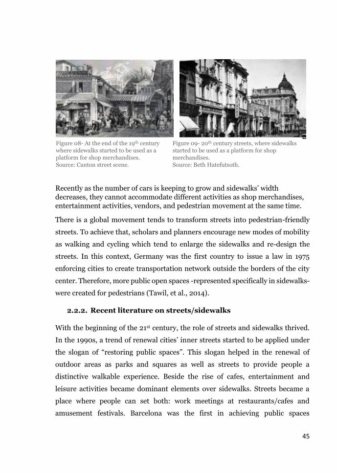
By the end of the 19th century, specialized shopping streets were known over cities,
shops exposed their merchandises on sidewalks and craftsmen exposed theirs in
front of their houses (Fig.08). Then, shop stands became permanent elements on
sidewalks, food carts started to be integrated within shop stands; a common open
platform was created where there is no separation between private and public
ownerships (Werf, et al., 2016). Since then, sidewalks played an important role at
Figure.06- Sidewalks and street markets in
the 16th century.
Source: Lucas van valckenborch
Figure.07- Sidewalks and streets in the 19th
century.
Source: Lucas van valckenborch

44
unifying the streetscape of cities. They were considered not only a place for
pedestrians but also a place where people can interact and achieve economic
benefits through different activities, which became a part of people’s everyday life.
As a consequence, shops were merged with the ground floor of buildings, glass
facades for display were introduced.
After world war II, large urban expansion occurred, followed by an enormous
increase in number of cars. Hence, sidewalks width decreased and large streets
invaded the cities where no places available for pedestrians as well as highway
roads were created to facilitate reaching new towns and neighborhoods (Gehl &
Gemzoe, 2003).
According to The Congrès internationaux d'architecture moderne (CIAM), Le
Corbusier tried to figure out a solution for pedestrians’ issues. Therefore, he
created the vision of “rue corridor”: the enclosed streets in order to divide
districts into small blocks with small shopping areas to increase the number and
width of sidewalks. Yet his plans were not used in several counties and a new
urban concept of open buildings was introduced. This concept allowed stores to
have a large exposed glass windows on the main streets whereas the entrances of
the stores allocated in secondary-back streets, cafes started to be merged with
pathways and sidewalks, street vendors appeared in an individual informal
pattern on the edges of the sidewalks opposite to the shops’ windows (Fig.09).
Later this concept was called “transparent streets” as it boosted interactions. yet,
sometimes it was a main reason of interfering pedestrian’s walkability (Werf, et
al., 2016)
45
Recently as the number of cars is keeping to grow and sidewalks’ width
decreases, they cannot accommodate different activities as shop merchandises,
entertainment activities, vendors, and pedestrian movement at the same time.
There is a global movement tends to transform streets into pedestrian-friendly
streets. To achieve that, scholars and planners encourage new modes of mobility
as walking and cycling which tend to enlarge the sidewalks and re-design the
streets. In this context, Germany was the first country to issue a law in 1975
enforcing cities to create transportation network outside the borders of the city
center. Therefore, more public open spaces -represented specifically in sidewalks-
were created for pedestrians (Tawil, et al., 2014).
2.2.2. Recent literature on streets/sidewalks
With the beginning of the 21st century, the role of streets and sidewalks thrived.
In the 1990s, a trend of renewal cities’ inner streets started to be applied under
the slogan of “restoring public spaces”. This slogan helped in the renewal of
outdoor areas as parks and squares as well as streets to provide people a
distinctive walkable experience. Beside the rise of cafes, entertainment and
leisure activities became dominant elements over sidewalks. Streets became a
place where people can set both: work meetings at restaurants/cafes and
amusement festivals. Barcelona was the first in achieving public spaces
Figure 08- At the end of the 19th century
where sidewalks started to be used as a
platform for shop merchandises.
Source: Canton street scene.
Figure 09- 20th century streets, where sidewalks
started to be used as a platform for shop
merchandises.
Source: Beth Hatefutsoth.

46
movement and renewal of streetscape which allowed the city to host Olympic
games in 1992 (Werf, et al., 2016).
Other cities started to follow Barcelona approach of renewal although their motive
was the economy rather than the distinctive walkable experience. Therefore,
several projects were created in European cities around the world; brownfields
and old harbors were renewed and transformed into open streets for leisure as
well as housing and headquarters. Public spaces, green spaces, new infrastructure
as wide sidewalks, tunnels and pedestrian friendly-streets were introduced as the
case of Hafencity in Hamburg and the Eastern Docklands in Amsterdam (Gehl &
Matan, 2007).
This variety of public spaces movement created several opportunities for
pedestrians by enhancing their walkability. One of the successful models was the
champs Elysées in Paris, where sidewalks represented the main component of the
streets so people can wander along restaurants and shopping axis. The synergy
resulted after renewing the champs Elysées between streets, houses, activities
became more robust (ibid).
After the success of Paris streets, planners decided that there is a need to connect
buildings with streets using vibrant facades. Hence, “shared space” concept was
redeveloped, contradicting Germany’s law 1975 (creating a traffic network outside
the borders of the city centers). This new approach is adopted till our present
days, considering streets as quintessential component of urban public spaces
which could contain everyone without separation between traffic, pedestrians,
and activities (Miller, 2007). Therefore, scholars and planners started to frame
streets, sidewalks, sidewalks’ activities into clear definitions illustrating the
evolution and significance of terms as well as identifying their role in people’s
everyday life use.

47
2.2.3. Evolution of research terms and their significance
In this study several words are being used interchangeably that can be curtailed
in streets, sidewalks, walkability/ walkable sidewalks, and informal practices. As
this research tends to explore and investigate the effects of informal practices on
people’s walkability on Cairo’s sidewalks. Hence, the means and purpose of
walking is not one of the data that the research will track. In other words, for the
researcher there is no difference between people’s walkability in terms of reaching
a destination or in terms of leisure and enjoyment. Therefore, this section will
identify the meanings and significance of the research’s fundamental key words
from several authors’ perspectives.
2.2.3.1. Streets
Streets are considered as the main component of the urban fabric. The units
through which cities’ identity could be easily revealed, and their existence
facilitate people’s movements from one point to another. According to (Global
Designing Cities Initiative, 2016), a street is the fundamental multi-dimensional
area which extend between two buildings; edges, and it include different land
uses, and activities to define its borders. One of the main streets’ advantages is
their ability of adaptation and dynamism, as they accommodate to the different
social, economic activities, and cultural significance that change through time.
Over time, streets and their significance were defined differently by several
authors. Some of them addressed streets through a morphological meaning and
physical existence whereas others claimed that the importance of streets lies
within their social and cultural identity. (Taylor & Rapoport, 2015) focused on the
morphology and the different structures of the streets, which eliminate their role
to accommodate activities that take place over the streets. Therefore, they assure
that “the main role of streets is limited within people’s or vehicles’ circulation, no
matter their width or length are, as long as they are the open spaces between
buildings”.

48
However, on the other hand urban scholars started to re-define streets as social
spaces focusing on their activities, in order to create supplementary definitions
for the ones which focused on the physical side only. In this context, one of the
famous definitions of streets in terms of social aspect was initiated by Jan Gehl in
his book “Cities for people”. He stated that “street life was what grew through
the cracks in pavement—a liveliness that thrived despite the asphalt and traffic,
they are the foundation of a city’s entire social structure and activities— getting
around, working, living, shopping, and playing”. Jan Gehl quoted words
reflected the importance of streets in the everyday life, and its dominant role as a
social space. Following Jan Gehl approach, other scholars affirmed his concept by
describing streets as “the social community through which people could link,
communicate, and socialize”. (Mehta, 2013), (Sadik-Khan, 2017). Since then, this
was the most recognized description among scholars for streets’ use and
significance (Global Designing Cities Initiative, 2016).
As a result for the previous definitions of streets, (Bain, et al., 2012) classified
streets into several typologies according to their own perspective. In order to
better understand how streets could help in creating better and integrated
communities. As a brief classification, they created five terminologies through
which streets types were identified: Alleys, residential streets, Green streets, Main
streets, and Festival streets.
Alleys: (Bain, et al.) addressed the significance of alleys into the service role they
provide as they were considered as utility corridors, yet they are most
underutilized type of streets. In several communities, alleys are treated as the
main spaces for meeting and gatherings, and most of the time they are used for
lively concentrated retail.
Residential streets: in terms of square-meters and width, residential streets come
in the second place after alleys. They exist in every neighborhood, people residing
in the area use them as their own property. Residential streets have endless

49
characteristics, beside the low traffic they support communities’ activities as
walking and cycling.
Green streets: unfortunately, this kind of streets does not exist all cities. The main
purpose of designing green streets is to take advantage of the public spaces
around the city, they supposed to function as urban streets free of any physical
features except from landscaping elements as trees and greenery in order to
provide open green spaces within the streetscape of cities.
Main streets: the largest, and widest type of streets among the different
typologies. They are considered as an economic engine of any city, the most
common type of streets that scholars previously defined. Include several types of
physical features and social activities. The more main streets are capable to
accommodate diverse activities yet without interfering each other’s the more they
are categorized as successful models.
Festival streets: are the last typology illustrated by (Bain, et al.). Some of the main
streets could be considered as festival streets as long as they have the physical
conditions to be easily shifted in terms of features. As festival streets are the
roadways that accommodate extra temporal activities for short periods.
2.2.3.2. Sidewalks
Sidewalks are the vital part of the streets, where all the activities take place, they
have almost the same characteristics of the different streets’ typologies (Çelik, et
al., 1996). From a planning perspective, planned and integrated sidewalks
contribute to the reflection of the city image, if the sidewalks reverse a
motivational/ interesting image therefore, the city is interesting and if not then
the city is not well-planned (Jacob, 1961).
According to (V.Mehta, 2007) sidewalks were re-conceptualized to be identified
as a proper space for transportation, as well as he defined sidewalks as “the
energetic open spaces that represents the urban system in terms of livability and
vitality”. “If streets were defined as public space for the interaction and the social

50
gathering then sidewalks are the main reason behind this classification” (Fyfe,
1998). In other words, (Fyfe) in his book Images of the streets was trying to
identify that the significance of sidewalks lies within its fundamental role in the
streets, as they are the basic units of the public open spaces where people could
rely on, in order to achieve social, economic and cultural purposes.
In Greek and roman old cities, there was no existence for a clear space to be
defined as a sidewalk yet they created borders to surround each and every
building and defined it as an edge (Carcopino, 1941). However, some authors as
(Kostof, 2005) considered the existence of the edges as a preliminary appearance
of the sidewalks. Hence, he assured that the first sidewalk was created 2000 BC
in turkey in a form of an edge then it was developed later in the 16th century and
then in the 19th century specially with the increase of urbanization and population.
Whereas other authors as Jane Jacobs, built his definition after defining the
sidewalks according to dictionaries. As stated in his book the death and life of
American cities, the original definition of sidewalks was: “a narrow or a wide
paved path located between buildings and streets’ borders, which fulfil
pedestrians’ services”. For Jacobs the developed definition of sidewalks was “the
well-paved pathways which include activities for pedestrians’ needs and
amusement, with a main role of keeping neighborhoods secured and
comfortable”.
The lack of arguments around the sidewalks might be because several authors
restricted their definitions into streets as if streets and sidewalks are one unit
(Blomley, 2009). Therefore, (Loukaitou & Ehrenfeucht, 2012) discussed
sidewalks in terms of value, and claimed that they are the parts of cities that are
taken for granted, yet they have been always used by people every day. The type
of activities the sidewalks accommodate are the factor through which people
perceive it (ibid).
Other authors overlooked the scientific and urban definition for sidewalks and
described them as “the linking chapters in a long story where the story represent

51
the whole city” (Franck & Stevens, 2006), these chapters were and will always
remain the core of the story (city) in which people could explore and discover the
hidden gems of it. Hence, (Michel De Certeau) studied in his book “The Writing
of History (European Perspectives” , people’s perception on sidewalks as
chapters of a story.
He assured that people perceive sidewalks as an interaction space and gatherings,
and these social gatherings could last for a long time if the sidewalks hold the
ingredients of comfort. The results of his interviews showed that people
recommended wider sidewalks, with wide trees’ canopy, and fixed seating
elements (Fig.10).
One of the in-depth analysis on sidewalks was done by (Annette Miae Kim) the
associate professor of public policy at the University of Southern California. She
illustrated in her book “Sidewalk City: Remapping Public Space in Ho Chi Minh
City”: how the evolution of cities affected streets in particular sidewalks
development. Her methodology and empirical approaches assigned her to easily
introduce us the importance of sidewalks in the everyday life, and how the use of
a sidewalk could affect a whole city vibrancy.
Figure.10- Sidewalks creating a gathering point because of the
comfort aspects
Source: Michel de Certeau

52
2.2.3.3. Informal practices on the sidewalks
Activities performed on the sidewalks could be classified into several categories,
the most common classification is: 1-movement and accessibility, 2-interpersonal
and social activities. Both categories affect each other mutually (Hanzl, 2013).
This mutual effect as well as their effects on -public spaces in general and
sidewalks in particular- was explained by (Appleyard, et al., 1981). They clarified
that the second category: interpersonal and social activities include the diverse
activities on the sidewalks counting the informal practices and interventions.
Informal practices could be simply defined into the elements that interrupt
people’s comfort in using the sidewalks as well as their walkability. They differ
from a city to another even it can differ from a sidewalk to another according to
the type of street and neighborhood (Donovan, 2003).
In the study of the anthropologist (Clifford Geertz), a preliminary clarification of
sidewalks activities were revealed. He illustrated that the disorganization of
activities as well as the street vendors –as a part of informal activities- on the
sidewalks were established in cities’ culture since the old humiliation, and they
might be a non-stoppable phenomenon in every street. This assumption on the
on-going existence of informal practices was confirmed by (International Labor
Organization report, 1972), arguing that these practices have an important role in
both: sidewalks’ development and cities’ economy.
Lately, different entities and organizations started to take actions towards
organizing the sidewalks’ activities. In order to improve people’s enjoyment and
walkability while using the sidewalks (Han, et al., 2019). Especially the non-
governmental organizations (NGOs), as they adopt the different perspectives and
the ideology of facilitating negotiations between: the pedestrians and the workers
of the informal sector as well as the street vendors. One of the well-known NGOs
is the “international net” which aims to organize and develop the informal sector
to achieve a main goal of establishing a well-planned social network and quality
of living (Bonner, 2009). Hence, several stakeholders assure at the importance of

53
keeping informal practices as they have positive and negative side, depending on
how they occupy the public spaces. However, from a governmental perspective
informal practices should disappear completely as they are the main source of
chaos on the sidewalks. Therefore, the government in many cities operated “the
vanishing and re-allocation” campaigns, to preserve the global city image which
will always create negotiations through neglecting the positive side of these
practices as a daily need for some sectors.
2.2.3.4. Walkability/Walkable sidewalks
The term walkability had been defined several times in different books and
articles. The most common definition is “a human act that could be restricted by
several factors, whether physical, environmental aspects as well as social
preferences and individuals’ perception”. Regarding social preferences and
individuals perception, they come from a pure culture preferences whereas the
physical and the environmental aspects depends on the nature of the walking area
as well as the physical characteristics of the sidewalks/ streets that accommodate
walking (Mehta, 2008).
(Najmaldin Hussein, 2018) referred in his article “The Pedestrianisation and Its
Relation with Enhancing Walkability in Urban Spaces” to the possibility in
determining whether the sidewalks are walkable or not. He illustrated that the
main factor that affect peoples’ decision to walk is the built environment and the
physical elements on the sidewalks, as they are the main motive behind their
perception. Therefore, walkability could be considered as a way of assessing
sidewalks/ streets.
Another definition of walkability by (Zarzelli, et al., 2019), trying to build on the
previous definition. “walkability is determined by several conditions beside the
physical aspects, where safety comes in the first place then accessibility and finally
the aesthetics of the pathways” Assuring Zarzelli, Ilic, & Sawada definition on
walkability, a well-explained definition was illustrated by (Michael Southworth,
2005), he declared that “walkability is the mean of encouraging people to

54
explore the physical and cultural aspect of their cities using the sidewalks, as
long as it provides safety and comfort, and connect people to their destinations
using the minimum effort and time.”
As this study will be focused on sidewalks as a micro scale and streets as a macro
scale, some key elements in term of the built environment and the physical
aspects should be available on the sidewalks level. Therefore, (Michael
Southworth) grouped the elements that have to exist on the sidewalks into
categories. For example, the first category was emphasizing on the importance of
sidewalks’ connection in order to facilitate people’s accessibility, and the width of
sidewalks should be relative to the street and the activities occupying the space.
The second category was focused on the conditions of streets and sidewalks
illustrating the significance of well maintained sidewalks, the existence of
crosswalks, and signs in order to regulate the formal/informal activities, ensure
safety, and boost the walking experience.
2.3. Streets and sidewalks: informal practices vs walkability
in urban spaces before and during the pandemic
2.3.1. Physical configuration: Streets/sidewalks as urban public
spaces
As the research is focusing on
exploring the effects of the
informal practices on people’s
walkability and the effective
width of the sidewalks. This
section is concerned on the
physical configuration of the
streets and sidewalks before
and during Covid-19
pandemic. Starting with

55
defining them as a part of the public spaces in general, then illustrating the
physical key attributes of walkable sidewalks with the existence of informal
practices before and during the pandemic. This will be through a brief
presentation on the three concepts and approaches of sidewalks in terms of
sharing the streets with different users which is relevant to the case of the
research. These approaches are: living streets/ sidewalks, sidewalks as shared
zones, and the 5 C approach. Followed by understanding the changes occurred in
urban public spaces and the key attributes of streets/ sidewalks during the
pandemic.
2.3.1.1. Urban public spaces before the pandemic
In normal cases of urban spaces -with no pandemic- and according to the previous
historical background, the rise of market places represented an important role in
people’s everyday integral life, where they could gather and strengthens their
social habits. Because of the street markets, main roads, streets, sidewalks and
buildings’ pockets became places where people spontaneously meet and socialize
to exchange information. Therefore, they were considered as cities’ connection
system (Gehl & Gemzoe, 2003). Due to the rapid urbanization, new means and
roles of public spaces were introduced (Weintraub, 1997).
The existence of different and several approaches of renewing and introducing
new means of public spaces awaken the interest of scholars to define public space
in general and streets/sidewalks in particular, in terms of ownerships,
accessibility, different social activities…etc. In this context, (Shaftoe, 2012)
represented in his book “Convivial Urban Spaces” the different ideologies and
definitions of public space through different authors’ perspective. As (Shaftoe)
stated in his book, some authors defined public space in terms of perception while
others defined it in terms of accessibility. According to (Gehl & Matan), people
perceive public space as a space where they can interact whether for social or
recreational purposes.

56
Other scholars described urban public spaces in terms of ownership as
(Madanipour, 1996). He stated that “public spaces are the places that no one owns
it, they are not guarded by individuals, governmental entities, or private sector
therefore, anyone can easily access it.” Whereas (Garau, 2015) defined public
spaces as “the accessible public facility in terms of spatial configuration and
economy where people can access it for free”. Therefore, public spaces are not
restricted on parks, and playgrounds yet streets, sidewalks, squares are
consequently included.
Although public space is not limited in the physical aspect but it is important to
commend the integration of the social aspect represented in the various activities
as well as the social behavior that take place in public spaces (Mitchell, 2003). In
this regard, (Garau, 2015) claimed that public space gain its value when it can
fulfil users’ different needs. Therefore, it can be defined as a “common platform
combining a wide range of diverse activities yet without interfering each other’s
preferences of using the space, a place where individuals can enjoy the shared
rights of their cities.” In other words, in public spaces -starting from a small alley
passing by a sidewalk, street, square to a large park- people should enjoy the
equity as well as having the rights for the basic facilities and entertainment
activities such as having a walking experience without interruption, smooth
cycling tours, sports facilities, and interaction (ibid).
Talking about streets and their sidewalks as part of public spaces, they are
considered as the most important parts of a cityscape. According to (Kim, 2015)
streets and sidewalks represent the largest part of a city in terms of area. In most
cities they sometimes surpass the area of parks and playgrounds which
indisputably represent the public spaces. Hence, (Bain, et al.) in their book
“Living streets: Strategies for Crafting Public Space” illustrated different
approaches that fit each and every one of streets/sidewalks’ users as pedestrians,
residents, governmental entities and policy makers. The book illustrated also the
best ways to use sidewalks and streets in order to contain several activities and
users. Assuming that the interconnection of a city result from well-connected

57
streets with homogeneous activities on the sidewalks that boost people’s
walkability.
(Bain, et al., 2012) claimed that the motive behind the book was the global trend
of defining streets as main components of a city’s public space to encourage the
creation of a wide area for pedestrians. In order to achieve this, the book defined
cities as the breathable, high quality place to live, work, and relax. The streets and
sidewalks are the places where any citizen spend 70 percent of his life. Hence, the
book illustrated the significance of creating well connected sidewalks and streets
to achieve a healthier, more satisfied life for any city resident. Thoughtful chosen
uses and activities as well as a good planning of their location and arrangement
on a sidewalk will definitely encourage people to use and enjoy streets as public
space. As well as planned streets will achieve walkable communities, which will
support social interaction and leisure.
In the same context in 2012, project for public spaces (PPT) initiated a manual in
association with the AARP for public and open spaces’ projects and development.
Named as Place making and The Future of Cities, aimed for “improving streets
and sidewalks as public spaces to rebuilt communities” (Kent & Madden, 2016).
The project adopted the ideology and concept of redesigning the streets and
sidewalks into more safe, accessible, entertainment, and comfortable spaces
focusing on pedestrians as the main beneficiaries. As well as providing several
guidance for sidewalks’ integrated design for sustainable use to achieve a better
public realm.
2.3.1.2. Key attributes of walkable streets/sidewalks with the
presence of informal practices before the pandemic
A. Living streets and sidewalks
The main aim of living streets and sidewalks’ concept is to improve the mobility
for pedestrians only without including vehicles’ movement, as well as increasing
the safety of users while using the sidewalks. The approach can be applied for
both: existing streets/sidewalks or newly designed ones, it focuses more on the

58
efficiency of sidewalks rather than streets (Nue urban concepts, 2017). The
concept was initiated in the first place to ensure a safe accessibility for different
users, including vehicles’ drivers, residents, shop owners and street vendors.
Therefore, according to (NZ Transport Agency, 2009), “the main aim of living
streets and sidewalks is represented within the context of an impartial
equilibrium between the needs and shares of every user in order to encourage a
better quality of life with the existence of a diverse activities on the sidewalks”.
The concept is considered as the new version and development of the German
woonerfs approach where cars are not allowed to overcome certain speed limit,
as a way for achieving safety for pedestrians (Nue urban concepts, 2017).
In order to achieve the living approach, some elements need to be incorporated
within the sidewalks’ systems, whereas some of the currently existing ones needs
to be more organized such as the street vendors, the temporary and permanent
food stalls that occupy the pedestrians’ zones, as well as the unorganized street
furniture and services kiosks. According to (NZ Transport Agency, 2009), the
elements that should be considered by planners and designers while designing
both new streets and sidewalks are defined as physical additions to streets and
sidewalks. They could be illustrated in: lighting poles for cars/bollards on the
sidewalks for pedestrians, organized sidewalks’ furniture, landscaping elements
as trees and identifying a well-organized zone on the sidewalks for extra activities
that today might be named as informal activities.
The New Zeland Transport report aimed to encourange planners to adopt the
living streets and sidewalks approach by stating the advantages that might ocuur
as a consequence. First personal safety and security of pedestrians as well as
residents will increase. Secondly, the economic vitality will be developed. And
finally, the social interactions on the sidewalks will increase as well as the sense
of belonging and place identity.

59
B. Streets and sidewalks as “Shared zones”
Shared zone concept is considered as the second concept for improving people’s
walkability. Unlike the living streets and sidewalks concept, this concept focuses
more on the streets improvement. It is kind of a planning approach for streets,
with a main goal of improving and upgrading the public realm. Through
decreasing the negative effect of car dominance as well as realizing a convenient
balance between the social interaction in streets and walkability in order to give
priority to pedestrians (Gillies, 2009).
According to (NZ Transport Agency, 2009), shared zones approach introduce
streets as a common right for both cars and pedestrians movement. It depends on
integrating physical street elements that aim to reduce risks of vehicles on the
pedestrians. Such as: fixed signs to persuade car drivers to slow down, creating
speed hump, and pedestrian crossings.
Hence, previous examples of shared zones demonstrated successful benefits,
streets witnessed low speed cars, remarkable decrease in congestion, less car
accidents, and finally, more pedestrian streets were created with more social
interaction and attractiveness (Gillies, 2009).
C. The 5 Cs approach
The 5 Cs approach is a comprehensive concept of categorization streets and
sidewalks, that aims at improving their quality while accommodating different
activities in order to improve pedestrians’ walkability (UK Department for
Transport, 2007). The approach focuses more on prioritizing people’s needs on a
sidewalk, therefore, it could include all the activities whether formal or informal
ones (ibid).
The approach is referring to all the features that streets/ sidewalks should offer to
pedestrians while walking (Methorst, et al., 2010). It recommends that
streets/sidewalks should achieve 5 concepts in order to boost the walking
experience. It demands streets/sidewalks to be:

60
Connected: through a complete chain of routes and sidewalks whether on a macro
scale as connected streets or micro scale as sidewalks connection physically or
visually.
Convivial: sidewalks have to be well structured, which support social interaction
through the existence of users’ needs in an organized way. Hence, the routes will
be more safe, pleasant and comfortable for pedestrians.
Conspicuous: to ensure an enjoyable and a smooth walking experience, there is a
must of providing streets with a clear signage and the same for the shops and the
activities on the sidewalks in order to make destination more visible and
reachable for all users.
Comfortable: by providing physical features as seating elements, and shading
devices as well as periodical maintaining for the sidewalks pavement.
Convenient: the final C, aims at making the streets and sidewalks an appropriate
place to accommodate different users, as well as achieving efficiency by creating
simple sidewalks with a cost-effectiveness in design and function.
Through achieving the different walkable approaches, sidewalks and streets could
accommodate the different activities without interfering pedestrians’ safety and
comfort while using the streets and sidewalks. Only if, activities patterns follow
the same concept. Therefore, it is important to understand the patterns of uses
occur on the sidewalks and understanding their relation with people’s walkability.
2.3.1.3. Urban public spaces and key attributes of
streets/sidewalks during the pandemic
With the occurrence of the pandemic –whether corona pandemic currently or
previously occurred pandemic-, the use of public spaces has changed around the
world. The pandemic totally changed the way that people physically use the
surrounding spaces in their daily life. According to (Sadik-Khan, 2017), urban
public spaces changed their functions -especially streets and sidewalks- due to the
imposed regulations by the governments as the social distancing regulation for

61
instance. The requirement of the physical distancing enjoins people to keep at
least 1.5 meters between each other while using any public space, with a
significant reduction for any group gatherings which require a wider open space
for the same number of people who were using the same space before the
pandemic.
New settings had been added during the time of Covid-19 pandemic which is “the
extra use of sidewalks”. As indoor facilities must re-allocate their space therefore,
they use parts of sidewalks and streets as parts of their territory. And according
to Sadik-Khan, this kind of appropriation could not be considered as informal
extensions as it occurred due to the pandemic situation. Therefore, cities started
to create key attributes and approaches to adapt and change their public spaces,
streets, and sidewalks in order to prepare them to cope with the crisis hence, their
citizens stay safe.
As successful model of cities that are making changes in their physical
environment specially in their streets and sidewalks, is London, Bogota, Oakland,
and Paris (Sarkin, 2020). London for instance was the first city that came up with
the plan of “Mayor’s Street space” which aims to track the transformation of
London streets in order to allow extra number of people experience new cycle
lanes, and wider pavement for social distancing walking. Bogota in Colombia and
Oakland released “Slow streets initiative” which is responsible to set aside 10% of
the city streets and sidewalks for recreations and started to limit 80% of the
informal practices occurred on the sidewalks as vendors, food carts, informally
parked cars and motorcycles, and shop merchandises.
According to Sarkin, Paris applied both approaches: the plan of London mixing it
with the initiative of Bogota and Oakland. Hence, a new framework and policy
was created. The main aim of this framework is creating a “15-minute city” (Fig.11)
with each and every daily need, that every citizen has a 15-minute short walk, bike
ride, or a public transit stop.

62
Figure.11- 15-minute city planning framework Paris en commun.
Source: micaëla
A. “Mayor’s streetscape and sidewalks” approach during the
pandemic
Mayor’s streetscape and sidewalks was the first approach published after the
prevalence of Covid-19 pandemic regarding the walking experience on sidewalks
in terms of practices. According to (Khan, 2020), this approach is mainly to help
London’s streets and sidewalks to adapt to the pandemic situation through
accommodating ten-times the number of cycling people and five-times the
number of pedestrians with the presence of informal practices of the sidewalks.
Therefore, the approach focus on four main aims to be implemented in the
majority of London’s streets as:
Creating new cycling lanes as well as widen the sidewalks as much as
possible to easily accommodate same/ higher number of people keeping
the social distancing.
Eliminate the majority of informal practices on the sidewalks, and re-
allocate them to a combined market place.
Instead of these practices, clean greenery and trees are allocated.

63
Reducing the number of cars and traffic on the residential streets in order
to allow extra number of people to use the sidewalks.
B. “Slow streets and sidewalks” approach during the pandemic
The second approach to support the new way of life due to Covid-19 pandemic is
“slow streets and sidewalks” approach. Based on (Schaaf, 2020), it has the same
big aim with the previous approach but it had been applied in different cities with
different objectives. Mainly this approach creates safe physical environment
through focusing on creating more space for pedestrians in terms of social
distancing regulation (ibid) (Fig.12-12’).
This approach requires less encouraging to cars’ drivers to use the chosen streets
unless there is a necessity to reach certain destination. It also forces them to drive
slowly, yet it was difficult to several people to stick to this approach while driving.
Therefore, specified point were launched by the governments of several cities
starting from Oakland, they urge that:
Car lanes have to be reduced from two or three lanes to only one lane in
both streets’ directions.
Installing sign ages referring to the slow approach in every street.
Remove all sidewalks’ informal practices except from the ones that highly
fulfill the needs with the condition that it doesn’t interrupt pedestrians’
walking experience.
Figure.12-12’- Applying the “slow streets and sidewalks” approach in Oakland.
Source: (Schaaf, 2020)

64
Create single chairs as street furniture with an in-between distance of 2
meters.
Add extra greenery as separators or buffer zones between sidewalks
practices and sitting elements.
Add street crossing to improve pedestrians’ walkability.
Encourage cycling as a main way of transportation.
2.3.2. Behavior patterns: uses and activities
As mentioned before in the
research framework, the
physical configuration,
uses/activities, and users’
perception are considered as
the interlinked chains that
frame the walkability
experience (See fig.04). This
section illustrates the
different activities occurs in
public spaces, and how do the uses on the sidewalks as well as people’s patterns
around these activities -which sometimes are considered as territorial behavior-
could affect people’s walking experience and sidewalks configuration before and
during Covid-19 pandemic.
o Sidewalks’ patterns of uses and their impacts on people’s
walkability before and during the pandemic
2.3.2.1. Activity pattern of uses on the sidewalks and buildings’
ground floor use
Jan Gehl in his book “Life between buildings: use of public spaces” illustrated
that people’s activities are the most important features in any public space as they

65
are considered the main representative of public spaces’ identity. His proof was
according to the theory of attraction “in public spaces activities attract people”.
Assuring that people always prefer vital places, if anyone has to choose whether
to walk in an empty roads or lively ones, he will definitely choose the livability.
Activities in any public space are classified into three types: functional
fundamental activities, non-obligatory recreational activities and social
interactive activities. Each kind of these activities impact the number of people
using the space, their behavior as well as the pattern of public spaces in different
ways (Gehl, 1987), As Gehl’s conclusion, a public space became socially interactive
and meaningful when the three types of activities exist in an integral way.
With the same ideology of Gehl, (David V. Kanter) claimed that public spaces are
easily identified by their activities. The reflective image of any place is derived
through the type of activity it can contain as well as the buildings ground floor
uses. Hence, the understanding concept of the majority of public spaces lies in the
patterns of activities which the place can accommodate (ibid).
Talking about activities on the sidewalks, buildings’ ground floor uses are
considered as an important aspect in designing the sidewalks. They act as the
main engine that is responsible of the activity patterns occurrence on the
sidewalks as well as people’s behavior (Guaralda & Joyce, 2013). Whenever there
is a linkage between a street and ground floor shops, the in-between barriers of
outdoor and indoor will vanish. Therefore, indoor shop activities of buildings’
ground floor will consequently extend to the outdoor space, which sometimes lead
to the informal practices on the sidewalks affecting people’s walkability in both
negative and positive ways (Gehl, 2013).

66
2.3.2.2. Permeability
Permeability is another accelerator for activities’ extensions on sidewalks and
informal practices (Elsheshtawy, 1997). It is a common feature between the
physical and social aspects as it can be in form of both physical and visual
permeability. The physical part can be represented in the ease of accessibility
whereas the visual indicates the transparency of ground floor shop facades.
According to (Gehl, 1987), sidewalks’ shops transparency represents the level of
people’s interaction with the activities, the more transparency the shop facades
are, the more interactive people become and the more existence of outdoor and
informal activities the sidewalks got (Fleury-Bahi & Pol, 2017).
(V.Mehta) referred to the significance of visual permeability through glass facades
only without the outdoor extension on the sidewalks play an important role in
shaping the identity of public spaces. As well as the ability of users in seeing what
are beyond the shops will probably create active sidewalks though without
interfering their comfort and walkable experience. Therefore, pedestrians will be
attracted in a way or another to explore what are beyond the glass edges.
2.3.2.3. Territoriality and personalization before the pandemic
This act of shop extensions toward the sidewalks that Jan Gehl referred to -while
he was defining the transparency and the visual permeability- is considered as a
form of activities’ territories in public spaces (Taylor, et al., 1984). Therefore,
different scholars defined territoriality as “the main gate through which people
deals with the urban public spaces” (Jacob, 1961), (Newman, 1996). Whilst others
as Edward Twitchell Hall illustrated territoriality in his book “La Dimension
cachée” in a more detailed definition. He stated that territoriality is “the behavior
that is first recognized in animals, it could be considered for humans as the
behavior that is related to physical spaces, which include an act of claiming areas’
ownership through adding barriers, marking elements, or artifacts”.
Building on Hall’s definition, (Irwin Altman) assured that as a result of territorial
behavior the border between public and private spaces could be unclear to several

67
users and might confuse them while doing their daily activities in public spaces.
Therefore, Altman defined it as “the area’s ownership claimed by people for a
specific time”. Demonstrating that the temporality of territorial behavior will not
affect public spaces’ users as the ones who claim for ownership will not have the
right to add any sort of physical barriers. On the other hand (Edney, 1976),
claimed that it is not common that people who claim for a part of urban space will
abstain adding physical barriers.
According to (Gehl, 1987), when the level of personalizing a public space area
increases, people start to use extra elements as signs. In order to associate
occupancy of the public space to claim territories. The sense of territorial activities
affects human behavior which consequently impact the security and maintenance
of the built and urban environment (Taylor & Brower, 1980). Aside from signs,
temporary sidewalks’ furniture was always used by shop owners to appropriate
territories in public spaces especially on the sidewalks. As movable streets’
furniture are easy to be controlled by people at different times (Ewing & Handy,
2009). Another psychological remark by (William H. Whyte, 1980) in his book
“The Social Life of Small Urban Spaces”, he observed that people usually prefer
moving chairs or tables before using them, which considered as an act of
appropriation.
Hence, urban planners came up with a general definition for territoriality and
personalization. “They are defined as acts of spatial dominance which affect
public spaces’ resources and users through appropriating the area” (Mehta,
2009). When shop owners, vendors and other activities’ owners start to
personalize the public space, users start to adapt to the surrounding urban
environment by adjusting the existing elements to meet their own needs. Which
usually are not a well-planned adjustment that produce a multi-layering of
territoriality leading to informality of practices and patterns (ibid). This multi-
layering of territoriality in public spaces conduct some kind of territorial
complexity (William H. Whyte, 1980). This complexity should be considered as a
natural phenomenon of people’s everyday life only if people dealt with it in a

68
planned way without interfering their other every day’s activities (Kärrholm,
2005).
2.3.2.4. People’s behavior and territoriality during the
pandemic
With the prevalence of Covid-19 pandemic, as the streets and the sidewalks
(urban public spaces in general) changed in terms of physical configurations,
people’s behavior and their personalization to the sidewalks changed eventually.
The majority of them started to re-thinking the streets and the sidewalks in order
to move in a safe way during their walking journey. According to (Sadik-Khan,
2020), during the pandemic, people started to get the awareness of being in a
transitional phase that might continue forever . Therefore, they configure
themselves the streets and the way they act and behave while wander along the
sidewalks.
So as a start, people around the world when they started to re-use the streets and
the sidewalks again after the lockdown, they safely access their daily needs using
the queuing method with keeping an adequate distance outside the grocery stores,
markets, and the public business (Fig.13).
Figure.13- Queuing method as a response behavior for the pandemic in pick-up daily needs
and transit.
Source: Represented by the researcher based on Sadik Khan.

69
After the restrictions are lifted, sidewalks became almost empty from informal
practices and being replaced by rooms for restaurants and other services sitting
elements outside the borders of shops’ territory (Fig.14). The advantage that
people got through the pandemic experience, is to use the streets and the
sidewalks in a way that could provide them extra social services -as cycling and
streets’ markets- than before through organizing all their needs in a smart way to
be easily accommodated by the sidewalks (Sadik-Khan, 2020), (Fig.15).
Even the shop owners they started to divide the sidewalks into zones and use only
one zone for their merchandises loading to allow more space for pedestrians and
other activities to benefit from the rest of the sidewalk and keep the social
distancing in the same time (Fig.16). while using wider open space, people create
boundaries to themselves in order not to exceed each other’s personal distance
(Fig.17).
Figure.14-15- Restaurants’ sitting elements along streets and sidewalks/ extra services as
streets’ markets.
Source: Represented by the researcher based on Sadik Khan.
Figure.16-17-Shops loading their merchandises using only one zone of the sidewalks/
organizing shared streets while keeping the social distancing.
Source: Represented by the researcher based on Sadik Khan.

70
2.3.3. Personal preferences: Users’ perception before and during
the pandemic
The final section will
illustrate the third chain in
the pedestrians’ walking
experience diagram. The
users’ perception which is
formed according to both:
physical and social aspects.
Whereas the research
illustrates the physical
aspect through streets and
sidewalks elements, and
the social aspect through the different activities they accommodate. Therefore, in
this section people’s needs/motives/perception will be discussed while using
streets and sidewalks accommodating informal practices under the umbrella of
environmental perception before and during the pandemic. A brief definition on
the images & meanings of the streets will be previewed as well as pedestrians’
needs, motives, and perception.
2.3.3.1. Environmental perception
According to several authors the environmental perception is a constant factor
that may not change according to the surrounding situations. That is why its
definitions remain the same whether before or during and maybe also after the
pandemic. One of the first and important authors that defined the environmental
perception was (Kevin Lynch, 1960). He started by defining the citizens’
perception about their cities. He stated that, “a city is the unit of civilization from
the physical and social perspectives. The citizens are the ones who form and shape
the city’s characteristics which develop their perception later”. In other words,
Lynch stated that the significance of perceiving the urban spaces is the main

71
motive of citizens in order to define and form images for their own city then for
their neighborhoods and finally for their surrounding streets and sidewalks.
Therefore, the term perception could include “the act of social interaction,
meetings as well as the individual understanding about their surrounding through
gathered information” (Carmona, 2003). Sometimes the act of perceiving a place
is considered more comprehensive than forming an emotional sense on the urban
surrounding (ibid).
On the other hand, environmental perception was defined by other authors than
urban planners such as geographers and policy makers. For instance, perception
from (Downs & Stea, 2017)’s perspective is “a term combining all the values,
meanings, memories, and other factors related to human psychology in order to
form what is called urban cognition”. The difference between perception and
cognition was illustrated in their book “Image and Environment: Cognitive
Mapping and Spatial Behavior”. Cognition is considered as the big umbrella
under which perception might be included. As well Downs & Stea clarified that
cognition can be defined also as the mental image of the urban environment.
Although, it is based on individuals’ experiences, hence, people deals and acts in
the urban public spaces specially streets as the way they see it and according to
their own previous experiences (Downs & Stea, 2017).
2.3.3.2. Image and perception of the streets/sidewalks
As mentioned previously, streets and sidewalks are considered as main public
spaces which accommodate different activities that affect people’s perceived
walkability. “As streets and sidewalks are the most diverse units of public spaces.
Therefore, there are several images and perception of streets/sidewalks, hence,
they are perceived by pedestrians in different and multiple ways. For critics a
sidewalk is considered as a place where community live, for others it is a place for
consumption and consumerism, yet others consider it as whether a dangerous or
safe place to walk and socialize.” (Mehta, 2008).

72
Sidewalks was also considered by Lynch as the physical element of streets which
help in constructing the image of the city as well as the pedestrian’s perception.
Therefore, when street users are asked what is the first thing that crosses their
mind when the word sidewalk is mentioned, there will be a wide variety of
responses (Mehta, 2008). These responses might be descriptive outcomes of
everyday scenes and experiences, strange observations that is not easily
recognized by urban planners and designers.
It also might include comments on the basic activities that sidewalks are made for
as walking and resting (ibid). Hence, it is difficult to categorize the street images
as they are large numbers of overlapped layers. Which are formed according to
the use, patterns, and sidewalks’ appropriation. As long as there are new activities
on the sidewalks, pedestrians’ needs will vary and then images and perception will
accordingly change.
2.3.3.3. Pedestrians’ needs, motives, and perceptions
Based on Sahar el Ghandour dissertation and her way of explaining how people
deal with practices while walking. Streets and sidewalks’ users have specific
needs, motives while walking in order to perceive the public spaces. According to
(Maslow, 1943), as stated in his theory of motivation, to achieve pedestrians’
motivation while walking or wandering through a space; different and multiple
needs have to be available. Illustrating the significance of five aims which are
considered as the main objectives accomplishing people’s motivation in different
public spaces. These five aims were classified by Maslow in a hierarchical
arranging where the lower need is more fundamental than the upper ones. They
were clustered in an ascending order starting from the bottom into: Psychological,
safety, love, esteem, and self-actualization (Fig.18). Which means that sidewalks’
users will be motivated first by achieving lower needs rather than achieving the
other ones.

73
Therefore, other authors as (Mariela A. Alfonzo, 2005) started to develop
Maslow’s triangle of needs into the walking needs triangle. In order to focus on
pedestrians only while walking in a public space, taking into consideration their
behavior and the availability of activities in the space. The walking needs triangle
is divided into five categories as Maslow’s triangle (Fig.19). It starts with the
feasibility which considered a non-urban category which focuses on individuals’
limits excluding the built environment. Followed by should be achieved first.
Pedestrians will never achieve a comfort walking experience unless safety and
accessibility are achieved four urban features as: accessibility, safety, comfort,
pleasurability. Following Maslow’s triangle, (Mariela A. Alfonzo) claimed that
users’ decision to start a walk and to enjoy the whole walking experience, bottom
level categories first.
However, pedestrians’ willingness to walk is not limited only on their needs yet,
it depends also on their perception and background. Therefore, (Mehta) started
to investigate street users’ perception and behavior in his book “Walkable streets:
pedestrian behavior, perceptions and attitudes”. As a main finding, “when
different people walk in the same streets, they will have different perception” (p.
240). Talking about different perceptions and backgrounds, (Geert Hofstede,
2001) illustrated that usually people with different cultural backgrounds won’t
seek or require the same needs. Hence, when walking needs are achieved they
Figure.18- Maslow’s hierarchy of needs.
Source: Maslow, 1943 based on sahar el
ghandour interpretation
Figure.19- Hierarchy of walking needs.
Source: Mariela A. Alfonzo, 2005,
based on sahar el ghandour
interpretation

74
became a personal issue affected by personal cultural and socio-economic
background.
On the contrary, (Methorst, et al., 2010) assured that, if the street user conscious
did not perceive one of the five needs clearly, he might not be able to explain this
need into a required aspect which could control his whole desire of walking. Not
only the unconsciousness of walking needs that affect the perception, but also the
low cost of walking and its feasibility will make pedestrians’ issues unrealized.
In this research, the main focus is conducted on pedestrians as the main target
users and their needs on the sidewalks with the existence of informal practices,
where the sidewalk environment is the main place of studying these needs.
According to (Kimmo Lapintie, 2007), pedestrians’ needs in terms of informal
activities have to be categorized into clusters. He defined the walking experience
in terms of informal practices into a multi-disciplinary perception/motives, which
is based on specific needs. These clustered needs are represented in:
psychological needs, existence needs, aesthetic needs, and the most important
public spaces related needs.

75
2.4. Summary
This chapter presented a literature review on the evolution of streets/sidewalks
through history, their significance as main public spaces of cities in
accommodating different activities, and their role in affecting people’s everyday
walking experience before and during Covid-19 pandemic. This was through
illustrating the relevant theories of the “walking experience” and the different
concepts and approaches of walkable sidewalks in terms of sidewalks’ informal
practices phenomenon, concerning people’s behavior while using the streets and
sidewalks vs the territorial behavior of different activities before and during
Covid-19 pandemic. As well as illustrating the image of streets in order to
understand pedestrians’ perception on sidewalks’ practices and how this image
affect their decision of walking. This overlapping understanding was conducted
according to the shortage of literature and studies on the phenomenon of informal
practices and its impacts on pedestrian’s walkability. As the chapter reviewed the
point of argument through different scholars’ perspective hence, the gathered
information will help in tackling and understanding the phenomenon in Cairo’s
streets and its effect on the perception of different users before and after the
prevalence of corona pandemic.

76

77
Chapter 3
Cairo streets and sidewalks: Informality vs walkability

78
3. Cairo streets and sidewalks: Informality vs walkability
According to the lack of data availability tracking the informality of practices’
impact on pedestrians’ walkability. This chapter is a brief reviewing of the
historical evolution of Cairo streets and sidewalks in order to understand how
informal practices developed according to the streets’ patterns development. And
how this evolution impacted people’s perceived walkability. Trying to understand
the difference that the phenomenon imposes to pedestrians before and during
corona pandemic. Through reviewing the value of streets and sidewalks in
historical Cairo vs after the pandemic, and how vibrant is the role of sidewalks
today in terms of informal practices and walkability in Cairo.
3.1. Historical evolution of streets and sidewalks patterns in
Cairo in terms of activities
“If we tend to understand new layering of streets and urban life of a city in
terms of development and activities, we have to understand the history nature
behind it, and differentiate between its origin functions those that had emerged
from it, and those which may still be called forth”
(Lewis Mumford, 1961)
Lewis Mumford words quoted above reflected the importance of studying the
historical evolution of streets and urban life of cities in order to understand how
they accommodated different activities throughout time. In this context, (Al-
Sayyad, 1981) illustrated the internal structure of Cairo morphology and its
physical elements and how street activities were initiated in the first place. He
stated that the very first design of Cairo is under an ongoing controversy,
suggesting that the original structure had some similarity with the roman designs,
where the main design was more into a rectangular plan (Fig.20). The majority of
Cairo’s properties were considered as private territories represented in palaces,
residential buildings, and most important the small streets. Small and narrow
streets were owned by individuals as their main function was the circulation

79
between residential blocks (Al-Sayyad, 1981). The only public spaces were the
administrative buildings, the mosques and the major streets where commercial
activities started to appear (Fig.20’).
According to (Burton, et al., 2015), Cairo’s streets were not designed for trade
exchange and practices as most of them were not wide enough to accommodate
several activities. This kind of streets that follow the narrow patterns design was
first introduced in the Fatimid era. Yet this kind of patterns did not obstruct
streets to accommodate diverse activities and uses. Narrow, and small patterns
streets were the places that people prefer to gather and interact in. Whereas, wider
and major streets were the ones which started to accommodate what now is called
informal practices (Al-Sayyad, 1981, pp. 25-26) (Fig.20’’). This arrangement of
minor and major streets was confusing to planners nowadays, as Cairo streets
were not designed for exchange nor for vehicles mobility, they were designed in
first place for residents’ movement. Yet this arrangement supported people’s
interaction and activities. Activities and practices were happening in the streets;
sidewalks were not introduced yet (ibid).
Figure 20- Cairo streets and physical elements structure
Source: represented by the researcher based on (Nezar Al-Sayyad, 1981)
Figure.20’- Cairo
major streets,
where the
commercial
activities started to appear.
Figure.20’’- Cairo
minor streets,
narrow in
between blocks
streets, used for
interaction.

80
With Cairo development, streets started to expand outside the walls and gates
which used to enclose the city (Al-Sayyad, 1981). They expanded in terms of a
main spine as the case of Al-Muez street with secondary narrow streets which
later were called alleys. According to (Al-Sayyad, 1981, pp. 6-7-8), (Burton, et al.,
2015), the main spine concept consisted of three parts, 1-the most important
part was located in the center of the spine where it had the widest part of the
street, located between two palaces used for streets’ festivals and public
occasions. 2-Both left and right parts were narrower than the central one, they
were considered as introductory spaces for the central part.
Their main use was residential and commercial spaces, where shops started to be
introduced, public spaces as mosques was overlooking the commercial activities.
Commercial, entertainment activities were taking place all over these two
segments into a non-structured patterns and some of them were in form of street
vendors, serving the central part. 3-Secondary alleys branched from the main
spine acted as the minor space in early Cairo street structure, they existed between
residential buildings, people use them as a place of interaction (Fig.21). The
elongated narrow structure of the streets was the main reason of the appearance
of different activities whether formal or informal ones. Informal activities back
then were mainly represented in vegetables and fruits’ vendors, men selling water
all over the street, and vendors specialized for selling and buying scrap and old
materials.
Figure 21- Cairo streets
development illustrating the
development of street activities
in Fatimid era. Source:
represented by the researcher
based on (Nezar Al-Sayyad,
1981) explanation.

81
With more extra development reaching the era of Salah-al-din, or in other terms
“Cairo of the Ayyubids”, the majority of residential villas turned into commercial
buildings. Economic activities were revived. Therefore, streets’ activities
flourished and expanded more than what it were in the Fatimid era (Al-Sayyad,
1981, pp. 24-25). According to (Adeed Dawisha, 2009), the majority of the Arab
travelers and explorer who visited Cairo during the time of Salah Al-Din referred
to the prosperity of the commercial activities whether in shops or diverse activities
located in the streets. It was suggested the main reason of this prosperity was the
evolution of narrow streets patterns (Al-Sayyad, 1981).
Based on some Moroccan travelers as Ibn Said who visited Cairo during in 1193,
streets became wider, taller buildings were built and most important sidewalks
were introduced, yet they were mainly introduced to accommodate commercial
activities. He also added an important observation, he noticed that the traffic was
congested due to the multi-functionality of the streets, residents were not
comfortable during walking, therefore the alleys had this important role of
accommodating people walkability in a comfortable way (ibid). The diversity and
multi-functionality of streets did not change the structure of the main spine; it
remained the same with the exact three segments but with wider distance
accommodating sidewalks and new uses. Where palaces were transformed into
schools. 1-the central part still had the same width yet it had no commercial
activities, 2-the left and right segment were transformed completely into
commercial axis, 3- and most important the role of alleys started to compete with
the main streets (Fig.22).

82
Reaching the ottoman era till our present days, streets’ functions were
significantly developed, there was no division in the streets anymore. Muez street
for instance was considered as one multi-function segment which gather all the
residential, commercial, religious, and the education facilities together (Fig.23)
(Al-Sayyad, 1981). And so did the rest of Cairo streets, diverse functions were
located in same streets therefore, commercial activities expanded all over Cairo
streets starting from the ottoman era till our present days. Based on street
structure divisions, people’s walkability was impacted negatively, sidewalks were
completely busy by commercial activities as well as streets by vehicles. Hence, as
a temporary solution the role of alleys -which started to appear in the Ayyubid
era-became an important feature of Cairenes and started to compete with main
streets’ functions, acting as the breathable public spaces to interact and walk
without being obstructed (Al-Sayyad, 1981), (Burton, et al., 2015).
Figure.22- Cairo streets development illustrating the development of street activities in
ayubid era. Source: represented by the researcher based on (Nezar Al-Sayyad, 1981)
explanation.

83
3.1.1. Historical role of alleys as important walkable public
spaces
With the prosperity of commercial activities along the major and main streets of
Cairo, the majority of people started to escape the congestion and use the minor,
narrow streets which latter were called alleys (Al-Sayyad, 1981). Although alleys
were not characterized with the features that could support walkability yet, people
considered it as their comfort public zones (Singerman, et al., 2006). According
to the (UNESCO World Heritage Centre, 2006), in old Cairo alleys were just as
important as streets and sidewalks, they served and supported people walkability
and interaction for long time (Fig.24). The significance of alleys is not that much
illustrated in books, yet it is obvious in movies and old men stories that it played
an important role in shaping the city identity beside boosting both walkability and
activities.
Figure.23- Cairo streets development illustrating the development of street activities
in the ottoman era and the rise of the role of alleys.
Source: represented by the researcher based on (Nezar Al-Sayyad, 1981) explanation.

84
Alleys remained for long time as private territory for the surrounding building
until they started to be heavily used by outsider residents (Singerman, et al.,
2006). Since then, scholars and urban planners started to pay attention to their
existence and frame it within the same category of minor streets. Therefore,
(Mohamed Gamal Abdelmonem, 2012), defined alleys as “the small unit of a
street, enclosed by low rise buildings, and have a special culture identity, and
social structure differ than the major streets”.
The role of alleys in maintaining the walkability to ease the experience of users
instead of using overcrowded streets had always been one of its main roles. Until
commercial activities took places all over alleys as well as the ground floor of its
overlooked buildings. This was when the transformation began to happen, they
became no more used as a mean of comfort walking yet it evolved its role into the
community interaction and integration (Abdelmonem, 2012). Mohamed Gamal
also illustrated that people’s sense of ownership towards alleys made them
percieve it as the extended open spaces for their houses, hence, they usually
extend activities, and sitting elements outside their houses’ territories.
Furthermore, the shift of use during the different time of the day was an
important factor observed by Gamal, he assured that alleys had three different
roles during one day. In the morning they have the same role of sidewalks in major
streets, whereas commercial trading is having place (Fig.25). In the evening, they
Figure.24- The role of alleys in supporting walkability
before the integration of activities
Source: Humphrey Spender.

85
Figure.25- section of a
Cairene alley illustrating its
role at the morning
(commercial activities)
Source: represented by the
researcher based on
(Abdelmonem, 2012)
Figure.25’- section of a
Cairene alley illustrating its
role at the evening (social
interaction)
Source: represented by the researcher based on
(Abdelmonem, 2012)
Figure.25’’- section of a
Cairene alley illustrating its
role at night (people walkability)
Source: represented by the
researcher based on
(Abdelmonem, 2012)
are always considered the social bonding public spaces for the interaction and
social gatherings happening in it (Fig 25’). At night, they could accoommodate the
first role they were always supporting it which is a quiet peaceful walkable
experience (Fig.25’’).
This phenomenon of transforming and adapting the alleys according to the needs
and uses is considered as a minimal experience of what is happening in the streets
and sidewalks through appropriating the space (Abdelmonem, 2012). In bigger
scale spaces, appropriating public areas to fulfill the needs is a way more
complicated than alleys, as it is not easy to maintain the different aspects of
physical, social, and consider the perception as well. Therefore, on streets and
sidewalks the excessiveness of informal activities in most cases interfere people’s
perception of using the sidewalks (Guaralda & Joyce, 2013) (Mehta, 2008).

86
3.2. Tracing changes: Informal practices vs walkability
3.2.1. Cairo sidewalks before the pandemic
Talking about streets and sidewalks, the act of appropriation in order to fulfill
certain needs, is considered as the main reason of creating a spatial complicated
phenomenon in the use of public spaces in general and street or sidewalks in
particular. The phenomenon has developed in Cairo throughout history and
became the most dominant phenomenon in Cairo streets (Fig.26,27) (Nagati &
Stryker, 2013). According to Omar Nagati and Beth Stryker, the phenomenon of
complexity through the prevalence of activities on the streets and sidewalks
started just after the Egyptian revolution in 2011 as Cairo’s streets and sidewalks
witnessed a process of urban transformation. The core of this transformation lies
within the concept of re-inventing the sidewalks based on people’s everyday
needs. Although practices on sidewalks were already existed since the Fatimid era
as illustrated previously, yet after the revolution till our present day new forms
has been introduced as well as new ways of using the public spaces in general
which make it difficult for pedestrians to use sidewalks (Fig.28) (ibid).
Based on (A Fragile Egypt in a Changing World: Six Years After the Revolution)
book, the economic, social and spatial aspects of the informal practices along the
sidewalks, have a remarkable impact on people’s walkability and quality of life.
These impacts could be positive or negative according to the spatial configuration
of the sidewalks. As they create a notable transformation in public spaces, affect
and affected by the buildings’ ground floor use (The tahrir institute, 2017).
Therefore, activities on Cairo sidewalks are categorized to three categories
according to their effects on people comfort and needs which later affect their
walkability and use of the sidewalks. The three categories affecting the physical
walkable environment are: fundamental activities which are responsible for the
comfort of the walkable experience, optional, and social interactive activities are
the ones which might interrupt walkability if they’re arranged in a wrong way. “It
is not professional to consider all the sidewalks activities as one category, as

87
people are encouraged to use the public space based on the different use of
activities allocated there.” (Ravazzoli & Toso, 2015).
Therefore (Mohamed Gamal Abdelmonem), framed the walkable experience in
terms of informal practices on Cairo’ sidewalks into a simple description. He
stated that “the main ruler and owners of Cairo sidewalks are the users especially
the pedestrians. The relation between walkability and sidewalks activities is
difficult to be fully understood hence, the majority of people take it the way it is.
It is always being said that what happen on Cairo sidewalks is considered as the
mirror of the Cairene society; as it highlights pedestrians’ and residents’ social,
cultural and economic backgrounds. That is why it is different when you walk on
a sidewalk in big city, village, downtown or informal settlement. Each has its own
walkable experience through the different activities which portray the unique
characteristics of its entourage and community.”
Figure.26- Sidewalks appropriation-
1930. Source: (Al-Masry, 2013)
Figure.27- scene of Cairo sidewalks
activities -1954-Source: (Al-Masry, 2013)

88
3.2.2. Cairo sidewalks during the pandemic
This section will describe briefly Cairo’ streets and sidewalks in terms of activities
and walkability after corona pandemic swept the world. This review is based on
the researcher observation and interviews to different sidewalks’ users in four
different places in Cairo. The four places were chosen with different nature in
order to frame out how people perceive and use Cairo’ sidewalks during the
pandemic and the curfew. Downtown, Attaba, Heliopolis, and Nasr city streets
were selected to have a quick overview on Cairo’s streets. The selection was based
on personal preferences of the researcher, as she chose the places where she could
easily visit and observe during the time of pandemic.
With the rapid spread of the pandemic around the world, all countries started to
take pre-cautions including Egypt. The Egyptian government stained people to
not leave their houses and to take all the needed safety measures. Since the 15th of
March schools were shuttered as well as mosques, churches, airports and touristic
sites. In addition to all the entertainment activities as coffee shops, restaurants,
Figure.28- scene of Cairo sidewalks activities-after 2011
Source: Maria Fedotova

89
malls and gyms to motivate people to stay at their homes. Curfew was imposed
from 8:00 pm to 6:00 am.
Regarding the day street activities, the government has pleaded the citizens to
start practicing the social distancing as much as they could and to keep from 1 to
2 meters away from each other’s. Since then, based on the researcher
interpretation and observation, streets’ and sidewalks’ activities passed through
two phases in most parts of Cairo, yet some places went only through the second
phase since the beginning of the curfew and still continuing till our present days
as the case of Attaba.
Phase one was just after the imposition of the curfew, it was observed in three
of the four places the researcher selected; downtown, Heliopolis, and Nasr city
streets. Most of the sidewalks’ users were committed to the rules imposed by the
government. Informal shops stopped to informally exceed the borders of their
own shops towards the sidewalks. Through an interview with a supermarket
owner in Nasr city to understand the purpose of not exposing his merchandises
on the sidewalks and if this is related to the state of emergency the world is passing
through or not; Mohamed Hassan the Owner of the shop stated that “it is better
now to keep all the merchandises inside the shop for my safety and everyone’s, in
order to reduce the danger consequences of people touching the products”, he
added one more cause “there is no much people wandering the streets to expose
my products, everyone is staying at their homes”.
Regarding the street vendors, especially in downtown and Heliopolis they were
no longer practicing vending on the sidewalks, even the vendors who use
permanent structures as the ones in downtowns were no longer active. With the
closure of local cafes, the services which accompanied them as shoe polishing men
were no longer appear on sidewalks. According to the patterns of activities
allocated on the sidewalks during phase one, people who were using the sidewalks
were reaching their destination in less time than before, some of them were
missing the interaction done through the existence of informal practices whereas,

90
others are enjoying the emptiness of streets and sidewalks (interview with 10
pedestrians in each area). Pedestrians’ movement patterns were easily to be
tracked by the researcher, as 90 percent of pedestrians were using the sidewalks
instead of streets, the continuity pattern of their walkability was no longer
interrupted except by the deteriorated tiling of the sidewalks or the informal
motorcycle parking on the sidewalks.
However, Phase 2 started at the last ten days of Ramadan almost at the 12th or
13th of May. Where people started to get bored of being locked out, streets and
sidewalks became almost the same they were before the crisis. However, through
interviewing the streets’ vendors who became active again on the sidewalks, their
existence was not based on boredom yet, their need of money was the main cause.
It is clear that these people are the most ones affected by the situation the country
is going through. Informal vendors are people who work without benefiting from
insurance or social security. Despite the fact that phase 2 was almost at the
beginning of Cairo entering the third stage in the spreading of the virus; informal
workers and vendors were back in order to secure their livelihood. Talking with
El-hag Ahmed Awad, who sells kids’ toys in downtown streets, he stated that “I
must work in order to feed my family members, I am not supposed to wait and
see my children dying, who else could feed them, yes I heard about the virus but
what could I do?”.
Another example is the vegetable market in Haroun al Rashid street, Heliopolis
which considered as the largest market of Heliopolis. The market started to work
again starting from the 15th of May (what is called by the researcher Phase 2).
Which seems that vendors and their customers are taking care to secure their
livelihood and food supply than to take care of their health. And by asking one
vegetable vendor there about why she is not staying at home she answered: “God
is my protector I have to feed my children.” Other places as Nasr city and
downtown, street vendors are back again yet they are keeping the social
distancing between them which make them more organized than before, therefore
pedestrians’ walkable experience are not affected negatively by their existence.

91
Beside the informality of activities, new occupations took place along sidewalks
as a result of phase 2. As the banks and services shop started to get back to work
while keeping the social distancing, they allocate all the seating elements outside
their shops or banks which blocked completely the sidewalks. This kind of
practice on sidewalks won’t be considered as informal ones as they supposed to
keep up with the current situation. Though it considered as a main interrupter for
sidewalks’ users while walking.
On the other side, as mentioned before there is some places in Cairo which
remained almost the same since day one of the curfew as Al-Attaba and Al-Mouski
which are considered as the most crowded markets in Cairo. Where most of Cairo’
streets were experiencing phase 1, Al-Attaba and Al-Mouski were in phase 2
(Fig.29). The municipalities tried to evacuate thousands of street vendors in
Attaba and Al-Mouski but it didn’t help. They only were committed to the curfew
hours, shops and vendors stopped working after 7:00 pm. Reaching phase 2 in
other places of Cairo, local authorities started to take actions regarding the street
vendors there especially the ones who have permanent structures. Rules were
issued at the end of April that all wood stalls in Attaba have to be evacuated
completely and have to be packet in plastic bags the way it is or fines will be
imposed (Fig.30). Therefore, vendors committed to the rules and stopped
working starting from the 26th of April till 31st of May. Almost a month with no
informal practices yet experiencing the walkability there was not that much
different as it was expected on sidewalks. This was due to the permanent wooden
stalls structure arrangement. Yet according to 10 chosen pedestrians in a random
way, using the streets instead of sidewalks during this month was as comfortable
as using sidewalks in any other place in Cairo, where the pedestrians were not
feeling interrupted (Fig.31).

92
Figure.29-Al Attaba street at the beginning of corona pandemic spread.
Source: Al-Ahram.
Figure.30-Al Attaba street at end of April after issuing the rule of evacuation
streets from vendors.
Source: Omar Al Razaz photography, edited by the researcher

93
3.3. Summary
This chapter presented a brief overview on how Cairo streets developed through
time, and when the informal practices got introduced based on the evolution of
the different patterns of the streets. As well as, reviewing the difference of main
streets, secondary streets and alleys in accommodating the different types of
practices and their impacts on people’s walking experience. Then the second part
of the chapter tended to understand the phenomenon of informal practices in
Cairo streets before and during the pandemic through a personal review and
interpretation based on an observation to different sidewalks users in four
different places in Cairo in order to understand how vibrant is the role of
sidewalks today in terms of informal practices and walkability in Cairo.
Figure.31-Pedestrians use the streets freely instead of the sidewalks
Source: Omar Al Razaz photography, edited by the researcher

94

95
Chapter 4
Downtown, Cairo case study

96
4. Downtown case study
This chapter is divided into two parts. The first part illustrates the reasons behind
choosing the selected case study: 26 July streets in downtown with its intersection
Emad Al-din, Talaat Harb, and champilion streets. As well as presenting all the
proposed possibilities for the case study and why they were not chosen. The
second part of this chapter identifying the used tools for collecting the targeted
data whether before or after the spread of the pandemic. Trying to explain each
tool separately in a comprehensive way in order to understand how the pandemic
affected their selection as well as their implementation on the community.
4.1. Downtown Area selection
As mentioned in chapter 1, The physical state of Cairo’s morphology is on an
ongoing process of reshaping its main features especially after corona pandemic.
This physical reshaping is taking place whether on a macro scale represented in
the informality of urban fabrics (informal settlements) or on a micro level
illustrated by the informal use of streets and sidewalks (informal practices). These
informal practices and interventions are heavily occured in formal neighborhoods
more than the informal ones in Cairo, invading the sidewalks and interrupting the
walkability experience of the sidewalks’users. Yet it is abandantly studied in
informal areas. During the pandemic, informal practices are signifiantly changed
in their existence and arragngment especially in formal areas. Hence, the main
purpose was choosing a formal, mixed used, middle class neighborhood in Cairo
as a main case study of the research, taking into consideration that the sidewalks
arrangement of the selected area should be different after the spread of the
pandemic. Which will ease studying the impacts of informal practices on people’s
walkability in their presence (before the pandemic) and absence (during the
pandemic).
Therefore, Downtown Cairo, Heliopolis, and Nasr city were suggested as they
meet the required specifications of the research. Then an online survey was held
as well as observation done by the researcher within 2 consecutive weeks to select

97
one area. And the results were referring to Downtown and Nasr city with a slightly
inclination to Downtown. As well as downtown was the first place in Cairo where
modern planning started to appear and accommodating the phenomenon of
informal practices, it is always known by its pedestrians’ friendly streets, it has a
unique urban fabric, and a special historical value. Hence, Downtown area was
selected to investigate the walkability perception in terms of informal practices
before and during corona pandemic.
Then came the part of choosing specific streets in Downtown to study, the choice
was based on some parameters set by the researcher as:
1-The existence of diverse types of informal practices,
2-Sidewalks with a variety land uses of ground floor,
3-Hierarchy of sidewalk width in order to accommodate both informal practices and walkability,
4-Diverse sidewalks’ users
5-Activity patterns on the sidewalks became different after the imposition of the curfew.
Hence, 26 July, Talaat Harb, Al-Borsa, Champilion, Emad Al-Din streets were
selected (Fig.32)
Figure.32-Suggested streets for the case study Source: The researcher

98
Due to the limited time and the willingness to produce more accurate data, the
researcher decided to focus on only one street, the one which meet all the
specifications and parameters set before. Therefore a differentiation matrix was
done by the researcher according to her own observation, in order to choose the
targeted case study (Fig.33).

99
4.1.1. Street selection
As 26 July street meet all the required specifications, the researcher chose it as
the main street for the case study. The intersections between 26 July street and
the other proposed streets will be studied as well, as the corners of these streets
are considered as focus points for the informal practices (Fig.34). Which will be
later described in details in the next chapter. 26 July is one of the well-known
streets in Downtown by its commercial and mixed use reputation. It also has
been always known by a special historical urban and architectural morphology
and fabric.
Figure.33-Selection criteria matrix. Source: The researcher

100
The most important factor of choosing it as the case study is the fact that this
street specifically, is considered one of two streets in Downtown which
accommodate more than five informal practices types, the second is Talaat Harb.
And the density of the informal practices on both sides is very high. Whereas, the
right side of the street is accommodating the metro pipes; therefore, the density
of informal practices exceeds 90% of the sidewalk width which consequently
interrupt pedestrians’ walkability. The researcher decided to integrate the
proposed streets’ intersection as each intersection represent a different type of
informal practices. 1- the intersection of 27 July street and Talaat Harb for
instance represents the vending phenomenon, 2- the one with Emad Al-Din street
represents the dynamic cafes’ furniture as well as the informal merchandises,
represents the dynamic cafes’ furniture as well as the informal merchandises, and
3- champilion intersection represents the informal parking on the sidewalks
4.2. Sidewalks surveyed: Data collection methods
As the case study will investigate only one street, this will help the researcher to
use 80% of the previously mentioned tools used by Salsabil Fahmy before which
will guarantee validating the results in different context while investigating the
Figure.34-Case study street with the intersection nodes Source: The researcher

101
phenomenon of the informal practices and its impacts on people’s perceived
walkability. The field work is mainly focusing on studying the micro scale
characteristics as well as the walking needs of the pedestrians as the main push
and pull factors on 26 July sidewalks. In order to understand how they impact the
informal practices before and after the imposition of the curfew, and hence affect
people’s perception which later impact in a way or another pedestrians’
walkability experience (Fig. 03).
The researcher divided 26 July street into three sections from A to C (Fig. 35), the
sections were further subdivided into 11 sidewalks segments to be easily used as
small parts for data collection and analysis. The sections of the sidewalks were
determined based on the diversity of informal practices in each segment, as well
as the physical, social, and land-use characteristics of every sidewalk’s segment.
Figure.03- Conceptual understanding of the pull and push factors affected by the informal
Practices-Defining the scope
Source: Researcher, based on (Mariela A. Alfonzo, walking needs hierarchy), (Mehta,
pedestrians behavior and perception in walkable streets)
Figure.35- Divisions/sections of 26 July street. Source: Researcher.

102
Based on the street divisions and the comparative nature of the study, the data
collection tools were categorized into 2 directions: During curfew referring to the
current situation and before curfew referring to the normal case of streets. In both
cases the researcher divided the tools into investigating 1- sidewalks’ patterns and
2- pedestrians’ perceived walkability in terms of informal practices (Fig.05)
aiming to collect sufficient amount of data on the micro scale sidewalks
characteristics contributing to the conceptual understanding of the research
(Fig.03).
The field work investigation started from the 14th of March to the 22nd of March
2020, then stopped according to the state regulations. The government imposed
the curfew on the 24th of March, therefore, the researcher re-completed the data
collection on the 30th of March to the 21th of April. Then started the investigation
again on the 27th of April to the 11th of May (During Ramadan in order to record
any differentiation whether on sidewalks’ patterns or in people perception and
behavior).
Before the imposition of the curfew, sidewalks’ patterns investigation was
conducted twice within 6 days including 2 week-ends:
In the morning: starting at 9:00 am to 12:00 pm.
In the evening: starting at 3:00 pm to 7:00 pm.
After the imposition of the curfew: the researcher had the opportunity to
investigate and record both: the sidewalks’ patterns and pedestrian perception
therefore, they were done during 6 weeks, 5 days per week in three different
timing including Friday and Saturday:
In the morning: starting from 8:00 am to 10:00 pm.
At noon: starting from 12:00 pm to 2:00 pm.
In the afternoon: starting from 3:00 pm to 6:00 pm (as the curfew starts
at 7:00 pm).

103
As for the interviews, the researcher did not conduct any before the curfew.
Therefore, all the interviews were held after the imposition of the curfew during
the same days of the observation, in parallel with phone call interviews to reach
different sectors and target groups.
4.2.1. Sidewalks’ patterns
The whole process of recording both the previous and the current status of the
sidewalks’ activity patterns depended on:
Online questionnaire for visitors and resident,
Observing and recording the dynamic of practices and people’s behavior
while using the sidewalks. The observation was done using (the
participant and non-participants’ observation method, Video recording,
Photos documentation, and sketches/ Time sampling).
Semi-structured, open ended interviews: on-site for the owners of the
practices, visitors and resident, and phone calls interviews for experts and
visitors.
4.2.1.1. Online questionnaire
Online questionnaire was the first tool conducted. It was targeting mainly the
visitors and residents of Downtown area in general and 26 July street in
particular. The main aim of starting with this tool was to form a general and
comprehensive idea about the physical characteristics of Downtown sidewalks
before visiting the site. Trying to understand how people use the sidewalks before
and after the curfew, in order to analyze the different patterns of downtown’s
sidewalks. And figure out how people react during the existence of informal
practices and after the sidewalks became almost empty. The online questionnaire
was divided into four sections:
Background information.
Informal practices and walkability on Cairo sidewalks.
The case study (Downtown area).

104
Downtown identity through informal practices.
Section 1 included 8 multiple-choice questions, section 2 included 7 multiple-
choice questions and 1 open-ended question, section 3 included 11 multiple choice
questions and 3 open-ended questions, and section 4 included 7 multiple-choice
questions and 2 open-ended questions.
The survey was published on social media channels as Facebook (especially
downtown residents’ groups), Twitter, and Instagram. 80 respondents filled out
the questionnaire (See appendix A).
4.2.1.2. Observation: video recording
After the launch of the online survey, and once the researcher got around 30
respondents, she started conducting the second tool: the observation. The video
recording method was the first tool used as a passive observation. Mainly the
researcher was aiming to form a comprehensive idea of her own about the
walkable experience on 26 July street with and without the informal practices
along the sidewalks.
The video of the whole street was recorded twice, the first one was before the
imposition of the curfew (normal status of 26 July street), whilst the second was
recorded 4 days after the imposition of the curfew. Therefore, the researcher
could identify the difference between the walking experience duration with and
without the existence of informal practices (Fig.36).
Figure.36- The path of video recorded in 26 July street. Source: Researcher.

105
As well as recording the diversity of activity patterns which affect people’s
walkability. During the field visits, the researcher recorded one video for each
section in three different timing of the day (Fig.37).
Figure.37- The path of video recorded in the three sections of the street
Source: Researcher.

106
Figure.38- Highlighting the buildings through which the top view shots were
photographed
Source: Researcher.
The researcher set a fixed starting point for each recording, walked along
the whole street on both sides and did the same for the specified sections
(small segments) without any interaction with the surrounding users.
This tool helped the researcher a lot during the analysis phase as it was
easily to be watched several times and get the same sense of being in the
field.
4.2.1.3. Observation: Photos documentation
Photos documentation was the second tool conducted in terms of observation.
Based on (Petersen, 2003), “taking photos as a way of documentation has always
been remarked as one of the important visualizing tools of any research, as they
can record actual moments as well as behaviors”. Petersen also illustrated in his
paper (Organisational Photography as a Research Method:What, How and Why),
that taking photograph during a field work will always help the researcher to
capture the elements that his eyes could miss.
Therefore, the researcher started to walk along the sidewalks’ segments taking
snapshot photographs for the different activities, the numbers/ genders of users
using these activities, and the walkability patterns of the pedestrians. In each
segment, the researcher chose a specific building and started to take photographs
through the roofs in order to get the whole image of the different segments
(Fig.38). About 2500 images were captured through the researcher mobile phone
using “Time stamp camera” application which provide accurate location, date,
and time to every photo which facilitate the analysis phase later on.

107
4.2.1.4. Observation: Sketches/Time sampling
The sketches and time sampling tools were done in parallel with the photos
documentation observation. As a participant observer whether before or after the
imposition of the curfew, the researcher prepared A3 printed map for the whole
street, and A4 maps for each section in order to facilitate taking important notes
and quick sketches. The main focus was on the sidewalks’ characteristics, the
walking needs, and the typologies of the informal practices (Conceptual
framework). Hence, the researcher sketched sidewalks patterns and people’s
walking behavior in terms of diagrams which will be analyzed later.
Furthermore, Time sampling sketches were a tool invented by the previously
mentioned dissertation “Re-thinking the vibrant life on the sidewalk” by Salsabil
Fahmy. So the method was done through the walk, illustrating the 3 different
timing of the observation. Which helped the researcher to identify the start and
end timing of each activity occur on the sidewalk, the stay duration of the different
practices. As well as mapping the difference occurred after the imposition of the
curfew in the consuming area by these activities and their number of users. The
researcher noted also that the genders and age groups of users became different
than the normal status of the streets. Time sampling sketching was very helpful
in recording the normal case of 26 July street before the curfew, as the researcher
did not have the opportunity to capture diverse photos before the imposition of
the curfew.
4.2.1.5. Interviews
Interviews was held just after the observation specially the sketches and time
sampling. The complexity of conducting interviews was mainly after the 24th of
March where people were afraid of getting involved in any conversation. Yet the
researcher was able to conduct around 40 semi-structured open ended
interviews. 25 interviews were conducted with the different typologies of informal
practices, and the last 15 interviews were conducted with both residents and
visitors. As the researcher was aiming to reach a larger number and due to the

108
fear of people, therefore, phone calls interviews was held with more 5 visitors, 2
residents and one expert: Dr. Omar Nagati “the founder of CLUSTER- Cairo Lab
for Urban Studies, Training, and Environmental Research”. He has launched
diverse and pilot successful projects in Downtown area.
The researcher revealed her identity and the purpose of the study before each and
every interview, hence, was no obligation for anyone to participate. As well as she
did not ask anyone to reveal his/ her name or age. Every participant had the right
to decide whether the researcher could record the interview or not.
Semi-Structured open ended interviews (owners of the informal
practices)
As one of the research main investigation is the spatial arrangements of the
sidewalk, the motives behind it, and how the country status affected their
arrangements. Therefore, semi-structured open ended interviews were held with
the owners of the informal practices whether shops or vendors (See appendix B).
The researcher chose owners with different genders, age, and spatial status
(static, dynamic) (Fig.39).
Although the researcher let the owners to take the interview to the direction they
want, she had to make sure that they respond to some important questions in the
context of the research objectives.:
How long does he/she is being practice the activity on the sidewalk?
On which days do they work?
For vendors: when they start to allocate their goods and when they finish?
Do vendors change their location or each one has an exact location known
by others?
Why he/she prefer a specific location?
How does the current status impact their location?
Carts owners: how and where do they park their carts before and after
curfew?

109
For fixed structure vendors: does she/he have to pay a rental amount of
money to use the sidewalk?
How do pedestrians deal with their existence previously and now?
Mainly the previous questions are the one that helped a lot understanding the
phenomenon in both previous and current situations.
Semi-Structured open ended interviews (Pedestrians:
visitors/residents)
Interviewing the visitors and residents helped the researcher in forming a
comprehensive understanding on the different users’ walkable experience as well
as evaluating how dynamic the selected sidewalks were before the pandemic and
how they became less vibrant. Different genders and age groups were targeted
(Fig. 40) as well as conducting the interviews in different timing along the day in
order to get diverse and reliable data (See appendix C). The researcher tried to
make sure that the following questions were answered by the pedestrians:
How often do they use the sidewalks in normal status?
How have the streets/sidewalks changed during the pandemic?
How often do you use the sidewalks before and during the pandemic?
Figure.39-Total number and gender of interviewees of each informal practices typology
Source: Researcher.

110
What kind of practices interrupt your walking experience?
How often do these practices exist during your walking trip?
During the pandemic, do you reach your destination in same, less, more
time than before?
4.2.2. Pedestrians’ perceived walkability
The complexity and diversity of activities occurred on the sidewalks of Downtown
could not be studied through the researcher perspective only. Pedestrians
perception must be taken into consideration, and have to be well studied in order
to analyze how the practices and the physical characteristics on a sidewalk could
impact someone’s decision whether to use the sidewalk or not especially after the
change occurred due to the pandemic. Although, the researcher was able to
interpret some of the pedestrians’ perception through the online questionnaire,
and the interviews. Yet she has to validate these results, therefore, she conducted:
cognitive mapping/ walkability audit tool and a perception visual experiment in
order to investigate in depth the different users’ perception while walking.
Figure 40-Total number and gender of interviewees Source: Researcher.

111
4.2.2.1. Cognitive mapping/ walkability audit
tool
The tool was conducted with 10 sidewalk users, 5 residents, 5 visitors. The
researcher asked the pedestrians to draw a simple sketch which can illustrates
how 26 July street could be described from their own perspective, memory, and
personal experiences. The researcher could not find any interactive more than the
15 participants as most of the pedestrians refused to hold any papers or pens.
The ones who participated had their own pens, blank A4 sheets were given to
them, no instructions were given from the researcher side, therefore, they felt free
to draw whatever they memorize about 26 July street. The importance of the
cognitive mapping lies in the idea of the sketches; sketches are not evaluated
through artistic perspective.

112

113
Chapter 5
Empirical data and preliminary findings

114
5. Empirical data and preliminary findings
The purpose of this chapter is to review the preliminary findings of data collected
through the previous methods. Starting with a site analysis of downtown streets
in general and 26 July street in particular presenting its historical evolution in
terms of urban evolution and sidewalks’ uses/activities. In order to understand
the factors behind the informal activities accommodated by 26 July sidewalks
nowadays. This chapter represents also the uses and activity of 26 July streets
before and during the pandemic as well as the gender using the sidewalks and the
diverse typologies of informal practices. All uses and practices were mapped
through time mapping techniques and analyzed through the researcher’s
sketches.
5.1. Site Analysis
5.1.1. A brief historical evolution of Downtown streets
5.1.1.1. The establishment of a new quarter
(1867-1952)
1880s was the decade of Downtown evolution and development. It became a
symbolic area representing modern Cairo which initially developed by Khedive
Ismail (Raymond, 2002). As (Janet L. Abu-Lughod) illustrated in her book Cairo:
1001 Years of the City Victorious, people argued a lot about the khedive motive
for developing Cairo, the most well-known reason was his visit to Paris in 1867.
He decided then to transform Cairo into Paris. Whereas, other historians claimed
that the khedive was already intended to develop Cairo before his visit to Paris
yet, the visit was only the motive to start. As a first step of development, Ali
Mubarak the minister of public works was charged to build high levels towns in a
record time. Yet the majority of the work invested in the evolution and
development impacted the old town in a negative way.
The character of the Haussmann development was prevailing on each and every
development done at that time. It was obvious in the existence of large and wide

115
streets, the connection of public and green spaces (Saad, 2017), which contradict
the narrow elongated streets of early Cairo (Fig.41) (see chapter 2).
Throughout the era of khedive Ismail inheritance (1879-1892), the area was
evolved rapidly and transformed into an urban center. Therefore, Al-tawfikeya
zone was created by Khedive Tawfik son of Ismail, which later became the
commercial and governmental entities hub where later was known by its stock
markets as well as the informal markets. (Al Tawfikeya zone: is the area within
the boundary of 26 July street and Ramses street).
The urban evolution of Downtown area was always related to foreigners’ impacts
on Cairo, the idea lies within the politics formula. The colonialism of Egypt by the
British was the main impact of Downtown architecture (Raymond, 2002). This
impact increased and became the main reason behind naming Downtown “the
colonial city” where around of 60% of foreigners were the residents of Al-
tawfikeya. According to Raymond, Al Ismailia act as a spatial barrier between
“local” where Egyptian residents live in old Cairo and “modern” Cairo where
foreigners live in Downtown.
Figure41-Khedevial Cairo vs old Islamic Cairo. Source: Al-Sayyed, 2011

116
Scholars explained Downtown urban evolution, as accumulative layering
evolution as it has gone through multiple phases of development. These phases
could be summarized in 1- the creation of attractive uses, 2- Flourishing state
caused by 1919 revolution. In this phase the accessibility and movement of the
locals to the area increased, as well as the economic activities along downtown
streets. As an effect to this phase, entertainment activity reached a peak in
Downtown; cinemas, cultural centers and shopping malls were built (Fig.42-43).
5.1.1.2. Socio-economic status (1960-2017)
According to Galila al Kadi justification in her book Le Caire centre en
mouvement, Downtown has always been considered as the center of elite people
and commercial activities compound till the establishment of Republic in 1952
(Fig.44). Since then till today a major shift appeared in downtown dwellers and
fabric. The identity of downtown changed from exclusive high-class
neighborhood to claimed privately neighborhood through the act of sidewalks
appropriation. through the prevalence of small shops, dynamic street vendors,
static structure vendors, local cafes welcoming both men and women. (Kadi,
2012) (Fig.45).
Figure42-43-Downtown maps illustrating the increase of economic and entertainment
activities in Al-Tawfikeya zone from 1900 to 1919. Source: (Ismail, 2014)

117
Figure44-Downtown maps illustrating the commercial activities hub in (1919-1952)
Source: Represented by the researcher based on (Kadi, 2012).
Figure45-Downtown maps illustrating the main commercial activities streets in
(1980-today)
Source: Represented by the researcher based on (Kadi, 2012).

118
Throughout Downtown development and evolution as well as the increase in the
number of population starting from 1960, Downtown was still keeping the
characteristics of the economical and entertainment activities. Reaching the late
80s, the number of households massively increased, the commercial and
technical jobs relatively increased. Therefore, Downtown main users increased.
Based on (Ismail, 2014), two main streets’ users were integrated beside the
residents and the tourists represented in shop owners and street vendors. With
the appearance of the integrated users along downtown streets, scholars started
to observe diverse issues which affect downtown’s urban form and users’ walking
experience. Hence, (Ismail, 2014), (Raymond, 2002), (Zakaria, 2010) classified
the repetitive issues occurred on downtown sidewalks starting from 2000 to 2006
and tried to propose some solution that might help especially in places with
similar character as Downtown (Fig. 46).
Figure46-Different users’ issues on downtown streets and proposed solutions.
Source: (Ismail, 2014), (Raymond, 2002), (Zakaria, 2010)

119
5.1.2. The case study analysis
The selected case study: 27 July street with its three intersections Talaat Harb,
Champilion, and Emad Al-Din are initially located in Al-Tawfikeya zone relative
to Khedive Tawfik developments as mentioned before. This zone was initially
created for the elite then parts of it now accommodating locals, workers, small
shops and workshops. 26 July is one of Tawfikeya evolved streets.
26 July street was initially named Fouad street relative to king Fouad, it became
26 July in referring to the day King Farouk left Egypt after 1952 revolution. The
street is considered one of the important streets in Downtown area as it
accommodates a wide diversity of commercial sectors whether formal shops or
informal vendor, as well as one of the important organization as the high court.
Not a few people (especially older generation) still call the street by its old name
“Fouad”.
One of the important observation the researcher got while walking along 26 July
street was the absence of Khedive Cairo spirit. Unlike other streets in Downtown
as Talaat Harb, Qasr Al-Nile, Tahrir, and even sheriff street. The researcher found
26 July street imbued more with the spirit of Attaba and Opera square. The reason
behind this observation might be that 26 July street is usually crowded whether
the street is blocked by cars or the sidewalks by the informal practices, vendors,
metro pipeline where people used it as sitting elements, parking, and local cafes
on the corners of the blocks. Yet after the imposition of the curfew a major change
occurred along the street regarding the uses and activities. Regarding the
buildings’ height, they vary between 4 to 7 floors, the majority are old building
with a floor height 4 meters.
26 July street is a main residential/ commercial street with (730 meters) total
length, and (20 meters) width. The right sidewalk of the street has a width of (5
meters) whereas the left sidewalks accommodate the metro pipelines therefore,
its net width is (4.5 meters). Both sidewalks have a unique physical and urban

120
characteristics with a total studied space of (5635 sq. meters) (Fig.47). Both
sidewalks (left and right side). The street is characterized by accommodating
different users and age groups in normal cases but during the pandemic the users
group became limited which will be illustrated later.
Figure47-zooming out and zooming in on the sidewalks ‘investigation area.
Source: Researcher

121 Figure48-Ground floor uses of 26 July streets and its intersections. Source: Researcher.
5.2. Sidewalks patterns
This section will review the preliminary findings of the data collected regarding
the sidewalks patterns, with an overview comparison between the normal state of
the sidewalks patterns and its state during the pandemic. This comparison
includes the ground floor uses, the different typologies of informal practices per
sections, the time sampling of each typology at three different timing of the day,
and the genders of users. Although the section will review the difference occurred
in 26 July street after the prevalence of the pandemic, in other streets all over
Cairo there might be some similarity but not the same (see chapter 3).
5.2.1. Ground floor uses
Based on the data collected by the researcher, ground floor uses in 26 July street
are mainly commercial and economic uses. Varies in a wide range of shops diverse
types including supermarkets, clothes and shoes stores, take-away food stores,
restaurants, cafes, pharmacies, book stores and home supplies stores (Fig.48).

122
Previous status (Before the pandemic)
After the analysis of the ground floor uses, from a general look it will seem obvious
that 27 july street is mainly for clothes and shoes stores. Yet, after the analysis the
researcher figure out that each section from A to C has a prevailing use. Starting
the walk from Al-Gomhoreya to Emad Al-din street, section (A-A) ground floor
uses are mainly clothes, shoes, supermarkets uses (Fig.49), therefore, section (A-
A) represents 50% of shops’ encroachments on the sidewalks due to the
supermarkets and the small clothing stores, as the majority of ordinary clothing
stores do not exceed the borders of their shops. Starting from Emad Al-Din Street
to Talaat Harb street, the higher percentages of ground floor uses in section (B-
B) are the home supplies, banks, and shoes stores (Fig.50). Which was the main
reson behind the small percentage of encroachments, this section represents
almost 20% of the total encroachments on 26 July sidewalks as the main reason
behind these encroachments is the home supplies stores. Whereas, section (C-C)
higher percentages are the food, workshops and services shops (Fig. 51). Hence,
this section represents 30% of the total encroachments.
Current status (During the pandemic)
Based on the researcher observation and interpretation, ground floor shops’
encroachments in Downtown streets in general and 26 July street in particular
passed through one phase of transformation in terms of sidewalks’
appropriation. For the selected case study, the ground floor uses remained the
same except for the leisure activities as the Cafes, as the rest of Cairo’s street they
were no longer exist on the sidewalks.
The phase of transformation: started just after the imposition of the curfew.
Where the researcher noticed that the shops stopped to expose their
merchandises and goods outside the borders of their stores. Through interviewing
5 shop owners in each section to understand the reason behind this
transformation, they all confirmed that the reason was based on:

123
1- The state regulations,
2- Their own safety as well as People ‘safety,
3- The decrease of pedestrians’ number along the street, therefore there is
no need to expose the products.
Specially the clothing stores’ and the supermarket owners the majority where
afraid of pedestrians touching their products therefore, they just expose their
goods within the glass vitrines. Therefore, while walking along the street after the
imposition of the curfew, the difference in the three sections was obvious. The
percentage of sidewalks’ encroachment in section (A-A) decreased into 5% (Fig.
49’)
Figure49-49’-Ground floor uses and sidewalks’ encroachment
of section A-A before and during the pandemic.
Source: Researcher.

124
New type of encroachment appeared after the imposition of the curfew specially
in Section (B-B) as it represents the banks and public services. As they started to
get back to work while keeping the social distancing, they started to allocate all
the seating elements outside their shops which blocked totally the sidewalks
(Fig.52). Hence, the percentage of section B encroachments increased to 30%
(Fig. 50’).
Figure 50-50’-Ground floor uses and sidewalks’
encroachment of section B-B before and during
the pandemic.
Source: Researcher.
Figure.52-Sidewalks new
occupations due to corona
pandemic.
Source: Researcher.

125
For the last section, section (C-C) the percentages decreased (Fig, 51’). Yet it is not
totally vanished as the workshops are still working and occupy the sidewalks, and
some food restaurants activate the take-away ordering therefore, they applied the
banks approaches and places some seating elements on the sidewalk outside their
shops.
Figure 51-51’-Ground floor uses and sidewalks’ encroachment
of section C-C before and during the pandemic.
Source: Researcher.

126
Figure53-35’-Informally parked motorcycle on 26 July sidewalks. Source: Researcher.
5.2.2. Informal practices typologies
According to sidewalk city book and Re-thinking vibrant life on the sidewalk
dissertation: the activities observed on 26July street before the pandemic, the
practices were classified t into seven categories:
Informal valets: who are the main reason for car parking informally
along the street (as 26 July street is one of downtown streets that the
municipality prevents car parking in it), and motorcycle all-over the
sidewalks section (Fig.53-53’).
Entertainment: Including Cafes, and restaurants extending their
seating area on the sidewalks (Fig.54).
Figure54-Cafes sitting elements over 26July street’ corners. Source: Researcher.

127
Infrastructure: The fixed objects placed on the sidewalks by the
government or the municipality including the metro pipelines on the left
sidewalk of 26 July street (Fig.55-55’), the electricity rooms, and manholes
(Fig.56)
Movable services: Including censer men passing by the shops, and
shoe-polishing men in front of every cafe shop (Fig.57-58).
Figure55-55’-Metro pipelines in 26 July street. Source: Researcher.
Figure56- Manholes
Source: Researcher.
Figure57-58- Shoe polishing man and censer man as a movable service in 26
July street. Source: Researcher.

128
Street furniture: Including the physical elements as: signage, trash
bins, seats and tables placed by the sidewalks ‘users whether the
pedestrians or the shop owners (Fig.59).
Shop merchandises: the ground floor shops’ extensions towards the
sidewalks (mentioned before), and kiosks extensions using stalls and
other structures (Fig.60).
Figure59- movable furniture in 26 July street. Source: Researcher.
Figure60- Extensions towards the sidewalk. Source: Researcher.

129
Street vendors: which include:
o 1-fixed structure vendors: book vendors, toys vendors (Fig.61).
o 2- Dynamic vendors: clothing vendors, grocery vendors, food
carts, back packing vendors (Fig.62-62’).
Previous status (Before the pandemic)
In order to understand the difference occurred on the sidewalks’ sections before
and after the pandemic, the researcher classified the previous activities in terms
of their spatial, economic, and socio-cultural aspects. Furthermore, in depth
investigation will be reviewed in the next chapter on the push and pull factors
affected by the informal practices and affecting the walkable experience
(conceptual framework). The diverse observed categories are classified into
Dynamic and static activities. The dynamic activities usually include interaction
and easily carried objects, whereas the static one includes fixed elements with less
interaction from the pedestrians’ side. Hence, each of the three sections
previously included different types of practices in terms of typology and spatial
configuration. Section (B-B) accommodate almost all the types of informal
practices observed on the sidewalks, followed by section (C-C), then section (A-
A) which accommodates the less variety of informal practices (Fig.63).
Figure61- Fixed vendors.
Source: Researcher.
Figure62-62’- Dynamic vendors. Source: Researcher.

130
To reach accurate numbers and data, table of areas was suggested by two
researcher: Salsabil Fahmy and Annette Miae Kim. Therefore, calculating the area
consumed by each practice in the three sections before and after the pandemic is
considered as an important step of comparison. The average quantity of each
typology helped the researcher to calculate the total area of each
typology (Table 1). The illustrated data in the table were gathered through users’
interviews, time sampling and recorded videos.
Figure.63-Categorization of informal practices typologies in the three sections.
Source: Researcher based on Salsabil Fahmy presentation of different activities.

131
Table 1: Illustrating the area consumed by each typology-the average
number of users in the three sections before the pandemic.
Source: Data gathered by the researcher based on Salsabil and Annette
method

132
Current status (During the pandemic)
Starting from day one after the imposition of the curfew till our present day, 26
July sidewalks in terms of the informal activities passed through two phases.
Phase one started at the 24th of March where the three sections became almost
empty from informal practices in terms of area (Table 2). Where the area
consumed by the different types of informal practices decreased from 80% to
30%; as the practices were occupying 80% from the total area of the sidewalks
and just after the imposition of the curfew, the percentage became 30% including
the metro pipelines. Street vendors were no longer exist on the sidewalks, carts
were completely vanished, only the back packing vendors were the one practicing
their job. Vendors who using the fixed structures on the sidewalks were no longer
active (Fig.64, 65). Therefore, as an effect, the area consumed by the informal
motorcycle parking on the sidewalks increased (Fig.66) as well as the number of
parked cars increased all over downtown street not only 26 July, as an impact of
the lockdown of people. Which accordingly increase the walkability as a mean of
transportation instead of using cars.
As the local cafes were closed, its accompanied practices as the extension of
seating elements along the sidewalks, as well as the shoe-polishing men were no
longer exist. Even the movable street furniture placed by the ground floor shops
decreased. Hence, pedestrian’s moving patterns became more smooth,
continuous, and less interrupted except by the sidewalks’ infrastructure as the
manholes, deteriorated tiling, and metro pipelines.
Figure.64,65,66-Inactive street vendors after the pandemic/ Informal motorcycles parking
replacing street vendors. Source: Researcher

133
Table 2: Illustrating the area consumed by each typology-the average
number of users in the three sections during the pandemic. Source:
Data gathered by the researcher based on Salsabil and Annette method

134
Phase 2 started at the end of Ramadan, around the 15th of May, where people
started to resume their work again. Through interviewing the street vendors, it
turned out that their need of money was the motive behind starting this phase.
Although all types of vending are back to the sidewalks yet, 90% of vendors are
keeping the social distancing which did not impact pedestrian’s walkable
experience in a negative way (Fig.67,68).
Figure.67-68-Same shot before and after the pandemic-vendors keeping distances
in downtown streets due to corona pandemic.
Source: Researcher.

135
5.2.3. Time sampling of different activities
5.2.3.1. Duration and frequency of informal
practices
After the classifications of the different types of informal practices through
observation, it was important that the next step is to gather more data about these
practices regarding their frequency and duration on the sidewalks as “time” is one
of the important factors that need to be spotted. But not only from the users’
perspectives but also from the owners of these practices’ point of view before and
during Covid-19 pandemic.
• Previous status (Before the pandemic)
By interviewing the different users and the owners of the informal practices, the
first information got from the informal practices owners is that most of them were
using the same spot for more than 5o years especially the vendors who are using
fixed structures (book & toys vendors) (Fig.69). The reason behind using the same
place regularly is because residents and people who are familiar with Downtown
know the surroundings and usually they come especially for their practices. As
well as, all kinds of informal practices whether the static or the movable ones were
performed The most in a daily basis (Fig.70).
Figure.69-Results of interviewing informal practices owners (men/women) on:
How long have you been practicing this activity on the same spot of the sidewalk? Source:
Researcher.

136
Then an intensive follow-up study focusing on the informal practices changes that
occurs hourly during the day (Fig.71). The X-axis illustrates the hours of the day
surveyed from 7 am to 9 pm whereas the Y-axis presents the percentage of the
total sidewalk area consumed by the practices, illustrated by photo-timing as the
case of the static kiosk (Fig.72). This graph validates the previously done
comparison on the area consumed by each practice as well as it gives insights
about these practices occurrence at different timing of the day. As a main finding
it shows that the total consumed area of 26 July sidewalk spaces taken for various
non-pedestrian uses varies from 10% to 70% of the sidewalk throughout the day
as indicated in (table 1).
The graph strength is that it proves that the sidewalks area of 26 July street use
fluctuates throughout the day. The 70% of its space used alternately by the
static/dynamic vendors, the movable services, the entertainment facilities, and
the informal parking. Usually in most of the time these practices overlapped with
each other and rarely you can find two or three types of practices only. And usually
90% of informal practices has three peaks as illustrated in (Fig.71). Most of the
time the peak hours are: at 9 am. 1 to 3 pm, and 5 pm.
Figure.70-Results of interviewing informal practices owners (men/women) on:
How frequent they practice their activities on the sidewalks of 26 July street before the
pandemic. Source: Researcher.

137
9 am: Sidewalks cafes at the
corners of 26 July street are
setting up. It is considered as
their first peak during the day
1 pm to 3 pm: Is the peak of
parking motorcycle on the sidewalks 7 pm to 9 pm: Motorcycle
parking replaces the cafes
sitting elements, as well as the
leisure and movable chairs of
shops take place
5 pm to 7 pm: Is the second
peak of Sidewalks cafes.
Figure 71-Frequency of informal practices in terms of sidewalks used percentage in 26
July street before the pandemic. Source: Researcher (the method is previously published
by the author of “Introducing the Mixed Use Sidewalk: Vending and Property
Rights in Public Space”
Figure 72-Photo timing in a case of static kiosk in 26 July Street-Photos credit to:
“Archiving the city flux” by Omar Nagati & Beth Stryler.

138
5.2.3.2. Space-time mapping
As the previously presented frequency graph does not indicate the spatial factor
of the informal practices, actually it does not illustrate the main issue of the
debate. For instance, the graph demonstrates that the informal practices occupy
70% of the sidewalks which means along the day there is 30% of empty space. Yet,
it is not clear if the spatial arrangment of these practices obstruct pedestrians’
walking experience or not. As well as, it shows only the surface area of the
sidewalk taken by certain use, hence, we cannot see the spatial dynamics of
practices whether they expand or they just take place of another practice that was
already exist in certain time of the day.
Therefore, space-time map is responsible to fill this gap in understanding the
dynamic of informal practices in 26 July sidewalks (Fig.73). Where X-axis
illustrates 26 July sidewalk, and Y-axis illustrates the hours of the day. the size of
the bars increases relatively with the size of place the practice consumes on the
sidewalk.
The Climate factor effect on the dynamism of practices and people’s
walkability
The space-time map showed that some spots on the sidewalk are sharable spots
between several practices. The interval of (1 pm to 7 pm) is considered as the peak
hours of practices where several layers of informal practices were taken place all-
over the sidewalk. The majority of practices start to occupy their spots around
(8am to 10 am) before the shops open as they start to open at 11 am. As the study
was done during the spring and the summer months, the researcher noticed that
during summer time where the temperature reaches 30° Celsius, the movable
services and some of the dynamic vendors change their place throughout the day.
For example, they start the day from 9 am to 12 pm located on the other side of
the shops (on the edge of the sidewalk) then from (12 pm to 2 pm) they tend to
move under a large street signage, a shading tree, and near the metro pipelines
(Fig.74-75). For the movable furniture by the shop owners: starting from (11 am

139
to 12pm) they replace the chairs right beside their shops’ facades, in the evening
they replace it on the edge of the sidewalk to benefit from the shade, and at the
night they use extra chairs on both sides (Fig.76). This behavior of dynamic
tendency demonstrates that the climate has a great impact of practices
distribution and arrangement as well as it affects people’s walkability. During
the time of replacement and dynamic, the act of moving chairs or other
elements, pedestrians are always obstructed and being interfered. Through
interviews, the majority of pedestrians referred to this act as a main frustrating
act during their walkable experience also they referred to the walking experience
in 26 July street as a difficult experience (Fig.77). As well as when they were
asked: “If they have to use the street instead of the sidewalks due to the dynamic
of informal practices before the pandemic?” the majority of interviewees around
80% answered yes without hesitation (Fig.78), and some of them added that the
fixed pipelines of the metro on the left side of 26 July sidewalk act as a main
barrier for them.
Figure.74, 75-People move chairs under shading trees at 12pm to 2pm in 26 July street
before the pandemic. Source: Researcher.

140
Figure.76-In the evening, people move chairs
towards the opposite side of their shops in 26
July street before the pandemic. Source: Researcher.
Figure.77- Results of interviewing pedestrians on:
How they could describe their walkability experience on the
sidewalks of 26 July street before the pandemic.
Source: Researcher.
Source: Researcher.
Figure.78- Results of
interviewing pedestrians on:
Do you have to use the street
instead of the sidewalks due to
the dynamic of informal
practices before the pandemic?
Source: Researcher.

141
Tree surroundings and signage effects
The elevated tree surroundings in 26 July street attracts the street vendors to use
it as a platform to expose their products, it also attracts shop owners to place their
chairs around it and sit over in order to create a wider space for sitting, whereas
the signage attracts the motorcycles and the bikes to park informally underneath
it (Fig.79). The existence of tree surroundings and signage help in the extension
and the accumulation of informal practices occurrence specially on the side edge
of the sidewalk.
Moreover, When the owners of shops and sidewalks’ practices were asked: “How
they mark the borders of their territory?”, the majority of them referred to the
movable chairs, tree surroundings, and street signage (Fig.80).
Figure.79-temporary parked
motorcycle whenever there are trees,
or signage in 26 July street before the
pandemic. Source: Researcher.
Figure.80-Results of interviewing informal
practices owners (men/women) on:
How they mark the borders of their territory
of 26 July street before the pandemic. Source:
Researcher.

142
Figure.73-Space-time map of informal practices in 26 July street before the pandemic (Where
X-axis illustrates 26 July sidewalk, and Y-axis illustrates the hours of the day). Source: Data
gathered by the researcher based on Salsabil Fahmy method of presentation
.

143

144
Current status (During the pandemic)
As mentioned before, due to the restritions imposed by the government during
the pandemic, sidewalks’ practices were impacted especially the dynamic ones.
Street vendors (clothing & grocery vendors) started to organize themselves when
they get back to work (Phase 2). Therefore, 75 % of vendors changed their old
spots on the sidewalks (Fig.81),
Metro pipeline side
With no practices
except of beggars
Figure.81-Space-time map of informal practices in 26 July street during the pandemic (Where
X-axis illustrates 26 July sidewalk, and Y-axis illustrates the hours of the day). Source: Data
gathered by the researcher based on Salsabil Fahmy method of presentation.
.

145
Empty streets
(No shop extension/
no vendors)
Empty streets
(Static vendor/sitting
element near shops
only)
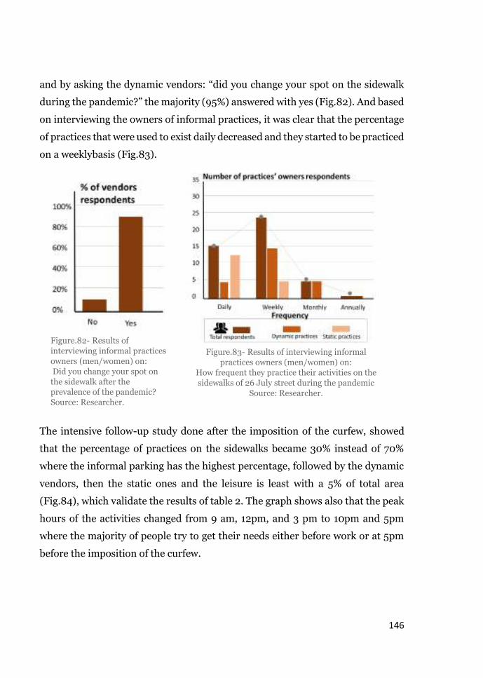
146
and by asking the dynamic vendors: “did you change your spot on the sidewalk
during the pandemic?” the majority (95%) answered with yes (Fig.82). And based
on interviewing the owners of informal practices, it was clear that the percentage
of practices that were used to exist daily decreased and they started to be practiced
on a weeklybasis (Fig.83).
The intensive follow-up study done after the imposition of the curfew, showed
that the percentage of practices on the sidewalks became 30% instead of 70%
where the informal parking has the highest percentage, followed by the dynamic
vendors, then the static ones and the leisure is least with a 5% of total area
(Fig.84), which validate the results of table 2. The graph shows also that the peak
hours of the activities changed from 9 am, 12pm, and 3 pm to 10pm and 5pm
where the majority of people try to get their needs either before work or at 5pm
before the imposition of the curfew.
Figure.82- Results of
interviewing informal practices
owners (men/women) on:
Did you change your spot on
the sidewalk after the prevalence of the pandemic?
Source: Researcher.
Figure.83- Results of interviewing informal
practices owners (men/women) on:
How frequent they practice their activities on the
sidewalks of 26 July street during the pandemic
Source: Researcher.

147
Vendors stick to the social distancing regulation, they have no opportunity to
move freely and benefit from trees and signage as before. Shop owners stopped
to use movable chairs along the sidewalks they became satisfied with using
chairs either in front of their shops only or inside its borders.
As the tree surroundings are no longer used by practices, pedestrians start to use
them as sitting elements as well as, the metropipelines are heavily used as a rest
area for pedestrians. Therefore, pedestrians refered to their walking experience
after the pandemic as an exciting journey in reaching their destination (Fig.85).
Sidewalks cafes at the corners
of 26 July street stopped to
working, all the leisure
activities are related to
outdoor sitting elements for
take-away restaurants
5 pm: Is the second peak of
informal practices on the
sidewalks, as it is the last hour
before the start of the curfew
9 to 10 am: Is the new peak
hours of informal vending
especially the parked motorcycle
on the sidewalks
Figure 84-Frequency of informal practices in terms of sidewalks used percentage in 26 July
street during the pandemic. Source: Researcher (the method is previously published by the
author of “Introducing the Mixed Use Sidewalk: Vending and Property
Rights in Public Space”. Credit: “Archiving the city flux” by Omar Nagati & Beth Stryler.

148
As well as, the percentage of people who were using the street instead of the
sidewalks decrease to 15% (Fig.86)
Figure.85- Results of interviewing pedestrians on:
How they could describe their walkability experience on the
sidewalks of 26 July street during the pandemic.
Source: Researcher.
Figure.86- Results of interviewing pedestrians on: Do you have to use the street instead of the sidewalks due to the
dynamic of informal practices during the pandemic?
Source: Researcher.

149
5.2.4. Gender of sidewalks’ users
Who are the users on 26 July before and during the pandemic?
Are the women supposed to represent the highest percentage of vendors
on the sidewalk?
These two questions came on the researcher during the observation phase,
therefore, she started to take notes and observe who is there? who uses the
sidewalks.
Previous status (Before the pandemic)
In order to get accurate findings, counting mobile app was used. Basically the
researcher has to identify a certain fixed points for every time measurement, the
app gives specific color for different genders and the researcher starts to mark the
color of the gender whenever a man or a woman pass.
Before the pandemic, the number of pedestrians along the three sections’
sidewalks were more men rather than women (Table 3). Starting from the
vendors, 26 July street vendors are mostly men, the women represent the smaller
percentage. Usually men are the ones selling clothing, shoes, and toys whereas
women sell grocery and most of the time stay at the corners of the three sections
away from the main street. All the back-packing vendors are men as well, no
women observed wandering the street, and this might be because men are
wandering carrying large and heavy back of goods.
Regarding the pedestrians, section (C-C) was the least one accommodating
women, based on interviews the main reason was the existence of cafes’ seating
elements over the corners which prevent women from using the sidewalks, they
use the street instead. The right side of 26 July street accommodates more women
than the left one as the left side is less in width due to the metro pipelines.
Therefore, women do not feel comfortable while walking with the existence of
men standing or sitting exceeding the borders of their shops from a side, and the

150
Table 3: Users gender on both sidewalks of 26 July street before the pandemic
Source: Researcher based on Annette Miae Kim presentation.
Table 4: Users gender on both sidewalks of 26 July street after the pandemic
Source: Researcher Researcher based on Annette Miae Kim presentation.
other side the metro pipelines and the street vendors blocking the rest of the
sidewalk.
Current status (During the pandemic)
As mentioned before, as the street practices decreased, the sidewalks became
almost empty from any informal activities except some dynamic activities, the
number of pedestrians from men and women became relative to each other’s but
even the number of women became a little bit higher than men (Table 4). Through
interviewing women, the majority of them were referring to the safety they feel
with the emptiness of the sidewalk from practices especially from the clothing
vendors and the cafes’ seating elements. One more phenomenon observed, that
women after the pandemic started to use the metro pipeline as seating elements.

151
Chapter 6
Understanding the push and pull factors

152
6. Understanding the push and pull factors before and during the
pandemic
This chapter tends to present a comprehensive understanding of the data
collected through the different methods illustrated in the previous chapter in
terms of the push and pull factors. The understanding of the push and pull factors
is based on the researcher conceptual framework which represents her own
interpretation of the phenomenon before and during the pandemic. This chapter
will analyze the impacts of: the sidewalks characteristics in terms of the walking
needs including 1-the physical, 2-the social characteristics, and their effect on
pedestrians’ perceived walkability before and during the pandemic.
6.1. Physical characteristics
6.1.1. Impacts of sidewalk pavement
The pavement of the sidewalks is one of the physical characteristics that has the
same impacts on informal practices and pedestrians’ walkability before and
during the pandemic. The condition of the pavement effect is divided into 2 cases.
The first one is the physical condition of the tiles whether they are broken or in a
good condition. The second direction is the effect of the difference pavements and
materials used all-over the sidewalk.
The first case exists only four times along both sides of 26 July sidewalks (Fig.87).
but only the first two of the four cases that might cause some difficulties for
pedestrians to walk smoothly along the sidewalks, especially that the two cases
exist at the side that accommodates the metro pipelines. But for the practices,
these deteriorations do not have a huge impact on the practices’ occurrence, as
they usually step aside just after their existence.
Figure.87- Sidewalks deterioration at 26 July street. Source: Researcher.

153
Regarding the second case: different tiling materials, both sidewalks sides of 26
July street consist of several tiling materials (Fig.88,89). The right side consists
of 9 kinds of pavement tiles whereas the left side (metro pipelines side) consists
of only 2 kinds of pavement tiles (Fig.90,91,92). The different pavement
materials along the side of the buildings used by the small shops as a platform
for extensions, and by the relatively large shops as a border to mark their
entrance in addition to the elevated door step which is used as a shop edge. And
whenever there is a group of shops that sell the same product, the tiles in front
of their shops are unified (Fig.93,94,95). Whilst the different pavement along
the side of the sidewalks’ curb are used by the dynamic vendors to mark their
spot on the sidewalk.
Figure.88- Case 1 of different pavement materials on 26 July sidewalks.
Source: Researcher based on Salsabil Fahmy’s outlining criteria of study.

154
Figure.89- Case 2 of different pavement materials on 26 July sidewalks. Source: Researcher
based on Salsabil Fahmy’s outlining criteria of study.
Figure 93,94,95- Unified paving on the side of the metro pipelines in front of the large clothing
shops. Source: Researcher.
Figure 90,91,92- Different tiles impacts.

155
During the pandemic
Although the effect of different tiling along the sidewalk changed slightly from
before to during the pandemic. However, during the observation phase of the case
of pandemic, it was obvious that the pavement colors and materials played an
important role in directing the shop owners to use the movable furniture where
the majority of them are committed to the marked line of the pavement. As well
as, during the second phase when they get back to expose their merchandises,
they just stick to the different tiling and decided not to exceed its
borders(Fig.96,97)
Therefore, an open, wide space is left for pedestrians without being obstructed as
it gives them the sense of being directed toward their destination. That is why
other shops started to paint the first row of tiles in front of their shops which was
not the case before the pandemic. while others even with the beginning of phase
2 they refused to expose their merchandises again on the sidewalks or even on the
changed tiles and they decided to just hang their products on the border of their
shops (Fig.98), or on a tree opposite to their shops. That is why the case during
the pandemic reveals an important pull factor for pedestrians, which is the
sidewalks divisions
Figure 96,97- Vendors and shop owners respecting the borders of the tiles. Source:
Researcher based on Salsabil Fahmy’s outlining criteria of study.
Figure 98- shops hanging their products respecting the borders of the tiles. Source:
Researcher based on Salsabil Fahmy’s outlining criteria of study.

156
6.1.2. Impacts of sidewalk divisions
The division method was presented clearly by Salsabil Fahmy in her dissertation
“Re-thinking the vibrant life on the sidewalk” in which she displayed all the
possible zones and phases a sidewalk could be divided into. And the observed
from the researcher side is that 90% of the divisions exist even in different context
yet the remarkable change appeared only with the invasion of new circumstances
which is the pandemic. Due to people’s behavior in terms of different pavements
occurred on the sidewalks of 26 July street during the time of pandemic, a
distinguishing division has been observed especially on the left side of 26 July
street. Despite the fact that the left sidewalk of the street (3.8 meters) is narrower
than the right side (5 to 6 meters), the left side is divided into four parts
(Fig.99,99’, 100,100’). The first part is along the sidewalk curb on which the metro
pipelines are located. Sometimes it is considered by pedestrians as a magnet to be
used as sitting elements in order to rest while walking. In this part, some vendors
use the stairs on the pipelines as a platform to expose their products which
sometimes obstruct pedestrians while crossing the street.
The second division is mainly a service part, the place where tree surrounds exist,
it is just along the metro pipelines and it has the smallest width among the three
other parts. The spaces in-between the trees are used by dynamic vendors
(clothing, grocery), and sometimes are used by shop owners by placing their
movable chairs whether to have conversations with the rest of the shops’ owners,
or to help old women and men to rest. It also occupied by the informally parked
motorcycles and bikes, as well as trash bins, and extra stalls of shops.
The third part is considered as a relatively wide part after the first division. During
the pandemic it is mainly for pedestrians’ circulation as well as the pedestrians
passing by for shopping. In addition, it is used by back packing vendors, and
censer men.
The fourth and the final part is the nearest part to the shops’ edge, in normal cases
before the pandemic it was used by shop owners as a platform to expose their

157
merchandises. But now as illustrated before, due to the pandemic it is used only
by the shop owners as a space to allocate their movable furniture. And by
pedestrians as their entrance zone to the different shops. This part of the sidewalk
accommodates the beggars before and during the pandemic, they never change
their location.
Figure 99,99’- First scenario of the left sidewalk division, with the existence of pedestrian bridge, movable furniture at one side. Source: Researcher
based on Salsabil Fahmy’s outlining criteria of study.

158
Figure 100,100’- Second scenario of the left sidewalk division, movable furniture on both
sides. Source: Researcher based on Salsabil Fahmy’s outlining criteria of study.

159
Although, the right sidewalk of the street is wider, however its divisions became
clear during the time of pandemic. The sidewalk is divided into three parts, almost
with the same width (Fig.101,101’, 102,102’). The first part is unlike the other side,
it is considered as the most dynamic part as it accommodated both: dynamic and
static practices. As the food carts, grocery, clothing vendors, and static ones as
books, toy vendors. As well as trees, lighting poles, trash bins, and informally
parked motorcycles. Sometimes this part extends beyond the sidewalk space and
occupy a part of the street.
The second division is similar to the third division in the left side of the street, as
it is considered as the pedestrians part where they can move freely, stop to enjoy
shop vitrines, negotiate with back-packing vendors, and stop to ask for direction.
Before the pandemic, this part was occupied by different informal practices as
illustrated in the space-time map.
The third and the last part is equivalent to the fourth part of the left side. The only
difference is its width, where it is larger than the left one, and identified more with
a different tiling materials (as illustrated in figure 82) as well as it accommodates
the extra sitting elements of public services as banks (Fig.95,95’).
As illustrated in the previous chapter (space-time map), during the pandemic the
temporality of activities occupying part 1 & 3 in the right side and part 2 & 4 in
the left side, allow more open wide space for pedestrians in different timing of the
day. As well as some of them extend their belonging toward the street which make
pedestrians enjoy the whole width of the sidewalk after the movement of these
temporal activities. Which was not the case before the pandemic, as some of the
activities remained constant and transformed from temporal to permanent.
Therefore, on the right side of 26 July street the boundaries of the sidewalk are
extended for 1 meter beyond the sidewalk edge yet, on the left side the metro
pipelines act as an edge blocking the extension of the different practices toward
the street (Fig.103). This extension is considered as intangible boundaries which
obstruct pedestrian movement. This boundary is created by the shop owners

160
displaying their products beyond the sidewalk area (Fig.103’), or adding some
tires to reserve a place for products extensions (Fig.103’’,103’’)
Figure 101,101’- First scenario of the right sidewalk division, before the pandemic.
Source: Researcher based on Salsabil Fahmy’s outlining criteria of study.

161
Figure 102,102’- Second scenario of the right sidewalk division, during the pandemic where
bank sitting elements occupy the widest division of the sidewalk. Source: Researcher based
on Salsabil Fahmy’s outlining criteria of study.

162
6.1.3. Impacts of metro pipelines
The existence of the metro pipe lines on the first division of the sidewalk, which
prevent pedestrians to move smoothly towards the other side of the street, or
practices to extend towards the street is considered as an edge. Based on (Gehl &
Matan, 2007), (Mehta, 2009). According to Salsabil Fahmy, people can create an
intangible edge by using physical elements. The case here that the physical
element is already there, that is why she claimed that the timing tool can easily
express people behavior throughout the day as well as defining the observed edge.
Therefore the street edge could be defined as a group of the same element
arranged along the street/the sidewalk side which have the ability to block
whether the visual or the physical connection. This element could be trees,
buildings, fixed furniture or any other continuity of a physical component.
Figure 103- 1-meter Extension of the informal practices on the right sidewalk of 26 July street
toward the street. Source: Researcher, photos credit: “Archiving the city flux” by Omar Nagati
& Beth Stryler.
Figure 103’
Figure 103’’
Figure 103’’’

163
Hence, the previous definition is repeated twice in the left side of 26 July street,
where the metro pipeline blocks the sidewalk from the curb side and the
continuity of shops block the sidewalk from the other side (Fig.104). And
according to (Hassan, 2012) in her book “People and Open Spaces: Psychological
Contentment and Landscape Narratives” people prefer to sit near an edge in
open spaces as it gives them the feeling of viewing the surroundings.
For that reason, it was understandable now why shop owners tend to move their
chairs either in front of their shops or on the opposite side right in front of the
pipelines. The existence of both edges act as a pull factors for both: practices’
owners and pedestrians as it makes them feel the connection between the indoor
space of their shops and the outdoor area of the sidewalk. As a consequence, the
arrangement of the movable furniture in the different sidewalks’ divisions on the
Figure104- Metro pipelines and buildings act as edges on the left sidewalk of 26 July street.
Source: Researcher

164
left side is expanded in 2 divisions during the whole timing of the day, unlike the
right side where the majority stick to the buildings’ side.
Before the pandemic, the number of movable chairs on the right side of the street
were relatively high, starting from 2 and increases to 15 chairs throughout the day
hours along the shops and curb side. However, during the pandemic the number
decreases as their existence became only at one side (the shop side considered as
an edge). Whereas the case of the left sidewalk is different, as during the pandemic
extra movable chairs are added especially by the metro pipeline side after 3:00
pm, some shops remove their chairs at the evening just before the imposition of
the curfew while in other spots observed, the owners leave their chairs outside to
the next day.
Previously, before the pandemic these chairs were a shared property where the
shop owners share theirs with vendors, especially the back-packing vendors,
starting from 12:00 pm to 6:00 pm, informal practices owners start to borrow
chairs, and boxes from the nearby kiosks in order to add sitting elements by the
pipelines side (Fig.105), but now it was noticed that several shop owners stopped
to share their chairs with others, while the minority who leave their chairs
overnight are leaving them to pedestrians in order to rest while walking. And
through interviews with shop owners, 40% on the left sidewalk responded by yes,
they do leave their movable furniture for pedestrians and the reason was their
tendency to provide pedestrians a comfortable walking experience and as
Mohamed Sameh owner of one of the supermarkets there said: “we now are in a
time of pandemic, we all supposed to help each other even by a simple act”
(Fig.105’).
As well as the doorkeepers of the buildings before the pandemic, during the
morning hours, they place their chairs in front of the building while at the evening
they move them toward the metro pipelines in order to sit with shop owners and
others doorkeepers. Whereas the case after the pandemic changed, in the

165
morning they stick to borders of the building while at the evening they offer their
chairs to old pedestrians and sit at the building step.

166
Extra chairs added by the shop owners at
12:00pm with the existence of vendors
Vendors are replaced by carts, bridges are used
by carts and shop owners for their products,
number of chairs decreases as it is a peak hour
Borrowed sitting elements from the nearby
kiosks
At 6:00pm the number of chairs increases,
bridge is used as sitting elements
Chairs are removed inside the shops and
returned back to the kiosks

167
Shop owners are inside their shops, vendors
have not started yet, only parked motorcycle
occupy the sidewalk
Shop owners start to allocate their chairs at
one side of the sidewalk, in front of their
shops, vendors occupy the opposite side
(metro pipeline side)
Vendors are replaced by shops sitting
elements but with keeping an adequate
social distancing.
40% of shop owners leave their chairs
outside to the next morning.
Figure 105- Metro pipelines and buildings act as edges on the left sidewalk of 26 July street
before the pandemic.
Figure 105’- Metro pipelines and buildings act as edges on the left sidewalk of 26 July street
during the pandemic.
Source: Data collected by the researcher, based on Salsabil Fahmy’s presentation.

168
6.2. Social characteristics
6.2.1. Impacts of sidewalk appropriation
As mentioned before, whether before or during the pandemic, and based on the
observation and the interviews, the static and the dynamic vendors of 26 July
street usually tend to occupy as much as possible the same place on the sidewalk.
They always mark their territory by using different elements as barrels, boxes,
furniture, and products with the same arrangement every. And mainly this act is
related to the design of the sidewalk which affect easily the personalization and
appropriation of the sidewalk by the different users (Fig. 106).
The scenario of arranging and locating personal items to reserve a certain spot
has always been a continuing act until the occurrence of the pandemic which
impacted this act slightly. Where users still do the same but referring to their
practice in a wider reservation boundary, keeping a reasonable distance from
other practices. Therefore, there is always a connection between the owners and
the users of informal practices. This connection is considered as one of the
strongest connection on the sidewalks because of the appropriation, which
strengthen the social, economic and the cultural interests between them.
The main reason behind facilitating this connection is the width and divisions of
the sidewalks. As informal practices owners during the pandemic are given an
opportunity to organize their products in a way that stick to the regulations as
well as, keeping the lively and dynamic aspect of the sidewalks as it was before the
pandemic. The regulations imposed due to the pandemic played an important role
in the existence of these practices, as it stopped the idea of people rejection toward
them. People started to accept their presence on the sidewalks as long as they keep
a distance between each other and allow pedestrians to move freely along the
sidewalks without being obstructed.
The connection between practices on the left sidewalk is stronger than the one on
the right side. As the left side is considered as an enclosed area because of the
metro pipelines as mentioned before, where the practices on the right side

169
sometimes expand beyond the sidewalk curb and obstruct the circulations of cars,
and during the pandemic the right side is always occupied by the additional
elements of the service shops as the waiting sitting area which block part 3,2, and
the majority of part 1 on the sidewalk. Hence, the extension on the right side is
almost the same before and during the pandemic. That is why the relation
between practices is weaker than the other side which leas consequently to an
independent willingness of each practice individually to mark their own spot.
Through interviews and questionnaire, the fact that the left sidewalk connection
is stronger than the right one was mentioned by several interviewees, where the
different owners help each other for 1-spotting their place on the sidewalk
(especially during the pandemic), 2- in reserving this spot (sometimes owners of
practices reserve the place for other owners), 3-lend each other movable
furniture, 4-share the same tables, water dispensers, and metro pipeline stairs as
a place to expose their sharable products. As well as, dynamic vendors usually
borrow movable furniture from shops or doorkeepers, shops depend on
supermarkets and kiosks to collect their garbage and protect their shops at night,
censer men and shoe polishing men have deals with certain shops to sit in front
of their entrances Therefore, they have social, spatial and economic sharable
connections.
On the right sidewalk, it is rarely to see a shoe polishing man or censer man as
they are not welcomed by the shop owners. And during the pandemic with the
spatially separated practices, the dependence of practices on each other became
less and less than before, especially when the sitting elements prevailed along
their spots.

170
Figure 106- Design of the sidewalk which affect easily the personalization and
appropriation of the sidewalk by the different users
Source: Data collected by the Researcher based on Salsabil Fahmy presentation.

171
6.3. Pedestrians’ perceived walkability
The perception of pedestrians on the whole walkability experience in 26 July
street –before or during the pandemic- depend the most on 1-the sidewalk
division, 2-the edge effect, and 3-the personalization/appropriation of the
sidewalk mentioned previously. Those factors mainly represent the push and pull
factors that are responsible to attract or repulse the pedestrians, as their role is
equivalent to a magnet. This magnet supposed to have equivalent potential of the
previous elements in order to pull more than push.
Before the pandemic, pedestrians were barely succeeding in managing their
movement on the sidewalk of 26 July street (Fig.107), the higher percentage
tended to use the street more than the sidewalks due to the sidewalks division,
where the parts of the activities on both sidewalks exceed their limits and affect
the part of people’s circulation. Whereas during the pandemic and because of
the regulations imposed, pedestrian movement became more constant than
before (Fig.108). People got the chance of maintaining the continuity of their
walking experience without being interrupted as much as the case before the
pandemic.
Figure 107- Pedestrian circulation on 26 July street before the pandemic. Source: Researcher

172
However, the residents of 26 July street still have the same perception of the
interruption they face on the sidewalk, therefore they tend to use the street. The
reason behind their behavior now –and the different pedestrians before the
pandemic- is the idea of the continuity of streets while sidewalks in Egypt is
always full of informal practices.
Through observation and interviews, the majority of pedestrians confirmed that
not only the intensity of informal practices affects their perception of sidewalks
continuity but also the temporality and permanency or in other simplified words
the duration and the space that each practice occupies interchangeably. As
illustrated in the table of area consumed by each practice and the space-time map,
the prevailing practices before the pandemic were a mix of static and dynamic
practices, the highest percentage that was permanently occupying the sidewalks
almost every day and at the same place was the vendors followed by the extension
of shop merchandises (Fig.109)
Whilst during the pandemic, the predominant practices and almost
permanent along the day are the dynamic practices as the informally parked bikes
and motorcycles as well as the movable furniture placed by the shop owners
throughout the day and left overnight (Fig.110). However, the rest of the practices
Figure 108- Pedestrian circulation on 26 July street during the pandemic. Source: Researcher

173
Figure 109- Area consumed by each
pandemic in 26 July street before the
pandemic. Source: Researcher
Figure 110- Area consumed by each
pandemic in 26 July street during the
pandemic. Source: Researcher
are temporally occurring on the sidewalk except the static vendors with a fixed
structure on the sidewalk.
The duration of each practice is an important factor as it is always related to the
controversy over the sidewalk space. Before the pandemic the contestation over
the sidewalk is higher than the competition happening now (during the
pandemic). As now, the imposed regulations somehow reduced the argument of
each practice over the use of the sidewalk. Hence, practices already organize
themselves and established an internal agreement territorialize a new spot with
keeping social distancing between each other (Fig.111).
Figure 111- Illustration of informal vendors before and during the pandemic after
organizing their new spots. Source: represented by the researcher

174
Pedestrians’ perception
In this research the word “pedestrian” means every user of the sidewalk space
including: visitors, residents, and informal practices owners. The interviews, and
the cognitive mapping with the different persona (Fig.112) before and during the
pandemic. The perception of people in general did not change that much from the
other study done before in Heliopolis, their perception varied only when they
were asked to express their experience during the pandemic. Which
demonstrated the point of view presented by Salsabil Fahmy that the context
definitely affects the perception of users. And as the practices were excessively
used on Downtown sidewalks as on Heliopolis ones therefore, the difference
might not be revealed easily as it popped up with the case during the pandemic.
Before the pandemic, pedestrians’ perception (visitors and residents) on the
walkable experience is always related with the presence of informal practices on
the sidewalks. the first persona “Ahmed” the residents’ persona, when he was
asked about his walking experience, he laughed sarcastically and claimed that “26
July street is different than the other streets of Downtown, you cannot enjoy
walking here with all the vendors you are seeing, 26 July street is only about
fulfilling our daily needs not a perfect street for walking” and this was more or
less a common answer by the residents of Downtown in general and 26 July street
in particular. When the same persona asked to draw a picture on what they
remember when 26 July street is mentioned, they referred also as he perceives
“Shawky”
Owners of
informal practices
“Ahmed”
Residents
for 40+ years
“Adel”
Frequent
visitors
“Amira”
Females
residents/visitors
Figure 112- Persona of interviewees. Source: Researcher based on Salsabil Fahmy
presentation.

175
the sidewalks and the streets as one structure, only the existence of cars is the
additional elements in the streets (Fig.113).
The second persona is “Adel”, the frequent visitor persona, he claimed that “there
is not enough space for walking, however, the solution is not removing them as
they accommodate the essential need of the residents and visitor, maybe they
might need some organization” he also added that “the side with the metro
pipelines should not include any practices as it is very narrow to accommodate
pedestrians and practices together” and by asking this persona to draw the
cognitive map, the majority of drawings were referring to the circulation between
sidewalks and streets together (Fig. 114-114’).
Figure 113- Cognitive map drawn by a 40 years’ resident, trying to describe 26 July
street/ sidewalk from his own perception
Figure 114- Cognitive map drawn by a 26 years’ visitor, describing 26 July street/
sidewalk from his own perception
Figure 114’- Cognitive map drawn by a 31 female visitor, describing 26 July

176
The third persona is “Amira”, the female resident/visitor. Females in general
whether she is a resident or a visitor refer to the unsafety they feel while using the
sidewalks especially the side with the café sitting elements, followed by the shop
owners sitting or standing in front of their shops. When she was asked about her
journey in 26 July street, she replied by “I cannot walk freely by using the sidewalk
only, I have to use the street instead most of the time, it is not the case of 26 July
street only, it is the same case of all the sidewalks in Egypt” and by asking her to
draw her walking experience, the drawings were illustrating the practices
especially the ones that causes her the harassments (Fig.115).
During the pandemic, the four persona have relatively same perception. The
female persona and the visitor one use the sidewalk now more than before, and
both referred to the well-organized practices. The noticeable comment is that
during interviews, pedestrians stopped to referring to these practices by the
“informality”. Even if the question contains the word informal practices, their
answers were containing the word practices only and some of them referred to it
as “the informally organized practices” and “the new practices”. And
when they were asked to draw the sidewalks during the pandemic, the majority of
Figure 115- Cognitive map drawn by a 27 years’ visitor, describing 26 July street/
sidewalk from her own perception

177
the drawings were remarkable as they’re containing the sidewalks divisions which
were not existing in their drawings before the pandemic at all (Fig.116,116’).
Whereas, the old resident persona the ones who know the place well and very
familiar with every detail of the neighborhood, they still use the streets instead of
the sidewalks whenever they pass by a spot that was previously occupied by
informal practices. As if their perception cannot recognize the difference that
happened all over the sidewalks. As well as their drawings were completely similar
to the ones before the pandemic.
However, the on-site interviews and cognitive mapping spotted that the different
personas noticed the difference of sidewalks before and during the pandemic. As
well as, the majority of the them claimed that previously they were in need of a
wider space for walking but now they are satisfied with the organization of
practices happening on the sidewalks. The online survey held before visiting the
site showed that the large percentage were asking for a complete removal for the
Figure 116- Cognitive map drawn by a 19 years’ visitor, describing 26 July street/
sidewalk during the pandemic from her own perception
Figure 116’- Cognitive map drawn by 24 years’ female resident, describing the divisions of 26 July sidewalks during the pandemic

178
different practices, only 10% recommended a wider organized sidewalk and the
same percentage replied with approving the fixed furniture only if this could be
considered as informal practices (Fig.117). And by asking people through the
online questionnaire which photo reminds them of Downtown streets, the
majority choose the books’ vendors followed by the cafes sitting elements then the
dynamic vendors (Fig.118)
Figure 117- Results of online questionnaire question “What case could improve your
walkable experience on 26 July sidewalks. Source: Researcher

179
6.4. Reflections
Chapter 5 and 6 tended to present an in-depth investigation on the research case
study, trying to answer the previously mentioned research questions. Chapter 5
presented the different factors behind the informal activities accommodated by
26 July sidewalks. It also illustrated the uses and activity of 26 July streets before
and during the pandemic as well as the gender using the sidewalks and the diverse
typologies of informal practices.
Then followed by chapter 6 which presented the interpretation of the factors
behind the informal practices phenomenon in downtown streets, the reason
behind the spatial patterns of the practices before and during the pandemic,
trying to spot the difference occurred and its effect on the pedestrians’ walking
experience. And based on the analysis of these factors (Push & pull), it became
clear that these factors are the motives behind the territorial behavior occurred
on the sidewalks whether by pedestrians or informal practices owners. That is
because the push and pull factors act as both accelerator or a delaying elements
for the informal practices occurrence. And because of the current situation of the
pandemic and its regulations, the sidewalks of 26 July street had witnessed both
the repulsion and the attraction of informal practices and pedestrians.
The difference between the two conditions (before and during the pandemic) is
when the push factors on the sidewalks is higher than the pull factors as the case
of during the pandemic, pedestrians are easily enjoying their walking experience
yet some of them miss the opportunity of fulfilling the essential needs (which
sometimes is considered as the main walking aim especially for residents).
Whereas, before the pandemic when the pull factors were higher, the number of
pedestrians were relatively high yet their walking experience was negatively
impacted. Therefore, the dimensional patterns of the practices on the sidewalks

180
and the different ways they use to mark their spatial spots are the consequence of
the relations of the factors addressed which have a great impact on pedestrians’
use of the sidewalks. For example, the accumulation of the informal practices
before the pandemic on certain spot is the result of the type of pavement and the
existence of buildings edges.
As an additional interesting result of these push and pull factors, a side
information observed during the observation phase is that the push and pull
factors not only affecting the informal practices as illustrates in the objectives in
a one-way direction (Fig.03), but it is also observed that some of these factors
would have a non-stoppable relation with the informal practices and are being
affected back, and that can go into a continuous cycle of a chain reaction (Fig.119)
Figure 119- Conceptual understanding evolution of the push and pull factors based on the
observation. Source: Researcher

181
Moreover, the second part of chapter 6 tended to understand the effects of
informal practices on people’s perceived walkability, through illustrating four
different personas’ perspective for both pedestrians and informal practices
owners. To understand how the later claim their rights of the sidewalk which
strongly impact the first. As well as pointing out to the difference between the
normal status (before the pandemic) and the current status (during the
pandemic). And from this part analysis, previewing the different drawings done
through the cognitive mapping, showed that usually informal practice owners
argue their legitimacy of owning the sidewalks and claiming that they don’t
negatively impact the pedestrians’ circulation. And because of the prevalence of
Covid-19 pandemic, this argument starts to disappear, owners of informal
practices and pedestrians are somehow now on a common ground of discussion,
where both parts started to consider the other’s point of view as long as each one
respect the space they have on the sidewalk.
Also, as a result of the cognitive mapping tool, there is a clear conflict between
what people actually want to fulfill their daily needs and what they want to have
an appropriate walking experience. Their responses regarding removing all the
practices from the sidewalks however, their first answer was regarding the
importance of these practices in fulfilling their daily basic needs. Yet during the
pandemic, when the majority witnessed the organization of the practices, they
started to claim other factors as the metro pipelines which act as an edge
preventing them to move freely to the other side of the street though this edge is
used as a permanent sitting element during the pandemic. Hence, there will
always be a contradiction between what people really need and what is allowed
for them to use.
One remarkable observation, is that pedestrians who were asked to draw how they
imagine the sidewalks of 26 July street before the pandemic, their drawings were

182
always tend to mention one or more type of informal practices, whereas their
drawing during the pandemic are always referring to the sidewalks and streets as
well as they stopped to mention the word “informal” before “practices”.
Therefore, analyzing and comparing the two status before and during the
pandemic illustrates that the owners of the informal practices -with correlation
with the pedestrians- have the ability to organize and adapt the whole sidewalk
area in a way that no one interrupts the other. They will always have the ability of
appropriating a certain space, each practice in a unique way as illustrated in both
cases before and during the pandemic, a way that probably will impact the social,
cultural, political and economic aspects. Although, the organization of these
practices was noticeable on the sidewalks, yet the ones who started to get back
immediately on the sidewalks after the imposition of the curfew, are the ones that
are accepted by pedestrians and its surrounding to take place, as well as its
economic benefit. If it is worth to work during a pandemic where the number of
people is less than before, which means that there is a high risk of not getting back
a reasonable benefit while risking their lives.

183
Chapter 7
Conclusion, Recommendations and Further research

184
7. Conclusion, Recommendations, and Further research
7.1. Conclusion
The empirical work of the research was done during the starting period of Covid-
19 pandemic which expected to make the phenomenon of informal practices looks
differently in the area of study than before it was actually being hit by the
pandemic, during the pandemic as a current temporary phase, and after it will
finish completely. The research focused only on period 1 and 2 as it is not really
clear now how it would affect the later-on permanent phase (after the pandemic)
and tried to give some expectations, projections on what might be long-term
impacts and what might just vanish and being faced out from our culture, social
practices, and economic behavior.
Therefore, the researcher managed to understand the impacts of the informal
practices as an outstanding phenomenon on the walking experience of
pedestrians through integrating the different theories of walkability with the
human behavior in the streets and sidewalks as the vital and lively parts of public
spaces. Tried to reach the aim of understanding the informality of practices that
affects people’s everyday life especially by exploring the sidewalks potential
operating as an inclusive space accommodating informal practices that affects
pedestrians twice before and during the pandemic.
Because of the lack of available data that address both informal practices and
people’s walkability together, the researcher tried to find a common ground in
order to study the whole phenomenon before and during the pandemic by
illustrating the theory of walkable experience in terms of interactions through
applying previously done study (Re-thinking the vibrant life on the sidewalk
dissertation by Salsabil Fahmy) with a context almost similar to the chosen one
and mapping tools already been used before and indicated its success for such
phenomenon and trying to build on it in order to understand the change that

185
happened with the appearance of the pandemic. So she defined the informal
practices as the main interaction factor of the research. Hence, streets and
sidewalks were integrated as they are the mediators that accommodate both. The
researcher defined them as part of public spaces therefore, it was important to
highlight their physical configuration then, understand the behavioral patterns
occurred through their existence acting as both: territorial behavior and everyday
activity patterns before and during the pandemic. Finally, since users’ walkability
experience in terms of informal practices is affected by their own perception, the
research reviewed a brief understanding on users’ and environmental perception,
as well as the image and perception of the sidewalks and how this image changed
after the occurrence of the pandemic.
The literature chapters aimed to frame, and understand the phenomenon within
the mentioned theory, focusing on reveling the change occurred to the informal
practices phenomenon and its impacts on people’s walkability due to the
pandemic. Using this framework in particular was a main point for the researcher
as it helped in tracking the historical evolution of the informal practices
phenomenon as well as the different key attributes of walkability before and
during the pandemic, despite the lack of data available in both tracks.
Chapter one, two, and three presented the results of the conceptual framework
developed by the researcher based on Salsabil Fahmy and Annette Miae Kim
explanation of the practice as they claimed it will reveal that people in different
context and with different cultures prefer spending time in public open spaces
rather than being in closed indoor areas. Talking about the case of Egypt and
especially Cairo, the higher percentage of Cairene since the Fatimid era till our
present days used to value the outdoor spaces, especially the spaces in front of
their houses represented in streets, sidewalks, and even alleys. Where before the
invention of sidewalks people escaped to alleys when streets were blocked by cars.
Therefore, sidewalks were introduced in their culture to fill this gap. And as a
consequence, sidewalks’ life in its socio-cultural environment represents a
quintessential role in identifying the identity of each area as they are used for

186
different activities. However, after the prevalence of the pandemic, people had to
spend the majority of their time at their homes and stopped to partially use the
outdoor areas restraint by governmental instructions. However, they always find
ways to somehow defrauding the orders to spent extra time in the outdoor spaces
as well as sidewalks became used differently.
Then to apply the information obtained through the literature on an on ground
field, a field conceptual framework (Push and pull framework) was created based
on the researcher interpretation to ease for her the choice of the case study as well
as the points that needed to be investigated. Hence, chapter 4 represented the
research case study, the reasons behind choosing 26 July streets in downtown
specifically. As well as this chapter identified the used tools for collecting the
targeted data whether before or after the spread of the pandemic with correlation
with the conceptual framework. Trying to explain each tool separately in a
comprehensive way in order to understand how the pandemic affected their
selection as well as their implementation on the community.
And based on the information gathered through the interlinkage of the different
field tools and the literature part, the researcher succeeded in investigating how
the sidewalk area in the selected case study was operated by the informal practices
before the pandemic, and how these practices changed in performance after the
occurrence of the pandemic. She also based on the used methodology inspired by
Salsabil Fahmy to measure the previous case of the sidewalks and streets a table
of calculated the area consumed by each practice before and during the pandemic
were done in order to align her approach, the habits they practice and the time
interval of each and every activity occurred on the sidewalk space in normal cases
comparing it with the time intervals affected by the pandemic and the curfew
hours.
In addition, the researcher studied the relation of all the previously mentioned
with pedestrian’s walkability as mentioned in Sahar el Ghandour dissertation
(Towards more pedestrian-Friendly Streets in Cairo), it was a must to study
187
behavior and perception of pedestrians. In order to understand how the physical
state and arrangement of practices’ settings could affect the users of the
sidewalks. Not only the residents of the area but also the visitors. Taking into
consideration the different factors (Push and Pull) that could affect both
pedestrians and owners of informal practices.
The researcher was not aiming to document the sidewalks status in both cases
before and during the pandemic as the before status were presented before in the
mentioned dissertation. But the main aim was to understand how sidewalks and
people’s perception changed after the occurrence of the pandemic and what are
the factors and tools inspired changed as well as what might became new normal
phase on Cairo sidewalks.
The findings’ analysis demonstrated that before the pandemic the case of
Downtown sidewalks was almost similar to the Case study of Heliopolis done by
Salsabil Fahmy in her dissertation (Re-Thinking the vibrant life on the sidewalk)
even it is a different context as she claimed that each and every vacant space on
the sidewalks is considered as a potential to be appropriated by the different
practices as it acts as a separate entity. However, during the pandemic the empty
areas on a sidewalk are created by the vendors and the shop owners themselves
motivated by the current status of the state “the pandemic” and its imposed
restrictions as the social distancing. Yet, it was obvious that in both cases it affects
the surrounding aspects as the previously done study in Heliopolis and impacted
the push and pull factors which later impact the perception of people to use the
sidewalks or not.
Therefore, it was important to investigate the sidewalk with relation to the socio-
cultural and physical aspects. Moreover, to highlight the characteristics of the
sidewalk area (Push and pull factors) as physical, social, uses, and walking needs
as well as the activity patterns of pedestrians and informal practices owners.
Studying activity patterns presented by Salsabil Fahmy with relation to the push
and pull factors was an important step to facilitate for the researcher the

188
comparison between the previous and the current status of the sidewalks. Which
evocate one of the important results of this comparison: that activities on 26 July
street before the pandemic could be described as “the excessiveness practices
over the street edges” as it was described before which mean that if the study
will be repeated all over different parts of Cairo whether Heliopolis or Downtown
or even Attaba -which have special characteristics unlike the first mentioned two-
, it will show more than 80% similarity when we decide to describe it. And that is
because of its intensity existence which increases over time yet, the phenomenon
interferes the walkable experience threatening their safety, accessibility, usability,
and comfort. Relating the phenomenon to the previously done studies where the
majority considered it as permanent activities not only in Cairo but all over the
world as it was there for every day at the same timing, regardless the negative
impacts it was posing on pedestrians’ walkable experience, it was one of the
factors that keep 26 July street a lively and vital street among Downtown streets.
However, on the other hand during the pandemic, the analysis showed that
pedestrians started to call the informal practices as “the informally organized
practices” or “the new practices” the term that the pedestrians themselves
and the users of the sidewalk started to use. And this is because of the internally
transformation that happened between the informal practices owners, as they
succeeded to stop fighting on the sidewalk and agreed to spontaneously change
their (previous-permanent) spot in order to respect the pandemic restrictions and
allow a reasonable social distance between each other.
Although there is a noticeable change that occurred in their behavior, however,
it was clear during the observation phase that “they are still in the process of
reshaping the sidewalk space to adapt with the unknown later-on permanent
phase (after the pandemic end)”. And the majority of practices became in forms
of informally parked vehicles as bikes, motorcycle, and cars on the contrary of the
case before the pandemic ad the majority were vendors and shop extensions.
Therefore, the sidewalk of 26 July street became less dynamic regarding the

189
informal practices yet, relatively vital regarding the smoothness of pedestrians’
circulation.
Therefore, the research expects that:
The instability and the dynamism of practices might get back if the streets
will be hit again by another phase of pandemic. Which will oblige the
owners to re-adapt with the unknown later-on permanent phase of after
the pandemic as some practices still ask for their previous spots on the
sidewalks which might destabilize the ideal phase occurring now.
Some behavior might be long term impacts
- regarding people’s patterns on the sidewalks such as:
1-the outdoor sitting elements of any public services stores (e.g. Banks,
orange, Vodafone…etc.),
2-the queuing of pedestrians in front of shops,
3-the “keeping distance” mindset while using the sidewalks or any public
place,
4-the pointing technique instead of touching the vendors’ products. 5- the
use of metro pipelines as a walking/sitting edge.
-And regarding the informal practices owners’ behavior:
1-the internal organization between them as keeping the social distance,
2- the shop owners act of limiting the extension of their merchandises,
3- the excessiveness of parked motorcycle on the sidewalks might heavily
increase as they usually find empty spots because of the spacing between
vendors.
And suggest that:
The comparison between two conditions of the sidewalks (as we don’t
know when the phases of the pandemic will end), the comparison with the
existing phase (phase 1 &2 of the pandemic) with the upcoming new
phases using the investigation methods developed by Salsabil Fahmy and

190
integrate it with the added online methods will eventually contribute in
helping planners for a better design for sidewalks which could
accommodate what people needs and what might ease and add comfort to
their walkable experience.
The study is not a guarantee that the change that occurred after the
prevalence of the pandemic might happen in other streets/sidewalks. Only
streets/sidewalks with similar settings as the pandemic affects each
context in a different way.
7.2. Recommendations
As the majority of researches, the research is not aiming to come up with
designing strategies. Yet, the idea is more related to presenting the different
typologies of informal practices that was existing on 26 July sidewalks before the
pandemic and the ones which are available now during the pandemic time. Trying
to preview the intersections of their spatial patterns with pedestrians. In order to
help urban planners and researchers to take into consideration the variables and
the changes that developed -due to the pandemic- when planning and
designing/re-designing sidewalks and streets to assure everyone’s needs and
comfort.
Therefore, the researcher recommends that:
Because of the informal practices mature behavior in time of crisis, and
the way they quickly responded to the imposed regulations without
evocating their normal negotiation of the sidewalk rights as mentioned in
the study of Heliopolis as well as shown in the case of before the pandemic
in downtown. The phenomenon might be more or less organized but it will
never vanish. Therefore, it is important that municipalities start to
reevaluate and reformulate the current policies according to the current

191
conditions. It is also important to consider the area allowed for each
practice to consume, the duration and time intervals, as well as creating
an explicit text with the allowed divisions of the sidewalks which meets
the pedestrians need and at the same time without obstructing their
walkable experience as the timing sampling method tool created by the
writer of (Re-Thinking the vibrant life on the sidewalk) as well as the
criteria developed in assessing the sidewalks were considered as a main
factor to depend on through all the changes that might happen due to the
pandemic.
7.3. Further Research
As the phenomenon of informal practices occurred generally all over Cairo, and
impact pedestrians’ walkability in different ways according to the context. And
due to the limited time and the conditions of the pandemic the researcher was
capable to investigate the phenomenon in only one area (26 July street,
Downtown) and she gave insights on extra 2 areas through presenting methods
and presentation techniques of the previously mentioned dissertation of Salsabil
Fahmy. Therefore, it is important to further investigate:
The phenomenon in different areas but after phase 2 of the pandemic to
map out the differences that might occur.
The study of Political perspective might contribute to the case as the
pandemic impose new regulations everyday creating new phases that we
have to deal with.
There is a need also to create an in-depth comparison between the later-
on permanent status of the streets after the pandemic is over, in order to
illustrate the difference between the 3 phases (before-during-and after the
pandemic).
192
References
Adeed Dawisha, 2009. Arab Nationalism in the Twentieth Century: From Triumph to
Despair. Miami University, Ohio: Princeton University Press.
Al-Masry, E., 2013. Egypt Through Time: Photographs From 1800-2015, Egypt: Egyptian
streets.
Al-Sayyad, N., 1981. Streets of islamic Cairo: a configuration of urban themes and
patterns. Cambridge, Mass: Aga Khan Program for Islamic Architecture.
Annette Miae Kim, 2015. Sidewalk City: Remapping Public Space in Ho Chi Minh City.
Chicago: University of chicago press.
Annez, P. C. & Buckley, R. M., 2009. Urbanization and Growth. USA: World Bank
Publications.
Appleyard, D., Gerson, M. S. & Lintell, M., 1981. Livable streets. California: University of
California Press.
atkinson, P. & hammersley, m., 2007. Ethnography principle in practice. Chicago:
Routledge.
Bain, L., Gray, B. & Rodgers, D., 2012. Living streets: Strategies for Crafting Public
Space. New york: John Wiley & Sons.
Blomley, N., 2009. Rights of Passage: Sidewalks and the Regulation of Public Flow. New
york: John Wiley & Sons.
Bonner, C., 2009. Organising In The Informal Economy. United Nations: StreetNet
International and WIEGO.
Burton, R. F., Payne, J., Lang, A. & Scott, J., 2015. One Thousand and One Nights. United
Kingdom: Delphi classics.
Cairo climate talks, 2012. SUSTAINABLE TRANSPORTATION AND THE QUESTION OF
GENDER, Cairo: s.n.

193
Carcopino, J., 1941. Daily life in ancient Rome. New Haven, Connecticut: Yale University
Press.
Carmona, M., 2003. Public Places, Urban Spaces: The Dimensions of Urban Design.
United Kingdom: Architectural Press.
Çelik, Z., Favro, D. & Ingersoll, R., 1994. Streets: Critical Perspectives on Public Space.
California: University of California Press.
Çelik, Z., Favro, D. & Ingersoll, R., 1996. Streets Critical Perspectives on Public Space.
California: University of california press.
Clifford Geertz, 1963. Peddlers and Princes. Chicago: University of Chicago Press.
Cullen, G., 1995. Urban design and townscape. USA: Architectural press.
David V. Kanter, 1977. The Psychology of Place. London: Palgrave Macmillan.
Denzin, N. K. & Lincoln, Y. S., 1994. Handbook of qualitative research. California:
Thousand oaks: sage publications.
Donovan, M. G., 2003. Informal Cities and the Contestation of Public Space: The Case of
Bogota's Street Vendors. California: Sage Publications.
Downs, R. M. & Stea, D., 2017. Image and Environment: Cognitive Mapping and Spatial
Behavior. New Jersey: Transaction Publishers.
Edney, J. J., 1976. The Psychological Role of Property Rights in Human Behavior. Sage
Journal, 8(7), pp. 811-822.
Elsheshtawy, Y., 1997. URBAN COMPLEXITY: TOWARD THE MEASUREMENT OF THE
PHYSICAL COMPLEXITY OF STREET-SCAPES. Journal of Architectural and Planning
Research, 14(4), pp. 301-316.
Ewing, R. & Handy, S., 2009. Measuring the unmeasurable: urban design qualities
related to walkability. Journal of urban design, 14(1), pp. 65-84.
Fleury-Bahi, G. & Pol, E., 2017. Handbook of Environmental Psychology and Quality of
Life Research. New York: Springer.
Franck, K. & Stevens, Q., 2006. Loose Space: Possibility and Diversity in Urban Life.
Milton Park, Abingdon: Routledge.
Fyfe, N., 1998. Images of the Street: Planning, Identity and Control in Public Space:
Representation, Experience and Control in Public Space. Milton Park, Abingdon:
Routledge.

194
Garau, P., 2015. Public space and the equitable city. Italy: UCLG Committee on
UrbanStrategic Planning .
Geert Hofstede, 2001. Culture’s Consequences: Comparing Values, Behaviors,
Institutions, and Organizations Across Nations. California: Sage publications.
Gehl, J., 1987. Life between buildings: use of public spaces. New York: Van Nostrand
Reinhold.
Gehl, J., 2013. Cities for people. Washington, D.C.: Island Press.
Gehl, J. & Gemzoe, L., 2003. New city spaces. s.l.:Danish Architectural Press.
Gehl, J. & Matan, A., 2007. Two perspective on public spaces. London: University of
Minesota press.
Gillies, A., 2009. Shared spaces in an Australian context. Australia: De Gruyter Mouton.
Global Designing Cities Initiative, N. A. o. C. T. O., 2016. Global Street Design Guide.
Washington, D.C.: Island press.
Guaralda, M. & Joyce, T., 2013. Life on the edge : the effects of building facade three
dimensionality on public social behaviour. eprints, 4(1), pp. 158-173.
Hall, E. T., 1966. La Dimension cachée. New York: Doubleday.
Han, H., Nguyen, T. V. & Sahito, N., 2019. Sidewalk zoom in: a spatial-tomporal
negotiation and self organization within a sociable space. Future Cities: Urban Planning,
Infrastructure and Sustainability, 7(1), pp. 1-19.
Hanzl, M., 2013. Green Design, Materials and Manufacturing Processes. London: CRC
Press, Taylor & Francis Group.
Hassan, D., 2012. People and Open Spaces: Psychological Contentment and Landscape
Narratives. USA: AP LAMBERT.
International Labor Organization report, 1972. Employment, income, and equality, s.l.:
United nations.
Irwin Altman, 1975. The environment and social behavior: privacy, personal space,
territory, crowding. California: Brooks/Cole Pub. Co..
Ismail, K. A., 2014. Reviving the heart of a historical metropolis: Comparative study
between different urban forms in downtown Cairo, Egypt. Cairo, UNESCO World
Heritage Centre.

195
Jacob, J., 1961. The Death and Life of Great American Cities.. New York : Random
house.
Janet L. Abu-Lughod, 1971. Cairo: 1001 Years of the City Victorious. New Jersey:
Princeton University Press.
Kadi, G. E., 2012. Le Caire centre en mouvement. France: IRD.
Kärrholm, M., 2005. Territorial Compexity in Public Places. London: Nordisk förening för
arkitekturforskning.
Kent, F. & Madden, K., 2016. Streets as places. New York: Project for Public Spaces.
Kevin Lynch, 1960. The image of the city. Cambridge: MIT Press.
Khan, S., 2020. Mayor’s bold new Streetspace plan will overhaul London’s streets,
London: Londonassembly.
Kim, A. M., 2015. Sidewalk City: Remapping Public Space in Ho Chi Minh City. Chicago:
University of Chicago Press.
Kimmo Lapintie, 2007. Modalities of Urban Space. Sage journal, 6(1), pp. 36-51.
Kingsford, C. L., 1925. The early history of piccadilly leicester square soho and their
neighbourhood. London: Cambridge University press .
Kostof, S., 2005. The City Assembled: The Elements of Urban Form Through History.
London: Thames & Hudson.
Kumar, A., 2011. ResearchandWritingSkillsDrAshwinKumarResearchandWritingSkills.
North Carolina: Lulu Press.
Lewis Mumford, 1961. The City in History: Its Origins, Its Transformations, and Its
Prospects. California: Harcourt, Brace & World.
Loayza, N. V., 20, December 2018. Informality: Why Is It So Widespread and How Can It
Be Reduced?, Malysia: world bank.
Loukaitou, A. & Ehrenfeucht, R., 2012. Sidewalks. Conflict and Negotiations over Public
Space. New Jersey: Wiley.
Madanipour, A., 1996. Urban Design and Dilemmas of Space. Sage journals, 14(3), pp.
144-145.
Mariela A. Alfonzo, 2005. To Walk or Not to Walk? The Hierarchy of Walking Needs.
Sage Journal, 37(6), pp. 808-836 .

196
Maslow, A. H., 1943. A theory of human motivation.. American Psychological
Association, 50(4), p. 370–396.
Mehta, V., 2008. Walkable streets: pedestrian behavior, perceptions and attitudes.
Journal of Urbanism: International Research on Placemaking and Urban Sustainability.
Mehta, V., 2009. Look Closely and You Will See, Listen Carefully and You Will Hear:
Urban Design and Social Interaction on Streets. Journal of Urban Design, 14(1), pp. 29-
64.
Mehta, V., 2013. The Street: A Quintessential Social Public Space. New York: Routledge.
Methorst, R., Monterde-i-Bort, H., Risser, R. & Walker, J., 2010. Pedestrians' Quality
Needs-Final Report, United Kingdom: Walk21.
Michael Southworth, 2005. Designing the Walkable City. Journal of urban planning and
development, 131(4).
Michel De Certeau, 2006. The Writing of History (European Perspectives). Columbia:
Columbia University Press.
Miller, K. F., 2007. Design on the public. Minnesota: University of minnesota.
Mitchell, D., 2003. Cultural landscapes: just landscapes or landscapes of justice?. sage
journal, 27(6), pp. 787-796.
Mohamed Gamal Abdelmonem, 2012. The Practice of Home in Old Cairo Towards
Socio-Spatial Models of Sustainable Living. The Architecture of Home in Cairo: Socio-
spatial Practices of Everyday Life, 23(1), pp. 35-50.
Nagati, O. & Stryker, B., 2013. Archiving the city in flux: Cairo's shifting urban landscape
since the January 25th revolution. Cairo, Egypt: Cluster.
Najmaldin Hussein, 2018. The Pedestrianisation and Its Relation with Enhancing
Walkability in Urban Spaces. CONTEMPORARY URBAN AFFAIRS, Volume 2, pp. 102-112.
Newman, O., 1996. Creating Defensible Space. USA: U.S. Department of Housing and
Urban Development.
Nue urban concepts, 2017. Complete and Living Streets, New York: Creatively
integrated mobility and land use.
NZ Transport Agency, 2009. Pedestrian planning and design guide, New Zealand:
Metropolitan Association of Urban Designers.

197
Petersen, N. J., 2003. Organisational Photography as a Research Method:What, How
and Why. United states: The Academy of Management Annual Meeting.
Ravazzoli, E. & Toso, S., 2015. Spatial Relations of Informal Practices in Cairo
Streetscape. New York, International RC21 Conference.
Raymond, A., 2002. Cairo historical city. Cambridge: Harvard University Press.
Saad, S. A. S., 2017. The Spatial Identity of Historic Cairo, Part one: Typology, Geometry,
and Geographic Distribution. Benha: Benha University.
Sadik-Khan, J., 2017. Streetfight: Handbook for an Urban Revolution. London: Penguin
Books.
Sadik-Khan, J., 2020. Streets for PandemicResponse & Recovery. London: Global
designing cities initiative.
Sarkin, G., 2020. Cities at the Front Line: Public Space in the Time of the COVID-19
Pandemic, Chicago: Smithgroup.
Schaaf, L., 2020. Oakland Slow Streets, Oaklan: the university.
Shaftoe, H., 2012. Convivial Urban Spaces. England: Earthscan.
Shi, X., Bosia, D. & Savio, L., 2019. The Influence Factor for Walkability of Street
Furniture. New York, Springer International Publishing, pp. p 347-357.
Singerman, D., Amar, P. & Amar, P. E., 2006. Cairo Cosmopolitan: Politics, Culture, and
Urban Space in the New Globalized Middle East. Cairo: The american university in
CAIRO PRESS.
Tawil, M., Reicher, C., Ramadan, K. & Jafari, M., 2014. Towards More Pedestrian
Friendly Streets in Jordan: The Case of Al Medina Street in Amman. sustainable
development, 7(2), p. 144.
Taylor, C. L. & Rapoport, A., 2015. Review of: THE MEANING OF THE BUILT
ENVIRONMENT. California: Sage Publications.
Taylor, R. B. & Brower, S., 1980. Home and Near-Home Territories. s.l.:Springer.
Taylor, R. B., Gottfredson, S. D. & Brower, S., 1984. Block Crime and Fear: Defensible
Space, Local Social Ties, and Territorial Functioning. Sage Journal.
The tahrir institute, 2017. A Fragile Egypt in a Changing World: Six Years After the
Revolution. Cairo: The tahrir institute for middle east policy.

198
UK Department for Transport, 2007. Manual for Streets. United Kingdon: Thomas
telford.
UN Habitat, 2013. Planning and Design for Sustainable Urban Mobility: Global Report
on Human Settlements, New York: UN Habitat.
UNESCO World Heritage Centre, 2006. Urban Regeneration Project for Historic Cairo,
s.l.: United nations educational, scientific, and cultural organization.
V.Mehta, 2007. Lively Streets: Determining Environmental Characteristics to Support
Social Behavior. Journal of planning education and research, 27(2), pp. 165-187 .
Walliman, N., 2011. Research methods: the basics. Milton: Routledge.
Weintraub, J., 1997. The Theory and Politics of the Public/Private Distinction. Chicago:
The university of chicago press.
Werf, J. v. d., Zweerink, K. & Teeffelen, J. v., 2016. HISTORY OF THE CITY, STREET AND
PLINTH. Netherlands: The city at eye level.
William H. Whyte, 1980. The Social Life of Small Urban Spaces. Washington. D.C.:
Conservation Foundation.
Zarzelli, A., Ilic, L. & Sawada, M., 2019. Deep mapping gentrification in a large Canadian
city using deep learning and Google Street View. Plos One, 14(3).
Salsabil Fahmy dissertation: “Re-thinking the vibrant life on the sidewalk: mapping the
spatial relations of informal practices on Cairo sidewalks”.
Sahar El-Ghandour dissertation: "Towards more pedestrian-friendly streets in Cairo"
Hajar Attwa dissertation: "The urban transformation of Downtown Cairo between state
and non-state stakeholders"
Mohamed abotera dissertation: "Identities on the menu: coffee houses from Cairo and
Cairo from its coffee houses.

199
Appendices

200
Appendix A
Online questionnaire directed to residents and visitors of Downtown
area, published on social media platforms
Referring to the Master's program "Integrated Urbanism and Sustainable Design"
at Ain Shams University, this questionnaire is a part of an Urban Study that
focuses on the development of Cairo. It aims to study the effect of informal
activities represented in the informal extensions of shops and street vendors on
the ability and interaction of pedestrians with the sidewalk area. In order to better
understand how sidewalks are managed before and during COVID-19 pandemic.
Your participation in this questionnaire with your own experience will strongly
affect the success of the study and the development of Cairo's sidewalks and
streets.
1-Background information
1.1. Your Sex
o Female o Male
1.2. How old are you?
ο 15-20
ο 31-40
ο 21-30
ο 31-40
ο 41-50
ο 51-60
ο >60

201
1.3. Where do you live?
1.4. Where is your work (if available)?
1.5. How do you usually go to work?
o Private car o Public transportation o Walking o By bike o More than one
1.6. Have you been staying at home in the last two weeks (since the beginning of the curfew)?
o Yes o No
1.7. If you had to break your quarantine, did your routes became different than before the imposition of the curfew?
o Yes, the routes became longer o Yes, the routes became shorter o There is no difference
1.8. If you use walking as a means of transportation – does the existence of shop extension and informal activities affect the duration of reaching your destination?
o Yes o No
2- Informal practices
2.1. Before the imposition of the curfew, did you have to use the street or the sidewalk during your walk?
o Sidewalk o Street o Both
2.2. After the imposition of the curfew, do you have to use the street or the sidewalk during your walk?
o Sidewalk o Street o Both

202
2.3. Choose the places that you could not walk in due to informal practices on the sidewalks (e.g. street vendors, cafes sitting elements, shops and workshops’ extensions)
o Heliopolis o Nasr city o Downtown o Other
2.4. Mention three places that became empty/ almost empty of informal practices
(e.g. street vendors, cafes sitting elements, shops and workshops’ extensions)
2.5. Did these places become different without these practices?
o Yes o No
2.6. If yes, have your desire to use the sidewalk increased?
o Yes o No o No difference
2.7. Do you feel more safe now than before to use empty sidewalk while walking?
o Yes o No o No difference
2.8. If you are a girl, does the emptiness of sidewalk from informal practices (e.g. street vendors, cafes sitting elements, shops and workshops’ extensions) affect your choice to use the sidewalk?
o Yes o No o No difference
3-The Case study (Pedestrians’ movement)
Downtown area was selected as the main case study of the research
3.1. User group
o Resident o Visitor o Former resident o Work in the area o For study

203
3.2. If you are a resident, mention the street you live in
3.2.1. Were the sidewalks previously occupied by informal practices o Yes o No
3..2.2. Are the sidewalks now empty/almost empty from practices after the imposition of the curfew?
o Yes o No
3.3. If you are a visitor in downtown area - mention the streets that you frequently
visit
3.3.1. Were the sidewalks previously occupied by informal practices
o Yes o No
3..3.2. Are the sidewalks now empty/almost empty from practices after the imposition of the curfew?
o Yes o No
3.4. If you are an own of a shop or workshop in downtown area - mention the
street name
3.5. How frequent do you visit Downtown? (For visitors)
o Daily o Weekly o Monthly o Once in a year
3.6. What is the main purpose of your visit?
o Shopping o Work o Business visit o Administrative visit o Walking o Entertainment o Study o Other (specify)
3.7. What activities do you usually practice outdoor? (Residents)

204
o Walking o Shopping o Coffee shops o Other (specify)
3.8. In what space do you perform these activities?
o Sidewalk o Street o Whenever there is a green space o Other
4-Identity
4.1. What first comes to your mind when describing your walk on 26 July sidewalks?
o Difficult-Exciting o Easy-frustrating o Comfortable-unpleasant o Difficult-unpleasant o Difficult-pleasant o Easy-exciting
4.2. Mention the difficulties you face while using 26 July sidewalks
4.3. Mention the positive factors that you face while using 26 July sidewalks
before and after the imposition of the curfew

205
4.4. From your perspective, evaluate the following in terms of your personal
experience of walking on 26 July sidewalks
Very weak Weak Neutral good Very good
4.5. What makes you differentiate between downtown streets?
o Trees o Sitting elements o Landmarks o Street vendors o Shop facades o Cafes o Historical buildings o Other (specify)
4.6. What case could improve your walkable experience on 26 July sidewalks?
o Keep sidewalks as they are o Remove all the practices
Characteristics
Safety
Accessibility
Sidewalk width
Physical condition
of sidewalk
Availability of
sitting elements
Availability of
green areas
Availability of
shading elements
Aesthetics of
sidewalk and
surrounding
󠄀
󠄀
󠄀
󠄀
󠄀
󠄀
󠄀
󠄀
󠄀 󠄀
󠄀
󠄀
󠄀
󠄀
󠄀
󠄀
󠄀
󠄀 󠄀
󠄀
󠄀
󠄀
󠄀
󠄀
󠄀 󠄀
󠄀
󠄀
󠄀
󠄀
󠄀
󠄀
󠄀 󠄀
󠄀
󠄀
󠄀
󠄀
󠄀
󠄀

206
o Add extra enjoyment activities o Same activities but more organized
4.7. If you had two roads leading to the same destination, which one would you choose?
o A short road but occupied with informal activities (street vendors – cafes’ sitting elements- shops extensions – workshops)
o A long road without any informal practices
4.8. Which photo represents to you the sidewalks of 26 July sidewalk

207
Appendix B
Semi-structured open ended interview with owners of informal
practices
1. How old are you?
2. Where do you live?
3. How long have you been practice the activity on the sidewalk? 4. On which days do you used to work before the pandemic? During the
pandemic?
For vendors:
5. when do you used to allocate your goods and when do you finish before the pandemic? During the pandemic?
6. Do you have to change your location or each one has an exact location known by others before the pandemic? Did the case change now (during the pandemic)?
7. Why do you prefer a specific spot on the sidewalk? Mention the potential of your needed spot before the pandemic
8. How does the current status impact your location?
For Carts owners:
9. How and where do you park your cart before and after curfew? 10. Do you have to pay fees for your reserved parking lot? 11. Did the case change after the pandemic?
For fixed structure vendors:
12. Do you have to pay a rental amount of money to use the sidewalk? 13. How do pedestrians deal with your existence previously and now? 14. How do you store your products before and during the pandemic?
For shop owners:
15. When do you open / close your shop? 16. At what time are you used to place movable furniture in front of your
shop? 17. Did the timing change after the occurrence of the pandemic?
18. Do you usually benefit from the different pavement materials on the sidewalk in displaying your products before and during the pandemic?

208
Appendix C
Semi-structured open ended interview with pedestrians
(Residents/visitors)
5. How old are you? 6. Where do you live? 7. How often do you use the sidewalks in normal status? 8. What is the purpose of your walk before the pandemic? 9. How have the streets/sidewalks changed during the pandemic? 10. What is the purpose of your walk during the pandemic? 11. How often do you use the sidewalks before and during the pandemic? 12. Is it easy for you to enter your building easily without being obstructed by
any practices? (Residents) 13. What kind of practices interrupt your walking experience before/during the
pandemic? 14. How often do you visit 26 July street? 15. How often do these practices exist during your walking trip? 16. What would you like to change in 26 July street?

209
ملخص البحث
القاهرة دائما ما يتم التعامل معه من سياق المستوطنات الغير وخاصا في العشوائية في مصر مصطلح
الرغم على الغاء القوانينومن منطلق فرض أقصىدراسته من هذا المنطلق بحد واعتاد الباحثونرسمية
الحياة وتؤثر علىفي الاماكن العامة من ان المصطلح يشمل الكثير من القطاعات الاخري المنتشرة
علىمن الاحيان تتعدي وفي كثيراليومية للناس متمثلة في الممارسات الغير رسمية التي تشغل الارصفة
في الشارع ايضا. و يمتد تأثير هذه الاشغالات الي حد النزاعات حيث انه يؤثر سلبا علي حق المشاه
.استخدام الرصيف
ية بإنتشار فيروس كورونا؛ الاشغالات الغير رسمية تراجعت نسبيا من الارصفة و طبقا للظروف الحال
حيث ان الحكومة اصدرت لوائح و قوانين بحجب البعض من الاشغالات للحفاظ علي سلامة المواطنين.
فأصبحت الارصفة شبه خاليا من الاشغالات مما ادي الي اتاحة المجال باستخدام الارصفة كحق للمشاه.
انتشار الفيروس اصبح يعيد تشكيل علاقة الفرد بالاماكن العامة و تغير مفهوم الرصيف عند البعض لذلك
بل انه تغير عند الكثير من مستخدمي الريف و من ضمنهم اصحاب هذه الاشغالات
ثيرها علي المشاه و الغير رسمية علي الارصفة و مدي تألذلك يهدف البحث لدراسة ظاهرة الاشغالات
فهم مدي تطورها و تاثيرها علي شوارع القاهرة و بالاخص شوارع وسط البلد قبل و بعد انتشار كذلك
٢ ٦لعرض نتائج اولية من العمل الميداني في شارع لها انات و تحلييمع البجالوباء. مع التركيز علي
ف هذه العوامل و يوليو بوسط البلد كدراسة حالة لفهم العوامل والدوافع وراء الظاهرة و كيفية اختلا
تاثيرها علي البيئة المحيطي بها سواء مباني او مشاه و مقارنة الاختلاف الواقع نتيجة لانتشار الفيروس.
إدارة الارصفة في الظروف الطبيعية او في وجود عوامل خارجية وذلك بهدف عرض مقترجات لكيفية
مثل الوباء.

210

211
إقرار
العمل إن .المستدام والتصميم المتكامل العمران درجة على للحصول عين جامعة في مقدمة الرسالة هذه ... سنة الباحث بمعرفة إنجازه تم قد الرسالة هذه تحويه الذي
في السليم العلمي الإسلوب اتبع قد وأنه الشخصي بحثه خلاصة هو المقدم العمل أن الباحث ويقر هذا
..الرسالة أجزاء مختلف في مكانه في كل العلمية المراجع من المؤخوذه المواد لىإ الإشارة
بذلك،،، مني إقرار وهذا
:التوقيع
دينا علاء علي عبدالله :الباحث
:التاريخ
۰ ٢۰٢ / ۰ ٨ /٢٣

212

213
تعديات الانشطة الغير تاثيرعشوائية الارصفة:
لامكانية المشي.رسمية علي ادراك الناس في زمن الوباء منطقة وسط البلد حالة دراسة
المستدام والتصميم المتكامل العمران في الماجستير درجة على للحصول مقدمة
دينا علاء علي عبدالله :أعداد
لجنة اشراف
ويلحيأ.د. حسن الم أ.د محمد صالحين
استاذ التخطيط و التصميم استاذ التخطيط و التصميم العمراني المتكامل
بجامعة برلين بجامعة عين شمس
الحكم لجنة
الخارجي الممتحن..…… .د.أ ..............أستاذ
.................... جامعة
..…… .د.أ ..............أستاذ
.................... جامعة ..…… .د.أ
..............أستاذ .................... جامعة
العليا الدراسات
.............:بتاريخ الرسالة أجيزت الإجازة ختم
.../.../... جامعةال مجلس موافقة ... /... /موافقة مجلس الكلية...
جامعة عين شـــــــمس

214

215
جامعة عين شـــــــمس
الانشطة الغير تعديات رتاثيعشوائية الارصفة:
رسمية علي ادراك الناس لامكانية المشي.
الوباء في زمن دراسة حالة منطقة وسط البلد
رسالة مقدمة للحصول على درجة الماجستير في العمران المتكامل والتصميم المستدام
إعداد
المشرفون
أ.د محمد صالحين أ.د. حسن المويلحي
استاذ التخطيط و التصميم العمراني المتكامل استاذ التخطيط و التصميم
بجامعة برلين بجامعة عين شمس
دينا علاء علي عبدالله
۰ ٢۰٢ / ۰ ٨ /٢٣