Si TTssuunnaammii,, CCyycclloonnee,, aanndd...
74
Version 1, December 5 th , 2008 Satellite View of Silhouette Island, November 2008 PROJECT BY: The Government of Seychelles, Department of Risk and Disaster Management & The United Nations Development Programme Prepared By: Mumtaz Hasan Period: July 2008 until December 2008 Post: District Contingency Planning Consultant S S i i l l h h o o u u e e t t t t e e i i s s l l a a n n d d T T s s u u n n a a m m i i , , C C y y c c l l o o n n e e , , a a n n d d F F l l o o o o d d D D i i s s a a s s t t e e r r R R e e s s p p o o n n s s e e P P l l a a n n
Transcript of Si TTssuunnaammii,, CCyycclloonnee,, aanndd...

Version 1, December 5th, 2008
Satellite View of Silhouette Island, November 2008
PROJECT BY: The Government of Seychelles, Department of Risk and Disaster Management & The United Nations Development Programme Prepared By: Mumtaz Hasan Period: July 2008 until December 2008 Post: District Contingency Planning Consultant
SSSiiilllhhhooouuueeetttttteee iiissslllaaannnddd
TTTsssuuunnnaaammmiii,,, CCCyyyccclllooonnneee,,, aaannnddd FFFlllooooooddd
DDDiiisssaaasssttteeerrr RRReeessspppooonnnssseee PPPlllaaannn

Table of Contents
Acknowledgements Abbreviations Part 1 Pages 7-8 General Information 1.1 - Introduction 1.2 - Objective 1.3 - Audience Part 2 Pages 8-18 Planning Framework and Process 2.1 - Tsunami
2.1.1 Definition 2.1.2 Characteristics 2.1.3 Historical Significance 2.1.4 Overall Risk and Vulnerability Assessment
2.2 - Cyclone 2.2.1 Definition 2.2.2 Characteristics 2.2.3 Historical Significance 2.2.4 Overall Risk and Vulnerability Assessment
2.3 - Flood 2.3.1 Definition 2.3.2 Characteristics 2.3.3 Historical Significance 2.3.4 Overall Risk and Vulnerability Assessment
2.4 – Silhouette Island Risk Assessment and Vulnerability for Tsunami, Cyclone, and Flood 2.4.1 Methodology for Rating Risk 2.4.2 Overall Risk Assessment and Vulnerability
2.5 - Definition of Contingency Planning 2.6 - Planning Principals Followed 2.7 - Preparation and Documentation 2.8 - Community Participation 2.9 - Validation Part 3 Pages 18-23 District Profile 3.1 - Social and Economic Profile 3.1.1 Overview
3.1.2 Location 3.1.3 Land Use Patterns
3.1.4 Geology and Geomorphology 3.1.5 Dams and River Systems
3.1.6 Power Stations and Electricity Installations 3.1.7 Industries and Small Businesses 3.1.8 Government Institutions 3.1.9 Social Institutions
Silhouette Island Tsunami, Cyclone and Flood Disaster Response Plan, Version 1
2

3.1.10 Communication Network 3.1.11 Demographic Features Part 4 Pages 23-29 Institutional Framework 4.1 - Disaster Management Structure of Silhouette Island 4.2 – Disaster Management Committee Overall Roles and Responsibilities 4.3 – The Silhouette Island Manager 4.4 - Emergency Operations Center (EOC) 4.3.1 Location of DEOC 4.3.2 Checklist for Equipping DEOC 4.3.3 Staffing and Organization of Work Teams for Emergency Response Part 5 Pages 29-49 Emergency Response Plan and Standard Operating Procedures 5.1 – Different Disaster Scenarios and Corresponding Warning Levels
5.1.1 Type and Meaning of Alerts/Warnings for Tsunami 5.1.2 Type and Meaning of Alerts/Warnings for Cyclone 5.1.3 Type and Meaning of Alerts/Warnings for Flood
5.2 - Disaster Cycle Phases 5.3 – Standard Operating Procedures (SOP), also called Emergency Response Procedures in National Contingency Plans
5.3.1 - SOP for Silhouette Island Manager for Notification and Overall Coordination of Response Activities 5.3.2 - SOP for Labriz Hotel Manager for Care of Guests and Hotel Staff 5.3.3 - SOP for Deputy Office Manager for Shelter Management 5.3.4 - SOP for Chief Medical Staff for Health and Hygiene 5.3.5 - SOPs for Water Treatment Personnel for Potable Water and Sanitation 5.3.6 - SOP for Deputy Field Manager for Solid Waste Disposal 5.3.7 - SOP for Environment Representative for Animal Care
Part 6 Pages 50-53 Ongoing Plan Maintenance 6.1 - Future Revision Requirements 6.2 - Procedures to Conduct Mock Exercise 6.3 - Procedures to Revise Disaster Response Plan 6.4 - Storage of Plan 6.5 - Accessibility of Plan Annex Pages 53-68
Annex 1 - Directory for Silhouette Island Annex 2 – List of Safety Areas/Shelters Annex 3 – List of Transportation for Evacuation Annex 4 – Risk Areas & Evacuation Routes Annex 5 – General Guidelines for Relief Goods and Distribution System Annex 6 – General Information for Animal Welfare Annex 7 - Other Resources Annex 8 – Sample Standard Format for Information Collection During Rapid Assessment
Annex 9 - Sample Standard Format for Situation Report Silhouette Island Tsunami, Cyclone and Flood Disaster Response Plan, Version 1
3

Annex 10 - List of Workshops, Meetings, Focus Group Discussions, and Interviews Conducted
Definition of Terminology Pages 68-69
Bibliography Pages 69-70 Silhouette Island School Emergency Procedures Silhouette Island Terrain Map
Silhouette Island Tsunami, Cyclone and Flood Disaster Response Plan, 4 Version 1

Acknowledgements This plan was prepared as a collaborative effort between the Seychelles Government and the UNDP country office. The facilitator and author, Mumtaz Hasan, would like to thank the many agencies, organizations, and individuals that have contributed greatly to its development during the contingency planning process. A special acknowledgement to the following individuals (presented in alphabetical order):
DRDM Director General, Mr. Michel Vielle DRDM Director of Early Warning, Education, and Sensitization, Mrs. Colette Servina DRDM Director of Mitigation and Risk Impact Assessment, Mr. James Chang-Tave GIS section, Mr. Francis Coeur de Lion for Silhouette Terrain Map IDC Chairman and CEO, Mr. Glenny Savy IDC Operations Manager, Mr. Terence Stravens Labriz Hotel Manager, Mr. Vinesh Gupta Silhouette Island Manager, Mr. Gilbert Esparon Silhouette School Head Teacher, Ms. Magda Rose UNDP Project Coordinator, Mr. Damien Riquet
Silhouette Island Tsunami, Cyclone and Flood Disaster Response Plan, Version 1
5

Abbreviations EOC Emergency Operations Center DRDM Department of Risk and Disaster Management ENSO El Nino Southern Oscillation EWS Early Warning System GIS Geographic Information System IDC Islands Development Company MENRT Ministry of Environment, Natural Resources, and Transport Met office Seychelles National Meteorological Services MOH Ministry of Health NGO Non Governmental Organization ORS Oral Rehydrating Salts PUC Public Utilities Corporation SBC Seychelles Broadcasting Corporation SOP Standard Operating Procedures SMS Short Message Service SPDF Seychelles People Defensive Force STAR STAR Seychelles Global Waste Management SWAC Solid Waste and Clearing section of the Pollution Control and Environmental
Impact Division of MENRT UNDP United Nations Development Programme
Silhouette Island Tsunami, Cyclone and Flood Disaster Response Plan, Version 1
6

Part 1 General Information 1.1 – Introduction This Silhouette Island Tsunami, Cyclone and Flood Disaster Response Plan is a joint initiative of the Department of Risk and Disaster Management (DRDM), Government of Seychelles and the United Nations Development Programme (UNDP) to strengthen community based disaster preparedness and emergency response in the Seychelles. Experience clearly indicates that effective humanitarian response at the onset of a crisis depends on the level of preparedness and planning of responding organizations as well as the capacities and resources available to them. The community based contingency planning process is an important component within the broader framework of emergency preparedness started in 2007 in Seychelles with the design of an early warning system, capacity assessment study, risk assessment study, national contingency plans and public awareness campaigns to help the Government and people of Seychelles successfully handle disaster situations with a minimum loss of human life and financial infrastructure. The Silhouette Island plan has been formulated under the district contingency planning process undertaken from July 2008 until December 2008. The design has been adapted from the standard format of the district plan to meet the unique needs of the island. A total of 26 community based disaster response plans have been produced, 25 plans for each district and additionally, 1 plan for Silhouette Island. This plan formalizes the contingency planning process specifically for disasters relating to tsunamis, cyclones and floods given the historical occurrence of these in Seychelles and related risks associated to them Last but not least, the plan has been written based on the current situation, disaster structure and policy of the project timeframe. As with all operational documents, with the evolution of time, it will have to be periodically updated to reflect overall changes in society and the working environment. A large part of the future success and effectiveness of this plan will rest largely on the enthusiastic contributory and ongoing participatory efforts of the users at community level. 1.2 – Objectives The primary objectives of the Silhouette Island contingency plan are:
To provide Silhouette Island management and first level field responders with a useful guide on how to effectively prepare for and respond to emergencies and disasters arising from tsunami, cyclone and flooding in their areas.
To improve preparedness of local communities through mitigation tools such as risk and
vulnerability analysis and developing a structure for maintaining a record of resource registers and databases.
To sequentially outline and clearly describe the standard operating procedures for the different components of disaster preparedness and response.
To ascertain existing emergency response practices of stakeholders, resources
available, evaluate requirements, agree on changes and integrate into plan. Silhouette Island Tsunami, Cyclone and Flood Disaster Response Plan, Version 1
7

To clearly distinguish and standardize the roles and responsibilities of disaster management stakeholders in disaster preparedness and response.
To develop a framework for future ongoing appraisal and improvement of plan to reflect
current circumstances. 1.3 – Audience The primary intended users of this plan include:
Silhouette Island manager and support staff IDC management at Mahe Silhouette Island residents Silhouette Island businesses such as hotels, restaurants, construction companies,
telecommunication offices, and others Other associated social organizations vital towards implementation activities of the plan
such as Seychelles Red Cross and church Silhouette Island health service organizations Silhouette Island educational facilities General interested members of the public
The aim of sharing the contingency plan across a wide cross section of society is to raise maximum public awareness and ensure that all agency functions are clearly understood and smoothly carried out without replication to achieve effective success in a disaster situation. Part 2 Planning Framework and Process 2.1 – Tsunami
2.1.1 - Definition Is a series of waves of extremely long wave length and long period, generated in a body of water by an impulsive disturbance that displaces the water such as an earthquake, landslide, or sub-marine volcanic eruption.
2.1.2 - Characteristics A tsunami wave may be very small in deep ocean, but as it approaches land can
increase to more than 10 meters in height and approaches shore as a fast moving wall of turbulent water.
Characteristics of large waves can cause hazards such as flooding, erosion and deforestation of coastal areas, ocean water surges and fluctuations.
Travels at high speed over transoceanic distances with little loss of energy. When a tsunami finally reaches the shore, it may appear as a rapidly rising or falling
tide, or a series of breaking waves. The first wave may not be the largest in the series of waves. Most destructive damages are caused by the washing away/draining of water which can
destabilize infrastructures and carry humans, animals, and other inanimate objects to sea.
One coastal area may see no damaging wave activity, while in another area, destructive waves can be large and violent.
Silhouette Island Tsunami, Cyclone and Flood Disaster Response Plan, Version 1
8
The flooding of an area can extend inland by 1,000 feet (305 meters) or more, covering large expanses of land with water and debris.
The vertical height reached by a tsunami onshore above sea level is called a run-up height.
A distant tsunami impacts the coast after several hours, a local tsunami can impact the coast in minutes.
For the Seychelles, risk analysis assessment shows that the travel time for a tsunami can range from a minimum of 2 to 6 hours to impact outer islands depending on origin.
2.1.3 - Historical Significance in Seychelles
To date, there are 2 officially reported tsunamis in Seychelles. a. August 27th, 1883 b. December 26th, 2004
a. The August 27th, 1883 tsunami was caused by the Krakatoa eruption in Java. The national archives document waves of 2.5 feet above the usual spring high tides. Unusual wave activity continued for 1 day and there are no reports of damages caused.
b. The December 26th, 2004 tsunami caused by an earthquake of magnitude 9.2 on the Richter scale from the Sumatra subduction zone. The travel time from the epicenter in Sumatra to the main islands of the Seychelles was approximately 6 hours to 7 hours. First crest of waves was 1.09 meters above normal tide and subsequent run-up waves ranged from 1.6 meters to 4.4 meters above normal tide. The following effects were reported observed as a result of the tsunami around the main islands:
Flooding along the coastline of Mahe, Praslin and La Digue. 2 deaths in total, several minor treatable injuries. Total estimated damage was reported to be USD$1.3 million. Damage to coastal infrastructure of roads and housing structures mostly on eastern and
western coast of Mahe. This includes structural damage to 5 schools, 100 houses, sport facilities, seawalls, and
5 bridges. Mahe airport runway and port area was flooded. Sea debris deposited. Dock structures in Port Victoria were damaged, 2 seawalls collapsed, 5 quays had wide
cracks. Generated 296 tons of debris costing approximately $15,500 to dispose off. Fishing sector heavily hit as many fishing vessels/equipment were lost or damaged Maximum damage to public works was in Victoria.
Based on historical accounts, it should be noted that no damages to any infrastructure was reported on Silhouette Island at La Passe and Grand Barbe settlements. The extent of run-up and flooding caused by the tsunami was limited to the beach areas, in particular the marsh and mouth of Grande Riviere that discharges into the sea.
2.1.4 - Overall Risk and Scenario Assessment The following information has been summarized from the Disaster Risk Profile of Seychelles report prepared by Denis Chang Seng and Richard Guillande, July 2008. Please note that the tsunami modeling data is limited only to Mahe, Praslin, and La Digue. It is being included below for informative purposes. The threat of tsunamis for Seychelles comes from the following main sources:
Silhouette Island Tsunami, Cyclone and Flood Disaster Response Plan, Version 1
9

a. Sumatra Subduction Zone within travel time of 6 hours to main islands. b. Makran Subduction Zone within travel time of 4.5 hours to main islands. c. Carlsberg Transform Fault within travel time of 2 hours to main islands. d. Piton de la Fournaise, Reunion Island within travel time of 2.5 hours to main islands. e. Comoros Zone within travel time of 2 hours to main islands.
The table below illustrates the various scenarios for Seychelles and the corresponding risks associated. Tsunami Generation Source
Scenarios
Earthquake intensity measurements on Richter scale
Maximum ocean water fluctuation level in centimeters (cm)
Maximum flood levels on Mahe and surrounding islands in meters (m)
Potential impact based on simulated models – Areas that would become inundated with maximum wave amplitude (mwa) in meters
Sumatra Subduction Zone
Worse 9.2 40-90 cm
3-4 m 1. Port Victoria and Anse La Mouche flooded mwa 3-4 meters. 2. Central east coast including Eden Island, Anse Aux Pins, Anse Royale, Baie Lazare and Beau Vallon flooded mwa 2-3 meters. 3. Seychelles International Airport and extreme southeast coast such as Anse Royale flooded mwa of 1-2 meters. 4. Grand Anse and Baie Ste. Anne Praslin flooded mwa 2-3 meters. 5. Anse Possession, Anse Volbert and Anse La Zio flooded mwa 1-2 meters. 6. La Digue and Felicite island flooded mwa of 1-2 meters.
Intermediate
8.8 5-30 cm
2-3 m Tsunami distribution pattern is similar to worse case scenario but maximum wave amplitude is less than 3 meters. 1. Port Victoria flooded mwa 2-3 meters 2. East and southeast coast including Anse Aux Pins, Anse Royale, Anse La Mouche, Anse Boileau flooded mwa 1-2 meters. 3. Grand Anse and Baie Ste. Anne Praslin flooded mwa 1-2 meters.
Low 8.3 Less than 10cm
Less than 1-2 m
Less overall inundation. The east and southeast coast of Mahe may be flooded with mwa of less than 1-2 meters.
Makran Subduction Zone
Worse 8.8 5-30 cm
2-3 m 1. Port Victoria flooded mwa 2-3 meters. 2. East and southeast coast areas such as Seychelles International Airport, Anse La Mouche, Anse Royale, Anse Aux Pins, Anse Boileau flooded mwa 1-2 meters. 3. Grand Anse and Baie St. Anne Praslin flooded mwa 1-2 meters. 3. Other areas on Mahe, Praslin and La Digue flooded mwa less than 1 meter.
Intermediate
8.3 5-10 cm
2-3 m
Low 7.5 Less than
Less than .7 m
Silhouette Island Tsunami, Cyclone and Flood Disaster Response Plan, Version 1
10

10cm Carlsberg Transform Fault
Worse 8.5 with strike angle of 17 degrees
Less than 8 cm
.4 - .8 m Isolated impact in bays along the east and southeast cost of Mahe. There is a low chance of such an earthquake to occur.
Intermediate
8.5 with strike angle of 35 degrees
Less than 8 cm
.4 - .8 m The difference is that the peak wave directions are towards northern Africa. There is a low chance of such an earthquake impacting Seychelles.
Low 7.7 Less than 4 cm
nil Minor water fluctuations in bays around Mahe, Praslin, La Digue.
Piton de la Fournaise, la Reunion
Worse Instability and lateral collapse for over thousands of years can generate a volcanogenic tsunami of limited range due to lack of far field directivity. Data for predicting scenarios are not fully developed and being researched.
Comoros Zone
Worse Earthquake magnitude has a potential to reach 6.5. There is a very low of tsunami generation. Any events will be localized and characterized by water disturbances not exceeding 5-10 cm.
Currently, the Seychelles Metrological Center will receive early warning messages from the Pacific Tsunami Warning Center (PTWC) and the Japanese Meteorological Agency (JMA) on earthquake activity when it occurs (future plans are that the Regional Tsunami Advisors are to be accredited by UNESCO-IOC by end of 2008 to continue with this service). Within 30 minutes of receipt, the Seychelles Met office will be able to analyze the data and send out alert/warning messages to DRDM for further notification and action. This should give lead agencies at a couple of hours to alert and evacuate the coastal populace. 2.2 – Cyclone
2.2.1 - Definition A cyclone is a large scale storm system with heavy rain and winds that rotate anti clockwise in the northern hemisphere and clockwise in the southern hemisphere around and toward a low pressure center. There are different types of cyclones. The following table shows the classification of cyclonic systems based on wind speed for the Indian Ocean region. Seychelles lies in the southwest region of the Indian Ocean in the southern hemisphere and follows this classification system.
Cyclonic System Wind Speed in Knots
Wind Speed in kilometers per hour
Tropical Disturbance Less than 27 Less than 50 Tropical Depression 28 to 33 52 to 62 Moderate Tropical Storm 34 to 47 63 to 88 Severe Tropical Storm 48 to 63 89 to 117 Tropical Cyclone 64 to 89 118 to 165 Intense Tropical Cyclone 90 to 115 166 to 212 Very Intense Tropical Cyclone Greater than 115 Greater than 212
2.2.2 - Characteristics
Silhouette Island Tsunami, Cyclone and Flood Disaster Response Plan, Version 1
11
Characteristics of high winds and intense rains can cause flooding, landslides, storm surges, coastal erosion and deforestation.
Tropical cyclone induced storm tides can increase the mean of water level 5 meters or more.
May take several days to develop. Reunion Tropical Cyclone Center can alert the Seychelles met office 2-3 days in
advance of warning to initiate preparative measures. One area may be completely unaffected while others experience storm effects. Types of damages that can be caused by high wind and rain are broken power lines,
broken water pipes, cracked roads, fallen uprooted trees, blocked silted/ drains causing flooding to buildings and roads, casualties from flying debris, contamination of environment.
The eye of the storm typically lasts from a couple of hours to a few days but residual storm effects such as intermittent raining, sporadic wind gusts and cloud cover can continue over a couple weeks until system has left the region.
2.2.3 - Historical Significance
Tropical cyclones reaching Seychelles are rare. To date, the tropical cyclones which have affected the Seychelles are:
a. Tropical depression “Ikonjo” on May 18th, 1990 b. Tropical depression “01S” on September 7th, 2002 c. Intense tropical cyclone “Bondo” on December 20th, 2006
a. Ikonjo lasted from May 18th, 1990 until May 21st, 1990. It reached maximum intensity of
wind speed up to 96 km per hour. The storm destroyed a great part of the island hotel of Desroches and strong winds on Mahe blew in the south westerly direction. No major damages were officially reported on Mahe but eyewitnesses remember trees being flattened in some areas.
b. 01S lasted from September 5th, 2002 until September 8th, 2002. It reached maximum intensity on September 7th with wind force of 120 km per hour reported on Praslin but Mahe and La Digue were not subject to the same intensity. Mahe experienced gale force of about 90 to 100 km per hour. On Mahe, maximum rainfall fell over the North western areas of Rochon and Le Niol.
c. Bondo lasted from December 19th, 2006 until December 21st, 2006. It is the first intense tropical cyclone in recent history to make direct impact on the outer islands of Providence and Farquhar and reached maximum intensity of 176 km per hour on these islands. On Mahe, Praslin and La Digue, it caused moderate rainfall, strong wind surges, and sea swells of .5 to 3.0 in height from southeast, southwest and northwest.
2.2.4 – Overall Risk and Scenario Assessment
The cyclone season for the southwest region of the Indian Ocean including the Seychelles islands typically starts from November 1 until May 15. Given its close location to the equator, the Seychelles islands lie outside the cyclone belt path and are therefore, normally indirectly affected by the cyclones. Seychelles is part of the Tropical Cyclone Committee, an organization of 14 members with Reunion as the main center officially used for monitoring cyclones and acting as the warning system for the southwest Indian Ocean.
Silhouette Island Tsunami, Cyclone and Flood Disaster Response Plan, Version 1
12

Cyclonic wind hazard analysis suggests six possible cyclone scenarios in the Seychelles region. The following table summarizes the 6 distinct cyclonic wind hazard zones based on the Disaster Risk Profile Report by Denis Chang Seng and Richard Guillande.
Cyclonic System Wind Speed in
Knots
Wind Speed in kilometers
per hour
Hazard Areas Return Period in Years
Tropical Disturbance Less than 27
Less than 50 Less than 2 years
Tropical Depression 28 to 33 52 to 62 Less than 2 years Moderate Tropical Storm
34 to 47 63 to 88 Mahe and inner islands (including Silhouette)
Less than 2 years
Severe Tropical Storm 48 to 63 89 to 117 2-4 Tropical Cyclone 64 to 89 118 to 165 4-10 Intense Tropical Cyclone 90 to 115 166 to 212 Outer Islands Aldabra
group, Farquhar group 14-50
2.3 – Flood
2.3.1 – Definition A flood can be defined as water covering a previously dry area.
For our purposes in this section of the plan, we will deal specifically with scenarios from floods occurring in known flood plains/areas when there is prolonged rainfall over several days or intense rainfall over a short period of time in the absence of cyclones and tsunamis.
2.3.2 – Characteristics
Is a localized slow onset hazard. Can be classified as flash flooding, occurs within hours of intense rainfall or general
flooding, occurring over days of prolonged rain. Primary types of flooding can be
riverine flooding - river or catchment overflowing banks. coastal flooding - from a combination of heavy rains and high tides/rising water trends.
urban flooding - flash flooding with debris such as mud/rock slides, general flooding such as blocked drains/culverts stagnating water, flash flooding of compromised dams.
Met office can predict rainfall patterns giving lead agencies time to initiate preparative measures.
Proactive feedback is required from local communities to alert authorities of alarming patterns developing in their areas.
Types of damaging impact felt can range from destroyed agricultural/livestock livelihoods, flooding of infrastructure with significant financial loss, contamination of environment, and spread of vector borne diseases such as cholera, typhoid, malaria, dengue. 2.3.3 – Historical Significance
The two most notable extreme rainfall events in recent times are the: a) August1997/1998 El Nino Rainfall
Silhouette Island Tsunami, Cyclone and Flood Disaster Response Plan, Version 1
13

b) December 28th-30th , 2004 Torrential Rainfall
a) August 1997/1998 El Nino Rainfall – An unusually large amount of rainfall occurred during the dry season of the southeast monsoon. The Seychelles International Airport reported monthly record maximum of 694.1 mm as opposed to normal levels of 107.1mm and caused damaging floods on the 3 main islands. Large damages were reported to road infrastructure, businesses and houses. This anomaly was attributed to the ENSO phenomenon.
b) December 28th – 30th, 2004 Torrential Rainfall – Torrential rains battered the island of Mahe, particularly the North for 3 consecutive days. Widespread flooding, especially in the capital of Victoria, occurred with water levels rising to about 1 meter. Significant damages were reported to road infrastructure as well as houses and businesses. Different areas in Mahe reported varying amount of rainfall, the northern region reported 400 mm whereas the southern regions reported 200 mm.
2.3.4 – Overall Risk and Scenario Assessment
The Seychelles climate can be divided into two main seasons, with the northwest monsoons prone to the highest flooding risk:
a) The Northwest Monsoon from December to March. This season is characterized by occasional heavy rainfall and the populace is most likely to be at risk from flooding in this period. Peak rainfall for Inner islands including Silhouette is during January and February causing most flooding during this time with the exception being the 1997 August ENSO event.
b) The Southeast Monsoon from May to October. This season is relatively cooler, drier, and windy with the southeast trade winds normally reaching their peak in July and August. Under normal circumstances, the risk for flooding in this season is minimal.
The 3 principal rainfall zones are: 1. Inner Islands of Mahe, Praslin and La Digue is the wettest zone with rainfall precipitation
of 5mm/day and at most risk from flooding. On Mahe, the wettest region is the North while the South is relatively dryer.
2. The outer southern islands of Farquhar are the medium zone with precipitation rate ranging between 3-4 mm/day.
3. The south western islands of Aldabra are the dryer zone with precipitation of less than 3mm/day.
Based on historical accounts and results from the flood simulation carried out under the Environmental Impact Assessment of Labriz Hotel, it should be noted that Silhouette Island has not been prone to high flooding. For the La Passe areas, most of the risk of flooding comes from areas located close to the marsh and mouth of Grande Riviere. Even at peak flow, the observed flooding concentration time is less than 10 minutes. 2.4 - Silhouette Risk Assessment and Vulnerability for Tsunami, Cyclone, and Flood Overall island risk is being rated in the section based on the information presented below. Unlike the district plans, Silhouette Island does not have tsunami modeling, 2005 drainage task force data, nor detailed topograpghy measurements at La Passe. Therefore, the risk map being utilized for Silhouette is an existing terrain map from the GIS section assuming the following standards:
Silhouette Island Tsunami, Cyclone and Flood Disaster Response Plan, Version 1
14

Tsunami risk areas are being defined as 5 meters below sea level and up to 250 meters inland.
Cyclone risk areas are being identified as areas lying below 2.5 meters up to a maximum of 150 meters inland for possible storm surge.
The flood risk areas are being depicted as historical accounts of the community and flood simulations from the Labriz EIA report.
2.4.1 Methodology for Rating Risk:
Overall risk is being measured according to the frequency of hazard occurrence, severity of hazard, and exposure/coping capacity of communities. Hazards with the greatest frequency, greatest consequences and ill prepared communities are deemed highest risk and most vulnerable. The overall findings are that tsunamis, cyclones and heavy flooding for the Seychelles are typically infrequent events, with moderate to severe consequences, moderate coping capacities of communities and overall, rated medium risk. Mild flooding occurs frequently with mild to moderate consequence and therefore also rated medium. The table below illustrates risk as a function of hazard frequency and severity. Severe
Hazard Severity Mild Rare Hazard Frequent Frequency
Risk = Hazard (frequency & severity) x Vulnerability (exposure/capacity)
Source: UN ISDR 2004
High Risk Medium Risk Low Risk
Tsunami
Cyclone
Flood
Silhouette Island Tsunami, Cyclone and Flood Disaster Response Plan, Version 1
15

The table below illustrates vulnerability as a function of the degree of exposure and capacity to address risk. Low Capacity to
Address Hazard High Low Exposure High To Hazard For this plan, to evaluate frequency of hazard occurrence and severity of hazard, criteria used were those presented in the Risk Assessment Report by Chang Seng et al. To evaluate vulnerability, the Capacity Assessment Report by John Neville was used as well discussions and assessment on benchmark categories such as governance, coastal resource and management, land use and structural design, risk knowledge, warning and evaluation, emergency response.
2.4.2 Overall Risk Assessment and Vulnerability The table below summarizes the overall risk and vulnerability with regards to tsunami, cyclones and floods.
Hazard Type
Hazard Frequency
Hazard Severity Community Coping Capacity
Overall Risk Rating
Tsunami Low High Medium Medium Cyclone Low Medium/High Medium Medium Flooding High Low/Medium Medium Medium
2.5 - Definition of Contingency Planning Contingency planning is a process comprising of a series of sequential steps in which assumed scenarios and objectives are agreed, managerial and technical actions defined, and potential response systems put in place in order to prevent, or better respond to, an emergency or critical situation. Planning typically takes place before the onset of emergency events. 2.6 - Planning Principals Followed This plan was created by using the following fundamental principals:
A dynamic process, focused on preparation and flexibility Integrated into ongoing operational planning activities Simply, clearly and sequentially written to provide easy to use information to managers,
programming staff and emergency officers Involving all stakeholders in preparedness activities Allocating responsibilities to all participating agencies
High Risk Low Risk Medium Risk
Tsunami Cyclone
Flood
Silhouette Island Tsunami, Cyclone and Flood Disaster Response Plan, Version 1
16

Addresses scenarios which are likely to impact humanitarian operations based on previously conducted risk assessment reports and GIS technology under the same project umbrella
Field based Considers and includes internationally accepted benchmarks and minimum standards of
disaster response such as SPERE handbook, best practices guidelines from UN and other disaster preparation agencies/forums
Mainstreams gender and HIV/AIDS in approach and activities 2.7 - Preparation and Documentation A combination of methods was used to research and write the plan. Preparation techniques used include:
Review of previous existing plans and documents Review information on benchmarks, minimum standards, latest disaster
databases for best practices and techniques Validating information from multiple-sources One to one interviews Focused group interviews Community based contingency planning workshops Risk assessment activities Participatory mapping activities
A standard format of the draft district contingency plan was developed by August 13th, 2008. This was used as a model for customizing and expanding the 25 district plans + Silhouette Island plan during the planning process. An introductory letter, guide and questionnaire was shared and circulated to each DA in 25 districts by August 29th, 2008 as part of preparation and planning work papers for facilitation, dialoguing and comments during workshops and participatory mapping exercises held during the month of September 2008. All districts were provided with the documentation at the same time and given equal timeframes in which to respond. The main preparation and coordination for the Silhouette Island plan was completed during the last week of November and first week of December. 2.8 - Community Participation Small community based contingency planning workshops for the 26 communities were conducted during the month of September 2008. A total of 10 initial workshops were held with the districts and 1 focused group meeting was held with Silhouette Island authorities. Workshops and focused group discussion activities included brainstorming on flip/poster charts, verbal presentations and discussions, and group exercises on topics such as:
• Past and current district disasters and response operations. • What is contingency planning, how it affects us and it’s importance. • Goal of project, timeframe of events and activities for project. • Explaining and using district tsunami, cyclone and flood maps to map out of hazard risk. • Discussing, assessing available capacities and resources. • How to develop a district evacuation plan with routes and shelters. • How district input and feedback will be reflected in plan, the plan standard framework
and mechanism for ongoing implementation/revision of plan.
Silhouette Island Tsunami, Cyclone and Flood Disaster Response Plan, Version 1
17

The interactive workshops and focused group discussions ensured that local existing local capacities were explored fully, promoted community participation and ultimately, fostered community understanding and ownership of plan. 2.9 – Validation 25 district plans were written during the month of October/November 2008 and 1 Silhouette Island plan was drafted by early December. They were shared with all districts and Silhouette Island disaster management committee for feedback comments and validation. A final workshop was organized on December 16th, 2008 at the STC conference room to officially present and distribute the final plans as well as walk through the Standard Operating Procedures. Part 3 Island Profile 3.1 – Social and Economic Profile
3.1.1 Overview The Republic of Seychelles is made up of 115 granite and coral islands extending from between 4 and 10 degrees south of the equator. The position of the archipelago lies between 480km and 1,600km from the east coast of Africa in the western Indian Ocean. It occupies a land area of 455 km² and an Exclusive Economic Zone of 1.4 million km².
3.1.2 Location Silhouette Island is the third largest granitic island of the Seychelles. It lies approximately 20km to the northwest of Mahe with a land area of 4,930 acres and a maximum altitude of 2,461 feet. It is comprised of the following main areas: Northern Region (Uninhabited)
1. Grebau, coastal 2. Anse Mondon, coastal 3. Belle Vue, inland 4. Dans L’Inde, inland 5. Dans Giroffe, inland 6. Mare aux Cochons or Scott Vale, inland
Southern Region (Uninhabited)
1. Glacis Cocos Marrons, coastal 2. Glacis Platte, coastal 3. Coco dans Trou, coastal 4. Mont Corgat Peak, inland 5. Mont Cocos Marrons Peak, inland
Eastern Region (Most Developed and Populous Area)
1. La Passe, concentrated population pocket 2. Mont Laurent, inland 3. Anse Lascars, coastal 4. Gratte Fesse Peak, inland 5. Mont Pot A Eau, inland
Silhouette Island Tsunami, Cyclone and Flood Disaster Response Plan, Version 1
18

Western Region (Small settlement of 3 habitants) 1. Pointe Etienne, coastal and inland 2. Grand Machabee, coastal and inland 3. Grand Barbe, coastal settlement 4. Mont Dauban Peak, inland
Below is an illustration of the La Passe settlement.
Silhouette Island Tsunami, Cyclone and Flood Disaster Response Plan, Version 1
19

Description: The northernmost area up to approx. midway where the Grand Riviere marsh/discharge is the Labriz Hotel compound. The staff quarters are behind the marsh and hotel compound. Mid section of the La Passe coastal strip is comprised of the medical incinerator furthest inland, the church, and school and several residences. The medical compound is opposite the school closer towards the coast. The fingers extending in the sea are the commercial jetty and passenger jetty with helipad. The buildings in front of the jetty are the IDC Island Managers office and fuel farm. The southernmost strip of beachfront property is currently under construction for a new hotel project.
Below is an illustration of the Grand Barbe settlement.
Description: Most of the buildings seen are remnants of a closed hotel. A total of 3 staff maintain the area. There is no jetty for mooring larger size vessels. A flat landing spot is available for helicopters. 3.1.3 Land Use Patterns
There are 2 settlements on Silhouette, La Passe and Grand Barbe. The largest and main settlement with majority of infrastructure and population is located at La Passe coastal plateau. The remainder of the island is ecologically conserved in its natural state. The terrain consists mostly of mountainous territories with five peaks over 500 meters in elevation; namely Mont Dauban (740m), Mont-Pot-a-Eau (621m), Gratte Fesse (515m) Mont Corgat (502m) and Mont Cocos Marrons (500m). 3.1.4 Geology and Geomorphology Seychelles’ 115 islands fall under two distinct groups:
Silhouette Island Tsunami, Cyclone and Flood Disaster Response Plan, Version 1
20

1) There are 43 Inner Islands - 41 granitic and 2 coralline. Silhouette is located among the inner granitic islands. These constitute of the oldest mid-oceanic granite islands of Precambrian origin on Earth with the tallest and most prominent peak as high as 905m on Mahe. The topography constitute of steep hilly, rocky slopes with low lying, narrow plateaus along the coastline. The inner islands lie within the relatively shallow Seychelles’ plateau, 4° south of the equator and roughly 1800 km distant from the east coast of Africa. The islands are the highest exposed part of the Mascarene Ridge, an Indian Ocean ridge running in a generally north south direction. To date, the islands are tectonically inactive. 2) There are a total of 72 coralline Outer Islands. These comprise of low-lying coralline cays, atolls and reef islands of the Outer Islands lie mainly beyond the plateau up to 10° south of the equator. These Outer Islands are divided into five groups: the Amirantes group lying 230km distant from Mahé, the Southern Coral Group, Alphonse Group, Farquhar Group and finally, the Aldabra Group, some 1150km from Mahé. 3.1.5 Dams and River Systems Silhouette Island privately manages its own potable water and sewerage system, separate from the national grid of PUC. Dams None Major Water Treatment Plants/Catchments of Major River Systems 1 at La Passe located behind the Labriz Hotel from the Grande Riviere system. Desalination Plants 2 at La Passe behind the Labriz Hotel mostly for the dry season.
3.1.6 Power Stations & Electricity Installations Silhouette Island privately manages its own electricity supply, separate the PUC national electricity grid. There are a total of 4 generators on the island for the production of electricity. The maximum capacity is 2 MW with a fuel storage of 30 days. The current usage is approx. 1 MW for all including the hotel, school, clinic and residents.
3.1.7 Industries and Small Businesses
The main industry on Silhouette Island is tourism. Apart from this, the staff and residents of the island are mainly concerned with the preservation of ecological biodiversity and maintenance of the island. Currently, Labriz Hotel is the only Hotel establishment offering accommodation and high end luxury services. The compound stretches midway from the La Passe Beach to the northernmost part of the settlement. There are currently 111 rooms categorized as 57 beach villas, 28 garden villas, 6 beach pool villas, 17 pavilions and 1 presidential suite. Another hotel project is currently under construction on the southern part of the La Passe costal strip named “Belle Tortue”. The Nature Protection Trust of Seychelles manages conservation on the island and has a breeding centre for the extinct-in-the-wild Seychelles giant tortoises and Arnold's Giant Tortoises. The breeding farm for conserving extinct tortoise species is located next to the
Silhouette Island Tsunami, Cyclone and Flood Disaster Response Plan, Version 1
21

Dauban coconut plantation. The project is being run by Ron and Gill Gerlach as the Nature Protection Trust Representatives.
3.1.8 Government Institutions The parastatal organization of “Islands Development Company”, IDC, manages the island of Silhouette. Presently, there are a total of 39 IDC staff located on Silhouette for managing the day-to-day operations of the island. The workers are on a rotational basis with a contract for a specified period after which they are replaced. There is only 1 school at La Passe catering for the whole island. Currently there are a total of 23 children and 11 staff. There is 1 medical center with 2 doctors and nursing staff located at La Passe. IDC and Labriz Hotel manage the center jointly. The building is government owned but Labriz Hotel administers medical staff payroll, medical supplies, and equipment for the entire island. There is a decompression chamber for diving accidents as well as a medical incinerator for disposing of medical waste. There are no police stations. Security related matters are managed by the IDC Silhouette Island manager.
3.1.9 Social Institutions
There is only 1 church at La Passe. Currently, there is no pastor administering services but upkeep and maintenance on the facility is being carried out. The religious breakdown of the population is similar to the pattern for Mahe and the other inner islands as follows:
• Roman Catholic 82.3% • Anglican 6.4% • Seventh Day Adventist 1.1%, • other Christian 3.4%, • Hindu 2.1% • Muslim 1.1% • other non-Christian 1.5% • unspecified 1.5% • none 0.6%
3.1.10 Communication Network
Transportation • Inter-Island Movement - The main mode of transportation to and from Silhouette island
to Mahe or elsewhere is by privately chartered boat or helicopter. • Internal Roads –All roads on the island are unpaved. The longest internally transverse
road is a dirt trail from La Passe to Grand Barbe through mountainous terrain. All island residents walk to get around. The Labriz Hotel operates several golf carts operational only within the La Passe limits for guests. These may also be used by the general populace in times of emergency.
• Ports and Jetties – There are 2 jetties at La Passe, a passenger jetty and a commercial
jetty. Both are approximately 3 meters to 3.5 meters above sea level.
Silhouette Island Tsunami, Cyclone and Flood Disaster Response Plan, Version 1
22

• Airports – There are no airports on Silhouette. There are 2 helipads located on the La Passe Passenger Jetty for helicopter transportation and 1 landing spot at Grand Barbe.
Telecommunication Silhouette Island utilizes the national grid network. The network is comprised of 2 telecom operators in Seychelles, Cable and Wireless and Telecom Seychelles Ltd marketed as Airtel. Both offer services such as fixed line and mobile line telephones with IDD (International Direct Dialing) and GSM (Cellular Global System for Mobile).
3.1.11 Demographic Features Based on the 2002 census figures, the Seychelles has an estimated population of 81,755. The approximate geographical distribution is 87.41% of the population on Mahe, 8.69% on Praslin, 2.57% on La Digue and 1.33% other islands. The currently known demographic breakdown for Silhouette Island is: IDC Grand Barbe maintenance staff – 3 Labriz staff – 355 IDC La Passe staff – 39 Children – 23 School staff – 11 Temporary construction workers – 44 Permanent families – 30 Total Residents (excluding guests) - 502 Part 4 Institutional Framework 4.1 - Disaster Management Structure of Silhouette Island The primary organization responsible for managing all of the island’s operations including disaster management and emergency response is IDC. To help conduct the disaster management process, a sub-working group called the Silhouette ‘Disaster Management Committee’, DMC, was recommended and established in October 2007 during the national contingency planning process and Silhouette Island Meeting by DRDM, UNDP consultants, ADPC consultants, and Silhouette Authorities. The DMC is very similar in composition to the Silhouette Monthly Management Meeting Group, a previously established management group meeting periodically to discuss island issues. The similar format between the two has been purposely suggested to utilize already existing good practices in place for disaster mitigation and response activities. Currently, the line management structure for managing and implementing disaster preparation and emergency response including notification and evacuation activities is illustrated below: Silhouette Island Tsunami, Cyclone and Flood Disaster Response Plan, Version 1
23

Note: Silhouette Island Manager will SMS or telephone all Silhouette DMC members for downward dissemination to respective organizations. 2 deputy island mangers will ensure notification of all staff and residents via telephone or door-to-door method with other IDC staff if telecommunication system is down/unresponsive. 4.2 – Disaster Management Committee Overall Roles and Responsibilities The 2007 terms of reference for the Silhouette Disaster Management Committee developed under the national contingency planning process is mainly for disaster mitigation. The details are listed below.
IDC Chairperson
Silhouette Island Manager
DMC Member IDC Deputy
Island Managers
DMC Member School Head
Teacher
DMC Member Clinic
Coordinator
DMC Member Labriz Hotel
Manager
DMC Member Nature
Protection Trust
All IDC staff and residents at La Passe & Grand Barbe including: • Fuel Farm • Power Plant • Sewerage
Plant • Construction
Workers
All school teachers and general staff, school children, and parents.
All on/off duty doctors, nurses, general staff, and patients.
All on/off staff, volunteers, and guests.
All on/off duty staff and guests including: • Eco Dive
Center • Spa • 5
restaurants • Boat
/Helicopter Operators
DRDM Met Office
Community in general
Silhouette Island Tsunami, Cyclone and Flood Disaster Response Plan, Version 1
24

I.- Objective of the Disaster Management Committee: To conduct the disaster management process in the island of Silhouette. II.- Composition of the Committee:
o Island Development Company representative in Silhouette (Chair) o Representative from Hospital o Representative from School o Representative from Labriz Hotel. o Representative from Ecodiving centre o Representative from the Conservation Foundation.
The Deputy Chairperson and the Secretary are still to be appointed. Other members could be invited to be members of the Committee. III.- Organisation:
1. The Silhouette Disaster Management Committee has a Chairperson, a Deputy Chairperson, a Secretary and members.
2. All members are expected to actively undertake the functions and responsibilities of the Silhouette Disaster Management Committee.
3. Working groups will be established as required. 4. Meetings will be held quarterly or monthly when required. 5. Members will provide a written summary of their activities for distribution to other
members, as required. 6. Recorded minutes and communications of the Silhouette Disaster Management
Committee meetings will be distributed at least one week prior to the next meeting. 7. To prepare an annual report of activities and submit it to IDC Mahe Office and to the
Department of Risk and Disaster Management.
IV.- Functions and Responsibilities:
1. To assess vulnerabilities on the island in terms of population, facilities, services, information, environment, etc.
2. To identify and implement measures for risk and vulnerability reduction on the island. 3. To identify hazards that could occur or impact on the island. 4. To design disaster scenarios for the case of the threat or impact of hazards on the
island (to know what is likely to happen if a hazard impacts.) 5. To establish warning systems on the island for triggering response in the case of the
threat of hazards. 6. To assess the capacity for response of the island in terms of personnel, equipment,
vehicles, boats, facilities, etc. 7. To design contingency plans and procedures for the case of threats and impacts of
specific hazards such as tsunami, heavy rainfall, fires, tidal waves and others. 8. To ensure organizations on the island know what to do in the case a warning is issued
for any type of hazard. 9. To ensure the population knows what to do in the case of issuing warnings and
activating response plans and procedures.
Silhouette Island Tsunami, Cyclone and Flood Disaster Response Plan, Version 1
25

10. To conduct public awareness campaigns and activities amongst the population and visitors to ensure they know risks and know what to do in the case of an emergency.
11. To identify disaster management training needs on the island and to coordinate with other agencies (IDC, DRDM, Red Cross, etc.), for the delivery of training courses needed.
12. To plan, organize, execute and evaluate simulation exercises involving key responders and the population on the island.
13. To liaise with IDC Mahe to ensure the Committee is warned and notified every time a national early warning is issued.
14. To coordinate with the Department of Risk and Disaster Management to request/receive technical assistance for the design and implementation of disaster management activities on the island.
4.3 – The Silhouette Island Manager In addition to the functions listed in Part 4 above, it is important to state that the Island Manger is the focal person for managing and coordinating emergency response activities with the other DMC members, staff, Silhouette residents and IDC head quarters during disasters. One of the key responsibilities of the Island Manager is to act as the early warning system for all residents as depicted in the structural flowchart. As well as notification, the Island Manager also plays the lead role for security, search and rescue, evacuation, and shelter management due to lack of police, fire brigade, army or other such personnel. The backups for the Island Manager are the deputy office manager and the deputy field manager. In the event that the Island Manager is unavailable (due to extenuating circumstances such as travel or medical emergency etc.), the backup(s) will assume the acting role of the Island Manager until the actual post holder is able to return and resume duties. The organizational structure is as follows: A detailed directory for Silhouette Island DMC and other residential contacts is located in Annex 1. (It is suggested that these contacts be programmed as an early warning notification group in the Island Manager and Deputy Manager mobiles for SMS in case of emergencies).
Silhouette Island Manager
Deputy Field Manager
IDC Store Agricultural workers responsible for clean up and maintenance
Deputy Office Manager Office Cleaner
Silhouette Island Tsunami, Cyclone and Flood Disaster Response Plan, Version 1
26

4.4 - Emergency Operations Center (EOC)
4.3.1 Location of EOC
For emergency response of national, regional, and localized disasters such as tsunami, cyclone, heavy raining causing flash flooding, water logging and landslide floods, the Silhouetted Island Manager’s office is generally used to conduct field based operations and becomes the Silhouette Island emergency operations center for the disaster management committee and other responders to operate from. In situations where the office lies in predicted risk areas, an alternative identified site should be used as a backup location. The Silhouette Island Managers Office lies in a potentially risk area for tsunami and cyclone (from storm surge). The safest alternative EOC site identified for tsunami and cyclone is the Church until the newly planned shelter is built.
4.3.2 Checklist for equipping EOC Preferably, each EOC should be equipped with the following types of items to facilitate work: Contingency plan, directories, maps of district/island Stationary Radio Land telephones, working mobile with additional fully charged backup, short wave
phones, fax machine Computer with internet connection, CD’s/hard drive/pen drive for storage Digital camera to document still and video images Basic kitchen facility with gas, matches, fridge, drinking water, non perishable food stuff,
bathroom, blankets for disaster team 1 week supply. First aid medical kit Fire extinguisher Safety wear for field workers such as bright visible wind breakers, rain wear, official ID
cards/badges, gloves. Backup generator, oil, torch loaded with batteries, candles
The Island Manager will be responsible to ensure the working condition and stock for these items during normal times and for directing setup of these items when the EOC is activated.
4.3.3 Staffing and Organization of Work Teams for Emergency Response During emergency response, it is proposed that the disaster management committee, other IDC staff, and volunteers may organize into the following emergency operation working teams at the EOC.
TTTeeeaaammm 111 Name: Operations Team Objective: To direct and coordinate overall activities. Responsible:Island Manager as the overall director. For a description of roles and responsibilities for Island Manager as overall director of operations, please consult Section 5, SOP 5.3.1 for Island Manager. These posts will be rotated in a minimum of 2 work shifts, lasting 12 hours each if required. The alternates/backups are the Deputy Managers. Silhouette Island Tsunami, Cyclone and Flood Disaster Response Plan, Version 1
27

Each backup must arrive 30 minutes before start of shift time and receive briefing on current situation.
TTTeeeaaammm 222 Name: Telecommunication and Information Team Objective: To direct and coordinate smooth operation of telecommunication of DEOC. Responsible: Deputy Office Manager Description of Roles and Responsibilities During Emergency Response
Assist and liaise with Island Manager as and when needed. Receives and answers standard public questions via telephone as directed by Island
Manager. Directs all incoming and outgoing calls. Logs and takes note of messages to be delivered. Maintain continuous traffic flow of all telecommunication equipment such as telephone,
fax, email, and direct to proper channel. Coordinate store emergency response activities. Act as secretary to emergency meetings. Document all discussions on paper/electronic
copy and keep a systematic record of information in central, safe location. Circulate information/documents as directed by Island Manager to disaster committee,
IDC HQ and other agencies. Backup of electronic district systems in safe location.
These posts will be rotated in a minimum of 2 work shifts, lasting 12 hours each if required. Each backup must arrive 30 minutes before start of shift time and receive briefing on current situation.
TTTeeeaaammm 333 Name: Implementation/Field Team Objective: To act as first line of response in assisting local communities with response
actions on the ground. Responsible: Deputy Field Manager Description of Roles and Responsibilities of Implementation/Field Teams Team 3A – Primarily responsible for information dissemination to public. Comprised mostly of IDC staff currently to provide warning information to the public. May be sub-divided into specific zones for work organization. Team 3B – Primarily responsible for shelter organization and management. Comprised mostly of IDC staff. Can also enlist volunteers from community. Team 3C – Primarily responsible with security of island. Comprised of IDC staff. Protect and secure lockdown of all important infrastructure such as generator compound, water treatment facility, telecommunication sites, fuel farm, hotel compound, tortoise farm & others.
Silhouette Island Tsunami, Cyclone and Flood Disaster Response Plan, Version 1
28

Team 3D – Primarily responsible for evacuation of risk areas. Comprised mostly of IDC staff and hotel staff. Provide directions to shelter, coordinate traffic, and assistance to public to arrive at shelter. Use golf carts as transport for elderly, infirmed, or crèche age children. Team 3E – Primarily responsible for search and rescue operations. Comprised mostly of IDC staff and community volunteers. These team members will be rotated in a minimum of 2 work shifts, lasting 12 hours each if required. Each backup must arrive 30 minutes before start of shift time and receive briefing on current situation.
TTTeeeaaammm 444 Name: Finance and Administrative Team Objective: To provide expedient and accountable financial support and administrative help
to the EOC team Responsible: 1. IDC office staff (Currently not known but probably falls under the
responsibilities of Deputy Office Manager) 2. Other alternatives could be to utilize hotel office staff.
Description of Roles and Responsibilities of Staff to Manage Disbursements
Assist and liaise with Island Manager. Advise Island Manager on local government disbursement policies. Responsible for all security and management of petty cash and checks. Make and maintain a systematic record of disbursements using GAAP in conjunction
with local policy. Maintain key and register for office store. Keep a signed register recording
disbursement of equipment and office stocks. Description of Roles and Responsibilities of Staff to Manage Purchases
Assist and liaise with Island Manager. Advise Island Manager on local government procurement policies from governmental
and non governmental sources. Responsible for security and management of purchased goods, stocks and storage
areas. Keep a log book of all items ordered including description and quantities, status of
order. Oversee logistics and proper storage.
Description of Roles and Responsibilities of Staff to Manage Administrative Functions
Assist and liaise with Island Manager. Maintain office logistics such as hygiene of offices and meal arrangements for EOC.
These team members will be rotated in a minimum of 2 work shifts, lasting 12 hours each if required. Each backup must arrive 30 minutes before start of shift time and receive briefing on current situation. Part 5 Emergency Response Plan and Standard Operating Procedures (SOP) 5.1 – Different Scenarios and Stages of Alert and Warning
Silhouette Island Tsunami, Cyclone and Flood Disaster Response Plan, Version 1
29

The Silhouette Island Manager will officially receive an alert in the form of an SMS from IDC HQ on Mahe in the expected event of flooding, cyclone, or tsunami. The different levels of warnings that will be issued, implications and actions to be followed are summarized in the tables below. These tables are based on and consistent with the procedures developed for the national contingency plans. 5.1.1 Determination of Warning Level for Tsunami Warning Levels
Interpretation/Scenario Actions to be taken by Silhouette Island Manager
Actions recommended for the public
Green. Advisory.
Very small possibility of destructive local tsunami. Waves below 0.5 m. There will be no significant impact.
1. Media will alert and advise local population. In addition, DRDM to inform IDC HQ to Silhouette through SMS. If SMS not available use any quick multiple media means such as land/mobile phones, fax. 2. Island Manager to inform DMC members, IDC Silhouette staff and all residents through SMS, telephone and word of mouth.
1. Standby and stay alert. No significant damage expected. Take precautions if you live in coastal areas. Listen to official broadcasts in radio and TV.
Yellow. Advisory.
Waves between 0.5 and 1 m. Moderate damage to coastline. Possibility of destructive local tsunami within 100 km of epicenter.
1. Notification continues as described in Green level. 2. The Island Manager is in touch with other agencies/contacts by telephone to liaise and have standby measures for transport, security, and shelter to evacuate public if advised to do so by IDC. 3. Prepare population in vulnerable coastal areas to evacuate if needed.
1. If your house/office is in a dangerous coastal area or floodable area, take precautions or evacuate temporarily if the authorities ask you to do so. 2. Protect your home and assets by turning of the gas, water connections. 3. Listen to the official broadcasts on radio and TV.
Warning Level 1. Orange.
Waves between 1.0 and 2.0 m. Impact, damage and flooding on coastal areas. Risk of a destructive tsunami.
1. Immediate triggering of emergency response plan and procedures. 2. As focal point, Island Manager convenes emergency response meetings, at IDC office or other point. Start to plan evacuation, relief, search and rescue, rapid assessment team etc 3. Evacuate endangered population immediately.
Listen to the official broadcasts on radio and TV. Do not stay on the coast to watch the tsunami you and your family could drown and die. Evacuate the area immediately if you live in a dangerous coastal area. Go to rest centers (shelters) or relatives’ houses if indicated by the Government. Protect your belongings: car, boats, etc. Protect your animals/pets. Protect your valuables and important documents. Go back home only when the authorities tell you to do so.
Warning Level 2. Red.
Waves over 2.0 m. Possibility to have an ocean wide tsunami. Similar damage in Seychelles to that with the 2004 tsunami or worse. High waves impacting severely on the coasts and settlements there. Areas flooded. Risk of injured and drowned people on the coasts.
1. Immediate triggering of district emergency response plan and procedures. 2. As focal point, the Island Manager convenes emergency response meetings, at IDC office or Safe backup location. Start to plan evacuation, relief, search and rescue, rapid assessment team etc 2. Evacuate endangered population immediately.
Listen to the official broadcasts on radio and TV. Do not stay on the coast to watch the tsunami you and your family could drown and die. Expect severe damage at least like the damage from the 2004 tsunami. Evacuate immediately if you live in a coastal or low area. Go to safe relatives’ houses or shelters. Protect your house and belongings. Protect your car/boat and your animals/pets. Bring with you important documents. Do not go back until the authorities recommend you to do so.
5.1.2 Determination of Warning Level for Cyclone Warning Level
Distance to Impact Actions to be taken by Silhouette Island Manager
Actions recommended for public
Green Between 750 to 1000 1. Media will advise general population. In Stay alert. Listen to the official broadcasts
Silhouette Island Tsunami, Cyclone and Flood Disaster Response Plan, Version 1
30

Advisory. nm (1389 to 1852 km). addition, DRDM to inform IDC to Silhouette either through SMS, telephone, email, fax. 2. Silhouette Island Manager to inform Silhouette staff and residents through SMS, telephone and word of mouth.
in radio and TV.
Yellow. Advisory.
Between 500 to 750 nm (926 to 1389 Km).
1. In addition to above, the Island Manager convenes a DMC meeting to discuss evacuation and special precautionary measures in coastal areas if needed and to be on standby.
Stay alert. Listen to the official broadcasts in radio and TV. If your house/office is in a dangerous coastal area or floodable area, take precautions if the authorities ask you to do so. Protect your home and assets.
Warning Level 1. Orange.
Between 250 to 500 nm (463 to 926 Km.).
1. In addition to above, the Island Manager convenes a DMC meeting and activates emergency response procedures based on IDC counsel, depending on cyclone characteristics. 3. Start evacuation of endangered areas.
Listen to the official broadcasts on radio and TV. Protect your belongings: car, boats, etc. Protect your animals/pets. Protect your valuables and important documents. Be ready to evacuate if the authorities tell you to do so for your safety.
Warning Level 2. Red.
Less than 250 nm (463 Km).
1. Once authorized by IDC, activate plan standard operating procedures. 2. Start evacuation coordination.
Evacuate area if in risk zone. Get ready for impact and expect damage due to strong winds, storm surge and rain. Listen to the official broadcasts on radio and TV Evacuate immediately if you live in a coastal or low area and if the authorities tell you to do so. Go to safe relatives’ houses or shelters, if so is determined by the authorities. Protect your house and belongings. Protect your car/boat and your animals/pets. Bring with you important documents, water and food. Do not go back until the authorities recommend you to do so.
5.1.3 Determination of Warning Levels for Flooding Warning Level
Interpretation/Scenario
Actions to be taken by Silhouette Island Manager
Actions Recommended for the Population
White: Advisory.
Possibility of localized floods. Consecutive rainfall up to:
• 30mm hourly • 80 mm after 3
hours • 75 mm for 24
hours
1. Media will advise general population. In addition, DRDM to inform IDC HQ to Silhouette either through SMS, telephone, email, fax. 2. Silhouette Island Manager to inform DMC members and all Silhouette residents through SMS, telephone and word of mouth.
Stay alert. Listen to the official broadcasts in radio and TV.
Yellow: Advisory.
Floods in low flood prone areas. Consecutive rainfall up to:
• 30.-50 mm hourly • 80-130 mm 3
hours • 75-200mm for 24
hours
1. Continue with above actions. 2. In addition, Island Manager convenes DMC meeting to discuss strategy.
Stay alert. Listen to the official broadcasts in radio and TV. If your house/office is in a dangerous coastal area or floodable area, take precautions if the authorities ask you to do so. Protect your home and assets.
Warning Level 1. Orange.
Likely to have severe wide spread flooding. Consecutive rainfall up to:
• 50-100mm hourly • 130-150mm 3
1. Continue with above actions. 2. Island Manager triggers plan standard operating procedures based on IDC counsel. 3. Start evacuation.
Listen to the official broadcasts on radio and TV. Protect your belongings: car, boats, etc. Protect your animals/pets. Protect your valuables and important documents. Be ready to evacuate if the authorities
Silhouette Island Tsunami, Cyclone and Flood Disaster Response Plan, Version 1
31

hours • 200-245mm in 24
hours
tell you to do so for your safety.
Warning Level 2. Red.
Severe wide spread flooding. Consecutive rainfall up to:
• 100 mm hourly • 150 mm in 3 hours • 245 mm in 24
hours
1. Continue with above actions. 2. Island Manager triggers plan standard operating procedures based on IDC counsel. 3. Coordinates with other agencies/community and starts evacuation of endangered areas, search and rescue, and clean-up etc
Get ready for flooding and expect damage due to water level, so be prepared in advance. Listen to the official broadcasts on radio and TV Evacuate immediately if you live in a coastal or low area and if the authorities tell you to do so. Go to safe relatives’ houses or shelters, if so is determined by the authorities. Protect your house and belongings. Protect your car/boat and your animals/pets. Bring with you important documents, water and food. Do not go back until the authorities recommend you to do so.
5.2 - Disaster Cycle For the sake of clear and systematic arrangement within SOPs, disaster management and implementation activities in each SOP will be arranged in the following 4 phases. 5.3 – Standard Operating Procedures (SOP), also called Emergency Response Procedures in National Contingency Plans 5.3.1 - SOP for Silhouette Island Manager for Notification and Overall Coordination of Response Activities Procedure 001, Version 1, December 5th, 2008 Objectives of Procedure: The purpose of this procedure is to:
1. Ensure notification of all DMC members, staff and residents of Silhouette about the presence of conditions that may necessitate activation of response plan and what to do in the event that activation of plan is necessary.
Silhouette Island Tsunami, Cyclone and Flood Disaster Response Plan, Version 1
32

2. To ensure that all high risk areas are safely and orderly evacuated to a pre-identified list of shelters prior to disaster impact.
3. To ensure that the populace is adequately cared for in shelters according to
internationally minimum set disaster response standards. 4. To assess, document, and report the physical damages done to populace and
infrastructure after the impact of tsunami, cyclone or flood. The findings are to be provided to government agencies for situation updates to public, for determining immediate relief aid and shelter needs, longer term recovery and rehabilitation needs, and for appraising financial costs.
5. To ensure overall effective and smooth emergency response coordination with local
government agencies and other stakeholders. Responsible for Procedure: Silhouette Island Manager Description of Steps to be Followed: Phase 1 – Non Disaster (Permanent Preparedness Activities):
Along with disaster management committee to review and update this procedure once a year or shortly after emergency response, whichever comes first.
Maintain mechanisms for information dissemination such as updating/backup of early
warning directory SMS group contact list on mobile and in paper/electronic copy.
Maintain workable condition of information dissemination equipment such as mobiles, land phones, radio phones, fax, and loud hailers.
Coordinate with IDC, DRDM and Ministry of Land Use and Habitat (GIS section) to
update hazard and risk maps when needed.
Coordinate with IDC, Red Cross or SPDF to arrange for tents and portable toilets for emergency use and SSPCA for mobile pet survival kits.
Coordinate with IDC and other private organizations to identify and maintain a list of
land and sea transportation resources to be used for assisting public (schools, clinics, elderly, disabled and general population) during evacuation.
Coordinate updating information on evacuation routes and list of potential shelters when
needed.
Maintain all lists, procedures, documents in systematically organized disaster file in office.
Maintain 10 copies of the standard formatted survey form (Annex 8) for all to follow
during rapid assessment with the aim to: a. Expedite the response time b. Allow staff to train and prepare ahead of time c. Ensure consistent and comprehensive information to be collected across all
areas.
Silhouette Island Tsunami, Cyclone and Flood Disaster Response Plan, Version 1
33

Provide all relevant field staff with briefing and training on Annex 8.
Maintain workable conditions of equipment that might be needed during survey such as
battery powered torches, whistles, mobile phones, official ID cards, sea and land transport, appropriate protective clothing such as gloves, boots and waterproof wind breakers.
Phase 2- Before Disaster : Notification and Preparation:
IDC HQ notifies Silhouette Island Manager of alert/warning through SMS. Message will include kind of event, expected locations of impact, warning levels and actions to be taken.
Alert all disaster management committee members and residents. Use directory in
Annex 1.
Mode of alert will be by SMS, mobile/land telephone, or manually by messenger on standby or evacuation actions.
Coordinate with caretaker of church and deputy office manager to prepare readiness of
shelter for possible evacuation.
Initiate talks with Labriz Hotel Manager to discuss strategy for evacuating guests and priority needs for golf carts.
Coordinate security arrangements for all utilities, food storage, fuel farm, jetty,
telecommunications and other vital infrastructure.
Maintain frequent contact with IDC HQ. If informed that threat has dissipated, IDC HQ will inform Island Manager to stand down. Island Manager will accordingly inform the rest of the Island to stand down.
Phase 3 – During Disaster: Security, Evacuation, Search and Rescue:
If threat is imminent, IDC HQ will direct the Island Manager to activate emergency response standard operating procedures.
Activate EOC. Re-call IDC office staff at La Passe, Grande Barbe, and other
community volunteers to EOC location. 1. For flood, use Silhouette Manager’s office. 2. For cyclone, use the Church 3. For tsunami, use the Church
All staff report to EOC location.
Direct setup of items at EOC. List of items potentially needed is found in Section 4.3.2.
Chair briefings and coordinate strategy at EOC. Plan evacuation and response strategy
according to identified risk. Use Annex 4 to determine risk areas and corresponding safety shelters.
Silhouette Island Tsunami, Cyclone and Flood Disaster Response Plan, Version 1
34

Contact school, clinic, hotel, construction workers to provide updates of strategy, assess
their needs, and coordinate response activities.
Deploy field team 3A to disseminate information to the general district public by door to door messenger, ringing church bells, and loud hailers/speakers.
Deploy field team 3B to assist coordinate shelter activities.
Deploy field team 3C to secure infrastructure.
Deploy field team 3D to evacuate all population.
Deploy golf carts based on priority needs.
Deploy field team 3E dedicated to assist with search and rescue when needed.
Maintain frequent hourly contact with IDC HQ. Once more information is received from
IDC, update all disaster committee members as well as provide updates of field activities at each stage to IDC HQ. Upward and downward feedback will continue until emergency is over.
Rapid Assessment:
IDC HQ to officially inform Island Manager when danger/threat has passed and when it is safe to resume activities.
If safe and favorable for outdoor activities, coordinate the formation of a multidisciplinary
team to participate in rapid assessment of areas such as personnel from:
1. Representative from Health 2. Representative from Environment 3. Representative from Hotel 4. Representative of School 5. IDC Engineering and Operations Staff
Chair a meeting including all participants and outline strategy for rapid assessment.
Provide all team members with standard format survey form (Annex 8) and briefing on
how to complete form.
Coordinate with rapid assessment team to ensure adequate appropriate equipment such as whistle, torch, protective clothing (gloves and footwear), and transport.
Deploy rapid assessment team to the field.
Team members to collect information and report it on standard format (Annex 8).
Methods used for collection will be by physical observation of terrain, talking to public and photographs/video if available.
When finished, teams to report back to the Island Manager and submit copy of report
findings.
Silhouette Island Tsunami, Cyclone and Flood Disaster Response Plan, Version 1
35

Officially deactivate rapid assessment team.
Within 24 hours, collate/summarize all reports findings into 1 report and send to IDC HQ
for further evaluation and action. Human Casualties:
Liaise with the medical center and deploy staff to recover and secure safety of casualties and surroundings, preserve scene, and necessary documentation information such as identification and incident report.
Ensure that all staff have basic safety protective wear such as rubber gloves, boots and
body bags. Clearing Infrastructure (Rehabilitation Activities):
Organize teams to clear trees and other debris from the settlement manually if possible.
Keep a record and document/photograph all damages to buildings and other infrastructure.
Liaise with Labriz hotel manager and IDC HQ for assistance such as temporary
shelters, heavy equipments, and technical engineering/environmental help.
Post warning signs at temporarily closed and unsafe areas. Media:
Write and send daily situation report by email, fax, or manually during emergency to IDC HQ.
IDC HQ to coordinate with SBC to produce official statements and press conferences
for public media release.
A sample format of a situation report for documentation and reporting is provided in Annex 9.
Other items to be used along with situation report for updating media include the
following:
Photographs before, during, and after disaster collected from various sources Assessment needs surveys Other personal interviews (narrative and numerical description) and field recounts of
impacts and timeline from various field eyewitnesses. Staff Operating Hours:
In general, after 12 hours in the EOC or on the field, all staff must be substituted by their backups.
Staff and backups will return to EOC or other posts and continue with 12 hour shifts
during emergency period. Phase 4 - After Disaster:
Silhouette Island Tsunami, Cyclone and Flood Disaster Response Plan, Version 1
36

IDC HQ to officially declare and alert that emergency is over to Island Manager.
Officially deactivate work of Silhouette Island IDC staff.
Inform other DMC members and residents.
Within 24 hours of deactivation, request after action reports from all DMC members.
Within 48 hours collect reports, summarize findings and submit to IDC HQ.
Within 2 weeks of deactivation, organize lessons learned meeting of all DMC members, community volunteers, other relevant IDC staff, and other participating government agencies such as DRDM to review disaster response process and document recommendations.
If revisions are needed to update plan, go to Part 6 of the plan and follow instructions on
how to revise the plan.
END Special Situation This chain of command is the standard procedure to be followed normally and will work better for tsunamis and cyclones warnings arising from Met Office to SBC and DRDM. However, exceptional cases may arise in which the local community is the first to be aware of high risks and possible disasters due to factors such as localized heavy raining starting to cause flooding/landslides or information received from other sources about hazard threats to the populace. In cases where the local community notices and is aware of possible disasters prior to receiving official warning from IDC, the Island Manager must report and authenticate information by alerting IDC to DRDM. Subsequently, DRDM to IDC will officially validate information and provide direction to the local community for downwards dissemination to all on actions to be taken. The Silhouette Island Manager or any member of the DMC may not initiate plan standard operating procedures without the official validation and confirmation from the IDC. 5.3.2 - SOP for Labriz Hotel Manager for Care of Guests and Hotel Staff Procedure 002, Version 1, December 5th, 2008 Objective of Procedure: To provide early warning notification to hotel guests and staff, coordinate evacuation and overall safety management of hotel compound until the emergency situation has passed. Responsible for Procedure: Labriz Island Manager Description of Steps to be Followed: Phase 1 – Non Disaster (Permanent Preparedness Activities):
Coordinate with the Island Manager to review and update this procedure once a year or shortly after emergency response, whichever comes first.
Silhouette Island Tsunami, Cyclone and Flood Disaster Response Plan, Version 1
37

Coordinate the preparation and maintenance of procedures/guidelines or hotel specific contingency plans to effectively manage the hotel staff, guests, and facilities in emergency response situations.
Share any newly developed plans/procedures that will impact community with Island
Manager.
Ensure that adequate stock of food, potable water, blankets, first aid kits are kept in a secure area away from the beachfront area. If possible, in attics or on raised cabinet structures.
Coordinate with Island Manager and other agencies to conduct updates on risk
assessment of hotel and advocate/ support improvements to hotel infrastructure/areas.
Coordinate with Island Manager and other agencies to train and build capacity of staff by attending workshops/sessions in topics such first aid, trauma/stress management, incident mass management, basic fire management and others.
Participate in mock exercises designed to test efficacy of contingency plan.
Phase 2- Before Disaster:
Receive SMS, telephone or word of mouth notification from Island Manager on possible threat.
Inform all hotel staff and guests by telephone, word of mouth, written signs in key areas
such as: 1. Assistant manager 2. Reception area 3. All restaurants including Grand Kaz 4. HR staff 5. Staff quarters 6. Eco dive center 7. Kiddy center 8. Conference Room 9. Tennis Courts 10. Spa 11. Boat/Helicopter/Tour operators 12. All guests in villas and suites 13. General Others
Ask all guests to return to hotel compound immediately, advise to pack a light handbag
with key documents/vital medicines and report to a central hotel area within 30 minutes. Keep a checklist of all guests and staff and do a head count.
Call a staff meeting. Take a staff count and discuss strategy. Initiate preparation
measures and coordinate with staff for arranging food, potable water, blankets, matches, torches, backup/charged mobile phones, readying important documents such as ID and passports of guests, moving all outdoor furniture indoors, and fastening equipments.
Silhouette Island Tsunami, Cyclone and Flood Disaster Response Plan, Version 1
38

Receive further notification from Island Manager on the situation. If threat has dissipated, stand down staff and guests. If threat is imminent, Island Manager officially activates emergency response procedures.
Phase 3 – During Disaster:
Evacuate guests and staff according to the type of threat. 1. For tsunami evacuate staff and guests to church. 2. For cyclone evacuate staff and guests to church or back compound of hotel
sports room, conference center. 3. For flooding around marshes of Grande Riviere – hotel villas are unaffected but
potentially affect staff quarters. Advise all staff to move to upper floors of staff quarters.
Deploy staff to board up glass surfaces of conference room, sports room for cyclone.
Coordinate placement of some staff in key road areas to direct foot traffic in the right
direction.
Coordinate priority needs of golf carts with medical center and Island Manager.
Deploy staff to shut down main utilities and report to shelter.
Deploy staff to ensure all premises are locked, windows closed and report to shelter.
At shelter, do a head count for guests and staff and coordinate with Island Manager for missing persons.
Assist Island Manager with shelter, food and water management for all.
Manage staff work timings to continue in 12 hour shifts until emergency is over.
Phase 4 - After Disaster:
Notified by Island Manager that emergency situation is over.
Inform staff and guests and accordingly, resume normal activity.
Within 24 hours of deactivation, prepare and submit after action report to Island Manager for onward submission to IDC HQ.
Within 2 weeks of deactivation, participate in lessons learned meeting organized by
Island Manager comprising of all DMC members, IDC and other participating government agencies to review disaster response process and document recommendations.
If revisions are needed to this procedure, coordinate with Island Manager on how to
update the plan.
END 5.3.3 - SOP for Deputy Office Manager until Other Staff is Nominated for Shelter Management
Silhouette Island Tsunami, Cyclone and Flood Disaster Response Plan, Version 1
39

Procedure 003, Version 1, December 5th, 2008 Objective of Procedure: To provide a safe area for the affected populace to receive basic shelter facilities securely and fairly without any religious, sex, political, social or color discrimination until the emergency situation has passed and they can safely return back to their homes. Responsible for Procedure: IDC Staff to be nominated by Island Manager Description of Steps to be Followed: Phase 1 – Non Disaster (Permanent Preparedness Activities):
Coordinate with the Island Manager to review and update this procedure once a year or shortly after emergency response, whichever comes first.
Participate in preparatory activities with Island Manager to maintain shelter. Ensure
adequate arrangements for toilets, candles, matches, first aid kit, backup vessels/buckets for manual storage of potable water, a secure storage area for food and tents.
Coordinate with Island Manager and other agencies to conduct updates on risk
assessment of shelters and advocate/ support improvements to shelter infrastructure/areas to prepare for effective evacuation.
Coordinate with Island Manager and other agencies to train and build capacity of
caretakers and volunteers by attending workshops/sessions in topics such first aid, trauma/stress management, incident mass management, basic fire management and others.
Participate in mock exercises designed to test efficacy of contingency plan.
Phase 2- Before Disaster:
Receives SMS, telephone or word of mouth notification from Island Manager on possible threat and to initiate shelter preparation measures.
Collect key and go to shelter with telephone, radio and other necessary items such as
buckets, vessels, basic cooking utensils, candles, matches.
Initiate preparation measures such as open entrance, collect potable water, ready manual lighting.
Coordinate with hotel staff and store for stand by blankets and food stock.
Receive further notification from Island Manager on the situation. If threat has
dissipated, stand down. If threat is imminent, Island Manager officially activates emergency response procedures.
Phase 3 – During Disaster:
Coordinates with Island Manager to request additional support from other IDC staff field team 3B, hotel, and volunteers.
Silhouette Island Tsunami, Cyclone and Flood Disaster Response Plan, Version 1
40

Staff and volunteers arrive and report in.
Direct set up of secure operations area. Can be a small office area or table if available. Area should have the following:
Available contingency plan, directories, topographic maps of district/island Stationary Radio Working telecommunications equipment such as mobile with additional fully
charged backup, fax machine, computer with internet connection, CD’s/hard drive/pen drive for storage (if available).
Basic kitchen facility with gas, matches, fridge, drinking water, non perishable food stuff, bathroom, blankets
First aid medical kit Fire extinguisher ID cards/badges for shelter helpers Backup generator, oil, torch loaded with batteries, candles
Chair orientation meeting with all staff/volunteers on operations strategy for receiving
evacuees, registration, organization of food, water and lodging, preparing separate infirmary area and organizing security measures.
Coordinate staff placement in areas near to shelter to direct public.
Coordinate to set up booth at entrance. Minimum of 2 staff to manage booth activities.
1 staff to ensure all evacuees to register before proceeding indoors. List of personal
information to include head household name, names and numbers of members of household, national ID numbers, ages, sex, and contact information.
1 staff to direct evacuees to lodging area.
Coordinate to set up help desk for all evacuees to report for general information and
guidance.
Help desk should be clearly visible, identifiable and manned for 24 hours in 2 shifts of maximum 12 hours each.
Coordinate a balance of male and female helpers to mainstream gender.
Direct arrangement of general room/hall for evacuees to stay in with open access to
gender sensitive bathrooms (locks/latches on doors, protective window coverings for privacy).
Coordinate arrangement of separate area for medical attention.
Coordinate arrangement of separate area for keeping casualties.
Continuous coordinating with Island Manager and hotel to arrange for food and potable
water.
Silhouette Island Tsunami, Cyclone and Flood Disaster Response Plan, Version 1
41

Manage staff/volunteer work timings to continue in 12 hour shifts until emergency is over.
Phase 4 - After Disaster:
Notified by Island Manager that emergency situation is over and further official directions.
Inform evacuees of information and accordingly, deactivate emergency shelter.
Within 24 hours of deactivation, prepare and submit after action report to Island
Manager.
Within 2 weeks of deactivation, participate in lessons learned meeting organized by Island Manager comprising of all DMC members, IDC and other participating government agencies to review disaster response process and document recommendations.
If revisions are needed to this procedure, coordinate with Island Manager on how to
update the plan.
END 5.3.4- SOP for Medical Center for Health and Hygiene Procedure 004 Version 1, December 5th, 2008 Objective of Procedure: To ensure that the affected population:
1. Has access to quick medical attention. 2. That medical waste is safely disposed of. 3. Preventative measures are in place to control the spread of vector borne diseases. 4. Human casualties are medically certified and safely preserved until burial.
Responsible for Procedure: Medical Chief Officer Description of Steps to be Followed: Phase 1 – Non Disaster (Permanent Preparedness Activities):
Coordinate with Island Manager and participate in disaster management committee meeting to review and update this procedure once a year or shortly after emergency response, whichever comes first.
Ensure that guidelines and procedures are in place for health activities in a disaster and
share information with DMC members.
Ensure that a current medical directory is kept listing contact information of all trained medical professionals and inventory list of type, amount and location of medical equipments and supplies.
Ensure that non perishable medical supplies such as gloves, bandages etc., basic
medicines such as ORS, antiseptics, fever reducers etc., and equipment are available in sufficient quantities for a 1 month stock.
Silhouette Island Tsunami, Cyclone and Flood Disaster Response Plan, Version 1
42

Coordinate with Silhouette Island Manager to implement an effective campaign to stop
the spread of vector borne diseases by: Advocating for spraying vulnerable and densely packed areas for mosquito,
house flies, rodents if needed etc.
Prepare and circulate appropriate educational material for populace on vector risk in their areas and advising on measures to control the spread of vector borne diseases. Example of simple guidelines range from:
a) Cover your food and store in clean area to prevent contamination. b) Keep nearby areas clean and free from stagnating water by draining them or
keeping them covered. Discard or empty unused items such as bottles, buckets, tires as they can become a breeding ground for mosquitoes.
c) Avoid going out during dusk time when mosquito activity is at its peak. d) Use a mosquito net or window net if possible indoors. e) Report to clinics immediately if you notice unusual symptoms of shivering,
tiredness, fever for early diagnosis and prevention. f) How to treat water for safe consumption by either boiling, filtering, purification
tablets.
Coordinate with Island Manager to provide community level health educational workshops and training sessions to on topics such as first aid care, stress/trauma management to build capacity and enhance quality of response activities.
Phase 2- Before Disaster:
Island Manager to notify medical chief of staff to stand by.
Inform all on duty and off duty medical staff via SMS, telephone or word of mouth to stand by.
Receive further notification from Island Manager on the situation. If threat has
dissipated, stand down medical staff. If threat is imminent, officially activates emergency medical procedures.
Phase 3 – During Disaster:
Call all on/off duty staff to report to their respective posts at clinic.
Coordinate with Island Manager to discuss evacuation strategy by telephone or word of mouth.
If needed, supervise the quick and safe evacuation of the medical center to shelter.
Coordinate the transportation of mobile equipments and vital supplies to designated
shelter.
Set up a temporary medical center at shelter.
Coordinate with Island Manager to safely and respectably handle human casualties.
Provide personnel to form part of rapid assessment team when required.
Silhouette Island Tsunami, Cyclone and Flood Disaster Response Plan, Version 1
43

Ensure that all medical staff has appropriate protective clothing.
Manage staff work timings to continue in 12 hour shifts until emergency is over.
Phase 4 - After Disaster:
Island Manager to officially notify medical chief of staff of deactivation.
Notify all remaining medical staff.
Within 24 hours of deactivation, prepare after action report and submit to Island Manager for further coordination with IDC HQ.
Within 2 weeks of deactivation, participate in lessons learned meeting organized by
Island Manager comprising of all DMC members, community volunteers, and other participating government agencies to review disaster response process and document recommendations.
If revisions are needed to this procedure, coordinate with Island Manager on how to
update the plan.
END A - Of General Concern To minimize the risk of fatal communicable diseases such as HIV/AIDS during emergency response, it is imperative that all medical staff, carriers of the virus, and general community at large is involved in ongoing capacity building/educational trainings during the initial preparedness phase, prior to the emergency to promote safe practices. During response, all emergency and health care staff, including IDC staff unit must be equipped with basic protective clothing such as rubber gloves, boots, maintain safe system for blood donation/supply systems and basic non stigmatized health care provided to all. B - Special Circumstances for Casualties Any casualties arising from the emergency should be dealt with in a respectable and custom sensitive manner. All parties concerned must cooperate to ensure that appropriate safe health and hygiene measures as well as social/religious customs are addressed. During a small and short term disaster where jetty, roads, medical center, church and cemeteries are operational, normal custom burial procedures should be followed.
For major long term disasters whereby infrastructures are damaged, inaccessible and mass casualties, the agencies concerned may have use alternative procedures for preservation of body and/or alternative sites for burial. Some safety points to consider are:
If freezer/cargo container is available, use to preserve until proper burial can be arranged for. Best temperature setting is 2c to 4c. Avoid ice (frozen water) as dirty waste water could create additional health safety issues.
Unique reference numbering system such as PLACE + Recovery Team + Body Count (e.g. Bel Ombre – Emergency Brigade Team – 001) must be mandatorily used. Label should be waterproof.
Use body bags if available or plastic sheet, bed sheets. Personal belongings such as clothes and jewelry should not be separated from body during recovery until identification is made.
Silhouette Island Tsunami, Cyclone and Flood Disaster Response Plan, Version 1
44

Agencies/volunteers present should catalogue bodies by keeping a registration/picture log to record identification details such as name, sex, physical description, date and time of death, cause of death and other relevant specifics for future records.
ALL emergency response personnel/volunteers must wear basic protective equipment such as rubber gloves and boots. It has been discovered that the HIV/AIDS virus can survive in a dead body for up to 6 days. Care must be taken in the handling and transportation.
If freezer preservation is not possible, alternative could be temporary burial (cooler temp. under ground).
Precautions should be taken to ensure that surface water from the graveyards must not enter inhabited areas. Any newly appointed graveyard site should be at least 20 meters from groundwater sources used for drinking groundwater, and at least 2 meters above groundwater table with a 10m buffer zone separating inhabited areas.
It is recommended that graves be 1.5m to 3m deep, single row placed parallel and at least .4 m apart for communal burial.
5.3.5- SOP for Water Treatment Personnel for Potable Water and Sanitation Procedure 005 Version 1, December 5th, 2008 Definition: Water refers to safe edible water sources for human consumption and sanitation refers to excreta drainage and disposal. Objective of Procedure: All people have access to safe and equitable water supply to a sufficient quantity for drinking, cooking, personal hygiene and a reliable system of waste disposal during emergency situations. Responsible for Procedure: Supervisor of Water Treatment System Description of Steps to be Followed: Phase 1 – Non Disaster (Permanent Preparedness Activities):
Coordinate with Silhouette Island Manager to review and update this procedure once a year or shortly after emergency response, whichever comes first.
Ensure that guidelines/procedures are in place in a disaster to cater for adequate quality and quantity of water supply, safe disposal of excreta and other measures such as standard epidemiological survey formats ready for assessment deployment.
Share any newly developed procedures that will impact with Island Manager and
community.
Coordinate with Island Manager and IDC to provide environmental health educational workshops and training sessions on topics such as water crisis management, basic techniques for treating water at households and others to build capacity and enhance quality of response activities.
Phase 2- Before Disaster:
Silhouette Island Tsunami, Cyclone and Flood Disaster Response Plan, Version 1
45

Silhouette Island Manager notifies alert/warning through SMS. Message will include kind of event, expected locations of impact, warning levels and actions to be taken.
Inform other relevant staff via SMS, telephone or word of mouth to stand by.
Receive further notification from Island Manager on the situation. If threat has
dissipated, stand down staff. If threat is imminent, activate emergency response procedures.
Phase 3 – During Disaster:
Deploy staff to field locations to secure stations at water treatment plant, electricity plant, desalination plant and other key locations.
Shut off power mains and ensure all outdoor mobile equipments are moved indoors,
and move indoor equipment on higher levels such as attics or cabinet tops.
Coordinate with Island Manager to meet immediate needs for potable water and waste disposal at shelter.
When safe, deploy staff to repair water damaged systems. If damage is significant to most major pipes and distribution points and extensive repairs will take more than 24 hours, make alternative arrangements such as temporary storage units to be placed at secure focal points on the island close to shelters, clinics, Island Manager’s office.
Coordinate with Island Manager to direct and supervise security and distribution
processes for water. A register of distribution quantity per household per day should be maintained and followed to ensure fair, equitable, accountable distribution. Some useful guidelines from SPERE to follow are:
Quantity of water for drinking and food – 2.5 to 3 liters a day per person Quantity for basic hygiene – 2 to 6 liters per day per person Quantity for basic cooking – 3 to 6 liters per day per person Total basic needs – a minimum of 7.5 liters to a maximum of 15 liters per person
depending on factors such as climate and social norms.
Deploy staff to maintain safe excreta disposal.
As a general rule, first repair toilet drainage facilities in shelters, second in public safe areas such as clinics, and thirdly, households and businesses.
If scenario is of a significant disaster with displaced population and a general lack of
toilets: a) Coordinate with Island Manager to initially designate defecation areas - mark off
an area to be used as a defecation field or trench latrine. Area must be gender sensitive and have temporary dividers (plastic sheet, board) for privacy. Ensure that all populace receives training on how to hygienically use facility.
b) Coordinate to start constructing temporary toilets for shelter and public use.
Provide personnel to form part of rapid assessment team. Representative to focus assessment on area of technical expertise.
Silhouette Island Tsunami, Cyclone and Flood Disaster Response Plan, Version 1
46

Ensure that all staff has appropriate protective clothing such as gloves and boots.
Manage staff work timings to continue in 12 hour shifts until emergency is over. Phase 4 - After Disaster:
Silhouette Island Manager officially notifies emergency situation over.
Inform all relevant field staff and deactivate emergency activities.
Within 24 hours of deactivation, document disaster response process in after action report and submit to Island Manager for onward submission to IDC HQ.
Within 2 weeks of deactivation, participate in lessons learned meeting organized by
Island Manager to review disaster response process and document recommendations.
If revisions are needed to this procedure, coordinate with Island Manager on how to update the plan.
END
5.3.6- SOP for Deputy Field Manager until Other Staff is Nominated for Solid Waste Disposal Procedure 006 Version 1, December 5th, 2008 Definition: Solid waste disposal refers to domestic waste including scrap metals and tree branches, industrial waste such as construction site material, medical waste, and hazardous chemical waste such as fuel. Objective of Procedure: All community members have access to a safe and reliable system of solid waste disposal during emergency situations. Responsible for Procedure: Coordinator for Island Waste Disposal Description of Steps to be Followed: Phase 1 – Non Disaster (Permanent Preparedness Activities):
Coordinate with Silhouette Island Manager to review and update this procedure once a year or shortly after emergency response, whichever comes first.
Coordinate the preparation and maintenance of procedures/guidelines to cater for
adequate safe disposal of solid waste during an emergency situation.
Share any newly developed plans/procedures that will impact solid waste disposal and management with Island Manager and community.
Coordinate with Island Manager and IDC to provide educational workshops and training
sessions on topics such as community based waste management techniques to field staff and others to build capacity and enhance quality of response activities.
Silhouette Island Tsunami, Cyclone and Flood Disaster Response Plan, Version 1
47

Phase 2- Before Disaster: Silhouette Island Manager notifies alert/warning through SMS. Message will include
kind of event, expected locations of impact, warning levels and actions to be taken.
Inform other relevant staff via SMS, telephone or word of mouth to stand by and prepare resources.
Receive further notification from Silhouette Island Manager on the situation. If threat
has dissipated, stand down staff. If threat is imminent, officially activate emergency response procedures.
Phase 3 – During Disaster:
Deploy staff to field locations to secure station.
Shut off power mains, ensure all outdoor mobile equipments are moved indoors, and move indoor equipment on higher levels such as attics or cabinet tops.
Coordinate with Island Manager to ensure that sufficient bins, manholes for waste
disposal in shelters. Ensure that waste is safely stored and sorted according to domestic, medical, hazardous.
Deploy staff to assist communities with collection of waste disposal at needed points.
Provide personnel to form part of rapid assessment team. Representative to focus
assessment on area of technical expertise.
Ensure that all deployed staff has appropriate protective clothing such as gloves and boots.
Manage staff work timings to continue in 12 hour shifts until emergency is over.
Phase 4 - After Disaster:
Silhouette Island Manager notifies emergency situation over.
Inform all relevant staff and deactivate emergency activities.
Within 24 hours of deactivation, document disaster response process in after action report and submit to Island Manager for onward submission to IDC HQ.
Within 2 weeks of deactivation, participate in lessons learned meeting organized by
Island Manager to review disaster response process and document recommendations.
If revisions are needed to this procedure, coordinate with Island Manager on how to update the plan.
END
5.3.7- SOP for Environmental Representative for Animal Care Procedure 07, Version 1, December 5th, 2008 Objective of Procedure:
Silhouette Island Tsunami, Cyclone and Flood Disaster Response Plan, Version 1
48

To ensure that animal welfare is provided to domestic, livestock and wildlife animals during disasters and that any casualties are appropriately handled in a safe and quick manner. Organizations Responsible: Silhouette Island Environmental Representative (Nature Trust of Seychelles) Description of Steps to be Followed: Phase 1 – Non Disaster (Permanent Preparedness Activities):
Coordinate with Island Manager and participate in DMC meeting to review and update this procedure once a year or shortly after emergency response, whichever comes first.
Coordinate the preparation and maintenance of procedures/guidelines to effectively
manage animal welfare in emergency response situations.
Share any newly developed plans/procedures that will impact community with Island Manager.
Coordinate with IDC to initiate educational workshops, training sessions, campaigns for
animal care to relevant field staff and community during emergencies to build capacity and enhance the quality of response activities.
Phase 2- Before Disaster:
Notified by Silhouette Island Manager of possible emergency situation.
Stand by and prepare resources. Inform all on duty and off duty staff and volunteers, gather animal survival kit, prepare ventilated hangar/roofed structure for safe keeping of animals.
Receive further notification from Island Manager on the situation. If threat has
dissipated, stand down staff and other resources. If threat is imminent, officially activate emergency response procedures.
Phase 3 – During Disaster:
Call all staff/volunteers to tortoise farm and report to representative.
Evacuate all animals to indoor location for flood/cyclone or higher ground close to church for tsunami.
Arrange for potable water, food, medical care and waste disposal.
Ensure that all volunteers have protective clothing such as rubber gloves and boots.
Participate in the rapid assessment organized by Island Manager. Representative to
focus assessment on area of technical expertise.
Manage staff work timings to continue in 12 hour shifts until emergency is over. Phase 4- After Disaster:
Silhouette Island Manager to officially notify emergency period over.
Silhouette Island Tsunami, Cyclone and Flood Disaster Response Plan, Version 1
49

Within 24 hours of deactivation, document disaster response process in after action report and submit to Island Manager for onward submission to IDC HQ.
Within 2 weeks of deactivation, participate in lessons learned meeting organized by Silhouette Island Manager to review disaster response process and document recommendations.
If revisions are needed to this procedure, coordinate with Island Manager on how to
update the plan.
END Part 6 Ongoing Plan Maintenance 6.1 – Future Revision Requirements To be effective, the plan must be reviewed and updated continuously to incorporate evolving humanitarian scenarios, management structures and other information. The Silhouette disaster response plan must be reviewed and updated once a year or after every actual disaster event, whichever comes first. For best work practice, 1 month prior to updating of plan, a mock/simulation exercise to test the plan and the understanding of all the activities of participants must be done at community level with the participation of all concerned. Once the mock exercises have been undertaken, it will be possible to identify shortfalls and take corrective action to address in the plan if necessary. 6.2 Procedures to Conduct Mock Exercise Definition: For the purposes of this plan, we will consider a mock exercise to a type of disaster response exercise where participants are required to role play a defined scenario and evaluate the results. There are different types of mock exercises and most fall under the following categories:
a) Walk through exercise – typically for 1 hour duration, format is a meeting with a few staff and a facilitator to go through and explain a specific disaster response procedure.
b) Table top exercise – typically 2 to 4 hours in duration, format requires an exercise to
act and talk through a specific disaster scenario and debriefing. Exercise can be performed in a collaborative office space. There can be several participants such as multi department players, evaluators, observers, facilitator, and reporter.
c) Full scale mock/simulation/drill exercise - typically 4 to 8 hours duration or more,
format is more involved and requires all participants to role play the entire plan process of a specific disaster scenario. Exercise is generally performed on site to replicate actual events and requires multiple players, evaluators, observer, controller, facilitator, and reporter.
Objective of Procedure: Silhouette Island Tsunami, Cyclone and Flood Disaster Response Plan, Version 1
50

To conduct mock exercises once a year in the absence of an emergency situation a minimum of 1 month prior to revising plan to achieve the following:
To test the effectiveness of the plan Prepare participants for real events Train participants on how to correctly and promptly act Build good working relationships with other coordinating agencies and organizations Evaluate procedures Improve procedures
Responsible for Procedure: The Silhouette Island Manager Description of Steps to be Followed:
Annually, 1 month prior to starting procedures to update plan, call a DMC meeting.
Chair meeting and set agenda to discuss mock exercise. Coordinate briefing on the different types of exercises and their objectives.
Decide and agree on the type of exercise to be conducted, depending on capacity and
needs of island. Exercises can either be walk through, table top or full scale drill. If no such exercises have been done previously or in the recent 2-3 years, recommend full scale drill for comprehensive training and preparation.
Discuss, agree and document the following to set up framework for conducting mock
exercise:
Set a schedule specifying the date, time, and location of exercise. Describe scenario and decide on scope of exercise. Decide on evaluation criteria such as reaction time for different procedures. Assign mock exercise code name such as ‘exercise striker’ to be used in all
communication. Assign responsibilities for participant’s roles such as players to role play events,
observers and evaluators to monitor events and provide feedback, documenter to record all mock exercise proceedings.
Select a facilitator to coordinate overall exercise, preserve information for future use and prepare any necessary after action/lesson learned reports.
Meeting end.
Facilitator of mock exercise (can be Island Manager or other person) to coordinate and
circulate minutes of meeting, agenda and reminder with all participants at least 3 days prior to starting mock exercise.
Facilitator of mock exercise to notify Silhouette public and IDC HQ by media or by
telephone depending on scale of exercise and possible impact to the public 2-3 days prior to exercise.
All participants read copy of plan prior to exercise day to prepare.
All participants show up on assigned day at location with necessary equipment for their
function such as mobile phones, store room keys, stationary, transport, loud hailers.
Silhouette Island Tsunami, Cyclone and Flood Disaster Response Plan, Version 1
51

Facilitator starts exercise and all staff begin any communication by clearly specifying
that this is a drill and refer to codename ‘exercise striker’ to avoid confusion or alarm.
All participant play roles defined by scenario.
Exercise completed.
All participants report back to central fixed location for debriefing meeting.
Facilitator to chair meeting. All participants give feedback, discuss and evaluate events and suggest improvements. Meeting is documented and all flip charts, papers is retained and stored systematically at Island Manager’s office for future reference.
Facilitator coordinates preparation and distribution of an after action/lessons learned
report to all participants within 1 week of exercise.
The after action report/lessons learned report can be used as a tool in updating disaster response plan, if needed.
6.3 – Procedures to Update Silhouette Island Tsunami, Cyclone, and Flood Disaster Response Plan Objective of Procedure: To review and update plan to reflect new and current information, incorporate lessons learned and best practices once a year or shortly after emergency response, whichever comes first. Responsible for Procedure: The Silhouette Island Manager Description of Steps to be Followed:
2 weeks advance notice - Contact DMC members by telephone, land mail or email and inform them of his intention to organize a meeting to review and discuss the plan. Specifically, the following members can also join and participate in this process:
DMC members Other relevant IDC staff supervising key infrastructures Other relevant Labriz staff Interested members of community DRDM staff
Inform all members of the time and place to meet, topics to be discussed, request
members to review existing plan, and to prepare recommendations.
Day of the meeting – All invitees attend meeting. An attendance record is kept. Island Manager will chair and facilitate the meeting. All members will discuss the plan, propose any changes to be made and agree on them. A meeting secretary to be appointed to take notes of the discussions during the meeting.
Within 3 working days - The secretary to make a list of all the proposed changes to be
made to plan and circulate the document to all attendees for comments/validation.
Silhouette Island Tsunami, Cyclone and Flood Disaster Response Plan, Version 1
52

Within 5 working days – Secretary to receive all feedback comments on list.
Within 3 working days – Secretary to revise list if needed and forward to Island Manager
for approval and further action.
Within 3 working days – IDC HQ to validate and forward to DRDM.
Within 10 working days - DRDM to use list to make changes to plan and send back to IDC for downward island circulation and storage.
END
6.4 - Storage of Plans The plans should be stored in paper as well as electronic copy. The officially signed copies should be filed in clearly labeled, easy to reach storage units and backed up electronically in:
DRDM’s office IDC HQ office Silhouette Island Manager office
3 hardcopies must be kept with the Island Manager, one in his secured private office, one in the general office area accessible to all public and one in the Island Manager’s home. 6.5 – Accessibility The plan should be shared and circulated to all relevant national level agencies by DRDM and all relevant local agencies by Island Manager such as Labriz hotel, new hotel, schools, clinics, all relevant social and key business organizations operating on the Island. Interested members of the general public may also view a copy kept at the Island Manager’s office. The logic behind this is the document should be made accessible and shared with as many people as possible to as a useful tool to create awareness on disaster preparation of local communities. Annex Annex 1 – Directory for Silhouette Island Name Post Title Work
Tel Work Fax Mobile Email
IDC Staff Mr. Gilbert Esparon Silhouette Island
Acting Manager 224077 520563
Mr. Steve Vinda Silhouette Island Operations Manager (Based on Mahe)
224640 587023 [email protected]
Mr. George Marie Silhouette Island Asst Manager
224077 517008
Mr. Darrel Benoit Silhouette Island Asst Manager
224077 528985
Silhouette Island Tsunami, Cyclone and Flood Disaster Response Plan, Version 1
53

Ms. Mina Julienne Cleaner 224077 Mr. Alex Bonnelame Supervisor, Water
Treatment Plant 520819
Mr. Robert Servina Plumber 321510 Mr. Thomas Shibu Water Desalination
Plant 726024
Mr. Abdulah Jumaye Grand Barbe Contact 575895 Labriz Hotel Mr.Vinesh Gupta Hotel General
Manager 293949 233939 726001 vinesh.gupta@labriz-
seychelles.com Graz Kaz 293949 Eco Dive Centre 293949 Medical Center Mr. Prasad Medawatte
Doctor 224110 293949 726010
Mr. Adrian Huemmer Doctor 224110 293949 726037
School Ms. Magda Rose Head Teacher 224655 577337 [email protected] Others Mr. Ron Gerlach Nature Protection Trust
Seychelles 323711
Ms. Wilna Malbrook Caretaker of Church 524646 Ms. Rita Ernesta Caretaker of Church 517098 Belle Tortue Project and construction workers focal person
Unknown
Annex 2 – List of Safety Areas/Shelters The safety areas and list of shared designated shelters for both short and long term durations for tsunami, cyclone, and flood are summarized in the table below. Definition of short term is hosting evacuees for a maximum of 24 hours and long term is up to 1 week.
No. Name of Shelter Location of
Shelter Focal Person
Contact Capacity Evacuee Groups
Tsunami, Cyclone, and Flood 1. Church La Passe
back area Silhouette
Island Manager
224077 • Approx. 100 indoors
• Approx. 500 outdoor open area
• Toilets/kitchen (from opposite residence)
General public of Silhouette
Flood
Silhouette Island Tsunami, Cyclone and Flood Disaster Response Plan, Version 1
54

1. Church as stated above 2. Upper level of Grand Kaz
building La Passe close to jetty
Silhouette Island Manager
224077 • Approx. 50 indoors
General public of Silhouette
3. Upper level of staff quarters La Passe behind hotel compound
Silhouette Island Manager
224077 • Approx. 150 indoors
General public of Silhouette
Cyclone 1. Church as stated above but
barricaded/reinforced/nailed with wooden planks or plywood at windows and other open spots.
General public of Silhouette
2. Back compound of Labriz such as fitness center, kiddy club, conference room reinforced by wooden planks on glass surfaces.
• Approx. 200 indoors
• Toilets
General public of Silhouette
Note 1: Open areas are feasible only for tsunami, not cyclone and flooding. They will need temporary shelters such as tents and portable toilet facilities set up. Arrangements need to be made with the Red Cross and SPDF for these in advance. Annex 3 – List of Transportation for Evacuation and General Tips for Public Safety The following transports may be contacted for evacuation use during emergency response proceedings: Serial No.
Name and Contact Information Quantity, Type and Capacity of Vehicles
Groups to Evacuate
1. Labriz Hotel Manager, Vinesh Gupta at 293949
Golf Carts for La Passe area Priority: 1. Elderly, infirmed, crèche children. 2. Medical equipment, blankets, food and water supplies. 3. General public.
2. Silhouette Island Manager at 224077 Small size boats, approx. 8 seater capacity for Grand Barbe area, if feasible for landing.
All 3 staff
General Tips for Providing Evacuation Directions to Public
1. Evacuees having any type of private transport or a network ‘buddy system’ should use it (own or friend or neighbor or relative).
2. Move in a quick and orderly manner. 3. Do not block roads and give priority to emergency vehicles. 4. If sufficient warning time has been given (2 hours or more until impact), public should
secure house and quickly gather pre-prepared emergency package. Silhouette Island Tsunami, Cyclone and Flood Disaster Response Plan, Version 1
55

Turn off electricity, gas and water mains. Protect and carry important documents such as ID card, passport, bank
information, money in sealable plastic bags. Carry relevant first aid kit such as 1 week stock of dependant medication such as
diabetes, heart medication etc. Carry clean drinking water in sealable plastic bottle, snack, and blanket in
portable bag not more than 7-10 kg. Lock all doors/windows. Drop animals to designated animal shelter when evacuating. Normally, animals
are not allowed inside public shelters. Vulnerable groups such as home for the elderly, disabled people, sick/infirmed,
pregnant, children should have priority of transport during evacuation. Annex 4 – Risk Areas and Evacuation Routes The following routes have been recommended for evacuation based on the geographic location of areas on Silhouette Island: No. Risk Area Location Evacuate to Shelter Evacuation Route Public Instructions
Tsunami (Predicted worse case scenario based on observed 2004 inundation on Mahe due to lack of modeling for Silhouette and using international standard parameter of risk areas as: lying 5 meters below sea level up to 250 meters inland) 1. La Passe Coastal Plateau
• All beach areas • All restaurants, villas,
residences and other infrastructure located at least 250 meters inland from the coast. This includes:
• New hotel project • IDC office and jetty area • Grand Kaz building • Medical Center • School • Staff quarters • Labriz Hotel compound
La Passe Church Take road track going inland. Go past the school and keep heading towards the mountains.
Proceed immediately to shelter or friend/family home not located in risk area. Be considerate of others – do not stop, park or block roads to talk friends or shop for last minute items. Once at shelter, report to shelter coordinator to register name and await instructions.
2. Grand Barbe Coastal Plateau • All beach areas • Entire settlements
including closed restaurants, villas, residences and other infrastructure located at least 250 meters inland from the coast.
La Passe Church Take the mountain road inland until the La Passe Church
Same as above.
Silhouette Island Tsunami, Cyclone and Flood Disaster Response Plan, Version 1
56
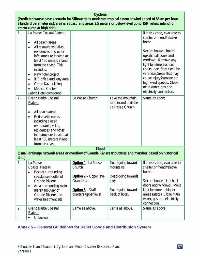
Cyclone (Predicted worse case scenario for Silhouette is moderate tropical storm at wind speed of 88km per hour. Standard parameter risk area is set as: any areas 2.5 meters or below level up to 150 meters inland for storm surge at high tide) 1. La Passe Coastal Plateau
• All beach areas • All restaurants, villas,
residences and other infrastructure located at least 150 meters inland from the coast. This includes:
• New hotel project • IDC office and jetty area • Grand Kaz building • Medical Center Labriz Hotel compound
If in risk zone, evacuate to shelter or friend/relative home. Secure house - Board up/latch all doors and windows. Remove any light furniture such as chairs, pots from close by verandas/areas that may cause injury/damage at high wind speeds. Close main water, gas and electricity connection.
2. Grand Barbe Coastal Plateau • All beach areas • Entire settlements
including closed restaurants, villas, residences and other infrastructure located at least 150 meters inland from the coast.
La Passe Church Take the mountain road inland until the La Passe Church
Same as above
Flood (Small drainage network areas or overflow of Grande Riviere tributaries and marshes based on historical data) 1. La Passe
Coastal Plateau • Pocket surrounding
coastal sea outlet of Grande Riviere.
• Area surrounding main marsh tributary of Grande Riviere and water treatment site.
Option 1 –La Passe Church Option 2 – Upper level Grand Kaz Option 3 – Staff quarters upper level
Road going towards mountains. Road going towards jetty. Road going towards back of hotel.
If in risk zone, evacuate to shelter or friend/relative home. Secure house - Latch all doors and windows. Move light furniture to higher areas (attics). Close main water, gas and electricity connection.
2. Grand Barbe Coastal Plateau • Unknown.
Same as above. Same as above. Same as above.
Annex 5 – General Guidelines for Relief Goods and Distribution System
Silhouette Island Tsunami, Cyclone and Flood Disaster Response Plan, Version 1
57

For Silhouette Island, the Island Manager is responsible for coordinating general aid for the shelters with the assistance of IDC, other government agencies and social organizations. This entails addressing the following tasks:
Assessing needs of shelters Identifying target population and priority groups Deciding on objectives, mode, and frequency of aid Coordinating with authorities to provide aid Arranging for transport delivery Arranging for secure temporary storage area to store aid Arranging for a system for equitable distribution in the shelter
Scenario 1 – Small scale emergencies generally faced by the Seychelles where residents are able to return home within 24 hours with no significant damage is done to infrastructure. Individuals are able to cope in the short term with a network of help from relatives, friends’ individual households reserves. In such a situation the local supply chain of SMB government parastatal carries a 2 week stock of food stuff and should be able to cover short term needs of shelters. Scenario 2 - In the event of a large scale disaster with severe incapacitating damages to important infrastructure such as ports, airports, SMB food stores and warehouse, many houses and a displaced population for several days or months. Additional long term assistance will have to be arranged for the island and coordinated by the Island Manager with IDC and the national government. A register of preferred suppliers and procurement policies should be maintained and used to save time during this process. The list may include government and non government agencies such as SMB, private businesses, personal household stock, NGOs and other social organizations (the coordinating body for all NGOs is LUNGOS) to help meet short term needs/demands and international aid agencies for longer term assistance. Examples of items that need to be planned for and considered to meet needs for evacuees in a natural disaster are: Food Standards: In general, a default energy requirement of 2,100 kcal/person/day is the international standard employed for distributing aid across households. When planning for immediate response, the proposed ration package must meet this requirement. As soon as possible, the ration should be adjusted to meet the demography of the population when known. The table below has been developed by USAID food for aid guidelines and is a useful guide for determining average energy requirements in population of known demography:
Age/sex group Requirement for Age/sex group (kcal/d)
Girls 0-4 yrs 12501 Boys 0-4 yrs 13201 Girls 5-9 yrs 1730 Boys 5-9 yrs 1980
Girls10-14 yrs 2040 Boys 10-14 yrs 2370
Silhouette Island Tsunami, Cyclone and Flood Disaster Response Plan, Version 1
58

Girls 15-18 yrs 2120 Boys 15-18 yrs 2700
Non-pregnant female 19-59 yrs 1990 Pregnant female 20+ years2 2275
Male 19-59 yrs 2460 Female 60+ yrs 1780
Male 60+ yrs 2010 1 For breast fed children, part of this energy is for the mother and the rest for complementary feeding of the child
For general feeding rations during initial response, the following ration package may be used:
Amount Commodity Protein (g) Fat (g) Energy (kcal)
30 g Fortified oil 0 30 270
100g Blended food 17 7 376
350g Cereal flour or Rice1 30-35 3.5-6 1,260
60g Pulse 13 <1g 204
Total 60-65 41-442 2,100 Standard Non Food Items (sufficient for 1 month): Clothing and bedding:
1 full set of clothing in correct size, climate, gender and culturally appropriate 1 blanket per person appropriate for tropical climate 1 sleeping mat per person appropriate for tropical climate
Hygiene: 1 bathing soap – 250 grams 1 washing soap – 200 grams Sanitary towels for women and girls 12 Washable nappies for infants and children under 2
Cooking and Eating Utensils: 1 large and 1 medium cooking pot with handle and lid 1 knife 2 wooden serving spoons 20 liter jerry can with screw cap or 10 liter bucket with lid (plastic food grade) 1 dish plate, spoon, mug (stainless steel or non-ferrous metal) Stove, fuel and lighting 1 stove and adequate fuel for each household
Tools and Equipment 1 mosquito net for each household to reduce vector borne diseases Training, guidance, tools such as plastic sheeting, hammer, shovel if responsible for
constructing own makeshift shelters such as tents. Additional Items that may be considered subject to availability:
100grams of toothpaste 1 toothbrush 250ml shampoo
Silhouette Island Tsunami, Cyclone and Flood Disaster Response Plan, Version 1
59

250ml lotion for infant and children under 2 1 razor
These are the basic minimum standards recommended by SPHERE; items may be customized to suit situation. Below are some useful guidelines to follow when coordinating for medium to long term food aid during an emergency:
The primary consideration of a food aid basket is the nutritional value. Equally important is to provide food that is familiar and socially acceptable. All items must have at least a 6 month shelf life (best before date) on arrival in country. Food packaging is sturdy, well labeled in readable language. Stored properly in secured, hygienic, dry, uncontaminated warehouses/locations. Random sample testing to test quality of food at point delivery by surveyors. Better to be packaged in quantities matching the basket composition to avoid re-
packaging and save time in distribution. Equitable and unbiased distribution of baskets is of primary importance. Population to be informed before on the type of food/ration to be distributed, location
and timetable for distribution in advance. Adequate security must be provided at distribution sites. Differences in rations to special groups such as infants, elderly, sick must be explained
openly and clearly. Fair, open and transparent supply chain management is established using local
capacity if feasible. Appropriate inventory accounting, reporting and financial systems are in place to ensure
accountability on ground level (e.g. – supervisor, signed inventory register).
Annex 6 – Contact Information for Animals and Useful Guidelines For public health reasons, shelters providing refuge to humans cannot allow animals inside their premises. All animal owners for pet and livestock have to find alternative locations to board their pets during disaster situations. Below is a listing of available animal shelters/boarding areas/helplines that may be used in an emergency situation: No Name and Location of
Animal Shelter Focal Person Contact Info.
Capacity Public Advise
Silhouette Resources 1. Improvised spaces such as
verandas, garages, hangards, or separately sectioned off open areas of shelters. (Must be covered for flood and cyclone).
Same as shelter focal person above.
20 or less Prepare pet survival kit ahead of time and bring along during emergency – Bring collar with ID, medical/vaccination records, water and food, medication, litter pans. (Contact SSPCA for aid)
2. Tortoise Farm Ron Gerlach Unknown Same as above National Level Resources on Mahe
Silhouette Island Tsunami, Cyclone and Flood Disaster Response Plan, Version 1
60

1 SSPCA – Seychelles Society for the Prevention of Cruelty to Animals (Domestic animals)
Duty in Charge Tel: 611004
Currently sharing vet office space until new office is built at Roche Caiman • Staff of 5 • Small operation theatre
with day care only (no overnights)
• Several cages for rent • Stock of medicine for
sale • Mobile equipment such
as pet survival kits
Same as above
2. MENRT – Dept. of Environment, Forestry and National Parks section at Botanical Garden (Wildlife)
Wildlife Representative - Selby Remy Tel:670500
Technical Personnel Same as above
3. MENRT – Dept. Natural Resources, Animal Health Section (Domestic/Livestock)
Livestock Advisor (office) Tel: 676400 Dept. of Vetinary Services (Union Vale) 24 hr emergency line: 285950
Technical Personnel • Animal facilities such as
quarantine kennel • Operation theatre • Approx. 13 trained vet
staff plus resident quarters
• Garage • Overnight stay of 12 to
15 cages • Kitchen/toilet/internet • Medicines and
equipments
Same as above
Some general useful tips for animal preparation in disasters:
For domestic/pet owners
Before disaster – Identify places you may take your pet to. Keep a survival kit for your pet for use in emergencies. Kit should include current ID, vet/vaccination records, non perishable food and water, carrier/leash/harness/cage, medication.
During disaster – Bring your pet inside promptly. Keep old newspapers handy. Separate animals such as dogs and cats since they tend to act irrationally in distressful times. If you have to evacuate, take your pet with you. If you are forced to leave them behind, leave them indoors in a safe area with food and water and leave a sign board with this information.
After disaster – A normally quite pet may become aggressive. Leash your pets and leave them in a fenced yard for the first few days. For livestock owners
Before disaster – Have an evacuation and transportation plan ready. Ensure all animals have tags/ID for facilitating return and a stock of food at alternative site to last a minimum of 1 week.
Silhouette Island Tsunami, Cyclone and Flood Disaster Response Plan, Version 1
61

During disaster – Evacuate animals according to plan. If not possible, coordinate with authorities to take to shelter area or other location. Keep authorities informed of major activities and unusual behavior patterns at all times For wildlife
Before disaster – Public do not try to corner wild animals, rescue them or give them refuge in your homes. Call the environmental representative on Silhouette for assistance.
During and after disaster – Public do not attempt to move a dead animal as they might pose serious health risks. Call the environmental representative on Silhouette for help and guidance.
Annex 7 – Other Resources None available for listing at this time. Annex 8 – Sample Standard Format for Information Collection During Rapid Assessment (The form presented below is from the national contingency plan for tsunami, cyclone and flood for the sake of consistency)
Form for the Collection of Information of Damage and Needs Assessment:
Form 500.1.- Damage and Needs Assessment Report.
Report No.____ Date_____ Time ____ Name ___________________________ Position__________________________ _________________________________ _________________________________
Platform/District/Sector/services/ facilities covered by this report:
Damage and Needs per Sector. Type, quantification and location of damage and needs. Action taken.
Population affected. -Deaths, missing, injured, type of injuries, location. -Needs in terms of: medical attention, counselling, medicines, doctors, nurses, first aids, medical equipment/materials. -Action taken.
Description:
Housing and human settlements: -Houses destroyed totally or partially. Type of damage. Location. Population displaced. Number of official/unofficial shelters activated. Number of shelterees. Areas flooded or destroyed. -Needs in terms of shelters, shelter management personnel, relief assistance for population displaced: water, food, blankets,
Description:
Silhouette Island Tsunami, Cyclone and Flood Disaster Response Plan, Version 1
62

other items for shelters: generators, cooking utensils, toiletries, toys, etc. Number of tarpaulins and type of building materials needed. -Action taken. Education and Culture: - Schools and education facilities destroyed or damaged. Location. Type, extent of damage. Cultural-Historical sites, libraries, community centres, sports facilities affected and type/extent of damage. Information lost. - Needs in terms of tarpaulins, building materials, school furniture, equipment; books, etc. - Action taken.
Description:
Health: a) Medical Attention /Infrastructure. -Specific structural damage to hospitals, clinics, home of the elderly, psychiatric hospital, etc. Medicines and medical equipment lost/damaged. Damage to other buildings and transportation. -Needs in terms of specific medical attention to patients/injured. Counselling. Medical personnel/nurses, etc. Medical equipment, medicines. Food, water, tarpaulins, building materials, generators, etc. -Action taken. b) Environmental health. - Damage to environment and consequences to public health: adequate quality and quantity water supply, food safety, basic sanitation, adequate waste disposal, vector control, epidemiological surveillance in specific affected areas and shelters. Interruption of services. Adequate management and disposal of dead people and animals. -Needs in terms of water, food, water testing kits, chlorinated tablets, pesticides, spraying equipment, protection equipment, and other equipment. Experts. Location of needs. -Action taken.
Description a): Description b):
Agriculture, livestock and fisheries. -Damage in terms of crops destroyed/affected, area, livestock lost/ affected, location, damage to fisheries, nurseries, and farms. Irrigation and drainage. -Needs in terms of food, agriculture/fisheries equipment, materials. -Action taken.
Description:
Tourism: Description: Silhouette Island Tsunami, Cyclone and Flood Disaster Response Plan, Version 1
63

-Damage in terms of structural damage, reduction of hotel capacity, communications, injured, energy, employees affected. Shipping industry. Tour operations. Marinas and yachting. -Needs in terms of tarpaulins, building materials, food, water, equipment and materials. -Action taken. -Trade and Industry: -Damage in terms of facilities, equipment, materials, products, and stock damaged/lost. Employees affected. Operations interrupted. Looting. -Needs in terms of tarpaulins, building materials, water, food, security, etc. -Action taken.
Description:
Energy: -Damage in terms of electricity interrupted in specific areas to specific sectors facilities. Damage to fuel storage and distribution. -Needs in terms of equipment, materials, generators, personnel, etc. -Action taken.
Description:
Water supply and sewerage: -Damage in terms of destruction of specific distribution/collection systems/equipment pipelines, reservoirs, pumping systems, in specific areas. -Needs in terms of repairs, equipment, personnel, water, electricity, etc. -Action taken.
Description:
Telecommunications and Broadcasting: -Damage in terms of loss of services in specific areas (cellular and landlines). Damage/loss of poles, lines, antennae, broadcasting equipment and facilities. -Needs in terms of repairs to damaged equipment, specific equipment for rehabilitation and continuation of communications/broadcasting. Radios. -Action taken.
Description:
Roads and drainage: -Damage in terms of roads/bridges damaged/obstructed by debris or land slippages, fallen trees, and wave affects. -Needs in terms of clearing roads and specific areas. Heavy-duty equipment. Key priorities. -Action taken.
Description:
Airport: -Damage in terms of structural damage,
Description:
Silhouette Island Tsunami, Cyclone and Flood Disaster Response Plan, Version 1
64
loss/damage of facilities/equipment: control tower, communications, radars, antennae, lights, power, and general state of the runaway. Interruption of commercial activities. -Needs in terms of specialised personnel, equipment, materials; repairs and resumption of commercial flights. -Action taken. Seaport: -Damage to docks, boats, sheds, buildings, personnel; loss of equipment, materials, cargo, etc. Interruption of services. -Needs in terms of personnel, equipment, materials for the repair of buildings/equipment and for the restoration of activities/services. -Action taken.
Description:
Environmental impacts: -Damage in terms of specific areas damaged forest, lakes, coasts, and habitats. Loss / endangerment of flora and fauna. -Needs in terms of specific mitigation /protection measures. -Action taken.
Description:
Final Comments. Name____________________________ Signature_________________________
Annex 9 – Sample Standard Format for Situation Report
SITUATION REPORT
The Island of: Situation Report No: Date: Time:
To The Chairperson Islands Development Company New Port (P.O. Box 638) Victoria, Mahe Email: [email protected] Telephone: 224640 Silhouette Island Tsunami, Cyclone and Flood Disaster Response Plan, Version 1
65

Fax: 224467 1. SITUATION or INCIDENT: Topic explanation - Type of emergency/disaster, location. Give concise summary of activities before, during and after the emergency/disaster. Response: 2. WEATHER SUMMARY: Topic explanation - Weather conditions at the time of the situation, if necessary. Response: 3. DEATH AND INJURIES: Topic explanation - Total deaths to date, total injuries to date – including location of the deaths/injuries, where practical. Response: 4. DAMAGES: Topic explanation - Type, extent and impact of property damage, how this directly affects people. (e.g., damage to housing, food supplies, medical resources, and water and sewage service). Also include special damage problems that may impact on vital services, such as damage to key utilities, communication facilities, medical resources, major military or major transportation facilities. (e.g. major highways, bridges, rail routes, and airports). Indicate any additional damage potential as a result of the emergency. Response: 5. RESOURCES COMMITTED: Topic explanation - List local, private, public, and national resources committed. This includes use of personnel and equipment, shelter supplies, engineering equipment, etc. Response:
LOCAL PRIVATE:
LOCAL PUBLIC:
NATIONAL PRIVATE:
NATIONAL PUBLIC: 6. MAJOR ACTIONS (PUBLIC/PRIVATE):
Major actions such as dissemination of emergency/disaster warnings, requests for assistance, public announcements or instructions, activation of EOC and emergency operations plan, evacuation, search and rescue, recovery and rehabilitation work. Response:
Silhouette Island Tsunami, Cyclone and Flood Disaster Response Plan, Version 1
66

Name all government and private agencies providing assistance
Response:
Indicate actions taken and/or general assistance provided by individuals, non profit organizations or any other type of volunteer groups. (i.e. Seychelles Red Cross, church groups, etc Include information such as number of meals served, number of individuals sheltered, etc. Response:
7. APPEAL FOR ASSISTANCE: Topic Explanation - List all requests for additional support. Do not send a request stating “Send all available help.” These requests should be specific (i.e. 1pick up truck or 1,000 ORS packets or 2 chainsaws or 1,000 gallons of drinking water etc). The name and position of the person making the request should also be included. DRDM will view this as a formal request and will act accordingly. Response: 8. OTHER INFORMATION: Other data and remarks not covered above.
PREPARED & SIGNED BY:
__________________________ (Name)
__________________________ Annex 18 – List of Workshops, Meetings, Focus Group Discussions and Interviews
1. Ms. Therese Gopal, National Statistics Bureau, Interview, August 5th, 2008. 2. Mr. Basil Esther, Forestry and National Parks, Interview, August 7th, 2008. 3. Mr. Selby Remy, Forestry and National Parks, Interview, August 7th, 2008. 4. Mr. Jason Jacquelin, SWAC, Interview, August 12th, 2008. 5. Mr. Francis Coeur de Lion, GIS, Meeting, August 15th, 2008. 6. Dr. Jude Gedeon, Mrs. Kathleen Adrienne, Mr. Nicola Sham Laye, Ms. Eulalie Sabury,
Mr. James Chang-Tave, Mr. Paul Labaleine, Mr. Eddie Payet, Ministry of Education and DRDM Focus Group Discussion, August 22nd, 2008.
7. Mr. Dan Frichot, Mr. Moses Barbe, Ms. Sylvanne Lemiel, Mr. Wilbur Omath, Mr. Guilly Anacoura, Ministry of Community Development, Focus Group Discussion, August 27th, 2008.
8. Participatory Contingency Planning Workshop and Mapping Exercises, District Beau Vallon DA and staff, emergency brigade, other district social, business and governmental agencies, September 8th, 2008.
9. Participatory Contingency Planning Workshop and Mapping Exercises, District Glacis DA and staff, emergency brigade, other district social, business and governmental agencies, September 8th, 2008.
Silhouette Island Tsunami, Cyclone and Flood Disaster Response Plan, Version 1
67

10. Participatory Contingency Planning Workshop and Mapping Exercises, District Anse Etoile, DA and staff, emergency brigade, other district social, business and governmental agencies, September 9th, 2008.
11. Participatory Contingency Planning Workshop and Mapping Exercises, District Bel Ombre, DA and staff, emergency brigade, other district social, business and governmental agencies, September 9th, 2008.
12. Participatory Contingency Planning Workshop and Mapping Exercises, District English River, DA and staff, emergency brigade, other district social, business and governmental agencies, September 10th, 2008.
13. Participatory Contingency Planning Workshop and Mapping Exercises, District Mont Buxton, DA and staff, emergency brigade, other district social, business and governmental agencies, September 10th, 2008.
14. Participatory Contingency Planning Workshop and Mapping Exercises, District St. Louis, DA and staff, emergency brigade, other district social, business and governmental agencies, September 11th, 2008.
15. Participatory Contingency Planning Workshop and Mapping Exercises, District Bel Air, DA and staff, emergency brigade, other district social, business and governmental agencies, September 11th, 2008.
16. Participatory Contingency Planning Workshop and Mapping Exercises, Districts Mont Fleuri, Plaisance, Les Mammelles, Roche Caiman, Cascade, Pointe Larue, Anse Aux Pins, Au Cap, Anse Royale, Takamaka, Baie Lazare, Anse Boileau, Grand Anse, Port Glaud, DA’s, Damien Riquet UNDP, September 15th, 2008.
17. Participatory Contingency Planning Workshop and Mapping Exercises, District Grand Anse Praslin, Baie St. Anne Praslin, La Digue, DA and staff, emergency brigade, other district social, business and governmental agencies, September 18th, 2008.
18. Mr. Michel Vielle, Mr. James Chang Tave, Mrs. Colette Servina, Ms. Sharon Thelemaque, Mr. France Sophola, Mr. Paul Labaleine, Mr. Dan Frichot, DRDM and MCDY Regional Platform Focus Group Discussion, September 19th, 2008.
19. Ms. Ruth Barbe, SSPCA Group Discussion, November 14th, 2008. 20. Mr. Glenny Savy, Mr. Terence Stravens, Mr. Gilbert Esparon, Mr. Vinesh Gupta, Ms.
Magda Rose, Mrs. Colette Servina, Mr. Damien Riquet, Mr. James Chang-Tave, and Mr. Michel Vielle, IDC and DRDM focused group meeting, November 25th, 2008.
Definition of Terminology Disaster - An event that causes significant loss of human life, economic and infrastructure damage and deterioration, and ecological disruption on a scale to warrant an extraordinary response from outside the affected community. Disasters are distinguished from emergencies by the greater level of response required. Emergency Operations Center (EOC) - A centralized facility to be utilized by the local government branch for direction, control, and coordination of emergency response activities during a disaster or emergency situation. Emergency - A sudden, generally unexpected occurrence or set of circumstances demanding immediate action. Flash floods – Is the product of heavy localized precipitation in a short time period over a given location. General floods – Precipitation over a longer time period and over a given river basin. Silhouette Island Tsunami, Cyclone and Flood Disaster Response Plan, Version 1
68

Hazard - Is a threat of an event that can have a negative effect on people or the environment. There are many types of hazards such as geological hazard (earthquake, avalanche, landslides), hydrological hazard (floods, tsunami), climatic or atmospheric hazard (cyclones, hailstorms, heat wave), wildlife hazard, biospherical hazards (epidemics). Rapid assessment – Is a review done onsite by a multi-disciplinary team with the objective to assess, document, and report the physical damages done to district populace and infrastructure after the impact of tsunami, cyclone or flood. The finings are provided to government agencies for situation updates to public, for determining immediate and long term relief and rehabilitation needs, and initial appraisal of financial costs. Rapid onset hazard – Is a hazard that develops suddenly without much warning or reaction time. Risk - Is a product of hazard and vulnerability. Short Message Service – Is a text message service that enables short messages of generally no more than 140-160 characters in length to be sent and transmitted from a mobile telephone. Short messages are stored and forwarded at SMS centers, which means that messages can be retrieved later on the mobile over the system's control channel. Slow onset hazard – Is a hazard that develops over a period of time so that adequate warning and preparations can be made to respond. SPERE – Is a handbook made up of a humanitarian charter and minimum standards of conduct for quality and accountability for disaster response and is a broad process of collaboration of humanitarian NGO and the Red Crescent movement. Storm surge – Is water that is pushed toward the shore by the force of winds swirling around a storm. Triage - Is a tool first responders and medical personnel use during a mass casualty incident in the hospital or field. First-arriving personnel distribute the limited medical resources and provide the necessary immediate medical care for the victims until more help is available later. Vector– Is a disease carrying agent such as mosquitoes, house flies, blow flies, and flesh flies. Vector Borne Disease – Diseases such as malaria, dengue, yellow fever, diarrhea, cholera. It is a major cause of sickness and death in disaster situations. Bibliography
1. Anse Royale District Contingency Plan, Department of Risk and Disaster Management, August 2006.
2. Capacity Needs Assessment, John Neville, 2007. 3. CARE Emergency Preparedness and Planning Guidelines Version 3, October 2003. 4. Commodities Reference Guide, Part II, Module 5, USAID Food for Peace, January
2006. Silhouette Island Tsunami, Cyclone and Flood Disaster Response Plan, Version 1
69

5. Contingency Planning Guidelines, A practical Guide for Field Staff, UNHCR, 1996. 6. Diagnosis of the Status of Emergency Planning in Seychelles, Arturo Lopez-Portillo
Contreras, February 1st, 2008. 7. Disaster Risk Profile Report, Denis Chang Seng & Richard Guillande, July 2008. 8. Effects of the 26th December Indian Ocean Tsunami in the Republic of Seychelles,
Canada-UNESCO Indian Ocean Tsunami Expedition, 2005. 9. Environmental Impact Assessment of Silhouette Island Resort (Labriz), S.I.G.M.A. –
Ove Arup & Partners, April 2005. 10. Establishment of an End-to-End Multi-Hazard Early Warning System (EWS):
Seychelles, Asian Disaster Preparedness Center, February 29th, 2008. 11. FEMA website, Disaster Preparedness, July 2008. 12. Final District Reports, Yann Rouseau and DRDM, June 2006. 13. Google Maps for Silhouette Island main map on cover page, La Passe, and Grand
Barbe in body of report, December 2008. 14. How resilient is your coastal community? A guide for evaluating coastal community
resilience to tsunamis and other hazards, US Indian Ocean Tsunami Warning System Program, 2007.
15. Inter-agency Contingency Planning Guideline for Humanitarian Assistance, IASC,
November 2007. 16. Management of Dead Bodies after Disasters: A Field Manual for First Responders, Pan
American Health Organization, WHO, ICRC and International Federation of Red Cross and Red Crescent Societies, 2006.
17. OCHA website, Disaster Preparedness Toolkit, November 2007. 18. Seychelles, Vicki King and Bryony Walmsley, 2004. 19. SPHERE website, Humanitarian Charter and Minimum Standards Handbook, 2000 &
2004. 20. The Seychelles Flood Response Plan, Arturo Lopez-Portillo Contreras, February 1st,
2008. 21. The Seychelles Tropical Cyclone Emergency Response Plan, Arturo Lopez-Portillo
Contreras, February 1st, 2008. 22. The Seychelles Tsunami Emergency Response Plan, Arturo Lopez-Portillo Contreras,
February 1st, 2008.
Silhouette Island Tsunami, Cyclone and Flood Disaster Response Plan, Version 1
70

SSIILLHHOOUUEETTTTEE IISSLLAANNDD
SSCCHHOOOOLL EEMMEERRGGEENNCCYY PPRROOCCEEDDUURREESS

Silhouette School Emergency Procedures (Until Contingency Plan is Written Next Year by School)
Silhouette Island Manager notify of warning from tsunami, cyclone or flood.
HHeeaadd tteeaacchheerr iimmmmeeddiiaatteellyy nnoottiiffiieess aallll sscchhooooll tteeaacchheerrss,, ggeenneerraall ssttaaffff aanndd ppaarreennttss ooff ssttuuddeennttss ooff ppoossssiibbllee tthhrreeaatt..
Prepare staff, students, facilities & standby.
Island Manager provides updates.
Head teacher informs all teachers, general staff and parents.
Head teacher initiates emergency response
procedures.
1. For tsunami
Inform all parents that school children are being evacuated to the church. Parents meeting point should be at the church.
Teachers to evacuate all students to assemble in open school compound. • Studies coordinator to perform
headcount of all staff and students. • Head teacher to shut main utilities. • Head teacher to lock building.
All teachers and students walk together to the church and check in with shelter coordinator.
2. For Cyclone
Inform all parents of school closing and to pick up children within set time frame of 1 hour or else children will be directly evacuated to the church by school.
Key teachers &r remaining students to assemble in front of head teacher’s office. • Studies coordinator to perform
headcount of all staff and students. • Head teacher to shut main utilities. • Head teacher to lock building.
Teachers and students walk together to the church and check in with shelter coordinator.
3. For Flood Inform all parents of school closing and to pick up children within set time frame of 1 hour or else children will be directly evacuated to the church by school.
Maintain positions until further advised by Silhouette Island Manager
Important Tel Contacts
Island Manager: 224077 Medical Center: 224110 Caretaker of Church: 524646 Labriz: 293949
Danger
No Danger
Key teachers &r remaining students to assemble in front of head teacher’s office. • Studies coordinator to perform
headcount of all staff and students. • Head teacher to shut main utilities. • Head teacher to lock building.
Teachers and students walk together to the church and check in with shelter coordinator.

SSIILLHHOOUUEETTTTEE IISSLLAANNDD
TTEERRRRAAIINN MMAAPP

¹½
¹½
¹½
¹½
¹½
¹½
¹½
¹½
¹½
¹½
¹½
¹½
¹½
¹½
¹½
¹½
¹½
¹½
¹½
¹½
¹½
¹½
¹½
¹½
¹½
¹½
¹½
¹½
¹½
¹½
¹½¹½
¹½
¹½
¹½
ü
ü
ü
ü
ü
ü
ü
ü
ü
ü
ü
ü
ü
ü
ü
ÆU
ÆU
ÆU
ÆU
ÆU
ÆU
ÆU
ÆU
ÆU
ÆU
®v®v
®v
®v
®v
®v
®v
®v
®v
®v
®v
®v
®v
®v
®v
®v
®v
®v
®v
®v
®v
®v
®v
®v
²
²
²
²
²
²¶²
²
²
²
²¶²
²
²
²
²
²
²
²
²
²
²
²
²
²
²
²
²
²
²
²
²
²
²
²
²
²
²
²
²
²
²
²
²
²
²
²
²
²
²
²
²
²
²
²
²
²
²
²
²
²
²
²
²¶²
²
²
²
²
²
²
²
²
²
²
²
²¶²
²
²
²
²
²
²¶²
²
²
²
²
²
²
²
²
²
²
²
²
²
²
²
²
²
²
²
²
²
²
²
²
²
²
²
²
²
²
²
²
²
²
²
²
²
²
²
²
×
×
×
×
×
×
×
×
×
×
×
×
×
×
×
×
×
×
×
×
×
×
×
×
×
î
î
î
î
î
î
î
î
î
î
î
î
î
î
î
î
î
î
î
î
î
î
î
ï
ï
ï
ï
ï
ï
ï
ï
ï
ï
ï
ï
ï
300000.000000
300000.000000
300500.000000
300500.000000
301000.000000
301000.000000
301500.000000
301500.000000
302000.000000
302000.000000
302500.000000
302500.000000
303000.000000
303000.000000
303500.000000
303500.000000
304000.000000
304000.000000
304500.000000
304500.000000
305000.000000
305000.000000
305500.000000
305500.000000
306000.000000
306000.000000
306500.000000
306500.000000
307000.000000
307000.000000
307500.000000
307500.000000
9501
000.0
0000
0
9501
000.0
0000
0
9501
500.0
0000
0
9501
500.0
0000
0
9502
000.0
0000
0
9502
000.0
0000
0
9502
500.0
0000
0
9502
500.0
0000
0
9503
000.0
0000
0
9503
000.0
0000
0
9503
500.0
0000
0
9503
500.0
0000
0
9504
000.0
0000
0
9504
000.0
0000
0
9504
500.0
0000
0
9504
500.0
0000
0
9505
000.0
0000
0
9505
000.0
0000
0
9505
500.0
0000
0
9505
500.0
0000
0
9506
000.0
0000
0
9506
000.0
0000
0
9506
500.0
0000
0
9506
500.0
0000
0
µSilhouette Island
1:7,200
0 250 500125 Meters
![Untitled-1 [iotic.ioc-unesco.org]iotic.ioc-unesco.org/1945makrantsunami/sources/nc/nc_in... · 2019-05-01 · sidency Magistrate t.œ The Ond a c cused is ¼bsëond- Ing ault.ed pollqcmen's](https://static.fdocuments.us/doc/165x107/5ecbcf59c5d4dd482b5da2c1/untitled-1-ioticioc-ioticioc-2019-05-01-sidency-magistrate-t-the-ond.jpg)