
Short-term Prediction Research and Transition (SPoRT)
11
transitioning research data to the operational weather community Short-term Prediction Research and Transition (SPoRT) SPoRT is focused on transitioning unique NASA and NOAA observations and research capabilities to the operational weather community to improve short-term weather forecasts on a regional and local scale. o close collaboration with numerous WFOs across the country o SPoRT activities began in 2002, first products to AWIPS in 2003 o co-funded by NOAA since 2009 through “proving ground” activities Proven paradigm for transition of research and experimental data to “operations” Benefit o demonstrate capability of NASA and NOAA experimental products to weather applications and societal benefit o prepares forecasters for use of data from next generation of operational satellites (JPSS, GOES-R)
Transcript of Short-term Prediction Research and Transition (SPoRT)

transitioning research data to the operational weather community
Short-term Prediction Research and Transition (SPoRT)
SPoRT is focused on transitioning unique NASA and NOAA observations and research capabilities to the operational weather community to improve short-term weather forecasts on a regional and local scale. o close collaboration with numerous WFOs across the country
o SPoRT activities began in 2002, first products to AWIPS in 2003
o co-funded by NOAA since 2009 through “proving ground” activities
Proven paradigm for transition of research and experimental data to “operations”
Benefit o demonstrate capability of NASA and NOAA experimental products to
weather applications and societal benefit
o prepares forecasters for use of data from next generation of operational satellites (JPSS, GOES-R)

transitioning research data to the operational weather community
Determine Forecast Issue
Match Forecast Issue
to Product
Determine Training Needs
Evaluate Product Impact
Enhance the Product
Has forecast issue been addressed?
Involve end user in entire
process
Ready for transition
Yes No
Match
problem to
product
Problem
been
addressed?
Assess
operational
impact
End user
training
Develop
solution
Determine
forecast
problem
Research Data / Products to “Operations”
SPoRT Paradigm • match forecast challenge to
data/product • develop solution /
demonstrate in ”test bed” environment
• integrate successful products into end user’s decision support tools
• create product training • perform product assessment
Maintain interactive partnership with end user throughout process
Need local end user advocate
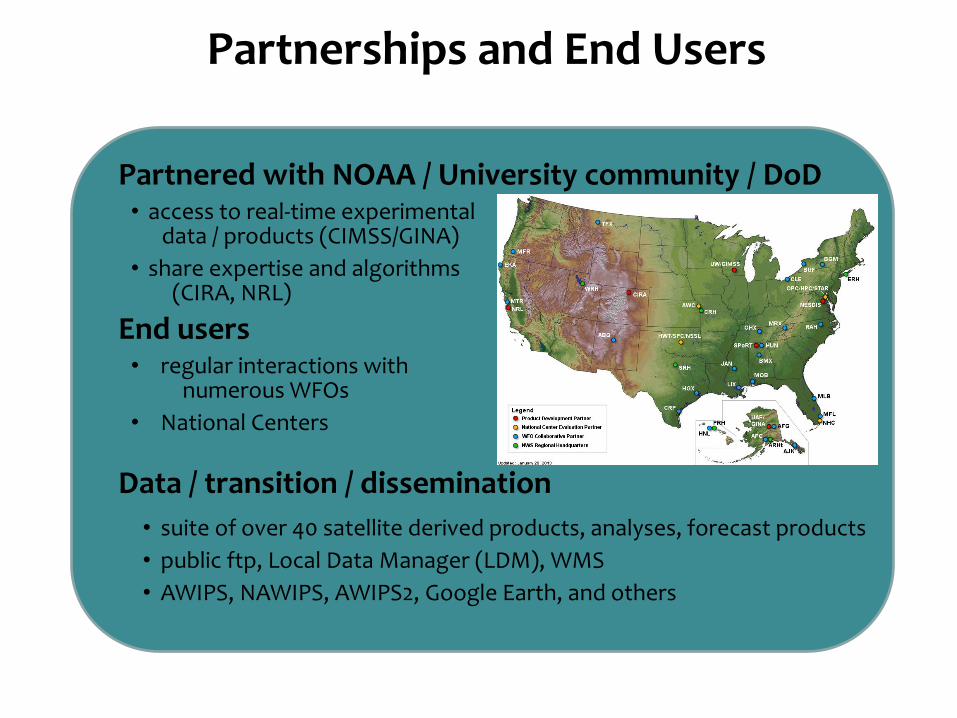
Partnered with NOAA / University community / DoD • access to real-time experimental data / products (CIMSS/GINA)
• share expertise and algorithms (CIRA, NRL)
End users • regular interactions with numerous WFOs
• National Centers
Data / transition / dissemination
• suite of over 40 satellite derived products, analyses, forecast products
• public ftp, Local Data Manager (LDM), WMS
• AWIPS, NAWIPS, AWIPS2, Google Earth, and others
Partnerships and End Users

transitioning research data to the operational weather community
SPoRT Focus and Direction INSTRUMENT / PRODUCT FORECAST PROBLEM
MODIS (Terra and Aqua)
Imagery (visible, 3.9, 6.7, 11 µm) Improve situational awareness Suite of RGB products (true, false color snow, air mass, night & day-time microphysics, dust)
Cloud structure, obstructions to visibility, extent of snow cover
Fog / low cloud (11-3.9 µm) Improve situational awareness
Land and sea surface temperature (LST, SST) Surface forcing for clouds and convection
SST and ice mask (Great Lakes and Arctic Ocean) Coastal processes, lake effect precipitation
NDVI / Green Vegetation (GVF) Model initiation / improved forecasts
AMSR-E (Aqua) / AMSR2 (GCOM)
Rain rate, cloud water Coastal weather, data in void regions
SST Coastal weather
Total Lightning Data (ground-based)
Source / flash density Severe weather, lightning safety
Combined Instrument Products
Multi-sensor SST composite Short-term weather forecasts
Blended TPW Moisture mapping, atmospheric rivers,
precipitation
HMS/FIRMS fire/burn area Smoke, reduced visibility, localized flooding
GOES
NESDIS aviation products Improve situational awareness
Sounder air mass RGB Storm dynamics, improved situational awareness
GOES-R Proxy Products
Pseudo GLM product suite Severe weather, lightning safety
GOES-MODIS hybrid imagery (visible, 3.9, 6.7,
11µm)
Improved situational awareness
Hybrid RGB suite Improved situational awareness
Quantitative Precipitation Estimates (QPE) Precipitation mapping
Convective Initiation (CI) product Convection, precipitation mapping
JPSS Proxy Products
VIIRS imagery (visible, 3.9, 11 µm) Improved situational awareness Suite of VIIRS RGB products (true, air mass (w/CrIS), night & day-time microphysics, dust)
Cloud structure, obstructions to visibility, storm dynamics
VIIRS DNB (low light) – radiance, reflectance,
RGB
Improved situational awareness
SEVIRI
RGB products (air mass, dust, Saharan Air Layer) Tropical storm forecasting, storm dynamics
Passive Microwave
TMI (TRMM) 37(V/H), 85(V/H), composite Precipitation monitoring, storm dynamics
SSMI(S) 37(V/H), 85(V/H), 91(V) Precipitation monitoring, storm dynamics
SSMI(S) RGBs – 37/85, 37PCT Precipitation monitoring, storm dynamics
MISCELLANEOUS
Land Information System (LIS) – soil moisture Convective initiation, drought monitoring, flooding
WindSat – Ocean Surface Wind Vectors (OSWV) Improved situational awareness over oceans
OMI
NESDIS SO2 Volcanic ash monitoring
AIRS
Carbon monoxide, ozone imagery Fires, air quality, storm dynamics
Address Forecast challenges of operational community • NASA and NOAA funding
• Strategic plan
• Science Advisory Committee
Products • MODIS, AIRS, Total Lightning, GOES, JPSS
(VIIRS , CrIS), SEVIRI, Passive Microwave, GOES-R proxy products
• Model and forecast products such as NASA/LIS analysis fields and WRF forecasts
ROSES funding to external community • ROSES 2010 o layered PW (CIRA) oenhanced QPE (OU/NSSL)
• ROSES 2013 (due 5/15/13) – 3-4 PI projects

transitioning research data to the operational weather community
Product Training
transitioning research data to the operational weather community
SPoRT training addresses different learning styles by creating a variety of training modules types for end users
• “quick guides” for easy forecaster reference • science sharing sessions
Two-side laminated “Quick Guide” for VIIRS DNB
• short (15-20 minute) self-learning guides (Articulate Presenter modules with audio) currently under development for Suomi NPP
Involve end user in training module development • user provide relevant examples • address forecaster concerns / usage • ownership in process / data
End user understanding leads to additional applications
transitioning research data to the operational weather community
Atmospheric rivers (with HMT)
• AIRS Level 2 T and q profiles to improve numerical analysis and forecast oUse HMT field campaign dropsonde
data to verify forecast improvements
• Aid in transition of HMT ensemble forecast precipitation product to AWIPS for West Coast WFOs
• HMT co-authors on AMS conference paper
• Planned participation in HMT-SE TPW forecast sensitivity to
assimilation of AIRS profiles (24 hour
forecast valid 11 March 2011)
x
CNTL
AIRS
HMT Drop
Specific
humidity
profile at
“X”
above
Collaboration with Other Testbeds

transitioning research data to the operational weather community
Tailored suite of proxy products for GOES-R ABI and GLM
• GOES-POES hybrid imagery • SEVIRI and MODIS RGB imagery • Pseudo GLM product suite • Collaboration with AWGs to transition
products (CI, QPE, GOES Sounder air mass RGBs)
x
GOES-R Proving Ground / HWT
GOES Sounder Air
Mass RGB (CIRA)
SEVIRI air mass RGB Product
from 3/28/2012 at 1545 UTC
Suspected stratospheric dry air on windward side of mid-latitude cyclone
Pseudo GLM evaluated at HWT 2011-2012
Convective Initiation at HWT

transitioning research data to the operational weather community transitioning research data to the operational weather community
Demonstrate the utility of JPSS data to operational weather forecasting • Transition selected products and capabilities, training, and product assess assessment
• VIIRS, CrIS, OMPS data
Dust-scattered sunrise over Huntsville
VIIRS DNB and Nighttime Microphysics Fog Detection
VIIRS dust product tracks dust from Nebraska into Southeast U.S.
Dust Product
VIIRS/CrIS “air mass” product for Superstorm Sandy
JPSS Proving Ground
oHigh resolution imagery oDNB low light imagery oRGB products (dust, night time microphysics, true
color, low cloud / fog, DNB) oFused VIIRS / CrIS (for missing water vapor and ozone
channels)

AWIPS II Activities at SPoRT
Transition SPoRT products from AWIPS to AWIPS II, and to develop, test, and transition new capabilities to ingest / display satellite / model products which best demonstrates the new satellite/sensor capabilities
transitioning research data to the operational weather community
Focus on: • multi-byte data sets • enhanced RGB display capabilities (with CIRA) • ingest and display of non-standard products
Worked with NWS OST SEC to establish governance for the transition / base lining of externally developed AWIPS II plugins and tools
• total lightning ATAN • Base lined in AWIPS II by summer
Leading efforts to train a community team of AWIPS II developers to support GOES-R and JPSS programs
• first EPDT workshop at SPoRT (3/2013) • 15 developers Total Lightning Data in AWIPS II
Earth Networks
pGLM
NALMA Source Density
NALMA Flash Extent
True color VIIRS data

Operations Proving Ground
• Use of ground-based total lightning products from SPoRT in numerous WFOs since 2003
• Rapid increases in total lightning signify a rapidly developing updraft - storms with stronger updrafts produce more lightning
• Led to concept of lightning “jump” (Schultz et al……)
transitioning research data to the operational weather community
Forecaster use of the SPoRT Lightning Tracking Tool
• Forecaster feedback indicated that a “trending tool” would greatly enhance utility of SPoRT total lightning data odeveloped a lightning tracking to
support this need o submitted to Operations PG (3/2013) o supports more generic tracking
meteogram under development by
MDL
Summary
SPoRT is an end-to-end transition to operations activity supported by NASA and NOAA
• Internally and externally developed products to address forecast issues
• Broad guidance and direction – external involvement
• Develop / refine solution in a “test bed” environment – involve end user
• Transition proven solutions to operational weather environment such as WFOs and National Centers
• Develop end user product training
• Conduct assessments and impact studies
Work collaboratively with other test beds and proving grounds
Explore transition through Operations Proving Ground
transitioning research data to the operational weather community


![Results in Physics - CORE · Jonathan L. Case ENSCO, Inc./NASA Short-term Prediction Research and Transition [SPoRT] Center, 320 Sparkman Dr., Huntsville, AL 35805, United States](https://static.fdocuments.us/doc/165x107/5f74acb4250dba11922098d4/results-in-physics-core-jonathan-l-case-ensco-incnasa-short-term-prediction.jpg)

