Shire of Christmas Island Local Planning Strategy endorsed May 2015
93
SHIRE OF CHRISTMAS ISLAND Endorsed by the Western Australian Planning Commission MAY 2015 DISCLAIMER This is a copy of the Local Planning Strategy at the date of endorsement produced from an electronic version of the Strategy held by the Department of Planning. Whilst all care has been taken to accurately portray the current Strategy provisions, no responsibility shall be taken for any omissions or errors in this documentation. Consultation with the respective Local Government Authority should be made to view a current legal version of the Strategy. Please advise the Department of Planning of any errors or omissions in this document. LOCAL PLANNING STRATEGY
Transcript of Shire of Christmas Island Local Planning Strategy endorsed May 2015

SHIRE OF CHRISTMAS ISLAND
Endorsed by the Western Australian Planning Commission
MAY 2015
DISCLAIMER
This is a copy of the Local Planning Strategy at the date of endorsement produced from an electronic version of the Strategy held by the Department of Planning. Whilst all care has been taken to accurately portray the current Strategy provisions, no responsibility shall be taken for any omissions or errors in this documentation. Consultation with the respective Local Government Authority should be made to view a current legal version of the Strategy. Please advise the Department of Planning of any errors or omissions in this document.
LOCAL PLANNING STRATEGY

Christmas Island Local Planning Strategy
May 2015
Shire of Christmas Island
Strategic Snapshot
Local Planning Strategy - Purpose
The Shire of Christmas Island Local Planning Strategy (LPS) provides a background and strategic foundation for planning, land use, and development on the island.
Key objectives and priority actions to support planning on Christmas Island are:
Whole of Island
Objective: Long term sustainable growth .
Key Actions:
• Prepare a Local Planning Policy Framework.
Settlement
Objective: Maintain and consolidate.
Key Actions:
• Increase residential densities.
• Implement the Cemetaries Management Plan.
Gaze Road Tourism and Commercial
Precinct
Objective: Facilitate and provide a destination.
Key Actions:
• Identify appropriate dive resort location within Gaze Road precinct.
• Relocate fuel tanks and service station.
• Enhance public open space.
Kampong and Smith Point Precinct
Objective: Maintain and consolidate history and port.
Key Actions:
• Climate change proofing and transitional arrangements.
• Restore and develop heritage sites for community use.
Poon Saan and Silver City
Objective: Maintain and expand urban development.
Key Actions:
• Detailed structure planning for urban development and hospital expansion.
Drumsite
Objective: Maintain and consolidate.
Key Actions:
• Expansion of power station, school, and commercial area.
• Enhance public open space.
• Horticultural trials and expansion.

Christmas Island Local Planning Strategy I a
Christmas Island Local Planning Strategy I b
Light Industrial Area
Objective: Facilitate industrial land.
Key Actions:
• Poon Saan bypass road and short term industrial lot release.
Phosphate Hill/Recreation Centre Precinct
Objective: Expand urban development, provide sports and recreation.
Key Actions:
• Define extent of groundwater aquifer on Christmas Island and manage treated sludge from Waste Water Treatment Plant.
• Detailed structure planning for urban development.
Airport Surrounds
Objective: Airport expansion and environmental preservation
Key Actions:
• Identify and protect areas for future airport expansion.
• Consider environmental compensation bank.
Golf Course and Resort Precinct
Objective: Strategic tourism.
Key Actions:
• Expand golf course and encourage eco-tourism.
Dolly Beach Road Precinct
Objective: Promote economic development.
Key Actions:
• Pilot agriculture and horticulture development.
• Detailed structure planning for tourism opportunity.
East Coast
Objective: Primary production and environmental protection.
Key Actions:
• Future mining.
• Post-mining lease transfer for agriculture and horticulture.
South Point
Objective: Long term rural land.
Key Actions:
• Maintain option of establishing space centre.
Rest of Island
Objective: Preserve National Park with eco-tourism.
Key Actions:
• Explore opportunity for eco-tourism sites.
• Provide for future expansion of Immigration Detention Centre.

Christmas Island Local Planning Strategy I c

Christmas Island Local Planning Strategy I d

Christmas Island Local Planning Strategy I e
Strategic Snapshot a
1. Introduction 1
1.1 Background 1
1.2 Purpose of the Local Planning Strategy 1
2. Christmas Island Profile 2
2.1 Location 2
2.2 Administration & Governance 2
2.3 Population & Demographics 3
2.4 Physical Environment 4
2.5 Flora & Fauna 7
2.6 Built Environment 13
2.7 Economy & Employment 20
2.8 Community Facilities 25
2.9 Heritage 26
2.10 Utilities & Infrastructure 27
2.11 Population Growth and Accommodation Demand 31
3. Planning & Policy Context 32
3.1 Town Planning Scheme No. 1 32
3.2 Christmas Island 2018 Plan 33
3.3 Crown Land Management Plan for the Indian Ocean Territories 34
3.4 Indian Ocean Territories Economic Development Strategic Plan 2010 – 2015 35
3.5 Outline Development Plan for the Light Industrial Area 35
3.6 State Planning Policy 36
4. Strategic Directions 38
4.1 Economic Drivers 39
4.2 Natural Environment 43
4.3 Water Management 44
4.4 Energy 45
4.5 Waste Management 45
4.6 Climate Change 46
4.7 Transport 47
4.8 Urban Expansion 49
4.9 Heritage 50
4.10 Community Facilities 51
5. Christmas Island Local Planning Strategy 52
5.1 Settlement 54
5.2 Gaze Road Tourism and Commercial Precinct 56
Contents
Christmas Island Local Planning Strategy I f
5.3 Kampong & Smith Point Precinct 58
5.4 Poon Saan & Silver City 60
5.5 Drumsite 62
5.6 Light Industrial Area 64
5.7 Phosphate Hill/Recreation Centre Precinct 66
5.8 Airport Surrounds 68
5.9 Golf Course & Resort Precinct 70
5.10 Dolly Beach Road Precinct 72
5.11 East Coast 74
5.12 South Point 76
5.13 Rest of Island 78
6. Policy Frameworks 80
6.1 Local Policy Guidance 80
6.2 Special Control Areas 81
6.3 Land Release Planning 81
7. Monitoring & Review 82
7.1 Monitoring and Review 82
8. References 83
Table Index
Table 1: Christmas Island Population 3
Table 2: Threatened Fauna 10
Table 3: Migratory Species 11
Table 4: Employment Comparison by Age 2001-2006 20
Figure IndexFigure 1: Christmas Island Location Plan 2
Figure 2: Geomorphology of Christmas Island 4
Figure 3: Christmas Island Aerial 5
Figure 4: Priority 1 and 2 Vegetation 7
Figure 5: Topographic Landform 8
Figure 6: Slope Analysis 9
Figure 7: Current Land Uses 13
Figure 8: Recorded Mining Activities 22
Figure 9: Current and Potential Mining Activities 23
Figure 10: Indicative Groundwater Extent 30
Figure 11: Christmas Island Strategic Land Use Plan Precincts 38
Figure 12: Strategic Land Use Plan - Whole of Island 52
Figure 13: Strategic Land Use Plan - North East 53
Draft Christmas Island Local Planning Strategy I 1
1. Introduction 1.1 BackgroundThe Shire of Christmas Island commenced a review of the Local Planning Strategy (LPS) and Town Planning Scheme No. 1 (TPS) in October 2010. The need for a review of the documents stems from rapid demographic growth that is placing demand and pressure on current and future land availability.
The current TPS received approval in accordance with the requirements of the then Town Planning and Development Act 1928 (WA)(CI) on 21 June 2001. The TPS did not originally incorporate an LPS as the TPS was initiated and prepared prior to the commencement of the Town Planning Amendment Regulations (1999)(WA)(CI), which requires the preparation of an LPS and compliance with the new Model Scheme Text (MST).
Preparation of the existing LPS commenced in 2003 and the draft was completed in February 2007, which included a public comment submissions period. Due to the changing economic, environmental and demographic circumstances on the Island, the LPS was never endorsed by the SOCI Council.
1.2 Purpose of the Local Planning Strategy
As per the Town Planning Regulations 1967 (WA)(CI), the objective of a Local Planning Strategy is to:
• Set out the long-term planning directions for the local government;
• Apply State and regional planning policies; and
• rovide the rationale for the zones and other provisions of the Town Planning Scheme.
The essential objective of the LPS is to provide a strategic vision and land use plan to guide future development on Christmas Island. The LPS will attempt to balance the needs of the natural environment, economic development and community expectations to ensure the long term sustainable development of Christmas Island.
The role of the LPS is to provide background information and analysis as well as strategic direction for the Island so that it can act as a guiding tool in the decision making process, as well as informing a review of the TPS.
Ultimately, the land use and development initiatives and directions developed in the LPS will be incorporated into a new TPS. As the statutory land use document for Christmas Island, the TPS will provide certainty and enhancement of the long term direction that better reflects the changing economic circumstances on the Island as well as the unique land use challenges that will be faced.
Christmas Island Local Planning Strategy I 2
2. Christmas Island Profile
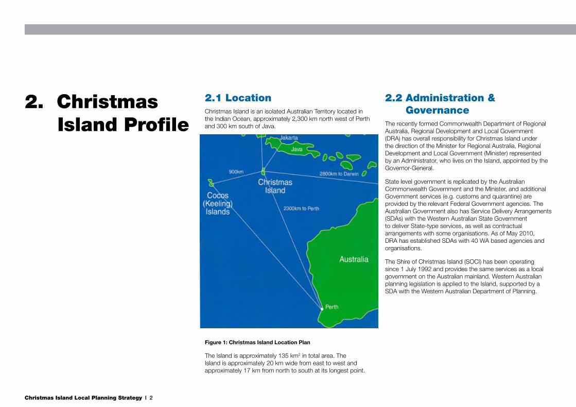
2.1 LocationChristmas Island is an isolated Australian Territory located in the Indian Ocean, approximately 2,300 km north west of Perth and 300 km south of Java.
Figure 1: Christmas Island Location Plan
The Island is approximately 135 km2 in total area. The Island is approximately 20 km wide from east to west and approximately 17 km from north to south at its longest point.
2.2 Administration & Governance
The recently formed Commonwealth Department of Regional Australia, Regional Development and Local Government (DRA) has overall responsibility for Christmas Island under the direction of the Minister for Regional Australia, Regional Development and Local Government (Minister) represented by an Administrator, who lives on the Island, appointed by the Governor-General.
State level government is replicated by the Australian Commonwealth Government and the Minister, and additional Government services (e.g. customs and quarantine) are provided by the relevant Federal Government agencies. The Australian Government also has Service Delivery Arrangements (SDAs) with the Western Australian State Government to deliver State-type services, as well as contractual arrangements with some organisations. As of May 2010, DRA has established SDAs with 40 WA based agencies and organisations.
The Shire of Christmas Island (SOCI) has been operating since 1 July 1992 and provides the same services as a local government on the Australian mainland. Western Australian planning legislation is applied to the Island, supported by a SDA with the Western Australian Department of Planning.
Christmas Island Local Planning Strategy I 3
2.3 Population & Demographics
2.3.1 Total Population
The current population on Christmas Island is approximately 2,000 people. Of this, 1,200 are identified as ‘locals’ (permenant residents) and the balance (800) is comprised of a transient workforce (construction workers, government employees, trades). The most recent Census information from the Australian Bureau of Statistics (ABS) is provided below:
Table 1: Christmas Island Population
Year Total Population
1991 1,275
1996 1,906
2001 1,446
2006 1,349
2011 2,072
The population of Christmas Island has fluctuated in recent times due to major economic shifts on the Island. These have included uncertainty over phosphate mining, the closure of the Christmas Island Resort and construction of the Immigration Detention Centre (IDC).
Previous population projections for the Island have been based on major economic events that have not materialised. Ultimately, the total population that the Island can support will be reliant upon the accurate identification of the extents of the fresh water supply and its protection, the future economic base of the Island after the cessation of phosphate mining and the identification of future residential areas, reconciled with environmental constraints.
2.3.2 Age-Sex Composition
Based on the 2011 census, 70.7 percent (or 1,465) of the population were males and 29.3 percent (607) were female. This is an increase in the proportion of men on the island since 2006, and is not surprising given the predominance of mining on the Island, as well as contractors involved in the construction and trade industries.
In the 2011 Census, the largest demographic on the Island was recorded as those aged between 25-54 years of age, reflecting the working nature of the Island in association with phosphate mining and construction activity. Other dominant age groups included:
• 13 percent children aged between 0-14 years, compared to 23.1 percent in 2006.
• 15.1 percent aged 55 years and over.
One particular anomaly in the age distribution is that only 15.4 percent of the population are aged between 15 - 24 years. This figure has increased slightly since 2006 (+6 percent) but may still reflect the lack of suitable job opportunities for recent school leavers as well as the desire to attend university or other further education opportunities on mainland Australia or in the South East Asia region.
Census data indicates a relatively steady increase in the 25-54 year age brackets, which represents the working class age groups, accompanied by a reasonable number of the elderly, reflecting the attraction of the Island for retirees.
The future of the Island will rely on the ability to retain its younger population and attract those who leave for further education back to the Island with suitable job opportunities. At the opposite end of the age spectrum, future planning needs to recognise that an increasing proportion of the population is over 55. Opportunities should be identified for additional aged care and other required facilities.
2.3.3 Ethnicity
At various times in the past, Christmas Island has been under the control of England, Japan, Singapore and Australia. Due to the Island’s history, there continues to be a diverse multicultural society on Christmas Island. The 2006 Census indicates the following break down of country of origin:
• 31.3 percent of the Island’s population were born in Australia.
• 17.9 percent were born in Malaysia.
• 16 percent were born in Iran.
• 5.4 percent were born in Afghanistan.
• 4.5 percent were born in Iraq.
The proportion of the population born in Australia has decreased 13.8 percent from the 2006 Census data (45.1 percent). The proportion born in Malaysia has also decreased (from 30.5 percent in 2006). However, the number of people born in Middle Eastern countries of Iran, Afghanistan and Iraq has increased significantly.
Language spoken at home is also an indicator of the diverse society on the Island, with only 23.9 percent of the Island’s population speaking English as the only language at home; a decrease from 34.8 percent in 2006. The most common languages other than English spoken at home were Malay 13.0 percent, Mandarin 11.2 percent, Cantonese 6.6 percent, Min Nan 1.0 percent and Thai 0.6 percent.
The Chinese and Malay communities on the Island maintain strong cultural links and traditions, including the maintaining of temples and shrines, and the celebration of traditional festivals and occasions. With this diversity and strong cultural tradition, provision must be made in future planning to provide facilities for all cultures on the Island.

Christmas Island Local Planning Strategy I 4
2.4 Physical Environment
2.4.1 Climate
Christmas Island is located at the southern edge of the equator which results in a tropical equatorial climate. This is characterised by a relatively uniform climate throughout the year where average maximum temperatures range from 28°C in April to 22°C in August. Christmas Island generally experiences two distinct seasons; the wet (November – May) and the dry (June – November) seasons. The average annual rainfall for Christmas Island is 2090 mm, with the wettest month on average being February (344 mm) and the driest being August (44 mm). Humidity on the Island varies little and ranges from 80% - 90%.
During the wet season, Christmas Island is subject to north west monsoons which typically cause high swells and strong winds. As a result, Flying Fish Cove is often affected by strong winds and large swells which can disrupt shipping activities.
Christmas Island can be affected by tropical cyclones passing close by the Island, however none have passed directly over the Island since human settlement. Parts of the Island are also susceptible to storm surges and wave over-spill, especially Flying Fish Cove and the Settlement area.
Christmas Island, as with many small islands around the world, is vulnerable to the effects of climate change. Changes in the climate (such as air temperature, rainfall, sea level rise and extreme storm events) over the past decades have been observed on the island. These trends are likely to continue and even accelerate during the 21st Century.
The observed climate trends for the island included:
• An increase in annual and seasonal air temperature by 0.4°C since 1974;
• An increase in sea surface temperature by 0.5°C, with a
stronger warming trend during June, July and August;
• A significant decreasing trend in September, October and November rainfall (- 420 mm since 1974); and, sea level rise of between 4 mm/year (for the gauge tide station data, since 1992) and 3.4 mm/year (for the satellite altimetry data, since 1993).
A review of the Western Australian tropical cyclone data base found an overall increase of 42% in the intensity of cyclones (Category 3 and 4) between 1974 and 1998, and it is expected that the island will experience a similar trend into the future.
2.4.2 Geology & Groundwater Hydrology
Christmas Island is the flat summit of a submarine mountain
which rises 5,500m to the surface of the ocean. The Island itself is approximately 300m above sea level at its highest point. The core of Christmas Island is composed of extremely hard and impervious volcanic material which is predominately basalt. The remnant of a coral reef forms a cap layer of limestone and phosphate deposits over the basalt core.
Due to faulting in the limestone rock that sits above the basalt layer, an irregular limestone surface has resulted, with caves and sinkholes. Whilst cave mapping has been undertaken on an ad hoc basis, there is still potentially a substantial amount of unmapped caves on the Island. This has implications for the stability of future development on the Island and detailed geotechnical investigations should be carried out to assess the associated risks.
Figure 2: Geomorphology of Christmas Island
Christmas Island Local Planning Strategy I 5
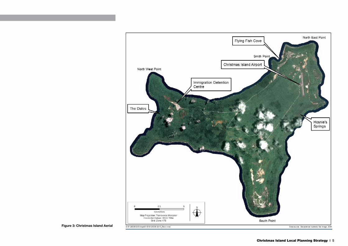
Figure 3: Christmas Island Aerial
Christmas Island Local Planning Strategy I 6
Caves also contain diverse subterranean environments that contain freshwater and marine habitats. Subterranean and groundwater ecosystems have important conservation value, particularly endemic fauna that occur in these habitats.
Generally, the soils on the Island are poorly developed with little clay content and are highly dispersive in some places. They scour and erode easily, and are relatively permeable and exhibit high infiltration rates. Some areas of groundwater outflows are well known, for example the Dales, Hosnies Springs, and Daniel Rouge Cave.
The dense jungle growth and generally highly permeable topography tends to result in little overland flow of surface water. Surface drainages are therefore poorly developed as the majority of rainfall leaches through the porous limestone and down to the underground basalt layer, before flowing out to the ocean. The exact locations where the water flows to the ocean, or pools on the basalt layer, are currently unknown as there is no exact knowledge of the profile of the basalt layer.
The exact extent of the underground aquifer that sits on top of the basalt layer is also currently unknown. Whilst there is some existing GIS information depicting the basalt aquifer and catchment areas, it is not sufficient to assess with the required degree of accuracy the basalt profile or water catchment areas. Any development therefore has the potential to impact upon this catchment, which is used for the Island’s potable water supply. It is especially relevant for any expansion of industrial and land fill land uses, given their increased potential for harmful substances to contaminate the water supply.
2.4.3 Landform
As a result of past uplifting of the basalt core, the Island is almost completely surrounded by sea cliffs, generally about 15m in height. Above these cliffs are a series of terraces which are backed by steep cliffs (up to 150m in height) rising to a central plateau area. The central plateau itself is undulating and covers the majority of the Island.
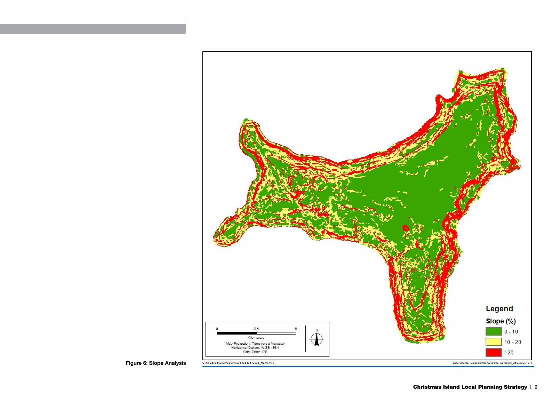
Figures 5 and 6 overleaf illustrate the extremity of slopes that occur on the Island in certain areas. Slopes up to 10% are considered manageable for urban development and
the construction of useable roads for large vehicles. Slopes between 10% - 20% are more difficult to manage in relation to urban development and vehicle movements, however this can be overcome with specific development requirements as well as speed limit and vehicle size restrictions on roads.
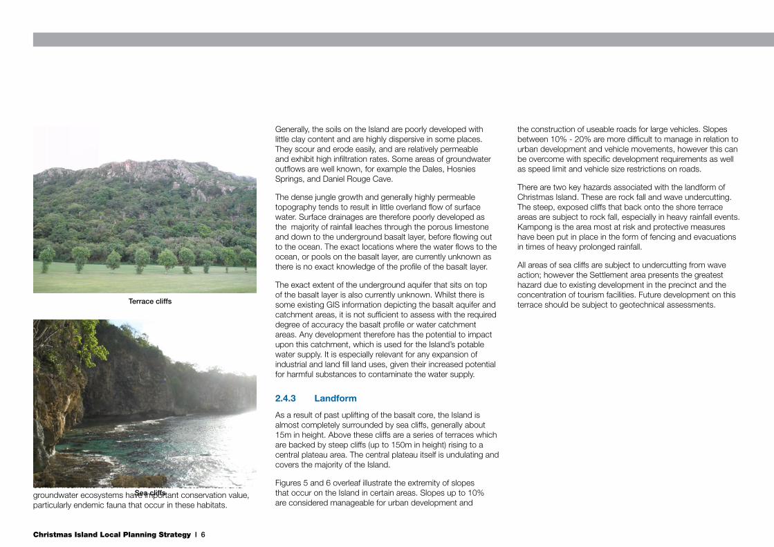
There are two key hazards associated with the landform of Christmas Island. These are rock fall and wave undercutting. The steep, exposed cliffs that back onto the shore terrace areas are subject to rock fall, especially in heavy rainfall events. Kampong is the area most at risk and protective measures have been put in place in the form of fencing and evacuations in times of heavy prolonged rainfall.
All areas of sea cliffs are subject to undercutting from wave action; however the Settlement area presents the greatest hazard due to existing development in the precinct and the concentration of tourism facilities. Future development on this terrace should be subject to geotechnical assessments.Terrace cliffs
Sea cliffs

Christmas Island Local Planning Strategy I 7
2.5 Flora & Fauna
2.5.1 Flora
The vegetation on Christmas Island is composed mainly of dense canopied evergreen forest, epiphytes and emergent trees. The forest has a dense closed canopy with a relatively open understory, including species such as herbs and ferns. This is largely the result of the role of land crabs, which are the island’s keystone species as they help to shape and maintain the structure and species composition of the island’s rainforests. The vegetation of the island is predominantly Indo-Malesian, with many species being common in South East Asia, through to New Guinea and Australia.
Three main categories of vegetation can be distinguished on the island, specifically primary (plateau) rainforest, marginal (terrace) rainforest and scrub forest. Primary rainforest (Priority 1) and marginal rainforest (Priority 2) are currently protected from clearance under the Environment Protection and Biodiversity Conservation Act 1999 (EPBC Act) and requires Ministerial consent for clearing. The extent of this vegetation is highlighted in Figure 4. Some restricted habitats support unusual vegetation such as areas with surface water or around the coastal fringe.
Approximately 85 km2, almost 64% of the Island, is protected within the Christmas Island National Park. The National Park has good representation of the species present on the island and preserves important ecosystems, including large stretches of coastal rainforest, evergreen tall closed forest (including nesting habitat for the endangered Abbotts booby), and other important habitats including wetlands such as the Dales and Hosnies Springs, of international importance.
Christmas Island has 411 recorded plant species and approximately 18 of these are endemic (Australian Government 2010). Many of the species have wide distributions in the South East Asia Pacific region, however most have reached
Figure 4: Priority 1 and 2 Vegetation

Christmas Island Local Planning Strategy I 8
Figure 5: Topographic Landform
Christmas Island Local Planning Strategy I 9
Figure 6: Slope Analysis

Christmas Island Local Planning Strategy I 10
considerable heights on Christmas Island.
A significant proportion of the Island has been impacted by phosphorus mining, which has removed upper level soils, leaving limestone pinnacles and bases with little soil cover. Some mined areas have partially recovered but most have been detrimentally impacted by coverage of introduced plant species and the lack of soil depth. The tall forest vegetation types are unlikely to return to many of the mined areas.
Significant Species
The Commonwealth EPBC Act provides for the protection of nationally and internationally significant flora, fauna, ecological communities and heritage places. According to the EPBC Protected Matters Search Tool, there are two wetlands covered under the international Ramsar treaty located on Christmas Island but no threatened ecological communities. Three plant species present on the island are protected under the EPBC Act, as outlined below.
Scientific Name Common Name EPBC Status
Asplenium listeriChristmas Island
SpleenwortCritically
Endangered
Pneumatopteris truncata
Fern sp.Critically
Endangered
Tectaria devexa Endangered
Asplenium listeri is a fern-like plant that grows in limestone rock crevices in dry, exposed areas on Christmas Island. It is found in rocky, narrow areas of inland cliff-tops, often located in shaded ocean-facing forest areas (Butz 2004; Holmes & Holmes 2002).
Pneumatopteris truncata is a large fern with an erect rhizome and fronds growing in a crown shape. It grows colonially on permanently moist sites, in marginal (terrace) rainforest and in shaded areas (Holmes & Holmes 2002).
Tectaria devexa is a terrestrial fern with fronds up to 40 cm long. This species has been recorded on Christmas Island in plateau rainforest in areas of deep soil (Department of Transport and Regional Services 2002). It is known in areas in Sri Lanka, southern China and Taiwan, the Philippines, Malesia, Vanuatu, and the Rockhampton area in central coastal Queensland (Bostock 1993).
Invasive Species
Over time, ship and air transport activities have allowed the introduction of several weed species to Christmas Island. There has also been a deliberate introduction of food plants, garden plants and colonising species for mined areas and turf grasses, some of which have become naturalised.
Whilst undisturbed primary rainforest is believed to be relatively resistant to invasion by weed species, the spread and establishment of weed species is still an issue for the Island. Weed species generally spread in disturbed areas of the forest, on roadsides and in areas of human settlement. Previously mined areas are also home to a range of exotic introduced plants, some of which were planted as part of historical rehabilitation programs.
2.5.2 Fauna
The geographical location of Christmas Island has lead to high endemic species numbers and the development of unique native fauna features. As of 2002, 31 native invertebrate species occur on the island and 20 of these are listed as endemic. Three native mammals could potentially be present, but only one (the Christmas Island Flying Fox) is confirmed as still in existance.
The Island is also home to the most remarkable abundance and diversity of land crabs in the world. Their scavenging activities recycle nutrients locked in fallen leaves, their burrowing tills the soil and their grazing on fruit trees and seedlings is an important factor in determining forest
Robber crabs
Red crab migration

Christmas Island Local Planning Strategy I 11
composition. In this way the species have important ecological significance on the Island. The land crabs have evolved from marine ancestors, as shown by their return to the sea for spawning. Apart from the 20 land crabs species, over 160 other species have been recorded from the reefs and shallows of Christmas Island. Land crabs on Christmas Island have important tourism, scientific, and educational values in addition to their ecological significance on the island.
The red crab Gecarcoidea natalis appears in huge numbers on the island, with a population estimate of some millions. Although most common in the moist environment of the rainforest, red crabs live in a variety of habitats including coastal shore terraces, and even domestic gardens. They dig burrows in soil or live in deep crevices in rock outcrops. For most of the year, a crab will settle in one place, living
in their burrow. However, the annual spawning migration, which occurs at the beginning of the wet season, creates a spectacle, and requires particular awareness by the Island’s residents to avoid large losses of crabs on roads.
The robber crab Birgus latro is the largest land-living arthropod in the world. Measuring up to 1.5 metres and weighing up to 4 kg, it can live for more than 30 years. Christmas Island is likely to have the largest population of robber crabs in the world.
Christmas Island is almost completely surrounded by narrow, fringing coral reef. The intertidal zone is highly energetic, with sea swell affecting the island’s coastline. Below 10m depth, there is a rich array of benthic organisms and fish species, though only a small number of these are endemic to the area.
Significant Species
Christmas Island supports 22 threatened fauna species and 19 migratory species listed under the EPBC Act. Apart from the whales, the most endangered species are the terrestrial mammals, which have been badly affected by the introduction of fauna such as rats.
Invasive Species
Invasive fauna speciei include cats, rats, and crazy ants and are a key threatening process for native species through predation.
Table 2: Threatened Fauna
Scientific Name Common Name EPBC Status
Mammals
Balaenoptera borealis Sei Whale Vulnerable
Balaenoptera musculus Blue Whale Endangered, Migratory
Crocidura attenuata trichura Christmas Island Shrew Endangered
Megaptera novaeangliae Humpback Whale Vulnerable, Migratory
Pipistrellus murrayi Christmas Island Pipistrelle Critically Endangered
Reptiles
Caretta caretta Loggerhead Turtle Endangered, Migratory
Chelonia mydas Green Turtle Vulnerable, Migratory
Dermochelys coriacea Leatherback Turtle Endangered, Migratory
Eretmochelys imbricata Hawksbill Turtle Vulnerable, Migratory
Lepidodactylus listeri Christmas Island Gecko, Lister's Gecko Vulnerable
Natator depressus Flatback Turtle Vulnerable, Migratory
Typhlops exocoeti Christmas Island Blind Snake Vulnerable
Sharks
Rhincodon typus Whale Shark Vulnerable, Migratory
Christmas Island Local Planning Strategy I 12
2.5.3 Ramsar Convention
Ramsar sites refer to registered sites of the Convention on Wetlands of International Importance, especially as Waterfowl Habitiat, or Ramsar Convention, an intergovernmental treaty which provides the framework for national action and international cooperation for the conservation and wise use of wetlands and their resources. Under the Commonwealth EPBC Act it is an offence to undertake any activity that has, will have or is likely to have a significant impact on a Ramsar site.
Christmas Island has two Ramsar sites; Hosnie’s Spring on the east coast and the Dales on the west coast. These sites need protecting from any action that will adversely impact on them. Both sites are within the Christmas Island National Park.
2.5.4 Environmental Protection and Biodiversity Conservation Act 1999
Under the EPBC Act, actions that have, or are likely to have, a significant impact on a matter of natural environmental significance (NES) require approval from the Australian Government Minister for the Environment, Heritage and the Arts (the Minister).
Matters of NES relevant to Christmas Island are wetlands of international importance, listed threatened species and ecological communities, migratory species protected under international agreements, and Commonwealth marine areas. The environment is also protected; where actions proposed are on, or will affect Commonwealth land and the environment, or where Commonwealth agencies are proposing to take an action.
Proposals or activities which may require consideration under the EPBC Act include, but are not limited to:
• Proposals to undertake development;
• Proposals to gazette or construct roads; and,
• Proposals to modify national park boundaries.
Migratory Species
The EPBC Act also protects listed migratory species that are recognised under international treaties such as the China Australia Migratory Bird Agreement (CAMBA), the Japan Australia Migratory Bird Agreement (JAMBA) and the Republic of Korea on the Protection of Migratory Birds (ROKAMBA).
A number of the listed migratory birds are common in the Christmas Island area, and are listed under the EPBC Act as well as the JAMBA and CAMBA migratory bird agreements. In addition, there are a number of EPBC listed turtle and whale species that are protected under international migratory agreements.
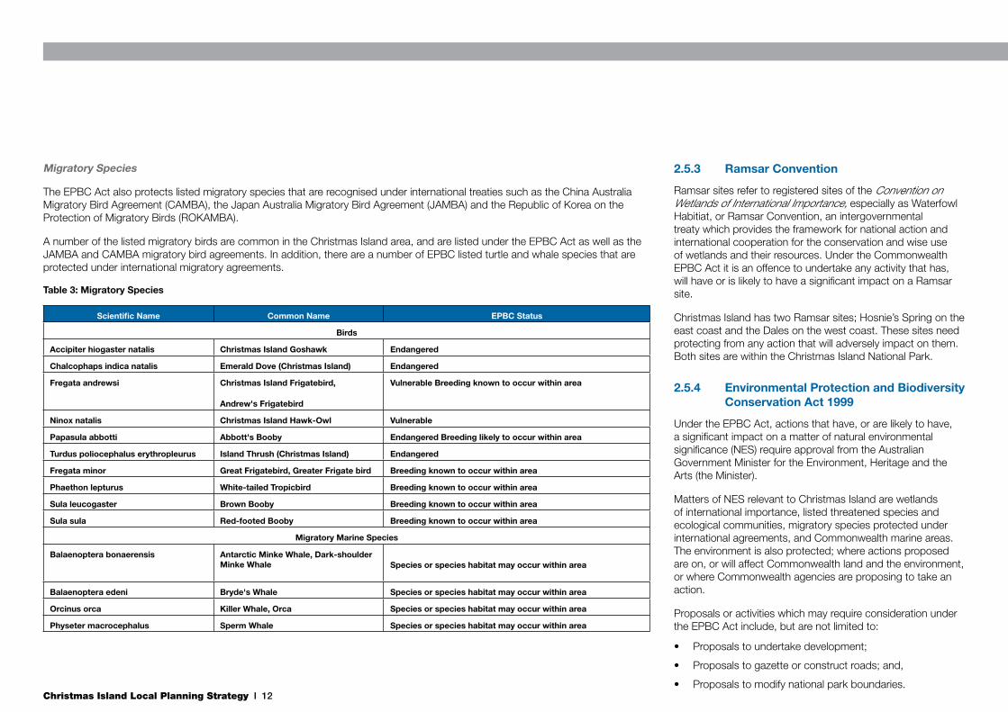
Table 3: Migratory Species
Scientific Name Common Name EPBC Status
Birds
Accipiter hiogaster natalis Christmas Island Goshawk Endangered
Chalcophaps indica natalis Emerald Dove (Christmas Island) Endangered
Fregata andrewsi Christmas Island Frigatebird,
Andrew's Frigatebird
Vulnerable Breeding known to occur within area
Ninox natalis Christmas Island Hawk-Owl Vulnerable
Papasula abbotti Abbott's Booby Endangered Breeding likely to occur within area
Turdus poliocephalus erythropleurus Island Thrush (Christmas Island) Endangered
Fregata minor Great Frigatebird, Greater Frigate bird Breeding known to occur within area
Phaethon lepturus White-tailed Tropicbird Breeding known to occur within area
Sula leucogaster Brown Booby Breeding known to occur within area
Sula sula Red-footed Booby Breeding known to occur within area
Migratory Marine Species
Balaenoptera bonaerensis Antarctic Minke Whale, Dark-shoulder Minke Whale Species or species habitat may occur within area
Balaenoptera edeni Bryde's Whale Species or species habitat may occur within area
Orcinus orca Killer Whale, Orca Species or species habitat may occur within area
Physeter macrocephalus Sperm Whale Species or species habitat may occur within area

Christmas Island Local Planning Strategy I 13
2.6 Built EnvironmentThe location of a large proportion of the Island’s built environment still reflects the various residential and industrial needs and requirements associated with the extraction of the Islands phosphate resources.
Due to the nature of the topography of Christmas Island, urban development has occurred in distinct clusters where land is most suitable. These areas are concentrated in the north east corner of the Island. There are three main urban clusters in this area; Poon Saan and Silver City, Drumsite, and Settlement and Kampong. These clusters are separate by major landform features and/or dense vegetation.
Figure 7: Current Land Uses
Settlement:- Mixed use residential and tourism- Increase residential densitiesSettlement:- Mixed use residential and tourism- Increase residential densitiesSettlement:- Mixed use residential and tourism- Increase residential densities
Settlement:- Mixed use residential and tourism- Increase residential densities
Settlement:- Mixed use residential and tourism- Increase residential densitiesSettlement:- Mixed use residential and tourism- Increase residential densitiesSettlement:- Mixed use residential and tourism- Increase residential densitiesSettlement:- Mixed use residential and tourism- Increase residential densitiesSettlement:- Mixed use residential and tourism- Increase residential densities
Settlement:- Mixed use residential and tourism- Increase residential densities
Settlement:- Mixed use residential and tourism- Increase residential densities
Commercial
Facility
Future Urban
Horticulture
Industrial
Mining
National Parks
Public Open Space
Public Purposes
Residential
Tourist
Vacant Crown Land
Legend: Zoning

Christmas Island Local Planning Strategy I 14
2.6.1 Poon Saan & Silver City
Poon Saan and Silver City are located on the lower slopes of the central plateau area. It is an elevated position, overlooking Settlement and Flying Fish Cove below. The cluster comprises residential, commercial and some community uses. The residential dwellings are a combination of apartments (in Poon Saan) and single dwellings (Silver City), and this pattern reflects the cultural identify of the two areas. Poon Saan is predominately a Chinese community. Silver City was originally an ex-pat community, however has more recently become increasingly diverse. There is also some short stay and Commonwealth Government multiple dwelling accommodation in Poon Saan.
The commercial component comprises a small supermarket, a number of restaurants and a hardware store. Other community based uses include an outdoor cinema, Fire and Emergency Services, a community centre, technical school and various small Public Open Space (POS) areas and temples/shrines.
Apartments in Poon Saan
Christmas Island Local Planning Strategy I 15
2.6.2 Drumsite
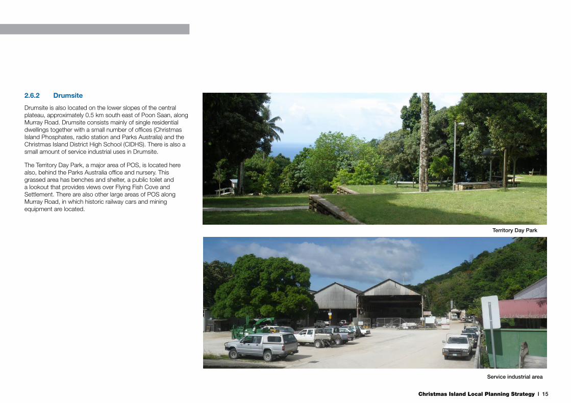
Drumsite is also located on the lower slopes of the central plateau, approximately 0.5 km south east of Poon Saan, along Murray Road. Drumsite consists mainly of single residential dwellings together with a small number of offices (Christmas Island Phosphates, radio station and Parks Australia) and the Christmas Island District High School (CIDHS). There is also a small amount of service industrial uses in Drumsite.
The Territory Day Park, a major area of POS, is located here also, behind the Parks Australia office and nursery. This grassed area has benches and shelter, a public toilet and a lookout that provides views over Flying Fish Cove and Settlement. There are also other large areas of POS along Murray Road, in which historic railway cars and mining equipment are located.
Territory Day Park
Service industrial area

Christmas Island Local Planning Strategy I 16
2.6.3 Settlement
Settlement is located on the western shore terrace and is primarily a residential area, together with the main commercial and tourism precinct of the Island along Gaze Road, north of the intersection with Murray Road. There are significant areas of heritage and cultural value within Settlement. A balance between these areas and structures and development of tourism facilities is necessary.
There are a number of tourism accommodation establishments within this precinct, with views over Flying Fish Cove, Smith Point and the Indian Ocean. This area represents the main area of tourist accommodation on the Island, and is accompanied by a pub, a supermarket, the Christmas Island Visitors Centre and the only domestic petrol station on the Island.
There are two domestic fuel storage tanks adjacent to the petrol station, connected via underground pipes. There is a risk associated with the fuel tanks located in such close proximity to accommodation facilities and residential dwellings. As such, they are considered a safety hazard. This area is the main tourism and commercial area on the Island and these fuel tanks also detract from the visual aesthetics and attraction of the precinct. The Fuel Consolidation Project by the Commonwealth will relocate these tanks, with potential new siting of the petrol station, and facilitate a more appropriate use of the site.
Opposite the pub is the Cocos Padang, an area of significant heritage value to the Island. It provides the only recognition of the Cocos Malay community on Christmas Island. Historically, it was the only area on the Island that the Cocos Malays were permitted to live. It is a large open area, with existing heritage buildings still located there. Any future development on this site will need to recognise and protect the heritage value of the site.
Domestic fuel tanks on Gaze Road
Cocos Padang
Christmas Island Local Planning Strategy I 17
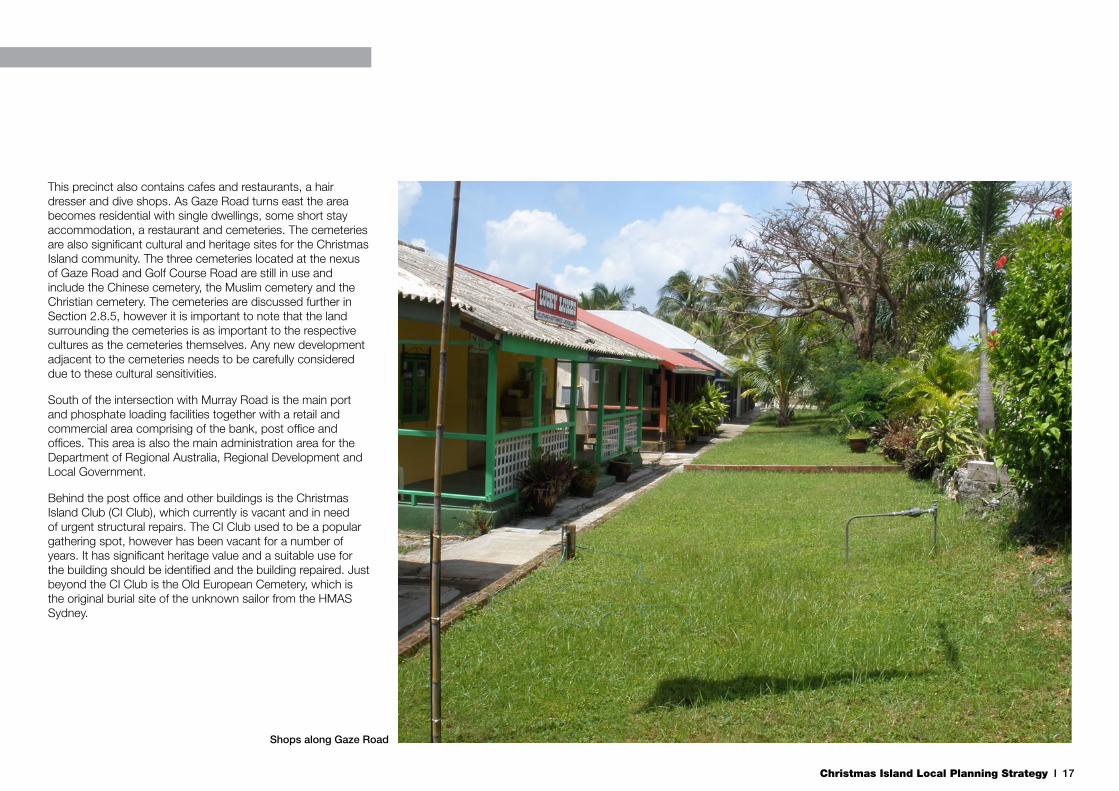
This precinct also contains cafes and restaurants, a hair dresser and dive shops. As Gaze Road turns east the area becomes residential with single dwellings, some short stay accommodation, a restaurant and cemeteries. The cemeteries are also significant cultural and heritage sites for the Christmas Island community. The three cemeteries located at the nexus of Gaze Road and Golf Course Road are still in use and include the Chinese cemetery, the Muslim cemetery and the Christian cemetery. The cemeteries are discussed further in Section 2.8.5, however it is important to note that the land surrounding the cemeteries is as important to the respective cultures as the cemeteries themselves. Any new development adjacent to the cemeteries needs to be carefully considered due to these cultural sensitivities.
South of the intersection with Murray Road is the main port and phosphate loading facilities together with a retail and commercial area comprising of the bank, post office and offices. This area is also the main administration area for the Department of Regional Australia, Regional Development and Local Government.
Behind the post office and other buildings is the Christmas Island Club (CI Club), which currently is vacant and in need of urgent structural repairs. The CI Club used to be a popular gathering spot, however has been vacant for a number of years. It has significant heritage value and a suitable use for the building should be identified and the building repaired. Just beyond the CI Club is the Old European Cemetery, which is the original burial site of the unknown sailor from the HMAS Sydney.
Shops along Gaze Road

Christmas Island Local Planning Strategy I 18
2.6.4 Kampong
Further south is the Kampong, adjacent to Flying Fish Cove. This area is predominately a Muslim community and there is a mosque and Muslim centre located here. The residents live primarily in apartment style residential dwellings that overlook Flying Fish Cove.
Flying Fish Cove is the only major beach on Christmas Island. Although there are other, smaller beaches around the Island, they more remote and harder to access. There are a variety of public facilities provided at Flying Fish Cove including grassed areas, picnic and BBQ facilities, and shaded areas. The Island’s main jetty is in Flying Fish Cove, which has hoisting capabilities. Adjacent to the jetty is a recreational boat ramp, one of two on the Island.
View of Settlement (top), the port (centre) and Kampong
(bottom) on the shore terrace. Silver City
can be seen at the top right of the photo
Christmas Island Local Planning Strategy I 19
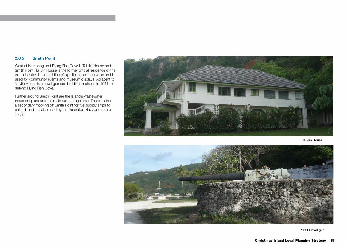
2.6.5 Smith Point
West of Kampong and Flying Fish Cove is Tai Jin House and Smith Point. Tai Jin House is the former official residence of the Administrator. It is a building of significant heritage value and is used for community events and museum displays. Adjacent to Tai Jin House is a naval gun and buildings installed in 1941 to defend Flying Fish Cove.
Further around Smith Point are the Island’s wastewater treatment plant and the main fuel storage area. There is also a secondary mooring off Smith Point for fuel supply ships to unload, and it is also used by the Australian Navy and cruise ships.
Tai Jin House
1941 Naval gun

Christmas Island Local Planning Strategy I 20
2.6.6 Phosphate Hill
Phosphate Hill is a developing cluster in close proximity to the airport. The main area of development is north of the airport, adjacent to Phosphate Hill Road. This small cluster includes the original immigration detention facilities (still in use although temporary in nature), the construction camp for the Immigration Detention Centre, the recreation centre, pool and the oval and cricket club facilities.
To the east of the current LIA area is the Phosphate Hill Cemetery, now closed, which is the original Chinese cemetery on the Island and contains many of the early workers who were involved in the mining of the ‘100 foot quarry’ to the north of the airport beacon.
This area has the greatest potential for urban expansion within the North East area as the three main settlement areas on the island have been developed to their full potential.
2.6.7 Rest of the Island
There are other small areas of development in other parts of the Island, however these are generally isolated from the main urban clusters in the North East area. They include:
• The Christmas Island Resort on the east coast;
• The golf course also on the east coast;
• The central area workshops in the centre of the Island;
• The Camp 4 Education & Research Station (‘Pink House’); and
• The Immigration Detention Centre at North West Point.
2.7 Economy & Employment
2.7.1 Christmas Island Economy
Historically, the economy of Christmas Island has been almost solely dependant on phosphate mining, and therefore is sensitive to both its production rates and price cycles. The historic reliance on a single economic driver has meant that the Island’s economic outlook lacked flexibility to change. With the near complete depletion of the mining resource, the long term prospects for this economic activity are becoming negligible. Economic activity on the Island has diversified in recent times with the construction of the Immigration Detention Centre and focus on the developing tourism industry.
The current industries on the Island include:
• Phosphate mining;
• Construction;
• Tourism;
• Retail / hospitality;
• Training / education;
• Government services, including health / social services;
• Maritime / stevedores;
• Agriculture / horticulture;
• Sport / recreation (lifestyle);
• Arts / culture;
• Maintenance programs;
• National parks;
• Immigration facilities; and
• Airport and allied services.
Despite this diversification, the economy is still heavily reliant on phosphate mining and Commonwealth Government services. Whilst there is evidence of an increased interest in establishing new business enterprises on the Island, little has been achieved. This is due to a variety of reasons, including the isolation of the Island, cost of freight and airfares, administrative barriers, lack of ready access to suitable land and lack of required expertise on the Island.
2.7.2 Employment
The total labour force at the time of the 2006 Census was 680 people, with a un-employment rate of 4.6%. Of this, 83% were employed full-time and 17% were employed part-time.
Employment was greatest in the 45-54 age group and, together with the 35-44 age group, totals 57% of the total workforce on the Island. Those aged over 55 comprise 18.7% of the total employed. The age group 20-34 account for just 21% of the total workforce. The table opposite outlines a comparison between Census information from 2001 and 2006.
Table 4: Employment Comparison by Age 2001-2006
Age Group% of workforce
% change2001 2006
15-19 2.1 3.1 +1
20-24 4.1 5.3 +1.2
25-34 20.4 15.9 -4.5
35-44 30.4 28.3 -2.1
45-54 31.8 28.7 -3.1
55+ 11.2 18.7 +7.5
These figures indicate an ageing workforce and poor retention of younger age groups to fill jobs on the Island. To develop a stable economic future for the Island and encourage the diversification of the economy, this trend needs to be reversed. Future planning needs to take these figures into account and

Christmas Island Local Planning Strategy I 21
consider strategies to increase retention of young people to work on the Island.
On Christmas Island, the largest industries by employment in 2006 were construction, with 121 workers (18% of the workforce), mining, with 98 workers (14%), and public service, with 96 workers (14%). The next largest industries were education & training (73 workers), health & social care (42), accommodation & food (39), transport, post & storage (35) and retail trade (27 workers) (Public Practice Pty Ltd, date unknown). There was no one employed in agriculture or aquaculture industries on the Island.
These figures reflect the dominance of mining and Government services on the Island. The high number of construction workers can be attributed to the increased investment in infrastructure by the Commonwealth Government in recent years to bring the Island’s infrastructure up to mainland standards, as well as refugee facilities. The construction industry grew the most out of any industry between 2001 and 2006, by 59 workers.
In terms of occupation, technicians, trade workers, labourers and machinery operators made up 49.1% (or 335 people) of the total number of employed aged over 15 in 2006. Professionals, administrative workers and managers made up 37.4% (or 255 people). These figures reflect the fact that phosphate mining and the Commonwealth Government are the two biggest employers on the Island.
2.7.3 Phosphate Mining
Mining has been occurring on the Island for over 100 years and it is increasingly likely that it will cease within 10 years, unless new mining leases are granted. The current mining leases expire in 2019, with actual mining ceasing before this date to allow for hand over of the leases. Phosphate Resources Ltd (PRL), operating as Christmas Island Phosphates, has twice applied for 8 new mining leases and
has been denied on both occasions (the most recent in 2010), due to environmental assessment and decision-making under the EPBC Act. Environmental constraints on the island are a key influence on the security of future mining operations.
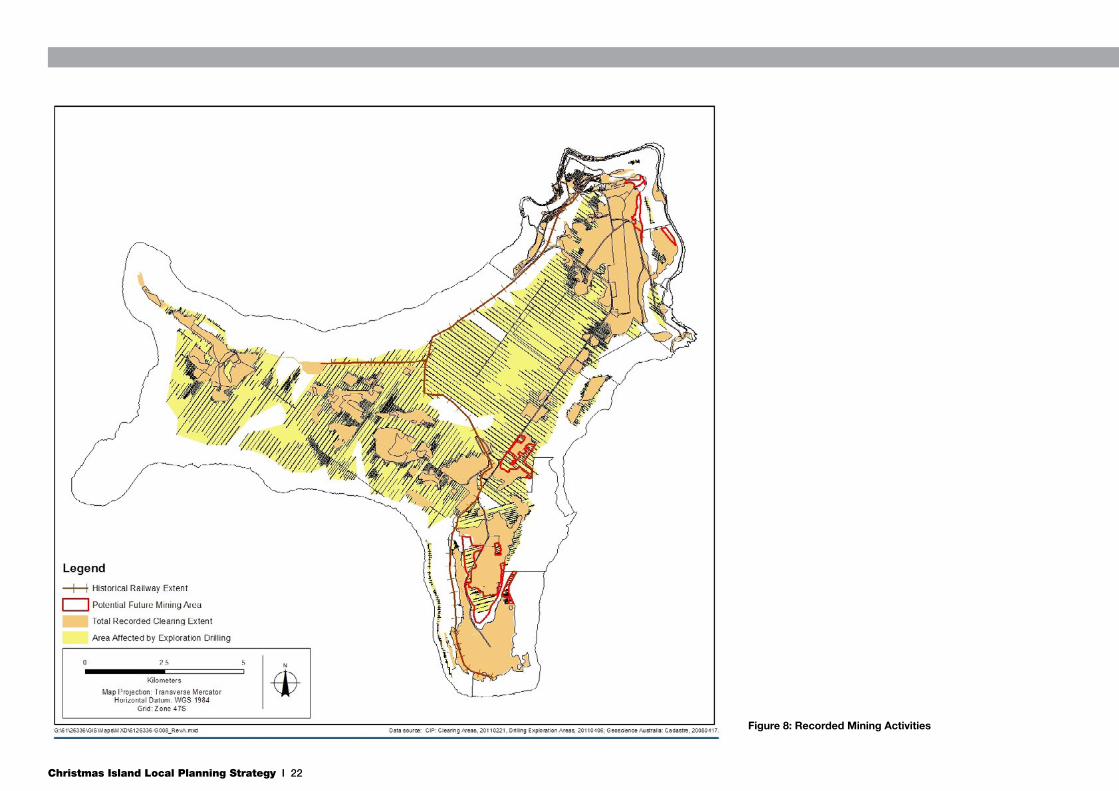
Mining operations have had an historical impact on the Island. Figure 8 illustrates the overall extent of mining activities on the Island. This includes the total extent of recorded clearing, exploration drill lines, and areas cleared for mining, roads and/or infrastructure.
As at 2008, the mine employed 185 people and was the Island’s largest private employer. It is important to note that the mine work force is both old (median age greater than 50) and, due to very low rate of worker turnover, ageing (ACIL Tasman 2008). At present, if mining activities were to cease, the economy of the Island would shrink dramatically and the Island would experience de-population as there would not be enough jobs to sustain the current population.
The re-use of existing mining leases can be explored to encourage further job creation. PRL should consider the diversification of its activities into areas such as land development and horticulture to take advantage of the skill base and equipment that the company possesses.
2.7.4 Commercial and Industrial Demand
Detailed analysis of economic development opportunities for Christmas Island is provided by ‘The Economy of the Indian Ocean Territories - Economic Development Opportunities for Christmas Island and the Cocos (Keeling) Islands’. The future cessation of mining operations will have significant economic impacts for the Island.
Employment within the mining sector will require replacement through development of other economic activities on the Island. To sustain the current population level, planning for the development and promotion of a mixed economy is required.
Promotion and investment in new economic activities, including with tourism, agriculture, and light industrial uses being the key opportunities for the island, places new and increasing demand for available land to support these economic uses.
2.7.5 Horticulture
Nearly all fresh food supplies are imported by both sea and air. This import reliance has resulted in high food prices and unreliable quality of fresh meat, fruit and vegetables. Supply is unreliable at times due to ships not being able to berth during the swell season and bad weather preventing planes from landing. Subsequently, prices of $12/kg for lettuce and $11.50/kg for tomatoes are relatively common (SGS 2010).
Mainstream on-Island horticultural production is limited to a small scale commercial producer. The operation is currently producing bananas in a large fruit forest plantation, as well as tomatoes, cucumbers, and lettuces within two greenhouses (SGS 2010). Other production is limited to a small number of community gardens as well as private gardens. These activities are particularly prevalent in the Chinese and Malay communities (SGS 2010).
If Christmas Island is to reduce its dependency on imported fresh fruit and vegetables and address the import-export imbalance, on-Island horticultural and aquacultural production should be increased to supply the Island’s needs. The existing activities on the Island demonstrate that large scale horticultural production is possible. In order to facilitate this, consideration needs to be given to the conversion of selected mining leases to horticultural use post mining, particularly for heavily disturbed areas (for example at South Point or the north eastern part of the island) where there is little prospect of natural rehabilitation.
Christmas Island Local Planning Strategy I 22
Figure 8: Recorded Mining Activities

Christmas Island Local Planning Strategy I 23
Figure 9: Current and Potential Mining Activities
Christmas Island Local Planning Strategy I 24
2.7.6 Public Sector
The public sector is acknowledged as the largest employer on the Island, with the creation of around 700 jobs through direct, indirect or induced impact. The Commonwealth are directly involved in the administration and governance of the Island and own the majority of the public infrastructure and facilities. The principle public sector organisations on the Island include:
• Christmas Island Administration (Department of Regional Australia, Local Government, Arts and Sport);
• Department of Immigration and Citizenship (DIAC);
• Parks Australia;
• Australian Federal Police (AFP);
• Australian Customs and Border Protection Command;
• Australian Quarantine Inspection Service;
• CIDHS; and
• The Shire of Christmas Island.
There are also a high number of contractors who travel to the Island.
Since the opening of the IDC, large numbers of DIAC and AFP staff travel regularly to the Island. Staff numbers fluctuate with the number of asylum seekers in the IDC and given the recent surge of asylum seekers detained on the Island, the number of staff on the Island has risen dramatically. Additional employment opportunities have also been generated through the provision of support services to the IDC.
Whilst this translates into a significant economic contribution to the local economy, these government employees take up accommodation, seats on flights and hire cars that reduce the ability of the Island to host larger numbers of tourists. The lack of certainty and long term predictability of immigration related activities constitute a significant challenge for strategic planning on the Island.
2.7.7 Tourism
The tourism industry of Christmas Island is almost solely based upon the unique natural environment, both on land and in the ocean. Christmas Island has a number of endemic species of both flora and fauna (primarily the famous red crab migration) that attract observers, researchers and film crews from across the world. Diving and fishing surrounding the Island are also considered exceptional and whale sharks are known to pass close by on their migrations. The natural assets of the island have tourism, scientific and educational significance that attracts various forms of tourism.
Despite the range of natural attractions on the Island, tourism remains a small contributor to the Island’s economy. This is mainly due to a lack of adequate tourism infrastructure, including a lack of beds, a lack of quality accommodation, high prices due to the isolation, high running costs for operators and relatively high airfares.
In 2007, one third of all visitors to Christmas Island travelled for holiday or leisure purposes, 49% for business or work reasons, and 14% were visiting friends and relatives (ACIL Tasman 2008). There is a dominance of the government sector on the Island and in the economy, with half of all visitors travelling for business reasons. It reflects the significant investment by the Commonwealth Government in infrastructure on the Island, and the modest economic contribution of the tourism industry.
The current accommodation capacity on the Island is approximately 150 beds (ACIL Tasman 2008). The Resort has recently re-opened, offering an additional 156 rooms. With the opening of the IDC and the large public sector involvement on the Island, the majority of these beds can be taken up by Commonwealth government employees most of the time, reducing availability for tourists.
Until April 2010, a return flight to Christmas Island could cost up to $1,700 (for an adult), which was prohibitively high from mainland Australia in comparison with more mainstream
international tourism destinations. Since April, Virgin Australia has been operating the service to the Island and fares have reduced to as low as $830 (adult) in some cases.
Frequency of air services have increased in recent times, with more flights now than at any time in history. Currently, there are 4 services a week from Perth to Christmas Island (Saturday, Tuesday, Thursday and Friday), serviced by Embraer 190 aircraft with a capacity of 104 seats. Availability on these flights can also be limited due to the high number of Government employees and contractors travelling to the Island. Recently, a once weekly Kuala Lumpur flight commenced.
In December 2009, Christmas Island hosted its first cruise ship, after upgrades to its port and mooring facilities. The P&O ‘Pacific Sun’ spent a day at Christmas Island, bringing 2,000 passengers to the Island. It is estimated that the visit injected about $45,000 into the local economy in 8 hours. Further cruise ships were scheduled for December 2010 and February 2011, however both visits were cancelled due to large swells. The locals considered the initial event a success with many acting as tour guides. With the limited availability of accommodation on the Island, combined with the Island’s operational constraints to carrying large numbers of tourists, cruise ships provide a real opportunity for the Island to accommodate large numbers of tourists (Simon Milcock, RDA, personal communication).
The increased affordability of airfares needs to be accompanied by a substantial investment in tourism infrastructure on the Island in order to grow the contribution of tourism to the Island’s economy. Without the traditional attributes associated with popular tourism, Christmas Island is unlikely to evolve as a mainstream tourism destination and can only generate specific top-end tourism opportunities rather than high volume and broad based patronage. The Island will cater, particularly, to the ‘Experience Seeker’ target market, that tends toward unique natural and cultural experiences and are sensitive to local communities and environments. This is a lower volume, but high yield market segment.
Christmas Island Local Planning Strategy I 25
2.8 Community Facilities
2.8.1 Education
The Christmas Island District High School located in Drumsite is the only school on the Island and is managed by the Western Australia Department of Education and Training under a SDA. The school provides classes from Year 1 through to Year 12 as of 2003. Early childhood education is provided off site at the Tom Patterson Centre in Settlement with a special program for 3 year olds and kindergarten. There is a pre-primary onsite.
The school currently has a total enrolment from pre-primary to Year 12 of 276 students. This number has remained relatively constant since 2006. The school also currently has approximately 100 additional students originating from the IDC. The CIDHS also hosts international students from Singapore, up to 4 times a year. This program has been cancelled in the past due to the lack of accommodation facilities for the students. Students from Christmas Island have been hosted in Singapore under a reciprocal program.
The CIDHS is often in the top performing schools in WA as it attracts a high number of applicants for teaching positions ensuring a wide pool of teaching talent to choose from. Due to the cultural diversity of the Island, the current school population has a ratio of approximately 70% Chinese, 15% Malay and 15% European students. Due to this cultural diversity, may students have English as a second language.
The CIDHS site is relatively small by mainland standards with minimal room to expand. It is also in close proximity to the PRL crushing and drying plant (400m to the south) and conveyor (immediately adjacent to the west). The site is also only 160m from the main fuel supply pipes to the power station and the power station and associated fuel storage tanks are only 400m south of the school.
Based on WA government guidelines, these separation distances are inadequate for a sensitive land use. Guidelines indicate that a suitable separation distance from a power generation plant should be at least 3km (Environmental Protection Authority 2005). Whilst acknowledging that this distance may not be achievable on the Island, a greater separation distance is desirable.
Post-secondary school education services are provided by the Indian Ocean Group Training Organisation, based in Taman Sweetland, who provide qualifications based on TAFE courses. Not all courses are nationally recognised however. The site is limited and a larger site should be identified to allow for expansion.
The CIDHS has recently received funding for a Trade Training Centre, to be built on the school site. This centre will provide a Certificate II/III in Metals. There is an expectation that the centre will be available for community use outside of school hours.
An alternative site should be considered to allow for the future expansion of school services on the Island in line with population increase. The ultimate relocation of the CIDHS into a lower hazard area is also desirable.
2.8.2 Health
The Christmas Island Hospital is located on Phosphate Hill Road between Poon Saan and the Light Industrial Area. The hospital has a fully functional operating theatre, 8 beds with a capacity for 12 and employs 36 staff. Permanent services provided on-Island include GP services, dentist, pre and post natal care, child health care, immunisation, pathology, a limited blood bank, a social worker and a morgue.
The Indian Ocean Territories Health Service (IOTHS) facilitates the transport of medically ill patients through two services; chartered medical evacuations and the Patient Assistance Travel Scheme (PATS). Medical evacuations are undertaken
on the basis of clinical need, which involves consultation between the presiding medical officer and the specialist in Perth according to standard medical emergency criteria. All medical evacuations are undertaken on chartered flights on the basis of the patient’s medical condition, the urgency of transfer to specialist care in Perth and the availability of commercial flights. The IOT PATS facilitates where people require travel and accommodation assistance in order to access medical treatment that is not available locally. This includes access to chemotherapy, major surgery or longer term psychiatric care. The IOT PATS guidelines largely follow those of Western Australia’s equivalent scheme and are subject to regular review.
The IOTHS also provides some specific health services for asylum seekers in immigration detention on the Island, including pathology and X-rays, all in-patient care including trauma management, emergency dental care and specialist torture and trauma counselling when required.
Expansion of the current hospital footprint could occur north of the current building if the bus depot was relocated. The current hospital has been designed to meet the needs of a population of 10,000 people.
2.8.3 Emergency Services
The Island has a full time Australian Federal Police presence, with the police station located in Settlement. There are full time officers stationed on the Island, and additional officers are flown in as specific situations dictate. Australian Customs and the Australian Quarantine and Inspection Service also have a permanent presence on the Island.
The Fire and Emergency Services Authority (FESA) also have a permanent presence on the Island, and the FESA building is located in Poon Saan. A volunteer St Johns Ambulance service is based at the hospital.
Christmas Island Local Planning Strategy I 26
2.8.4 Religious Facilities
Due to the cultural diversity on Christmas Island, there are a number of different religious facilities on the Island, celebrating the three main religions. There is a mosque in Kampong, at least 16 temples and shrines located around the Island, and a Catholic Church in the area behind the Post Office and Courthouse.
SOCI recently has been approached by the Christian Fellowship Association (CFA) in regards to establishing a place of worship on the Cocos Padang. The Shire rejected this request but resolved at is Ordinary Meeting on 23/11/10 to assist the CFA in identifying an alternative suitable site through the LPS review process. The LPS provides a range of zoning recommendations that can facilitate development of a place of worship in appropriate locations.
2.8.5 Cemeteries
There are five cemeteries in total on Christmas Island, with three separate operational cemeteries for Christians, Chinese and Muslims on the Island, all located at the eastern edge of Settlement on the Golf Course Road. The cemeteries are located on narrow strips of land either side of the road, with limited room for expansion. Despite the low number of burials on the Island in recent times, areas for new or expanded cemeteries should be identified in reflection of an aging population.
The two historical cemeteries are the Old European Cemetery adjacent to the CI Club and the Phosphate Hill Cemetery near the golf course lookout.
There is significant cultural importance placed on the location, vistas and surrounding land use of the Chinese cemeteries in particular. These aspects need to be taken into consideration for any future planning for the cemeteries and the surrounding land use of the Chinese and Muslim cemeteries in particular.
2.9 HeritageChristmas Island contains a long and storied history and this is reflected in its mining heritage and cultural diversity. The importance of the Island’s history and heritage is reflected by the listing of 11 places on the Commonwealth Heritage List (CHL). The CHL comprises natural, Indigenous and historic heritage places on Commonwealth land. Entries on the CHL are protected under the EPBC Act. The listed places on Christmas Island include:
• Administrator’s House Precinct;
• Bungalow 702;
• Christmas Island Natural Areas;
• Drumsite Industrial Area;
• Industrial and Administrative Group;
• Malay Kampong Group;
• Malay Kampong Precinct;
• Phosphate Hill Historic Area;
• Poon Saan Group;
• Settlement Christmas Island; and
• South Point Settlement Remains.
These entries cover large areas and include many of the Island’s community facilities such as the cemeteries, the mosque, many temples and shrines, the Chinese Literary Association building, the Malay Club and the police station.
In addition to these areas of significant heritage value, there are places of local heritage and cultural significance that also need recognition and protection. These places have been identified previously on a Shire Heritage List. These items and the items of national significance should be listed on a Municipal Heritage Inventory which is adopted and protected by the TPS.
The majority of the places listed on the Shire Heritage List are industrial in nature. These listings recognise the significance of the Island’s industrial and mining heritage. Future planning should recognise the heritage significance of the Island’s industrial heritage and ensure that opportunities for future tourism development associated with cultural tourism and industrial heritage are preserved.
Development on Christmas Island must be at a sustainable level and be sympathetic to both the Island’s heritage values and the listed heritage status of specific buildings and sites. In assessing the heritage value of a building or place, the curtilage (i.e. the area that surrounds the site) forms an essential part of its heritage value. It often extends beyond the boundaries of the site itself in order to maintain the sites visual setting and reflect its uses.

Christmas Island Local Planning Strategy I 27
2.10 Utilities & Infrastructure
2.10.1 Roads
The SOCI is responsible for the construction and maintenance of roads on the Island, as per mainland standards. This jurisdiction extends to gazetted public roads only. Roads within the National Park are the responsibility of Parks Australia and roads within mining leases the responsibility of PRL. The road network is of critical importance with a high rate of car ownership on the Island.
Sealed roads are contained within the built up area of the Dogs Head. Local construction material can be problematic due to issues of polishing which increases the slipperiness of the roads. It is also light in colour, which creates visibility problems in relation to white road markings.
Outside of the built up area, there is a network of chalk and limestone surfaced roads used primarily for hauling phosphate. These roads are open to the public for access to various remote locations; however they are not gazetted as public roads. Consideration should be given to gazetting some of these roads as they are essential to the movement of vehicles around the Island.
A network of crab crossings have been installed on many of these roads in an effort to reduce the number of red crab deaths. The crossings consist of a tunnel under the road covered by a metal grid. The tunnels have proved relatively successful, however they are expensive to install, costly to maintain and the number of crabs killed by vehicles remains high as tunnels are not as effective at protecting crabs as temporary road closures.
A network of lesser roads and tracks exist that are unsurfaced and provide access to beaches, lookouts and other tourist destinations. Of the major roads on the Island, North South Baseline Road is a gazetted road. However, East West
Baseline and most of Murray Road are not gazetted.
The Rest of Island precinct consists almost entirely of National Park, which will remain unchanged. Land uses in the Rest of Island precinct include the Immigration Detention Centre (IDC) and the Central Area Workshops. The IDC is a key Federal Government infrastructure asset and future planning should provide for possible expansion. Additional land surrounding the current IDC at North West Point has been identified to provide a specific area for any required future expansion.
Sealing and gazetting Murray Road and North West Point Roads that provide access to the IDC should be a priority, given its strategic importance and the volume of traffic that travels to and from the site on a daily basis. This will require the approval of the Director of National Parks and may require assessment under the EPBC Act. It is likely that Murray Road would still require closing during crab migration.
There are potential safety issues associated with freight movement accessing the airport and port travelling through residential Poon Saans area.
The Light Industrial Area Outline Development Plan identifies a planned Murray Road Link to remove a large portion of through traffic from the residential areas along Murray Road in Poon Saan and provide a more direct route from the airport down to the Kampong and Settlement areas. It would also provide a safer and easier alternative for larger vehicles traveling between the airport and port. Taking into account the topography of the area, heritage and pinnacle areas, what is considered the most suitable alignment for this link has been identified.
Phosphate Hill is a developing cluster in close proximity to the airport. The main area of development is north of the airport, adjacent to Phosphate Hill Road. This small cluster includes the original immigration detention facilities (temporary facility, still in use), the construction camp for the Immigration Detention Centre, the recreation centre, pool and the oval and cricket club facilities. It is necessary to improve accessibility
to this area from the Poons Saan and Drums site areas to the west to accommodate anticipated activity.
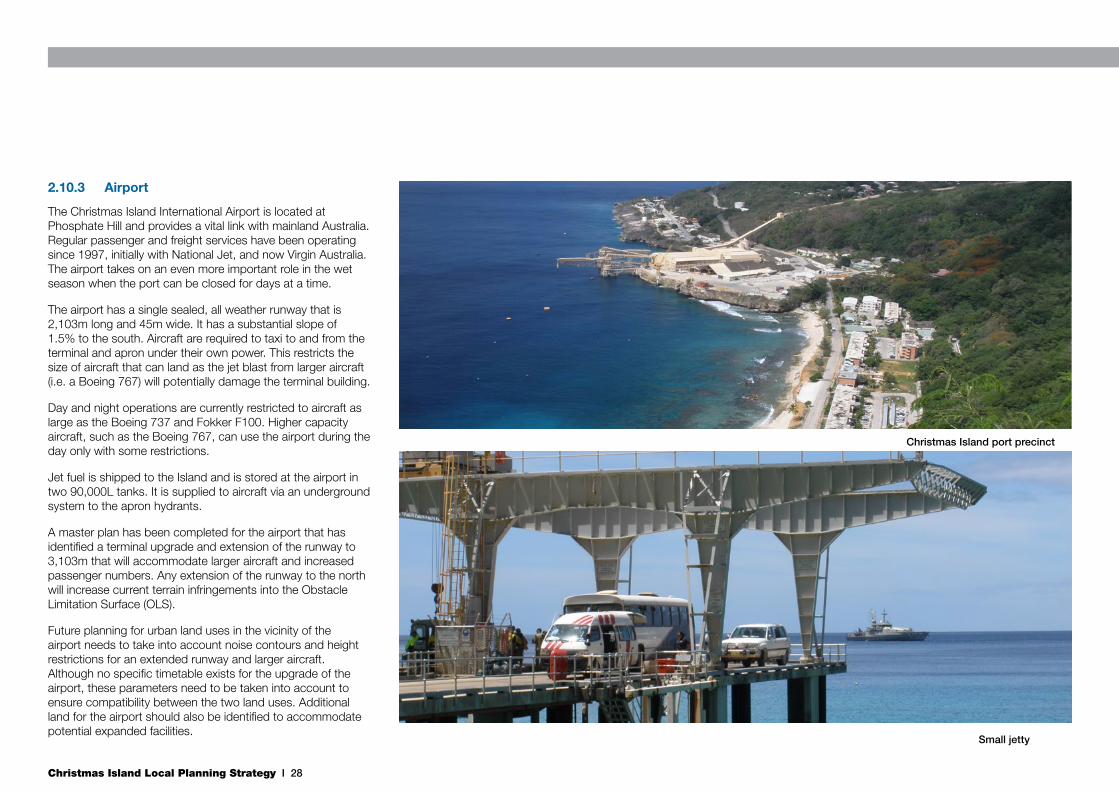
2.10.2 Port
The main port on Christmas Island is located in Flying Fish Cove and is primarily utilised for bulk handling, container ships and fuel imports. Phosphate is the major export from the port. Ships moor to a network of deep sea buoys. This network has recently been upgraded to handle visiting cruise ships.
The port has a cantilever crane to lift containers and other goods from moored ships to the wharf. There is also a container stacking and handling area. Phosphate loading operations take place through the port either via a conveyor and retractable booms that extend out over the ship to be loaded for bulk product, or the crane for bagged product.
Due to the open nature of Flying Fish Cove and the port, it is subject to difficult and dangerous weather conditions, primarily during the December – April swell season. During periods of high swell, the port is inaccessible and this can create significant delays for incoming ships. A secondary port facility on the eastern side of the Island at Nui Nui provides an alternative off-loading facility in emergency situations when Flying Fish Cove is inaccessible. This facility also has a crane to lift containers and hard stand areas for storage. The Commonwealth is currently upgrading the Nui Nui port facilities, installing mooring buoys and a landing platform to provide an alternative should the primary port at Flying Fish Cove be unavailable.
There is a small jetty in Flying Fish Cove to handle small loads and boats. This jetty is currently used for the offloading of asylum seekers. A flat bottomed barge is lowered into the water from the jetty, retrieves asylum seekers from Navy boats, and is hoisted back up to the level of the jetty walkway to unload.There is a secondary mooring off Smith Point for fuel supply ships to unload, and it is also used by the Australian Navy and cruise ships.
Christmas Island Local Planning Strategy I 28
2.10.3 Airport
The Christmas Island International Airport is located at Phosphate Hill and provides a vital link with mainland Australia. Regular passenger and freight services have been operating since 1997, initially with National Jet, and now Virgin Australia. The airport takes on an even more important role in the wet season when the port can be closed for days at a time.
The airport has a single sealed, all weather runway that is 2,103m long and 45m wide. It has a substantial slope of 1.5% to the south. Aircraft are required to taxi to and from the terminal and apron under their own power. This restricts the size of aircraft that can land as the jet blast from larger aircraft (i.e. a Boeing 767) will potentially damage the terminal building.
Day and night operations are currently restricted to aircraft as large as the Boeing 737 and Fokker F100. Higher capacity aircraft, such as the Boeing 767, can use the airport during the day only with some restrictions.
Jet fuel is shipped to the Island and is stored at the airport in two 90,000L tanks. It is supplied to aircraft via an underground system to the apron hydrants.
A master plan has been completed for the airport that has identified a terminal upgrade and extension of the runway to 3,103m that will accommodate larger aircraft and increased passenger numbers. Any extension of the runway to the north will increase current terrain infringements into the Obstacle Limitation Surface (OLS).
Future planning for urban land uses in the vicinity of the airport needs to take into account noise contours and height restrictions for an extended runway and larger aircraft. Although no specific timetable exists for the upgrade of the airport, these parameters need to be taken into account to ensure compatibility between the two land uses. Additional land for the airport should also be identified to accommodate potential expanded facilities.
Small jetty
Christmas Island port precinct
Christmas Island Local Planning Strategy I 29
2.10.4 Water
The Water Corporation of WA is currently responsible for the water supply on Christmas Island, under a SDA with the Commonwealth Government. The Water Corporation distribute fresh water by collecting and pumping water from a number of underground springs and flows around the Island. The main collection point is Jedda Cave, located in the interior of the Island on the central plateau. Other collections points provide redundancy in the system and include the Waterfall springs, Jane-up sinkhole and the Ross Hill Gardens springs. Jane-up provides equipment redundancy, but at best only limited source redundancy. Waterfall redundancy is impacted by infrastructre which only allows water to reach George Fam tank.
A significant proportion of Christmas Island’s water supply is extracted from the National Park, through Jedda Cave. The Christmas Island national Park Draft Management Plan 2012-2022 provides information and recommendations for future water use agreements.
Water is treated and stored in a network of above ground tanks in Settlement, Drumsite and other locations around the Island. Water is distributed through a standard reticulation system to customers. Water for the lower terrace (Settlement and Kampong) is sourced from the Waterfall springs and distributed from a tank adjacent to the SOCI building. Water for the rest of the Island is sourced from Jedda Cave (direct to the IDC and from the Drumsite tank for the rest of the urban settlement).
There are no water supply capacity issues at present due to the heavy rainfall experienced by the Island over the recent wet season. However, due to the nature of water resources and restricted redundancy, this situation can change annually. The Island has experienced water restrictions in the past during prolonged dry spells.
As outlined in Section 2.4.2, the exact extent of the
underground aquifer from which fresh water is sourced from is currently unknown. A Water Management Plan for the Island was prepared in 1999 that indicated that classification of the Island’s fresh groundwater into perched aquifers and basel aquifers should only be considered preliminary as much of the data is inferred (Falkland 1999). Figure 10 illustrates the current mapped extent of the aquifer and existing water sources.
Given the nature of the aquifer recharge and unknown extent, the water source is highly vulnerable to contamination from a variety of land uses, especially waste disposal sites (Falkland 1999). If pollution was detected at a water source (e.g. Jedda, Waterfall), then the source would need to be closed and where pollution continued, the Island would have a significant water supply problem (Falkland 1999). This scenario highlights the critical requirement of protecting the water source and preventing any contamination.
Chirstmas Island is vulnerable to groundwater polution; steps must be taken to ensure well head protection zones and priority classifications around existing water supplies are protected from possible future contamination. Suitable development and land use controls are required to minimise the risk of contamination to the underground water source. The effectiveness of such controls will be limited however until the exact location and extent of the underground aquifer is determined. This mapping will also assist in locating new water sources to take pressure of environmentally sensitive areas, such as the Waterfall springs.
2.10.5 Wastewater
The Water Corporation of WA is responsible for the operation of the wastewater system on Christmas Island, under a SDA with the Commonwealth Government. The wastewater treatment plant (WWTP) is located at Smith Point, adjacent to fuel off-loading and storage facilities. The plant receives wastewater from both the Christmas Island Community and the Immigration Detention centres; it has the capacity to treat
1.75ML of wastewater per day.
A $10m upgrade of the WWTP has been completed and increased the capacity from 1,350/1,400m3 per day to 1,750m3 per day. The upgrade has increased the capacity to approximately 6,000 people.
The IDC is currently placing excessive strain on the WWTP and infrastructure as the water usage at the IDC is well above the Island’s average. Water usage at the IDC is recorded at 360L/person/day, compared to 1,000L/day for a family of four. With around 2,000 people housed at the IDC, this additional water usage is transformed into a significant increased inflow to the WWTP. The Water Corporation have advised that if the IDC was to reduce its consumption of water, then the upgraded WWTP could cater for up to 6,500 people.
The current pipe infrastructure presents the main concern for wastewater infrastructure on the Island. In heavy rainfall events, there is significant storm water infiltration into the system. This influx of water is contributing to the flow of wastewater to the WWTP and affecting its capacity.
The system uses intermittent aeration and UV treatment, with the final treated effluent disposed of by ocean outfall. Treated sludge is transported to the rubbish tip on Phosphate Hill. Up to 9 tonnes of sludge a week is currently being dumped at the rubbish tip. This practice is not preferred, however the circumstances of the Island dictate the limited disposal options at present. Options for the alternative treatment (either incineration or composting) of the sludge at the rubbish tip are currently being investigated by the SOCI as part of a Waste Management Study.
In such an isolated environment, consideration should also be given to sustainable water management practices, including wastewater re-use options. Sustainable water management practices have the potential to positively impact on the fresh water supply by reducing demand and reducing the pressure on the underground aquifer. Potential wastewater re-use, as an

Christmas Island Local Planning Strategy I 30
example opportunity, could target horticulture and agriculture activities and contribute to the diversification of the Island’s economic base.
2.10.6 Power
Power generation and distribution is the responsibility of the Indian Ocean Territory Power Authority (IOTPA). Power for the Island is supplied by diesel generators and the power station is located on Murray Road in Drumsite. The current power load is 7mW and new generators have increased capacity to 17.2mW.
Diesel is supplied to the power station via pipes from the main storage facility at Smith Point. Once off-loaded from supply ships, the diesel is pumped through pipes up the significant incline to the power station.
The current power station requires additional room in the future to accommodate expansion and relocation plans.
It is recognised that the reliance on imported fuel for power on the Island is an unsustainable and undesirable outcome in the long term. Alternative energy sources have been investigated in the past which have concluded that solar and wind power are not viable sources of energy for the Island. A Renewable Energy Study has been prepared for the IOTPA, which investigated the viability of bio-fuel on the Island. It has been concluded in that study that a land area of approximately 800 ha could sustain the Island’s power output.
2.10.7 Solid Waste
Waste management provides a significant challenge for the Island. Traditional waste landfill methods are not necessarily appropriate in a remote island environment. In addition, leaching effects from the unlined rubbish tip on the groundwater aquifer are unquantified and there is little soil available to cover waste. Figure 10: Indicative Groundwater Extent
Christmas Island Local Planning Strategy I 31
SOCI is responsible for the management of waste on the Island, including the current rubbish tip. All solid waste is currently disposed of at the rubbish tip, which is located at Phosphate Hill, adjacent to the recreation centre and detention centre.
Organisation and separation of rubbish does not occur in a systematic manner, which has resulted in a large tip area with different kinds of waste scattered in different areas. Many of the stockpiles of tyres, car bodies and other metal waste are overgrown by the jungle. Hazardous waste is stored in the open, subject to heat and rain. Treated sludge from the WWTP is transported to the tip and deposited, with little cover.
There are various risks involved in the current waste management practices on the Island, including biological risks associated with the dumping of sewage sludge and mixed municipal waste. Potential leaching of the 90% liquid sludge poses a direct contamination risk to the groundwater resource (RAUM 2011). Chemicals from paints, solvents, acids, alkalis are all contributing to chemical risks to water, soil and the environment (RAUM 2011).
Waste management practices are currently being investigated as part of a Waste Management Study for SOCI. The study proposes a new Resource Recovery Centre (RRC) for the management and recovery of resources from the Municipal Solid Waste Stream (MSW). Volume reduction and waste minimisation should be the overall strategy adopted. All organic components of MSW have to be separated at the source for treatment and recovery of quality by-products. Proper treatment of wastewater sludge requires immediate attention. With proper recovery of resources SOCI could manage the landfill with just one inert landfill that is affordable for the Island (RAUM 2011).
If these recommendations are adopted, waste management could occur on a much smaller footprint, with reduced on and off-site effects, in the current rubbish tip location for the foreseeable future.
A suitable alternative long term location for the rubbish tip cannot be determined until the extent of the groundwater catchment is identified and the effects of the current tip on the groundwater are quantified.
2.10.8 Construction Materials
Christmas Island has a very limited local source of raw and construction materials. Significant investment in infrastructure projects is placing high demand on construction materials, and the Island relies strongly on imported materials from other islands and the mainland.
Construction works on Christmas Island are dependant on identification of local material supplies and greater import of materials. Import of materials, particularly from Cocos (Keeling) Island, requires consideration of quarantine implications.
2.10.9 Telecommunications
The advancement of information and communication technologies in recent years coupled with the remote location of the island are contributing factors to a growing demand for greater telecommunication services on the island. The island is serviced by conventional landline telecommunications, whilst the Radio Frequency National Site Archive indicates that Telstra operates six (6) fixed mobile base stations on the island providing mobile broadband facilities to residents. Furthermore, recent and planned delivery of digital TV (project roll-out 2013) and the NBN (via satellite by the end of 2015) will improve the level of telecommunications greatly.
2.11 Population Growth and Accommodation DemandA detailed discussion and analysis of the demand for land on Christmas Island has been undertaken through the Accommodation Needs Assessment for Christmas Island and
Cocos (Keeling) Islands (Department of Regional Australia, Regional Development and Local Government 2011). The study has identified a critical shortfall of accommodation on the Island, with demand for urban expansion to support the current population. Key findings include:
• Affordable housing options are needed immediately for age groups 20-35 years and retirees;
• Tourist accommodation is being significantly pressured from FIFO;
• Home ownership is becoming out of reach in the context of a highly inflated market; there is little availability of vacant dwellings for owner occupiers; and
• Housing options need to be flexible for changing needs and family structure.
With significant unmet demand there has been significant increase in rental costs, with increases of 200% and 300% between 2009 and 2011. There is significant demand for family style 3 and 4 bedroom homes, with demand for blocks being large enough to build such homes.
Existing vacant private land could, in the short to medium term, have a development capacity for an additional 171 dwellings and at least an additional 124 tourism accommodations. Demand for alternative housing styles, particular family style homes, identifies a need for additional urban expansion areas to support both the current population, and future growth.
The Commonwealth is currently delivering a new residential development in Drumsite, which will reduce pressure on accommodation in the short term.
Christmas Island Local Planning Strategy I 32
3.1 Town Planning Scheme No. 1The current TPS was gazetted in 2002, and preparation commenced earlier than this date. The TPS provides the statutory framework for land use and development on the Island in accordance with applied Western Australian planning legislation. The current TPS is the first TPS for the Island.
As a result of changing economic and policy circumstances, the TPS is outdated and provides limited direction, especially in relation to urban expansion. Some of the land use zonings are unsuitable and/or do not match the circumstances on the ground. There are also numerous zoning inconsistencies between what is depicted on the Scheme Maps and what has actually been built.
Alongside preparation of this LPS, a comprehensive review of the TPS has been undertaken to provide greater long term land use direction that will facilitate the future sustainable development of Christmas Island. The new TPS2 (to be gazetted as the operational scheme) reflects the strategies of this LPS.
3.1.1 Town Planning Regulations Review
The Western Australian Department of Planning (DoP) is currently conducting a review of the Town Planning Regulations (1967)(WA)(CI) (as amended) and the associated Model Scheme Text (MST).
The draft Regulations and Model Scheme Text were advertised in November 2014 and include:
• Local Provisions – customised section to suit individual Local Governments;
• Generalised Provisions – standardised across the State and will address common elements and procedures; and
• Local Scheme Map – with standardised terminology, legend and colours.
Once the Regulations have been finalised and come into effect, the general provisions of the Model Scheme Text will replace the relevant sections of TPS2. Local provisions (zones and development requirements) will continue to apply.
3.1.2 Town Planning Scheme
All town planning schemes under WA planning legislation have to follow a specific format as prescribed by the MST. Given the advice from DoP noted above, there is likely to be no need for large scale changes to the content of the TPS text. Changes to the TPS text are most likely to be limited to an update of references to policies and legislation, land use zones, and the land use table.
The major change is most likely to be related to the TPS maps, as these depict the spatial distribution of land uses on the Island. The intent of these maps will be to reflect the land uses changes identified in the LPS process. As well as some zoning inconsistencies, there are some instances where land use zones in the Christmas Island TPS maps do not reflect and follow cadastral boundaries. This situation causes uncertainty for land owners in relation to what development is permitted on their land and is not common practice. Land use zone delineation should adhere to cadastral boundaries where practicable.
3. Planning & Policy Context
Christmas Island Local Planning Strategy I 33
3.1.3 Zoning Inconsistencies
The current land use zoning under the TPS determines the capability of each parcel of land in terms of future land use. Within the TPS is a Land Use Zoning Table which sets out the permitted land uses for each land use zone.
Due to historical circumstances and the sometimes unrelenting need for additional infrastructure and services on the Island, there are currently many examples of land uses being situated in land use zones that are not suitable (compared to mainland practices). This is an undesirable situation that severely limits the capability of these land parcels in terms of land re-use or land use expansion until the zoning issues are rectified. It also provides uncertainty for the land owner in relation to what their land can be used for.
3.1.4 Mining Leases
Currently, mining leases are designated as a specific land use reserve within the TPS. These mining leases should not be designated by a specific reserve or zone in the TPS as it makes it extremely difficult to facilitate other uses on that land without following a full rezoning process. These leases should be designated as rural (or other relevant land uses). This will allow much easier conversion to other land uses without the need to follow lengthy statutory processes in the future. It also will increase the range of land use diversity permitted on the land.
3.2 Christmas Island 2018 PlanThe Our Future Christmas Island 2018 Plan (the 2018 Plan) was prepared in 2011. The 2018 Plan is required to articulate shared community directions for the future of the Island. It includes a shared community vision, key actions, milestones and timelines for actions. A key aspect of the 2018 Plan is to
ensure that strategies are community initiated and that these strategies assist in developing long-term economic diversity for the Island’s economy (C Change & AWSPS 2010).
The Christmas Island 2018 Community Vision statement that was developed is: A place for everyone, without exception. An accompanying Statement of Values and Principles was developed:
‘We are a diverse community with diverse views and aspirations but many common values that unify us. These values and principles underpin our vision for the future and are presented here as a statement of who we are as a community. We wish these values and principles to be considered by all when making decisions to shape the future.’ (C Change & AWSPS 2010)
The 2018 Plan recognises the need to diversify the economic base of the Island to develop a post-mining economic future. It also recognises the uniqueness of the natural environment and the importance of its protection as well as the high cost of living and associated financial pressures and the impact that the Immigration Detention Centre is having on Island life.
A number of themes and actions were developed with the community that address the challenges facing the Island, whilst accomplishing and adhering to the community vision and Statement of Values and principles. These are categorised under six themes: land use planning, infrastructure planning, economic diversification, protecting the natural environment, community capacity, health and wellbeing, and governance, institutional capacity and getting things done.
Key relevant themes: Land use planning
• Review water resources to establish a sustainable population level;
• Determine land needed for future retail, commercial and community uses;
• Ensure appropriate land use opportunities for research and development;
• Draft a land use release and development plan;
• Develop master plans for community focal points;
• Move the domestic fuel tanks currently located in Settlement; and
• Promote agricultural practices by utilising disused mining leases.

Christmas Island Local Planning Strategy I 34
Key relevant themes: Infrastructure planning
• Establish a priority infrastructure plan;
• Prepare a Waste Avoidance and Management Strategy;
• Expand recreation facilities at Phosphate Hill; and
• Develop green energy options.
Key relevant themes: Economic diversification
• Encouragement of horticulture and aquaculture production on the Island;
• Review and streamline application processes;
• Implement a commercial horticultural system on the Island; and
• Investigate interest in developing a Tropical Climate Research Institute and Oceanographic Institute on the Island.
Key relevant themes: Protecting the natural environment
• Implement the National Park Management Plan.
Key relevant themes: Community capacity, health and wellbeing
• Encourage DIAC to lengthen contract timeframes for workers;
• Determine aged care needs on the Island;
• Establish a community garden; and
• Education of the community and potential horticultural stakeholders in Island specific horticultural production.
Key relevant themes: Governance and institutional capacity
• Develop a Memorandum of Understanding between SOCI and DRA to facilitate joint planning, communication and information sharing.
3.3 Crown Land Management Plan for the Indian Ocean Territories
A Crown Land Management Plan for the Indian Ocean Territories (CLMP) was prepared by GHD for the Attorney-General’s Department (AGD) over the course of 2008-2009. The purpose of this document was to assess Crown land on the Indian Ocean Territories to enable informed decisions to be made on its most suitable future uses which will lead to the overall better management of Crown land. Given that the majority of land on Christmas Island is owned or managed by the Commonwealth, the outcomes of the land suitability and capability assessment and subsequent recommendations from the CLMP are especially relevant to this project.
The project consisted of an initial assessment of Crown land on Christmas Island, which was undertaken by drawing on readily available information, mostly from resources provided by AGD and from the Department of Planning. The assessment provided the basis for a plan of management, which included recommendations on the appropriate future uses of land and land development priorities (i.e. short term, medium term, long term).
The CLMP recognised that the most effective and recognised land management plan is, and will continue to be, the TPS. It was concluded that the TPS offers the most effective way of directing the future land uses on the Island to align with the strategic directions outlined in the CLMP. As part of this, the existing LPS was reviewed in the context of future management of Crown land on the Island.
A series of recommendations (34 in total) formed part of the CLMP in relation to governance, land use and economic development. More specifically, recommendations were provided to:
• Review the LPS and TPS;
• Reduce the Island’s dependency on imported fresh food and energy;
• Consider the extraction of phosphate in areas that may be used for urban development;
• The development of a strategy to convert mining leases to agricultural/horticultural uses;
• The preparation of various Outline Development Plans for tourism and future urban areas;
• Provide forward planning of targeted land uses and obtain approvals prior to marketing activities; and
• Create an on-Island working group to progress the implementation of the CLMP and town planning review process.
Christmas Island Local Planning Strategy I 35
3.4 Indian Ocean Territories Economic Development Strategic Plan 2010 – 2015
In considering realistic options for the future socio-economic prosperity on Christmas Island and the Cocos (Keeling) Islands, the Economic Development Strategic Plan 2010-2015 (the Plan) is the most up to date shared vision “to progress economic development sustainability in the economy of the IOT”.
The Plan is designed to be linked with Commonwealth Government IOT Futures Plan, Crown Land Management Plan and Futures Plans of both Shires and provides a local strategy to link with the Commonwealth Government Regional Development Australia program. The Plan allows DRA and the Shires of Christmas Island and Cocos (Keeling) Islands to consider the strategies in their planning purposes and decision making on resource allocations.
In 2009 the Minister for Home Affairs constituted the Economic Development Consultative Groups for the Indian Ocean Territories. The Minister appointed the members of the CKI and CI EDCG for a term of two years from May 2009 and nominated the Administrator of the IOT as Chair of the Groups.
The Plan is designed to have a regional and strategic approach with both CI and CKI being supportive and learning from each other.
The Plan has indentified four key priority areas aimed at:
• Building the capacity of the resident population;
• Reduce red/green tape and accelerate private/public development procedures;
• Increase awareness of the Plan for residents and new
investment; and
• Foster sustainable economic development associated with tourism, education & research, horticulture and aquaculture.
The Plan recognises the importance of supplying adequate quantity and quality of housing accommodation in the IOT for the three main target groups being local residents, fly-in fly-out /short term workers and tourists.
3.5 Outline Development Plan for the Light Industrial Area
An Outline Development Plan (ODP) for the Light Industrial Area (LIA) on Christmas Island was prepared by GHD in 2010 that provides a land use planning framework to guide the future subdivision and development of the site. The ODP has been endorsed by the SOCI Council and provides the general future subdivision and land use planning framework to facilitate the expansion of the LIA.
The purpose of the ODP is to facilitate the release of additional industrial land to provide opportunities for further economic development on the Island. It will also allow the consolidation of dispersed industrial land uses in other parts of the Island into one central location with similar industries. More efficient and safer heavy vehicle movements have also been considered to reduce the impact on nearby residential areas.
As part of the preparation of the ODP, preliminary servicing and traffic analysis were undertaken to investigate possible impacts of the proposed development on current infrastructure as well as potential required upgrades. The ODP also takes into account various heritage considerations in the surrounding areas as well as environmental constraints.
As a strategic land use and subdivision plan for the future of the LIA, the proposed land uses and road network should be reflected within the LPS.

Christmas Island Local Planning Strategy I 36
3.6 State Planning PolicyState Planning Policies are prepared and adopted by the Western Australian Planning Commission and provide policy guidance for a range of key planning issues across the State of Western Australia.
Local governments must have due regard for State Planning Policies when preparing planning strategies and when making decisions on planning matters. Key state planning policies with land use planning implications for Christmas Island are discussed in this section.
3.6.1 SPP 2 Environment and Natural Resources Policy
SPP2 provides a policy framework to integrate environmental and natural resource management considerations into broader land use planning and decision-making activities. The policy is supported by more detailed planning policies that provide additional policy guidance on particular environmental issues or attributes.
The LPS should incorporate protection of environmental matters to respond to the guidance of SPP2.
3.6.2 SPP 2.5 Agricultural and Rural Land Use Planning
SPP2.5 provides specific policy guidance for agricultural and rural land use planning. The policy provides a particular focus on identifying and appropriately zoning highly productive agricultural land.
The policy recognises the importance of the full diversity of rural land uses, including the need to provide for resource extraction and mining, to provide food and materials for the community. The policy also provides guidance for the effective stewardship of agricultural assets through incorporation of natural resource management.
The LPS should incorporate the requirements of SPP2.5, and recognise the importance of mineral extraction and local agricultural activities for the economic growth of the Christmas Island community.
3.6.3 SPP 2.6 State Coastal Planning Policy
SPP2.6 considers land use planning issues specifically as they relate to the coast, and provides guidance to integrate coastal
processes into strategic planning and decision-making.
The LPS should consider the impact of key coastal processes, in particular storm surge, tidal processes, and sea level change in making recommendations for future land use change in coastal areas of the Island.
3.6.4 SPP 3 Urban Growth and Settlement
SPP3 provides policy guidance for the creation of sustainable urban settlements in Western Australia. Key policy objectives relate to promoting a wide variety of housing, employment, recreational facilities and open space, responding to social and economic needs of the community, and coordinating delivery of infrastructure and services.
The LPS is a key strategic mechanism to implement SPP3 in Christmas Island, through consideration of and planning for key urban issues and opportunities on the Island. The LPS should facilitate new and expanded urban areas to provide for the social and economic needs of the community.
3.6.5 SPP 3.4 Natural Hazards and Disasters
SPP3.4 provides a planning framework for planning authorities to undertake strategic planning and make decisions in areas potentially affected by natural hazards and disasters. The policy provides information with regard to flood, severe storms and cyclones, storm surge, bush fires, landslides, and earthquakes.
The LPS should consider and make recommendations for land use and further work necessary to inform planning decisions, with particular regard to cyclonic and storm surge risk.
Christmas Island Local Planning Strategy I 37
3.6.6 SPP 3.5 Historic Heritage Conservation
SPP3.5 provides a planning framework for conservation of historic heritage. The policy provides a framework for the Heritage Council and local governments to identify, assess and designate heritage areas of state or local significance. The policy sets out development principles for considering planning applications for places from either state or local registers.
The LPS should identify and consider the heritage value of places on Christmas Island, and make recommendations for their conservation through appropriate planning mechanisms such as the Local Planning Scheme.
3.6.7 SPP 4.1 State Industrial Buffer Policy
SPP4.1 provides a framework for protection of industrial activities through identification and management of buffers to sensitive land uses. To provide more detail on the types of buffers required for industrial uses, the Environmental Protection Authority’s (EPA’s) Guidance Statement No. 3; Seperation Distances between Industrial and Sensitive Land Uses provides a number of generic buffer distances for various industry types.
A draft State Industrial Buffer policy has been prepared and advertised by the WAPC. The updated draft places lesser focus on generic buffers as the only mechanism to manage land use conflict, and recognises that site specific management activities can be identified through planning and environmental assessment processes to manage impacts on sensitive land uses. A focus on onsite management techniques and site specific studies can effectively reduce the need for incorporation of generic industrial buffers into planning strategies.
On Christmas Island, there are few industries listed with generic buffers in the EPA’s Guidance Statement No. 3. Relevant generic buffers from the statement include:
• Airport (no generic buffer);
• Extractive industry/mining (no generic buffer);
• Fuel storage (300 to 500 metres);
• Power supply (no generic buffer);
• Agriculture/aquaculture (300-500 metres);
• Radio towers (no generic buffer);
• Solid waste disposal (500 metres); and
• Waste water treatment plant (no generic buffer).
The application of generic industrial buffers on Christmas Island is not recommended as the sole means to ensure industry does not impact on sensitive land uses. The LPS should consider key issues associated with industrial types, and consider opportunities such as relocation and changed management practices to address issues of land use conflict.
Specific planning proposals for industrial activities on Christmas Island should consider surrounding land uses and ensure appropriate buffers, consistent with the requirements of SPP4.1 (State Industrial Buffer Policy), guided by generic buffers set out in the EPA’s Guidance Statement No. 3, and in consideration of environmental management processes to be utilised.
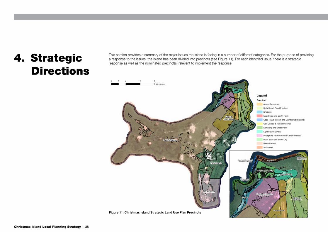
Christmas Island Local Planning Strategy I 38
This section provides a summary of the major issues the Island is facing in a number of different categories. For the purpose of providing a response to the issues, the Island has been divided into precincts (see Figure 11). For each identified issue, there is a strategic response as well as the nominated precinct(s) relevent to implement the response.
4. Strategic Directions
Figure 11: Christmas Island Strategic Land Use Plan Precincts

Christmas Island Local Planning Strategy I 39
4.1 Economic DriversThe leadership for economic development on Christmas Island has been delegated to the Christmas Island Economic Development Consultative Group (CIEDCG). Since 2009 the CIEDCG has prepared, in close consultation with stakeholders and the community, the IOT Economic Development Strategic Plan 2010-2015.
The CIEDCG will soon be replaced with an organisation modelled on the Western Australian Regional Development Commission structure.
Other economic development measures have also been identified in the CLMP and the 2018 Plan. These reports have identified the need to ensure that the Christmas Island economy achieves greater diversification and moves away from the traditional dependency on one specific industry sector such as phosphate mining.
There is a consensus of opinion that the relevant economic drivers for Christmas Island include population growth, the cessation of mining, food supply, tourism opportunities, construction material supply, future economic activities, private investment, accommodation supply and home business/mixed use.
4.1.1 Population Growth
Current Issue Strategic Response Relevant Precinct
The lack of accurate information defining the extent of fresh water resources prevents the establishment of definite population targets
Mapping of the basalt layer
Plan for a total population of 5000 permanent people as per community-endorsed 2018 Plan
Whole of Island
Ageing workforce Provision of appropriate facilities and infrastructure near community services in the short term
Poon Saan & Silver City, Settlement
Youth and young couples are not encouraged to stay on-Island due to lack of employment and accommodation opportunities
Create new jobs and accommodation for singles and young couples
Encourage new small business enterprises
Provide adequate training opportunities linked with identified business drivers
Whole of Island
Fly in-fly out workforce not well integrated with the community and appropriate accommodation in short supply impacting on tourism facilities
Create quality accommodation for fly in-fly out workforce that can also be used for tourism and local needs (youth)
Gaze Road, Poon Saan & Silver City, Drumsite
Potential intake of additional population to sustain and diversify economic growth
Ensure that land supply and accommodation are aligned with population growth rates
Whole of Island
Christmas Island Local Planning Strategy I 40
4.1.2 Cessation of Mining
Current Issue Strategic Response Relevant Precinct
Current mining leases to expire in 2019, with actual operations to cease before then
Conversion of mining leases to rural leases before or beyond 2019 for agriculture and aquaculture related activities targeting on-Island needs and potential export markets
Identification of suitable mining leases for relinquishment to Parks Australia
Dolly Beach Road, East Coast and South Point, Rest of Island
Application for new mining leases
Support any reapplication for new mining leases in close proximity to the existing urban areas to allow for a smooth transition from mining to agriculture and the establishment of new urban areas in the Phosphate Hill area
Phosphate Hill/Recreation Centre, Light Industrial Area, Airport Surrounds
Uncertainty associated with the mining workforce
Re-training of the mining workforce in agriculture and aquaculture related activities as well as training in other sectors
Whole of Island
Future of mining infrastructure
Conversion and re-use of infrastructure and ensure heritage retention where applicable
Re-use of the current dryers site for potential food processing purposes associated with agriculture and aquaculture (optimum location for wastewater re-use)
Kampong and Smith Point, Poon Saan and Silver City, Drumsite
4.1.3 Food Supply
Current Issue Strategic Response Relevant Precinct
Unreliable supply of fresh foodEstablish, in conjunction with PRL, on-Island food production trials on selected mining leases
Dolly Beach Road, Drumsite
Increased costs of imported fresh food jeopardises the economic viability of emerging businesses such as tourism
Source cheaper fresh food supply through on-Island production
Drumsite, Dolly Beach Road, East Coast
Capture existing on-Island knowledge in horticulture
Introduce community gardens within and outside urban areas in conjunction with broader trials.
Poon Saan and Silver City, Settlement, Kampong and Smith Point, Drumsite, Phosphate Hill/Recreation Centre
Quarantine regulations on imported plants frustrates the ability to diversify home grown fresh food production
Develop and endorse a commonly shared list of permissible animal and plant species suitable to Christmas Island and consider a review of the current plant assessment process.
Establishment of a food research centre for agriculture and aquaculture activities
Whole of Island (except National Park)

Christmas Island Local Planning Strategy I 41
4.1.4 Tourism Opportunities
Current Issue Strategic Response Relevant Precinct
Lack of traditional high volume tourism attributes
Development of small niche tourism activities taking advantage of the quality of the flora, fauna and marine life as well as the island’s unique historical, cultural and religious heritage.
Whole of Island
Absence of tourism accommodation within the National Park
Work closely with Parks Australia to identify suitable sites for eco-tourism developments and create specific building regulations, in accordance with the Christmas Island National Park Management Plan and subject to the requierments of the EPBC Act.
Rest of Island (National Park)
Lack of tourist facilitiesIdentification of sites suitable for tourism within the existing settlement
Settlement, Gaze Road, Poon Saan and Silver City, Dolly Beach Road
Enhancement of Gaze Road Tourism and Commercial Precinct
Develop a Structure Plan that facilitates the maintenance of heritage values, general landscaping upgrades, the introduction of new commercial and tourism enterprises and new accommodation
Relocation of domestic fuel tanks (near the power station) and petrol station
Gaze Road, Drumsite
Cruise ship visits gaining community and Commonwealth Government support
Continue to upgrade port infrastructure to facilitate disembarkment of passengers
Development of dedicated local markets in the various existing precincts
Kampong and Smith Point, Gaze Road
Lack of 5-star ResortExplore synergies with current Christmas Island Resort location
Dolly Beach Road
4.1.5 Construction Material Supply
Current Issue Strategic Response Relevant Precinct
Heavy reliance on imported construction materials
Identification of suitable land for the extraction and processing of local building materials (e.g. limestone and timber)
Implement the approved LIA Outline Development Plan
Whole of Island (except National Park), Light Industrial Area
No exchange of construction material between Christmas Island and the Cocos (Keeling) Islands
Facilitate the exchange of material between the Islands in line with past activities and increase synergies between the two economies
Kampong and Smith Point, Light Industrial Area
Christmas Island Local Planning Strategy I 42
4.1.6 Future Economic Activities
Current Issue Strategic Response Relevant Precinct
Economic diversification is required due to the foreseeable cessation of mining and lack of reliability of immigration activities
Re-focus economic activities towards alternative sectors such as tourism, agriculture/aquaculture, research and development, training and education, and government activities
Whole of Island
Current land uses provisions do not provide for future economic activities
Identification of suitable land for new economic sectors Whole of Island
Local skill and knowledge base unprepared for new economic activities
Identify suitable areas and infrastructure for education and training associated with new economic activities
Drumsite, Phosphate Hill/Recreation Centre, Light Industrial Area
4.1.7 Private Investment
Current Issue Strategic Response Relevant Precinct
Private investors find it difficult to invest in leased land
Encourage a relaxation of the Commonwealth Land Disposal Policy to increase investment options on Island
Whole of Island (except National Park)
Private investment on the Island is reliant on the release of Crown land for future investment opportunities
Align the LPS with the findings and recommendations of the CLMP
Whole of Island (except National Park)
The stringent environment approval requirements associated with new development can frustrate positive outcomes
Support the creation of a land bank of Priority 1 and 2 vegetation areas outside of the National Park that could be used for environmental offsets
Whole of Island (except National Park)
4.1.8 Accommodation Supply
Current Issue Strategic Response Relevant Precinct
There is a acute shortage of accommodation on the Island and a need for more accomodation
Increased economic activity and diversification will require additional accommodation
Identify suitable areas for future urban expansion
Adjust residential densities in existing residential areas
Phosphate Hill/Recreation Centre, Poon Saan and Silver City, Drumsite

Christmas Island Local Planning Strategy I 43
4.1.9 Home Business/Mixed Use
Current Issue Strategic Response Relevant Precinct
Growing interest in home businesses and the mix of activities within residential and tourism
Encourage mixed use activities through the introduction of a Mixed Use zone in the TPS
Gaze Road, Settlement, Poon Saan and Silver City
4.2.1 Natural Environment
Current Issue Strategic Response Relevant Precinct
Red crab migration routes threatened by human activities
Maintenance, protection and introduction of new red crab migration protection measures as part of future urban development
Phosphate Hill/Recreation Centre, Light Industrial Area, Poon Saan and Silver City, Drumsite, Settlement, Golf Course and Resort
The limestone geology of the Island comprises potentially unidentified caves
Ensure any new development considers the geotechnical limitations associated with potential caves
Whole of Island
Resolution of National Park boundaries Support the rationalisation of National Park boundaries Whole of Island
Some mining leases are surrounded by National Park
Support the relinquishment of the central and north western mining leases to Parks Australia
Rest of Island
Mining leases will be extinguished by 2019Ensure that the re-use of mining leases towards rural activities balances the needs of the environment with the economic future of the Island’s population
Dolly Beach Road, East Coast, South Point
4.2 Natural EnvironmentWhilst significant areas of the Island are protected within the National Park, historic phosphate mining and human activities have had some impact. Future urban expansion and possible mining present threats that require management and consideration.
There is a need to assess and minimise environmental impacts from development and redevelopment on Christmas Island, particularly in relation to traffic impacts on red crabs. Future policy guidance should provide a framework to integrate environmental management into land use planning and decision making.

Christmas Island Local Planning Strategy I 44
4.3.1 Potable Water
Current Issue Strategic Response Relevant Precinct
Lack of accurate definition of underground fresh water aquifer
Mapping of the basalt layer and cave systems
Assessment of the catchment extent and capacityWhole of Island
Potential for contamination of fresh water supply
Mapping of the basalt layer and cave systems to assess the catchment extents
Identification of land use controls in areas which may impact on vulnerable groundwater resources
Whole of Island
Lack of redundancy in water supplyResearch, prove and develop additional water sources in consultation with Director National Parks
Whole of Island
Powerlines to freshwater pumping stations are currently above ground and at high risk from storm damage
Secure power supply to water pumping stations by installing power supply underground
Whole of Island
4.3.2 Wastewater
Current Issue Strategic Response Relevant Precinct
Sustainable Water Management PracticesInvestigate sustainable water management practices, such as wastewater re-use opportunities for agricultural purposes
Drumsite, Dolly Beach Road
Above ground wastewater infrastructure in high rock fall risk areas
Encourage the Commonwealth to take appropriate measures to protect infrastructure from rock fall risks
Kampong and Smith Point
Disposal of treated wastewater sludge in land fill at the rubbish tip
Establish a composting facility at the rubbish tip to appropriately treat wastewater sludge
Phosphate Hill/Recreation Centre, Light Industrial Area
4.3 Water ManagementThe extent of groundwater aquifer is undetermined. There is an urgent need to determine the extent of the groundwater catchment and to determine whether development has the potential to impact upon this catchment that is used for the Island’s potable water supply. It is especially relevant for any expansion of industrial and land fill land uses, to ensure harmful substances do not contaminate the water supply.
Recent investment by the Commonwealth has increased the capacity of the Wastewater Treatment Plant at Smith Point to cater for a population of 6,000
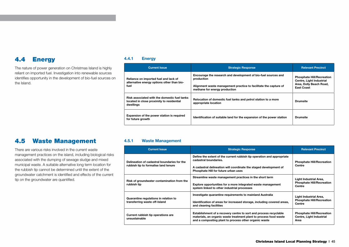
Christmas Island Local Planning Strategy I 45
4.4.1 Energy
Current Issue Strategic Response Relevant Precinct
Reliance on imported fuel and lack of alternative energy options other than bio-fuel
Encourage the research and development of bio-fuel sources and production
Alignment waste management practice to facilitate the capture of methane for energy production
Phosphate Hill/Recreation Centre, Light Industrial Area, Dolly Beach Road, East Coast
Risk associated with the domestic fuel tanks located in close proximity to residential dwellings
Relocation of domestic fuel tanks and petrol station to a more appropriate location
Drumsite
Expansion of the power station is required for future growth
Identification of suitable land for the expansion of the power station Drumsite
4.5.1 Waste Management
Current Issue Strategic Response Relevant Precinct
Delineation of cadastral boundaries for the rubbish tip to formalise land tenure
Define the extent of the current rubbish tip operation and appropriate cadastral boundaries.
A cadastral delineation will coordinate the staged development of Phosphate Hill for future urban uses
Phosphate Hill/Recreation Centre
Risk of groundwater contamination from the rubbish tip
Streamline waste management practices in the short term
Explore opportunities for a more integrated waste management system linked to other industrial processes
Light Industrial Area, Phosphate Hill/Recreation Centre
Quarantine regulations in relation to transferring waste off-Island
Investigate quarantine requirements to mainland Australia
Identification of areas for increased storage, including covered areas, and cleaning facilities
Light Industrial Area, Phosphate Hill/Recreation Centre
Current rubbish tip operations are unsustainable
Establishment of a recovery centre to sort and process recyclable materials, an organic waste treatment plant to process food waste and a composting plant to process other organic waste
Phosphate Hill/Recreation Centre, Light Industrial Area
4.4 EnergyThe nature of power generation on Christmas Island is highly reliant on imported fuel. Investigation into renewable sources identifies opportunity in the development of bio-fuel sources on the Island.
4.5 Waste ManagementThere are various risks involved in the current waste management practices on the island, including biological risks associated with the dumping of sewage sludge and mixed municipal waste. A suitable alternative long term location for the rubbish tip cannot be determined until the extent of the groundwater catchment is identified and effects of the current tip on the groundwater are quantified.

Christmas Island Local Planning Strategy I 46
4.6.1 Climate Change
Current Issue Strategic Response Relevant Precinct
Risks associated with sea level rise and storm surge effects on Kampong
Develop a long term residential transition plan (20-30 years) for Kampong towards safer existing and new urban areas
Kampong and Smith Point
Risks associated with increased wave undercutting of terrace cliffs
Minimise any new development geotechinically at risk on the ocean side of Gaze Road
Gaze Road, Settlement
Ensure all port facilities are operational and maintained in the context of potential for increased storm surges
Maintain and consolidate the Island’s principal goods and fuel port outlets
Upgrade Nui Nui port facilities to an operational standard to ensure alternative port facility remains available in extreme events
Kampong and Smith Point, Golf Course and Resort
Overtopping of cliffs in Settlement in high swells
Minimise any new development at risk of inundation on the ocean side of Gaze Road
Gaze Road, Settlement
The need for cyclone-rated buildings on the Island in the context of climate change forecasts for Category 4-5 cyclones in the region
Ensure that all new development meets requirements for Category 5 cyclones as per Building Code of Australia standards
Whole of Island
4.6 Climate ChangeThe Climate Change Risk Assessment for the Indian Ocean Territories (AECOM 2010) has identified that Christmas Island has experienced changes in climate over the past decades, and these trends are likely to continue. As a small island, Chrismas Island is vulnerable to the effects of climate change. In particular, coastal stability and storm swell issues at Kampong, Settlement (Gaze Road), Smith Point, Golf Course and Resort.
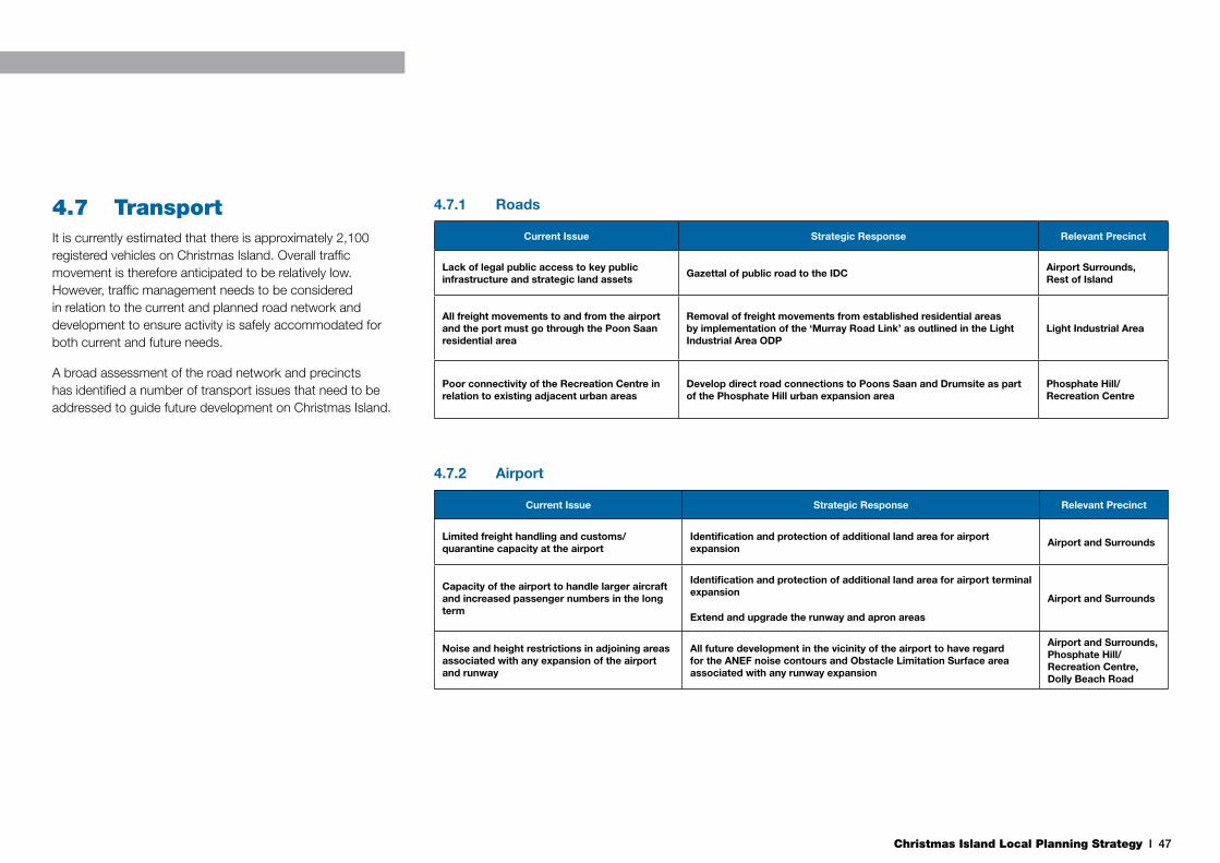
Christmas Island Local Planning Strategy I 47
4.7.1 Roads
Current Issue Strategic Response Relevant Precinct
Lack of legal public access to key public infrastructure and strategic land assets
Gazettal of public road to the IDCAirport Surrounds, Rest of Island
All freight movements to and from the airport and the port must go through the Poon Saan residential area
Removal of freight movements from established residential areas by implementation of the ‘Murray Road Link’ as outlined in the Light Industrial Area ODP
Light Industrial Area
Poor connectivity of the Recreation Centre in relation to existing adjacent urban areas
Develop direct road connections to Poons Saan and Drumsite as part of the Phosphate Hill urban expansion area
Phosphate Hill/Recreation Centre
4.7.2 Airport
Current Issue Strategic Response Relevant Precinct
Limited freight handling and customs/quarantine capacity at the airport
Identification and protection of additional land area for airport expansion
Airport and Surrounds
Capacity of the airport to handle larger aircraft and increased passenger numbers in the long term
Identification and protection of additional land area for airport terminal expansion
Extend and upgrade the runway and apron areas
Airport and Surrounds
Noise and height restrictions in adjoining areas associated with any expansion of the airport and runway
All future development in the vicinity of the airport to have regard for the ANEF noise contours and Obstacle Limitation Surface area associated with any runway expansion
Airport and Surrounds, Phosphate Hill/Recreation Centre, Dolly Beach Road
4.7 TransportIt is currently estimated that there is approximately 2,100 registered vehicles on Christmas Island. Overall traffic movement is therefore anticipated to be relatively low. However, traffic management needs to be considered in relation to the current and planned road network and development to ensure activity is safely accommodated for both current and future needs.
A broad assessment of the road network and precincts has identified a number of transport issues that need to be addressed to guide future development on Christmas Island.
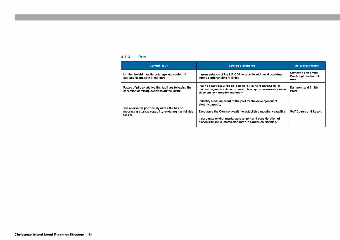
Christmas Island Local Planning Strategy I 48
4.7.3 Port
Current Issue Strategic Response Relevant Precinct
Limited freight handling/storage and customs/quarantine capacity at the port
Implementation of the LIA ODP to provide additional container storage and handling facilities
Kampong and Smith Point, Light Industrial Area
Future of phosphate loading facilities following the cessation of mining activities on the Island
Plan to adapt/convert port loading facility to requirements of post mining economic activities such as agro-businesses, cruise ships and construction materials
Kampong and Smith Point
The alternative port facility at Nui Nui has no mooring or storage capability rendering it unreliable for use
Indentify areas adjacent to the port for the development of storage capacity
Encourage the Commonwealth to establish a mooring capability
Incorporate environmental assessment and consideration of biosecurity and customs standards in expansion planning.
Golf Course and Resort

Christmas Island Local Planning Strategy I 49
4.8.1 Urban Expansion
Current Issue Strategic Response Relevant Precinct
Critical shortage of housing on the Island
Identification of suitable land for future residential areas
Encourage the development of a Crown land release plan to facilitate the development of identified new urban areas
Poon Saan and Silver City, Phosphate Hill/Recreation Centre
Potential fragmentation of communities across the Island
Identification of appropriate areas for urban development in close proximity to public amenities and existing settlements
Poon Saan and Silver City, Phosphate Hill/Recreation Centre, Drumsite
Identified urban expansion areas coincide with identified mineable phosphate deposits
Support any new mining application in the identified urban expansion areas subject to including provisions in the Mine Abandonment Plan that ensure the post mining landscape is suitable for urban development
Phosphate Hill/Recreation Centre
The cost of urban development on the Island (i.e. infrastructure and construction)
Consolidation of urban development within the infrastructure rich existing settlement area
Poon Saan and Silver City, Phosphate Hill/Recreation Centre, Drumsite, Settlement
Increased risk of rock fall in Kampong due to slope instability
Develop a long term residential transition plan (20-30 years) for Kampong towards safer existing and new residential areas
Poon Saan and Silver City, Phosphate Hill/Recreation Centre
4.8 Urban ExpansionThe the Accommodation Needs Assessment for Christmas Island and Cocos (Keeling) Islands (Department of Regional Australia, Regional Development and Local Government 2011) identifies supply and demand for accommodation in Christmas Island, and identifies a clear shortage of housing on the Island, and concerns for housing affordability.
Housing, accommodation and land supply on Christmas Island is a key community concern.

Christmas Island Local Planning Strategy I 50
4.9.1 Heritage
Current Issue Strategic Response Relevant Precinct
Local heritage recognition in addition to Commonwealth heritage recognition
The development and implementation of a Municipal Heritage Inventory for incorporation into the TPS
Whole of Island
Numerous places of heritage significance are found throughout the Island
Future development in close proximity to recognised places of heritage significance to be undertaken in consultation with relevant stakeholders prior to submission of planning application
Whole of Island
Cemeteries on the Island are currently managed by multiple authorities, restricting effective management practices
All cemeteries, both active and historical, should be under a single vesting order to SOCI to ensure a co-ordinated approach to their management, including funding and maintenance
Whole of Island
4.9 HeritageThe Shire of Christmas Island has a Heritage Advisory Committee to provide valuable input into specific development proposals that may affect heritage sites and buildings. The continued role of the Committee is to consider and make recommendations to the Shire for any development proposal within heritage areas.

Christmas Island Local Planning Strategy I 51
4.9.1 Community Facilities
Current Issue Strategic Response Relevant Precinct
Lack of active recreation facilities i.e. playing fields
Provision of additional playing fields adjacent to the cricket ovalPhosphate Hill/Recreation Centre
Current golf course limited to 9 holesInvestigate the development of additional golf course capability in the relevant precincts
Golf Course and Resort, Dolly Beach Road, Phosphate Hill/Recreation Centre
Future expansion of the three operational cemeteries
Expand Christian cemetery northwards to Gaze Road, expand Chinese and Muslim cemeteries eastwards along Golf Course Road
Settlement
Lack of suitable venue for the Christian Fellowship Association
Include the provision of place(s) of worship in urban expansion areas and relevant Structure Plans
Poon Saan and Silver City
Lack of aged care facilities on the Island Identification of a suitable location for aged-care facilitiesPoon Saan and Silver City, Phosphate Hill/Recreation Centre
Need for the establishment of a museum/interpretive centre on the Island
Support the establishment of a museum/interpretive centre at Tai Jin House
Kampong and Smith Point
Future expansion of the CIDHS, and possible collocation of education services on the Island
Include the provision of education facilities in urban expansion areasPhosphate Hill/Recreation Centre
Future expansion of the Christmas Island Hospital
Implementation of the hospital expansion as outlined in the Light Industrial Area ODP
Poon Saan and Silver City
4.10 Community FacilitiesExpansion and greater provision of community facilities is necessary to support the current and growing community of Christmas Island.
Existing recreational facilities at Phosphate Hill share a complex relationship with the secure Department of Immigration facilities. Planning for expansion of the facilities is working to reconcile these relationships with community needs for expanded sports fields, additional change room facilities as well as general upgrades to the public realm to encourage greater activity in the precinct.

Christmas Island Local Planning Strategy I 52
The Christmas Island Local Planning Strategy depicts the future land use directions for the Island as a whole. Its purpose is to guide the future development and long term sustainable growth of the Island. The proposed land uses have been identified as a response to the various land use, economic, social and environmental challenges facing the Island today. The LPS is intended to facilitate land use change, where necessary, across the Island to address these challenges.
Each of the identified precincts has different objectives, land use priorities and opportunities, requiring different approaches to future land uses. These precincts and their proposed future directions are further outlined below.
5. Christmas Island Local Planning Strategy
CONSOLIDATE IMMIGRATIONDETENTION CENTRE ATNORTH WEST POINT
GAZETTE MURRAY ROADAS PUBLIC ROAD
EXPLORE ECO-TOURISMOPPORTUNITIES WITHINNATIONAL PARK
RELOCATE PARKAUSTRALIA NURSERYTO CENTRAL AREAWORKSHOPS
ECO-TOURISMOPPORTUNITIES
POTENTIALENVIRONMENTALCORRIDORS
TECHNICAL CHARACTERISTICSREMAIN FOR SPACE PORT
Figure 12: Strategic Land Use Plan - Whole of Island
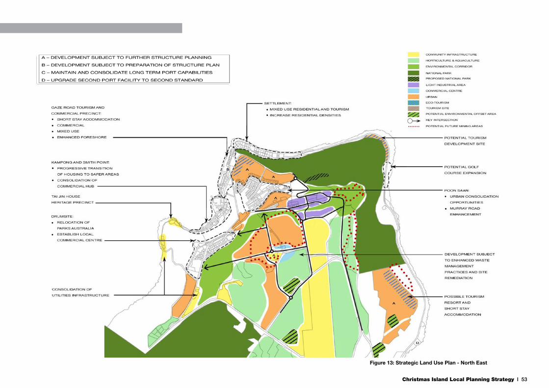
Christmas Island Local Planning Strategy I 53
Figure 13: Strategic Land Use Plan - North East

Christmas Island Local Planning Strategy I 54
5.1 Settlement
5.1.1 Objective
To maintain and consolidate the residential character of the area, as well as cater for small scale low impact tourism accommodation opportunities and the protection of historic cemetery sites.
5.1.2 Land Use Priorities
Although most of the Settlement precinct is already committed to residential land uses, there are opportunities to create a mix of residential and tourism accommodation within this precinct. The land is flat, has extensive ocean views, has service infrastructure in place, existing lots are large and is in close proximity to the Gaze Road Tourism and Commercial Precinct. These attributes confirm the strategic nature of this precinct for tourism and residential land uses.
5.1.3 Key Opportunities & Initiatives
Tourism Opportunities
Some of the larger lots within this precinct, such as Rumah Tinggi and the Mine Manager’s House, have the potential to be further developed into ‘boutique’ tourism and a range of accommodation venues to take advantage of ocean views and proximity to the main tourism precinct on the Island. This approach is encouraged within this precinct on suitably sized sites.
Residential Opportunities
There are existing plans for some of the larger residential lots to be subdivided within this precinct. These lots have a higher density (R20) than the general density of R10. Given the attributes of the precinct, the density of residential development should be increased. A modest increase would enhance the residential capacity and take advantage of existing services and amenities, whilst still maintaining the precinct’s residential character and feel.
Cemetary Planning Opportunities
Expansion of the three operational cemeteries is required to cater for future needs. This expansion is proposed to occur adjacent to the existing cemeteries along Golf Course Road and include dedicated off-street parking areas. It has been identified by the community that the Christian cemetery, adjacent to the Mango Tree Lodge, would expand northwards to Gaze Road and the Chinese and Muslim cemeteries would expand eastwards along Golf Course Road.
Lot 3029, known locally as the ‘Chicken Farm’, on Gaze Road is located between the Christian, Muslim, and Chinese cemetaries. The site’s location makes it appropriate for community uses complementary to the surrounding cemetaries. Future use and development should consider opportunities for greater integration of the site with the cemetaries.
5.1.4 Priority Actions
• Increase residential densities within the Settlement precinct.
• Implement the Cemetaries Management Plan.
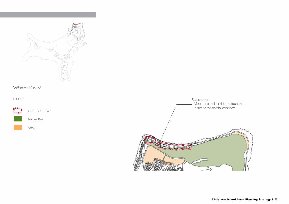
Christmas Island Local Planning Strategy I 55
LEGEND:
Settlement Precinct
National Park
Urban
Settlement:- Mixed use residential and tourism- Increase residential densitiesSettlement:- Mixed use residential and tourism- Increase residential densitiesSettlement:- Mixed use residential and tourism- Increase residential densities
Settlement:- Mixed use residential and tourism- Increase residential densities
Settlement Precinct

Christmas Island Local Planning Strategy I 56
5.2 Gaze Road Tourism and Commercial Precinct
5.2.1 Objective
To facilitate the introduction of new commercial, tourism and accommodation options, open space enhancements and the preservation of heritage values to provide a functional, attractive and desirable destination for the community and tourists.
5.2.2 Land Use Priorities
The Gaze Road Tourism and Commercial Precinct already functions as a key destination for tourists with the presence of tourism accommodation as well as cafes, a tavern, dive shop and other retail activity. To cater for an increased population and the desired increases in tourist numbers, the precinct needs to develop tourism facilities, short stay accommodation, commercial activity and landscaping/open space enhancements. There are numerous sites within this precinct that can be utilised for this purpose. The introduction of mixed use developments into the precinct will increase development opportunities and contribute to enhancing the appeal and vitality of the precinct.
Due to wave undercutting potential and inundation from large storm surge and swell events, further development should be restricted to the eastern side of Gaze Road. The western side should be utilised further as public open space.
5.2.3 Key Opportunities & Initiatives
Fuel Tank Relocation and Buffer Opportunities
The above ground fuel tanks opposite Temple Court are being relocated to a more appropriate location in the Drumsite precinct. Future use of these sites will require contamination
assessment and potential remediation.
Tourism and Heritage Development Opportunities
Existing facilities within Gaze Road, along with its access to the ocean, make the precinct an appropriate site to encourage a dive resort, for which there is already demand on the Island.
The Cocos Padang is considered a key development site within this precinct. The site is a heritage site with a large area of cleared land on Gaze Road, and can achieve ocean access through a constructed boardwalk. Any development would need to enhance the heritage values of the existing buildings, and this could be done through a number of initiatives, such as refurbishing and utilising the current buildings for small shop areas to take advantage of the proximity to other tourism accommodation and the existing retail areas.
Tourism accommodation could be located on either side of the building at the base of the slope to take advantage of ocean views and provide a unique setting that recognises the historic character of the site. This would enhance and expand the current tourism and commercial precinct and provide a greater range attractions and facilities to visitors.
There are two other areas of underutilised land within this precinct. One is on the ocean side of the existing row of shops north of the police station. The development of low key, bed and breakfast type short stay accommodation here is encouraged. The second is the strip of land between the supermarket and the incline on the eastern side of Gaze Road. This area should be developed for a mix of uses that include tourism accommodation, residential and commercial. This site has ocean views and direct access to Gaze Road.
Public Open Space Opportunities
The western side of Gaze Road, from the Chinese Literary Association building to the police station, should be maintained as public open space. Arts and Culture Christmas Island
(Inc) has recently facilitated new public art here and has plans for additional public art, shade and seating areas and barbeque facilities to create a community space in the Police Padang area. These enhancements are encouraged should be expanded south along the foreshore to create the Island’s premier public parkland following fuel tank removal.
Arts and Culture Christmas Island (Inc) have a proposal to rename the whole strip of open space to the ‘Tea Gardens’, a name which has historical significance for the area. Together with the injection of new tourism and commercial developments, the enhancement of this open space area will provide a Island wide recreation focal point for visitors and the local community.
Key objectives for foreshore open space in Christmas Island include:
• Activate open space to facilitate and encourage a range of passive and active recreational uses.
• Respect and take advantage of natural and unique landscape features, natural elements, and views.
• Protect and conserve habitat and movement of native fauna.
• Reflect and conserve historical significance of the area.
5.2.4 Priority Actions
• Encourage development of a dive resort within Gaze Road precinct.
• Relocate fuel tanks and service station.
• Enhance public open space.
Gaze Road Tourism and Commercial Precinct
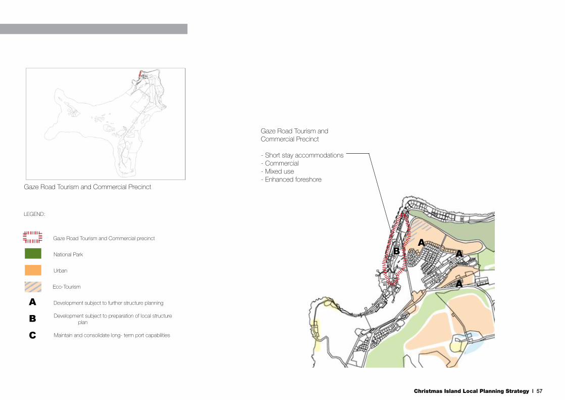
Christmas Island Local Planning Strategy I 57
Gaze Road Tourism and Commercial Precinct
LEGEND:
Gaze Road Tourism and Commercial precinct
National Park
Urban
Eco-Tourism
Development subject to further structure planning
Development subject to preparation of local structure plan
Maintain and consolidate long- term port capabilities
Settlement:- Mixed use residential and tourism- Increase residential densitiesSettlement:- Mixed use residential and tourism- Increase residential densitiesSettlement:- Mixed use residential and tourism- Increase residential densities
A
Gaze Road Tourism and Commercial Precinct
- Short stay accommodations- Commercial- Mixed use- Enhanced foreshore
C
B
AB A
A

Christmas Island Local Planning Strategy I 58
5.3 Kampong & Smith Point Precinct
5.3.1 Objective
To maintain and consolidate the Island’s principal goods and fuel port outlets, protect historic features, enhance the Flying Fish Cove foreshore settings and further develop existing commercial functions.
5.3.2 Land Use Priorities
Kampong is primarily a residential area and, therefore, most of the land is already committed as residential dwellings and are not likely to change. This area is also subject to climate change impacts and rock fall risk. The main climate change impacts that should be considered will occur from storm surges and shoreline erosion.
The small commercial district opposite the port serves an important function as an administrative centre for the Island. The post office, the bank, courthouse and DRA offices are all located within this precinct. The further development of these key functions should be encouraged. Traffic management issues may arise in this area with increased development, with potential conflicts between normal vehicle movements and port traffic movements (trucks, sea container movements).
Aside from Tai Jin House and its immediate surrounds, the main land use at Smith Point continues to be key infrastructure assets such as the WWTP and fuel storage. These uses will remain in this area, with additional land identified for expansion of the WWTP if required.
5.3.3 Key Opportunities & Initiatives
Climate Change Responses
Any new development in the Kampong area is not supported and the progressive transition of accommodation to safer new urban areas such as Phosphate Hill should be considered over the next 20-30 years. This may need to occur earlier depending on the condition of existing buildings.
The future of the phosphate loading facilities following the cessation of mining activities on the Island remains uncertain. As the Island’s principal inlet and outlet for goods, the port facilities need to be maintained and consolidated to cope with the possible effects of climate change. There is an opportunity to adapt or convert these facilities to the requirements of post-mining economic activities such as agro-businesses, cruise ships and construction materials.
Heritage Opportunities
The Christmas Island Club (CI Club) is a heritage listed building that is currently in a dilapidated condition. A recent structural integrity report completed on the CI Club revealed that there are slope instabilities, major termite damage, cracking around the building, and that the retaining wall is no longer providing support and the lower edge of the building has been undermined (GHD 2009). The report concludes that a two stage repair including the stabilisation of the slope followed by the repair and rejuvenation of the building would be feasible.
The CI Club and the surrounding environment including shrines and the Old European Cemetery (which contained the unknown sailor from HMAS Sydney) is a major part of the Island’s history. The CI Club and surrounds could be developed as a historical precinct for visitors with the promotion of links directly through to Flying Fish Cove, Tai Jin House and the walking trail through to Territory Day Park. Additional walking trails could be established to link with the National Park and Margaret Beach. The precinct could provide
1-2 days of historical exploring all based around the CI Club and Flying Fish Cove as the major asset and entry point for visitors.
The Island currently lacks a dedicated museum or interpretive centre to highlight the Island’s diverse and interesting history and heritage. Tai Jin House, as the former Governor’s residence, is currently underutilised and should be a central attraction in tourists with an interest in the Island’s history. Tai Jin House would provide an ideal setting for a museum, together with the surrounding grounds, nearby naval gun and barracks and views of Kampong and Settlement.
5.3.4 Priority Actions
• Climate change proofing and transitional arrangements.
• Restore and develop heritage sites for community use.
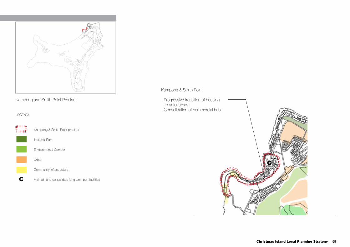
Christmas Island Local Planning Strategy I 59
LEGEND:
Kampong & Smith Point precinct
National Park
Environmental Corridor
Urban
Community Infrastructure
Maintain and consolidate long term port facilities
Settlement:- Mixed use residential and tourism- Increase residential densitiesSettlement:- Mixed use residential and tourism- Increase residential densities
Settlement:- Mixed use residential and tourism- Increase residential densities
Kampong & Smith Point
- Progressive transition of housing to safer areas- Consolidation of commercial hub
C
Settlement:- Mixed use residential and tourism- Increase residential densities
Settlement:- Mixed use residential and tourism- Increase residential densities
Kampong and Smith Point Precinct
C

Christmas Island Local Planning Strategy I 60
5.4 Poon Saan & Silver City
5.4.1 Objective
To maintain the precinct as the main residential area on the Island through the consolidation of existing developed areas and the identification of appropriate new urban expansion areas.
5.4.2 Land Use Priorities
This precinct has been developed previously with a mixture of high density apartments, concentrated in Poon Saan, and low density single residential lots in Silver City. These two housing types reflect the two different cultures that predominate in the two suburbs. This area will remain as the central residential area on the Island in the short to medium term, with accompanying commercial uses on Lower Poon Saan Road.
There are few development opportunities within the precinct for new urban development, and these should be developed primarily for residential uses, with ancillary aged care, short stay, tourism and commercial activities. Mixed use developments should be encouraged to make more efficient use of land as well as attract additional small businesses. These areas provide short term opportunities to increase the housing stock on the Island and encourage local private investment.
5.4.3 Key Opportunities & Initiatives
Urban Expansion Opportunities
The northern side of Arenga Close represents one of the future urban areas within the precinct that should be utilised for additional residential land uses. This land in the bend of Murray Road is relatively flat compared to other possible development sites and could potentially have views northwards to the ocean. Given the existing road network and service provision,
the area could be developed in stages to meet housing needs on the Island as they evolve.
In order to ensure the orderly future development of the area, further detailed structure planning will be required to identify the appropriate land uses and spatial layout. The structure plan will also need to investigate and address any environmental impacts, including vegetation clearing. A vegetation buffer should be maintained along Murray Road to screen any new development.
This precinct also includes Taman Sweetland, which consists broadly of the area between Murray Road and the LIA. There is a large area of Unallocated Crown Land between Plant Hill Road and Murray Road that should be developed for residential and commercial uses.
Tourism Opportunities
Further west of the Arenga Close site is a second site that is suitable for development for residential and tourism uses. This site is at the bottom of Seaview Drive and has elevated views of the ocean and lower terrace. The site is ideal for a tourism development to take advantage of these views, nestled within the jungle vegetation. There may also be an opportunity for a pedestrian link down to a redeveloped Cocos Padang site and the Gaze Road Tourism and Commercial Precinct to encourage the direct movement of visitors and residents from Silver City down to the main tourism and commercial precinct. The site is quite steep and has areas of Priority 2 vegetation, so detailed site planning would be required to mitigate these constraints.
Pedestrian Safety Opportunities
SOCI is concerned with pedestrian safety along Murray Road in Poon Saan and is seeking to remove unsightly vehicular shelters immediately north of the Murray Road/Phosphate Hill Road intersection. The purpose is to achieve greater pedestrian safety along Murray Road, relocate residential car
parking to a more suitable location and improve pedestrian connectivity towards Drumsite. The Council has initiated plans for the road realignment and are currently consulting the community.
Health and Aged Care Opportunities
The hospital is located in the south eastern corner of the precinct, and its expansion northwards over the bus depot (and the relocation of the bus depot to the LIA) has been identified in the LIA ODP. There is an opportunity for complimentary land uses to locate adjacent to the hospital, on the western edge, to take advantage of possible synergies. Aged care or independent living units would benefit in being in close proximity to the hospital.
The landform is quite steep and the Commonwealth will support the preparation of a detailed Structure Plan or similar for this land before it can be developed further to address the site constraints.
5.4.4 Priority Actions
• Detailed structure planning for urban development and hospiral expansion.
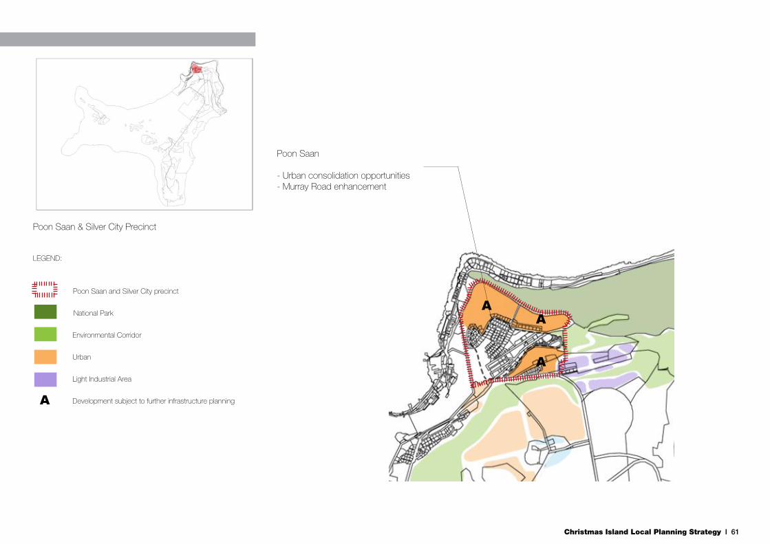
Christmas Island Local Planning Strategy I 61
LEGEND:
Poon Saan and Silver City precinct
National Park
Environmental Corridor
Urban
Light Industrial Area
Development subject to further infrastructure planning
Settlement:- Mixed use residential and tourism- Increase residential densitiesSettlement:- Mixed use residential and tourism- Increase residential densities
Settlement:- Mixed use residential and tourism- Increase residential densities
A
Settlement:- Mixed use residential and tourism- Increase residential densities
Settlement:- Mixed use residential and tourism- Increase residential densities
Poon Saan
- Urban consolidation opportunities- Murray Road enhancement
Poon Saan & Silver City Precinct
AA
A

Christmas Island Local Planning Strategy I 62
5.5 Drumsite
5.5.1 Objective
To maintain and consolidate residential functions and capture redevelopment opportunities to provide a mix of complimentary land uses for the precinct.
5.5.2 Land Use Priorities
Given the topographic constraints and limited developable land in Drumsite, it is not envisaged that the precinct will change dramatically over the long term. The long term focus will remain residential; however there is scope for tourism accommodation at the Old Dryers site, expansion of the small commercial area on Tong Yan Loh as well as the school and power station. These opportunities will require site assessment, including contamination, heritage and access.
Enhancements of significant public open spaces areas are also encouraged, including Territory Day Park and areas adjacent to Murray Road.
The consolidation of the existing horticultural area is encouraged, as a precursor to larger scale horticultural activities on the Island.
5.5.3 Key Opportunities & Initiatives
Urban Expansion Opportunities
The CLMP has identified that Parks Australia are supportive of moving their offices and nursery from Drumsite to the Central Area Workshops. If these functions are relocated, then a significant portion of land would become available for development. This area has elevated views across the ocean, has direct access to Murray Road and is adjacent to Territory Day Park. One major constraint to any new development is the above ground conveyor that runs through the site.
A vacant site in Drumsite that is developable in the short term is on the corner of Tong Yan Loh and Sung Maw Loh. It is an 8,580m2 site that is cleared, flat, has views over the ocean and has existing service infrastructure available from previous development. The site is Crown land and DRA is currently delivering up to 30 dwellings on the site. An initial 16 dwellings are due for practical completion by the end of 2012.
Educational Opportunities
Any expansion of the school in its current location needs to be considered in the context of the proximity of the fuel pipelines that feed the power station. Whilst there is some room to expand, this would bring the school closer to the pipeline which is not a desirable outcome in terms of risk and safety. School functions should be consolidated within the current footprint in the short term, and consideration given to relocation in the medium to long term to Phosphate Hill (see Section 5.7).
Power and Fuel Infrastructure Opportunities
Future expansion of the power station will occur southwards, towards the intersection of Murray Road with Irvine Hill Road. This expansion will cater for future increases in capacity of the power station, as well the relocation of the domestic fuel tanks from Gaze Road in Settlement. Expansion of the power station should consider surrounding land uses and ensure appropriate buffers, consistent with the requirements of SPP4.1 (State Industrial Buffer Policy), guided by generic buffers set out in the Environmental Protection Authority’s Guidance Statement No. 3; Seperation Distances between Industrial and Sensitive Land Uses.
The relocation of the fuel tanks will also include the relocation of the fuel station from Gaze Road to Drumsite. The fuel station needs to be accessible to the whole community and Drumsite is a more accessible location to a larger number of residents. A location near the intersection of Murray Road and Sung Maw Loh is considered the most suitable for a future
fuel station. The location of the future fuel tanks and station should consider surrounding land uses and ensure appropriate buffers, consistent with the requirements of SPP4.1 (State Industrial Buffer Policy), guided by generic buffers set out in the Environmental Protection Authority’s Guidance Statement No. 3; Seperation Distances between Industrial and Sensitive Land Uses.
Horticultural Opportunities
The uptake of the current horticultural area on Murray Road has been limited to date with only one enterprise in operation. The continued use of this area for local food production should be encouraged with produce sold to local supermarket operators. The area could be utilised for small trials to establish the viability of large scale agricultural and aquacultural production on the Island. Given its close proximity to the WWTP, as well as existing pipe infrastructure, consideration should be given to wastewater re-use for agricultural purposes in this area.
Specific planning proposals for intensive horticulture and aquaculture should consider surrounding land uses and ensure appropriate buffers, consistent with the requirements of SPP4.1 (State Industrial Buffer Policy), guided by generic buffers set out in the Environmental Protection Authority’s Guidance Statement No. 3; Seperation Distances between Industrial and Sensitive Land Uses.
5.5.4 Priority Actions
• Expansion of power station, school, and commercial area.
• Enhance pubic open space.
• Horticultural trials and expansion.
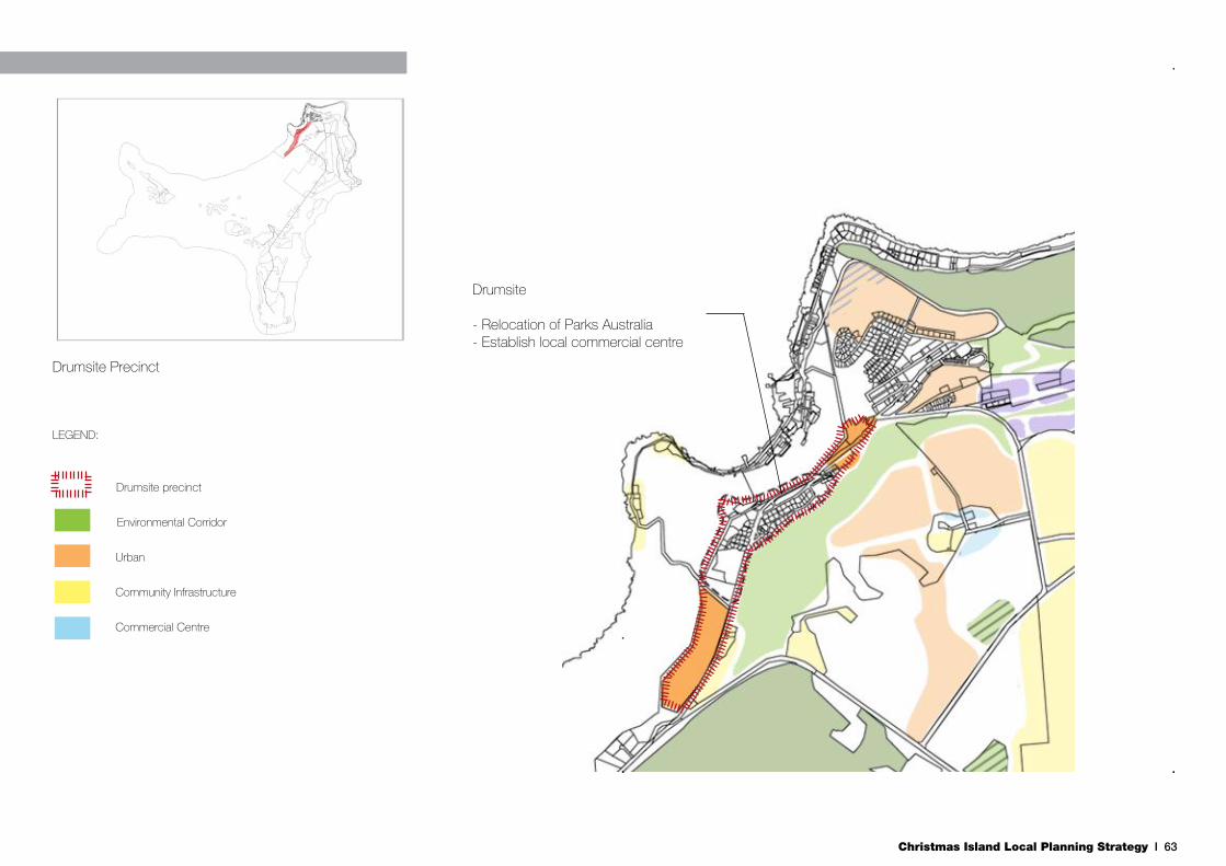
Christmas Island Local Planning Strategy I 63
Drumsite Precinct
LEGEND:
Drumsite precinct
Environmental Corridor
Urban
Community Infrastructure
Commercial Centre
Settlement:- Mixed use residential and tourism- Increase residential densitiesSettlement:- Mixed use residential and tourism- Increase residential densities
Settlement:- Mixed use residential and tourism- Increase residential densitiesSettlement:- Mixed use residential and tourism- Increase residential densities
Settlement:- Mixed use residential and tourism- Increase residential densities
Drumsite
- Relocation of Parks Australia- Establish local commercial centre
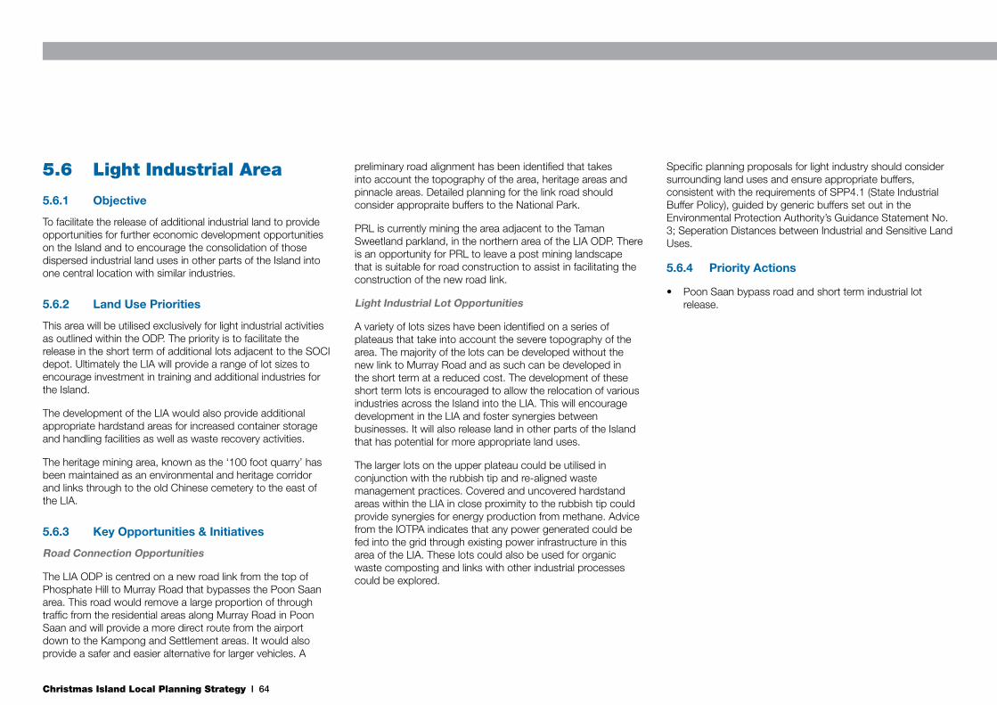
Christmas Island Local Planning Strategy I 64
5.6 Light Industrial Area
5.6.1 Objective
To facilitate the release of additional industrial land to provide opportunities for further economic development opportunities on the Island and to encourage the consolidation of those dispersed industrial land uses in other parts of the Island into one central location with similar industries.
5.6.2 Land Use Priorities
This area will be utilised exclusively for light industrial activities as outlined within the ODP. The priority is to facilitate the release in the short term of additional lots adjacent to the SOCI depot. Ultimately the LIA will provide a range of lot sizes to encourage investment in training and additional industries for the Island.
The development of the LIA would also provide additional appropriate hardstand areas for increased container storage and handling facilities as well as waste recovery activities.
The heritage mining area, known as the ‘100 foot quarry’ has been maintained as an environmental and heritage corridor and links through to the old Chinese cemetery to the east of the LIA.
5.6.3 Key Opportunities & Initiatives
Road Connection Opportunities
The LIA ODP is centred on a new road link from the top of Phosphate Hill to Murray Road that bypasses the Poon Saan area. This road would remove a large proportion of through traffic from the residential areas along Murray Road in Poon Saan and will provide a more direct route from the airport down to the Kampong and Settlement areas. It would also provide a safer and easier alternative for larger vehicles. A
preliminary road alignment has been identified that takes into account the topography of the area, heritage areas and pinnacle areas. Detailed planning for the link road should consider appropraite buffers to the National Park.
PRL is currently mining the area adjacent to the Taman Sweetland parkland, in the northern area of the LIA ODP. There is an opportunity for PRL to leave a post mining landscape that is suitable for road construction to assist in facilitating the construction of the new road link.
Light Industrial Lot Opportunities
A variety of lots sizes have been identified on a series of plateaus that take into account the severe topography of the area. The majority of the lots can be developed without the new link to Murray Road and as such can be developed in the short term at a reduced cost. The development of these short term lots is encouraged to allow the relocation of various industries across the Island into the LIA. This will encourage development in the LIA and foster synergies between businesses. It will also release land in other parts of the Island that has potential for more appropriate land uses.
The larger lots on the upper plateau could be utilised in conjunction with the rubbish tip and re-aligned waste management practices. Covered and uncovered hardstand areas within the LIA in close proximity to the rubbish tip could provide synergies for energy production from methane. Advice from the IOTPA indicates that any power generated could be fed into the grid through existing power infrastructure in this area of the LIA. These lots could also be used for organic waste composting and links with other industrial processes could be explored.
Specific planning proposals for light industry should consider surrounding land uses and ensure appropriate buffers, consistent with the requirements of SPP4.1 (State Industrial Buffer Policy), guided by generic buffers set out in the Environmental Protection Authority’s Guidance Statement No. 3; Seperation Distances between Industrial and Sensitive Land Uses.
5.6.4 Priority Actions
• Poon Saan bypass road and short term industrial lot release.

Christmas Island Local Planning Strategy I 65
Settlement:- Mixed use residential and tourism- Increase residential densities
Settlement:- Mixed use residential and tourism- Increase residential densities
Settlement:- Mixed use residential and tourism- Increase residential densitiesSettlement:- Mixed use residential and tourism- Increase residential densities
Settlement:- Mixed use residential and tourism- Increase residential densities
Light Industrial Area
- New road linkages- Relocation of industries into LIALight Industrial Area Precinct
Settlement:- Mixed use residential and tourism- Increase residential densities
Commercial Centre
Community Infrastructure
Urban
Environmental Corridor
Light Industrial
Light Industrial Area Boundary
Potential Future Mining Areas

Christmas Island Local Planning Strategy I 66
5.7 Phosphate Hill/Recreation Centre Precinct
5.7.1 Objective
To provide for the long term expansion of the urban area of Christmas Island on Phosphate Hill, facilitate the creation of a ‘Sports and Recreation Precinct’ and consolidate waste management practices.
5.7.2 Land Use Priorities
Phosphate Hill is the most appropriate area to provide long term expansion of the urban area on Christmas Island. The topography is not as severe as other areas, it is close to the existing urban areas on the Island, has existing services in close proximity and has significant community facilities already in place.
The large scale development of land for urban uses in the precinct will be subject to a series of constraints, such as:
• The future of the rubbish tip;
• The future of the immigration detention centre;
• The potential mining of phosphate resources;
• Buffers associated with the communications towers; and
• The Obstacle Limitation Surface restrictions.
5.7.3 Key Opportunities & Initiatives
Staged Mining and Development Opportunities
Urban development areas coincide with identified phosphate deposits. These deposits have been subject to two mining lease applications by CIP, both rejected. Future urban development in this precinct should not sterilise economically
viable phosphate deposits, and mining should occur prior to development. Any future mining lease application should be supported in this area, subject to including provisions in the Mine Abandonment Plan that ensure the post mining landscape is suitable for urban development.
Urban Expansion Opportunities
Phosphate Hill provides significant area of developable land to cater for the long term growth of the Island. Future development will be subject to detailed Structure planning. Planning should consider the following key concepts for the precinct:
• Connectivity – road connections to Poon Saan and Drumsite.
• Education – additional educational facilities should be considered as well as the long term location of the CIDHS.
• Recreation facilities – additional playing fields adjacent to the cricket oval to cater for other sports and investigation of the provision of an 18 hole golf course in areas unsuitable for urban development (i.e. buffer areas).
• Accommodation – provision of a range of accommodation types, include aged care and short stay.
• Environment - provision of environmental buffers and crab migration corridors across the site.
• Rural land uses - horticultural and aquacultural activities, especially within buffer areas.
• Constraints – consideration to the radio tower buffers, rubbish tip buffer, ANEF noise contours, Obstacle Limitation Surface area of an extended runway, and the relocation of the immigration detention centre.
Waste Management Initiatives
It is not proposed to relocate the rubbish tip in the short term. An alternative location should not be identified until the extent of the groundwater aquifer is accurately defined. The long term consolidation of the tip in the southern portion of its current location is currently being investigated as part of a detailed Waste Management Strategy for SOCI.
Initial findings of the study indicate that the current practice of dumping treated sludge from the WWTP at the rubbish tip is highly undesirable and an alternative disposal method should be implemented as soon as possible. Other preliminary recommendations include:
• Establishment of a recovery centre for recyclables;
• Organic waste treatment plant for food waste; and
• A composting plant for other organic waste.
Waste minimisation incentives and strategies should be explored to support capital works on the site. With maximum recycling, treatment and processing of waste, the size of the tip can be substantially reduced and the site remediated over time. The processes outlined above could be achieved on dedicated hardstand areas, and could have synergies with industrial processes in the LIA.
The rubbish tip current does not have any cadastral boundaries and so land tenure cannot be formalised between the Commonwealth and SOCI. A cadastral boundary should be defined to allow this formalisation to occur. This definition would also allow the coordinated staged development of Phosphate Hill for future urban uses.
5.7.4 Priority Actions
• Define extent of groundwater aquifer on Christmas Island and manage treated sludge from Waste Water Treatment Plant.
• Detailed structure planning for urban development.

Christmas Island Local Planning Strategy I 67
Phosphate Hill / Recreation Area PrecinctSettlement:- Mixed use residential and tourism- Increase residential densitiesSettlement:- Mixed use residential and tourism- Increase residential densities
Settlement:- Mixed use residential and tourism- Increase residential densitiesSettlement:- Mixed use residential and tourism- Increase residential densities
Settlement:- Mixed use residential and tourism- Increase residential densities
Settlement:- Mixed use residential and tourism- Increase residential densities
Potential Environmental Offset Area
Commercial Centre
Urban
Community Infrastructure
Horticulture / Aquaculture
Environmental Corridor
Phosphate Hill/Recreation Area Boundary
LEGEND:
Potential Future Mining Areas
Phosphate Hill / Recreation Centre
- Development subject to enhanced waste management practices and site remediation

Christmas Island Local Planning Strategy I 68
5.8 Airport Surrounds
5.8.1 Objective
To cater for the potential expansion of the airport and runway and preserve areas of high environmental quality and significance.
5.8.2 Land Use Priorities
The airport represents an extremely important piece of infrastructure on the Island, and its future is of critical importance to the future of the Island. The priority for this precinct is to identify and protect areas for the future expansion of the runway and terminal facilities.
This precinct also includes areas of significant environmental value that need protecting from future development.
5.8.3 Key Opportunities & Initiatives
Airport Expansion Options
Any future expansion of the runway will also require an expansion of passenger, baggage and freight handling facilities to accommodate larger planes and increased traffic. Expansion northwards from the current terminal building along the western boundary of the current airport site is best suited to accommodate this expansion if required. The area is relatively flat, is outside of the Phosphate Hill radio tower buffer areas and a direct access to Phosphate Hill Road can be achieved for freight movements.
Urban Expansion Opportunities
The remainder of the triangle of land between the airport, Irvine Hill Road and Phosphate Hill Road has been identified for long term urban development. It is envisaged that this area can be developed after Phosphate Hill if required, however could be
developed earlier for discrete urban uses if required. There is a small separate lot within this land area that is Priority 1 vegetation and as such needs to be retained for conservation purposes. All future development should have regard to the ANEF noise contours and Obstacle Limitation Surface area associated with any future runway expansion.
Environmental Protection and Compensation Opportunities
The remaining area of this precinct, west of North South Baseline Road contains Priority 1 and 2 vegetation together with recorded bird nesting sites and increased human disturbances in this area is not desirable. This area has been identified as a potential protection area to compensate for new urban development. The intention is to preserve areas of high environmental quality to compensate for the loss of areas of lower environmental quality within the urban areas. This particular area is over 430 ha and its preservation will ensure the continued protection of the environmental values on the Island and enhance the environmental corridor through to the east coast of the Island.
The area may not meet the requirements of an environmental offset for the purposes of approvals under the EPBC Act. Particular proposals will need to considered against the requirements of the EPBC Act, considering the appropriateness of the proposal, onsite mitigation, and any specific environmental offsets required in accordance with the Commonwealth’s offset policy and requirements.
5.8.4 Priority Actions
• Identify and protect areas for future airport expansion.
• Consider environmental compensation bank.
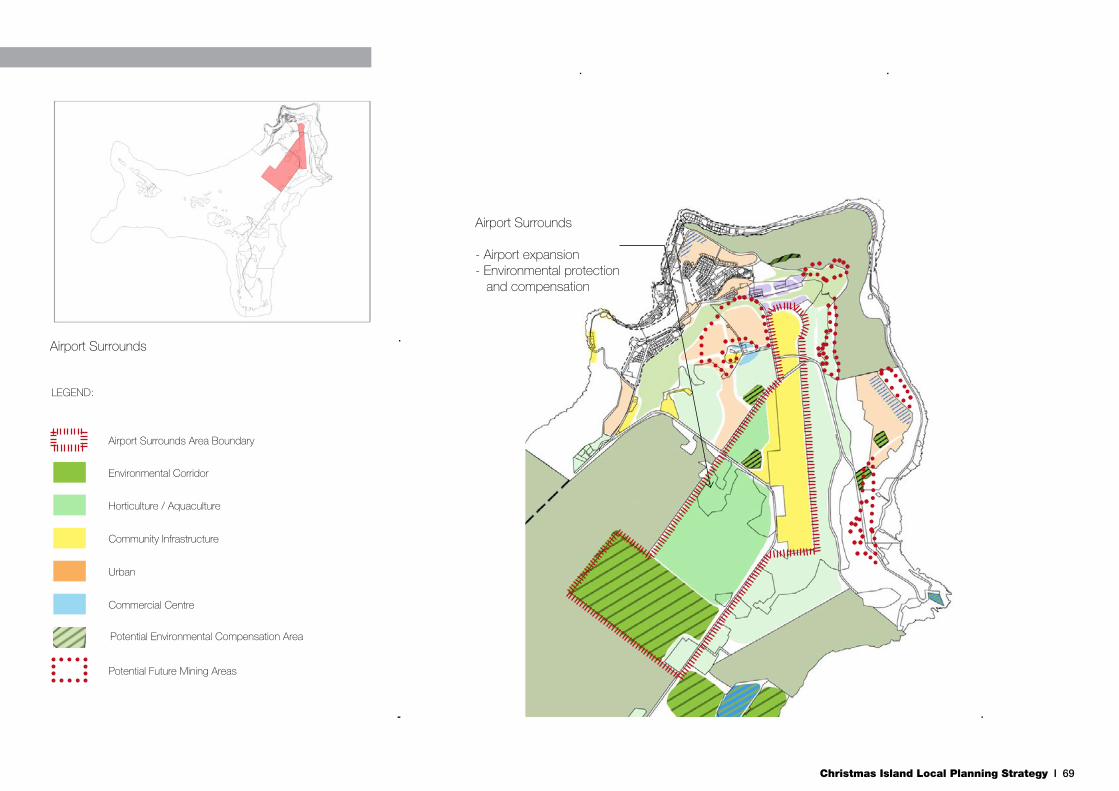
Christmas Island Local Planning Strategy I 69
Airport Surrounds
- Airport expansion- Environmental protection and compensation
Settlement:- Mixed use residential and tourism- Increase residential densitiesSettlement:- Mixed use residential and tourism- Increase residential densities
Settlement:- Mixed use residential and tourism- Increase residential densitiesSettlement:- Mixed use residential and tourism- Increase residential densities
Settlement:- Mixed use residential and tourism- Increase residential densities
Settlement:- Mixed use residential and tourism- Increase residential densities
Potential Environmental Compensation Area
Commercial Centre
Urban
Community Infrastructure
Horticulture / Aquaculture
Environmental Corridor
Airport Surrounds Area Boundary
LEGEND:
Potential Future Mining Areas
Airport Surrounds

Christmas Island Local Planning Strategy I 70
5.9 Golf Course & Resort Precinct
5.9.1 Objective
To promote the golf course and Resort as strategic tourist destinations and encourage further tourism developments where possible to take advantage of uninterrupted ocean views.
5.9.2 Land Use Priorities
This precinct covers the narrow shore terrace along a portion of the eastern coast of the Island with steep cliffs on the western side of Golf Course Road. Key tourism assets in the precinct include the golf course and Christmas Island Resort. Further tourism opportunities should be explored where possible to take advantage of ocean views and proximity to the ‘Grotto’ swimming hole, golf course and resort.
5.9.3 Key Opportunities & Initiatives
Tourism Opportunities
The current golf course is 9 holes and has panoramic views over the ocean. The provision of a full 18 hole golf course is a desirable attribute for the Island in attracting tourists to the Island. Consideration should be given to investigating the feasibility of expanding the existing golf course along the coast.
At the northern end of the precinct is a privately owned lot at the base of the cliff that is relatively flat and is suitable for future development. Development of eco-friendly tourism accommodation on the site, should be encouraged, which would consist of lightweight structures on stilts that are completely self-contained and self sufficient. It is currently
zoned for residential land use, which is not a desirable use given the natural attributes of the site and distance to the main Settlement area. This area is a major migration area for red crabs, which provides an opportunity for eco-tourism development, which, in turn, must also consider and design for appropriate management.
Port Upgrade Opportunities
This precinct includes the Nui Nui port facility, which was constructed as an alternative port facility to Flying Fish Cove in adverse weather conditions. Despite this, the facilities at Nui Nui are seldom used due to a lack of mooring facilities and limited container storage area. The Nui Nui port facilities should be upgraded to an operational standard, and additional container storage areas developed, to ensure that it can function as a true alternative port facility that is available during extreme events.
5.9.4 Priority Actions
• Expand golf course and encourage eco-tourism.
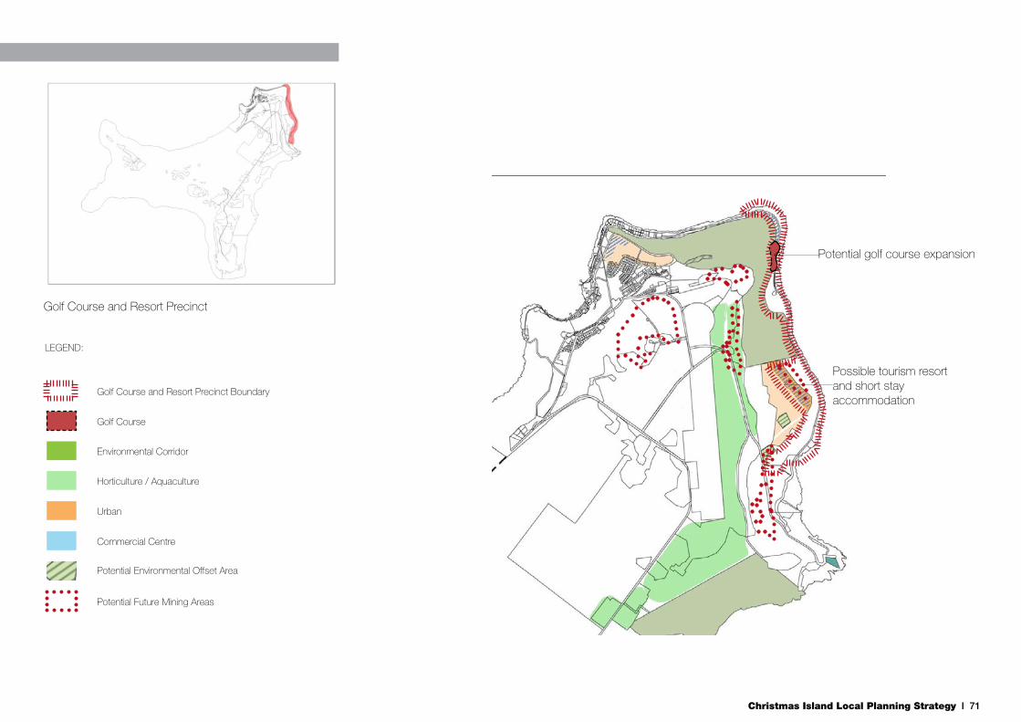
Christmas Island Local Planning Strategy I 71
Potential golf course expansion
Possible tourism resortand short stay accommodation
Settlement:- Mixed use residential and tourism- Increase residential densities
Settlement:- Mixed use residential and tourism- Increase residential densities
Settlement:- Mixed use residential and tourism- Increase residential densities
Settlement:- Mixed use residential and tourism- Increase residential densities
Settlement:- Mixed use residential and tourism- Increase residential densities
Potential Environmental Offset Area
Commercial Centre
Urban
Horticulture / Aquaculture
Environmental Corridor
Golf Course and Resort Precinct Boundary
LEGEND:
Potential Future Mining Areas
Settlement:- Mixed use residential and tourism- Increase residential densities
Golf Course
Golf Course and Resort Precinct
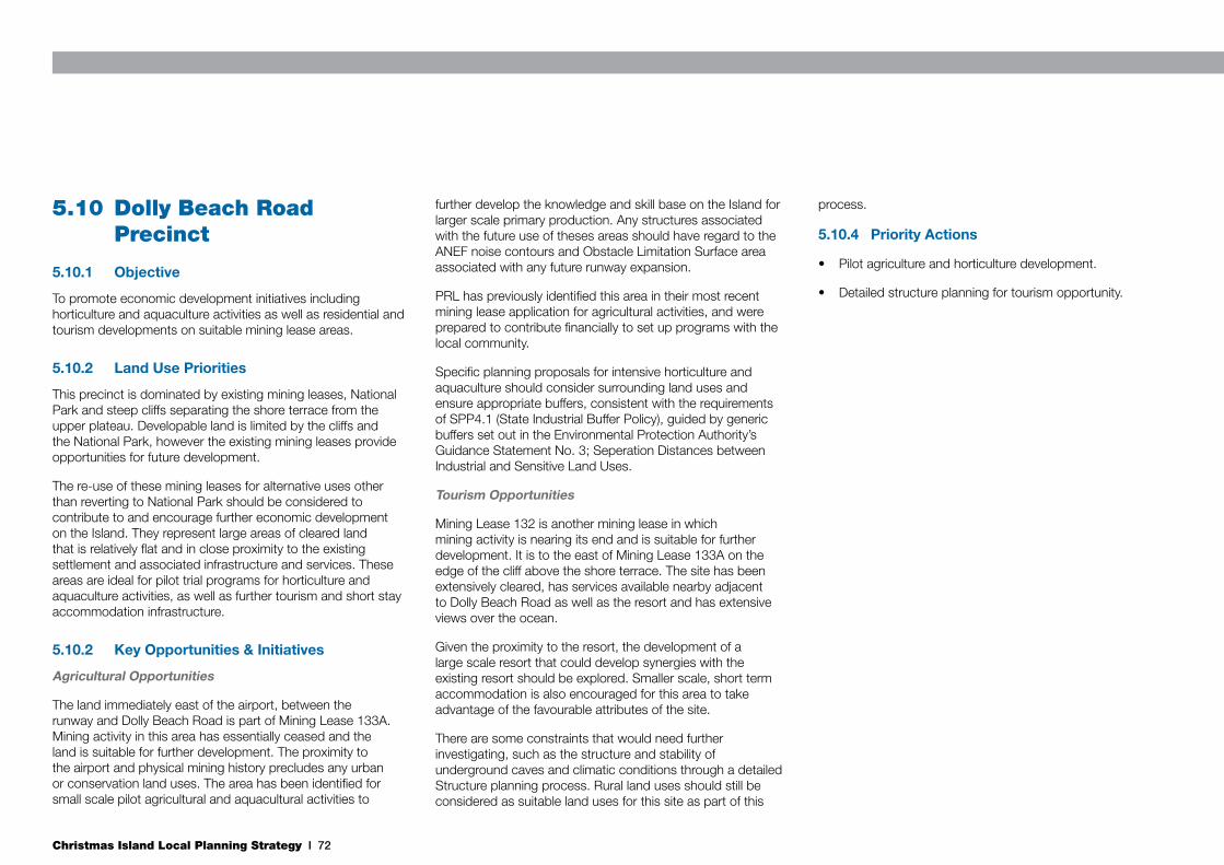
Christmas Island Local Planning Strategy I 72
5.10 Dolly Beach Road Precinct
5.10.1 Objective
To promote economic development initiatives including horticulture and aquaculture activities as well as residential and tourism developments on suitable mining lease areas.
5.10.2 Land Use Priorities
This precinct is dominated by existing mining leases, National Park and steep cliffs separating the shore terrace from the upper plateau. Developable land is limited by the cliffs and the National Park, however the existing mining leases provide opportunities for future development.
The re-use of these mining leases for alternative uses other than reverting to National Park should be considered to contribute to and encourage further economic development on the Island. They represent large areas of cleared land that is relatively flat and in close proximity to the existing settlement and associated infrastructure and services. These areas are ideal for pilot trial programs for horticulture and aquaculture activities, as well as further tourism and short stay accommodation infrastructure.
5.10.2 Key Opportunities & Initiatives
Agricultural Opportunities
The land immediately east of the airport, between the runway and Dolly Beach Road is part of Mining Lease 133A. Mining activity in this area has essentially ceased and the land is suitable for further development. The proximity to the airport and physical mining history precludes any urban or conservation land uses. The area has been identified for small scale pilot agricultural and aquacultural activities to
further develop the knowledge and skill base on the Island for larger scale primary production. Any structures associated with the future use of theses areas should have regard to the ANEF noise contours and Obstacle Limitation Surface area associated with any future runway expansion.
PRL has previously identified this area in their most recent mining lease application for agricultural activities, and were prepared to contribute financially to set up programs with the local community.
Specific planning proposals for intensive horticulture and aquaculture should consider surrounding land uses and ensure appropriate buffers, consistent with the requirements of SPP4.1 (State Industrial Buffer Policy), guided by generic buffers set out in the Environmental Protection Authority’s Guidance Statement No. 3; Seperation Distances between Industrial and Sensitive Land Uses.
Tourism Opportunities
Mining Lease 132 is another mining lease in which mining activity is nearing its end and is suitable for further development. It is to the east of Mining Lease 133A on the edge of the cliff above the shore terrace. The site has been extensively cleared, has services available nearby adjacent to Dolly Beach Road as well as the resort and has extensive views over the ocean.
Given the proximity to the resort, the development of a large scale resort that could develop synergies with the existing resort should be explored. Smaller scale, short term accommodation is also encouraged for this area to take advantage of the favourable attributes of the site.
There are some constraints that would need further investigating, such as the structure and stability of underground caves and climatic conditions through a detailed Structure planning process. Rural land uses should still be considered as suitable land uses for this site as part of this
process.
5.10.4 Priority Actions
• Pilot agriculture and horticulture development.
• Detailed structure planning for tourism opportunity.
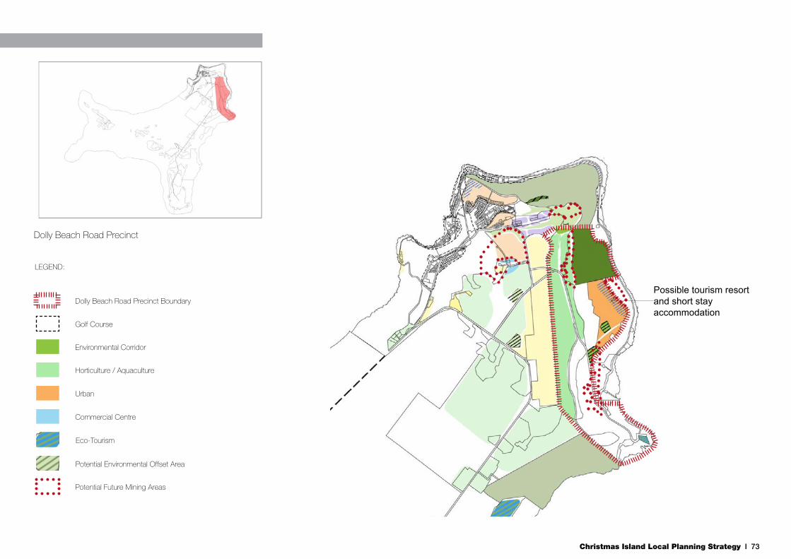
Christmas Island Local Planning Strategy I 73
Possible tourism resortand short stay accommodation
Settlement:- Mixed use residential and tourism- Increase residential densities
Settlement:- Mixed use residential and tourism- Increase residential densities
Settlement:- Mixed use residential and tourism- Increase residential densities
Settlement:- Mixed use residential and tourism- Increase residential densities
Settlement:- Mixed use residential and tourism- Increase residential densities
Potential Environmental Offset Area
Commercial Centre
Urban
Horticulture / Aquaculture
Environmental Corridor
Dolly Beach Road Precinct Boundary
LEGEND:
Potential Future Mining Areas
Settlement:- Mixed use residential and tourism- Increase residential densities
Golf Course
Dolly Beach Road Precinct
Eco-Tourism

Christmas Island Local Planning Strategy I 74
5.11 East Coast
5.11.1 Objective
To facilitate the development of primary production activities and provide environmental offset areas of high environmental quality to provide enhanced connections between the National Park and the east coast.
5.11.2 Land Use Priorities
This precinct contains numerous mining leases along the length of the North South Baseline Road. Consideration needs to be given to their conversion to horticulture and aquaculture activities. Their use for primary production will contribute to the diversification of the economic base of the Island once mining ceases subject to water availability. Their utilisation for primary production is a long term goal, once smaller activities have been undertaken in precincts closer to the settlement area.
The precinct also includes two isolated areas of National Park on the east coast of the Island. There are opportunities within the precinct to identify environmental offset areas that would connect these two isolated areas to the main body of the National Park.
5.11.3 Key Opportunities & Initiatives
Future Mining Areas
To the south of the airport, there are numerous small, irregular shaped mining leases that include ML133B, 121, 127, 125, 129 and the southern portion of 133A. Further south along the road are mining leases ML102, 103, 104, 105, 122 and 123.
Post Mining Horticultural Opportunities
Post mining, leases can be transferred to productive land uses to facilitate the creation of a self-sufficient food supply for the
Island. If horticultural activities in areas closer to the airport are successful, these lower mining lease areas may be utilised for high value export oriented agricultural activities and possibly plant and food research activities.
Given its connections to Greta and Dolly beaches to the south and North South Baseline Road, Mining Lease 124 has the potential to provide for nature based tourism as part of a future environmental corridor.
The southern area of Mining Lease 106 could be transferred to the National Park over time as part of broader discussions about mining and environmental approvals. This transfer would create an environmental corridor between two separated sections of the National Park.
Specific planning proposals for intensive horticulture and aquaculture should consider surrounding land uses and ensure appropriate buffers, consistent with the requirements of SPP4.1 (State Industrial Buffer Policy), guided by generic buffers set out in the Environmental Protection Authority’s Guidance Statement No. 3; Seperation Distances between Industrial and Sensitive Land Uses.
5.11.4 Priority Actions
• Future mining.
• Post-mining lease transfer for agricultuer and horticulture.

Christmas Island Local Planning Strategy I 75
Settlement:- Mixed use residential and tourism- Increase residential densitiesSettlement:- Mixed use residential and tourism- Increase residential densities
Settlement:- Mixed use residential and tourism- Increase residential densities
Settlement:- Mixed use residential and tourism- Increase residential densities
Potential Environmental Offset Area
Eco-tourism
Community Infrastructure
Horticulture / Aquaculture
Environmental Corridor
East Coast Precinct Boundary
LEGEND:
Potential Future Mining Areas
Eco-tourism opportunities
Potential environmental corridors
East Coast

Christmas Island Local Planning Strategy I 76
5.12 South Point
5.12.1 Objective
To provide a long term growth area for rural based activities, whilst maintaining the option of establishing a space centre given the continued interest in the site.
5.12.2 Land Use Priorities
Given the isolation of the area and the high cost of infrastructure provision on the Island, no specific land uses have been considered for site other than rural based activities. If additional land for horticulture is required in the long term, activities could be expanded to South Point.
5.12.3 Key Opportunities & Initiatives
The technical and physical factors that made the Asia Pacific Space Centre (ASPC) possible at South Point remain unchanged. The previous proposal involved sections of mining leases ML100 and 101 for the required infrastructure. The post mining characteristics of the land, its isolation from the main urban area and lack of any service infrastructure provision limits the potential of this land for permanent residential development and other intensive land uses.
5.12.4 Priority Actions
• Maintain option of establishing space centre.
Christmas Island Local Planning Strategy I 77
Settlement:- Mixed use residential and tourism- Increase residential densitiesSettlement:- Mixed use residential and tourism- Increase residential densitiesSettlement:- Mixed use residential and tourism- Increase residential densities
Potential Environmental Offset Area
Horticulture / Aquaculture
Environmental Corridor
East Coast Precinct Boundary
LEGEND:
Potential Future Mining Areas

Christmas Island Local Planning Strategy I 78
5.13 Rest of Island
5.13.1 Objective
To preserve and enhance the Christmas Island National Park and encourage the limited development of small eco-tourism developments to take advantage of the unique natural environment.
5.13.2 Land Use Priorities
This entire precinct consists almost entirely of National Park, which will remain unchanged. The Christmas Island National Park will be managed by the Director of National Parks in accordance with the EPBC Act and a Management Plan prepared under the EPBC Act.
The future of a small number of mining leases is yet to be determined, however leases for sites of high rehabilitation and conservation potential would be best suited to be amalgamated into the National Park. These areas are not suited to any further use due to the concentration of infrastructure and activity in the north eastern section of the Island. It is not considered appropriate to spread infrastructure and human activity on an island where the cost of providing services and infrastructure is already relatively high.
The only other land uses in the precinct are the IDC and the Central Area Workshops. The IDC is a key Federal Government infrastructure asset and future planning should provide for possible expansion.
5.13.3 Key Opportunities & Initiatives
Tourism Opportunities
There is currently a lack of tourism accommodation within the National Park across the Island. Given the unique nature of the National Park and its role in attracting tourists to the Island, opportunities for discrete eco-tourism development should be explored with Parks Australia, together with the development of specific development requirements.
Industrial Relocation Opportunities
The existing buildings at the Central Area Workshops are suitable for re-use. The current industrial land uses are not desirable and would be better suited to the proposed LIA, to take advantage of purpose built facilities and co-location with other industries. This would also result in less transport requirements on roads frequently closed during the crab migration.
Given the isolated nature of the Central Area Workshops the site has been identified for the relocation of the Parks Australia offices and nursery. This location provides more space, adaptable existing buildings, and closer proximity to the surrounding National Park and mining leases most likely to be returned to Parks for rehabilitation. An opportunity also exists to use this area for research and education purposes for visiting students or researchers, with the nearby Pink House utilised for accommodation, subject to clean up and soil contamination assessments. The site is also suitable for other associated uses such as a visitor centre.
Commonwealth Government Land
Additional land surrounding the current IDC at North West Point has been identified to provide a specific area for any required future expansion or ancillary activities that may require additional land. This will ensure that these activities do not occur in a sporadic manner in unsuitable locations should the
need arise, whilst also allowing for the concentration of similar activities in one area.
Sealing and gazetting Murray and North West Point Roads that provide access to the IDC should be a priority given its strategic importance and the volume of traffic that travels to and from the site on a daily basis. Murray Road is part of Christmas Island National Park, therefore the sealing of the road will require approval from the Director National Parks and may require referral and approval under the EPBC Act.
5.13.4 Priority Actions
• Explore opportunity for eco-tourism sites.
• Provide for future expansion of Immigration Detention Centre.
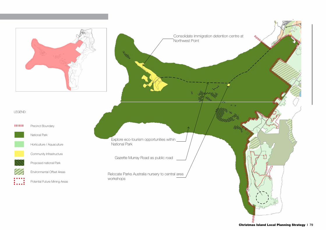
Christmas Island Local Planning Strategy I 79
Settlement:- Mixed use residential and tourism- Increase residential densitiesSettlement:- Mixed use residential and tourism- Increase residential densities
Environmental Offset Areas
Horticulture / Aquaculture
National Park
Precinct Boundary
LEGEND:
Potential Future Mining Areas
Settlement:- Mixed use residential and tourism- Increase residential densities
Community Infrastructure
Proposed national Park
Relocate Parks Australia nursery to central area workshops
Gazette Murray Road as public road
Consolidate immigration detention centre at Northwest Point
Explore eco-tourism opportunities within National Park
Christmas Island Local Planning Strategy I 80
6.1 Local Policy GuidanceThrough the preparation of this LPS and consideration of the provisions of the TPS, a number of additional challenges have been identified which are too detailed for either the LPS or the TPS to address.
These challenges can be more appropriately managed by way of Local Planning Policies (LPP’s) developed in accordance with the provisions of Part 2 of the TPS.
A Local Planning Policy Framework will enable Council to work with the Commonwealth and State Governments to identify and fill key policy gaps and provide greater guidance for development and land use on the island.
Key priorities for LPPs are further outlined below.
6.1.1 Environmental Management
Various types of land use and development can impact on the unique environment of Christmas Island. The important and diverse environmental assets of the island require greater policy guidance and specific attention to facilitate sustainable development and protect assets. It is recommended that the SOCI prepare environmental LPPs, particularly to provide guidance regarding:
• Buffers to National Park for reduce risks of non-native species;
• Site and species selection for intensive horticulture, i.e. non-invasive species;
• Need for and level of environmental assessment;
• Integration with and requirements under the Environmental Protection and Biodiversity Conservation Act (1999);
• Geotechnical assessments, particularly on shore terraces;
• Contamination assessment and remediation;
• Crab protection and migration routes; and
• Water source protection zones.
6.1.2 Built Form
The Christmas Island climate and environment is unique in the Western Australian development context. Influences of both meteorological and native flora and fauna provide a justification for the SOCI to consider alternative built form requirements than the generic provisions allowed for, particularly in the Residential Planning Codes. It is recommended that the SOCI prepare a LPP for Locally Responsive Built Form Guidelines. These guidelines should consider the following as a minimum:
• Climate including access to and shading from sunlight, natural ventilation and, conversely, protection from strong winds;
• Relationship to natural ground level (elevation of building to allow for ventilation and perhaps crab migrations);
• Treatment of topography;
• Outdoor areas including the treatment and location of alfresco areas;
• Materials and colours including lightweight materials and locally supplied stone and a consideration of local characteristics and aesthetic; and
• Roof forms.
6.1.3 Transportable Dwellings
The SOCI is remote and constructions costs can be prohibitive. It is a fact of the locale that transportable dwellings are utilised on Island in both a semi-permanent and permanent
6. Policy Frameworks

Christmas Island Local Planning Strategy I 81
format. To best manage any of the possible amenity impacts of a proliferation of transportable dwelling construction, it is recommended that the SOCI prepare a LPP for Transportable Dwellings and that the LPP consider the following as a minimum:
• Materials and colours;
• Integration with the site and local environment;
• Limits to or specific development provisions for transportable dwellings which are proposed to be in situ for substantial periods of time; and
• Provision of amenity for residents.
6.1.4 Eco-Tourism
There is a recognised lack of tourism opportunities within Crown Land on Christmas Island. Provision of eco-tourism opportunity, particularly in proximity to National Park, should be considered. Encouraging eco-tourism requires greater policy guidance to ensure that this niche form of development achieves its function to integrate with the natural landscape, and manage environmental impacts. It is recommended that the SOCI prepare a LPP for eco-tourism, that provides guidance on:
• Environmental impact;
• Visual impact;
• Intensity of development; and
• Site requirements.
6.1.5 Temporary Accommodation
Greater collaboration is necessary between government and the community to improve emergency response and longer term transitional accommodation arrangements, particularly
in Kampong. It is recommended that the SOCI prepare a LPP for temporary accommodation that includes guidance for alternative accommodation on the Island should certain areas become too hazardous to live in.
6.2 Special Control Areas
6.2.1 Groundwater Management
There is limited understanding of the actual location of available groundwater being utilised for potable water on the Island. As a result it is difficult for the SOCI to assess where groundwater may be impacted by contaminants or how land uses may influence the subsequent use of groundwater. It has been recommended the extent of the groundwater supply (the basalt layer) is accurately mapped in the short term and this may then form the basis for amendments to the LPS and the TPS (if required).
In the absence of this data, it is recommended that the SOCI include a special control area (SCA) within the scheme for groundwater management, and that the SCA consider the following as a minimum:
• Risks associated with development (water contamination and geotechnical);
• Details required to be submitted with applications in regard to potential groundwater and geotechnical impacts; and
• Possible management methods.
Subsequently, when the data is available, the SCA should be amended to consider more specific details that will become apparent.
6.2.2 Wastewater Treatment Plant
The current infrastructure presents a concern for wastewater management on the Island. There is signficiant stormwater
infiltration into the piping system during heavy rainfall events. This stormwater is contributing to the flow of wastewater to the wastewater treatment plant and impacting its capacity.
A special control area is recommended in the Scheme to ensure the wastewater treatment plant provides future alternative treatment methods. Sustainable water management practices, including wastewater re-use options should be included within the Scheme to positively impact on the fresh water supply by reducing demand and reducing the pressure on the underground aquifer, and to limit the amount of sludge dumped at the rubbish tip and disposed into the ocean.
6.3 Land Release PlanningThe Local Planning Strategy identifies significant portions of land for urban development in response to accommodation pressures. Identified urban areas provide a logical spatial framework for expansion, integrating with existing and planned infrastructure needs.
As the Local Planning Strategy is predominantly a spatial strategy, the temporal nature of land release requires further planning.
The Our Future Christmas Island 2018 Plan identifies the need for a land release and development plan. The development of a strategic land release plan will enable the appropraite sequencing of land release, considering demand and contingency for transitional relocation from some settlemtne areas as they become too dangerous for permanent habitation, as well as responding to mining operations and post-mining lease transfer.
The rationale for land release and phasing needs to be directly related to infrastructure delivery. Structure plans prepared for urban development should also provide detailed staging plans to ensure the sequencing of land development in a way that the market can respond to demand.

Christmas Island Local Planning Strategy I 82
7.1 Monitoring and ReviewThe LPS should not be viewed as a fixed plan, and it is essential that this LPS respond to change in a planned manner to ensure benefits to the community are maximised. The LPS should be reviewed every five years to coincide with the review of the TPS. Given the long-term application of the LPS, the review at five year intervals may be confined primarily to updating of information and minor adjustments.
Other instances when the LPS may be reviewed which may require larger adjustments could include:
• When significant projects are proposed that have not been foreseen by the current LPS;
• There is a change in Federal or State Government policies; or
• Specific community expectations for development change.
Amendments will be made to the LPS as deemed necessary and as required by the Shire of Christmas Island. Any such amendment will be advertised to the public for comment.
7. Monitoring & Review

Christmas Island Local Planning Strategy I 83
ACIL Tasman. 2008, The Economy of the Indian Ocean Territories: Economic development opportunities for Christmas Island and the Cocos (Keeling) Islands, prepared for the Attorney-General’s Department, September 2008.
AECOM. 2010, Indian Ocean Territory Climate Change Risk Assessment, 2010 Update Version, prepared for Attorney-General’s Department, 3 June 2010, Canberra.
Australian Government Attorney General’s Office, Christmas Island Environment and Heritage, Accessed 2/2/2011
Bostock, Peter D. 1993, ‘Tectaria [Dryopteridaceae] in Commonwealth of Australia (1993)’, Flora of Australia, vol 48, pp. 394-398 Australian Government Publishing Service, Canberra
Butz, M. (2004). National recovery plan for the Christmas Island Spleenwort Asplenium listeri. [Online]. Department of the Environment and Heritage. Canberra, Commonwelath of Australia. Available from: http://www.environment.gov.au/biodiversity/threatened/publications/recovery/a-listeri/index.html.
C Change Sustainable Solutions & Anthony Whitaker Strategic Planning Solutions. 2011, Our Future Christmas Island 2018 Plan, January 2011.
Christmas Island and Cocos (Keeling) Islands Economic Consultative Groups. 2010, Indian Ocean Territories Economic Development Strategic Plan 2010 – 2015, October 2010.
Department of Regional Australia, Regional Development & Local Government (IOT Administration), 2011. Accommodation Needs Assessment. Christmas Island & Cocos (Keeling) Islands.
Department of Transport and Regional Services. 2002, Christmas Island- Common Use Infrastructure, Additional Port Facility Draft Environmental Report, April 2002.
Environmental Protection Authority. 2005, Guidance for the Assessment of Environmental Factors: Separation Distances between Industrial and Sensitive Land Uses, No. 3, June 2005.
Falkland, T & Usback, R. 1999, Christmas Island Water Management Plan, October 1999.
GHD. 2009, Christmas Island Structural Integrity Inspections, Perth, 18 May 2009.
GHD. 2009, Crown Land Management Plan for the Indian Ocean Territories – Christmas Island, September 2009, Perth, Western Australia.
GHD. 2010, Report for Christmas Island Light Industrial Area – Outline Development Plan, December 2010, Perth, Western Australia.
Holmes, J. & G. Holmes. 2002, Conservation Status of the Flora of Christmas Island, Indian Ocean.
Koltasz Smith. 2007, Christmas Island Local Planning Strategy Draft 2007, February 2007, Perth, Western Australia.
Public Practice Pty Ltd. Date unknown, Christmas Island Economic Portrait.
RAUM International Pty Ltd. 2011, Intergrated Waste Management and Treatment Systems for Christmas Island, Dr Jaya Nair, 20 March 2011, Western Australia.
SGS Economics & Planning. 2010, Horticulture Feasibility Study for the Indian Ocean Territories, June 2010, Perth, Western Australia.
Urban Aesthetics and Calmy Planning and Design. 2011, Accommodation Needs Assessment Chistmas Island and Cocos (Keeling) Islands. prepared for Department of Regional Australia, Regional Development and Local Government, Canberra, Australia
Western Australian Planning Commission. 2002, Shire of Christmas Island Town Planning Scheme No. 1, gazetted 4 July 2002.
http//www.ag.gov.au/www/agd/agd.nsf/Page/TerritoriesofAustralia_ChristmasIsland_ChristmasIslandEnvironmentandHeritage
http://www.environment.gov.au/parks/publications/christmas/land-crabs-brochure.html
http://www.environment.gov.au/parks/christmas/nature-science/fauna/index.html
8. References
Christmas Island Local Planning Strategy I 84
Disclaimers
This Christmas Island Local Planning Strategy (“Report”):1. has been prepared by GHD Pty Ltd (“GHD”) for the Shire of Christmas Island;2. may only be used and relied on by the Shire of Christmas Island;3. must not be copied to, used by, or relied on by any person other than the Shire of Christmas Island without the prior written consent of GHD;4. may only be used for the purpose of considering the future endorsement of a Local Planning Strategy by the Shire of Christmas Island until such time as the Shire of Christmas Island adopts the Local Planning Strategy as their own (and must not be used for any other purpose).GHD and its servants, employees and officers otherwise expressly disclaim responsibility to any person other than the Shire of Christmas Island arising from or in con-nection with this Report. To the maximum extent permitted by law, all implied warranties and conditions in relation to the services provided by GHD and the Report are excluded unless they are expressly stated to apply in this Report.Subject to the paragraphs in this section of the Report, the opinions, conclusions and any recommendations in this Report are based on conditions encountered and information reviewed at the time of preparation and may be relied on until adopted by the Shire of Christmas Island, after which time, GHD expressly disclaims responsi-bility for any error in, or omission from, this Report arising from or in connection with those opinions, conclusions and any recommendations.
Whilst every care has been taken to prepare maps contained in this document, GHD (and CIP, Geoscience Australia) make no representations or warranties about its accuracy, reliability, completeness or suitability for any particular purpose and cannot accept liability and responsibility of any kind (whether in contract, tort or otherwise) for any expenses, losses, damages and/or costs (including indirect or consequential damage) which are or may be incurred by any party as a result of the map being inaccurate, incomplete or unsuitable in any way and for any reason.
GHD
GHD House, 239 Adelaide Tce. Perth, WA 6004 P.O. Box 3106, Perth WA 6832 T: 61 8 6222 8222 F: 61 8 6222 8555 E: [email protected]
© GHD 2012
This document is and shall remain the property of GHD. The document may only be used for the purpose for which it was commissioned and in accordance with the Terms of Engagement for the commission. Unauthorised use of this document in any form whatsoever is prohibited.
Document Status
Rev No. AuthorReviewer Approved for Issue
Name Signature Name Signature Date
0 Scott Jeffrey Scott Jeffrey Anna Kelderman 19/04/2011
1 Colleen Murphy Colleen Murphy Anna Kelderman 04/04/2012
2 Colleen Murphy Colleen Murphy Anna Kelderman 02/05/2012
3 Colleen Murphy Colleen Murphy Anna Kelderman 19/10/2012
4 Julian TurcoColleen Thompson
Anna Kelderman 05/02/2015
5 Rachel MarieColleen Thompson
Colleen Thompson 07/07/2015