Ships and harbours of the Hellenistic and Roman ...
25
1 Honor Frost Foundation honorfrostfoundation.org Maritime Archaeology Graduate Symposium 2020 22 nd – 23 rd February 2020. Short Report Series. doi: https://doi.org/10.33583/mags2020.06 © 2020 The Author Ships and harbours of the Hellenistic and Roman Mediterranean: a new approach Ioannis D. Nakas Department of Classics, Ancient History and Archaeology, University of Birmingham, UK Email: [email protected] Abstract Harbours have been some of the most important centres of trade and exchange, as well as of interaction between different people and cultures. They are, nevertheless, primarily built to accommodate and serve ships, an aspect rather poorly examined by scholarship and research. This paper will present a new approach on the study of the harbours of the Hellenistic and Roman Mediterranean based on the examination of their configuration vis-à-vis their capacity to accommodate certain numbers and types of ships. This approach aims in introducing a new methodology that can be applied in further sites and time periods. Key words Hellenistic and Roman Harbours; Mediterranean; Aegean sea; Delos ships; draft; capacity; anchoring; beaching; docking.
Transcript of Ships and harbours of the Hellenistic and Roman ...

1 Honor Frost Foundation honorfrostfoundation.org
Maritime Archaeology Graduate Symposium 2020
22nd – 23rd February 2020. Short Report Series.
doi: https://doi.org/10.33583/mags2020.06
© 2020 The Author
Ships and harbours of the Hellenistic and Roman Mediterranean: a new
approach
Ioannis D. Nakas
Department of Classics, Ancient History and Archaeology, University of Birmingham, UK
Email: [email protected]
Abstract
Harbours have been some of the most important centres of trade and exchange, as well as of interaction
between different people and cultures. They are, nevertheless, primarily built to accommodate and
serve ships, an aspect rather poorly examined by scholarship and research. This paper will present a
new approach on the study of the harbours of the Hellenistic and Roman Mediterranean based on the
examination of their configuration vis-à-vis their capacity to accommodate certain numbers and types
of ships. This approach aims in introducing a new methodology that can be applied in further sites and
time periods.
Key words
Hellenistic and Roman Harbours; Mediterranean; Aegean sea; Delos ships; draft; capacity;
anchoring; beaching; docking.
2 Honor Frost Foundation honorfrostfoundation.org
Preface
This paper is based on the author’s on-going PhD study at the University of Birmingham under the
title “The construction, use and evolution of late Hellenistic and Roman harbours of the Aegean”. The
author would like to thank his supervisors, Henry Chapman, Gareth Sears and Mantha Zarmakoupi for
their feedback, support and help in the development and progress of this study.
Introduction
Ancient harbours are amongst the most important and intriguing anthropogenic structures. And this is
mainly due to their key role as centres of commercial and cultural exchanges and human interaction,
especially during eras of intensified sea trade like the Hellenistic and Roman period and in
geographical areas where the sea played a major role in every aspect of human life like the
Mediterranean. Harbours have a complex nature that unifies a series of functions: they operate as
gateways to hinterland, nodal points in commercial networks and monumental maritime facades of
cities and states, as well as autonomous spaces and distinct settlements that serve the people related
with the sea in a variety of ways (Delano Smith 1979: 327; Karmon 1985; Rickman 1985; Rogers
2013; Bouras 2016; Reger 2016: 14).
But whatever their role is, harbours are built, organised and operated under a very specific principle:
to sufficiently shelter and serve ships and their cargoes, as well as crews and passengers. And this is a
principle essentially connecting the world of harbours with that of ships and seamanship and defining
their role within contemporary commercial networks. As we will see this aspect of harbour operation
has not yet been sufficiently explored in scholarship and there is great potential in a new approach that
connects harbours with the number, type and tonnage of the ships they had to accommodate, as well
as the cargoes these ships carried and the role they played to the harbours’ development.
Hellenistic and Roman Harbours of the Mediterranean: an overview
There are few other periods in the history of Europe that can be considered more dynamic than the
Hellenistic and Roman one (Rostovtzeff 1941: v; Grant 1990; ix). This period was marked by
significant developments, especially in the economic sector (Archibald 2005: 1), which peaked thanks
to the gradual unification of the Mediterranean world that started under Alexander the Great and was
completed with the Roman Empire. This unification made mobility and exchange some of the major
characteristic of the period (Paterson 1998: 150; Wilson 2011: 39; Temin 2013: 2); especially during

3 Honor Frost Foundation honorfrostfoundation.org
the Roman Imperial years, the sheer volume of trade, often served by new, larger and technologically
improved ship types, grew to unprecedented levels (Casson 1974: 121-2). This intensification of sea
trade naturally brought new demands on contemporary harbours. These had to serve a rising number
and growing tonnage of ships, as well as an equally high amount of commercial activities and larger
populations (Casson 1971: 366-7; Oleson and Hohlfelder 2011: 814-6). Many were hence transformed
into “models of really clever and efficient planning and artistic creations of a high order, beautifully
laid out and adorned with imposing buildings and decorative sculptures” (Rostovtzeff 1941: 1042). A
new important technology also appeared in harbour construction, with the introduction of the use of
hydraulic concrete by the Romans, which were to succeed (but not entirely replace) the older, “Greek”
technique of ashlar construction on rubble foundations (Casson 1971: 367-8; Oleson 1988: 148;
Rickman 1996: 285). The harbours of the period were thus some of the most dynamic, busy and
important centres of commerce and seamanship, as well as “facades maritimes” and gateways of cities,
states and regions (Horden and Purcell 2000: 392) and this makes their study extremely important.
A methodological gap
For more than a century, ancient harbours have been approached and studied in various ways and
literature on them amounts an impressive number of studies (for general overviews of the relative
scholarship see Blackman 1982: 85-90 and Oleson and Hohlfelder 2011: 810). More recent studies
have contributed greatly to the knowledge of ancient Mediterranean harbours, especially of the
Hellenistic and Roman period, developing various new methodologies and approaches: these included
the meticulous examination of commercial networks and of the seminal role harbours played in them,
both in the wider area of the Mediterranean (Wilson et al. 2013; Preiser-Kapeller and Daim 2015) as
well as in more specific regions (Bouras 2008; 2016; Schörle 2011; Leidwanger 2013). The complex
relationship of harbours with their urban or rural hinterlands has been studied too, especially in well-
researched sites like Ostia/Portus (Brandt 2005; Boetto 2010; Keay 2013; Boetto 2016) and Delos
(Karvonis 2008; Karvonis and Malmary 2009; 2012; Zarmakoupi 2013; 2018). Finally,
interdisciplinary approaches combining archaeological and geophysical research were employed in
sites like Portus, Miletus and Ephesus (Keay et al. 2014; Brückner et al. 2014; Delile et al. 2015),
successfully recreating the original environment of harbours and their evolution.
Despite the importance of all these studies, the relationship between ships, cargoes and harbours in a
more explicitly functional, “down-to-earth” way has been largely neglected, with few exceptions:
Johannès Pâris in his pioneering study on the harbours of Delos (1916) tried to consider the capacity
of these harbours to accommodate a certain number of ships, but he lacked accurate and sufficient data

4 Honor Frost Foundation honorfrostfoundation.org
on both the harbour’s configuration as well as on the ships of the period; a similar effort was made by
Alexandros Papageorgiou-Venetas in his 1981 study of the urban environment of Hellenistic and
Roman Delos, but he also did not consider bathymetric and ship draft data adequately. Giulia Boetto
was the only scholar who properly introduced ship typology and size/tonnage into her discussion over
the operation of Roman Portus and Ostia (2010; 2016). By taking advantage of the improved
knowledge on ancient ship configuration and operation she proposed a division of the two harbours
and their river and canal network into specific zones different types of ships could use and where
different kinds of cargoes could be handled. Boetto’s thorough approach showed the potential of
studying harbour vis-à-vis ships by combining data from both fields. The scholar, however, did not
include bathymetric data in her calculations, nor did she consider the possibility of alternative methods
of using harbours beyond docking and many questions were left unanswered. A more inclusive and
more quantitative methodology is thus necessary for the proper understanding of the complex
relationship of harbours with ships.
Ships and harbours: a complicated relationship
The first step towards understanding the relationship between ships and harbours is the thorough
examination of the ships that would have used these harbours during a given time period, in our case
the Hellenistic and Roman one. The typology of the ships of this period (this mostly refers to
merchantmen, which are most likely to use commercial harbours and survive in the archaeological
archive better than galleys) has been extensively studied and discussed in a series of publications
(Casson 1971: 171-2; Parker 1992: 89; Jurišić 2000; Boetto 2010: T.1; Nantet 2016), largely based on
direct information from shipwreck finds (Figure 1). Thanks to this data substantial evidence have been
accumulated on issues such as size and draft, which are very important for the navigation and handling
of ships within harbours (Boetto 2010: 121, T.1; Nantet 2016: T.47). The basic typology of ships of
the period, including their tonnage, size and draft, is seen in Table 1.
Several important points relevant to the relationship between harbours and ships have appeared
through the study of the ships of the period: ships were quite variable both in terms of size and tonnage,
as well as cargo, and no specific, “average” type of merchantman seems to have ever existed. Despite
a general tendency for ships to become larger towards the end of the Roman Republican Period (e.g.
the “myriophoroi” 10,000-amphorae carriers of the early-1st century BCE; Wallinga 1964: 3-5; Wilson
2011: 39) what becomes evident through the scrutiny of the evidence is that these, along with other
merchantmen of great tonnage (even up to 1,200 tons like the Isis “mega-freighter” described by
Lucian in the 2nd century CE; Casson 1971: 186-8; Houston 1987) operated side-by-side with a

5 Honor Frost Foundation honorfrostfoundation.org
multitude of smaller ships, supplementing each other and serving different trade networks (Tchernia
2011: 87-8; Nantet 2016: 122-3). To these ships one should add the large number of small-capacity
lighters, service boats, tugboats and ferries that operated in an around every harbour of the period,
especially the one related with canal networks and rivers like Alexandria and Portus (Casson 1965;
Khalil 2010; Boetto 2010). Despite, however, the number of smaller ships operating in ancient
harbours, their size, tonnage, as well as draft were small and had a limited impact on the configuration
and operation of harbours; they could either use shallower areas and beaches or their cargo value was
small and would not require any substantial investments in the configuration of the harbours they
frequented.
Another important aspect of the seamanship and the ships of the period is the ability to deploy
alternative methods of using harbours beyond docking. Although a common practice today, docking
in antiquity appears to have been a much less popular choice for mariners. Before the introduction of
the hydraulic concrete by the Romans in the second half of the 1st century BCE (Brandon et al. 2014:
233-5) most docks and other harbour works were erected on rubble foundations (Rickman 1996;
Blackman 2008, 643-7; Wilson 2011: 46-7). Ships of greater tonnage could not approach such
structures due to the inclination of the foundation. Wooden piers would have solved the problem, but
they appear to have been scarce, as their use is documented in very few sites (Marseille; Hesnard 1994:
209) and in highly stylised Roman frescoes (Votruba 2017: Fig.8), whereas they are totally absent
from written sources. Nevertheless, even when the hydraulic concrete was introduced, this did not
affect the configuration of every harbour in the Mediterranean, since its application was costly (its
basic material, the pozzolana pumice, was imported from Campania) and technically complex. Thus
many areas remained untouched from this new technology (Brandon et al. 2014: 233-4, Fig.3.2; Nakas
2019). The merchantmen of the period were, however, well outfitted and quite advanced and could
employ alternative methods easily. Anchoring in the open and using lighters and beaching were the
main ones, practices widely employed also by vernacular ships in recent years and even today (Houston
1988: 560-1; Votruba 2017: Figs.5 -6). Anchoring was commonly employed throughout the Greco-
Roman world, as seen through written evidence, whereas ships carried enough anchors of various kinds
and sizes (Votruba 2014); regular beaching and draft-beaching on the other hand was ideal for smaller
vessels, lighters and light galleys (Votruba 2017: 26), but more complicated for larger ships, especially
when loaded. The common use of lifeboats as tugboats and lighters, sounding leads and multiple sails
of various types and sizes (the artemon foresail had become a usual feature in ships by the 1st century
CE; Arnaud 2011: 152) would have allowed ships to approach and use harbours easily, and, more
importantly, adapt to any harbour and coastal environment they would encounter during their travels,

6 Honor Frost Foundation honorfrostfoundation.org
equipped with harbour works or not (Casson 1971: 248-9; Whitewright 2011: 8; Wilson 2011: 45-6;
Nakas 2019).
The second step for the implementation of this new approach to harbour studies concerns the in-depth
scrutiny of harbours themselves. And this aims basically in the recreation of the original form harbours
had during the period studied. The geological changes and mainly the steady rise of the sea level in the
Mediterranean, but also local subsidence, uplift, siltation, earthquakes as well as recent interventions
are what have basically given Mediterranean harbours the image they have today (usually submerged;
Marriner and Morhange 2007). The implications emerging from this study concern the variability of
harbour spaces and the difficulty in establishing their original size and, mostly, depth, a feature that
greatly influences their ability to accommodate ships. Thorough geophysical research is required for
the most accurate and inclusive recreation of ancient harbour environment. Geophysical data is not,
however, available in all sites, whereas others, due to their dynamic character, are ever-changing and
various scenarios can be suggested concerning their original configuration.
Having created a reliable reconstruction of the harbour researched we can import the data on ships
collected in order to check out the capacity of the harbour, as well as the possible methods that could
be employed for its use by mariners and reach some useful and solid conclusions. This will be
demonstrated below in the case study harbour of Delos.
The case study of Delos
Delos was the port-of-trade par excellence of the Hellenistic and early Roman Mediterranean (Lawall
2005: 214). The city developed from a small settlement around the sanctuary into one of the main
centres of retail trade and seamanship and witnessed a unique and unprecedented urban development
from the early 3rd century BCE and until its destruction and decline in 88/67 BCE (Hatzfeld 1919, 34,
36; Green 1990, 384-5; Rauh 1993). The significance of Delos as a religious, cultural and commercial
centre triggered the beginning of large-scale excavations (since 1872) and other studies (for a general
overview of the scholarship on ancient Delos see Bruneau and Ducat 2005 and Zarmakoupi 2015),
which have also included the geomorphology and archaeology of the local harbours (Pâris 1916;
Duchêne et al. 2001; Zarmakoupi and Athanasoula 2018). These studies have offered adequate data to
allow for a satisfactory reconstruction of the ancient city and its harbours.
Delos is located at the centre of the Aegean, with the Cyclades “dancing” around the sacred island of
Apollo, according to Callimachus’ description (Del.300-1; Constantacopoulou 2007: 25-6),
conveniently situated on the main sea routes crossing the archipelago (Pâris 1916: 7; Bouras 2016:

7 Honor Frost Foundation honorfrostfoundation.org
216-8, Fig.1). It is an arid, small, elongated island with no substantial natural harbours, despite the
fragmentation of tis coasts, which are generally rocky, apart from the centre of its western shore where
a series of sandy beaches is to be found (Figure 2). Natural siltation is minimal and apart from the
regular sea-level rise (2-2.5 m since the late Hellenistic period; Desruelles et al. 2004; Dalongeville et
al. 2007) the coastal landscape has not been heavily disturbed by other natural factors (Hejl et al. 2002:
54-5). Large parts of the Main Harbour have unfortunately been covered by excavation debris and the
modern jetty that serves the island today (Zarmakoupi and Athanasoula 2018: 93).
Lacking a big natural harbour or anchorage, Delos was served by a series of smaller ones dispersed
along its coasts (Figure 2). The Main Harbour (often referred to as the “Sacred Harbour”, although the
term is not attested in any ancient source) was located at the centre of the island’s western coast (Figure
3); it gave direct access to the sanctuary as well as to two of the main markets of the island (the agora
of the Competaliasts to the south and the agora of Theophrastos to the north) and was protected from
the prevailing northern and north-western winds by the impressive rubble “Great Mole” (the whole
structure measures c. 200 x 100 m). The ancient harbour was relatively small (1,500-2,000 m2), very
shallow (maximum 1-2 m) and heavily affected by siltation from the sea, since the mole created a
vortex phenomenon, which recycled both sea as well as land sediments, greatly contributing to its
transformation into a sea-side swamp (Desruelles et al. 2007: Fig.5). No dredging was documented in
antiquity, but even it this had occurred it would have made little difference since the crystalline
basement rock is to be found just underneath the surface sediments (Desruelles and Hasenohr 2018:
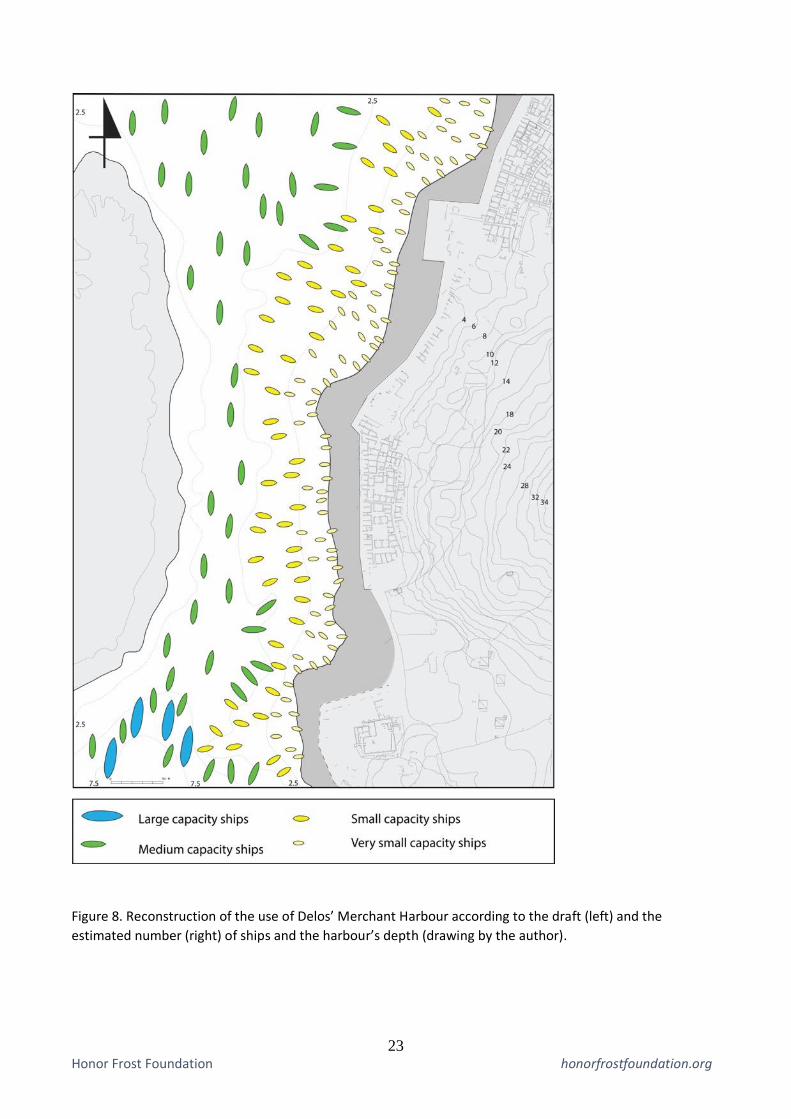
42). Towards the south the Merchant Harbour stretched for nearly 600 metres along the shallow, sandy
coast, up to the Asklepieion peninsula (Figure 4). The whole harbour covered an area of approximately
7,000 m2. The beach opened to a series of warehouses or shops, lined up on the shore, along with a
narrow stone-paved quay (Malmary & Karvonis 2016: 176). Although no harbour works were erected
there, the area was protected from the prevailing northern winds by the “Great Mole”, as well as the
two Rematiaris islets. Its small depth along the sandy coast also depleted waves thanks to the refraction
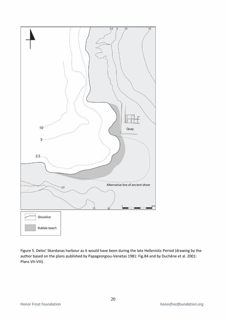
principle (Beresford 2013: 31-3). To the north of the Main Harbour the Skardanas bay was also used
as a harbour, as the semi-submerged remains of a quay and a commercial building indicate (Duchêne
et al. 2001: Pl.LVIII-LXIII, Plans VII-VIII; Zarmakoupi & Athanasoula 2017). The harbour was
relatively small (1,000 m2) and much deeper than the other ones (Figure 5); it was, nevertheless,
exposed to the winds and currents, facing west/northwest, unprotected by any natural or human-made
feature. Finally the island’s east coast, that was generally rocky and exposed and inhabited only at the
area of the stadium, was served by the harbour of Gourna. This accommodated ships coming from the
east (Zarmakoupi 2018: 37), and operated also as the local harbour of the Stadium District (Figure 6).

8 Honor Frost Foundation honorfrostfoundation.org
The harbour was deep but totally unprotected and a unique feature was the construction of an ashlar
quay along the shore (Zarmakoupi and Athanasoula 2018: 98, Fig.10).
Considering the original form of the harbours of Delos and relating it with the size and draft of
contemporary ships we can reach the following conclusions considering the harbours’ capacity and
operation. The Main Harbour had no capacity whatsoever to accommodate any ship with a draft of
more than 1 m, and that not close to its shores, which were even shallower (Figures 3 and 7). Although
theoretically there would have been enough space for more than 100 small and very small capacity
ships, it is highly unlikely that anything above 50 such ships could be accommodated there, leaving
enough space for movement and anchoring. These ships would have also been unable to dock on the
quays at the harbour’s southern part, since these were ashlar structures built on dry land and a strip of
sand or rubble divided them from the sea (Figure 7). The Merchant Harbour, had an improved capacity,
thanks to its size and depth, but could still not accommodate any ships of large capacity (Figures 4 and
8). It is estimated that 20 ships of medium, 40 ships of small and at least 100 ships of very small
capacity could use the harbour. As in the Main Harbour, no actual docks existed there, quays being
actually retaining walls supporting a narrow paved road separated from the sea by a wide beach
(Malmary and Karvonis 2016: Fig.5). The Merchant Harbour did, however, open to a wider area,
conventionally called Southern Anchorage, located to the south of the Great Rematiaris islet, a deep
and relatively protected area, that has been used as an anchorage in recent years and is still used today
by sailing ships (Figure 2; Gallois 1910: Figs.26, 28-31, 38). The anchorage covered an area of
approximately 23,000 m2, offering plenty of space and depth for the accommodation and movement
of ships of every capacity: it is estimated that at least 38 ships of great, 85 ships of medium, 130 ships
of small and about 500 ships of very small capacity could use the area. Skardanas was a small but
rather deep bay, allowing for the simultaneous accommodation of 2-3 ships of great, 10 ships of
medium, 10 ships of small and 20 ships of very small capacity (Figure 9). As in the Main and Merchant
Harbours no remains of any actual docks have been preserved at Skardanas bay and it is highly
probable that it had a similar configuration with the Merchant Harbour, with quays separated by a
beach at its middle. Finally Gourna was a rather deep harbour and was equipped with what appears to
have been a 50 m-long ashlar dock, founded in rather deep water (5-7 m) that allowed the docking of
ships of large capacity too (Figure 10; Papageorgiou-Venetas 1981: Fig.85; Zarmakoupi and
Athanasoula 2018: Fig.1). It is estimated that 4 ships of great, 6 ships of medium, 10 ships of small
and 12 ships of very small capacity could use the harbour.
What becomes evident from the examination of the capacity of the Delian harbours, as well as the
implications of the movement and accommodation of various ships is the inability of any ship to dock

9 Honor Frost Foundation honorfrostfoundation.org
on any harbour structure of the island, with the possible exception of the Gourna small dock (wooden
piers in Delos are not documented in written sources or archaeological finds). Harbour works were in
general surprisingly poor for such an important harbour city, limited to the “Great Mole”, the Gourna
quay and the line of quays/retaining walls along the waterfront, which, however, could not function as
proper docks. Furthermore, the Main Harbour, as well as large part of the Merchant Harbour was
practically inapproachable by ships of medium and large capacity, which would have to use Skardanas
and Gourna, which were the least protected areas for anchoring or the Southern Anchorage. Although
the later was relatively well protected by the Great Rematiaris islet, it still remained exposed to any
abrupt change of wind, something not at all uncommon in the Aegean (Arnaud 2005: 16-23).
Beaching would have been easy on the long, sandy beaches of the island’s western coast, but that
would have mostly considered ships of very small capacity and galleys, since larger ships would have
to be empty of their cargoes and would require substantial manpower and supports to be hauled on
land. Draft beaching could have been a solution, but the draft of medium and large capacity ships,
when loaded (Table 1), would have prevented porters from approaching them, due to the depth of the
water. The operation of a shipyard, a slipway and a capstan, attested by inscriptions on the island
during the 3rd century BCE (Homolle 1882: 67; Vélissaropoulos 1980: 215) confirm the importance of
the practice but most likely refer to ship maintenance and not to a general practice for the
accommodation of large numbers of ships.
It appears that the best solution for ships visiting the busy island would have been to cast their anchors
in the open and use lighters for the loading/unloading of merchandize. Despite the dangers such a
practice entails, mainly the possibility of ships loosing their cables, drifting and crushing on the shores,
it was a rather convenient method for using the local harbours. It allowed great numbers of ships of all
types to visit the island without entering enclosed basins, where movement would have been difficult
and affected by siltation, as it happened in the Main Harbour. The operation of multiple harbours
around the island and in a short distance to each other also allowed ships to use each according to their
provenance, the climatic conditions, lack of space or according to the urban district they had to serve
(Zarmakoupi 2018: 37-8). Such use of the harbours of Delos was directly related to the commercial
operation of the whole city. Notwithstanding the volume of commercial traffic handled in the busy
harbour city during the Late Hellenistic period, the city operated predominantly as a retail centre:
relatively small parts of cargoes (especially of bulk victuals) were actually transported on the island,
which could cover large part of its needs through local production and imports from nearby islands
(Reger 1994: 99-101). It is thus not surprising that the storage infrastructure of the city was equally
limited as its harbour works (Duchêne 1993: 125; Zarmakoupi 2013: §7). This operation of the island

10 Honor Frost Foundation honorfrostfoundation.org
as an entrepôt from which trade was administered and cargoes transhipped or diverted would perfectly
agree with the lack of substantial infrastructure and the employment of short-term anchoring of
merchantmen around it.
The study of the harbours of Hellenistic Delos through the eyes of the mariners who used them, paints
a complex and very interesting picture: as the city grew rapidly thanks to its commercial development,
Delians took advantage of every single bay, beach and anchorage to facilitate sea traffic (Zarmakoupi
2018: 36-8). Little was, however, invested into any harbour works, that being protective moles and
quays or dredging operations. The “Great Mole” of the Main Harbour was rather unnecessary, since
the harbour was very shallow and was most likely connected with the protection of ceremonial galleys
that would have used the harbour regularly (Figure 7; the demarcated “galley cove” operated there, as
indicated by a boundary stone inscription; Dûchene et al. 2001: 153-4). The harbours of Delos were,
quite like the unfortified, “boundless” city itself, open to the outer sea and ships could easily move
around them, taking advantage of any favourable condition and making good use of space. The nature
of these largely exposed harbours, must have forced merchantmen to lie at anchor and use lighters.
Despite the potential dangers of this method, it kept ships away from the hazards of the rocky or sandy
shores and allowed them to move easily around the island and leave without much trouble when their
cargoes were sold. The development of Delos into “the common market of Greece” (Paus.8.33.2), a
thriving retail centre and a unique cosmopolitan city, proves that the harbours, despite their
“simplicity” adequately fulfilled their role and contemporary mariners had all the skill and equipment
to use them with safety.
Conclusions
Approaching ancient harbours through their relationship with the ships they were built to shelter and
serve provides new and very useful data on their operation and development. More importantly, this
data is strictly measurable and accurate and can create compound scenarios on the operation of
harbours in connection to ships and cargoes. As seen the in case study of Delos, the employment of
this method shows the ingenuity and resourcefulness of the mariners of the period, as well as the
complexity of contemporary harbours, which did not always have to be deep, large and equipped with
substantial harbour works to fulfil their role on the one hand as ship havens and on the other as
commercial centres. By applying this approach to more harbours of the period, but also of other periods
and regions, can be a very useful tool for the better understanding of harbours and their role in the
development of contemporary economy, trade and seamanship.

11 Honor Frost Foundation honorfrostfoundation.org
Reference list
Archibald, Z.H. 2005. ‘Market and exchange: the structure and scale of economic behaviour in the
Hellenistic Age’. In Archibald et al. 2005. Pp. 1-26.
Archibald, Z.H., Davies, J.K. and Gabrielsen, V. (eds.) 2005. Making, Moving and Managing. The
New World of Ancient Economies. Oxford.
Arnaud, P. 2005. Les Routes de la Navigation Antique. Itinéraires en Mediterranée. Paris.
Arnaud, P. 2011. ‘Sailing 90 degrees from the wind: norm or exception?’. In Harris & Iara 2011. Pp.
147-60.
Beresford, J. 2013. The Ancient Sailing Season. Leiden and Boston: Brill.
Blackman, D.J. 1982. Ancient harbours in the Mediterranean, part 1. IJNA 11.2: 79-104.
Blackman, D.J. 2008. ‘Sea transport, part 2: harbors’. In J.P. Oleson (ed.), The Oxford Handbook of
Engineering and Technology in the Classical World. Oxford. Pp. 638-70.
Boetto, G. 2010. ‘Le port vu de la mer: l'apport de l'archéologie navale à l'étude des ports antique’.
Bolletino di Archeologia on line I, Volume Speciale, B B7 (9): 112–28.
Boetto, G. 2016. ‘Portus, Ostia and Rome: a transport zone in the maritime/land Interface’. In
Höghammar et al. 2016. Pp. 269-89.
Bouras, C. 2008. L'Espace Maritime Égéen à l'Époque Impériale: Les Espaces et les Activités
Portuaires de Pompée à la Fondation de Constantinople. PhD thesis: University of Strasbourg.
Bouras, C. 2016. ‘A Harbour Network in the Aegean Sea During the Roman Imperial Period?’. In
Höghammar et al. 2016. Pp. 201-23.
Brandon, C.J., Hohlfelder, R.L., Jackson, M.D. and Oleson, J.P. 2014. Building for Eternity: The
History and Technology of Roman Concrete Engineering in the Sea. Oxford.
Brandt, J.R. 2005. ‘’The warehouse of the world’. A comment on Rome’s supply chain during the
empire’. Orizzonti. Rassegna di Archeologia 6: 25–47.
Brückner, H., Herda, A., Müllenhoff, M., Tabbel, W. and Stümpel, H. 2014. ‘On the Lion Harbour
and other harbours in Miletos: recent historical, archaeological, sedimentological, and geophysical
research’. In R. Frederiksen and S. Handberg (eds.), Proceedings of the Danish Institute at Athens,
Vol.VII, Athens. Pp. 49-103.
Bruneau, Ph. and Ducat, J. 2005. Guide de Délos. École Français d’Athénes: Paris.
Casson, L. 1965. ‘Harbour and River Boats of Ancient Rome’. JRS 55: 31-9.
Casson, L. 1971. Ships and Seamanship in the Ancient World. Princeton University Press.
Casson, L. 1974. Travel in the Ancient World. The John Hopkins University Press.
Constantakopoulou, Ch. 2007. The Dance of the Islands: Insularity, Networks, the Athenian Empire,
and the Aegean World. Oxford University Press.

12 Honor Frost Foundation honorfrostfoundation.org
Dalongeville, R., Desruelles, S., Fouache, E., Hasenohr, C. and Pavlopoulos, K. 2007. ‘Hausse
relative du niveau marin a Delos (Cyclades, Grece): rhythme et effets sur les paysages littoraux de la
ville hellenistique’. Mediterranee 108: 17–28.
Delano Smith, C. 1979. Western Mediterranean Europe. A Historical Geography of Italy, Spain and
Southern France since the Neolithic. Academic Press.
Delile, H., Blichert-Toft, J., Goiran, J.-Ph., Stock, F., Arnaud-Godet, F., Bravard, J.-P., Brückner, H.
and Albarède, F. 2015. ‘Demise of a harbor: a geochemical chronicle from Ephesus’. Journal of
Archaeological Science 53: 202-13.
Desruelles, S., Fouache, É., Pavlopoulos, K., Dalongeville, R., Peulvast, J.-P., Coquinot, Y. and
Potdevin, J.-L. 2004. ‘Beachrocks et variations récentes de la ligne de rivage en Mer Égée et dans
l'ensemble insulaire Mykonos–Délos–Rhénée (Cyclades, Grèce)’. Géomorphologie: relief,
processus, environnement 1: 5-18.
Desruelles, S., Fouache, E., Dalongeville, R., Pavlopoulos, K., Peulvast, J.-P., Coquinot, Y.,
Potdevin, J.-L., Hasenohr, C., Brunet, M., Mathieu, R. and Nicot, E. 2007. ‘Sea-level changes and
shoreline reconstruction in the ancient city of Delos (Cyclades, Greece)’. Geodinamica Acta 20.4:
231–39.
Duchêne, H. 1993. ‘Délos, réalités portuaires et emporion’. In A. Bresson, A. and Rouillard, P.
(eds.), L’Emporion. Paris. Pp. 113-25.
Duchêne, H., Fraisse, P., Delongeville, R. and Bernier, P. 2001. La Paysage Portuaire de la Délos
Antique: Recherches sur les Installations Maritimes, Commerciales et Urbaines du Littoral Délien.
Exploration Archéologique de Délos XXXIX.
Gallois, L. 1910. Cartographie de l’Ile de Délos. Exploration Archéologique de Délos III.
Green, P. 1990. Alexander to Actium: the Hellenistic Age. Thames and Hudson: London.
Harris, W.V. and Iara, K. (eds.), 2011. Maritime Technology in the Ancient Economy: Ship-Desigh
and Navigation. JRA Suppl.84.
Hatzfeld, J. 1919. Les Traffiquants Italiens dans l’Orient Hellénique. Paris: de Boccard.
Hejl E., Riedl, R. and Weingartner, H. 2002. ‘Post-plutonic unroofing and morphogenesis of the
Attic–Cycladic complex (Aegea, Greece)’. Tectonophysics 349: 37-56.
Hesnard, A. 1994. ‘Une nouvelle fouille du port de Marseille, place Jules-Verne’. Comptes rendus
des séances de l'Académie des Inscriptions et Belles-Lettres 138.1: 195-217.
Höghammar, K., Alroth, B. and Lindhagen, A. (eds.), 2016. Ancient Ports. The Geography of
Connections, Proceedings of an International Conference at the Department of Archaeology and
Ancient History. Uppsala University, 23-25 September 2010. Acta Universitatis Upsaliensis,
Uppsala.
Homolle, Th. 1882. ‘Comptes des Hiéropes du temple d'Apollon Délien’. BCH 6, 1-167.
Horden, P. and Purcell, N. 2000. The Corrupting Sea. A Study of Mediterranean History. Blackwell.
Houston, G.W. 1987. ‘Lucian's Navigium and the dimensions of the Isis’. The American Journal of
Philology 108.3: 444-50.

13 Honor Frost Foundation honorfrostfoundation.org
Houston, G.W. 1988. ‘Ports in perspective: some comparative materials on Roman merchant ships
and ports’. AJA 92: 553-64.
Jurišić, M. 2000. Ancient Shipwrecks of the Adriatic. Maritime Transport During the First and
Second Centuries AD. BAR 828.
Karmon, Y. 1985. ‘Geographical components in the study of the ancient Mediterranean’. In Raban
1985. Pp. 1-2.
Karvonis, P. 2008. ‘Les installations commerciales dans la ville de Délos à l’époque hellénistique’.
BCH 132: 153-219.
Karvonis, P. and Malmary, J.J. 2012. ‘Du quartier à l’agora: étude de cas dans le Quartier du théâtre
à Délos’. In V. Chankowski & P. Karvonis (eds.), Tout Vendre, Tout Acheter. Structures et
Équipements des Marchés Antiques. Actes du Colloque d’Athènes, 16-19 Juin 2009, Athens. Pp.
263-75.
Keay, S. (ed.), 2013. Rome, Portus and the Mediterranean. Archaeological Monographs of the
British School at Rome 21.
Keay, S., Parcak, S.H. and Strutt, K.D. 2014. ‘High-resolution space and ground-based remote
sensing and implications for landscape archaeology: the case from Portus, Italy’. Journal of
Archaeological Science 52: 277-92.
Khalil, E. 2010. ‘The sea, the river and the lake: all the waterways lead to Alexandria’. Bolletino di
Archeologia on line I, Volume Speciale, B B7 (9): 33-48.
Lawall, M.L. 2005. ‘Amphoras and Hellenistic economies: addressing the (over)emphasis on
stamped amphora handles’. In Archibald et al. 2005. Pp. 188-232.
Leidwanger, J. 2013. ‘Opportunistic ports and spaces of exchange in Late Roman Cyprus’. Journal
of Maritime Archaeology 8: 221-43.
Malmary, J.-J. and Karvonis, P. 2016. ‘Trois îlots commerciaux le long du rivage occidental de
Délos: le Magasin des Colonnes, le Magasin δ et le Groupe ε’. In U. Fellmeth, J. Krüger, K. Orh and
J.J. Rasch (eds.), Wirtschaftsbauten in der antiken Stadt. International Kolloquium, 16-17 November
2012. Karlsruhe: Karlsruhe Institut für Technologie. Pp. 167-79.
Marriner, N. and Morhange, Chr. 2007. ‘Geoscience of ancient Mediterranean harbours’. Earth-
Science Reviews 80: 137-94.
Moretti, J.-C., Fadin, L., Fincker, M. and Picard, V. 2015. L’Atlas de Délos. Exploration
Archéologique de Délos XLIII. Paris and Athens.
Nakas, Y. 2019. ‘”Gain overcomes everything”: a mariner’s perspective on the use of harbours and
anchorages in the Hellenistic and Roman Mediterranean. In In Poseidon’s Realm XXIV. Contact
Zones: Archaeology Between Water and Land Coasts, Lake and River Shores. International
Conference. Bodrum 2019 (under publication).
Nantet, E. 2016. Phortia, le Tonnage des Navires de Commerce en Méditerranée, du VIIIe Siècle av.
l’ère Chrétienne au VIIe Siècle del’ ère Chrétienne. PUR: Rennes.
Oleson, J.P. 1988. ‘The technology of Roman harbours’. IJNA 17.2: 147-57.

14 Honor Frost Foundation honorfrostfoundation.org
Oleson, J.P. and Hohlfelder, R.L. 2011. ‘Ancient harbors in the Mediterranean’. In A. Catsambis, B.
Ford and D.L. Hamilton (eds.), The Oxford Handbook of Maritime Archaeology. Oxford University
Press. Pp. 809-33.
Papageorgiou-Venetas, A. 1981. Délos. Recherches urbaines sur une ville antique. Berlin: Deutscher
Kunstverlag.
Pâris, J. 1916. ‘Contribution a l’etude des ports antiques du mond Grec (1)’. BCH 40: 5-73.
Parker, A.J. 1992. Ancient Shipwrecks of the Mediterranean and the Roman Provinces. BAR 580.
Oxford.
Paterson, J. 1998. ‘Trade and traders in the Roman world: scale, structures, and organization’. In H.
Parkins and C. Smith (eds.), Trade, Traders and the Ancient City. Routledge. Pp. 149-67.
Preiser-Kapeller, J. and Daim, F. (eds.), 2015. Harbours and Maritime Networks as Complex
Adaptive Systems. International Workshop. Römisch-Germanisches Zentralmuseum, Mainz (17-
18.10.2013).
Raban, A. (ed.), 1985. Harbour Archaeology. Proceedings of Ancient Mediterranean Harbours.
Caesarea Maritima 24-8.6.83. BAR 257.
Rauh, N. K. 1993. The sacred bonds of commerce: religion, economy, and trade society at
Hellenistic Roman Delos, 166-87 B.C.. Amsterdam: J. C. Gieben.
Reger, G. 1994. Regionalism and Change in the Economy of Independent Delos, 314-167 BC.
University of California Press.
Reger, G. 2016. ‘Nodes of sea and sand. Ports, human geography, and networks of trade’. In
Höghammar et al. 2016. Pp. 9-36.
Rickman, G.E. 1985. ‘Towards a study of Roman ports’. In Raban 1985. Pp. 105-14.
Rickman, G.E. 1996. ‘Portus in perspective’. In A. Gallina Zevi and A. Claridge (eds.), ‘Roman
Ostia’ Revisited. Archaeological and Historical Papers in Memory of Russell Meiggs. London. Pp.
281-291.
Rogers, A. 2011. ‘Reimagining Roman ports and harbours: the port of Roman London and
waterfront archaeology’. Oxford Journal of Archaeology 30.2: 207-25.
Rostovtzeff, M. 1941. The Social and Economic History of the Hellenistic World. Oxford.
Schörle, K. 2011. ‘Constructing port hierarchies: harbours of the central Tyrrhenian coast’. In D.
Robinson and A. Wilson (eds.), Maritime Archaeology and Ancient Trade in the Mediterranean.
Oxford Centre for Maritime Archaeology Monographs 6. Oxbow Books. Pp. 93-106.
Tchernia, A. 2011. ‘L’utilisation des gros tonnages’. In Harris and Iara 2011. Pp. 83-8.
Temin, P. 2013. The Roman Market Economy. Princeton University Press.
Vélissaropoulos, J. 1980. Les nauclères grecs. Recherches sure les institutions maritimes en Grèce et
dans l’ Orient hellénisé. Geneva.
Votruba, G.F. 2014. Iron Anchors and Mooring in the Ancient Mediterranean (until ca.1500 CE).
PhD thesis. University of Oxford.

15 Honor Frost Foundation honorfrostfoundation.org
Votruba, G.F. 2017. ‘Did vessels beach in the ancient Mediterranean? An assessment of the textual
and visual evidence’. The Mariner's Mirror 103.1: 7-29.
Wallinga, H.T. 1964. ‘The Unit of Capacity for Ancient Ships’. Mnemosyne, Fourth Series 17.1: 1-
40.
Whitewright, J. 2011. ‘The Potential performance of ancient Mediterranean sailing rigs’. IJNA 40.1:
2-17.
Wilson, A. 2011. ‘The economic influence of developments in maritime technology’. In Harris and
Iara 2011. Pp. 211-33.
Wilson, A., Schörle, K. and Rice, C. 2013. ‘Roman ports and Mediterranean connectivity’. In Keay
2013. Pp. 367-91.
Zarmakoupi, M. 2013. ‘The city of late Hellenistic Delos and the integration of economic activities
in the domestic Sphere’. Center for Hellenic Studies Research Bulletin 1.2 (http://nrs.harvard.edu/urn
3:hlnc.essay: ZarmakoupiM.The_City_of_Late_Hellenistic_Delos.2013).
Zarmakoupi, M. 2015. ‘Hellenistic & Roman Delos. The city & its emporion’. AR, Archaeology in
Greece 61 (2014-15): 115–32.
Zarmakoupi, M. 2018. ‘The urban development of the late Hellenistic Delos’. In S.L. Martin-
McAuliffe and D.M. Millette (eds.), Ancient Urban Planning in the Mediterranean. New Research
Directions. Routledge. Pp. 28-49.
Zarmakoupi, M. & Athanasoula, M. 2017. ‘The Delos Underwater Survey Project (2014-2016)’.
Under the Mediterranean: 100 years on…The Honor Frost Foundation Conference of ‘Mediterranean
Maritime Archaeology’. Nicosia, 20-24 October 2017.
Zarmakoupi, M. and Athanasoula, M. 2018. ‘Υποβρύχια αρχαιολογική έρευνα στη βορειοανατολική
πλευρά της Δήλου (Συνοικία του Σταδίου)’. In A. Simosi and S. Sotiriou (eds.), Proceedings from
‘Βουτιά στα περασμένα: Η υποβρύχια αρχαιολογική έρευνα, 1976–2014//Diving in the Past:
Underwater Archaeological Research, 1976–2014. Pp. 91-102.

16 Honor Frost Foundation honorfrostfoundation.org
Tables
Ca
tego
ries
Nam
e/s
hip
wre
ck
Ca
pac
ity
(t)
Len
gth
(m
)
Be
am (
m)
Hei
ght
fro
m k
eel t
o
dec
k (m
)
Dra
ft (
m)
Are
a co
vere
d (
m2 )
Exceptionally large cargo ships
‘Syracosia’ ‘Isis’
1,200-1,700 53 14 7 4.5 742 m2
Large cargo ships (myriophoroi) 10,000 amphorae 50,000 modii 350-500 tons
Madrague de Giens Albenga
350-390 40 9-12 4.5 3.5-4 280-600 m2
Large capacity 5,000 amphorae
150-350 tons
Antikythera Antirhodos
Mahdia Marzamemi
Punta del Francese Saint-Tropez
Spargi Torre Sgarrata I
170-350 21-40 8-14 3.5-5 2-4
Medium capacity 3,000 amphorae 20,000 modii 75-150 tons
Bourse de Marseille Kizilburun Porto Nuovo
Titan Pisa A St.Gervais 3
80-150 15-30 4-9 2-3 1.5-2 125-270 m2
Small capacity 1,000 amphorae 10,000 modii 15-75 tons
Apollonia Ashkelon Roman Carry-le-Rouet Cavalière Chretienne C Conque de Salins Diano Marina Dramont A & I Fiumicino 1 & 2 Grado I Grand Congloué B Grand Ribaud D Izmetište Kyrenia La Giraglia
Ladispoli Laurons 2 Margarina Marseillan Beauséjour Meloria C Miladou Naples A Ouest Giraglia 2 Pisa (Hellenistic ship) Planier III Port-Vendres I Serçe Limanı Tre Senghe
20-80 12-24 3.3-6 1-2.5 1.5-2.5 70-175 m2
Very small capacity (less than 15 tons)
Herculaneum Kinneret Naples B & C
Ostia, Isola Sacra I Pisa B, C & F Toulon 1 & 2
4-10 6.3-13 2-5 0.4-0.8 0.5-1.2 16-63 m2
Table 1: A comparative table of the dimensions and tonnage of various ships of the Hellenistic and Roman
period of the Mediterranean, based on shipwreck finds and written evidence.
Figures

17 Honor Frost Foundation honorfrostfoundation.org
Figure 1. Comparative profiles of various Mediterranean ships of the Hellenistic and Roman period (drawing
by the author).

18 Honor Frost Foundation honorfrostfoundation.org
Figure 2. Left: general plan of Delos with the various harbours and anchorages of the island indicated. Right:
plan of the ancient city of Delos with various harbours and sites mentioned in the text indicated (drawings by
the author; for the plan on the right the map published by Moretti et al. 2015: Pl.5 has been used).
Figure 3. Delos’ Main Harbour as it would have been during the late Hellenistic Period (drawing by the
author; bathymetry is based on the plans published by Pâris 1916: Pl.1-IV; the ancient remains on the coast
are based on Moretti et al. 2015: Fig.5 and on the survey by Dardinier, published in Duchêne et al. 2001:
Doc.I-VIII).

19 Honor Frost Foundation honorfrostfoundation.org
Figure 4. Delos’ Merchant Harbour as it would have been during the late Hellenistic Period (drawing by the
author; bathymetry is based on the plans published by Pâris 1916: Pl.1-IV; the ancient remains on the coast
are based on Moretti et al. 2015: Fig.5).
20 Honor Frost Foundation honorfrostfoundation.org
Figure 5. Delos’ Skardanas harbour as it would have been during the late Hellenistic Period (drawing by the
author based on the plans published by Papageorgiou-Venetas 1981: Fig.84 and by Duchêne et al. 2001:
Plans VII-VIII).

21 Honor Frost Foundation honorfrostfoundation.org
Figure 6. Delos’ Gourna harbour as it would have been during the late Hellenistic Period (drawing by the
author based on the plans published by Papageorgiou-Venetas 1981: Fig.85 and by Zarmakoupi 2015:
Fig.132).

22 Honor Frost Foundation honorfrostfoundation.org
Figure 7. Reconstruction of the use of Delos’ Main Harbour according to the draft (left) and the estimated
number (right) of ships and the harbour’s depth (drawing by the author).
23 Honor Frost Foundation honorfrostfoundation.org
Figure 8. Reconstruction of the use of Delos’ Merchant Harbour according to the draft (left) and the
estimated number (right) of ships and the harbour’s depth (drawing by the author).

24 Honor Frost Foundation honorfrostfoundation.org
Figure 9. Reconstruction of the use of Delos’ Skardanas harbour according to the draft (left) and the
estimated number (right) of ships and the harbour’s depth (drawing by the author).

25 Honor Frost Foundation honorfrostfoundation.org
Figure 10. Reconstruction of the use of Delos’ Gourna harbour according to the draft (left) and the estimated
number (right) of ships and the harbour’s depth (drawing by the author).