
Sherrat 1982
30
ANDREW SHERRATT THE DEVELOPMENT OF NEOLITHIC AND COPPER AGE SETTLEMENT IN THE GREAT HUNGARIAN PLAIN PART I: THE REGIONAL SETTING Summary. This paper describes the development of settlement over the period 60004000 BC in part of central Europe. It contrasts the patterns of initial agrarian occupation with the subsequent expansion of population in the eastern part of the Carpathian Basin. This area is of particular interest, both as a major focus of prehistoric settlement, and because it is possible to compare the results of recent local surveys with a well documented series of regional distri- butions. The purpose of this article is to describe the succession of patterns which characterise the first four millennia of agricultural settlement in the Great Hungarian Plain. It consists of two parts: a regional description and analy- sis of the distribution of known Neolithic and Copper Age sites in Eastern Hungary, and a more detailed consideration of the patterns of site location as they have been revealed by recent survey work in the Koros basin.' The aim is to relate the evidence from a planned survey programme to the de- velopment of prehistoric settlement in the region as a whole. The area chosen has particular advantages for a study of this kind. The archaeological study of the region has a continuous history from the early nineteenth century when finds were first systematically recorded. The cul- tural sequence is well known from numerous excavations, including deeply-stratified tell settlements. The Neolithic and Copper Age cultures have been well described in a series of monographs which contain comprehen- sive lists of known sites. The environmental setting of these distributions, consisting of an alluvial plain with surrounding terraces and uplands, has been systematically mapped and described. The large areas of relatively uniform landscape simplify the problem of analysis and generalisation. The sample of sites at a regional level is thus both large and well dated, and its geographical context is well known. In addition, a central part of the region has been selected for planned investigation in the programme of the Archaeological Topography of Hungary.2 This county-by- county survey consists not only of the sys- tematic recording of known finds but also of active fieldwork directed to an assessment of the density of archaeological sites in the area. For the first time it has been possible to appreciate the numbers of prehistoric set- tlements and the regularities of their distri- bution at a local level. This both @ OXFORD JOURNAL OF ARCHAEOLOGY 1(3)1982 287
-
Upload
uli-valdegru -
Category
Documents
-
view
58 -
download
0
Transcript of Sherrat 1982
ANDREW SHERRATT
THE DEVELOPMENT OF NEOLITHIC AND COPPER AGE SETTLEMENT IN THE GREAT HUNGARIAN PLAIN PART I: THE REGIONAL SETTING
Summary. This paper describes the development of settlement over the period 60004000 BC in part of central Europe. It contrasts the patterns of initial agrarian occupation with the subsequent expansion of population in the eastern part of the Carpathian Basin. This area is of particular interest, both as a major focus of prehistoric settlement, and because it is possible to compare the results of recent local surveys with a well documented series of regional distri- butions.
The purpose of this article is to describe the succession of patterns which characterise the first four millennia of agricultural settlement in the Great Hungarian Plain. It consists of two parts: a regional description and analy- sis of the distribution of known Neolithic and Copper Age sites in Eastern Hungary, and a more detailed consideration of the patterns of site location as they have been revealed by recent survey work in the Koros basin.' The aim is to relate the evidence from a planned survey programme to the de- velopment of prehistoric settlement in the region as a whole.
The area chosen has particular advantages for a study of this kind. The archaeological study of the region has a continuous history from the early nineteenth century when finds were first systematically recorded. The cul- tural sequence is well known from numerous excavations, including deeply-stratified tell settlements. The Neolithic and Copper Age cultures have been well described in a series
of monographs which contain comprehen- sive lists of known sites. The environmental setting of these distributions, consisting of an alluvial plain with surrounding terraces and uplands, has been systematically mapped and described. The large areas of relatively uniform landscape simplify the problem of analysis and generalisation. The sample of sites at a regional level is thus both large and well dated, and its geographical context is well known.
In addition, a central part of the region has been selected for planned investigation in the programme of the Archaeological Topography of Hungary.2 This county-by- county survey consists not only of the sys- tematic recording of known finds but also of active fieldwork directed to an assessment of the density of archaeological sites in the area. For the first time it has been possible to appreciate the numbers of prehistoric set- tlements and the regularities of their distri- bution at a local level. This both
@ OXFORD JOURNAL OF ARCHAEOLOGY 1(3)1982 287
THE DEVELOPMENT OF NEOLITHIC AND COPPER AGE SETTLEMENT
revolutionises the interpretation of distri- bution patterns on a regional scale, and must itself be interpreted in the wider con- text of regional development. A major theme of this article is thus the interplay between different types of sample of the spatial pat- terning, and the way in which each contrib- utes to a comprehensive view.
The information from the topographic survey of Co. Bekes is the basis for a co- operative research programme between the Ashmolean Museum of the University of Oxford and the Archaeological Institute of the Hungarian Academy of Sciences. This is concerned with the closer definition of the distribution and structure of Neolithic and
Copper Age settlement by an integrated pro- gramme of surface collecting, geophysical survey and sampling by excavation^.^ The present paper provides a background to this continuing programme of fieldwork, which takes the analysis offered here down to the level of individual communities and their components. This aspect, and the com- plementary study of traded materials, are dis- cussed elsewhere (Sherratt 1982, in press a,b).
EASTERN HUNGARY WITHIN THE CARPATHIAN BASIN4
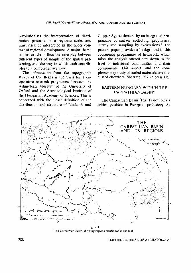
The Carpathian Basin (Fig. 1) occupies a critical position in European prehistory. As
18. F. m.
Figure 1 The Carpathian Basin, showing regions mentioned in the text.
288 OXFORD JOURNAL OF ARCHAEOLOGY
ANDREW SHERRATT
a major lowland area on the middle course of the Danube, it is connected by natural routes with the Mediterranean, the Pontic steppes, and the loess-lands of central Europe. It was important both in the initial spread of agriculture from the east Medi- terranean in the sixth millenium BC,5 and also in the transmission of elements from the steppe belt from the third millennium on- wards. Its largely enclosed character, ringed on all sides by mountains rising to over 1000 m, nevertheless made it the focus of a distinctive series of cultures which had a continuing influence on surrounding areas.
The Basin itself is a downfaulted median mass formed during the Tertiary mountain- building phase that produced the Alps and the Carpathiam6 Its sinking surface has been covered by the erosion products of the surrounding uplands. During the Miocene and Pliocene it was occupied by the sea, and marine limestones were deposited. These, mantled during the Pleistocene by loess, form the predominant landscape in the area to the west of the Danube-the historical Pannonia. The eastern part, affected by con- tinuing tectonic depression, has been filled by alluvial deposits of various kinds to prod- uce a level plain with only minor changes in relief-the Great Hungarian Plain ( N a g y Alfiild).
This contrast is accentuated by a climatic difference, the eastern part having the low rainfall and high evaporation characteristic of the Pontic steppe belt further east. While the western part forms a southern projection of the central European loess region, the eastern part has an individual character re- sulting from the combination of a con- centration of surface water from the surrounding mountains with a yearly pre- cipitation in the Plain of less than 600 mm. The slow drainage from its level surface has created a mosaic of marshy floodplains and
dry interfluves, in which minor differences in relief have a marked effect in creating suit- able conditions for early settlement.
This alluvial plain, covering an area of 100,000 km2, is surrounded first by a narrow terrace of marine limestones, and then by the ring of fold mountains, rich in the hard stone and metal ores sought by early man. The upland and lowland areas thus formed a complementary unity in their respective min- eral and agricultural resources.
In cultural terms, the western part of the Carpathian Basin has always had strong links via Moravia with the central European loess area, beginning with the formation there of the Neolithic Bandkeramik complex which spread throughout central Europe. This pattern may also be discerned in the later Neolithic and Copper Age Lengyel cul- ture, and was still evident in the Bronze Age. The eastern part of the Carpathian Basin, lacking an easy northern outlet, followed a rather different course, with more evident southern links. It formed the northern margin of early Neolithic cultures of Balk- an/Near Eastern character, and later in the Neolithic it again marked the furthest exten- sion of settlement types including tells. It was increasingly integrated within the cen- tral European sphere, however, first by the strengthening of links with the Ukraine and southern Poland across the north-eastern Carpathians and secondly by the infilling of the sandy area between the Tisza and the Danube which allowed the first cultural uni- fication of the Carpathian Basin in the Baden period.
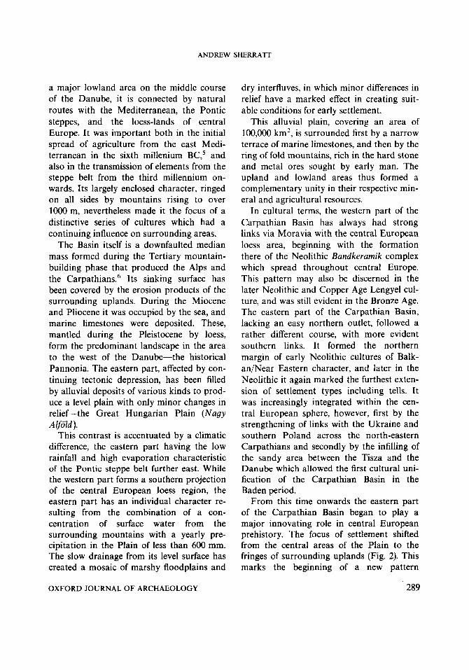
From this time onwards the eastern part of the Carpathian Basin began to play a major innovating role in central European prehistory. The focus of settlement shifted from the central areas of the Plain to the fringes of surrounding uplands (Fig. 2). This marks the beginning of a new pattern
OXFORD JOURNAL OF ARCHAEOLOGY 289
THE DEVELOPMENT OF NEOLITHIC AND COPPER AGE SETTLEMENT
T ISZAPOLGAR
Figure 2 The contrasting distribution of settlement in north-east Hungary in the Early Copper Age (Tiszapolgar) and Early
Bronze Age (Hatvan). From Bognar-Kutzian (1972) and Kalicz (1968).
characteristic of the Bronze Age, in which a powerful centre of political and cultural de- velopment emerged in the north-eastern part of the Carpathian Basin. The advanced social organisation and metallurgical skills associated with the rise of the Otomani cul- ture had a major impact on surrounding re- gions.
THE EVOLUTION OF THE EAST HUNGARIAN
LANDSCAPE
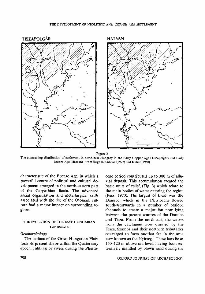
Geomorphology The surface of the Great Hungarian Plain
took its present shape within the Quaternary epoch. Infilling by rivers during the Pleisto-
cene period contributed up to 300 m of allu- vial deposit. This accumulation created the basic units of relief, (Fig. 3) which relate to the main bodies of water entering the region (Pecsi 1970). The largest of these was the Danube, which in the Pleistocene flowed south-westwards in a number of braided channels to create a major fan now lying between the present courses of the Danube and Tisza. From the north-east, the waters from the catchment now drained by the Tisza, Szamos and their northern tributaries converged to form another fan in the area now known as the Nyi r~kg.~ These fans lie at 150-120 m above sea-level, having been ex- tensively mantled by blown sand during the
290 OXFORD JOURNAL OF ARCHAEOLOGY
ANDREW SHERRATT
12' 1
EASTERN HUNGARY GEOMORPHOLOGY AND EVOLUTION OF DRAINAGE
I 10' 22'
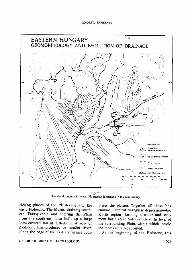
Figure 3 The development of the east Hungarian landscape in the Quaternary.
closing phases of the Pleistocene and the early Holocene. The Maros, draining south- ern Transylvania and entering the Plain from the south-east, also built up a large loess-covered fan at 110-90 m. A row of piedmont fans produced by smaller rivers along the edge of the Tertiary terrace com-
pletes the picture. Together, all these fans enclose a central triangular depression-the Koros region-forming a water and sedi- ment basin some 5-10 m below the level of the surrounding Plain, within which loessic sediments were redeposited.
At the beginning of the Holocene, this
OXFORD JOURNAL OF ARCHAEOLOGY 29 1

THE DEVELOPMENT OF NEOLITHIC A N D COPPER AGE SETTLEMENT
EASTERN HUNGARY LANDSCAPE TYPES
b
12’
I I’
- h f u i W B t e r W Y S
Modified from Peca and ahus
1 I
Figure 4 ., The geomorphic units of eastern Hungary and their associated soils. (These units are used in outline as the base-maps
for Figs 1Cb15.)
area received water from all the surrounding This major river, flowing across the area in a territories (Papp 1969), the greatest volume south-westerly direction, built up a substan- being supplied by the palaeo- tial series of raised beds at about 85 m, Szamos -k Tisza, which flowed along the with backswamps on either side. Its fre- southern margin of the Nyirseg in a valley quently changing course created a tangle of now occupied by a small creek called the Er. old channels outlined by levees, coalescing
292 OXFORD JOURNAL OF ARCHAEOLOGY
ANDREW SHERRATT
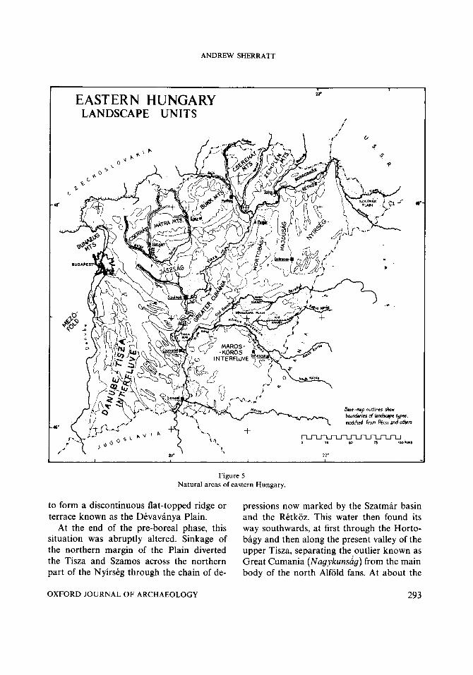
EASTERN HUNGARY LANDSCAPE UNITS
, 1
Figure 5 Natural areas of eastern Hungary.
to form a discontinuous flat-topped ridge or terrace known as the Devavanya Plain.
At the end of the pre-boreal phase, this situation was abruptly altered. Sinkage of the northern margin of the Plain diverted the Tisza and Szamos across the northern part of the Nyirseg through the chain of de-
OXFORD JOURNAL OF ARCHAEOLOGY
pressions now marked by the Szatmar basin and the Retkoz. This water then found its way southwards, at first through the Horto- bagy and then along the present valley of the upper Tisza, separating the outlier known as Great Cumania (Nagykunsug) from the main body of the north Alfold fans. At about the
293

THE DEVELOPMENT OF NEOLITHIC AND COPPER AGE SETTLEMENT
same time the Maros also moved south- wards to occupy its present course. These two diversions reduced the hydrographic im- portance of the Koros region and interrup- ted the process of infilling. The rivers draining into it were now smaller, and the sediments which continued to accumulate there became generally finer. The Dtvavanya Plain was left in a fossilised form, as the Beretty6 and Rapid Koros spread respec- tively into the backswamps on either side, where their slow drainage created the bog- like conditions of the Great (Nagy-) and the Little (Kis - ) Sarret (lit. ‘bog-meadow’). Water from the Tisza and Szamos still occasionally found its way into this region as overspill in times of flood, following both the Er valley and the Hortobagy.
The floods of the Tisza and its tributaries occur in two peaks, one in early spring and a larger one in early summer, the former caused by snowmelt and the latter by rain- fall. At these times the water occupied large parts of the Koros area, depositing a black organic meadow-clay that contrasts with the yellow loessic deposits of the ridges. The river-courses themselves were in any case highly unstable, with extensive meanders and ox-bow lakes reflecting frequent changes of course. Regulation of the Tisza during the nineteenth century reduced its length by approximately one third, and all the rivers of the Plain are now constrained by massive dykes. This canalisation, by restricting the flood areas and altering the water-table, had extensive secondary effects on sedimentation and soil-formation.
Soils and Vegetation
The soils of eastern Hungary are closely related to the relief (Fig. 4). The whole of the lowland area is dominated by processes pro-
ducing steppe soils (Somogyi 1964); only where the hills on the edge of the Plain rise to over 200 m, and in the north-eastern area where there is an increase in rainfall and summer moisture, do forest soils occur. Skeletal sandy soils occur on the Danube fan and the Nyirstg. Over the rest of the region, varieties of chernozem are the rule except where modified by groundwater conditions. There is a graduated sequence from true chernozem on the loess-covered fans to the alluvial and marsh soils of the floodplains. In between lie meadow chernozems, and the saline soils-solonetz and solonchak-that occur under a steppe climate where salt- charged groundwater evaporates at the sur- face. These soils are particularly important since they occupy a position intermediate between the dry soils of the interfluves and those of the low floodplain, where inun- dation inhibited cultivation and permanent settlement.
Most of the Great Hungarian Plain is covered by vegetation classified as forest steppe. Considerable areas, notably on the chernozem-covered interfluves, are unlikely to have undergone extensive afforestation during the Holocene. Riparian forests, how- ever, are likely to have been characteristic of the floodplain margins and wet depressions. The extent of forest cover on the lower ter- race now characterised by solenetz soils is problematic, but a mosaic of light forest and more open areas is most likely.
The landscape of the Great Hungarian Plain, therefore, as it presented itself to early settlers, offered a range of environments each with its attendant problems, from aridity to inundation. This fine balance of advantage made the choice of settlement-location a critical one, and the distribution of prehisto- ric sites is thus an important source of infor- mation on the ecological requirements of early farmers.
294 OXFORD JOURNAL OF ARCHAEOLOGY
ANDREW SHERRATT
THE CULTURAL SUCCESSION AND THE STRUCTURE OF REGIONAL CONTACTS
The well-investigated succession of Neo- lithic and Copper Age cultures and the growing number of radiocarbon dates pro- vide a firm framework for the interpretation of the settlement-evidence. The classification of these groups will be briefly reviewed in this section before presenting the details of their distributions.
T h e Neolithic Period The earliest agricultural communities in
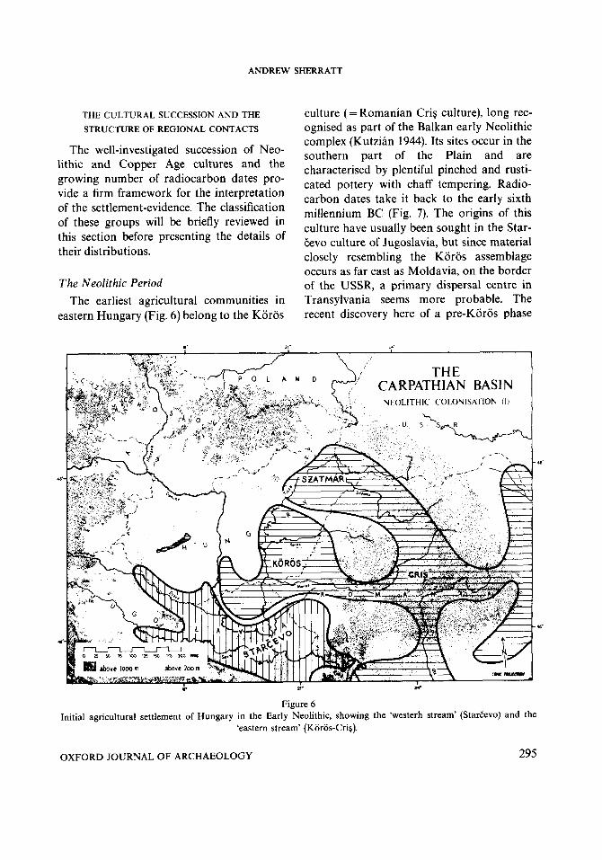
eastern Hungary (Fig. 6) belong to the Koros
culture ( = Romanian Cri$ culture), long rec- ognised as part of the Balkan early Neolithic complex (Kutzian 1944). Its sites occur in the southern part of the Plain and are characterised by plentiful pinched and rusti- cated pottery with chaff tempering. Radio- carbon dates take it back to the early sixth millennium BC (Fig. 7). The origins of this culture have usually been sought in the Star- Cevo culture of Jugoslavia, but since material closely resembling the Koros assemblage occurs as far east as Moldavia, on the border of the USSR, a primary dispersal centre in Transylvania seems more probable. The recent discovery here of a pre-Koros phase
Figure 6 Initial agricultural settlement of Hungary in the Early Neolithic, showing the ‘westerh stream’ (StarEevo) and the
‘eastern stream’ (Koros-Cri$).
OXFORD JOURNAL OF ARCHAEOLOGY 295
THE DEVELOPMENT OF NEOLITHIC AND COPPER AGE SETTLEMENT
? w .V lx 4 k cn
\ \
PROTO - V I N ~ A
A
B V I N ~ A -
VINCA - PLOCNIK C
D
TORWS - - _
( E A R L Y )
KOROS
( LATE
'r-
. . \
\ \
I I I
( EARLV )
( L A T E )
ji+KAL- SZAMOS/ TISZADOI HAT ESZTAR BUKK
:+ SZILMEG)
I
TISZA 1 HERPALY csosr- I HALOM I I I
7 - - - _ _ _ _ _ - - - - - - - PROTOTI S U P O L G A R
TI 5 tAPOLGAR
4200 b c
4000 b c
3500 bc
URANOVO I n CRl'i
4500 b c
VESELINOVO D U D E F I KOURILO
€ady LBK
W J A N O V E T S
VXDASTRA h t r LBK
MARICA. BOlAN GRAD ESHNITSA
PRECUCUTENI
Shhband K Htnhelstrin Ear[& Lcnyyel
GUMELNITSA SALCUTSA CUC UTEN I Rocssm Later Lcngyel
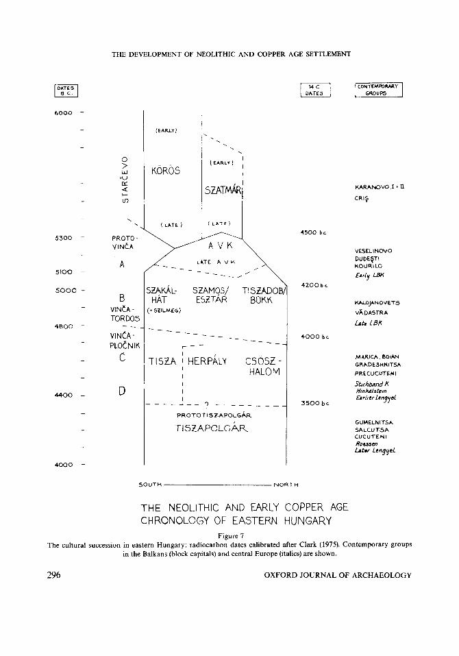
THE NEOLITHIC AND EARLY COPPER AGE CHRONOLOGY OF EASTERN HUNGARY
Figure 7 The cultural succession in eastern Hungary: radiocarbon dates calibrated after Clark (1975). Contemporary groups
in the Balkans (block capitals) and central Europe (italics) are shown.
296 OXFORD JOURNAL OF ARCHAEOLOGY
ANDREW SHERRATT
of painted pottery with strong analogies in northern Bulgaria (ComSa 1974) indicates the possibility of an eastern stream of Neo- lithic population, parallel to that of StarEevo further west, which would have provided the basis for such a Koros dispersal. In this case, the eastern part of the Carpathian Basin would have been the meeting point for two streams of incoming Neolithic population as shown in Fig. 6. True StarEevo sites occur in the southern part of Western Hungary where they are represented by recent finds at Lanycsok and Becsehely (Kalicz 1980).
A further element in this picture is the recently-defined Szatmar group in the north- east part of the Carpathian Basin with a ma- terial culture basically similar to that of Koros (Kalicz and Makkay 1977). It can plausibly be interpreted as a further move- ment from Transylvania around the north- ern margin of the Bihor Mountains. Far fewer sites are known than for Koros, and it probable arrived somewhat later (Fig. 6).
Around 5300 BC (4500 bc) major changes took place within the Carpathian Basin. Eastern Hungary became the focus of a new group centred in the Great Hungarian Plain, while western Hungary was occupied for the first time by agricultural groups expanding from the former StarEevo area. These changes must be seen as part of a wider reor- ganisation throughout south-east Europe, reflected in new cultural groupings such as VinCa and Veselinovo. The south part of the Carpathian Basin formed part of the zone characterised by dark, burnished pottery or- namented by channelling; in the south east (from Serbia along the Maros to Transylvania) it is represented by the VinEa culture, and in the south-west (along the Sava and Drava) by the related Sopot group. To the north of this zone, incised, linear or- nament was characteristic-the so-called LBK or Linienbandkeramik- which divides
into two regional groups. Within the pre- viously occupied area of the Great Hungarian Plain, the group known as AVK (Aroldi Vonaldiszes Keramia = Alfold Linear Pottery) developed from local Koros and Szatmar populations under strong VinEa influence (Kalicz and Makkay 1977). In the hitherto unoccupied area west of the Danube a new group, the west Hungarian branch of pan-European LBK, made its appearance as the first stage in a major movement of agricultural expansion.
These two groups in the east and west of the Carpathian Basin thus emerged in paral- lel, with a common background in the earl- ier agricultural communities of the Balkans. Although imports demonstrate a continuing contact between them, they continued on in- dependent lines of development. In terms of European prehistory, the western group was the more significant: for it was this group that carried agriculture into Moravia and northwards beyond the Carpathians to the whole of the central European loess belt from France to the Ukraine. Expansion in eastern Hungary took place along the val- leys reaching up into the mountain foreland to produce important peripheral groups in the karstic landscapes of north-east Hungary and Slovakia, but major expansion was blocked. While western Hungary maintained an important role as intermediary between the Balkans and central Europe, eastern Hungary continued an introverted devel- opment in which Balkan elements became increasingly pronomced.
The changes marked by the appearance of AVK and earliest western Bandkeramik seem to have been relatively rapid (Fig. 7), for by c.5200 BC (4300 bc) the cultural uni- formity of eastern Hungary had given way to a series of regional pottery styles, (Bognar- Kutzian 1966; Kalicz and Makkay 1977), with further VinEa influence in the south and
OXFORD JOURNAL OF ARCHAEOLOGY 297
THE DEVELOPMENT OF NEOLITHIC AND COPPER AGE SETTLEMENT
a lively focus of trade and stylistic inno- vation in the north. This pattern was more stable, lasting for some 3-400 years. On the lower and middle Tisza and along the Koros, the Szakalhat group is distinguished by pottery ornamented with paint outlined by incised decoration. To the north of this the Esztar group occupied a wide territory on the Nyirseg, Szamos and upper Berettyo, in which pottery with dark painted orna- ment was used. Various smaller groups emerged on the fringes of the northern mountains: Szilmeg in the Bukk foothills, Tiszadob in the Sajo valley, and Bukk in the mountains themselves, with exceptionally fine incised and occasionally painted pottery. All these groups are distinguished by their characteristic finewares, which occur in smaller quantities as imports in each others' areas. This small-scale cultural distinc- tiveness is probably related to a degree of economic differentiation, and the trade between mountain and plain in obsidian and other hard stones was greatly expanded. Biikk sherds and obsidian from the Tokaj and neighbouring sources occurs on VinEa sites in Serbia and southern Transylvania, a distance of 400 km.
Around 4800 BC (4000 bc) another hor- izon of stylistic cultural change can be ob- served in many parts of the Balkans, for instance in the transition from VinEa-Tordos to VinEa-PloEnik. At this time the Great Hungarian Plain saw the emergence of Late Neolithic groups represented by the Tisza and Herpaly-Csoszhalom groups (Bognar- Kutzian 1966). Decorated Tisza fine pottery, with its intricate incised, textile-like patterns is characteristic of the southern area and shows continuity from the Szakalhat group. The northern part of the Plain-with the ex- ception of the mountain fringes, where settle- ment was abandoned-was occupied by the Herpaly-Csoszhalom group, with painted
finewares. This replaced the multitude of smaller groups on the northern edge of the Plain, and is found in the former Esztar area. Small differences in the colour-combinations distinguish Herpaly from Csoszhalom, but together they differ from Tisza not only in their pottery but also in their settlement- pattern and in the occurrence of small num- bers of simple copper objects, for instance at Herpaly. Since both these groups shared a common set of domestic pottery, the sharp frontier between Tisza and Herpaly fine- wares may indicate a genuine social bound- ary that is particularly interesting because of the differences in settlement-types, in which true tells are confined to the north and east. These groups were long-lived, persisting for perhaps a 3-400 year span. During this period the elaborately-decorated finewares declined, with the final phase of Tisza being distinguished as the Gorzsa group.
The Copper Age A new pattern marks the beginning of the
Copper Age' around 4400 BC (3500 bc), when a much more uniform culture devel- oped over eastern Hungary and neighbour- ing parts of Transylvania (Bognar-Kutzian 1972). This. was the Tiszapolgar culture, which has a new range of shapes (especially pedestalled forms with decorative lugs), but lacks the element of painted decoration. The larger cemeteries of this period provide evi- dence of the first heavy copper objects and also goldwork. These indicate the rising wealth of areas on the edge of the Plain, with access both to the highland metal sources and to trade routes, which for the first time crossed the Carpathians to bring commodi- ties such as blades of Ukrainian flint into circulation. This new, outward-looking pat- tern reduced the importance of the hitherto wealthy central area.
By 4000 BC (3200 bc) this pattern may be
298 OXFORD JOURNAL OF ARCHAEOLOGY

ANDREW SHERRATT
NEOLITHIC & COPPER AGE POTTERY
BODROGKERESZT~R c 3900 - 3 5 0 0 BC
TI SZAPOLGAR c 4400- 3 9 0 0 BC
c 4800 - 4 4 0 0 BC
c 5100- 4800 BC
KOROS c 6000 - 5 3 0 0 BC
3 1 3 d
Figure 8 Selected pottery types characteristic of the main phases of the Neolithic and Copper Ages in eastern Hungary.
OXFORDJOURNALOFARCHAEOLOGY 299
THE DEVELOPMENT OF NEOLITHIC AND COPPER AGE SETTLEMENT
perceived with even greater clarity in the succeeding Bodrogkeresztur culture (Patay 1974). The scale of copper production was greatly expanded, with copper axes oc- curring in graves up to 200 km from the copper sources. This metalwork and even pottery occurs north of the Carpathians in Little Poland, while cultural mixing with late Salcutsa groups on the Lower Danube testifies to the increased importance of links in this direction also (Roman 1971).
The most radical break in the prehistory of this region occurred around 3500 BC (2800 bc). The appearance of the Baden cul- ture, with its roots in the Lengyel tradition of western Hungary and Czechoslovakia, marks the integration of eastern Hungary into a wider grouping including the whole of the Carpathian Basin (Banner 1956). The pottery assemblage was transformed by a new range of types including pails, jugs and cups that testify to fundamental changes in eating habits, with an increased importance of liquids. This occurs over a wide area of south-east and central Europe. The first evidence for the cart, and probably also the plough, appear at this time (Sherratt 1981).
Another important development of this period was the appearance of large numbers of tumuli (some up to 70 m in diameter and 10 m high) containing burials covered by planks and hides, with the body in a charac- teristic supine position, with knees drawn up, and the skull painted with stripes of red ochre. They have few grave-goods, but oc- casionally earrings of silver. Such burials have close analogies on the Pontic steppes, and other examples are known from the lower Danube. They have plausibly been in- terpreted as evidence for an intrusive steppe population, maintaining a cultural distinc- tiveness alongside native groups (Ecsedy 1979).
The Early Bronze Age By 2800 BC (2200 bc) these populations
had fused to form the Early Bronze Age groups of this area, broadly divided between a north-eastern (NyirsCg) group and a cen- tral (Mako) group (Kalicz 1968). Innovations at this time include improved techniques of copperworking such as the two-piece mould and the new types it made possible, and also the advent of horse-breeding on a large scale. Trade in metal items, and also warfare increased in significance, reaching their full development in the NagurCv, Hatvan, Oto- mani and Perjamos cultures. These occupy discrete territories, the first on the Danube and middle Tisza, the second and third in northern and north eastern Hungary, and the last on the Maros. These are more than simply ceramic styles, and the burial evi- dence indicates that they may be consciously distinguished cultural groups (O’Shea 1978). Sites of this period show significant new fea- tures such as large cemeteries with several hundred graves (especially in the south, on the major rivers at the Maros confluence) and the reappearance of tell sites, which now had a fortified character. These are especially common on the margins of the Basin, (though flat sites fortified with ring ditches are known from the Koros region). The Oto- mani culture in particular shows a new level of centralisation, and its sites have produced evidence of bronze- and gold-working, early ironwork, chariotry and stone-built fortifi- cations (Vladar 1973).
THE REGIONAL DISTRIBUTION OF SETTLEMENT
The agricultural occupation of eastern Hungary in the periods described in the pre- ceding section may be followed in the series of distribution maps presented in Figs I& 1 5.9 What is essential to such comparisons, however, is an appreciation of how this
300 OXFORD JOURNAL OF ARCHAEOLOGY

ANDREW SHERRATT
archaeological record has been built up and how it must be supplemented by future re- search. The characteristics of this record will therefore be briefly reviewed before dis- cussion of the distributions.
History of research Hungary has a long tradition of archae-
ological research, with the oldest national museum in Europe, founded in 1802. As well as this national focus, local museums and amateur societies have been active from the later nineteenth century onwards. By the time of the International Congress of Pre- historic Anthropology and Archaeology in Budapest in 1876, organised by Floris Romer, (1878) commissions with local correspon- dents were investigating the problems of ob- sidian distribution, tell settlements, tumuli and hillforts. County archaeological maps were exhibited at the Congress. The Tisza/ Koros region was well represented, with re- ports on excavations at the Bronze Age tell of Nagyrev and finds from the important Tisza culture sites of Szegvar-Tuzkoves and Bektsszentandras (Romer 1878). Before the First World War excavations had taken place at the eponymous sites of Lengyel (1880s), Tiszapolgar (1900s) and the crucial Bronze Age tell at Toszeg (1906-13).
Investigations in the Interwar years clar- ified the Neolithic cultural succession (Tompa 1929, 1937) and saw extensive re- gional fieldwork-notably by Janos Banner (1942) in the Szeged-Hodmezovasarhely area and by Jeno Hillebrand (1937) in the Bukk mountains. Kutzian summarised the Koros culture, and since the Second World War further monographs in the series Archaeolo- gia Hungarica have described the as- semblages and known findspots of the Koros, AVK, Tiszapolgar, Baden and EBA cultures, (Kalicz and Makkay 1977, Bognar- Kutzian 1972, Banner 1956, Kalicz 1968)
while Bodrogkeresztur has been summarised in a major article (Patay 1974). Only the Tisza-Herpaly-Csoszhalom complex remains without monographic treatment. Excavations on tell settlements have taken place at Herpaly, Tape-Lebo, Szegvar-Tuzkoves, Battonya-Pariustanya and Veszto Magor, as well as the settlement and cemetery at Aszod and at many Koros sites."
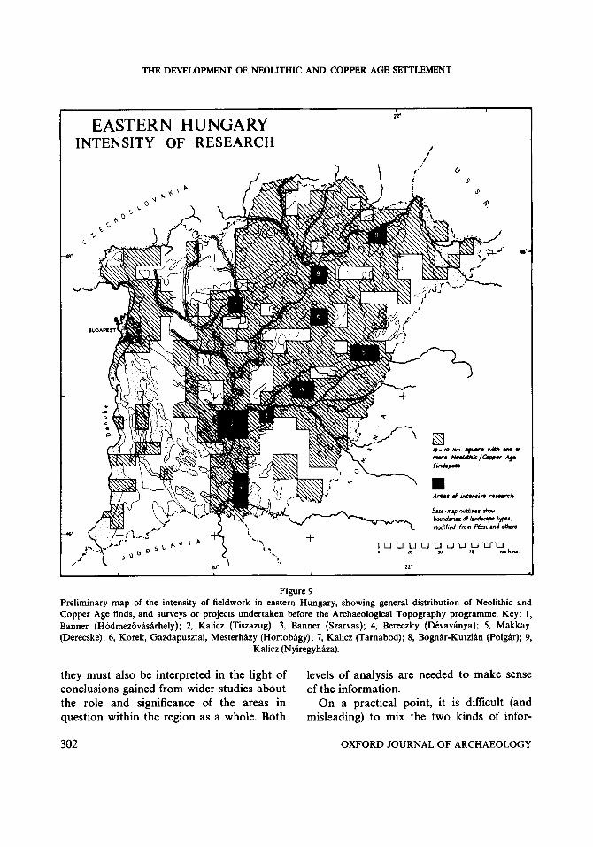
At the same time regional surveys have been conducted, first by Kalicz in the Tisa- zug (1957), by Bognar-Kutzian in connection with the major excavation of the Tiszapolgar cemetery (Bognar-Kutzian 1963), and by Makkay near Derecske (Makkay 1957). These pioneer projects have led to a current interest in the discovery and registration of sites, fuelled by the need to identify priorities in rescue work on the part of local institu- tions in many areas. This work has been or- ganised and given central direction by the Hungarian Academy in the programme of the Archaeological Topography of Hungary (Magyarorszag RCgCszeti Topograjaja), a county-by-county survey of finds, sites, and monuments. Although the initial volumes have been concerned with western Hungary (Co. Veszprem, Co. Komarom), a major pro- gramme on the northern part of Co. Bekes (covering the Koros area from the Roman- ian border to Szarvas) is nearing completion (e.g. Ecsedy et al. in press). This work is unique in its scale and sustained intensity, and has multiplied the number of known prehistoric sites by a factor of ten.
These planned surveys represent a new threshold in the discovery of prehistoric settlement-patterns which complements the overall picture built up by chance finds and selective recording. They can be used to cali- brate existing maps by demonstrating the arbitrary character of existing records and indicating the real nature of changes in the number, character and location of sites. But
OXFORD JOURNAL OF ARCHAEOLOGY 301
THE DEVELOPMENT OF NEOLITHIC AND COPPER AGE SETTLEMENT
I 22.
EASTERN HUNGARY INTENSITY OF RESEARCH 1
.i
11. I
Figure 9 Preliminary map of the intensity of fieldwork in eastern Hungary, showing general distribution of Neolithic and Copper Age finds, and surveys or projects undertaken before the Archaeological Topography programme. Key: 1, Banner (Hodmezovasarhely); 2, Kalicz (Tiszazug); 3, Banner (Szarvas); 4, Bereczky (Dtvavanya); 5, Makkay (Derecske); 6, Korek, Gazdapusztai, Mesterhby (Hortobagy); 7, Kalicz (Tarnabod); 8, Bognar-Kutzian (Polgar); 9,
Kalicz (Nyiregyhaza).
they must also be interpreted in the light of conclusions gained from wider studies about the role and significance of the areas in question within the region as a whole. Both
levels of analysis are needed to make sense of the information.
On a practical point, it is difficult (and misleading) to mix the two kinds of infor-
302 OXFORD JOURNAL OF ARCHAEOLOGY

ANDREW SHERRATT
mation on a single small-scale map. It is better to realise that traditional distribution- maps indicate only the occurrence of sites in a given area, but not their relative density: this can only be assessed from full survey data." For this reason, findspots from the recent Topographic Survey have not been plotted on the small-scale regional maps. Fig. 9 shows a first attempt to map the intensity of research which underlies the following dis- tributions.
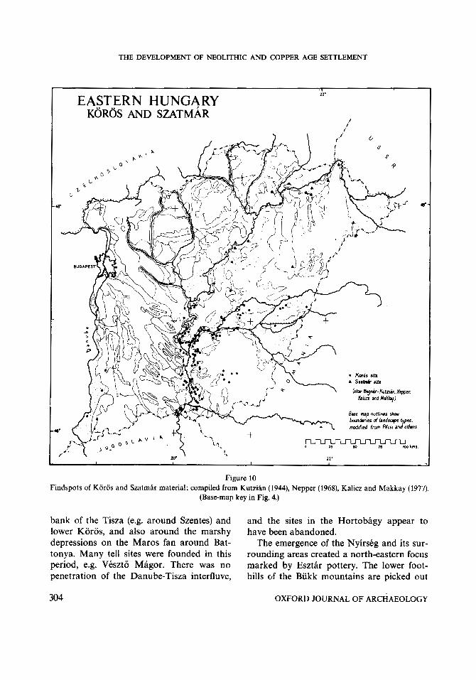
The Koros and Szatmcir cultures (Fig. 10) The first Neolithic communities show a
strongly constrained distribution with a riverine emphasis and little or no expansion into the side valleys or onto the fans. The Koros and Szatmar distributions are very similar in this respect, and their complemen- tary character, with a boundary on the middle Tisza, is consistent with a conver- gence along the Tisza from south and north respectively. Although the apparent clusters of settlement are largely related to the inten- sity of fieldwork (e.g. around Hodmezovas- arhely and in the Tiszazug), there appears to be a real difference between the density of Koros sites and those of Szatmar. The very high density of Koros sites is remarkable, and contrasts in this respect also with Star- Zevo (Kalicz 1980). Where the floodplain is narrow, the sites show a linear arrangement on bluffs overlooking the valley; where the floodplain is broader they occur on the small islands of higher ground within it. In places (as around Hodmezovasarhely) the pattern of sites may relate to an earlier course of the Tisza. The only exception to the general ri- verine distribution is the group of sites on the Maros fan around Oroshaza, which may indicate more extensive penetration of this region. By comparison with the following period there is a notable absence of sites on
the broad, flat floodplains of the Hortobagy and the middle Tisza.
Excavated evidence of the Koros economy demonstrates a substantial seasonal contri- bution from fishing, shellfish-gathering and fowling, as well as the cultivation of grain and the keeping of domestic livestock, mainly sheep (Bokonyi 1974). Clay weights, probably net-sinkers, are common finds.
The A@d Linear Pottery ( A V K ) culture (Fig. 11)
This period was probably shorter than the others considered here, and is contemporary with the earliest phases of the VinEa culture (sites not known), which extended up to the Maros confluence. The basic pattern resem- bles that of Koros, with some additional movement along the side-valleys up into the Jaszsag and along the Sajo, with an initial penetration into the foothills. (It is likely that some of the sites of the Tiszadob group shown in the following map began before the end of this period.) A complementary ex- pansion occurred on the floodplain to the north of the middle Tisza, and in the now highly saline lands of the Hortobagy. The distribution was still predominantly riverine, with no settlement of the northern fan on the Hajdusag and Nyirseg.
The economy is less well known, but there are indications that there was less reliance on wild resources and a greater emphasis on cattle and perhaps cereals. Net-sinkers no longer occur.
Szakalhat and i ts contemporaries (Fig. 12) This period saw a general expansion in the
north, encompassing the Jaszsag, the north- ern foothills and limestone mountains, and the Nyirseg with its surrounding floodplains-the upper Tisza depressions and the upper Berettyo. Some expansion is also observable in the south, on the east
OXFORD JOURNAL OF ARCHAEOLOGY 303
THE DEVELOPMENT OF NEOLITHIC AND COPPER AGE SETTLEMENT
1 22’ EASTERN HUNGARY
KOROS AND SZATMAR I
I I
I ,
Figure 10 Findspots of Koros and Szatmar material; compiled from Kutzian (1944), Nepper (1968), Kalicz and Makkay (1977).
(Base-map key in Fig. 4.)
bank of the Tisza (e.g. around Szentes) and and the sites in the Hortobagy appear to lower Koros, and also around the marshy have been abandoned. depressions on the Maros fan around Bat- The emergence of the Nyirskg and its sur- tonya. Many tell sites were founded in this rounding areas created a north-eastern focus period, e.g. Veszto Magor. There was no marked by Esztar pottery. The lower foot- penetration of the Danube-Tisza interfluve, hills of the Bukk mountains are picked out
304 OXFORD JOURNAL OF ARCHAEOLOGY

ANDREW SHERRATT
EASTERN HUNGARY A.Y K.
ir
/ i
i
Figure 11 Findspots of AVK material; from Kalicz and Makkay (1977). (Findspots of contemporary Transdanubian LBK not
shown.)
by the curious small concentration of the which are also represented on the Retkoz Szilmeg group, extending to the opposite and the northern Nyirstg. bank of the Tisza. The mountains them- Bukk sites, (both on terraces and in the selves, and the adjacent valleys of the Sajo plentiful caves) occur in the greatest number and the Hernad, were the focus of the dis- in the limestone mountains of the Bukk itself tinctive Tiszadob and the Bukk groups, and the North Borsod Karst. The absence of
OXFORD JOURNAL OF ARCHAEOLOGY 305
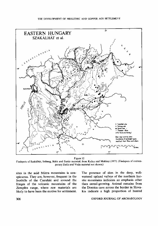
THE DEVELOPMENT OF NEOLITHIC AND COPPER AGE SETTLEMENT
22'
EASTERN HUNGARY SZAKALHAT et al.
I i
i
Figure 12 Findspots of Szakalhat, Szilmeg, Bukk and Esztar material; from Kalicz and Makkay (1977). (Findspots of contem-
porary Zseliz and VinEa material not shown.)
sites in the acid Matra mountains is con- The presence of sites in the deep, well- spicuous. They are, however, frequent in the watered upland valleys of the northern kar- foothills of the Cserehat and around the stic mountains indicates an emphasis other fringes of the volcanic mountains of the than cereal-growing. Animal remains from Zemplen range, where raw materials are the Domica cave across the border in Slova- likely to have been the motive for settlement. kia indicate a high proportion of hunted
306 OXFORD JOURNAL OF ARCHAEOLOGY
ANDREW SHERRATT
species, with predominance of sheep among the domestic stock. Within the cave, lines of postholes outline rectangular pens some 3 by 4 m, while smaller camp-sites occur nearby next to springs. These indicate the import- ance of animal-keeping, perhaps on a trans- humant basis, though carbonised cereals and grinders indicate the consumption of grain. The village-like open sites at lower altitudes had an economy similar to that of sites in the Plain, based on cattle-keeping (Lichardus 1974).
An important element in the economy of the region was trade, both in raw materials and manufactured products.' Although the limestone areas themselves have no hard rocks, the andesites and rhyolites of the Bukk foothills and the ZemplCn mountains, along with the obsidian deposits of the latter (especially around Erdohorvati) were both exploited and widely traded. Hoards of blades in local siliceous rock are known from Barca and Boldogkovaralja-the latter apparently an obsidian workshop also-and there is a group of nine axes from Domica (Kalicz and Makkay 1977; Lichardus 1974). Bukk groups were active both in the direct exploitation of these resources and as middle- men in their distribution both northwards and southwards. Another traded commodity was pottery-apparently manufactured from terra rossa in the caves themselves. This was superbly decorated with fine parallel lines and was traded over a similar area as obsid- ian, as far as Serbia, Transylvania and south- ern Poland. The economy of these sites cannot be understood in terms of local self- sufficiency.
In the Plain to the south the prosperity of this period is emphasised both by the number and size of sites and by their evident ability to acquire highland products and ma- terials. The emphasis on cattle has prompted speculation that this formed an important
traded commodity in its own right (Sherratt 1982).
Tisza-Herpaly-Csoszhalom The sites of this period have not been sys-
tematically mapped, but from the known distribution a great similarity to that of the preceding groups may be inferred, the main difference being the lack of sites in the north- ern mountain fringe. Continuity in the main cultural boundary, from Szakalhat/Esztar to Tisza/Herpaly-Csoszhalom is very striking, with a proliferation of sites in the upper Berettyo region, which continued as a major focus of settlement. Large numbers of tell sites (including Herpaly itself: Korek and Patay 1956) are known from this area. The tell at Csoszhalom near Polgar (Bognar- Kutzian 1958) can be seen as part of the northern wing of this group on the other side of the Nyirseg.
In the Tisza province further south two types of settlement are known (Kalicz 1965): a zone of 'pit settlements' on the middle Tisza and a zone on the Lower Tisza and Koros where very large aggregated sites up to a kilometre across are ~ o m m o n . ' ~ Such sites are usually near to important river links, and may reflect the advantages of con- gregation at nodal points of trade. (This seems to be the case in the VinEa area, as at VinEa itself.) The smaller size of Herpaly tells may thus reflect a different organisation of trading activity in a zone with more immedi- ate access to highland resources.
The lowland economy continued to be dominated by cattle-raising, with high pro- portions of large animals of aurochs size on sites of the Herpaly-Csoszhalom group (Bokonyi 1974). Lowland sites continued to import large quantities of highland ma- terials. The lack of sites in the mountains appears to indicate that control of these re- sources now lay with adjacent lowland
OXFORD JOURNAL OF ARCHAEOLOGY 307
THE DEVELOPMENT OF NEOLITHIC AND COPPER AGE SETTLEMENT
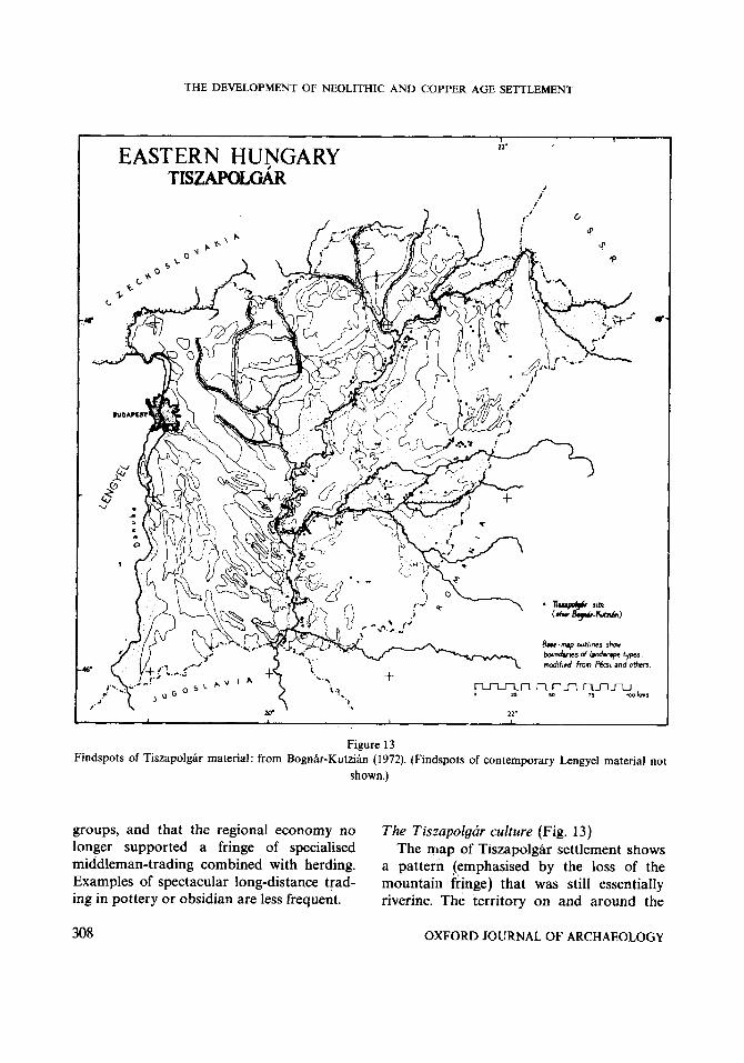
EASTERN HUNGARY TISZAPOLGiR
1 22'
I i
Findspots of Tiszapolgar material: from Bognar-Kutzian (1 972). (Findspots of contemporary Lengyel material not shown.)
groups, and that the regional economy no The Tiszapolgar culture (Fig. 13) longer supported a fringe of specialised The map of Tiszapolgar settlement shows middleman-trading combined with herding. a pattern (emphasised by the loss of the Examples of spectacular long-distance trad- mountain fringe) that was still essentially ing in pottery or obsidian are less frequent. riverine. The territory on and around the
308 OXFORD JOURNAL OF ARCHAEOLOGY
ANDREW SHERRATT
Nyirseg remained the main area of interest outside the river valleys. Contemporary Lengyel groups again occupied the north- west of the area (sites not shown) on the upper Galga and Zagyva, forming a link westwards from the Jaszsag. One or two Tis- zapolgar sites are known from the eastern fringes of the Danube-Tisza Interfluve, but there was no real penetration of this area. The Koros-Berettyo area was well popu- lated, while Makkay’s survey of the Derecske region (1957) indicated a large number of sites between the upper Berettyo and the Nyirseg. The Polgar area is similarly highlighted by Bognar-Kutzian’s work, while the Tiszazug again shows the plentiful sites from Kalicz’ survey. Two areas of settlement, indicating the possibility of further sites, are picked out on the Maros fan, around Or- oshhza and Battonya.
Although they have not been differen- tiated on the map, large cemetery sites are known. The Tiszapolgar-Basatanya cem- etery contained over 60 graves of this period and was not directly associated with an adjacent settlement (Bognar-Kutzian 1963). Such cemeteries seem to have had a distinc- tive role in the settlement pattern, perhaps serving as the common focus for several small hamlets.
Subsistence evidence shows a continuing emphasis on cattle, though now without the large, aurochs-sized specimens that have been interpreted as evidence of hunting and local domestication. A new traded com- modity, however, was the heavy copper axe, mostly in the form of simple axe-hammers. The distribution of these finds (Schubert 1965) is notably restricted to the edge of the Plain, mostly outside Hungary: one group occurs in the north-east, for instance as grave- goods at Luiky and Tibava in Slovakia, another group is at the foot of the Rezhegy- seg (Copper mountains) along the head-
waters of the Berettyo in Romania, and a third lies in the portion of the Plain in northern Jugoslavia (Bognar-Kutzian 1972). The central area of the Plain, although well populated, was not rich in metal goods.
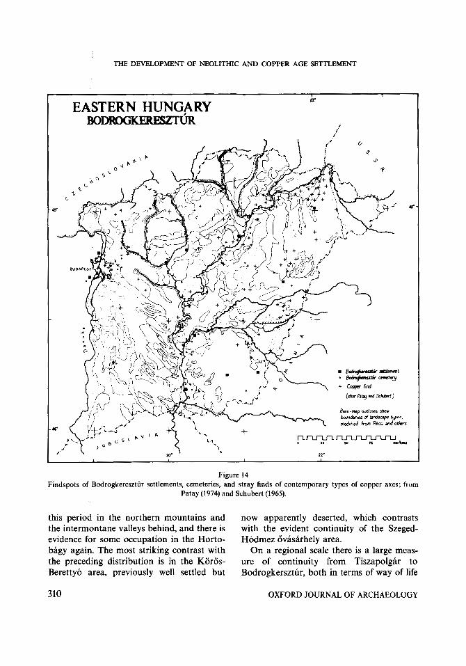
Bodrogkeresztur (Fig. 14) The map of this period is more compli-
cated, since it attempts to differentiate settle- ments and cemeteries, and also records stray finds of copper axes. Characteristically, rather few settlements have been recognised, though eight times as many cemeteries are known and an equal number of stray axes- many themselves probably derived from de- stroyed graves. Cemeteries clearly continued to be important in the settlement pattern, and the Tiszapolgar-Basatanya cemetery contained nearly 100 graves of this period. The small number of settlement-sites is partly related to the difficulty of recognising Bodrogkeresztur pottery, only a small pro- portion of which is decorated. The distri- bution of sites defined on the occurrence of pottery (less than half the number of com- parable Tiszapolgar sites) can usefully be supplemented by findspots of types of copper axes known to belong to this period. This information amplifies, but does not radically change, the basic pattern shown by settlements and cemeteries.
While the riverine axis continued to be important, a scatter of sites occurs on the fans, notably on the Nyirseg and less obvi- ously on the Maros fan (though this may be due to the poorer representation of metal finds in the central part of the Plain). Some increase in activity is evident on the Danube-Tisza Interfluve, while the import- ant linking area between the Jaszsag and the Danube bend was absorbed from Lengyel into the Bodrogkeresztur grouping, empha- sising the increasing significance of east-west links. Small numbers of finds reappear at
OXFORD JOURNAL OF ARCHAEOLOGY 309
THE DEVELOPMENT OF NEOLITHIC AND COPPER AGE SETTLEMENT
I I "I Y
EASTERN HUNGARY BoDRoGKEREszTljR I I
Figure 14 Findspots of Bodrogkeresztar settlements, cemeteries, and stray finds of contemporary types of copper axes; from
Patay (1974) and Schubert (1965).
tnis perioa in me norrnern rnouncains anu IIVW appa i~ i i~ iy u G a G 1 CGU, wlllL1l LVIILIaJLa
the intermontane valleys behind, and there is with the evident continuity of the Szeged- evidence for some occupation in the Horto- Hodmez ovasarhely area. bagy again. The most striking contrast with On a regional scale there is a large meas- the preceding distribution is in the Koros- ure of continuity from Tiszapolgar to Berettyo area, previously well settled but Bodrogkersztur, both in terms of way of life
310 OXFORD JOURNAL OF ARCHAEOLOGY

ANDREW SHERRATT
(continuity in ceramic forms, similar subsis- tence pattern) and in the continuity of parti- cular sites such as the Tiszapolgar cemetery. The distribution of copper objects, too, shows a similar pattern but on an expanded scale (Schubert 1965). The greatest densities are on the northern Nyirseg and the upper Tisza, probably representing the east Slova- kian centre exemplified in the previous period by Tibava; the southern NyirsCg, upper Berettyo and north-east Maros fan, again the western fringe of a Transylvanian group; and in the area of the Danube bend, reflecting west Slovakian sources. A few strays from Serbian sources complete the picture in the south. Relatively few copper objects reached the central part of eastern Hungary, Tiszazug and the lower Koros.
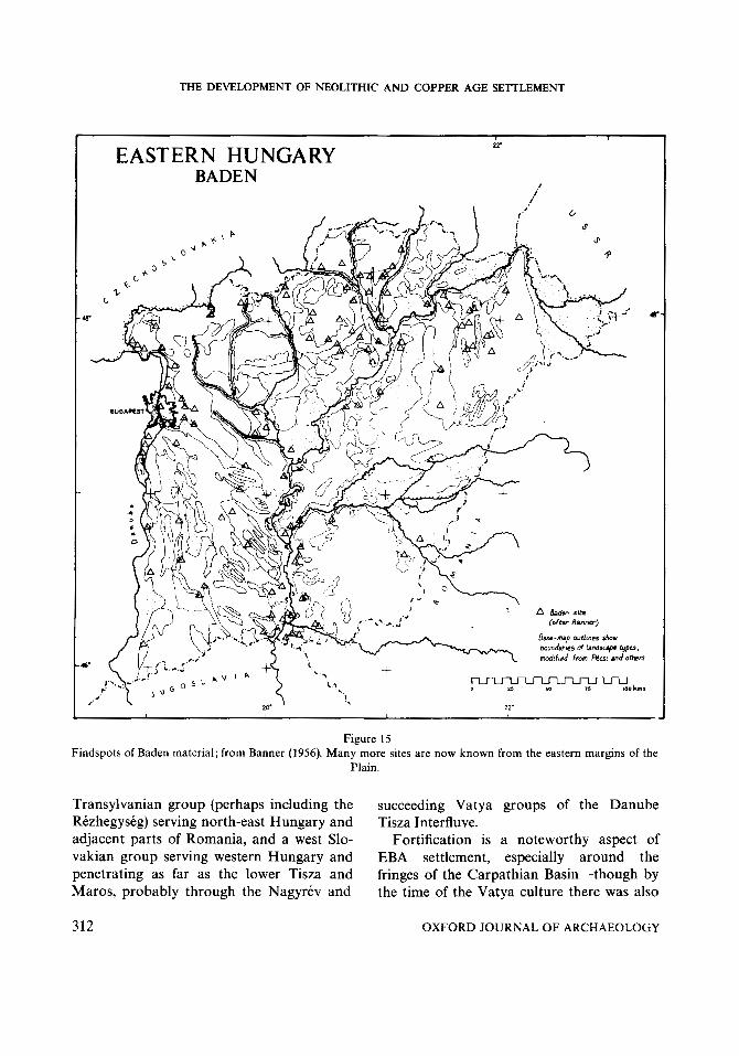
Baden (Fig. 15) and Early Bronze Age Banner’s map of sites belonging to the
Baden complex was published in his mono- graph of 1956, and has a serious gap in its coverage of lowland eastern Hungary. A recently-published map of the adjacent area of Romania (Roman and Nemeti 1978) gives a better impression of the numbers of sites now known. Together, these two maps in- dicate the growing importance of the areas on the edges of the Plain. In particular, in- termontane valleys such as those of the Her- nad and Sajo now supported a substantial population, both in their lower reaches and along their headwaters in Slovakia. This substantial upland expansion brought to an end the dominance of the Plain. There is some suggestion of an emphasis on cattle in the upland valleys and on sheep in the low- lands (Bokonyi 1974). Sites (including the well-known cemetery of Alsonemedi) ap- peared at this time on the Danube-Tisza In- terfluve in larger numbers, and opened further westward links.
Bronze Age sites have been accurately
mapped only for certain cultures (e.g. Kalicz 1968), but the general pattern follows strong- ly from Baden and shows the continuing im- portance of the basin-edge as opposed to the centre of the Plain. The magnitude of this contrast is well summarised in Fig. 2, which compares the Tiszapolgar distribution with that of Hatvan. The main EBA concentration is along the northern margin of the Plain, and picks out the line of the terrace between the Jaszsag and the Hernad-Saj6 confluence. Many of these sites are tells, including the eponymous examples of Hatvan and Fiizesa- bony. This line, (now followed by the main Budapest-Miskolc road), was an important route of contact and trade, especially as horses were now bred in large numbers and bone harness-pieces are not uncommon finds.
The role of trade is also significant in ex- plaining the continuing importance of the major rivers within the Plain. Positions on the river itself, rather than just with access to the soils of the floodplain margin, were es- pecially sought. The Tisza and the Maros, with their potential for long-distance trade by dugout canoe, were more important than the Koros in this context. It is significant that the name of the eponymous EBA site on the central Tisza, Nagyrev, actually means ‘Great port’. The concentration of large cem- eteries at the Maros confluence (Szoreg, Deszk, Oszentivan etc.) is also notable, and imported items such as copper ornaments and fossil shell beads are conspicuous items in the graves (O’Shea 1978).
The large volumes of bronze goods in circulation are indicated by stray finds and hoards, whose distributions form a special topic that will not be considered here, (though see maps in Bona 1975, Mozsolics 1967 and 1973, Hansel 1968). The overall pattern of metal supply, however was domi- nated by two groups of sources: a north
OXFORD JOURNAL OF ARCHAEOLOGY 311
THE DEVELOPMENT OF NEOLITHIC AND COPPER AGE SETTLEMENT
Figure 15 Findspots of Baden material; from Banner (1956). Many more sites are now known from the eastern margins of the
Plain.
Transylvanian group (perhaps including the succeeding Vatya groups of the Danube Rezhegyskg) serving north-east Hungary and Tisza Interfluve. adjacent parts of Romania, and a west Slo- Fortification is a noteworthy aspect of vakian group serving western Hungary and EBA settlement, especially around the penetrating as far as the lower Tisza and fringes of the Carpathian Basin-though by Maros, probably through the Nagyrev and the time of the Vatya culture there was also
312 OXFORD JOURNAL OF ARCHAEOLOGY

ANDREW SHERRATT
a ring of ‘hillforts’ around the territory of this culture in the strategic linking area between the Danube and Tisza. The most striking examples of defensive works are the major fortified centres at Barca and SpiSsky Stvrtok in the montane valleys of Slovakia, which have notable concentrations of wealth (Vladar 1973); but many of the lower-order tell- and flat sites throughout the region were protected by concentric ditches.
CONCLUSIONS
Systematic comparison of the patterns of finds over the 4000 years from the Neolithic to the Early Bronze Age demonstrates a con- siderable measure of continuity in the areas chosen for settlement, but also important variations both in the central area of the Plain and on the margins of the occupied area.
The rivers played a primary role, first in the initial dispersal of population, secondly through their association with well-watered environments, and increasingly because of the role of the waterways in trade. Year- round settlement in the floodplain itself was precluded by the spring and early summer floods; yet the broad interfluvial areas with their low rainfall were equally unsuitable for early agriculture. Early settlement was there- fore concentrated on the lower terrace or in- termediate zone, overlooking the floodplain, either beside the major rivers or on raised areas with the basins defined by the larger fans. Along the active river-courses, this gave settlement a linear character, as in the Tisza- zug; elsewhere clusters of settlement oc- curred where sites occupied the margins of small islands rising from the floodplain, as in the area around Hodmezovasarhely or the Devavanya Plain.
Some settlement took place within the
Maros fan and the Nyirseg, but occupation here was less continuous and confined to favourable depressions. Very little penetra- tion of the Danube-Tisza Interfluve took place until Baden times. The upland fringe experienced a brief, specialised occupation in the Biikk period, after which settlement was again largely confined to the plains. Per- manent occupation was pushed up the river valleys penetrating into the highlands during the Baden period, initiating a general move- ment of population from the central part of the Carpathian Basin to the edges, particu- larly along the northern and eastern terrace margins where the main concentration of Bronze Age tell sites occurs.
The area of the Koros-Berettyo depres- sion, for which more detailed evidence is available, was thus a core area of Neolithic settlement which gradually lost its import- ance in the later periods. The marked local shift in population at the time of Bodrog- keresztur raises the possibility that signifi- cant ecological change took place in this extensive lowland area at this time; but the long-term decline of this area must also be related to its structural position in the con- text of the expanding margin of settlement in the Carpathian Basin as a whole.
The detailed settlement-patterns which can be reconstructed from planned surveys such as that in the northern part of Co. Bekes make it possible to examine the rela- tive densities of settlement over this period and to follow these changes in terms of the location of particular sites. The broad geo- graphical treatment of this section can thus be refined to deal with the behaviour of indi- vidual communities. This aspect will be fol- lowed further in Part 2 of this paper.I4
Ashmolean Museum Oxforir
OXFORD JOURNAL OF ARCHAEOLOGY 313
THE DEVELOPMENT OF NEOLITHIC AND COPPER AGE SETTLEMENT
NOTE4
1. Part 11, dealing with the detailed area survey, will be presented in the following issue of this journal. 2. Magyarorszhg Rkgkszeti Topograjiaja: Vols. 1-4, Co. VeszprCm (1966-1972); Vol. 5, Co. KomProm (1979); Vol. 6 Co. BCkCs (in press). 3. The programme of Hungarian-British fieldwork is directed jointly by Dr. Istvan Torma and the author. 4. The natural physiographic unit is the Carpathian Basin, consisting of Pannonia in the west, the Great Hungarian Plain in the centre and Transylvania in the east. This was also a political entity until 1920, when it was divided between Hungary, Romania and Jugo- slavia. Since recent research has been organised within these national boundaries, the term ‘eastern Hungary’ is used here to describe the territory of the present Hungarian state east of the Danube. 5. Calibrated radiocarbon dates are used throughout, using the table provided in Clark (1975). Uncorrected radiocarbon dates are indicated as bc. 6. For a convenient introduction to Hungarian geogra- phy, see Pecsi and Sarfalvi (1964). The environmental background and its changes are usefully discussed from an archaeological standpoint in Kosse (1979). 7. For the names of these physiographic units and their location, see Fig. 5. 8. The Hungarian divisions of the later Neolithic and Copper Age do not directly correspond to other east European systems, where the term ‘Chalcolithic’ or ‘Eneolithic’ is used. Hungarian usage of the term ‘Copper Age’ rightly stresses the important changes that begin with Tiszapolgar, but by including Baden (as Late Copper Age) it fails to indicate the radically new aspects of the latter. 9. A comparison of Koros and AVK distributions with various elements of the landscape. (climate, vegetation, hydrology, geology, soils) is given in Kosse (1979), which includes a statistical analysis of the occurrence of sites in different zones. While this usefully complements the approach adopted here, it is limited to small-scale maps and uses the stylistic groups rather than a re- gional framework as the units of analysis. For further comments on the statistical methods, see the review in Proceedings ofthe Prehistoric Society, 46 (1980). 10. For references to recent work, see especially Kalicz (1970) and the yearly reports in Mitteilungen des Archaeologischen Instituts (Budapest). An unpublished study of the Tisza culture has been written by J. Korek, A Tiszai Kultha Budapest 1973. 11. A more serious problem is the interpretation of negative evidence: the blank areas on distribution maps. Where sites are known for some periods and not
others, it is reasonable to assume that this absence is significant. Where no prehistoric sites of any period are known, judgement must be suspended until the region has been actively investigated. The interpretation of dis- tribution maps is therefore only one point in the cycle of archaeological research, reaching preliminary con- clusions and posing questions for future fieldwork. 12. It is worth noting the presence in the uplands of a macrolithic industry (‘Grobgeratiges Mesolithikum’ or Eger-Avas culture) usually taken to be of Mesolithic date and sometimes seen as a source of the Szatmar and AVK populations (e.g. Kalin 1980). Its dating, how- ever, is uncertain, and such tools have occasionally been found in association with pottery (Dobosi 1976). It is possible that these actually indicate Neolithic extrac- tion sites, and are thus similar to the Lengfeld, Campig- nian, Montmorencian and Hackpen Hill industries in western Europe. 13. These include some of the most famous Late Neo- lithic sites in Hungary, many of which are on present or former courses of important rivers, e.g. Hodmezovasarhely-Kokoenydomb (Tisza), Szegvar- Tuzkoves (Tisza) Szarvas-Pepikert = Bekesszentandras (Koros), DCvavanya-Sarto (Hortobagy-Berettyo), Szeghalom-Kovacshalom (Sebes Koros) and Battonya- Parasztanya (Szaraz-kr). 14. It is a pleasure to acknowledge the advice and help of Hungarian colleagues: Nandor Kalicz, Janos Makkay, Istvan Torma and Gyorgy Goldman-none of whom should however be held responsible for any errors or deficiencies of this article. The’maps are the work of Nick Grifiths. Fieldwork in Hungary has been supported by the British Academy, University of Oxford, the Leverhulme Trust and the National Geographic Society.
BIBLIOGRAPHY
BANNER, J. 1942. Das Tisza-, Maros-, Koros Gebiet bis zur Entwicklung der Bronzezeit (Leipzig, Archaeological Institute).
BANNER, J. 1956. Die Pkceler Kultur (Budapest, Akade- miai Kiadb).
BOKONYI, s. 1974. History ofDomestic Mammals in cen- tral and eastern Europe (Budapest, Akadtmiai Kiado).
BOGNAR-KUTAIAN, I. 1958. Polgar-Csoshalom (Archaeologische Forschungen im Jahre 1957). Archae- ologiai Ertesitii 85, 201.
BOGNAR-KUTZIAN, I. 1963. The Copper Age cemetery of Tiszapolgar-Basatanya (Budapest, Akademiai Kiado).
314 OXFORD JOURNAL O F ARCHAEOLOGY

ANDREW SHERRATT
BOGNAR-KUTZIAN, I. 1966. Das Neolithikum in Ungarn. Archaeologia Austriaca 40,249-280.
BOGNAR-KUTAIAN, I . 1972. The early Copper Age Tiszapolgar Culture in the Carpathian Basin (Budapest, Akademia Kiado).
BOGNAR-KUTZIAN, I. See also KUTZIAN, I.
B ~ N A , I. 1975. Die Mittlere Bronzezeit Ungarns und ihre siidostlichen Beziehungen (Budapest, Akademiai Kiado).
CLARK, R. M. 1975. A calibration curve for radiocarbon dates. Antiquity 49, 251-266.
COMSA, E. 1974. Die Entwicklung, Periodisierung und relative Chronologie der jungsteinzeitlichen Kulturen Rumaniens. Zeitschrift f i r Archiiologie 8, 1-44.
DOBOSI, v . T. 1972. Mesolitische Fundorte in Ungarn. A h a Regin 39-59. (Also published separately as Die Aktuellen Fragen der Bandkeramik edited by J. Fitz and J. Makkay, Szekesfehervar, Co. Feher Museum).
DOBOSI, v. T. 1976. Prehistoric settlement at Demjen- Hegyeskobkc. Folia Archaeologica 27, 9-39.
ECSEDY, I. 1979. The people of the Pit-grave Kurgans in eastern Hungary (Budapest, Akademiai Kiado).
ECSEDY, I. et al. (In press): Magyarorszag Rkgeszeti Topograjiaja V I . (Bekes Megye I : A Szeghalmi Jaras). Akademiai Kiado, Budapest.
HANSEL, B. 1968. Beitrage zur Chronologie der mittleren Bronzezeit im Karpathenbecken (Bonn, Rudolf Habelt).
HILLEBRAND, J. 1937. Der Stand der Erforschung der alteren Steinzeit in Ungarn. 24/25. Bericht der Romisch-Germanischen Kommission 193415, 16-26.
KALICZ, N. 1957. Tiszazug 6skori Telepulesei. RegPszeti Fiizetek 8, 1-102.
KALICZ, N. 1965. Siedlungsgeschichtliche Probleme der Koros- und der Theiss-Kultur. Acta Antiqua et Archae- ologica (Szeged) 8 , 2 7 4 0 .
KALICZ, N. 1968. Die Friihbronzezeit in Nordost-Ungarn (Budapest, Akademiai Kiadd). KALICZ, N. 1970. Clay Gods: The Neolithic Period and Copper Age in Hungary (Budapest, Corvina Press).
KALICZ, N. 1980. Neuere Forschungen uber die En- tstehung des Neolithikums in Ungarn. In Kozlowski, J. K. and Machnik, J. (eds.) Problkmes de la Nkolithisation dans certaines Regions de I'Europe (Wrocaw-Warsaw- Krakow-Gdansk, Ossolineum).
KALICZ, N. and MAKKAY, J. 1972. Probleme des fruhen Neolithikums der nordlichen Tiefebene. Alba Regia, 77-92.
KALICZ, N. and MAKKAY, I. 1977. Die Linienbandkeramik in d m Grossen Ungarischen Tiefebene (Budapest, Akad- tmiai Kiado).
KOREK, J. and PATAY, P. 1956. A Herpalyi-halom k6kor- vegi es rezkori telepulese. Folia Archaeologica 8, 23-42.
KOSSE, K. 1979. Settlement Ecology of the Koros and Linear Pottery Cultures in Hungary (Oxford, British Archaeological Reports I.S. 64).
KUTZIAN, I. 1944. A Koros-KulturalThe Koros Culture (Budapest, Dissertationes Pannonicae).
KUTZIAN, I. see also BOGNAR-KUTZIAN, I.
LICHARDUS, I. 1974. Studien zur Biikker Kultur (Bonn, Habel t).
MAKKAY, J. 1957. A bihari Berettyovolgy oskori leletei. A Debreceni Dhri Muzeum Eukiinyve, (1948-56), 2140.
MOZSOLICS, A. 1967. Bronzefunde des Karpathenbeckens (Budapest, Akademiai Kiado).
MOZSOLICS, A. 1973. Bronze- und Goldfunde des Karpa- thenbeckens (Budapest, Akademiai, Kiado).
NEPPER, I. 1970. Megjegyzksek a Koros csoport eszkoz- keszletenek vizsgalatahoz. A Debreceni Deri Muzeum Eokonyoe 1968,79-109.
O'SHEA, I. M. 1978. Mortuary Variability: an Archaeolog- ical Investigation with Case Studies from the Nineteenth Century Central Plains of North America and the Early Bronze Age of Southern Hungary (Unpublished PhD thesis, University of Cambridge).
PAPP, A. 1969. Korosvidek: a felszin kialakulha es mai kepe. In Pecsi, M. (ed.) A tiszai Alfdld, 270-274 (Budapest, Akademiai Kiado).
PATAY, P. 1974. Die hochkupferzeitliche Bodrog- keresztur-Kultur. Bericht der Romisch- Germanischen Kommission 55, 1-72.
PhCSI, M. 1970. Geomorphological Regions of Hungary (Budapest, Akamemiai Kiado).
PECSI, M. and SARFALVI, B. 1964. The Geography of Hungary (Budapest, Corvina Press).
ROMAN, P. 1971. Strukturanderungen des En- daneolithikums im Donau-Karpaten-Raum. Dacia 15,
ROMAN, P. and NEMETI, I. 1978. Cultura Baden in Ro- mLnia (Bucharest, Institute of Archaeology).
ROMER, F. 1878. Compte-Rendu de la huitikme Session: Congrks International d'Anthropologie et d'drcheologie Prihistoriques, 1876 (Budapest, National Museum of Hungary).
3 1-1 70.
OXFORD JOURNAL O F ARCHAEOLOGY 315
THE DEVELOPMENT OF NEOLITHIC AND COPPER AGE SETTLEMENT
SCHUBERT, F. 1965. z u den siidosteuropaischen Kup- feraxten. Germania 43, 214295.
SHERRATT, A. G. 1981. Plough and pastoralism: aspects of the Secondary Products Revolution. In Hodder, I., Isaac, G. and Hammond, N. (eds) Pattern of the Past: Studies in Honour of David Clarke (Cambridge, Cam- bridge University Press).
SHERRATT, A. G. 1982. Mobile resources: settlement and exchange in early agricultural Europe in Ranking, Re- sources and Exchange, A. C. Renfrew and S. J. Shennan (eds) (Cambridge, Cambridge University Press).
SHERRATT, A. G. in press (a): The Prehistoric Settlement history of the Great Hungarian Plain National Geogra- phic Research Reports (1980) Washington.
SHERRATT, A. G. in press (b): Early agrarian settlement in
316
the Koros region of the Great Hungarian Plain Acta Archaeologica Budapest.
SOMOGYI, s. 1964. Geographical factors in the formation of alkali soils (Szik-soils) in Hungary. In Pecsi, M. (ed.) Applied Geography in Hungary 36-57 (Budapest, Akad- emiai Kiado).
TOMPA, F. 1929. Die Bandkeramik in Ungarn (Budapest, Franklin).
TOMPA, F. 1937. 25 Jahre Urgeschichtsforschung in Ungarn 1912-1936; 24/25. Bericht der Romisch- Germanischen Kommission 193415,277127.
VLADAR, J. 1973. Osteuropaische und mediterrane Ein- fliisse im Gebiet der Slovakei wahrend der Bronzezeit. Slovenska Archaeologia 21, 253-357.
OXFORD JOURNAL OF ARCHAEOLOGY


![Eidswick 1982] Rubik's Cube Engagement Calendar 1982](https://static.fdocuments.us/doc/165x107/5523c4c24a7959505e8b4e3d/eidswick-1982-rubiks-cube-engagement-calendar-1982.jpg)