Shanghai, China 24-28 Sep. 2007 - World … EPS are available through internet. This pilot project...
74
Applications of probabilistic forecasting at JMA Expert Meeting on the Application of Probabilistic Forecast Shanghai, China 24-28 Sep. 2007 Munehiko YAMAGUCHI 1 1: Numerical Prediction Division, Japan Meteorological Agency
Transcript of Shanghai, China 24-28 Sep. 2007 - World … EPS are available through internet. This pilot project...

Applications of probabilistic forecasting at JMA
Expert Meeting on the Application of Probabilistic ForecastShanghai, China
24-28 Sep. 2007
Munehiko YAMAGUCHI1
1: Numerical Prediction Division, Japan Meteorological Agency

JMA Home Page

JMA Home PageJMA provides applications of probabilistic forecasting through JMA homepage (http://www.jma.go.jp/jma/indexe.html)

Typhoon Track Forecast @ JMA Home Page
Issued at 05UTC 6 Sep. 2007
Typhoon FITOW
The forecast uncertainty on TC central position is described in a circle, whose radius is decided on a statistical method, usinginformation about current TC position and intensity.

Typhoon Strike Probability @ JMA Home Page
Issued at 00UTC 6 Sep. 2007
Typhoon FITOW
Typhoon Strike ProbabilityDefinition;
A probability with which sustained wind speed reaches 50kt over the next 3 days.
As of now (Sep. 2007), the areasize of the TC striking area is estimated using a statistical method, not EPS.
Future issue is optimizing the areasize using ensemble spread.

Probability Forecast of Rain @ JMA Home Page
y = a0 + a1X1 + a2X2 + …y : objective variable (ex. Probability of rain) a : coefficientsx : explaining variable (model output)
Multiple regression methodMultiple regression method
JMA uses kalman filter method to update the coefficients and gets to the probability of 6-hourly precipitation forecast up to 2 days ahead.
JMA provides 6-hourly probability forecast of rain up to 2 days ahead, using kalman filter technique.

One week forecast for end users
Categorical weather forecast
Minimum and maximum temperatures with variability range
Probability of daily precipitation (%)
Reliability index (A,B or C)
Climatological data for reference
Weather outlook
The forecasts are almost based on one week EPS.

One Week Forecast @ JMA Home Page
Issued at 02UTC 20 Sep. 2007
One-Week Forecast
The forecast uncertainty on weather predictions is described in a “character”, A, most reliable, B and C, least reliable, using information of ensemble spread by medium-range EPS. The information is update every day.

One Month Forecast @ JMA Home PageJMA One month EPS provide probabilistic information on average temperature, precipitation, sunshine and snowfall over the next 4 weeks. The information is updated once a week.
Issued at 02UTC 01 Sep. 2007
Probabilistic forecast of average temperature in Sep. 2007

Seasonal Forecast @ JMA Home PageJMA seasonal EPS provide probabilistic information on average temperature, precipitation, sunshine and snowfall over the next three months. The information is updated once a month.
Issued at 02UTC 01 Sep. 2007
Probabilistic forecast of average temperature during Sep to Nov. 2007

JMA’s Pilot Project for EPS products

JMA’s Pilot Project for EPS products
1
2
3
JMA started a pilot project on which EPS products by JMA mediu-rang EPS are available through internet. This pilot project was built to support NMHCs in Region II, based on the concept of the GDPFS manual.

POHNPEI, CAROLINE IS.TIANJINYANGONMADRAS/MINAMBAKKAM KABUL AIRPORT
CHUUK, ECIBEIJINGTOKYOBOMBAY/SANTACRUZ ESFAHAN
DAVAO AIRPORTSAIPAN (CG)PHNOM-PENH/POCHEN TONGJEJUCALCUTTA/DUM DUM TEHRAN-MEHRABAD
MACTANNWSO AGANA, GUAMVIENTIANEBUSANNEW DEHLI/SAFDARJUNG BAGHDAD
PUERTO PRINCESAHAIKOUTAN SON HOA (Ho Chi Minh)SEOULDHAKA KUWAIT INTERNATIONAL
AIRPORT
MANILAGUANGZHOUDA NANGTAIPA GRANDEISLAMABAD KING KHALED INT. AIR
LAOAGFUZHOU HANOIKOWLOONSANA'A ASHGBAT
KOTA KINABALUHANGZHOUSINGAPORE CHANGI AIRPORT
KATHMANDU AIRPORT SEEB, INTL AIRPORT DUSHANBE
BRUNEI AIRPORTSHANGHAIKUALA LUMPUR/SUBANGULAANBAATARABU DHABI INTER. AIRPORT TASHKENT
YAP, CAROLINE IS.NANJINGPHUKET ALTAI DOHA INTERNATIONAL AIRPORT BISHKEK
KOROR, PALAU WCI.QINGDAOBANGKOKMALE BAHRAIN(INT. AIRPORT) ASTANA
MAJURO/MARSHALL IS.JINANCHIANG MAI COLOMBO ABHA Moscow
EPSgram for about 70 points in Region II
Click!!

Interpretation of box plotLargest value
Upper quartile
Lower quartile
Median
Smallest value
Interpretationof boxplots Image
of PDF
“Box plot” represent the distribution of the forecast by ensemble prediction system.

Surface temperature (degree C)Initial time
Elem
ent
FT+0 FT+216
The first quartile The third quartilemedian
min
max
6 hourly
control

Precipitation rate (mm/6hr)Initial time
Elem
ent
FT+6 FT+216
The third quartilemedian
min
max
6 hourly
control
The first quartile
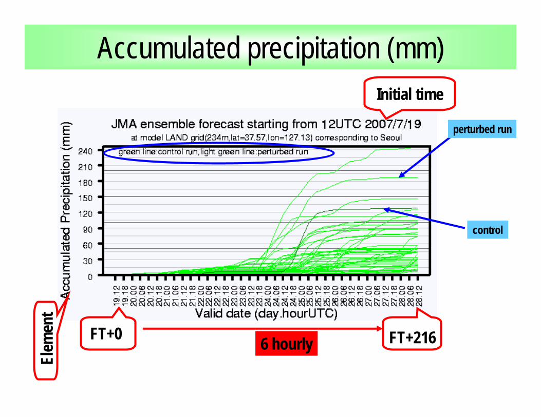
Accumulated precipitation (mm)Initial time
Elem
ent
FT+0 FT+2166 hourly
control
perturbed run

Accumulated precipitation (mm)Heavy rain is predicted with some ensemble members at 24th July.
Heavy rain is predicted with many ensemble members.

Sea level pressure (hPa)Initial time
Elem
ent
FT+0 FT+216
The first quartile The third quartilemedian
min
max
6 hourly
control

Upper air temperature (degree C)Initial time
Elem
ent
FT+0 FT+192
The first quartile The third quartilemedian
min
max
12 hourly
control

Upper air temperature (degree C)Probability (%) not to exceed threshold
Initial time
Elem
ent Valid date
control
Cumulative frequency curve

Application of One-week EPSfor heavy rain forecast
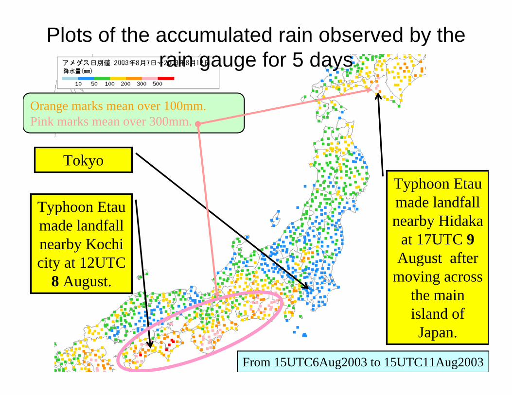
Plots of the accumulated rain observed by the rain gauge for 5 days
Typhoon Etaumade landfall nearby Kochi city at 12UTC
8 August.
TokyoTyphoon Etaumade landfall nearby Hidaka
at 17UTC 9August after
moving across the main island of Japan.
From 15UTC6Aug2003 to 15UTC11Aug2003
Orange marks mean over 100mm.Pink marks mean over 300mm.

Accumulated precipitation around Hidaka
Initiated time is 12UTC
2Aug2003.
PIHR(Potential Index of a Heavy Rainfall) marks 211%,saying a high possibility of an abnormal rainfall in this period shown as the arrow.
Any forecast was not enough to estimate the amount of the heavy
rainfall.

How to calculate PI (1)Initial time is 12UTC
2Aug2003.
The EPS distribution is compared with the model climate, not observed distribution.
Ensemble forecast
Model climate
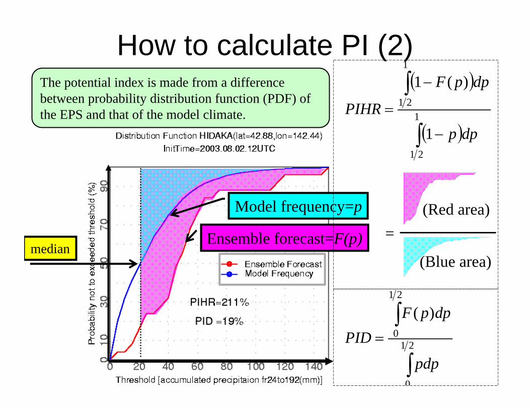
How to calculate PI (2)
median
( )
( )∫
∫
−
−
= 1
21
1
21
1
)(1
dpp
dppF
PIHR
=(Red area)
(Blue area)
∫
∫= 21
0
21
0
)(
pdp
dppFPID
Model frequency=p
Ensemble forecast=F(p)
The potential index is made from a difference between probability distribution function (PDF) of the EPS and that of the model climate.
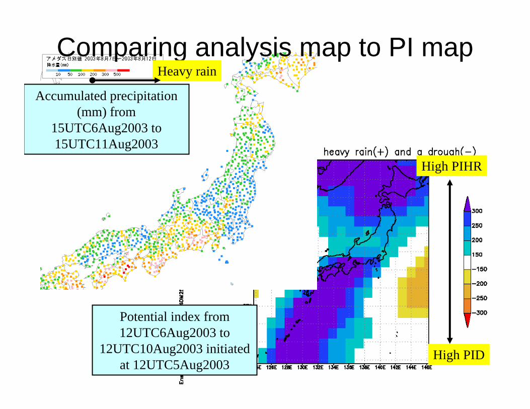
Accumulated precipitation (mm) from
15UTC6Aug2003 to 15UTC11Aug2003
Comparing analysis map to PI map
Potential index from 12UTC6Aug2003 to
12UTC10Aug2003 initiated at 12UTC5Aug2003
High PID
High PIHR
Heavy rain

Verification of PIScatter diagram for forecasts and the precipitation ratio (the rain gauge
data) from 24hr to 120 hr at TOKYO for 365 cases for September 2002 - August 2003.
Forecast
Obs. Red X =PIDBlue X =PIHR
Normal (100%)
PID is below 50% and PIHR is above 200% when heavy rainfall exceeding 600% of climate value occurs.
The area ofhigh PIHR
Low PID
600% of climate value

How to get a forecast scenario
•Histogram
•Spaghetti / Plume diagram
•Cluster analysis

Rainfall PDF derived from JMA-EPSHistogram of accumulated precipitation from 24hr to 216hr at T106 land grid-point closest to Tokyo predicted by the 25 ensemble members. The initial time is 12UTC on 12th October 2004. Black line indicates a density function of the histogram. Blue line indicates a density function of daily model climate.
Scenario 1 Scenario 2 Scenario 3

Accumulated precipitation at TokyoPlume diagram of accumulated precipitation at T106 land grid-point closest to Tokyo predicted by the 25 ensemble members (blue lines) as a function of forecast time from 24hr to 216hr. The initial time is 12UTC on 9th November 2004. Red line indicate the accumulated precipitation observed by the rain gauge at Tokyo. The shading shows a probability of accumulated precipitation defined as the occurrence ratio in EPS. Potential indices (PIHR and PID) are indicated for the period shown as arrows.
All members have rainfall.
Some of members have rainfall.

Cluster analysis• Cluster analysis
– JMA introduces Ward method.
• Tube method
– developed by ECMWF
– JMA also introduce a central cluster derived from a tube method. ECMWF News Letter No.79

JMA cluster analysisC
lust
er 1
Clu
ster
3
Clu
ster
2
Each panel has six maps, showing daily charts 72 to 192 hours ahead. Initial time is 12UTC on 3rd September 2001.
The typhoon moves toward the eastern part of Japan.
The typhoon moves toward central part of Japan
The typhoon moves toward south-western part of Japan.
T T T
T T T
TT T
T T T
T T

Left
colu
mn
is d
aily
fore
cast
map
s of 5
00hP
a ge
opot
entia
lhe
ight
72
to 1
92 h
ours
ahe
ad a
s an
aver
age
of c
entra
l cl
uste
r mem
bers
of E
PS.
The
next
col
umn
is fo
r 850
hPa
pote
ntia
l tem
pera
ture
Cen
tral c
lust
er c
harts
The
figur
e sh
ows 5
clu
ster
av
erag
es, c
ontro
l for
ecas
t an
d hi
gh-r
esol
utio
n fo
reca
st o
f tem
pera
ture
an
omal
y at
850
hPa
for
four
citi
es o
f Jap
an
Six
figur
es a
re d
aily
spag
hetti
di
agra
m 7
2 to
192
hou
rs a
head
. 25
mem
bers
are
gro
uped
into
5
clus
ters
. Ave
rage
of m
embe
rs in
ea
ch c
lust
er fo
r 500
hPa
geop
oten
tialh
eigh
t (so
lid li
ne),
PoP
(das
h lin
e) a
nd n
orm
aliz
ed
spre
ad (n
umbe
r) a
re sh
own.
Clu
ster
-ana
lyze
d pl
ume
diag
ram
Clu
ster
-ana
lyze
d sp
aghe
tti d
iagr
am
A series of JMA EPS products

Whether the ensemble forecast captures the analysis
or not?

Talagrand diagram (1)• Preparation
– order the members of the ensemble forecast from lowest to highest
– identify n+1 ranges including the two extremes
– identify the location of the observation– tally over a large number of cases
lowest highest
+25C +26C +28C
Each ensemble forecast (This ensemble size is three.)
Analysis+27C
Just one case

Talagrand diagram (2)
Categories defined by ordered ensemble sizeR
elat
ive
freq
uenc
y of
an
alys
is
Three talagrand diagrams for 1-, 3- and 6-day ensemble forecasts of sea level pressure in the Northern Hemisphere extratropics.
Ideal rate line of analysis1-day forecast
6-day forecast3-day forecast
OutlierOutlier
Flat
Dome-sharp
L-sharp

Talagrand diagram (3)• Interpretation
– Flat indicates the ensemble spread is suitable so that the ensemble forecast capture the analysis well.
– A U-shaped distribution indicates the ensemble spread is not enough to capture the analysis.
– A dome-shaped distribution indicates the ensemble spread is too large.
– L-shaped and J-shaped distributions indicate the NWP model has over- and under-forecasting bias, respectively.

Operational use of One-week EPS
•Stamp map
•The ensemble mean and spread
•Reliability Index
•Guidance of the maximum and minimum temperature

One week forecast for end users
Categorical weather forecast
Minimum and maximum temperatures with variability range
Probability of daily precipitation (%)
Reliability index (A,B or C)
Climatological data for reference
Weather outlook
The forecasts are almost based on one week EPS

Application of one-week EPSto temperature forecast

•The daily maximum and minimum surface temperatures at about 180 cities of Japan are calculated for each member by using a Kalman filtering technique.•Ensemble GPVs at target cites are calculated through interpolation.•The maximum and minimum temperatures are calculated using the previous Kalman filtering coefficients and two predictors at 15JST and 03JST, respectively.
Surfacetemperature
925hPa
How to calculate the daily maximum and minimum surface temperature
25 forecasts
15JSTKalmanfiltering
03JST
Kalmanfiltering
Maximumtemperat
ure
Minimumtemperat
ure
Dew-pointdepression

Maximumtemperature
Kalmanfiltering
Probability Density Function of the daily maximum temperature
Surface temperature at 15JSTderived from one-week EPS
Relative Cumulative frequencycurve of ensemble forecasts
Relative Cumulative frequencycurve of observed data
Frequency distribution ofall ensemble 5-days forecasts at TOKYO for 1st-31th October 2003
The bias is removed!!

EPSgram of daily Max/Min guidanceInitial time : 12UTC10October2003Valid day : 11,12,13,14,15,16,17,18,19Target point : TOKYO
Largest value
Upper quartile
Lower quartile
Median
Smallest value
Interpretationof boxplots
Imageof
PDFX marks : Observed value
Boxplots : Ensemble guidance The ensemble guidance says that the spread is large when the trend of the max. temp. changes.
11th 12th 13th 14th 15th 16th 17th 18th 19th

Product of extreme high temperature
•Offered to forecasters and Electric Power Company
•They use as a probabilistic measure of the extreme high temperature.
•If the maximum temperature exceeds a certain level ( 33C at Tokyo), consumption of electric power increases rapidly to exceeds the limit of supply, resulting in power shortage.

PDF of daily maximum temperatureThe maximum temperatures at about 180 cities of Japan are calculated for
each member by using a Kalman filtering technique. The PDF is a frequency distribution of one week EPS members at 9 local sites in Tokyo metropolitan
area. The lead time is 3day.
Cumulative frequency curve
Frequency distribution
Initial time : 12UTC30August2003Valid time : 3 September 2003Point name : TOKYO
Probability of electric power shortage
8% (=2/25)

Verification of daily Maximum guidanceValid day : from 1st to 31th of October 2003Forecast day : 5 daysTarget porint : TOKYO
X marks : Observed value
Boxplots : Ensemble guidance
Blue dots : Control guidance
The observed value is almost in the range of
the ensemble guidance.
The spread is not enough to catch the
extreme cases.
•Temperatures derived from EPS represent the actual PDF very well.
•The Kalman filtering is effective to remove the systematic bias from the model results such as surface temperature derived from EPS.
•Extreme cases, especially surface variables, are not always caught up by all ensemble members.
•Increase of the ensemble size•Introduction of a new guidance for expanding the spread•Introduction of another calibration technique (say later)
Conclusion of the application of One-week EPS to temperature forecast

Typhoon EPS

Motivation for developing Typhoon EPSJMA plans to operate the Typhoon Ensemble Prediction System (EPS) from the TC season in 2008, following experimental operations in 2007.
Motivation 1Expected error reduction of deterministic track forecasts by using statistical methods such as ensemble mean or cluster analysis.
Mean track forecasts error can be statistically improved. Error reduction is over 30km at +72h.
Mean distance error of ensemble meantrack forecasts consisted of ECMWF, UKMO, JMA-GSM and JMA-TYM
Motivation 2Estimating track forecasts uncertainties which differ from day to day and applying to beneficial use of probabilistic track forecasts.

Specifications of the Typhoon EPS
The operation of TYM will stopped in this November when the Typhoon EPS starts its operation.
Intensity forecasts are supported by 20km GSM which will be operated from this November.

3 typhoons at the same time !!!
Typhoon track forecasts for typhoon MARIA, SAOMAI, BOPHA initial time 2006.08.07.12 UTC
Current TYM
J1J2
Typhoon EPS
We sometimes have 3 or more TCs at the same time in the Western North Pacific

Case Study: Typhoon MARIA (T0607)
Black line: best trackTY
M a
nd G
SMC
urre
nt fo
reca
st
TYM
fore
cast
sG
SM fo
reca
sts
In the early stage of MARIA, TYM and GSM failed to express the recurvature.
All track forecasts by TYM and GSM for MARIA.
Initail time is from 2006.08.05.00 to 2006.08.10.18 UTC.
Initial time: 2006.08.05.00UTC

Typhoon EPS for MARIAInitial time: 00UTC 5Aug 2006
Typhoon ensemble forecast
(strike probability map)
TYM
and
GSM
Typhoon EPS indicates the probability of landing around Tokai district.
Cur
rent
fore
cast

Statistical verification results
Deterministic forecasts Probabilistic forecasts
Mean distance error of TC track forecasts
Forecast range is 132hours (see X axis)
Blue line : JMA TYM
Green line : Control run (non-perturbed run)
Red line : Ensemble mean
Mean track forecasts error is smaller than that of TYM. Error reduction is about 10km at +72h.
Reliability Diagram Brier Score
We conducted a numerical experiment on the Typhoon EPS. The experiment period is Aug. and Sep. in 2004.
High reliability and plus brier skill score.
Current forecast
original
tracks
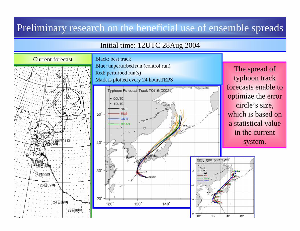
The spread of typhoon track
forecasts enable to optimize the error
circle’s size, which is based on a statistical value
in the current system.
Initial time: 12UTC 28Aug 2004
Preliminary research on the beneficial use of ensemble spreads
Black: best trackBlue: unperturbed run (control run)Red: perturbed run(s)Mark is plotted every 24 hoursTEPS

CT
dire
ctio
nA
T di
rect
ion
Correlation factor =0.38
スプレッドをコントロールランの台風進路に沿った成分(AT)と直行する成分(CT)に分け
て検証した。統計期間は実験1の予報対象期間で、3日予報の予報円を検証の対象とす。
Correlation factor =-0.02
Preliminary research on the beneficial use of ensemble spreads
Posi
tion
erro
r of c
ontro
l run
Ensemble spread
Ensemble spread
Posi
tion
erro
r of c
ontro
l run

New application for typhoon track forecasts
The forecast uncertainty on TC central position is described in a circle, whose radius is decided on a statistical method, using information about current TC position and intensity.
Current Application Application in the future
The area which represents forecast uncertainty could be optimized by using ensemble spread, which changes day by day, typhoon by typhoon.

Circle is good ?to express forecast uncertainty on typhoon track movements?
The forecast uncertainty on TC central position is described in a circle, whose radius is decided on a statistical method, using information about current TC position and intensity.
Current Application
In the stage that typhoon is going along with subtropical jet, forecast uncertainty is relatively large in the direction of movement, compared with that in the crosswise direction.

Cluster Analysis- case study : typhoon MARIA-
Scenario 1 Scenario 2
Deterministic forecast (red line)Initial: 2006.08.06 12UTC
Deterministic forecast (red line)Initial: 2006.08.06 12UTC
Example of probabilistic forecastTwo scenarios (see green line) suggested
Example of probabilistic forecastTwo scenarios (see green line) suggested
Even if the best likely solution, or deterministic forecast, goes wrong, several other scenarios presented help people act accordingly, and in some cases they can prepare for the anticipated damage well in advance.
Best track

Best track
EPS Multi Center EPS
Example of probabilistic forecast.Conceivable scenario is only one!
Example of probabilistic forecast.Conceivable scenario is only one!
If the number of possible scenarios is only one, it means the scenario is a highly likely scenario. People can act accordinglyand in areas where the possibility of the typhoon striking is estimated 0 they can avoid taking unnecessary actions against the typhoon approaching.
Cluster Analysis- case study : typhoon CHABA-
Deterministic forecast (red line)Initial: 2004.08.28 12UTC
Deterministic forecast (red line)Initial: 2004.08.28 12UTC

ensemble mean of the only cluster vscontrol run vs ensemble mean
In the cases where the number of clusters is analyzed only one, a statistical verification shows the ensemble mean of the cluster have
smaller error (light blue), compared with the average forecast error by control run or “simple” ensemble mean over a year( red or black).
In the cases where the number of clusters is analyzed only one, a statistical verification shows the ensemble mean of the cluster have
smaller error (light blue), compared with the average forecast error by control run or “simple” ensemble mean over a year( red or black).
Uncertainty information derived from a cluster analysis - Typhoon track forecasting -
Frequency distribution of the analyzed number of cluster. Verification period is 2006.

Case Study : The analyzed number of cluster is 12006年9月23日 T0614 (left)2006年12月2日 T0621(right)
black : best trackred red :: ensemble memberensemble memberblue blue :: control runcontrol rungreen green :: ensemble meanensemble mean
In below cases the ensemble mean of the cluster have smaller error (light blue), compared with the average forecast error by control run or
“simple” ensemble mean over a year( red or black).
We can say “the uncertainty of the track forecast is relatively small”
In below cases the ensemble mean of the cluster have smaller error (light blue), compared with the average forecast error by control run or
“simple” ensemble mean over a year( red or black).
We can say “the uncertainty of the track forecast is relatively small”
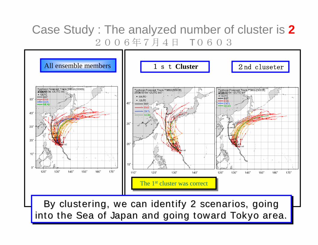
Case Study : The analyzed number of cluster is 22006年7月4日 T0603
1st ClusterAll ensemble members 2nd cluseter
By clustering, we can identify 2 scenarios, going into the Sea of Japan and going toward Tokyo area.
By clustering, we can identify 2 scenarios, going By clustering, we can identify 2 scenarios, going into the Sea of Japan and going toward Tokyo area.into the Sea of Japan and going toward Tokyo area.
The 1st cluster was correctThe 1st cluster was correct

Case Study : The analyzed number of cluster is 22006年7月23日 T0605
1st ClusterAll ensemble members 2nd cluseter

Case Study : The analyzed number of cluster is 22006年8月6日 T0607
1st ClusterAll ensemble members 2nd cluseter
The 2nd cluster was correctThe 2nd cluster was correct
Even if the best likely solution, or deterministic forecast, goes wrong, several other scenarios presented help people act accordingly, and in some cases they can prepare for the anticipated damage well in advance.

Case Study : The analyzed number of cluster is 32006年5月13日 T0601
All ensemble membersAll ensemble members
1st cluster
2nd cluster
3rd cluster
Considering not only the direction but also the speed, the cluster analysis method suggested 3 scenarios.
Considering not only the direction but also the speed, the cluster analysis method suggested 3 scenarios.

Case study - Typhoon Etau (T0310)Red line indicates the observed track of T0310.
GOES 9 Infrared Satellite Image at 09 UTC 8 August 2003

JMA issues the typhoon forecastJMA currently issues the information on a geographical circle in which a typhoon center will reach with 70% probability.circle
The radius of the forecast circle depends on the statistics of the past forecast results but not on the characteristic of individual typhoon.
The radius

yphoon track forecasts of Etau in the early stage
The range of the ensemble trackspread covers the observed track.
Black line … the observed trackRed line ... the unperturbed control runOrange lines … the perturbed runMarks … plotted every 6 hours
Initial time is 12UTC 3Aug2003.Current forecast
Ensemble forecastup to 3 days

Typhoon track forecasts of Etau just before recurvature
The spread was small enough to indicate high reliability. The probabilityof landfall of the typhoon on western Japan was very high.
Initial time is 12UTC 6Aug2003.
Current forecast
Ensemble forecastup to 3 days

Strike probability of Etau
Kochi cityof Shikoku
island (70%)
Tokyo (10%)
Hidaka of Hokkaido island
(50%)
Initial time is 12UTC6Aug2003.
Red line ... the observed trackX marks … plotted every 24 hours
The probability means that the cyclonewill pass within a 120km (about 65nm) radius
during the next 120 hours.
Ensemble forecastup to 5 days

Point strike probability at Kochi cityA
ccum
ulat
ed st
rike
prob
abili
ty(%
)
The most probable time of the typhoon landing means when the the curve shows a steep
gradient.
Just before landfall(almost analysis)
24hr before
Typhoon Etau made landfall nearby Kochi city at 12UTC 8 August.
48hr before
72hr before
96hr before
120hr before
Valid date

Verification of strike probability forecastThe reliability diagram for strike probability forecast that typhoon centers will pass within 120km from the verification points during the first 120 hours. The data used for verification are 174 forecasts for 37 Tropical cyclones over the responsible area of the RSMC Tokyo Typhoon Center in the year of 2002.
The strike probability has high reliability.
Forecast probability
Obs
erve
d fr
eque
ncy