Shahejie−Shahejie/Guantao/Wumishan and Carboniferous ... · vi Conversion Factors Multiply By To...
100
U.S. Department of the Interior U.S. Geological Survey Scientific Investigations Report 2011–5010 Shahejie−Shahejie/Guantao/Wumishan and Carboniferous/Permian Coal−Paleozoic Total Petroleum Systems in the Bohaiwan Basin, China (based on geologic studies for the 2000 World Energy Assessment Project of the U.S. Geological Survey) Anhui Jiangsu Shandong Henan Hubei Shanxi Hebei Liaoning North Korea Nei Mongol Jilin Heilongjiang Mongolia Bohaiwan Basin Beijing Shanghai 122° 114° 46° 38° Bohai Bay Korea Bay Yellow Sea Liao He Huang He 0 200 MI 0 200 KM
Transcript of Shahejie−Shahejie/Guantao/Wumishan and Carboniferous ... · vi Conversion Factors Multiply By To...

U.S. Department of the InteriorU.S. Geological Survey
Scientific Investigations Report 2011–5010
Shahejie−Shahejie/Guantao/Wumishan and Carboniferous/Permian Coal−Paleozoic Total Petroleum Systems in the Bohaiwan Basin, China (based on geologic studies for the 2000 World Energy Assessment Project of the U.S. Geological Survey)
Anhui
Jiangsu
Shandong
Henan
Hubei
Shanxi
HebeiLiaoning
NorthKorea
Nei MongolJilin
HeilongjiangMongolia
BohaiwanBasin
Beijing
Shanghai
122°114°
46°
38°
BohaiBay
KoreaBay
YellowSea
Liao H
e
Huang He
0 200 MI
0 200 KM


Shahejie−Shahejie/Guantao/Wumishan and Carboniferous/Permian Coal−Paleozoic Total Petroleum Systems in the Bohaiwan Basin, China (based on geologic studies for the 2000 World Energy Assessment Project of the U.S. Geological Survey)
By Robert T. Ryder, Jin Qiang, Peter J. McCabe, Vito F. Nuccio, and Felix Persits
Scientific Investigations Report 2011–5010
U.S. Department of the InteriorU.S. Geological Survey

U.S. Department of the InteriorKEN SALAZAR, Secretary
U.S. Geological SurveyMarcia K. McNutt, Director
U.S. Geological Survey, Reston, Virginia: 2012
For more information on the USGS—the Federal source for science about the Earth, its natural and living resources, natural hazards, and the environment, visit http://www.usgs.gov or call 1–888–ASK–USGS.
For an overview of USGS information products, including maps, imagery, and publications, visit http://www.usgs.gov/pubprod
To order this and other USGS information products, visit http://store.usgs.gov
Any use of trade, product, or firm names is for descriptive purposes only and does not imply endorsement by the U.S. Government.
Although this report is in the public domain, permission must be secured from the individual copyright owners to reproduce any copyrighted materials contained within this report.
Suggested citation:Ryder, R.T., Qiang, Jin, McCabe, P.J., Nuccio, V.F., and Persits, Felix, 2012, Shahejie−Shahejie/Guantao/Wumishan and Carboniferous/Permian Coal−Paleozoic Total Petroleum Systems in the Bohaiwan Basin, China (based on geologic studies for the 2000 World Energy Assessment Project of the U.S. Geological Survey): U.S. Geological Survey Scien-tific Investigations Report 2011–5010, 89 p.
On the cover: Bohaiwan basin (outlined in red) in a regional setting. From Allen and others (1997).
iii
Contents
Foreword .........................................................................................................................................................1Abstract ...........................................................................................................................................................2Acknowledgments .........................................................................................................................................2Introduction.....................................................................................................................................................2Province Geology ...........................................................................................................................................7
Geographic Setting ...............................................................................................................................7Stratigraphic Setting ............................................................................................................................7Tectonic Setting ....................................................................................................................................9
Exploration History as of June 2001 ..........................................................................................................11Shahejie−Shahejie/Guantao/Wumishan Total Petroleum System (312701) .......................................12
Petroleum Occurrence ......................................................................................................................12Source Rocks.......................................................................................................................................14
Introduction.................................................................................................................................14Stratigraphic Units .....................................................................................................................14
Member 3 of the Shahejie Formation ............................................................................14Member 1 of the Shahejie Formation ............................................................................16Member 4 of the Shahejie Formation ............................................................................16Member 2 of the Kongdian Formation ...........................................................................16Member 3 of the Dongying Formation ...........................................................................16
Geochemical Characteristics ..................................................................................................16Source Rocks in Member 3 of the Shahejie Formation ..............................................16Oil-Source Rock Correlations .........................................................................................16Natural Gases ....................................................................................................................18
Pods of Thermally Mature Source Rock ................................................................................18Burial History, Hydrocarbon Generation, and Migration .............................................................18
Burial History and Hydrocarbon Generation .........................................................................18Migration .....................................................................................................................................21
Overburden Rocks ..............................................................................................................................21Shahejie Formation Overburden .............................................................................................21Dongying Formation Overburden ............................................................................................21Regional Post-Paleogene Uplift and Guantao Formation Overburden .............................22
Trap Styles for Oil and Gas Fields .....................................................................................................22Structural Traps ..........................................................................................................................22Stratigraphic Traps ....................................................................................................................22
Reservoir Rocks ..................................................................................................................................26Sandstone Reservoirs ...............................................................................................................26
Jiyang Subbasin ................................................................................................................26Liaohe Subbasin ................................................................................................................26Jizhong Subbasin ..............................................................................................................26Huanghua Subbasin .........................................................................................................26Linqing/Dongpu Subbasin ...............................................................................................27Bozhong Subbasin ............................................................................................................27

iv
Carbonate and Crystalline Basement Reservoirs ................................................................27Liaohe Subbasin ................................................................................................................27Jizhong Subbasin ..............................................................................................................27
Seal Rocks............................................................................................................................................27Assessment Units ...............................................................................................................................28
Tertiary Lacustrine Assessment Unit ......................................................................................28Pre-Tertiary Buried Hills Assessment Unit ............................................................................28Potential Undiscovered Oil and Gas Resources as of June 2001 ......................................31
Onshore ..............................................................................................................................31Offshore ..............................................................................................................................31
Carboniferous/Permian Coal–Paleozoic Total Petroleum System (312702) .......................................31Petroleum Occurrence ......................................................................................................................31Source Rocks.......................................................................................................................................33
Geochemical Characteristics ..................................................................................................33Carboniferous and Permian Coal Beds .........................................................................33Natural Gases ....................................................................................................................33
Pods of Thermally Mature Source Rock ................................................................................33Burial History and Hydrocarbon Generation ..................................................................................33Overburden Rocks ..............................................................................................................................33
Shihezi and Shiqianfeng Formations Overburden ................................................................35Jurassic and Lower Cretaceous Overburden .......................................................................35Kongdian Formation Overburden ............................................................................................35Shahejie Formation Overburden .............................................................................................35
Trap Styles for Gas Fields ..................................................................................................................35Reservoir Rocks ..................................................................................................................................35
Sandstone Reservoirs ...............................................................................................................35Coal Bed Reservoirs ..................................................................................................................37
Seal Rocks............................................................................................................................................37Assessment Unit .................................................................................................................................37
Summary........................................................................................................................................................37References Cited..........................................................................................................................................38
Figures 1. Maps showing oil and gas fields, structural domains, structural depressions,
and uplifts in the Bohaiwan basin ..............................................................................................3 2. Cross section through the Jizhong, Huanghua, and Jiyang subbasins ...............................4 3. Cross section through the Bozhong subbasin .........................................................................6 4. Stratigraphy of the subbasins in the Bohaiwan basin ............................................................8 5. Tectonic map of the Bohaiwan basin in a regional setting .................................................10 6. Map of the Shahejie–Shahejie/Guantao/Wumishan Total Petroleum System
showing pods of mature source rock and oil and gas fields ...............................................13 7. Events chart for the Shahejie–Shahejie/Guantao/Wumishan Total Petroleum
System ..........................................................................................................................................15

v
8. Map showing the distribution of the total organic carbon in the Shahejie Member 3 source rocks, Jiyang subbasin .............................................................................17
9. Burial history and hydrocarbon generation model for the Shahejie– Shahejie/Guantao/Wumishan Total Petroleum System, Jiyang subbasin ........................19
10. Burial history and hydrocarbon generation model for the Shahejie– Shahejie/Guantao/Wumishan Total Petroleum System, Bozhong subbasin ....................20
11. Structure contour map and cross section of the western part of the Shengtuo oil field, Jiyang subbasin ...........................................................................................................23
12. Structure contour map and cross section of the Chengdong oil field, Jiyang subbasin ..........................................................................................................................24
13. Structure contour map and cross section of the Renqiu oil field, Jizhong subbasin ........................................................................................................................25
14. Map showing the area of the Tertiary lacustrine assessment unit of the Shahejie–Shahejie/Guantao/Wumishan Total Petroleum System .....................................29
15. Map showing the area of the pre-Tertiary buried hills assessment unit of the Shahejie–Shahejie/Guantao/Wumishan Total Petroleum System .....................................30
16. Partial stratigraphic column for the Bohaiwan basin showing the essential elements of the Carboniferous/Permian Coal–Paleozoic Total Petroleum System .........32
17. Map of the Carboniferous/Permian Coal–Paleozoic Total Petroleum System showing pods of mature source rock and the coal-sourced gas assessment unit ........34
18. Events chart for the Carboniferous/Permian Coal–Paleozoic Total Petroleum System ..........................................................................................................................................36
Tables[Tables 1–15 follow References Cited]
1–6. Size, cumulative production, and selected characteristics of oil and gas fields in the Shahejie−Shahejie/Guantao/Wumishan Total Petroleum System, Bohaiwan basin
1. Jiyang subbasin .................................................................................................................44 2. Liaohe subbasin .................................................................................................................50 3. Jizhong subbasin ...............................................................................................................55 4. Huanghua subbasin ...........................................................................................................59 5. Linqing/Dongpu subbasin .................................................................................................62 6. Bozhong subbasin .............................................................................................................64 7. Selected geochemical properties of source rocks in Member 3 of the
Shahejie Formation .....................................................................................................................65 8. Stratigraphic, geochemical, and thermal maturation data used to construct the
burial history and hydrocarbon generation model for the Jiyang subbasin .....................66 9. Stratigraphic, geochemical, and thermal maturation data used to construct the
burial history and hydrocarbon generation model for the Bozhong subbasin .................6710–15. Selected properties of major reservoirs in the Shahejie−
Shahejie/Guantao/Wumishan Total Petroleum System, Bohaiwan basin 10. Jiyang subbasin .................................................................................................................68 11. Liaohe subbasin .................................................................................................................75

vi
Conversion Factors
Multiply By To obtain
Lengthmillimeter (mm) 0.03937 inch (in.)meter (m) 3.281 foot (ft) kilometer (km) 0.6214 mile (mi)
Areasquare kilometer (km2) 0.3861 square mile (mi2)
Volumecubic foot (ft3) 0.02832 cubic meter (m3) barrel (bbl) (petroleum,
1 barrel = 42 gal)0.1590 cubic meter (m3)
gallon (gal) 0.003785 cubic meter (m3) cubic meter (m3) 35.31 cubic foot (ft3)cubic meter (m3) 6.290 barrel (bbl) (petroleum,
1 barrel = 42 gal)cubic meter (m3) 264.2 gallon (gal)
Temperature in degrees Celsius (°C) may be converted to degrees Fahrenheit (°F) as follows: °F=(1.8×°C)+32
12. Jizhong subbasin ...............................................................................................................80 13. Huanghua subbasin ...........................................................................................................84 14. Linqing/Dongpu subbasin .................................................................................................87 15. Bozhong subbasin .............................................................................................................89

vii
Letter Symbols for Units of Measure
BBO billion barrels of oil (bbl × 109) BBOE billion barrels of oil equivalent BOE barrel of oil equivalent TCFG trillion cubic feet of gas T metric ton
Definitions
Thousand =103 Million =106 Billion =109 Trillion =1012
1 BOE =1 barrel of crude oil (42 gallons) =6,000 cubic feet of natural gas =1.5 barrels of natural gas liquids


Shahejie−Shahejie/Guantao/Wumishan and Carboniferous/Permian Coal−Paleozoic Total Petroleum Systems in the Bohaiwan Basin, China (based on geologic studies for the 2000 World Energy Assessment Project of the U.S. Geological Survey)
By Robert T. Ryder, Jin Qiang, Peter J. McCabe, Vito F. Nuccio, and Felix Persits
ForewordThis report was prepared as part of the 2000 World
Energy Assessment Project of the U.S. Geological Survey (USGS). For this project, the world was divided into 8 regions and 937 geological provinces. The provinces were then ranked according to the discovered oil and gas volumes within each (Klett and others, 1997). Then, 76 “priority” provinces (exclu-sive of the United States and chosen for their high ranking) and 52 “boutique” provinces (exclusive of the United States and chosen for their anticipated petroleum richness or special regional economic importance) were selected for appraisal of oil and gas resources. The petroleum geology of these priority and boutique provinces is described in this series of reports.
The purpose of this effort is to aid in assessing the quantities of oil, gas, and natural gas liquids that have the potential to be added to reserves within the next 30 years. These volumes either reside in undiscovered fields whose sizes exceed the stated minimum-field-size cutoff value for the assessment unit (variable, but must be at least 1 million barrels of oil equivalent) or occur as reserve growth of fields already discovered.
The total petroleum system, which constitutes the basic geologic unit of the oil and gas assessment, includes all geneti-cally related petroleum that occurs in shows and accumula-tions (discovered and undiscovered) that (1) have been gener-ated by a pod or closely related pods of mature source rock and (2) exist within a limited mappable geologic space, alone with the essential mappable geologic elements (source, reser-voir, seal, and overburden rocks) that control the fundamental processes of generation, expulsion, migration, entrapment, and preservation of petroleum. The minimum petroleum system is that part of a total petroleum system encompassing discovered shows and accumulations together with the geologic space in which the various essential elements have been proved by these discoveries.
An assessment unit is a mappable part of the total petro-leum system in which discovered and undiscovered fields constitute a single, relatively homogeneous population such that the chosen methodology of resource assessment based on estimation of the number and sizes of undiscovered fields is applicable. A total petroleum system may equate to a single assessment unit. If necessary, a total petroleum system may be subdivided into two or more assessment units if each assess-ment unit is sufficiently homogeneous in terms of geology, exploration considerations, and risk to assess individually.
A graphical depiction of the elements of a total petroleum system is provided in the form of an events chart that shows the times of (1) deposition of essential rock units; (2) trap formation; (3) generation, migration, and accumulation of hydrocarbons; and (4) preservation of hydrocarbons.
A numeric code identifies each region, province, total petroleum system, and assessment unit; these codes are uni-form throughout the project and will identify the same type of entity in any of the publications. The code is as follows:
ExampleRegion, single digit 3Province, three digits to the right of region code 3127Total petroleum system, two digits to the right of province code 312701Assessment unit, two digits to the right of petroleum system code 31270101
The codes for the regions and provinces are listed in Klett and others (1997).
Oil and gas reserves quoted in this report are derived from Petroconsultants’ Petroleum Exploration and Production database (Petroconsultants, 1996) and other area reports from Petroconsultants, Inc., unless otherwise noted.
Figures in this report that show boundaries of the total petroleum system(s), assessment units, and pods of active

2 Total Petroleum Systems in the Bohaiwan Basin, China
source rocks were compiled by using geographic information system (GIS) software. Political boundaries and cartographic representations were taken, with permission, from the ESRI (Environmental Systems Research Institute) (1992) ArcWorld 1:3 million digital coverage; they have no political signifi-cance and are displayed for general reference only. Oil and gas field centerpoints, shown in these figures, are reproduced, with permission, from Petroconsultants (1996).
AbstractThis report discusses the geologic framework and petro-
leum geology used to assess undiscovered petroleum resources in the Bohaiwan basin province for the 2000 World Energy Assessment Project of the U.S. Geological Survey (U.S. Geo-logical Survey World Energy Assessment Team, 2000). The report also refers to several later papers (published between 2001 and 2004) that offer additional perspectives.
Two total petroleum systems have been identified in the Bohaiwan basin of northeastern China. The Shahejie−Shahejie/Guantao/Wumishan Total Petroleum System, the major total petroleum system in the basin, involves oil and gas generated from mature pods of lacustrine source rock. In general, the mature pods of source rock are associated with six major rift-controlled subbasins that from northeast to southwest are named as follows: (1) Liaohe, (2) Bozhong, (3) Huanghua, (4) Jiyang, (5) Jizhong, and (6) Linqing/Dongpu. The entire Bozhong subbasin and parts of the Huanghua and Liaohe subbasins are located in Bohai Bay. The term Bohai Bay as used in this report follows the usage of Hu and others (1989) and Hu and Krylov (1996). The primary source rock of the total petroleum system is Member 3 of the Eocene and Oligocene Shahejie Formation, and secondary source rocks are Member 2 of the Paleocene and Eocene Kongdian Formation, Members 4 and 1 of the Shahejie Formation, and Member 3 of the Dongying Formation. The majority of the oil and gas fields in the Bohaiwan basin are closely associ-ated with the six subbasins and their mature source rock pods. The most productive sandstone reservoirs in the Bohaiwan basin are located in the Shahejie Formation (Members 1−4), Oligocene Dongying Formation (largely Members 2 and 3), and Miocene Guantao Formation. Also, the Bohaiwan basin has very productive carbonate reservoirs such as the Middle Proterozoic Wumishan Formation, Cambrian Fujunshan and Mentou Formations, and Ordovician Fengfeng and Majiagou Formations. Locally, Archean crystalline basement rocks are important oil reservoirs. Most oil and gas generated from the Shahejie and Kongdian Formations are trapped in large faulted roll-over anticlines, compaction (drape) anticlines, and tilted fault blocks (buried hills). Subtle traps consist of faulted anticlinal noses that may be associated with facies-change, unconformity, or diagenetic stratigraphic traps.
Two assessment units are defined in the Shahejie−Shahe-jie/Guantao/Wumishan Total Petroleum System: (1) a Tertiary
lacustrine assessment unit consisting of sandstone reservoirs interbedded with lacustrine shale source rocks and (2) a pre-Tertiary buried hills assessment unit consisting of carbonate reservoirs that are overlain unconformably by lacustrine shale source rocks.
The second total petroleum system identified in the Bohaiwan basin is the Carboniferous/Permian Coal–Paleo-zoic Total Petroleum System, a hypothetical total petroleum system involving natural gas generated from multiple pods of thermally mature coal beds in five of the six subbasins. Low-permeability sandstone in the Lower Permian Shanxi and Shihezi Formations and possibly Carboniferous coal beds are the reservoir rocks. Most of the natural gas is inferred to be trapped in continuous accumulations near the center of the subbasins. This total petroleum system is largely unexplored and has good potential for undiscovered gas accumulations. One assessment unit, coal-sourced gas, is defined in this total petroleum system.
AcknowledgmentsCumulative production and selected characteristics of oil
and gas fields used in this report were obtained from unpub-lished Bohaiwan basin oil- and gas-field data (oil industry compilations, unpub. data, 1996). Moreover, English transla-tions of the following volumes contained many fundamen-tal facts and interpretations used in this report: (1) Shengli oil field (Editorial Committee of Petroleum Geology of the Shengli Oil Field, 1987) (hereinafter referred to as ECPG−Shengli, 1987); (2) Liaohe oil fields (Ge and Editorial Com-mittee of Petroleum Geology of the Liaohe Oil Fields, 1989) (hereinafter referred to as Ge and ECPG−Liaohe, 1989); (3) Huabei oil field (Editorial Committee of Petroleum Geol-ogy of the Huabei Oil Field, 1987) (hereinafter referred to as ECPG−Huabei, 1987); (4) Dagang oil field (Editorial Com-mittee of Petroleum Geology of the Dagang Oil Field, 1987) (hereinafter referred to as ECPG−Dagang, 1987); and (5) Oil- and gas-bearing areas on the continental shelf and its neigh-boring regions, part I, offshore Bohai (Editorial Committee of Petroleum Geology of Oil- and Gas-Bearing Areas on the Continental Shelf and its Neighboring Regions, 1987) (herein-after referred to as ECPG−Continental Shelf, 1987).
Eric Morrissey, USGS (Reston, Va.), drafted and (or) revised all the figures used in the report except figure 2, which was drafted by Susan Walden, USGS (Denver, Colo.).
IntroductionThe Bohaiwan basin (3127; USGS World Energy Assess-
ment Project numeric code) in northeastern China is the largest petroleum-producing region in China (Klett and others, 1997). The basin consists of six rift-controlled subbasins (Liaohe, Bozhong, Huanghua, Jiyang, Jizhong, and Linqing/

Introduction 3
Dongpu1), all of which produce oil and gas (fig. 1A,B). These subbasins and several adjoining uplifts in the Bohaiwan basin are shown along with locations of oil and gas fields in figure 1. The general structural styles of the subbasins and adjoining
1The Linqing subbasin at the south end of the Bohaiwan basin consists of the Dongpu, Guanxian, Quixian, and Xinxian depressions and the Tangyin graben (figs. 1A,B). For discussion purposes, the Linqing subbasin and the oil- and gas-bearing Dongpu depression are combined in this study and called the Linqing/Dongpu subbasin.
uplifts in the Bohaiwan basin are shown on the geologic cross sections in figures 2 and 3. In addition, more than 50 smaller structural depressions (sags), commonly flanked by tilted fault-block uplifts (buried hills), are recognized throughout the basin (Chang, 1991; Allen and others, 1997).
Oil was first discovered in the Jiyang subbasin in 1961 at the giant Dongxin field. This field and approximately 72 addi-tional fields subsequently discovered in the Jiyang subbasin constitute the large Shengli producing complex (Scott, 1990) (fig. 1A). In the early 1980s, exploration began in earnest in
Figure 1. Maps of the Bohaiwan basin showing (A) selected oil and gas fields and structural domains and (B) structural depressions and uplifts. Figure 1A is from Hu and Krylov (1996). Figure 1B is from Chang (1991, fig. 1, p. 99) and Allen and others (1997, fig. 3, p. 954) and published with permission of Elsevier. Cross section A–A’ is shown in figures 2A and B, and cross section B–B’ is shown in figure 3. Due to differences in projection, scale, and accuracy of latitude-longitude grids, the location of some cities and features in this figure may not be consistent with their location in other figures in this report.
Shoreline of Bohai Bay
B'
B
A
A'
a
a’
a”
EXPLANATIONFor Figure 1A
Digital compilation by Eric A. Morrissey
Complex of oil and (or) gas fields
Structure boundary
Basin boundary
Oil field
Gas field
City
0 25 50 75 100 MILES
0 25 50 75 100 KILOMETERS
36° 36°
116°
116°
40° 40°
122°
122°
42°
38°
120°
118°
38°
118°
120°
Jinganbu/JingbeiDongshengpu
Qianjing-Damintun
SHENYANGCOMPLEX
Xinglongtai
ShuangtaiziLengjiapu
Huanxiling
ShuguangGaosheng
Biantai
Fahaniu
Dawa
Haiwaihe
Kuihuadao
Rongxingtun
Huangjindai
Yulou
Rehetai
Qinglongtai
Ciyutuo
Jinzhou 9-3
Jinzhou 20-2
Bozhong 427
Bozhong 428(Xi)
Qinhuangdao 32-6Bozhong 428(B)
Bozhong 6
Jinxian 1-1-1
Suizhong 36-1
Suizhong
Bozhong 25-1Bozhong 22-1
Peng Lai 19-3-1
DAGANGCOMPLEX
Banqiao
Tanggu
BeibuGaoshangbu
Bozhong 34-2
Bozhong 28-1
ZhouqingzhuangWangxuzhuang Haisi
Zhangjuhe
Yangerzhuang
Xiaoji andWangguantun
Zaoyuan
KongdianYangsanmu
HaiyiCFD-14-1-1
Chengdong
Gudao
Gudong
SHENGLICOMPLEX
Changdi
Chengdao
ShenghaiChengbei
Bonan
Yidong
Haojia
Yonganzhen
Yanjia
Taoerhe
Yingxiongztan
Dawangzhuang
Yihezhuang
Bamianhe
ShengtuoLijin
Le’an
ChunhuazhenLiangjialao
ShinanWangjiagang
DongxinShanjiasi
Linpan Shanghe
Jinjia
HuagouFanjia
Pingfangwang
Linfanjia
Hexiwu
Bieguzhuang
Renqiu
Mozhou
Wenan
Suqiao
Gaojiabu
Chaheji
Longhuzhuang
NanmazhuangGaoyang
NanxiaochenHezhuangxi
Hezhuang
Shennan
Liuxi
Dawangzhuang
Suning
Taijiazhuang
Jinqui
Mazhai
Machang
QingzujiHuzhuangji
QiaokouBaimiao
Wenliu
Pucheng
Zhao 41
Binnan
Zhuangxi
Weibei
PANSHANCOMPLEX
NEIHUANG
U
PLIFT
HUANGHUA
SUBBASIN
BOZHONG S
UBBASIN
JIYANG
SUBBASIN
CHENGNING
U
PLIFT
CANG
XIAN
U
PLIF
T
JIZHONG S
UBBASIN
XINGHEN
G UPLIF
TLIN
QING
SUBBASIN
DONGPU
DEPRESSION
TANG
YIN
GRAB
EN
LIAO
DONG
UPLIF
T
LI
AOHE
SUBBASIN
LUDO
NG
U
PLIF
T
TA
I HA
NG
SHAN
UPLIFT
Y A NSH A N
F O L D
BE L T
LUXI
UPLIF
T
TANXIAN
UPLIFT
Puyang
Xingtai
Tianjing
Tangshan
Beijing
Cangzhou
Dezhou
Shijiazhuang
Weifang
Lushun
LongkouYantai
Qinhuangdao
Anshan
Dalian
ZiboJinan
Yingkou
Jinzhou
Mongolia
China North Korea
Location map. Bohaiwan basin outlined in red.
Anhui
Jiangsu
Shandong
Henan
Hubei
Shanxi
HebeiLiaoning
NorthKorea
Nei MongolJilin
HeilongjiangMongolia
BohaiwanBasin
Beijing
Shanghai
122°114°
46°
38°
BohaiBay
KoreaBay
YellowSea
Liao H
e
Huang He
Bohaiwan basin (outlined in red) in a regional setting. From Allen and others (1997).
0 200 MI
0 200 KM
Yellow Sea
Depression
EXPLANATIONFOR FIGURE 1B
Uplift
Basin boundary
A
Baodingdepression
Beijingdepression
Shijiazhuang-Jinxiandepression Shulu
depression
Shenxiandepression
Wuqingdepression
Beitang-Nanbudepression
Nangongdepression
Quixiandepression
Guanxiandepression
Dezhoudepression
Huimindepression
Xinxiandepression
Dongpudepression
Candong-Changzhuangdepression
Qikoudepression
Yanshandepression
Banqiaodepression
Dongyingdepression
Changwei/Weibeidepression
Laizhouwandepression
Qinnandepression
Chezhendepression
Liaodongdepression
Liaoxidepression
Damintundepression
Raoyangdepression
Daxinguplift
Niutuozhenuplift
Cangxianuplift
Xinghenguplift
Neihuanguplift
Chengninguplift
Kedonguplift
Miaoxiuplift
Shijiutuouplift
Chengbeiuplift Bonan
uplift
Chenjaizhuang uplift
Cangxianuplift
Tanxianuplift
JIZH
ONG SUBBASIN
Tang
yin
g
rabe
n
JIYANG SUBBASIN
LIAO D
ONG UPLIF
T
YANSHAN FOLD
BOZHONG SUBBASIN
LUDO
NG U
PLIFT
LUXI
UPL
IFT
TAIH
ANG
LINQIN
G
HUANGHUA
LIAOHE
SUBBASIN
SHAN
UPLIFT
BEL T
SUBBASIN
SUB
BASIN
Baxiandepression
Zhanghuadepression
Guandepression
Huanghekoudepression
B’
B
A
a
A’
a’
a”
Shoreline of Bohai Bay
TAN-L
U FA
ULT
ZON
E
B

4 Total Petroleum Systems in the Bohaiwan Basin, China
Figu
re 2
A.
Nor
thw
est p
art o
f geo
logi
c cr
oss
sect
ion
A–A’
thro
ugh
the
Jizh
ong,
Hua
nghu
a, a
nd J
iyan
g su
bbas
ins
in th
e Bo
haiw
an b
asin
(fro
m H
u an
d Kr
ylov
, 199
6). S
ee fi
gure
1
for t
he li
ne o
f sec
tion
and
figur
e 2B
for t
he e
xpla
natio
n of
form
atio
ns.
Es
EsEd
EdEs
EsEs
EsEs
Es4-
Ek
Es
Q-N
Q-N
O
C-P
Es4-Ek
Es4-
Ek C-P
OO
O
O
Cang
xian
Up
lift
Ba
xian
Depr
essi
onN
iutu
ozhe
n
Upl
ift
Gua
nDe
pres
sion
Jizh
ong
Subb
asin
C-P
Mz
C-P
Ban
qiao
Depr
essi
on
Huan
ghua
Sub
basi
n
Q
ikou
Depr
essi
onCh
engn
ing
U
plift
OQ-
NQ-
N
EdEd
EdEd
Ed
EsEs
Es
EsEs
Mz
Mz
Mz
ArAr
ArAr
2,00
0
4,00
0
6,00
0
8,00
0
10,0
00
MET
ERS
a’a
aA
NW 2,00
0
4,00
0
6,00
0
MET
ERS
*Lo
catio
n of
bur
ial
hist
ory
and
hydr
ocar
bon
gene
ratio
n m
odel
Stra
tigra
phic
bo
unda
ry
Unco
nfor
mity
Faul
t
Gas
field
Oil f
ield
EXPL
AN
ATIO
N
FOR
FIG
URE
S 2A
AN
D 2
B
015
MIL
ES
015
KIL
OMET
ERS
SCA
LE F
OR
FIG
URE
S 2A
AN
D 2
B

Introduction 5
Figu
re 2
B.
Sout
heas
t par
t of g
eolo
gic
cros
s se
ctio
n A–
A’ th
roug
h th
e Ji
zhon
g, H
uang
hua,
and
Jiy
ang
subb
asin
s in
the
Boha
iwan
bas
in (m
odifi
ed fr
om H
u an
d Kr
ylov
, 199
6). S
ee
figur
e 1
for t
he li
ne o
f sec
tion.
Ar
Es4-
Ek
Q-N
Es4-Ek
OC-P
Mz
ArO
OC-
PEsEd
O
OC-P
Es4-
EkEs
Es
Q-N
ArOC-P
Mz
Es4-
Ek
EsEd OC-P
Mz
ArOC-P
Mz
Es4-
EkEs
Q-N
Ar
A’a”
SE
Jiya
ng S
ubba
sin
Tanx
ian
Upl
iftCh
angw
ei/W
eibe
i De
pres
sion
Dong
ying
De
pres
sion
ArO
O
Mz
Es4-
Ek
Es
Q-N
Es4-
Ek
EdO
OO
O
Es4-
EkEs
Q-N
Es4-
Ek
Es
EdEs
Ar
a”a’
Jiya
ng S
ubba
sin
Chen
jaizh
uang
Up
lift
Zhan
ghua
De
pres
sion
Chez
hen
Depr
essi
onCh
engn
ing
Uplif
t
10,0
00
8,00
0
6,00
0
4,00
0
2,00
0
MET
ERS
10,0
00
8,00
0
6,00
0
4,00
0
2,00
0
MET
ERS
*
Arch
ean
Ar:
Ordo
vici
an, C
ambr
ian,
and
Pro
tero
zoic
O:
Carb
onife
rous
and
Per
mia
nC-
P:
Mes
ozoi
cM
z:
Eoce
ne M
embe
r 4 o
f the
Sha
hejie
For
mat
ion
and
Pale
ocen
e an
d Eo
cene
Kon
gdia
n Fo
rmat
ion
Es4-
Ek:
Olig
ocen
e an
d Eo
cene
Sha
hejie
For
mat
ion
(Mem
bers
1-3
)Es
:
Olig
ocen
e Do
ngyi
ng F
orm
atio
nEd
:
Quat
erna
ry a
nd N
eoge
neQ-
N:
EXPL
AN
ATIO
N O
F FO
RMAT
ION
S FO
R F
IGU
RES
2A A
ND
2B
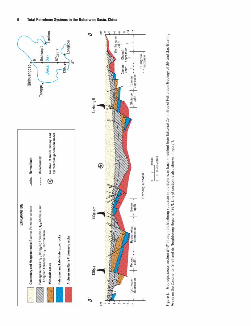
6 Total Petroleum Systems in the Bohaiwan Basin, China
Figu
re 3
. Ge
olog
ic c
ross
sec
tion
B–B’
thro
ugh
the
Bozh
ong
subb
asin
in th
e Bo
haiw
an b
asin
(mod
ified
from
Edi
toria
l Com
mitt
ee o
f Pet
role
um G
eolo
gy o
f Oil-
and
Gas
-Bea
ring
Area
s on
the
Cont
inen
tal S
helf
and
its N
eigh
borin
g Re
gion
s, 1
987)
. Lin
e of
sec
tion
is a
lso
show
n in
figu
re 1
.
Pale
ogen
e ro
cks:
T2-
3 Don
gyin
g Fo
rmat
ion,
T3-
8 Sha
hejie
and
Ko
ngdi
an F
orm
atio
ns, T
8 Cen
ozoi
c ba
se
EXPL
AN
ATIO
N
Qua
tern
ary
and
Neo
gene
rock
s; G
uant
ao F
orm
atio
n at
bas
e
Mes
ozoi
c ro
cks
Pale
ozoi
c an
d La
te P
rote
rozo
ic ro
cks
Arc
hean
and
Ear
ly P
rote
rozo
ic ro
cks
Nor
mal
faul
t
Unc
onfo
rmity
Loca
tion
of b
uria
l hi
stor
y an
d hy
droc
arbo
n ge
nera
tion
mod
el
05
10 M
ILES
05
10 K
ILOM
ETER
S
Qinh
uang
dao
Tang
gu
Long
kou
Boh
ai
BayBo
zhon
g 5
BZ28
-1-7
13B 5
-1
B
B'
Lush
un
B’B
Huan
ghua
su
bbas
in
Shiji
utuo
up
lift
Qinn
an
depr
essi
on
Qinn
anup
lift
20 4 6 8 10 12
Bozh
ong
5
Chan
gli
depr
essi
on
Shan
halg
uan
uplif
t
KM
Kedo
ng
uplif
tHu
angh
ekou
de
pres
sion
Laizh
owan
depr
essi
on
Bozh
ong
subb
asin
Bona
n up
lift
20 4 6 8 10 12
BZ28
-1-7
13B 5
-1
T 2 T 3 T 8
T 2 T 3 T 8
T 2T 3
T 8
KM

Province Geology 7
the Bohai Bay part of the Bohaiwan basin and resulted in oil and gas discoveries in the Bozhong (1981) and Liaohe (1984) subbasins. Through the second quarter of 1996, the Bohaiwan basin had a known petroleum volume (cumulative production + remaining reserves) of 27.3 billion barrels of oil equivalent (BBOE) (Klett and others, 1997). The term “known petroleum volume” as used by Klett and others (1997) for the entire Bohaiwan basin is synonymous with the term “known recov-erable” (also defined as cumulative production + remaining reserves) used for oil fields presented later in this report.
A Paleogene lacustrine black shale and mudstone unit (Member 3 of the Shahejie Formation, fig. 4), representing one of several stages of maximum expansion of subbasin-centered lakes, is the major source rock. Paleogene and Neogene nonmarine sandstones constitute the major reservoir rocks, especially where they are interbedded with lacustrine black shale and mudstone source rocks. Also, Paleozoic and Middle to Late Proterozoic marine limestone and dolomite and highly weathered Archean crystalline basement rocks are important reservoirs (fig. 4). The Paleogene and Neogene nonmarine sandstone reservoirs were deposited in deltaic and fluvial sequences that flanked subbasin-centered lakes and in turbidite sequences in the central parts of the lakes. The lower Paleo-zoic and Proterozoic marine limestone and dolomite reservoirs were deposited as peritidal and shallow-water shelf carbonates on a stable craton.
Technically, each of the six subbasins in the Bohaiwan basin, with one or more pods of active source rock, constitutes a separate total petroleum system because the subbasins are separated from one another by structurally high fault blocks (horst blocks) that are largely impervious to the migration of oil and gas. Furthermore, multiple petroleum systems may exist in each subbasin as suggested by the presence of several important source-rock intervals in the basin, such as three members of the Shahejie Formation, one member of the Kong-dian Formation, and one member of the Dongying Formation. However, rather than separate total petroleum systems being assigned to each subbasin and (or) to each major source-rock interval, they are combined in this report into a single total petroleum system. The Shahejie−Shahejie/Guantao/Wumis-han Total Petroleum System recognized in this report very adequately expresses the dominance of the Shahejie Forma-tion source rocks, the highly productive Shahejie Formation and Guantao Formation sandstone reservoir rocks, and the Wumishan Formation carbonate reservoir rock. Recognition of a single total petroleum system is further justified by the similarity in physical and chemical properties of the Bohaiwan basin oils (tables 1−6; Chen and others, 1996).
The Shahejie−Shahejie/Guantao/Wumishan Total Petro-leum System (312701) contains all of the discovered oil and gas in the Bohaiwan basin. The oil and gas in this total petro-leum system are trapped in conventional accumulations (see the definition by Klett and others, 2000).
The hypothetical Carboniferous/Permian Coal–Paleozoic Total Petroleum System (312702) is based on data presented by Chang and others (1981) and Xu and Shen (1996). This
total petroleum system is named for a moderately to deeply buried sequence of Carboniferous and Permian coal beds, which is the source-rock interval, and Paleozoic sandstone-and-coal-bearing units (Permian and Carboniferous) that are considered to be the reservoirs. Most of the gas in this hypothetical total petroleum system is inferred to be trapped in continuous accumulations (see the definition by Klett and others, 2000).
Province Geology
Geographic Setting
The Bohaiwan basin is situated in Hebei, Henan, Lia-oning, and Shandong Provinces of eastern China (fig. 1). Approximately 25 percent of the basin is located beneath Bohai Bay,2 a shallow marine embayment of the north end of the Yellow Sea. North Korea is within 200 kilometers (km) of the northeast end of the basin and Mongolia is within 550 km of the northwest end. A low-relief (<100 meters (m) above mean sea level) alluvial and coastal plain bordering Bohai Bay characterizes the present-day topography. The Huang He (Yellow River) flows northeastward across the basin and emp-ties into the south end of Bohai Bay, where it has built a delta. Several other large rivers flow across the basin, including the Liao He that empties into the north end of Bohai Bay. Sur-face air temperatures are hot (>20°C) in the summer and cold (<0°C) in the winter.
Stratigraphic Setting
Sedimentary fill as thick as 10 km is preserved in one or more depressions (sags) of the Jiyang, Jizhong, and Bozhong subbasins (figs. 2, 3). In ascending order, the major stratigraphic units in the Dongying depression of the Jiyang subbasin are as follows: (1) unnamed Cambrian and Ordovi-cian strata (200–500 m); (2) unnamed Carboniferous and Permian strata (500–1,200 m); (3) unnamed Mesozoic strata (800–2,500 m); (4) Paleocene and Eocene Kongdian Forma-tion (Members 1−3) and Eocene Shahejie Formation (Member 4) (1,400–6,000 m); (5) Eocene and Oligocene Shahejie For-mation (Members 1−3) (400–1,600 m); (6) Oligocene Dong-ying Formation (200–800 m); and (7) unnamed Neogene and Quaternary strata (500–2,000 m) (Hu and Krylov, 1996) (fig. 2). The 1,200-m thickness for the Carboniferous and Permian strata indicated by Hu and Krylov (1996) is probably too great when compared with thickness estimates of 450 to 770 m cited by ECPG−Shengli (1987) and of 300 to 330 m cited by Lee (1989) (fig. 4).
2The term “Bohai Bay” as used in this report follows the usage of Hu and others (1989) and Hu and Krylov (1996).

8 Total Petroleum Systems in the Bohaiwan Basin, China
SOU
RCES
(see
Ref
eren
ces
Cite
d)
Chin
ese
Acad
emy
of G
eolo
gica
l Sci
ence
s, 1
982
Hao
and
Zhan
g, 1
984
Inst
itute
of G
eolo
gy, A
cade
mia
Sin
ica,
195
8Fe
i and
Wan
g, 1
984
Regi
onal
Stra
tigra
phic
Edi
toria
l Se
ctio
n of
the
He
bei P
rovi
nce
and
Tian
jin R
egio
n, 1
979a
Regi
onal
Stra
tigra
phic
Edi
toria
l Se
ctio
n of
the
He
bei P
rovi
nce
and
Tian
jin R
egio
n, 1
979b
Scie
ntifi
c Re
sear
ch
Inst
itute
of
Pe
trol
eum
Ex
plor
atio
n an
d D
evel
opm
ent,
Min
istr
y of
Pe
trol
eum
Ind
ustr
y an
d In
stitu
te o
f Ge
olog
y an
d Pa
leon
tolo
gy, A
cade
mia
Sin
ica,
197
8
Zha,
198
4
Zhon
gyua
n Pe
trole
um E
xplo
ratio
n Bu
reau
, 198
0
Sand
ston
e
Mud
ston
e
Cong
lom
erat
ic s
ands
tone
Cong
lom
erat
e
Silts
tone
Shal
e
Oil s
hale
(bla
ck s
hale
)
Lim
esto
ne
Argi
llace
ous
limes
tone
Quar
tzite
Dolo
mite
Rock
sal
t
Gyps
um
Basa
lt
Volc
anic
rock
Oil
Oil a
nd g
as
Gas
Gran
ite a
nd g
neis
s
Coal
Hiat
us
Angu
lar u
ncon
form
ity
Disc
onfo
rmity
EXPL
AN
ATIO
N
Era
Kong
dian
Shah
ejie
Dong
ying
Guan
tao
Min
ghua
zhen
Pale
ocen
e
Eoce
ne
Olig
ocen
e
Mio
cene
Plio
cene
Form
atio
nor
Grou
pSe
ries
Syst
em
Neogene
Cret
aceo
usan
dJu
rass
ic
MesozoicCenozoic
Terti
ary
Paleogene
Sini
anCa
mbr
ian
Ordo
vici
an
Perm
ian
and
Carb
onife
rous
Archean and Early Proterozoic
Middle and Late ProterozoicPaleozoic
Jixi
an
Qing
baik
ou
Chan
gche
ng
Shih
ezi
Shan
xiTa
iyua
nBe
nxi
Feng
feng
Bado
u
Maj
iago
uLi
angj
iash
an
Tiel
ing
Hong
shui
zhan
gW
umis
han
Yang
zhua
ng
Gaoy
uzhu
ang
Men
tou
Yili
Jing
eryu
Chan
glon
gsha
nXi
amal
ing
300-
600
500-
700
70-1
,000
150-
370
100-
700
45-4
00
200-
300
40-3
71
1,00
0
90-1
,000
50-4
00
Jizh
ong
subb
asin
Linq
ing/
Dong
pu s
ubba
sin
1 2 4321321
3-4
1-3
1-3
21
Lith
olog
yM
embe
r/Res
ervo
irLi
thol
ogy
Mem
ber/R
eser
voir
Thic
knes
s(m
)
300-
3,50
0
200-
300
137
800
170
1,60
0
800
800
200
400-
2,00
0
600
0-80
0
600
30-5
0010
-300
160-
1,06
0
190-
1,04
0
350-
440
120-
440
90-7
00
60-5
10
100-
1,00
0
550
0-60
060
21 43 321
800
200-
300
400-
850
170-
450
100-
1,00
0
Huan
ghua
sub
basi
n 400-
800
1,00
0-1,
500
60-3
0015
0-35
050
-240
50-3
3015
0-38
0
200-
600
Boha
iwan
Bas
in
121 32 4 5
Lith
olog
yM
embe
r/Res
ervo
irTh
ickn
ess(
m)
Thic
knes
s(m
)Bo
zhon
g su
bbas
inJi
yang
sub
basi
n
630-
980
130-
540
350-
950
800-
1,15
0
100-
250
200-
400
150-
800
200-
300
0-30
0
300-
500
500-
600
630-
980
130-
540
350-
950
800-
1,15
0
100-
250
200-
400
150-
800
200-
300
0-30
0
300-
500
500-
600
121 3 2 3 2144321 321 21
Lith
olog
yM
embe
r/Res
ervo
irLi
thol
ogy
Mem
ber/R
eser
voir
Thic
knes
s(m
)Th
ickn
ess(
m)
300-
330
300-
510
300-
500
180-
360
120-
320
0-50
0
530
300-
1,00
0
300-
500
33
60 60
Liao
he s
ubba
sin
630-
980
130-
540
350-
950
800-
1,15
0
100-
250
200-
400
150-
800
200-
300
0-30
0
300-
500
400-
1,20
0
300-
500
500-
600
321 321 4 321
Lith
olog
yM
embe
r/Res
ervo
irTh
ickn
ess(
m)
300-
700
250-
750
0-1,
500
640
Fuju
nsha
n

Province Geology 9
Representative stratigraphic sections for each of the six subbasins are shown in figure 4. These stratigraphic sec-tions were compiled by Lee (1989) from a variety of sources. Modifications to Lee’s (1989) original compilation include the following: (1) the addition of the Paleocene to the lower part of the Kongdian Formation as reported by Allen and oth-ers (1997); (2) the upward revision of the Eocene-Oligocene boundary to the middle of Member 2 of the Shahejie Forma-tion as reported by ECPG−Shengli (1987) and Allen and oth-ers (1997); (3) the addition of oil and gas symbols to the Mio-cene-Pliocene Minghuazhen Formation as reported by Gong and others (1998) and Jin and McCabe (1998); (4) the addition of several lithologic units such as sandstone reported by Tian and others (1996); and (5) the addition of Archean rocks to several subbasins as reported by Zhao and others (1999).
Tectonic Setting
The Bohaiwan basin is a large (~200,000 km2) intracra-tonic rift basin composed of Precambrian, Paleozoic, Meso-zoic, and Tertiary sedimentary rocks underlain by Precambrian crystalline basement rocks and overlain by unconsolidated Quaternary sediments. The basin is largely surrounded by mountain ranges and uplifts composed of a variety of Precam-brian, Paleozoic, and Mesozoic rocks. Complex block faulting in the subsurface has little, if any, surface expression (figs. 2, 3). Block-faulted pre-Quaternary rocks in the subsurface define a “dogleg-shaped” basin consisting of a rhomboid-shaped central area and narrow northeast- and southwest-tapering extensions (fig. 1; Allen and others, 1997). The length of the basin between its narrow southwest and northeast extensions is approximately 1,100 km and the width of the basin at its rhomboid-shaped central area is approximately 400 km (fig. 1). The basin is underlain by Archean and Early Proterozoic metamorphic rocks that constitute the North China (Sino-Korean) block or craton (Tian and others, 1992; Yin and Nie, 1996). Archean and Early Proterozoic metamorphic rocks, Middle and Late Proterozoic to lower Paleozoic sedi-mentary rocks, and Jurassic and Cretaceous volcanic rocks are exposed in uplifts that flank the west (Taihang Shan uplift) and north (Yanshan fold belt) sides of the basin and parts of the east (Ludong and Liao Dong uplifts) and south (Luxi uplift) sides (fig. 1A) (Tian and others, 1992; Allen and others, 1997). The 2,500-km-long, left-lateral(?) Tan-Lu fault zone (fig. 5) bounds the east side of the Bohaiwan basin (Yin and Nie, 1996; Kimura and others, 1990).
A complex basin evolution involved the following events: (1) several stages of Proterozoic and early Paleozoic shelf sedimentation (~1,700 to 458 Ma); (2) early to middle Paleozoic regional subaerial exposure and erosion (~458 to 320 Ma); (3) late Paleozoic foreland basin(?) sedimenta-tion and contractional deformation(?) (~320 to 250 Ma); (4) Mesozoic contractional deformation, extensional deformation, and volcanism (~240 to 230 Ma and ~160 to 70 Ma); (5) early Tertiary (Paleogene) extension and rifting (~55 to 24 Ma); and (6) late Tertiary (Neogene) to recent post-rift subsidence (~22 Ma to present) (Hu and others, 1989; Allen and others, 1997).
Shallow-marine carbonates and local sandstone of Middle to Late Proterozoic, Cambrian, and Ordovician age were deposited on the North China block (fig. 5) when it was part of Gondwanaland (Lin and others, 1985). After a 130- to 150-million-year (m.y.) interval of post-Middle Ordovician epeirogenic uplift, subaerial erosion, and northward drift, the North China block collided with, and accreted to, the Mongol-Okhotsk terrane (Altaids) (fig. 5) in Late Carboniferous to Early Permian time (Yin and Nie, 1996; Sengör and Natal’in, 1996). Allen and others (1997) suggested that southward-directed thrusting generated by the collision may have formed a foreland basin on the North China block. Late Carbonif-erous and Permian shallow-marine limestone, continental terriginous clastic rocks, and coal beds (Lin and others, 1995) were deposited in the foreland basin. However, contractional tectonism accompanying the collision does not appear to have left a recognizable structural imprint on Proterozoic and early Paleozoic sedimentary rocks of the North China block.
The complex Mesozoic history of the Bohaiwan basin area is marked by contractional and extensional deformation, plutonism, and volcanism. Late Triassic collision (Indosinian orogeny) between the North China and South China (Yang-tze) blocks uplifted most of the Bohaiwan area so that very few Triassic strata were preserved (Yin and Nie, 1996). Late Jurassic to Early Cretaceous contraction (Yanshanian orogeny) is recorded in basement-involved, fold-and-thrust belts with associated plutonism along the north (Yanshan fold belt) and west flanks (Taihang Shan uplift) of the basin (Kimura and others, 1990; Davis and others, 1996). Nonmarine Mesozoic red beds in the Bohaiwan basin may represent deposits of a foreland basin that accompanied this contraction (Hsü, 1989). Pre-Cenozoic decollement structures and overthrusts reported on seismic profiles crossing Bohai Bay (Zhu Xia in Hsü, 1989) provide additional evidence for contraction at this time. The plate tectonic setting of the contraction is uncertain, but possibilities include (1) gravitational collapse and southward spreading of the Mongol-Okhotsk terrane during subduction beneath the Siberia (Angara) craton, (2) collision between the North China and South China blocks, (3) subduction of the Pacific plate (not shown in this report) beneath North China, and (4) combinations of the above (Davis and others, 1996; Yin and Nie, 1996; Meng, 2003) (fig. 5).
Major crustal extension that initiated the Bohaiwan basin probably began in early Late Cretaceous time and was charac-terized by an east-dipping, downward-flattening, breakaway
Figure 4 (facing page). Stratigraphy of the subbasins in the Bohaiwan basin (modified from Lee, 1989). These stratigraphic sections originally were compiled by Lee from the sources listed.

10 Total Petroleum Systems in the Bohaiwan Basin, China
Yinshan-Tumen fault
Mish
an-F
ushu
n fau
lt
EXPLANATION
0 200 MILES
0 200 KILOMETERS
Fault—Sawteeth on upper plate. Arrows show relative movement
Basin
OrdosBasin
EastBasin
TamsungBasin
HailarBasin
ErlianBasin
BohaiwanBasin
SongliaoBasin
Zeya-a-BureyaBasin
SanjiangMiddle AmurBasin
RUSSIA
Siberia (Angara) craton
Yinshan
North China blockYellow
Sea
MONGOLIA
RUSSIARUSSIA
BohaiBay
KoreaBay
North China block
Mongol-Okhotsk terrane
(Altaids)
Tan-
Lu
Yanshan
fold belt
fault
zone
Mongo
l- Okh
otsk
collis
ion
zone
Taih
ang
Shan
upl
ift
South China (Yangtze) block
Daxi
ngga
nlin
g
u
plift
NORTH KOREA
SOUTH KOREA
110° 115° 120° 125° 130°
50°
45°
40°
35°
30°

Exploration History as of June 2001 11
normal fault that separated highly extended pre-Cenozoic rocks of the basin from less extended rocks of the Taihang Shan uplift west of the basin (Ma and Wu, 1987; Davis and others, 1996). The western margin of this master detachment fault system is exposed in the Taihang Shan and Yan Shan ranges as north- to northeast-trending normal faults of large displacement. Local basaltic volcanism was associated with this extension (Tian and others, 1992).
Crustal extension and rifting that began in latest Meso-zoic time accelerated during late Paleocene to Eocene time and continued more or less continuously through Oligocene time to shape the present-day Bohaiwan basin (Hu and others, 1989; Allen and others, 1997). Deformation is characterized by listric normal faults that segmented the Archean base-ment rocks into an array of large half-grabens, tilted fault blocks, grabens, and intervening structural highs (rises and horst blocks). Thick syn-rift nonmarine deposits of alluvial fan, fluvial, and lacustrine origin filled the evolving basins. Commonly, basaltic lavas are interbedded with the syn-rift sedimentary deposits (Ye and others, 1997). Back-arc spread-ing caused by subduction roll-back of the Pacific plate beneath North China is the probable mechanism of basin formation (Watson and others, 1987; Hsü, 1989; Tian and others, 1992; Allen and others, 1997).
Early Cenozoic extension (late Paleocene to early Eocene) was concentrated in the southern (Linqing/Dongpu), western (Jizhong and Huanghua), and northeastern (Liaohe) parts of the basin and resulted in north-northeast-trending rift structures (Hu and others, 1989; Allen and others, 1997). Very likely, the normal faults accompanying this rifting event in the southern and western parts of the basin were controlled by, and flatten into, the east-dipping latest Mesozoic breakaway normal fault proposed by Davis and others (1996).
Basinwide extension began in the middle Eocene Epoch (Allen and others, 1997) or early Oligocene Epoch (Hu and others, 1989), during which time extensional faults propagated rapidly southward from the Liaohe subbasin area to overlap, in en echelon fashion, active rift structures in the southern and western parts of the basin. The zone of overlap between the northwest-trending rifts, each having a component of right-lat-eral transtension, formed pull-apart basins in the vicinity of the Jiyang and Bozhong subbasins (Allen and others, 1997). These
proposed right-lateral pull-apart structures created east-west- oriented rift basins and marked crustal thinning (Ye and others, 1985). For this dextral-shear model to work, the Tan-Lu fault zone along the east side of the basin (fig. 1B) would have had right-lateral movement throughout the Tertiary. In contrast, tectonic plate reconstructions by Kimura and others (1990) and Yin and Nie (1996) suggested left-lateral displacement along the Tan-Lu fault zone (fig. 5). Active crustal extension continued throughout the basin in late Eocene and Oligocene time but was concentrated in the central (Bozhong and Jiyang subbasins) part (Ye and others, 1985; Allen and others, 1997). The estimated 30 percent of crustal extension across the Bohaiwan basin produced a 30- to 35-km-thick crust that is 5 to 10 km thinner than the crust in the adjoining Taihang Shan (Liu and others, 1978; Davis and others, 1996).
Rifting ended rather abruptly in latest Oligocene to early Miocene time and the basin evolved into a post-rift, thermal subsidence phase (Hu and others, 1989; Allen and others, 1997). Allen and others (1997) suggested that prior to thermal subsidence, contractional (or transpressional) deformation at the end of the Oligocene may have caused mild structural inversion in parts of the basin. They attributed the termination of the rifting phase to colliding of the India and Eurasia plates or colliding of the Australia and Philippine plates (none of these tectonic plates are shown in this report). Regional uplift and approximately 200 to 1,300 m of erosion predated the deposition of post-rift Neogene and Quaternary sedimentary rocks that covered most of the basin. The center of post-rift subsidence and sedimentation is coincident with the region of maximum Paleogene extension in the vicinity of present-day Bohai Bay. Thick Quaternary sediments and a record of large earthquakes delineate a west-northwest-trending zone of sub-sidence between Beijing and the center of Bohai Bay that may signify an active, new phase of rifting (Ye and others, 1985).
Exploration History as of June 2001Encouraged by historical reports of local oil and gas
seeps along the shores of Bohai Bay and adjoining areas, petroleum exploration began in the Bohaiwan basin about 1955. After regional geophysical surveys and the drilling of 10 dry holes (4 in Linqing/Dongpu subbasin, 3 in Jiyang subba-sin, 2 in Huanghua subbasin, and 1 in Jizhong subbasin), oil was discovered in the Jiyang subbasin in 1960 or 1961 (table 1). This discovery of the giant Dongxin oil field on the Dong-ying faulted anticline led to development of the fourth largest field in the Shengli complex (fig. 1A). The giant Shengtuo and Gudao oil fields (largest fields in the Shengli complex) (fig. 1A) were discovered in 1964 and 1968, respectively. The third largest oil field in the Shengli complex, the Gudong field (fig. 1A), was discovered in 1984 near the shoreline of Bohai Bay. Oil in all these giant fields is trapped in faulted roll-over anticlines or in compaction anticlines draped over underlying
Figure 5 (facing page). Tectonic map of northeastern China and adjoining countries showing the Bohaiwan basin, North China block, and selected tectonic provinces and features. Modified from Allen and others (1997, fig. 4, p. 956) and published with permission of Elsevier. Names of selected features are from Davis and others (1996), Kimura and others (1990), Meng (2003), Yin and Nie (1996), and Sengör and others (1993).
12 Total Petroleum Systems in the Bohaiwan Basin, China
tilted fault blocks (buried hills) of lower Paleozoic carbonate rocks. Reservoirs consist of lacustrine and fluvial-deltaic sand-stones of Paleogene and Neogene age. The combined known recoverable of the Dongxin, Shengtuo, Gudao, and Gudong fields is between 9 and 10 billion barrels of oil (BBO) (Jin and McCabe, 1998).
The first commercial oil discoveries in the other subba-sins of the Bohaiwan basin were reported as follows: Huan-ghua subbasin, 1962; Jizhong subbasin, 1964; Liaohe sub-basin, 1964; Linqing/Dongpu subbasin, 1975; and Bozhong subbasin, 1975. In the Jizhong subbasin, the giant Renqiu oil field (fig. 1A), with a known recoverable of 2.3 BBO (Horn, 1990) to 2.85 BBO (Jin and McCabe, 1998), was discovered in 1975. The discovery of the Renqiu field was very significant because it established buried-hill traps (tilted fault blocks), with Proterozoic and lower Paleozoic carbonate reservoirs, as a major target for exploration (Zhai and Zha, 1982). Prior to the discovery of Renqiu, objectives for oil exploration in the Bohaiwan basin were confined to accumulations in Paleogene and Neogene lacustrine sandstone reservoirs in structural and stratigraphic traps. The major onshore oil fields in the Liaohe subbasin were discovered between 1964 and 1975 in faulted anticlines and buried hills: Huangjindai (1964); Xinglongtai in the Panshan complex (1969); Gaosheng (1975); Huanxil-ing (1975); and Shuguang in the Panshan complex (1975) (fig. 1A). Commonly, these Liaohe subbasin fields contain low-gravity oil and have a combined known recoverable of at least several billion barrels of oil (table 2; Jin and McCabe, 1998).
Beginning in 1980, the Chinese National Offshore Oil Company (CNOOC) signed several cooperative agreements with foreign companies to explore the offshore part of the Bohaiwan basin (ECPG−Continental Shelf, 1987; Han and Wang, 1997). Among the oil fields discovered on coopera-tive lease blocks in the Bozhong subbasin are the following: Bozhong 28-1 (date of discovery 1981); Bozhong 28-2 (date of discovery 1983); Bozhong 34-3 (date of discovery 1984); Peng Lai 14-3-1 (date of discovery 1997); and Peng Lai 19-3-1 (date of discovery 1999) (ECPG−Continental Shelf, 1987; Oil and Gas Journal, 1997; Shirley, 2000) (see fig. 1A for the location of several of these fields). The largest off-shore oil field discovered in the Bohaiwan basin to date is the Suizhong 36-1 field (fig. 1A) in the Liaohe subbasin. Dis-covered by the Chinese in 1986, this field contains, in-place, between 1 and 2.1 billion barrels of low-gravity oil (Li, 1989; Gustavson and Xin, 1990; Jin and McCabe, 1998). In 1995, the Chinese discovered the Qinhuangdao 32-6 oil field (fig. 1A) in the Bozhong subbasin, their second largest offshore oil field (having in-place oil of ≈ 1 BBO) (China Oil & Gas, 1998; Appalachian Basin Report, 1998). Atlantic Richfield (now merged with British Petroleum (BP)) and Texaco (now merged with Chevron) are developing this field in cooperation with CNOOC (Appalachian Basin Report, 1998).
The onshore part of the Bohaiwan basin is now in a mature stage of exploration, having a high density of wells drilled to less than 3,500 m and about 1,400 wells drilled
deeper than 3,500 m (He and others, 1998). Exploration in the Bohaiwan basin in the 1990s and early 2000s focused on the offshore area (He and others, 1998; Oil and Gas Journal Newsletter, 1999; Oil and Gas Journal, 2001), but onshore exploration for oil and gas at depths between 3,500 and 5,500 m continues (He and others, 1998; Zhang, 1999).
Ulmishek (1992) suggested that the Bozhong and Liaohe (offshore) subbasins have the best potential for new oil and gas discoveries. Most future discoveries in the onshore part of the Bohaiwan basin are expected to be in subtle, chiefly strati-graphic, traps. In the 1994 USGS World Energy Resources Assessment (Masters and others, 1998), known recoverable oil and gas in the Bohaiwan (North China) basin were estimated to be 15.6 BBOE (13.4 BBO and 13.4 trillion cubic feet of gas (TCFG)), whereas undiscovered oil and gas resources were estimated, at a mean value, to be 6.7 BBOE (5.4 BBO and 8 TCFG). The known petroleum volume of 27.3 BBOE reported by Klett and others (1997) consists of 24.6 BBO, 15.7 TCFG, and 0.1 billion barrels of natural gas liquids.
Shahejie−Shahejie/Guantao/Wumishan Total Petroleum System (312701)
Petroleum Occurrence
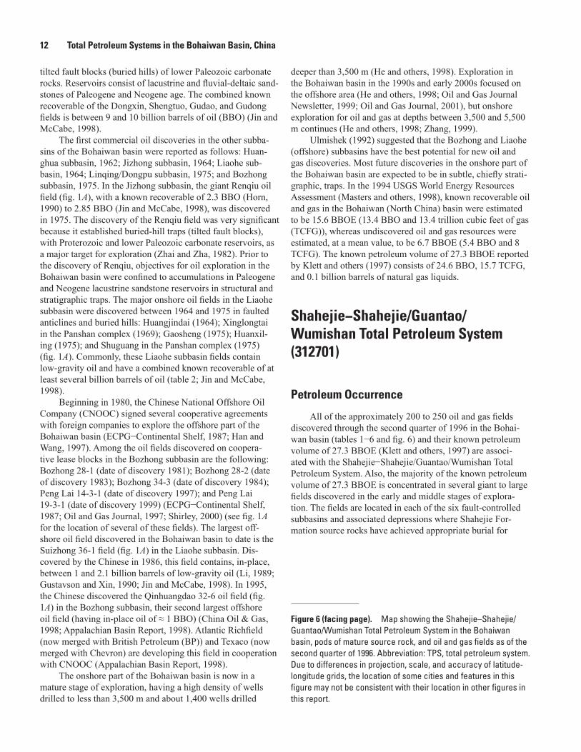
All of the approximately 200 to 250 oil and gas fields discovered through the second quarter of 1996 in the Bohai-wan basin (tables 1−6 and fig. 6) and their known petroleum volume of 27.3 BBOE (Klett and others, 1997) are associ-ated with the Shahejie−Shahejie/Guantao/Wumishan Total Petroleum System. Also, the majority of the known petroleum volume of 27.3 BBOE is concentrated in several giant to large fields discovered in the early and middle stages of explora-tion. The fields are located in each of the six fault-controlled subbasins and associated depressions where Shahejie For-mation source rocks have achieved appropriate burial for
Figure 6 (facing page). Map showing the Shahejie–Shahejie/Guantao/Wumishan Total Petroleum System in the Bohaiwan basin, pods of mature source rock, and oil and gas fields as of the second quarter of 1996. Abbreviation: TPS, total petroleum system. Due to differences in projection, scale, and accuracy of latitude-longitude grids, the location of some cities and features in this figure may not be consistent with their location in other figures in this report.

Shahejie−Shahejie/Guantao/Wumishan Total Petroleum System (312701) 13
Oil field
Gas field
Oil and gas field
City
TPS boundary
Assessment unit boundary
Outline of pod of mature source rock
Geologic province boundary
Subbasin boundary Uplift boundaryBzHuLiaLi/DoJyJz
BozhongHuanghuaLiaoheLinqing/DongpuJiyangJizhong
CaCh
CangxianChengning (this area is excluded from the TPS)
EXPLANATION
Zhangguang-cailing Uplift
Songliao BasinErlianBasin
Taihangshan YanshanFold Belt
BohaiwanBasin
KoreaBay
Basin
LuxiJiaoliao
Basin
Subei YellowSea Basin
QinlingDabieshan Fold Belt
ShanxiPlateau
BohaiBay
Taikang HefeiBasin
0 120 MILES40 80
0 120 KILOMETERS40 80
115°
35°
40°
120° 125°
Bz
Hu
Lia
Li/Do
Jy
JzCa
Ch
China
Yellow Sea
(Bohaiwan basin outlined in red)
Wudi
Jinan
Linyi
Shulu
Guan
Hangu
Anshan
Xinmin
Baxian
Renqui
Xinj in
Dal ian
Lushun
Tanggu
Jinzhou
Weifang
Tianjin
Dongj ia
Baoding
Beijing
Zhanhua
Changi l
Yanshan
Yingkou
Shenyang
Guangrao
Shenxian
Tangshan
Huanghua
Cangzhou
Goubangzi
Dongguang
Qinhuangdao
Yangerzhuang
Chenjiazhuang
Shijiazhuang
Zibo(Zhangdian)

14 Total Petroleum Systems in the Bohaiwan Basin, China
oil generation (figs. 1−3). Two major reservoir intervals are recognized in the total petroleum system: (1) Tertiary sand-stones of nonmarine origin that overlie, are interbedded with, or are in fault contact with Shahejie Formation source rocks and (2) Archean metamorphic rocks and Proterozoic and lower Paleozoic marine carbonates that are unconformably overlain by or are in fault contact with Shahejie Formation source rocks. Approximately 80 percent of the known recoverable oil and gas in the Bohaiwan basin reside in Tertiary sandstone reservoirs and about 10 to 20 percent reside in Proterozoic and lower Paleozoic carbonate and Archean crystalline rock reservoirs in buried hills. A small percentage of the known oil and gas reserves are located in Tertiary bioclastic carbon-ate reservoirs, shale reservoirs, and volcanic rock reservoirs (Chang, 1991).
Source Rocks
IntroductionSimilar biomarker (terpanes, steranes, pristane, phytane),
n-alkane, and δ13C1 distributions from at least several hundred crude oils (from both sandstone and carbonate reservoirs) suggest that the oils in all six subbasins in the Bohaiwan basin very likely have been derived from source rocks of the same approximate age and depositional setting (ECPG−Shengli, 1987; ECPG−Continental Shelf, 1987; Liang, 1987a,b; Shi and Qin, 1987; Liu and others, 1988; Ge and ECPG−Liaohe, 1989; Chen and others, 1996). This conclusion is further supported by reasonably consistent API gravity values (≈25 to 44°) and sulfur content (<0.1 to 1.0 percent), high paraffin content (≈20 to 30 percent), and gas-oil ratios (generally less than 1,000 ft3 of gas per barrel of oil) among most crude oils in the Bohaiwan basin (tables 1−6; Chang, 1991).
Heavy to very heavy crude oils (<10 to 20° API gravity) are common in the Bozhong, Jiyang, Liaohe, and Huanghua subbasins. Some of these oils may have high sulfur contents (1−10 percent; see tables 1, 2, and 4) because of their abun-dant resin and asphaltene contents. Probably most of the heavy to very heavy oils were derived from the same source rocks as the light crude oils, but were modified by additional post-emplacement processes such as evaporative loss, water washing, and extensive biodegradation (Lu and others, 1990). However, some of the heavy oils may have originated from thermally immature source rocks that were deposited in brack-ish to saline water (Shi and others, 1982; Liang, 1987b; Huang and others, 1990; Lu and others, 1990; Chen and others, 1994; and Chen and others, 1996).
Stratigraphic UnitsMember 3 of the Eocene and Oligocene Shahejie Forma-
tion is the primary source rock in the Shahejie–Shahejie/Guantao/Wumishan Total Petroleum System (fig. 4). Also,
Members 4 and 1 of the Shahejie Formation are important source rocks in the Shahejie–Shahejie/Guantao/Wumishan Total Petroleum System, and in several subbasins they may be the primary source rocks (fig. 4). Other source rocks included in the Shahejie–Shahejie/Guantao/Wumishan Total Petroleum System are Member 2 of the Paleocene and Eocene Kongdian Formation (fig. 4), an important source rock in the Huanghua subbasin, and Member 3 of the lower Oligocene Dongying Formation, probably an important source rock in the Bozhong subbasin. Members 1, 3, and 4 of the Shahejie Formation, Member 2 of the Kongdian Formation, and Member 3 of the Dongying Formation are all identified on the events chart (fig. 7) as source rocks of the Shahejie–Shahejie/Guantao/Wumishan Total Petroleum System.
Member 3 of the Shahejie FormationMember 3 of the Shahejie Formation is the most impor-
tant source rock in the Bohaiwan basin (Liang, 1987a,b; ECPG−Shengli, 1987; Liu and others, 1988; Wu and Liang, 1988; Ge and ECPG−Liaohe, 1989; Li, Yao, and Liu, 1991; Gardemal and others, 1996; Gong and others, 1998). Most of the Shahejie Formation source rocks are interpreted to be deepwater lacustrine deposits in association with widespread anoxic conditions (Hu and others, 1989; Chang, 1991; Allen and others, 1997), and Member 3 represents the most wide-spread of these deposits in the Bohaiwan basin (Yao and others, 1994, cited in Allen and others, 1997). Intense rifting and a climate change to wetter, more humid conditions are suggested by Hu and others (1989) and Chang (1991) as the main reasons for the abrupt expansion of lacustrine condi-tions. Member 3 in all six subbasins generally consists of 1,000-m-thick, deepwater lacustrine deposits primarily of dark-gray mudstone, oil shale (black shale), siltstone, and dark-gray sandstone (fig. 4) (ECPG−Shengli, 1987; Chang; 1991; Yao and others, 1994, cited in Allen and others, 1997). This extensive lacustrine system is largely freshwater (ECPG−Shengli, 1987; Chen and others, 1994), but locally the lacus-trine system may have been mixed with seawater as suggested by the coexistence of freshwater and brackish-water fossils (Zhang, 1987). Beds of halite and gypsum are associated with Member 3 lacustrine deposits in the Linqing/Dongpu subbasin (Li, Yao, and Liu, 1991; Jin, 1991).
Figure 7 (facing page). Events chart for the Shahejie–Shahejie/Guantao/Wumishan Total Petroleum System. Geologic time scale based on Magoon and Dow (1994) and Magoon and Schmoker (2000). Abbreviations: Plio., Pliocene; Mio., Miocene; Olig., Oligocene; Eoc., Eocene; Pal., Paleocene; E, Early; M, Middle; L, Late.

Shahejie−Shahejie/Guantao/Wumishan Total Petroleum System (312701) 15
350
400
450
500
550
570
150
200
0
50
100
300
250
323
363
408
439
510
146
208
2,500
24
65
290
245 E
L
L
M
E
LM
E
L
L
L
M
E
E
M
E
L
M
E
LM
E
E
L
E
L
Cambrian
Ordovician
Silurian
Devonian
Mississippian
Pennsylvanian
Permian
Triassic
Jurassic
Cretaceous
Paleogene
Neogene
EProt. & Arch.
M-LProt.
Cam
bria
n an
d Or
dovi
cian
rock
sCr
etac
eous
and
Ju
rass
ic ro
cks
Perm
ian
and
Carb
onife
rous
rock
s
Sha
K 1-3
Mi
Gu
Do1-
4
L
EM
Prot
.Ar
ch.
JyBz
inburied
hills
inburied
hills
inburied
hills
rollover anticlines andtilted fault blocks
compaction (drape) anticlinesand rejuvenated faults
Extension and Rifting
Subsidence
CRIT
ICAL
MOM
ENT
PRES
ERVA
TION
GEN
ERAT
ION
- M
IGRA
TION
- ACC
UMUL
ATIO
N
TRAP
FOR
MAT
ION
OVER
BURD
EN R
OCK
SEAL
ROC
K
RESE
RVOI
R RO
CK
SOUR
CE R
OCK
ROCK
UN
ITPETR
OLEU
MSY
STEM
EVE
NTS
GEOL
OGIC
TIM
ESC
ALE
(Mill
ion
year
s)
Eoc.
Pal.
Mio.Olig.
Plio.
Jy
Bz
Sha, 1-4
K, 1-3
Prot.
Arch.
Mi
Gu
EXPLANATION
Rock Unit
Do
Critical moment, Jiyang subbasin
Critical moment, Bozhong subbasin
Unconformity
Hiatus
Shahejie Formation, Members 1–4
Kongdian Formation, Members 1–3
Proterozoic rocks
Archean rocks
Minghuazhen Formation
Guantao Formation
Dongying Formation

16 Total Petroleum Systems in the Bohaiwan Basin, China
Member 1 of the Shahejie FormationMember 1 of the Shahejie Formation is another important
source rock that occurs in all six subbasins (ECPG−Shengli, 1987; ECPG−Continental Shelf, 1987; Liu and others, 1988; Ge and ECPG−Liaohe, 1989; Tian and others, 1996; Hu, 1995, cited in Jin and McCabe, 1998). Similar to Member 3, Member 1 of the Shahejie Formation represents widespread lacustrine conditions; however, the dark-gray mudstone and oil-shale (black shale) source rocks in Member 1 are com-monly of lower organic richness than source rocks in Member 3 because basin subsidence was slower and more uniform dur-ing the deposition of Member 1 (Yao and others, 1994, cited in Allen and others, 1997). Member 1 of the Shahejie Forma-tion most commonly ranges in thickness from about 200 to 400 m (fig. 4). Fossil and lithologic assemblages suggest that Member 1 was deposited largely under freshwater conditions, but highly saline water was present in the Linqing/Dongpu subbasin as indicated by the presence of halite and gypsum deposits (Li, Yao, and Liu, 1991).
Member 4 of the Shahejie FormationMember 4 of the Shahejie Formation is reported to be
an important source rock in the Jiyang, Jizhong, Liaohe, and Linqing/Dongpu subbasins (ECPG−Shengli, 1987; Qian and Chen, 1990; Wu and Liang, 1988; Ge and ECPG−Liaohe, 1989; Tong and Huang, 1991; Hu, 1995, cited in Jin and McCabe, 1998). Member 4 represents the initial phase of widespread lacustrine sedimentation in the Bohaiwan basin (Hu and others, 1989; Yao and others, 1994, cited in Allen and others, 1997). Dark-gray mudstone interbedded with oil shale (black shale), siltstone, and sandstone of deepwater lacustrine origin characterize Member 4 deposits in the Jiyang subbasin, whereas dark-gray mudstone interbedded with gypsum-bear-ing mudstone, bioclastic limestone, and dolomite characterize Member 4 deposits in the other subbasins. Red beds, halite, and anhydrite commonly found in parts of Member 4 probably reflect a hot, dry climate (Hu and others, 1989). The presence of foraminifera and nannofossils in several carbonate units in Member 4 indicates that the lacustrine system at this time was intermittently connected with marine water (ECPG−Shengli, 1987; Allen and others, 1997). The thickness of Member 4 of the Shahejie Formation ranges generally from about 350 to 1,000 m (fig. 4).
Member 2 of the Kongdian FormationMember 2 of the Kongdian Formation is of secondary
importance as a source rock in comparison to Members 1, 3, and 4 of the Shahejie Formation. This source rock seems to be important only in the Huanghua subbasin (Liang, 1987a,b; Tian and others, 1996) and possibly in the Jizhong subbasin, where the Kongdian Formation is undivided (Wu and Liang, 1988). Member 2 source rocks consist of dark-gray to black mudstone and oil shale (black shale) and interbedded silt-stone and sandstone that probably were deposited in local
shallow-water lakes (Yao and others, 1994, cited in Allen and others, 1997). Lacustrine source-rock deposits in Member 2 were preceded by alluvial fan and fluvial deposits (Member 3) characterized by red and green mudstone, sandstone, and conglomerate with interbedded basalt flows. Member 1, which succeeds Member 2, has similar deposits as well as ephem-eral-lake deposits characterized by dark-gray gypsum-bearing mudstone (Zhang, 1987). Member 2 ranges in thickness from about 400 to 600 m (fig. 4).
Member 3 of the Dongying FormationThe lower part of the Dongying Formation (Member 3)
is also of secondary importance as a source rock in compari-son to Members 1, 3, and 4 of the Shahejie Formation. This source rock may be important in the Bozhong subbasin where it consists of dark gray mudstone that probably was deposited in deeper lakes (ECPG−Continental Shelf, 1987; Gong and others, 1998; Xu, 2004).
Geochemical Characteristics
Source Rocks in Member 3 of the Shahejie FormationTotal organic carbon (TOC) content in weight percent,
kerogen type, and hydrogen index (HI) values in milligrams of hydrocarbon per grams of organic carbon (mgHC/g orgC) for mudstone and oil-shale source rocks in Member 3 of the Shahejie Formation are reported in table 7. Figure 8 shows the distribution of total organic carbon in the Member 3 source rocks. The abundant organic matter in the source rocks is dom-inated by algae and bacteria that accumulated in the middle, deeper parts of the lake and by large quantities of terrigenous organic matter (including spores and pollen) that accumulated along the shallower margins of the lake (Hu and others, 1989; Gardemal and others, 1996).
Oil-Source Rock CorrelationsOil-source rock correlations based on biomarker distri-
butions (isoprenoids and others), n-alkane distributions, and δ13 C data indicate that the Shahejie Formation (Members 1, 3, and 4) and Kongdian Formation (Member 2) (Huanghua subbasin only) are the predominant source rocks for oils in the Tertiary sandstone reservoirs and the pre-Tertiary buried-hill carbonate reservoirs. For example, as interpreted from bio-marker distributions, oil in the Bozhong subbasin was derived from two main types of lacustrine source rock in Member 3 of the Shahejie Formation (Gardemal and others, 1996). One source-rock type (in the upper part of Member 3) has algal affinities, whereas the other source-rock type (in the lower part of Member 3) has higher quantities of bacteria (Gardemal and others, 1996). Also, oil from the Bozhong 28-1 field has been correlated with source rocks from Members 3 and 1 of the Shahejie Formation using biomarkers, n-alkane distributions, and δ13 C data (ECPG−Continental Shelf, 1987).
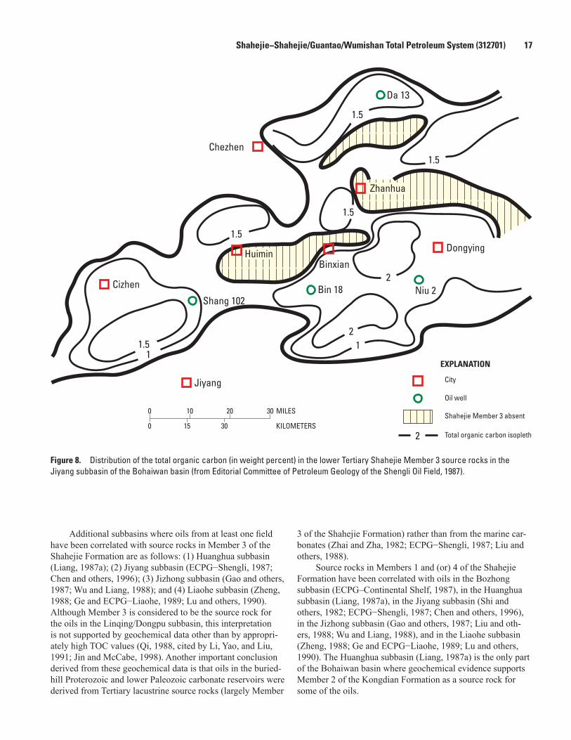
Shahejie−Shahejie/Guantao/Wumishan Total Petroleum System (312701) 17
Additional subbasins where oils from at least one field have been correlated with source rocks in Member 3 of the Shahejie Formation are as follows: (1) Huanghua subbasin (Liang, 1987a); (2) Jiyang subbasin (ECPG−Shengli, 1987; Chen and others, 1996); (3) Jizhong subbasin (Gao and others, 1987; Wu and Liang, 1988); and (4) Liaohe subbasin (Zheng, 1988; Ge and ECPG−Liaohe, 1989; Lu and others, 1990). Although Member 3 is considered to be the source rock for the oils in the Linqing/Dongpu subbasin, this interpretation is not supported by geochemical data other than by appropri-ately high TOC values (Qi, 1988, cited by Li, Yao, and Liu, 1991; Jin and McCabe, 1998). Another important conclusion derived from these geochemical data is that oils in the buried-hill Proterozoic and lower Paleozoic carbonate reservoirs were derived from Tertiary lacustrine source rocks (largely Member
3 of the Shahejie Formation) rather than from the marine car-bonates (Zhai and Zha, 1982; ECPG−Shengli, 1987; Liu and others, 1988).
Source rocks in Members 1 and (or) 4 of the Shahejie Formation have been correlated with oils in the Bozhong subbasin (ECPG–Continental Shelf, 1987), in the Huanghua subbasin (Liang, 1987a), in the Jiyang subbasin (Shi and others, 1982; ECPG−Shengli, 1987; Chen and others, 1996), in the Jizhong subbasin (Gao and others, 1987; Liu and oth-ers, 1988; Wu and Liang, 1988), and in the Liaohe subbasin (Zheng, 1988; Ge and ECPG−Liaohe, 1989; Lu and others, 1990). The Huanghua subbasin (Liang, 1987a) is the only part of the Bohaiwan basin where geochemical evidence supports Member 2 of the Kongdian Formation as a source rock for some of the oils.
Chezhen
Cizhen
Jiyang
Shang 102Bin 18
Da 13
Zhanhua
Dongying
Niu 2
BinxianHuimin
1.5
1.5
1.5
1.5
1.5
1
2
2
1
2 Total organic carbon isopleth
Shahejie Member 3 absent
Oil well
City
EXPLANATION
0 10 20 30 MILES
0 15 30 KILOMETERS
Figure 8. Distribution of the total organic carbon (in weight percent) in the lower Tertiary Shahejie Member 3 source rocks in the Jiyang subbasin of the Bohaiwan basin (from Editorial Committee of Petroleum Geology of the Shengli Oil Field, 1987).

18 Total Petroleum Systems in the Bohaiwan Basin, China
Natural GasesNatural gases in the Shahejie–Shahejie/Guantao/Wumi-
shan Total Petroleum System consist of a mixture of hydrocar-bon and non-combustible gases. The hydrocarbon gases most commonly occur as gas caps associated with oil fields and are characterized as wet gas: CH4 ≈ 77−93 percent, C2H6+ ≈5−20 percent, N2 ≈ 0.25−2 percent, and CO2 ≈ 0.25−2 percent (ECPG−Shengli, 1987; ECPG−Huabei, 1987; ECPG−Dagang, 1987; ECPG−Continental Shelf, 1987; Ge and ECPG−Liaohe, 1989; Xu and others, 1997). Most nonassociated gas accumu-lations consist of dry gas with CH4 >95 percent and C2H6+ ≈0−2 percent (ECPG−Dagang, 1987; Ge and ECPG−Liaohe, 1989). Small amounts of inert gases Ar and He, measured in tens to hundreds of parts per million (ppm), are mixed with the hydrocarbon gases (Ge and ECPG−Liaohe, 1989; Xu and others, 1997).
Carbon isotopes (δ13C1 ≈ -55.6 to -34.6) of selected hydrocarbon gases suggest that the majority of the Bohaiwan basin gases are thermogenic in origin (Xu and others, 1997). Moreover, in the Jiyang subbasin the carbon isotopic com-positions of the methane gases are very similar to those of absorbed gases in Member 3 of the Shahejie Formation, which is the proposed source rock (ECPG−Shengli, 1987). Several gases having light carbon isotopic values (δ13C1 ≈ -58.2 to -56.6) probably represent a mixture of biogenic and thermo-genic gases (ECPG−Dagang, 1987; Xu and others, 1997). High amounts (>15 percent) of non-combustible CO2 and N2 gases are present in the Huanghua and Jiyang subbasins (ECPG−Dagang, 1987; ECPG−Shengli, 1987). Gases having a high percentage of CO2 could have resulted from one or more of the following mechanisms: (1) migration of magmatic- and (or) mantle-derived fluids during Cenozoic volcanism, (2) thermal decomposition of carbonate rocks during deep burial, and (3) decomposition of sedimentary organic matter during deep burial (Dai and others, 1996; Xu and others, 1997; Jin and others, 2004). One well in the southern Jizhong subbasin reported an H2S content >90 percent (ECPG−Huabei, 1987).
Pods of Thermally Mature Source RockPods of thermally mature source rock (having vitrinite
reflectance (%Ro) of about 0.5−1.5) associated with the Shahe-jie and Kongdian Formations are confined to the six subbasins and the numerous associated depressions in the Bohaiwan basin (figs. 1A,B, 6). For example, in the Jiyang subbasin, Qian (1994; cited in Jin and McCabe, 1998) recognized 11 pods of mature source rock (identified as oil-source centers in their terminology) that are clustered in the Dongying, Huimin, Chezhen (Chenzheng), and Zhanhua (Zhanghua) depressions (see fig. 1B for location of depressions). The three pods of mature source rock in the Jiyang subbasin shown in figure 6 are centered on the Dongying, Huimin, Chezhen (Chenzheng), and Zhanhua (Zhanghua) depressions. The maximum thick-ness of mature source rock is about 900 m in the Dongying depression, about 400 m in the Huimin depression, and about
200 m in the Chezhen (Chenzheng) and Zhanhua (Zhanghua) depressions (ECPG−Shengli, 1987).
The Jizhong subbasin is another example where pods of mature source rock have been identified in the literature (Wu and Liang, 1988). One pod is located in the Guan depression in the northern part of the subbasin, whereas farther south, a second, larger pod is located in the Baxian, Raoyang, Shenx-ian, and Shulu depressions (figs. 1B, 6; Wu and Liang, 1988). Member 3 of the Shahejie Formation, containing thermally mature dark mudstone (oil shale and black shale) source rocks, reaches a maximum thickness of about 2,400 m in the Guan depression and about 300 to 500 m in the southern depressions (ECPG−Huabei, 1987).
Burial History, Hydrocarbon Generation, and Migration
Burial History and Hydrocarbon GenerationBurial history and hydrocarbon-generation-model studies
using a 36° C/km average geothermal gradient suggest that about 2,200 to 2,500 m of overburden rocks were required to achieve the critical moment for Shahejie Formation (Member 3) source rocks in the Jiyang and Bozhong subbasins (figs. 7, 9, 10; tables 8, 9). Although seemingly thin compared with most oil-producing regions of the world (where overburden thickness is commonly ≥3,000 m), these estimated overburden thicknesses are consistent with those in other subbasins and depressions in the Bohaiwan basin, such as the Huanghua subbasin (Chen and Zhang, 1991; Li and others, 2004), the Jizhong subbasin (Li, Du, and Hu, 1991; V.F. Nuccio, unpub. data, 1999), and the Liaohe subbasin (Ge and ECPG−Liaohe, 1989). In addition to the majority of the oils that were gener-ated from the thermal degradation of kerogen between %Ro ≈ 0.5 and 1.5, some of the heavy oils in the Bozhong, Jiyang, Liaohe, and Huanghua subbasins have been suggested to be the products of immature source rocks having %Ro ≈ 0.3−0.5 and overburden thickness ≤2,000 m (Huang and others, 1990; Lu and others, 1990; Jin, 1991; Jin and McCabe, 1998). Huang and others (1990) suggested that these immature oils may have been formed at low temperatures from organic matter that was present in organic solvents.
On the basis of burial history and hydrocarbon generation models, we conclude that the critical moment for the Sha-hejie−Shahejie/Guantao/Wumishan Total Petroleum System in the Dongying depression of the Jiyang subbasin occurred in approximately middle Miocene time (≈15 Ma) (figs. 7, 9; table 8).
Burial history and hydrocarbon generation models of the Bozhong subbasin suggest that the critical moment there occurred in approximately early Oligocene time (≈30 Ma), about 15 Ma earlier than in the Jiyang subbasin (figs. 7, 10; table 9). This timing of oil generation is consistent with stud-ies by Gardemal and others (1996). Because of their greater

Shahejie−Shahejie/Guantao/Wumishan Total Petroleum System (312701) 19
0
2000
4000
6000
8000
10,0
00
12,0
0040
030
070
060
050
010
00
t=0
200
AGE
(MIL
LION
YEA
RS)
DEPTH (METERS)
Cam
bria
nOr
dovi
cian
Silu
rian
Devo
nian
Mis
s.Pe
nn.
Perm
ian
Tria
ssic
Jura
ssic
Cret
aceo
usP
EO
MPl
Unna
med
Olig
ocen
eSt
rata
300°
C
100°
C
200°
C
mai
n ph
ase
oil
late
oil
criti
cal
mom
ent
FORM
ATIO
N
Quat
erna
ry,
Min
ghua
zhen
,an
dGu
anta
o
Dong
ying
Shah
ejie
Mem
bers
1-2
Shah
ejie
Mem
ber 3
Shah
ejie
Mem
ber 4
and
Kong
dian
Mem
bers
1-3
Cret
aceo
usan
dJu
rass
ic
Perm
ian
and
Carb
onife
rous
Ordo
vici
anan
dCa
mbr
ian
base
men
t
Figu
re 9
. Bu
rial h
isto
ry a
nd h
ydro
carb
on g
ener
atio
n m
odel
for t
he S
hahe
jie–S
hahe
jie/G
uant
ao/W
umis
han
Tota
l Pet
role
um S
yste
m in
the
Jiya
ng s
ubba
sin
of th
e Bo
haiw
an
basi
n. A
bbre
viat
ions
: Mis
s., M
issi
ssip
pian
; Pen
n., P
enns
ylva
nian
; P, P
aleo
cene
; E, E
ocen
e; O
, Olig
ocen
e; M
, Mio
cene
; Pl,
Plio
cene
and
Qua
tern
ary;
t=0,
pre
sent
day
.
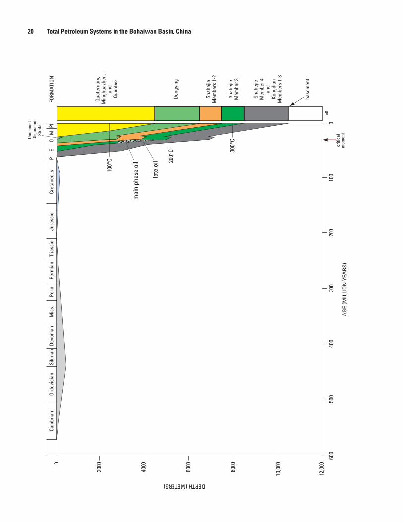
20 Total Petroleum Systems in the Bohaiwan Basin, China
0
2000
4000
6000
8000
10,0
00
12,0
00
400
300
600
500
100
0t=
020
0
AGE
(MIL
LION
YEA
RS)
DEPTH (METERS)
Cam
bria
nOr
dovi
cian
Silu
rian
Devo
nian
Mis
s.Pe
nn.
Perm
ian
Tria
ssic
Jura
ssic
Cret
aceo
usP
EO
MPl
Unna
med
Olig
ocen
eSt
rata
300°
C
100°
C 200°
C
Quat
erna
ry,
Min
ghua
zhen
,an
dGu
anta
o
Dong
ying
Shah
ejie
Mem
bers
1-2
Shah
ejie
Mem
ber 3
Shah
ejie
Mem
ber 4
and
Kong
dian
Mem
bers
1-3
mai
n ph
ase
oil
late
oil
criti
cal
mom
ent
base
men
t
FORM
ATIO
N

Shahejie−Shahejie/Guantao/Wumishan Total Petroleum System (312701) 21
thickness, overburden rocks in the Bozhong subbasin at the critical moment for Member 3 source rocks of the Shahejie Formation were limited to Members 1 and 2 of the Shahejie Formation and to the Dongying Formation (fig. 4, table 9). Based on tables 8 and 9, the net thickness of the combined Shahejie (Members 1 and 2), Dongying, and Guantao For-mations in the Bozhong subbasin is about double the net thickness of these units in the Jiyang subbasin. This greater thickness of overburden rock may explain why the critical moment for Member 3 (Shahejie Formation) source rocks in the Bozhong subbasin is earlier than in the Jiyang subbasin.
MigrationMost of the oil in this total petroleum system was gener-
ated in fault-controlled half-grabens—classified as subbasins, depressions, and sags depending on their size—and migrated both updip along the gentle flanks of these structures and subvertically along the master fault systems (Wu and Liang, 1988; Chen and Zhang, 1991; Chang, 1991). Where a “low” central high block is flanked by two half-grabens (each hav-ing a master fault that dips toward the other), oil migration commonly was focused away from the depressions toward the “low” central high (Chen and Zhang, 1991). Oil migrated into buried hills either directly from overlying or adjoining mature Tertiary source rocks, along unconformities, or subvertically along fault zones (Zhai and Zha, 1982; Zheng, 1988). Local to short-range oil migration was dominant in each subbasin, and probably the oil migrated no farther than a few tens of kilome-ters from the pods of mature source rock (source centers) (Wu and Liang, 1988; Chang, 1991; Jin and McCabe, 1998). Com-plicated structural patterns, abrupt sedimentary facies changes, and relatively small sizes of the subbasins and depressions prevented any long-range migration.
Overburden Rocks
Overburden rocks at the critical moment for Member 3 source rocks of the Shahejie Formation in the Jiyang subba-sin consisted, in ascending order, of Members 2 and 1 of the Shahejie Formation, the Dongying Formation, and the Guan-tao Formation (fig. 4; table 8). An estimated 300 m of upper
Oligocene strata were removed prior to the deposition of the Guantao Formation (fig. 4; table 8).
Shahejie Formation OverburdenUpper Eocene and lower Oligocene Member 2 of the
Shahejie Formation represents a gradually shrinking stage of the lake and is characterized by fluvial, deltaic, and shallow-water lacustrine deposits that replaced widespread deepwater lacustrine deposits of Member 3 (ECPG−Shengli, 1987). Fluvial deposits were locally derived from uplifted and eroded fault blocks that flanked the depressions. During Member 2 deposition, lacustrine environments persisted in the Chezhen (Chenzheng) and Zhanhua (Zhanghua) depressions of the Jiyang subbasin, whereas alluvial plain, swamp, and fluvial environments formed in the Dongying and Huimin depres-sions (ECPG−Shengli, 1987) (see fig. 1B for the location of the depressions). Shallow lacustrine deposits of the Chezhen (Chenzheng) and Zhanhua (Zhanghua) depressions consist of gray, dark-gray, and gray-green mudstone, siltstone, silty fine-grained sandstone, dolomitic carbonates, and local sand-stone (ECPG−Shengli, 1987). Fluvial deposits (braided and meandering channels) in the Dongying and Huimin depres-sions consist of medium- to fine-grained sandstones and associated crevasse splay, whereas the alluvial plain deposits consist of siltstone, fine-grained sandstone, and red and green mudstones (ECPG−Shengli, 1987). Fine-grained sandstone, siltstone, and greenish-gray mudstone characterize the deltaic deposits. Local alluvial fan deposits, consisting of coarse sandstone and conglomeratic sandstone, are located around the margins of the depressions (ECPG−Shengli, 1987). Some alluvial fans prograded into the lake to form fan deltas and subaqueous fans.
Lacustrine conditions expanded and water deepened somewhat in the Jiyang subbasin during the deposition of lower Oligocene Member 1 of the Shahejie Formation so that gray to dark-gray shale and mudstone, commonly containing abundant organic matter, was the dominant lithology (ECPG−Shengli, 1987; Hu and others, 1989). Carbonate grainstone deposits as much as 10 m thick commonly accumulated in beach and barrier-bar environments along the shoreline.
Dongying Formation OverburdenThe upper Oligocene Dongying Formation in the Dong-
ying depression represents the rapid east-to-west progradation of fluvial and deltaic deposits over Member 1 of the Shahejie Formation (ECPG−Shengli, 1987). Fluvial and deltaic deposits also dominated the Dongying Formation in the Huimin depres-sion, but the direction of progradation was from northwest to south. Shallow lacustrine deposits of green and gray mudstone and thin sandstone represent the Dongying Formation in the Chezhen (Chenzheng) and Zhanhua (Zhanghua) depressions. Local subaerial exposure of these mudstone beds in the Dong-ying Formation formed minor red beds.
Figure 10 (facing page). Burial history and hydrocarbon generation model for the Shahejie–Shahejie/Guantao/Wumishan Total Petroleum System in the Bozhong subbasin of the Bohaiwan basin. Abbreviations: Miss., Mississippian; Penn., Pennsylvanian; P, Paleocene; E, Eocene; O, Oligocene; M, Miocene; Pl, Pliocene and Quaternary; t=0, present day.

22 Total Petroleum Systems in the Bohaiwan Basin, China
Regional Post-Paleogene Uplift and Guantao Formation Overburden
A brief period of regional uplift and erosion at the end of the Oligocene produced a basinwide unconformity between syn-rift Paleogene strata and overlying post-rift Neogene strata (Allen and others, 1997) (fig. 4). Post-rift thermal subsidence that followed the uplift and erosion (Allen and others, 1997) produced Neogene strata that were more uniform in thickness and facies type than the Paleogene strata. In the Jiyang subba-sin, the Miocene Guantao Formation, consisting of alluvial fan deposits (conglomeratic sandstone), braided fluvial deposits (sandstone), and alluvial plain deposits (red and grayish-green mudstone), rests unconformably on the Dongying Formation (Hu and others, 1989; Allen and others, 1997). The majority of the fluvial sandstones in the Guantao Formation in the Jiyang subbasin were derived from the Chengning uplift that bounds the north side of the subbasin (ECPG−Shengli, 1987) (see fig. 1B for the location of the depressions).
Trap Styles for Oil and Gas Fields
The locations of most of the oil and (or) gas fields discov-ered through the second quarter of 1996 in the Shahejie−Sha-hejie/Guantao/Wumishan Total Petroleum System are shown in figure 6. Also, many of these fields are labeled in figure 1A. The trap type for many of the fields is noted in tables 1 through 6. According to Petroconsultants (1996), structural traps account for approximately 95 percent of the known oil and gas in the Bohaiwan basin, and stratigraphic traps account for the remaining 5 percent.
Structural TrapsLatest Cretaceous and Paleogene extensional and trans-
tensional tectonics in the Bohaiwan basin created numerous faulted roll-over anticlines (fig. 11), anticlinal noses, fault (horst) blocks, and tilted fault blocks that constitute the major-ity of the structural traps in the Shahejie−Shahejie/Guantao/Wumishan Total Petroleum System (Qian and Chen, 1990; Chang, 1991; Li, Yao, and Liu, 1991) (fig. 2). Anticlinal traps have either four-way closure or three-way closure in combina-tion with an updip fault-block seal. Additional anticlines were formed by differential compaction (drape) over fault (horst) blocks and buried hills (fig. 12) (Li, 1989; Qian and Chen, 1990; Chang, 1991) and by local diapirism owing to remo-bilized salt-bearing mudstone (Wang and others, 1985). Oil trapped in the compaction (sediment-drape) anticline at the giant Gudao field in the Jiyang subbasin may have had a com-plex history of remigration that followed episodes of nearly continuous faulting from the latest Cretaceous through most of the Neogene (Chen and Wang, 1980). Locally, structural traps probably were modified by minor Quaternary compression and inversion (Zhao and Windley, 1990), perhaps causing remigra-tion of hydrocarbons to new sites of entrapment.
Structural traps that involve large horst blocks and tilted fault blocks with Archean crystalline reservoirs and Proterozoic and lower Paleozoic carbonate reservoirs are referred to as buried hills (Zhai and Zha, 1982; Zheng, 1988; ECPG−Continental Shelf, 1987) (figs. 2 and 13). Zhai and Zha (1982) emphasized that these “buried hills” are not hills in the geomorphological sense but rather are simply fault blocks that formed during major regional extension. According to them, most subaerial weathering of the fault blocks predated regional extension and occurred during periods of uplift and erosion between the late Ordovician and the late Mesozoic to early Tertiary. Structural traps that involve horst blocks and tilted fault blocks with Tertiary sandstone reservoirs are classified as fault traps and fault-block traps (Qian and Chen, 1990; Chen and Zhang, 1991; Tian and others, 1996).
Stratigraphic TrapsIn addition to structural traps, numerous stratigraphic
traps are present in Tertiary strata of the Bohaiwan basin and consist of facies-change, unconformity, stratigraphic onlap, and diagenetic varieties (Ma and others, 1982; Chen and others, 1988; Shaui and others, 1988; Qian and Chen, 1990). Commonly, unconformity and facies-change stratigraphic traps form combination traps with anticlinal noses and flanks. In general the stratigraphic traps are small and subtle and thus are of secondary importance. Most stratigraphic traps were established by the end of the Eocene, but optimum trapping conditions probably were not established until lateral and top seals were more deeply buried during the Oligocene. In some cases bitumen seals have formed near the surface (due to the evaporative loss of light hydrocarbons) and trapped oil on the flanks of the subbasins (Chang, 1991).
Figure 11 (facing page). Structure contour map and cross section of the western part of the Shengtuo oil field in the Jiyang subbasin of the Bohaiwan basin. The entrapment of oil occurs in a roll-over anticline. See figure 1A for location of the oil field. A. Structure contour map on the top of Member 2 of the Shahejie Formation (modified from Editorial Committee of Petroleum Geology of the Shengli Oil Field, 1987). B. Cross section A–A’. From Jin and McCabe (1998, fig. 14, p. 356) and published with permission of Elsevier. Approximate line of section is shown in figure 11A. Cross section is not to scale. Abbreviations: Ek, Paleocene and Eocene Kongdian Formation; Es, Eocene and Oligocene Shahejie Formation (Members 1–4); Ed, Oligocene Dongying Formation; N+Q, Neogene and Quaternary strata.

Shahejie−Shahejie/Guantao/Wumishan Total Petroleum System (312701) 23
1-8
3-5
7
4-19
6-131
5-23
2-155
6-52
-2000
-2000
-200
0
-2000
-2000-20
50
-1850
-1850
-1950
-1950
-1850
-1850
-185
0
-195
0
-1950
-1950
-1950
-1900
-1900
-1900
-190
0
-1900
-1900
-1900
-190
0
-190
0
oil-w
ater
con
tact
oil-watercontact
oil-watercontact
0 2 KILOMETERS
Oil well
Approximate line of section
Normal fault
Structure contour (in meters)
oil-water contact
Approximate
A
B
A’
A’A
A
Oil pool
N+Q
EdEs1
Es2
Es4
Ek
Es3-1
Es3-2
Es3-3
Normal fault
Contact
SOUTH NORTH
Unconformity
2000
3000
4000
5000
DEPTH (METERS)
A’A
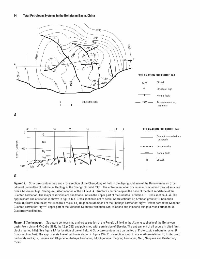
24 Total Petroleum Systems in the Bohaiwan Basin, China
25
25
12
1012
+
+
A
A'
A'A' 10
33
33
14
14
-1200-1200
-120
0
-118
0
-1220-1210
-1210
-1260
-1280
-1240
-1200
-122
0
-1155
-1290-1
160
-116
0
-1180
-117
0
-1155
-1200-1150
-1150
DEPT
H (M
ETER
S)
2000
1000
0
Es1
Nm
upperNglowerNg
Q
Ar ArMz
ArO OC_C_ C_
0 2 KILOMETERS
B
A
33 Oil well
Normal fault
Unconformity
Contact, dashed where uncertain
EXPLANATION FOR FIGURE 12B
-2000 Structure contour, in meters
Normal fault
+ Structural high
12 Oil well
EXPLANATION FOR FIGURE 12A
Figure 12. Structure contour map and cross section of the Chengdong oil field in the Jiyang subbasin of the Bohaiwan basin (from Editorial Committee of Petroleum Geology of the Shengli Oil Field, 1987). The entrapment of oil occurs in a compaction (drape) anticline over a basement high. See figure 1A for location of the oil field. A. Structure contour map on the base of the third sandstone of the Guantao Formation. The major reservoirs are sandstone units in the upper part of the Guantao Formation. B. Cross section A–A’. The approximate line of section is shown in figure 12A. Cross section is not to scale. Abbreviations: Ar, Archean granite; _, Cambrian rocks; O, Ordovician rocks; Mz, Mesozoic rocks; Es1, Oligocene Member 1 of the Shahejie Formation; Nglower, lower part of the Miocene Guantao Formation; Ngupper, upper part of the Miocene Guantao Formation; Nm, Miocene and Pliocene Minghuazhen Formation; Q, Quaternary sediments.
Figure 13 (facing page). Structure contour map and cross section of the Renqiu oil field in the Jizhong subbasin of the Bohaiwan basin. From Jin and McCabe (1998, fig. 12, p. 355) and published with permission of Elsevier. The entrapment of oil occurs in tilted fault blocks (buried hills). See figure 1A for location of the oil field. A. Structure contour map on the top of Proterozoic carbonate rocks. B. Cross section A–A’. The approximate line of section is shown in figure 13A. Cross section is not to scale. Abbreviations: Pt, Proterozoic carbonate rocks; Es, Eocene and Oligocene Shahejie Formation; Ed, Oligocene Dongying Formation; N+Q, Neogene and Quaternary rocks.

Shahejie−Shahejie/Guantao/Wumishan Total Petroleum System (312701) 25
A'
A
2000
3000
4000DEPT
H (M
ETER
S)
A A'
N+Q
Ed
Es Es
Pt Pt
-340
0
-3400 -3
400
-340
0
-3000
-3200
-3400-3200
-360
0
-360
0-3
600
-360
0
-3600
-320
0-3000
-380
0
-380
0-3
800
-380
0de
pres
sion
depr
essio
n -3800
-3600
-280
0
-3600
-3800
-3800-3600
-3600
-3200
B
A
4 KILOMETERS0
Normal fault
Unconformity
Contact
Oil pool
EXPLANATION FOR FIGURE 13B
Normal fault
-3600 Structure contour, in meters
Oil
EXPLANATION FOR FIGURE 13A

26 Total Petroleum Systems in the Bohaiwan Basin, China
Reservoir Rocks
Reservoir rocks in the Shahejie−Shahejie/Guantao/Wumishan Total Petroleum System consist of four major types. In approximate order of importance they are as follows: (1) sandstone and conglomeratic sandstone of Paleogene age deposited in fan delta, deltaic, littoral, and subaqueous fan (turbidite) systems associated with large, deepwater to shal-low-water lakes (Ma and others, 1982; Zhao and others, 1988; Li, Yao, and Liu, 1991; Gustavson and Xin, 1992; Tian and others, 1996); (2) sandstone and conglomeratic sandstone of late Paleogene and Neogene age deposited in fluvial systems (Chen and Wang, 1980; ECPG−Dagang, 1987; ECPG−Con-tinental Shelf, 1987; Tian and others, 1996; Hurst and oth-ers, 2001); (3) highly weathered and fractured carbonates of Proterozoic and early Paleozoic age deposited under peritidal and open-shelf conditions on shallow-marine carbonate plat-forms (Zhai and Zha, 1982; Fei and Wang, 1984; Horn, 1990); and (4) highly weathered and fractured crystalline basement rocks of Archean age (Zheng, 1988; Tong and Huang, 1991). Although shallow-water limestone reef and grainstone depos-its in Members 1 and 4 of the Shahejie Formation are locally important reservoir units in the Jiyang (Ma and others, 1982; ECPG−Shengli, 1987), Huanghua (Tian and others, 1996), and Liaohe (Lomando, 1996) subbasins, they are of secondary importance in comparison to the four major reservoir types. Also, volcanic rocks of Tertiary age are locally important reservoirs in the Liaohe subbasin (Chen and others, 1999), but overall, they are of secondary importance. Selected properties of the sandstone, carbonate, and crystalline basement reser-voirs in the six subbasins are listed in tables 10 through 15.
Primary reservoirs vary among the six subbasins, but overall, the Shahejie and Guantao Formations are the domi-nant Tertiary sandstone reservoirs and the Wumishan Forma-tion is the dominant pre-Tertiary carbonate reservoir.
Sandstone ReservoirsOil and gas are produced from sandstone reservoirs in all
the subbasins of the Bohaiwan basin and in most Paleogene and Neogene stratigraphic units. Although important Tertiary sandstone reservoirs are located in the Kongdian (Member 1), Shahejie (Members 2 and 3), Dongying (Member 3), Guantao, and Minghuazhen Formations (figs. 2, 3, and 4), their relative importance varies among the subbasins. Typically, the sand-stone is highly feldspathic (arkosic litharenite, lithic arkose) (ECPG−Shengli, 1987; ECPG−Dagang, 1987; ECPG−Conti-nental Shelf, 1987; Li and others, 2004) and primary inter-granular porosity is the predominant porosity type.
Jiyang SubbasinBraided fluvial and (or) deltaic sandstones in Member
2 of the Shahejie Formation, as well as deltaic, turbidite, and shoreline sandstones in Member 3, are among the primary
reservoirs in the Jiyang subbasin (Ma and others, 1982; ECPG−Shengli, 1987; Jin and McCabe, 1998). Porosity values for Member 2 sandstone reservoirs are commonly greater than 25 percent and permeability values are between 500 and 1,000 millidarcies (md) (ECPG−Shengli, 1987) (table 10). Other important sandstone reservoirs in the Jiyang subbasin are asso-ciated with the Guantao and Dongying Formations (ECPG−Shengli, 1987; Chen and Wang, 1980). In the giant Gudao oil field (fig.1A), fluvial sandstones in the Guantao Formation comprise individual elongate sandstone bodies that range in thickness from 4 to 12 m and have porosity ranging from 30 to 32 percent and permeability between 510 and 2,440 md (Chen and Wang, 1980) (table 10).
Liaohe SubbasinThe dominant sandstone reservoirs in the Liaohe sub-
basin are located in the Shahejie Formation (Members 1, 2, and 3) and the lower part of the Dongying Formation (Ge and ECPG−Liaohe, 1989; Gustavson and Xin, 1992) (table 11). The Dongying Formation sandstone reservoirs in the Suizhong 36-1 oil field (fig. 1A) are poorly consolidated and have poros-ity values between 28 and 35 percent and permeability values commonly greater than 100 md (Li, 1989).
Jizhong SubbasinSandstone reservoirs in the Jizhong subbasin are located
in the Kongdian Formation (Member 1), Shahejie Formation (Members 1, 2, 3, and 4), and Dongying Formation (Mem-ber 3) (ECPG−Huabei, 1987; Wu and Liang, 1988; Li, Du, and Hu, 1991). Typical sandstone reservoirs in the Shahejie Formation (Members 3 and 4) have a pay thickness of 2 to 4 m (maximum 10 m), an average porosity between 25 and 28 percent, and an average permeability of about 160 md (ECPG−Huabei, 1987) (table 12). Oil-bearing sandstones in the Dongying Formation (Member 3) have moderate to poor reservoir properties that are characterized by porosity values between 19 and 27 percent and permeability values between <50 and 770 md (ECPG−Huabei, 1987) (table 12).
Huanghua SubbasinImportant sandstone reservoirs in the Huanghua subbasin
are located in the Kongdian (Member 1), Shahejie (Members 1 and 3), Dongying (Member 3), Guantao, and Minghuazhen Formations (ECPG−Dagang, 1987; Chen and Zhang, 1991; Tian and others, 1996; Jin and McCabe, 1998). Guantao For-mation sandstone reservoirs have a net pay thickness as great as 20 to 30 m, porosity as much as 33 percent, and permeabil-ity as high as several darcies (Li and Zhang, 1987) (table 13). In comparison, the Kongdian (Member 1) sandstone reservoirs have a total thickness of about 100 m (no net pay recorded), an average porosity of about 15 to 25 percent, and an average permeability of about 65 to 294 md.

Shahejie−Shahejie/Guantao/Wumishan Total Petroleum System (312701) 27
Linqing/Dongpu Subbasin In the Linqing/Dongpu subbasin, the most produc-
tive sandstone reservoirs for oil are located in the Shahejie Formation (Members 2 and 3) (Li, Yao, and Liu, 1991; Jin and McCabe, 1998). Oil-bearing sandstone reservoirs in Member 2 of the Shahejie Formation are commonly characterized by porosity values between 11 and 25 percent and by permeabil-ity values between 37 and 240 md (table 14). In addition, Jin and McCabe (1998) reported porosity values in Member 2 to be 24 to 25 percent and permeability values to be as high as 850 and 940 md.
Bozhong SubbasinIn the Bozhong subbasin, the Guantao and Minghuazhen
Formations (fluvial origin) and the lower part (Member 3) of the Dongying Formation (deltaic origin) constitute the main sandstone reservoirs (Gong and others, 1998; Hurst and oth-ers, 2001; Xu, 2004). The combined thickness of the net pay for fluvial sandstone reservoirs in the Guantao Formation in the Peng Lai 19-3 field (fig. 1A) is as much as 160 m, and permeability ranges from 100 md to several darcies (Hurst and others, 2001) (table 15).
Carbonate and Crystalline Basement ReservoirsBuried-hill oil and gas accumulations that produce from
highly weathered and fractured Proterozoic and lower Paleo-zoic carbonate and (or) Archean crystalline basement reser-voirs are present in all subbasins of the Bohaiwan basin except for the Linqing/Dongpu (Zhai and Zha, 1982). Carbonate reservoirs of importance are located in the Middle Proterozoic Gaoyuzhuang, Yangzhuang, and Wumishan Formations, the Cambrian Fujunshan and Mentou Formations, and the Ordovi-cian Fengfeng, Liangjiashan, and Majiagou Formations (Zhai and Zha, 1982; ECPG−Huabei, 1987; Zheng, 1988; Horn, 1990; Tong and Huang, 1991) (fig. 4). The largest known buried-hill accumulations in Proterozoic and lower Paleozoic carbonates and (or) Archean basement rocks are located in the Jizhong and Liaohe subbasins.
Carbonate reservoirs consist largely of fine- to medium-crystalline dolomite and bioclastic and oolitic limestone. Generally, these carbonates have poor primary intercrystalline and intergranular porosity, and they depend on karst processes and tectonic fractures to improve their reservoir character (Zhai and Zha, 1982; ECPG−Shengli, 1987; ECPG−Huabei, 1987; Wu, 1998).
Archean crystalline-basement reservoirs consist primar-ily of metamorphosed granitic rocks that have been intensely weathered and fractured (Zheng, 1988; Tong and Huang, 1991; Wu, 1998). In addition to having fracture porosity, these basement reservoir rocks have secondary intergranular poros-ity formed by alteration of unstable minerals such as amphibo-lite and biotite (Tong and Huang, 1991).
Liaohe SubbasinDolomite in the Wumishan Formation, sandy dolomite
and dolomitic quartzite of the Middle Proterozoic Tieling Formation, dolomite and quartzite of the Middle Proterozoic Gaoyuzhuang Formation, and metamorphosed Archean gra-nitic rocks are the main reservoir rocks in the large oil fields of the Liaohe subbasin (Zheng, 1988; Ge and ECPG−Liaohe, 1989; Tong and Huang, 1991). Although secondary porosity caused by grain dissolution and intercrystalline pores is locally important, fracture porosity is the dominant porosity type (Ge and ECPG−Liaohe, 1989; Tong and Huang, 1991) (table 11). Tong and Huang (1991) noted that total porosity in the Dong-shengpu oil field (fig. 1) averages 3.8 to 4.2 percent, of which about 90 percent is fracture porosity.
Jizhong SubbasinThe Wumishan Formation is the main reservoir in the
giant Renqiu oil field (figs. 1A, 13; table 12) in the Jizhong subbasin (ECPG−Huabei, 1987; Horn, 1990). The reservoir rock consists of algal (stromatolitic) dolomite with siliceous dolomite and intercalated argillaceous dolomite that has been highly fractured and modified by karst processes. The net thickness of the entire producing interval (the Wumishan, Fujunshan (Fujushan), and Liangjiashan Formations, and sev-eral other units) is 850 m (Horn, 1990). Primary pore space in these carbonate reservoirs is nearly nonexistent because it has been occluded during a complex history of diagenetic, burial, subaerial/karst, and tectonic processes. Secondary pore space consists of intracrystalline pores, dissolution pores and vugs, microfractures, fractures, and cavities (ECPG−Huabei, 1987). Numerous high-angle fractures and small faults formed largely by late Paleozoic (Indosinian) and Mesozoic (Yanshanian) compression cut pervasively across the carbonate units and, during Paleogene extension, served as conduits for circulat-ing meteoric water and intense karst activity (Fei and Wang, 1984). Horn (1990) reported that the fracture widths in the Renqiu reservoirs commonly range from 0.1 to 1.0 millime-ters (mm) and that about 7 percent of the fractures are wider than 1.0 mm. Well logging and reservoir performance studies suggest that the Wumishan Formation reservoir at Renqiu has a bulk porosity of about 4 to 5 percent, a matrix porosity of about 3.1 to 4.2 percent, and a fracture porosity of about 0.6 to 0.9 percent (Horn, 1990). Drilling records that show sudden drops of the drill bit and (or) lost circulation of drilling fluid indicate that numerous caves and cavities are present in the carbonate reservoir (Fei and Wang, 1984). Permeability is dif-ficult to measure because of reservoir heterogeneity, but where data are available, values range from 0.1 to 100 md, with values as high as 1,000 md in fracture zones (Horn, 1990).
Seal Rocks
The most important regional seal rocks for anticlinal traps in the Shahejie−Shahejie/Guantao/Wumishan Total Petroleum

28 Total Petroleum Systems in the Bohaiwan Basin, China
System consist of 400- to 1,000-m-thick, gray lacustrine mudstone units in Members 1 and 3 of the Shahejie Formation (ECPG−Shengli, 1987) and a 800- to 1,200-m-thick, green to brownish-red and light-gray nonmarine mudstone unit in the Minghuazhen Formation (Chen and Wang, 1980) (figs. 4, 7). Secondary seal rocks consist of discontinuous evaporite and calcareous lacustrine mudstone units, between 100 and 150 m thick, in Members 2 and 4 of the Shahejie Formation (Wu and Liang, 1988). Numerous local mudstone units (mainly of lacustrine origin) in the Shahejie Formation also are top and lateral seals for stratigraphically trapped oil and gas in lenticular sandstone bodies (Ma and others, 1982). Fault-block accumulations, where oil and gas are trapped in sandstone reservoirs, depend on impermeable mudstone in the Shahejie Formation in adjoining fault blocks and in some cases the faults themselves for lateral seals (Chen and Wang, 1980; Ma and others, 1982; ECPG−Shengli, 1987).
Most mudstones in the Shahejie Formation also are top and lateral seal rocks for tilted fault-block (buried-hill) accu-mulations in carbonates and crystalline basement rocks (Zhai and Zha, 1982; Zheng, 1988; Horn, 1990). In some localities, lateral seals for buried-hill accumulations are mudstone in Carboniferous and Permian formations, Mesozoic formations, and the Tertiary Kongdian Formation (ECPG−Shengli, 1987; ECPG−Huabei, 1987). Many of the Shahejie seal rocks are also source rocks, making them conveniently located to charge adjoining buried-hill traps either along adjoining faults or along adjoining unconformities (ECPG−Huabei, 1987; Zheng, 1988).
Assessment Units
Two major assessment units are defined in the Shahejie−Shahejie/Guantao/Wumishan Total Petroleum System: (1) a Tertiary lacustrine assessment unit (31270101) consisting of conventional oil and gas accumulations in sandstone reservoirs of lacustrine and fluvial origin and (2) a pre-Tertiary buried hills assessment unit (31270102) consisting of conventional oil and gas accumulations in highly fractured and weathered Pro-terozoic and lower Paleozoic carbonates of peritidal to shallow-marine origin and Archean crystalline basement rocks.
Tertiary Lacustrine Assessment UnitThe Tertiary lacustrine assessment unit consists of oil,
associated gas, and nonassociated gas trapped in faulted roll-over anticlines, compaction (drape) anticlines, anticlinal noses, fault (horst) blocks, and tilted fault blocks. The area of the assessment unit shown in figure 14 encompasses all pods of mature source rock in the subbasins but excludes the Cheng-ning uplift between the Jiyang and Huanghua subbasins.
Although included with the assessment unit in figure 14, thermally immature regions having a relatively thin
sedimentary cover such as the Cangxian uplift and the north-ern part of the Linqing/Dongpu subbasin may not be prospec-tive. The Paleogene and Neogene sandstones of lacustrine (deltaic, fan delta, and subaqueous fan) and fluvial (braided and meandering channels) origin are the main reservoir units. Also included in this assessment unit are a variety of stratigraphic-trap accumulations (facies-change, unconformity, stratigraphic onlap, and diagenetic) and combination-trap accumulations. Giant oil fields (≥1 BBO) discovered in this assessment unit in the Jiyang subbasin (Dongxin, Gudao, Gudong, and Shengtuo), Huanghua subbasin (Dagang com-plex (Beidagang) and Chengdao), and Linqing/Dongpu sub-basin (Pucheng and Wenliu) account for a combined known recoverable of 15.7 BBO (Jin and McCabe, 1998). Several major oil fields trapped largely in faulted anticlines and fault blocks in this assessment unit are the Bonan and Linpan fields (Jiyang subbasin), Wangguangtun and Zaoyuan fields (Huang-hua subbasin), and Gaosheng field (Liaohe subbasin) (fig. 1A; tables 1, 2, and 4). This group of five major oil fields accounts for another 4.2 billion barrels of known recoverable oil (Jin and McCabe, 1998) and, when combined with the eight giant fields, accounts for 19.9 BBO or about 80 percent of the known volume of oil (24.6 BBO) of the 27.3 BBOE discov-ered in the basin through the second quarter of 1996 (Klett and others (1997).
Pre-Tertiary Buried Hills Assessment UnitThe pre-Tertiary buried hills assessment unit, the extent
of which is shown in figure 15, involves oil and (or) gas trapped in tilted fault blocks and horst blocks where the reservoirs are Proterozoic and lower Paleozoic carbonates and Archean crystalline rocks. This assessment unit covers the same area as the Tertiary lacustrine assessment unit shown in figure 14. Giant buried-hill oil fields discovered to date in the assessment unit are Renqiu in the Jizhong subbasin and Shuguang (Shu-huan) and Jinganbu (Jing-anbao) in the Liaohe subbasin (fig. 1A; tables 2 and 3). These three buried-hill fields have a combined known recoverable of approximately 6.9 BBO (Jin and McCabe, 1998). When the known recoverable oil of these three giant buried-hill oil fields is combined with the known recoverable oil of the eight giant (and five major) Tertiary lacustrine oil fields, the total 26.8 BBO exceeds by about 9 percent the known volume of oil (24.6 BBO) discov-ered in the basin through the second quarter of 1996 (Klett and others, 1997). Eventually, the known volume of 24.6 BBO of the 27.3 BBOE (Klett and others, 1997) and (or) the known recoverable of the 11 giant oil fields and the 5 major oil fields (Jin and McCabe, 1998) must be revised to correct the discrep-ancy. One way the discrepancy might be corrected is to apply reserve growth to some of the oil fields used to compile the known volume of 27.3 BBOE (Klett and others, 1997). The other possibility is that the known recoverable estimates cited by Jin and McCabe (1998) are too optimistic.
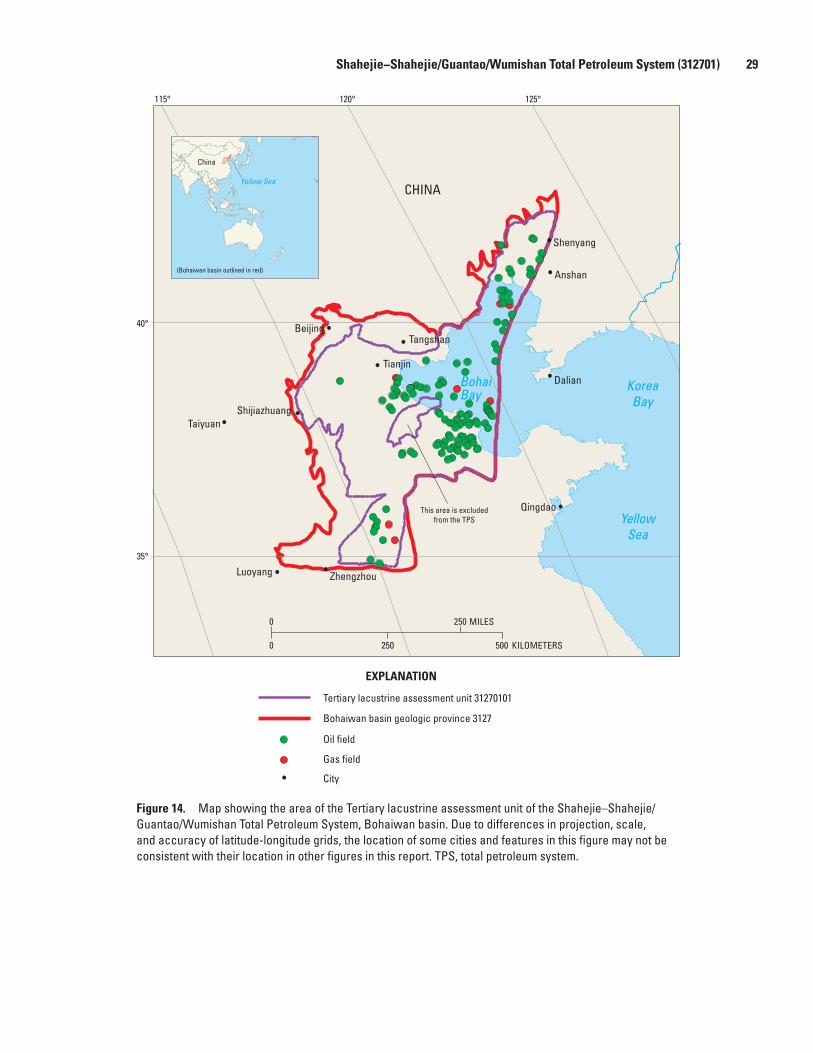
Shahejie−Shahejie/Guantao/Wumishan Total Petroleum System (312701) 29
Figure 14. Map showing the area of the Tertiary lacustrine assessment unit of the Shahejie–Shahejie/Guantao/Wumishan Total Petroleum System, Bohaiwan basin. Due to differences in projection, scale, and accuracy of latitude-longitude grids, the location of some cities and features in this figure may not be consistent with their location in other figures in this report. TPS, total petroleum system.
KoreaBay
YellowSea
BohaiBay
Luoyang Zhengzhou
TaiyuanShijiazhuang
BeijingTangshan
Tianjin
Anshan
Shenyang
Dalian
Qingdao
CHINA
This area is excludedfrom the TPS
Tertiary lacustrine assessment unit 31270101
Bohaiwan basin geologic province 3127
Oil field
Gas field
City
EXPLANATION
115° 120° 125°
40°
35°
0 250
KILOMETERS0 250 500
MILES
China
Yellow Sea
(Bohaiwan basin outlined in red)
##
##
#
#
#
#
###
###
# ## ##########
###
### ###
## ## ## ##### ## ## ### # # ### # ## ### ## ### ## ## ## ## ### # ## #### #
# ### ####### #### ### ## ##### ### ###
#######
##
#

30 Total Petroleum Systems in the Bohaiwan Basin, China
Figure 15. Map showing the area of the pre-Tertiary buried hills assessment unit of the Shahejie–Shahejie/Guantao/Wumishan Total Petroleum System, Bohaiwan basin. Due to differences in projection, scale, and accuracy of latitude-longitude grids, the location of some cities and features in this figure may not be consistent with their location in other figures in this report. TPS, total petroleum system.
Pre-Tertiary buried hills assessment unit 31270102
Bohaiwan basin geologic province 3127
Oil field
Gas field
City
EXPLANATION
KoreaBay
YellowSea
BohaiBay
Luoyang Zhengzhou
TaiyuanShijiazhuang
BeijingTangshan
Tianjin
Anshan
Shenyang
Dalian
Qingdao
CHINA
This area is excludedfrom the TPS
115° 120° 125°
40°
35°
0 250
KILOMETERS0 250 500
MILES
China
Yellow Sea
(Bohaiwan basin outlined in red)
#
#
#
#
####
####
## ####
##
##
#######
##
##
Carboniferous/Permian Coal–Paleozoic Total Petroleum System (312702) 31
Potential Undiscovered Oil and Gas Resources as of June 2001
OnshoreThe onshore part of the Bohaiwan basin is probably in
the very mature stage of exploration, in which all the easily identified anticlines, fault blocks, and buried hills at shallow (≤2,500 m) and intermediate (2,500−4,500 m) depths have already been drilled. Future onshore oil and gas discoveries are expected to be found in subtle stratigraphic, structural, and combination structural and stratigraphic traps that, for example, are formed by faults and stratigraphic pinchouts with anticlinal noses that should be identifiable on high-resolution three-dimensional (3-D) seismic records. Such traps may occur in synclines or in homoclinal structures on the flanks of major anticlines and fault blocks, where fewer exploration holes have been drilled. Small to medium-size oil fields are expected in these traps.
Also, there may be potential for undiscovered small to medium-size gas fields in the Tertiary lacustrine assessment unit deeper than 4,000 m in the onshore parts of the Huang-hua, Linqing/Dongpu, and Liaohe subbasins where secondary porosity in the sandstones is as high as 15 percent (He and others, 1998; Zhang, 1999). Commonly the reservoirs are overpressured (He and others, 1998).
OffshoreThe offshore part of the Bohaiwan basin, particularly in
the Bozhong and Liaohe subbasins, has the best potential for undiscovered oil and gas accumulations. Many medium-size to large fields have been discovered in the offshore area and, as of June 2001, CNOOC and its foreign partners had identi-fied 19.7 BBO of proved “reserves” (Oil and Gas Journal, 2001). These estimated proved “reserves” probably represent in-place oil and include all discoveries made throughout the exploration history from 1980 to 2001 in Bohai Bay. The 9.5 BBOE cited by Xu (2004) is probably a good estimate of the known recoverable oil and gas discovered to date in the offshore part of the Bohaiwan basin. Anticlines and fault blocks in the Tertiary lacustrine assessment unit were the major exploration targets in the 1980s and 1990s (Gong and others, 1998; Shirley, 2000; Xu, 2004), but buried hills and fault blocks in the pre-Tertiary buried hills assessment unit are becoming increasingly important exploration targets (Neese and Jewell, 1998; Wu, 1998). The only buried-hill discovery in the early phase of Bohai Bay exploration was the Bozhong 28 field (Matsuzawa, 1988; Wu, 1998). Wu (1998) reported that proved petroleum reserves (known recoverable) in pre-Tertiary reservoirs account for about 4 to 5 percent of the total proved reserves in Bohai Bay; with increased drilling and high-reso-lution 3-D seismic data, there is great potential for additional reserves. The maximum depth to crystalline basement in
Bohai Bay is about 10,000 to 12,000 m in the center of the Bozhong subbasin and about 8,000 to 10,000 m in the deepest part of the Huanghekou depression (fig. 3). Areas on the flanks of these depocenters are very prospective, but, as noted by Brad Patton (in Shirley, 2000), the reservoirs may be of lesser quality there.
Carboniferous/Permian Coal–Paleozoic Total Petroleum System (312702)
Petroleum Occurrence
The Carboniferous/Permian Coal−Paleozoic Total Petro-leum System is a hypothetical total petroleum system having Carboniferous and Permian coal beds as the source rock and Permian sandstones and possibly Carboniferous coal beds as the main reservoirs. Both the reservoir and source rocks are located in subcrops of Carboniferous and Permian strata in fault blocks (buried hills), fault-bounded depressions, and broad synclines.
This hypothetical total petroleum system is proposed because of the following developments. First, preliminary investigations of several Bohaiwan subbasins indicate that Carboniferous and Permian coal measures very likely have generated large volumes of natural gas that may have accumu-lated in Carboniferous and Permian sandstone and coal-bed reservoirs (Chang and others, 1981; ECPG−Dagang, 1987; Ge and ECPG−Liaohe, 1989; Su, 1995). Second, several gas accumulations are recognized in Carboniferous and Permian sandstone, lower Paleozoic carbonate, and Tertiary sandstone reservoirs that are in close proximity to Carboniferous and (or) Permian coal beds. Examples of such gas accumulations are the Suqiao, Liuqiying, Guxingzhuang, and Shenxi oil and gas fields in the Jizhong subbasin (ECPG−Huabei, 1987; table 3); the Bonan oil field (Yi-155 gas well) in the Jiyang subbasin (ECPG−Shengli, 1987; table 1); and the Wenliu and Mach-ang oil and gas fields in the Linqing/Dongpu subbasin (Dai and others, 2004; table 5). Third, the geochemical character of many of the previously cited gas accumulations further supports the derivation from Carboniferous and (or) Perm-ian coal beds (Shi and Qin, 1987; Zhu and Xu, 1988; Xu and Shen, 1996). The geochemical characteristics that support coal-derived gases in the Bohaiwan basin are listed in the fol-lowing section on source rocks. Fourth, small coalbed meth-ane projects in mined and unmined regions of the Huanghua subbasin have had modest success that include the drilling of a 1,100-m-deep well that produced gas at a rate of 6,000 m3/day (≈0.21 million ft3/day) (U.S. Environmental Protection Agency, 1996).

32 Total Petroleum Systems in the Bohaiwan Basin, China
Figure 16. Partial stratigraphic column for the Bohaiwan basin showing the essential elements of the Carboniferous/Permian Coal–Paleozoic Total Petroleum System. Modified from Lin and others (1995, fig. 2, p. 126) and published with permission of CRC Press/Balkema.
EXPLANATION
Sandstone Siltstone Shale and Mudstone Coal Limestone Hiatus
20–250
50–120
400–600
50–300
2
4b
3
4a
3b
3a
2b
2a
5
4
1
Source Rock
SealReservoirThickness (m)
LithologyUnitFormation
Serie
s
SystemEra
Taiyuan
Ordovicianand
Cambrian
Shihezi
Shanxi
Benxi
Pale
ozoi
c
Carb
onife
rous
Upp
er
Perm
ian
Low
er
Jurassicand
Cretaceous
Mes
ozoi
c

Carboniferous/Permian Coal–Paleozoic Total Petroleum System (312702) 33
Although these developments are encouraging, the Car-boniferous/Permian Coal−Paleozoic Total Petroleum System is largely unexplored and will remain hypothetical until the Carboniferous and Permian coal beds are firmly established as an important source of gas for fields in the Bohaiwan basin. Meanwhile, all the previously cited gas accumulations are considered to be part of the Shahejie−Shahejie/Guantao/Wumishan Total Petroleum System.
Source Rocks
Coal beds and carbonaceous shale in the Upper Carbon-iferous Taiyuan Formation and the Lower Permian Shanxi Formation are the expected source rocks in the Carbonifer-ous/Permian Coal−Paleozoic Total Petroleum System (figs. 4, 16). Carboniferous and Permian carbonaceous shale- and coal-bearing strata in the Bohaiwan basin range from 100 to 400 m thick (Chang and others, 1981; ECPG−Dagang, 1987). As many as 25 coal beds having a net thickness of 58 m and individual coal beds as thick as 9 m are present in the Taiyuan and Shanxi Formations in the Huanghua subbasin (ECPG−Dagang, 1987). Moreover, there are 30 Carboniferous and Permian coal beds in the eastern part of the Huanghua subba-sin (south of Tangshan) that range in thickness from 1 to 4 m (U.S. Environmental Protection Agency, 1996). In the northern part of the Jizhong subbasin, as many as 18 coal beds have been reported in the Taiyuan and Shanxi Formations having a net thickness of 7 to 33.5 m, with individual coal beds as thick as 4.8 m (Su, 1995).
Geochemical Characteristics
Carboniferous and Permian Coal BedsCarboniferous and Permian coal beds have TOC values
that average 58.4 weight percent in the Huanghua subbasin (ECPG−Dagang, 1987) and 53.9 weight percent in the Jizhong subbasin (ECPG−Huabei, 1987). Most coal beds and carbon-aceous shale are dominated by gas-prone type III kerogen, but oil-prone type II kerogen also is present (ECPG−Dagang, 1987). Similar kerogens (vitrinite and exinite macerals) were reported by Su (1995) for coal in the Suqiao-field area of the Jizhong subbasin. The methane content of 9 to15 m3/metric ton (T) (288–480 ft3/ton) measured in the Jizhong subbasin coal beds is comparable to other regions of the world where coalbed methane is produced (Su, 1995). Also, coal beds in the Huanghua subbasin are reported to have a high gas content that ranges from 7.5 m3/T (240 ft3/ton) to 9 to 15 m3/T (288–480 ft3/ton), with a maximum of 20 m3/T (640 ft3/ton) (U.S. Environmental Protection Agency, 1996).
Natural GasesNatural gas derived from Carboniferous and Permian coal
beds in the Bohaiwan basin has the following geochemical
characteristics compared to gas derived from oil-prone Tertiary lacustrine source rocks: (1) drier gas (89−95 percent CH4); (2) heavier δ13C1 values (-31.1 to -26.4); (3) higher mercury content (>700 ng/m3), and higher 40Ar/36Ar values (>950 ng/m3) (Shi and Qin, 1987; Zhu and Xu, 1988; Xu and Shen, 1996). Oil-source rock correlations suggest that local oil and condensate in Carboniferous and Permian sandstones in the Huanghua and Jizhong subbasins were generated from carbonaceous shale and coal beds of the same age (Shi and Qin, 1987; ECPG−Dagang, 1987).
Pods of Thermally Mature Source RockPods of thermally mature source rock associated with
the Carboniferous and Permian coals are present throughout most of the Huanghua, Jiyang, Jizhong, and Linqing/Dongpu subbasins (Chang and others, 1981; ECPG−Dagang, 1987) (fig. 17). Carboniferous and Permian coal beds appear to be very thin in the Bozhong subbasin (ECPG−Continental Shelf, 1987) and in most of the Liaohe subbasin except at the north-east end (Ge and ECPG−Liaohe, 1989; Li and others, 1995). Carboniferous and Permian coal beds in the Huanghua sub-basin have %Ro values that range from about 0.6 to 1.1 percent (ECPG−Dagang, 1987). These vitrinite reflectance values are consistent with the primarily high volatile bituminous rank of coal beds in the eastern part of the Huanghua subbasin (U.S. Environmental Protection Agency, 1996). Comparable vitrinite reflectance values are reported for Carboniferous and Perm-ian coal beds in the Jizhong subbasin (%Ro=0.8−1.1), but in the Zhongyuan region of the Linqing/Dongpu subbasin they are much higher (%Ro=2.0−4.0) (Shi and Qin, 1987). Very likely, the %Ro=2.0−4.0 values are representative of deeply buried boundary-fault margins of half-grabens, whereas the %Ro=0.6−1.1 values are representative of moderately to shal-lowly buried flexural margins of half-grabens (half-graben terminology from Morley, 1995).
Burial History and Hydrocarbon Generation
On the basis of an estimated geothermal gradient of 32 to 34°C/km, the critical moment for the Carboniferous/Permian Coal−Paleozoic Total Petroleum System in deeply buried boundary-fault margins of half-grabens is estimated to be in the early Paleogene (≈50 Ma) (fig. 18). In regions where Mesozoic strata are thin to absent or where Carbonifer-ous and Permian coal beds are less deeply buried along the flexural margins of half-grabens, the critical moment probably approaches lower Oligocene to upper Miocene time as esti-mated by model studies for the Shahejie−Shahejie/Guantao/Wumisham Total Petroleum System (figs. 9, 10).
Overburden Rocks
Overburden rocks at the critical moment in the Dongying depression of the Jiyang subbasin were about 5,000 m thick

34 Total Petroleum Systems in the Bohaiwan Basin, China
City
TPS boundary
Assessment unit boundary
Outline of pod of mature source rock
Geologic province boundary
Subbasin boundary Uplift boundaryBzHuLiaLi/DoJyJz
BozhongHuanghuaLiaoheLinqing/DongpuJiyangJizhong
CaCh
CangxianChengning
EXPLANATION
Zhangguang-cailing Uplift
Songliao BasinErlianBasin
BohaiwanBasin
KoreaBay
Basin
LuxiJiaoliao
Basin
Subei YellowSea Basin
Taikang HefeiBasin
QinlingDabieshan Fold Belt
ShanxiPlateau
BohaiBay
Taihangshan YanshanFold Belt
0 120 MILES40 80
0 120 KILOMETERS40 80
115°
35°
40°
120° 125°
Bz
Hu
Lia
Li/Do
Jy
Jz
Ca
Ch
This area isexcluded from
the TPS
China
Yellow Sea
(Bohaiwan basin outlined in red)
Wudi
Jinan
Linyi
Shulu
Guan
Hangu
Anshan
Xinmin
Baxian
Renqui
Xinj in
Dal ian
Lushun
Tanggu
Jinzhou
Weifang
Tianjin
Dongj ia
Baoding
Beijing
Zhanhua
Changi l
Yanshan
Yingkou
Shenyang
Guangrao
Shenxian
Tangshan
Huanghua
Cangzhou
Goubangzi
Dongguang
Qinhuangdao
Yangerzhuang
Chenjiazhuang
Shijiazhuang
Zibo(Zhangdian)

Carboniferous/Permian Coal–Paleozoic Total Petroleum System (312702) 35
and consisted of the Permian Shihezi and Shiqianfeng Forma-tions, unnamed Jurassic and Cretaceous strata, Paleocene and Eocene Kongdian Formation, and Member 4 of the Shahejie Formation (figs. 2B, 4, and 18).
Shihezi and Shiqianfeng Formations OverburdenThe Lower Permian Shihezi Formation in the Huanghua
subbasin consists of a 500- to 600-m-thick nonmarine unit of sandstone and pebbly sandstone, purple mudstone, and carbonaceous mudstone (ECPG−Dagang, 1987). The Shihezi Formation at this locality is overlain by the Upper Permian Shiqianfeng Formation, a 700-m-thick unit of red mudstone, siltstone, and volcanic rocks (ECPG−Dagang, 1987). The Shihezi and Shiqianfeng Formations in the Jizhong subbasin are similar in lithology to these formations in the Huanghua subbasin, but they are thinner, with a thickness of 150 to 475 m for the Shihezi and 100 to 230 m for the Shiqianfeng (ECPG−Dagang, 1987).
Jurassic and Lower Cretaceous OverburdenJurassic and Lower Cretaceous strata in the Huanghua
subbasin are composed of the following nonmarine units: (1) a 200-m-thick Lower to Middle Jurassic unit of gray mudstone, conglomerate, carbonaceous shale, and coal; (2) a 600-m-thick Middle to Upper Jurassic unit of purplish-red arenaceous mudstone, tuffaceous sandstone, and volcanic rocks; and (3) a 200-m-thick or greater Lower Cretaceous unit of predomi-nantly brownish-red arenaceous mudstone (ECPG−Dagang, 1987). Jurassic and Lower Cretaceous rocks are as much as 3,000 m thick along the western margin of the Jizhong sub-basin, but in most parts of the subbasin they are as much as 1,600 m thick (ECPG−Huabei, 1987).
Kongdian Formation OverburdenThe Paleogene Kongdian Formation ranges in thick-
ness from about 1,000 to 1,600 m in the Bozhong, Huanghua, Jiyang, and Liaohe subbasins (fig. 4) and locally is as thick as 2,500 m in part of the Huanghua subbasin (ECPG−Dagang, 1987). In contrast, the Kongdian Formation is considerably
thinner in the Jizhong and Linqing/Dongpu subbasins, where it ranges in thickness from about 200 to 400 m (fig. 4). As previously discussed, the Kongdian Formation is characterized by conglomerate, conglomeratic sandstone, and red mudstone of alluvial fan origin and volcanic rocks that formed during initial stages of rifting. In the Huanghua subbasin, Member 2 of the Kongdian Formation is characterized by lacustrine deposits such as nearshore and subaqueous sandstones and gypsum- to anhydrite-bearing gray to brown mudstone that is considered to be a source rock (ECPG−Dagang, 1987).
Shahejie Formation OverburdenMember 4 of the Shahejie Formation consists of thick,
widespread, lacustrine gray to brown mudstone deposits that are important source rocks in many parts of the Bohaiwan basin. The thickness of Member 4 of the Shahejie Formation ranges from about 300 to 500 m in the Linqing/Dongpu sub-basin (Li, Yao, and Liu, 1991) to about 1,000 m in the other subbasins of the Bohaiwan basin (fig. 4).
Trap Styles for Gas Fields
Gas in the hypothetical total petroleum system may be trapped as continuous accumulations at or near the center of the subbasins (basin-center gas). Gas entrapment may be facil-itated by updip zones of high water saturation in the Permian sandstones in a manner described by Masters (1979). Analogs to the basin-center gas accumulations proposed in the Car-boniferous/Permian Coal−Paleozoic Total Petroleum System in the Bohaiwan basin may be the Changqing and Sulige gas fields in the Ordos basin (fig. 5), located about 500 to 550 km west of the Bohaiwan basin (Zhang and Yu, 1998). Although the Ordos basin, rather than being a rift basin, is a foreland basin having low-dipping, unfaulted homoclinal strata, the Changqing, Sulige, and associated gas fields are characterized by low-permeability sandstone reservoirs of Carboniferous and Permian age, by coal-bed source rocks, and by a basin-center structural setting (Zhang and Yu, 1998; Li, 2002).
Reservoir Rocks
Sandstone ReservoirsReservoir rocks in the Carboniferous/Permian Coal−
Paleozoic Total Petroleum System are expected to consist of grayish-white, fine-grained to pebbly sandstone of fluvial and deltaic origin in the Lower Permian Shanxi and Shihezi Formations (ECPG−Huabei, 1987; Lin and others, 1995). By analogy to Carboniferous and Permian sandstones in the nearby Ordos basin, sandstones in the Shanxi and Shihezi Formations in the Bohaiwan basin probably are quartzose in composition (Li and others, 1997; Liu and others, 2002).
Figure 17 (facing page). Map showing the Carboniferous/Permian Coal–Paleozoic Total Petroleum System in the Bohaiwan basin, pods of mature source rock, and the coal-sourced gas assessment unit. Abbreviation: TPS, total petroleum system. Due to differences in projection, scale, and accuracy of latitude-longitude grids, the location of some cities and features in this figure may not be consistent with their location in other figures in this report.
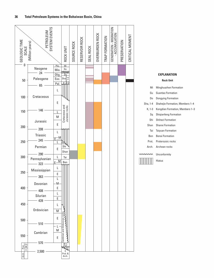
36 Total Petroleum Systems in the Bohaiwan Basin, China
350
400
450
500
550
570
150
200
0
50
100
300
250
323
363
408
439
510
146
208
2,500
24
65
290
245 E
L
L
M
E
LM
Eoc.
Pal.
Mio.Olig.
E
L
L
L
M
E
E
M
E
L
M
E
LM
E
E
L
E
L
Cambrian
Ordovician
Silurian
Devonian
Mississippian
Pennsylvanian
Permian
Triassic
Jurassic
Cretaceous
Paleogene
Neogene
EProt. & Arch.
M–LProt.
Cam
bria
n an
d Or
dovi
cian
rock
sCr
etac
eous
and
Ju
rass
ic ro
cks
Shi
Shan
Sha
1-3
Ben
Tai
MiPlio.Gu
Do
1-4
L
EM
Prot
.Ar
ch.
Sq
K
CRIT
ICAL
MOM
ENT
PRES
ERVA
TION
GEN
ERAT
ION
- M
IGRA
TION
- ACC
UMUL
ATIO
N
TRAP
FOR
MAT
ION
OVER
BURD
EN R
OCK
SEAL
ROC
K
RESE
RVOI
R RO
CK
SOUR
CE R
OCK
ROCK
UN
ITPETR
OLEU
MSY
STEM
EVE
NTS
GEOL
OGIC
TIM
ESC
ALE
(Mill
ion
year
s)
Prot.
Arch.
Sha, 1-4
K, 1-3
Sq
Shi
Shan
Tai
Ben
Mi
Gu
EXPLANATION
Rock Unit
Do
Proterozoic rocks
Archean rocks
Unconformity
Hiatus
Shahejie Formation, Members 1–4
Kongdian Formation, Members 1–3
Shiqianfeng Formation
Shihezi Formation
Shanxi Formation
Taiyuan Formation
Benxi Formation
Minghuazhen Formation
Guantao Formation
Dongying Formation

Summary 37
In the Suqiao field (Jizhong subbasin), porosity in an Upper Permian sandstone reservoir at a depth of about 3,350 m ranges from about 15 to 19 percent and permeability ranges from 29 to 400 md (average 200 md) (ECPG−Huabei, 1987). These relatively high porosity and permeability values from a single locality are inconsistent with continuous gas accumula-tion. Therefore, additional porosity and permeability data are required from moderately to deeply buried Carboniferous and Permian sandstone units to adequately evaluate the hypotheti-cal total petroleum system.
Coal Bed ReservoirsCoal beds also may be reservoirs in the Carboniferous/
Permian Coal−Paleozoic Total Petroleum System. Dai and others (2004) reported that Permian and Carboniferous coal beds in the Linqing/Dongpu subbasin contain a significant amount of gas pores (micropores), which could improve natural gas production. Such micropores, in addition to micro-fractures, are important for the storage of large volumes of adsorbed gas in coal beds (Rice and others, 1993).
Seal Rocks
The proposed seal rocks for the sandstone reservoirs in the Carboniferous/Permian Coal−Paleozoic Total Petroleum System consist largely of Mesozoic (Jurassic and Lower Cretaceous) nonmarine purplish- to brownish-red shales (not shown in fig. 4) and widespread lacustrine gray mudstone and shale of Members 1 and 3 of the Shahejie Formation (fig. 4). The Mesozoic and Shahejie Formation seal rocks commonly are 500 to 1,000 m thick in the Bohaiwan subbasins (fig. 4). The seals in the coal beds are connate water and ground-water that keep the gas from escaping microfractures and micropores.
Assessment Unit
A coal-sourced gas assessment unit (31270201) is defined in the hypothetical Carboniferous/Permian Coal−Paleozoic Total Petroleum System, where Lower Permian sandstone and possibly Carboniferous coal beds are the reservoirs. This assessment unit, whose boundary coincides with that of the total petroleum system, was not assessed by the U.S.
Geological Survey World Energy Assessment Team (2000). A separate coalbed methane assessment unit may be needed at a later time if Carboniferous and Permian coal beds become a primary target for exploration in addition to the sandstone reservoirs. Because most Carboniferous and Permian strata in the Bohaiwan basin are sparsely drilled, this assessment unit has good potential for undiscovered gas fields. Drilling depths to potential traps are between 2,000 and 7,000 m (Chang and others, 1981).
SummaryAll of the 27.3 BBOE of known petroleum volume in the
Bohaiwan basin through the second quarter of 1996 (Klett and others, 1997) are located in the Shahejie−Shahejie/Guantao/Wumishan Total Petroleum System. Member 3 of the Paleo-gene Shahejie Formation, which consists of about 1,000 m of deepwater lacustrine dark-gray mudstone and oil shale (black shale), is the primary source rock. Member 1 of the Shahejie Formation, consisting of about 200 to 400 m of lacustrine dark-gray mudstone and oil shale (black shale), probably is the second most important source rock. The primary reser-voir rocks are Paleogene and Neogene nonmarine feldspathic sandstone and highly weathered and fractured lower Paleozoic and Middle to Late Proterozoic marine limestone and dolo-mite. Also, highly weathered and fractured Archean crystalline basement rocks are important reservoirs. Sandstone reservoirs, generally very fine to fine grained, represent deltaic and fluvial deposits that flanked subbasin-centered lakes and turbidite deposits that accumulated in the central parts of the lakes. Lower Paleozoic and Proterozoic limestone and dolomite reservoir rocks were deposited as peritidal and shallow-water shelf carbonates on a stable craton. The reservoir properties of these limestone and dolomite units have been greatly enhanced by pervasive weathering and the development of abundant fractures. According to Petroconsultants (1996), structural traps account for approximately 95 percent of the known oil and gas in the Bohaiwan basin, and stratigraphic traps account for the remaining 5 percent.
Two oil and gas assessment units are identified in the Shahejie−Shahejie/Guantao/Wumishan Total Petroleum System: (1) a Tertiary lacustrine assessment unit and (2) a pre-Tertiary buried hills assessment unit. Both assessment units are composed of conventional petroleum accumulations.
A coal-sourced gas assessment unit is defined in the hypothetical Carboniferous/Permian Coal−Paleozoic Total Petroleum System. This total petroleum system is largely unexplored and therefore is considered to have good poten-tial for future discoveries of natural gas. Carboniferous and Permian coal beds are the proposed source rocks and Lower Permian sandstones and possibly Carboniferous coal beds are the proposed reservoirs. Most of the natural gas in this total petroleum system is considered to be trapped as continuous basin-centered accumulations.
Figure 18 (facing page). Events chart for the Carboniferous/Permian Coal–Paleozoic Total Petroleum System. Geologic time scale based on Magoon and Dow (1994) and Magoon and Schmoker (2000). Abbreviations: Plio., Pliocene; Mio., Miocene; Olig., Oligocene; Eoc., Eocene; Pal., Paleocene; E, Early; M, Middle; L, Late.

38 Total Petroleum Systems in the Bohaiwan Basin, China
References Cited
Allen, M.B., Macdonald, D.I.M., Zhao Xun, Vincent, S.J., and Brouet-Menzies, C., 1997, Early Cenozoic two-phase exten-sion and late Cenozoic thermal subsidence and inversion of the Bohai Basin, northern China: Marine and Petroleum Geology, v. 14, nos. 7−8, p. 951−972.
Appalachian Basin Report, 1998, Section I, This week: Denver, Petroleum Information/Dwights LLC, Appalachian Basin Report, v. 37, no. 39, 10-1-98, section I, p. 3−4.
Chang Cheng-yong, 1991, Geological characteristics and distribution patterns of hydrocarbon deposits in the Bohai Bay Basin, east China: Marine and Petroleum Geology, v. 8, no. 1, p. 98−106.
Chang Xiaozhe, Zhen Yichuen, Xie Chenkan, and Yang Fuxin, 1981, The prospect of Permo-Carboniferous coal-formed gas in North China [in Chinese]: Oil and Gas Geology, v. 2, no. 4, p. 341−350.
Chen Fajing and Zhang Shulin, 1991, Tectonic evolution and hydrocarbon migration in the Huanghua basin, NE China: Journal of Petroleum Geology, v. 14, no. 2, p. 197−210.
Chen Jianyu, Bi Yangpong, Zhang Jiguo, and Li Shuafu, 1996, Oil-source correlation in the Fulin basin, Shengli petroleum province, east China: Organic Geochemistry, v. 24, no. 8/9, p. 931−940.
Chen Sizhong and Wang Ping, 1980, Geology of Gudao oil field and surrounding areas, in Halbouty, M.T., ed., Giant oil and gas fields of the decade 1968−1978: American Associa-tion of Petroleum Geologists Memoir 30, p. 471−486.
Chen Sizhong, Qian Kai, and Li Zesong, 1988, Characteristics and distribution of stratigraphic oil pools in Jiyang depres-sion: China Oil, v. 5, no. 3/4, p. 46−55.
Chen Zhenyan, Yan Huo, Li Junsheng, Zhang Ge, Zhang Zhanwen, and Liu Baozhu, 1999, Relation between Ter-tiary volcanic rocks and hydrocarbons in the Liaohe Basin, People’s Republic of China: American Association of Petro-leum Geologists Bulletin, v. 83, no. 6, p. 1004−1014.
Chen Zhilin, Zhou Guangjia, and Alexander, R., 1994, A biomarker study of immature crude oils from the Shengli oil field, People’s Republic of China: Chemical Geology, v. 113, no. 1−2, p. 117−132.
China Oil & Gas, 1998, Two Bohai oil fields to be exploited: China Oil & Gas, v. 5, no. 1, p. 31.
Chinese Academy of Geological Sciences, 1982, An outline of the stratigraphy in China [in Chinese]: Beijing, Geological Publishing House, v. 1, 445 p.
Dai Jinxing, Ding Weiwei, Li Jian, and Zhu Guangyou, 2004, Gas pores in Permo-Carboniferous coal of the Dongpu depression and their implication for hydrocarbon genera-tion and accumulation, Bohai Bay Basin, China [abs.]: Abstracts of the 21st Annual Meeting of the Society for Organic Petrology, 27 September−1 October, 2004, Sydney, Australia, v. 21, p. 58.
Dai Jin-xing, Song Yan, Dai Chun-sen, and Wang Da-rui, 1996, Geochemistry and accumulation of carbon dioxide gases in China: American Association of Petroleum Geolo-gists Bulletin, v. 80, no. 10, p. 1615−1626.
Davis, G.A., Qian X., Zheng Y., Tong H., Yu H., Wang C., Gehrels, G.E., Shafiquallah, M., and Fryxell, J.E., 1996, Mesozoic deformation and plutonism in the Yunmeng Shan: a metamorphic core complex north of Beijing, in Yin An and Harrison, T.M., eds., The tectonic evolution of Asia: Cambridge University Press, p. 253−280.
Editorial Committee of Petroleum Geology of the Shengli Oil Field, 1987, Shengli oil field, v. 6 of Petroleum geology of China: Beijing, Petroleum Industry Press, 518 p.
Editorial Committee of Petroleum Geology of the Huabei Oil Field, 1987, Huabei oil field, v. 5 of Petroleum geology of China: Beijing, Petroleum Industry Press, 452 p.
Editorial Committee of Petroleum Geology of the Dagang Oil Field, 1987, Dagang oil field, v. 4 of Petroleum geology of China: Beijing, Petroleum Industry Press, 434 p.
Editorial Committee of Petroleum Geology of Oil and Gas Bearing Areas on the Continental Shelf and its Neighboring Regions, 1987, Oil and gas bearing areas in the continental shelf and its neighboring regions, part I, offshore Bohai, v. 16 of Petroleum geology of China: Beijing, Petroleum Industry Press, 260 p.
ESRI (Environmental Systems Research Institute, Inc.), 1992, ArcWorld 1:3 million digital database. (Database available from ESRI, 380 New York Street, Redlands, CA 92373-8100, U.S.A.)
Fei Qi and Wang Xie-Pei, 1984, Significant role of structural fractures in Renqiu buried-hill oil field in eastern China: American Association of Petroleum Geologists Bulletin, v. 68, no. 8, p. 971−982.
Gao Weiliang, Shi Xihui, and Qin Jianzhong, 1987, Hydrocar-bon generation, chap. 5 in Editorial Committee of Petro-leum Geology of the Huabei Oil Field, Huabei oil field, v. 5 of Petroleum geology of China: Beijing, Petroleum Industry Press, p. 127−240.
Gardemal, Micah, Sofer, Zvi, Womer, Michael, and Sun Xiao Hong, 1996, Integrated geochemical and basin modeling approach to hydrocarbon systems analysis, Bohai Basin,

References Cited 39
People’s Republic of China [abs.]: American Association of Petroleum Geologists, Annual Meeting Expanded Abstracts, v. 5, p. 50.
Ge Taisheng and the Editorial Committee of Petroleum Geology of the Liaohe Oil Fields, 1989, Petroleum geol-ogy, Liaohe oil fields, v. 3 of Petroleum geology of China: Beijing, Petroleum Industry Press, pagination within chapters.
Gong Zaishen, Zhu Weilen, and Jiang Wenrong, 1998, Prospects of hydrocarbon exploration in Bohai Bay [abs.]: American Association of Petroleum Geologists, Annual Meeting Expanded Abstracts [Salt Lake City, Utah, May 17−28, 1998], PPF 720, CD-ROM, 6 p.
Gustavson, J.B., and Xin Shi Gong [sic], 1990, Reservoir delineation by geophysical methods in the Suizhong 36-1 oil field, Bohai Gulf, China [abs.]: American Association of Petroleum Geologists Bulletin, v. 74, no. 6, p. 976.
Gustavson, J.B., and Xin Shi Gang, 1992, The Suizhong 36-1 oil field, Bohai Gulf, offshore China, reservoir delineation by geophysical methods, in Halbouty, M.T., ed., Giant oil and gas fields of the decade 1978−1988: American Associa-tion of Petroleum Geologists Memoir 54, p. 459−470.
Han Qingbing and Wang Zhan, 1997, Bohai prominent for cooperation with foreign firms: China Oil & Gas, v. 4, no. 3, p. 179.
Hao Shihsheng and Zhang Changgen, 1984, The primary hydrocarbon characteristics of the Middle-Upper Protero-zoic in the northern part of North China: Beijing Petroleum Symposium, September 1984, 31 p.
He Haiqing, Chi Qiue’, and Hu Qiuping, 1998, Advances in petroleum exploration of deep zone in Bohai Bay: China Oil & Gas, v. 5, no. 2, p. 73−75.
Horn, M.K., 1990, Renqiu field, in Beaumont, E.A., and Foster, N.H., comps., Structural traps II; traps associated with tectonic faulting: Tulsa, Okla., American Association of Petroleum Geologists Treatise of Petroleum Geology, Atlas of Oil and Gas Fields, v. A−017, p. 227−252.
Hsü, K.J., 1989, Origin of sedimentary basins of China, in Zhu Xia, ed., Chinese sedimentary basins: Amsterdam, Elsevier, p. 207−227.
Hu J., 1995, Practice of oil and gas exploration and petroleum system study in east China [in Chinese]: Explorer, v. 1, no. 1, p. 12−19.
Hu Jianyi, and Krylov, H.A., chairmen, 1996, Bohai Bay Basin, in Petroleum potential maps of northeast Asia: Beijing, China Petroleum Industry Press, 1 sheet, scale ≈ 1:1,571,000.
Hu Jianyi, Xu Shubao, Tong Xiaoguang, and Wu Huayuan, 1989, The Bohai Bay Basin, in Zhu Xia, ed., Chinese sedi-mentary basins: Amsterdam, Elsevier, p. 89−105.
Huang Difan, Li Jinchao, and Zhang Diajiang, 1990, Matu-ration sequence of continental crude oils in hydrocarbon basins in China and its significance, in Durand, B., and Behar, F., eds., Advances in organic geochemistry 1989; Part I, Organic geochemistry in petroleum exploration: Organic Geochemistry, v. 16, nos. 1−3, p. 521−529.
Hurst, Sharon, Hows, Melton, and Kurkjian, Andrew, 2001, Formation tester—1, Cased-hole tester provides field testing alternative: Oil and Gas Journal, v. 99, no. 24, p. 49−52.
Institute of Geology, Academia Sinica, 1958, Regional stratig-raphy of China, supplement [in Chinese]: Beijing, Science Press, 190 p.
Jin Qiang, 1991, Sedimentation and organic geochemistry of source rocks in the deep and shallow-water saline lakes in Tertiary, China [in Chinese]: Acta Sedimentologica Sinica, v. 9, no. 2, p. 114−120.
Jin Qiang and McCabe, P.J., 1998, Genetic features of petro-leum systems in rift basins of eastern China: Marine and Petroleum Geology, v. 15, no. 4, p. 343−358.
Jin Zhijun, Zhang Liuping, Yang Lei, and Hu Wenxuan, 2004, A preliminary study of mantle-derived fluids and their effects on oil/gas generation in sedimentary basins: Journal of Petroleum Science and Engineering, v. 41, nos. 1−3, p. 45−55.
Kimura, Gaku, Takahashi, Masaki, and Kono, Masaru, 1990, Mesozoic collision-extrusion tectonics of eastern Asia: Tectonophysics, v. 181, no. 1−4, p. 15−23.
Klett, T.R., Ahlbrandt, T.S., Schmoker, J.W., and Dolton, G.L., 1997, Ranking of the world’s oil and gas provinces by known petroleum volumes: U.S. Geological Survey Open-File Report 97−463, one CD-ROM.
Klett, T.R., Schmoker, J.W., Charpentier, R.R., Ahlbrandt, T.S., and Ulmishek, G.F., 2000, Glossary, chap. GL of U.S. Geological Survey World Energy Assessment Team, U.S. Geological Survey World Petroleum Assessment 2000—Description and results: U.S. Geological Survey Digital Data Series DDS–60, 8 p. Entire report is available on 4 CD-ROMs and at http://pubs.usgs.gov/dds/dds-060/
Lee, K.Y., 1989, Geology of petroleum and coal deposits in the North China basin, eastern China: U.S. Geological Sur-vey Bulletin 1871, 36 p., 2 pls. in pocket.
Li Baofang, Wen Xianduan, Kang Xidong, and Li Guidong, 1997, The applications of high-resolution sequence stratig-raphy to paralic and terrestrial coal-bearing strata: Two case

40 Total Petroleum Systems in the Bohaiwan Basin, China
studies from the western North China Paleozoic basin and the Tulufan-Hami Jurassic basin, in Yang Qi, ed., Proceed-ings of the 30th International Geological Congress, v. 18, pt. B, p. 1−19.
Li Bingquan, 1989, The discovery and development of SZ 36-1 oil field in Liadodong [sic] Bay: Proceedings, Offshore Technology Conference [21st Annual Offshore Technol-ogy Conference, Houston, Tex., May 1−4, 1989], v. 1, p. 429−436.
Li Desheng, Du Yonglin, and Hu Guonong, 1991, Petroleum geological characteristics of the Langfang-Gu’an Basin, Beijing-Tianjing region, in Li Desheng, ed., Tectonic types of oil and gas basins in China: Beijing, Petroleum Industry Press, p. 67−80.
Li Desheng, Yao Yongyun, and Liu Youyuan, 1991, Facies models in the Paleogene terrestrial salt lake deposits of Zhongyuan oil fields, Dongpu depression, east China, in Li Desheng, ed., Tectonic types of oil and gas basins in China: Beijing, Petroleum Industry Press, p. 81−93.
Li Huijun, Wu Tairan, Ma Zongjin, and Zhang Wencai, 2004, Pressure retardation of organic maturation in clastic res-ervoirs: a case study from the Banqiao sag, eastern China: Marine and Petroleum Geology, v. 21, no. 9, p. 1083−1093.
Li Kemin, 2002, Deep basin gas reservoirs of late Palaeozoic in northern Ordos Basin [in Chinese]: Oil and Gas Geology, v. 23, no. 2, p. 190−192.
Li Shaoguang and Zhang Jieru, 1987, Reservoirs, chap. 6 in Editorial Committee of Petroleum Geology of the Dagang Oil Field, Dagang oil field, v. 4 of Petroleum geology of China: Beijing, Petroleum Industry Press, p. 177−212.
Li Sitian, Mao Bangzhuo, and Lin Changsong, 1995, Coal resources and coal geology in China: Episodes, v. 18, nos. 1−2, p. 26−30.
Liang Fuhua, 1987a, Generation of oil and gas, in Editorial Committee of Petroleum Geology of the Dagang Oil Field, Dagang oil field, v. 4 of Petroleum geology of China: Beijing, Petroleum Industry Press, p. 114–176.
Liang Fuhua, 1987b, Zonation of oil and gas in the Huanghua basin, China: Journal of Petroleum Geology, v. 10, no. 3, p. 327−334.
Lin Changsong, Li Sitian, and Li Zhen, 1995, Facies archi-tecture, stratigraphic sequences and coal occurrences in the Late Carboniferous and Early Permian delta complexes of the North Huabei basin, China, in Oti, M.N., and Postma, George, eds., Geology of deltas: Rotterdam, A.A. Balkema, p. 125−138.
Lin Jin-lu, Fuller, M., and Zhang Wen-you, 1985, Preliminary Phanerozoic polar wander paths for the North and South China blocks: Nature, v. 313, no. 6002, p. 444−449.
Liu Baoquan, Zeng Xianzhang, and Liu Shuzhen, 1988, Cor-relation of oil-source biomarkers in Renqiu oil field, north China, in Yen, T.F., and Moldowan, J.M., eds., Geochemi-cal biomarkers: Chur, Switzerland, Harwood Academic Publishers, p. 71−88.
Liu De-liang, Tan Ying, Sun Xian-ru, Li Zheng-sheng, Fang Guo-qing, and Tao Shi-zhen, 2002, Characteristics of erathem fluid inclusions and their relationship with oil-gas evolution in Ordos Basin [in Chinese]: Acta Sedimento-logica Sinica, v. 20, no. 4, p. 695−704.
Liu Yuan-lung, Wang Qian-shen, and Zhao Jian-hua, 1978, A preliminary study based on gravity data of the crustal structure of the Peking-Tientsin area and its neighboring regions [in Chinese]: Acta Geophysica Sinica, v. 21, no. 1, p. 9−17.
Lomando, A.J., 1996, Exploration models for Tertiary lacus-trine carbonates, Liaodong Bay, People’s Republic of China [abs.]: American Association of Petroleum Geologists, Annual Meeting Expanded Abstracts [San Diego, Calif., May 19−22, 1996], v. 5, p. 84.
Lu Songnian, He Wei, and Huang Haiping, 1990, The geo-chemical characteristics of heavy oil and its recovery in Liaohe Basin, China, in Durand, B., and Behar, F., eds., Advances in organic geochemistry 1989: Organic Geo-chemistry, v. 16, nos. 1–3, p. 437−449.
Ma Li, Ge Taisheng, Zhao Xueping, Zie Taijun, Ge Rong, and Dang Zhenrong, 1982, Oil basins and subtle traps in the eastern part of China, in Halbouty, M.T., ed., The deliberate search for the subtle trap: American Association of Petro-leum Geologists Memoir 32, p. 287−315.
Ma Xingyuan and Wu Daning, 1987, Cenozoic extensional tectonics in China: Tectonophysics, v. 133, no. 3−4, p. 243−255.
Magoon, L.B., and Dow, W.G., 1994, The petroleum system, chap. 1 in Magoon, L.B., and Dow, W.G., eds., The petro-leum system—from source to trap: American Association of Petroleum Geologists Memoir 60, p. 3−24.
Magoon, L.B., and Schmoker, J.W., 2000, The total petroleum system—the natural fluid system network that constrains the assessment unit, chap. PS of U.S. Geological Survey World Energy Assessment Team, U.S. Geological Survey World Petroleum Assessment 2000—Description and results: U.S. Geological Survey Digital Data Series DDS−60, p. 1−20. Entire report is available on 4 CD-ROMs and at http://pubs.usgs.gov/dds/dds-060/
Masters, C.D., Root, D.H., and Turner, R.M., 1998, World conventional crude oil and natural gas: Identified reserves, undiscovered resources and futures: U.S. Geological Survey Open-File Report 98–468, 105 p., 2 pls., scale 1:45,000,000, available at http://pubs.usgs.gov/of/1998/of98-468/
References Cited 41
Masters, J.A., 1979, Deep basin gas trap, western Canada: American Association of Petroleum Geologists Bulletin, v. 63, no. 2, p. 151−181.
Matsuzawa, Arika, 1988, Oil and gas exploration in Bohai Bay, China, in Wagner, H.C., Wagner, L.C., Wang, F.F.H., and Wong, F.L., eds., Petroleum resources of China and related subjects: Circum-Pacific Council for Energy and Mineral Resources Earth Science Series, v. 10, p. 263−275.
Meng Qing-Ren, 2003, What drove late Mesozoic extension of the northern China-Mongolia tract?: Tectonophysics, v. 369, no. 3−4, p. 155−174.
Morley, C.K., 1995, Developments in the structural geology of rifts over the last decade and their impact on hydrocarbon exploration, in Lambiase, J.J., ed., Hydrocarbon habitat in rift basins: Geological Society Special Publication, v. 80, p. 1−32.
Neese, D.G., and Jewell, G.A., 1998, Developing an integrated exploration strategy for complex carbonate reservoirs in a Tertiary wrench segmented basin: Bohai Bay, China [abs.]: American Association of Petroleum Geologists, Annual Meeting Expanded Abstracts [Salt Lake City, Utah, May 17–20, 1998], PPF 488, CD-ROM, 2 p.
Oil and Gas Journal, 1997, Phillips finds oil in Bohai Bay: Oil and Gas Journal, v. 95, no. 46, p. 30.
Oil and Gas Journal, 2001, China’s offshore revival: Oil and Gas Journal, v. 99, no. 51, p. 58–65.
Oil and Gas Journal Newsletter, 1999, Chevron is making a major commitment to its upstream operations in China: Oil and Gas Journal, v. 97, no. 1, n.p.
Petroconsultants, 1996, Petroleum exploration and produc-tion database: Petroconsultants, Inc., P.O. Box 740619, 6600 Sands Point Drive, Houston, TX 77274-0619, U.S.A., or Petroconsultants, Inc., P.O. Box 152, 24 Chemin de la Mairie, 1258 Perly, Geneva, Switzerland.
Qi Xingyu, 1988, The types and occurrence of oil and gas pools in Dongpu depression [in Chinese]: Acta Petrolei Sinica, v. 9, no. 2, p. 28−36.
Qian K., 1994, Petroleum explorations and developments in the Shengli oilfield [in Chinese]: Dongying, China, The Press House of Petroleum University.
Qian Kai and Chen Yunlin, 1990, Hydrocarbon occurrences in the Jiyang basin: China Earth Sciences, v. 1, no. 2, p. 139−152.
Qin Kelin, Yu Jiaren, and Liu Yi, 1987, Selected oil fields, in Editorial Committee of Petroleum Geology of the Huabei Oil Field, Huabei oil field, v. 5 of Petroleum geology of China: Beijing, Petroleum Industry Press, p. 334−438.
Regional Stratigraphic Editorial Section of the Hebei Province and Tianjin Region, 1979a, Stratigraphy of the Hebei Sheng and Tianjin Shi [in Chinese]: Beijing, Geological Publishing House, Regional stratigraphic tables of North China, v. 1, 312 p.
Regional Stratigraphic Editorial Section of the Hebei Province and Tianjin Region, 1979b, Stratigraphy of the Hebei Sheng and Tianjin Shi [in Chinese]: Beijing, Geological Publishing House, Regional stratigraphic tables of North China, v. 2, 228 p.
Rice, D.D., Law, B.E., and Clayton, J.L., 1993, Coalbed gas—An undeveloped resource, in Howell, D.G., ed., The future of energy gases: U.S. Geological Survey Professional Paper 1570, p. 389–404.
Scientific Research Institute of Petroleum Exploration and Development, Ministry of Petroleum Industry and Institute of Geology and Paleontology, Academia Sinica, 1978, Early Tertiary gastropod fossils from coastal region of Bohai [in Chinese]: Beijing, Science Press, 157 p., 33 pls.
Scott, R.W., 1990, 138 rigs are operating in 59-field Shengli area: World Oil, v. 210, no. 3, p. 69−75.
Sengör, A.M.C., and Natal’in, B.A., 1996, Paleotectonics of Asia: Fragments of a synthesis, in Yin An and Harrison, T.M., eds., The tectonic evolution of Asia: Cambridge Uni-versity Press, p. 486−640.
Sengör, A.M.C., Natal’in, B.A., and Burtman, V.S., 1993, Evo-lution of the Altaid tectonic collage and Palaeozoic crustal growth in Eurasia: Nature, v. 364, no. 6435, p. 299−307.
Shaui Defu, Qian Kai, Song Yongshen, and Ge Rong, 1988, Stratigraphic-lithologic oil and gas pools in the Jiyang depression, China, in Wagner, H.C., Wagner, L.C., Wang, F.F.H., and Wong, F.L., eds., Petroleum resources of China and related subjects: Circum-Pacific Council for Energy and Mineral Resources Earth Science Series, v. 10, p. 329−344.
Shi Ji-Yang, Mackenzie, A.S., Alexander, R., Eglinton, G., Gowar, A.P., Wolff, G.A., and Maxwell, J.R., 1982, A biological marker investigation of petroleum and shales from the Shengli oil field, The People’s Republic of China: Chemical Geology, v. 35, no. 1−2, p. 1−31.
Shi Xihui and Qin Jianzhong, 1987, Hydrocarbon generation, in Editorial Committee of Petroleum Geology of the Huabei Oil Field, Huabei oil field, v. 5 of Petroleum geology of China: Beijing, Petroleum Industry Press, p. 127−240.
Shirley, Kathy, 2000, China’s Bohai Bay yields big finds: AAPG Explorer, v. 21, no. 4, p. 60−61, 75.
Su Xiaopeng, 1995, The resource and exploration of coalbed methane in China: Tuscaloosa, University of Alabama, Intergas ’95; International Unconventional Gas Symposium Proceedings, p. 369−378.

42 Total Petroleum Systems in the Bohaiwan Basin, China
Tian Keqin, Shi Yanmin, Qin Ruozhe, McMillan, N.J., and Lee, P.J., 1996, Petroleum geology of the Huanghua Basin, eastern China: Bulletin of Canadian Petroleum Geology, v. 44, no. 4, p. 595−614.
Tian Zai-Yi, Han Ping, and Xu Ke-Ding, 1992, The Mesozoic-Cenozoic East China rift system: Tectonophysics, v. 208, no. 1−3, p. 341−363.
Tong XiaoGuang and Huang Zuan, 1991, Buried-hill discover-ies of the Damintun depression in north China: American Association of Petroleum Geologists Bulletin, v. 75, no. 4, p. 780−794.
Ulmishek, Gregory, 1992, Geology and hydrocarbon resources of onshore basins in eastern China: U.S. Geological Survey Open-File Report 93–4, 150 p.
U.S. Environmental Protection Agency, 1996, Reducing methane emissions from coal mines in China; the potential for coalbed methane development (Public Review Draft): U.S. Environmental Protection Agency Report EPA 430-R-96-005, chapters have separate pagination.
U.S. Geological Survey World Energy Assessment Team, 2000, U.S. Geological Survey World Petroleum Assessment 2000—Description and results: U.S. Geological Survey Digital Data Series DDS–60, 4 CD-ROMs; also available at http://pubs.usgs.gov/dds/dds-060/
Wang Xie-Pei, Fei Qi, and Zhang Jia-Hua, 1985, Cenozoic diapiric traps in eastern China: American Association of Petroleum Geologists Bulletin, v. 69, no. 12, p. 2098−2109.
Watson, M.P., Hayward, A.B., Parkinson, D.N., and Zhang Zh. M., 1987, Plate tectonic history, basin development and petroleum source rock deposition onshore China: Marine and Petroleum Geology, v. 4, no. 3, p. 205−225.
Wu Changlin, 1998, Pre-Tertiary fractured reservoirs in the western Bohai Bay basin, PR China [abs.]: American Asso-ciation of Petroleum Geologists, Annual Meeting Expanded Abstracts [Salt Lake City, Utah, May 17−28, 1998], PPF 712, CD-ROM, 4 p.
Wu Huayuan and Liang Digang, 1988, Formation condi-tions of three oil fields in the Jizhong depression, China, in Wagner, H.C., Wagner, L.C., Wang, F.F.H., and Wong, F.L., eds., Petroleum resources of China and related subjects: Circum-Pacific Council for Energy and Mineral Resources Earth Science Series, v. 10, p. 311−328.
Xu Sheng; Nakai, Shun’ichi; Wakita, Hiroshi; Xu Yongchang; and Wang Xianbin, 1997, Carbon isotopes of hydrocarbons and carbon dioxide in natural gases in China: Journal of Asian Earth Sciences, v. 15, no. 1, p. 89−101.
Xu Tianguang, 2004, Petroleum systems and plays of the offshore Bohai Gulf Basin, China [abs.]: American Associa-
tion of Petroleum Geologists, Annual Meeting Expanded Abstracts, [Dallas, Tex.], v. 13, p. A151.
Xu Yongchang and Shen Ping, 1996, A study of natural gas origins in China: American Association of Petroleum Geologists Bulletin, v. 80, no. 10, p. 1604−1614.
Yao Yimin, Liang Hongde, Cai Zhiguo, Guan Xueting, Zhao Zhiqing, Cheng Zhongqin, Sun Zhencheng, and Yang Shizhong, 1994, Tertiary in petroliferous regions of China (IV); the Bohai Gulf basin: Beijing, Petroleum Industry Press, 240 p.
Ye Delong, Lu Fengxiang, Zhu Qinwen, and Zheng Jianping, 1997, Study on Eogene basalts; implication of the deep pro-cess over the Bohaiwan basin evolution: Journal of China University of Geosciences, v. 8, no. 1, p. 78−82.
Ye Hong, Shedlock, K.M., Hellinger, S.J., and Sclater, J.G., 1985, The North China basin: An example of a Cenozoic rifted intraplate basin: Tectonics, v. 4, no. 2, p. 153–169.
Yin An and Nie Shangyou, 1996, A Phanerozoic palinspastic reconstruction of China and its neighboring regions, in Yin An and Harrison, T.M., eds., The tectonic evolution of Asia: Cambridge University Press, p. 442−485.
Zha Quanheng, 1984, Jizhong depression, China—Its geologic framework, evolutionary history, and distribution of hydro-carbons: American Association of Petroleum Geologists Bulletin, v. 68, no. 8, p. 983−992.
Zhai Guangming and Zha Quanheng, 1982, Buried-hill oil and gas pools in the North China basin, in Halbouty, M.T., ed., The deliberate search for the subtle trap: American Associa-tion of Petroleum Geologists Memoir 32, p. 317−335.
Zhang Fumin, 1987, Stratigraphy and the Tertiary sedimen-tary environment, in Editorial Committee of Petroleum Geology of the Dagang Oil Field, Dagang oil field, v. 4 of Petroleum geology of China: Beijing, Petroleum Industry Press, p. 32−73.
Zhang Minyu and Yu Keqiang, 1998, Research on the devel-opment well pattern of a low-permeability thin-bed large gas field in Ordos Basin [in Chinese]: Natural Gas Industry, v. 18, no. 5, p. 26−28.
Zhang Yirong, 1999, Shell/Benton/CNPC venture drills first deep exploration well in Liaohe: China Oil & Gas, v. 6, no. 2, p. 132.
Zhao Guochun, Wilde, S.A., Cawood, P.A., and Lu Liangzhao, 1999, Tectonothermal history of the basement rocks in the western zone of the North China craton and its tectonic implications: Tectonophysics, v. 310, nos. 1−4, p. 37−53.

References Cited 43
Zhao Kejing, Liang Shengzheng, and Wang Zhihe, 1987, Exploration history, in Editorial Committee of Petroleum Geology of the Huabei Oil Field, Huabei oil field, v. 5 of Petroleum geology of China: Beijing, Petroleum Industry Press, p. 16−25.
Zhao Xueping, Zhang Fumin, and Yang Huairan, 1988, Seis-mic-reflection studies in the Huanghua depression, Bohai Bay Basin, China, in Wagner, H.C., Wagner, L.C., Wang, F.F.H., and Wong, F.L., eds., Petroleum resources of China and related subjects: Circum-Pacific Council for Energy and Mineral Resources Earth Science Series, v. 10, p. 277−296.
Zhao Z.Y., and Windley, B.F., 1990, Cenozoic tectonic exten-sion and inversion of the Jizhong Basin, Hebei, northern China: Tectonophysics, v. 185, no. 1−2, p. 83−89.
Zheng Changming, 1988, A new exploration method for buried-hill oil fields, the Liaohe depression, China, in Wagner, H.C., Wagner, L.C., Wang, F.F.H., and Wong, F.L.,
eds., Petroleum resources of China and related subjects: Circum-Pacific Council for Energy and Mineral Resources Earth Science Series, v. 10, p. 251−262.
Zhongyuan Petroleum Exploration Bureau, 1980, Structural outline map of the Dongpu depression [in Chinese]: Puyang, Henan, Zhongyuan Petroleum Exploration Bureau, one sheet with composite columnar section, scale 1:200,000.
Zhu Jiawei and Xu Huazheng, 1988, Geochemical charac-teristics of natural gas in the Dongpu depression, North China, in Wagner, H.C., Wagner, L.C., Wang, F.F.H., and Wong, F.L., eds., Petroleum resources of China and related subjects: Circum-Pacific Council for Energy and Mineral Resources Earth Science Series, v. 10, p. 535−545.
Zhu Shuian, 1987, Course of exploration, in Editorial Com-mittee of Petroleum Geology of Zhongyuan, Nanyang oil field, v. 7 of Petroleum geology of China: Beijing, Petro-leum Industry Press, p. 12−21.

44 Total Petroleum Systems in the Bohaiwan Basin, ChinaTa
ble
1.
Size
, cum
ulat
ive
prod
uctio
n, a
nd s
elec
ted
char
acte
ristic
s of
oil
and
gas
field
s in
the
Shah
ejie
–Sha
hejie
/Gua
ntao
/Wum
isha
n To
tal P
etro
leum
Sys
tem
in th
e Ji
yang
su
bbas
in, B
ohai
wan
bas
in (p
rovi
nce
3127
), Ch
ina.
—Co
ntin
ued
[Dat
a ar
e fr
om a
n oi
l ind
ustry
com
pila
tion
(unp
ub. d
ata,
199
6). T
he c
umul
ativ
e oi
l and
gas
pro
duct
ion
valu
es fr
om th
is c
ompi
latio
n ar
e th
roug
h ab
out 1
988,
unl
ess n
oted
oth
erw
ise.
For
exa
mpl
e, c
umul
a-tiv
e pr
oduc
tion
of o
il th
roug
h 19
94 is
indi
cate
d by
(94)
. Abb
revi
atio
ns: D
isco
very
dat
e: O
N, o
nsho
re; O
FF, o
ffsho
re; R
eser
voir,
API
Gra
vity
, and
Sul
fur
(per
cent
): S
ha, S
hahe
jie; D
ong,
Don
gyin
g; ss
, sa
ndst
one;
Fm
, for
mat
ion;
Sou
rce
rock
(s):
S, S
hahe
jie F
orm
atio
n; G
as-o
il ra
tio (G
OR
): ft
3 per
bbl
, cub
ic fe
et o
f gas
per
bar
rel o
f oil;
ave
., av
erag
e; H
ydro
carb
on ty
pe, t
rap:
O, o
il; G
, gas
; O/G
, oil
and
gas;
A
, ant
iclin
e; A
N, a
ntic
linal
nos
e; B
H, b
urie
d hi
ll; C
A, c
ompa
ctio
n an
ticlin
e; D
, dom
e; F
A, f
aulte
d an
ticlin
e; F
AN
, fau
lted
antic
linal
nos
e; F
CA
, fau
lted
com
pact
ion
antic
line;
FB
, fau
lt bl
ock;
FB
/s, f
ault
bloc
k/st
ratig
raph
ic; S
, stra
tigra
phic
; S/fc
, stra
tigra
phic
/faci
es c
hang
e; F
ield
stat
us: N
o pr
od.,
no p
rodu
ctio
n; O
per.,
ope
ratio
nal.
Oth
er a
bbre
viat
ions
: n.r.
, not
reco
rded
; v.,
very
; MM
b, m
illio
ns o
f bar
rels
(bbl
x 1
06 );
BC
F, b
illio
ns o
f cub
ic fe
et (f
t3 x 1
09 ). S
peci
al re
fere
nce:
+ , Ed
itoria
l Com
mitt
ee o
f Pet
role
um G
eolo
gy o
f the
She
ngli
Oil
Fiel
d (1
987)
]
Fiel
d N
o.Fi
eld
nam
eD
isco
very
da
teRe
serv
oir
Sour
ce
rock
(s)
API
gra
vity
Gas
-oil
ratio
(G
OR;
ft3 p
er
bbl)
Sulfu
r(p
erce
nt)
Hyd
roca
rbon
ty
pe, t
rap
Fiel
d si
ze
Oil/
Gas
Fiel
d st
atus
Cum
ulat
ive
prod
uctio
n of
oi
l (M
Mb)
Cum
ulat
ive
prod
uctio
n of
ga
s (B
CF)
1Sh
entu
o (S
heng
tuo)
1964
ON
Shah
ejie
(Sha
I, II
, II
I); D
ongy
ing
(Don
g I,
II, I
II);
Gua
ntao
; Min
g-hu
azhe
n
S15
.9–3
3°87
–411
n.r.
O/G
; FA
gian
t/maj
orO
per.
834.
9(9
4)n.
r.
2G
uang
li19
66O
NSh
ahej
ie (S
ha II
I, IV
); K
ongd
ian
S21
.5–2
9.3°
n.r.
1–2.
75O
; FA
Nm
ajor
Ope
r.88
.8(9
4)n.
r.
3W
angj
iaga
ng19
74O
NSh
ahej
ie (S
ha I,
II, I
II)
S30
.2°
n.r.
0.34
O; F
Ala
rge
Ope
r.64
n.r.
4G
udao
1968
ON
Shah
ejie
(Sha
I, II
); D
ongy
ing;
Gua
n-ta
o; M
ingh
uazh
en;
Pale
ozoi
c ca
rbon
-at
e
S21
.5–3
1°10
0–15
0n.
r.O
/G; C
Agi
ant/m
e-di
umO
per.
551.
2n.
r.
5C
heng
dong
1970
ON
Gua
ntao
; Min
g-hu
azhe
nS
<25.
7°53
–131
0.37
O/G
; D,
FCA
maj
or/v
. sm
all
Ope
r.11
2.2
n.r.
6G
udon
g19
84O
N/O
FFSh
ahej
ie; D
ongy
ing;
G
uant
ao; M
ing-
huaz
hen
S24
–35°
1,81
40.
3O
/G; C
Agi
ant/v
. sm
all
Ope
r.22
3.2
n.r.
7C
aoqi
ao
(Le’
an)
1971
ON
Shah
ejie
(Sha
I, II
, II
I, IV
); K
ongd
ian;
G
uant
ao
S<1
0–13
.5°
n.r.
0.57
–1.5
9O
/G; F
AN
med
ium
/v.
smal
lO
per.
15.2
(94)
1.3
8B
amia
nhe
1970
ON
Shah
ejie
(Sha
III,
IV);
Pale
ozoi
cS
13.2
–24.
7°n.
r.1.
1–2.
71O
/G; F
Bla
rge/
smal
lO
per.
9.6
n.r.
9Li
nfan
jia19
81O
ND
ongy
ing;
Gua
ntao
S20
.2–2
2°n.
r.0.
31–1
.91
O/G
; Am
ediu
m/
smal
lO
per.
n.r.
n.r.
10B
onan
1971
; 197
5+
ON
Shah
ejie
(Sha
I, II
, II
I); D
ongy
ing;
C
arbo
nife
rous
(Yi-
155)
+
S17
.5–2
2.3°
Sha;
24–3
5°D
ong
535
ave.
0.07
–2.9
0Sh
a;0.
1–0.
6D
ong
O; F
B
G+
maj
orO
per.
92.7
n.r.

Table 1 45Ta
ble
1.
Size
, cum
ulat
ive
prod
uctio
n, a
nd s
elec
ted
char
acte
ristic
s of
oil
and
gas
field
s in
the
Shah
ejie
–Sha
hejie
/Gua
ntao
/Wum
isha
n To
tal P
etro
leum
Sys
tem
in th
e Ji
yang
su
bbas
in, B
ohai
wan
bas
in (p
rovi
nce
3127
), Ch
ina.
—Co
ntin
ued
[Dat
a ar
e fr
om a
n oi
l ind
ustry
com
pila
tion
(unp
ub. d
ata,
199
6). T
he c
umul
ativ
e oi
l and
gas
pro
duct
ion
valu
es fr
om th
is c
ompi
latio
n ar
e th
roug
h ab
out 1
988,
unl
ess n
oted
oth
erw
ise.
For
exa
mpl
e, c
umul
a-tiv
e pr
oduc
tion
of o
il th
roug
h 19
94 is
indi
cate
d by
(94)
. Abb
revi
atio
ns: D
isco
very
dat
e: O
N, o
nsho
re; O
FF, o
ffsho
re; R
eser
voir,
API
Gra
vity
, and
Sul
fur
(per
cent
): S
ha, S
hahe
jie; D
ong,
Don
gyin
g; ss
, sa
ndst
one;
Fm
, for
mat
ion;
Sou
rce
rock
(s):
S, S
hahe
jie F
orm
atio
n; G
as-o
il ra
tio (G
OR
): ft
3 per
bbl
, cub
ic fe
et o
f gas
per
bar
rel o
f oil;
ave
., av
erag
e; H
ydro
carb
on ty
pe, t
rap:
O, o
il; G
, gas
; O/G
, oil
and
gas;
A
, ant
iclin
e; A
N, a
ntic
linal
nos
e; B
H, b
urie
d hi
ll; C
A, c
ompa
ctio
n an
ticlin
e; D
, dom
e; F
A, f
aulte
d an
ticlin
e; F
AN
, fau
lted
antic
linal
nos
e; F
CA
, fau
lted
com
pact
ion
antic
line;
FB
, fau
lt bl
ock;
FB
/s, f
ault
bloc
k/st
ratig
raph
ic; S
, stra
tigra
phic
; S/fc
, stra
tigra
phic
/faci
es c
hang
e; F
ield
stat
us: N
o pr
od.,
no p
rodu
ctio
n; O
per.,
ope
ratio
nal.
Oth
er a
bbre
viat
ions
: n.r.
, not
reco
rded
; v.,
very
; MM
b, m
illio
ns o
f bar
rels
(bbl
x 1
06 );
BC
F, b
illio
ns o
f cub
ic fe
et (f
t3 x 1
09 ). S
peci
al re
fere
nce:
+ , Ed
itoria
l Com
mitt
ee o
f Pet
role
um G
eolo
gy o
f the
She
ngli
Oil
Fiel
d (1
987)
]
Fiel
d N
o.Fi
eld
nam
eD
isco
very
da
teRe
serv
oir
Sour
ce
rock
(s)
API
gra
vity
Gas
-oil
ratio
(G
OR;
ft3 p
er
bbl)
Sulfu
r(p
erce
nt)
Hyd
roca
rbon
ty
pe, t
rap
Fiel
d si
ze
Oil/
Gas
Fiel
d st
atus
Cum
ulat
ive
prod
uctio
n of
oi
l (M
Mb)
Cum
ulat
ive
prod
uctio
n of
ga
s (B
CF)
11Sh
angd
ian
1960
ON
Shah
ejie
(Sha
II, I
II,
IV);
Don
gyin
g;
Gua
ntao
S38
–42.
3°n.
r.0.
47–0
.64
O/G
; FA
N,
S/fc
+
maj
or/v
. sm
all
Ope
r.31
.5n.
r.
12Sh
unhu
azhe
n (C
hun-
huaz
hen)
1965
ON
Shah
ejie
(Sha
II, I
II,
IV)
S39
.6–5
2.5°
n.r.
n.r.
O/G
; FA
Nla
rge/
smal
lO
per.
33.2
n.r.
13Q
iaoz
huan
g19
75O
NSh
ahej
ie (S
ha II
I)S
30.4
n.r.
n.r.
O/G
; FB
,S/
fc+
v. sm
all/v
. sm
all
Ope
r.1.
50.
385
14G
unan
1975
ON
Shah
ejie
; Don
gyin
g;
Gua
ntao
; Mes
ozoi
c (J
uras
sic
ss)
S30
.4–3
5.4°
n.r.
0.02
–0.6
6O
; FA
Nsm
all
Ope
r.5.
6n.
r.
15Sh
angh
e19
71O
NSh
ahej
ie (S
ha I,
II, I
II,
IV);
Don
gyin
gS
31.1
–37°
100–
535
0.22
–0.6
1O
/G; F
Bla
rge/
v. sm
all
Ope
r.33
.7n.
r.
16D
ongx
in19
61O
NSh
ahej
ie (S
ha I,
II,
III)
; Don
gyin
g;
Gua
ntao
S17
.5–2
9.3°
75–3
750.
32–1
.36
O/G
; FA
gian
t/sm
all
Ope
r.32
1.5
n.r
17Yo
ngan
zhen
1965
ON
Shah
ejie
(Sha
II, I
II,
IV)
S34
.2–5
1.1°
250–
350
<0.5
O/G
; FA
, FB
maj
or/v
. sm
all
Ope
r.71
.1n.
r.
18H
aojia
1965
ON
Shah
ejie
(Sha
I, II
, III
)S
25.7
–37°
295–
375
n.r.
O; F
AN
med
ium
Ope
r.21
.4n.
r.
19Li
jin (L
ijun)
1979
ON
Shah
ejie
(Sha
I, II
, II
I, IV
)S
43.6
–49.
7°20
0–30
00.
1–0.
2O
; FA
larg
eO
per.
29.9
n.r.
20K
enli
1967
ON
Shah
ejie
(Sha
I, II
); M
esoz
oic
(Jur
assi
c ss
); O
rdov
icia
n (M
ajia
gou
Fm)
S44
.9–4
5.4°
Sha;
49.9
° Ord
90–1
000.
18–0
.32
Sha;
0.19
–0.3
3O
rd.
O; F
CA
, BH
larg
eO
per.
27.9
n.r.
21H
etan
g (H
etan
)19
86O
NSh
ahej
ie (S
ha II
, III
); M
esoz
oic
S40
.9–7
2.4°
n.r.
n.r.
O/G
; FB
med
ium
/v.
smal
lO
per.
7.3
0.01
1
22Li
angj
iala
o (L
iang
ji-al
ou)
1964
ON
Shah
ejie
(Sha
III)
S37
–43.
8°12
3–23
00.
16–0
.20
O; F
Bla
rge
Ope
r.55
.6n.
r.

46 Total Petroleum Systems in the Bohaiwan Basin, ChinaTa
ble
1.
Size
, cum
ulat
ive
prod
uctio
n, a
nd s
elec
ted
char
acte
ristic
s of
oil
and
gas
field
s in
the
Shah
ejie
–Sha
hejie
/Gua
ntao
/Wum
isha
n To
tal P
etro
leum
Sys
tem
in th
e Ji
yang
su
bbas
in, B
ohai
wan
bas
in (p
rovi
nce
3127
), Ch
ina.
—Co
ntin
ued
[Dat
a ar
e fr
om a
n oi
l ind
ustry
com
pila
tion
(unp
ub. d
ata,
199
6). T
he c
umul
ativ
e oi
l and
gas
pro
duct
ion
valu
es fr
om th
is c
ompi
latio
n ar
e th
roug
h ab
out 1
988,
unl
ess n
oted
oth
erw
ise.
For
exa
mpl
e, c
umul
a-tiv
e pr
oduc
tion
of o
il th
roug
h 19
94 is
indi
cate
d by
(94)
. Abb
revi
atio
ns: D
isco
very
dat
e: O
N, o
nsho
re; O
FF, o
ffsho
re; R
eser
voir,
API
Gra
vity
, and
Sul
fur
(per
cent
): S
ha, S
hahe
jie; D
ong,
Don
gyin
g; ss
, sa
ndst
one;
Fm
, for
mat
ion;
Sou
rce
rock
(s):
S, S
hahe
jie F
orm
atio
n; G
as-o
il ra
tio (G
OR
): ft
3 per
bbl
, cub
ic fe
et o
f gas
per
bar
rel o
f oil;
ave
., av
erag
e; H
ydro
carb
on ty
pe, t
rap:
O, o
il; G
, gas
; O/G
, oil
and
gas;
A
, ant
iclin
e; A
N, a
ntic
linal
nos
e; B
H, b
urie
d hi
ll; C
A, c
ompa
ctio
n an
ticlin
e; D
, dom
e; F
A, f
aulte
d an
ticlin
e; F
AN
, fau
lted
antic
linal
nos
e; F
CA
, fau
lted
com
pact
ion
antic
line;
FB
, fau
lt bl
ock;
FB
/s, f
ault
bloc
k/st
ratig
raph
ic; S
, stra
tigra
phic
; S/fc
, stra
tigra
phic
/faci
es c
hang
e; F
ield
stat
us: N
o pr
od.,
no p
rodu
ctio
n; O
per.,
ope
ratio
nal.
Oth
er a
bbre
viat
ions
: n.r.
, not
reco
rded
; v.,
very
; MM
b, m
illio
ns o
f bar
rels
(bbl
x 1
06 );
BC
F, b
illio
ns o
f cub
ic fe
et (f
t3 x 1
09 ). S
peci
al re
fere
nce:
+ , Ed
itoria
l Com
mitt
ee o
f Pet
role
um G
eolo
gy o
f the
She
ngli
Oil
Fiel
d (1
987)
]
Fiel
d N
o.Fi
eld
nam
eD
isco
very
da
teRe
serv
oir
Sour
ce
rock
(s)
API
gra
vity
Gas
-oil
ratio
(G
OR;
ft3 p
er
bbl)
Sulfu
r(p
erce
nt)
Hyd
roca
rbon
ty
pe, t
rap
Fiel
d si
ze
Oil/
Gas
Fiel
d st
atus
Cum
ulat
ive
prod
uctio
n of
oi
l (M
Mb)
Cum
ulat
ive
prod
uctio
n of
ga
s (B
CF)
23, 2
4H
ongl
iu-K
en-
dong
1986
ON
Shah
ejie
(Sha
II, I
II);
Gua
ntao
S29
.3–3
6°Sh
a;11
.0–1
2.7°
Gua
n
n.r.
0.13
–0.5
3O
; FB
smal
lO
per.
10.8
0.05
8
25
Laoh
ekou
1985
ON
Gua
ntao
S18
.4°
n.r.
0.21
O/G
; FB
smal
l/v.
smal
lO
per.
4.0
n.r.
26Li
npan
1964
ON
Shah
ejie
(Sha
I, II
, II
I); D
ongy
ing;
G
uant
ao
S16
.5–5
7.2°
(730
)0.
05–0
.6O
/G; F
B,
A+
maj
or/v
. sm
all
Ope
r.83
.8n.
r.
27D
anjia
shi
1970
ON
Shah
ejie
; Don
gyin
g;
Gua
ntao
S11
.4–1
2.9°
40–8
50.
58O
/G; F
AN
larg
e/v.
smal
lO
per.
8.3
n.r.
28Ta
oerh
e (G
ui-
erhe
)19
78O
NSh
ahej
ie; O
rdov
icia
n;
Car
boni
fero
usS
17.0
–25.
9°n.
r.0.
55O
/G; C
A,
BH
v. sm
all/v
. sm
all
Ope
r.3.
6n.
r.
29Y
ibei
1976
ON
Shah
ejie
(Sha
II, I
V);
Mes
ozoi
c (J
uras
sic
ss)
S25
.7–3
3.0°
285
n.r.
O; F
Bv.
smal
lO
per.
8.3
n.r.
30Y
ihez
huan
g19
77O
NSh
ahej
ie (S
ha I,
II,
III,
IV);
Gua
ntao
; O
rdov
icia
n (B
adou
Fm
., M
ajia
gou
Fm);
Jura
ssic
; Pe
rmia
n; C
arbo
n-ife
rous
S29
.3–3
1.1°
255–
410
0.74
O; B
Hsm
all
Ope
r.24
.7n.
r.
31Y
idon
g19
71O
NSh
ahej
ie; D
ongy
ing;
G
uant
aoS
27.5
–31.
1°50
–410
1.3
O/G
; FB
/ssm
all/v
. sm
all
Ope
r.13
.4n.
r.
32K
enxi
1972
ON
Shah
ejie
(Sha
I);
Don
gyin
g; G
uant
aoS
19.5
–27.
3°n.
r.0.
97–1
.62
Gua
n;0.
18–1
.12
Don
g;1.
94 S
ha
O/G
; FB
med
ium
/v.
smal
lO
per.
32.5
n.r.

Table 1 47Ta
ble
1.
Size
, cum
ulat
ive
prod
uctio
n, a
nd s
elec
ted
char
acte
ristic
s of
oil
and
gas
field
s in
the
Shah
ejie
–Sha
hejie
/Gua
ntao
/Wum
isha
n To
tal P
etro
leum
Sys
tem
in th
e Ji
yang
su
bbas
in, B
ohai
wan
bas
in (p
rovi
nce
3127
), Ch
ina.
—Co
ntin
ued
[Dat
a ar
e fr
om a
n oi
l ind
ustry
com
pila
tion
(unp
ub. d
ata,
199
6). T
he c
umul
ativ
e oi
l and
gas
pro
duct
ion
valu
es fr
om th
is c
ompi
latio
n ar
e th
roug
h ab
out 1
988,
unl
ess n
oted
oth
erw
ise.
For
exa
mpl
e, c
umul
a-tiv
e pr
oduc
tion
of o
il th
roug
h 19
94 is
indi
cate
d by
(94)
. Abb
revi
atio
ns: D
isco
very
dat
e: O
N, o
nsho
re; O
FF, o
ffsho
re; R
eser
voir,
API
Gra
vity
, and
Sul
fur
(per
cent
): S
ha, S
hahe
jie; D
ong,
Don
gyin
g; ss
, sa
ndst
one;
Fm
, for
mat
ion;
Sou
rce
rock
(s):
S, S
hahe
jie F
orm
atio
n; G
as-o
il ra
tio (G
OR
): ft
3 per
bbl
, cub
ic fe
et o
f gas
per
bar
rel o
f oil;
ave
., av
erag
e; H
ydro
carb
on ty
pe, t
rap:
O, o
il; G
, gas
; O/G
, oil
and
gas;
A
, ant
iclin
e; A
N, a
ntic
linal
nos
e; B
H, b
urie
d hi
ll; C
A, c
ompa
ctio
n an
ticlin
e; D
, dom
e; F
A, f
aulte
d an
ticlin
e; F
AN
, fau
lted
antic
linal
nos
e; F
CA
, fau
lted
com
pact
ion
antic
line;
FB
, fau
lt bl
ock;
FB
/s, f
ault
bloc
k/st
ratig
raph
ic; S
, stra
tigra
phic
; S/fc
, stra
tigra
phic
/faci
es c
hang
e; F
ield
stat
us: N
o pr
od.,
no p
rodu
ctio
n; O
per.,
ope
ratio
nal.
Oth
er a
bbre
viat
ions
: n.r.
, not
reco
rded
; v.,
very
; MM
b, m
illio
ns o
f bar
rels
(bbl
x 1
06 );
BC
F, b
illio
ns o
f cub
ic fe
et (f
t3 x 1
09 ). S
peci
al re
fere
nce:
+ , Ed
itoria
l Com
mitt
ee o
f Pet
role
um G
eolo
gy o
f the
She
ngli
Oil
Fiel
d (1
987)
]
Fiel
d N
o.Fi
eld
nam
eD
isco
very
da
teRe
serv
oir
Sour
ce
rock
(s)
API
gra
vity
Gas
-oil
ratio
(G
OR;
ft3 p
er
bbl)
Sulfu
r(p
erce
nt)
Hyd
roca
rbon
ty
pe, t
rap
Fiel
d si
ze
Oil/
Gas
Fiel
d st
atus
Cum
ulat
ive
prod
uctio
n of
oi
l (M
Mb)
Cum
ulat
ive
prod
uctio
n of
ga
s (B
CF)
33W
uhao
zhua
ng19
75O
N/O
FFSh
ahej
ie (S
ha II
I)S
33–3
7°37
8–39
20.
07–0
.29
O/G
; FB
larg
e/sm
all
Ope
r.9.
8n.
r.
34W
angz
huan
g19
84O
NA
rche
an/P
rote
rozo
ic
rock
sS
57.2
°29
40.
14O
; BH
smal
lO
per.
13.7
n.r.
35N
ingh
ai19
64O
NSh
ahej
ie (S
ha II
); D
ongy
ing
S30
.4–3
3.4°
387
0.23
–0.2
5O
; FB
med
ium
Ope
r.33
.8n.
r.
36Pi
ngfa
ngw
ang
1966
ON
Shah
ejie
(Sha
II, I
V);
Cam
bria
nS
24.7
–31.
3°25
0–60
00.
2–0.
5O
/G; F
CA
,B
Hla
rge/
smal
lO
per.
70.1
n.r.
37B
inna
n19
65O
NSh
ahej
ie (S
ha I,
II, I
II,
IV);
Don
gyin
gS
18.7
–20.
3°17
5–50
00.
22–1
.26
O; F
B, F
Ala
rge
Ope
r.53
.8n.
r.
38Sh
inan
1975
ON
Shah
ejie
S23
.8–3
3°15
00.
11–0
.71
O; F
AN
med
ium
Ope
r.29
.7n.
r.
39X
ianh
ezhu
ang
1963
ON
Shah
ejie
(Sha
I, II
, III
)S
14.1
–33.
2°71
–382
0.15
–1.9
6O
; FA
Nm
ajor
Ope
r.75
.5n.
r.
40Zh
uang
xi19
85O
NSh
ahej
ie; O
rdov
icia
n;
Cam
bria
nS
15.9
–39.
6°n.
r.n.
r.O
/G; A
N,
BH
smal
l/sm
all
Ope
r.8.
0n.
r.
41D
awan
g-zh
uang
1972
ON
Shah
ejie
(Sha
II)
S16
.8–3
2.1°
n.r.
n.r.
O; S
smal
lO
per.
4.1
n.r.
42X
inlic
un19
66O
NSh
ahej
ie (S
ha II
, III
); D
ongy
ing
Sn.
r.n.
r.n.
r.O
; FB
v. sm
all
Ope
r.4.
0n.
r.
43C
hang
ti (C
hang
di)
1979
ON
Shah
ejie
(Sha
I, II
, II
I); M
esoz
oic
S21
.3–4
3.8°
n.r.
n.r.
O/G
med
ium
/sm
all
Ope
r.18
.0n.
r.
44Sh
aojia
1962
ON
Don
gyin
g; G
uant
aoS
n.r.
n.r.
n.r.
O/G
; Ssm
all/v
. sm
all
Ope
r.4.
1n.
r.
45X
iaoy
ing
1975
ON
Shah
ejie
S33
°n.
r.n.
r.O
; FB
v. sm
all
Ope
r.2.
1n.
r.
46G
aoqi
ng19
78O
NSh
ahej
ie (S
ha II
I);
Kon
gdia
n; D
ong-
ying
; Mes
ozoi
c (J
uras
sic)
S14
.1–1
4.7°
n.r.
n.r.
O; F
Bsm
all
Ope
r.2.
5n.
r.

48 Total Petroleum Systems in the Bohaiwan Basin, ChinaTa
ble
1.
Size
, cum
ulat
ive
prod
uctio
n, a
nd s
elec
ted
char
acte
ristic
s of
oil
and
gas
field
s in
the
Shah
ejie
–Sha
hejie
/Gua
ntao
/Wum
isha
n To
tal P
etro
leum
Sys
tem
in th
e Ji
yang
su
bbas
in, B
ohai
wan
bas
in (p
rovi
nce
3127
), Ch
ina.
—Co
ntin
ued
[Dat
a ar
e fr
om a
n oi
l ind
ustry
com
pila
tion
(unp
ub. d
ata,
199
6). T
he c
umul
ativ
e oi
l and
gas
pro
duct
ion
valu
es fr
om th
is c
ompi
latio
n ar
e th
roug
h ab
out 1
988,
unl
ess n
oted
oth
erw
ise.
For
exa
mpl
e, c
umul
a-tiv
e pr
oduc
tion
of o
il th
roug
h 19
94 is
indi
cate
d by
(94)
. Abb
revi
atio
ns: D
isco
very
dat
e: O
N, o
nsho
re; O
FF, o
ffsho
re; R
eser
voir,
API
Gra
vity
, and
Sul
fur
(per
cent
): S
ha, S
hahe
jie; D
ong,
Don
gyin
g; ss
, sa
ndst
one;
Fm
, for
mat
ion;
Sou
rce
rock
(s):
S, S
hahe
jie F
orm
atio
n; G
as-o
il ra
tio (G
OR
): ft
3 per
bbl
, cub
ic fe
et o
f gas
per
bar
rel o
f oil;
ave
., av
erag
e; H
ydro
carb
on ty
pe, t
rap:
O, o
il; G
, gas
; O/G
, oil
and
gas;
A
, ant
iclin
e; A
N, a
ntic
linal
nos
e; B
H, b
urie
d hi
ll; C
A, c
ompa
ctio
n an
ticlin
e; D
, dom
e; F
A, f
aulte
d an
ticlin
e; F
AN
, fau
lted
antic
linal
nos
e; F
CA
, fau
lted
com
pact
ion
antic
line;
FB
, fau
lt bl
ock;
FB
/s, f
ault
bloc
k/st
ratig
raph
ic; S
, stra
tigra
phic
; S/fc
, stra
tigra
phic
/faci
es c
hang
e; F
ield
stat
us: N
o pr
od.,
no p
rodu
ctio
n; O
per.,
ope
ratio
nal.
Oth
er a
bbre
viat
ions
: n.r.
, not
reco
rded
; v.,
very
; MM
b, m
illio
ns o
f bar
rels
(bbl
x 1
06 );
BC
F, b
illio
ns o
f cub
ic fe
et (f
t3 x 1
09 ). S
peci
al re
fere
nce:
+ , Ed
itoria
l Com
mitt
ee o
f Pet
role
um G
eolo
gy o
f the
She
ngli
Oil
Fiel
d (1
987)
]
Fiel
d N
o.Fi
eld
nam
eD
isco
very
da
teRe
serv
oir
Sour
ce
rock
(s)
API
gra
vity
Gas
-oil
ratio
(G
OR;
ft3 p
er
bbl)
Sulfu
r(p
erce
nt)
Hyd
roca
rbon
ty
pe, t
rap
Fiel
d si
ze
Oil/
Gas
Fiel
d st
atus
Cum
ulat
ive
prod
uctio
n of
oi
l (M
Mb)
Cum
ulat
ive
prod
uctio
n of
ga
s (B
CF)
47Zh
engl
izhu
ang
1965
ON
Shah
ejie
(Sha
I, II
, III
)S
22.5
–32.
8°n.
r.n.
r.O
/G; F
Bsm
all/v
. sm
all
Ope
r.5.
0n.
r.
48Lu
ojia
(Cuo
-jia
)19
88O
NSh
ahej
ieS
17.1
–26.
6°n.
r.n.
r.O
; FB
v. sm
all
Ope
r.3.
6n.
r.
49D
awan
gbei
1984
ON
Shah
ejie
(Sha
II)
S29
.7–3
4°n.
r.n.
r.O
; FB
med
ium
Ope
r.4.
4n.
r.
50N
iuzh
uang
1966
ON
Shah
ejie
(Sha
III)
S21
.0–3
2.8°
n.r.
n.r.
Ola
rge
Ope
r.5.
6n.
r.
51C
henj
iazh
uang
ON
Gua
ntao
S<1
0–11
.9°
n.r.
n.r.
O/G
; S/fc
v. sm
all/v
. sm
all
Ope
r.0.
657
n.r.
52Zh
engj
ia19
80O
NSh
ahej
ie (S
ha II
I)S
n.r.
n.r.
n.r.
On.
r.A
ppra
isin
gn.
r.n.
r.
53Ya
ngjia
ogou
ON
Shah
ejie
; Gua
ntao
Sn.
r.n.
r.n.
r.O
/Gn.
r.A
ppra
isin
gn.
r.n.
r.
54Ji
njia
ON
Shah
ejie
(Sha
I)S
11.7
–18.
1°n.
r.n.
r.O
/G; F
Bsm
all/v
. sm
all
Ope
r.6.
5n.
r.
55B
oxin
gO
NSh
ahej
ie (S
ha IV
); O
rdov
icia
nS
31.0
–34.
0°n.
r.n.
r.O
/G; F
B, A
v. sm
all
No
prod
.n.
r.n.
r.
56Pi
ngna
nO
NSh
ahej
ie (S
ha IV
); O
rdov
icia
nS
26.8
–31.
7°n.
r.n.
r.O
/G; B
Hv.
smal
lA
ppra
isin
gn.
r.n.
r.
57C
hend
ao
(Che
ngda
o)O
FFG
uant
ao; D
ongy
ing;
Sh
ahej
ieS
15.9
–33.
2°n.
r.n.
r.O
larg
eO
per.
n.r.
n.r.
58X
inta
ng (X
in-
tan)
ON
/OFF
Gua
ntao
; Sha
hejie
S11
.0–1
5.1°
n.r.
n.r.
O; S
/fcv.
smal
lA
ppra
isin
gn.
r.n.
r.
59Ta
ipin
gO
ND
ongy
ing;
Gua
ntao
S<1
0–21
.3°
n.r.
n.r.
O/G
; FB
smal
l/v.
smal
lA
ppra
isin
gn.
r.n.
r.
60Yu
huan
gmia
oO
NSh
ahej
ie; D
ongy
ing
S21
.5–3
4.6°
n.r.
n.r.
O/G
v. sm
all/v
. sm
all
No
prod
.n.
r.n.
r.
63D
aluh
uO
NSh
ahej
ieS
28.9
–36.
8°n.
r.n.
r.O
; S/fc
smal
lO
per.
1.3
n.r.
64Fe
iyan
tan
ON
Gua
ntao
S18
.2°
n.r.
n.r.
O/G
; FB
v. sm
all/v
. sm
all
Ope
r.2.
1n.
r.

Table 1 49Ta
ble
1.
Size
, cum
ulat
ive
prod
uctio
n, a
nd s
elec
ted
char
acte
ristic
s of
oil
and
gas
field
s in
the
Shah
ejie
–Sha
hejie
/Gua
ntao
/Wum
isha
n To
tal P
etro
leum
Sys
tem
in th
e Ji
yang
su
bbas
in, B
ohai
wan
bas
in (p
rovi
nce
3127
), Ch
ina.
—Co
ntin
ued
[Dat
a ar
e fr
om a
n oi
l ind
ustry
com
pila
tion
(unp
ub. d
ata,
199
6). T
he c
umul
ativ
e oi
l and
gas
pro
duct
ion
valu
es fr
om th
is c
ompi
latio
n ar
e th
roug
h ab
out 1
988,
unl
ess n
oted
oth
erw
ise.
For
exa
mpl
e, c
umul
a-tiv
e pr
oduc
tion
of o
il th
roug
h 19
94 is
indi
cate
d by
(94)
. Abb
revi
atio
ns: D
isco
very
dat
e: O
N, o
nsho
re; O
FF, o
ffsho
re; R
eser
voir,
API
Gra
vity
, and
Sul
fur
(per
cent
): S
ha, S
hahe
jie; D
ong,
Don
gyin
g; ss
, sa
ndst
one;
Fm
, for
mat
ion;
Sou
rce
rock
(s):
S, S
hahe
jie F
orm
atio
n; G
as-o
il ra
tio (G
OR
): ft
3 per
bbl
, cub
ic fe
et o
f gas
per
bar
rel o
f oil;
ave
., av
erag
e; H
ydro
carb
on ty
pe, t
rap:
O, o
il; G
, gas
; O/G
, oil
and
gas;
A
, ant
iclin
e; A
N, a
ntic
linal
nos
e; B
H, b
urie
d hi
ll; C
A, c
ompa
ctio
n an
ticlin
e; D
, dom
e; F
A, f
aulte
d an
ticlin
e; F
AN
, fau
lted
antic
linal
nos
e; F
CA
, fau
lted
com
pact
ion
antic
line;
FB
, fau
lt bl
ock;
FB
/s, f
ault
bloc
k/st
ratig
raph
ic; S
, stra
tigra
phic
; S/fc
, stra
tigra
phic
/faci
es c
hang
e; F
ield
stat
us: N
o pr
od.,
no p
rodu
ctio
n; O
per.,
ope
ratio
nal.
Oth
er a
bbre
viat
ions
: n.r.
, not
reco
rded
; v.,
very
; MM
b, m
illio
ns o
f bar
rels
(bbl
x 1
06 );
BC
F, b
illio
ns o
f cub
ic fe
et (f
t3 x 1
09 ). S
peci
al re
fere
nce:
+ , Ed
itoria
l Com
mitt
ee o
f Pet
role
um G
eolo
gy o
f the
She
ngli
Oil
Fiel
d (1
987)
]
Fiel
d N
o.Fi
eld
nam
eD
isco
very
da
teRe
serv
oir
Sour
ce
rock
(s)
API
gra
vity
Gas
-oil
ratio
(G
OR;
ft3 p
er
bbl)
Sulfu
r(p
erce
nt)
Hyd
roca
rbon
ty
pe, t
rap
Fiel
d si
ze
Oil/
Gas
Fiel
d st
atus
Cum
ulat
ive
prod
uctio
n of
oi
l (M
Mb)
Cum
ulat
ive
prod
uctio
n of
ga
s (B
CF)
65Y
ingx
iong
tan
(Yin
gxio
ng-
ztan
)
OFF
Shah
ejie
S25
.6°
n.r.
n.r.
O; F
Bsm
all
Ope
r.n.
r.n.
r.
66D
ongf
engg
ang
ON
n.r.
Sn.
r.n.
r.n.
r.O
n.r.
No
prod
.n.
r.n.
r.
67Ya
njia
ON
Shah
ejie
Sn.
r.n.
r.n.
r.G
; FB
v. sm
all
No
prod
.n.
r.n.
r.
68H
uago
uO
NSh
ahej
ie; D
ongy
ing;
G
uant
aoS
n.r.
n.r.
n.r.
G; F
Bv.
smal
lN
o pr
od.
n.r.
n.r.

50 Total Petroleum Systems in the Bohaiwan Basin, ChinaTa
ble
2.
Size
, cum
ulat
ive
prod
uctio
n, a
nd s
elec
ted
char
acte
ristic
s of
oil
and
gas
field
s in
the
Shah
ejie
–Sha
hejie
/Gua
ntao
/Wum
isha
n To
tal P
etro
leum
Sys
tem
in th
e Li
aohe
su
bbas
in, B
ohai
wan
bas
in (p
rovi
nce
3127
), Ch
ina.
—Co
ntin
ued
[Dat
a ar
e fr
om a
n oi
l ind
ustry
com
pila
tion
(unp
ub. d
ata,
199
6), L
i (19
89),
and
Gus
tavs
on a
nd X
in (1
992)
. The
cum
ulat
ive
oil a
nd g
as p
rodu
ctio
n va
lues
from
the
oil i
ndus
try c
ompi
latio
n ar
e th
roug
h ab
out
1989
. Abb
revi
atio
ns: D
isco
very
dat
e: O
N, o
nsho
re; O
FF, o
ffsho
re; R
eser
voir,
API
Gra
vity
, and
Sul
fur
(per
cent
): S
ha, S
hahe
jie; F
m, f
orm
atio
n; D
ong,
Don
gyin
g; S
ourc
e ro
ck(s
): S
, Sha
hejie
For
mat
ion;
G
as-o
il ra
tio (G
OR
): ft
3 pe
r bbl
, cub
ic fe
et o
f gas
per
bar
rel o
f oil;
Hyd
roca
rbon
type
, tra
p: O
, oil;
G, g
as; O
/G, o
il an
d ga
s; B
H, b
urie
d hi
ll; C
A, c
ompa
ctio
n an
ticlin
e; F
A, f
aulte
d an
ticlin
e; F
B, f
ault
bloc
k;
Fiel
d st
atus
: Ope
r., o
pera
tiona
l; N
o pr
od.,
no p
rodu
ctio
n. O
ther
abb
revi
atio
ns: n
.r., n
ot re
cord
ed; v
., ve
ry; n
egl.,
neg
ligib
le; M
Mb,
mill
ions
of b
arre
ls (b
bl x
106 );
BC
F, b
illio
ns o
f cub
ic fe
et (f
t3 x 1
09 ). S
peci
al
refe
renc
e: + ,
Ge
and
Edito
rial C
omm
ittee
of P
etro
leum
Geo
logy
of t
he L
iaoh
e O
il Fi
elds
(198
9)]
Fiel
d N
o.Fi
eld
nam
eD
isco
very
da
teRe
serv
oir
Sour
ce
rock
(s)
API
gra
vity
Gas
-oil
ratio
(G
OR;
ft3 p
er
bbl)
Sulfu
r(p
erce
nt)
Hyd
roca
rbon
ty
pe, t
rap
Fiel
d si
ze
Oil/
Gas
Fiel
d st
atus
Cum
ulat
ive
prod
uctio
n of
oi
l (M
Mb)
Cum
ulat
ive
prod
uctio
n of
ga
s (B
CF)
1R
ehet
ai (p
art
of P
ansh
an
com
plex
)
1966
ON
Shah
ejie
(vol
cani
c ro
cks)
S32
.8–3
3.8°
412–
490
0.15
O/G
; FA
smal
l/v.
smal
lO
per.
7.1
4.2
2H
uang
jinda
i19
64O
NSh
ahej
ie (S
ha Ia
, Ib,
II
, III
); D
ongy
ing
S
29.5
–67.
5°Sh
a Ia
;38
.4–4
2.1°
Sha
Ib;
40–4
5.2°
Sha
II;
39.8
–42.
1°Sh
a II
I;24
–30.
4°D
ong
1,00
0
0.05
–0.1
1Sh
a Ia
;0.
06–0
.08
Sha
Ib;
0.04
–0.0
8Sh
a II
;0.
03–0
.04
Sha
III;
0.13
–0.1
6D
ong
O/G
; FA
smal
l/sm
all
Ope
r.7.
463
.8
3Yu
lou
1968
ON
Shah
ejie
(Sha
I lo
wer
, Sh
a I m
iddl
e)S
30.4
–40.
6°n.
r.0.
06–0
.13
O/G
; FA
smal
l/v.
smal
lO
per.
8.0
1.1
4X
ingl
ongt
ai
(par
t of
Pans
han
com
plex
)
1969
ON
Shah
ejie
(Sha
I* , II
* , II
I); D
ongy
ing;
A
rche
an ro
cks
* maj
or re
serv
oir
S38
.4–4
6.5°
25.7
–36.
6°Sh
a I;
27.9
–39.
4°Sh
a II
;37
.2–3
9.6°
Sha
III;
26.3
–33.
6°D
ong
694
0.07
–0.6
2O
/G; B
H, F
Am
ajor
/larg
eO
per.
163
352.
3

Table 2 51Ta
ble
2.
Size
, cum
ulat
ive
prod
uctio
n, a
nd s
elec
ted
char
acte
ristic
s of
oil
and
gas
field
s in
the
Shah
ejie
–Sha
hejie
/Gua
ntao
/Wum
isha
n To
tal P
etro
leum
Sys
tem
in th
e Li
aohe
su
bbas
in, B
ohai
wan
bas
in (p
rovi
nce
3127
), Ch
ina.
—Co
ntin
ued
[Dat
a ar
e fr
om a
n oi
l ind
ustry
com
pila
tion
(unp
ub. d
ata,
199
6), L
i (19
89),
and
Gus
tavs
on a
nd X
in (1
992)
. The
cum
ulat
ive
oil a
nd g
as p
rodu
ctio
n va
lues
from
the
oil i
ndus
try c
ompi
latio
n ar
e th
roug
h ab
out
1989
. Abb
revi
atio
ns: D
isco
very
dat
e: O
N, o
nsho
re; O
FF, o
ffsho
re; R
eser
voir,
API
Gra
vity
, and
Sul
fur
(per
cent
): S
ha, S
hahe
jie; F
m, f
orm
atio
n; D
ong,
Don
gyin
g; S
ourc
e ro
ck(s
): S
, Sha
hejie
For
mat
ion;
G
as-o
il ra
tio (G
OR
): ft
3 pe
r bbl
, cub
ic fe
et o
f gas
per
bar
rel o
f oil;
Hyd
roca
rbon
type
, tra
p: O
, oil;
G, g
as; O
/G, o
il an
d ga
s; B
H, b
urie
d hi
ll; C
A, c
ompa
ctio
n an
ticlin
e; F
A, f
aulte
d an
ticlin
e; F
B, f
ault
bloc
k;
Fiel
d st
atus
: Ope
r., o
pera
tiona
l; N
o pr
od.,
no p
rodu
ctio
n. O
ther
abb
revi
atio
ns: n
.r., n
ot re
cord
ed; v
., ve
ry; n
egl.,
neg
ligib
le; M
Mb,
mill
ions
of b
arre
ls (b
bl x
106 );
BC
F, b
illio
ns o
f cub
ic fe
et (f
t3 x 1
09 ). S
peci
al
refe
renc
e: + ,
Ge
and
Edito
rial C
omm
ittee
of P
etro
leum
Geo
logy
of t
he L
iaoh
e O
il Fi
elds
(198
9)]
Fiel
d N
o.Fi
eld
nam
eD
isco
very
da
teRe
serv
oir
Sour
ce
rock
(s)
API
gra
vity
Gas
-oil
ratio
(G
OR;
ft3 p
er
bbl)
Sulfu
r(p
erce
nt)
Hyd
roca
rbon
ty
pe, t
rap
Fiel
d si
ze
Oil/
Gas
Fiel
d st
atus
Cum
ulat
ive
prod
uctio
n of
oi
l (M
Mb)
Cum
ulat
ive
prod
uctio
n of
ga
s (B
CF)
5Sh
ugua
ng (p
art
of P
ansh
an
com
plex
)
1975
ON
Arc
hean
rock
s;
Mid
dle
Prot
eroz
oic
(Wum
isha
n Fm
); Sh
ahej
ie (S
ha I,
II,
III,
IV)
S
33.6
°A
rche
an;
10–1
8.2°
Sha
I, II
;
13.3
–20.
2°Sh
a II
I;35
.6°
Sha
IV
13–2
924.
56–1
0.9
O/G
; BH
, FA
gian
t/sm
all
Ope
r.13
1.7
46.3
Arc
hean
;
24.4
Sha
II;
61.0
Sha
III,
IV
6.6
6G
aosh
eng
(Gao
shen
)+
(par
t of
Pans
han
com
plex
)
1975
ON
Shah
ejie
; (Sh
a II
I lo
wer
, Sha
IV
uppe
r)
S15
.9–3
7.0°
111–
245
0.49
–0.6
4O
/G; F
Am
ajor
/me-
dium
Ope
r.69
.748
.7
7H
uanx
iling
(H
uanx
ilin)
+
1975
ON
Arc
hean
rock
s; S
hahe
-jie
(Sha
I, II
, III
up
per,
III m
iddl
e/lo
wer
, IV
)
S39
.0°
Arc
hean
;10
.0–1
7.9°
Sha
I; 1
2.2–
31.3
°Sh
a II
;35
.0°
Sha
III u
p-pe
r;14
.5–4
3.6°
Sha
III
mid
dle/
low
er;
30.4
–36.
6°Sh
a IV
19–1
,282
0.15
–0.3
4Sh
a I;
0.05
–0.2
7Sh
a II
;0.
29Sh
a II
I up-
per;
0.02
–0.1
3Sh
a II
I m
iddl
e/lo
wer
O/G
; FB
gian
t/me-
dium
Ope
r.32
0.6
136.
8

52 Total Petroleum Systems in the Bohaiwan Basin, ChinaTa
ble
2.
Size
, cum
ulat
ive
prod
uctio
n, a
nd s
elec
ted
char
acte
ristic
s of
oil
and
gas
field
s in
the
Shah
ejie
–Sha
hejie
/Gua
ntao
/Wum
isha
n To
tal P
etro
leum
Sys
tem
in th
e Li
aohe
su
bbas
in, B
ohai
wan
bas
in (p
rovi
nce
3127
), Ch
ina.
—Co
ntin
ued
[Dat
a ar
e fr
om a
n oi
l ind
ustry
com
pila
tion
(unp
ub. d
ata,
199
6), L
i (19
89),
and
Gus
tavs
on a
nd X
in (1
992)
. The
cum
ulat
ive
oil a
nd g
as p
rodu
ctio
n va
lues
from
the
oil i
ndus
try c
ompi
latio
n ar
e th
roug
h ab
out
1989
. Abb
revi
atio
ns: D
isco
very
dat
e: O
N, o
nsho
re; O
FF, o
ffsho
re; R
eser
voir,
API
Gra
vity
, and
Sul
fur
(per
cent
): S
ha, S
hahe
jie; F
m, f
orm
atio
n; D
ong,
Don
gyin
g; S
ourc
e ro
ck(s
): S
, Sha
hejie
For
mat
ion;
G
as-o
il ra
tio (G
OR
): ft
3 pe
r bbl
, cub
ic fe
et o
f gas
per
bar
rel o
f oil;
Hyd
roca
rbon
type
, tra
p: O
, oil;
G, g
as; O
/G, o
il an
d ga
s; B
H, b
urie
d hi
ll; C
A, c
ompa
ctio
n an
ticlin
e; F
A, f
aulte
d an
ticlin
e; F
B, f
ault
bloc
k;
Fiel
d st
atus
: Ope
r., o
pera
tiona
l; N
o pr
od.,
no p
rodu
ctio
n. O
ther
abb
revi
atio
ns: n
.r., n
ot re
cord
ed; v
., ve
ry; n
egl.,
neg
ligib
le; M
Mb,
mill
ions
of b
arre
ls (b
bl x
106 );
BC
F, b
illio
ns o
f cub
ic fe
et (f
t3 x 1
09 ). S
peci
al
refe
renc
e: + ,
Ge
and
Edito
rial C
omm
ittee
of P
etro
leum
Geo
logy
of t
he L
iaoh
e O
il Fi
elds
(198
9)]
Fiel
d N
o.Fi
eld
nam
eD
isco
very
da
teRe
serv
oir
Sour
ce
rock
(s)
API
gra
vity
Gas
-oil
ratio
(G
OR;
ft3 p
er
bbl)
Sulfu
r(p
erce
nt)
Hyd
roca
rbon
ty
pe, t
rap
Fiel
d si
ze
Oil/
Gas
Fiel
d st
atus
Cum
ulat
ive
prod
uctio
n of
oi
l (M
Mb)
Cum
ulat
ive
prod
uctio
n of
ga
s (B
CF)
8Sh
uang
taiz
i (p
art o
f Pa
nsha
n co
mpl
ex)
1970
ON
Shah
ejie
(Sha
I, II
, II
I); D
ongy
ing
S35
.2–7
9.7°
Sha
I, II
; 4
3.8°
Sha
III;
43.8
°D
ong
1,11
00.
06–0
.24
Sha
I, II
; 0
.11–
0.15
Sha
III
O/G
; FA
med
ium
/me-
dium
Ope
r.25
.213
6.8
9N
iuju
1974
ON
Shah
ejie
(Sha
I up
per,
Sha
I mid
dle,
Sha
I l
ower
, Sha
II);
Don
gyin
g
S49
.9–>
86.2
°Sh
a I u
pper
;46
.5–>
86.2
°Sh
a I m
iddl
e;33
.8–>
86.2
°Sh
a I l
ower
; >
86.2
°Sh
a II
;49
.7–>
86.2
°D
ong
1,05
50.
09Sh
a I u
pper
;0.
03–0
.13
Sha
I mid
dle;
0.03
Sha
I low
er;
0.04
Sha
II;
0.07
–0.1
3D
ong
O/G
; FA
med
ium
/me-
dium
Ope
r.23
.572
.9
10Q
ingl
ongt
ai19
80O
NSh
ahej
ie (S
ha I,
Sha
II
I upp
er, S
ha II
I m
iddl
e); D
ongy
ing
S15
.6°
Sha
I;19
.7°
Sha
III u
p-pe
r;17
.6–3
7.8°
Sha
III
mid
dle;
36.8
°D
ong
236
0.09
–0.2
6O
/G; F
Asm
all/s
mal
lO
per.
12.5
negl
.
11Q
ianj
ing-
Dam
intu
n (p
art o
f Sh
enya
ng
com
plex
)
1965
ON
Shah
ejie
(Sha
I, S
ha
III,
Sha
III-
IV)
S19
.0–3
9.0°
19.7
°Sh
a II
I-IV
564–
755
0.05
–0.1
4O
/G; F
Ala
rge/
smal
lO
per.
9.6
6.3

Table 2 53Ta
ble
2.
Size
, cum
ulat
ive
prod
uctio
n, a
nd s
elec
ted
char
acte
ristic
s of
oil
and
gas
field
s in
the
Shah
ejie
–Sha
hejie
/Gua
ntao
/Wum
isha
n To
tal P
etro
leum
Sys
tem
in th
e Li
aohe
su
bbas
in, B
ohai
wan
bas
in (p
rovi
nce
3127
), Ch
ina.
—Co
ntin
ued
[Dat
a ar
e fr
om a
n oi
l ind
ustry
com
pila
tion
(unp
ub. d
ata,
199
6), L
i (19
89),
and
Gus
tavs
on a
nd X
in (1
992)
. The
cum
ulat
ive
oil a
nd g
as p
rodu
ctio
n va
lues
from
the
oil i
ndus
try c
ompi
latio
n ar
e th
roug
h ab
out
1989
. Abb
revi
atio
ns: D
isco
very
dat
e: O
N, o
nsho
re; O
FF, o
ffsho
re; R
eser
voir,
API
Gra
vity
, and
Sul
fur
(per
cent
): S
ha, S
hahe
jie; F
m, f
orm
atio
n; D
ong,
Don
gyin
g; S
ourc
e ro
ck(s
): S
, Sha
hejie
For
mat
ion;
G
as-o
il ra
tio (G
OR
): ft
3 pe
r bbl
, cub
ic fe
et o
f gas
per
bar
rel o
f oil;
Hyd
roca
rbon
type
, tra
p: O
, oil;
G, g
as; O
/G, o
il an
d ga
s; B
H, b
urie
d hi
ll; C
A, c
ompa
ctio
n an
ticlin
e; F
A, f
aulte
d an
ticlin
e; F
B, f
ault
bloc
k;
Fiel
d st
atus
: Ope
r., o
pera
tiona
l; N
o pr
od.,
no p
rodu
ctio
n. O
ther
abb
revi
atio
ns: n
.r., n
ot re
cord
ed; v
., ve
ry; n
egl.,
neg
ligib
le; M
Mb,
mill
ions
of b
arre
ls (b
bl x
106 );
BC
F, b
illio
ns o
f cub
ic fe
et (f
t3 x 1
09 ). S
peci
al
refe
renc
e: + ,
Ge
and
Edito
rial C
omm
ittee
of P
etro
leum
Geo
logy
of t
he L
iaoh
e O
il Fi
elds
(198
9)]
Fiel
d N
o.Fi
eld
nam
eD
isco
very
da
teRe
serv
oir
Sour
ce
rock
(s)
API
gra
vity
Gas
-oil
ratio
(G
OR;
ft3 p
er
bbl)
Sulfu
r(p
erce
nt)
Hyd
roca
rbon
ty
pe, t
rap
Fiel
d si
ze
Oil/
Gas
Fiel
d st
atus
Cum
ulat
ive
prod
uctio
n of
oi
l (M
Mb)
Cum
ulat
ive
prod
uctio
n of
ga
s (B
CF)
12Fa
hani
u (p
art
of S
heny
ang
com
plex
)
1974
ON
Shah
ejie
(Sha
III)
; A
rche
an ro
cks
S35
.0–4
1.1°
703
<0.1
O/G
; FA
, BH
med
ium
/v.
smal
lO
per.
1.4
3.6
13Ji
ngan
bu,
Jing
anpu
, Ji
ngbe
i (J
inga
nbao
) (p
art o
f Sh
enya
ng
com
plex
)
1973
ON
Arc
hean
rock
s;
Mid
dle
Prot
ero-
zoic
; Sha
hejie
; D
ongy
ing
S19
.2–3
5°n.
r.n.
r.O
/G; F
A, B
Hgi
ant/v
. sm
all
Ope
r.97
.70.
140
14D
awa
1987
ON
Don
gyin
gS
20.7
–37.
0°20
3–88
8n.
r.O
/G; F
Bla
rge/
v. sm
all
Ope
r.7.
61.
7
15Sh
uang
nan
(Shu
nag-
nan)
(par
t of
Pan
shan
co
mpl
ex)
ON
Shah
ejie
S39
.4°
n.r.
n.r.
G; F
Bsm
all
No
prod
.n.
r.6.
3
16N
iuxi
ngtu
o (p
art o
f Pa
nsha
n co
mpl
ex)
ON
Shah
ejie
Sn.
r.n.
r.n.
r.O
; FB
smal
lO
per.
5.4
n.r.
17H
aiw
aihe
ON
Don
gyin
gS
n.r.
n.r.
n.r.
O/G
; FB
larg
e/v.
smal
lO
per.
13.2
3.2
18D
apin
gfan
g19
65+
ON
Shah
ejie
; Don
gyin
gS
n.r.
n.r.
n.r.
O/G
; FB
v. sm
all/v
. sm
all
Ope
r.1.
1n.
r.
19Le
jiapu
(L
engj
iapu
) (p
art o
f Pa
nsha
n co
mpl
ex)
ON
Shah
ejie
Sn.
r.n.
r.n.
r.O
; FA
larg
eO
per.
0.79
8ne
gl.
20B
iant
ai (p
art o
f Sh
enya
ng
com
plex
)
ON
Arc
hean
rock
s;
Shah
ejie
S36
.0°
n.r.
n.r.
OG
; FB
smal
l/v.
smal
lO
per.
6.4
0.49
0
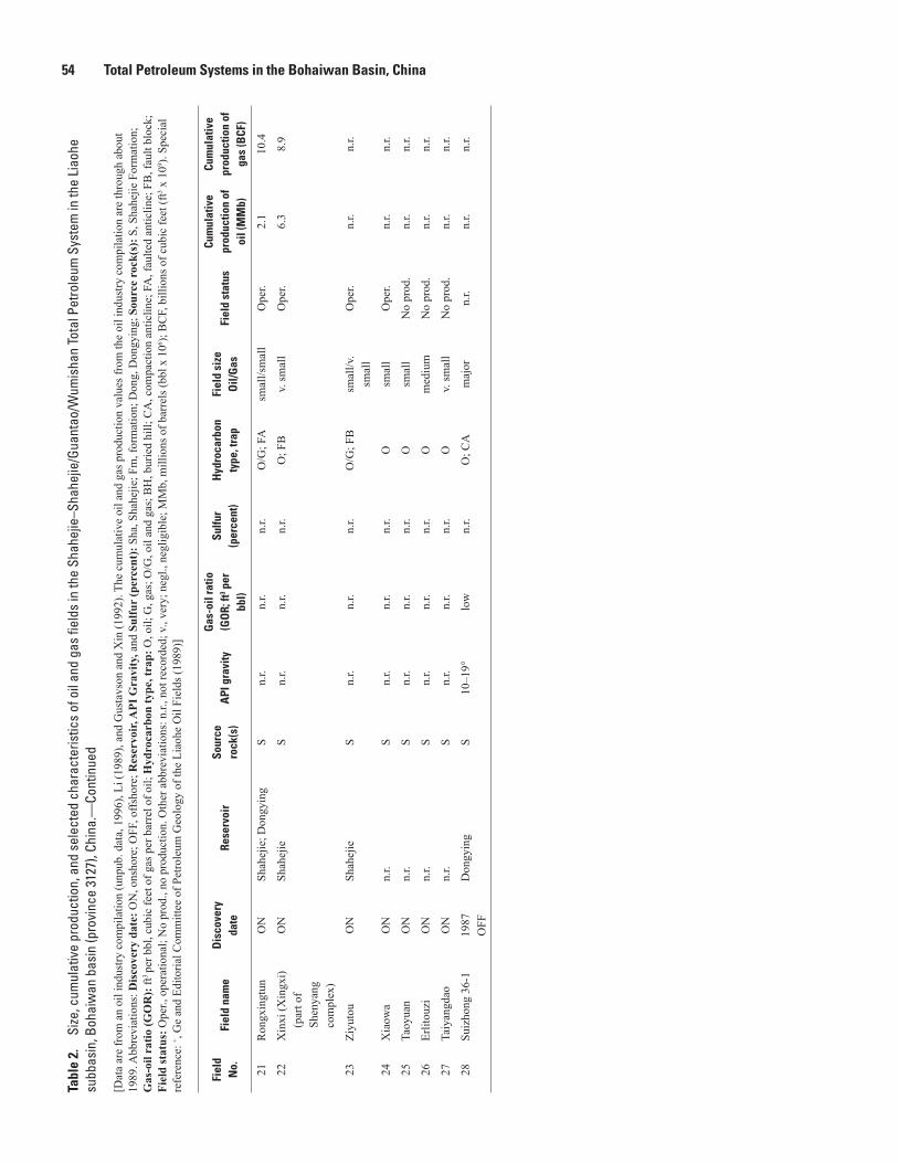
54 Total Petroleum Systems in the Bohaiwan Basin, ChinaTa
ble
2.
Size
, cum
ulat
ive
prod
uctio
n, a
nd s
elec
ted
char
acte
ristic
s of
oil
and
gas
field
s in
the
Shah
ejie
–Sha
hejie
/Gua
ntao
/Wum
isha
n To
tal P
etro
leum
Sys
tem
in th
e Li
aohe
su
bbas
in, B
ohai
wan
bas
in (p
rovi
nce
3127
), Ch
ina.
—Co
ntin
ued
[Dat
a ar
e fr
om a
n oi
l ind
ustry
com
pila
tion
(unp
ub. d
ata,
199
6), L
i (19
89),
and
Gus
tavs
on a
nd X
in (1
992)
. The
cum
ulat
ive
oil a
nd g
as p
rodu
ctio
n va
lues
from
the
oil i
ndus
try c
ompi
latio
n ar
e th
roug
h ab
out
1989
. Abb
revi
atio
ns: D
isco
very
dat
e: O
N, o
nsho
re; O
FF, o
ffsho
re; R
eser
voir,
API
Gra
vity
, and
Sul
fur
(per
cent
): S
ha, S
hahe
jie; F
m, f
orm
atio
n; D
ong,
Don
gyin
g; S
ourc
e ro
ck(s
): S
, Sha
hejie
For
mat
ion;
G
as-o
il ra
tio (G
OR
): ft
3 pe
r bbl
, cub
ic fe
et o
f gas
per
bar
rel o
f oil;
Hyd
roca
rbon
type
, tra
p: O
, oil;
G, g
as; O
/G, o
il an
d ga
s; B
H, b
urie
d hi
ll; C
A, c
ompa
ctio
n an
ticlin
e; F
A, f
aulte
d an
ticlin
e; F
B, f
ault
bloc
k;
Fiel
d st
atus
: Ope
r., o
pera
tiona
l; N
o pr
od.,
no p
rodu
ctio
n. O
ther
abb
revi
atio
ns: n
.r., n
ot re
cord
ed; v
., ve
ry; n
egl.,
neg
ligib
le; M
Mb,
mill
ions
of b
arre
ls (b
bl x
106 );
BC
F, b
illio
ns o
f cub
ic fe
et (f
t3 x 1
09 ). S
peci
al
refe
renc
e: + ,
Ge
and
Edito
rial C
omm
ittee
of P
etro
leum
Geo
logy
of t
he L
iaoh
e O
il Fi
elds
(198
9)]
Fiel
d N
o.Fi
eld
nam
eD
isco
very
da
teRe
serv
oir
Sour
ce
rock
(s)
API
gra
vity
Gas
-oil
ratio
(G
OR;
ft3 p
er
bbl)
Sulfu
r(p
erce
nt)
Hyd
roca
rbon
ty
pe, t
rap
Fiel
d si
ze
Oil/
Gas
Fiel
d st
atus
Cum
ulat
ive
prod
uctio
n of
oi
l (M
Mb)
Cum
ulat
ive
prod
uctio
n of
ga
s (B
CF)
21R
ongx
ingt
unO
NSh
ahej
ie; D
ongy
ing
Sn.
r.n.
r.n.
r.O
/G; F
Asm
all/s
mal
lO
per.
2.1
10.4
22X
inxi
(Xin
gxi)
(par
t of
Shen
yang
co
mpl
ex)
ON
Shah
ejie
Sn.
r.n.
r.n.
r.O
; FB
v. sm
all
Ope
r.6.
38.
9
23Zi
yuto
uO
NSh
ahej
ieS
n.r.
n.r.
n.r.
O/G
; FB
smal
l/v.
smal
lO
per.
n.r.
n.r.
24X
iaow
aO
Nn.
r.S
n.r.
n.r.
n.r.
Osm
all
Ope
r.n.
r.n.
r.
25Ta
oyua
nO
Nn.
r.S
n.r.
n.r.
n.r.
Osm
all
No
prod
.n.
r.n.
r.
26Er
litou
ziO
Nn.
r.S
n.r.
n.r.
n.r.
Om
ediu
mN
o pr
od.
n.r.
n.r.
27Ta
iyan
gdao
ON
n.r.
Sn.
r.n.
r.n.
r.O
v. sm
all
No
prod
.n.
r.n.
r.
28Su
izho
ng 3
6-1
1987
OFF
Don
gyin
gS
10–1
9°lo
wn.
r.O
; CA
maj
orn.
r.n.
r.n.
r.

Table 3 55Ta
ble
3.
Size
, cum
ulat
ive
prod
uctio
n, a
nd s
elec
ted
char
acte
ristic
s of
oil
and
gas
field
s in
the
Shah
ejie
–Sha
hejie
/Gua
ntao
/Wum
isha
n To
tal P
etro
leum
Sys
tem
in th
e Ji
zhon
g su
bbas
in, B
ohai
wan
bas
in (p
rovi
nce
3127
), Ch
ina.
—Co
ntin
ued
[Dat
a ar
e fr
om a
n oi
l ind
ustry
com
pila
tion
(unp
ub. d
ata,
199
6). T
he c
umul
ativ
e oi
l and
gas
pro
duct
ion
valu
es fr
om th
is c
ompi
latio
n ar
e th
roug
h ab
out 1
992,
unl
ess n
oted
oth
erw
ise.
For
exa
mpl
e, c
umul
a-tiv
e pr
oduc
tion
thro
ugh
1984
is in
dica
ted
by (8
4). A
bbre
viat
ions
: Dis
cove
ry d
ate:
ON
, ons
hore
; Sou
rce
rock
(s):
S, S
hahe
jie F
orm
atio
n; C
, Car
boni
fero
us st
rata
; Res
ervo
ir, A
PI G
ravi
ty, G
as-o
il ra
tio, a
nd
Sulfu
r (p
erce
nt):
Fm
, for
mat
ion;
Sha
, Sha
hejie
; Don
g, D
ongy
ing;
ft3 p
er b
bl, c
ubic
feet
of g
as p
er b
arre
l of o
il; H
ydro
carb
on ty
pe, t
rap:
O, o
il; O
/G, o
il an
d ga
s; B
H, b
urie
d hi
ll; D
, dom
e; F
D, f
aulte
d do
me;
FA
, fau
lted
antic
line;
FB
, fau
lt bl
ock;
FC
A, f
aulte
d co
mpa
ctio
n an
ticlin
e; A
, ant
iclin
e; S
/fc, s
tratig
raph
ic/fa
cies
cha
nge;
Fie
ld st
atus
: No
prod
., no
pro
duct
ion;
Ope
r., o
pera
tiona
l; D
evel
., be
ing
deve
lope
d.
Oth
er a
bbre
viat
ions
: n.r.
, not
reco
rded
; v.,
very
; MM
b, m
illio
ns o
f bar
rels
(bbl
x 1
06 ); B
CF,
bill
ions
of c
ubic
feet
(ft3 x
109 ).
Spe
cial
refe
renc
es: + ,
Shi a
nd Q
in (1
987)
; # , Zh
ao a
nd o
ther
s (19
87);
Δ , Q
in a
nd o
th-
ers (
1987
)]
Fiel
d N
o.Fi
eld
nam
eD
isco
very
da
teRe
serv
oir
Sour
ce
rock
(s)
API
gra
vity
Gas
-oil
ratio
(G
OR;
ft3 p
er
bbl)
Sulfu
r (p
erce
nt)
Hyd
roca
rbon
ty
pe, t
rap
Fiel
d si
ze
Oil/
Gas
Fiel
d st
atus
Cum
ulat
ive
prod
uctio
n of
oi
l (M
Mb)
Cum
ulat
ive
prod
uctio
n of
ga
s (B
CF)
1R
enqi
u19
75O
NM
iddl
e Pr
oter
ozoi
c (W
umis
han
Fm);
Cam
bria
n (F
ujun
shan
Fm
);O
rdov
icia
n (M
ajia
gou
Fm)
S27
.9°
29.9
°
28.9
°
20 23 172
0.32 0.2
0.17
O; B
Hgi
ant
Ope
r.62
9.8
7.7
n.r.
n.r.
2Yo
ngqi
ng
(incl
udes
Li
uqiy
ing)
1978
ON
Mid
dle
Prot
eroz
oic
(Wum
isha
n Fm
); O
rdov
icia
n (M
ajia
-go
u an
d Fe
ngfe
ng
Fms)
S51
.8°
222
0.02
O/G
; BH
v. sm
all/v
. sm
all
Ope
r.2.
11.
9
3Lo
nghu
zhua
ng19
77O
NO
rdov
icia
n (M
ajia
gou
Fm)
S36
.4°
120.
05O
; BH
smal
lO
per.
18.6
n.r.
4N
anm
eng
1976
ON
Cam
bria
n (F
ujun
shan
, M
ento
u, C
hang
xia
Fms)
; Ord
ovic
ian
(Maj
iago
u Fm
); Sh
ahej
ie
S39
.8°
Fuju
nsha
n;40
.4°
Men
tou;
46.0
°M
ajia
gou;
39.8
°Sh
a
14Fu
juns
han;
28M
ento
u;9
Maj
iago
u;28 Sh
a
0.08
Fuju
nsha
n;0.
06M
ento
u;0.
06M
ajia
gou;
0.05 Sha
O; B
Hv.
smal
lO
per.
5.3
n.r.
5G
uxin
gzhu
ang
(Gux
-in
zhua
ng)
1979
ON
Ord
ovic
ian
(Maj
ia-
gou
and
Feng
feng
Fm
s);
S, C
+46
.0°
n.r.
n.r.
O/G
; BH
v. sm
all/v
. sm
all
Shut
inn.
r.1.
5
6Su
qiao
1982
#
ON
Ord
ovic
ian
(Maj
ia-
gou
Fm);
Perm
ian
(Shi
hezi
Fm
)Δ
S, C
+n.
r.n.
r.n.
r.O
/G; B
Hv.
smal
l/v.
smal
lO
per.
n.r.
n.r.
7M
ozho
u19
78O
NM
iddl
e Pr
oter
ozoi
c (W
umis
han
Fm);
Shah
ejie
S34
.2°
390.
07O
; BH
smal
lO
per.
21.8
n.r.
8Ya
nglin
g (Y
anlin
g)19
77 (1
976)
ON
Mid
dle
Prot
eroz
oic
(Wum
isha
n Fm
)S
26.8
°12
0.39
O; B
Hm
ediu
mO
per.
33.5
n.r.

56 Total Petroleum Systems in the Bohaiwan Basin, ChinaTa
ble
3.
Size
, cum
ulat
ive
prod
uctio
n, a
nd s
elec
ted
char
acte
ristic
s of
oil
and
gas
field
s in
the
Shah
ejie
–Sha
hejie
/Gua
ntao
/Wum
isha
n To
tal P
etro
leum
Sys
tem
in th
e Ji
zhon
g su
bbas
in, B
ohai
wan
bas
in (p
rovi
nce
3127
), Ch
ina.
—Co
ntin
ued
[Dat
a ar
e fr
om a
n oi
l ind
ustry
com
pila
tion
(unp
ub. d
ata,
199
6). T
he c
umul
ativ
e oi
l and
gas
pro
duct
ion
valu
es fr
om th
is c
ompi
latio
n ar
e th
roug
h ab
out 1
992,
unl
ess n
oted
oth
erw
ise.
For
exa
mpl
e, c
umul
a-tiv
e pr
oduc
tion
thro
ugh
1984
is in
dica
ted
by (8
4). A
bbre
viat
ions
: Dis
cove
ry d
ate:
ON
, ons
hore
; Sou
rce
rock
(s):
S, S
hahe
jie F
orm
atio
n; C
, Car
boni
fero
us st
rata
; Res
ervo
ir, A
PI G
ravi
ty, G
as-o
il ra
tio, a
nd
Sulfu
r (p
erce
nt):
Fm
, for
mat
ion;
Sha
, Sha
hejie
; Don
g, D
ongy
ing;
ft3 p
er b
bl, c
ubic
feet
of g
as p
er b
arre
l of o
il; H
ydro
carb
on ty
pe, t
rap:
O, o
il; O
/G, o
il an
d ga
s; B
H, b
urie
d hi
ll; D
, dom
e; F
D, f
aulte
d do
me;
FA
, fau
lted
antic
line;
FB
, fau
lt bl
ock;
FC
A, f
aulte
d co
mpa
ctio
n an
ticlin
e; A
, ant
iclin
e; S
/fc, s
tratig
raph
ic/fa
cies
cha
nge;
Fie
ld st
atus
: No
prod
., no
pro
duct
ion;
Ope
r., o
pera
tiona
l; D
evel
., be
ing
deve
lope
d.
Oth
er a
bbre
viat
ions
: n.r.
, not
reco
rded
; v.,
very
; MM
b, m
illio
ns o
f bar
rels
(bbl
x 1
06 ); B
CF,
bill
ions
of c
ubic
feet
(ft3 x
109 ).
Spe
cial
refe
renc
es: + ,
Shi a
nd Q
in (1
987)
; # , Zh
ao a
nd o
ther
s (19
87);
Δ , Q
in a
nd o
th-
ers (
1987
)]
Fiel
d N
o.Fi
eld
nam
eD
isco
very
da
teRe
serv
oir
Sour
ce
rock
(s)
API
gra
vity
Gas
-oil
ratio
(G
OR;
ft3 p
er
bbl)
Sulfu
r (p
erce
nt)
Hyd
roca
rbon
ty
pe, t
rap
Fiel
d si
ze
Oil/
Gas
Fiel
d st
atus
Cum
ulat
ive
prod
uctio
n of
oi
l (M
Mb)
Cum
ulat
ive
prod
uctio
n of
ga
s (B
CF)
9B
aliz
huan
g19
76O
NM
iddl
e Pr
oter
ozoi
c (W
umis
han
Fm)
S31
.1°
280.
21O
; BH
smal
lO
per.
11.9
n.r.
10X
uezh
uang
1977
ON
Mid
dle
Prot
eroz
oic
(Wum
isha
n Fm
); D
ongy
ing
S28
.0°
27.5
°
230.
210.
40
O; F
D, B
Hsm
all
Ope
r.9.
0n.
r.
11B
aliz
huan
gxi
1978
ON
Mid
dle
Prot
eroz
oic
(Wum
isha
n Fm
); D
ongy
ing;
Gua
ntao
S32
.1–3
4.0°
19–2
40.
12–0
.15
O; D
, BH
smal
lO
per.
17.4
n.r.
12H
ejia
n19
77O
NM
iddl
e Pr
oter
o-zo
ic (G
aoyu
zhua
ng
Fm);
Don
gyin
g (p
rimar
y re
serv
oir
?)Δ
S34
.0°
32.1
°
24 19
0.15
O; B
Hsm
all
Ope
r.21
.5n.
r.
13Li
ubei
(Liu
lu-
bei N
orth
)19
76O
NM
iddl
e Pr
oter
o-zo
ic (W
umis
han
Fm);
Don
gyin
g;
Shah
ejie
; Gua
ntao
(p
rimar
y re
serv
oir
?)Δ
S37
.2°
29.3
°
280.
05
0.27
O; B
H, F
Am
ediu
mO
per.
31.2
n.r.
14H
ezhu
angx
i19
82O
NO
rdov
icia
n (F
engf
eng
Fm)
S43
.4°
1,65
7–5,
538
0.06
O; B
Hv.
smal
lSh
ut in
0.26
3n.
r.
15H
ezhu
ang
1979
ON
Ord
ovic
ian
(Fen
gfen
g Fm
)S
36.6
°1,
424–
1,48
10.
14O
; BH
v. sm
all
Ope
r.3.
8n.
r.
16Sh
enxi
1979
ON
Ord
ovic
ian
(Maj
iago
u Fm
)S,
C+
38.8
°81
4–1,
111
0.11
O/G
; BH
v. sm
all
Ope
r.n.
r.n.
r.
17H
exiw
u19
66O
NSh
ahej
ieS
28.8
–45.
8°75
90.
04–0
.15
O; F
Bsm
all
Ope
r.3.
4n.
r.
18Li
uqua
n19
78O
NSh
ahej
ieS
36.6
–43.
2°56
4–81
00.
06–0
.16
O/G
; FA
smal
l/v.
smal
lO
per.
3.6
0.25
9
19Zh
ongc
hako
u19
78O
NSh
ahej
ieS
27.5
°21
80.
16O
; FB
v. sm
all
Ope
r.1.
6n.
r.

Table 3 57Ta
ble
3.
Size
, cum
ulat
ive
prod
uctio
n, a
nd s
elec
ted
char
acte
ristic
s of
oil
and
gas
field
s in
the
Shah
ejie
–Sha
hejie
/Gua
ntao
/Wum
isha
n To
tal P
etro
leum
Sys
tem
in th
e Ji
zhon
g su
bbas
in, B
ohai
wan
bas
in (p
rovi
nce
3127
), Ch
ina.
—Co
ntin
ued
[Dat
a ar
e fr
om a
n oi
l ind
ustry
com
pila
tion
(unp
ub. d
ata,
199
6). T
he c
umul
ativ
e oi
l and
gas
pro
duct
ion
valu
es fr
om th
is c
ompi
latio
n ar
e th
roug
h ab
out 1
992,
unl
ess n
oted
oth
erw
ise.
For
exa
mpl
e, c
umul
a-tiv
e pr
oduc
tion
thro
ugh
1984
is in
dica
ted
by (8
4). A
bbre
viat
ions
: Dis
cove
ry d
ate:
ON
, ons
hore
; Sou
rce
rock
(s):
S, S
hahe
jie F
orm
atio
n; C
, Car
boni
fero
us st
rata
; Res
ervo
ir, A
PI G
ravi
ty, G
as-o
il ra
tio, a
nd
Sulfu
r (p
erce
nt):
Fm
, for
mat
ion;
Sha
, Sha
hejie
; Don
g, D
ongy
ing;
ft3 p
er b
bl, c
ubic
feet
of g
as p
er b
arre
l of o
il; H
ydro
carb
on ty
pe, t
rap:
O, o
il; O
/G, o
il an
d ga
s; B
H, b
urie
d hi
ll; D
, dom
e; F
D, f
aulte
d do
me;
FA
, fau
lted
antic
line;
FB
, fau
lt bl
ock;
FC
A, f
aulte
d co
mpa
ctio
n an
ticlin
e; A
, ant
iclin
e; S
/fc, s
tratig
raph
ic/fa
cies
cha
nge;
Fie
ld st
atus
: No
prod
., no
pro
duct
ion;
Ope
r., o
pera
tiona
l; D
evel
., be
ing
deve
lope
d.
Oth
er a
bbre
viat
ions
: n.r.
, not
reco
rded
; v.,
very
; MM
b, m
illio
ns o
f bar
rels
(bbl
x 1
06 ); B
CF,
bill
ions
of c
ubic
feet
(ft3 x
109 ).
Spe
cial
refe
renc
es: + ,
Shi a
nd Q
in (1
987)
; # , Zh
ao a
nd o
ther
s (19
87);
Δ , Q
in a
nd o
th-
ers (
1987
)]
Fiel
d N
o.Fi
eld
nam
eD
isco
very
da
teRe
serv
oir
Sour
ce
rock
(s)
API
gra
vity
Gas
-oil
ratio
(G
OR;
ft3 p
er
bbl)
Sulfu
r (p
erce
nt)
Hyd
roca
rbon
ty
pe, t
rap
Fiel
d si
ze
Oil/
Gas
Fiel
d st
atus
Cum
ulat
ive
prod
uctio
n of
oi
l (M
Mb)
Cum
ulat
ive
prod
uctio
n of
ga
s (B
CF)
20B
iegu
zhua
ng19
78O
NSh
ahej
ieS
33.2
°37
00.
13O
/G; F
Bm
ediu
m/v
. sm
all
Ope
r.26
.00.
830
21C
hahe
ji19
78Δ
ON
Shah
ejie
S34
.8°
652
0.15
O; F
CA
larg
eO
per.
45.4
n.r.
22Li
uliz
huan
g19
77O
NK
ongd
ian
S31
.5°
125
0.23
O; F
Av.
smal
lO
per.
4.9
n.r.
23N
anm
azhu
ang
1976
ON
Shah
ejie
S29
.3°
111
0.25
O; F
Asm
all
Ope
r.7.
0n.
r.
24Su
ning
1981
ON
Don
gyin
gS
31.3
°25
00.
16O
; FA
smal
lO
per.
59.2
n.r.
25D
awan
g-zh
uang
1979
ON
Shah
ejie
; Don
gyin
gS
28.2
°17
10.
13–0
.29
O; F
Am
ediu
mO
per.
18.0
n.r.
26Li
uxi
1980
ON
Shah
ejie
S25
.0°
153
0.47
O; F
Bsm
all
Ope
r.7.
3n.
r.
27Sh
enna
n19
79O
NSh
ahej
ie (S
ha I)
; D
ongy
ing
(Don
g II
, III
)
S29
.1°
Don
g II
;20
.8–2
8.8°
Don
g II
I
n.r.
0.09
–0.6
7Sh
a I;
0.13
–0.2
2D
ong
II;
0.07
–0.8
2D
ong
III
O; F
Av.
smal
lO
per.
0.43
0n.
r.
28Ji
nqiu
(J
ingq
iu)
1982
ON
Shah
ejie
S31
.1°
366
0.31
O; F
Asm
all
Ope
r.16
.5n.
r.
29W
enan
ON
Don
gyin
g; S
hahe
jie;
Perm
ian
S76
.3°
n.r.
n.r.
O/G
; Av.
smal
l/v.
smal
lO
per.
0.57
80.
802
30N
anxi
aoch
enO
NSh
ahej
ieS
n.r.
n.r.
n.r.
O; A
v. sm
all
No
prod
.n.
r.n.
r.
31G
aojia
bu
(Gao
jiapu
)O
NSh
ahej
ieS
25.0
°n.
r.n.
r.O
v. sm
all
Shut
in0.
560
n.r.
32Fe
nghe
ying
1964
#
ON
Shah
ejie
S68
.1°
n.r.
n.r.
O; S
/fcv.
smal
lO
per.
0.44
5n.
r.
33X
iliu
ON
Shah
ejie
S22
.3–3
1.3°
n.r.
n.r.
O; S
/fcv.
smal
lO
per.
0.04
3n.
r.

58 Total Petroleum Systems in the Bohaiwan Basin, ChinaTa
ble
3.
Size
, cum
ulat
ive
prod
uctio
n, a
nd s
elec
ted
char
acte
ristic
s of
oil
and
gas
field
s in
the
Shah
ejie
–Sha
hejie
/Gua
ntao
/Wum
isha
n To
tal P
etro
leum
Sys
tem
in th
e Ji
zhon
g su
bbas
in, B
ohai
wan
bas
in (p
rovi
nce
3127
), Ch
ina.
—Co
ntin
ued
[Dat
a ar
e fr
om a
n oi
l ind
ustry
com
pila
tion
(unp
ub. d
ata,
199
6). T
he c
umul
ativ
e oi
l and
gas
pro
duct
ion
valu
es fr
om th
is c
ompi
latio
n ar
e th
roug
h ab
out 1
992,
unl
ess n
oted
oth
erw
ise.
For
exa
mpl
e, c
umul
a-tiv
e pr
oduc
tion
thro
ugh
1984
is in
dica
ted
by (8
4). A
bbre
viat
ions
: Dis
cove
ry d
ate:
ON
, ons
hore
; Sou
rce
rock
(s):
S, S
hahe
jie F
orm
atio
n; C
, Car
boni
fero
us st
rata
; Res
ervo
ir, A
PI G
ravi
ty, G
as-o
il ra
tio, a
nd
Sulfu
r (p
erce
nt):
Fm
, for
mat
ion;
Sha
, Sha
hejie
; Don
g, D
ongy
ing;
ft3 p
er b
bl, c
ubic
feet
of g
as p
er b
arre
l of o
il; H
ydro
carb
on ty
pe, t
rap:
O, o
il; O
/G, o
il an
d ga
s; B
H, b
urie
d hi
ll; D
, dom
e; F
D, f
aulte
d do
me;
FA
, fau
lted
antic
line;
FB
, fau
lt bl
ock;
FC
A, f
aulte
d co
mpa
ctio
n an
ticlin
e; A
, ant
iclin
e; S
/fc, s
tratig
raph
ic/fa
cies
cha
nge;
Fie
ld st
atus
: No
prod
., no
pro
duct
ion;
Ope
r., o
pera
tiona
l; D
evel
., be
ing
deve
lope
d.
Oth
er a
bbre
viat
ions
: n.r.
, not
reco
rded
; v.,
very
; MM
b, m
illio
ns o
f bar
rels
(bbl
x 1
06 ); B
CF,
bill
ions
of c
ubic
feet
(ft3 x
109 ).
Spe
cial
refe
renc
es: + ,
Shi a
nd Q
in (1
987)
; # , Zh
ao a
nd o
ther
s (19
87);
Δ , Q
in a
nd o
th-
ers (
1987
)]
Fiel
d N
o.Fi
eld
nam
eD
isco
very
da
teRe
serv
oir
Sour
ce
rock
(s)
API
gra
vity
Gas
-oil
ratio
(G
OR;
ft3 p
er
bbl)
Sulfu
r (p
erce
nt)
Hyd
roca
rbon
ty
pe, t
rap
Fiel
d si
ze
Oil/
Gas
Fiel
d st
atus
Cum
ulat
ive
prod
uctio
n of
oi
l (M
Mb)
Cum
ulat
ive
prod
uctio
n of
ga
s (B
CF)
34Ta
ijiaz
huan
gO
NSh
ahej
ieS
n.r.
n.r.
n.r.
O/G
; S/fc
v. sm
all/v
. sm
all
Ope
r.0.
480
1.7
35W
uqia
ngO
NSh
ahej
ieS
n.r.
n.r.
n.r.
O; S
/fcv.
smal
lO
per.
0.45
6n.
r.
36Yu
kou
ON
Shah
ejie
Sn.
r.n.
r.n.
r.O
; FB
v. sm
all
Ope
r.0.
308
n.r.
37G
aoya
ngO
NSh
ahej
ieS
33.0
–34.
4°n.
r.n.
r.O
; S/fc
v. sm
all
Ope
r.n.
r.n.
r.
38Li
uzu
ON
n.r.
Sn.
rn.
r.n.
r.O
smal
lD
evel
.n.
r.n.
r.
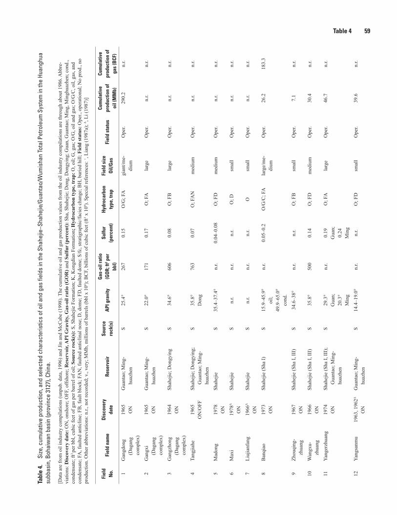
Table 4 59Ta
ble
4.
Size
, cum
ulat
ive
prod
uctio
n, a
nd s
elec
ted
char
acte
ristic
s of
oil
and
gas
field
s in
the
Shah
ejie
–Sha
hejie
/Gua
ntao
/Wum
isha
n To
tal P
etro
leum
Sys
tem
in th
e Hu
angh
ua
subb
asin
, Boh
aiw
an b
asin
(pro
vinc
e 31
27),
Chin
a.—
Cont
inue
d
[Dat
a ar
e fr
om o
il in
dust
ry c
ompi
latio
ns (u
npub
. dat
a, 1
996)
and
Jin
and
McC
abe
(199
8). T
he c
umul
ativ
e oi
l and
gas
pro
duct
ion
valu
es fr
om th
e oi
l ind
ustry
com
pila
tions
are
thro
ugh
abou
t 198
6. A
bbre
-vi
atio
ns: D
isco
very
dat
e: O
N, o
nsho
re; O
FF, o
ffsho
re; R
eser
voir,
API
Gra
vity
, Gas
-oil
ratio
(GO
R) a
nd S
ulfu
r (p
erce
nt):
Sha
, Sha
hejie
; Don
g, D
ongy
ing;
Gua
n, G
uant
ao; M
ing,
Min
ghua
zhen
; con
d.,
cond
ensa
te; f
t3 pe
r bbl
, cub
ic fe
et o
f gas
per
bar
rel o
f oil;
Sou
rce
rock
(s):
S, S
hahe
jie F
orm
atio
n; K
, Kon
gdia
n Fo
rmat
ion;
Hyd
roca
rbon
type
, tra
p: O
, oil;
G, g
as; O
/G, o
il an
d ga
s; O
/G/C
, oil,
gas
, and
co
nden
sate
; FA
, fau
lted
antic
line;
FB
, fau
lt bl
ock;
FA
N, f
aulte
d an
ticlin
al n
ose;
D, d
ome;
FD
, fau
lted
dom
e; S
/fc, s
tratig
raph
ic/fa
cies
cha
nge;
BH
, bur
ied
hill;
Fie
ld st
atus
: Ope
r., o
pera
tiona
l; N
o pr
od.,
no
prod
uctio
n. O
ther
abb
revi
atio
ns: n
.r., n
ot re
cord
ed; v
., ve
ry; M
Mb,
mill
ions
of b
arre
ls (b
bl x
106 );
BC
F, b
illio
ns o
f cub
ic fe
et (f
t3 x 1
09 ). S
peci
al re
fere
nces
: + , Li
ang
(198
7a);
Δ , Li
(198
7)]
Fiel
d N
o.Fi
eld
nam
eD
isco
very
da
teRe
serv
oir
Sour
ce
rock
(s)
API
gra
vity
Gas
-oil
ratio
(G
OR;
ft3 p
er
bbl)
Sulfu
r(p
erce
nt)
Hyd
roca
rbon
ty
pe, t
rap
Fiel
d si
ze
Oil/
Gas
Fiel
d st
atus
Cum
ulat
ive
prod
uctio
n of
oi
l (M
Mb)
Cum
ulat
ive
prod
uctio
n of
ga
s (B
CF)
1G
angd
ong
(Dag
ang
com
plex
)
1965
ON
Gua
ntao
; Min
g-hu
azhe
nS
25.4
°26
70.
15O
/G; F
Agi
ant/m
e-di
umO
per.
290.
2n.
r.
2G
angx
i (D
agan
g co
mpl
ex)
1965
ON
Gua
ntao
; Min
g-hu
azhe
nS
22.0
°17
10.
17O
; FA
larg
eO
per.
n.r.
n.r.
3G
angz
hong
(D
agan
g co
mpl
ex)
1964
ON
Shah
ejie
; Don
gyin
gS
34.6
°60
60.
08O
; FB
larg
eO
per.
n.r.
n.r.
4Ta
ngjia
he19
65O
N/O
FFSh
ahej
ie; D
ongy
ing;
G
uant
ao; M
ing-
huaz
hen
S35
.8°
Don
g76
30.
07O
; FA
Nm
ediu
mO
per.
n.r.
n.r.
5M
adon
g19
78O
NSh
ahej
ieS
35.4
–37.
4°n.
r.0.
04–0
.08
O; F
Dm
ediu
mO
per.
n.r.
n.r.
6M
axi
1978
Δ
ON
Shah
ejie
Sn.
r.n.
r.n.
r.O
; Dsm
all
Ope
r.n.
r.n.
r.
7Li
ujia
nfan
g19
66Δ
ON
Shah
ejie
Sn.
r.n.
r.n.
r.O
smal
lO
per.
n.r.
n.r.
8B
anqi
ao19
73O
NSh
ahej
ie (S
ha I)
S15
.9–4
5.9°
oil;
49.9
–65.
0°co
nd.
n.r.
0.05
–0.2
O/G
/C; F
Ala
rge/
me-
dium
Ope
r.26
.218
3.3
9Zh
ouqi
ng-
zhua
ng19
67O
NSh
ahej
ie (S
ha I,
III)
S34
.6–3
8°n.
r.n.
r.O
; FB
smal
lO
per.
7.1
n.r.
10W
angx
u-zh
uang
1966
ON
Shah
ejie
(Sha
I, II
I)S
35.8
°50
00.
14O
; FD
med
ium
Ope
r.30
.4n.
r.
11Ya
nger
zhua
ng19
74O
NSh
ahej
ie (S
ha I,
III)
; G
uant
ao; M
ing-
huaz
hen
S29
.3°
Gua
n;20
.3°
Min
g
n.r.
0.19
Gua
n;0.
24M
ing
O; F
Ala
rge
Ope
r.46
.7n.
r.
12Ya
ngsa
nmu
1963
, 196
2Δ
ON
Gua
ntao
; Min
g-hu
azhe
nS
14.4
–19.
0°n.
r.n.
r.O
; FD
smal
lO
per.
39.6
n.r.
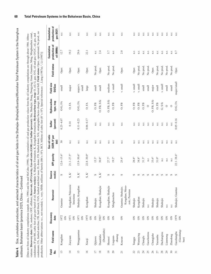
60 Total Petroleum Systems in the Bohaiwan Basin, ChinaTa
ble
4.
Size
, cum
ulat
ive
prod
uctio
n, a
nd s
elec
ted
char
acte
ristic
s of
oil
and
gas
field
s in
the
Shah
ejie
–Sha
hejie
/Gua
ntao
/Wum
isha
n To
tal P
etro
leum
Sys
tem
in th
e Hu
angh
ua
subb
asin
, Boh
aiw
an b
asin
(pro
vinc
e 31
27),
Chin
a.—
Cont
inue
d
[Dat
a ar
e fr
om o
il in
dust
ry c
ompi
latio
ns (u
npub
. dat
a, 1
996)
and
Jin
and
McC
abe
(199
8). T
he c
umul
ativ
e oi
l and
gas
pro
duct
ion
valu
es fr
om th
e oi
l ind
ustry
com
pila
tions
are
thro
ugh
abou
t 198
6. A
bbre
-vi
atio
ns: D
isco
very
dat
e: O
N, o
nsho
re; O
FF, o
ffsho
re; R
eser
voir,
API
Gra
vity
, Gas
-oil
ratio
(GO
R) a
nd S
ulfu
r (p
erce
nt):
Sha
, Sha
hejie
; Don
g, D
ongy
ing;
Gua
n, G
uant
ao; M
ing,
Min
ghua
zhen
; con
d.,
cond
ensa
te; f
t3 pe
r bbl
, cub
ic fe
et o
f gas
per
bar
rel o
f oil;
Sou
rce
rock
(s):
S, S
hahe
jie F
orm
atio
n; K
, Kon
gdia
n Fo
rmat
ion;
Hyd
roca
rbon
type
, tra
p: O
, oil;
G, g
as; O
/G, o
il an
d ga
s; O
/G/C
, oil,
gas
, and
co
nden
sate
; FA
, fau
lted
antic
line;
FB
, fau
lt bl
ock;
FA
N, f
aulte
d an
ticlin
al n
ose;
D, d
ome;
FD
, fau
lted
dom
e; S
/fc, s
tratig
raph
ic/fa
cies
cha
nge;
BH
, bur
ied
hill;
Fie
ld st
atus
: Ope
r., o
pera
tiona
l; N
o pr
od.,
no
prod
uctio
n. O
ther
abb
revi
atio
ns: n
.r., n
ot re
cord
ed; v
., ve
ry; M
Mb,
mill
ions
of b
arre
ls (b
bl x
106 );
BC
F, b
illio
ns o
f cub
ic fe
et (f
t3 x 1
09 ). S
peci
al re
fere
nces
: + , Li
ang
(198
7a);
Δ , Li
(198
7)]
Fiel
d N
o.Fi
eld
nam
eD
isco
very
da
teRe
serv
oir
Sour
ce
rock
(s)
API
gra
vity
Gas
-oil
ratio
(G
OR;
ft3 p
er
bbl)
Sulfu
r(p
erce
nt)
Hyd
roca
rbon
ty
pe, t
rap
Fiel
d si
ze
Oil/
Gas
Fiel
d st
atus
Cum
ulat
ive
prod
uctio
n of
oi
l (M
Mb)
Cum
ulat
ive
prod
uctio
n of
ga
s (B
CF)
13K
ongd
ian
1972
ON
Gua
ntao
S12
.6–1
5.6°
300.
25–4
.07
O/G
; FA
smal
lO
per.
12.7
n.r.
14Za
oyua
n19
71O
NK
ongd
ian;
Pal
eozo
ic
limes
tone
S, K
+21
.1–2
7.5°
n.r.
0.14
O; F
Am
ajor
Ope
r.19
.2n.
r.
15W
angg
uant
un19
71O
NSh
ahej
ie; K
ongd
ian
S, K
+15
.9–3
0.6°
n.r.
0.11
–0.2
3O
/G; F
Am
ajor
/v.
smal
lO
per.
29.6
n.r.
16X
iaoj
i19
75O
NK
ongd
ian
S, K
+22
.8–3
0.0°
n.r.
0.06
–0.1
7O
; FA
larg
eO
per.
22.1
n.r.
17Q
ijiaw
uO
NSh
ahej
ieS
15.3
°n.
r.n.
r.O
; FB
smal
lN
o pr
od.
n.r.
n.r.
18D
uanl
ubo
(Dua
nliu
bo)
1983
Δ
ON
Kon
gdia
n; S
hahe
jieS,
K+
30.8
°n.
r.n.
r.O
; FB
, S/fc
smal
lO
per.
2.4
n.r.
19Sh
enus
iO
NK
ongd
ian;
Sha
hejie
S27
.7°
n.r.
n.r.
O; F
B, S
/fcm
ediu
mN
o pr
od.
5.7
n.r.
20Li
ugua
n-zh
uang
ON
Min
ghua
zhen
S19
.2°
n.r.
n.r.
O; F
Bv.
smal
lN
o pr
od.
n.r.
n.r.
21K
oucu
nO
NG
uant
ao; S
hahe
jie;
Kon
gdia
n; M
eso-
zoic
; Per
mia
n
S25
.4°
n.r.
n.r.
O; F
Bv.
smal
lO
per.
2.0
n.r.
22Ta
nggu
ON
Shah
ejie
S28
.8°
n.r.
n.r.
O; F
Bv.
smal
lO
per.
n.r.
n.r.
23W
umay
ing
ON
Kon
gdia
nS
34.8
°n.
r.n.
r.O
; FB
v. sm
all
No
prod
.n.
r.n.
r.
24C
hang
luO
NSh
ahej
ieS
31.3
°n.
r.n.
r.O
; FB
smal
lN
o pr
od.
n.r.
n.r.
25G
aoch
ento
uO
Nn.
r.S
n.r.
n.r.
n.r.
Osm
all
No
prod
.n.
r.n.
r.
26C
hang
juhe
ON
Shah
ejie
S33
.6°
n.r.
n.r.
O; F
B, S
/fcm
ajor
Ope
r.n.
r.n.
r.
27Yu
esan
baO
NSh
ahej
ieS
31.0
°n.
r.n.
r.O
; FB
smal
lN
o pr
od.
n.r.
n.r.
28D
acha
ngto
uO
NSh
ahej
ieS
n.r.
n.r.
n.r.
G; S
/fcv.
smal
lN
o pr
od.
n.r.
n.r.
29Li
anm
eng
ON
n.r.
Sn.
r.n.
r.n.
r.O
smal
lN
o pr
od.
n.r.
n.r.
30Zh
aodo
ngO
Nn.
r.S
n.r.
n.r.
n.r.
Osm
all
No
prod
.n.
r.n.
r.
31G
aosh
angb
u (G
aosh
ang-
bao)
1979
ON
Shah
ejie
; Gua
ntao
S22
.1–3
8.6°
n.r.
0.05
–0.1
6O
/G; F
Am
ajor
/sm
all
Ope
r.8.
7n.
r.

Table 4 61Ta
ble
4.
Size
, cum
ulat
ive
prod
uctio
n, a
nd s
elec
ted
char
acte
ristic
s of
oil
and
gas
field
s in
the
Shah
ejie
–Sha
hejie
/Gua
ntao
/Wum
isha
n To
tal P
etro
leum
Sys
tem
in th
e Hu
angh
ua
subb
asin
, Boh
aiw
an b
asin
(pro
vinc
e 31
27),
Chin
a.—
Cont
inue
d
[Dat
a ar
e fr
om o
il in
dust
ry c
ompi
latio
ns (u
npub
. dat
a, 1
996)
and
Jin
and
McC
abe
(199
8). T
he c
umul
ativ
e oi
l and
gas
pro
duct
ion
valu
es fr
om th
e oi
l ind
ustry
com
pila
tions
are
thro
ugh
abou
t 198
6. A
bbre
-vi
atio
ns: D
isco
very
dat
e: O
N, o
nsho
re; O
FF, o
ffsho
re; R
eser
voir,
API
Gra
vity
, Gas
-oil
ratio
(GO
R) a
nd S
ulfu
r (p
erce
nt):
Sha
, Sha
hejie
; Don
g, D
ongy
ing;
Gua
n, G
uant
ao; M
ing,
Min
ghua
zhen
; con
d.,
cond
ensa
te; f
t3 pe
r bbl
, cub
ic fe
et o
f gas
per
bar
rel o
f oil;
Sou
rce
rock
(s):
S, S
hahe
jie F
orm
atio
n; K
, Kon
gdia
n Fo
rmat
ion;
Hyd
roca
rbon
type
, tra
p: O
, oil;
G, g
as; O
/G, o
il an
d ga
s; O
/G/C
, oil,
gas
, and
co
nden
sate
; FA
, fau
lted
antic
line;
FB
, fau
lt bl
ock;
FA
N, f
aulte
d an
ticlin
al n
ose;
D, d
ome;
FD
, fau
lted
dom
e; S
/fc, s
tratig
raph
ic/fa
cies
cha
nge;
BH
, bur
ied
hill;
Fie
ld st
atus
: Ope
r., o
pera
tiona
l; N
o pr
od.,
no
prod
uctio
n. O
ther
abb
revi
atio
ns: n
.r., n
ot re
cord
ed; v
., ve
ry; M
Mb,
mill
ions
of b
arre
ls (b
bl x
106 );
BC
F, b
illio
ns o
f cub
ic fe
et (f
t3 x 1
09 ). S
peci
al re
fere
nces
: + , Li
ang
(198
7a);
Δ , Li
(198
7)]
Fiel
d N
o.Fi
eld
nam
eD
isco
very
da
teRe
serv
oir
Sour
ce
rock
(s)
API
gra
vity
Gas
-oil
ratio
(G
OR;
ft3 p
er
bbl)
Sulfu
r(p
erce
nt)
Hyd
roca
rbon
ty
pe, t
rap
Fiel
d si
ze
Oil/
Gas
Fiel
d st
atus
Cum
ulat
ive
prod
uctio
n of
oi
l (M
Mb)
Cum
ulat
ive
prod
uctio
n of
ga
s (B
CF)
32Li
uzha
n19
80Δ
ON
Shah
ejie
; Gua
ntao
; M
ingh
uazh
enS
29.7
°n.
r.n.
r.O
; FB
, S/fc
med
ium
Ope
r.3.
2n.
r.
33B
eipu
(Bei
bao)
1980
Δ
ON
Don
gyin
g; G
uant
aoS
43.2
°n.
r.n.
r.O
v. sm
all
Ope
r.0.
078
n.r.
34La
oyem
iao
ON
Don
gyin
g; M
ing-
huaz
hen
S34
.4°
n.r.
n.r.
O; F
B, S
/fcv.
smal
lO
per.
1.3
n.r.
35Ta
ngha
i/D
ulin
g (T
angh
e)
ON
Shah
ejie
; Mes
ozoi
c (J
uras
sic)
; Cam
-br
ian
S22
.3°
n.r.
n.r.
O; F
B, B
H,
S/fc
v. sm
all
Ope
r.0.
239
n.r.
36C
ansh
akou
ON
Shah
ejie
S29
.7°
n.r.
n.r.
O; F
Bm
ediu
mO
per.
5.5
n.r.
37B
aige
zhua
ng≈1
976Δ
ON
n.r.
Sn.
r.n.
r.n.
r.O
v. sm
all
Ope
r.n.
r.n.
r.
38C
heng
dao
1988
ON
/OFF
Gua
ntao
and
Min
g-hu
azhe
nS
n.r.
n.r.
n.r.
Ogi
ant
Ope
r.n.
r.n.
r.

62 Total Petroleum Systems in the Bohaiwan Basin, ChinaTa
ble
5.
Size
, cum
ulat
ive
prod
uctio
n, a
nd s
elec
ted
char
acte
ristic
s of
oil
and
gas
field
s in
the
Shah
ejie
–Sha
hejie
/Gua
ntao
/Wum
isha
n To
tal P
etro
leum
Sys
tem
in th
e Li
nqin
g/Do
ngpu
sub
basi
n, B
ohai
wan
bas
in (p
rovi
nce
3127
), Ch
ina.
—Co
ntin
ued
[Dat
a ar
e fr
om a
n oi
l ind
ustry
com
pila
tion
(unp
ub. d
ata,
199
6). T
he c
umul
ativ
e oi
l and
gas
pro
duct
ion
valu
es fr
om th
is c
ompi
latio
n ar
e th
roug
h ab
out 1
989.
Abb
revi
atio
ns: D
isco
very
dat
e: O
N, o
nsho
re;
Sour
ce r
ock(
s): S
, Sha
hejie
For
mat
ion;
C, C
arbo
nife
rous
stra
ta; G
as-o
il ra
tio (G
OR
): ft
3 per
bar
rel,
cubi
c fe
et o
f gas
per
bar
rel o
f oil;
Hyd
roca
rbon
type
, tra
p: O
, oil;
G, g
as; G
/C, g
as a
nd c
onde
nsat
e;
O/G
, oil
and
gas;
FA
, fau
lted
antic
line;
FB
, fau
lt bl
ock;
S/fc
, stra
tigra
phic
/faci
es c
hang
e; F
AN
, fau
lted
antic
linal
nos
e; F
ield
stat
us: O
per.,
ope
ratio
nal;
No
prod
., no
pro
duct
ion.
Oth
er a
bbre
viat
ions
: n.r.
, not
re
cord
ed; v
., ve
ry; M
Mb,
mill
ions
of b
arre
ls (b
bl x
106 );
BC
F, b
illio
ns o
f cub
ic fe
et (f
t3 x 1
09 ). S
peci
al re
fere
nces
: + , X
u an
d Sh
en (1
996)
; # , Zh
u (1
987)
; Δ , D
ai a
nd o
ther
s (20
04)]
Fiel
d N
o.Fi
eld
nam
eD
isco
very
da
teRe
serv
oir
Sour
ce
rock
(s)
API
gra
vity
Gas
-oil
ratio
(G
OR;
ft3 p
er
bbl)
Sulfu
r(p
erce
nt)
Hyd
roca
rbon
ty
pe, t
rap
Fiel
d si
ze
Oil/
Gas
Fiel
d st
atus
Cum
ulat
ive
prod
uctio
n of
oi
l (M
Mb)
Cum
ulat
ive
prod
uctio
n of
ga
s (B
CF)
1Pu
chen
g (Z
hong
yu-
an)
1979
(197
5)#
ON
Shah
ejie
S31
.1–3
7.0°
389–
949
0.19
–0.5
6O
/G; F
Agi
ant
Ope
r.19
2.8
n.r.
2W
enm
ingz
hai
1979
ON
Shah
ejie
S22
.3–2
9.3°
240
1.37
O; F
Ala
rge
Ope
r.33
.3n.
r.
3W
eich
eng
1977
ON
Shah
ejie
S20
.7–2
9.3°
444
0.06
–1.9
O/G
; FA
larg
e/sm
all
Ope
r.26
.1n.
r.
4G
uyun
ji19
80O
NSh
ahej
ieS
33.0
–35.
0°n.
r.n.
r.O
/G; F
Av.
smal
l/v.
smal
lN
o pr
od.
n.r.
n.r.
5W
endo
ng19
78O
NSh
ahej
ieS
37.0
–43.
2°n.
r.0.
22–0
.23
O/G
; FA
maj
or/s
mal
lO
per.
33.6
n.r.
6W
enna
n19
78O
NSh
ahej
ieS
37.0
–41.
1°74
00.
1–0.
8O
/G; F
Am
ediu
mO
per.
44.7
n.r.
7W
enliu
1977
ON
Shah
ejie
S, C
+33
.8–3
9.4°
356–
597
0.32
–0.9
5O
/G; F
Agi
ant/m
e-di
umO
per.
3.5
n.r.
8W
en-2
319
77O
NSh
ahej
ieS
n.r.
n.r.
n.r.
G/C
; FA
maj
or/m
e-di
umO
per.
17.0
(con
dens
ate)
2.1
9Q
iaok
ou19
77O
NSh
ahej
ieS
39.0
–39.
4°29
6–47
7n.
r.O
; FA
smal
lO
per.
3.7
n.r.
10B
aim
iao
1980
ON
Shah
ejie
Sn.
r.n.
r.n.
r.G
; FB
, S/fc
v. sm
all
Ope
r.n.
r.n.
r.
11M
acha
ng19
81O
NSh
ahej
ieS,
CΔ
39.0
°41
9–66
3n.
r.O
/G; F
Bv.
smal
lO
per.
8.3
n.r.
12Sa
nchu
nji
1987
ON
Shah
ejie
S33
.4–3
7.8°
n.r.
n.r.
O; F
AN
v. sm
all
No
prod
.n.
r.n.
r.
13M
azha
i19
88O
NSh
ahej
ieS
30.0
°60
–111
n.r.
O; F
Av.
smal
lO
per.
6.3
n.r.
14H
uzhu
angj
i19
83O
NSh
ahej
ieS
17.1
–38.
0°n.
r.0.
54–0
.70
O; F
A, F
Bla
rge
Ope
r.26
.4n.
r.
15Q
ingz
uji
1986
ON
Shah
ejie
S31
.5–3
8.8°
126–
316
0.21
O; F
Bv.
smal
lO
per.
1.7
n.r.
16Li
uzhu
ang
ON
Shah
ejie
S26
.6°
n.r.
n.r.
O; F
Bv.
smal
lN
o pr
od.
n.r.
n.r.

Table 5 63Ta
ble
5.
Size
, cum
ulat
ive
prod
uctio
n, a
nd s
elec
ted
char
acte
ristic
s of
oil
and
gas
field
s in
the
Shah
ejie
–Sha
hejie
/Gua
ntao
/Wum
isha
n To
tal P
etro
leum
Sys
tem
in th
e Li
nqin
g/Do
ngpu
sub
basi
n, B
ohai
wan
bas
in (p
rovi
nce
3127
), Ch
ina.
—Co
ntin
ued
[Dat
a ar
e fr
om a
n oi
l ind
ustry
com
pila
tion
(unp
ub. d
ata,
199
6). T
he c
umul
ativ
e oi
l and
gas
pro
duct
ion
valu
es fr
om th
is c
ompi
latio
n ar
e th
roug
h ab
out 1
989.
Abb
revi
atio
ns: D
isco
very
dat
e: O
N, o
nsho
re;
Sour
ce r
ock(
s): S
, Sha
hejie
For
mat
ion;
C, C
arbo
nife
rous
stra
ta; G
as-o
il ra
tio (G
OR
): ft
3 per
bar
rel,
cubi
c fe
et o
f gas
per
bar
rel o
f oil;
Hyd
roca
rbon
type
, tra
p: O
, oil;
G, g
as; G
/C, g
as a
nd c
onde
nsat
e;
O/G
, oil
and
gas;
FA
, fau
lted
antic
line;
FB
, fau
lt bl
ock;
S/fc
, stra
tigra
phic
/faci
es c
hang
e; F
AN
, fau
lted
antic
linal
nos
e; F
ield
stat
us: O
per.,
ope
ratio
nal;
No
prod
., no
pro
duct
ion.
Oth
er a
bbre
viat
ions
: n.r.
, not
re
cord
ed; v
., ve
ry; M
Mb,
mill
ions
of b
arre
ls (b
bl x
106 );
BC
F, b
illio
ns o
f cub
ic fe
et (f
t3 x 1
09 ). S
peci
al re
fere
nces
: + , X
u an
d Sh
en (1
996)
; # , Zh
u (1
987)
; Δ , D
ai a
nd o
ther
s (20
04)]
Fiel
d N
o.Fi
eld
nam
eD
isco
very
da
teRe
serv
oir
Sour
ce
rock
(s)
API
gra
vity
Gas
-oil
ratio
(G
OR;
ft3 p
er
bbl)
Sulfu
r(p
erce
nt)
Hyd
roca
rbon
ty
pe, t
rap
Fiel
d si
ze
Oil/
Gas
Fiel
d st
atus
Cum
ulat
ive
prod
uctio
n of
oi
l (M
Mb)
Cum
ulat
ive
prod
uctio
n of
ga
s (B
CF)
17H
upuz
hai/
Xue
jiO
Nn.
r.S
n.r.
n.r.
n.r.
Gv.
smal
lO
per.
n.r.
n.r.
18X
uji
ON
n.r.
Sn.
r.n.
r.n.
r.O
smal
lO
per.
n.r.
n.r.
19W
enbe
iO
Nn.
r.S
n.r.
n.r.
n.r.
Osm
all
Ope
r.n.
r.n.
r.

64 Total Petroleum Systems in the Bohaiwan Basin, ChinaTa
ble
6.
Size
, cum
ulat
ive
prod
uctio
n, a
nd s
elec
ted
char
acte
ristic
s of
oil
and
gas
field
s in
the
Shah
ejie
–Sha
hejie
/Gua
ntao
/Wum
isha
n To
tal P
etro
leum
Sys
tem
in th
e Bo
zhon
g su
bbas
in, B
ohai
wan
bas
in (p
rovi
nce
3127
), Ch
ina.
[Dat
a ar
e fr
om E
dito
rial C
omm
ittee
of P
etro
leum
Geo
logy
of O
il- a
nd G
as-B
earin
g A
reas
on
the
Con
tinen
tal S
helf
and
its N
eigh
borin
g R
egio
ns (1
987)
, Mat
suza
wa
(198
8), L
ee (1
989)
, Oil
and
Gas
Jour
nal
(199
7), S
hirle
y (2
000)
, and
Hur
st a
nd o
ther
s (20
01).
Abb
revi
atio
ns: D
isco
very
dat
e: O
FF, o
ffsho
re; R
eser
voir
: Sha
, Sha
hejie
; Sou
rce
rock
(s):
S, S
hahe
jie F
orm
atio
n; G
as-o
il ra
tio (G
OR
): ft
3 per
bar
rel,
cubi
c fe
et o
f gas
per
bar
rel o
f oil;
Hyd
roca
rbon
type
, tra
p: O
, oil;
O/G
, oil
and
gas;
BH
, bur
ied
hill;
CA
, com
pact
ion
antic
line;
FA
, fau
lted
antic
line;
FA
N, f
aulte
d an
ticlin
al n
ose;
FB
, fau
lt bl
ock;
Fie
ld st
a-tu
s: D
isc.
, dis
cove
ry; D
evel
., be
ing
deve
lope
d; O
per.,
ope
ratio
nal;
P&A
, plu
gged
and
aba
ndon
ed. O
ther
abb
revi
atio
ns: n
.r., n
ot re
cord
ed; M
Mb,
mill
ions
of b
arre
ls (b
bl x
106 );
BC
F, b
illio
ns o
f cub
ic fe
et (f
t3 x
109 )] Fi
eld
No.
Fiel
d na
me
Dis
cove
ry
date
Rese
rvoi
rSo
urce
ro
ck(s
)A
PI g
ravi
tyG
as-o
il ra
tio
(GO
R; ft
3 per
bb
l)
Sulfu
r (p
erce
nt)
Hyd
roca
rbon
ty
pe, t
rap
Fiel
d si
ze
Oil/
Gas
Fiel
d st
atus
Cum
ulat
ive
prod
uctio
n of
oi
l (M
Mb)
Cum
ulat
ive
prod
uctio
n of
ga
s (B
CF)
1Q
inhu
angd
ao
30-1
≈197
5O
FFM
esoz
oic
(Jur
assi
c)S
n.r.
n.r.
n.r.
O; B
Hn.
r.D
isc.
n.r.
n.r.
2Sh
ijiut
uo
(Qin
huan
g-da
o 35
-1,
Boz
hong
5)
1975
OFF
Mes
ozoi
c (J
uras
sic)
; D
ongy
ing;
Gua
ntao
S
27°
1,16
0n.
r.O
/G; C
A,
BH
n.r.
Dev
el.
n.r.
3,09
7
3B
ozho
ng 2
5-1-
119
81O
FFSh
ahej
ie (S
ha II
I);
Mes
ozoi
cS
33°
390
n.r.
O/G
; FA
n.r.
n.r.
n.r.
n.r.
4B
ozho
ng 2
8-1
1981
OFF
Shah
ejie
(Sha
I);
Cam
bria
n; O
rdov
i-ci
an
S39
°97
00.
2–0.
17O
/G; B
Hn.
r.n.
r.n.
r.n.
r.
5B
ozho
ng 2
8-2-
119
83O
FFD
ongy
ing
S30
.0°
760
0.24
O/G
; FA
n.r.
Dis
c.n.
r.n.
r.
6B
ozho
ng 3
4-1-
119
84O
FFD
ongy
ing;
Gua
ntao
; M
ingh
uazh
enS
39.5
°80
0n.
r.O
/G; F
An.
r.D
isc.
n.r.
n.r.
7B
ozho
ng 3
4-2
1983
OFF
Shah
ejie
(Sha
II, I
II);
Don
gyin
g; G
uant
aoS
36°
520
0.11
–0.2
1O
/G; F
An.
r.O
per.
n.r.
n.r.
8B
ozho
ng 3
4-3
1984
OFF
Don
gyin
g; G
uant
aoS
36°
350–
850
0.09
O/G
; FA
Nn.
r.n.
r.n.
r.n.
r.
9B
ozho
ng 3
4-4
1985
OFF
Shah
ejie
(Sha
II, I
II)
Sn.
r.n.
r.n.
r.O
/G; F
An.
r.O
per.
n.r.
n.r.
10Pe
ng L
ai 1
4-3-
119
97O
FFM
ioce
ne sa
ndst
one
S26
–36°
n.r
n.r.
O; n
.r.n.
r.D
isc.
;P&
A, 1
999
n.r.
n.r.
11Pe
ng L
ai 1
9-3-
119
99O
FFG
uant
ao; M
ing-
huaz
hen
S11
–21°
50–3
00n.
r.O
/G; F
Bn.
r.D
isc.
n.r.
n.r.

Table 7 65Ta
ble
7.
Sele
cted
geo
chem
ical
pro
perti
es o
f sou
rce
rock
s in
Mem
ber 3
of t
he S
hahe
jie F
orm
atio
n.
Subb
asin
Tota
l org
anic
car
bon
(TO
C)(w
eigh
t per
cent
)Ke
roge
n ty
peH
ydro
gen
Inde
x (H
I)(m
illig
ram
s of
hyd
roca
rbon
s pe
r gra
m o
f org
anic
car
bon)
Refe
renc
e
Jiya
ng1−
21.
17−3
.47
—
— — —
— —15
0−40
0(s
ever
al v
alue
s as h
igh
as 9
37 a
nd 1
,136
)
ECPG
−She
ngli
(198
7)1
Jin
(199
1)C
hen
and
othe
rs (1
996)
Liao
he1.
5−2.
0I a
nd II
in w
este
rn sa
g;II
and
III i
n ea
ster
n an
d D
amitu
n sa
gs—
Ge
and
ECPG
−Lia
ohe
(198
9)2
Jizh
ong
≥1.0
(Cha
heji
field
)— —
—II
(Ren
qiu
field
)—
— —20
0−57
9
Wu
and
Lian
g (1
988)
Liu
and
othe
rs (1
988)
Gao
and
oth
ers (
1987
)
Hua
nghu
a0.
75−2
.22
II—
Lian
g (1
987a
)
Linq
ing/
Don
gpu
0.3−
3.2
II a
nd II
I39
4−62
3 (n
orth
ern
part)
113−
315
(sou
ther
n pa
rt)Ji
n an
d M
cCab
e (1
998)
Boz
hong
0.68
−1.6
6II
—G
ong
and
othe
rs (1
998)
1 Edi
toria
l Com
mitt
ee o
f Pet
role
um G
eolo
gy o
f the
She
ngli
Oil
Fiel
d (1
987)
.2 G
e an
d Ed
itoria
l Com
mitt
ee o
f Pet
role
um G
eolo
gy o
f the
Lia
ohe
Oil
Fiel
ds (1
989)
.

66 Total Petroleum Systems in the Bohaiwan Basin, ChinaTa
ble
8.
Stra
tigra
phic
, geo
chem
ical
, and
ther
mal
mat
urat
ion
data
use
d to
con
stru
ct th
e bu
rial h
isto
ry a
nd h
ydro
carb
on g
ener
atio
n m
odel
(fig
. 9) f
or th
e Ji
yang
sub
basi
n,
Boha
iwan
bas
in, C
hina
.
[See
figu
res 1
and
2 fo
r loc
atio
n of
the
Jiya
ng su
bbas
in a
nd th
e bu
rial h
isto
ry a
nd h
ydro
carb
on g
ener
atio
n m
odel
. Asi
a Pa
cific
regi
on (0
3), C
hina
(31)
, Boh
aiw
an b
asin
pro
vinc
e (2
7), J
iyan
g su
bbas
in (u
sing
ge
olog
ic p
erio
ds/e
poch
s and
oth
er d
ata
assi
gned
by
Edito
rial C
omm
ittee
of P
etro
leum
Geo
logy
of t
he S
heng
li O
il Fi
eld,
198
7; L
ee, 1
989;
and
Hu
and
Kry
lov,
199
6). T
hick
ness
es o
f the
sedi
men
tary
rock
s use
d in
the
mod
el a
re b
ased
on
figur
e 2.
Pro
vinc
e ge
olog
ist:
R.T
. Ryd
er; b
uria
l his
tory
and
pet
role
um g
ener
atio
n m
odel
ed b
y V.
F. N
ucci
o, 1
999.
Pre
sent
-day
surf
ace
tem
pera
ture
= ~
14°
C; a
vera
ge g
eoth
erm
al g
radi
-en
t = 3
6°C
/km
. Abb
revi
atio
ns: F
orm
atio
n: u
ndiff
., un
diffe
rent
iate
d; m
, met
er; O
lig.,
Olig
ocen
e; Ju
r., Ju
rass
ic; O
rd.,
Ord
ovic
ian;
Cam
b., C
ambr
ian;
mbr
., m
embe
r; L
ithol
ogy:
ss, s
ands
tone
; sls
, silt
ston
e; sh
, sh
ale;
blk
, bla
ck; e
vap,
eva
porit
e; ls
, lim
esto
ne; T
herm
al in
dice
s and
Geo
chem
. ind
ices
: %R
o, vi
trini
te re
flect
ance
; pct
., pe
rcen
t; TO
C, t
otal
org
anic
car
bon]
Dep
th to
top
of u
nit
(met
ers)
Form
atio
nLi
thol
ogy
(per
cent
)Th
erm
al in
dice
sG
eoch
em. i
ndic
esPe
riod
or e
poch
Age
(Ma)
Surf
ace–
1,40
0Q
uate
rnar
y un
diff.
Min
ghua
zhen
Gua
ntao
---u
ncon
form
ity--
-(~
300
m o
f Olig
. stra
ta re
mov
ed)
60 ss
,40
sls
%R
o < 0
.5N
eoge
ne, Q
uate
rnar
y23
–0
24–2
3
(300
m)
Unn
amed
Olig
. stra
ta50
ss, 5
0 sl
sO
ligoc
ene
(par
t)28
–24
1,40
0–2,
000
Don
gyin
g50
ss, 5
0 sl
sO
ligoc
ene
(par
t)35
–28
2,00
0–2,
600
Shah
ejie
(mbr
s. 1,
2)
50 sh
& b
lk sh
,30
ss, 2
0 sl
sO
ligoc
ene
(par
t),Eo
cene
(par
t)39
–35
2,60
0–3,
600
Shah
ejie
(mbr
. 3)
90 sh
& b
lk sh
,10
sls
TOC
= 2
.0 w
eigh
t per
cent
80 p
ct. t
ype
I ker
ogen
,20
pct
. typ
e II
ker
ogen
Eoce
ne (p
art)
49–3
9
3,60
0–7,
100
Shah
ejie
(mbr
. 4) a
ndK
ongd
ian
(mbr
s. 1–
3)
---u
ncon
form
ity--
-(~
200
m o
f Jur
. stra
ta re
mov
ed)
70 sh
& b
lk sh
,10
eva
p &
ls10
ss, 1
0 sl
s
Eoce
ne (p
art),
Pale
ocen
e (p
art)
60–4
9
90–6
0
7,10
0–8,
700
Mes
ozoi
c un
diff.
---u
ncon
form
ity--
-(~
100
m o
f Per
mia
n st
rata
rem
oved
)
80 sh
, 20
ssJu
rass
ic (p
art),
Cre
tace
ous (
part)
208–
90
245–
208
8,70
0–9,
900
Car
boni
fero
us-P
erm
ian
undi
ff.--
-unc
onfo
rmity
---
(~30
0 m
of O
rd.-C
amb.
stra
ta re
mov
ed)
80 sh
, 15
ss,
5 co
alC
arbo
nife
rous
,Pe
rmia
n36
0–24
5
438–
360
9,90
0–10
,400
Ord
ovic
ian
and
Cam
bria
n--
-unc
onfo
rmity
---
(~20
0 m
of A
rche
an ro
cks r
emov
ed)
80 ls
, 20
shO
rdov
icia
n,C
ambr
ian
570–
438
10,4
00A
rche
an b
asem
ent r
ocks
Igne
ous a
ndm
etam
orph
ic ro
cks
Arc
hean
>2,5
00
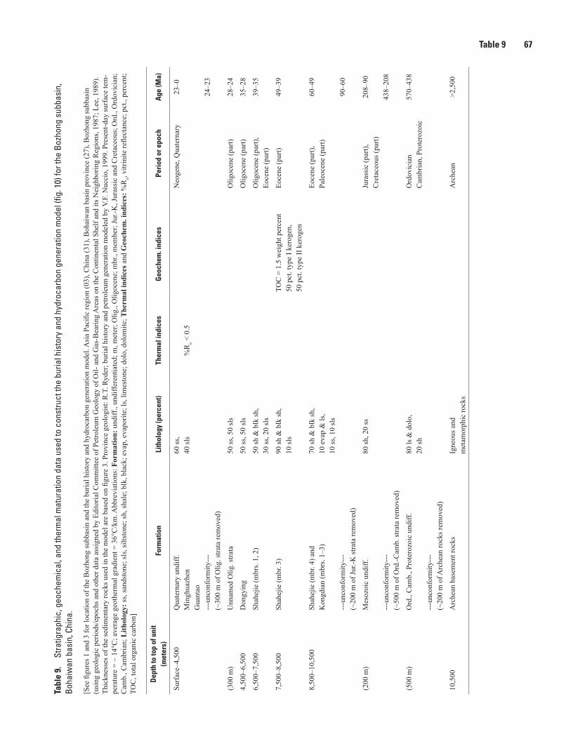
Table 9 67Ta
ble
9.
Stra
tigra
phic
, geo
chem
ical
, and
ther
mal
mat
urat
ion
data
use
d to
con
stru
ct th
e bu
rial h
isto
ry a
nd h
ydro
carb
on g
ener
atio
n m
odel
(fig
. 10)
for t
he B
ozho
ng s
ubba
sin,
Bo
haiw
an b
asin
, Chi
na.
[See
figu
res 1
and
3 fo
r loc
atio
n of
the
Boz
hong
subb
asin
and
the
buria
l his
tory
and
hyd
roca
rbon
gen
erat
ion
mod
el. A
sia
Paci
fic re
gion
(03)
, Chi
na (3
1), B
ohai
wan
bas
in p
rovi
nce
(27)
, Boz
hong
subb
asin
(u
sing
geo
logi
c pe
riods
/epo
chs a
nd o
ther
dat
a as
sign
ed b
y Ed
itoria
l Com
mitt
ee o
f Pet
role
um G
eolo
gy o
f Oil-
and
Gas
-Bea
ring
Are
as o
n th
e C
ontin
enta
l She
lf an
d its
Nei
ghbo
ring
Reg
ions
, 198
7; L
ee, 1
989)
. Th
ickn
esse
s of t
he se
dim
enta
ry ro
cks u
sed
in th
e m
odel
are
bas
ed o
n fig
ure
3. P
rovi
nce
geol
ogis
t: R
.T. R
yder
; bur
ial h
isto
ry a
nd p
etro
leum
gen
erat
ion
mod
eled
by
V.F.
Nuc
cio,
199
9. P
rese
nt-d
ay su
rfac
e te
m-
pera
ture
= ~
14°
C; a
vera
ge g
eoth
erm
al g
radi
ent =
36°
C/k
m. A
bbre
viat
ions
: For
mat
ion:
und
iff.,
undi
ffere
ntia
ted;
m, m
eter
; Olig
., O
ligoc
ene;
mbr
., m
embe
r; Ju
r.-K
, Jur
assi
c an
d C
reta
ceou
s; O
rd.,
Ord
ovic
ian;
C
amb.
, Cam
bria
n; L
ithol
ogy:
ss, s
ands
tone
; sls
, silt
ston
e; sh
, sha
le; b
lk, b
lack
; eva
p, e
vapo
rite;
ls, l
imes
tone
; dol
o, d
olom
ite; T
herm
al in
dice
s and
Geo
chem
. ind
ices
: %R
o, vi
trini
te re
flect
ance
; pct
., pe
rcen
t; TO
C, t
otal
org
anic
car
bon]
Dep
th to
top
of u
nit
(met
ers)
Form
atio
nLi
thol
ogy
(per
cent
)Th
erm
al in
dice
sG
eoch
em. i
ndic
esPe
riod
or e
poch
Age
(Ma)
Surf
ace–
4,50
0Q
uate
rnar
y un
diff.
Min
ghua
zhen
Gua
ntao
---u
ncon
form
ity--
-(~
300
m o
f Olig
. stra
ta re
mov
ed)
60 ss
,40
sls
%R
o < 0
.5N
eoge
ne, Q
uate
rnar
y23
–0
24–2
3
(300
m)
Unn
amed
Olig
. stra
ta50
ss, 5
0 sl
sO
ligoc
ene
(par
t)28
–24
4,50
0–6,
500
Don
gyin
g50
ss, 5
0 sl
sO
ligoc
ene
(par
t)35
–28
6,50
0–7,
500
Shah
ejie
(mbr
s. 1,
2)
50 sh
& b
lk sh
,30
ss, 2
0 sl
sO
ligoc
ene
(par
t),Eo
cene
(par
t)39
–35
7,50
0–8,
500
Shah
ejie
(mbr
. 3)
90 sh
& b
lk sh
,10
sls
TOC
= 1
.5 w
eigh
t per
cent
50 p
ct. t
ype
I ker
ogen
,50
pct
. typ
e II
ker
ogen
Eoce
ne (p
art)
49–3
9
8,50
0–10
,500
Shah
ejie
(mbr
. 4) a
ndK
ongd
ian
(mbr
s. 1–
3)
---u
ncon
form
ity--
-(~
200
m o
f Jur
.-K st
rata
rem
oved
)
70 sh
& b
lk sh
,10
eva
p &
ls,
10 ss
, 10
sls
Eoce
ne (p
art),
Pale
ocen
e (p
art)
60–4
9
90–6
0
(200
m)
Mes
ozoi
c un
diff.
---u
ncon
form
ity--
-(~
500
m o
f Ord
.-Cam
b. st
rata
rem
oved
)
80 sh
, 20
ssJu
rass
ic (p
art),
Cre
tace
ous (
part)
208–
90
438–
208
(500
m)
Ord
., C
amb.
, Pro
tero
zoic
und
iff.
---u
ncon
form
ity--
-(~
200
m o
f Arc
hean
rock
s rem
oved
)
80 ls
& d
olo,
20 sh
Ord
ovic
ian
Cam
bria
n, P
rote
rozo
ic57
0–43
8
10,5
00A
rche
an b
asem
ent r
ocks
Igne
ous a
ndm
etam
orph
ic ro
cks
Arc
hean
>2,5
00
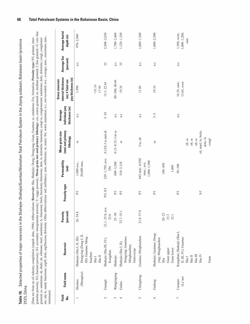
68 Total Petroleum Systems in the Bohaiwan Basin, ChinaTa
ble
10.
Sele
cted
pro
perti
es o
f maj
or re
serv
oirs
in th
e Sh
ahej
ie–S
hahe
jie/G
uant
ao/W
umis
han
Tota
l Pet
role
um S
yste
m in
the
Jiya
ng s
ubba
sin,
Boh
aiw
an b
asin
(pro
vinc
e 31
27),
Chin
a.—
Cont
inue
d
[Dat
a ar
e fr
om a
n oi
l ind
ustry
com
pila
tion
(unp
ub. d
ata,
199
6). A
bbre
viat
ions
: Res
ervo
ir: S
ha, S
hahe
jie; D
ong,
Don
gyin
g; G
uan,
Gua
ntao
; ss,
sand
ston
e; F
m, f
orm
atio
n; P
oros
ity ty
pe: P
/I, p
rimar
y in
ter-
gran
ular
por
osity
; S/f,
frac
ture
por
osity
; S/I,
seco
ndar
y in
terg
ranu
lar p
oros
ity; V
, vug
gy p
oros
ity; M
ean
grai
n si
ze a
nd p
rim
ary
litho
logy
: crs
, coa
rse
grai
ned;
m, m
ediu
m g
rain
ed; f
, fine
gra
ined
; vf,
very
fine
gr
aine
d; ss
, san
dsto
ne; s
h, sh
ale;
slt,
silts
tone
; mar
l, m
arls
tone
; ls,
limes
tone
; bio
ls, b
iocl
astic
lim
esto
ne; d
olo.
ls, d
olom
itic
limes
tone
; con
gl ss
, con
glom
erat
ic sa
ndst
one;
dol
o, d
olom
ite; c
ongl
, con
glom
er-
ate;
sdy
ls, s
andy
lim
esto
ne; a
rgill
. dol
o, a
rgill
aceo
us d
olom
ite. O
ther
abb
revi
atio
ns: m
d, m
illid
arcy
; mm
, mill
imet
er; m
, met
er; S
w, w
ater
satu
ratio
n; n
.r., n
ot re
cord
ed; a
ve.,
aver
age;
max
., m
axim
um; m
in.,
min
imum
]
Fiel
d N
o.Fi
eld
nam
eRe
serv
oir
Poro
sity
(p
erce
nt)
Poro
sity
type
Perm
eabi
lity
(md)
Mea
n gr
ain
size
(m
m) a
nd p
rim
ary
litho
logy
Aver
age
indi
vidu
al p
ay
thic
knes
s (m
)
Gro
ss re
serv
oir
inte
rval
thic
knes
s (m
); #
Tota
l net
pa
y th
ickn
ess
(m)
Aver
age
Sw
(per
cent
)Av
erag
e bu
rial
de
pth
(m)
1Sh
entu
o (S
heng
tuo)
Shah
ejie
(Sha
I, II
, III
); D
ongy
ing
(Don
g I,
II,
III)
; Gua
ntao
; Min
g-hu
azhe
n
Sha
I Sh
a II
26–3
4.8
P/I
1,00
0 av
e.,
20,6
00 m
ax.
ssn.
r.1,
990
<33.
1#17
.9#
n.r.
970–
2,96
0
2G
uang
liSh
ahej
ie (S
ha II
I, IV
); K
ongd
ian
23.1
–25.
8; a
ve.
25.0
P/I;
S/f
229–
1,79
5; a
ve.
356
0.12
4; f
ss a
nd sh
5–10
15.3
–22.
6#35
2,50
0–2,
650
3W
angj
iaga
ngSh
ahej
ie25
–30
P/I
600–
3,20
00.
15–0
.33;
f-m
ss
n.r.
80–1
00; 4
0.4#
n.r.
1,70
0–2,
460
4G
udao
Shah
ejie
(Sha
I, II
);
Don
gyin
g; G
uant
ao;
Min
ghua
zhen
; O
rdov
icia
n
32.7
–35.
1P/
I51
0–3,
118
ssn.
r.19
.3#
351,
120–
1,35
0
5C
heng
dong
Gua
ntao
; Min
ghua
zhen
21.8
–37.
4P/
I64
3 m
in.–
6,93
0 m
ax.;
ave.
1,
000–
1,50
0
f ss,
slt
n.r.
11.0
#n.
r.1,
060–
1,36
0
6G
udon
gSh
ahej
ie; G
uant
ao; D
ong-
ying
; Min
ghua
zhen
Sh
a
Gua
n up
per
Gua
n lo
wer
20–2
233
.332
.1
P/I
180–
450
1,00
9
ss3–
519
.3#
n.r.
1,00
0–2,
500
7C
aoqi
ao
(Le’
an)
Kon
gdia
n; S
hahe
jie (S
ha I,
II
, III
, IV
); G
uant
ao
Sha
I Sh
a II
Sh
a II
I Sh
a IV
G
uan
P/I
S/f
50–1
00
slt,
sssl
t, ss
slt,
sssl
t, m
arl,
ls, b
iols
, do
lo. l
sco
ngl
n.r.
16.3
#, e
ast;
13.6
#, w
est
n.r.
1,30
0, w
est;
1,00
0–1,
200,
ea
st

Table 10 69Ta
ble
10.
Sele
cted
pro
perti
es o
f maj
or re
serv
oirs
in th
e Sh
ahej
ie–S
hahe
jie/G
uant
ao/W
umis
han
Tota
l Pet
role
um S
yste
m in
the
Jiya
ng s
ubba
sin,
Boh
aiw
an b
asin
(pro
vinc
e 31
27),
Chin
a.—
Cont
inue
d
[Dat
a ar
e fr
om a
n oi
l ind
ustry
com
pila
tion
(unp
ub. d
ata,
199
6). A
bbre
viat
ions
: Res
ervo
ir: S
ha, S
hahe
jie; D
ong,
Don
gyin
g; G
uan,
Gua
ntao
; ss,
sand
ston
e; F
m, f
orm
atio
n; P
oros
ity ty
pe: P
/I, p
rimar
y in
ter-
gran
ular
por
osity
; S/f,
frac
ture
por
osity
; S/I,
seco
ndar
y in
terg
ranu
lar p
oros
ity; V
, vug
gy p
oros
ity; M
ean
grai
n si
ze a
nd p
rim
ary
litho
logy
: crs
, coa
rse
grai
ned;
m, m
ediu
m g
rain
ed; f
, fine
gra
ined
; vf,
very
fine
gr
aine
d; ss
, san
dsto
ne; s
h, sh
ale;
slt,
silts
tone
; mar
l, m
arls
tone
; ls,
limes
tone
; bio
ls, b
iocl
astic
lim
esto
ne; d
olo.
ls, d
olom
itic
limes
tone
; con
gl ss
, con
glom
erat
ic sa
ndst
one;
dol
o, d
olom
ite; c
ongl
, con
glom
er-
ate;
sdy
ls, s
andy
lim
esto
ne; a
rgill
. dol
o, a
rgill
aceo
us d
olom
ite. O
ther
abb
revi
atio
ns: m
d, m
illid
arcy
; mm
, mill
imet
er; m
, met
er; S
w, w
ater
satu
ratio
n; n
.r., n
ot re
cord
ed; a
ve.,
aver
age;
max
., m
axim
um; m
in.,
min
imum
]
Fiel
d N
o.Fi
eld
nam
eRe
serv
oir
Poro
sity
(p
erce
nt)
Poro
sity
type
Perm
eabi
lity
(md)
Mea
n gr
ain
size
(m
m) a
nd p
rim
ary
litho
logy
Aver
age
indi
vidu
al p
ay
thic
knes
s (m
)
Gro
ss re
serv
oir
inte
rval
thic
knes
s (m
); #
Tota
l net
pa
y th
ickn
ess
(m)
Aver
age
Sw
(per
cent
)Av
erag
e bu
rial
de
pth
(m)
8B
amia
nhe
Shah
ejie
(S
ha II
I upp
er;
Sha
III l
ower
; Sh
a IV
);
Pale
ozoi
c
35.3
34.5
31.0
P/I
1,46
81,
326
575
ssn.
r.8.
53#
n.r.
1,10
0–1,
300
9Li
nfan
jiaD
ongy
ing;
Gua
ntao
31P/
I39
20.
31; m
ar
kosi
c ss
, slt
n.r.
5.1#
n.r.
1,00
0–1,
100
10B
onan
Shah
ejie
(Sha
I, II
, III
); D
ongy
ing
18.4
–24.
1;
21.0
ave
.P/
I, S/
f10
0–20
0ss
, con
gl ss
n.r.
15.1
#35
.62,
800–
3,40
0
11Sh
angd
ian
Shah
ejie
(Sha
II, I
II,
Sha
IV u
pper
, Sha
IV
mid
dle)
; Don
gyin
g;
Gua
ntao
23–3
1P/
I44
–1,0
00ss
n.r.
7.3#
, eas
t; 4–
6,
cent
ral;
5.6–
6.8,
w
est
351,
430–
1,55
0,
wes
t; 1,
390–
1,47
0, c
entra
l; 1,
100–
1,20
0,
east
12Sh
unhu
azhe
n (C
hun-
huaz
hen)
Shah
ejie
(Sha
II, I
II, I
V)
20P/
I, S/
I, V
100,
ss; <
30, l
sss
, ls
n.r.
6.3#
n.r.
1,77
0–2,
400
13Q
iaoz
huan
gSh
ahej
ie15
.3P/
I15
1ss
2–3
5.2–
11#
n.r.
3,05
0–3,
190
14G
unan
Shah
ejie
; Don
gyin
g;
Gua
ntao
; M
esoz
oic
(Jur
assi
c)
22–2
5P/
I5–
2,16
4; a
ve.
>500
ss
tuffa
ceou
s ss
n.r.
640;
25#
n.r.
2,10
0–2,
740
15Sh
angh
eSh
ahej
ie (S
ha I,
II u
pper
, II
low
er, I
II u
pper
, III
lo
wer
, IV
); D
ongy
ing
16.2
–22.
4P/
I11
–151
; ave
. 30
–50
ssn.
r.12
.6#
58.3
1,55
0–2,
550
16D
ongx
inSh
ahej
ie (S
ha I,
II, I
II);
Don
gyin
g; G
uant
ao
Sha
I Sh
a II
Sh
a II
I D
ong
G
uan
25–3
1P/
I2,
350–
4,50
0;
usua
lly 1
,000
0.08
–0.1
5; v
f-f s
sn.
r.37
.0#–
173#
200
400
500
300
300
351,
350–
3,24
0

70 Total Petroleum Systems in the Bohaiwan Basin, ChinaTa
ble
10.
Sele
cted
pro
perti
es o
f maj
or re
serv
oirs
in th
e Sh
ahej
ie–S
hahe
jie/G
uant
ao/W
umis
han
Tota
l Pet
role
um S
yste
m in
the
Jiya
ng s
ubba
sin,
Boh
aiw
an b
asin
(pro
vinc
e 31
27),
Chin
a.—
Cont
inue
d
[Dat
a ar
e fr
om a
n oi
l ind
ustry
com
pila
tion
(unp
ub. d
ata,
199
6). A
bbre
viat
ions
: Res
ervo
ir: S
ha, S
hahe
jie; D
ong,
Don
gyin
g; G
uan,
Gua
ntao
; ss,
sand
ston
e; F
m, f
orm
atio
n; P
oros
ity ty
pe: P
/I, p
rimar
y in
ter-
gran
ular
por
osity
; S/f,
frac
ture
por
osity
; S/I,
seco
ndar
y in
terg
ranu
lar p
oros
ity; V
, vug
gy p
oros
ity; M
ean
grai
n si
ze a
nd p
rim
ary
litho
logy
: crs
, coa
rse
grai
ned;
m, m
ediu
m g
rain
ed; f
, fine
gra
ined
; vf,
very
fine
gr
aine
d; ss
, san
dsto
ne; s
h, sh
ale;
slt,
silts
tone
; mar
l, m
arls
tone
; ls,
limes
tone
; bio
ls, b
iocl
astic
lim
esto
ne; d
olo.
ls, d
olom
itic
limes
tone
; con
gl ss
, con
glom
erat
ic sa
ndst
one;
dol
o, d
olom
ite; c
ongl
, con
glom
er-
ate;
sdy
ls, s
andy
lim
esto
ne; a
rgill
. dol
o, a
rgill
aceo
us d
olom
ite. O
ther
abb
revi
atio
ns: m
d, m
illid
arcy
; mm
, mill
imet
er; m
, met
er; S
w, w
ater
satu
ratio
n; n
.r., n
ot re
cord
ed; a
ve.,
aver
age;
max
., m
axim
um; m
in.,
min
imum
]
Fiel
d N
o.Fi
eld
nam
eRe
serv
oir
Poro
sity
(p
erce
nt)
Poro
sity
type
Perm
eabi
lity
(md)
Mea
n gr
ain
size
(m
m) a
nd p
rim
ary
litho
logy
Aver
age
indi
vidu
al p
ay
thic
knes
s (m
)
Gro
ss re
serv
oir
inte
rval
thic
knes
s (m
); #
Tota
l net
pa
y th
ickn
ess
(m)
Aver
age
Sw
(per
cent
)Av
erag
e bu
rial
de
pth
(m)
17Yo
ngan
zhen
Shah
ejie
(Sha
II, I
II, I
V)
Sha
II
Sha
III
Sha
IV
23–3
2.6
P/I
981–
9,87
07–
167–
16
ssn.
r.14
.6#
401,
390–
2,31
0
18H
aojia
Shah
ejie
25P/
I70
7–2,
740
ssn.
r.4.
9#30
–40
1,87
5–2,
660
19Li
njin
(Liju
n)Sh
ahej
ie24
.7–2
9.6
P/I
260–
1,77
00.
09–0
.21;
vf-
f ss
1–10
50–8
0; 1
2.6#
351,
560–
3,40
0
20K
enli
Shah
ejie
(Sha
I, II
); M
esoz
oic
(Jur
assi
c ss
); O
rdov
icia
n (M
ajia
gou
Fm)
Sha
I Sh
a II
Ju
rass
ic ss
M
ajia
gou
40 m
ax.;
28.6
av
e.
0.23
P/I
P/I
P/I
S/f,
S/I,
V
2,48
6
1,00
0
ss ss ss ss dolo
7–10
19.7
#16
#12
.1#
135#
n.r.
1,81
0–1,
944
21H
etan
g (H
etan
)Sh
ahaj
ie (S
ha II
, Sha
II
low
er, S
ha II
I; M
eso-
zoic
Sh
a II
Sh
a II
low
er
Sha
III
34.3
max
.; 29
av
e.
31.1
max
.; 28
.5
ave.
P/I
10,6
00 m
ax.;
3,28
0 av
e.
5,42
4 m
ax.;
1,35
3 av
e.
ss4–
19.4
250
13.6
#
20.1
#
n.r.
2,05
0–2,
300
22Li
angj
iala
o (L
iang
ji-al
ou)
Shah
ejie
(S
ha II
I)18
.8–2
2.8
P/I
514–
4,11
8co
ngl,
ss, s
ltn.
r.50
; 11.
8#70
; 12#
31–5
02,
000–
2,86
0
23, 2
4H
ongl
iu-K
en-
dong
Shah
ejie
(Sha
II, I
II);
Gua
ntao
Sh
a
Sha
II
Sha
III
Gua
n
20.9 20 33.4
P/I
74.2
363
4,80
0
0.18
; f ss
biol
ssl
t; m
con
gl ss
slt ss
n.r.
26.7
#n.
r.
2,20
0–2,
300
1,25
0–1,
450

Table 10 71Ta
ble
10.
Sele
cted
pro
perti
es o
f maj
or re
serv
oirs
in th
e Sh
ahej
ie–S
hahe
jie/G
uant
ao/W
umis
han
Tota
l Pet
role
um S
yste
m in
the
Jiya
ng s
ubba
sin,
Boh
aiw
an b
asin
(pro
vinc
e 31
27),
Chin
a.—
Cont
inue
d
[Dat
a ar
e fr
om a
n oi
l ind
ustry
com
pila
tion
(unp
ub. d
ata,
199
6). A
bbre
viat
ions
: Res
ervo
ir: S
ha, S
hahe
jie; D
ong,
Don
gyin
g; G
uan,
Gua
ntao
; ss,
sand
ston
e; F
m, f
orm
atio
n; P
oros
ity ty
pe: P
/I, p
rimar
y in
ter-
gran
ular
por
osity
; S/f,
frac
ture
por
osity
; S/I,
seco
ndar
y in
terg
ranu
lar p
oros
ity; V
, vug
gy p
oros
ity; M
ean
grai
n si
ze a
nd p
rim
ary
litho
logy
: crs
, coa
rse
grai
ned;
m, m
ediu
m g
rain
ed; f
, fine
gra
ined
; vf,
very
fine
gr
aine
d; ss
, san
dsto
ne; s
h, sh
ale;
slt,
silts
tone
; mar
l, m
arls
tone
; ls,
limes
tone
; bio
ls, b
iocl
astic
lim
esto
ne; d
olo.
ls, d
olom
itic
limes
tone
; con
gl ss
, con
glom
erat
ic sa
ndst
one;
dol
o, d
olom
ite; c
ongl
, con
glom
er-
ate;
sdy
ls, s
andy
lim
esto
ne; a
rgill
. dol
o, a
rgill
aceo
us d
olom
ite. O
ther
abb
revi
atio
ns: m
d, m
illid
arcy
; mm
, mill
imet
er; m
, met
er; S
w, w
ater
satu
ratio
n; n
.r., n
ot re
cord
ed; a
ve.,
aver
age;
max
., m
axim
um; m
in.,
min
imum
]
Fiel
d N
o.Fi
eld
nam
eRe
serv
oir
Poro
sity
(p
erce
nt)
Poro
sity
type
Perm
eabi
lity
(md)
Mea
n gr
ain
size
(m
m) a
nd p
rim
ary
litho
logy
Aver
age
indi
vidu
al p
ay
thic
knes
s (m
)
Gro
ss re
serv
oir
inte
rval
thic
knes
s (m
); #
Tota
l net
pa
y th
ickn
ess
(m)
Aver
age
Sw
(per
cent
)Av
erag
e bu
rial
de
pth
(m)
25La
ohek
ouG
uant
ao33
.9P/
I55
70.
1; v
f bio
ls2.
7–10
, eas
t; 2.
3–9.
1 w
est
6.4#
n.r.
1,34
0–1,
700
26Li
npan
Shah
ejie
; Don
gyin
g;
Gua
ntao
Sh
a
Gua
n
12–3
3.4
P/I
300–
400
1,00
0
ssn.
r.1,
400;
12.
4#n.
r.1,
360–
3,36
0
27D
anjia
shi
Shah
ejie
; Don
gyin
g;
Gua
ntao
D
ong
G
uan
24–3
4P/
I>5
,000
cong
l, cr
s ss
n.r.
22#
62#
n.r.
1,00
0–1,
200
28Ta
oerh
e (G
ui-
erhe
)Sh
ahej
ie;
Ord
ovic
ian;
C
arbo
nife
rous
10–2
7P/
I16
8ss do
lon.
r.3.
6#–7
.8#
31.7
#
n.r.
1,60
0–1,
670
29Y
ibei
Shah
ejie
(Sha
II, I
V);
Mes
ozoi
c (J
uras
sic)
Sh
a II
Sh
a IV
Ju
rass
ic
13.9
–18.
7
S/f
9.6
dolo
and
ark
osic
ss
ls a
nd sd
y ls
arko
sic
ss a
nd
volc
anic
last
ics
n.r.
18.0
#n.
r.1,
840–
2,80
0
30Y
ihez
huan
gSh
ahej
ie (S
ha I,
II, I
II,
IV);
Gua
ntao
; Jur
assi
c;
Ord
ovic
ian
(Bad
ou a
nd
Maj
iago
u Fm
s); C
ar-
boni
fero
us; P
erm
ian
B
adou
M
ajia
gou
n.r.
S/f,
V
S/f,
V
core
: 4.5
–14.
2m
atrix
: 8.4
core
: 2.5
mat
rix: 8
0–87
0
ls, d
olo
ls, d
olo
n.r.
30–5
0; 2
4.9#
30–5
0; 2
4.9#
n.r.
1,83
0–2,
280
1,83
0–2,
280
31Y
idon
gSh
ahej
ie; D
ongy
ing;
G
uant
ao19
.5P/
I21
0–1,
630
crs s
sn.
r.3#
–54.
8#8.
7#n.
r.1,
250–
2,83
0

72 Total Petroleum Systems in the Bohaiwan Basin, ChinaTa
ble
10.
Sele
cted
pro
perti
es o
f maj
or re
serv
oirs
in th
e Sh
ahej
ie–S
hahe
jie/G
uant
ao/W
umis
han
Tota
l Pet
role
um S
yste
m in
the
Jiya
ng s
ubba
sin,
Boh
aiw
an b
asin
(pro
vinc
e 31
27),
Chin
a.—
Cont
inue
d
[Dat
a ar
e fr
om a
n oi
l ind
ustry
com
pila
tion
(unp
ub. d
ata,
199
6). A
bbre
viat
ions
: Res
ervo
ir: S
ha, S
hahe
jie; D
ong,
Don
gyin
g; G
uan,
Gua
ntao
; ss,
sand
ston
e; F
m, f
orm
atio
n; P
oros
ity ty
pe: P
/I, p
rimar
y in
ter-
gran
ular
por
osity
; S/f,
frac
ture
por
osity
; S/I,
seco
ndar
y in
terg
ranu
lar p
oros
ity; V
, vug
gy p
oros
ity; M
ean
grai
n si
ze a
nd p
rim
ary
litho
logy
: crs
, coa
rse
grai
ned;
m, m
ediu
m g
rain
ed; f
, fine
gra
ined
; vf,
very
fine
gr
aine
d; ss
, san
dsto
ne; s
h, sh
ale;
slt,
silts
tone
; mar
l, m
arls
tone
; ls,
limes
tone
; bio
ls, b
iocl
astic
lim
esto
ne; d
olo.
ls, d
olom
itic
limes
tone
; con
gl ss
, con
glom
erat
ic sa
ndst
one;
dol
o, d
olom
ite; c
ongl
, con
glom
er-
ate;
sdy
ls, s
andy
lim
esto
ne; a
rgill
. dol
o, a
rgill
aceo
us d
olom
ite. O
ther
abb
revi
atio
ns: m
d, m
illid
arcy
; mm
, mill
imet
er; m
, met
er; S
w, w
ater
satu
ratio
n; n
.r., n
ot re
cord
ed; a
ve.,
aver
age;
max
., m
axim
um; m
in.,
min
imum
]
Fiel
d N
o.Fi
eld
nam
eRe
serv
oir
Poro
sity
(p
erce
nt)
Poro
sity
type
Perm
eabi
lity
(md)
Mea
n gr
ain
size
(m
m) a
nd p
rim
ary
litho
logy
Aver
age
indi
vidu
al p
ay
thic
knes
s (m
)
Gro
ss re
serv
oir
inte
rval
thic
knes
s (m
); #
Tota
l net
pa
y th
ickn
ess
(m)
Aver
age
Sw
(per
cent
)Av
erag
e bu
rial
de
pth
(m)
32K
enxi
Shah
ejie
(Sha
I); D
ong-
ying
; Gua
ntao
Sh
a I
Don
g
Gua
n28
.831
.2
P/I
706
1,36
02,
720
ss
cong
l ss
ss ss
n.r.
10.8
#n.
r.1,
350–
1,85
0
33W
uhao
zhua
ngSh
ahej
ie (S
ha II
I upp
er,
Sha
III l
ower
)18
.3 u
pper
; 12
.5–1
6.2
low
erP/
I26
1 up
per;
2.3–
6.7
low
erco
ngl s
s, f s
s, sl
tn.
r.16
.4#–
21.4
#n.
r.3,
200–
3,80
0
34W
angz
huan
gA
rche
an a
nd P
rote
rozo
ic
rock
s5.
6S/
f, V
493
gran
iten.
r.20
0; 9
0#n.
r.1,
470–
1,67
0
35N
ingh
aiSh
ahej
ie; D
ongy
ing
19.0
–28.
2P/
I30
0–1,
800
ssn.
r.14
.7#–
15.7
#n.
r.1,
600–
2,30
0
36Pi
ngfa
ngw
ang
Shah
ejie
(Sha
II, I
V);
Cam
bria
n
Sha
21–2
7S/
f, V
690
biol
s, oo
litic
ls,
argi
ll. d
olo
n.r.
17.9
#n.
r.1,
510–
1,58
0
37B
inna
nSh
ahej
ie (S
ha I,
II, I
II,
IV);
Don
gyin
g
Sha
I Sh
a II
Sh
a II
I Sh
a IV
D
ong
25n.
r.45
–897
ss ls ss ss slt ss
n.r.
12.4
#n.
r.1,
700–
3,02
0
38Sh
inan
Shah
ejie
21.5
P/I
n.r.
ss11
–32
21.5
#n.
r.2,
700–
2,90
0
39X
ianh
ezhu
ang
Shah
ejie
(Sha
I, II
, III
)25
–30
P/I
702–
2,20
0f-
m ss
n.r.
53.2
#n.
r.1,
780–
2,96
0
40Zh
uang
xiSh
ahej
ie; O
rodo
vici
an,
Cam
bria
n13
–16
P/I;
S/f,
V86
.9bi
ols,
ss, m
udst
one
n.r.
12#
43–4
83,
000–
3,10
0
41D
awan
g-zh
uang
Shah
ejie
(Sha
II)
15–2
6n.
r.2,
160–
3,12
0ss
n.r.
15#
n.r.
2,16
0–3,
120
42X
inlic
unSh
ahej
ie (S
ha II
, III
); D
ongy
ing
n.r.
n.r.
n.r.
ssn.
r.8.
5#n.
r.n.
r.
43C
hang
ti (C
hang
di)
Shah
ejie
(Sha
I, II
, III
); M
esoz
oic
17–3
2P/
I11
.6–1
,001
ssn.
r.10
#35
–42
n.r.

Table 10 73Ta
ble
10.
Sele
cted
pro
perti
es o
f maj
or re
serv
oirs
in th
e Sh
ahej
ie–S
hahe
jie/G
uant
ao/W
umis
han
Tota
l Pet
role
um S
yste
m in
the
Jiya
ng s
ubba
sin,
Boh
aiw
an b
asin
(pro
vinc
e 31
27),
Chin
a.—
Cont
inue
d
[Dat
a ar
e fr
om a
n oi
l ind
ustry
com
pila
tion
(unp
ub. d
ata,
199
6). A
bbre
viat
ions
: Res
ervo
ir: S
ha, S
hahe
jie; D
ong,
Don
gyin
g; G
uan,
Gua
ntao
; ss,
sand
ston
e; F
m, f
orm
atio
n; P
oros
ity ty
pe: P
/I, p
rimar
y in
ter-
gran
ular
por
osity
; S/f,
frac
ture
por
osity
; S/I,
seco
ndar
y in
terg
ranu
lar p
oros
ity; V
, vug
gy p
oros
ity; M
ean
grai
n si
ze a
nd p
rim
ary
litho
logy
: crs
, coa
rse
grai
ned;
m, m
ediu
m g
rain
ed; f
, fine
gra
ined
; vf,
very
fine
gr
aine
d; ss
, san
dsto
ne; s
h, sh
ale;
slt,
silts
tone
; mar
l, m
arls
tone
; ls,
limes
tone
; bio
ls, b
iocl
astic
lim
esto
ne; d
olo.
ls, d
olom
itic
limes
tone
; con
gl ss
, con
glom
erat
ic sa
ndst
one;
dol
o, d
olom
ite; c
ongl
, con
glom
er-
ate;
sdy
ls, s
andy
lim
esto
ne; a
rgill
. dol
o, a
rgill
aceo
us d
olom
ite. O
ther
abb
revi
atio
ns: m
d, m
illid
arcy
; mm
, mill
imet
er; m
, met
er; S
w, w
ater
satu
ratio
n; n
.r., n
ot re
cord
ed; a
ve.,
aver
age;
max
., m
axim
um; m
in.,
min
imum
]
Fiel
d N
o.Fi
eld
nam
eRe
serv
oir
Poro
sity
(p
erce
nt)
Poro
sity
type
Perm
eabi
lity
(md)
Mea
n gr
ain
size
(m
m) a
nd p
rim
ary
litho
logy
Aver
age
indi
vidu
al p
ay
thic
knes
s (m
)
Gro
ss re
serv
oir
inte
rval
thic
knes
s (m
); #
Tota
l net
pa
y th
ickn
ess
(m)
Aver
age
Sw
(per
cent
)Av
erag
e bu
rial
de
pth
(m)
44Sh
aojia
Don
gyin
g; G
uant
ao G
uan
n.r.
n.r.
n.r.
ssn.
r.15
#n.
r.1,
930–
2,02
0
45X
iaoy
ing
Shah
ejie
13–1
7P/
I2.
8ss
, ls
n.r.
6.7#
4.3
1,90
0–3,
040
46G
aoqi
ngD
ongy
ing;
Kon
gdia
n;
Shah
ejie
(Sha
III)
; M
esoz
oic
(Jur
assi
c)
29P/
I32
ssn.
r.20
#33
n.r.
47Zh
engl
izhu
ang
Shah
ejie
(Sha
I, II
, III
)27
P/I
120–
488
ssn.
r.12
.0#
451,
400–
1,65
0
48Lu
ojia
Shah
ejie
20–2
3S/
f, V
n.r.
ss, l
s, vo
lcan
ics
n.r.
n.r.
35–4
02,
000–
2,04
0
49D
awan
gbei
Shah
ejie
(Sha
II)
16P/
I32
.8ss
n.r.
743
2,85
0–3,
500
50N
iuzh
uang
Shah
ejie
(Sha
III)
17–2
0P/
I1.
5–29
ssn.
r.10
#n.
r.n.
r.
51C
henj
iazh
uang
Gua
ntao
28P/
I80
0–2,
000
ssn.
r.6.
5#45
1,26
0–1,
320
52Zh
engj
iaSh
ahej
ie (S
ha II
I)n.
r.n.
r.n.
r.n.
r.n.
r.n.
r.n.
r.n.
r.
53Ya
ngjia
ogou
Shah
ejie
; Gua
ntao
n.r.
n.r.
n.r.
n.r.
n.r.
n.r.
n.r.
n.r.
54Ji
njia
Shah
ejie
(Sha
I)32
–34
P/I
1,05
6–1,
653
ssn.
r.14
#n.
r.80
0–90
0
55B
oxin
gSh
ahej
ie (S
ha IV
)14
–17
P/I
3.7–
23.3
ssn.
r.43
#n.
r.2,
600–
2,82
0
56Pi
ngna
nSh
ahej
ie (S
ha IV
);
Ord
ovic
ian
2P/
I2.
36do
lon.
r.n.
r.n.
r.2,
260–
2,60
0
57C
hend
ao
(Che
ngda
o)G
uant
ao; D
ongy
ing;
Sh
ahej
ie20
–34
P/I
516–
2,04
5ss
n.r.
n.r.
n.r.
1,25
0–2,
730
58X
inta
ng (X
in-
tan)
Gua
ntao
; Sha
hejie
35P/
I2,
914
ssn.
r.n.
r.36
1,05
0–1,
150
59Ta
ipin
gD
ongy
ing;
Gua
ntao
23–2
8P/
I1,
464–
2,08
8ss
n.r.
n.r.
40–4
41,
100–
1,40
0
60Yu
huan
gmia
oSh
ahej
ie; D
ongy
ing
22S/
f24
0vo
lcan
ics
n.r.
n.r.
452,
060–
2,55
0
63D
aluh
uSh
ahej
ie16
P/I
3–15
ssn.
r.27
.2#
n.r.
2,80
0–3,
300
64Fe
iyan
tan
Gua
ntao
35P/
I6,
367
ssn.
r.7.
5#32
1,20
0–1,
340
65Y
ingx
iong
tan
Shah
ejie
23P/
I10
1.2
ssn.
r.n.
r.44
2,00
0–2,
100
66D
ongf
engg
ang
n.r.
n.r.
n.r.
n.r.
n.r.
n.r.
n.r.
n.r.
n.r.
67Ya
njia
Shah
ejie
27.7
P/I
95ss
n.r.
n.r.
n.r.
n.r.

74 Total Petroleum Systems in the Bohaiwan Basin, ChinaTa
ble
10.
Sele
cted
pro
perti
es o
f maj
or re
serv
oirs
in th
e Sh
ahej
ie–S
hahe
jie/G
uant
ao/W
umis
han
Tota
l Pet
role
um S
yste
m in
the
Jiya
ng s
ubba
sin,
Boh
aiw
an b
asin
(pro
vinc
e 31
27),
Chin
a.—
Cont
inue
d
[Dat
a ar
e fr
om a
n oi
l ind
ustry
com
pila
tion
(unp
ub. d
ata,
199
6). A
bbre
viat
ions
: Res
ervo
ir: S
ha, S
hahe
jie; D
ong,
Don
gyin
g; G
uan,
Gua
ntao
; ss,
sand
ston
e; F
m, f
orm
atio
n; P
oros
ity ty
pe: P
/I, p
rimar
y in
ter-
gran
ular
por
osity
; S/f,
frac
ture
por
osity
; S/I,
seco
ndar
y in
terg
ranu
lar p
oros
ity; V
, vug
gy p
oros
ity; M
ean
grai
n si
ze a
nd p
rim
ary
litho
logy
: crs
, coa
rse
grai
ned;
m, m
ediu
m g
rain
ed; f
, fine
gra
ined
; vf,
very
fine
gr
aine
d; ss
, san
dsto
ne; s
h, sh
ale;
slt,
silts
tone
; mar
l, m
arls
tone
; ls,
limes
tone
; bio
ls, b
iocl
astic
lim
esto
ne; d
olo.
ls, d
olom
itic
limes
tone
; con
gl ss
, con
glom
erat
ic sa
ndst
one;
dol
o, d
olom
ite; c
ongl
, con
glom
er-
ate;
sdy
ls, s
andy
lim
esto
ne; a
rgill
. dol
o, a
rgill
aceo
us d
olom
ite. O
ther
abb
revi
atio
ns: m
d, m
illid
arcy
; mm
, mill
imet
er; m
, met
er; S
w, w
ater
satu
ratio
n; n
.r., n
ot re
cord
ed; a
ve.,
aver
age;
max
., m
axim
um; m
in.,
min
imum
]
Fiel
d N
o.Fi
eld
nam
eRe
serv
oir
Poro
sity
(p
erce
nt)
Poro
sity
type
Perm
eabi
lity
(md)
Mea
n gr
ain
size
(m
m) a
nd p
rim
ary
litho
logy
Aver
age
indi
vidu
al p
ay
thic
knes
s (m
)
Gro
ss re
serv
oir
inte
rval
thic
knes
s (m
); #
Tota
l net
pa
y th
ickn
ess
(m)
Aver
age
Sw
(per
cent
)Av
erag
e bu
rial
de
pth
(m)
68H
uago
uSh
ahej
ie; D
ongy
ing;
G
uant
aon.
r.P/
In.
r.ss
n.r.
7.0#
n.r.
750–
1,31
0
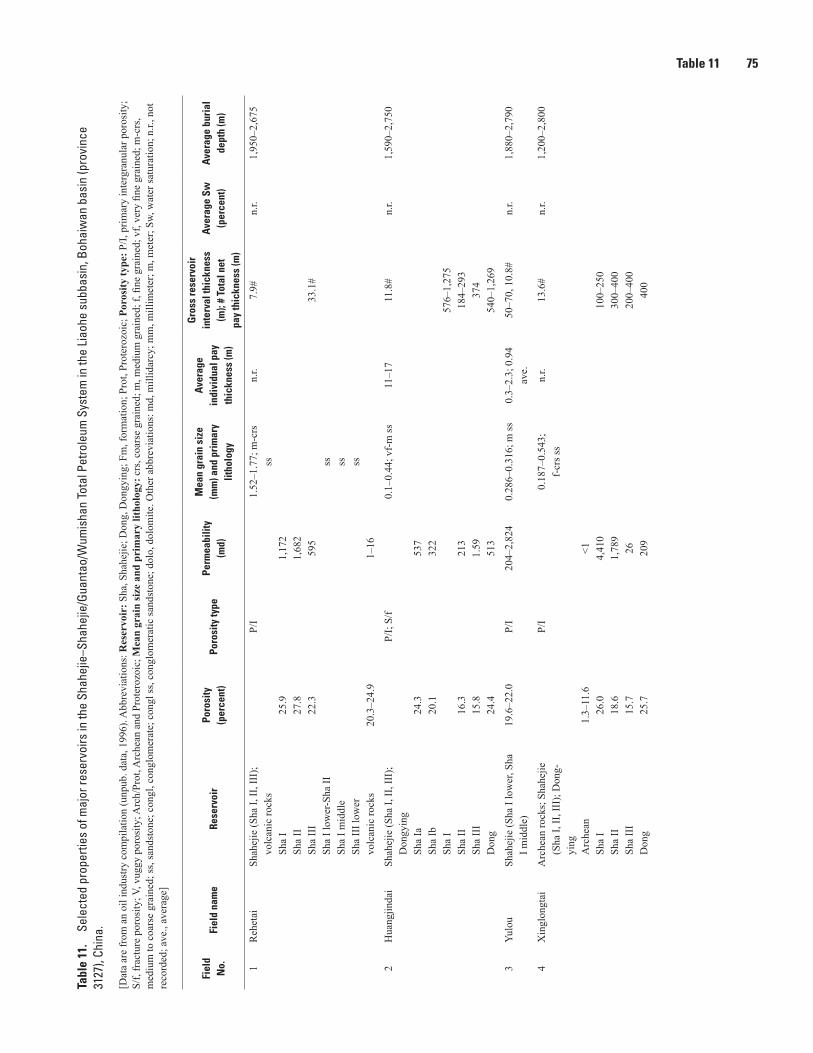
Table 11 75Ta
ble
11.
Sele
cted
pro
perti
es o
f maj
or re
serv
oirs
in th
e Sh
ahej
ie–S
hahe
jie/G
uant
ao/W
umis
han
Tota
l Pet
role
um S
yste
m in
the
Liao
he s
ubba
sin,
Boh
aiw
an b
asin
(pro
vinc
e 31
27),
Chin
a.—
Cont
inue
d
[Dat
a ar
e fr
om a
n oi
l ind
ustry
com
pila
tion
(unp
ub. d
ata,
199
6). A
bbre
viat
ions
: Res
ervo
ir: S
ha, S
hahe
jie; D
ong,
Don
gyin
g; F
m, f
orm
atio
n; P
rot,
Prot
eroz
oic;
Por
osity
type
: P/I,
prim
ary
inte
rgra
nula
r por
osity
; S/
f, fr
actu
re p
oros
ity; V
, vug
gy p
oros
ity; A
rch/
Prot
, Arc
hean
and
Pro
tero
zoic
; Mea
n gr
ain
size
and
pri
mar
y lit
holo
gy: c
rs, c
oars
e gr
aine
d; m
, med
ium
gra
ined
; f, fi
ne g
rain
ed; v
f, ve
ry fi
ne g
rain
ed; m
-crs
, m
ediu
m to
coa
rse
grai
ned;
ss, s
ands
tone
; con
gl, c
ongl
omer
ate;
con
gl ss
, con
glom
erat
ic sa
ndst
one;
dol
o, d
olom
ite. O
ther
abb
revi
atio
ns: m
d, m
illid
arcy
; mm
, mill
imet
er; m
, met
er; S
w, w
ater
satu
ratio
n; n
.r., n
ot
reco
rded
; ave
., av
erag
e]
Fiel
d N
o.Fi
eld
nam
eRe
serv
oir
Poro
sity
(p
erce
nt)
Poro
sity
type
Perm
eabi
lity
(md)
Mea
n gr
ain
size
(m
m) a
nd p
rim
ary
litho
logy
Aver
age
indi
vidu
al p
ay
thic
knes
s (m
)
Gro
ss re
serv
oir
inte
rval
thic
knes
s (m
); #
Tota
l net
pa
y th
ickn
ess
(m)
Aver
age
Sw
(per
cent
)Av
erag
e bu
rial
de
pth
(m)
1R
ehet
aiSh
ahej
ie (S
ha I,
II, I
II);
volc
anic
rock
s Sh
a I
Sha
II
Sha
III
Sha
I low
er-S
ha II
Sh
a I m
iddl
e
Sha
III l
ower
vo
lcan
ic ro
cks
25.9
27.8
22.3
20.3
–24.
9
P/I
1,17
21,
682
595
1–16
1.52
–1.7
7; m
-crs
ss ss ss ss
n.r.
7.9#
33.1
#
n.r.
1,95
0–2,
675
2H
uang
jinda
iSh
ahej
ie (S
ha I,
II, I
II);
Don
gyin
g
Sha
Ia
Sha
Ib
Sha
I Sh
a II
Sh
a II
I D
ong
24.3
20.1
16.3
15.8
24.4
P/I;
S/f
537
322
213
1.59 513
0.1–
0.44
; vf-
m ss
11–1
711
.8#
576–
1,27
518
4–29
337
454
0–1,
269
n.r.
1,59
0–2,
750
3Yu
lou
Shah
ejie
(Sha
I lo
wer
, Sha
I m
iddl
e)19
.6–2
2.0
P/I
204–
2,82
40.
286–
0.31
6; m
ss
0.3–
2.3;
0.9
4 av
e.50
–70,
10.
8#n.
r.1,
880–
2,79
0
4X
ingl
ongt
aiA
rche
an ro
cks;
Sha
hejie
(S
ha I,
II, I
II);
Don
g-yi
ng
Arc
hean
Sh
a I
Sha
II
Sha
III
Don
g
1.3–
11.6
26.0
18.6
15.7
25.7
P/I
<1 4,41
01,
789
26 209
0.18
7–0.
543;
f-
crs s
s n.
r.13
.6#
100–
250
300–
400
200–
400
400
n.r.
1,20
0–2,
800

76 Total Petroleum Systems in the Bohaiwan Basin, ChinaTa
ble
11.
Sele
cted
pro
perti
es o
f maj
or re
serv
oirs
in th
e Sh
ahej
ie–S
hahe
jie/G
uant
ao/W
umis
han
Tota
l Pet
role
um S
yste
m in
the
Liao
he s
ubba
sin,
Boh
aiw
an b
asin
(pro
vinc
e 31
27),
Chin
a.—
Cont
inue
d
[Dat
a ar
e fr
om a
n oi
l ind
ustry
com
pila
tion
(unp
ub. d
ata,
199
6). A
bbre
viat
ions
: Res
ervo
ir: S
ha, S
hahe
jie; D
ong,
Don
gyin
g; F
m, f
orm
atio
n; P
rot,
Prot
eroz
oic;
Por
osity
type
: P/I,
prim
ary
inte
rgra
nula
r por
osity
; S/
f, fr
actu
re p
oros
ity; V
, vug
gy p
oros
ity; A
rch/
Prot
, Arc
hean
and
Pro
tero
zoic
; Mea
n gr
ain
size
and
pri
mar
y lit
holo
gy: c
rs, c
oars
e gr
aine
d; m
, med
ium
gra
ined
; f, fi
ne g
rain
ed; v
f, ve
ry fi
ne g
rain
ed; m
-crs
, m
ediu
m to
coa
rse
grai
ned;
ss, s
ands
tone
; con
gl, c
ongl
omer
ate;
con
gl ss
, con
glom
erat
ic sa
ndst
one;
dol
o, d
olom
ite. O
ther
abb
revi
atio
ns: m
d, m
illid
arcy
; mm
, mill
imet
er; m
, met
er; S
w, w
ater
satu
ratio
n; n
.r., n
ot
reco
rded
; ave
., av
erag
e]
Fiel
d N
o.Fi
eld
nam
eRe
serv
oir
Poro
sity
(p
erce
nt)
Poro
sity
type
Perm
eabi
lity
(md)
Mea
n gr
ain
size
(m
m) a
nd p
rim
ary
litho
logy
Aver
age
indi
vidu
al p
ay
thic
knes
s (m
)
Gro
ss re
serv
oir
inte
rval
thic
knes
s (m
); #
Tota
l net
pa
y th
ickn
ess
(m)
Aver
age
Sw
(per
cent
)Av
erag
e bu
rial
de
pth
(m)
5Sh
ugua
ngA
rche
an/P
rote
rozo
ic
rock
s; M
iddl
e Pr
oter
o-zo
ic (W
umis
han
Fm);
Shah
ejie
(Sha
I, II
, III
, IV
) A
rche
an/P
rot
Sha
Sh
a I l
ower
Sh
a II
Sh
a II
I Sh
a IV
31.5
25–3
019
.9–2
7.3
P/I,
Sha;
S/f,
A
rch/
Prot
354
336
476–
1,28
4
0.32
5; m
ss0.
512;
crs
ss0.
09–0
.236
; vf-
f ss
n.r.
173#
4#–3
3#50
–250
50–1
2060
0
n.r.
700–
2,40
0
6G
aosh
eng
Shah
ejie
(Sha
III,
IV)
5.2–
39.4
; 20–
25
ave.
P/I
1–20
,675
; 1,
000–
3,00
0 av
e.
0.38
–0.4
9; m
ss10
–20
60–1
00; 6
7.6#
n.r.
1,30
0–1,
700
7H
uanx
iling
Arc
hean
rock
s; S
hahe
jie
(Sha
I, II
, III
, IV
) A
rche
an
Sha
I Sh
a II
Sh
a II
I Sh
a II
I upp
er
Sha
III m
iddl
e
Sha
III l
ower
Sh
a IV
3.2
21.3
–29.
0
19.2
13.8
P/I
S/f,
V<1
659–
2,20
1
302
85
cong
l, co
ngl s
s, ss
gran
ite
0.32
; m ss
0.30
5; m
ss
0.31
; m ss
n.r.
36.2
#
150–
350
100–
300
300–
800
0–50
0
n.r.
2,50
0–2,
800
1,20
01,
000–
2,00
0
1,70
0–2,
500
1,40
0–2,
700
2,00
0–2,
200
2,10
0–2,
850
8Sh
uang
taiz
iSh
ahej
ie (S
ha I,
II, I
II);
Don
gyin
g
Sha
I low
er-I
I Sh
a II
Sh
a II
I
4.0–
28.1
; 17.
0 av
e.3.
4–20
.8; 1
3.0
ave.
P/I
1–20
,031
; 282
av
e.1–
275;
15.
4 av
e.
0.34
9–0.
40; m
ss
cong
l ss a
nd sa
ndy
cong
lss
and
con
gl ss
n.r.
30.2
#
60–2
00
1,00
0
n.r.
2,30
0–2,
800

Table 11 77Ta
ble
11.
Sele
cted
pro
perti
es o
f maj
or re
serv
oirs
in th
e Sh
ahej
ie–S
hahe
jie/G
uant
ao/W
umis
han
Tota
l Pet
role
um S
yste
m in
the
Liao
he s
ubba
sin,
Boh
aiw
an b
asin
(pro
vinc
e 31
27),
Chin
a.—
Cont
inue
d
[Dat
a ar
e fr
om a
n oi
l ind
ustry
com
pila
tion
(unp
ub. d
ata,
199
6). A
bbre
viat
ions
: Res
ervo
ir: S
ha, S
hahe
jie; D
ong,
Don
gyin
g; F
m, f
orm
atio
n; P
rot,
Prot
eroz
oic;
Por
osity
type
: P/I,
prim
ary
inte
rgra
nula
r por
osity
; S/
f, fr
actu
re p
oros
ity; V
, vug
gy p
oros
ity; A
rch/
Prot
, Arc
hean
and
Pro
tero
zoic
; Mea
n gr
ain
size
and
pri
mar
y lit
holo
gy: c
rs, c
oars
e gr
aine
d; m
, med
ium
gra
ined
; f, fi
ne g
rain
ed; v
f, ve
ry fi
ne g
rain
ed; m
-crs
, m
ediu
m to
coa
rse
grai
ned;
ss, s
ands
tone
; con
gl, c
ongl
omer
ate;
con
gl ss
, con
glom
erat
ic sa
ndst
one;
dol
o, d
olom
ite. O
ther
abb
revi
atio
ns: m
d, m
illid
arcy
; mm
, mill
imet
er; m
, met
er; S
w, w
ater
satu
ratio
n; n
.r., n
ot
reco
rded
; ave
., av
erag
e]
Fiel
d N
o.Fi
eld
nam
eRe
serv
oir
Poro
sity
(p
erce
nt)
Poro
sity
type
Perm
eabi
lity
(md)
Mea
n gr
ain
size
(m
m) a
nd p
rim
ary
litho
logy
Aver
age
indi
vidu
al p
ay
thic
knes
s (m
)
Gro
ss re
serv
oir
inte
rval
thic
knes
s (m
); #
Tota
l net
pa
y th
ickn
ess
(m)
Aver
age
Sw
(per
cent
)Av
erag
e bu
rial
de
pth
(m)
9N
iuju
Shah
ejie
(Sha
I, II
); D
ongy
ing
Sh
a I u
pper
; Sh
a I m
iddl
e
Sha
I low
er
Sha
II
Don
g
18.2
18.8
12.3
13.3
22.5
P/I
99 246
50 37 1,50
1
0.29
; m ss
0.34
; m ss
0.28
; m ss
0.43
; m ss
0.37
; m ss
, con
gl
ss
2–5
33#
60 1,00
0
n.r.
945–
3,26
6
10Q
ingl
ongt
aiSh
ahej
ie (S
ha I,
III)
; D
ongy
ing
Sh
a I
Sha
III
Don
g
25.9
19.8
–23.
5
P/I
1,05
51,
092–
4,19
1
0.2–
0.8;
f–cr
s ss;
co
ngl s
s20
oil;
3.2
gas
20#
200
250
650
n.r.
1,28
0–1,
870
11Q
ianj
ing-
Dam
intu
nSh
ahej
ie (S
ha I,
III,
IV)
Sha
I Sh
a II
I Sh
a II
I low
er
Sha
III u
pper
Sh
a IV
14–2
018
–23
P/I
100–
1,00
010
0–65
0
ss
0.3–
0.7;
m-c
rs ss
0.1–
0.35
; vf-
m ss
4–46
.521
#36
0–65
052
5–1,
103
35–2
64
n.r.
1,77
3–2,
158
12Fa
hani
uA
rche
an ro
cks;
Sha
hejie
(S
ha II
I)7.
6–22
.3P/
I10
–890
0.07
–0.8
4; v
f-cr
s ss
0.6–
6.8
17.3
#n.
r.1,
420–
2,70
8

78 Total Petroleum Systems in the Bohaiwan Basin, ChinaTa
ble
11.
Sele
cted
pro
perti
es o
f maj
or re
serv
oirs
in th
e Sh
ahej
ie–S
hahe
jie/G
uant
ao/W
umis
han
Tota
l Pet
role
um S
yste
m in
the
Liao
he s
ubba
sin,
Boh
aiw
an b
asin
(pro
vinc
e 31
27),
Chin
a.—
Cont
inue
d
[Dat
a ar
e fr
om a
n oi
l ind
ustry
com
pila
tion
(unp
ub. d
ata,
199
6). A
bbre
viat
ions
: Res
ervo
ir: S
ha, S
hahe
jie; D
ong,
Don
gyin
g; F
m, f
orm
atio
n; P
rot,
Prot
eroz
oic;
Por
osity
type
: P/I,
prim
ary
inte
rgra
nula
r por
osity
; S/
f, fr
actu
re p
oros
ity; V
, vug
gy p
oros
ity; A
rch/
Prot
, Arc
hean
and
Pro
tero
zoic
; Mea
n gr
ain
size
and
pri
mar
y lit
holo
gy: c
rs, c
oars
e gr
aine
d; m
, med
ium
gra
ined
; f, fi
ne g
rain
ed; v
f, ve
ry fi
ne g
rain
ed; m
-crs
, m
ediu
m to
coa
rse
grai
ned;
ss, s
ands
tone
; con
gl, c
ongl
omer
ate;
con
gl ss
, con
glom
erat
ic sa
ndst
one;
dol
o, d
olom
ite. O
ther
abb
revi
atio
ns: m
d, m
illid
arcy
; mm
, mill
imet
er; m
, met
er; S
w, w
ater
satu
ratio
n; n
.r., n
ot
reco
rded
; ave
., av
erag
e]
Fiel
d N
o.Fi
eld
nam
eRe
serv
oir
Poro
sity
(p
erce
nt)
Poro
sity
type
Perm
eabi
lity
(md)
Mea
n gr
ain
size
(m
m) a
nd p
rim
ary
litho
logy
Aver
age
indi
vidu
al p
ay
thic
knes
s (m
)
Gro
ss re
serv
oir
inte
rval
thic
knes
s (m
); #
Tota
l net
pa
y th
ickn
ess
(m)
Aver
age
Sw
(per
cent
)Av
erag
e bu
rial
de
pth
(m)
13Ji
ngan
bu (J
in-
ganb
ao)
Arc
hean
/Pro
tero
zoic
ro
cks;
Mid
dle
Prot
ero-
zoic
rock
s (Ji
ngan
bu
Fm);
Shah
ejie
(Sha
III)
; D
ongy
ing
A
rche
an
Jing
anbu
Sh
a
Sha
III
Don
g
3.8
4.8
4.8–
35.7
; 16–
22
ave.
S/f,
V
P/I
26 0.3
1–27
,998
; 17
1–1,
774
ave.
amph
ibol
ite a
nd
gran
ulite
dolo
and
met
a-ar
gilli
te0.
2–0.
4; f-
m ss
2–5
n.r.
n.r.
2,45
0–3,
450
1,07
8–2,
844
2,60
0
14D
awa
Don
gyin
g25
P/I
721
0.16
; f ss
1.5–
4027
.5#
n.r.
1,70
0–2,
800
15Sh
uang
nan
(Shu
nag-
nan)
Shah
ejie
12.8
n.r.
40ss
n.r.
13.0
#35
3,15
0–3,
380
16N
iuxi
ngtu
oSh
ahej
ien.
r.n.
r.n.
r.ss
n.r.
20–6
0#n.
r.1,
500–
2,20
0
17H
aiw
aihe
Don
gyin
gn.
r.n.
r.n.
r.ss
n.r.
20.6
#n.
r.1,
600–
2,40
0
18D
apin
gfan
gSh
ahej
ie; D
ongy
ing
30P/
I29
–4,5
82ss
n.r.
15.4
#n.
r.1,
300–
2,35
0
19Le
jiapu
(Len
ji-ap
u)Sh
ahej
ien.
r.n.
r.n.
r.f s
sn.
r.20
.1–4
0.7#
, oil;
7.
1#, g
asn.
r.1,
300–
2,80
0
20B
iant
aiA
rche
an ro
cks;
Sha
hejie
A
rche
an
Shah
ejie
6.8–
21.1
S/f,
V
P/I
91–7
61m
etam
orph
ic
rock
sss
n.r.
53.4
#n.
r.1,
480–
2,40
0
21R
ongx
ingt
unSh
ahej
ie; D
ongy
ing
22n.
r.n.
r.ss
1.0–
2.5
4.5#
n.r.
1,60
0–3,
200
22X
inxi
(Xin
gxi)
Shah
ejie
n.r.
n.r.
n.r.
ssn.
r.11
.7#
n.r.
1,67
0–2,
240
23Zi
yuto
uSh
ahej
ien.
r.P/
I, S/
fn.
r.ss
n.r.
11.7
#n.
r.1,
670–
2,24
0
24X
iaow
an.
r.n.
r.n.
r.n.
r.n.
r.n.
r.n.
r.n.
r.n.
r.
25Ta
oyua
nn.
r.n.
r.n.
r.n.
r.n.
r.n.
r.n.
r.n.
r.n.
r.

Table 11 79Ta
ble
11.
Sele
cted
pro
perti
es o
f maj
or re
serv
oirs
in th
e Sh
ahej
ie–S
hahe
jie/G
uant
ao/W
umis
han
Tota
l Pet
role
um S
yste
m in
the
Liao
he s
ubba
sin,
Boh
aiw
an b
asin
(pro
vinc
e 31
27),
Chin
a.—
Cont
inue
d
[Dat
a ar
e fr
om a
n oi
l ind
ustry
com
pila
tion
(unp
ub. d
ata,
199
6). A
bbre
viat
ions
: Res
ervo
ir: S
ha, S
hahe
jie; D
ong,
Don
gyin
g; F
m, f
orm
atio
n; P
rot,
Prot
eroz
oic;
Por
osity
type
: P/I,
prim
ary
inte
rgra
nula
r por
osity
; S/
f, fr
actu
re p
oros
ity; V
, vug
gy p
oros
ity; A
rch/
Prot
, Arc
hean
and
Pro
tero
zoic
; Mea
n gr
ain
size
and
pri
mar
y lit
holo
gy: c
rs, c
oars
e gr
aine
d; m
, med
ium
gra
ined
; f, fi
ne g
rain
ed; v
f, ve
ry fi
ne g
rain
ed; m
-crs
, m
ediu
m to
coa
rse
grai
ned;
ss, s
ands
tone
; con
gl, c
ongl
omer
ate;
con
gl ss
, con
glom
erat
ic sa
ndst
one;
dol
o, d
olom
ite. O
ther
abb
revi
atio
ns: m
d, m
illid
arcy
; mm
, mill
imet
er; m
, met
er; S
w, w
ater
satu
ratio
n; n
.r., n
ot
reco
rded
; ave
., av
erag
e]
Fiel
d N
o.Fi
eld
nam
eRe
serv
oir
Poro
sity
(p
erce
nt)
Poro
sity
type
Perm
eabi
lity
(md)
Mea
n gr
ain
size
(m
m) a
nd p
rim
ary
litho
logy
Aver
age
indi
vidu
al p
ay
thic
knes
s (m
)
Gro
ss re
serv
oir
inte
rval
thic
knes
s (m
); #
Tota
l net
pa
y th
ickn
ess
(m)
Aver
age
Sw
(per
cent
)Av
erag
e bu
rial
de
pth
(m)
26Er
litou
zin.
r.n.
r.n.
r.n.
r.n.
r.n.
r.n.
r.n.
r.n.
r.
27Ta
iyan
gdao
n.r.
n.r.
n.r.
n.r.
n.r.
n.r.
n.r.
n.r.
n.r.
28Su
izho
ng 3
6–1
Don
gyin
g28
–35
P/I
0.01
–5,0
00ss
n.r.
n.r.
n.r.
n.r.

80 Total Petroleum Systems in the Bohaiwan Basin, ChinaTa
ble
12.
Sele
cted
pro
perti
es o
f maj
or re
serv
oirs
in th
e Sh
ahej
ie–S
hahe
jie/G
uant
ao/W
umis
han
Tota
l Pet
role
um S
yste
m in
the
Jizh
ong
subb
asin
, Boh
aiw
an b
asin
(pro
vinc
e 31
27),
Chin
a.—
Cont
inue
d
[Dat
a ar
e fr
om a
n oi
l ind
ustry
com
pila
tion
(unp
ub. d
ata,
199
6). A
bbre
viat
ions
: Res
ervo
ir: D
ong,
Don
gyin
g; G
uan,
Gua
ntao
; Sha
, Sha
hejie
; Fm
, for
mat
ion;
Por
osity
type
: S/IC
, sec
onda
ry in
terc
ryst
allin
e po
rosi
ty; S
/f, fr
actu
re p
oros
ity; V
, vug
gy p
oros
ity; P
/I, p
rimar
y in
terg
ranu
lar p
oros
ity; P
/IC, p
rimar
y in
terc
ryst
allin
e po
rosi
ty; M
ean
grai
n si
ze a
nd p
rim
ary
litho
logy
: f, fi
ne g
rain
ed; v
f, ve
ry fi
ne g
rain
ed;
dolo
, dol
omite
; ls,
limes
tone
; cal
c. d
olo,
cal
care
ous d
olom
ite; d
olo.
ls, d
olom
itic
limes
tone
; ss,
sand
ston
e; c
ongl
, con
glom
erat
e. O
ther
abb
revi
atio
ns: m
d, m
illid
arcy
; mm
, mill
imet
er; c
m, c
entim
eter
; m, m
eter
; Sw
, wat
er sa
tura
tion;
n.r.
, not
reco
rded
; ave
., av
erag
e]
Fiel
d N
o.Fi
eld
nam
eRe
serv
oir
Poro
sity
(p
erce
nt)
Poro
sity
type
Perm
eabi
lity
(md)
Mea
n gr
ain
size
(m
m) a
nd p
rim
ary
litho
logy
Aver
age
indi
vidu
al p
ay
thic
knes
s (m
)
Gro
ss re
serv
oir
inte
rval
thic
knes
s (m
); #
Tota
l net
pa
y th
ickn
ess
(m)
Aver
age
Sw
(per
cent
)Av
erag
e bu
rial
de
pth
(m)
1R
enqi
uM
iddl
e Pr
oter
ozoi
c (W
u-m
isha
n Fm
); C
ambr
ian
(Fuj
unsh
an F
m);
Ord
o-vi
cian
(Maj
iago
u Fm
) W
umis
han
Fu
juns
han
M
ajia
gou
6 4.3 5
S/IC
; S/f;
VS/
IC; S
/f; V
S/IC
; S/f;
V
1,25
31,
288
296
alga
l dol
odo
lols
and
dol
o
2,34
141
–56
270#
30#
32.2
#
n.r.
3,25
03,
227
3,44
0
2Yo
ngqi
ngM
iddl
e Pr
oter
ozoi
c (W
u-m
isha
n Fm
); O
rdov
i-ci
an (F
engf
eng
and
Maj
iago
u Fm
s)
0.09
–5.7
P/I
0.85
ave
.do
lo a
nd ls
n.r.
24.9
#n.
r.2,
000–
2,08
0
3Lo
nghu
zhua
ngO
rdov
icia
n (M
ajia
gou
Fm)
1.87
–4.0
6P/
I; S/
f; V
0.88
–20
dolo
and
lsn.
r.n.
r.1,
966–
2,27
5
4N
anm
eng
Cam
bria
n (F
ujun
shan
, M
ento
u an
d C
hang
xia
Fms)
; Ord
ovic
ian
(Ma-
jiago
u Fm
); Sh
ahej
ie
Fuju
nsha
n
Men
tou
C
hang
xia
M
ajia
gou
Sh
ahej
ie17
.1
P/I
223
1,08
711
0
dolo
oolit
ic ls
dolo
. ls,
calc
. dol
odo
lof s
s
n.r.
42–4
9.3#
n.r.
1,84
2–2,
036
5G
uxin
gzhu
ang
(Gux
-in
zhua
ng)
Ord
ovic
ian
(Fen
gfen
g an
d M
ajia
gou
Fms)
n.r.
S/f
n.r.
dolo
and
lsn.
r.15
.8#
n.r.
3,30
0–3,
500
6Su
qiao
Ord
ovic
ian
(Maj
iago
u Fm
)n.
r.n.
r.n.
r.n.
r.n.
r.n.
r.n.
r.n.
r.
7M
ozho
uM
iddl
e Pr
oter
ozoi
c (W
u-m
isha
n Fm
); Sh
ahej
ie
Wum
isha
n
Shah
ejie
2.8–
3.1
16
P/I
5.1–
9.3
dolo ss
2.3
128.
9#n.
r.4,
060–
4,41
0
8Ya
nglin
g (Y
anlin
g)M
iddl
e Pr
oter
ozoi
c (W
u-m
isha
n Fm
)1.
16–1
.55
P/I;
P/IC
; S/
f; V
1.5–
90do
lon.
r.86
.0#
n.r.
2,84
0–3,
090
9B
aliz
huan
gM
iddl
e Pr
oter
ozoi
c (W
u-m
isha
n Fm
)6
P/I;
S/f;
V13
8do
lon.
r.81
.0#
n.r.
2,58
0–2,
750

Table 12 81Ta
ble
12.
Sele
cted
pro
perti
es o
f maj
or re
serv
oirs
in th
e Sh
ahej
ie–S
hahe
jie/G
uant
ao/W
umis
han
Tota
l Pet
role
um S
yste
m in
the
Jizh
ong
subb
asin
, Boh
aiw
an b
asin
(pro
vinc
e 31
27),
Chin
a.—
Cont
inue
d
[Dat
a ar
e fr
om a
n oi
l ind
ustry
com
pila
tion
(unp
ub. d
ata,
199
6). A
bbre
viat
ions
: Res
ervo
ir: D
ong,
Don
gyin
g; G
uan,
Gua
ntao
; Sha
, Sha
hejie
; Fm
, for
mat
ion;
Por
osity
type
: S/IC
, sec
onda
ry in
terc
ryst
allin
e po
rosi
ty; S
/f, fr
actu
re p
oros
ity; V
, vug
gy p
oros
ity; P
/I, p
rimar
y in
terg
ranu
lar p
oros
ity; P
/IC, p
rimar
y in
terc
ryst
allin
e po
rosi
ty; M
ean
grai
n si
ze a
nd p
rim
ary
litho
logy
: f, fi
ne g
rain
ed; v
f, ve
ry fi
ne g
rain
ed;
dolo
, dol
omite
; ls,
limes
tone
; cal
c. d
olo,
cal
care
ous d
olom
ite; d
olo.
ls, d
olom
itic
limes
tone
; ss,
sand
ston
e; c
ongl
, con
glom
erat
e. O
ther
abb
revi
atio
ns: m
d, m
illid
arcy
; mm
, mill
imet
er; c
m, c
entim
eter
; m, m
eter
; Sw
, wat
er sa
tura
tion;
n.r.
, not
reco
rded
; ave
., av
erag
e]
Fiel
d N
o.Fi
eld
nam
eRe
serv
oir
Poro
sity
(p
erce
nt)
Poro
sity
type
Perm
eabi
lity
(md)
Mea
n gr
ain
size
(m
m) a
nd p
rim
ary
litho
logy
Aver
age
indi
vidu
al p
ay
thic
knes
s (m
)
Gro
ss re
serv
oir
inte
rval
thic
knes
s (m
); #
Tota
l net
pa
y th
ickn
ess
(m)
Aver
age
Sw
(per
cent
)Av
erag
e bu
rial
de
pth
(m)
10X
uezh
uang
Mid
dle
Prot
eroz
oic
(Wu-
mis
han
Fm);
Don
gyin
g
Wum
isha
n
Don
g6 23
P/I;
S/f;
V
129
59–2
50do
lo ss
n.r.
79#
n.r.
2,82
0–3,
000
11B
aliz
huan
gxi
Mid
dle
Prot
eroz
oic
(Wu-
mis
han
Fm);
Don
gyin
g;
Gua
ntao
W
umis
han
D
ong
G
uan
218.
4–24
.5
P/I;
S/f;
V
190
8.9–
4,90
0
dolo
n.r.
126.
0#n.
r.3,
760–
4,05
0
12H
ejia
nM
iddl
e Pr
oter
ozoi
c (G
aoyu
zhua
ng F
m);
Don
gyin
g
Gao
yuzh
uang
D
ong
8.4–
24.5
21
P/I;
S/f;
V
8.9–
4,90
019
0do
lo a
nd q
uartz
itess
n.r.
150–
180
49#
13.4
#
n.r.
2,29
0–2,
450
2,00
0–2,
400
13Li
ubei
(Liu
lu-
bei N
orth
)M
iddl
e Pr
oter
ozoi
c (W
u-m
isha
n Fm
); Sh
ahej
ie;
Don
gyin
g; G
uant
ao;
Wum
isha
n
Sha
D
ong
G
uan
2.3–
4.8
29
P/I;
S/f;
V
156,
cor
e;
10–3
0, m
atrix
294–
8,33
0, c
ore
dolo ss
n.r.
116#
5.1#
n.r.
3,22
0–3,
450
2,12
0
14H
ezhu
angx
iO
rdov
icia
n (F
engf
eng
Fm)
6P/
I; S/
f; V
8.5
ls a
nd d
olo
n.r.
160;
20.
2#n.
r.3,
540–
3,77
0
15H
ezhu
ang
Ord
ovic
ian
(Fen
gfen
g Fm
)6–
9P/
I; S/
f; V
50do
lo a
nd ls
n.r.
429–
14.0
#n.
r.3,
200–
3,30
0
16Sh
enxi
Ord
ovic
ian
(Maj
iago
u Fm
)5
P/I;
S/f;
V65
dolo
and
lsn.
r.44
.9#
n.r.
3,75
0–4,
100
17H
exiw
uSh
ahej
ie (S
ha II
, III
) Sh
a II
Sh
a II
I low
er
Sha
III u
pper
18.6
–20.
322
.124
.6–2
8.9
P/I
30–9
025
160–
190
ss (l
ithic
are
nite
)n.
r.22
0–1,
374;
6#
n.r.
2,60
0–3,
200
18Li
uqua
nSh
ahej
ie17
–27.
2P/
I9–
280
0.07
9; v
f ss (
lithi
c ar
kose
)0.
6–10
.8; 2
–4
ave.
1,00
0; 9
#n.
r.1,
000–
3,20
0
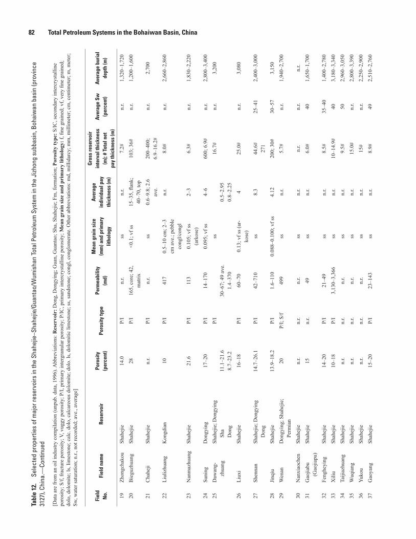
82 Total Petroleum Systems in the Bohaiwan Basin, ChinaTa
ble
12.
Sele
cted
pro
perti
es o
f maj
or re
serv
oirs
in th
e Sh
ahej
ie–S
hahe
jie/G
uant
ao/W
umis
han
Tota
l Pet
role
um S
yste
m in
the
Jizh
ong
subb
asin
, Boh
aiw
an b
asin
(pro
vinc
e 31
27),
Chin
a.—
Cont
inue
d
[Dat
a ar
e fr
om a
n oi
l ind
ustry
com
pila
tion
(unp
ub. d
ata,
199
6). A
bbre
viat
ions
: Res
ervo
ir: D
ong,
Don
gyin
g; G
uan,
Gua
ntao
; Sha
, Sha
hejie
; Fm
, for
mat
ion;
Por
osity
type
: S/IC
, sec
onda
ry in
terc
ryst
allin
e po
rosi
ty; S
/f, fr
actu
re p
oros
ity; V
, vug
gy p
oros
ity; P
/I, p
rimar
y in
terg
ranu
lar p
oros
ity; P
/IC, p
rimar
y in
terc
ryst
allin
e po
rosi
ty; M
ean
grai
n si
ze a
nd p
rim
ary
litho
logy
: f, fi
ne g
rain
ed; v
f, ve
ry fi
ne g
rain
ed;
dolo
, dol
omite
; ls,
limes
tone
; cal
c. d
olo,
cal
care
ous d
olom
ite; d
olo.
ls, d
olom
itic
limes
tone
; ss,
sand
ston
e; c
ongl
, con
glom
erat
e. O
ther
abb
revi
atio
ns: m
d, m
illid
arcy
; mm
, mill
imet
er; c
m, c
entim
eter
; m, m
eter
; Sw
, wat
er sa
tura
tion;
n.r.
, not
reco
rded
; ave
., av
erag
e]
Fiel
d N
o.Fi
eld
nam
eRe
serv
oir
Poro
sity
(p
erce
nt)
Poro
sity
type
Perm
eabi
lity
(md)
Mea
n gr
ain
size
(m
m) a
nd p
rim
ary
litho
logy
Aver
age
indi
vidu
al p
ay
thic
knes
s (m
)
Gro
ss re
serv
oir
inte
rval
thic
knes
s (m
); #
Tota
l net
pa
y th
ickn
ess
(m)
Aver
age
Sw
(per
cent
)Av
erag
e bu
rial
de
pth
(m)
19Zh
ongc
hako
uSh
ahej
ie14
.0P/
In.
r.ss
n.r.
7.2#
n.r.
1,32
0–1,
720
20B
iegu
zhua
ngSh
ahej
ie28
P/I
165,
cor
e; 4
2,
mat
rix<0
.1; v
f ss
15–3
5, fl
ank;
40
–70,
top
103;
36#
n.r.
1,20
0–1,
600
21C
hahe
jiSh
ahej
ien.
r.P/
In.
r.ss
0.6–
9.8;
2.6
av
e.20
0–40
0;
6.9–
16.2
#n.
r.2,
700
22Li
uliz
huan
gK
ongd
ian
10P/
I41
70.
5–10
cm
; 2–3
cm
ave
.; pe
bble
co
ngl/c
ongl
n.r.
8.0#
n.r.
2,66
0–2,
860
23N
anm
azhu
ang
Shah
ejie
21.6
P/I
113
0.10
5; v
f ss
(ark
ose)
2–3
6.3#
n.r.
1,83
0–2,
220
24Su
ning
Don
gyin
g17
–20
P/I
14–1
700.
095;
vf s
s4–
660
0; 6
.9#
n.r.
2,80
0–3,
400
25D
awan
g-zh
uang
Shah
ejie
; Don
gyin
g
Sha
D
ong
11.1
–21.
68.
7–23
.2
P/I
30–6
7; 4
9 av
e.1.
4–37
0
ss0.
5–2.
950.
8–2.
25
16.7
#n.
r.3,
200
26Li
uxi
Shah
ejie
16–1
8P/
I60
–70
0.13
; vf s
s (ar
-ko
se)
425
.0#
n.r.
3,08
0
27Sh
enna
nSh
ahej
ie; D
ongy
ing
D
ong
14.7
–26.
1P/
I42
–710
ss8.
344
.6#
271
25–4
12,
400–
3,00
0
28Ji
nqiu
Shah
ejie
13.9
–18.
2P/
I1.
6–11
00.
088–
0.10
0; v
f ss
4.12
200;
30#
30–5
73,
150
29W
enan
Don
gyin
g; S
hahe
jie;
Perm
ian
20P/
I; S/
f49
9ss
n.r.
5.7#
n.r.
1,94
0–2,
700
30N
anxi
aoch
enSh
ahej
ien.
r.n.
r.n.
r.ss
n.r.
n.r.
n.r.
n.r.
31G
aojia
bu
(Gao
jiapu
)Sh
ahej
ie15
n.r.
49ss
n.r.
6.0#
401,
650–
1,70
0
32Fe
nghe
ying
Shah
ejie
14–2
0P/
I21
–49
ssn.
r.8.
5#35
–40
1,40
0–2,
780
33X
iliu
Shah
ejie
10–1
8P/
I3,
130–
3,36
6ss
n.r.
10–1
4.9#
403,
180–
3,34
0
34Ta
ijiaz
huan
gSh
ahej
ien.
r.n.
r.n.
r.ss
n.r.
9.5#
502,
960–
3,05
0
35W
uqia
ngSh
ahej
ien.
r.n.
r.n.
r.ss
n.r.
15.0
#n.
r.2,
800–
3,39
0
36Yu
kou
Shah
ejie
n.r.
n.r.
n.r.
ssn.
r.15
#n.
r.2,
250–
2,90
0
37G
aoya
ngSh
ahej
ie15
–20
P/I
23–1
43ss
n.r.
8.9#
492,
510–
2,76
0

Table 12 83Ta
ble
12.
Sele
cted
pro
perti
es o
f maj
or re
serv
oirs
in th
e Sh
ahej
ie–S
hahe
jie/G
uant
ao/W
umis
han
Tota
l Pet
role
um S
yste
m in
the
Jizh
ong
subb
asin
, Boh
aiw
an b
asin
(pro
vinc
e 31
27),
Chin
a.—
Cont
inue
d
[Dat
a ar
e fr
om a
n oi
l ind
ustry
com
pila
tion
(unp
ub. d
ata,
199
6). A
bbre
viat
ions
: Res
ervo
ir: D
ong,
Don
gyin
g; G
uan,
Gua
ntao
; Sha
, Sha
hejie
; Fm
, for
mat
ion;
Por
osity
type
: S/IC
, sec
onda
ry in
terc
ryst
allin
e po
rosi
ty; S
/f, fr
actu
re p
oros
ity; V
, vug
gy p
oros
ity; P
/I, p
rimar
y in
terg
ranu
lar p
oros
ity; P
/IC, p
rimar
y in
terc
ryst
allin
e po
rosi
ty; M
ean
grai
n si
ze a
nd p
rim
ary
litho
logy
: f, fi
ne g
rain
ed; v
f, ve
ry fi
ne g
rain
ed;
dolo
, dol
omite
; ls,
limes
tone
; cal
c. d
olo,
cal
care
ous d
olom
ite; d
olo.
ls, d
olom
itic
limes
tone
; ss,
sand
ston
e; c
ongl
, con
glom
erat
e. O
ther
abb
revi
atio
ns: m
d, m
illid
arcy
; mm
, mill
imet
er; c
m, c
entim
eter
; m, m
eter
; Sw
, wat
er sa
tura
tion;
n.r.
, not
reco
rded
; ave
., av
erag
e]
Fiel
d N
o.Fi
eld
nam
eRe
serv
oir
Poro
sity
(p
erce
nt)
Poro
sity
type
Perm
eabi
lity
(md)
Mea
n gr
ain
size
(m
m) a
nd p
rim
ary
litho
logy
Aver
age
indi
vidu
al p
ay
thic
knes
s (m
)
Gro
ss re
serv
oir
inte
rval
thic
knes
s (m
); #
Tota
l net
pa
y th
ickn
ess
(m)
Aver
age
Sw
(per
cent
)Av
erag
e bu
rial
de
pth
(m)
38Li
uzu
n.r.
n.r.
n.r.
n.r.
n.r.
n.r.
n.r.
n.r.
n.r.

84 Total Petroleum Systems in the Bohaiwan Basin, ChinaTa
ble
13.
Sele
cted
pro
perti
es o
f maj
or re
serv
oirs
in th
e Sh
ahej
ie–S
hahe
jie/G
uant
ao/W
umis
han
Tota
l Pet
role
um S
yste
m in
the
Huan
ghua
sub
basi
n, B
ohai
wan
bas
in (p
rovi
nce
3127
), Ch
ina.
—Co
ntin
ued
[Dat
a ar
e fr
om o
il in
dust
ry c
ompi
latio
ns (u
npub
. dat
a, 1
996)
. Abb
revi
atio
ns: R
eser
voir
: Sha
, Sha
hejie
; Gua
n, G
uant
ao; M
ing,
Min
ghua
zhen
; Kon
g, K
ongd
ian;
Por
osity
type
: P/I,
prim
ary
inte
rgra
nula
r por
os-
ity; M
ean
grai
n si
ze a
nd p
rim
ary
litho
logy
: crs
, coa
rse
grai
ned;
m, m
ediu
m g
rain
ed; f
, fine
gra
ined
; vf,
very
fine
gra
ined
; vf-
f, ve
ry fi
ne to
fine
gra
ined
; ss,
sand
ston
e; sl
t, si
ltsto
ne; b
iols
, bio
clas
tic li
mes
tone
; ls
, lim
esto
ne. O
ther
abb
revi
atio
ns: m
d, m
illid
arcy
; mm
, mill
imet
er; m
, met
er; S
w, w
ater
satu
ratio
n; n
.r., n
ot re
cord
ed; a
ve.,
aver
age]
Fiel
d N
o.Fi
eld
nam
eRe
serv
oir
Poro
sity
(p
erce
nt)
Poro
sity
type
Perm
eabi
lity
(md)
Mea
n gr
ain
size
(m
m) a
nd p
rim
ary
litho
logy
Aver
age
indi
vidu
al p
ay
thic
knes
s (m
)
Gro
ss re
serv
oir
inte
rval
thic
knes
s (m
); #
Tota
l net
pa
y th
ickn
ess
(m)
Aver
age
Sw
(per
cent
)Av
erag
e bu
rial
de
pth
(m)
1G
angd
ong
Gua
ntao
; Min
ghua
zhen
32P/
I4.
4–17
.60.
17; f
ss15
1,00
0; 1
5#35
2,60
0
2G
angx
iG
uant
ao; M
ingh
uazh
en31
P/I
834
0.11
; vf s
sn.
r.1,
000;
14.
5#40
602–
1,67
3
3G
angz
hong
Shah
ejie
; Don
gyin
g21
P/I
2–1,
194;
67
ave.
0.08
1; v
f ss
n.r.
200–
400;
8.8
#40
1,90
0–3,
050
4Ta
ngjia
heSh
ahej
ie; G
uant
ao; D
ong-
ying
; Min
ghua
zhen
27P/
I30
60.
05–0
.32;
slt,
m ss
n.r.
19.5
#n.
r.1,
690–
3,26
0
5M
adon
gSh
ahej
ie9.
0–19
.7P/
I49
–523
0.11
7–0.
158;
vf
-f ss
13–1
622
0–24
0; 3
3.4#
n.r.
3,78
8–4,
015
6M
axi
Shah
ejie
n.r.
n.r.
n.r.
n.r.
n.r.
n.r.
n.r.
n.r.
7Li
ujia
nfan
gSh
ahej
ien.
r.n.
r.n.
r.ss
n.r.
n.r.
n.r.
n.r.
8B
anqi
aoSh
ahej
ie (S
ha I)
Sh
a I
21P/
I99
ss ssn.
r.1,
656;
8.3
#n.
r.2,
436–
4,09
2
9Zh
ouqi
ng-
zhua
ngSh
ahej
ie (S
ha I,
III)
Sh
a I
Sha
III
13.5
P/I
60.
1–0.
7; v
f-cr
s ss
oolit
ic ss
ss
5–8
7.6#
60–1
6015
0–45
0
n.r.
2,50
0–3,
100
10W
angx
u-zh
uang
Shah
ejie
(Sha
I, II
I)
Sha
I Sh
a II
I25 26
P/I
204
994
biol
sss
4–6
8.4#
n.r.
2,03
0–2,
540
11Ya
nger
zhua
ngSh
ahej
ie (S
ha I,
III)
; G
uant
ao; M
ingh
uazh
en
Gua
n
Min
g4.
8–10
.4 1
0.3–
17.6
P/I
841–
2,71
41,
246–
4,83
6
ssn.
r.25
.2#
n.r.
1,11
0–2,
030
12Ya
nsan
gmu
Gua
ntao
; Min
ghua
zhen
31P/
I1,
475
0.15
9; f
ss5–
819
.4#
n.r.
1,18
0–1,
460
13K
ongd
ian
Gua
ntao
33P/
I1,
878
ssn.
r.25
0; 1
1.8#
n.r.
1,20
0–1,
440
14Za
oyua
nK
ongd
ian;
Pa
leoz
oic
21.9
–26.
7P/
I16
5–1,
543
0.09
2–0.
211;
vf
-f ss ls
20–6
1.5
400;
19.
4#n.
r.1,
640–
2,28
0
15W
angg
uant
unSh
ahej
ie; K
ongd
ian
Sh
a
Kon
g
19–2
9P/
I27
–626
slt
biol
s3–
914
13.9
#n.
r.1,
800
16X
iaoj
iK
ongd
ian
15–1
7P/
I12
8–19
7f s
sn.
r.20
0; 4
1.2–
67.2
#n.
r.2,
700–
3,10
0
17Q
ijiaw
uSh
ahej
ie19
P/I
n.r.
ssn.
r.3.
5#40
1,92
0–2,
600

Table 13 85Ta
ble
13.
Sele
cted
pro
perti
es o
f maj
or re
serv
oirs
in th
e Sh
ahej
ie–S
hahe
jie/G
uant
ao/W
umis
han
Tota
l Pet
role
um S
yste
m in
the
Huan
ghua
sub
basi
n, B
ohai
wan
bas
in (p
rovi
nce
3127
), Ch
ina.
—Co
ntin
ued
[Dat
a ar
e fr
om o
il in
dust
ry c
ompi
latio
ns (u
npub
. dat
a, 1
996)
. Abb
revi
atio
ns: R
eser
voir
: Sha
, Sha
hejie
; Gua
n, G
uant
ao; M
ing,
Min
ghua
zhen
; Kon
g, K
ongd
ian;
Por
osity
type
: P/I,
prim
ary
inte
rgra
nula
r por
os-
ity; M
ean
grai
n si
ze a
nd p
rim
ary
litho
logy
: crs
, coa
rse
grai
ned;
m, m
ediu
m g
rain
ed; f
, fine
gra
ined
; vf,
very
fine
gra
ined
; vf-
f, ve
ry fi
ne to
fine
gra
ined
; ss,
sand
ston
e; sl
t, si
ltsto
ne; b
iols
, bio
clas
tic li
mes
tone
; ls
, lim
esto
ne. O
ther
abb
revi
atio
ns: m
d, m
illid
arcy
; mm
, mill
imet
er; m
, met
er; S
w, w
ater
satu
ratio
n; n
.r., n
ot re
cord
ed; a
ve.,
aver
age]
Fiel
d N
o.Fi
eld
nam
eRe
serv
oir
Poro
sity
(p
erce
nt)
Poro
sity
type
Perm
eabi
lity
(md)
Mea
n gr
ain
size
(m
m) a
nd p
rim
ary
litho
logy
Aver
age
indi
vidu
al p
ay
thic
knes
s (m
)
Gro
ss re
serv
oir
inte
rval
thic
knes
s (m
); #
Tota
l net
pa
y th
ickn
ess
(m)
Aver
age
Sw
(per
cent
)Av
erag
e bu
rial
de
pth
(m)
18D
uanl
ubo
(Dua
nliu
bo)
(Dua
b-ki
ubo)
Kon
gdia
n; S
hahe
jie15
.1P/
I29
ssn.
r.40
.1#
302,
880–
3,57
0
19Sh
enus
iK
ongd
ian;
Sha
hejie
25P/
I30
4ss
n.r.
18.0
#37
1,36
0–3,
050
20Li
ugua
n-zh
uang
Min
ghua
zhen
32P/
I35
2ss
n.r.
1.8#
451,
300–
1,50
0
21K
oucu
nG
uant
ao; S
hahe
jie;
Kon
gdia
n; M
esoz
oic;
Pe
rmia
n
26.9
P/I
230
ssn.
r.14
.0#
331,
360–
1,79
0
22Ta
nggu
Shah
ejie
22P/
I10
ssn.
r.8.
6#40
2,12
0–2,
600
23W
umay
ing
Kon
gdia
n18
.6P/
I29
3ss
n.r.
7.46
#36
2,46
0–3,
510
24C
hang
luSh
ahej
ie20
P/I
30–1
00ss
n.r.
15.9
#40
3,75
0–3,
850
25G
aoch
ento
un.
r.n.
r.n.
r.n.
r.n.
r.n.
r.n.
r.n.
r.n.
r.
26C
hang
juhe
Shah
ejie
20P/
I44
ssn.
r.11
.7#
402,
610–
3,70
0
27Yu
esan
baSh
ahej
ie16
.4n.
r.50
ssn.
r.10
.8#
402,
160–
3,47
0
28D
acha
ngto
uSh
ahej
ie20
P/I
80ss
n.r.
5.5#
322,
550–
2,75
0
29Li
anm
eng
n.r.
n.r.
n.r.
n.r.
n.r.
n.r.
n.r.
n.r.
n.r.
30Zh
aodo
ng
(incl
udes
Zh
ao D
ong
C-1
and
Zh
ao D
ong
D-1
)?
n.r.
n.r.
n.r.
n.r.
n.r.
n.r.
n.r.
n.r.
n.r.
31G
aosh
angb
u (G
aosh
ang-
bao)
Shah
ejie
; Gua
ntao
; Sh
a
Gua
n13
.5–1
9.1
28.9
–30.
9
P/I
5–35
4 94
9–1,
446
ssn.
r.50
#n.
r.3,
000
32Li
uzha
nSh
ahej
ie; G
uant
ao; M
ing-
huaz
hen
21.5
P/I
n.r.
ssn.
r.10
#40
1,50
0–3,
640
33B
eipu
Don
gyin
g; G
uant
ao22
P/I
n.r.
ssn.
r.10
.8#
401,
920–
4,00
0
34La
oyem
aio
Don
gyin
g; M
ingh
uazh
en24
.5P/
In.
r.ss
n.r.
8.0#
381,
860–
3,08
0

86 Total Petroleum Systems in the Bohaiwan Basin, ChinaTa
ble
13.
Sele
cted
pro
perti
es o
f maj
or re
serv
oirs
in th
e Sh
ahej
ie–S
hahe
jie/G
uant
ao/W
umis
han
Tota
l Pet
role
um S
yste
m in
the
Huan
ghua
sub
basi
n, B
ohai
wan
bas
in (p
rovi
nce
3127
), Ch
ina.
—Co
ntin
ued
[Dat
a ar
e fr
om o
il in
dust
ry c
ompi
latio
ns (u
npub
. dat
a, 1
996)
. Abb
revi
atio
ns: R
eser
voir
: Sha
, Sha
hejie
; Gua
n, G
uant
ao; M
ing,
Min
ghua
zhen
; Kon
g, K
ongd
ian;
Por
osity
type
: P/I,
prim
ary
inte
rgra
nula
r por
os-
ity; M
ean
grai
n si
ze a
nd p
rim
ary
litho
logy
: crs
, coa
rse
grai
ned;
m, m
ediu
m g
rain
ed; f
, fine
gra
ined
; vf,
very
fine
gra
ined
; vf-
f, ve
ry fi
ne to
fine
gra
ined
; ss,
sand
ston
e; sl
t, si
ltsto
ne; b
iols
, bio
clas
tic li
mes
tone
; ls
, lim
esto
ne. O
ther
abb
revi
atio
ns: m
d, m
illid
arcy
; mm
, mill
imet
er; m
, met
er; S
w, w
ater
satu
ratio
n; n
.r., n
ot re
cord
ed; a
ve.,
aver
age]
Fiel
d N
o.Fi
eld
nam
eRe
serv
oir
Poro
sity
(p
erce
nt)
Poro
sity
type
Perm
eabi
lity
(md)
Mea
n gr
ain
size
(m
m) a
nd p
rim
ary
litho
logy
Aver
age
indi
vidu
al p
ay
thic
knes
s (m
)
Gro
ss re
serv
oir
inte
rval
thic
knes
s (m
); #
Tota
l net
pa
y th
ickn
ess
(m)
Aver
age
Sw
(per
cent
)Av
erag
e bu
rial
de
pth
(m)
35Ta
ngha
i/D
ulin
g (T
angh
e)
Shah
ejie
; Mes
ozoi
c (J
uras
-si
c); C
ambr
ian
5P/
In.
r.ss
n.r.
6.7#
351,
710–
1,80
0
36C
ansh
akou
Shah
ejie
21.5
P/I
n.r.
ssn.
r.93
.3#
401,
500–
3,60
0
37B
aige
zhua
ngn.
r.n.
r.n.
r.n.
r.n.
r.n.
r.n.
r.n.
r.n.
r.

Table 14 87Ta
ble
14.
Sele
cted
pro
perti
es o
f maj
or re
serv
oirs
in th
e Sh
ahej
ie–S
hahe
jie/G
uant
ao/W
umis
han
Tota
l Pet
role
um S
yste
m in
the
Linq
ing/
Dong
pu s
ubba
sin,
Boh
aiw
an b
asin
(p
rovi
nce
3127
), Ch
ina.
—Co
ntin
ued
[Dat
a ar
e fr
om a
n oi
l ind
ustry
com
pila
tion
(unp
ub. d
ata,
199
6). A
bbre
viat
ions
: Res
ervo
ir: S
ha, S
hahe
jie; P
oros
ity ty
pe: P
/I, p
rimar
y in
terg
ranu
lar p
oros
ity; M
ean
grai
n si
ze a
nd p
rim
ary
litho
logy
: f, fi
ne
grai
ned;
vf,
very
fine
gra
ined
; slt,
silts
tone
; ss,
sand
ston
e. O
ther
abb
revi
atio
ns: m
d, m
illid
arcy
; mm
, mill
imet
er; m
, met
er; S
w, w
ater
satu
ratio
n; n
.r., n
ot re
cord
ed; a
ve.,
aver
age;
max
, max
imum
]
Fiel
d N
o.Fi
eld
nam
eRe
serv
oir
Poro
sity
(p
erce
nt)
Poro
sity
type
Perm
eabi
lity
(md)
Mea
n gr
ain
size
(m
m) a
nd p
rim
ary
litho
logy
Aver
age
indi
vidu
al p
ay
thic
knes
s (m
)
Gro
ss re
serv
oir
inte
rval
thic
knes
s (m
); #
Tota
l net
pa
y th
ickn
ess
(m)
Aver
age
Sw
(per
cent
)Av
erag
e bu
rial
de
pth
(m)
1Pu
chen
gSh
ahej
ie (S
ha I,
II, I
II, I
V)
Sha
I Sh
a II
upp
er
Sha
II lo
wer
Sh
a II
Sh
a II
I Sh
a II
I and
IV
27.7
23.4
10.6
–23.
5
P/I
548
165
37.1
–241
.6
f ss (
arko
se)
ss ss ss ss ss ss
n.r.
30#
n.r.
2,20
0–3,
800
2W
enm
ingz
hai
Shah
ejie
(Sha
I, II
, III
)24
–28
P/I
300–
700
f ss
n.r.
26.2
#n.
r.1,
360–
2,32
0
3W
eich
eng
Shah
ejie
14–2
0P/
I2–
100
ssn.
r.1,
000;
18.
5#n.
r.1,
700–
2,90
0
4G
uyun
jiSh
ahej
ie16
–19
P/I
n.r.
f ss
n.r.
n.r.
n.r.
n.r.
5W
endo
ngSh
ahej
ie (S
ha II
, III
, IV
) Sh
a II
Sh
a II
I21
.411
.7–2
1.5
P/I
210
2.8–
131
slt,
ss1–
3n.
r.n.
r.3,
100–
3,35
0
6W
enna
nSh
ahej
ie (S
ha II
, III
)15
–20
P/I
20–1
10sl
t1–
285
0; 1
9.7#
n.r.
2,50
0–3,
750
7W
enliu
Shah
ejie
(Sha
II, I
II)
Sha
II
Sha
III
21.2
–24.
723
.2–2
3.7
P/I
53.7
–245
163–
236
ssn.
r.17
.2–2
2.8#
n.r.
1,90
0–2,
600
8W
en-2
3Sh
ahej
ie
Sha
low
er
Sha
mid
dle
Sh
a up
per
11.4
–12.
411
.6–1
3.9
8.8–
10.3
P/I
3.6–
3.7
12.3
–17.
10.
2–1.
77
0.03
2–0.
092,
slt,
vf ss
n.r.
400
69.5
#44
.4#
12.4
#
n.r.
2,67
0–3,
110
9Q
iaok
ouSh
ahej
ie (S
ha II
, III
) Sh
a II
Sh
a II
I19
.515
–27
P/I
140
11
slt
n.r.
n.r.
n.r.
2,45
0–2,
950
10B
aim
iao
Shah
ejie
7.6
P/I
1.36
–1.8
8n.
r.n.
r.n.
r.n.
r.n.
r.
11M
acha
ngSh
ahej
ie19
.5P/
I10
1ss
2–4
50n.
r.2,
500–
3,00
0
12Sa
nchu
nji
Shah
ejie
11.1
–21.
6P/
I0.
6–33
3sl
t2–
4n.
r.n.
r.3,
030–
3,20
0
13M
azha
iSh
ahej
ie15
–27;
22.
1 av
e.P/
I4–
200
ss (l
ithic
ark
ose)
n.r.
62.6
#n.
r.1,
860–
1,95
0
14H
uzhu
angj
iSh
ahej
ie20
–23
P/I
202–
248
0.04
–0.3
; slt,
ss2–
4n.
r.n.
r.1,
700–
2,50
0
15Q
ingz
uji
Shah
ejie
16–2
0; 1
8 av
e.P/
I30
; 726
max
.sl
t2–
3n.
r.n.
r.1,
900–
2,04
0
16Li
uzhu
ang
Shah
ejie
5P/
I12
0ss
n.r.
3.2#
402,
890–
3,05
0

88 Total Petroleum Systems in the Bohaiwan Basin, ChinaTa
ble
14.
Sele
cted
pro
perti
es o
f maj
or re
serv
oirs
in th
e Sh
ahej
ie–S
hahe
jie/G
uant
ao/W
umis
han
Tota
l Pet
role
um S
yste
m in
the
Linq
ing/
Dong
pu s
ubba
sin,
Boh
aiw
an b
asin
(p
rovi
nce
3127
), Ch
ina.
—Co
ntin
ued
[Dat
a ar
e fr
om a
n oi
l ind
ustry
com
pila
tion
(unp
ub. d
ata,
199
6). A
bbre
viat
ions
: Res
ervo
ir: S
ha, S
hahe
jie; P
oros
ity ty
pe: P
/I, p
rimar
y in
terg
ranu
lar p
oros
ity; M
ean
grai
n si
ze a
nd p
rim
ary
litho
logy
: f, fi
ne
grai
ned;
vf,
very
fine
gra
ined
; slt,
silts
tone
; ss,
sand
ston
e. O
ther
abb
revi
atio
ns: m
d, m
illid
arcy
; mm
, mill
imet
er; m
, met
er; S
w, w
ater
satu
ratio
n; n
.r., n
ot re
cord
ed; a
ve.,
aver
age;
max
, max
imum
]
Fiel
d N
o.Fi
eld
nam
eRe
serv
oir
Poro
sity
(p
erce
nt)
Poro
sity
type
Perm
eabi
lity
(md)
Mea
n gr
ain
size
(m
m) a
nd p
rim
ary
litho
logy
Aver
age
indi
vidu
al p
ay
thic
knes
s (m
)
Gro
ss re
serv
oir
inte
rval
thic
knes
s (m
); #
Tota
l net
pa
y th
ickn
ess
(m)
Aver
age
Sw
(per
cent
)Av
erag
e bu
rial
de
pth
(m)
17H
upuz
hai/
Xue
jin.
r.n.
r.n.
r.n.
r.n.
r.n.
r.n.
r.n.
r.n.
r.
18X
uji
n.r.
n.r.
n.r.
n.r.
n.r.
n.r.
n.r.
n.r.
n.r.
19W
enbe
in.
r.n.
r.n.
r.n.
r.n.
r.n.
r.n.
r.n.
r.n.
r.

Table 15 89Ta
ble
15.
Sele
cted
pro
perti
es o
f maj
or re
serv
oirs
in th
e Sh
ahej
ie–S
hahe
jie/G
uant
ao/W
umis
han
Tota
l Pet
role
um S
yste
m in
the
Bozh
ong
subb
asin
, Boh
aiw
an b
asin
(pro
vinc
e 31
27),
Chin
a.
[Dat
a ar
e fr
om E
dito
rial C
omm
ittee
of P
etro
leum
Geo
logy
of O
il- a
nd G
as-B
earin
g A
reas
on
the
Con
tinen
tal S
helf
and
its N
eigh
borin
g R
egio
ns (1
987)
, Lee
(198
9), a
nd H
urst
and
oth
ers (
2001
). A
bbre
via-
tions
: Res
ervo
ir: S
ha, S
hahe
jie; D
ong,
Don
gyin
g; G
uan,
Gua
ntao
; L.,
low
er; U
., up
per;
ss, s
ands
tone
; Mea
n gr
ain
size
and
pri
mar
y lit
holo
gy: s
s, sa
ndst
one;
dol
o, d
olom
ite. O
ther
abb
revi
atio
ns: m
d, m
il-lid
arcy
; mm
, mill
imet
er; m
, met
er; S
w, w
ater
satu
ratio
n; n
.r., n
ot re
cord
ed]
Fiel
d N
o.Fi
eld
nam
eRe
serv
oir
Poro
sity
(p
erce
nt)
Poro
sity
type
Perm
eabi
lity
(md)
Mea
n gr
ain
size
(m
m) a
nd p
rim
ary
litho
logy
Aver
age
indi
vidu
al p
ay
thic
knes
s (m
)
Gro
ss re
serv
oir
inte
rval
thic
knes
s (m
); #
Tota
l net
pa
y th
ickn
ess
(m)
Aver
age
Sw
(per
cent
)Av
erag
e bu
rial
de
pth
(m)
1Q
inhu
angd
ao
30-1
Mes
ozoi
c (J
uras
sic)
22.8
n.r.
16.7
ande
site
n.r.
30#
n.r.
3,00
0
2Sh
ijiut
uoD
ongy
ing;
G
uant
ao;
Mes
ozoi
c
n.r.
n.r.
n.r.
ssba
salt
n.r.
30#
n.r.
n.r.
3B
ozho
ng 2
5-1-
1Sh
ahej
ie (S
ha II
I);
Mes
ozoi
c8–
12n.
r.6.
51–6
1.19
ssn.
r.4
n.r.
3,35
5
4B
ozho
ng 2
8-1
Shah
ejie
(Sha
I); O
rdov
i-ci
an; C
ambr
ian
Sh
a I
L. O
rdov
icia
n-U
. C
ambr
ian
5.2–
8.5
2.24
n.r.
2–14
.21.
8ss do
lo
n.r.
323
n.r.
n.r.
n.r.
2,97
5
2,99
03,
200
5B
ozho
ng 2
8-2-
1D
ongy
ing
(Don
g lo
wer
)6–
16n.
r.0.
29–3
.45
ssn.
r.20
.5n.
r.3,
067
6B
ozho
ng 3
4-1-
1D
ongy
ing;
Gua
ntao
;M
ingh
uazh
en
13.9
–23.
525
.9n.
r.se
vera
l >98
752
0.3
ss ss ss
n.r.
2.5–
84#
n.r.
2,24
4
7B
ozho
ng 3
4-2
Shah
ejie
(Sha
II, I
II);
Don
gyin
g; G
uant
ao
Sha
II, I
II
Don
g lo
wer
D
ong
G
uan
8–17
23.5
16.8
25.9
n.r.
0.29
–977
.13
987
160
520.
3
ss ss ss ss
n.r.
1,16
2; 8
3#8# 26
n.r.
3,34
4
8B
ozho
ng 3
4-3
Don
gyin
g; G
uant
ao
Don
g lo
wer
G
uan
23.5
25.9
n.r.
987
520.
3ss ss
n.r.
8# 200
n.r.
3,00
03,
300
9B
ozho
ng 3
4-4
Shah
ejie
(Sha
II, I
II)
12.3
4n.
r.3.
33ss
n.r.
n.r.
n.r.
3,40
0
10Pe
ng L
ai 1
4-3-
1M
ioce
ne ss
n.r.
n.r.
n.r.
ssn.
r.n.
r.n.
r.2,
372
11Pe
ng L
ai 1
9-3-
1G
uant
ao; M
ingh
uazh
enn.
r.n.
r.10
0–1,
000
ssn.
r.16
0# in
Gua
ntao
n.r.
1,20
0

Ryder and others—Total Petroleum
Systems in the B
ohaiwan B
asin, China—Scientific Investigations Report 2011–5010