Shadows in the Sand: Unfriendly Landscape in Archaeology
15
This is an Open Access article distributed in accordance with the Creative Commons Attribution Non Commercial (CC-BY- NC-ND 4.0) license, which permits others to copy or share the article, provided original work is properly cited and that this is not done for commercial purposes. Users may not remix, transform, or build upon the material and may not distribute the modified material (http://creativecommons.org/licenses/by-nc/4.0/) Trivent Publishing © The Authors, 2016 Available online at http://trivent-publishing.eu/ Philosophy, Communication, Media Sciences Series Volume The Modern and Contemporary Reception of Saint Gerard of Cenad Shadows in the Sand: Unfriendly Landscape in Archaeology Dorel Micle Department of History, West University of Timişoara, Romania, [email protected] Abstract The low-land of the Banat Region in Western Romania is a territory rich in archaeological sites, the presence of human communities being facilitated by the local geomorphology, hydrography, and pedology. Even so, this area includes approximately 975 km 2 where there are no traces of human settling from the nineteenth century (when archaeological research first begun in Banat) until today. After analysing the paleochannels of the Mureș River (the Galațca Channel being the best one preserved) and the soil resulted after sediment deposition, it is visible that the entire plain has a sub- layer of sand which cloaked the groundwater, thus preventing human communities from settling here. The lack of rivers and springs explains why the land was unsuitable for agriculture from the Neolithic Period to the Middle Ages. The Habsburg colonisation of the eighteenth century allowed the first villages to take shape here while the economic exploitation of the plain started via hydro-amelioration works (digging wells and irrigation canals) -- this made the territory famous up until today for its “Gottlob watermelons,” the “Lovrin vegetables,” and the “Teremia brandy” (produced from the grapes cultivated there). This is proof that sandy lands in the area were efficiently exploited after being transformed from “unfriendly” lands into “useful” lands. Keywords Landscape Archaeology; geomorphology; pedology, hydrographical analysis; landscape evolution; palaeo watercourse.
Transcript of Shadows in the Sand: Unfriendly Landscape in Archaeology

This is an Open Access article distributed in accordance with the Creative Commons Attribution Non Commercial (CC-BY-
NC-ND 4.0) license, which permits others to copy or share the article, provided original work is properly cited and that this is
not done for commercial purposes. Users may not remix, transform, or build upon the material and may not distribute the
modified material (http://creativecommons.org/licenses/by-nc/4.0/)
Trivent Publishing
© The Authors, 2016
Available online at http://trivent-publishing.eu/
Philosophy, Communication, Media Sciences Series
Volume The Modern and Contemporary Reception of Saint Gerard of Cenad
Shadows in the Sand:
Unfriendly Landscape in Archaeology
Dorel Micle
Department of History, West University of Timişoara, Romania, [email protected]
Abstract
The low-land of the Banat Region in Western Romania is a territory rich in archaeological sites, the
presence of human communities being facilitated by the local geomorphology, hydrography, and
pedology. Even so, this area includes approximately 975 km2 where there are no traces of human
settling from the nineteenth century (when archaeological research first begun in Banat) until today.
After analysing the paleochannels of the Mureș River (the Galațca Channel being the best one
preserved) and the soil resulted after sediment deposition, it is visible that the entire plain has a sub-
layer of sand which cloaked the groundwater, thus preventing human communities from settling here.
The lack of rivers and springs explains why the land was unsuitable for agriculture from the Neolithic
Period to the Middle Ages. The Habsburg colonisation of the eighteenth century allowed the first
villages to take shape here while the economic exploitation of the plain started via hydro-amelioration
works (digging wells and irrigation canals) -- this made the territory famous up until today for its
“Gottlob watermelons,” the “Lovrin vegetables,” and the “Teremia brandy” (produced from the
grapes cultivated there). This is proof that sandy lands in the area were efficiently exploited after
being transformed from “unfriendly” lands into “useful” lands.
Keywords
Landscape Archaeology; geomorphology; pedology, hydrographical analysis; landscape evolution;
palaeo watercourse.
Teodora
Typewritten text
DOI: 10.22618/TP.PCMS.20163.61001

Dorel Micle
Shadows in the Sand: Unfriendly Landscape in Archaeology
2
I. Introduction
The Banat region in Western Romania stretches from the River Mureș to the Danube River and from
the country’s administrative border to the Carpathian Mountains (Fig. 1); it is shaped as a huge
sloping-terraced amphitheatre (Fig. 2) descending from east to west. The archaeological potential of
this area is particularly rich, being favoured by a temperate-continental climate with Mediterranean
influences, a rich hydrographical basin and a micro-geomorphologic structure favourable to human
setting.
A recent study1 which analyses the link between the habitat conditions and the marshes situated
west and south-west of Cenad, reveals that the number of archaeological sites reduces considerably
(being almost zero) in a territory only 20 km south-southeast of Cenad, between the Galațca Channel
and the Beregsău Rivulet, the number of archaeological sites reduces considerably tending towards
zero. Because the rest of the Banat Plain abounds in archaeological sites (also in marshy areas), we
asked ourselves whether this situation originates in research flaws or has natural causes. The area
encompasses an equilateral triangle with sides of about 50 km, limited north by the Galațca Channel,
south-west by the border with Serbia, and south-east by the Beregsău Rivulet, covering about 975 km2.
Fig. 1. Historical Banat and the area investigated
Fig. 2. The disposition of the major relief
forms in Banat2 (choremic representation)
1 D. Micle, “Cenadul în contextul geografiei istorice. O analiză a evoluției condițiilor de habitat” [Cenad in the
context of geographical history. An analysis of the evolution of the habitat conditions], in Filosofia Sfântului
Gerard de Cenad în context cultural și biografic [The philosophy of Saint Gerard of Cenad in cultural and
biographic context], ed. Claudiu Mesaroș (Szeged: JATE Press, 2013), 158-173. 2 Legend: 1 - The Plains of the Low Timiș, 2 - The High Plains, 3 – The Western Hills, 4 – The Western
Carpathians.

Dorel Micle
Shadows in the Sand: Unfriendly Landscape in Archaeology
3
II. The geomorphologic, hydrographical and pedological analysis of the Galațca and
Grabaț Plains
The Jimbolia-Cărpiniş-Biled Plain (situated between the Galaţca Channel and the Beregsău Rivulet, an
area with the most fertile soils in Banat), is formed of mainly overlapping loessoid3 and coarse fluvial
deposits;4 it is conventionally divided into the Galațca Plain in the north and the Grabaț Plain in the
south. The Teremia-Pesac sandy plain sector starts north of the contact of the Mureșul Flooding Plain
with a narrow section of plain and continues with a broader section towards south-southwest taking
the shape of a micro-delta that continues beyond the border with Serbia to the confluence with the
River Tisa. In the east, the plain goes on the following route: Periam – Pesac – Lovrin – Gottlob –
Comloșu Mare, which separates it from the Plain of Jimbola. The Teremia Mare – Tomnatic – Periam
line separates it from the Aranca fluvial-lacustrine Plain. According to soil science and
geomorphology specialists, the Mureș River created this plain in the Holocene Era.5 Its waters cut a
bed through the loessoid materials on the Periam – Pesac direction where they untangled and the
watercourse broadened due to the decrease of the slope. The first thicker sand deposits were upstream
Pesac, after which the watercourse curved towards the west – north-west eroding the right bank and
depositing on the left one. The longitudinal fluvial sand banks rose 1-2 metres above the general level
of the loessoid plains, which points to deeper waters and higher speeds.6 The University of Szeged
analyzed the materials extracted from the minor bed of the Galațca Channel (today’s name of this
fossil mender of the Palaeomureș) through the OSL method (Optically Stimulated Luminescence),
resulting that the Mureș River created this palaeochannel some 8.1-6.1 billion years ago,7 thus being
active in the Neolithic Period.
Fig. 3. The Mureș Palaeochannel (detail), apud G. Sipos, op. cit., p. 49, fig. 8.
Initially, the Palaeomureș flowed from Lovrin to the south-west of Gottlob and Comloșu Mic,
where it deposited lentils of sand; it later stabilised along the sinusoid axis of Lovrin – Tomnatic –
3 Geografia României. Regiunile pericarpatice [The Geography of Romania. The territories outside the
Carpathian Mountains], vol. IV (Bucharest: Editura Academiei Române, București, 1992), 145. 4 Gr. P. Pop, Dealurile de Vest și Câmpia de Vest [The Western Hills and the Western Plain] (Oradea: Editura
Universității din Oradea, 2005), 143-144. 5 Gh. Ianoș, Riscuri pedohidrice în partea central-vestică a Câmpiei Banatului [Pedohidric risks in the central-
western region of the Plain of Banat] (Timișoara: Editura Universității de Vest, 2008), 25. 6 Ibidem.
7 G. Sipos (ed.), Past, Present, Future of the Maros River (Timișoara: Editura Universității de Vest, 2012), 56,
table 4.
Dorel Micle
Shadows in the Sand: Unfriendly Landscape in Archaeology
4
Vizejdia – Comloșu Mare, a route marked by a continuous band of sand deposits. The land eroded by
this last route of the Paleomureș fluctuated rather often, reaching 2 km in its width.8
Depending on the initial configuration of the relief, coarse alluvial materials were deposited mainly
on the left bank because the land is slightly inclined from south to north, from 95 m altitude in the
Grabaț Plain to 85 m in the current area of the Mureș River (Fig. 4).
Fig. 4. North-west and south-east profile of the Mureș River and the Bega Channel along the
Cenad – Saravale – Pesac – Biled – Becicherecu Mic – Timișoara line
A thorough analysis of Google Earth satellite images and older ortho-photoplans (1968s-1969s)
shows that there was, from north-east to south-west (along the Satu Mare – Variaș – Șandra – Iecea
Mare – Cărpiniș – Checea – Hedin line), another palaeochannel, probably of the Mureș River, as well
as a third one on the same direction, but along the Satu Mare – Bulgăruș – Lenauheim line, where it
divides into two branches: one to Grabaț – Comloșu Mic and another one to Checea – Radojevo.
These fossil watercourses consist of numerous meanders and inter-twinning which supports the theory
of a difficult evolution: the sand deposits and the conformation of the current soils stand as proof (Fig.
5).
Fig. 5. Ortho-photoplan detail of palaeo-beds between the
Galațca Channel (north-west) and the Apa Mare Rivulet (east)
8 Ibidem, 48.

Dorel Micle
Shadows in the Sand: Unfriendly Landscape in Archaeology
5
Fig. 6. The palaeocourses of the River Mures are illustrated by
the distribution of the psamosoils and alluvial soils at Lovrin
Fig. 7. The palaeocourses of the River Mures are
illustrated by the distribution of the psamosoils and
alluvial soils at Lenauheim
The map of soil types9 points to the grouping of psamosoils (a type of soil that has not evolved,
made of medium-coarse sands, with low fertility) into narrow bands along the main palaeochannels of
the Mureș River. In their vicinity, marking the line of the old flowing directions, alluvial soils (molic,
gleyc, and alkalised) agglomerate, as they had been deposited on the banks of the palaeochannels
during the flooding of the Mureș River. These types of soil correspond to the major bed of a
downstream river. From the perspective of the sediments, it is characterised by tabular or elongated
accumulations of fine material (silt) with parallel laminations (sometimes rhythmical) and by fining-up
micro-sequences accompanied by contraction polygons, phyto-clasts, palaeosoils, and root debris. The
land is proper for agricultural purposes (1st class fertility) in the area where the waters withdrew from
fossil meanders and where chernozem (typical, gleyed, and salty) developed over sands, but it needs
hydro-ameliorative works because of the lack of active water sources and the high permeability of
parental materials which cause the pluvial waters to persist for no longer than one or two days.10
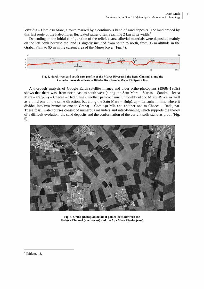
Based on these analyses, we can argue that the Mureș River had several palaeochannels from the
south to the north (Fig. 8) before it stabilised in its current form -- the most well-known and best
profiled palaeochannel (with probably the longest activity) being the Galațca Channel . The current
watercourse of the Aranca Rivulet also represents an intermediary phase of the palaeo watercourse of
the Mureș River.11
Thus, packages of sands deposited in the sector between the watercourse of the
Beregsău Rivulet and the Galațca Channel are also the result of to the Mureș River; all this happened
in time, from south to north, the river stabilising along the line of the current Galațca Channel (Fig. 9)
sometime during the Neolithic Period.
9 D. Țărău, M. Luca, Panoptic al comunelor bănățene din perspectivă pedologică [Panopticon of the settlements
of Banat from a pedological perspective] (Timișoara: Marineasa, 2002), 94, 142-148. 10
Ianoș, Riscuri pedohidrice, 26. 11
Ibidem, 16, fig. 2; Pop Dealurile de Vest și Câmpia de Vest., 144.
Dorel Micle
Shadows in the Sand: Unfriendly Landscape in Archaeology
6
Fig. 8. Map of possible palaeochannels of the Mureș River in the Grabaț and Galațca Plains
Fig. 9. Platform of sands deposited along palaeochannels of the Mureș River in the sector between the current
watercourse of the Mureș River and Bega Channel along the north-west – south-east line Szeged – Beba Veche –
Dudeștii Vechi – Comloșu Mare – Checea – Cenei – Diniaș
III. The map showing the archaeological potential of the Banat Plain
Based on these geographical observations, we systematised all data regarding the archaeological
findings in the area (known and unknown) and we grouped them on maps showing the archaeological
potential. Furthermore, we grouped them into six eras representative for the habitat of Banat12
(Fig.
10-15).
Fig. 10. The map of the spatial distribution of the
findings from the Neolithic Period
Fig. 11. The map of the spatial distribution of the findings
from the Bronze Age
12
These maps are the work of the ArheoVest team in the last 10 years of mapping archaeological findings in
Banat, locating both known and unknown sites. We thank our friend Andrei Stavilă for designing the maps in
ArcGIS.

Dorel Micle
Shadows in the Sand: Unfriendly Landscape in Archaeology
7
Fig. 12. The map of the spatial distribution of the
findings from the Post-Roman Period
Fig. 13. The map of the spatial distribution of the findings
from the Early Middle Ages
Fig. 14. The map of the spatial distribution of the
findings from the High Middle Ages
Fig. 15. The map of the spatial distribution of the findings
from the Late Middle Ages
Although we cannot speak of a systematic archaeological research in the field, it is visible that the
spatial distribution of the archaeological findings reflect a de facto situation which may be considered
as both sample and representative (cumulating all archaeological findings that could be analyzed from
1800 until today): the area we analysed was avoided by human communities from the Prehistory up
until the Habsburg colonisation in the eighteenth century. The maps show a hiatus of human habitation
which seems to have no logical explanation because the land is highly fertile.
Analysing the spatial distribution of the archaeological findings along seven Millennia, we can
easily see that the area we investigated remained uninhibited, even towards the end of the Bronze Age
or during the third and fourth centuries A.D., when there was a demographic boom in the Banat Plain.
In this context, the only explanation could lie in the surface waters, i.e. the rivers and rivulets, which
do not exist in this sector as the thick layer of sands deposited by the palaeobeds of the Mureș River
created an interfluve with fertile soils but with no natural hydrographic system, Therefore, there are no
springs in the area, and ground waters are 2-6 metres deep (Grabaț - 6 m; Pesac - 4 m; Tomnatic – 4
m; Lovrin – 2 m; Uihei – 2 m; Bulgăruș - 2 m; Teremia Mare - 2 m). While in the neighbouring areas
(in the north, the Aranca Rivulet flooding meadow or in the south, the Beregsău River flooding
meadow), where the level of ground waters reach 1 metre, fountains are frequently seen in the plain
area, in the area investigated by us, fountains are rather rare (they can be exclusively found in
settlements or in their immediate vicinity).

Dorel Micle
Shadows in the Sand: Unfriendly Landscape in Archaeology
8
Fig. 16. The distribution of fountains in the research area according to
Josephinische (Erste) Landesaufnahme (1769-1772)
The first land survey done by Habsburg military engineers between 1769 and 1772 captured an
interesting situation in the field: most fountains were in Periam (24) while the rest were in Comloșu
Mare (six fountains east from the locality) and Gottlob (three fountains west from the locality). A
thorough analysis shows that they also follow the watercourse of some meanders parallel to the
Galațca Channel. The rest of the area investigated (about 975 km2) contains 57 fountains, of which 36
are grouped along the Galațca Channel, 13 along the median palaeochannel between Periam and
Checea, and 8 along the eastern palaeochannel between Satu Mare and Cărpiniș. Thus, we can see that
a huge area has no fountains for humans or animals.
The issue of drinking water in the area seems obvious: the proof stands in the routes converging
toward the fountains which shortcut the distance between localities (in order to reach the areas where
these fountains are located). The latter are located along the former meanders of the palaeo
watercourse of the Mureș River, and their scarcity resulted in building roads for the only purpose of
reaching the fountains (Fig. 17).
Thus, in some cases, the principle of the “fountain by the road” is reversed: the road was turned to
reach water sources. This is the case of the road from Bulgăruș to Iecea Mare, where there are no
fountains; in exchange, there were secondary routes which led to one of the four resources of drinking
water.
Dorel Micle
Shadows in the Sand: Unfriendly Landscape in Archaeology
9
Fig. 17a. Fountain located east from Lenauheim
Fig. 17b. Fountain located east from Iecea Mare
Fig. 17c. Fountain located between Pesac and Biled Fig. 17d. Fountain located between Pesac and Bulgăruș
IV. The Habsburg colonisation and the introduction of the Galațca and Grabaț Plains
into the modern agricultural circuit
If we analyze the urban features of the localities mapped by the military land surveyors, we see that in
the studied area only Checea, Comloș (Comloșu Mare), and Variaș seem to be older (Fig. 18a-c), with
a typical native medieval urban structure (joint ownership). The rest of localities (Bulgăruș, Grabaț,
Iecea Mare, Iecea Mică, Jimbolia, Lenauheim, Lovrin, Periam, and Pesac) follow the Austrian model
(Fig. 19a-f), which proves that the Habsburg colonisation meant to develop local economy. The
localities of Tomnatic, Vizejdia, Gottlob, Comloșu Mic, Uihei, Șandra, and Cărpiniș did not exist at
the time of the land survey, therefore they were not mapped.

Dorel Micle
Shadows in the Sand: Unfriendly Landscape in Archaeology
10
Fig. 18a. The village of Comloș Fig. 18b. The village of
Checea
Fig. 18c. The village of Variaș
Fig. 19a. The village of Bulgăruș Fig. 19b. The village of Grabaț Fig. 19c. The village of Lenauheim
Fig. 19d. The village of Iecea Mare Fig. 19e. The village of Pesac Fig. 19f. The commune of Jimbolia
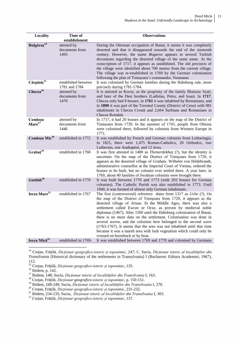
Studying the history of each locality,13
we see that the dates of their establishment are often
ambiguous and impossible to track or they are considered to be former medieval settlements (village
precincts, groups or clusters of villages) referred to by many local historians because of their local and
national patriotism – data gathered and processed because of administrative, economic, and financial
reasons by the Habsburgs immediately after Banat was occupied in 1716.
13
See full data on this topic in: R. Crețan, V. Frățilă, Dicționar geografico-istoric și toponimic al județului Timiș
[Geographical-historical and toponymic dictionary of the Timiș County] (Timișoara: Editura Universității de
Vest, 2007). We thank our friend Sorin Forțiu for verifying the accuracy of settlement attesting and
establishment.
Dorel Micle
Shadows in the Sand: Unfriendly Landscape in Archaeology
11
Locality Time of
establishment
Observations
Bulgăruș14
attested by
documents from
1493
During the Ottoman occupation of Banat, it seems it was completely
deserted and that it disappeared towards the end of the sixteenth
century. However, the name Bogaros appears in several Turkish
documents regarding the deserted village of the same name. At the
conscription of 1717, it appears as uninhibited. The old precincts of
the village were identified about 700 metres from the current village.
The village was re-established in 1769 by the German colonisation
following the plan of Timișoara’s commander, Neumann.
Cărpiniș15
established between
1781 and 1784
It was colonised by German families during the Habsburg rule, more
precisely during 1781-1784.
Checea16
attested by
documents from
1470
It is attested as Kocse, as the propriety of the family Blasiusz Szati,
and later of the Desi brothers (Ladislau, Petru, and Ioan). In 1717,
Checea only had 8 houses, in 1761 it was inhabited by Romanians, and
in 1890 it was part of the Torontal County (District of Cena) with 981
inhabitants in Checea Croată and 2,664 Serbians and Romanians in
Checea Română.
Comloșu
Mare17
attested by
documents from
1446
In 1717, it had 20 houses and it appears on the map of the District of
Timișoara from 1720. In the summer of 1743, people from Oltenia
were colonised there, followed by colonists from Western Europe in
1771.
Comloșu Mic18
established in 1772 It was established by French and German colonists from Lotharingia.
In 1825, there were 1,475 Roman-Catholics, 20 Orthodox, two
Lutherans, one Anabaptist, and 12 Jews.
Grabaț19
established in 1768 It was first attested in 1480 as Themerdekhaz (?), but the identity is
uncertain. On the map of the District of Timișoara from 1720, it
appears as the deserted village of Grabatz. Wilhelm von Hildebrandt,
administrative counsellor at the Imperial Court of Vienna, ordered the
houses to be built, but no colonist ever settled there. A year later, in
1769, about 40 families of Swabian colonists were brought there.
Gottlob20
established in 1770 It was built between 1770 and 1773 (with 203 houses for German
colonists). The Catholic Parish was also established in 1773. Until
1940, it was formed of almost only German inhabitants.
Iecea Mare21
established in 1767 The first (controversial) reference dates from 1317 as Uche (?). On
the map of the District of Timișoara from 1720, it appears as the
deserted village of Jetsaa. In the Middle Ages, there was also a
settlement called Ewcze or Ocse, as proven by medieval noble
diplomas (1467). After 1500 until the Habsburg colonisation of Banat,
there is no more data on the settlement. Colonisation was done in
several waves, and the colonists here belonged to the second wave
(1763-1767). It seems that the area was not inhabited until that time
because it was a marsh area with lush vegetation which could only be
crossed on horseback or by boat.
Iecea Mică22
established in 1769- It was established between 1769 and 1770 and colonised by Germans
14
Crețan, Frățilă, Dicționar geografico-istoric și toponimic, 247; C. Suciu, Dicționar istoric al localităților din
Transilvania [Historical dictionary of the settlements in Transylvania] I (Bucharest: Editura Academiei, 1967),
112. 15
Crețan, Frățilă, Dicționar geografico-istoric și toponimic, 135. 16
Ibidem, p. 142. 17
Ibidem, 148; Suciu, Dicționar istoric al localităților din Transilvania I, 163. 18
Crețan, Frățilă, Dicționar geografico-istoric și toponimic, p. 150-151. 19
Ibidem, 248-249; Suciu, Dicționar istoric al localităților din Transilvania I, 270. 20
Crețan, Frățilă, Dicționar geografico-istoric și toponimic, 231-232. 21
Ibidem, 234-235; Suciu, Dicționar istoric al localităților din Transilvania I, 303. 22
Crețan, Frățilă, Dicționar geografico-istoric și toponimic, 137.

Dorel Micle
Shadows in the Sand: Unfriendly Landscape in Archaeology
12
1770 during the second wave of the colonisations of Banat, also called the
Teresina Colonisation (Theresianische Ansiedlung) (when 150 families
of German agriculturists and artisans from Pfalz, Alsace, Lorena, and
Württemberg arrived). The colonists built 100 houses and a school.
The colony was called Klein Jetscha.
Jimbolia23
attested by
documents from
1333
It was colonised in 1766 by Germans and called Hatzfeld. Because it
was larger (405 houses) than the neighbouring localities (of only 50-
300 houses), it soon became a borough of economic importance
between Timișoara and Kikinda. This is why it became an
administrative centre for the neighbouring communes. From 1766 until
1778, it was a commune (during 1766-1768, a double commune:
Hatzfeld-Landestreu) of the Habsburg crown domain. Between 1778
and 1890, it was a borough in the Torontal County with the capital at
Becicherecul Mare (nowadays Zrenjanin in Serbia). The District of
Jimbolia (Zsombolyaijárás) (1890-1918) was formed of the communes
of Zsombolya (Jimbolia), Grabácz (Grabaț) and Vizezsdia (Vizejdia).
Between 1918 and 1924, Jimbolia was part of Yugoslavia (County of
Belgrade), as Dzombolj. After it was returned to Romania, on April 10,
1924, a new small rural district had its capital in Jimbolia.
Lenauheim24
attested by
documents from
1482
Attested in 1482 as Chathad (controversial). It was established in 1767
and colonised by Germans (Swabians). It was officially called Csatád
until 1926, when its name was turned into Lenauheim to honour the
poet Nikolaus Lenau, born there.
Lovrin25
attested by
documents from
1466
First attested in 1466 as Loranthalma, and later as Lorant or
Lorantfalva. In 1529, it was pillaged by the Ottomans, which caused
the population to flee the area. In 1564, it became the propriety of the
Bishop of Cenad. It was repopulated and inhabited by Serbians who
lived there until 1582. Another decline followed and it was deserted
once more. It was re-populated again in 1777 when the first Bulgarian
colonists came and re-named it Lovrinac. In 1779, the first German
colonists are mentioned (Banat Swabians from Cenad and other
localities from Banat), but most colonists were brought between 1784
and 1786. They had several privileges causing the Serbians and
Bulgarians to leave.
Periam26
attested by
documents from
1332
In 1332, it was mentioned by a certain Blasius de Priamus
representing his magister Imre of Becsei, son of Csata, of the Becse-
Gregor family, in a real estate transaction.
Pesac27
established in 1768 In 1399, it is mentioned in a Hungarian royal diploma as Puerseegh,
but it is not certain that it was Pesac. On November 16, 1768, it was
first attested in documents as a village established by the appointment
of Emperor Joseph II on his first visit to Banat. It was established by
the Romanians of Sânpetru Mare (Serbian) because of the repeated
flooding of the Aranca River.
Șandra28
established in 1833 It was established in 1833 as Alexanderhausen or Sándorháza, in
23
Ibidem, 58-60; Suciu, Dicționar istoric al localităților din Transilvania I, 317. 24
Crețan,Frățilă, Dicționar geografico-istoric și toponimic,246-247; Suciu, Dicționar istoric al localităților din
Transilvania I, 356. 25
Crețan, Frățilă, Dicționar geografico-istoric și toponimic, 253-254; Suciu, Dicționar istoric al localităților
din Transilvania I, 363. 26
Crețan, Frățilă, Dicționar geografico-istoric și toponimic, 306-308; C. Suciu (b), Dicționar istoric al
localităților din Transilvania [Historical dictionary of the settlements of Transylvania] II (Bucharest: Editura
Academiei, 1968), 34. 27
Crețan, Frățilă, Dicționar geografico-istoric și toponimic, p. 308-310; Suciu, Dicționar istoric al localităților
din Transilvania II, 35. 28
Crețan, Frățilă, Dicționar geografico-istoric și toponimic, 365-366; Suciu, Dicționar istoric al localităților din
Transilvania II, 167.

Dorel Micle
Shadows in the Sand: Unfriendly Landscape in Archaeology
13
honour of the name of the Bishop Alexander of Zagreb (the bishopric
owned the lands in the area). On January 1st, the bishop signed a
document allowing the 146 families of German colonists from the
neighbouring localities to settle here
Tomnatic29
attested at the
beginning of the
eleventh century
(Naggeuz, i.e.
Nagyősz)
After the Austrian occupation of Banat in 1716, the colonisation of the
area had begun. It was colonised in 1772 by poor French colonists
from Alsace-Lorena. Previously, Romanians and Serbians had lived
here.
Variaș30
attested by
documents from
1333
It was first attested in 1333 in a Papal indulgence as Varijas. It was a
royal domain (of the Hungarian Crown) until 1381, when it became
the property of Petrus and Nicolaus Maczedoniay. Ioannes
Maczedoniay donated it in 1454 to his widowed sister Anna Fargacs.
In 1464, it was attested as the property of Felix Fargacs. In 1466, it
was purchased for 500 gulden by the famous officer Ladislau Doczy, a
hero of the victory of Semendria against the Ottoman Empire. Doczy’s
residence was in Periam. It was deserted in the seventeenth century,
under the Ottoman rule. After the Ottomans were forced to leave the
area in the eighteenth century, it was colonised by Serbians and
Germans. In 1786, the Swabians from Banat arrived. In 1793, a
Serbian and a German school were established here.
Vizejdia31
attested by
documents from
1424
Medieval Vizejdia was the property of the Hungarian nobles of the
Vizesgyani family, hence the name. It was first attested in 1424 in a
noble diploma. During the Ottoman rule, it continued to be mentioned
in Ottoman documents as Wyses or Vizesgian (1647), a “locality of
Coumans and Romanian serfs.” It was later inhabited by Serbians who
were replaced by Hungarians, Germans, Bulgarians, and Romanians.
Uihei32
established in 1844 It is one of the most recent colonised localities in Banat. It was
established in 1844, more than 100 years after the beginning of
colonisations, by inhabitants of other neighbouring villages (Grabaț,
Bulgăruș, Lenauheim, Iecea Mare, Șandra) and of villages from Banat.
Most of the first colonists cultivated tobacco.
The Habsburg administration was interested in colonising all good agricultural areas, and it
developed a network of localities along the main medieval roads or built new roads across inhabited
areas using the already existing villages as milestones. Thus, along the communication line from
north-west Tisa, from Novi Kneževac via Mokrin and Comloșu Mare to south-east, to Becicherecu
Mic, they established new villages in the uninhabited area in Grabaț, Lenauheim, and Iecea Mare. All
three were along the new road linking the Tisa River with the Beregsău Rivulet (the only ones where
there was drinking water, fig. 20), although the locations of the new colonies were chosen to avoid the
former meanders of the Palaeomureș.
29
Crețan, Frățilă, Dicționar geografico-istoric și toponimic, 382-383; Suciu, Dicționar istoric al localităților din
Transilvania II, 200. 30
Crețan, Frățilă, Dicționar geografico-istoric și toponimic, 407-408; Suciu, Dicționar istoric al localităților din
Transilvania II, 237. 31
Crețan, Frățilă, Dicționar geografico-istoric și toponimic, 232-234; Suciu, Dicționar istoric al localităților din
Transilvania II, 253. 32
Crețan, Frățilă, Dicționar geografico-istoric și toponimic, 366; Suciu, Dicționar istoric al localităților din
Transilvania II, 215.

Dorel Micle
Shadows in the Sand: Unfriendly Landscape in Archaeology
14
Fig. 20. The new Habsburg colonies of Grabaț, Lenauheim, and Iecea Mare, with standardised urban structure, built
along the line linking Comloșu Mare and Becicherecu Mic, 1769-1772
(picture from Prima ridicare topografică militară iosefină - Josephinische (Erste) Landesaufnahme)
One can easily see in Fig. 20 that, around 1769 and 1772, most of the area consisted of grassland
and only a small area (along the newly-built roads) consisted of agricultural lands. Therefore, we can
suppose that, until the Habsburg colonisations, the area was a huge uncultivated steppe used
sporadically for animals.
V. Conclusions
This study highlighted the relationship between man and environment, subjecting to analyses.
Furthermore, this study is also a research method for archaeologists and historians. Among research
topics in the field of landscape archaeology, geomorphologic analysis, the analysis of the evolution of
hydrographic network and the analysis of soils are scientific tools which can clarify certain aspects of
the history of human communities and their habitats.
The extremely favourable geographical conditions of the Banat Plain from prehistory until today
show local features caused by different natural factors (swamps, sand dunes, etc.) which
archaeologists and historians tend to ignore. Therefore “legends” were born about the impossibility of
inhabiting the marsh areas, about the prehistoric economy which was based mainly on agriculture, or
about areas deserted because of frequent attacks by the barbarians, the Ottomans, the Tatars, etc.
As we show in this study, the explanation can sometimes be more prosaic and less spectacular, yet
more founded scientifically by cumulating certain geographical factors which are “unfriendly” to
human communities during times when they mainly relied on nature. Once modernity arrived with its
mechanical, hydraulic, electrical, etc. means, humans managed to model nature and exploit it
efficiently, improving geomorphologic, hydrographic, and soil conditions through land improvement,
desiccations, channelling, irrigations, etc. Therefore, the modern man no longer interpreted correctly
geographical conditions of the past.
This is the case of the present study – the lack of human settlements until the eighteenth century in
the sector between the Galațca Channel and the Beregsău Rivulet in the low Plain of Jimbola from
Western Romania. Although future systematic archaeological digging will complete the “white spots”
of the area, historians will have to consider the natural habitat conditions if they wish to correctly
interpret the distribution of the localities in the area.
Dorel Micle
Shadows in the Sand: Unfriendly Landscape in Archaeology
15
Until new archaeological findings in the area provide another explanation, we believe that the
sandy land and the lack of surface water were the causes of the lack of human settlements from
Prehistory until the Middle Ages in the area. Only modern times and new agricultural technologies are
to be thanked for the famous “Gottlob watermelons,” for the “Lovrin vegetables,” or for the “Teremia
brandy” produced here: this is the proof that sandy lands in the area were exploited efficiently after
being transformed from “unfriendly” lands into “useful” lands.
References
Crețan, R., Frățilă V. Dicționar geografico-istoric și toponimic al județului Timiș [Geographical-
historical and toponymic dictionary of the Timiș County]. Timișoara: Editura Universității de
Vest, 2007.
Geografia României. Regiunile pericarpatice [The Geography of Romania. The territories outside the
Carpathian Mountains], vol. IV. Bucharest: Editura Academiei Române, 1992.
Ianoș, Gh. Riscuri pedohidrice în partea central-vestică a Câmpiei Banatului [Pedohidric risks in the
central-western region of the Plain of Banat]. Timișoara: Editura Universității de Vest, 2008.
Micle, D. “Cenadul în contextul geografiei istorice. O analiză a evoluției condițiilor de habitat” [Cenad
in the context of geographical history. An analysis of the evolution of the habitat conditions]. In
Filosofia Sfântului Gerard de Cenad în context cultural și biografic [The Philosophy of Saint
Gerard of Cenad in cultural and biographical context], 158-173. Szeged: JATE Press, 2013.
Pop, Gr. P. Dealurile de Vest și Câmpia de Vest [The Western Hills and the Western Plain]. Oradea:
Editura Universității din Oradea, 2005.
Sipos, G. (ed.). Past, Present, Future of the Maros River . Timișoara: Editura Universității de Vest,
2012.
Suciu, C. Dicționar istoric al localităților din Transilvania [Historical dictionary of the settlements of
Transylvania] I. Bucharest: Editura Academiei, 1967.
_____. Dicționar istoric al localităților din Transilvania [Historical dictionary of the settlements of
Transylvaina] II. Bucharest: Editura Academiei, 1968.
Țărău, D., Luca M. Panoptic al comunelor bănățene din perspectivă pedologică [Panopticon of the
settlements of Banat from a pedological perspective]. (Timișoara: Marineasa, 2002.