
SGS Pinecrest Lake Level Plan 5-17-10 - State Water
36
PINECREST RESERVOIR LAKE LEVEL STUDY PLAN Spring Gap-Stanislaus Project (FERC Project No. 2130) Prepared By: May 2010
Transcript of SGS Pinecrest Lake Level Plan 5-17-10 - State Water
PINECREST RESERVOIR LAKE LEVEL STUDY PLAN
Spring Gap-Stanislaus Project (FERC Project No. 2130)
Prepared By:
May 2010

Pinecrest Reservoir Lake Level Study Plan i May 2010
Spring Gap-Stanislaus Project, FERC Project No. 2130 © 2010, Pacific Gas and Electric Company
TABLE OF CONTENTS
Page
1.0 Introduction........................................................................................................................1
1.1 License Requirement ...........................................................................................................1
1.2 Consultation .........................................................................................................................1
2.0 Goals and Objectives .........................................................................................................2
3.0 Study Area ..........................................................................................................................2
4.0 Methods...............................................................................................................................3
4.1 Task 1 – Obtain and Review Existing Information .............................................................5
4.2 Task 2 – Collect Recreation Data and Conduct Photo Survey ............................................6
4.3 Task 3 – Public Meeting ......................................................................................................7
4.4 Task 4 – Tabulate Data and Develop Lake Level Graphics ................................................8
4.5 Task 5 – Analyze Potential Recreation Impacts to the Seven Recreational Features .........8
4.6 Task 6 – For Identified Impacts, Identify Potential Mitigation Measures and Preliminary
Concept Descriptions. ..........................................................................................................9
5.0 Schedule ..............................................................................................................................9
6.0 Analysis .............................................................................................................................10
7.0 Consistency With Generally Accepted Practice............................................................10
8.0 Products ............................................................................................................................10
8.1 Draft Lake Level Study Report..........................................................................................10
8.2 Final Lake Level Study Report ..........................................................................................11
9.0 References.........................................................................................................................11

Pinecrest Reservoir Lake Level Study Plan ii May 2010
Spring Gap-Stanislaus Project, FERC Project No. 2130 © 2010, Pacific Gas and Electric Company
APPENDICES
Appendix A Consultation Documentation
Pinecrest Reservoir Lake Level Study Plan 1 May 2010
Spring Gap-Stanislaus Project, FERC Project No. 2130 © 2010, Pacific Gas and Electric Company
1.0 INTRODUCTION
On June 16, 2009, the State Water Resources Control Board (State Water Board) issued a revised
Section 401 Water Quality Certification (Revised Certification) for the Spring Gap-Stanislaus
Hydroelectric Project (Federal Energy Regulatory Commission [FERC] Project No. 2130)
(Project). The Revised Certification was then included in a FERC Order Clarifying Prior Orders
issued on January 13, 2010 (130 FERC § 62,036). The Revised Certification, among other
things, requires preparation of a study plan (Plan) to determine the minimum operating lake level
elevation for Pinecrest Reservoir that protects certain specific recreational uses for the period
ranging from the end of spill through Labor Day. This study plan was prepared to comply with
the Lake Level Study requirements in the Revised Certification.
1.1 LICENSE REQUIREMENT
Revised Certification Condition No. 4 reads as follows:
“Within nine months of license issuance the Licensee shall submit a Pinecrest Reservoir minimum lake-level study plan (Lake-level Study), developed in consultation with the USFS, DFG, State Water Board staff, and TUD, to the Deputy Director for modification and approval that will determine the minimum Pinecrest Reservoir elevation between End of Spill through Labor Day that protects recreational uses (specifically, Day-Use Area beaches, the marina to just east of the handicap fishing access, and other areas as directed by the State Water Board). Licensee shall complete the Lake-level Study as approved by the Deputy Director by the end of the first full calendar year after license issuance. The completed study shall be provided to the USFS, DFG, State Water Board staff, and TUD for review and comment. By March 1 of the year following completion of the Lake-level Study, the Licensee shall submit to the Deputy Director for approval the completed study, including any comments received. Within six months of approval of the Lake-level Study by the Deputy Director, Licensee may request the State Water Board modify the target elevation of 5,608 feet based on the results of the Lake-level Study, after the State Water Board provides notice to affected parties.”
1.2 CONSULTATION
Revised Certification Condition 4 requires that this Plan be developed in consultation with the
USDA-Forest Service (Forest Service), California Department of Fish and Game (CDFG), State

Pinecrest Reservoir Lake Level Study Plan 2 May 2010
Spring Gap-Stanislaus Project, FERC Project No. 2130 © 2010, Pacific Gas and Electric Company
Water Resources Control Board (State Water Board), and Tuolumne Utilities District (TUD). A
draft plan was developed by Pacific Gas and Electric Company (PG&E) and provided to the
agencies on October 9, 2009. Comments were received from the State Water Board, Forest
Service, and TUD. On December 9, 2009, a consultation meeting was held with the commenting
agencies to discuss the Plan and responses to comments. The comments and responses to those
comments are provided in Appendix A, as are the meeting notes from the December 9
consultation meeting. Comments on the draft Plan are addressed in revisions incorporated in the
current version.
2.0 GOALS AND OBJECTIVES
The purpose of the Pinecrest Reservoir Lake Level Study is to “determine the minimum
Pinecrest Reservoir elevation between End of Spill through Labor Day that protects recreational
uses (specifically, Day-Use Area beaches, the marina to just east of the handicap fishing access,
and other areas as directed by the State Water Board)” for the recreational uses identified in the
Revised Certification.
3.0 STUDY AREA
Pinecrest Reservoir is located off of Highway 108, about 25 miles north-east of Sonora.
Pinecrest Reservoir is on the South Fork of the Stanislaus River. The study area for this Plan
consists of the identified recreational features on the southwest side of Pinecrest Reservoir, and
will focus on Day Use Area beaches, handicap fishing access, the marina, and the associated
boat ramp. Based on consultation with the State Water board, Forest Service, and TUD, a total
of seven (7) recreation features will be evaluated under this Study as follows:
1. Gas Dock and Slips
2. Boat Ramp and Courtesy Dock
3. Designated/Buoyed Swim Area

Pinecrest Reservoir Lake Level Study Plan 3 May 2010
Spring Gap-Stanislaus Project, FERC Project No. 2130 © 2010, Pacific Gas and Electric Company
4. Mixed Day Use Area (adjacent to the Swim Area)
5. Americans with Disabilities Act (ADA) Accessible Fishing Platform
6. Overflow Area, South Shore
7. Overflow Area, North of Marina
Figure 1 presents a map identifying the seven recreational features under consideration in this
Study.
4.0 METHODS
This section discusses our methodology for completing the study, upon approval of this Plan.
The study consists of six primary tasks: 1) obtain and review existing information; 2) collect
recreation data and conduct photo survey; 3) tabulate data and develop lake level graphics; 4)
analyze data for potential impacts to recreation; and 5) analyze potential recreation impacts to
the seven recreational features identified in Study Area. Once the drawdown effects are
identified, mitigation measures, focused on maintaining the usability of the specific recreation
features at a wider range of reservoir elevations, will be identified and preliminary descriptions
developed. Detailed plans and an implementation schedule will be developed for those measures
selected for implementation; however, the plans and schedule are not included as part of this
study.
Focusing on the seven recreation features shown in Figure 1, this study will identify recreation
activities and usability characteristics from a lake level elevation of 5,617 ft msl to 5,610 ft msl
to use as a baseline. This baseline will be compared to use characteristics at those seven
locations at lake level elevations between 5,608 ft msl and 5,595 ft msl. Effects on recreational
usability and uses will be assessed incrementally using a combination of three-dimensional (3D)

Pinecrest Reservoir Lake Level Study Plan 4 May 2010
Spring Gap-Stanislaus Project, FERC Project No. 2130 © 2010, Pacific Gas and Electric Company
Figure 1. Pinecrest Reservoir Lake Level Study Recreational Features Included in the Analysis.
Pinecrest Reservoir Lake Level Study Plan 5 May 2010
Spring Gap-Stanislaus Project, FERC Project No. 2130 © 2010, Pacific Gas and Electric Company
surface modeling and recreation usability data. Between 5,617 ft msl and 5,610 ft msl lake level
elevation data and topography in relation to recreational features for recreational usability will be
assessed at one-foot increments, while recreation use will be assessed at two-foot intervals.
Specifically, baseline recreational usability data will be assessed at 5,617; 5,615; 5,613; 5,611;
and 5,610 ft msl. From 5,608 ft msl to 5,595 ft msl, both elevation data in relation to the seven
recreation features and recreation usability data will be assessed at one-foot intervals.
The Plan will be implemented through the following tasks:
Task 1 - obtain and review existing information;
Task 2 - collect recreation data and conduct photo survey;
Task 3 - public meeting;
Task 4 - tabulate data and develop lake level graphics;
Task 5 - analyze potential recreation impacts to the seven recreational features; and
Task 6 - for identified impacts, identify potential mitigation measures and preliminary
concept descriptions.
These tasks are discussed in detail below.
4.1 TASK 1 – OBTAIN AND REVIEW EXISTING INFORMATION
Task 1 consists of the following:
Compilation and review of background information, such as historical operations and
recreational use, including any data previously collected by the Forest Service and
PG&E.
Preparation of a base map showing the seven specific recreational features in relation to
lake topography. The base map will be at a 40 foot scale with one foot contour intervals
showing the seven recreation features shown in Figure 1. The source of this map will be
the 2009 aerial orthophoto and digital terrain data provided by TUD. This will be used to
evaluate usability of the seven features.

Pinecrest Reservoir Lake Level Study Plan 6 May 2010
Spring Gap-Stanislaus Project, FERC Project No. 2130 © 2010, Pacific Gas and Electric Company
Establish photographic survey points to contribute to the evaluation of recreational
usability and use. PG&E will meet with representatives from the State Water Board,
CDFG, Forest Service, and TUD in the field to select and agree upon specific locations
for data collection.
PG&E in consultation with the agencies will identify and agree upon recreational uses
and usability criteria for the seven recreational features and impact criteria against which
all potential lake level elevation impacts will be measured.
4.2 TASK 2 – COLLECT RECREATION DATA AND CONDUCT PHOTO SURVEY
Task 2 consists of collecting data to evaluate the effect of reservoir drawdown on the seven
identified recreation features at Pinecrest Lake. Data will be collected at lake level elevations
below 5,617 ft msl during the summer and fall of 2010.
Field staff will collect data important to better understanding the usable range (lake levels) of the
recreation features. Data will be collected in conjunction with the photo surveys so that the
observations and measurements will occur incrementally as the reservoir level decreases. A field
data sheet will be developed and will include but not be limited to the following metrics:
Distance from recreation facility to the water, and depth of water
Soil characteristics (e.g. is the area passable without going through mud flats)
Slope (e.g. is the slope too steep as to diminish access)
The amount of recreation use occurring (if any) at the recreation feature
Distance from shade, trees
Field staff also will note the time of day, weather (rain, clear, etc.) air temperature, and presence
of wind, which will be important since a low use day may be attributed to rain and not just to
low reservoir levels. In addition to the quantitative measures, qualitative observations will be
made regarding facility and area usability. Field staff will be instructed to note and photo
document potential barriers to access or factors limiting usability that may emerge as the lake

Pinecrest Reservoir Lake Level Study Plan 7 May 2010
Spring Gap-Stanislaus Project, FERC Project No. 2130 © 2010, Pacific Gas and Electric Company
level decreases. Other items to be considered include if and when the boat ramp is no longer
functional, if and when the buoyed swim area loses functionality, if and when the boaters are no
longer able to fuel at the docks, and whether previously inundated areas remain usable and the
extent of usability.
Along with the recreation data, photographic surveys will be conducted at each of the seven
recreational features at the full range of lake level elevations. The photo-points will be
documented using a Trimble resource grade global positioning system with external antenna
(GPS). These photo-points will be used to monitor the characteristics and usability of the
selected recreational features, pursuant to the criteria established in Task 1 at each incremental
lake level elevation. The photo-point surveys will be initiated after cessation of spill at an
elevation of approximately 5,617 ft msl, and conducted at 2 ft interval down to a lake level
elevation of 5,610 ft msl, and one foot intervals from 5,608 ft msl down to 5,595 ft msl, as
described in Section 4.0, above. Lake levels below 5,608 ft msl can occur after Labor Day
depending on water year type, when recreational use is expected to decrease. To avoid the bias
of relying on recreational use that has a significant seasonal component, usability of the seven
recreational features will be emphasized in the analysis of lake levels from 5,608 to 5,595 over
the actual amount of use observed.
Topographic surveys will be made in selected areas associated with the seven recreation features.
These surveys will be conducted to verify elevations and to obtain additional data to supplement
the topography derived from TUD's orthophotography and digital terrain information.
4.3 TASK 3 – PUBLIC MEETING
PG&E will hold a facilitated public meeting at the direction of the State Water Board. The
meeting will be held in Sonora in April or May of 2010. The objective of this meeting is to
obtain feedback on recreational uses as noted in Task 1.
Pinecrest Reservoir Lake Level Study Plan 8 May 2010
Spring Gap-Stanislaus Project, FERC Project No. 2130 © 2010, Pacific Gas and Electric Company
4.4 TASK 4 – TABULATE DATA AND DEVELOP LAKE LEVEL GRAPHICS
All recreation data collected will be tabulated. Photo-point locations and profiles will be
mapped. Photographs taken at each photo-point will be summarized to illustrate changes to the
selected recreational features resulting from lake level elevations being assessed.
Using the 2009 aerial topography and digital orthophoto provided by TUD, a digital terrain
model of the lake bottom will be prepared along with 3D graphics to depict and visualize
different lake elevations relative to each of the seven recreation features. The digital terrain
model will be used to generate lake level graphics including plan view figures and transect
profiles perpendicular to the shoreline. At each incremental lake level elevation studied, at least
one plan view figure and one profile will be developed at each of the recreation features to
illustrate functionality with respect to that lake level.
4.5 TASK 5 – ANALYZE POTENTIAL RECREATION IMPACTS TO THE SEVEN RECREATIONAL
FEATURES
Potential impacts to the recreational usability of the seven recreational features will be assessed
for lake levels from 5,608 ft msl to 5,595 ft msl compared to the baseline (recreational usability
within the range 5,617 to 5,610 ft msl). Baseline data for recreational usability will be collected
and analyzed at two foot intervals as follows: 5,617; 5,615; 5,613; 5,611; and also at 5,610 ft
msl. Baseline elevation data will be analyzed at one foot intervals between 5,617 and 5,610 ft
msl. One foot intervals will be analyzed from 5,608 to 5,595 ft msl. Recreation usability will be
evaluated for agreed upon recreational uses as determined in Task 1. The results of the field data
collection and photographic surveys will be compared with the lake level digital elevation model
and graphics to assess the potential impact of reservoir drawdown at the seven identified
recreation features. Lake elevations where functionality of recreation features are diminished, or
access is reduced will be identified. Critical reservoir levels (such as when the boat ramp may
no longer be accessible) also will be identified.
Data analysis is discussed in detail in Section 6.0.

Pinecrest Reservoir Lake Level Study Plan 9 May 2010
Spring Gap-Stanislaus Project, FERC Project No. 2130 © 2010, Pacific Gas and Electric Company
4.6 TASK 6 – FOR IDENTIFIED IMPACTS, IDENTIFY POTENTIAL MITIGATION MEASURES
AND PRELIMINARY CONCEPT DESCRIPTIONS.
Once the drawdown effects are identified, mitigation measures will be identified and preliminary
descriptions will be developed. Mitigation measures will focus on the seven specific recreation
features to increase usability at a wider range of reservoir elevations.
Detailed mitigation plans and an implementation schedule will be developed for those measures
selected for implementation; however, without knowing the scope of potential mitigation, the
plans and schedule are not included as part of this study.
5.0 SCHEDULE
This section summarizes our planned schedule for implementation of the study and preparation
and submittal of the Pinecrest Lake Level Study Report (Study Report), pending approval of this
Plan.
Date Deliverable
Spring 2010 Hold facilitated meeting public meeting at the direction of the State Water Board. The objective of the meeting is to obtain further feed back on recreational uses as noted in Task 1.
Spring/Summer 2010 Photo-point consultation and location selection meeting in the field with resource agencies. Begin photo-point survey after end-of-spill at a lake level elevation of approximately 5,617 ft msl.
Summer-Fall 2010 Conduct photo-point surveys at 2 ft intervals from 5,617 (ft) msl to 5,610 ft msl, and at one ft intervals from 5,610 ft msl to 5,595 (ft) msl. Supplementary surveying for recreation features.
Fall 2010 Conduct additional ground survey (data collection) from 5,617 ft msl to 5,595 (ft) msl.
December 2010 Plan for, and schedule meeting with resource agencies in advance of preparation of final Study Report.
January 14, 2011 Draft Study Report submitted to the State Water Board, CDFG, Forest Service, and TUD for review and comment
February 14, 2011 (or 30-days after receipt of draft Study Report)
Agency comments of draft Study Report due to PG&E.
March 1, 2011 Submit final Study Report, after comments from agencies are addressed, revised Study Report submitted to State Water Board Deputy Director for review and approval.

Pinecrest Reservoir Lake Level Study Plan 10 May 2010
Spring Gap-Stanislaus Project, FERC Project No. 2130 © 2010, Pacific Gas and Electric Company
6.0 ANALYSIS
For each of the recreational features analyzed, the study will describe the relevant recreational
elements (i.e., available beach area, bottom of boat ramp, accessibility of fishing platform, etc.)
relative to lake level elevations of the Study. Profile figures developed during the analysis will
graphically depict the features and incremental lake level elevations.
The analysis will include an evaluation of the observed relationship between lake level elevation
and recreation usability for the seven recreational features and assessed using the impact criteria
established in Task 1.
The photo-points will be used to monitor the recreational features at lake level elevations below
5,617 ft msl. The photo-point survey will provide pictures of each recreational feature in
conjunction with all incremental lake level elevations as described above. Photos will be
provided as an appendix in the Lake Level Study. The recreational features and, the potential
impacts will be presented in a tabular format.
7.0 CONSISTENCY WITH GENERALLY ACCEPTED PRACTICE
The Lake Level Study will be performed according to accepted technical and data collection
practices. A high precision GPS will be used to measure location and supplemented with
standard survey equipment as needed. All photo-points will be shot from a tripod-mounted
digital camera at multiple focal lengths (to be determined on site) and high depth of field to
provide clear views of relevant features.
8.0 PRODUCTS
8.1 DRAFT LAKE LEVEL STUDY REPORT
A draft Study Report will be prepared and submitted to the State Water Board, Forest Service,
CDFG, and TUD for review and comment. This draft Study Report will:

Pinecrest Reservoir Lake Level Study Plan 11 May 2010
Spring Gap-Stanislaus Project, FERC Project No. 2130 © 2010, Pacific Gas and Electric Company
Document recreational features at lake level elevations below 5,617 ft msl to 5,595ft msl.
Data collected from 5,617 ft msl to 5,610 ft msl will be considered baseline condition.
Evaluate, in accordance with the criteria established in Task 1 and Section 6.0, the
potential impacts to recreational features at elevations between 5,608 ft msl and 5,595 ft
msl.
Identify possible mitigation measures for potential impacts to recreational usability below
a lake level of 5,608 ft msl, pursuant to criteria established in Task 1 and Section 6.0.
The recreational features, the potential impacts, and measures to mitigate potential
impacts, will be presented in a tabular format.
The agencies will be provided with a 30-day review and comment period. Comments will be
due to PG&E at the conclusion of the 30-day agency review and comment period.
8.2 FINAL LAKE LEVEL STUDY REPORT
Comments received from the participating agencies will be addressed and a final Study Report
prepared. The activities in this task include:
Review and address comments.
Incorporate appropriate revisions into a final Study Report.
PG&E will meet with commenting agencies prior to submission of final Report. Send
final Study Report to the Deputy Director of the State Water Board for approval by
March 1, 2011.
9.0 REFERENCES
State Water Resources Control Board (State Water Board). 2009. Order WR 2009-0039. Order
Granting Permission for Reconsideration and Authorizing Issuance of a revised Water
Quality Certification. Pacific Gas and Electric Company, Spring-Gap-Stanislaus
Hydroelectric Project. Federal Energy Regulatory Commission Project No. 2130.

Pinecrest Reservoir Lake Level Study Plan May 2010
Spring Gap-Stanislaus Project, FERC No. 2130 © 2010, Pacific Gas and Electric Company
APPENDIX A
CONSULTATION DOCUMENTATION

Pinecrest Reservoir Lake Level Study Plan A-1 May 2010
Spring Gap-Stanislaus Project, FERC Project No. 2130 © 2010, Pacific Gas and Electric Company
Page # Section, Topic or Issue
Paragraph or Bullet
Comment Number: Comments (if a direct edit, indicate with single line strike-out marks)
Response to Comments
Written Comments Received from the State Water Board on November 3, 2009
2 2.0
Goals and Objectives
State Water Board
Comment #1
As stated, the goal of the study is to determine the minimum reservoir elevation(s) necessary to protect recreational users. Condition #4 specifically lists day-use beaches and other areas as directed by the State Water Board. State Water Board staff has determined there are other facilities/structures that are sensitive to reservoir surface elevation. Water surface elevations can impact usability of the boat ramp, gas/boat docks, and expose rocks that are obstacles to boating. These facilities/structures must be included in the Plan.
Adopted. Based on consultation with the State Water board, Forest Service, and TUD on 12-9-09, a total of seven (7) recreation features will be evaluated under this Study. See response to Comment #55.
2 3.0
Study Area
State Water Board Comment #2
The study area needs to be expanded to include the area northeast of the marina. The U.S. Forest Service recently banned dogs from the main beach and day-use area. Dog owners are now using the beach northeast of the marina and east of the handicap fishing access. The area northeast of the marina is also used for mooring boats. As stated above, the study area also needs to include certain areas of the lake where boulders become exposed and cause a navigation hazard. The boulders impact both sail boats and motor boats. The exact area of study should be defined through consultation with long-term recreational users of the lake. Collection of elevation data on those boulders identified through consultation will be important for identification of minimum water surface elevation.
Adopted. See response to Comment #1.
2 4.0
Methods
State Water Board Comment #3
The Plan proposes to assess three water surface elevations between 5,608 and 5,604 feet. This range of elevations and two-foot stage changes between elevations will not yield information with adequate resolution for decision-making. The objective of the study is to determine the reservoir elevation(s) at which user satisfaction diminishes or recreational use is impacted. The study should start at full reservoir pool and measure at a minimum of one foot elevation steps down to a level of 5,600 feet or lower. The lowest elevation for study may be determined after consultation with recreational users and reviewing existing information.
Adopted. Based on consultation with the State Water board, Forest Service, and TUD on 12-9-09, the Study will assess recreation use from a lake level of 5,617 ft msl to 5,595 ft msl. See response to Comment #51.
2 4.0
Methods
State Water Board Comment #4
Five transects may not provide adequate information on the relationship between beach use and changes in recreational opportunities at various water surface elevation. A more robust tool such as a land based survey (under the supervision of a licensed surveyor) or photogrammetry may be required.
Adopted. Using the 2009 aerial topography and digital orthophoto provided by TUD, a digital terrain model of the lake bottom will be prepared along with 3D graphics to depict and visualize different lake elevations relative to each of the seven recreation features.
2 4.0
Methods
State Water Board Comment #5
The Plan includes development of up to 10 photographic survey points at the three proposed water surface elevations. Photographic surveys should be collected at one foot elevation steps as described above. The elevation at which the boat ramp and gas/boat docks become unusable, and the elevation at which rocks are exposed, should be discrete points that are also measured and photographed.
Adopted with Modification. The photo-point surveys will be initiated after cessation of spill at an elevation of approximately 5,617 ft msl, and conducted at 2 ft intervals down to a lake level elevation of 5,610 ft msl, and one foot intervals down to 5,595 ft msl.

Pinecrest Reservoir Lake Level Study Plan A-2 May 2010
Spring Gap-Stanislaus Project, FERC Project No. 2130 © 2010, Pacific Gas and Electric Company
Page # Section, Topic or Issue
Paragraph or Bullet
Comment Number: Comments (if a direct edit, indicate with single line strike-out marks)
Response to Comments
2 4.0
Methods
State Water Board Comment #6
Recreational surveys conducted during the relicensing, and information submitted by the Friends of Pinecrest show that there are many long-time users of the lake. Completion of the Plan will require surveys of cabin owners, campers, day users, and organizational campers. Historic knowledge of recreational lake users is critical to establishing the water surface elevations that support each of the recreational uses. Information from long-time users is necessary to identify hazard rocks, and determine conditions that make beaches unusable for each recreational use. The Plan should describe how surveys of long-time users will be incorporated. PG&E should hold a public meeting to gather additional information. Stakeholders that should be invited to the meeting include the Pinecrest Lake Resort, Friends of Pinecrest, and the Central Sierra Environmental Resource Center.
Adopted with Modification. Based on consultation with the State Water board, Forest Service, and TUD on 12-9-09, user surveys are not required. Instead, a combination of quantitative and qualitative data will be collected to track the effect of reservoir drawdown on usability of the recreation features. However, a public outreach meeting to discuss the Plan to be convened by the State Water Board is now included in the Plan. See response to Comment #64.
2 4.0
Methods
State Water Board Comment #7
Existing information should be collected and used in the development of the final Plan. Tuolumne Utilities District conducted a limited survey of the reservoir that could be useful in developing the final Plan. The U.S. Forest Service may also have additional information on recreational use and reservoir elevation.
Adopted. Task 1 consists of compilation and review of background information, such as historical operations and recreational use, including any data previously collected by the Forest Service and Licensee. Also see response to Comment #4.
State Water Board
Comment #8
In addition to identifying the minimum reservoir elevation(s) that supports recreational uses, the final report should include recommendations for improvements that can protect recreational uses at lower reservoir elevations. When conducting the study the consultants should, if possible, identify the specific impact to recreational use below the identified minimum reservoir elevation. Consultation with recreational users will be an important part of developing recommendations for improvements. When possible, the reservoir minimum reservoir elevation that can be achieved with improvements should be identified.
Not Adopted. See response to Comment #6.
Written Comments Received from the Tuolumne Utilities District (TUD) on
November 5, 2009
TUD
Comment #9
PG&E's first draft only studied reservoir elevation to 5,604, whereas the 401 Certification required PG&E to "determine the minimum Pinecrest Reservoir elevation between End of Spill and Labor Day that protects recreational uses." Thus, using a minimum elevation of 5,604 inappropriately predetermines the outcome of the study. However we do recognize the need for a floor, otherwise the study could go on forever, so we chose 5,595, which is slightly lower than reservoir elevation during the 1976 drought. Due to the increased instream flows required in the 401 Certification, evaluation to the slightly lower elevation is justified. . .
Adopted. See response to Comment #3.
TUD
Comment #10
Added a requirement that mitigation measures will be identified that will allow the reservoir elevation to be dropped further, and still preserve recreational uses, than what would be possible without those mitigation measures. This change is consistent with discussions and agreements reached during preparation of the final 401 Certification conditions.
Adopted with Modification. Section 4.0 states that “once the drawdown effects are identified, mitigation measures will be identified and preliminary descriptions will be developed.”

Pinecrest Reservoir Lake Level Study Plan A-3 May 2010
Spring Gap-Stanislaus Project, FERC Project No. 2130 © 2010, Pacific Gas and Electric Company
Page # Section, Topic or Issue
Paragraph or Bullet
Comment Number: Comments (if a direct edit, indicate with single line strike-out marks)
Response to Comments
TUD
Comment #11
Expanded the generation and resolution of data to include the production of a base map with a 40-foot scale and single foot contours and a digital terrain model. The map and model will help establish the recreational facilities impacted by each single foot drop in elevation and will be of adequate resolution to provide for knowledge based decision making.
Adopted. See response to Comment #4.
REVISIONS MADE IN THE PLAN BY TUD
2 3.0
Study Area 1st Paragraph
TUD Comment #12
A total minimum of five (5) facilities/recreational areas will be evaluated under this study.
Adopted with Modification. See response to Comment #1.
2 3.0
Study Area 2nd Paragraph
TUD Comment #13
Figure 1 presents a map identifying the initial five (5) recreational facilities and uses under consideration in this study plan.
Adopted with Modification. See response to Comment #1.
2 4.0
Methods
TUD Comment #14
The Lake Level Study consists of five primary four tasks: . . .
Adopted with Modification. See response to Comment #1.
2 4.0
Methods
TUD Comment #15
. . . . and 4) analyze the information, and 5) identify measures to be implemented to mitigate any potential impacts to specified recreation uses, the implementation of which would allow the reservoir surface elevation to be further lowered.
Adopted with Modification. See response to Comment #10.
3 4.0
Methods
TUD Comment #16
This study plan will assess evaluate the incremental effect of lowering the minimum reservoir water surface elevations below 5,6171 in the range of 5,608 to 5,604 feet (ft) mean sea level (MSL). For each foot below 5,617 (ft), the plan will describe the effect on the selected recreational facilities and uses, if any, and will identify measures that will mitigate that effect, according to established criteria, to an acceptable level, if necessary. The plan will continue to reduce the examined elevation until elevation 5,595 (ft) MSL.
Adopted. See response to Comment #3.
4 4.0
Methods 2nd Bullet
TUD Comment #17
Task 1 - Obtain/Review Existing Information Task 1 consists of the following:
Identification of data gaps (if any).
Adopted.
1 Lake elevation values used in this study and report reference the Pinecrest lake elevations that are used in PG&E lake level measurements and reference the spillway crest as 5611.5 feet.

Pinecrest Reservoir Lake Level Study Plan A-4 May 2010
Spring Gap-Stanislaus Project, FERC Project No. 2130 © 2010, Pacific Gas and Electric Company
Page # Section, Topic or Issue
Paragraph or Bullet
Comment Number: Comments (if a direct edit, indicate with single line strike-out marks)
Response to Comments
5 4.0
Methods 1st Paragraph
TUD Comment #18
The base map shallTask 2 - Data Collection/Survey Task 2 consists of collecting elevation data at five locations among the recreational areas listed above. Data will be collected at three reservoir water surface elevations between 5,604 and 5,608 ft MSL. Data collection activities in this task include:
Plan and coordinate a 40 foot scale one foot contour interval map. Meet site visit with representatives from the State Water Board,
California Department of Fish and Game (CDFG), US Department of Agriculture-Forest Service (USDA-FS), and Tuolumne Utilities District (TUD) to; a) establish agreement on recreational facilities to be surveyed; b) establish agreement on photographic survey points; c) establish recreation usability and impact criteria against which all potential water surface elevation impacts will be measured; and d) identify data gaps (if any). confirm photo point locations to assess recreational facilities and uses.
Adopted. Section 4.1 states “Licensee will meet with representatives from the State Water Board, CDFG, Forest Service, and TUD in the field to select specific locations for data collection.,” and “Licensee in consultation with the agencies will identify recreational uses and usability criteria of the recreational features and impact criteria against which all potential lake level elevation impacts will be measured.” Also see response to Comments #1 related to number of recreation features to be included in this study.
5 4.0
Methods 1st and 2nd Paragraph
TUD Comment #19
Task 2 – Data Collection/Survey Task 2 consists of collecting Collect elevation data at the agreed upon recreational facilities and uses identified in Task 1. Data will be collected at all reservoir water surface elevations below 5,617 ft MSL, that are accessible during winter of 2009 and fall of 2010. (removed bullet formatting from paragraph) Data collection activities in this task include:
Collect data at the five selected recreational facilities and locations (Figure 2). The digital terrain modelsurvey will be used to generate five (5) transect profiles perpendicular to the shoreline for agreed upon recreational features. Profiles will be developed, at minimum, for the Day Use Area beach (2 profiles), the marina, boat ramp, and the handicap fishing access. The agreed uponRelevant recreational facilities and usesfeatures will be identified and measured as illustrated in Figure 2.
Adopted with Modification. See response to Comments #1 and #4.

Pinecrest Reservoir Lake Level Study Plan A-5 May 2010
Spring Gap-Stanislaus Project, FERC Project No. 2130 © 2010, Pacific Gas and Electric Company
Page # Section, Topic or Issue
Paragraph or Bullet
Comment Number: Comments (if a direct edit, indicate with single line strike-out marks)
Response to Comments
6 4.0
Methods 1st Paragraph
TUD Comment #20
The data collection and color aerial ortho-photo ground survey will be performed between in the winter of 2009/10 and fall (October 2010). Fall and winter is a key time for this survey because the water surface elevation in the lake is low and will allow direct measurement of elevations. to the lowest elevation to be considered, 5,604 ft MSL. By conducting the survey when the lake is at a lower elevation, The base map field crews can measure attributes along the transects that may affect recreational use that are otherwise submerged during the recreation season. Also, there is a relatively low risk of weather delays at this time, compared to be 40 foot scale, one foot Contour Interval mapping, later in the year. Each transect profile will be measured beginning above the maximum operational elevation of the reservoir. Each transect will be measured with an overall color aerial ortho-photo of the Pinecrest lake shore study area. The extent of Trimble® resources grade Global Positioning System (GPS) unit. Each transect will be profiled from the upslope endpoint down to the water's edge. GPS data will permit mapping will include the area just northeast the profile locations relative to the recreation areas of the boat dock/marina, to just east of the handicap fishing access. Prominent boulders and stumps in these recreational areas will be field located horizontally and vertically, reservoir using a geographic information system (GIS) will be developed to manage the field data that is collected. The 40 foot scale one foot Contour Mapping and color ortho photo. Each profile will include measurement of the water surface elevation, which will be used as a base map in the GIS. Transect and other data that is collected as part to link transect measurements to reservoir operations. Water surface elevations, as measured by PG&E, for the days and times of the survey this study will be used incorporated in the GIS to assist in analysis.
Adopted with Modification. See response to Comments #1, #4 and #5.
8 4.0
Methods 2nd Paragraph
TUD Comment #21
Develop a photographic survey of select recreational features at the full range of lake elevations. The being considered. Up to 10 photo-points will be selected in Task 1 consultation with the resource agencies and will be measured by GPS. These photo-points will be used to monitor the characteristics and usability of the selected recreational features, pursuant to the criteria established in Task 1 at the different water surface elevations. The photo-point survey will be initiated after cessation of spill at an elevation of about 5,6175,608 ft MSL at the locations selected in consultation with the resource agencies. This will be followed by photo-point surveys at reservoir water surface elevations at each (one) foot elevation drop below 5,617of approximately 5,606 and at 5,604 ft MSL.
Adopted with Modification. See response to Comments #5.
9 4.0
Methods 1st Bullet
TUD Comment #22
Task 3 - Tabulate Field Data and Map Photo-point locations and profiles will be mapped. The data will be
entered into a GIS platform to plot the profile locations in plan view and in profile. A digital terrain model of the lake bottom will be prepared along with 3D graphics to depict and visualize different lake elevations relative to day use beach area, handicap fishing access and boat dock marina facility.One site map and five (5) profiles from these data will be developed during the analysis.
Adopted. See response to Comment #4.

Pinecrest Reservoir Lake Level Study Plan A-6 May 2010
Spring Gap-Stanislaus Project, FERC Project No. 2130 © 2010, Pacific Gas and Electric Company
Page # Section, Topic or Issue
Paragraph or Bullet
Comment Number: Comments (if a direct edit, indicate with single line strike-out marks)
Response to Comments
9 5.0
Schedule
TUD Comment #23
Date Deliverable
Spring/Summer 2010
Photo-point consultation and location selection meeting in the field with resource agencies. Begin photo-point survey after end-of-spill at a water surface elevation of approximately 5,617 5,608 ft MSL.
Summer-Fall 2010 Conduct photo-point surveys at single foot increments below additional elevations of 5,606 and 5,604 5,617 (ft) MSL to 5,595 (ft) MSL.
Winter 2010 - Fall 2010 Conduct ground survey (data collection) between following at an elevation 5,617 to 5,5955,604 (ft) MSL.
December 2010
Plan for and schedule meeting with resource agencies in advance of preparation of final Draft Lake Level Study.
Adopted with Modification. Modification made to increment only. See response to Comments #3 and #5.
10 6.0
Analysis 1st Paragraph
TUD Comment #24
For each of the recreational five (5) facilities characterized by profiles as discussed above, the study will describe the elevation of relevant recreational elements (i.e., available beach area, boat ramp accessibility, etc.) relative to water surface elevations of the reservoir within the range under study. Profile figures developed during the analysis will graphically depict the surveyed cross-sections within the range of water surface elevations.
Adopted. See response to Comment #1.
10 6.0
Analysis 2nd Paragraph
TUD Comment #25
The analysis will include an evaluation discussion of the observed relationship between the agreed upon recreational facilities and uses, the reservoir water surface elevation. Reservoir water surface elevations will also be identified and evaluated as they pertain to: when the boat ramp becomes unusable; when docks become perched or unusable; when beach access/recreation usability becomes hampered or unusable; when water access becomes difficult; or when access for handicapped persons becomes difficult or impossible.
Adopted with Modification. Section 6.0 now states “The analysis will include an evaluation of the observed relationship between the agreed upon recreational feature, the lake level elevation recreation usability, and any additional impact criteria established in Task 1.”
10 6.0
Analysis 3rd Paragraph
TUD Comment #26
Additional issues of particular interest will be noted in the analysis of each of the profiles, including: the lowest usable safe elevations for relevant facilities, such as the bottom of the boat ramp; whether fishing is possible from platforms that are perched, or if the marina docks become perched; the slope of the land or changes in substrate (i.e., sand to rock) and impact criteria established in Task 1. when public access and/or pedestrian traffic might become a safety concern. (add to previous paragraph)
Adopted with Modification. See response to Comment #25.
10 6.0
Analysis 4th Paragraph
TUD Comment #27
The photo-points will be used to monitor the recreational facilities and uses features at reservoir water surface elevations of 5,604, 5,606 and 5,608 below 5,617 feet MSL in single foot increments. The photo-point survey will provide pictures of each recreational facility in conjunction with allthe three water surface elevations. Photos will be provided as an appendix in the Lake Level Study.
Adopted. See response to Comment #3.

Pinecrest Reservoir Lake Level Study Plan A-7 May 2010
Spring Gap-Stanislaus Project, FERC Project No. 2130 © 2010, Pacific Gas and Electric Company
Page # Section, Topic or Issue
Paragraph or Bullet
Comment Number: Comments (if a direct edit, indicate with single line strike-out marks)
Response to Comments
11 6.0
Analysis 1st Paragraph
TUD Comment #28
If adverse impacts to selected recreational facilities and uses are identified, the study will describe measures to be implemented to mitigate the identified impacts. Potential alternative measures to be considered include, but are not limited to:
modification of the existing boat dock configuration to increase usability and accessibility at a wider range of reservoir elevations
removal or implementation of public safety measures to reduce boating hazards at a wider range of reservoir elevations
enhancement of day use area beaches to increase user acceptability at a wider range of reservoir elevations
enhancement of handicap fishing access to increase user acceptability at a wider range of reservoir elevations
The recreational facilities and uses, the potential impacts, and the measures to mitigate potential impacts will be presented in a tabular format.
Adopted with Modification. Section 4.6 has been edited to state: “Once the drawdown effects are identified, mitigation measures will be identified and preliminary descriptions will be developed. Mitigation measures will be focused on the seven specific recreation features to increase usability at a wider range of reservoir elevations. Detailed mitigation plans and an implementation schedule will be developed for those measures selected for implementation; however, the plans and schedule are not included as part of this study.” Also, the last bullet in Section 8.1 states “The recreational features, the potential impacts, and measures to mitigate potential impacts, will be presented in a tabular format.”
11
7.0 Consistency With
Generally Accepted Practice
1st Paragraph TUD
Comment #29
. . . . A high precision GPS will be used to measure location and supplemented with standard survey equipment as needed. The aerial topography shall will be performed by a qualified photogrameprist. used to measure transect profiles. . . .
Adopted. See response to Comment #4.
12 8.1
Draft Lake Level Study
1st Bullet TUD
Comment #30
Document recreational facilities/uses at reservoir water surface elevations below of 5,608, 5,606, and 5,604 ft 5,617 MSL to 5,595 MLS.
Adopted. See response to Comment #3.
12 8.1
Draft Lake Level Study
2nd Bullet TUD
Comment #31
Evaluate, in accordance with the criteria established in Task 1 and Section 6.0, the potential impacts to recreational facilities and uses caused by lowering the surface relationship between water elevation of the reservoir.
Adopted. Second bullet in Section 8.1 now states “Evaluate, in accordance with the criteria established in Task 1 and Section 6.0, the potential impacts to recreational features caused by lowering the lake level elevation from 5,608 ft msl to 5,595 ft msl.”
12 8.1
Draft Lake Level Study
3rd Bullet TUD
Comment #32
Evaluate all possible mitigation measures that will allow a lower minimum lake level, and recreational uses. The reservoir water surface elevations at which protects the recreational facilities and uses pursuant to criteria established in Task 1 and Section 6.0.
Adopted with Modification. Fourth bullet in Section 8.1 has been modified to state: “Identify possible mitigation measures for the new lower minimum lake level below 5,608 ft msl, pursuant to criteria established in Task 1 and Section 6.0.”
12 8.1
Draft Lake Level Study
4th Bullet TUD
Comment #33
Based upon the impacts and mitigation measures identified, recommend a new minimum water surface elevation. The recreational facilities and uses, the potential impacts, the measures to mitigate potential impacts, the corresponding estimated planning, design and construction costs, and the new minimum water surface elevation will be presented in a tabular format. have a reduced use and/or become unusable, are the focus of this study.
Adopted with Modification. Fifth bullet in Section 8.1 now states: “The recreational features, the potential impacts, and measures to mitigate potential impacts, will be presented in a tabular format.”
13 8.2
Final Lake Level Study
1st Bullet TUD
Comment #34
PG&E will meet with commenting agencies prior to submission of final draft. Send Final Lake Level Study Report to the Deputy Director of the State Water Board for approval by March 1, 2011.
Adopted with Modification. Third bullet in Section 8.2 now states: “Licensee will meet with commenting agencies prior to submission of final Report. Final Study Report will be sent to the Deputy Director of the State Water Board for approval by March 1, 2011.”

Pinecrest Reservoir Lake Level Study Plan A-8 May 2010
Spring Gap-Stanislaus Project, FERC Project No. 2130 © 2010, Pacific Gas and Electric Company
Page # Section, Topic or Issue
Paragraph or Bullet
Comment Number: Comments (if a direct edit, indicate with single line strike-out marks)
Response to Comments
Written Comments Received from the Forest Service on November 19, 2009
Overview Forest Service Comment #35
This Plan provides a framework for the refinement of the minimum summer lake level that will meet goals of the recreation beneficial use of water and water supply, power and ecological objectives of streamflow in the South Fork Stanislaus River. The Forest Service remains committed to the intent of our 4(e) Conditions. These objectives should be coordinated as best as possible to provide the optimum use of water each year, recognizing annual flow variability.
Clarification. PG&E appreciates the Forest Service's recognition of considerations that are related to lake operations.
2 4.0
Methods 1st Paragraph
Forest Service Comment #36
1. Lake Level Elevations—the elevations should cover a broader range than 5,608 to 5,604 feet to reflect interests of recreational and water supply objectives. The Forest Service 4(e) condition specifies a “target level” of 5,610 feet. There is uncertainty about the lower levels at which recreation facilities (beaches, marina, boat ramp, etc.) remain functional and/or desirable, or could be adjusted to by improvements to those facilities. For example, during relicensing proceedings it was anecdotally believed that the minimum functional level for the marina was 5,606 feet. Observation of the marina on September 23, 2009 revealed it was functional at 5,603 feet. As such, the minimum level in the Plan should be at least 5,600 or a similar elevation. In summary, it is essential that a broader range of elevations is evaluated to fully inform study analysis of the interests of recreation and water supply objectives.
Adopted. See response to Comment #3.
4 4.0
Methods 1st Bullet
Forest Service Comment #37
2. Task 1—the Forest Service has background information on recreational lake levels and related facilities that should be included in the study. It is available upon request.
Adopted. First bullet in Section 4.1 now states “Compilation and review of background information, such as historical operations and recreational use, including any data previously collected by the Forest Service and Licensee.”
4
4.0 Methods
Task 2 Data Collection
2nd Paragraph Forest Service Comment #38
3a. Ground survey—the proposed time period (October 2010) provides insufficient time to gather data on recreation use for the study. The time period should be extended to begin with the summer recreation use period and end when the water level reaches the agreed to lower level (i.e. 5,600 feet). From the Forest Service’s perspective this is essential to understand recreation use patterns (including water-based and land-based recreation use patterns) from high water through decreasing levels as the season proceeds. Without this information it is not possible to know the effects on recreation at varying water levels.
Clarification. See response to Comment #6.
6
4.0 Methods
Task 2 Data Collection
1st Bullet Forest Service Comment #39
3b. Photo record—the proposed time period should be expanded to capture water level-recreation use relationships during the summer-to-fall recreation season.
Adopted. See response to Comments #3 and #5.
4.0 Methods
Task 2 Data Collection
Forest Service Comment #40
3c. Hydrologic data—hydrologic data should be collected in relation to various water levels during the study period to provide relationships between recreation and water supply concerns. This data is already available and needs to be incorporated in the study for analysis purposes to inform the effects of various water levels on recreation use and vice versa. This is an important missing component of the Plan.
Not Adopted. Evaluation of consumptive use and minimum flows in relation to lake level elevation is beyond the scope of this study.
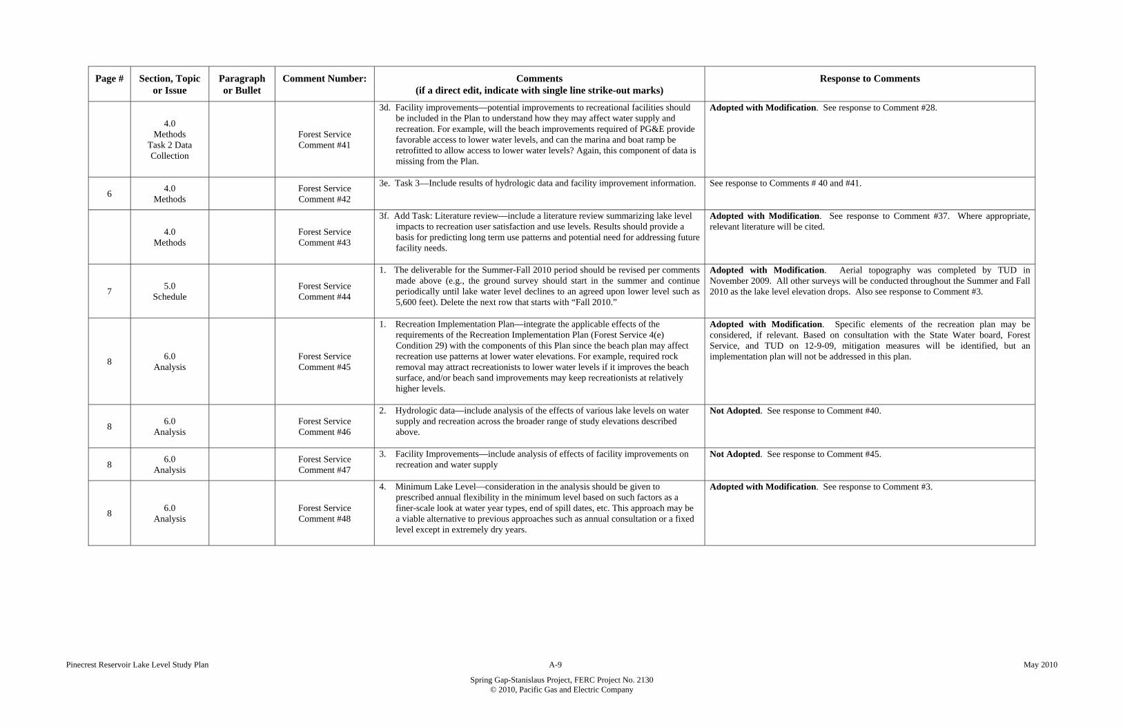
Pinecrest Reservoir Lake Level Study Plan A-9 May 2010
Spring Gap-Stanislaus Project, FERC Project No. 2130 © 2010, Pacific Gas and Electric Company
Page # Section, Topic or Issue
Paragraph or Bullet
Comment Number: Comments (if a direct edit, indicate with single line strike-out marks)
Response to Comments
4.0 Methods
Task 2 Data Collection
Forest Service Comment #41
3d. Facility improvements—potential improvements to recreational facilities should be included in the Plan to understand how they may affect water supply and recreation. For example, will the beach improvements required of PG&E provide favorable access to lower water levels, and can the marina and boat ramp be retrofitted to allow access to lower water levels? Again, this component of data is missing from the Plan.
Adopted with Modification. See response to Comment #28.
6 4.0
Methods
Forest Service Comment #42
3e. Task 3—Include results of hydrologic data and facility improvement information.
See response to Comments # 40 and #41.
4.0
Methods
Forest Service Comment #43
3f. Add Task: Literature review—include a literature review summarizing lake level impacts to recreation user satisfaction and use levels. Results should provide a basis for predicting long term use patterns and potential need for addressing future facility needs.
Adopted with Modification. See response to Comment #37. Where appropriate, relevant literature will be cited.
7 5.0
Schedule
Forest Service Comment #44
1. The deliverable for the Summer-Fall 2010 period should be revised per comments made above (e.g., the ground survey should start in the summer and continue periodically until lake water level declines to an agreed upon lower level such as 5,600 feet). Delete the next row that starts with “Fall 2010.”
Adopted with Modification. Aerial topography was completed by TUD in November 2009. All other surveys will be conducted throughout the Summer and Fall 2010 as the lake level elevation drops. Also see response to Comment #3.
8 6.0
Analysis
Forest Service Comment #45
1. Recreation Implementation Plan—integrate the applicable effects of the requirements of the Recreation Implementation Plan (Forest Service 4(e) Condition 29) with the components of this Plan since the beach plan may affect recreation use patterns at lower water elevations. For example, required rock removal may attract recreationists to lower water levels if it improves the beach surface, and/or beach sand improvements may keep recreationists at relatively higher levels.
Adopted with Modification. Specific elements of the recreation plan may be considered, if relevant. Based on consultation with the State Water board, Forest Service, and TUD on 12-9-09, mitigation measures will be identified, but an implementation plan will not be addressed in this plan.
8 6.0
Analysis
Forest Service Comment #46
2. Hydrologic data—include analysis of the effects of various lake levels on water supply and recreation across the broader range of study elevations described above.
Not Adopted. See response to Comment #40.
8 6.0
Analysis
Forest Service Comment #47
3. Facility Improvements—include analysis of effects of facility improvements on recreation and water supply
Not Adopted. See response to Comment #45.
8 6.0
Analysis
Forest Service Comment #48
4. Minimum Lake Level—consideration in the analysis should be given to prescribed annual flexibility in the minimum level based on such factors as a finer-scale look at water year types, end of spill dates, etc. This approach may be a viable alternative to previous approaches such as annual consultation or a fixed level except in extremely dry years.
Adopted with Modification. See response to Comment #3.

Pinecrest Reservoir Lake Level Study Plan A-10 May 2010
Spring Gap-Stanislaus Project, FERC Project No. 2130 © 2010, Pacific Gas and Electric Company
Page # Section, Topic or Issue
Paragraph or Bullet
Comment Number: Comments (if a direct edit, indicate with single line strike-out marks)
Response to Comments
Summary Forest Service Comment #49
This Plan does not include a suitable elevation range to inform decisions on the minimum lake level for Pinecrest Reservoir. In its present form this Plan provides little more information than is presently known; that is, the Forest Service already has beach area data and a photo record at various elevations from 5,617 feet (high water) down to 5,608 feet, and some photos of lower levels. It is also silent on effects of potential changes to facilities such as the boat ramp, marina, and beach improvements required of PG&E in the FERC license. But most of all, the Plan does not account for recreation use patterns during the summer in the study area. It is essential for all concerned parties to be adequately informed on this factor in making a decision on minimum lake level. Recreation use on the beaches, marina and boat ramp areas is present and easily observed and recorded during the summer season. The Plan should be revised to account for the factors described in these comments.
Adopted with Modification. See response to Comment #3. Also see response to Comment #5. Recreation feature usability data will be collected during summer and fall months.
Verbal Comments Received at the Consultation Meeting on December 9, 2009
01a. Study Requirements -
Minimum Elevation
Comment #50
The study's elevation range end at 5,600 ft msl or lower, rather than 5,604 ft msl. TUD proposed the study’s minimum elevation range be 5,595 ft msl based on historical operations information. State Water Board recommended it be at least 5,600 ft msl.
Adopted. The minimum elevation for the study will be 5,595 ft msl.
01b. Study Requirements -
Maximum Elevation
Comment #51
The study's elevation range begin at the full reservoir pool. 401 Certification requires a minimum reservoir elevation of 5,608 ft msl between the time spill ends and Labor Day. Baseline recreation data is needed above that elevation to understand and compare potential effects of drawdown below 5,608 ft.
Adopted. The maximum elevation for the study will be 5,617 ft msl. Baseline data will be developed for elevations between 5,617 and 5,610 ft msl. Elevations between 5,608 and 5,595 ft msl are identified as the target range for evaluation of potential effects of lowered lake levels. Only effects identified within this lower range are subject to mitigation.
01c. Study Requirements - Measurement Increments
Comment #52
Data collected at a minimum of one foot contours. This topic is tied to 5b. Study Requirements – Scope – photographic Survey TUD’s preference, from an engineering perspective, is to use a digital terrain model (DTM), which can provide more data and be used as a visual tool for the public. The benefit is that a topographic map and cross-sections can be easily developed for any lake level. To that end, TUD has contracted the services of a photogrammetrist to develop a DTM, contour map with one-foot interval, and an orthophoto of the study area. This data would be available in 2 to 3 weeks.
Adopted. TUD will provide the DTM data to PG&E for use in this study. PG&E will evaluate the data when it is available, and barring any conflicts or issues with the data, will modify the Plan to reflect this new development. FOLLOW-UP: Tom Scesa, TUD, provided PG&E and ENTRIX (Mike Rudd) with the digital terrain model data and aerial imagery on December 21, 2009.
01d. Study Requirements - Measurement
Reference
Comment #53
Lake elevation values reference PG&E existing lake level measurements and the spillway crest as 5,611.5 ft msl. TUD requested clarification/relationship of elevations taken from PG&E datum
(5,611.5 ft msl) to USGS datum. After a quick investigation, Scott Fee stated that the USGS datum and PG&E
datum are equal at Pinecrest.
Adopted. Plan now incorporates a clarification that the data used is taken from PG&E datum, which is equal to the USGS datum.
01e. Study
Requirements – Scope and Range
Comment #54
Further define study scope and elevation range. Adopted. See response to Comments #50 and #51.

Pinecrest Reservoir Lake Level Study Plan A-11 May 2010
Spring Gap-Stanislaus Project, FERC Project No. 2130 © 2010, Pacific Gas and Electric Company
Page # Section, Topic or Issue
Paragraph or Bullet
Comment Number: Comments (if a direct edit, indicate with single line strike-out marks)
Response to Comments
02a. Study Requirements -
Additional Facilities
Comment #55
Additional facilities beyond those stated in the plan need to be included in the study. Additional recreation facilities potentially impacted by the lowered lake level need to be included in the Plan. A map was drawn on the white board and photo taken for the record (see Attachment).
Adopted. The Plan will include seven recreation facilities/areas: 1) gas docks and slips, 2) boat ramp and courtesy dock, 3) designated/buoyed swim area, 4) mixed day use area (SE of #3), 5) ADA accessible fishing access, 6) south shore overflow (near private parking), and 7) overflow area north of marina (both mixed use areas). ACTION ITEM: Karen Caldwell to identify parameters of south shore overflow area (#6) and forward information to Ross Jackson and/or Matt Fransz.
02b. Study Requirements -
Additional Facilities - Areas
Included
Comment #56
The study area should include the area northeast of the marina. Clarification. See response to Comment #55.
03. Study Requirements -
Additional Research
Comment #57
The plan should include identification and analysis of existing information, such as recent surveys
ACTION ITEM: ENTRIX will include in the Plan a task to work with PG&E and the Forest Service to obtain relevant existing recreation user information.
04. Study
Requirements / Timeframe
Comment #58
The survey timeframe should be expanded to get a thorough understanding of recreational use patterns. Lower lake levels of interest cannot occur under the existing license until after Labor Day, when uses and users may change. Collection of use data would not be equivalent before and after Labor Day. Recreational usability of the seven recreation features rather than use would be a better measure of effect.
Clarification. See response to Comment #64.
05a. Study
Requirements - Survey Method
Comment #59
Survey should use more detailed and use more advanced techniques. Clarification. See response to Comment #60.
05b. Study Requirements -
Scope - Photographic
Survey
Comment #60
Photographic surveys should be at all lake elevations and follow changes made in Task 1. Proposed methodology to be used needs to capture water elevations and provide an image of the recreation feature at the agreed upon elevations.
Adopted. Lake level elevations will be analyzed at one-foot increments from 5,617 to 5,595 ft msl using a DTM and orthophoto. See response to Comments #51 and #52.
05c. Study Requirements - Scope - Rocks
and Obstructions
Comment #61
Underwater rocks and other obstructions should be included in the analysis to determine minimum elevation, due to potential impacts to boats.
Adopted. It is not possible to map-out all rocks in the lake; however, maps will be created in this study showing specific lake elevations and exposed rocks within the range levels being studied based on ortho-photography.
05d. Study Requirements - Scope - Lake
Terrain
Comment #62
A digital terrain model of the lake bottom should be prepared. Adopted. See response to Comments #52 and #60.
06a. Study Requirements - Scope - User Satisfaction
Comment #63
The plan should include a literature review summarizing lake level impacts.
Clarification. See response to Comment #60. Literature will be used as appropriate.
Pinecrest Reservoir Lake Level Study Plan A-12 May 2010
Spring Gap-Stanislaus Project, FERC Project No. 2130 © 2010, Pacific Gas and Electric Company
Page # Section, Topic or Issue
Paragraph or Bullet
Comment Number: Comments (if a direct edit, indicate with single line strike-out marks)
Response to Comments
06b. Study Requirements -
Scope - Summer Recreational Use
Comment #64
Define recreational use patterns during summer. Discussion on what type of user surveys would be needed to capture public response to the different lake levels and determine how recreation is impacted. Suggested using baseline data to define recreation use and usability, and photographic data along with modeled topographic characteristics to evaluate effects of lowered lake levels on the usability of the seven recreation features.
Adopted. Plan will not include user surveys, a public outreach meeting to be convened by the State Water Board is now included in the Plan.. PG&E to include proposed process to evaluate usability in the Plan.
07. Study
Requirements - Scope –
Comment #65
Further define study scope Adopted. See response to Comments #51, #55, and #64.
08. Study Requirements -
Scope - 4(e) Conditions
Comment #66
The Plan should coordinate with improvements outlined in the Recreation Implementation Plan, required in the Forest Service's 4(e) Condition 29.
Adopted with Modification. See response to Comment #45.
09. Study
Requirements - Hydrologic Data
Comment #67
Hydrologic data based on various water levels should be included in the study
Not Adopted. See response to Comments #50, #51, and #60.
10a. Impact
Criteria Comment #68 Minimum reservoir elevations should be based on improvements to recreational facilities.
Adopted. The Plan will cover specific recreation areas and how they will be affected by the lake levels. See response to Comments #50, #51, and #60.
10b. Impact
Criteria – Flexibility
Comment #69
The commenter suggests that a floating minimum level based on several criteria should be used rather than a single fixed point.
Not Adopted. See response to Comment #50.
11. Mitigation
Measures Comment #70
The final report should include recommendations for improvements that can protect recreational uses at lower reservoir elevations.
Adopted. Intent of the study plan is to determine impacts to recreation features at lake levels between 5,608 ft msl and 5,595 ft msl. This information can then be used to formulate appropriate mitigation measures and enhancements.
12a. Consultation
– Public Comment #71 Public consultation through meetings and surveys should be done to establish water surface elevations that support each of the recreational uses.
Adopted with Modification. See response to Comments #51, #55, and #64.
12b. Consultation - Final Meeting Comment #72
A final meeting with agencies should be planned prior to submission of the plan's final draft. Review of steps to finalize plan and schedule meetings as needed.
Adopted. Include statement in plan that consultation will be continued after submittal. Resubmit plan on January 22, 2010, and if there are additional agency comments incorporate afterwards. The incorporation of these comments will be noted in the plan. FOLLOW-UP: A revised draft of Plan will be provided by PG&E on January 22, 2010. PG&E and the agencies will meet and review plan sometime after February 17, 2010.

Pinecrest Reservoir Lake Level Study Plan A-13 May 2010
Spring Gap-Stanislaus Project, FERC Project No. 2130 © 2010, Pacific Gas and Electric Company
Page # Section, Topic or Issue
Paragraph or Bullet
Comment Number: Comments (if a direct edit, indicate with single line strike-out marks)
Response to Comments
Written Comments Received from the State Water Board on January 28, 2010
(to the January version of the Plan)
5 4.0
Methods Paragraph 1
State Water Board Comment No. 1
Focusing on the seven recreation features shown in Figure 1, this study will identify recreation activities and use characteristics from a lake level elevation of 5,617 ft msl to 5,610 ft msl to use as a baseline. This baseline will be compared with the effect of lowering the lake level elevation between 5,608 ft msl and 5,595 ft msl prior to Labor Day.
Adopted with Modification: This study is intended to compare usability at different lake levels with the baseline. The language is modified as follows: This baseline will be compared to use characteristics at those seven locations at with the effect of lowering the on recreational uses lake level elevations between 5,608 ft msl and 5,595 ft msl prior to Labor Day.
7
4.2 Task 2 – Collect Recreation Data
and Conduct Photo Survey
Middle of Paragraph 2
State Water Board Comment No. 2
The photo-point surveys will be initiated after cessation of spill at an elevation of approximately 5,617 ft msl, and conducted at 2 ft interval down to a lake level elevation of 5,610 ft msl, and one foot intervals down to 5,595 ft msl. Lake levels from below 5,608 ft msl to 5,595 ft msl can occur after Labor Day depending on water year type, when recreational use is expected to decrease.
Adopted.
8 4.3
Task 3 – Public Meeting
Paragraph 1 State Water Board Comment No. 3
PG&E will hold a facilitated public meeting at the direction of the State Water Board. The location, timing, and invitees to this meeting also will be at the direction of the State Water Board meeting with be held in Sonora in April or May 2010. The objective of the meeting will be to further refine recreational uses and gather usability criteria from lake users.
Adopted with Modification: PG&E will hold a facilitated public meeting at the direction of the State Water Board. The location, timing, and invitees to this meeting also will be at the direction of the State Water Board meeting with be held in Sonora in April or May 2010. The objective of the meeting is to obtain further feed back on recreational uses as noted in Task 1. will be to further refine recreational uses and gather usability criteria from lake users.
8
4.5 Task 5 – Analyze
Potential Recreation
Impacts to the Seven
Recreational Features
Paragraph 1 State Water Board Comment No. 4
Potential impacts to the recreational usability of the seven recreational features will be assessed for lake levels from 5,608 610 ft msl to [Comment - Baseline data will be collected down to 5,610. Usability data will be collected at one foot intervals. This means you need to start collecting data at 5,610, otherwise there is a data gap between 5,610 and 5,608. This is consistent with Methods above.] 5,595 ft msl compared to the baseline (recreational usability within the range 5,617 to 5,610 ft msl).
Clarification Needed. According to the notes from the 12/9/09 meeting at the State Water Board, “Baseline Data will be developed for elevations between 5,617 fl msl and 5,610 ft msl. Elevations between 5,608 msl and 5,595 ft msl are identified as the target range for elevation of potential effects of lowered lake levels.”
11 8.1
Draft Lake Level Study Report
Bullet 2 State Water Board Comment No. 5
Evaluate, in accordance with the criteria established in Task 1 and Section 6.0, the potential impacts to recreational features caused by lowering the lake levelat elevations from between 5,608 ft msl to and 5,595 ft msl.
Adopted.
Written Comments Received from TUD on February 8, 2010
(to the January version of the Plan)
3 4.0
Methods Middle of
Paragraph 1 TUD
Comment No. 1
Once the drawdown effects are identified, mitigation measures, implementation of which will increase the usability of the specific recreation features at a wider range of reservoir elevations, will be identified and preliminary descriptions will be developed.
Adopted with Modifications: Language modified as follows: Once the drawdown effects are identified, mitigation measures focused on maintaining the usability of the specific recreation features at a wider range of reservoir elevations will be identified and preliminary descriptions will be developed.
6
Task 4.1 Obtain and
Review Existing Information
Bullet 3 TUD
Comment No. 2
Establish photographic survey points to contribute to the evaluation of recreational usability and use. PG&E will meet with representatives from the State Water Board, CDFG, Forest Service, and TUD in the field to select and agree upon specific locations for data collection.
Adopted.

Pinecrest Reservoir Lake Level Study Plan A-14 May 2010
Spring Gap-Stanislaus Project, FERC Project No. 2130 © 2010, Pacific Gas and Electric Company
Page # Section, Topic or Issue
Paragraph or Bullet
Comment Number: Comments (if a direct edit, indicate with single line strike-out marks)
Response to Comments
6
Task 4.1 Obtain and
Review Existing Information
Bullet 4 TUD
Comment No. 3
PG&E in consultation with the agencies will identify and agree upon recreational uses and usability criteria for the seven recreational features and impact criteria against which all potential lake level elevation impacts will be measured.
Adopted.
7
4.2 Task 2 – Collect Recreation Data
and Conduct Photo Survey
Paragraph 2 TUD
Comment No. 4
The photo-point surveys will be initiated after cessation of spill at an elevation of approximately 5,617 ft msl, and conducted at 2 ft interval down to a lake level elevation of 5,610 ft msl, and one foot intervals down to 5,595 ft msl. Lake levels from 5,608 ft msl to 5,595 ft msl will be studied occur after Labor Day, when recreational use is expected to decrease.
Adopted with modifications: See Response to State Water Board Comment No. 2 above. State Water Board language adopted.
7
4.2 Task 2 – Collect Recreation Data
and Conduct Photo Survey
End of Paragraph 2
TUD Comment No. 5
To avoid the bias of relying on recreational use that has a significant seasonal component, usability of the seven recreational features will be emphasized in the this analysis of lake levels from 5,608 to 5,595 over the actual amount of use observed.
Adopted.
8
4.5 Task 5 – Analyze
Potential Recreation
Impacts to the Seven
Recreational Features
Paragraph 1 TUD
Comment No. 6
Potential impacts to the recreational usability of the seven recreational features will be assessed for lake levels from 5,608 ft msl to 5,595 ft msl compared to the baseline (recreational usability within the range 5,617 to 5,610 ft msl). Recreation usability will be evaluated for all baseline recreation activities as determined in Task 1.
Adopted with Modification: To be consistent with Task 1, the text has been modified as follows: Recreation usability will be evaluated for all baseline agreed upon recreational activities uses as determined in Task 1.
9
4.6 Task 6 – For
Identified Impacts, Identify
Potential Mitigation
Measures and Preliminary
Concept Descriptions.
Paragraph 1 TUD
Comment No. 7
Once the drawdown effects are identified, mitigation measures will be identified and preliminary descriptions will be developed. Mitigation measures will focus on the seven specific recreation features to increase usability at a wider range of reservoir elevations and allow the Revised Certification to be amended to reflect a new minimum lake elevation between 5608 and 5595.
Not Adopted: See Response to TUD Comment No. 1 above. Any action pertaining to the modification of the 401 Certification or the use of the results of this study to modify the Certification are beyond the scope of this work.
11 8.1
Draft Lake Level Study Report
Bullet 3 TUD
Comment No. 8
Based upon the impacts identified, recommend a new minimum lake level elevation.
Adopted. Recommendation of specific new minimum lake levels is beyond the scope of this study.
11 8.1
Draft Lake Level Study Report
Bullet 4 TUD
Comment No. 9
Identify possible mitigation measures for potential impacts to recreational usability below a the new lower minimum lake level of below 5,608 ft msl, pursuant to criteria established in Task 1 and Section 6.0.
Adopted.
11 8.1
Draft Lake Level Study Report
Bullet 5 TUD
Comment No. 10
Based upon the impacts identified and incorporation of the mitigation measures, if any, recommend a new minimum lake level elevation. The recreational features, the potential impacts, and measures to mitigate potential impacts, will be presented in a tabular format.
Not Adopted: The focus of this study is to assess impacts on recreation usability and to identify potential mitigation measures for those impacts. Further analysis or recommendation is beyond the scope of this study.
Appendix A Consultation
Documentation
TUD Comment No. 11
Delete entire Appendix A Consultation Documentation section Not adopted: Consultation documentation is required.
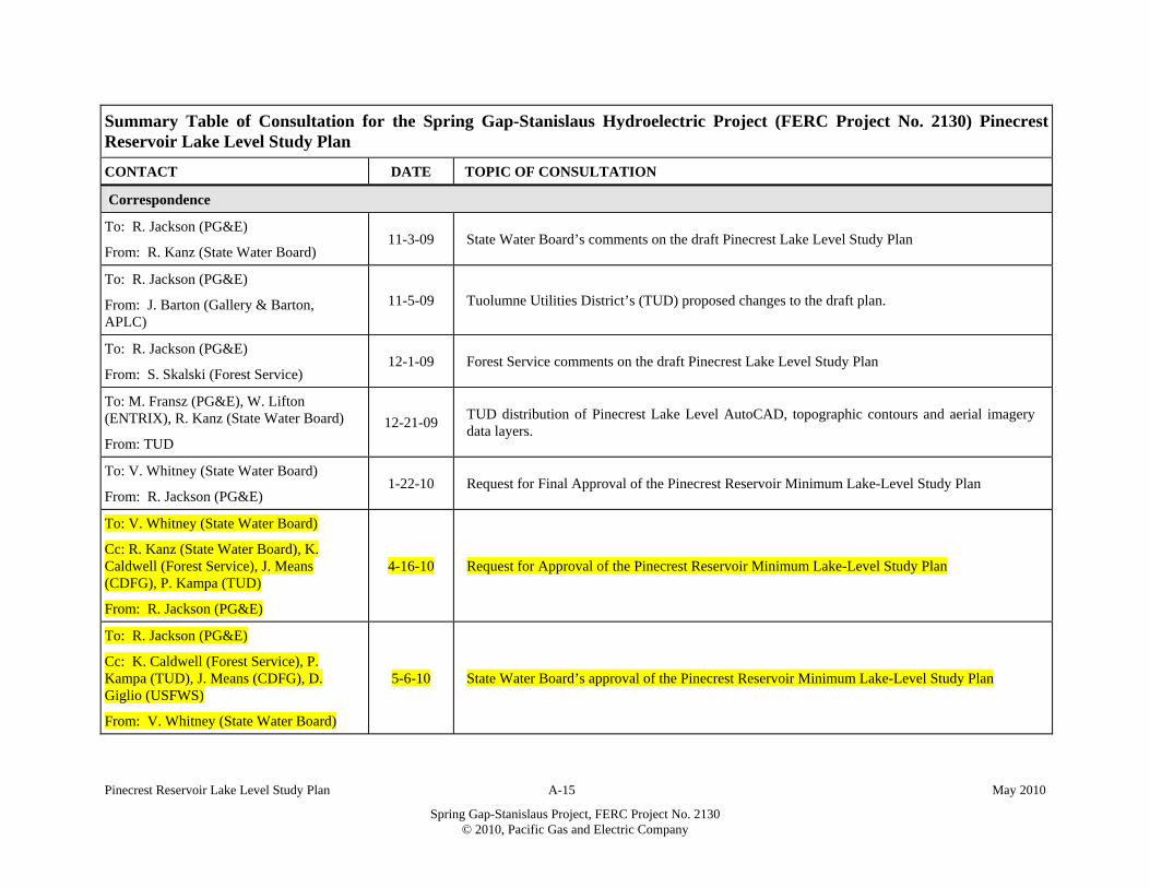
Pinecrest Reservoir Lake Level Study Plan A-15 May 2010
Spring Gap-Stanislaus Project, FERC Project No. 2130 © 2010, Pacific Gas and Electric Company
Summary Table of Consultation for the Spring Gap-Stanislaus Hydroelectric Project (FERC Project No. 2130) Pinecrest Reservoir Lake Level Study Plan
CONTACT DATE TOPIC OF CONSULTATION
Correspondence
To: R. Jackson (PG&E)
From: R. Kanz (State Water Board) 11-3-09 State Water Board’s comments on the draft Pinecrest Lake Level Study Plan
To: R. Jackson (PG&E)
From: J. Barton (Gallery & Barton, APLC)
11-5-09 Tuolumne Utilities District’s (TUD) proposed changes to the draft plan.
To: R. Jackson (PG&E)
From: S. Skalski (Forest Service) 12-1-09 Forest Service comments on the draft Pinecrest Lake Level Study Plan
To: M. Fransz (PG&E), W. Lifton (ENTRIX), R. Kanz (State Water Board)
From: TUD
12-21-09 TUD distribution of Pinecrest Lake Level AutoCAD, topographic contours and aerial imagery data layers.
To: V. Whitney (State Water Board)
From: R. Jackson (PG&E) 1-22-10 Request for Final Approval of the Pinecrest Reservoir Minimum Lake-Level Study Plan
To: V. Whitney (State Water Board)
Cc: R. Kanz (State Water Board), K. Caldwell (Forest Service), J. Means (CDFG), P. Kampa (TUD)
From: R. Jackson (PG&E)
4-16-10 Request for Approval of the Pinecrest Reservoir Minimum Lake-Level Study Plan
To: R. Jackson (PG&E)
Cc: K. Caldwell (Forest Service), P. Kampa (TUD), J. Means (CDFG), D. Giglio (USFWS)
From: V. Whitney (State Water Board)
5-6-10 State Water Board’s approval of the Pinecrest Reservoir Minimum Lake-Level Study Plan
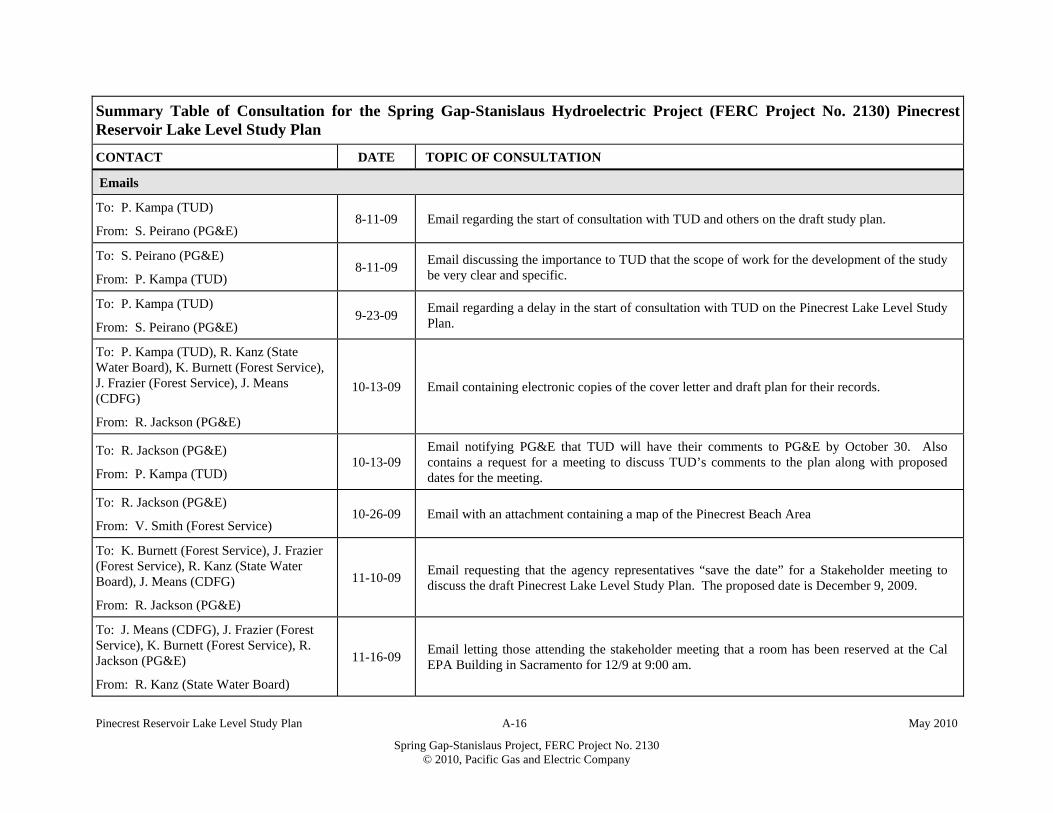
Pinecrest Reservoir Lake Level Study Plan A-16 May 2010
Spring Gap-Stanislaus Project, FERC Project No. 2130 © 2010, Pacific Gas and Electric Company
Summary Table of Consultation for the Spring Gap-Stanislaus Hydroelectric Project (FERC Project No. 2130) Pinecrest Reservoir Lake Level Study Plan
CONTACT DATE TOPIC OF CONSULTATION
Emails
To: P. Kampa (TUD)
From: S. Peirano (PG&E) 8-11-09 Email regarding the start of consultation with TUD and others on the draft study plan.
To: S. Peirano (PG&E)
From: P. Kampa (TUD) 8-11-09
Email discussing the importance to TUD that the scope of work for the development of the study be very clear and specific.
To: P. Kampa (TUD)
From: S. Peirano (PG&E) 9-23-09
Email regarding a delay in the start of consultation with TUD on the Pinecrest Lake Level Study Plan.
To: P. Kampa (TUD), R. Kanz (State Water Board), K. Burnett (Forest Service), J. Frazier (Forest Service), J. Means (CDFG)
From: R. Jackson (PG&E)
10-13-09 Email containing electronic copies of the cover letter and draft plan for their records.
To: R. Jackson (PG&E)
From: P. Kampa (TUD) 10-13-09
Email notifying PG&E that TUD will have their comments to PG&E by October 30. Also contains a request for a meeting to discuss TUD’s comments to the plan along with proposed dates for the meeting.
To: R. Jackson (PG&E)
From: V. Smith (Forest Service) 10-26-09 Email with an attachment containing a map of the Pinecrest Beach Area
To: K. Burnett (Forest Service), J. Frazier (Forest Service), R. Kanz (State Water Board), J. Means (CDFG)
From: R. Jackson (PG&E)
11-10-09 Email requesting that the agency representatives “save the date” for a Stakeholder meeting to discuss the draft Pinecrest Lake Level Study Plan. The proposed date is December 9, 2009.
To: J. Means (CDFG), J. Frazier (Forest Service), K. Burnett (Forest Service), R. Jackson (PG&E)
From: R. Kanz (State Water Board)
11-16-09 Email letting those attending the stakeholder meeting that a room has been reserved at the Cal EPA Building in Sacramento for 12/9 at 9:00 am.

Pinecrest Reservoir Lake Level Study Plan A-17 May 2010
Spring Gap-Stanislaus Project, FERC Project No. 2130 © 2010, Pacific Gas and Electric Company
Summary Table of Consultation for the Spring Gap-Stanislaus Hydroelectric Project (FERC Project No. 2130) Pinecrest Reservoir Lake Level Study Plan
CONTACT DATE TOPIC OF CONSULTATION
To: R. Jackson (PG&E),
From: Ana Barrales-Santillo (Forest Service)
11-19-09 Email containing the draft comment letter from Kathy Burnett
To: Ana Barrales-Santillo (Forest Service)
From: R. Jackson (PG&E), K. Burnett (Forest Service)
11-19-09 Email notifying Ana that the wrong letter was sent
To: R. Jackson (PG&E), K. Burnett (Forest Service)
From: Ana Barrales-Santillo (Forest Service)
11-19-09 Email containing the correct draft comment letter from Kathy Burnett
To: J. Means (CDFG), K. Burnett (Forest Service), K. Caldwell (Forest Service), R. Kanz (State Water Board), P. Kampa (TUD), D. Giglio (USFWS), J. Frazier (Forest Service), S. Peirano (PG&E), M. Fransz (PG&E), W. Lifton (ENTRIX), T. Moore (PG&E), S. Fee PG&E), G. Nunnelley (TUD), T. Scesa (TUD)
From: R. Jackson (PG&E)
12-2-09 Email confirmation and agenda for the Pinecrest Lake-level Study Plan meeting to be held December 9th, 2009 starting at 9 AM. The meeting will be held at the Cal EPA Building 1001 I Street Sacramento.
To: K. Caldwell (Forest Service)
From: R. Jackson (PG&E) 12-10-09
Emailed reminder for K. Caldwell to ask Julie where the boundary of the study should be for the South Shore Overflow beach area.
To: R. Jackson (PG&E)
From: K. Caldwell (Forest Service) 12-11-09
Emailed answer to the above information request - the answer is that the south shore overflow seems to peter out around Lot 355,356.

Pinecrest Reservoir Lake Level Study Plan A-18 May 2010
Spring Gap-Stanislaus Project, FERC Project No. 2130 © 2010, Pacific Gas and Electric Company
Summary Table of Consultation for the Spring Gap-Stanislaus Hydroelectric Project (FERC Project No. 2130) Pinecrest Reservoir Lake Level Study Plan
CONTACT DATE TOPIC OF CONSULTATION
To: W. Lifton (ENTRIX), M. Fransz (PG&E)
From: G. Nunnelley (TUD)
1-6-10 Email regarding Pinecrest mapping data.
To: G. Nunnelley (TUD)
From: M. Fransz (PG&E) 1-6-10 Email regarding Pinecrest mapping data.
To: R. Kanz (State Water Board)
From: S. Peirano (PG&E) 1-19-10 Email providing a status update on the Pinecrest Lake-level Study Plan.
To: R. Kanz (State Water Board)
From: M. Fransz (PG&E) 1-19-10 Email containing a draft copy of the Pinecrest Lake Level Study Plan for review.
To: V. Whitney (State Water Board), R. Kanz (State Water Board), K. Caldwell (Forest Service), K. Burnett (Forest Service), P. Kampa (TUD), J. Means (CDFG)
From: M. Fransz (PG&E)
1-22-10 Email submitting for approval the revised draft Spring Gap-Stanislaus Project (FERC No. 2130) Pinecrest Reservoir Minimum Lake-level Study Plan.
To: P. Kampa (TUD)
From: M. Fransz (PG&E) 1-23-10
Email explaining that due to problems with TUD receiving large files PG&E will be sending a CD of the plan and its cover letter via Fed-X.
To: M. Fransz (PG&E)
From: R. Kanz (State Water Board) 1-27-10
Email requesting a Microsoft Word version of the Pinecrest Reservoir Minimum Lake-level Study Plan.
To: R. Kanz (State Water Board)
From: M. Fransz (PG&E) 1-27-10
Email replying to the request for a Microsoft Word version of the Pinecrest Reservoir Minimum Lake-level Study Plan.
To: M. Fransz (PG&E)
From: R. Kanz (State Water Board) 1-28-10
Email containing State Water Board’s comments to the Pinecrest Reservoir Minimum Lake-level Study Plan.

Pinecrest Reservoir Lake Level Study Plan A-19 May 2010
Spring Gap-Stanislaus Project, FERC Project No. 2130 © 2010, Pacific Gas and Electric Company
Summary Table of Consultation for the Spring Gap-Stanislaus Hydroelectric Project (FERC Project No. 2130) Pinecrest Reservoir Lake Level Study Plan
CONTACT DATE TOPIC OF CONSULTATION
To: R. Kanz (State Water Board)
From: S. Peirano (PG&E) 2-2-10 Email acknowledging State Water Board’s comments.
To: R. Kanz (State Water Board)
From: S. Peirano (PG&E) 2-3-10 Email containing a correction to the date mentioned in the above email.
To: R. Jackson (PG&E)
From: P. Kampa (TUD) 2-8-10 Email containing TUD’s comments to the Pinecrest Reservoir Minimum Lake-level Study Plan.
To: R. Jackson (PG&E)
From: P. Kampa (TUD) 2-10-10
Email thanking PG&E for the opportunity to discuss the Spring Gap-Stanislaus Pinecrest Lake Level and Spill Mgmt plans.
To: P. Kampa (TUD), R. Kanz (State Water Board), K. Caldwell (Forest Service), J. Means (CDFG)
From: R. Jackson (PG&E)
3-16-10 Email supplying dates for a meeting to discuss the Pinecrest Reservoir Minimum Lake-level Study Plan comments/concerns.
To: J. Means (CDFG), K. Caldwell (Forest Service), R. Jackson (PG&E), P. Kampa (TUD)
Cc: K. Burnett (Forest Service), S. Fee (PG&E), M. Fransz (PG&E), S. Peirano (PG&E), T. Moore (PG&E)
From: R. Kanz (State Water Board)
3-16-10 Email noting a preference of either April 1st or 8th for a meeting.
To: R. Jackson (PG&E)
From: K. Caldwell (Forest Service) 3-18-10 Email stating that the Forest Service does not need/want to participate in a meeting at this time.
To: W. Lifton (ENTRIX), M. Fransz (PG&E), R. Jackson (PG&E), P. Kampa (TUD), T. Scesa (TUD)
From: R. Kanz (State Water Board)
4-7-10 Email requesting that the Pinecrest Reservoir Minimum Lake-level Study Plan Public Meeting be held on May 28, 2010.

Pinecrest Reservoir Lake Level Study Plan A-20 May 2010
Spring Gap-Stanislaus Project, FERC Project No. 2130 © 2010, Pacific Gas and Electric Company
Summary Table of Consultation for the Spring Gap-Stanislaus Hydroelectric Project (FERC Project No. 2130) Pinecrest Reservoir Lake Level Study Plan
CONTACT DATE TOPIC OF CONSULTATION
To: R. Kanz (State Water Board), W. Lifton (ENTRIX), M. Fransz (PG&E), R. Jackson (PG&E), S. Peirano (PG&E), T. Scesa (TUD)
Cc: T. Scesa (TUD), C. Prunchak (TUD)
From: P. Kampa (TUD)
4-7-10 Email stating that TUD will likely have representation by Board members and Tom Scesa at the public meeting.
To: V. Whitney (State Water Board)
Cc: R. Jackson (PG&E), S. Peirano (PG&E), R. Kanz (State Water Board), K. Caldwell (Forest Service), K. Burnett (Forest Service), P. Kampa (TUD), J. Means (CDFG)
From: M. Fransz (PG&E)
4-16-10 Email submitting for approval the revised draft Spring Gap-Stanislaus Project (FERC No. 2130) Pinecrest Reservoir Minimum Lake-level Study Plan.
To: R. Kanz (State Water Board), K. Caldwell (Forest Service), K. Burnett (Forest Service), P. Kampa (TUD), J. Means (CDFG)
Cc: R. Jackson (PG&E), S. Peirano (PG&E)
From: M. Fransz (PG&E)
4-16-10 Email submitting the revised draft Spring Gap-Stanislaus Project (FERC No. 2130) Pinecrest Reservoir Minimum Lake-level Study Plan for review.
To: M. Fransz (PG&E), R. Kanz (State Water Board), K. Caldwell (Forest Service), K. Burnett (Forest Service), J. Means (CDFG)
Cc: R. Jackson (PG&E), S. Peirano (PG&E)
From: P. Kampa (TUD)
4-20-10 Email requesting that changes that were made to the March version of the Pinecrest Reservoir Minimum Lake-level Study Plan be highlighted.

Pinecrest Reservoir Lake Level Study Plan A-21 May 2010
Spring Gap-Stanislaus Project, FERC Project No. 2130 © 2010, Pacific Gas and Electric Company
Summary Table of Consultation for the Spring Gap-Stanislaus Hydroelectric Project (FERC Project No. 2130) Pinecrest Reservoir Lake Level Study Plan
CONTACT DATE TOPIC OF CONSULTATION
To: P. Kampa (TUD)
Cc: R. Jackson (PG&E), S. Peirano (PG&E), R. Kanz (State Water Board), K. Caldwell (Forest Service), K. Burnett (Forest Service), J. Means (CDFG), W. Lifton (ENTRIX), C. Lawson (ENTRIX)
From: M. Fransz (PG&E)
4-20-10 Email containing a copy of the Pinecrest Reservoir Minimum Lake-level Study Plan showing all edits between the April 16 and the previous version (January 22 distribution).
To: M. Fransz (PG&E)
From: P. Kampa (TUD) 4-20-10
Email acknowledging receipt of the Pinecrest Reservoir Minimum Lake-level Study Plan showing all edits.
Telephone/Meeting Log
Coordinator: S. Peirano (PG&E) 12-9-09 Meeting notes from the December 9, 2009 Pinecrest Lake Level Study Plan Consultation Meeting
Coordinator: S. Peirano (PG&E) 4-1-10 Meeting notes from the April 1, 2010 Pinecrest Lake Level Study Plan Consultation Meeting


