SEW-08020 Harringworth STW Planning...
73
mä~ååáåÖ ~åÇ `çããìåáíó áåîçäîÉãÉåí mä~ååáåÖ pìééçêíáåÖpí~íÉãÉåí ^åÖäá~å t~íÉê pÉêîáÅÉë iíÇ cçê `çåëíêìÅíáçå çÑ ~ åÉï m~Åâ~ÖÉ pÉï~ÖÉ qêÉ~íãÉåí tçêâë i~åÇ çÑÑ t~âÉêäÉó oç~ÇI e~êêáåÖïçêíÜK pbtJMUMOM
Transcript of SEW-08020 Harringworth STW Planning...

==
mä~ååáåÖ=~åÇ=`çããìåáíó=áåîçäîÉãÉåí=mä~ååáåÖ=pìééçêíáåÖ=pí~íÉãÉåí=
=^åÖäá~å=t~íÉê=pÉêîáÅÉë=iíÇ=
=======
cçê=`çåëíêìÅíáçå=çÑ=~=åÉï=m~Åâ~ÖÉ=pÉï~ÖÉ=qêÉ~íãÉåí=tçêâë==
i~åÇ=çÑÑ=t~âÉêäÉó=oç~ÇI=e~êêáåÖïçêíÜK=pbtJMUMOM=
==
===================
=======
pbtJMUMOM=e~êêáåÖïçêíÜ=pqt=mä~ååáåÖ=pí~íÉãÉåíKÇçÅ==Ekçî=OMNNF= 2
`çåíÉåíë==
NK fkqolar`qflk ......................................................................................3
OK molmlpba=absbilmjbkq..................................................................3
OKNK qÜÉ=páíÉKKKKKKKKKKKKKKKKKKKKKKKKKKKKKKKKKKKKKKKKKKKKKKKKKKKKKKKKKKKKKKKKKKKKKKKKKKKKKKKKKKKKKKKKKKKKKKKKKKKKKKKKK P
OKOK qÜÉ=éêçéçë~äKKKKKKKKKKKKKKKKKKKKKKKKKKKKKKKKKKKKKKKKKKKKKKKKKKKKKKKKKKKKKKKKKKKKKKKKKKKKKKKKKKKKKKKKKKKKKKKKK P
PK mobJ^mmif`^qflk=`lkpriq^qflk ....................................................6
QK PLANNING POLICY.................................... .............................................6
QKNK `áêÅìä~ê=NTLVN=Út~íÉê=fåÇìëíêó=fåîÉëíãÉåíW=mä~ååáåÖ=`çåëáÇÉê~íáçåë KKKKKK S
QKOK k~íáçå~ä=mä~ååáåÖ=mçäáÅóKKKKKKKKKKKKKKKKKKKKKKKKKKKKKKKKKKKKKKKKKKKKKKKKKKKKKKKKKKKKKKKKKKKKKKKKKKKKKK S
QKPK t~ëíÉ=aÉîÉäçéãÉåí=cê~ãÉïçêâKKKKKKKKKKKKKKKKKKKKKKKKKKKKKKKKKKKKKKKKKKKKKKKKKKKKKKKKKKKKKKKKK T
QKQK içÅ~ä=mä~ååáåÖKKKKKKKKKKKKKKKKKKKKKKKKKKKKKKKKKKKKKKKKKKKKKKKKKKKKKKKKKKKKKKKKKKKKKKKKKKKKKKKKKKKKKKKKKKKKKK T
RK mi^kkfkd=`lkpfabo^qflkp .............................................................8
RKNK lÇçìêKKKKKKKKKKKKKKKKKKKKKKKKKKKKKKKKKKKKKKKKKKKKKKKKKKKKKKKKKKKKKKKKKKKKKKKKKKKKKKKKKKKKKKKKKKKKKKKKKKKKKKKKKKKK U
RKOK bÅçäçÖó KKKKKKKKKKKKKKKKKKKKKKKKKKKKKKKKKKKKKKKKKKKKKKKKKKKKKKKKKKKKKKKKKKKKKKKKKKKKKKKKKKKKKKKKKKKKKKKKKKKKKKKKK U
RKPK ^êÅÜ~ÉçäçÖó KKKKKKKKKKKKKKKKKKKKKKKKKKKKKKKKKKKKKKKKKKKKKKKKKKKKKKKKKKKKKKKKKKKKKKKKKKKKKKKKKKKKKKKKKKKKKKKKK U
RKQK ^êÄçêáÅìäíìê~ä=^ëëÉëëãÉåí KKKKKKKKKKKKKKKKKKKKKKKKKKKKKKKKKKKKKKKKKKKKKKKKKKKKKKKKKKKKKKKKKKKKKKKKKK U
RKRK qê~ÑÑáÅ=jçîÉãÉåíëKKKKKKKKKKKKKKKKKKKKKKKKKKKKKKKKKKKKKKKKKKKKKKKKKKKKKKKKKKKKKKKKKKKKKKKKKKKKKKKKKKKKKKK V
SK prpq^fk^_fifqv....................................................................................9
TK `lk`irpflk..........................................................................................9 =

pbtJMUMOM=e~êêáåÖïçêíÜ=pqt=mä~ååáåÖ=pí~íÉãÉåíKÇçÅ==Ekçî=OMNNF= 3
NK fåíêçÇìÅíáçå==qÜáë= éä~ååáåÖ= ëí~íÉãÉåí= ëìééçêíë= íÜÉ= ~ééäáÅ~íáçå= ëìÄãáííÉÇ= Äó=^åÖäá~å=t~íÉê=pÉêîáÅÉë=iíÇ=Ñçê=íÜÉ=ÅçåëíêìÅíáçå=çÑ=~=åÉï=é~Åâ~ÖÉ=pÉï~ÖÉ=qêÉ~íãÉåí=tçêâë=íç=éêçîáÇÉ=Ñáêëí=íáãÉ=ëÉïÉê~ÖÉ=íç=íÜÉ=e~êêáåÖïçêíÜ=~åÇ=pÜçíäÉó=~êÉ~K==^åÖäá~å= t~íÉê= pÉêîáÅÉë= iíÇ= E^åÖäá~å= t~íÉêF= Ü~ë= ~= äçåÖ= íÉêã= ëíê~íÉÖó= Ñçê=ÇÉäáîÉêáåÖ=ëÉêîáÅÉI=êÉäá~Äáäáíó=~åÇ=î~äìÉ=Ñçê=ãçåÉó=Ñçê=áíë=ÅìëíçãÉêëK=qÜÉ=ëíê~íÉÖó=áÇÉåíáÑáÉë= ~= åìãÄÉê= çÑ= ÅÜ~ääÉåÖÉë= íÜ~í= íÜÉ= êÉÖáçå= Ñ~ÅÉë= áå= íÜÉ= ÑìíìêÉI= íÜáë=áåÅäìÇÉë= ãÉÉíáåÖ= ~ää= ÅìêêÉåí= ~åÇ= ÑìíìêÉ= äÉÖ~ä= ~åÇ= êÉÖìä~íçêó= çÄäáÖ~íáçåë= íç=éêçíÉÅí=~åÇ=ÉåÜ~åÅÉ=íÜÉ=ï~íÉê=ÉåîáêçåãÉåí=ïÜáäëí=êÉÇìÅáåÖ=çìê=ÅçåíêáÄìíáçå=íç=Åäáã~íÉ=ÅÜ~åÖÉK==^åÖäá~å= t~íÉê= Ü~ë= ÄÉÉå= êÉèìÉëíÉÇ= íç= éêçîáÇÉ= Nëí= íáãÉ= ëÉïÉê~ÖÉ= íç= íÜÉ=e~êêáåÖïçêíÜ=~åÇ= pÜçíäÉó= ~êÉ~= ìåÇÉê= pÉÅíáçå= NMN^=çÑ= íÜÉ=t~íÉê= fåÇìëíêó=^Åí=NVVNK=råÇÉê=íÜÉ=^ÅíI=^åÖäá~å=t~íÉêI=~ë=íÜÉ=ëÉïÉê~ÖÉ=ìåÇÉêí~âÉêI=Ü~ë=~=Çìíó=íç=éêçîáÇÉ=~=éìÄäáÅ=ëÉïÉê=Ñçê=~å=~êÉ~=ïÜÉêÉ=ÉñáëíáåÖ=Çê~áå~ÖÉ=ëóëíÉãë=ÖáîÉ=êáëÉ=íç=~ÇîÉêëÉ=ÉÑÑÉÅíë=çå=íÜÉ=ÉåîáêçåãÉåí=~åÇ=~ãÉåáíó=~åÇ=íÜÉ=ãçëí=~ééêçéêá~íÉ=ï~ó=çÑ=êÉëçäîáåÖ=íÜçëÉ=ÉÑÑÉÅíë=áë=Äó=éêçîáÇáåÖ=~=éìÄäáÅ=ëÉïÉêK==lå=êÉÅÉáéí=çÑ=íÜÉ=~ééäáÅ~íáçå=Ñçê=íÜÉ=e~êêáåÖïçêíÜ=~åÇ=pÜçíäÉó=~êÉ~I=íÜÉ=îáää~ÖÉ=ï~ë=~ëëÉëëÉÇ=Ñçê=ÉåîáêçåãÉåí~ä=éçääìíáçåK==fí=ï~ë=ÇÉíÉêãáåÉÇ=íÜ~í=íÜÉ=Çê~áå~ÖÉ=Ñêçã= ÅÉêí~áå= éêçéÉêíáÉë= ï~ë= Ü~îáåÖ= ~å= ~ÇîÉêëÉ= ÉÑÑÉÅí= ìéçå= íÜÉ= ÉåîáêçåãÉåíK=qÜÉêÉÑçêÉ= áí=ï~ë= ÅçåëáÇÉêÉÇ= ~ééêçéêá~íÉ= íç= éêçîáÇÉ= ~= éìÄäáÅ= ëÉïÉê= ëóëíÉã= Ñçê=íÜáë=äçÅ~äáíó=~åÇ=éêçíÉÅí=íÜÉ=äçÅ~ä=~ãÉåáíó=~åÇ=éêÉîÉåí=éçíÉåíá~ä=Åçåí~ãáå~íáçå=çÑ=ÖêçìåÇï~íÉê=~åÇ=äçÅ~ä=ï~íÉê=ÅçìêëÉëK==qÜÉ= éìêéçëÉ= çÑ= íÜáë= éä~ååáåÖ= ~åÇ= Åçããìåáíó= áåîçäîÉãÉåí= ëí~íÉãÉåí= áë= íç=~ÇÇêÉëë= íÜÉ= éä~ååáåÖ= áëëìÉë= éçëÉÇ= Äó= íÜÉ= ÅçåëíêìÅíáçå= çÑ= ~= åÉï= pÉï~ÖÉ=qêÉ~íãÉåí=tçêâëK=qÜÉ=éáéÉäáåÉ=~åÇ=éìãéáåÖ=ëí~íáçå=ïáää=ÄÉ=ÅçåëíêìÅíÉÇ=ìåÇÉê=éÉêãáííÉÇ=ÇÉîÉäçéãÉåíK=
==OK mêçéçëÉÇ=aÉîÉäçéãÉåí= OKNK qÜÉ=páíÉ=qÜÉ=éêçéçëÉÇ=pÉï~ÖÉ=qêÉ~íãÉåí=tçêâë=ïáää=ÄÉ=äçÅ~íÉÇ=çÑÑ=t~âÉêäÉó=oç~Ç=àìëí=çìíëáÇÉ= íÜÉ= ëÉííäÉãÉåí= ÄçìåÇ~êó= çÑ= e~êêáåÖïçêíÜ= ~åÇ= pÜçíäÉó= ïáíÜáå= íÜÉ=ÄçìåÇ~êó= çÑ= b~ëí= kçêíÜ~ãéíçåëÜáêÉ= aáëíêáÅí= `çìåÅáä= mä~ååáåÖ= ^ìíÜçêáíó=EpmVOVVTUFK= qÜÉ= ïçêâë= ïáää= ÄÉ= äçÅ~íÉÇ= ïáíÜáå= íÜÉ= ÅçêåÉê= çÑ= ~å= ~ê~ÄäÉ= ÑáÉäÇ=~Çà~ÅÉåí=íç=~å=ÉñáëíáåÖ=ÜÉÇÖÉêçïK=qÜÉ=åÉ~êÉëí=éêçéÉêíó=áë=~ééêçñáã~íÉäó=PPMã=~ï~óK===OKOK qÜÉ=éêçéçë~ä=qÜÉ=éêçéçëÉÇ=ïçêâë=ïáää=éêçîáÇÉ=íêÉ~íãÉåí=çÑ=ëÉï~ÖÉ=Ñçê=íÜÉ=åÉï=ëÉïÉê=ëóëíÉã=Ñçê=e~êêáåÖïçêíÜ=~åÇ=pÜçíäÉóK=qÜÉ=åÉï=ïçêâë=ïáää=Ü~îÉ=~= ëáíÉ=~êÉ~=çÑ=MKNV=Ü~=~åÇ=Åçåëáëíë=çÑ=~=éêáã~êó=ëÉííäÉãÉåí=í~åâI=êçíçê=ãçÇìäÉI=Ñáå~ä=ëÉííäÉãÉåí=í~åâI=Åçåíêçä= âáçëâI= íÉäÉãÉíêó= ~Éêá~äI= ÅÜÉãáÅ~ä= ÇçëáåÖ= ìåáí= ~åÇ= åÉï= ~ÅÅÉëë= ~åÇ= ëáíÉ=êç~ÇI=~äçåÖ=ïáíÜ=~=NKUã=ÜáÖÜ=ëÉÅìêáíó=ÑÉåÅÉK=pÉï~ÖÉ=ïáää=ÄÉ=éìãéÉÇ=Ñêçã=íÜÉ=ëÉï~ÖÉ=éìãéáåÖ=ëí~íáçå=~í=pÉ~íçå=oç~Ç=íç=íÜÉ=åÉï=ïçêâëK=eÉêÉ=íÜÉ=ëÉï~ÖÉ=ïáää=ÄÉ= íêÉ~íÉÇ= ~åÇ= íÜÉ= íêÉ~íÉÇ= Ñáå~ä= ÉÑÑäìÉåí= ïáää= ÄÉ= ÇáëÅÜ~êÖÉÇ= áåíç= íÜÉ= oáîÉê=tÉää~åÇ= Ekdo=pmVOSVUNFK=^å= áåÇáÅ~íáîÉ= ÅçåëÉåí=Ü~ë=~äêÉ~Çó=ÄÉÉå=ÖáîÉå=Äó= íÜÉ=
pbtJMUMOM=e~êêáåÖïçêíÜ=pqt=mä~ååáåÖ=pí~íÉãÉåíKÇçÅ==Ekçî=OMNNF= 4
båîáêçåãÉåí=^ÖÉåÅó=~åÇ=~=Ñçêã~ä=ÇáëÅÜ~êÖÉ=ÅçåëÉåí=Ü~ë=ÄÉÉå=~ééäáÉÇ=ÑçêK=qÜÉ=ïçêâë= ïáää= Ü~îÉ= ~= ã~ñáãìã= ÇáëÅÜ~êÖÉ= çÑ= R= äLëK= qÜÉ= ëÉï~ÖÉ= ëäìÇÖÉ= ïáää= ÄÉ=í~åâÉêÉÇ=~ï~ó=~ééêçñáã~íÉäó=ÉîÉêó=O=ãçåíÜëK=qÜÉ=ã~àçêáíó=çÑ=íÜÉ=éêçÅÉëëÉë=ïáää=ÄÉ=ÄÉäçï=ÖêçìåÇI=ïáíÜ=àìëí=íÜÉ=`çåíêçä=háçëâI=Öì~êÇ=ê~áäë=~åÇ=é~êí=çÑ=íÜÉ=oçíçê=jçÇìäÉ=~ÄçîÉ=ÖêçìåÇ=äáãáíáåÖ=íÜÉ=áãé~Åí=çå=íÜÉ=ä~åÇëÅ~éÉ=ÅÜ~ê~ÅíÉêK==mêáã~êó=pÉííäÉãÉåí=q~åâ=cäçï= ÉåíÉêë= íÜÉ=ïçêâë= áåíç= íÜÉ= éêáã~êó= ëÉííäÉãÉåí= í~åâ= EmpqFI= ÜÉêÉ= ëçäáÇë= ~êÉ=ëÉííäÉÇ=çìí=~åÇ=íÜÉ=éêáã~êó=ÉÑÑäìÉåí=ÅçåíáåìÉë=íç=íÜÉ=êçíçê=ãçÇìäÉK=qÜÉ=mpq=ïáää=ÄÉ=ÅçåëíêìÅíÉÇ=ÄÉäçï=ÖêçìåÇK=qÜÉ=ëäìÇÖÉ=Çê~ï=çÑÑ=éáéÉë=ïáää=ÄÉ=íÜÉ=çåäó=~ÄçîÉ=ÖêçìåÇ=ëíêìÅíìêÉ=Ñçê=íÜáë=éêçÅÉëë=EÇê~ïáåÖW=pbtJMUMOMJe^otpqJO^JmidJQNMFK==oçíçê=jçÇìäÉ=qÜÉêÉ=áë=çåÉ=êçíçê=ãçÇìäÉX=íÜáë=áë=~=êçí~íáåÖ=ÄáçäçÖáÅ~ä=Åçåí~Åíçê=ïÜáÅÜ=~Åíë=~ë=~=ÄáçäçÖáÅ~ä=ÑáäíÉê=ÑìêíÜÉê=íêÉ~íáåÖ=íÜÉ=éêáã~êó=ÉÑÑäìÉåíK=qÜÉ=Äìäâ=çÑ=íÜáë=ëíêìÅíìêÉ=ïáää=ÄÉ=ÄÉäçï=ÖêçìåÇI=ÜçïÉîÉê= áí=ïáää=Ü~îÉ=~å=~ÄçîÉ=ÖêçìåÇ= ÅçîÉê=ïÜáÅÜ=ïáää=ÄÉÅçåëíêìÅíÉÇ=Ñêçã=Öä~ëë=êÉáåÑçêÅÉÇ=éä~ëíáÅ=EdomF=ÅçäçìêÉÇ=ÖêÉÉå=_pNQ`PV=EpbtJMUMOMJe^otpqJO^JmidJQNNFK==páòÉ=~ÄçîÉ=ÖêçìåÇ=W=RKRUã=ñ=PKPRã=ñ=NKQã=ÜáÖÜ=~í=ã~ñ==cáå~ä=pÉííäÉãÉåí=q~åâ=qÜÉ=ÉÑÑäìÉåí=Ñêçã=íÜÉ=êçíçê=ãçÇìäÉ=ïáää=ÄÉ=íê~åëÑÉêêÉÇ=íç=íÜÉ=Ñáå~ä= ëÉííäÉãÉåí=í~åâ=EcpqFI=ïÜÉêÉ=ÑìêíÜÉê=ëÉííäÉãÉåí=çÅÅìêëK==^Ö~áå=íÜÉ=í~åâ=ïáää=ÄÉ=ÅçåëíêìÅíÉÇ=ÄÉäçï=ÖêçìåÇ=ÜçïÉîÉêX=~=Öì~êÇ=ê~áä=ïáää=ÄÉ=ÅçåëíêìÅíÉÇ=~êçìåÇ=íÜÉ=íçé=çÑ=íÜÉ=cpq=Ñçê=ÜÉ~äíÜ=~åÇ=ë~ÑÉíó=êÉ~ëçåë=Ñêçã=Ö~äî~åáëÉÇ=ëíÉÉäK=qÜáë=ïáää=ÄÉ=NKNQã=ÜáÖÜK==EpbtJMUMOMJe^otpqJO^JmidJQNOFK==`ÜÉãáÅ~ä=açëáåÖ=råáí=pÉéíáÅáíó=çÅÅìêë=áå=ëÉï~ÖÉ=åÉíïçêâë=ïÜÉêÉ=ÇáëëçäîÉÇ=çñóÖÉå=Ü~ë=ÄÉÉå=ÅçåëìãÉÇ=~åÇ=~å~ÉêçÄáÅ=ÅçåÇáíáçåë=~êÉ=ÑçêãÉÇI=íÜáë=ÖÉåÉê~ääó=çÅÅìêë=ïÜÉêÉ=ëÉï~ÖÉ=Ñäçïë=~êÉ= äçï= çê= íÜÉêÉ= áë= ~= äçåÖ= êÉëáÇÉåÅÉ= íáãÉK= qÜáë= Å~å= äÉ~Ç= íç= íÜÉ= Ñçêã~íáçå= çÑ=ëìäéÜìêáÅ=~ÅáÇ=çå=íÜÉ=áåíÉêå~ä=ëìêÑ~ÅÉë=çÑ=íÜÉ=ëÉïÉê=åÉíïçêâK=iÉÑí=ìåíêÉ~íÉÇI=íÜÉ=~ÅáÇ=ïáää=~íí~Åâ=íÜÉ=áåíÉÖêáíó=çÑ= íÜÉ=ëÉïÉêI= äÉ~ÇáåÖ=íç=íÜÉ=ÉîÉåíì~ä=Åçää~éëÉ=Ñçê=íÜÉ=ã~áå=~åÇ=íÜÉ=åÉÉÇ=Ñçê=ÉãÉêÖÉåÅó=êÉÅçåëíêìÅíáçåK=få=~ÇÇáíáçå=ëÉéíáÅ=ëÉï~ÖÉ=Å~å=äÉ~Ç=íç=äçÅ~ä=çÇçìê=áëëìÉëK==qç=ÉåëìêÉ=íÜÉêÉ=áë=åç=ëÉéíáÅáíó=~åÇ=ÅçåëÉèìÉåíäó=çÇçìê= çê= ~ÅáÇ= ÅçêêçëáçåI= áí= áë= åÉÅÉëë~êó= íç= áåëí~ää= ~= ÅÜÉãáÅ~ä= ÇçëáåÖ= ìåáíK= qÜáë=ÇçëÉë= ~= åáíê~íÉ= Ä~ëÉÇ= éêçÇìÅí=ïÜáÅÜ= ÅÜ~åÖÉë= íÜÉ= Ä~ÅíÉêá~ä= éçéìä~íáçå= íç= çåÉ=ïÜáÅÜ= éêÉîÉåíë= ëÉéíáÅíó= ~åÇ= íÜÉêÉÑçêÉ= ~ëëçÅá~íÉÇ= áëëìÉëK= qÜáë= ïáää= Åçåëáëí= çÑ= ~=ÄìåÇÉÇ=í~åâ==ÅçåëíêìÅíÉÇ=Ñêçã=dom=~åÇ=ÅçäçìêÉÇ=ÖêÉÉå=_pNQ`PVK=aÉí~áäë=Å~å=ÄÉ=ÑçìåÇ=çå=Çê~ïáåÖ=paJpJUMK==páòÉW=OKUã=ñ=NKRã=ñ=NKSã=ÜáÖÜ=Eã~ñFK==háçëâ=qÜÉêÉ=ïáää=ÄÉ=~=ÖêçìåÇ=Ä~ëÉÇ=Åçåíêçä=âáçëâK=qÜáë=ïáää=ÄÉ=ÅçåëíêìÅíÉÇ=Ñêçã=EdomF=~åÇ= ÅçäçìêÉÇ= ÖêÉÉå= _pNQ`PVK= qÜáë= Ü~ë= ÄÉÉå= ÇÉëáÖåÉÇ= íç= ~= ãáåáãìã= ëáòÉ= íç=ÜçìëÉ= íÜÉ= åÉÅÉëë~êó= ÉäÉÅíêáÅ~ä= é~åÉäë= ~åÇ= íÉäÉãÉíêó= ÉèìáéãÉåíK= EpbtJMUMOMJe^topqJO^JmidJQMPFK==páòÉW=Pã=ñ=NKTã=ñ=O=ã=ÜáÖÜ===
pbtJMUMOM=e~êêáåÖïçêíÜ=pqt=mä~ååáåÖ=pí~íÉãÉåíKÇçÅ==Ekçî=OMNNF= 5
qÉäÉãÉíêó=^Éêá~ä=qÜÉ=íÉäÉãÉíêó=~Éêá~ä=ïáää=ÄÉ=Sã=áå=ÜÉáÖÜí=ïÜáÅÜ=áë=íÜÉ=ãáåáãìã=ÜÉáÖÜí=êÉèìáêÉÇ=íç= çÄí~áå= ~= ëáÖå~ä= ~í= íÜáë= ëáíÉI= ÇÉí~áäë= Å~å= ÄÉ= ëÉÉå= çå= Çê~ïáåÖ= paJpJNMO= ~åÇ=ÉäÉî~íáçå=Çê~ïáåÖë=çÑ=íÜÉ=ëáíÉK==iáÖÜíáåÖ=qç=Åçãéäó=ïáíÜ=ÜÉ~äíÜ=~åÇ=ë~ÑÉíó=äÉÖáëä~íáçå=áí=áë=åÉÅÉëë~êó=íç=áåëí~ää=äáÖÜíáåÖ=çå=íÜÉ= ëáíÉK= qÜÉ= éêçéçëÉÇ= ä~ãéë=ïáäää= ÄÉ=ÜáÖÜ= éêÉëëìêÉ= ëçÇáìã= ä~ãéë= ~åÇ=ïáää= ÄÉ=ãçìåíÉÇ= çå= Qã= ÜáÖÜ= ÜáåÖÉÇ= íìÄìä~ê= Åçäìãå= íç= ~ääçï= ÄìäÄë= íç= ÄÉ= ÅÜ~åÖÉÇ=É~ëáäóK=aÉí~áäë=çÑ= íÜÉ= ä~ãéë= Å~å=ÄÉ= ÑçìåÇ=çå=Çê~ïáåÖ=pbtJMUMOMJe^topqJO^JmidJQNP=~åÇ=ÉåÅäçëÉÇ= áåÑçêã~íáçå= ëÜÉÉíK= få=çêÇÉê= íç=~îçáÇ= äáÖÜí=éçääìíáçåI= íÜÉ=äáÖÜíáåÖ=ïáää=çåäó=ÄÉ=ìëÉÇ=ïÜÉå=çéÉê~íáçå=ëí~ÑÑ=îáëáí= íÜÉ=ëáíÉK=qÜÉ=äáÖÜíë=ïáää=ÄÉ=ÅçåíêçääÉÇ=Äó=~=ã~åì~ä= ëïáíÅÜ=~åÇ=ïáää=ÄÉ= ÅçåíêçääÉÇ=îá~=~= ëïáíÅÜ=~í= íÜÉ=ã~áå=Ö~íÉK==cÉåÅáåÖ=qÜÉ=ëáíÉ=ïáää=ÄÉ=ÉåÅäçëÉÇ=~åÇ=ëìêêçìåÇÉÇ=Äó=~=NKUã=ÜáÖÜ=ãÉëÜ=ïÉäÇ=ÑÉåÅÉ=ïáíÜ=P=ëíê~åÇë= çÑ= Ä~êÄÉÇ= ïáêÉ= çå= íçé= ã~âáåÖ= ~= íçí~ä= ÜÉáÖÜí= çÑ= OKPã= ~åÇ= ïáää= ÄÉ=ÅçäçìêÉÇ=ÖêÉÉå= E_pNQ`PVF= íç=ãáåáãáëÉ= áíë= áãé~Åí= áå= íÜÉ=ÉåîáêçåãÉåí= EÇê~ïáåÖ=åçK=paJdJOQLOFK===e~êÇ=i~åÇëÅ~éáåÖ=qÜÉ=ëáíÉ=~ÅÅÉëë=êç~Ç=ïáää=ÄÉ=ÑáåáëÜÉÇ=áå=ÅçåÅêÉíÉ=ïáíÜ=~=jlq=íóéÉ=N=ëìÄJÄ~ëÉI=íÜáë=áë=éêçÇìÅÉÇ=Ñêçã=ÅêìëÜÉÇ=ÅçåÅêÉíÉ=ïÜáÅÜ=Åçãé~Åíë= íç=Ñçêã=~=ëçäáÇ=Ä~ëÉK=qÜÉêÉ=~êÉ=~=ëã~ää=åìãÄÉê=çÑ=çå=ëáíÉ=Ñççíé~íÜë=íç=~ääçï=~ÅÅÉëë=íç=íÜÉ=éä~åíI=ÇÉí~áäë=çÑ=íÜáë=Å~å=ÄÉ=ÑçìåÇ=çå=Çê~ïáåÖ=pbtJMUMOMJe^topqJO^JmidJQMPK=qÜÉ=êÉëí=çÑ=íÜÉ=ëáíÉ=ïáää=ÄÉ=ÑáåáëÜÉÇ=áå=Öê~îÉä=íç=~ääçï=Ñçê=ÑêÉÉ=Çê~áå~ÖÉ=çÑ=ëìêÑ~ÅÉ=ï~íÉêK==pçÑí=i~åÇëÅ~éáåÖ=qÜÉ= éêçéçëÉÇ= ëáíÉ= áë= ~äêÉ~Çó= ëÅêÉÉåÉÇ= ~äçåÖ= íÜÉ= ïÉëíÉêå= ÄçìåÇ~êó= ïáíÜ= ~å=ÉñáëíáåÖ= ÜÉÇÖÉêçïI= íÜáë= ïáää= ÄÉ= êÉáåÑçêÅÉÇ= ïáíÜ= ~ÇÇáíáçå~ä= éä~åíáåÖ= ïÜÉêÉ=êÉèìáêÉÇK= qÜÉ= êÉã~áåáåÖ= ÄçìåÇ~êáÉë= ïáää= ÄÉ= éä~åíÉÇ= ïáíÜ= ~= ÑáîÉ= ëéÉÅáÉë=ÜÉÇÖÉêçïK=qÜÉ=ÅìêêÉåí=ä~åÇçïåÉê=Ü~ë=êÉèìÉëíÉÇ==~ÇÇáíáçå~ä=éä~åíáåÖ=çÑ=ç~â=~åÇ=~ëÜ=íêÉÉëK=qÜáë=Ü~ë=ÄÉÉå=~ÖêÉÉÇ=ïáíÜ=qáå~=`ìëë= EpÉåáçê=båîáêçåãÉåí~ä=mä~ååÉêFK=qÜáë=áë=ëÜçïå=çå=Çê~ïáåÖ=pbtJJMUMOMJe^topqJO^JmidJQMPK==^ÅÅÉëë=qÜÉ= éêçéçëÉÇ= åÉï= ëÉï~ÖÉ= íêÉ~íãÉåí= ïçêâë= ïáää= êÉèìáêÉ= ~= åÉï= ~ÅÅÉëë= çÑÑ=t~âÉêäÉó=oç~ÇK=qÜÉ=~ÅÅÉëë=~åÇ=ëáíÉ=êç~Ç=Ü~ë=ÄÉÉå=ÇÉëáÖåÉÇ=íç=~ääçï=Ñçê=~=í~åâÉê=íç=ÉåíÉê=íÜÉ=ëáíÉ=~åÇ=íìêå=êçìåÇ=ëç=íÜ~í=íÜÉ=ÇêáîÉê=ïáää=åçí=Ü~îÉ=íç=êÉîÉêëÉ=íÜÉ=îÉÜáÅäÉ= çåíç= íÜÉ= êç~Ç= ãáåáãáëáåÖ= êáëâ= íç= íê~ÑÑáÅK= qÜÉ= ~ÅÅÉëë= êç~Ç= ïáää= ÄÉ=ÅçåëíêìÅíÉÇ=Ñêçã=ÅçåÅêÉíÉ=~ë=éÉê=Çê~ïáåÖ=pbtJMUMOMJO^JabqJMRN=~åÇ=Ü~ë=ÄÉÉå=~ééêçîÉÇ=Äó=eáÖÜï~óëK==pìêÑ~ÅÉ=t~íÉê=oìåçÑÑ=qÜÉêÉ=ïáää=ÄÉ=~=ëäáÖÜí=~ãçìåí=çÑ=ëìêÑ~ÅÉ=ï~íÉê=êìåçÑÑ=Ñêçã=íÜÉ=ëáíÉ=~ÅÅÉëë=êç~ÇK=eçïÉîÉê= ~ë= íÜÉ= ëáíÉ= ëäçéÉë= ~ï~ó= Ñêçã= íÜÉ= êç~ÇI= íÜáë= ïáää= åçí= áåÅêÉ~ëÉ= ëìêÑ~ÅÉ=ï~íÉê=çå=íÜÉ=ÜáÖÜï~óK=fí= áë=éêçéçëÉÇ=íç=éìí=~=cêÉåÅÜ=Çê~áå=~äçåÖ=íÜÉ=åçêíÜÉêå=ÄçìåÇ~êó=çÑ=íÜÉ=~ÅÅÉëë=êç~Ç=ïÜáÅÜ=ïáää=Çê~áå=áåíç=~=ëç~â~ï~óI=ÇÉí~áäë=çÑ=ïÜáÅÜ=Å~å=ÄÉ=ÑçìåÇ=çå=Çê~ïáåÖ=pbtJMUMOMJO^JabqJMRNK====

pbtJMUMOM=e~êêáåÖïçêíÜ=pqt=mä~ååáåÖ=pí~íÉãÉåíKÇçÅ==Ekçî=OMNNF= 6
PK mêÉJ~ééäáÅ~íáçå=`çåëìäí~íáçå= ^ë= é~êí= çÑ= íÜáë= ~= åìãÄÉê= çÑ= ëí~íìíçêó= ~åÇ= åçå= ëí~íìíçêó= ÄçÇáÉë= Ü~îÉ= ÄÉÉå=ÅçåëìäíÉÇ=êÉÖ~êÇáåÖ=íÜÉ=ëÅÜÉãÉ=~ë=~=ïÜçäÉI=íÜÉëÉ=áåÅäìÇÉW==
• kçêíÜ~ãéíçåëÜáêÉ==`çìåíó=`çìåÅáä=o cê~åÅáë=`çìÖÜä~å=EkçêíÜ~ãéíçåëÜáêÉ=`çìåíêó=eáÖÜï~óëF=o mÉíÉê=jççê=EmêáåÅáé~ä=aÉîÉäçéãÉåí=`çåíêçä=lÑÑáÅÉêF=o qáå~=`ìëë=EpÉåáçê=båîáêçåãÉåí~ä=mä~ååÉêF=o iÉëäÉóJ^åå=j~íÜÉê=E`çìåíó=^êÅÜ~ÉçäçÖáëí=^ÇîáëçêF=
• kçêíÜ~ãéíçåëÜáêÉ=_áçÇáîÉêëáíó=oÉÅçêÇë=`ÉåíêÉ=EtáäÇäáÑÉ=qêìëíF=Eo~ÅÜÉä=q~íÉFK==jÉãÄÉêë=çÑ=íÜÉ=ÇÉëáÖå=íÉ~ã=~ííÉåÇÉÇ=m~êáëÜ=`çìåÅáä=jÉÉíáåÖë=çå=NP
íÜ=g~åì~êó=
OMNN= ~åÇ= UíÜ= pÉéíÉãÄÉê= OMNNK= få= ~ÇÇáíáçå= ~= mìÄäáÅ= léÉå= a~ó=ï~ë= ÜÉäÇ= çå= S
íÜ=
pÉéíÉãÄÉê=OMNNK=
==QK Planning Policy = 4.1. Circular 17/91 ‘Water Industry Investment: Pla nning Considerations `áêÅìä~ê= NTLVV= ÖáîÉë= ÖìáÇ~åÅÉ= íç= içÅ~ä= mä~ååáåÖ= ^ìíÜçêáíáÉë= Eim^ëF= çå= íÜÉ=éä~ååáåÖ= áãéäáÅ~íáçåë= çÑ= íÜÉ= áåîÉëíãÉåí= éêçÖê~ããÉ=ÄÉáåÖ= ìåÇÉêí~âÉå= Äó= íÜÉ=ï~íÉê= áåÇìëíêó= áå= çêÇÉê= íç= Åçãéäó=ïáíÜ= å~íáçå~ä= ~åÇ= bìêçéÉ~å= äÉÖáëä~íáçåK= = fí=~ÇîáëÉë= äçÅ~ä= ~ìíÜçêáíáÉë= íç= ÚÖáîÉ= ëóãé~íÜÉíáÅ= ÅçåëáÇÉê~íáçå= íç= ÇÉîÉäçéãÉåí=éêçéçë~äë=~áãÉÇ=~í=ÉåÜ~åÅáåÖ=íÜÉ=íêÉ~íãÉåí=çÑ=ëÉï~ÖÉÛK= fí=ëí~íÉë=íÜ~í=ÚéêçàÉÅíë=~êÉ=ÄÉáåÖ=ìåÇÉêí~âÉå= íç=~= ëíêáÅí= íáãÉí~ÄäÉ= áå=çêÇÉê= íç=ãÉÉí= ëéÉÅáÑáÅ= bìêçéÉ~å=äÉÖáëä~íáîÉ= êÉèìáêÉãÉåíëK= bñéÉÇáíÉÇ= Ü~åÇäáåÖ= ëÜçìäÇ= ÄÉ= ÖáîÉå= íç= ~ää= éêçéçëÉÇ=ïçêâëI= áêêÉëéÉÅíáîÉ= çÑ= ëáòÉI= ïÜáÅÜ= ~êÉ= ~áãÉÇ= ~í= ãÉÉíáåÖ= ï~íÉê= Åçãé~åáÉëÛ=çÄäáÖ~íáçåëK= cìêíÜÉê= ~ÇîáÅÉ= áå= é~ê~Öê~éÜ=NR= ëí~íÉë= íÜ~í= ÚíÜÉ= ëÅçéÉ= Ñçê= ~äíÉêáåÖ=íÜÉ=ëÅ~äÉI=äçÅ~íáçå=çê=ÉäÉî~íáçå=çÑ=íêÉ~íãÉåí=áë=äáãáíÉÇK=pìÅÜ=ÅçåëáÇÉê~íáçåë=ã~ó=ÄÉ= ëìÑÑáÅáÉåí= íç= çìíïÉáÖÜ= éä~ååáåÖ= çÄàÉÅíáçåë= ïÜáÅÜ= ïçìäÇ= çíÜÉêïáëÉ= ÖáîÉ=ÖêçìåÇë=Ñçê=êÉÑìë~ä=çÑ=éä~ååáåÖ=éÉêãáëëáçåÛ=
4.2. National Planning Policy k~íáçå~ä= éä~ååáåÖ= éçäáÅó= ~ÇîáÅÉ= ÅçåÅÉêåáåÖ= áëëìÉë= êÉä~íáåÖ= íç= íÜáë= éä~ååáåÖ=~ééäáÅ~íáçå=áë=ÅìêêÉåíäó=Åçåí~áåÉÇ=ïáíÜáå=íÜÉ=ÑçääçïáåÖ=ÇçÅìãÉåíëK==
• mä~ååáåÖ=mçäáÅó=pí~íÉãÉåí=N=J=mmpN=ëÉíë=çìí=íÜÉ=çîÉê~êÅÜáåÖ=éä~ååáåÖ=éçäáÅáÉë=çå=íÜÉ=ÇÉäáîÉêó=çÑ=ëìëí~áå~ÄäÉ=ÇÉîÉäçéãÉåí=íÜêçìÖÜ=íÜÉ=éä~ååáåÖ=ëóëíÉãK=få=é~ê~Öê~éÜ=PQI=íÜÉ=ÖìáÇ~åÅÉ=ëí~íÉë=íÜ~íW=EaÉëáÖå=ïÜáÅÜ=áë=áå~ééêçéêá~íÉ=áå=áíë=ÅçåíÉñíI=çê=ïÜáÅÜ=Ñ~áäë=íç=í~âÉ=íÜÉ=çééçêíìåáíáÉë=~î~áä~ÄäÉ=Ñçê=áãéêçîáåÖ=íÜÉ=ÅÜ~ê~ÅíÉê= ~åÇ= èì~äáíó= çÑ= ~å= ~êÉ~= ~åÇ= íÜÉ= ï~ó= áí= ÑìåÅíáçåëI= ëÜçìäÇ= åçí= ÄÉ=~ÅÅÉéíÉÇKÒ=
• mä~ååáåÖ=mçäáÅó=pí~íÉãÉåí=R= J=mmpR=Ó=mä~ååáåÖ=Ñçê= íÜÉ=eáëíçêáÅ=båîáêçåãÉåí=Å~ãÉ=áåíç=ÉÑÑÉÅí=çå=íÜÉ=OPêÇ=j~êÅÜ=OMNM=~åÇ=êÉéä~ÅÉÇ=mmdNR=Ó=mä~ååáåÖ=~åÇ=
íÜÉ=eáëíçêáÅ=båîáêçåãÉåíK==• mä~ååáåÖ=mçäáÅó=pí~íÉãÉåí=T=J==mmpT=Ó=pìëí~áå~ÄäÉ=aÉîÉäçéãÉåí=ïáíÜáå=oìê~ä=
^êÉ~ëK=qÜáë=å~íáçå~ä=éçäáÅó=ÖìáÇ~åÅÉ=ÇçÅìãÉåí=çìíäáåÉë=íÜÉ=âÉó=éêáåÅáéäÉë=íç=ÉåëìêÉ= íÜ~í= íÜÉ= èì~äáíó= ~åÇ= ÅÜ~ê~ÅíÉê= çÑ= íÜÉ= ÅçìåíêóëáÇÉ= áë= éêçíÉÅíÉÇ= ~åÇ=ïÜÉêÉ= éçëëáÄäÉ= ÉåÜ~åÅÉÇ= ~åÇ= ëÉíë= çìí= ÖìáÇÉäáåÉë= Ñçê= åÉï=ÇÉîÉäçéãÉåí= íç=ÉåëìêÉ=íÜ~í=íÜÉ=áåíêáåëáÅ=èì~äáíó=çÑ=ëìÅÜ=~êÉ~ë=áë=åçí=ÅçãéêçãáëÉÇK==

pbtJMUMOM=e~êêáåÖïçêíÜ=pqt=mä~ååáåÖ=pí~íÉãÉåíKÇçÅ==Ekçî=OMNNF= 7
• mä~ååáåÖ=mçäáÅó=pí~íÉãÉåí=V=J=mmpV=mä~ååáåÖ=~åÇ=_áçÇáîÉêëáíó=~åÇ=dÉçäçÖáÅ~ä=`çåëÉêî~íáçåI= éêçîáÇÉë= ÖìáÇ~åÅÉ= íç= ~îçáÇ= ÇÉîÉäçéãÉåí= çê= ~ÅíáîáíáÉë= ïÜáÅÜ=áåíêçÇìÅÉ=~=ÇÉíêáãÉåí~ä=áãé~Åí=ìéçå=íÜÉ=èì~äáíó=çÑ=íÜÉ=å~íìê~ä=ÉåîáêçåãÉåíK=
• mä~ååáåÖ= mçäáÅó= pí~íÉãÉåí= NM= Ó= mmpNM=t~ëíÉ=j~å~ÖÉãÉåíI= íÜáë= mmp= Ñçêãë=é~êí=çÑ=íÜÉ=å~íáçå~ä=ï~ëíÉ=ã~å~ÖÉãÉåí=éä~å=Ñçê=íÜÉ=rhK=
=^= åìãÄÉê= çÑ= é~ê~Öê~éÜë= ïáíÜáå= íÜÉ= ~ÄçîÉ= ÇçÅìãÉåíë= ~êÉ= ÅçåëáÇÉêÉÇ= íç= ÄÉ=êÉäÉî~åí=íç=íÜÉ=ÇÉîÉäçéãÉåí=éêçéçë~äK==
=QKPK t~ëíÉ=aÉîÉäçéãÉåí=cê~ãÉïçêâ=qÜÉ=kçêíÜ~ãéíçåëÜáêÉ=jáåÉê~äë= ~åÇ=t~ëíÉ=aÉîÉäçéãÉåí= cê~ãÉïçêâ= EjtacFI=Åçåí~áåë=éä~åë=~åÇ=éçäáÅáÉë=êÉèìáêÉÇ=íç=ÇÉíÉêãáåÉ=éä~ååáåÖ=~ééäáÅ~íáçåë=çê=áíÉãë=êÉä~íáåÖ=íç=ãáåÉê~äë=~åÇ=ï~ëíÉ=ÇÉîÉäçéãÉåí=áå=kçêíÜ~ãéíçåëÜáêÉK=qÜÉ=`çåíêçä=~åÇ=j~å~ÖÉãÉåí=çÑ=aÉîÉäçéãÉåí=ama=Ñçêãë=é~êí=çÑ= íÜÉ=jtac=~åÇ=Åçåí~áåë=ëéÉÅáÑáÅ=éçäáÅáÉë=~åÇ=ÇÉîÉäçéãÉåí=ÅêáíÉêá~=Ñçê=ã~å~ÖáåÖ=~åÇ=ÅçåíêçääáåÖ=ãáåÉê~äë=~åÇ=ï~ëíÉ=ÇÉîÉäçéãÉåíK=qÜÉ=ÑçääçïáåÖ=éçäáÅáÉë=Ü~îÉ=ÄÉÉå=áÇÉåíáÑáÉÇ=~ë=êÉäÉî~åí=áå=ÇÉíÉêãáåáåÖ=íÜáë=~ééäáÅ~íáçåK==
• `pNW=kçêíÜ~ãéíçåëÜáêÉÛë=ï~ëíÉ=ã~å~ÖÉãÉåí=Å~é~ÅáíóK==
• `pOW=pé~íá~ä=ëíê~íÉÖó=Ñçê=ï~ëíÉ=ã~å~ÖÉãÉåí=
• `pNQW=^ÇÇêÉëëáåÖ=íÜÉ=áãé~Åí=çÑ=éêçéçëÉÇ=ãáåÉê~äë=~åÇ=ï~ëíÉ=ÇÉîÉäçéãÉåí=
• `jaNW=aÉîÉäçéãÉåí=ÅêáíÉêá~=Ñçê=ï~ëíÉ=ã~å~ÖÉãÉåí=Ñ~ÅáäáíáÉë=EåçåJáåÉêí=~åÇ=Ü~ò~êÇçìëFK=
• `jaOW=aÉîÉäçéãÉåí=ÅêáíÉêá~=Ñçê=ï~ëíÉ=Çáëéçë~ä=EåçåJáåÉêí=~åÇ=Ü~ò~êÇçìëF=• `jaTW k~íìê~ä=~ëëÉíë=~åÇ=êÉëçìêÅÉë • `jaNMW=i~óçìí=~åÇ=ÇÉëáÖå=èì~äáíó=
• `jaNQW=fãéäÉãÉåí~íáçå==qÜÉ=ÇÉîÉäçéãÉåí=ïáää=éêçîáÇÉ=äçÅ~ä=ëÉï~ÖÉ=íêÉ~íãÉåí=íç=~=Åçããìåáíó=ïÜç=~êÉ=åçí=ÅìêêÉåíäó=ÅçååÉÅíÉÇ=íç=~=ã~áå=ëÉïÉê~ÖÉ=åÉíïçêâK=qÜáë=áë=áå=~ÅÅçêÇ~åÅÉ=ïáíÜ=mçäáÅáÉë= `pNI= `pOI= `jaN=~åÇ= `jaOK= qÜÉ= ëÅÜÉãÉ=ïáää= ÜÉäé= áãéêçîÉ= äçÅ~ä=ï~íÉê=èì~äáíó=~åÇ=ÄáçÇáîÉêëáíó=ïáíÜáå= íÜÉ= êáîÉê= Å~íÅÜãÉåí=~êÉ~=Äó= êÉÇìÅáåÖ=éçíÉåíá~ä=éçääìíáçå=Ñêçã=ëÉéíáÅ=í~åâëK=^å=bÅçäçÖáÅ~ä=pìêîÉó=Ü~ë=~äëç=ÄÉÉå=ÅçãéäÉíÉÇ=~åÇ=áí=ï~ë= ÑçìåÇ= íÜ~í= íÜÉêÉ= ïçìäÇ= ÄÉ= åç= áãé~Åí= çå= éêçíÉÅíÉÇ= ëéÉÅáÉë= íÜáë= áë= áå=~ÅÅçêÇ~åÅÉ=ïáíÜ=éçäáÅáÉë=`pNQ=~åÇ=`jaTK===qÜÉ=ëáíÉ=ïáää=ÄÉ=ëÅêÉÉåÉÇ=ïáíÜ=R=ëéÉÅáÉë=ÜÉÇÖÉêçï=~äçåÖ=ïáíÜ=^ëÜ=~åÇ=l~â=íêÉÉëK=qÜáë=ïáää= êÉÇìÅÉ= íÜÉ= áãé~Åí=çÑ= íÜÉ=ÇÉîÉäçéãÉåí=ïáíÜáå= íÜÉ=ïáÇÉê= ä~åÇëÅ~éÉ= áå=~ÅÅçêÇ~åÅÉ=ïáíÜ=mçäáÅáÉë=`pNQ=~åÇ=`jaNMK==^åÖäá~å=t~íÉê= Ü~ë= ~= ÅçããáíãÉåí= íç= Ü~äîáåÖ= ÉãÄçÇáÉÇ= Å~êÄçå= áå= ~ëëÉíë= íÜÉó=ÄìáäÇ=Äó=OMNR= EÑêçã=OMNM=Ä~ëÉäáåÉFI= íÜÉêÉÑçêÉ=ÅçåëáÇÉê~íáçå=Ü~ë=ÄÉÉå=ÖáîÉå= íç=íÜÉ= ÇÉëáÖåI= ã~íÉêá~äë= ~åÇ= äçÅ~íáçå= çÑ= íÜÉ= éêçéçëÉÇ= ÇÉîÉäçéãÉåí= áå= äáåÉ= ïáíÜ=^åÖäá~å=t~íÉêë=Öç~äëI=íÜáë=áë=áå=~ÅÅçêÇ~åÅÉ=ïáíÜ=éçäáÅó=`pTK=
QKQK içÅ~ä=mä~ååáåÖ=få= ÇÉëáÖåáåÖ= íÜáë= ëÅÜÉãÉ= ÅçåëáÇÉê~íáçå= Ü~ë= ÄÉÉå= ÖáîÉå= íç= íÜÉ= kçêíÜ=kçêíÜ~ãéíçåëÜáêÉ= `çêÉ= pé~íá~ä= píê~íÉÖó= E~ÇçéíÉÇ= gìåÉ= OMMUF= ïáíÜ= ëéÉÅáÑáÅ=êÉÑÉêÉåÅÉ=íç=íÜÉ=ÑçääçïáåÖ=éçäáÅáÉëK==
• mçäáÅó=NW=píêÉåÖíÜÉåáåÖ=íÜÉ=kÉíïçêâ=çÑ=`çããìåáíáÉëK=
• mçäáÅó=SW=fåÑê~ëíêìÅíìêÉ=aÉäáîÉêó=~åÇ=aÉîÉäçéÉê=`çåíêáÄìíáçåëK=

pbtJMUMOM=e~êêáåÖïçêíÜ=pqt=mä~ååáåÖ=pí~íÉãÉåíKÇçÅ==Ekçî=OMNNF= 8
• mçäáÅó=NPW=dÉåÉê~ä=pìëí~áå~ÄäÉ=aÉîÉäçéãÉåí=mêáåÅáéäÉëK==_ó= áåëí~ääáåÖ= äçÅ~ä= ëÉï~ÖÉ= áåÑê~ëíêìÅíìêÉ= ~åÇ= íêÉ~íãÉåíI= ^åÖäá~å= t~íÉê= áë=éêçîáÇáåÖ= Ñ~ÅáäáíáÉë= íç= ëìééçêí= ëìëí~áå~ÄäÉ= ÅçããìåáíáÉëK= få= ~ÇÇáíáçå=ÅçåëáÇÉê~íáçå=Ü~ë=ÄÉÉå=ÖáîÉå=íç=êÉÇìÅáåÖ=íÜÉ=áãé~Åí=çÑ=íÜÉ=ÇÉîÉäçéãÉåí=çå=íÜÉ=ïáÇÉê= ~êÉ~=ïáíÜ= êÉëéÉÅí= íç= íÜÉ= äçÅ~íáçå= ~åÇ= íÜÉ= ~ÇÇáíáçå= çÑ=~= åÉï=ÜÉÇÖÉêçï=~åÇ=íêÉÉëK=qÜáë=áë=áå=~ÅÅçêÇ~åÅÉ=ïáíÜ=íÜÉ=~ÄçîÉ=éçäáÅáÉëK==qÜÉ= kçêíÜ~ãéíçåëÜáêÉ= `çêÉ= pé~íá~ä= píê~íÉÖó= íÜÉ= oìê~ä= kçêíÜI= lìåÇäÉ= ~åÇ=qÜê~éëíçå=mä~å=aÉîÉäçéãÉåí=mä~å=açÅìãÉåí=E~ÇçéíÉÇ=gìäó=OMNNF=ï~ë=êÉîáÉïÉÇI=ÜçïÉîÉê=åçåÉ=çÑ=íÜÉ=éçäáÅáÉë=ïÉêÉ=ÑçìåÇ=êÉäÉî~åí=íç=íÜáë=ÇÉîÉäçéãÉåíK===
RK mä~ååáåÖ=`çåëáÇÉê~íáçåë= RKNK lÇçìê=qÜÉ=éêçéçëÉÇ=ïçêâë=áë=~=ÅäçëÉÇ=ëóëíÉã=~åÇ=ÇçÉë=åçí=Ü~îÉ=~åó=ê~ï=ëÉï~ÖÉ=çéÉå=íç= íÜÉ=~íãçëéÜÉêÉK= få= íáãÉë=çÑ= äçï= Ñäçï= ëÉéíáÅáíó=ïáíÜáå= íÜÉ=åÉíïçêâ= Å~å=ÖáîÉ=êáëÉ= íç= çÇçìêëK= qç= Éäáãáå~íÉ= íÜáëI= ~= ÅÜÉãáÅ~ä= ÇçëáåÖ= ìåáí=ïáää= ÄÉ= áåëí~ääÉÇK= qÜáë=ÇçëÉë=~=åáíê~íÉ=Ä~ëÉÇ= ÅÜÉãáÅ~ä= áåíç= íÜÉ= ëÉï~ÖÉ=éêçîáÇáåÖ=~= ëìééäó=çÑ=çñóÖÉåI=éêÉîÉåíáåÖ=ëÉéíáÅáíó=~åÇ=íÜÉ=éçíÉåíá~ä=ã~äçÇçìêë=íÜ~í=ã~ó=çíÜÉêïáëÉ=çÅÅìêK===RKOK bÅçäçÖó=bÅçäçÖó=áëëìÉë=~êÉ=~äëç=íóéáÅ~ääó=~=âÉó=áëëìÉ=çå=^åÖäá~å=t~íÉê=ÇÉîÉäçéãÉåíëK=^å=ÉÅçäçÖáÅ~ä=Ç~í~=ëÉ~êÅÜ=ï~ë=ÅçãéäÉíÉÇ=Äó=kçêíÜ~ãéíçåëÜáêÉ=_áçÇáîÉêëáíó=oÉÅçêÇë=`ÉåíêÉ= ïÜç= áåÇáÅ~íÉÇ= íÜ~í= ÉáÖÜí= éêçíÉÅíÉÇ= ~åÇ= åçí~ÄäÉ= ëéÉÅáÉë= êÉÅçêÇë= ÑÉää=ïáíÜáå= íÜÉ= ëÉ~êÅÜ= ÄçìåÇ~êáÉë= çÑ= íÜÉ= ëÅÜÉãÉK= ^å= ÉÅçäçÖáÅ~ä= ëìêîÉó= ï~ë=ìåÇÉêí~âÉå=Äó=dêçåíãáà=çå=ÄÉÜ~äÑ=çÑ=^åÖäá~å=t~íÉêK=qÜÉ=éìêéçëÉ=çÑ=íÜÉ=êÉéçêí=ï~ë= íç= ÇÉíÉêãáåÉ=ïÜÉíÜÉê= ~åó= éêçíÉÅíÉÇ= ëéÉÅáÉë= ïÉêÉ= éêÉëÉåí=ïÜáÅÜ=ã~ó= ÄÉ=~ÇîÉêëÉäó= ~ÑÑÉÅíÉÇ= Äó= íÜÉ= ïçêâë= éêçéçëÉÇ= ~åÇ= íç= áÇÉåíáÑó= ~åó= Åçåëíê~áåíë=áãéçëÉÇ= Äó= íÜÉáê= éêÉëÉåÅÉ=~åÇ= áÑ= éêÉëÉåí=ã~âÉ=~ééêçéêá~íÉ= êÉÅçããÉåÇ~íáçåë=Ñçê=ãáíáÖ~íáçå=Ñçê=íÜÉ=ëÅÜÉãÉ=íç=~îçáÇ=~åó=~ÇîÉêëÉ=áãé~ÅíëK==^åÖäá~å=t~íÉê=ïáää=Åçãéäó=Ñìääó=ïáíÜ=~ää=íÜÉ=êÉÅçããÉåÇ~íáçåë=Åçåí~áåÉÇ=ïáíÜáå=íÜÉ=êÉéçêíëK=fí=áë=åçí=ÅçåëáÇÉêÉÇ=íÜ~í=íÜ~í=éêçéçëÉÇ=ÇÉîÉäçéãÉåí=ïáää=Ü~îÉ=~å=~ÇîÉêëÉ= áãé~Åí=ìéçå=íÜÉ=~êÉ~=~åÇ=ïçìäÇ=Åçãéäó=Ñìääó=ïáíÜ=å~íáçå~ä=~åÇ=äçÅ~ä=éä~å=éçäáÅáÉëK=^=Åçéó=çÑ=íÜÉ=Ñìää= êÉéçêí= áë=ÉåÅäçëÉÇK=mäÉ~ëÉ=åçíÉ=íÜ~í=íÜÉ=êÉéçêí=êÉÑÉêë= íç=Ä~ÇÖÉêë=~äçåÖ=íÜÉ= éáéÉäáåÉ= êçìíÉ= ~åÇ= åçí= íç= ä~åÇ= ~êçìåÇ= íÜÉ= éêçéçëÉÇ= ëÉï~ÖÉ= íêÉ~íãÉåí=ïçêâë= ~åÇ=ïÉ= ~äêÉ~Çó= Ü~îÉ= ~= äáÅÉåÅÉ= Ñêçã=k~íìê~ä= båÖä~åÇ= Ñçê=ïçêâë= áå= íÜáë=~êÉ~K==RKPK ^êÅÜ~ÉçäçÖó=^êÅÜ~ÉçäçÖáÅ~ä= ~åÇ= Åìäíìê~ä= ÜÉêáí~ÖÉ= áë= íóéáÅ~ääó= ~= âÉó= áëëìÉ= çå=^åÖäá~å=t~íÉê=ÇÉîÉäçéãÉåíëK=^=ÄêáÉÑ=Ñçê=íÜÉ=~êÅÜ~ÉçäçÖáÅ~ä=ÑáÉäÇ=Éî~äì~íáçå=ï~ë=çÄí~áåÉÇ=Ñêçã=iÉëäÉóJ^åå= j~íÜÉê= E`çìåíêó= ^êÅÜ~ÉçäçÖáÅ~ä= ^ÇîáëçêF= áå= lÅíçÄÉê= OMNNK= = fåáíá~ä=íêá~ä= íêÉåÅÜáåÖ= ï~ë= Å~êêáÉÇ= çìí= ~í= íÜÉ= ëáíÉ= Äó= kçêíÜ~ãéíçåëÜáêÉ= ^êÅÜ~ÉçäçÖóI=ÜçïÉîÉê= åç= ~êÅÜ~ÉçäçÖáÅ~ä= êÉã~áåë= ïÉêÉ= ÑçìåÇK= ^= Åçéó= çÑ= íÜÉ= êÉéçêíI= E~äëç=ëìÄãáííÉÇ=íç=íÜÉ=`çìåíó=^êÅÜ~ÉçäçÖáëíF=Ü~ë=ÄÉÉå=áåÅäìÇÉÇ=áå=íÜáë=~ééäáÅ~íáçåK==RKQK ^êÄçêáÅìäíìê~ä=^ëëÉëëãÉåí=qÜÉ=~ÅÅÉëë= íç= íÜÉ=åÉï= ëÉï~ÖÉ= íêÉ~íãÉåí=ïçêâë=ïáää= êÉèìáêÉ= êÉãçî~ä=çÑ=~= íêÉÉ=~åÇ=ÜÉÇÖÉêçïK=^=ÇÉí~áäÉÇ=íêÉÉ=ëìêîÉó=Ü~ë=ÄÉÉå=ìåÇÉêí~âÉå=Äó=dêçìåÇ=`çåíêçä=áå=çêÇÉê=íç=ÉåëìêÉ=íÜ~í=~åó=íêÉÉ=ïáíÜáå=ÅäçëÉ=éêçñáãáíó=çÑ=íÜÉ=~ééäáÅ~íáçå=ëáíÉ=~êÉ=éêçíÉÅíÉÇ= Äó= íÜÉ= ÖìáÇÉäáåÉë= ëÉí= çìí= áå= _êáíáëÜ= pí~åÇ~êÇ= RUPT= EOMMRF= ÚqêÉÉë= áå=
pbtJMUMOM=e~êêáåÖïçêíÜ=pqt=mä~ååáåÖ=pí~íÉãÉåíKÇçÅ==Ekçî=OMNNF= 9
oÉä~íáçå= íç= `çåëíêìÅíáçå= Ó= oÉÅçããÉåÇ~íáçåëÛK= ^ää= íÜÉ= êÉÅçããÉåÇ~íáçå=Åçåí~áåÉÇ=ïáíÜáå=íÜÉ=êÉéçêí=ïáää=ÄÉ=áãéäÉãÉåíÉÇ=áå=çêÇÉê=íç=ë~ÑÉ=Öì~êÇ=ÉñáëíáåÖ=íêÉÉë=ïáíÜáå= íÜÉ= îáÅáåáíó= çÑ= íÜÉ= ~ééäáÅ~íáçå= ëáíÉK= ^= Åçéó= çÑ= íÜÉ= Ñìää= êÉéçêí= ~åÇ=ÇÉí~áäÉÇ=êÉÅçããÉåÇ~íáçåë=~êÉ=áåÅäìÇÉÇ=ïáíÜ=íÜáë=~ééäáÅ~íáçåK==RKRK qê~ÑÑáÅ=jçîÉãÉåíë=låÅÉ=ÇÉîÉäçéãÉåí=áë=ÅçãéäÉíÉ=íÜÉ=ëáíÉ=ïáää=ÄÉ=îáëáíÉÇ=çåÅÉ=ÉîÉêó=íïç=ïÉÉâë=Äó=~ìíÜçêáëÉÇ=éÉêëçååÉä=ìëáåÖ=~=ëã~ää=î~åK=qÜÉ= áåíÉêå~ä= ëáíÉ= êç~Ç=ïáää=ÄÉ=ìëÉÇ=Ñçê=é~êâáåÖK= qÜÉêÉ= ïáää= ÄÉ= åç= ~ÇÇáíáçå~ä= é~êâáåÖ= ëé~ÅÉë= íÜÉêÉÑçêÉ= êÉÇìÅáåÖ= íÜÉ=Ñççíéêáåí=çÑ=íÜÉ=éêçéçëÉÇ=ëáíÉK==qÜÉ=çåäó=çíÜÉê=îÉÜáÅäÉ=ãçîÉãÉåí=ïáää=ÄÉ=ã~ÇÉ=Äó=~=í~åâÉê=~ééêçñáã~íÉäó=S=íáãÉë=éÉê=óÉ~êK====
SK pìëí~áå~Äáäáíó==qÜÉ=ïÜçäÉ=ëÅÜÉãÉ=ïáää=áãéêçîÉ=ï~íÉê=èì~äáíó=áå=íÜÉ=`~íÅÜãÉåí=Äó=êÉÇìÅáåÖ=íÜÉ=~ãçìåí=çÑ= ê~ï=ëÉï~ÖÉ=ÇáëÅÜ~êÖÉÇ= áåíç=äçÅ~ä=ï~íÉêÅçìêëÉëK=qÜáë=~äëç=ãÉÉíë= íÜÉ=åÉÉÇë=çÑ=íÜÉ=Åçããìåáíó=Äó=éêçîáÇáåÖ=ÉëëÉåíá~ä= áåÑê~ëíêìÅíìêÉ=~åÇ=äçÅ~ä=ëÉï~ÖÉ=íêÉ~ãÉåíI= íÜÉêÉÑçêÉ= ÅçåíêáÄìíáåÖ= íç= lÄàÉÅíáîÉ= NW= aÉîÉäçéáåÖ= pìëí~áå~ÄäÉ=`çããìåáíáÉë=~åÇ=lÄàÉÅíáîÉ=RW=pé~íá~ä=aáëíêáÄìíáçå=çÑ=t~ëíÉ=aÉîÉäçéãÉåíI=çÑ=íÜÉ=jtacK=
==TK `çåÅäìëáçå==qÜÉ=éêçéçëÉÇ=ëÉï~ÖÉ=íêÉ~íãÉåí=ïçêâë=EpqtF=áë=êÉèìáêÉÇ=íç=Éå~ÄäÉ=íÜÉ=îáää~ÖÉë=çÑ=e~êêáåÖïçêíÜ= ~åÇ= pÜçíäÉó= íç= Ü~îÉ=ã~áåë= ëÉïÉê~ÖÉ= Ñçê= íÜÉ= Ñáêëí= íáãÉK= = fí= áë=äçÅ~íÉÇ=~ï~ó=Ñêçã=êÉëáÇÉåíá~ä=éêçéÉêíáÉë=ïáíÜáå=~å=~ÖêáÅìäíìê~ä=ÑáÉäÇK=tÜáäëí=áí=áë=áåÉîáí~ÄäÉ=íÜ~í=íÜÉ=pqt=ïáää=ÄÉ=îáëáÄäÉI=åÉï=ÜÉÇÖÉêçï=~åÇ=íêÉÉë=ïáää=ÄÉ=éä~åíÉÇ=íç= êÉÇìÅÉ= íÜÉ= îáëì~ä= áãé~Åí= çå= íÜÉ= ëìêêçìåÇáåÖ= ~êÉ~K= ^åÖäá~å=t~íÉê= ÄÉäáÉîÉë=íÜ~í=íÜÉ=éêçéçëÉÇ=ÇÉîÉäçéãÉåí=áë=áå=~ÅÅçêÇ~åÅÉ=ïáíÜ=å~íáçå~ä=~åÇ=íÜÉ=`çìåÅáäë=éä~ååáåÖ= éçäáÅáÉë= ~åÇ= ïáää= éêçîáÇÉ= ÖêÉ~íÉê= áãéêçîÉãÉåíë= íç= íÜÉ= ïáÇÉê= éìÄäáÅ=~ãÉåáíó=íÜ~í=çìíïÉáÖÜ=~åó=~ÇÇáíáçå~ä=îáëì~ä=áãé~Åí=çå=íÜÉ=ÅÜ~ê~ÅíÉê=~åÇ=ïáÇÉê=ä~åÇëÅ~éÉK==
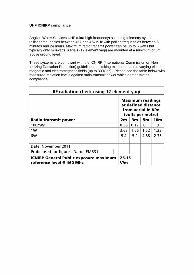
UHF ICNIRP compliance Anglian Water Services UHF (ultra high frequency) scanning telemetry system utilises frequencies between 457 and 464MHz with polling frequencies between 5 minutes and 24 hours. Maximum radio transmit power can be up to 6 watts but typically only milliwatts. Aerials (12 element yagi) are mounted at a minimum of 6m above ground level. These systems are compliant with the ICNIRP (International Commission on Non-Ionizing Radiation Protection) guidelines for limiting exposure to time varying electric, magnetic and electromagnetic fields (up to 300Ghz). Please see the table below with measured radiation levels against radio transmit power which demonstrates compliance. =
oc=ê~Çá~íáçå=ÅÜÉÅâ=ìëáåÖ=NO=ÉäÉãÉåí=ó~Öá=
==
j~ñáãìã=êÉ~ÇáåÖë=~í=ÇÉÑáåÉÇ=Çáëí~åÅÉ=Ñêçã=~Éêá~ä=áå=sLã=Eîçäíë=éÉê=ãÉíêÉF=
o~Çáç=íê~åëãáí=éçïÉê= Oã= Pã= Rã= NMã=
NMMãt= MKPS= MKNT= MKN= M=
Nt= PKSP= NKSS= NKRO= NKOP=
St= RKQ= RKO= QKUU= OKPR=
== == == == ==
a~íÉW=kçîÉãÄÉê=OMNN= == == == ==
mêçÄÉ=ìëÉÇ=Ñçê=ÑáÖìêÉëW=k~êÇ~=bjoPN= == == == ==
f`kfom=dÉåÉê~ä=mìÄäáÅ=ÉñéçëìêÉ=ã~ñáãìã=êÉÑÉêÉåÅÉ=äÉîÉä=]=QSM=jÜò=
ORKNR=sLã= ==
==
Harringworth STW Extended Phase 1 Habitat Survey
Version no. Issue date Issue status Prepared/ Reviewed by
Distribution
1.0 02.11.11 Final Dr. Rebecca
Morris/Dr. Iain Adderton
Lotte Kolind / Project Team
Document issue details:
Notice: This report was prepared by @one Alliance solely for use by Anglian Water Services Limited (Anglian Water). This report is not addressed to and may not be relied upon by any person or entity other than Anglian Water for any purpose without the prior written permission of @one Alliance. Its directors, employees and affiliated companies accept no responsibility or liability for reliance upon or use of this report (whether or not permitted) other than by Anglian Water for the purposes for which it was originally commissioned and prepared.
Report Status:
In producing this report, @one Alliance has relied upon information provided by others. The completeness or accuracy of this information is not guaranteed by @one Alliance.
FINAL
Harringworth Sewage Treatment Works Extended Phase 1 Habitat Survey Report Title:
Job No: 109036 006
Report No: R858/109036 - 006/V1/2011
Name Date
Prepared By: Dr. Rebecca Morris 02.11.2011
Checked By: Sarah Gooch 02.11.2011
Approved By: Dr. Paul Clack 02.11.2011

CONTENTS EXECUTIVE SUMMARY .............................................................................................. iii 1 INTRODUCTION ................................................................................................ 1 1.1 Scope of works ................................................................................................. 1 1.2 Proposed engineering works .......................................................................... 1 2 METHODS.......................................................................................................... 2 3 CONSTRAINTS.................................................................................................. 2 4 DESK REVIEW .................................................................................................. 3 4.1 Conservation sites ........................................................................................... 3 4.2 Protected species records............................................................................... 3 5 SITE SURVEY.................................................................................................... 5 5.1 General habitat description and evaluation................................................... 5 5.2 Hedgerows ........................................................................................................ 5 5.3 Invasive plant species...................................................................................... 6 6 PROTECTED SPECIES OF WILDLIFE............................................................. 7 6.1 Badgers ............................................................................................................. 7 6.2 Bats.................................................................................................................... 7 6.3 Birds .................................................................................................................. 7 6.4 Great crested newt ........................................................................................... 8 6.5 Hazel dormice ................................................................................................... 8 6.6 Reptiles.............................................................................................................. 8 6.7 Otter, water vole and white-clawed crayfish.................................................. 8 7 CONCLUSION ................................................................................................. 10 8 RECOMMENDATIONS .................................................................................... 11
Harringworth STW - i - November 2011 Extended Phase 1 Habitat Survey 109036 006
Alliance
Issue No.1
TABLES Table 1 Statutory conservation sites. ......................................................................................3 Table 2 List of protected species records obtained from the NBN website. ............................3 FIGURES Figure 1 Statutory and non-statutory conservation sites within a 1.5km radius of the centre of the Harringworth STW scheme. Figure 2 Scheme drawing with target notes. APPENDICES Appendix A Target notes. Appendix B Site photographs. Appendix C Birds recorded during extended Phase 1 habitat survey. Appendix D Legislation.
Harringworth STW - ii - November 2011 Extended Phase 1 Habitat Survey 109036 006
Alliance
Issue No.1
EXECUTIVE SUMMARY Grontmij has been appointed by Anglian Water to carry out an extended Phase 1 habitat survey of the Harringworth Sewage Treatment Works (STW) scheme. This survey report identifies potential ecological constraints to the project and provides appropriate recommendations for mitigation. One statutory conservation site, Seaton Meadows Site of Special Scientific Interest, was found within 1.5km of the scheme. Natural England has already been consulted and no impact to this site is expected. No non-statutory conservation sites will be affected by the scheme. No hedgerows in the vicinity of the scheme were classified as being important as defined by The Hedgerow Regulations (1997). Habitats which have potential to support nesting birds were identified along the scheme. Hedgerows and trees should be cleared outside the bird breeding season where possible. Badgers are known to be active in the area and therefore precautions should be taken to prevent these animals becoming trapped in any excavations. The River Welland has potential to support water voles and otters and if the banks or channel of this watercourse are to be affected during construction water vole and otter surveys are recommended. The riparian corridor also has potential to support reptiles and vegetation clearance ahead of construction is recommended.
Harringworth STW - iii - November 2011 Extended Phase 1 Habitat Survey 109036 006
Alliance
Issue No.1
1 INTRODUCTION
1.1 Scope of works Grontmij Limited (Grontmij) has been appointed by Anglian Water Limited (Anglian Water) to carry out an extended Phase 1 habitat survey of a proposed Sewage Treatment Works (STW) near the villages of Harringworth and Shotley, Northamptonshire, hereafter referred to as “the scheme”. The purpose of the survey was to determine whether there were any potential protected species, or habitats and species of conservation value in the vicinity of the scheme which may be adversely affected by the proposed works. The survey report also identifies any constraints imposed by these in relation to environmental legislation and makes appropriate recommendations for mitigation or further survey work. The scope of work included a desk based review of all pertinent information, an extended Phase 1 habitat survey and the production of an ecological report.
1.2 Proposed engineering works Anglian Water is constructing a new STW to serve the villages of Harringworth and Shotley. An outfall pipe will connect to the STW and discharge into the River Welland.
Harringworth STW - 1 - November 2011 Extended Phase 1 Habitat Survey 109036 006
Alliance
Issue No.1
2 METHODS A desk study and extended Phase 1 habitat survey were carried out for the scheme. Information from the following sources was reviewed as part of the desk study:
• Information on the Multi-Agency Geographical Information for the Countryside (MAGIC) website within a 1.5km radius of the centre of the scheme;
• Information on the National Biodiversity Network (NBN) website in relation to protected species within 10km of the scheme;
• 1: 25,000 Ordnance Survey (OS) map. • Environmental Screening Report (ESR) provided by Anglian Water’s Climate Change
and Environmental Management Team. The field survey included the following:
• Identification of all main habitats within the survey area. • Identification of invasive plant species within the work area (e.g. Japanese knotweed,
giant hogweed and Himalayan balsam). • Identification and assessment of the value of any habitats that will have to be
removed / destroyed by the scheme including trees, hedges and ponds. • As recommended by Joint Nature Conservation Committee (JNCC)1 and Institute of
Ecology and Environmental Management (IEEM)2 Guidelines the survey identifies the potential for protected species within the work area including:
o Great crested newt ponds and terrestrial habitat within 500m of the scheme. o Badger setts within 30m of the scheme. o Potential bat roosts and foraging habitat within the scheme footprint. o Potential hazel dormice habitat within 30m of the scheme. o Nesting habitats for birds within the scheme footprint. o Otters and otter habitat within 30m of the scheme. o Reptile habitat including hibernacula within the scheme footprint. o Water vole habitat within 20m of the scheme. o Potential habitat for native white-clawed crayfish in watercourses affected by
the scheme. The extended Phase 1 habitat survey of the STW and outfall was undertaken on the 4th October 2011 by Sarah Gooch (MIEEM), the weather was sunny with temperatures of 19oC.
3 CONSTRAINTS No constraints were encountered during the survey.
Extended Phase 1 Habitat Survey 109036 006
Alliance
Issue No.1
1 JNCC (2010). Handbook for Phase 1 Habitat Survey. 2 IEEM (2011). Guidelines for Baseline Ecological Assessment.
Harringworth STW - 2 - November 2011
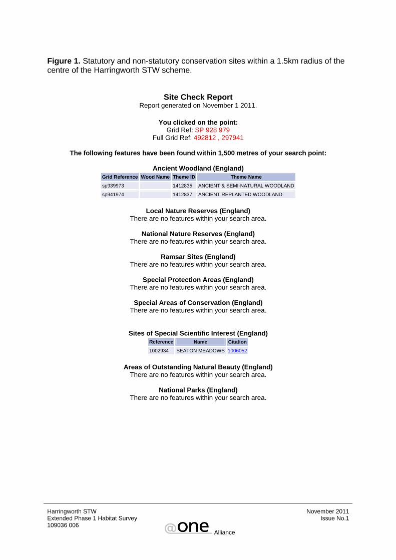
4 DESK REVIEW 4.1 Conservation sites The MAGIC website was used to check for the presence of statutory and some non-statutory conservation sites within a 1.5km radius of the centre of the scheme (Figure 1). There was one statutory conservation site identified within 1.5km of the scheme and it is summarised in Table 1. Seaton Meadows Site of Special Scientific Interest (SSSI) is located north of the River Welland and is unlikely to be affected. Natural England has already been consulted regarding this scheme and no concerns were raised so no further work is recommended. Table 1. Statutory conservation sites. Feature Name SSSI
Seaton Meadows SP 915978 One of the few remaining examples of unimproved alluvial flood meadows in Leicestershire. This is located approximately 1km from the scheme.
Two areas of ancient and semi-natural woodland and ancient replanted woodland are present in the search area. Although ancient woodland does not receive full statutory protection, national, regional and local planning policies are increasingly mentioning protection of ancient woodland in planning documents (e.g. Planning Policy Statement 9 (PPS9) – Biodiversity and Geological Conservation, 2005). Given the national decline in this type of woodland and the steps being taken by the Woodland Trust to conserve the remaining areas, careful consideration must be given to works close to these features. However, as all ancient woodland is located over 1km from the scheme it will not be affected. According to the ESR there are no other non-statutory conservation sites within 1.5km that could potentially be impacted by the works.
4.2 Protected species records Results of the search of the NBN gateway website within the 10km squares surrounding the proposed scheme (SP 89 and SP 99) are summarised in Table 2. Table 2. List of protected species records obtained from the NBN website. Species Location
The closest record is from Cryers Hill, located 4km west of the scheme. The most recent record is from 1979.
Badger
Six species of bat have been recorded: pipistrelle sp., brown long-eared, Daubenton’s, whiskered, noctule and Natterer’s. The closest record is from Monckton Farm, located 3km west of the scheme. The most recent record is from 2008 (Natterer’s).
Bats
Great crested newt
The closest record is from 9 Main Street Lyddington, located 2km west of the scheme. The most recent record is from 2009.
Harringworth STW - 3 - November 2011 Extended Phase 1 Habitat Survey 109036 006
Alliance
Issue No.1
The closest record is from Wakerley Great Wood, located 2.7km east of the scheme. The most recent record is from 2004.
Hazel dormouse
The closest record is from the River Welland at Harringworth, located 1km south west of the scheme. The most recent record is from 1996.
Otter
Four species of reptiles have been recorded: grass snake, slow-worm, adder and common lizard. Grass snake has been recorded in grid square SP 89. The closest slow-worm record is from Wakerley Woods, located approximately 1.5km north east of the scheme. The closest adder record is from Harringworth, located 2.5km south west of the scheme. Common lizard has been recorded in the same 1km grid square as the scheme. The most recent records are from 1992 (grass snake), 2009 (slow-worm) and 1990 (adder and common lizard).
Reptiles
The closest record is from Harringworth, no specific location given. The most recent record is from 1982.
Water vole
White-clawed crayfish
No records.
Harringworth STW - 4 - November 2011 Extended Phase 1 Habitat Survey 109036 006
Alliance
Issue No.1
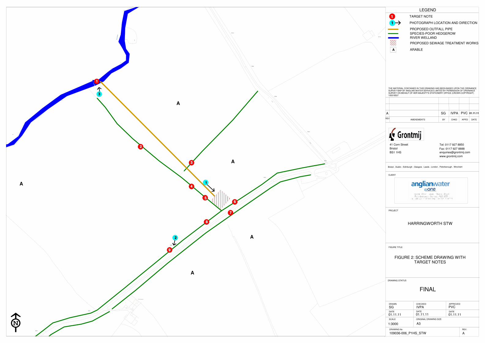
5 SITE SURVEY A Phase 1 habitat map of the scheme is provided as Figure 2 with associated Target Notes detailed in Appendix A. Photographs taken during the survey are included in Appendix B.
5.1 General habitat description and evaluation The majority of the scheme is located within arable fields (Photograph 1) but parts of the scheme also pass through hedgerows and may affect a grassland verge. The agricultural fields and grassland verge on the northern side of Wakerley Road have only ecological importance within their own zone of influence. The hedgerows and the verge to the south of Wakerley Road have more value and are considered to be of local ecological value. The proposed STW is located in an arable field. This habitat is of low ecological value. The River Welland (Target Note 1) has potential to support a number of protected species and therefore is considered to be of county level ecological importance.
5.2 Hedgerows Many hedgerows are protected from damage or destruction by the Hedgerow Regulations 1997. This legislation applies to any hedgerow growing in, or adjacent to, any common land, protected land, or land used for agriculture, forestry or the breeding or keeping of horses, ponies or donkeys if –
- it has a continuous length of at least 20 metres or
- it has a continuous length of less than 20 metres but each end meets with another hedgerow. If the hedgerow meets the above specification and has existed for 30 years then any action that will result in damage or destruction must be notified to the Local Planning Authority (LPA) at least 42 days in advance by the submission of a Hedgerow Removal Notice. The LPA then has 42 days to determine whether or not the hedgerow is 'important' under the regulations, and whether or not to issue a Hedgerow Retention Notice. None of the hedgerows in the vicinity of the scheme are deemed “important” according to their ecological value under the Hedgerow Regulations. However, should hedgerow removal be required they should also be considered under archaeological and historical criteria as this may qualify them as important. Consideration should be given to nesting birds where the scheme affects hedgerows. Recommended Action:
• If hedgerow removal is required such as for access to the STW then notices should
be applied for well in advance of works from the LPA, unless the hedges are within the boundary of the planning application area.
• If possible, existing gaps should be utilised and the length of sections removed
minimised as much as possible.
Harringworth STW - 5 - November 2011 Extended Phase 1 Habitat Survey 109036 006
Alliance
Issue No.1
• Following the completion of the scheme, reinstatement of removed sections will be necessary in the first planting season after construction using native species common to the hedgerow affected.
• Loss of the hedgerow for access to the STW should be compensated for by planting
a hedgerow around the STW.
5.3 Invasive plant species No invasive plant species were identified during the survey.
Harringworth STW - 6 - November 2011 Extended Phase 1 Habitat Survey 109036 006
Alliance
Issue No.1
6 PROTECTED SPECIES OF WILDLIFE Although several species are afforded protection under the Wildlife and Countryside Act, 1981 (as amended) only those considered as relevant to the scheme are included. A brief summary of the legislation surrounding each species or group is provided in Appendix D.
6.1 Badgers A badger sett was identified along Wakerley Road on an embankment adjacent to the road (Target Note 9, Photograph 2). It had three holes and was active at the time of survey. This is located more than 30m from the scheme and therefore is not expected to be affected. A badger latrine was identified at the base of a hedgerow (Target Note 4) indicating that badgers are foraging close to the scheme, therefore recommendations are given to minimise any impacts to badgers using this area. Recommended Action:
• The ends of trenches should be graded at a shallow angle or a suitable ramp provided to enable animals to escape should they gain entry.
• Where pipes with an internal diameter of greater than 200mm emerge from
backfilled trenches then the terminal ends should be capped. This will prevent animals from entering pipes and becoming trapped.
6.2 Bats No mature trees or buildings were identified as having potential to support bat roosts close to the scheme. The River Welland has some suitability to be used by foraging bats, but works are unlikely to affect this.
6.3 Birds There are several habitats in the vicinity of the scheme with high potential to support nesting birds, including hedgerows (Target Notes 2, 3, 5, 6 and 8) and tall ruderal vegetation on the road verge (Target Note 7). During the survey, 17 species of bird were seen and heard (Appendix C). Some of these species are ground, tree and hedge nesters and it is therefore possible that they could be nesting within habitats on the scheme. The house sparrow is a species of high conservation concern and based on population assessments by leading governmental and non-governmental conservation organisations is placed on the Red List. Swallow is a species of medium conservation concern and based on population assessments by leading governmental and non-governmental conservation organisations is placed on the Amber List3. House sparrows are also a UK Biodiversity Action Plan (BAP) priority species. House sparrows are hedgerow nesters and therefore could be of concern if hedgerows are affected along this scheme. 3 Eaton, M.A., Brown, A.F., Noble, D.G., Musgrove, A.J., Hearn, R., Aebischer, N.J., Gibbons, D.W., Evans, A. and Gregory, R.D. (2009). Birds of Conservation Concern 3: the population status of birds in the United Kingdom, Channel Islands and the Isle of Man. British Birds 102, pp296-341.
Harringworth STW - 7 - November 2011 Extended Phase 1 Habitat Survey 109036 006
Alliance
Issue No.1

If any of the hedgerows or trees need to be removed as part of the works recommendations are given below. Recommended action:
• If works are undertaken outside the breeding season (i.e. after August 2011 and before March 2012) then there will be no impacts to nesting birds.
• If hedgerows or trees are to be removed during the breeding season they should be
checked in advance by an experienced ecologist and then, assuming no nests are present, cleared at the earliest opportunity. If active nests are found, clearance will have to be delayed until young have fledged.
6.4 Great crested newt There are no ponds marked on the OS map and engineering drawings within 500m of the scheme and therefore no further work is recommended.
6.5 Hazel dormice Hazel dormice records exist from Wakerley Great Wood located 2.7km away in 1999. However, hedgerows along the scheme do not contain suitable species of sufficient diversity to support this species and there are no suitable woodlands in the immediate area. No further work is recommended.
6.6 Reptiles The riparian corridor of the River Welland (Target Note 1) has potential to support reptiles such as grass snake which may use the river as a movement corridor. Recommended action:
• If the riparian corridor is to be affected during works associated with the outfall vegetation should be cut down to ground level before construction to discourage animals from the working area.
6.7 Otter, water vole and white-clawed crayfish The River Welland (Target Note 1, Photograph 3) has potential to support otter, water vole and white-clawed crayfish. No signs of any of these species were found during the survey. However, otters have been recorded along the River Welland 1km south west of the scheme and water vole records exist from Harringworth. Records exist for American signal crayfish from a tributary of the River Welland within 10km of the scheme. It is therefore possible that they are present in this area of the river. As the American signal crayfish carries a disease to which the native white-clawed crayfish is particularly susceptible it is unlikely that they will co-exist in the same stretch of river.
Harringworth STW - 8 - November 2011 Extended Phase 1 Habitat Survey 109036 006
Alliance
Issue No.1
Recommended action: • If works to install outfall structures are going to affect the banks or channel of the
River Welland pre-construction surveys for otter and water vole will be required.
• Plant and materials should not be parked or stored on the banks of the River Welland as this will damage the bank structure and could damage burrows/holts if present.
• Pollution prevention and control measures should be undertaken during construction
to prevent any pollutants or sediments entering watercourses or ditches which may flow into larger watercourses used by protected species.
Harringworth STW - 9 - November 2011 Extended Phase 1 Habitat Survey 109036 006
Alliance
Issue No.1
7 CONCLUSION There is one statutory conservation site identified approximately 1km from the scheme. Seaton Meadows SSSI is located north of the River Welland and is unlikely to be affected. Natural England have been contacted regarding this scheme and no issues were identified and therefore no further work is required. No non-statutory conservation sites will be affected by the scheme. There are no important hedgerows along the scheme however, consideration should be given to birds that could be nesting within them between March and August. The River Welland is of county level ecological importance and could support a number of protected species. Hedgerows and the verge to the south of Wakerley Road were assessed as being of local level of ecological importance, other habitats were only important within their own zone of influence. The location of the STW will not have any long term impacts as it is located in habitat of low ecological value. Depending on the construction methods used the scheme also has potential to impact upon badgers, nesting birds, reptiles, otters and water voles.
Harringworth STW - 10 - November 2011 Extended Phase 1 Habitat Survey 109036 006
Alliance
Issue No.1
8 RECOMMENDATIONS Undertaking the following recommendations will serve to minimise the impacts of the scheme and avoid delays which could occur if not undertaken.
1. The length of hedgerow sections requiring removal should be minimised and existing gaps used where possible. Reinstatement should occur in the first planting season after construction and use native species common to the hedgerow affected.
2. To protect badgers in the wider environment it is recommended that any trenches left
open overnight are graded to allow badgers to escape and any pipes over 200mm in diameter are capped to prevent badgers becoming trapped.
3. If vegetation clearance needs to be undertaken such as hedgerow removal for access
to the STW then this should be done outside the breeding season (i.e. after August) to avoid impacts to nesting birds.
4. If vegetation is to be removed during the bird breeding season it should be checked in
advance by an experienced ecologist and then cleared at the earliest opportunity. If any nesting birds are present then the work programme will need to be rescheduled for that area until the young have fledged.
5. The loss of a hedgerow for access to the STW could be compensated for by planting
a hedgerow around the STW.
6. If the riparian corridor is to be affected during works associated with the outfall vegetation should be cut down to ground level before construction to discourage reptiles from the working area.
7. If the River Welland is affected by the works such as installing an outfall structure
then surveys for otter and water vole are recommended.
8. Plant and materials should not be parked or stored on the banks of the River Welland as this will damage the bank structure and could damage burrows/holts if present.
9. Pollution prevention and control measures should be undertaken during construction
to prevent any pollutants or sediments entering watercourses or ditches which may flow into larger watercourses used by protected species.
This report is based on the work plan provided, should the plans be altered, such that the plan is significantly changed, time of works delayed, or construction method altered, ecologists at Grontmij Limited should be contacted immediately for further advice.
Harringworth STW - 11 - November 2011 Extended Phase 1 Habitat Survey 109036 006
Alliance
Issue No.1

FIGURES
Harringworth STW November 2011 Extended Phase 1 Habitat Survey 109036 006
Alliance
Issue No.1
Harringworth STW November 2011 Extended Phase 1 Habitat Survey 109036 006
Alliance
Issue No.1
Figure 1. Statutory and non-statutory conservation sites within a 1.5km radius of the centre of the Harringworth STW scheme.
You clicked on the point: Grid Ref: SP 928 979
Full Grid Ref: 492812 , 297941
The following features have been found within 1,500 metres of your search point:
Ancient Woodland (England) Grid Reference Wood Name
Site Check Report Report generated on November 1 2011.
Theme ID Theme Name sp939973 1412835 ANCIENT & SEMI-NATURAL WOODLAND sp941974 1412837 ANCIENT REPLANTED WOODLAND
Local Nature Reserves (England)
There are no features within your search area.
National Nature Reserves (England) There are no features within your search area.
Ramsar Sites (England)
There are no features within your search area.
Special Protection Areas (England) There are no features within your search area.
Special Areas of Conservation (England)
There are no features within your search area.
Sites of Special Scientific Interest (England) Reference Name Citation
1002934
Areas of Outstanding Natural Beauty (England) There are no features within your search area.
National Parks (England)
There are no features within your search area.
SEATON MEADOWS
1006052

Figure 1 continued. Statutory and non-statutory conservation sites within a 1.5km radius of the centre of the Harringworth STW scheme.
Harringworth STW November 2011 Extended Phase 1 Habitat Survey 109036 006
Alliance
Issue No.1
CHKD APR'D
THE MATERIAL CONTAINED IN THIS DRAWING HAS BEEN BASED UPON THE ORDNANCE SURVEYMAP BY SEVERN TRENT WATER LTD. BY PERMISSION OF ORDNANCE SURVEY ON BEHALFOF THE CONTROLLERS OF HER MAJESTY'S STATIONERY OFFICE (CROWN COPYRIGHT) WU 29852
ORIGINAL DRAWING SIZE
CHECKED
DATE
APPROVED
DATE
www.grontmij.com
DRAWING No REV.
DRAWING STATUS
Bristol . Dublin . Edinburgh . Glasgow . Leeds . London . Peterborough . Wrexham
Bristol
41 Corn Street
CLIENT
DATE
SCALE
DRAWN
FIGURE TITLE
BYAMENDMENTS DATE
BS1 1HS
REV
Fax: 0117 927 8888
Tel: 0117 927 8850
PROJECT
11
11
TARGET NOTE
PHOTOGRAPH LOCATION AND DIRECTION
FINAL
THE MATERIAL CONTAINED IN THIS DRAWING HAS BEEN BASED UPON THE ORDNANCE SURVEY MAP BY ANGLIAN WATER SERVICES LIMITED BY PERMISSION OF ORDNANCE SURVEY ON BEHALF OF HER MAJESTY'S STATIONERY OFFICE (CROWN COPYRIGHT) 100018507
LEGEND
HARRINGWORTH STW
FIGURE 2: SCHEME DRAWING WITHTARGET NOTES
SG IVPA PVC
01.11.11 01.11.11 01.11.11
A3
A109036-006_P1HS_STW
A SG IVPA PVC 01.11.11
CR
Def
CR
CR
Def
Riv
er
Wel la
nd
1
2
The Bungalows
67.1m
85.6m
78.0m
83.2m
60.0m
72.8m
84.7m
58.8m
68.3m
49.1m
Track
Track
A
A
A
A
A
77
88
99
11
22
55
44
33
66
33
22
11
1:3000
PROPOSED OUTFALL PIPE
SPECIES-POOR HEDGEROW
RIVER WELLAND
ARABLE
PROPOSED SEWAGE TREATMENT WORKS
A

APPENDIX A TARGET NOTES
Harringworth STW November 2011 Extended Phase 1 Habitat Survey 109036 006
Alliance
Issue No.1
Target Note Comment
River Welland which had abundant bank-side vegetation and potential to support otter, water vole and white-clawed crayfish. The riparian corridor has potential to support reptiles.
1
2 Species-poor hedgerow comprised of blackthorn, hawthorn and rose sp.
3 Species-poor hedgerow 3m high with hawthorn and elder.
4 Badger latrine at base of hedgerow.
5 Species-poor hedgerow 4m high with hawthorn, ivy and elder.
Species-poor hedgerow 4m high with hawthorn, lime sp. and elder. A rabbit warren is present at its base. 6
Road verge with tall ruderal vegetation and grasses including hogweed, nettle, cock’s-foot and false oat-grass. 7
Species-poor hedgerow with hawthorn, elder, ivy and bramble. Occasional mature ash and lime trees are present along its length. 8
Badger sett comprised of three holes and appeared to be active at the time of survey. 9
Harringworth STW November 2011 Extended Phase 1 Habitat Survey 109036 006
Alliance
Issue No.1

APPENDIX B SITE PHOTOGRAPHS
Harringworth STW November 2011 Extended Phase 1 Habitat Survey 109036 006
Alliance
Issue No.1
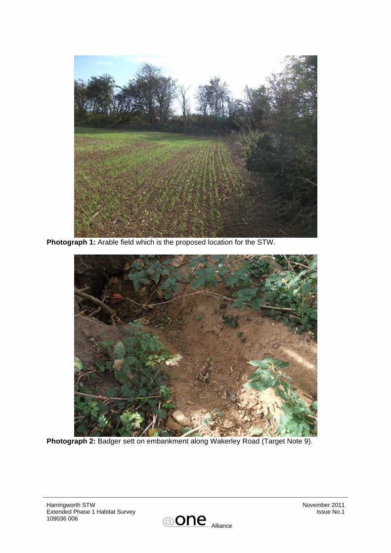
Photograph 1: Arable field which is the proposed location for the STW.
Photograph 2: Badger sett on embankment along Wakerley Road (Target Note 9).
Harringworth STW November 2011 Extended Phase 1 Habitat Survey 109036 006
Alliance
Issue No.1
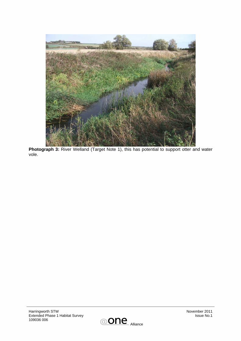
Photograph 3: River Welland (Target Note 1), this has potential to support otter and water vole.
Harringworth STW November 2011 Extended Phase 1 Habitat Survey 109036 006
Alliance
Issue No.1

APPENDIX C BIRDS RECORDED DURING EXTENDED PHASE 1 HABITAT SURVEY
Harringworth STW November 2011 Extended Phase 1 Habitat Survey 109036 006
Alliance
Issue No.1
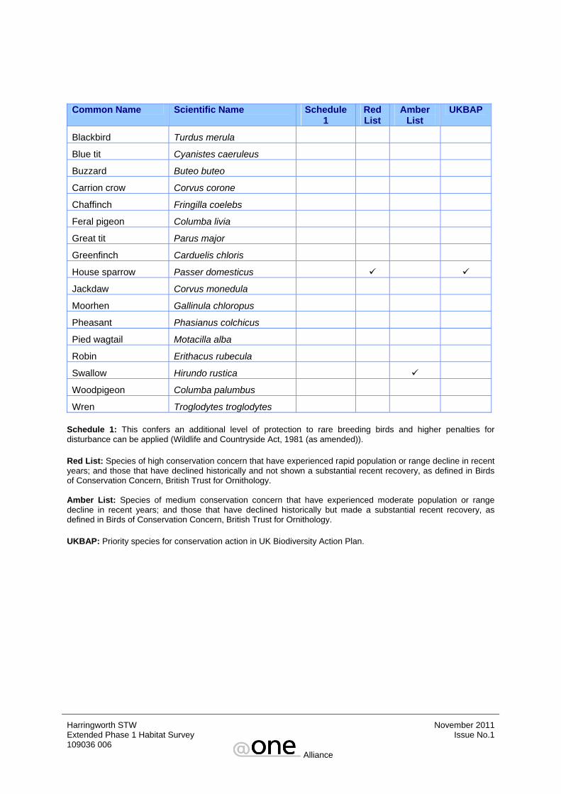
Common Name Scientific Name Schedule
1 Red List
Amber List
UKBAP
Blackbird Turdus merula
Blue tit Cyanistes caeruleus
Buzzard Buteo buteo
Carrion crow Corvus corone
Chaffinch Fringilla coelebs
Feral pigeon Columba livia
Great tit Parus major
Greenfinch Carduelis chloris
House sparrow Passer domesticus
Jackdaw Corvus monedula
Moorhen Gallinula chloropus
Pheasant Phasianus colchicus
Pied wagtail Motacilla alba
Robin Erithacus rubecula
Swallow Hirundo rustica
Woodpigeon Columba palumbus
Wren Troglodytes troglodytes
Schedule 1: This confers an additional level of protection to rare breeding birds and higher penalties for disturbance can be applied (Wildlife and Countryside Act, 1981 (as amended)). Red List: Species of high conservation concern that have experienced rapid population or range decline in recent years; and those that have declined historically and not shown a substantial recent recovery, as defined in Birds of Conservation Concern, British Trust for Ornithology. Amber List: Species of medium conservation concern that have experienced moderate population or range decline in recent years; and those that have declined historically but made a substantial recent recovery, as defined in Birds of Conservation Concern, British Trust for Ornithology. UKBAP: Priority species for conservation action in UK Biodiversity Action Plan.
Harringworth STW November 2011 Extended Phase 1 Habitat Survey 109036 006
Alliance
Issue No.1

APPENDIX D LEGISLATION
Harringworth STW November 2011 Extended Phase 1 Habitat Survey 109036 006
Alliance
Issue No.1

The following is a summary of legislation covering protected species of wildlife relevant to this scheme: Badger Badgers are protected under the following Act:
• The Protection of Badgers Act, 1992.
This statute makes it an offence to kill, ill treat or wilfully harm a badger or attempt to do so; or interfere with a sett (any structure or place which displays signs indicating current use by a badger) and disturbing a badger which may be occupying it. Where planning permission has been granted, Natural England may issue a licence to interfere with setts for development purposes. However, licences are only usually issued for works between July and November, a period when badgers are unlikely to have dependent young below ground. Bats All bats in the UK are protected under British and European legislation:
• Included in Annex II and IV of EC Directive 92/43/EEC on the Conservation of Natural Habitats and of the Wild Fauna and Flora (the Habitats Directive 1992) as obligated by the Bern Convention (1979) which implements the Conservation of Habitats and Species Regulations 2010 making it a European protected species (listed under Schedule 2).
• Schedule 5 of the Wildlife and Countryside Act (1981) (as amended by the Countryside Rights of Way Act 2000).
• Appendix II on The Convention on the Conservation of Migratory Species of Wild Animals (Bonn Convention).
• Section 41 of the Natural Environment and Rural Communities Act (2006). Under these statutes, it is an offence to damage or destroy any bat roosts, intentionally or recklessly obstruct a bat roost, deliberately, intentionally or recklessly disturb a bat or intentionally kill, injure or take any bat. Birds Birds are protected under the following:
• Section 1 of the Wildlife and Countryside Act 1981 (as amended by the Countryside Rights of Way Act 2000).
• Bird species which are listed on Schedule 1 of the Wildlife and Countryside Act (1981) receive greater protection and special penalties are imposed for offences.
• Council Directive 79/409/EEC on the Conservation of Wild Birds (The Birds Directive 1979) as obligated by the Bern Convention (1979) and Bonn Convention (1979).
Under these statutes it is an offence to intentionally kill, injure or take any wild bird or take, damage or destroy the nest (whilst being built or in use) or eggs. For species listed on Schedule 1, a person is guilty of an offence if they disturb these species while nest building, or is in or near a nest containing eggs or young; or disturbs dependent young of such a bird.
Harringworth STW November 2011 Extended Phase 1 Habitat Survey 109036 006
Alliance
Issue No.1
Great crested newt The great crested newt is protected under British and European legislation:
• Included in Annex II and IV of the Habitats Directive 1992 as obligated above. • Schedule 5 of the Wildlife and Countryside Act (1981) (as amended by the
Countryside Rights of Way Act 2000). • Section 41 of the Natural Environment and Rural Communities Act (2006).
The above makes it an offence to deliberately capture or kill a great crested newt, damage any place used for shelter or protection by the species, including breeding ponds and terrestrial habitats, or intentionally or recklessly disturb a great crested newt whilst it is occupying a place of shelter. Hazel Dormice Hazel dormice are protected under the following:
• Included in Annex II and IV of the Habitats Directive 1992 as obligated above. • Schedule 5 of the Wildlife and Countryside Act (1981) (as amended by the
Countryside Rights of Way Act 2000). • Section 41 of the Natural Environment and Rural Communities Act (2006).
These statutes makes it an offence to kill injure or disturb a hazel dormouse, damage or destroy a place of shelter or intentionally damage or destroy a place of shelter or protection whilst it is occupied by an animal. Otter Otters are protected under the following:
• Included in Annex II and IV of the Conservation of the Habitats Directive 1992 as obligated above.
• Schedule 5 of the Wildlife and Countryside Act (1981) (as amended by the Countryside Rights of Way Act 2000).
• Section 41 of the Natural Environment and Rural Communities Act (2006). Under these statutes it is an offence to injure, kill or take an otter, or to intentionally damage or destroy, or obstruct access to any structure or place which an otter uses for shelter or protection; or disturb an animal while it is occupying such a structure.
Harringworth STW November 2011 Extended Phase 1 Habitat Survey 109036 006
Alliance
Issue No.1
Reptiles All reptiles are protected under the following:
• Schedule 5 of the Wildlife and Countryside Act (1981) (as amended by the Countryside Rights of Way Act 2000). In respect of Section 9.5 only – protected against intentional killing, injuring or taking and sale of any live or dead specimen, or any part of or anything derived from such an animal.
• Section 41 of the Natural Environment and Rural Communities Act (2006). • Sand lizard and Smooth snake are also included in Annex II and IV of the Habitats
Directive, 1992.
All reptiles are protected against intentional killing and injuring. This should be interpreted as meaning that if the harming of a reptile can reasonably be avoided then any act causing harm is quite probably illegal, and measures should be put in place to avoid this happening. It is also an offence to damage or destroy any place used for shelter or protection by sand lizard or smooth snake, or intentionally or recklessly disturb these animals while they occupy such a place. Water vole Water voles are protected under the following:
• Schedule 5 of the Wildlife and Countryside Act (1981) (as amended by the Countryside Rights of Way Act 2000.
• Section 41 of the Natural Environment and Rural Communities Act (2006). Under these statutes it is an offence to intentionally kill, injure or take (capture) a water vole; possess or control a live or dead water vole, or any part of a water vole; intentionally or recklessly damage, destroy or obstruct access to any structure or place which the animals use for shelter or protection or disturb water voles when they are using such a place; sell, offer for sale or advertise for live or dead water voles. White-clawed crayfish The white-clawed crayfish is protected under the following:
• Included in Annex II and V of the Habitats Directive 1992 as obligated above. • Schedule 5 of the Wildlife and Countryside Act (1981) (as amended by the
Countryside Rights of Way Act 2000). • Section 41 of the Natural Environment and Rural Communities Act (2006).
The above statutes make it illegal to either take white-clawed crayfish from the wild or sell them without an appropriate licence from the appropriate nature conservation agency. In addition, white clawed crayfish is listed as a Species of Principal Importance under the provisions of the NERC Act. PPS9 gives guidance on the treatment of such species and states that local authorities should ensure that they are protected from the adverse effects of development, where appropriate, by using planning conditions or obligations.
Harringworth STW November 2011 Extended Phase 1 Habitat Survey 109036 006
Alliance
Issue No.1

BRIEF FOR THE ARCHAEOLOGICAL FIELD EVALUATION OF THE LAND AT THE PROPOSED HARRINGWORTH & SHOTLEY
STW, NORTHAMPTONSHIRE
CONTENTS: 1 - INTRODUCTION 2 - OBJECTIVES 3 - FIELD METHODS 4 - POST-FIELDWORK 5 - REPORT 6 - GENERAL
Planning Services Northamptonshire County Council

1 INTRODUCTION
1.1 This Brief is valid for 6 months from the date of issue. If the project it describes is undertaken after that period the Brief should be referred to the County Archaeological Advisor for revision; no work should be undertaken until an updated Brief has been issued.
1.2 The background for this archaeological field evaluation is contained in the
Brief for a Programme for the Archaeological Investigation of the land at the proposed Harringworth & Shotley STW, Northamptonshire (12th October 2011) which accompanies this document, and which should be read in conjunction with it.
1.3 The archaeological field evaluation forms Stage I of the programme of
archaeological investigation for the site outlined in the above Brief. 2. OBJECTIVES 2.1 It is clear that the study area has considerable archaeological potential and
could contain remains that would be a significant constraint on the construction of the extensions.
2.2 Further information on the archaeological potential within the proposed
development is required. 2.3 Information on the following is required:
2.3.1 The location, extent, nature, and date of any archaeological features or deposits that may be present.
2.3.2 The integrity and state of preservation of any archaeological features or deposits that may be present.
2.4 The information required will be acquired through a programme of
archaeological research and fieldwork as outlined below. 3 FIELD METHODS 3.1 In order to obtain the information outlined in 2.2 a programme of
archaeological fieldwork will be undertaken. 3.2 Throughout the project the standards set in: Institute of Field Archaeologists
Codes of Conduct and Standards and Guidance documents (specifically Standard and Guidance for Archaeological Field Evaluation, revised 2008), English Heritage’s Management of Research Projects in the Historic Environment (2009) and Archaeological Archives: A Guide to best practice in creation, compilation, transfer and curation Archaeological Archive Forum (2007) will be adhered to.
3.3 The recording system employed will conform to these standards and the recording system employed will conform to these standards and will be approved by the County Archaeological Advisor before the project commences.
3.4 An integrated project archive (including both artefacts/ecofacts and project
documentation) should be prepared upon completion of the project. Archaeological contractors should note that there is currently no archaeological archive depository able to accept material from this part of the county, although the issue is being actively addressed and it is hoped that suitable facility will be available within 3-5 years. Provision should therefore be made for retaining the project archive until such time as a suitable depository is available and arrangements have been made for the transfer of the archive. Provision should be made for the payment of a ‘deposit grant’ at the time of archive transfer towards the costs of archive curation in perpetuity. The rates and requirements currently employed by archive stores elsewhere in the country and by Northampton Borough Museum for its archive store should be used for guidance.
3.5 The archaeological contractor must be satisfied that all constraints on
archaeological fieldwork are identified and appropriate measures to avoid damaging or illegal impacts must be put in place before the project commences. The constraints include the siting of live services, Tree Preservation Orders, public rights of way, contaminated land, areas of ecological interest and the habitats of protected species.
3.6 The field evaluation will have a single stage as outlined below. 3.7 STAGE I – TRIAL TRENCHING 3.7.1 A series of trial trenches will be excavated within the areas shown on the site
drawing provided with the consultation identified as potential areas of intrusive works.
3.7.2 The evaluation should include a programme of three 20 meter trenches. 3.7.3 The trial trenches will be located with the areas of intrusive works and will
also overlap sufficiently to provide the option for reorientation if required. The trench layout and the deployment of the contingency allowance will be discussed with and agreed by the County Archaeological Advisor before they are implemented.
3.7.4 The trial trenches will be excavated under archaeological supervision by a
suitable machine fitted with a toothless bucket with a minimum width of 1.8m. 3.7.5 Topsoil and other overburden will be removed by machine down to the top of
natural subsoil or archaeological deposits, whichever is encountered first. 3.7.6 The spoil will be scanned for artefacts. 3.7.7 The trial trenches will then be cleaned by hand and the location of all features
and deposits recorded at a scale of 1:50. 3.7.8 Sufficient of any archaeological features or deposits revealed will be
excavated in order to provide the information required. All discrete features will be half sectioned, where safe to do so but should in any case the sample should not be less than 50% of the whole. Excavation slots must be at least 1m in width. It should be born in mind that excavation must not compromise
the integrity of the archaeological record. Investigation should be undertaken in such a way as to allow for the protection of the deposits through the application of mitigation procedures or through the opportunity for better excavation under the conditions pertaining to full investigation of a larger area.
3.7.9 Should a significant depth of stratified deposits be encountered it may be
necessary for excavation to continue in a restricted area within the trial trenches in order to test the depth and nature of the stratigraphy. The location and scale of the deeper excavation will be dictated by the nature of the archaeological deposits revealed in the opening of the trenches and by other on–site conditions, paying particular regard to health and safety issues. The agreement of the County Archaeological Advisor must be obtained before such a strategy is implemented.
3.7.10 All excavated features and deposits will be fully recorded in accordance with
the approved recording system. The primary photographic record will normally be compiled in 35mm black and white format. This will be supplemented by 35mm colour slide/print and digital format. The different mediums have their own strengths and that the use of a combination presents the best way of ensuring the optimum conditions for the survival of archival records. Further information on digital archiving can be obtained from the Technical Advisory Service for Images and Archaeology Data Service.
3.7.11 A programme of sampling to retrieve environmental and organic material will
be undertaken as an intrinsic part of the evaluation. This will be based on the environmental strategy produced by the environmental specialist as required within the investigation component of the Brief. Guidance on sampling can also be obtained from English Heritage (2002) and following discussions with the CAA during the first monitoring meeting.
3.7.12 All finds and other relevant material will be retained and removed from the
site for post-fieldwork analysis. 3.7.13 Care must be taken in dealing with human remains and the appropriate
Department for Constitutional Affairs and environmental health regulations followed. CAA and the local Coroner must be informed immediately upon discovery of human remains. Where human remains are encountered as part of the investigation, it is essential that the post-excavation assessment contains an analysis of the remains and a statement for the final deposition of the assemblage. The qualified statement must address future research potential, where applicable, and the options for reburial.
3.7.14 Project Managers are reminded of the need to comply with the requirements
of the Treasure Act 1996 (with subsequent amendments). Advice and guidance on compliance with Treasure Act issues can be obtained from the Historic Environment Record (HER) office, and project managers are recommended to report any finds that could be considered treasure under the terms of the Act made during the process of fieldwork to SMR within 48 hours of discovery.
3.7.15 All areas of ground disturbance will be accurately surveyed in and marked out
prior to the commencement of work.
3.7.16 The trial trenches will not be back filled before they have been inspected by the County Archaeological Advisor or the agreement of that Officer has otherwise been obtained for the back filling of specific trenches.
4. POST-FIELDWORK 4.1 After completion of the fieldwork programme the data acquired will be
analysed to a level which will provide the information required (see 2.2). 4.2 Bulk soil samples taken for environmental purposes (3.7.11) will be sieved
and scanned. 4.3 All finds will be cleaned, marked, sorted and analysed in accordance with the
approved recording system and the practices and standards described in Preparation of Archaeological Archives; Selection, Retention and Dispersal of Archaeological Collections (1993), the IFA Standards and Guidance for Finds Work (2000) and Archaeological Archives: A Guide to best practice in creation, compilation, transfer and curation (2007)
4.4 All medieval and earlier artefacts should be reported on by a suitably qualified
specialist, named in the contractor's method statement or Specification. All Saxon and later ceramics should be classified in accordance with the Northamptonshire Ceramic Type Series.
4.5 All records and materials produced will be fully archived. The archive will
conform to the standards outlined in MoRPHE Project Planning Note 3: Archaeological Excavation, Appendix 1.
5 REPORT 5.1 A report will initially be prepared on the results of the field evaluation. 5.2 It will describe the methods employed and outline the results in relation to the
areas of information required (see 2.2) and conform to the standards set out in the Association of County Archaeological Officer’s Briefs and Specifications for Archaeological Assessment and Field Evaluation (1993) and the Institute of Field Archaeologist’s Standard and Guidance for Archaeological Field Evaluation (1999).
5.3 The report must contain sufficient detail to enable the results to be interpreted
without recourse to the site archive. It will include tabulations of contexts and finds by context. It will also include a non-technical summary of the project and its results.
5.4 The results of this evaluation must be related to the archaeological and
historical context of the surrounding area. 5.5 The report should also contain a consideration of the significance of the
results of the evaluation, putting them into a local and regional context. It must not, however, contain any recommendations for dealing with the archaeological resources in the light of the plans to develop the site.
5.6 Unless other arrangements are made, 6 months after the submission of the report the information it contains will be entered into the Historic Environment Record; a publicly accessible database.
6 GENERAL 6.1 The fieldwork must be undertaken by a team of recognised professional
competence and experience in this type of project. The project officer should have IFA membership or equivalent experience. The use of volunteers or unwaged personnel is specifically excluded unless they are additional to the core project staff.
6.2 Before commencing work the Project Manager must carry out a risk
assessment and liaise with the site owner, Client and CAA in ensuring that all potential risks are minimised. A copy should be sent to CAA
6.3 The WSI should conform to the outline in MoRPHE Project Planning Note 3:
Archaeological Excavation and will contain information on the following:
the size and qualification of the work force including names and experience of key personnel;
details of staffing levels and the number of person days to be spent on each specific task;
details of specialists, including qualifications, who are likely to have input into the project, whether they are in-house or contracted in;
details of the recording system for fieldwork and post-excavation analysis;
a timetable covering the whole project from setting up on site through report writing to deposition of the archive, including suitable allowance for bad weather or other unforeseen circumstances, the latter must be clearly indicated.
6.4 The WSI will be submitted to the County Archaeological Advisor for vetting to
ensure their conformity to this Brief before the contract for the project can be let.
6.5 The appointed archaeological contractor must consult (unless advised
otherwise) the Northamptonshire Historic Environment Record with the regard to the archaeological and historical background for the development site and surrounding area before submitting the Project Proposal in order to establish the archaeological context for the project.
6.6 Adequate arrangements must be made within a suitable time scale for the
conservation of artefacts. Where fragile or unstable finds are recovered appropriate steps must be taken to stabilise them. All conservation, including initial stabilisation must be undertaken by recognised, named specialists.
6.7 The site archive should be organised so as to be compatible with other
modern archaeological archives produced in Northamptonshire. Artefacts, environmental and organic material must be labelled, processed and
analysed in a manner compatible with the requirements of Archaeological Archives (2007).
6.8 Northamptonshire County Council supports the national stage of the Online
Access to the Index of Archaeological Investigations (OASIS III) project and would encourage archaeological contractors to support this initiative. In order that a record is made of all archaeological events within the county occurring through planning systems, the archaeological contractor is requested to input details of this project online at the ADS internet site. The OASIS reference ID should be cleared indicated on any reports.
6.9 The responsibility for monitoring the progress of the project throughout its life,
to ensure adherence to this Brief and the maintenance of professional standards is undertaken by the County Archaeological Advisor. So that arrangements for monitoring can be made the County Archaeological Advisor will be notified of the archaeological contractor engaged to undertake the work and be given two weeks notification of the start date of the project in writing. Monitoring requirements will also be included in the project timetable with the agreement of the County Archaeological Advisor. Two copies of the report (one bound ‘hardcopy’, one digital) should be submitted to the CAA. The digital copy should include both the report text and all illustrations, ideally as a single electronic document. After approval, the report will be passed to the Northamptonshire Historic Environment Record to act as a permanent record of the investigation. Additional copies of the report will be required to support the planning application, and archaeological contractors should confirm the requirements of their client and the County Planning Authority.
6.10 Any variation to the WSI must be agreed with the County Archaeological
Advisor before a revised programme of work is implemented. 6.11 It should be noted that a charge will normally be made for consulting the
Historic Environment Record, and the project estimate should include an element for this cost.
6.12 It is the policy of planning to ensure that the results of archaeological work in
Northamptonshire are made available to the public through a variety of media. The Project Manager is encouraged, therefore, to provide a strategy for site presentation, which would include (where appropriate) the issue of press releases, articles to local and national media, an "open day" for visitors or a parish-based presentation of the excavated remains. All public outreach events must be conducted following consultation with and approval by, the Client. Planning request advanced notice of outreach events and reserve the right to publicise them on our website. In relation to the promotion of archaeological research, Project Managers are requested to provide a short article (where appropriate) for the Planning web site. The main aim of the article is to capture the attention and imagination of the general Northamptonshire public. The articles would ideally contain photographs of recognisable archaeological activity, such as settlement, burial and cultural artefacts.
REFERENCES APP (2007) Archaeological Archives: A Guide to best practice in creation, compilation, transfer and curation Archaeological Archive Forum (2007) Cooper, NJ (ed), 2006, The Archaeology of the East Midlands: an archaeological resource assessment and research agenda, University of Leicester/ English Heritage Digital Archives from Excavation and Fieldwork Guide to Good Practice Second Edition: available online at http://ads.ahds.ac.uk/project/goodguides/excavation ENGLISH HERITAGE (2009) Management of Research Projects in the Historic Environment and MoRPHE Project Planning Note 3: Excavation (2008). ENGLISH HERITAGE (2002) Environmental Archaeology: A Guide to the Theory and Practice of Methods, from sampling and recovery to post excavation (Centre for Archaeology Guidelines) INSTITUTE FOR ARCHAEOLOGISTS (2008 revision) Standard and Guidance for Archaeological Field Evaluation INSTITUTE FOR ARCHAEOLOGISTS (2008 revision) Standards and Guidance for the Collection, Documentation, Conservation and Research of Archaeological Materials SOCIETY OF MUSEUM ARCHAEOLOGISTS (1993) Preparation of Archaeological Archives; Selection, Retention and Dispersal of Archaeological Collections Technical Advisory Service for Images Introductory Pack: Image Capture: Hardware and Software available online at www.tasi.ac.uk V1 12th October 2011 (Copyright Northamptonshire County Council 2011)

BRIEF FOR A PROGRAMME OF ARCHAEOLOGICAL INVESTIGATION OF THE LAND AT THE PROPOSED
HARRINGWORTH & SHOTLEY STW, NORTHAMPTONSHIRE
CONTENTS: 1 - INTRODUCTION 2 - BACKGROUND 3 - ARCHAEOLOGICAL BACKGROUND 4 - OBJECTIVES 5 - METHOD STATEMENT
Planning Northamptonshire County Council

1 INTRODUCTION 1.1 This Brief is valid for 6 months from the date of issue. If the project it describes is
undertaken after that period the Brief should be referred to the County Archaeological Advisor for revision: no work should be undertaken until an updated Brief has been issued.
1.2 Anglian Water proposes to construct a STW to the east of the villages of
Harringworth and Shotley. 1.3 Anglian Water in compliance with their Code of Practice have requested that due
to the potential for archaeological deposits an archaeological evaluation should be undertaken to assess the archaeological potential of the development area.
1.4 At present there is insufficient information available on the archaeology to enable an assessment of the potential impact of the development to be made or to allow an appropriate mitigation strategy to be developed.
1.5 Further information is required on the archaeology potential of the proposed site.
This is in line with the Anglian Water Code of Practice and the guidance contained in line with PPS5 Planning for the Historic Environment.
1.6 The information that is required will be obtained through an archaeological field
evaluation. 1.7 This Brief provides the basis for undertaking the field evaluation and for
archaeological contractors to draw up a Project Proposal for it together with an estimate of costs.
2 BACKGROUND
2.1 The works involve the creation of a new sewage treatment works to the north east of Shotley off the Wakerley Road at Grid Reference SP9350 9801.
2.2 Topographically the site slopes down from the road from at a high point of 81AoD
–78AoD. 2.3 The works are within agricultural land. 2.4 The underlying geology within the pipeline route is Whitby Mudstone Formation.
3 ARCHAEOLOGICAL BACKGROUND 3.1 The proposed STW lies within an area of known archaeological activity. The HER
contains records pertaining to Saxon pottery associated with the work of David Hall as part of the Rockingham Forest project.
3.2 The HER also records another Saxon pottery scatter to the east of the proposed
STW. The area to the south contains the Ironstone Quarry (Formerly Bloxham & Whiston Ironstone Co Ltd; Stewarts & Lloyds Ltd) which has been quarried.
3.3 To the east of the study area a number of other possible site have been identified by fieldwalking including site containing further Saxon and also possible Neolithic scatters.
4 OBJECTIVES 4.1 In general the purpose of an archaeological investigation is to determine and
understand the nature, function and character of an archaeological site in its cultural and environmental setting.
4.2 The national research context is provided by English Heritage (1991 and 1997)
and regionally by ULAS (2006) 4.3 The WSI must include a clear statement of the research aims and objectives for
the project derived from the above sources. In particular the aims of the investigation will include:
i) establishing the date, nature and extent of activity or occupation on the
development site; ii) recovering artefacts to assist in the development of type series within the
region; iii) recovering palaeo-environmental remains to determine local environmental
conditions. 4.4 The resulting archive (finds and records) will be organised and deposited in a
registered museum (eventually) to facilitate access for future research and interpretation for public benefit.
5. METHOD STATEMENT 5.1 In order to obtain the information outlined in 4.3 a programme of archaeological
fieldwork will be undertaken. 5.2 The staged approach will follow the sequence outlined below:
5.2.1 STAGE I – An archaeological field evaluation of the site to locate, define and characterise any archaeological remains that exist. A Brief for the field evaluation and these works accompanies this document.
5.2.2 STAGE II – An appraisal of the results of the field evaluation and their
significance with regard to the proposed development. This may lead to the definition of a programme of investigation and recording of archaeological remains, which will be unavoidably destroyed by the development. The County Archaeological Advisor will prepare a Brief for the next phase of the investigation for the agreement of the developer, Anglian Water. The Brief will cover a programme of post-excavation and analysis and publication.
5.2.3 STAGE III – The implementation of an agreed programme of
archaeological investigation and recording based on the Brief drawn up by the County Archaeological Advisor.
5.3 Throughout the project the standards set in: Institute for Archaeologists Codes of Conduct and Standards and Guidance documents, English Heritage’s Management of Research Projects in the Historic Environment (2009) and Archaeological Archives (APP 2007) will be adhered to.
5.4 The recording system employed will conform to these standards and will be
approved by the County Archaeological Advisor before the project commences. 5.5 Any environmental sampling will be undertaken following the guidance contained
in English Heritage (2002). 5.6 All post-excavation work will follow the formula laid out in English Heritage’s
Management of Research Projects in the Historic Environment (2009). 5.7 All medieval and earlier artefacts should be reported on by a suitably qualified
specialist, named in the contractor's method statement or Specification. All Saxon and later ceramics should be classified in accordance with the Northamptonshire Ceramic Type Series.
5.8 The appointed archaeological contractor must consult (unless advised otherwise)
the Historic Environment Record with the regard to the archaeological and historical background for the development site and surrounding area before submitting the Project Proposal in order to establish the archaeological context for the project.
5.9 An integrated project archive (including both artefacts/ecofacts and project
documentation) should be prepared upon completion of the project. Archaeological contractors should note that there is currently no archaeological archive depository able to accept material from this part of the county, although the issue is being actively addressed and it is hoped that suitable facility will be available within 3-5 years. Provision should therefore be made for retaining the project archive until such time as a suitable depository is available and arrangements have been made for the transfer of the archive. Provision should be made for the payment of a ‘deposit grant’ at the time of archive transfer towards the costs of archive curation in perpetuity. The rates and requirements currently employed by archive stores elsewhere in the country and by Northampton Borough Museum for its archive store should be used for guidance.
5.10 The responsibility for monitoring the progress of the project throughout its life, to
ensure adherence to the Brief and the maintenance of professional standards is undertaken by the County Archaeological Advisor. So that arrangements for monitoring can be made the County Archaeological Advisor will be notified of the archaeological contractor engaged to undertake the work and be given two weeks notification of the start date of the project in writing. Monitoring requirements will also be included in the project timetable with the agreement of the County Archaeological Advisor.
REFERENCES APP (2007) Archaeological Archives: A Guide to best practice in creation, compilation, transfer and curation : Archaeological Archive Forum (2007) Cooper, NJ (ed), 2006, The Archaeology of the East Midlands: an archaeological resource assessment and research agenda, University of Leicester/ English Heritage
Digital Archives from Excavation and Fieldwork Guide to Good Practice Second Edition: available online at http://ads.ahds.ac.uk/project/goodguides/excavation ENGLISH HERITAGE (2009) Management of Research Projects in the Historic Environment and MoRPHE Project Planning Note 3: Excavation (2008). ENGLISH HERITAGE (2002) Environmental Archaeology: A Guide to the Theory and Practice of Methods, from sampling and recovery to post excavation (Centre for Archaeology Guidelines) INSTITUTE FOR ARCHAEOLOGISTS (2008 revision) Standard and Guidance for Archaeological Field Evaluation INSTITUTE FOR ARCHAEOLOGISTS (2008 revision) Standards and Guidance for the Collection, Documentation, Conservation and Research of Archaeological Materials SOCIETY OF MUSEUM ARCHAEOLOGISTS (1993) Preparation of Archaeological Archives; Selection, Retention and Dispersal of Archaeological Collections Technical Advisory Service for Images Introductory Pack: Image Capture: Hardware and Software available online at www.tasi.ac.uk V1 12th October 2011 (Copyright Northamptonshire County Council 2011)
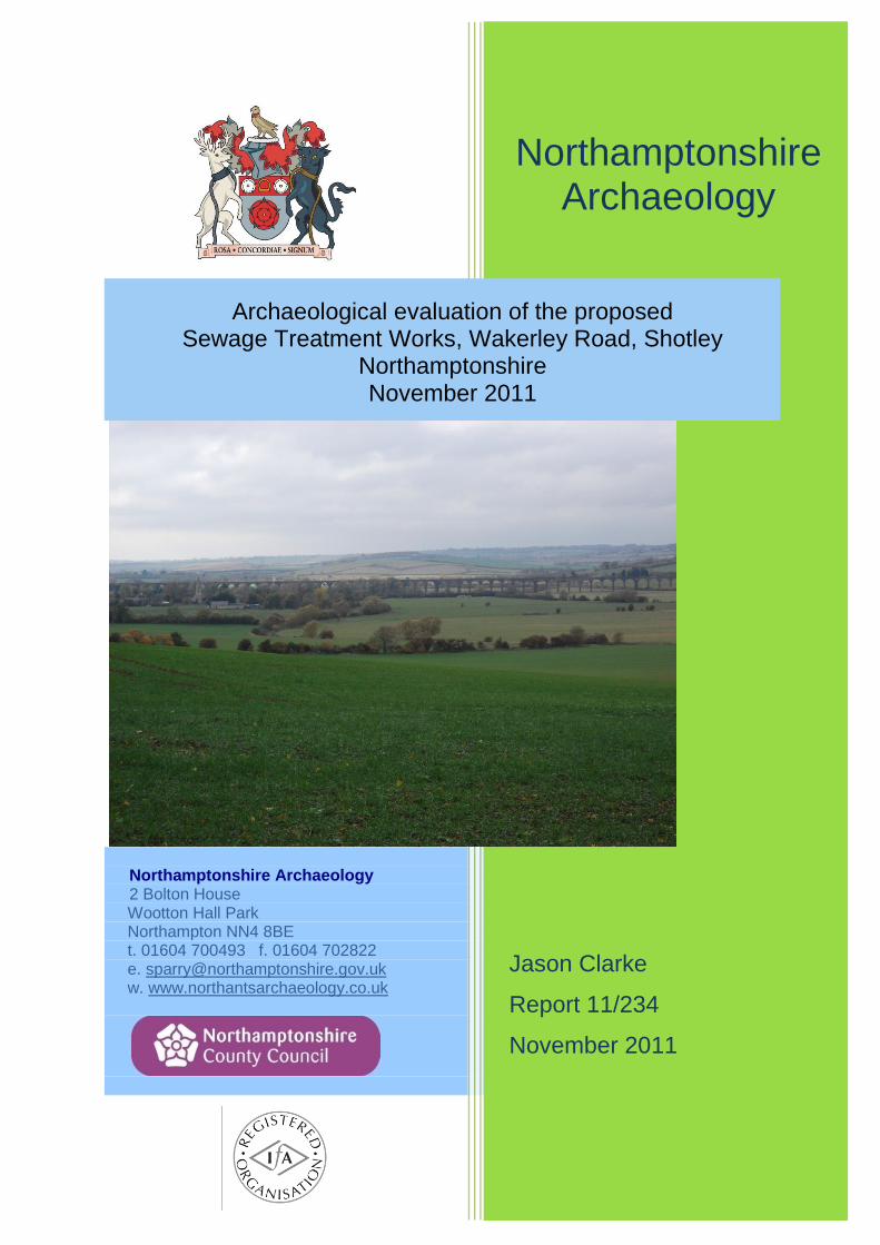
Northamptonshire Archaeology 2 Bolton House Wootton Hall Park Northampton NN4 8BE t. 01604 700493 f. 01604 702822 e. [email protected] w. www.northantsarchaeology.co.uk
Northamptonshire Archaeology
Jason Clarke
Report 11/234
November 2011
Archaeological evaluation of the proposed Sewage Treatment Works, Wakerley Road, Shotley
Northamptonshire November 2011
WAKERLEY ROAD, SHOTLEY
Northamptonshire Archaeology Report 11/234 i
STAFF
Project Manager Jim Brown BSc PGDip MIfA
Text Jason Clarke BSc MA AIfA
Fieldwork Jason Clarke
Chris Chinnock BA MSc
Illustrations Amir Bassir BSc
QUALITY CONTROL
Print name Signed Date
Checked by Pat Chapman
Verified by Jim Brown
Approved by Andy Chapman
WAKERLEY ROAD, SHOTLEY
Northamptonshire Archaeology Report 11/234 ii
OASIS REPORT FORM
PROJECT DETAILS
Project title Archaeological evaluation of the proposed Sewage Treatment Works, Wakerley Road, Shotley, Northamptonshire, November 2011
Short description In November 2011, Northamptonshire Archaeology undertook an archaeological evaluation by trial trench of the proposed sewage treatment works at Wakerley Road, Shotley, Northamptonshire. The underlying geology of fragmented ironstone was identified, but no archaeological features of deposits were present and no finds were recovered.
Project type Trial trench evaluation
Previous work None
Current land use Arable
Future work Unknown
Monument type and period
None
Significant finds None
PROJECT LOCATION
County Northamptonshire
Site address Wakerley Road
Easting Northing SP 9350 9801
Area (sq m/ha) 0.15 hectres
Height aOD 78-81mAOD
PROJECT CREATORS
Organisation Northamptonshire Archaeology (NA)
Project brief originator Northamptonshire County Council
Project Design originator Northamptonshire Archaeology (NA)
Director/Supervisor Jason Clarke (NA)
Project Manager Jim Brown (NA)
Sponsor or funding body Anglian Water Service Ltd
PROJECT DATE
Start date 02/11/2011
End date 02/11/2011
ARCHIVES Location
(Accession no.) Contents
Physical Northamptonshire Archaeology Archive
Store
None
Paper Site records (1 archive box)
Digital Client report PDF
BIBLIOGRAPHY
Title Archaeological evaluation of proposed Sewage Treatment Works, Wakerley Road, Shotley, Northamptonshire, November 2011
Serial title & volume 11/234
Author(s) Jason Clarke
Page numbers 7
Date November 2011
WAKERLEY ROAD, SHOTLEY
Northamptonshire Archaeology Report 11/234 iii
Contents
1 INTRODUCTION 1
2 BACKGROUND 1
2.1 Location and geology 1
2.2 Historical and archaeological background 1
3 OBJECTIVES AND METHODOLOGY 4
4 THE EXCAVATED EVIDENCE 4
5 DISCUSSION 5
BIBLIOGRAPHY 6 APPENDIX – CONTEXT INDEX
Figures Front cover: Development area, looking west Fig 1: Site location Fig 2: Trench location plan, Historic Environment Record (HER) data Fig 3: Trench 1, looking north-west Back cover: Backfilled trenches, looking south-west
Northamptonshire Archaeology Report 11/234 Page 1 of 7
ARCHAEOLOGICAL EVALUATION OF THE
PROPOSED SEWAGE TREATMENT WORKS
WAKERLEY ROAD, SHOTLEY, NORTHAMPTONSHIRE
NOVEMBER 2011
Abstract
In November 2011, Northamptonshire Archaeology undertook an archaeological evaluation by trial trench of the proposed sewage treatment works at Wakerley Road, Shotley, Northamptonshire. The underlying geology of fragmented ironstone was identified, but no archaeological features of deposits were present and no finds were recovered.
1 INTRODUCTION
In November 2011, an archaeological trial trench evaluation was carried out by Northamptonshire Archaeology (NA) on the site for a proposed sewage treatment works at Wakerley Road, Shotley, Northamptonshire (NGR: SP 9350 9801; Fig 1). The work was commissioned by Anglian Water Services Ltd.
The scope of works was outlined in a brief issued by the Northamptonshire County Council Archaeological Advisor (Mather 2011) and detailed in the Written Scheme of Investigation prepared by Northamptonshire Archaeology (Brown 2011). The objectives of the evaluation were to determine the presence of any archaeological features or deposits within the application area and to date and characterise their extent, depth of burial and state of preservation.
2 BACKGROUND
2.1 Location and geology
The development area is located to the north-east of Shotley, off the Wakerley Road (NGR SP 9350 9801) comprising an area of approximately 0.15ha. The site is situated within agricultural fields on sloping ground, falling from south-east to north-west (81-78m above Ordnance Datum). The underlying geology is of the Whitby Mudstone formation.
2.2 Historical and archaeological background
The Historic Environment Record indicates several archaeological data entries located within the development or close by (Fig 2). Fieldwalking to the east has identified sites and flint scatters comprising Early Neolithic to Early Bronze Age activity (HER2142, 9374). Excavations and observations during modern ironstone quarrying (HER8487) recorded late Iron Age and Romano-British iron working areas to the north-east (Jackson 1981, HER3100). Saxon pottery have been recovered from the immediate vicinity of the site as well as further afield (HER3096). This collection was part of the Rockingham Forest project, conducted under David Hall (Foard et al 2003).

Scale 1:20,000
© Crown copyright. All rights reserved. NorthamptonshireCounty Council: Licence No. 100019331. Published 2011
Site location Fig 1
0 1km
Shotley
Northamptonshire
R Ne
ne
925
980
Site location
HarringworthHarringworthHarringworthHarringworthHarringworthHarringworthHarringworthHarringworthHarringworth
Deene Road
Deene Road
Deene Road
Deene Road
Deene Road
Deene Road
Deene Road
Deene Road
Deene Road
Wakerle
y Road
Wakerle
y Road
Wakerle
y Road
Wakerle
y Road
Wakerle
y Road
Wakerle
y Road
Wakerle
y Road
Wakerle
y Road
Wakerle
y Road
ShotleyShotleyShotleyShotleyShotleyShotleyShotleyShotleyShotley
Northampton
935915
990
970
R Welland
R Welland
R Welland
R Welland
R Welland
R Welland
R Welland
R Welland
R Welland
R Welland
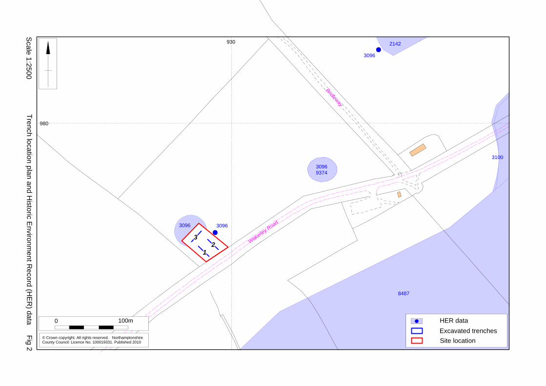
Scale 1:2500
© Crown copyright. All rights reserved. NorthamptonshireCounty Council: Licence No. 100019331. Published 2010
Trench location plan and Historic E
nvironment R
ecord (HE
R) data Fig 2
0 100m
Site location
222222222333333333
111111111
Wakerley Road
Wakerley Road
Wakerley Road
Wakerley Road
Wakerley Road
Wakerley Road
Wakerley Road
Wakerley Road
Wakerley RoadBridleway
Bridleway
Bridleway
Bridleway
Bridleway
Bridleway
Bridleway
Bridleway
Bridleway
Excavated trenchesHER data
3096 3096
30969374
3096
2142
8487
3100
930
980
WAKERLEY ROAD, SHOTLEY
Northamptonshire Archaeology Report 11/234 Page 4 of 7
To the west of the proposed development site, east of Harringworth and south of Shotley, lie the remains of two deserted medieval villages (DMVs), Harringworth: SP 9185 9718 and Shotley: SP 9260 9720 (RCHME 1975, 48-52). The remains comprise low banks and scarps and hollow-ways. Associated with the two DMVs are a fishpond (SP 9180 9757), near the Manor House, and a Deer Park (SP 922 953). More recent activity is located to the south of the site within an ironstone quarry which was formerly run by Bloxham & Whiston Ironstone Co Ltd and Stewarts & Lloyds Ltd (HER8487).
3 OBJECTIVES AND METHODOLOGY
Three trial trenches were excavated in accordance with a trench plan prepared by Northamptonshire Archaeology and approved by the Northamptonshire County Council Archaeological Advisor (Fig 2). The trenches measured 20m long by 2m wide, totalling an excavated area of 120m2, and were positioned using a Leica system 1200 GPS. A 3CX mechanical excavator fitted with a 1.6m wide ditching bucket was used to remove overburden to archaeological levels or the natural substrate, whichever was encountered first. The trenches were cleaned sufficiently to enable the identification and definition of any archaeological features. Recording followed standard NA procedures as described in the Fieldwork Manual (NA 2006). Deposits were described on pro-forma sheets. Context sheets were cross-referenced to scale plans, section drawings and photographs. Photography was with 35mm black and white film and colour slides, supplemented with digital images. Spoil heaps and features were scanned with a metal detector to maximise the recovery of metal objects. All works were conducted in accordance with the Institute for Archaeologists’ Code of Conduct (IfA 2010) and Standard and guidance for archaeological field evaluation (IfA 2008).
4 THE EXCAVATED EVIDENCE
The underlying substrate was encountered between 0.27m and 0.35m below the modern ground surface in all three trenches. This occurred as mid to light orange-brown sandy clay and fragmented ironstone with occasional angular to sub-angular limestone fragments. In Trench 1 the natural lay 0.27-0.35m below the ground surface. The overlying subsoil (102), 0.17m thick, was mid brown-grey sandy loam. The topsoil (101) was mid brown soft loam. Both soils contained occasional ironstone and limestone fragments. The natural in Trench 2 was 0.30m below the ground surface, overlain by mid brown sandy clay subsoil (202), 0.15m thick. The topsoil, (201) comprised mid brown soft loam. Trench 3 was the shallowest, the natural only 0.28m below the ground surface (Fig 3). The mid brown sandy loam subsoil (302), 0.15m thick, was overlain by mid brown soft loam topsoil (301). No archaeological features or deposits were encountered in any of the trenches and no finds were recovered from the excavated soils.
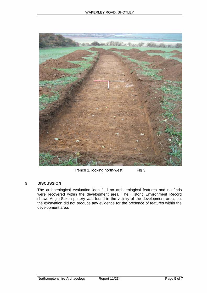
WAKERLEY ROAD, SHOTLEY
Northamptonshire Archaeology Report 11/234 Page 5 of 7
Trench 1, looking north-west Fig 3
5 DISCUSSION
The archaeological evaluation identified no archaeological features and no finds were recovered within the development area. The Historic Environment Record shows Anglo-Saxon pottery was found in the vicinity of the development area, but the excavation did not produce any evidence for the presence of features within the development area.
WAKERLEY ROAD, SHOTLEY
Northamptonshire Archaeology Report 11/234 Page 6 of 7
BIBLIOGRAPHY
Brown, J, 2011 Archaeological Field Evaluation of the Proposed Sewage Treatment Works, Wakerley Road, Shotley, Northamptonshire, Northamptonshire Archaeology Foard, G, Hall, D, and Britnell, T, 2003 The Historic landscape of Rockingham Forest, The Rockingham Forest Trust, Northamptonshire County Council, English Heritage IfA 2008 Standard and guidance for field evaluation, Institute for Archaeologists IfA 2010 Code of Conduct, Institute for Archaeologists
Jackson, D, 1981 Archaeology at an ironstone quarry in the Harringworth-Wakerley area 1968-79, Northamptonshire Archaeol, 16, 14-33
Mather, L, 2011 Brief for the Archaeological Field Evaluation of the Land at the Proposed Harringworth & Shotley STW, Northamptonshire, Northamptonshire County Council Planning NA 2006 Archaeological Fieldwork Manual, Northamptonshire Archaeology
RCHME 1975 Count of Northampton, Archaeological Sites in North-East Northamptonshire, 1, Royal Commission on Historic Monuments, England, HMSO
Websites
BGS 2009 http://www.bgs.ac.uk/geoindex/home.html British Geological Survey website
Northamptonshire Archaeology a service of Northamptonshire County Council 24 November 2011
WAKERLEY ROAD, SHOTLEY
Northamptonshire Archaeology Report 11/234 Page 7 of 7
APPENDIX - CONTEXT INDEX
Trench No
Length, width & alignment
NGR Surface height
Depth & height of natural
1 20m x 2.0m NW to SE
SP 9295 9783 78m aOD 77.67aOD
Context Context type
Feature & type
Description
Dimensions Artefacts/
Samples
101 Topsoil Mid brown soft loam 0.16m thick -
102 Subsoil Mid brown-grey sandy loam 0.17m -
103 Natural Light brown-orange sandy clay, with ironstone inclusions
-
Trench No
Length, width & alignment
NGR Surface height
Depth & height of natural
2 20m x 2.0m
NW to SE
SP 9296 9784 78m aOD 77.72 aOD
Context Context type
Feature & type
Description
Dimensions Artefacts/
Samples
201 Topsoil Mid brown soft loam 0.13m thick -
202 Subsoil Mid brown sandy clay 0.15m thick -
203 Natural Light brown-orange sandy clay with ironstone and limestone inclusions
-
Trench No
Length, width & alignment
NGR Surface height
Depth & height of natural
3 20m x 2.0m
E to W
SP 9294 9783 76m aOD 75.73 m aOD
Context Context type
Feature & type
Description
Dimensions Artefacts/
Samples
301 Topsoil Mid brown soft loam 0.12m thick -
302 Subsoil Mid brown sandy loam 0.15m thick -
303 Natural Light brown-orange sandy clay with ironstone inclusions
-
Northamptonshire Archaeology
Northamptonshire Archaeology 2 Bolton House Wootton Hall Park Northampton NN4 8BE t. 01604 700493 f. 01604 702822 e. [email protected] w. www.northantsarchaeology.co.uk
Northamptonshire County Council