Service oriented Platform independent Support of OGC ... · Besides the WMS standard (Web Mapping...
2
M.O.S.S. Computer Grafik Systeme GmbH Hohenbrunner Weg 13 D- 82024 Taufkirchen Germany Tel. +49 89 / 666 75 100 Fax +49 89 / 666 75 180 E-mail: [email protected] www.moss.de The Web-GIS solution for all requirements WEGA-Web fully relies on OGC standards and can therefore be used for numerous tasks and inte- grated in any software architecture. Base data © Landesamt für Vermessung und GeobasisinformationRheinland-Pfalz; 09/2007 consult. develop. solve. www.moss.de WEGA-Web Web-GIS Highlights Service oriented D Platform independent D (Client, Server, GIS system) Support of D OGC standards, inkl. WCS and CSW Scalable D through different client versions and modules High-level D middleware Modular D Cross-system D handling of GIS data Visualisation and printing of D any WMS data source Powerful RedLine tool D with server side saving Interaction of GeoWebServices WMS and WCS Example: visualisation of environmental noise data Arbitrary WMS client, e.g. WebOffice (SYNERGIS) D Getting noise measurement data via WCS D Displaying via WMS D Application example
Transcript of Service oriented Platform independent Support of OGC ... · Besides the WMS standard (Web Mapping...
M.O.S.S. Computer Grafik Systeme GmbHHohenbrunner Weg 13D- 82024 TaufkirchenGermanyTel. +49 89 / 666 75 100Fax +49 89 / 666 75 180E-mail: [email protected]
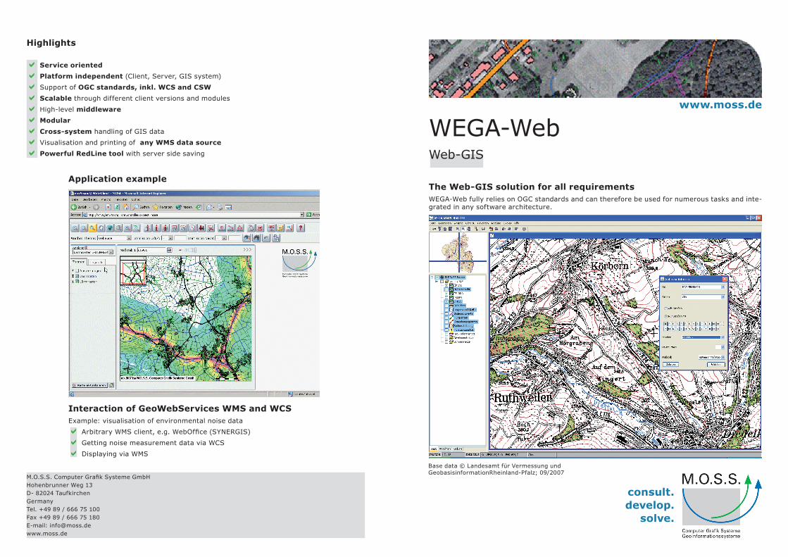
The Web-GIS solution for all requirementsWEGA-Web fully relies on OGC standards and can therefore be used for numerous tasks and inte-grated in any software architecture.
Base data © Landesamt für Vermessung undGeobasisinformationRheinland-Pfalz; 09/2007
consult. develop.
solve.
www.moss.de
WEGA-WebWeb-GIS
Highlights
Service orientedDDPlatform independentDD (Client, Server, GIS system)
Support of DD OGC standards, inkl. WCS and CSW
ScalableDD through different client versions and modules
High-level DD middleware
ModularDDCross-systemDD handling of GIS data
Visualisation and printing of DD any WMS data source
Powerful RedLine toolDD with server side saving
Interaction of GeoWebServices WMS and WCSExample: visualisation of environmental noise data
Arbitrary WMS client, e.g. WebOffice (SYNERGIS)DDGetting noise measurement data via WCSDDDisplaying via WMSDD
Application example
WEGA-Web
The various components of WEGA-Web, e.g. several client versions for für different require-ments as well as a powerful middleware offer a broad range off applications from simple viewing as far as editing in your browser.
WEGA uses the Service Oriented Architecture (SOA) concept with func-tionality encapsulation inot services, i.e. web services.
Besides the WMS standard (Web Mapping Service) naturally also the WFS standard (Web Feature Service) for delivery, for editing and for manipulating of features in form of GML (Geo Markup Language) is supported as well as the WCS standard (Web Coverage Service) for the access to raster data and the OGC Catalogue Service (CSW).
Modules like WEGA-GDM-Web for geo document management and WEGA-GENERIC as generic attribute data module complete the WEGA product family that is not limited to simple data displaying solu-tions but is ideally usable for the interactive and cross-system treatment of GIS data and the integration of available attribute data.
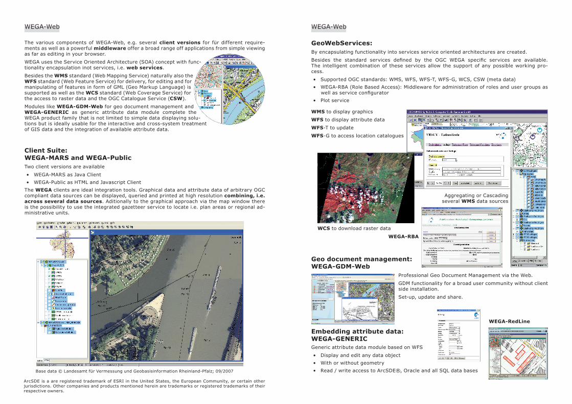
Client Suite: WEGA-MARS and WEGA-PublicTwo client versions are available
WEGA-MARS as Java Client• WEGA-Public as HTML and Javascript Client•
The WEGA clients are ideal integration tools. Graphical data and attribute data of arbitrary OGC compliant data sources can be displayed, queried and printed at high resolution combining, i.e. across several data sources. Aditionally to the graphical approach via the map window there is the possibility to use the integrated gazetteer service to locate i.e. plan areas or regional ad-ministrative units.
GeoWebServices:By encapsulating functionality into services service oriented architectures are created.
Besides the standard services defined by the OGC WEGA specific services are available. The intelligent combination of these services allow the support of any possible working pro-cess.
Supported OGC standards: WMS, WFS, WFS-T, WFS-G, WCS, CSW (meta data)• WEGA-RBA (Role Based Access): Middleware for administration of roles and user groups as • well as service configuratorPlot service•
Geo document management: WEGA-GDM-Web
Professional Geo Document Management via the Web.
GDM functionality for a broad user community without client side installation.
Set-up, update and share.
WEGA-Web
Base data © Landesamt für Vermessung und Geobasisinformation Rheinland-Pfalz; 09/2007
ArcSDE is a are registered trademark of ESRI in the United States, the European Community, or certain other jurisdictions. Other companies and products mentioned herein are trademarks or registered trademarks of their respective owners.
WMS to display graphics
WFS to display attribute data
WFS-T to update
WFS-G to access location catalogues
Aggregating or Cascading several WMS data sources
WCS to download raster data
WEGA-RBA
WEGA-RedLine
Embedding attribute data: WEGA-GENERICGeneric attribute data module based on WFS
Display and edit any data object• With or without geometry• Read / write access to ArcSDE®, Oracle and all SQL data bases•