Seqwater Development Guidelines Documents/Catchment... · Seqwater Development Guidelines ......
48
Seqwater Development Guidelines Development Guidelines for Water Quality Management in Drinking Water Catchments 2012
Transcript of Seqwater Development Guidelines Documents/Catchment... · Seqwater Development Guidelines ......

Seqwater Development Guidelines
Development Guidelines for Water Quality Management in Drinking Water Catchments
2012

2Seqwater Development Guidelines 2012Development Guidelines for Water Quality Management in Drinking Water Catchments
3Seqwater Development Guidelines 2012
Development Guidelines for Water Quality Management in Drinking Water Catchments
Contents
1. Introduction to the Guidelines 6
1.1 Purpose of these Guidelines 6
1.2 Background 6
1.3 Application of the Guidelines 6
1.4 Guidelines Structure 8
2. Development and Water Quality Vision and Objectives 8
2.1 Overview of Vision and Objectives 8
2.2 Development and Water Quality Vision 8
2.3 Development Water Quality Objectives 8
2.4 Defining ‘Adverse Impact on Water Quality’ 8
3. Information for all Development 9
3.1 Overview on Information for all Development 9
3.2 Information to support Development Proposals and Site Analysis 9
3.3 Horizontal Separation Distances (Setback) Requirements 10
4. Water Quality Management Guidelines 12
4.1 Overview of Elements of Water Quality Management 12
4.2 Element 1: On-Site Wastewater Treatment and Effluent Disposal 12
4.3 Element 2: Riparian Land Management 14
4.4 Element 3: Waste and Emissions Management 15
4.5 Element 4: Water Recycling and Re-Use 17
4.6 Element 5: Water Sensitive Design and Stormwater/Runoff Management 18
4.7 Element 6: Dangerous and Hazardous Substances Management 21
4.8 Element 7: Vegetation Management 23
4.9 Element 8: Excavation and Filling 24
4.10 Element 9: Steep or Unstable Land 25
4.11 Element 10: Bushfire Prone Land Management Guideline 26

4Seqwater Development Guidelines 2012Development Guidelines for Water Quality Management in Drinking Water Catchments
5. Land Use Specific Guidelines 27
5.1 Overview of Land Use Specific and Water Quality Matters 27
5.2 Site Analysis and Setbacks 27
5.3 Element 11: Extractive Industry 27
5.4 Element 12: Urban (Including Residential) 29
5.5 Element 13: Utilities, Industry and Commercial 30
5.6 Element 14: Rural Residential and Rural Living 31
5.7 Element 15: Rural Land Uses 32
5.8 Element 16: Recreation and Sport Uses 40
6. Environmental Management Guidelines 41
6.1 Overview of Environmental Management and Water Quality 41
6.2 Element 17: Site Based Management Plans 41
Table Index
Table 1 Site Analysis Requirements 9
Table 2 Horizontal Separation Distances (Setback) Requirements 10
Table 3 Horizontal Separation Distances (Setbacks) for all Land Uses, Development and Activities 10
Table 4 Element 1: On-Site Wastewater Treatment and Effluent Disposal Specific Outcomes and Measures 13
Table 5 Element 2: Riparian Land Management Specific Outcomes and Measures 14
Table 6 Element 3: Waste and Emissions Management Specific Outcomes and Measures 15
Table 7 Element 4: Water Recycling and Re-Use Specific Outcomes and Measures 17
Table 8 Element 5: Water Sensitive Design and Stormwater/Runoff Management Specific Outcomes and Measures 18
Table 9 Element 6: Dangerous and Hazardous Substances Management Specific Outcomes and Measures 21
Table 10 Element 7: Vegetation Management Specific Outcomes and Measures 23
Table 11 Element 8: Excavation and Filling Specific Outcomes and Measures 24
Table 12 Element 9: Steep or Unstable Land Specific Outcomes and Measures 25

5Seqwater Development Guidelines 2012
Development Guidelines for Water Quality Management in Drinking Water Catchments
Table 13 Element 10: Bushfire Prone Land Management Specific Outcomes and Measures 26
Table 14 Element 11: Extractive Industry Specific Outcomes and Measures 27
Table 15 Element 12: Urban Land Uses Specific Outcomes and Measures 29
Table 16 Element 13: Utilities, Industry and Commercial Land Uses Specific Outcomes and Measures 30
Table 17 Element 14: Rural Residential and Rural Living Land Uses Specific Outcomes and Measures 31
Table 18 Element 15A: Agriculture and Forestry Land Uses Specific Outcomes and Measures 33
Table 19 Element 15B: Intensive Animal Husbandry Specific Outcomes and Measures 36
Table 20 Element 15C: Kennels and Equestrian Land Use Specific Outcomes and Measures 38
Table 21 Element 16: Recreation Land Use Specific Outcomes and Measures 40
Table 22 Element 17: Site Based Management Plans Specific Outcomes and Measures 41
Figure Index
Figure 1 Drinking Water Supply Catchment Areas In South East Queensland 7
Appendices
A References 43
B Glossary of Terms 45
C Seqwater Assets and Water Storages 46
6Seqwater Development Guidelines 2012Development Guidelines for Water Quality Management in Drinking Water Catchments
1. Introduction to the Guidelines
1.1 Purpose of these GuidelinesThe purpose of these Guidelines is to assist land users, developers and Government authorities in achieving sustainable water quality outcomes for land uses, development and activities within Queensland Bulk Water Supply Authority’s (trading as Seqwater) water supply catchments. Seqwater seek to provide guidance on how development in water supply catchments should be undertaken to best manage potential impacts on water quality.
1.2 Background Under the South East Queensland Water (Restructuring) Act 2007, Seqwater gained responsibility for the management of a number of bulk water assets and storages in South East Queensland (SEQ). Water from these assets and storages is the primary supply of raw drinking water in SEQ and also supplies to agriculture, industry and major utilities in the region. The catchment areas associated with these assets and storages span several local government areas and contain a diverse range of land use types, including urban, industry, rural and environmental.
Development activities and the intensification of land usage have the potential to impact on water quality in the water supply catchments, which may result in nuisance and/or harm to public health and environmental values. Impacts on water quality may also result in the interruption and/or loss of water supply, as well as require higher levels of treatment. These risks can be managed in part through consideration of development in relation to these Guidelines.
The significant and sustained growth in the SEQ region has already highlighted sustainable water supply concerns, as indicated in the Healthy Waterways Ecosystem Health Monitoring Program Report Cards (2000–2009). Consequently, ensuring the health of catchments, aquifers and their ecosystems is one of the guiding principles of the South East Queensland Water Strategy 2008.
The maintenance and enhancement of water quality has been recognised as a significant regional planning matter through Desired Regional Outcome 11 of the SEQ Regional Plan 2009-2031, which aims to ensure water in the region is managed on a sustainable and integrated basis to provide adequate supplies for human and environmental uses (SEQ Regional Plan 2009-2031).
Further, the importance of catchment management as a means of protecting drinking water supplies is highlighted in Policy 11.5.1 of the Regional Plan, which aims to identify and protect existing and potential drinking water catchments from inappropriate land use (SEQ Regional Plan 2009-2031).
Through the Sustainable Planning Act 2009 and the Environmental Protection Act 1994, water quality must be provided for in ongoing planning and development assessment. All levels of government, industry and community have responsibility for taking all reasonable and practicable measures to minimise or prevent environmental harm to waterways and water bodies.
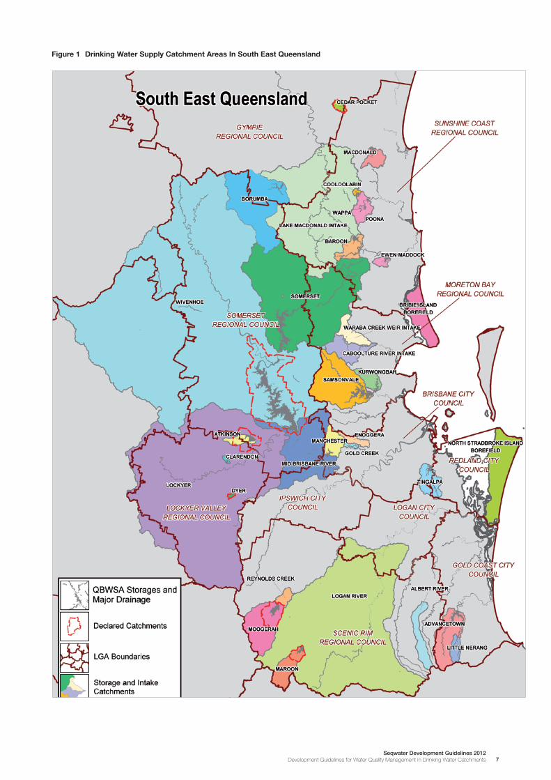
The Sustainable Planning Act 2009 gives Concurrence Agency powers to Seqwater to preserve water quality in Declared Catchment Areas (DCA). DCAs are designated under the Water Act 2000 and include Wivenhoe Dam, Bill Gunn Dam, Atkinson’s Dam, Maroon Dam, Moogerah Dam and Cedar Pocket Dam (see Figure 1). Guideline F10 – Policy and Code for Preserving Water Quality in Declared Catchment Areas, is administered by Seqwater when assessing all development applications within the DCA.
1.3 Application of the Guidelines
The Guidelines are intended to apply to any area within the catchment of a bulk water asset or storage managed by Seqwater. A list of the bulk water assets and water storages managed by Seqwater is contained in Appendix C. Figure 1 below illustrates the catchment areas associated with the major water storages managed by Seqwater.
The Guidelines are intended to provide land users, land use decision makers and the community in the water supply catchments with guidance on how development can be undertaken to minimise any impact on water quality and contribute to the achievement of relevant Environmental Values and Water Quality Objectives. The principal application of the Guidelines is to express the desired sustainable water quality outcomes sought from development within the water supply catchments. The Guidelines will be used by Seqwater to review and condition development applications under the Sustainable Planning Act 2009, and offer advice for general enquires relating to activities in the catchment areas.
The Guidelines are not intended to override provisions in local government planning schemes or other development regulating instruments, codes or policies. The Guidelines do, however, describe the additional considerations for development that occurs within the water supply catchments. In general terms, Seqwater will seek to have development proposals demonstrate that the Guidelines are satisfied with regard to the proposal achieving the ‘Development and Water Quality Vision’, as well as the ‘Development Water Quality Objectives’ and the relevant ‘Specific Outcomes’.
7Seqwater Development Guidelines 2012
Development Guidelines for Water Quality Management in Drinking Water Catchments
Figure 1 Drinking Water Supply Catchment Areas In South East Queensland

8Seqwater Development Guidelines 2012Development Guidelines for Water Quality Management in Drinking Water Catchments
1.4 Guidelines Structure
The format of the Guidelines is intended to be generally consistent with established land use management instruments, such as State Planning Policies and ‘codes’, that appear in local government planning schemes. The overall outcome of the Guidelines is expressed as the ‘Development and Water Quality Vision’, which is supported by the ‘Development Water Quality Objectives’. A table format is used to express ‘Specific Outcomes’ along with ‘Measures’ that achieve the Specific Outcomes. The Measures are not the only means of achieving the Specific Outcomes and alternative solutions can be used where it is demonstrated that these achieve the Specific Outcome to the same level. The Guidelines are organised under the following sections:
n Section 2: Development and Water Quality Vision and Objectives
n Section 3: Information for all Development
n Section 4: Water Quality Management Guidelines
n Section 5: Land Use Specific Guidelines
n Section 6: Environmental Management Guidelines
2. Development and Water Quality Vision and Objectives
2.1 Overview of Vision and Objectives
This section of the Guidelines sets the overall outcomes and themes for the Guidelines by expressing an overall ‘Development and Water Quality Vision’ that is supported by ‘Development Water Quality Objectives’. These in turn are the basis of the ‘Specific Outcomes’ and ‘Measures’ in the later sections of the Guidelines. The Development and Water Quality Vision is a statement that simply defines what the Guidelines set out to achieve. Development that is considered under these Guidelines must achieve the vision and objectives stated in this section.
2.2 Development and Water Quality Vision
The vision that the Guidelines are seeking to achieve is:
Existing and future land uses, development and activities in water supply catchments are undertaken in a manner that contribute to maintaining and improving water quality in those catchments.
Existing and future land uses, development and activities in water supply catchments are undertaken in a sustainable manner, that will not have an adverse impact on the environment.
2.3 Development Water Quality Objectives
To support the overall water quality vision for development, the Guidelines also seek to achieve the following objectives:
1. Location: To situate land uses, development and activities in locations that support achieving the Development and Water Quality Vision
2. Design and Layout: To design and lay out land uses, development and activities in a manner that supports achieving the Development and Water Quality Vision
3. Management: To manage land uses and development and any associated ancillary activities or operations, in a manner that supports achieving the Development and Water Quality Vision
4. Cumulative Impact: To undertake land uses, development and activities in the catchments in such a manner as to ensure no cumulative impact on water quality and support achieving the Development and Water Quality Vision.
Achieving these objectives is detailed through the following sections of the Guidelines that deal with water quality management issues, specific land use types and environmental management.

9Seqwater Development Guidelines 2012
Development Guidelines for Water Quality Management in Drinking Water Catchments
2.4 Defining ‘Adverse Impact on Water Quality’
For the purposes of these Guidelines, the term ‘adverse impact on water quality’ is a non-quantified term that refers to any impact on water quality that is considered by Seqwater to cause or contribute to health risk, environmental risk or adverse implications for water treatment with regard to water quality both in the catchments and the storages.
3. Information for all Development
3.1 Overview on Information for all Development
This section of the Guidelines provides a description of the material considered necessary to support development proposals in water supply catchments. Most development proposals will be in relation to Development Applications made under the SPA, but it is intended that the information identified in this section will be relevant to all land use, development and activity proposals in water supply catchments.
3.2 Information to support Development Proposals and Site Analysis
A critical factor in selecting an appropriate site for a land use, development or activity, is understanding its characteristics by way of a site analysis. All development proposals should be preceded by a site analysis to determine the capacity of the site to accommodate the proposed land use, development or activity. Development proposals should be accompanied by a detailed Land Assessment and Management Plan/Report which identifies the following features, and any appropriate management practices.
A thorough site analysis undertaken as part of the design process will allow a systematic approach to understanding the site and allowing sustainable water quality outcomes to be achieved.
Table 1 Site Analysis Requirements
Specific Outcome Measures
S1 Site Analysis
A site analysis is undertaken to demonstrate that the arrangement and undertaking of land uses, development and activities is appropriate for the location in the context of achieving the Development and Water Quality Vision.
M1.1 A site evaluation and analysis is undertaken that includes:
a) Contour data at 5 metre intervals for a development parcel and down to 1 metre intervals for the nominated building and/or activity pad/area and any land disposal area(s);
b) A slope assessment indicating slopes with gradients between 0-10%, 11-15%, 16-20%, 21-25% and greater than 25%;
c) Soil and geology types including areas prone to erosion, instability, dispersive soils, swelling clays, rock outcrops, salinity, acid soils, and areas where chemical residue may occur due to previous activities on the site;
d) Poorly draining and seasonally waterlogged areas including springs, wetlands and flood plains, ground water levels, recharge areas and aquifer intake points;
e) Existing natural and constructed water bodies;
f) Flood heights for the major event nominated under the local government requirements;
g) Existing natural and constructed drainage patterns and likely changes to such with management of stormwater quality;
h) Extent and condition of any riparian lands and remnant native vegetation with management of such illustrated;
i) Assessment of slopes, vegetation and the aspect for the site and surrounds with regards to bushfire risk with illustration of the approach for managing development;
j) Micro climatic conditions relevant to the site including prevailing winds and rainfall;
k) Existing and proposed structures, buildings, and farm improvements;
l) Likely areas/extent of earthworks and clearing, plus recommended envelopes for building pads;
m) The envelope for any effluent disposal field/system; and
n) The approach to any arable and pastoral activities on the site, including keeping of horses and dogs, as relevant to the scale and intensity of the uses.

10Seqwater Development Guidelines 2012Development Guidelines for Water Quality Management in Drinking Water Catchments
3.3 Horizontal Separation Distances (Setback) Requirements
In addition to the site analysis requirements identified in Specific Outcome S1 above, all development is required to maintain the appropriate horizontal distance from features within and surrounding the site. These are to be provided as follows:
Table 2 Horizontal Separation Distances (Setback) Requirements
Specific Outcome Measures
S2 Horizontal Separation Distances (Setbacks)
All land use, development and activities are appropriately located with horizontal separation distances to reduce potential adverse impacts on water quality, being appropriate for the location in the context of achieving the Development and Water Quality Vision.
M2.1 Site characteristics for land uses, development and activities are in accordance with the following Table 3: Horizontal Separation Distances for all Land Uses, Development and Activities.
M2.2 Where alternative horizontal separation distances are proposed, a quantified assessment should be provided which clearly demonstrates:
a) Mitigating circumstances;
b) There is no suitable alternative;
c) The mitigation and management measures required to ensure there is not adverse impact on water quality; and
d) That the grounds and assessment are acceptable to Seqwater.
Table 3 Horizontal Separation Distances (Setbacks) for all Land Uses, Development and Activities
Feature Surveyed bank of an intermittent water course
Surveyed bank of a permanent water course
Water supply well, bore and/or dam
Nearest cut, embankment or other point where effluent might surface
Upper flood margin level of an urban water supply storage
Natural grade
Flood immunity
Treated Effluent Disposal (irrigation) areas
50m 100m 50m 30m 400m 10% 1 metre above 1 in 50
Waste and Emission Sources, Storages and Treatment Areas
50m 100m 250m 30m 400m 10% 1 metre above 1 in 50
Dangerous and Hazardous Substances Management, Storage and Handling
50m 100m 250m 30m 400m 10% 1 metre above 1 in 50
Water Recycling and Re-Use Discharge
50m 100m 250m 30m 400m 10% 1 metre above 1 in 50
Extractive Industry
50m 100m 250m 250m 400m 10% 1 in 50

11Seqwater Development Guidelines 2012
Development Guidelines for Water Quality Management in Drinking Water Catchments
Feature Surveyed bank of an intermittent water course
Surveyed bank of a permanent water course
Water supply well, bore and/or dam
Nearest cut, embankment or other point where effluent might surface
Upper flood margin level of an urban water supply storage
Natural grade
Flood immunity
Urban Land Uses (including Residential)
50m 100m 30m 30m 400m 15% 1 in 100
Utility, Industry and Commercial Land Uses
Low risk 100m Low risk 100m Low risk 250m
Low risk
50m
Low risk 800m
Low risk 6% Low risk
1 in 50
High risk 1 High risk 1 High risk 1 High risk 1 High risk 1 High risk 6% High risk
1 in 100
Rural Residential and Rural Living Land Uses
50m 100m 250m 30m 400m 15% 1 in 100
Rural Land Uses (including Intensive Animal Husbandry, Kennels and Equestrian)
50m 100m Farming 50m Farming
10m
Farming 400m 5% Farming
1 in 20
Others 250 Others
30
Others 800 Others
1 in 50
Sport and Recreation Land Uses
50m 100m 250m 30m 400m * *
1 High risk utilities, industry and commercial land uses will have a horizontal separation distance determined on a case by case basis, but will be at least the Low Risk separation distance
* The range of uses in this land use type prevents a single requirement. Where uses are ‘fixed’ (i.e. permanent structures) the slope should not exceed 10% and flood immunity 1 in 50, but other sport and recreation uses will have a variety of parameters depending on location, the activity, scale, frequency and risk to water quality. These must be addressed as part of any consideration of sport and recreation uses.
Table 3 Horizontal Separation Distances (Setbacks) for all Land Uses, Development and Activities cont.
12Seqwater Development Guidelines 2012Development Guidelines for Water Quality Management in Drinking Water Catchments
4. Water Quality Management Guidelines
4.1 Overview of Elements of Water Quality Management
This section of the Guidelines seeks to provide guidance on a common set of water quality management issues that affect all development in the catchments and which have the potential to cause an adverse impact on water quality. Based on the type and site specifics of the development application, the relevant ‘Elements’ will be considered. The Elements are as follows:
n Element 1: On-Site Wastewater Treatment and Effluent Disposal
n Element 2: Riparian Land Management
n Element 3: Waste and Emission Management
n Element 4: Water Recycling and Water Re-Use
n Element 5: Water Sensitive Design and Stormwater/Runoff Management
n Element 6: Dangerous and Hazardous Substances Management
n Element 7: Vegetation Management
n Element 9: Excavation and Filling
n Element 9: Steep and Unstable Land
n Element 10: Bushfire Prone Land Management
Consideration of these Elements is to be read in conjunction with the Land Use Specific Guidelines and the Environmental Management Guidelines.
4.2 Element 1: On-Site Wastewater Treatment and Effluent Disposal
This Element applies to any land use, development or activity that involves the treatment of sewage (also ‘blackwater’). Typically this Element will apply to on-site wastewater treatment and effluent disposal systems designed for a single dwelling, but will also apply to systems designed for up to 20 EP (equivalent persons) which are not regulated by the Department of Environment & Resource Management (DERM) as an Environmentally Relevant Activity. Note that this Element applies to all development and activities where treatment and/or effluent disposal occurs, not only to where both are occurring. Key references relating to this Element are the Queensland Plumbing and Wastewater Code 2006 and the AS/NZS 1547:2000 On-site Domestic Wastewater Management. It should be noted that in some instances, this Element requires standards that are in excess of these and other reference standards, as it is considered appropriate to apply a higher standard of management where treatment and disposal is occurring in a drinking water catchment.
Table 4 Element 1: On-Site Wastewater Treatment and Effluent Disposal Specific Outcomes and Measures
Specific Outcome Measures
S3 Site Evaluation (Assessment)
A complete evaluation of the site is undertaken to ensure the most suitable location for wastewater treatment and disposal is determined.
M3.1 A detailed site evaluation is undertaken by a suitably qualified person(s) that addresses the criteria contained in Specific Outcome S1 as well as:
a) Depth to bedrock and seasonal groundwater;
b) Nature of site water supply;
c) Local climatic conditions;
d) Site stability;
e) Soil profile in accordance with Australian Standard; and
f) Soil characteristics, particularly Cation Exchange Capacity, dispersal potential, permeability, depth of topsoil to impermeable layer and structure.
M3.2 Siting of the treatment and disposal areas reflects the outcomes of the report in M3.1 and the other Specific Outcomes of this Element.

13Seqwater Development Guidelines 2012
Development Guidelines for Water Quality Management in Drinking Water Catchments
Specific Outcome Measures
S4 Wastewater Treatment System
The wastewater treatment system is certified under the Plumbing and Drainage Act 2002, combines black (toilet) and grey (kitchen/ablution) water, and is capable of producing the standard of treatment required by this Element.
M4.1 The wastewater treatment system must include:
a) A disinfection process to achieve the required microbiological quality and processes including: chlorination, UV radiation, oxidation or membrane processes as per the Queensland Plumbing and Wastewater Code, if surface irrigation is the desired disposal method;
b) For a dwelling, provide emergency storage capacity of 1,000 litres and adequate buffering for shock loading/down time and the like;
c) For other than a dwelling, provide emergency storage capable of holding 3 – 6 hours peak flow of treated effluent in the event of emergencies/overload, with provision for desludging; and
d) For other than a dwelling, provide back-up pump installation and back-up power capable of dealing with failures. All fittings will be annually certified by a licensed electrician and plumber.
S5 Treated Effluent Characteristics
The wastewater treatment system produces a minimum secondary treated effluent (90th percentile) or, where deemed appropriate, a higher level of treatment, to preserve water quality and minimise human health risks.
M5.1 Secondary treated effluent is characterised by:
a) Biochemical Oxygen Demand (BOD) less than or equal to 20mg/L with no sample over 30mg/L;
b) Total Suspended Solids less than 30mg/L with no sample over 45mg/L; and
c) Faecal coliforms less than 200cfu/100mL with no sample over 1000cfu/L.
Ref: Queensland Plumbing and Wastewater Code
M5.2 Where a composting or other alternative waste treatment system is to be provided, it must be demonstrated that the treated material does not cause an adverse impact on water quality through material allowing nutrients to enter surface waters or groundwater systems including where the treated material is used for fertiliser or other soil improvement, or disposed of.
S6 Treated Effluent Application Areas
Effluent land application areas are sustainably sized and provided with an irrigation method that prevents any adverse impacts on water quality.
M6.1 Irrigation may be via traditional trench, sub-surface drip irrigation, surface drip, sand mound or evapotranspiration-absorption wetland.
M6.2 Application areas are sized and located with regard to the evaluation described under Specific Outcome S3.
M6.3 An effluent irrigation area must be calculated (sized) to take into account:
a) Soil type, texture and permeability;
b) Climate conditions, including rainfall, evaporation and evapotranspiration;
c) The rate of uptake of nitrogen, phosphorus and soluble salts in soils, allowing no leaching of nutrients to groundwater or surface water.
M6.4 A reserve land application area of up to 100% of the effluent irrigation design area, is available on the lot.
M6.5 The application area must not cause risk of salinisation, overland flow, ponding or seepage.
M6.6 Land application areas are to be vegetated and sizing of the area must include consideration of the vegetation type and capacity for up-take.
S7 Application Area Location
Effluent disposal application areas are located to achieve no additional effect on water quality.
M7.1 Siting conditions should abide by the Queensland Plumbing and Wastewater Code and consider:
a) Protection of public health (Table 1.2);
b) Protection of surface and groundwater quality (Table 1.3) including diversion mounds upslope of the application area so that these waters do not flow onto or across the application area.
M7.2 Siting of the application area (inclusive of any reserve area) must achieve the horizontal separation distances as per Specific Outcome S2 and the following:
a) On land with a low capability of becoming unstable or collapsing during construction/operation;
b) On land that is not susceptible to salinisation, unless appropriate soil amelioration with organic matter, gypsum or lime is conducted;
c) Located where the area has a good aspect for enhanced exposure to sunlight and prevailing breezes;
d) On land that is free of, or not susceptible to, depressions where runoff may pond on the application area;
Table 4 Element 1: On-Site Wastewater Treatment and Effluent Disposal Specific Outcomes and Measures cont.
14Seqwater Development Guidelines 2012Development Guidelines for Water Quality Management in Drinking Water Catchments
Specific Outcome Measures
e) On/in soils with permeability between 0.06m/day and 3.0 m/day;
f) On land that does not contain rock outcrops, faults, areas underlain by fractured rock, coarse alluvium or similar which may short-circuit wastewater to groundwater;
g) On land where the base of the land application field is at least 2 metres above the seasonal high water table/bedrock (whichever is the less vertical distance below the base of the application area); and
h) Not located in overland flow paths or on areas that perform ground water recharge or discharge functions.
S8 Treatment System Management
Treatment and disposal systems are managed and operated to sustain quality of effluent and achieve no additional effect on water quality.
M8.1 Owners and occupiers are made aware of the ongoing operational requirements of the wastewater treatment and effluent disposal system before the system is operational, or at the time of purchase/occupation where the system is already operational.
M8.2 Owners and occupiers are made aware of actions to be undertaken should the system fail or where failure is imminent.
M8.3 Owners or occupiers must maintain the Vegetation Management Plan with regard to vegetation in the application area to ensure that nutrients beyond natural state levels do not emit from the site.
S9 Treatment System Monitoring
Treatment and disposal systems are monitored and maintained to sustain quality of effluent and achieve no additional effect on water quality.
M9.1 Monitoring is undertaken annually from the time of commissioning to determine the quality of the waste water produced from the effluent treatment system.
M9.2 Monitoring of the soils, vegetation and groundwater in the application area is undertaken every three years to establish that treated effluent is not percolating into groundwater.
M9.3 Sampling and testing is in accordance with relevant regulatory requirements and manuals such as those provided by the DERM, and testing is undertaken through an accredited Laboratory.
M9.4 Continuous monitoring is undertaken by the system owner for any water on the surface of the application area, down-slope resurfacing, change in plant growth on or around the application area and any other signs of problems, and problems addressed through maintenance.
4.3 Element 2: Riparian Land Management
This Element provides for the protection, maintenance, management and rehabilitation of the riparian area adjacent to waterways, watercourses and water storages in water supply catchments.
Table 5 Element 2: Riparian Land Management Specific Outcomes and Measures
Specific Outcome Measures
S10 Riparian Land Management
Riparian land is maintained in its natural state on each side of the high or outer bank to maintain:
a) Bank stability by protecting against bank erosion;
b) Water quality by filtering sediments, nutrients and other pollutants;
c) Aquatic habitat; and
d) Terrestrial habitat.
M10.1 The high or outer bank is defined by survey.
M10.2 No clearing or removal of vegetation or other material occurs in a watercourse.
M10.3 The extent to which riparian land from each high or outer bank on either side of a watercourse is maintained in its natural state is for a width of:
a) 100 metres to a lake or wetland;
b) 50 metres to a watercourse with a stream order 5 or greater;
c) 25 metres to a watercourse with a stream order 3 or 4; and
d) 10 metres to a watercourse with a stream order 1 or 2.
Note these widths are consistent with the Regional Vegetation Management Code: Southeast Queensland Bioregion as provided by the former Department of Natural Resources and Water, 20 November 2006
S11 Rehabilitating Riparian Land
Where riparian land is not in its natural state, rehabilitation and management occurs.
M11.1 Vegetation replanting, stormwater management, access management and sediment and erosion control actions are implemented through a management plan.
Table 4 Element 1: On-Site Wastewater Treatment and Effluent Disposal Specific Outcomes and Measures cont.

15Seqwater Development Guidelines 2012
Development Guidelines for Water Quality Management in Drinking Water Catchments
Specific Outcome Measures
S12 Land Use, Development and Activities in Riparian Land
Land Uses, development and activities in the width of riparian land are limited to essential and non-intensive uses.
M12.1 Land uses, development and activities in the riparian width area are limited to:
a) Approved water supply pumps and bores (including pump sheds);
b) Controlled grazing in accordance with section 5.7;
c) Fencing, unstructured play equipment and fixed outdoor furniture;
d) A defined pathway or water access point for informal recreation which is developed and managed in accordance with an approved Stormwater Quality Control Plan addressing these Guidelines and with compliance with any DERM riverine/environmental guidelines.
S13 Riparian Vegetation Management Plan
Manage identified riparian lands in accordance with an approved Vegetation Management Plan.
M13.1 A Vegetation Management Plan is prepared and implemented that includes:
a) Retention of trees and shrubs along the approved width of riparian land;
b) Supplementary planting of uniform, dense and rough ground cover;
c) Low maintenance, deep rooted vegetation which increases the density of vegetation;
d) Species appropriate to soils and natural erosion activity as well as flood, drought and bushfire characteristics;
e) Native species endemic to the area at a density and structure representative of nearby undisturbed areas and reflecting the natural zonation of species;
f) Species which facilitate rehabilitation of degraded areas; and
g) Grassed filter strips should also be provided at the point of flow concentrations.
4.4 Element 3: Waste and Emissions Management
This Element applies to any land use, development or activity (other than that normally associated with a dwelling) where the generation of waste or other emission may cause an adverse impact on water quality. Note the nature of emissions is limited to those of a liquid and solid nature (including dust), as noise, light and odour do not readily impact on water quality, however, odour may indicate the presence of other waste or emission types that do cause an impact.
This Element does not replace or supersede any more stringent requirements, regulations, or policies, or the role of any assessment manager or referral agency.
Table 6 Element 3: Waste and Emissions Management Specific Outcomes and Measures
Specific Outcome Measures
S14 Waste and Emission Management
Waste and emission areas are managed so that contaminants do not have an adverse impact on water quality and to prevent contaminants from entering surface water or groundwater bodies.
M14.1 A Waste Management Plan is prepared and submitted with the development application detailing:
a) All processes that generate wastes and/or emissions;
b) The quantities, storage and handling of materials and by-products;
c) The source, quantity and biological/chemical characteristics of the waste or emissions; and
d) Options for waste minimisation.
M14.2 Waste and emissions are characterised in terms of their capacity to emit contaminants including through the breakdown of matter, liquid waste, stormwater run-off and airborne contaminants.
S15 Waste and Emission Management Location
Waste and emissions management areas are located so that contaminants do not have an adverse impact on water quality and to prevent contaminants from entering surface water or groundwater bodies.
M15.1 Waste and emission sources, storages and treatment areas are located having regard to the criteria contained in Specific Outcome S1, the horizontal separation distances contained in Specific Outcome S2, and the following:
a) Be on land with a low capability of becoming unstable or collapsing; and
b) Not be on areas that perform ground water recharge or discharge functions.
Table 5 Element 2: Riparian Land Management Specific Outcomes and Measures cont.

16Seqwater Development Guidelines 2012Development Guidelines for Water Quality Management in Drinking Water Catchments
Specific Outcome Measures
S16 Airborne Waste and Emission Management
Where emissions have potential to become airborne, these are treated at the source so that contaminants do not have an adverse impact on water quality and to prevent contaminants from being deposited on surface waters, or on land where it can be transported to surface water or groundwater bodies.
M16.1 Where airborne emissions are present as part of the land use, development or activity, these are characterised in accordance with Specific Outcome S14.
M16.2 An assessment is made of the volume and level of contaminants that may be dispersed based on the nature of emissions and climatic factors.
M16.3 Where the risk is determined to have the potential for an adverse impact on water quality; the source is treated to remove this risk.
S17 Collection and Initial Treatment
Waste and emissions collection and initial treatment is undertaken so that contaminants do not have an adverse impact on water quality and to prevent contaminants from entering surface water or groundwater bodies.
M17.1 Collection and initial treatment of waste and emissions is undertaken so that:
a) Water use is minimised to reduce effluent volumes;
b) Dry methods or high pressure water use is maximized;
c) Wash and process wastewater is isolated from stormwater and any cleaner streams;
d) Suspended matters and solids are isolated;
e) Highly contaminated wastewater is isolated for sufficient pre-treatment in holding tanks with off-site disposal of contaminants by a licensed contractor;
f) All areas where contamination may occur (e.g. storage areas, handling areas, wash down areas, servicing/maintenance areas, process areas, waste storage areas) are located in weatherproofed buildings with a perimeter bund;
g) Activities avoid kerosene, petrol and organic solvent cleaners and minimise the use of slow degreasers and detergents;
h) The installation of substance recovery units in servicing bays allows for maximum reuse followed by collection in secure, weatherproof containers for disposal of used substances by a licensed contractor;
i) Collection and storage areas are provided with impervious sealed floors and bunds graded to contain worst case spills and wash water, with discharge to a system of imperviously lined pits/basins and sumps to permit settling of solids, neutralising of heavy metals and separation of oils and emulsifiers for separate, appropriate chemical treatment without threat of overflow; and
j) The sizing of collection and initial treatment areas is to accommodate minimal long term volume and back-up storage.
S18 Treatment and Disposal
Waste and emissions treatment and disposal is undertaken so that contaminants do not have an adverse impact on water quality and to prevent contaminants from entering surface water or groundwater bodies.
M18.1 Treatment and disposal of waste and emissions is undertaken so that:
a) Treatment reflects the volumes, strengths and constituents of wastewater (e.g. total suspended solids, nutrients, pH, heavy metals, BOD, salinity);
b) Waste is treated through a series of approved systems (e.g. storage/treatment lagoons) designed by a suitably qualified and experienced engineer;
c) Provision of sufficient storage capacity is made to allow for maximum first-flush holding capacity to provide for hydraulic and waste loadings (including sufficient freeboard) in major storm events;
d) Provision of sufficient storage capacity is made for wet weather, maintenance, accidental spills, system down-time and shock loading without necessitating release of untreated wastewater;
e) Storage and treatment occurs on existing or created impermeable surfaces to prevent leaching;
f) Periodic desludging of storages is undertaken to maximise silt settlement and sludge retention with uncontaminated organic matter recycled in the process or stored. Contaminants are to be removed from the site by a licensed contractor;
g) Treated waste that is high in heavy metals, biological parameters, hazardous dusts, by-products, separated oils, grease, hydrocarbons, chemical sludge and floor waste is to be placed in secured, weather proofed containers/tanks in a bunded area and removed by a licensed contract or for disposal at a registered disposal or refuse facility;
h) Saline effluent is separated and directed to facilities to permit appropriate removal of salt;
i) Where it is practical, wastewater is treated to a standard to allow it to be:
(i) Recycled; or
Table 6 Element 3: Waste and Emissions Management Specific Outcomes and Measures cont.

17Seqwater Development Guidelines 2012
Development Guidelines for Water Quality Management in Drinking Water Catchments
Specific Outcome Measures
(ii) Evaporated at a lined evaporation facility; or
(iii) Irrigated in accordance with an approved irrigation management plan.
j) Where effective reuse of wastewater on a site is not possible for water quality or other reasons, provision is made for tertiary treatment prior to discharge;
k) No incineration or burial of waste is to be undertaken on-site, with solid waste being collected and stored in weather proofed, sealed waste receptacles, located in roofed and bunded areas, for collection by a licensed contractor for disposal at a licensed facility;
l) Provision is made for ongoing monitoring of water in pits and ponds and for the adjustment of practices to optimise treatment and control nutrients; and
m) Stockpiling and spreading of waste in a form appropriate as a soil conditioner should be minimised, with such activities occurring in accordance with these Guidelines.
4.5 Element 4: Water Recycling and Re-Use
This Element applies to all development in which water is recycled or re-used for any purpose, other than a system for on-site wastewater treatment and effluent disposal which has a peak design capacity of less than 21 equivalent persons.
Table 7 Element 4: Water Recycling and Re-Use Specific Outcomes and Measures
Specific Outcome Measures
S19 Water Recycling and Re-Use Management
All components of the recycled water scheme, including treatment, storage and reuse systems are designed, constructed, operated and maintained so as not to cause any adverse impact on water quality.
M19.1 All recycled water systems shall adopt as a minimum, the recommended class of treatment and monitoring requirements for the particular reuse purpose as specified in the Queensland Water Recycling Guidelines (former EPA, now DERM, 2005).
M19.2 A draft Recycled Water Management Plan shall be prepared as part of the development application and should provide an assessment of all risks and associated mitigation strategies for preventing any adverse impact on water quality within the drinking water supply catchments shown on Figure 1.
M19.3 All recycled water schemes involving discharge of recycled water to land or water must ensure appropriate buffer distances are provided to surface and groundwaters conveying water to the drinking water supplies, including the horizontal separation distances contained in Specific Outcome S2.
M19.4 All recycled water agreements prepared for schemes within the drinking water supply catchments identified on Figure 1 shall recognise the location of the site within a drinking water supply catchment and should include a requirement that any party to the agreement who becomes aware of an actual or potential threat to water quality within the drinking water supply catchment must notify Seqwater.
M19.5 Recycled water schemes involving the potential for direct or indirect release of recycled water to surface or groundwater bodies within the drinking water catchments shall involve consultation with Seqwater.
S20 Water Recycling and Re-Use Monitoring
Monitoring of water quality is undertaken to ensure that design, construction, operation, maintenance and decommissioning of all recycled water systems does not cause an adverse impact on water quality.
M20.1 The Recycled Water Management Plan should provide for regular monitoring of any potentially affected surface or groundwater bodies both upstream and downstream of the recycled water scheme to identify any potential impacts on water quality. Monitoring shall be undertaken in accordance with the DERM Monitoring and Sampling Manual 2009, or the Australian Guidelines for Water Quality Monitoring and Reporting (ANZECC, 2000). Where any water quality parameter measured downstream of the scheme exceeds the result measured upstream by greater than 10%, the results of monitoring shall be forwarded to Seqwater.
Table 6 Element 3: Waste and Emissions Management Specific Outcomes and Measures cont.

18Seqwater Development Guidelines 2012Development Guidelines for Water Quality Management in Drinking Water Catchments
4.6 Element 5: Water Sensitive Design and Stormwater/Runoff Management
4.6.1 Purpose and Objective of Water Sensitive Design and Stormwater/Runoff Management Element
This Element applies to all development within the water supply catchments and encompasses stormwater and runoff management, with particular emphasis on the integration of Water Sensitive Design principles into the development. This element compliments many existing accepted Water Sensitive Urban Design (WSUD) principles, with a rural context.
The key objective of this Element is to ensure that applicants undertake planning, construction and maintenance of development to ensure that stormwater runoff originating from development has no adverse impact on water quality within the catchment. This can be achieved through:
n Ensuring development does not increase stormwater quantity or flow velocity from the subject site
n Ensuring development releases stormwater of a quality that will not adversely impact on receiving waters
n Ensuring development releases stormwater of a quality that is fit for purpose as a drinking water supply for the South East Queensland, and which will require minimal treatment before supply
n Ensuring development does not contribute to any cumulative impacts
n Ensuring development minimises potential for erosion
n Ensuring development minimises disturbance to natural or existing drainage systems (including the bed and banks of receiving waters) and riparian areas.
It is not the intent of the Guidelines to recommend specific stormwater management measures/devices for the control of stormwater from development within the water supply catchments. The stormwater management issues of each development proposal are unique and there remains a variety of ever-improving technology available which can adequately address the specific needs of each development. It is the intent of the Guidelines to provide a framework that ensures comprehensive stormwater management planning and design is undertaken for every development.
4.6.2 Water Sensitive Design
Water Sensitive Design covers a broad range of matters from the detailed selection of internal domestic water fixtures through to regional level water quality. The general concepts of water sensitive design have been incorporated into all Elements within these Guidelines. This Element however, specifically focuses on the water sensitive management of stormwater and runoff from land use, development and activities within the water supply catchments.
Table 8 Element 5: Water Sensitive Design and Stormwater/Runoff Management Specific Outcomes and Measures
Specific Outcome Measures
S21 Site Based Stormwater Quality (and Runoff) Management Plan
A Site Based Stormwater Quality Management Plan including water quality objectives, design, maintenance, monitoring and operation of all measures, is prepared for all High Risk Developments.
M21.1 A Site Based Stormwater Management Plan (SBSMP) is prepared that addresses all Specific Outcomes of this Element and is relevant to the particular land use, development and/or activity.
M21.2 The SBSMP is prepared and signed-off by a suitably qualified and experienced engineer.
M21.3 The SBSMP establishes that erosion, sediment and stormwater quality are controlled at each stage of construction to prevent off-site movement of pollutants in compliance with the results from assessments describe under Specific Outcome S23 and the requirements outlined in any published Council/Government guideline, manual and the like.
M21.4 The SBSMP ensures that stormwater management measures will be installed and maintained by suitably qualified professionals.
M21.5 The SBSMP demonstrates that any revegetation, measures, devices and systems will be self-regulatory and low maintenance such that provision for a regime approved by a local government is not necessary.
19Seqwater Development Guidelines 2012
Development Guidelines for Water Quality Management in Drinking Water Catchments
Specific Outcome Measures
S22 Site Characteristics
Site characteristics are understood in order to determine the appropriate stormwater management approach relevant to the land use, development and/or activity.
M22.1 An assessment of site characteristics is undertaken that demonstrates an appropriate approach to preventing disturbance as determined through assessment of the following:
a) Soil types/properties including unconsolidated soils, hard setting and surface sealing soils and soils known to, or which have the potential to be susceptible to acidity, dispersive subsoils, salinity, sodicity, toxicity, accelerated erosion or other hazards;
b) Local geology as having potential for land slip, seeps and the like;
c) Watercourses, overland flow paths, wetlands, waterway vegetation, natural detention basins and water bodies within or upstream/downstream of the site;
d) Ridge crests, drainage lines, waterlogged areas, discharge points, flood plains and known flood problem areas within or upstream/downstream of the site;
e) Areas where removal of vegetation and ground cover will likely create erosion problems or reduce infiltration capacity;
f) Areas susceptible to wind and water erosion;
g) Areas which due to the length and steepness of slopes may be prone to subsidence, mass movement or erosion; and
h) Areas where the depth to water table or nature of bedrock will affect infiltration capacity, land stability, and the like.
S23 Stormwater/Runoff Management Capacity
Development capacity is limited to a type, amount and location for which likely stormwater pollutants from construction and operation can be captured and treated on-site through best practice stormwater quality control measures, including retention and detention as appropriate to the site an the land use.
M23.1 Scale, location and intensity of land uses, development and activities are such that the sizing of stormwater management measures can be accommodated wholly within the site.
(Note the ‘measures’ includes a range of features and devices including basins, swales, traps, buffer strips, wetlands etc.)
M23.2 Scale, location and intensity of land uses, development and activities are such that all adverse water quality impacts can be mitigated onsite.
M23.3 Land area is set aside for the appropriately sized stormwater mitigation measures.
S24 Stormwater Management Measures
Stormwater management measures for construction and operation are appropriate to water quality, drainage, flooding and waterway corridor issues in the catchments, catchment areas identified in any Council plans/strategies, or any endorsed catchment management plan.
M24.1 Stormwater management measures are selected, and the overall stormwater management system designed and certified by a suitably qualified and experienced professional as being appropriate to the site in terms of soil type, landform and ecological characteristics, using results of the assessment for Specific Outcome S22, and recognised, locally accepted hydrological, hydraulic, hydrogeological, soil, water quality and biological data and design methodologies.
M24.2 Designs should stipulate pollutant removal performance, maintenance requirements and responsibility for the overall stormwater management system, as well as stipulate the type, location, installation, pollutant removal performance and maintenance requirements for each stormwater management measure.
M24.3 Stormwater management measures and the overall stormwater management system is designed and engineered for a range of storm events in compliance with published local or State objectives.
M24.4 Stormwater management measures and the overall stormwater management system demonstrate diversion of clean runoff around the problem areas listed in Specific Outcome S22 to stable areas and the rehabilitation/maintenance of such areas with deep-rooted vegetation or other appropriate ground cover.
M24.5 Stormwater management measure principally rely on non-mechanical management measures.
M24.6 Stormwater management measures principally rely on non-structural management measures (such as grass swales, infiltration areas, revegetated areas and the like) in situations where they offer better solutions than structural measures.
M24.7 Stormwater management measures should be integrated into the overall design and landscaping of the site.
M24.8 Stormwater management measures for construction are used in locations where they remain in place for the duration of development works and/or where permanent stormwater controls will eventually be incorporated.
Table 8 Element 5: Water Sensitive Design and Stormwater/Runoff Management Specific Outcomes and Measures cont.

20Seqwater Development Guidelines 2012Development Guidelines for Water Quality Management in Drinking Water Catchments
Specific Outcome Measures
M24.9 Where permanent stormwater quality management measures are required (structural and non-structural), such are selected, constructed and maintained in accordance with local government requirements, manuals, guidelines and the like with location and installation undertaken to prevent erosion or contamination of runoff and as appropriate to the existing and proposed features of the site.
M24.10 Selection, design and installation of stormwater management measures should reflect the following principles:
a) Minimise areas subject to disturbance;
b) Maintain maximum protective vegetation using selective clearing where appropriate, with retention of native vegetation to maximise infiltration;
c) Minimise the area of impervious surfaces and compacted soils;
d) Ensure that contaminated areas, exposed sites, unstable areas and areas with contaminated wash water are isolated with clean runoff diverted around such area without causing scouring or concentrated flows;
e) For clean runoff (including roof water), use of surface design to slow overland flow velocity and to encourage maximum soakage and infiltration (except in unstable areas);
f) Protect natural stormwater flow paths;
g) Prevent any effluent from overflow at any stage in its treatment and disposal process (including effluent from sewage treatment and other effluent producing land uses);
h) Intercept and treat runoff and sediment from road ways and other impervious surfaces at the point of source to prevent oil, grease, chemicals, silt, trace metals, nutrients such as phosphorus and nitrogen and other contaminants from entering the environment;
i) Use filter strips at the point of erosion source and at stormwater discharge points;
j) Prevent any clearing or earthworks in riparian lands or within sensitive areas;
k) Establish where erosion, sediment and flow control devices should be used and the most effective devices in the circumstances (including storm events) which should be installed at the source to improve water quality;
l) Re-establish vegetation and stabilise as soon as practical on areas that have been disturbed using stripped soils and vegetation consistent with native species in the area or appropriate to the soil types and climatic conditions; and
m) Provide for maximised on-site stormwater reuse, rainwater storage and the like.
S25 Erosion and Sediment Control Plan
Where land uses, development or activities involve any earthworks, roadworks and building works, appropriate practices, procedures and devices are identified in an Erosion and Sediment Control Plan.
M25.1 The Erosion and Sediment Control Plan (ESCP) is prepared and signed-off by a suitably qualified and experienced professional.
M25.2 ESCPs establish that erosion, sediment and stormwater quality are controlled at each stage of construction to prevent off-site movement of pollutants in compliance with the results from assessments described under Specific Outcome S23 and the requirements outlined in any published Council/Government guideline, manual and the like.
M25.3 ESCPs establish that stormwater management measures are used in locations where they remain in place for the duration of development works and/or where permanent stormwater management measures will eventually be incorporated.
M25.4 ESCPs establish that stormwater management measures are installed and maintained by suitably qualified professionals.
S26 Outcomes of Stormwater/Runoff Management
Stormwater management does not cause an adverse impact on flooding, drainage or water quality.
M26.1 Land uses, development, activities and stormwater management ensure:
a) No increased peak discharges outside the boundaries of the site;
b) No increased flood levels or volumes outside the boundaries of the site;
c) No adverse impacts of flooding on developed or developable areas;
d) No increased erosion potential on or outside the boundaries of the site;
e) No adverse impacts on water quality outside the boundaries of the site; and
f) No damage or erosion of waterways.
Table 8 Element 5: Water Sensitive Design and Stormwater/Runoff Management Specific Outcomes and Measures cont.

21Seqwater Development Guidelines 2012
Development Guidelines for Water Quality Management in Drinking Water Catchments
Specific Outcome Measures
S27 Water Quality Monitoring
Monitoring of water quality is undertaken to ensure that construction, operation and decommissioning of land uses, development and activities do not cause an adverse impact on water quality.
M27.1 Site specific discharge is monitored annually through approved testing under the DERM Monitoring & Sampling Manual 2009, or the Australian Guidelines for Water Quality Monitoring and Reporting (ANZECC, 2000) for land uses, development and activities:
a) In or within 100 metres of riparian land;
b) That significantly increase impervious surface areas; or
c) On areas with potential to contaminate or increase runoff.
M27.2 Reporting is sent to the local government establishing that agreed water quality parameters are being fulfilled. Where problems are reported, appropriate techniques are implemented immediately at the expense of the owner to ensure that standards can be met.
M27.3 Site Based Stormwater Management Plans for High Risk development provides for annual monitoring of revegetation areas and other approved devices, measures and systems by proponents, or, at the owners expense, the local government, to ensure their effectiveness in capturing and treating stormwater quality to an agreed discharge level. Maintenance is outlined in the Plan with provision to use local resources, and clear procedures to address poor operations.
(Refer to Section 6 of these Guidelines regarding Environmental Management and monitoring)
4.7 Element 6: Dangerous and Hazardous Substances Management
This Guideline is recommended for reference by applicants and Government when dealing with any development proposals involving the manufacturing or storage of any of the below mentioned substances within the catchments defined in Figure 1.
Substances which are considered under this Guideline include dyes, thinners, hydrocarbons, pesticides, disinfectants, chemicals, fertilisers, detergents, oils, metal salts, acids, alkalis, solvents, greases, as well as fuels and substances outlined in the Flammable and Combustibles Liquids Regulation 2001 and applicable Australian standards and Codes. Small quantities of less than 25 litres which are used for hygiene purposes are not considered relevant under this part of this Guideline.
It is noted, determined by threshold amounts, that certain activities will become Environmentally Relevant Activities (ERAs) under the Environmental Protection Regulation 1998 involving the Department of Environment & Resource Management as the assessing authority or concurrence agency.
Table 9 Element 6: Dangerous and Hazardous Substances Management Specific Outcomes and Measures
Specific Outcome Measures
S28 Site Evaluation and Suitability
A comprehensive evaluation is undertaken and demonstrates the suitability of the site, particularly given its location within the drinking water catchment, for development involving the storage and handling of dangerous or hazardous substances based on the nature and quantity of substances, and processes proposed.
M28.1 Proposals which handle and store dangerous and hazardous substances should be accompanied by a report by a suitably qualified and experienced chemical engineer or similar outlining the following:
a) A site assessment in accordance with Specific Outcome S1;
b) Amount, nature and chemical characteristics of substances;
c) The process involving the substances;
d) The nature of waste generation and approach to management; and
e) How contaminants will be managed to ensure they will not enter the surface water and ground water bodies, in compliance with relevant Australian legislation, standards and codes.
S29 Design and Construction
Development involving the storage and handling of dangerous and hazardous substances is designed, constructed and managed to prevent the release of contaminants to surface water or groundwater bodies.
M29.1 Based on the nature and quantity of substances, the following measures will be fulfilled in the management, handling and storage areas:
a) Through design and layout, separation of incompatible substances is ensured (e.g. acids and alkalis);
b) Management, handling and storage of substances (including fuelling of vehicles and plants, dispensing, empty containers and containers containing hazardous waste) to be undertaken in secured, climate controlled, weatherproofed (roofed), level, bunded enclosures located away from movement areas and in accordance with the horizontal separation distances contained in Specific Outcome S2;
c) Ensure outdoor transfer of liquids from bulk tankers to on-site storage occurs within chemical resistant, sealed and bunded areas that permit full recovery of spills;
Table 8 Element 5: Water Sensitive Design and Stormwater/Runoff Management Specific Outcomes and Measures cont.

22Seqwater Development Guidelines 2012Development Guidelines for Water Quality Management in Drinking Water Catchments
Specific Outcome Measures
d) Ensure surfaces on which substances are stored or handled, and bunds are constructed of impermeable materials (e.g. concrete, clay or synthetic liners) resistant to damage from stored materials and appropriate to weight bearing requirements;
e) Ensure enclosures are engineered for fire resistant recovery of spills through bunds, sumps or similar, with all areas designed in accordance with the capacity set under the Environmental Protection Act 1994 and any Australian legislation, standards and Codes applicable to the nature of substances on the site; and
f) Employ “secondary containment” to catch leakages from below ground chemical storage tanks and hazardous storage areas with regular inspection and testing of underground storage tanks, other storage containers, operating equipment, delivery systems and the like, within the time period accepted by the suppliers and regulators of specific storages, materials and products.
M29.2 High Risk Proposals should be accompanied by a report from a suitably qualified and experienced chemical engineer or similar establishing that the management, handling and storage of substances will:
a) Fulfil risk management requirements;
b) Be located outside sensitive areas on the site;
c) Contain and recover all spills and waste output on-site, including detailed designs;
d) Ensure there is no infiltration of spills or wastes into the groundwater or direct discharge of substances or wastes to waterways;
e) Ensure that corrosion (or exposure to other damaging elements) is prevented;
f) Occur in dedicated, suitable areas and structures to prevent any potential for contaminated discharge or mixing of incompatible activities and substances;
g) Comply at all times with relevant Australian legislation, standards and Codes; and
h) Prevent overfilling, leaks and spills from containers with sizing, design, materials and maintenance of containers in accordance with the relevant Australian legislation, standards and Codes.
S30 Discharge of Wastes
No direct or indirect discharge of solid or liquid wastes from the development occurs to surface water or groundwater bodies within the catchment.
M30.1 All liquid waste associated with managing substances to be collected and held in a holding tank for pump-out and disposal by a licensed waste contractor to a registered hazardous waste facility.
M30.2 Absorbent materials are used and not water for clean-up of spills, with materials placed in drums and disposed of by a licensed waste contractor, in accordance with the requirements for the substance.
M30.3 Sludge (e.g. solid floor waste), used containers, packaging and other solid waste is checked for contamination and contained in solid waste receptacles for disposal at an approved hazardous waste facility by a licensed contractor.
M30.4 No solid waste material is burnt or buried at the site, to prevent toxic material releases.
S31 Stormwater Management
Stormwater is managed to minimise contamination by dangerous or hazardous substances stored on site, and to prevent the discharge of contaminants to surface water or groundwater bodies.
M31.1 A Stormwater Management Plan incorporating the following measures shall be prepared and implemented on site:
a) Uncontaminated stormwater (including roof water from areas not used to handle substances) is directed away from buildings, likely contaminated areas or bunded compounds to the appropriate stormwater management measure for subsequent off-site discharge into the natural drainage system;
b) Contaminated runoff is collected by drains which are located and sized to capture first flush stormwater and to contain worst case spills, with diversion of spills and wash water to a wastewater holding and pre-treatment tank on the site; and
c) Holding tanks to provide for the separation of oils/solvents and solids with pump-out and removal by a licensed waste contractor for treatment and disposal at an approved hazardous waste management facility in the region.
cont.

23Seqwater Development Guidelines 2012
Development Guidelines for Water Quality Management in Drinking Water Catchments
Specific Outcome Measures
S32 Risk/Hazard Assessment
Potential risks to water quality associated with the on-site storage and handling of dangerous and hazardous substances are identified, assessed and managed to prevent adverse impacts on downstream water quality.
M32.1 A Risk/Hazard Management Plan shall be prepared by a qualified and experienced chemical engineer or similar, and shall document the identified risks and associated mitigation strategies (including staff training on emergency response and safe handling and maintenance of goods) to prevent spills during routine operations as well as contingency plans developed for the event of fire, explosion, storm, vandalism or significant chemical spills.
M32.2 Emergency response procedures are documented and approved by substance manufacturers, the local government, the DERM and the emergency services agencies in the locality, who are in agreement that the risk to the environment, community and downstream water quality can be contained on-site.
4.8 Element 7: Vegetation Management
This Element applies to all development and provides for the protection, maintenance, management and rehabilitation of vegetation that has an important role in maintaining water quality in waterways, watercourses and water storages in water supply catchments.
Table 10 Element 7: Vegetation Management Specific Outcomes and Measures
Specific Outcome Measures
S33 Evaluation of Vegetation
Development design and layout shall identify and maintain all vegetation important to habitat protection, slope stability and downstream water quality.
M33.1 The following areas of important vegetation shall be identified and development activities shall be designed to minimise clearance and/or degradation of:
a) Vegetation on ridges and vegetated slopes (15% and greater gradient);
b) Rare, endangered and vulnerable vegetation communities and those providing for interlocking canopies;
c) Riparian lands (refer Element 2);
d) Vegetation within 50m of stormwater discharge areas, groundwater recharge areas, salinity outbreak areas or areas prone to salinity;
e) Viable stands and corridors of native vegetation;
f) Vegetation in areas known or likely to have sodic/dispersive clay subsoils, acid soils or soils prone to erosion or mass movement; and
g) Vegetation providing natural windbreaks and shelter.
M33.2 Provision is made for wind breaks in areas where wind velocity and temperature may exacerbate erosion (with a guide being that wind may be reduced for a distance of 25 times the height of the tree on the downwind side of a property).
S34 Prevention of Vegetation Disturbance
Development works shall be carried out to prevent direct and/or incidental disturbance to areas of vegetation important to habitat protection and maintenance of downstream water quality.
M34.1 Development shall prevent disturbance to important vegetation through, but not limited to, the following measures:
a) Demarcation of approved areas of disturbance;
b) Restricting ancillary activities (e.g. stockpile sites) to existing cleared areas or approved areas of disturbance;
c) Use of low impact construction techniques and machinery; and
d) Undertaking clearing in stages.
M34.2 Appropriate erosion and sediment control measures should be implemented in all areas where vegetation is cleared and soils are exposed to erosive forces during development activities.
S35 Revegetation
Progressive and timely revegetation using appropriate local native species shall occur in all areas cleared for development works so as to prevent adverse impacts on downstream water quality.
M35.1 Revegetation is undertaken in accordance with a Vegetation Management Plan that includes re-establishment of vegetation for the site. The aim of revegetation is to enhance water quality from the site.
S36 Vegetation Management
An ongoing management regime shall be established for all identified vegetation areas.
M36.1 A nominated body/person shall be responsible for vegetation monitoring and maintenance including seasonal weeding.
M36.2 The maintenance regime shall form part of a Vegetation Management Plan.
M36.3 The Vegetation Management Plan shall be prepared and signed-off by a suitably qualified person and shall include monitoring and reporting in accordance with Element 17 of these Guidelines.
Table 9 Element 6: Dangerous and Hazardous Substances Management Specific Outcomes and Measures cont.

24Seqwater Development Guidelines 2012Development Guidelines for Water Quality Management in Drinking Water Catchments
4.9 Element 8: Excavation and Filling
This Element applies to all development involving excavation or filling and provides for the protection of water quality within the water supply catchments through minimising adverse landform and flow patterns, and minimising the transfer of disturbed sediment to watercourses.
Table 11 Element 8: Excavation and Filling Specific Outcomes and Measures
Specific Outcome Measures
S37 Minimal Site Disturbance
Development layout and design minimises the need for extensive earthworks whilst complying with design standards.
M37.1 A layout plan demonstrates that proposed roads, infrastructure, building areas, structures and other works are or can be located and aligned to avoid steep slopes (at 15% and greater), rock outcrops, unstable or erosion prone land and other sensitive landscapes.
M37.2 Building works on slopes over 15% in gradient avoid ‘slab on ground’ and retaining wall construction.
M37.3 Reshaping of land which has naturally occurring slopes between 15−20%, should include a Proposal Plan prepared by a suitably qualified and experienced professional indicating preliminary details of required earthworks and ensures reshaping avoids unstable, erosion prone, constrained areas and native or significant stands of vegetation.
M37.4 Maximum grades for roads and streets are as nominated in Queensland Streets: Design Guidelines for Subdivisional Streetworks 1993 and any relevant Australian standards or codes, with maximum grades of 12% in urban settings and 16% for rural and rural residential settings.
M37.5 Driveways to have a maximum longitudinal grade of 15% and the maximum cross fall of 5%. Sealing or rock stabilisation of access driveways on steep land is needed to minimise potential for sediment movement.
M37.6 Where roads and utilities must cross a watercourse, such should occur at 90 degrees with bridging favoured over the use of embankments, backfill and small culverts. Design and construction should be demonstrated in plans as:
a) Minimising clearing of riparian vegetation;
b) Minimising areas affected by earthworks and other construction activity (e.g. use of pillars);
c) Minimising substrate disturbance;
d) Preventing realignment of natural waterways; and
e) Avoiding engineering solutions for scour control.
S38 Flooding and Ponding
Excavation and filling activities shall not contribute to flooding on-site or on nearby lands.
M38.1 No filling or excavation within any known or local government nominated flood prone area.
M38.2 Filling does not affect existing natural drainage or detrimentally reduce the storage capacity volume in a flood plain.
M38.3 Filling or excavation do not cause ponding on the site or on nearby lands, or adversely affect overland flow paths.
S39 Minimise Sedimentation and Erosion
Excavation and filling activities are undertaken so as to minimise erosion and sediment movement into surface water bodies and to prevent interference with groundwater.
M39.1 An Erosion and Sediment Control Plan (see Specific Outcome S25)shall be prepared by a suitably qualified and experienced professional and shall detail all temporary and permanent erosion and sediment control measures required to prevent the movement of pollutants off-site, as well as monitoring and maintenance requirements for such measures.
S40 Ancillary Activities
Ancillary activities are located so as to prevent contamination and/or interference with flows in any surface water or groundwater bodies.
M40.1 Ancillary activities, including land disposal of treated wash water and contaminated runoff, plus the location of buildings, structures, stockpiles, wash down areas, chemical storage/handling areas, loading/unloading areas, ponds/dams, and the like are sited:
a) On flat to gently sloping land (generally less than 10%) which is not prone to erosion, salinity and seasonal waterlogging;
b) Where the seasonal ground water level is more than 3 metres below surface level;
c) On predominantly loamy soils with more than 15% clay content and which avoids fractured rock;
d) More than 50 metres from a surveyed high bank of a river, creek, stream or other waterway or to a groundwater recharge point; and
e) Above the 1 in 50 year ARI flood line.
25Seqwater Development Guidelines 2012
Development Guidelines for Water Quality Management in Drinking Water Catchments
Specific Outcome Measures
S41 Stabilisation
All areas subject to excavation and filling activities are stabilised upon completion of works.
M41.1 Cut and fill batters should be consistent with the following principles:
a) Do not straddle lot boundaries;
b) Do not extend into riparian lands;
c) Are limited to a maximum slope of 1 in 4 with batters being treated to allow for successful stabilisation and/or revegetation;
d) Are protected from runoff;
e) Filling and excavation do not impact on the stability of land, as indicated through preliminary engineering drawings; and
f) Provide for several cuts and fills, rather than severe and large cuts and fills.
M41.2 Revegetation is to achieve 60% surface coverage after about 6 months and to minimise weed invasion.
4.10 Element 9: Steep or Unstable Land
This Element applies to all development occurring on land having slopes greater than 15%. This Element provides for the protection of water quality within water supply catchments through maintaining stable landforms and minimising the potential transfer of sediment to watercourses from erosion.
Table 12 Element 9: Steep or Unstable Land Specific Outcomes and Measures
Specific Outcome Measures
S42 Site Suitability Assessment
A site suitability assessment is undertaken for development on all steep or unstable land proposed so as to minimise the potential for erosion (and landslides) that may cause contamination or interfere with the flow of local watercourses.
M42.1 All land having a gradient greater than 15% is assessed by a qualified geologist or geotechnical engineer and is determined to be geologically stable and capable of supporting the type of development proposed.
S43 Design on Steep Slopes
Buildings, structures, infrastructure (including paths and roads), high activity areas and other works on lands with slopes over 15% are designed, sited and constructed having regard to the results of studies from Specific Outcome S42.
M43.1 Buildings, structures, infrastructure (including paths and roads), high activity areas and other works on lands with slopes over 15%:
a) Are positioned along and follow the natural contours;
b) Limit the extent of cut and fill so it does not involve a total change of more than 1.5 metres relative to natural ground level at any point;
c) Minimise the use of retaining walls;
d) Avoid slab on ground construction;
e) Design footings to be parallel to the direction of stormwater flows;
f) Minimise disturbance to natural drainage patterns;
g) Minimise the extent of hard surfaces such as paved and roofed areas;
h) Minimise the length of driveways and roads;
i) Minimise disturbance to soils and sub-soils; and
j) Retain ground cover and significant tree cover.
Table 11 Element 8: Excavation and Filling Specific Outcomes and Measures cont.

26Seqwater Development Guidelines 2012Development Guidelines for Water Quality Management in Drinking Water Catchments
4.11 Element 10: Bushfire Prone Land Management Guideline
This Element applies to all development occurring on land where vegetation clearing or other works may be undertaken as part of bushfire management. This Element is not to be considered in isolation to other related Elements such as Riparian Land, Vegetation and Excavation and Filling. This Element provides for the protection of water quality within water supply catchments through reducing the potential impacts from vegetation loss and other works associated with bushfire management practices.
Table 13 Element 10: Bushfire Prone Land Management Specific Outcomes and Measures
Specific Outcome Measures
S44 Vegetation Clearing
Bushfire hazard management measures should not result in adverse impacts on riparian vegetation and water quality.
M44.1 No clearing of vegetation for firebreaks, fire maintenance trails or other bushfire hazard reduction measures shall occur in the following areas:
a) Vegetation on ridges and vegetated slopes (15% and greater gradient);
b) Rare, endangered and vulnerable vegetation communities and those providing for interlocking canopies;
c) Riparian lands (refer Element 2);
d) Vegetation within 50m of stormwater discharge areas, groundwater recharge areas, salinity outbreak areas or areas prone to salinity;
e) Viable stands and corridors of native vegetation; and
f) Vegetation in areas known or likely to have sodic/dispersive clay subsoils, acid soils or soils prone to erosion or mass movement.
M44.2 Appropriate erosion and sediment control measures should be implemented in all areas where vegetation is cleared and soils are exposed to erosive forces as a result of clearing for bushfire hazard management.
S45 Sedimentation and Erosion Prevention
All firebreaks and fire maintenance trails should be constructed and maintained to prevent erosion and sedimentation, or other adverse water quality impacts.
M45.1 Fire breaks and fire maintenance trails shall have a maximum grade of 16%.
M45.2 A good coverage of grass, or another surface not susceptible to erosion (e.g. road pavement), should be maintained along all firebreaks and fire maintenance trails to minimise erosion and sedimentation.
S46 Extraction of Water for Fire Fighting
Extraction of fire fighting water supply shall not adversely impact on water quality within the catchment.
M46.1 Where fire fighting water supply is extracted from a watercourse within the catchment, extraction shall be undertaken so as to:
a) Minimise the clearing of riparian vegetation;
b) Minimise disturbance to the bed and banks of the watercourse; and
c) Prevent discharge of contaminants to the watercourse.
M46.2 Where clearing of riparian vegetation or disturbance to the bed and banks of a watercourse are unavoidable during the extraction of water for fire fighting, appropriate rectification works shall be undertaken as soon a practicable.
27Seqwater Development Guidelines 2012
Development Guidelines for Water Quality Management in Drinking Water Catchments
5. Land Use Specific Guidelines
5.1 Overview of Land Use Specific and Water Quality Matters
The section of the Guidelines seeks to provide guidance on general land use types and the specific aspects of those land uses that could potentially impact on water quality.
This section includes guidelines for the following land use types:
n Extractive Industry
n Urban Land Uses (including Residential)
n Utility, Industry and Commercial Land Uses
n Rural Residential and Rural Living Land Uses
n Rural Land Uses (including Intensive Animal Husbandry)
n Recreation Land Uses.
These Land Use Specific Guidelines are to be read in conjunction with the Water Quality Management Guidelines and the Environmental Management Guidelines.
5.2 Site Analysis and Setbacks
Understanding site characteristics is essential in determining if the site has the capacity to accommodate a proposed land use, development or activity. Development proposals should be accompanied by a detailed Land Assessment and Management Plan/Report in accordance with Specific Outcome S1 and should achieve the required setbacks in accordance with Specific Outcome S2 of these Guidelines.
5.3 Element 11: Extractive Industry
This section provides for extractive industries where material is excavated or otherwise removed from a site.
Table 14 Element 11: Extractive Industry Specific Outcomes and Measures
Specific Outcome Measures
S47 Environmental Management
Development occurs in accordance with a Site Based Management Plan (SBMP).
M47.1 A SBMP shall be prepared in accordance with Element 17 of these Guidelines and should address:
a) All Specific Outcomes and Measures of this Element;
b) The impacts of the development during site works and ongoing operation;
c) Ongoing monitoring; and
d) Progressive restoration.
S48 Site Assessment and Layout
Site layout identify the location of buildings, structures, stockpiles, washdown areas, chemical storage/ handling areas, loading/unloading areas, effluent treatment areas and ponds/dams.
M48.1 Undertake a site assessment to demonstrate that all extraction activities and ancillary infrastructure are located in accordance with Specific Outcomes S1 and S2 and the following principles:
a) In areas where the highest seasonal ground water level is more than 3 metres below surface level;
b) On predominantly loamy soils with more than 15% clay content and which avoids fractured rock;
c) Separated from any aquifer providing potable or agricultural water supply;
d) Outside areas of remnant vegetation;
e) Not on permeable soils over shallow aquifers unless protective measures are in place; and
f) Not in areas where groundcover is important in runoff and erosion management.

28Seqwater Development Guidelines 2012Development Guidelines for Water Quality Management in Drinking Water Catchments
Specific Outcome Measures
S49 Minimisation of Sedimentation and Erosion
Extraction areas shall be sited, designed and managed so as to minimise erosion and sedimentation.
M49.1 Extraction activities are conducted in a planned and progressive manner that minimises the total area disturbed at any one time.
M49.2 Benching within extraction areas is undertaken to minimise slopes and decrease runoff water velocity.
M49.3 Groundwater movements are not interrupted by earthworks.
M49.4 Settlement pond spillways are designed to prevent erosion.
M49.5 Energy dissipating structures are provided for all flow paths where gradients exceed 5%.
M49.6 Drainage lines and natural runoff flows shall be protected and maintained by using culverts and spans.
M49.7 Vegetation in constrained areas shall be maintained wherever possible and all disturbed areas shall be revegetated in a timely and progressive manner.
M49.8 Dust generation shall be managed to minimise transfer of dust particles to watercourses.
M49.9 A Site Development Plan shall be provided to illustrate proposed staging and sequencing of extraction and rehabilitation activities.
S50 Stormwater Management
Stormwater management systems are implemented to prevent any contamination of the water bodies during major rainfall events.
M50.1 Impervious lined drains and stormwater treatment measures are constructed as part of the extractive operation to accommodate a 1 in 50 year rainfall event within the operation area, and must not contaminate surface water or groundwater bodies.
M50.2 Suitable drains are constructed to collect and divert clean stormwater runoff away from excavated areas, stockpiles, washing and washdown areas, storage areas and other potentially contaminated areas.
M50.3 All contaminated runoff, including small non-concentrated flows, is isolated and appropriately treated prior to discharge to a natural drainage system or beyond the property boundary.
M50.4 Suitable provisions are made for the collection, treatment (where necessary) and discharge of clean stormwater (including roof water).
M50.5 Grassed areas or other structures are established to decrease the velocity of the runoff before entry to natural drainage systems.
M50.6 Stockpiling of sludge from ponds and pits, raw material and overburden/soils, shall be positioned upstream of the stormwater management measures installed on site.
M50.7 Upstream drains and diversion banks plus down slope bunds/traps are provided where necessary.
M50.8 Management of stormwater runoff is in accordance with the Specific Outcomes and Measures detailed in Element 5: Water Sensitive Design and Stormwater/Runoff Management.
S51 Stormwater Treatment
Stormwater treatment ensures that contaminants do not have an adverse impact on water quality by preventing these from entering surface water or groundwater bodies.
M51.1 Settlement ponds and treatment shall provide for the removal of suspended sediment and neutralising of contaminants for collection and off-site disposal.
S52 Treated Waste Disposal
The management of treated liquid, solid waste, accumulated ground water and surface waters ensures that there is no adverse impact on water quality.
M52.1 Treated liquid and solid waste is to be managed in accordance with Element 3: Waste & Emissions Management.
M52.2 Accumulated ground water and surface waters will be monitored in accordance with Element 17 and treated where necessary.
M52.3 Material sludge may be composted for site rehabilitation works or vegetated to form part of the site landscape.
S53 Extractive Activities in Flood Plain
For extractive or disturbing activities occurring in a flood plain, management reduces the effect of high velocity flood flows from causing erosion and depositing sediment into watercourses.
M53.1 Extraction and disturbance within the floodplain is minimised.
M53.2 Riparian vegetation is retained and maintained in a functioning healthy state.
M53.3 Filling and storage of extracted material does not:
a) Affect existing natural drainage or reduce the storage capacity volume of a flood plain; or
b) Cause ponding on the site or nearby lands, or create adverse overland flow paths.
Table 14 Element 11: Extractive Industry Specific Outcomes and Measures cont.

29Seqwater Development Guidelines 2012
Development Guidelines for Water Quality Management in Drinking Water Catchments
Specific Outcome Measures
S54 Rehabilitation
Rehabilitation of disturbed areas is to occur.
M54.1 Provide a Rehabilitation Management Plan prepared by a suitably qualified professional that demonstrates that restoration of the site will be undertaken to stabilise the area in a timely and progressive manner.
M54.2 The plan is to consider:
a) Landform and soil profiles and their sustainable end use;
b) Staged rehabilitation;
c) Methods of remediation for contaminated areas; and
d) The type, source and quantities of materials for rehabilitation.
5.4 Element 12: Urban (Including Residential)
This land use type includes all forms of urban development, particularly for residential purposes. This land use is connected to off-site wastewater treatment, reticulated water supply and typically developed stormwater infrastructure.
Table 15 Element 12: Urban Land Uses Specific Outcomes and Measures
Specific Outcome Measures
S55 Site Planning and Layout
Any dwellings, structures, building areas, ancillary structures, access ways, roads, infrastructure, earthworks and other development are located to ensure minimal clearing of natural vegetation, earthworks, and movement of sediments or nutrients from the site.
M55.1 A Development Layout Plan shall be prepared and submitted with the development application which demonstrates that proposed dwellings, structures, building areas, ancillary structures, access ways, roads, infrastructure, earthworks and other development are located in accordance with Specific Outcomes S1 and S2 and the following:
a) On land with an area large enough to contain a dwelling and circulation area which is not prone to rock outcrops, unstable or erosion prone land or other sensitive landscapes;
b) In compliance with the requirements of the Building Code of Australia for construction in bushfire prone areas and the Bushfire Prone Areas: Siting and Design of Residential Buildings 1997.
c) On land that avoids steep slopes (at 15% and greater);
d) On land that minimises land disturbance and cut and fill;
e) Following natural contours;
f) On land that necessitates minimal disturbance to remnant native and stabilising vegetation;
g) To retain natural ground cover and topography;
h) To avoid earthworks on riparian land; and
i) To ensure roads, access ways and utilities do not cross waterways or run within areas essential to the passage and infiltration of concentrated runoff flow.
M55.2 Subdivision layout design minimises:
a) The use of rear access blocks and lengthy access ways unless they do not create potential to increase clearing or earthworks; and
b) Earthworks so cut and fill does not exceed 1.5 metres in height.
M55.3 Stormwater management is undertaken in compliance with the Specific Outcomes and Measures of Element 5: Water Sensitive Design and Stormwater/Runoff Management.
M55.4 Development on land having naturally occurring slopes greater than 15% but not exceeding 20% and which will require reshaping, ensures:
a) Compliance with the Specific Outcomes and Measures of Element 9: Steep or Unstable Land;
b) Reshaping avoids unstable, erosion prone, constrained areas and native or significant stands of vegetation; and
c) Building works on slopes avoid “slab on ground” and retaining wall construction.
M55.5 On-site vehicle movement and standing is to occur on sealed areas designed in accordance with Australian Standards AS 2890.1- 1986 and AS 2890.2 – 1989 and which are provided with an adequately sized drainage system to capture first flush runoff and prevent any contaminants from entering into receiving waters.
Table 14 Element 11: Extractive Industry Specific Outcomes and Measures cont.
30Seqwater Development Guidelines 2012Development Guidelines for Water Quality Management in Drinking Water Catchments
Specific Outcome Measures
S56 Off-site Disposal of Stormwater and Wastewater
Off-site disposal of stormwater and wastewater is undertaken utilising infrastructure with sufficient capacity and standard of treatment to ensure there is no adverse impact on water quality
M56.1 It is demonstrated that any off-site stormwater management systems and wastewater treatment plants have capacity to accommodate the flows from the site.
M56.2 It is demonstrated that any off-site stormwater management systems and wastewater treatment plants achieve a treatment standard where the additional volume contributed by the site will not cause or contribute to an adverse impact, or risk of adverse impact on water quality.
M56.3 Management of any treated effluent intended for recycling is in accordance with the Specific Outcomes and Measures of Element 4: Water Recycling and Water Re-Use.
5.5 Element 13: Utilities, Industry and Commercial
This land use type encompasses all utilities, industrial and commercial development despite its location or whether it has an on-site wastewater treatment system. This land use type includes uses such as soil conditioning, composting, nurseries, vermiculture, secondary industry (e.g. vehicle/equipment display and supplies) and major utilities (e.g. wastewater treatment plants, water treatment plants, telecommunications towers, power stations etc.).
Table 16 Element 13: Utilities, Industry and Commercial Land Uses Specific Outcomes and Measures
Specific Outcome Measures
S57 Environmental Management
Development occurs in accordance with a Site Based Management Plan (SBMP).
M57.1 A SBMP shall be prepared in accordance with Element 17 of these Guidelines and should address:
a) All Specific Outcomes and Measures of this Element;
b) The impacts of the development during site works and ongoing operation;
c) Ongoing monitoring; and
d) Progressive restoration.
S58 Site Planning and Layout
Utilities, Industry and Commercial land uses are appropriately located to reduce potential adverse impacts on water quality.
M58.1 All buildings, structures, stockpiles, process, storage and handling areas, wash down areas, vehicle movement areas, ponds/dams, waste treatment/disposal areas and the like are located in accordance with Specific Outcomes S1 and S2 and to:
a) Reflect hydrogeological assessments which demonstrates that seepage can be controlled;
b) Avoid areas above aquifers or soils that are: highly acidic or alkaline; saline or highly sodic; highly permeable; erosion prone; dispersive or unstable; prone to seasonal waterlogging;
c) Ensure the highest seasonal ground water level is 3 metres below surface level;
d) Contain development on slopes that are free draining;
e) Position all development above known or local government prescribed flood levels;
f) Ensure adequate and reliable water supply for drinking, sanitation, processing, fire fighting, dust suppression and the like, which is not saline or needing excessive chemical treatment. Ensure there is adequate storage capacity for water supply;
g) Ensure water storage and abstraction do not adversely affect the quality and quantity of water in the water supply catchments;
h) Ensure an adequate and reliable power supply, with back-up, that guarantees failures do not undermine the operation of any facility that could impact on water quality; and
i) Minimise clearing of native vegetation or grasslands which help to control runoff.
M58.2 For high risk development, setbacks to waterways, groundwater recharge areas, on-site water supplies and urban water supply storages should be in accordance with the outcomes of detailed hydraulic and nutrient mass balance modelling which establishes zero direct or indirect discharge from the site.
Table 15 Element 12: Urban Land Uses Specific Outcomes and Measures cont.

31Seqwater Development Guidelines 2012
Development Guidelines for Water Quality Management in Drinking Water Catchments
Specific Outcome Measures
S59 Waste Management
All solid and liquid wastes generated by and as a result of development must be managed so as to prevent direct or indirect discharge of contaminants to surface water or groundwater bodies.
M59.1 Management of wastes and emissions is in accordance with the Specific Outcomes and Measures detailed in Element 3: Waste & Emissions Management.
S60 Stormwater Management
Stormwater runoff is managed to ensure discharge quality and quantity does not have an adverse impact on downstream water quality.
M60.1 Management of stormwater runoff is in accordance with the Specific Outcomes and Measures detailed in Element 5: Water Sensitive Design and Stormwater/Runoff Management.
S61 Off-site Disposal of Stormwater and Wastewater
Off-site disposal of stormwater and wastewater is undertaken through infrastructure with sufficient capacity and standard of treatment to ensure there is no adverse impact on water quality.
M61.1 It is demonstrated that any off-site stormwater management systems and wastewater treatment plants have capacity available to accommodate the flows from the site.
M61.2 It is demonstrated that any off-site stormwater management systems and wastewater treatment plants achieve a treatment standard where the additional volume contributed by the site will not cause or contribute to an adverse impact, or risk of adverse impact on water quality.
M61.3 Management of any treated effluent intended for recycling is in accordance with the Specific Outcomes and Measures of Element 4: Water Recycling and Water Re-Use.
S62 On-site Wastewater Treatment and Disposal
On-site disposal of effluent is to a secondary treatment standard.
M62.1 Management of wastewater and treated effluent disposal is in accordance with the Specific Outcomes and Measures detailed in Element 1: On-Site Wastewater Treatment and Effluent Disposal.
S63 Dangerous and Hazardous Substances Management
All dangerous and hazardous substances used, stored or manufactured on the site are managed to prevent direct or indirect discharge of contaminants to surface water or groundwater bodies.
M63.1 Management of all hazardous substances used, stored or manufactured on the site is in accordance with the Specific Outcomes and Measures detailed in Element 6: Dangerous and Hazardous Substances Management.
5.6 Element 14: Rural Residential and Rural Living
This land use type includes all residential uses outside of urban locations where off-site disposal of sewage occurs, including residential dwellings tourist cabins, education camps and the like.
Table 17 Element 14: Rural Residential and Rural Living Land Uses Specific Outcomes and Measures
Specific Outcome Measures
S64 Site Planning and Layout
Any dwellings, structures, building areas, ancillary structures, access ways, roads, infrastructure, earthworks and other development are located to ensure minimal clearing of natural vegetation, earthworks, and movement of sediments or nutrients from the site.
M64.1 A Development Layout Plan shall be prepared and submitted with the development application which demonstrates that proposed dwellings, structures, building areas, ancillary structures, access ways, roads, infrastructure, earthworks and other development are located in accordance with Specific Outcomes S1 and S2 and the following:
a) On land measured over a 40m by 40m area and which is not prone to rock outcrops, unstable or erosion prone land or other sensitive landscapes;
b) In compliance with the requirements of the Building Code of Australia for construction in bushfire prone areas and the Bushfire Prone Areas: Siting and Design of Residential Buildings 1997;
c) On land that avoids steep slopes (at 15% and greater);
d) On land that minimises land disturbance and cut and fill;
e) Following natural contours;
f) On land that minimises disturbance to remnant native and stabilising vegetation;
g) To retain natural ground cover and topography;
h) To avoid earthworks on riparian land; and
i) To ensure roads, access ways and utilities do not cross waterways or run within areas essential to the passage and infiltration of concentrated runoff flow.
Table 16 Element 13: Utilities, Industry and Commercial Land Uses Specific Outcomes and Measures cont.

32Seqwater Development Guidelines 2012Development Guidelines for Water Quality Management in Drinking Water Catchments
Specific Outcome Measures
M64.2 Subdivision layout design minimises:
a) The use of rear access blocks and lengthy access ways unless they do not create potential to increase clearing or earthworks; and
b) Earthworks so cut and fill does not exceed 1.5 metres in height.
M64.3 Development on land having naturally occurring slopes greater than 15% but not exceeding 20% and which will require reshaping, ensures:
a) Compliance with the Specific Outcomes and Measures of Element 9: Steep or Unstable Land;
b) Reshaping avoids unstable, erosion prone, constrained areas and native or significant stands of vegetation; and
c) Building works on slopes avoid “slab on ground” and retaining wall construction.
M64.4 On-site vehicle movement and standing is to occur on sealed areas designed in accordance with Australian Standards AS 2890.1- 1986 and AS 2890.2 – 1989 and which are provided with an adequately sized drainage system to capture first flush runoff and prevent any contaminants from entering receiving waters.
S65 On-site Wastewater Treatment and Disposal
On-site disposal of effluent is to a secondary treatment standard.
M65.1 Management of wastewater and treated effluent disposal is in accordance with the Specific Outcomes and Measures detailed in Element 1: On-Site Wastewater Treatment and Effluent Disposal.
S66 Treated Effluent Irrigation Areas
Suitable treated effluent irrigation areas are provided.
M66.1 Where details on exact house or structure design is not available (such as in subdivision development), irrigation areas must be nominated on the basis of 4 person households in accordance with the Specific Outcomes and Measures identified in Element 1: On-Site Wastewater Treatment and Effluent Disposal.
S67 Re-use and Recycling of Treated Effluent
Re-use and recycling of treated effluent is undertaken in a manner that will not cause an adverse impact on water quality.
M67.1 Management of any treated effluent intended for recycling is in accordance with the Specific Outcomes and Measures of Element 4: Water Recycling and Water Re-Use.
S68 Stormwater Management
Stormwater runoff is managed to ensure discharge does not have an adverse impact on water quality.
M68.1 Management of stormwater runoff is in accordance with the Specific Outcomes and Measures detailed in Element 5: Water Sensitive Design and Stormwater/Runoff Management.
S69 Open Space and Effluent Disposal Areas
Sufficient useable open space is provided for each residence and treated effluent irrigation areas do not require additional clearing or other site disturbances.
M69.1 The location of dwellings/structures and treated effluent irrigation areas, and the size of lots, ensure that sufficient open space is available on-site for outdoor domestic recreation use (particularly considering effluent irrigation areas will not be usable for outdoor recreation).
M69.2 Lots should be sized to ensure that treated effluent irrigation areas do not exceed one-quarter of the site area and do not obstruct the use of outdoor areas adjacent to a dwelling.
M69.3 Irrigation areas are located to ensure there is no removal of remnant vegetation and minimal disturbance to other vegetation.
5.7 Element 15: Rural Land Uses
Three general rural land uses have been considered under the Guidelines on the basis that they will likely trigger the need for a development application:
n Agriculture and forestry
n Intensive animal husbandry
n Kennels and equestrian.
While other rural land uses such as farming and grazing may not trigger the need for a development application, the Guidelines highlight best practice farming measures and encourage the use of ‘Property Management Plans’ as advocated by the Department of Environment & Resource Management (DERM).
Table 17 Element 14: Rural Residential and Rural Living Land Uses Specific Outcomes and Measures cont.

33Seqwater Development Guidelines 2012
Development Guidelines for Water Quality Management in Drinking Water Catchments
5.7.1 Element 15A: Agriculture and Forestry
Table 18 Element 15A: Agriculture and Forestry Land Uses Specific Outcomes and Measures
Specific Outcome Measures
S70 Property Management Plans
A Property Management Plan should be prepared and implemented for the whole farm, setting out land management issues.
M70.1 A Property Management Plan should address all the Specific Outcomes and Measures of this Element.
M70.2 A Property Management Plan should identify:
a) Slopes with gradients 0-2%, 3-10%, 11-15%, 16-20% and greater than 20%;
b) Areas of erosion incidents, dispersive soils, salinity, acidity, contamination, sodicity hazard, stoniness and slope failure;
c) Seasonally waterlogged areas, springs, wetlands and flood plains;
d) Ground water levels, recharge areas and aquifer intake points;
e) Local drainage catchments, watercourses and drainage lines;
f) Remnant native vegetation;
g) Micro climatic conditions (winds/frost);
h) Existing structures and farm improvements; and
i) Cross sections of proposed structures, storage areas, sediment controls, drainage and water retention networks, and the like.
M70.3 Implement the Property Management Plan. Management of the farm should be consistent with the details of the plan.
S71 Site Planning and Layout
All farming and forestry activities are located and managed to ensure there is no adverse impact on water quality.
M71.1 All farming and forestry activities are located in accordance with Specific Outcomes S1 and S2 and should avoid:
a) Unstable and constrained areas or soils with poor nutrient retention ability, unless they can be sensitively rehabilitated for sustainable use;
b) Land that is regularly inundated (for example more than once in a 20 year period), with buildings having a greater flood immunity in accordance with local government requirements;
c) Remnant native vegetation;
d) Land less than 2 metres above the seasonal high water table;
e) Annual cropping on land with slopes over 10% in gradient (as advised by DERM), with soil conservation procedures for slopes greater than 2-3%; and
f) Perennial tree and vine cropping, horticulture and forestry on slopes over 15% in gradient.
S72 Vehicle Movement
Internal roadways and bushfire breaks are located to ensure there is no adverse impact on water quality.
M72.1 Ensure that internal vehicle movement areas are located and maintained to minimise erosion, sediment movement and interference with natural/existing drainage.
M72.2 Ensure fire breaks are located and maintained to minimise erosion, sediment movement and interference with natural/existing drainage.
S73 Sustainable Soil Management
Farm management and agricultural practices employ sustainable soil management.
M73.1 Farm management and agricultural practices employ sustainable soil conservation methodologies which:
a) Minimise disturbance when establishing crops – i.e. retain a minimum of 30% ground cover of grasses, cover crop or crop stubble;
b) Minimise soil compaction and sheet, gully and rill erosion;
c) Stabilise of landform after disturbance;
d) Rehabilitate degraded and disturbed areas;
e) Conserve soils through best practice measures as defined by industry, DERM and National Land Care;
f) Adopt measures to minimise potential for waterlogging, ponding, concentrated flows or erosion;
g) Demonstrate that no movement of sediment or nutrients beyond the boundary of the site occurs during clear fell forestry harvesting (i.e. 2 months every 15-25 years depending on trees);
h) Manage surface irrigation to ensure optimum plant uptake;
i) Effectively intercepts and treats runoff;
Table 17 Element 14: Rural Residential and Rural Living Land Uses Specific Outcomes and Measures cont.

34Seqwater Development Guidelines 2012Development Guidelines for Water Quality Management in Drinking Water Catchments
Specific Outcome Measures
j) Minimise erosion during grazing and controlled burning;
k) Fence and divert runoff around degraded lands with rehabilitation of such areas (including gullies) or other erosion affected areas;
l) Establish and/or maintain group planting, which will provide wind breaks, shading (for grazing) and will capture manure and loose soils;
m) Adopt sustainable stocking rates appropriate to the nature of soils, vegetation cover, climate, nature of pasture in accordance with the Field Manual and DERM/Department of Primary Industries and Fisheries; and
n) Provide for a variety or vegetation across the property to prevent pastures being dominated by a limited range of species (e.g. annual grasses) or species with limited groundcover (e.g. species that clump or provide less than 80% groundcover).
S74 Use of Fertilisers, Treated Wastewater and Soil Conditioners
Details of the use fertilisers, treated wastewater and soil conditioners are planned and recorded.
M74.1 Ensure irrigation of treated wastewater and spreading of solid waste occurs only when pathogens and toxins are below acceptable and established limits and the nutrient application rate does not exceed soil/plant uptake capacity.
M74.2 Ensure runoff from areas over which nutrients are applied is captured by appropriate measures, designed by a suitably qualified and experienced professional. The runoff capture measures should have capacity to hold 15% of runoff from an irrigation event.
M74.3 Ensure moderation of fertiliser programs based on nutrient loadings and bi-annual testing of runoff water and groundwater.
M74.4 Ensure fertilisers, treated wastewater and soil conditioners are placed in soils before mulching rather than surface spreading.
M74.5 Ensure application follows planting so as to minimise runoff and leaching.
M74.6 Ensure applications are initially based on the results of soil tests relative to the fertility needs of crops and limitations of soil.
M74.7 Ensure applications are timed to minimise rainfall and wind loss, irrigated tailwater generation, and the movement of nitrogen and phosphorus below the root zones or off-site.
M74.8 Ensure fertilisers are applied to allow for the setback and locational requirements, including avoiding areas which are exposed, erosion prone, unstable, have a high seasonal water table or are in a recharge zone.
M74.9 Ensure all testing and sampling of soils, treated effluent, runoff, manure, compost, sludge and groundwater is undertaken in accordance with the relevant Australian legislation, manuals, and guidelines.
S75 Irrigation
Where irrigation is to be used to intensify land use from pastoral or rain fed farming, management ensures there is no adverse impact on water quality.
M75.1 Irrigation water supplies are proven through engineering studies to be sufficient to supply crop water needs for seven years out of every ten.
M75.2 Irrigation management and practices should provide for:
a) Runoff interception between rows for reuse or for discharge to grassed areas;
b) Irrigation water quality appropriate for the purpose of use;
c) Irrigation methods, rates and timing which are appropriate for climatic conditions, soil structure, topography and crop/pasture moisture needs, and which ensure over watering, ponding, erosion and deep drainage of nutrients are avoided;
d) Capture of runoff, generally at the source, for diversion by appropriate measures to recovery dams for irrigation reuse;
e) Placement of vegetated filters to reduce salt and nutrient loads in runoff/tail water;
f) Implementation of irrigation/storage facilities, drainage systems, first flush/sediment controls and the like to prevent erosion, seepage and overflows;
g) Preservation of natural drainage features and natural groundwater levels; and
h) Drainage measures which slow water movement, increase infiltration time and minimise nutrients leaching down the soil profile or past the root zone.
Table 18 Element 15A: Agriculture and Forestry Land Uses Specific Outcomes and Measures cont.
35Seqwater Development Guidelines 2012
Development Guidelines for Water Quality Management in Drinking Water Catchments
Specific Outcome Measures
S76 Disturbance in Flood Plains
Disturbance within the flood plain is minimised to reduce the effect of high velocity flood flows stripping soil from large areas and depositing sediment into watercourses.
M76.1 Ensure the retention of tall grasses, shrubs, dense stands and healthy riparian vegetation to slow flows and protect soil from scour, with supplementary planting of vegetation perpendicular to watercourses, along fence lines, tracks and roads to reduce flow velocity and erosion.
M76.2 Management of structures, banks and channels to ensure there is no concentration of flood flows which can lead to stream channel degradation and/or sediment movement into surface water bodies.
S77 Potential Contamination Management
Farm management includes measures to prevent contaminants from entering the water catchments.
M77.1 Farm management provides for:
a) Specific areas designed for farm machinery and equipment maintenance, wash down and the like;
b) The management of wastewater in accordance with the Specific Outcomes and Measures identified in Element 1: On-Site Wastewater Treatment and Effluent Disposal;
c) The management of wastes and emission in accordance with the Specific Outcomes and Measures identified in Element 3: Waste & Emissions Management;
d) The storage and handling of on-site chemicals including pesticides and fuels is in accordance with the Rural Chemicals Guide 2010 and in accordance with the Specific Outcomes and Measures identified in Element 6: Dangerous and Hazardous Substances Management;
d) The storage and handling of fuels (diesel /petrol) in accordance with the Dangerous Goods Safety Management Regulation 2001 having regard to the thresholds for exemption;
e) The storage of waste (oils, containers and unwanted farm chemicals etc.) in leak proof containers located in bunded areas for collection and disposal by a licensed waste contractor no less than annually;
f) The avoidance of plunge dips, spray races and open pen spraying in the catchments where practical, with such activities occurring only where provision is made to divert clean runoff away from the area and so seepage, spills and contaminated runoff can be contained for collection in sealed containers for disposal offsite. Drift should be minimised through use of covered/low volume, pressurised kits; and
g) Only hand held spot spraying or stem injection of chemicals within 30 metres of a permanent watercourses, with a setback of:
(i) 400 metres from permanent watercourses for activities requiring high volume air blast spray application of chemicals or treated wastewater; or
(ii) 100 metres from permanent watercourses for activities requiring low volume pressurised spray of chemicals or treated wastewater.
S78 Riparian Land and Fuel Load Management
Riparian land and vegetation fuel loads are managed to ensure there is no adverse impact on water quality.
M78.1 Stock access into and the crossing of riparian lands and waterways is controlled by:
a) Fencing of riparian land as appropriate to flooding and maintenance;
b) Providing off-stream watering points and feeding;
c) Prohibiting stock access to riparian land and waterways during high erosion/rainfall periods;
d) Limiting stock access to riparian land and waterways to times of low erosion/rainfall periods; and
e) Limiting stock access to a formed walkway at an appropriate stable point on the stream bank;
M78.2 Vegetation management for bushfire fuel load reduction is undertaken in accordance with the Specific Outcomes and Measures identified in Element 10: Bushfire Prone Land Management.
S79 Integrated Pest Management
Where appropriate, adopt Integrated Pest Management through an approved Integrated Pest Management Plan.
M79.1 Integrated Pest Management (organic) methods and practices are to provide for the following:
a) Identification and monitoring of detrimental species/occurrences;
b) Setting of thresholds for viable economic damage;
c) Management of identified damaging problems through non-chemical controls (e.g. biological and mechanical) or controlled, efficient, limited residue chemical use, with appropriate stormwater management measures in place to prevent chemical and sediment movement off-site; and
d) Controlled use of fire in accordance with Rural Fire Service requirements and outside native grass seeding periods.
Table 18 Element 15A: Agriculture and Forestry Land Uses Specific Outcomes and Measures cont.
36Seqwater Development Guidelines 2012Development Guidelines for Water Quality Management in Drinking Water Catchments
5.7.2 Element 15B: Intensive Animal Husbandry
This section deals with intensive animal husbandry, which typically includes cattle feedlots, piggeries and poultry sheds, but also includes other forms of intensive animal husbandry such as ostriches, lamas and goats.
Table 19 Element 15B: Intensive Animal Husbandry Specific Outcomes and Measures
Specific Outcome Measures
S80 Site Planning and Layout
The design and layout of the facilities and development demonstrates a suitable location that minimises potential impact on water quality.
M80.1 All development associated with intensive animal husbandry (sheds, yards, ponds, waste/storage areas, loading areas, stockpiles, wash down areas etc.) is located in accordance with Specific Outcomes S1 and S81 and on land that is:
a) Free draining to avoid waterlogging;
b) At least 5 metres (for feedlots and piggeries) or 2 metres (for poultry sheds) above the seasonal high groundwater level and outside of groundwater recharge areas;
c) Outside potentially unstable and constrained areas (such as soils which: are highly impermeable, acidic or contaminated; have swelling clays or rocky outcrops; or are prone to salinity or erosion);
d) Provided with reliable water supply for animal health and sanitation (which is not saline or in need of excessive chemical treatment);
e) Ensured a water supply (via storage or abstraction) that does not adversely impact on the quality and quantity of water in the water supply catchment;
f) Provided with suitable water for fire fighting, dust controls and dilution of effluent waters;
g) Connected to an electricity supply with generators for back-up; and
h) Provided with all-weather sealed road access onto and off site.
S81 Location of Infrastructure and Activities
Infrastructure and activities are appropriately setback from water bodies and watercourses.
M81.1 Setbacks should be in accordance with Specific Outcome S2 for feedlots (with 50 or less standard cattle units) and piggeries (with 1000 or less standard pig units) and poultry sheds (with 10,000 birds or more).
M81.2 For other feedlots, piggeries and intensive animal husbandry uses, setbacks to waterways, groundwater recharge areas, on-site water supplies and urban water supply storages, should be in accordance with the outcomes of detailed hydraulic and nutrient mass balance modelling which establishes zero direct or indirect discharge from the site.
S82 Stormwater, Excavation and Filling Management
Stormwater, excavation and filling management minimise potential adverse impact on water quality.
M82.1 Site planning demonstrates that:
a) Clean runoff which is not captured in rain water tanks, is diverted around contaminated or disturbed areas through measures engineered to prevent scour, erosion and ponding, for discharge into storage ponds;
b) Clean runoff in storage ponds is reused onsite or discharged in accordance with the Specific Outcomes and Measures identified in Element 5: Water Sensitive Design and Stormwater/Runoff Management;
c) Sheds are roofed, with impervious floors that are raised above ground level and/or bunded to contain contaminated waters; and
d) Pens and animal movement areas are located on compacted, well drained surfaces which provide for the capture of contaminated runoff for appropriate treatment and disposal.
S83 Wastewater Minimisation
Wastewater is minimised with unavoidable quantities (including contaminated runoff) captured in drains and treated in a series of treatment facilities.
M83.1 Site design and facilities layout is undertaken by a suitably qualified and experienced engineer in accordance with Department of Primary Industries and Fisheries and DERM standards and regulations.
S84 Wastewater Treatment
The wastewater treatment system produces a minimum secondary treated effluent (90th percentile) or higher where deemed appropriate to preserve water quality and minimise human health risks.
M84.1 Secondary treated effluent is characterised by:
a) Biochemical Oxygen Demand (BOD) less than or equal to 20mg/L with no sample over 30mg/L;
b) Total Suspended Solids less than 30mg/L with no sample over 45mg/L; and
c) Faecal coliforms less than 200cfu/100mL with no sample over 1000cfu/L.
Ref: Queensland Plumbing and Wastewater Code 2006

37Seqwater Development Guidelines 2012
Development Guidelines for Water Quality Management in Drinking Water Catchments
Specific Outcome Measures
S85 Treated Wastewater Management
Treated waste water (including contaminated runoff) is reused in process waters, where practical (e.g. flushing) or discharged via irrigation without causing or contributing to an adverse impact on water quality.
M85.1 MEDLI modelling is used to assess irrigation rates and sizing of irrigation areas.
M85.2 Effluent irrigation is undertaken in accordance with the Specific Outcomes and Measures identified in Element 1: On-Site Wastewater Treatment and Effluent Disposal.
S86 Waste Management
Waste measures are based on a hierarchy of: avoidance/prevention; reuse; recycling; recovery; and disposal. Solid waste from dry/wet soiled litter, feed bins, manure, screening/sludge, spilt feed and the like is managed to minimise potential impacts on water quality.
M86.1 Waste measures ensure waste production is minimised through a hierarchy of: avoidance/prevention; reuse; recycling; recovery; and disposal.
M86.2 Solid wastes are regularly deposited into weather proofed, sealed waste receptacles which are stored roofed and bunded areas for collection and disposal by a licensed contractor within a period not exceeding 3 months; or
The use of waste for the generation of biofuel and/or biochar is a preferred option to direct land application of treated waste. Biochar from organic waste is a more stable soil conditioner than anaerobically digested waste.
M86.3 Stockpiling, on-farm composting and anaerobic digestion areas:
a) Are sealed and bunded to protect from wind and rain erosion;
b) Ensure the diversion of clean runoff away from the area and any contaminated streams of runoff;
c) Ensure contaminated runoff is diverted to the main treatment system;
d) Are not located on effluent irrigation areas.
M86.4 Land application of treated waste should only occur where an assessment demonstrates that:
a) The water quality of surface water or groundwater bodies will not be adversely affected;
b) Through ongoing testing the mass of nutrients to be applied will equal the mass removal rate for the chosen crop or pasture;
c) Through ongoing testing application rates, reflect the nutrient status of the soil;
d) Where grazed, animal waste deposition during consumption of plant nutrients does not cause nutrient overloading;
e) Applications are suitable for the property given soil properties and climatic conditions;
f) Applications are suitable given the characteristics of the treated waste;
g) Application, management and monitoring occurs;
h) Clean runoff is diverted around application areas; and
i) Spreading of treated waste is minimised during wet periods.
M86.5 Spreading of waste in a form appropriate as a soil conditioner should be carefully managed. This extends to all forms of nutrient applications, including chemical fertilisers.
S87 Carcass Management
On-site burial and incineration of dead animals, afterbirth etc. is avoided.
M87.1 Demonstrate that carcass removal is undertaken as soon as possible via a licensed contractor with disposal at a licensed and regulated place.
M87.2 Where burial is required, this is undertaken in compliance with Department of Primary Industries and Fisheries (DPIF) requirements.
M87.3 Where composting is proposed, aerobic composting occurs in accordance with DPIF requirements, with pads/pits lined with impervious surfaces that drain to the main treatment systems on site.
M87.4 The depth to the water table of any carcass disposal facility exceeds 5 metres and diversion drains are established to redirect surface water away from the facility and/or contaminated runoff.
Table 19 Element 15B: Intensive Animal Husbandry Specific Outcomes and Measures cont.

38Seqwater Development Guidelines 2012Development Guidelines for Water Quality Management in Drinking Water Catchments
5.7.3 Element 15C: Kennels and Equestrian
Kennels and equestrian uses are prevalent in the catchment area with many being of a small scale that does not trigger the need for a development application. Cumulatively however, there is potential for these uses to contribute to adverse impacts on water quality and as such, Specific Outcomes and Measures are provided in these Guidelines.
Table 20 Element 15C: Kennels and Equestrian Land Use Specific Outcomes and Measures
Specific Outcome Measures
S88 Site Planning and Layout
The location and layout of kennels and equestrian facilities is appropriate to the site and minimises potential impacts on water quality.
M88.1 All development associated with kennels and equestrian land use (Sheds, yards, ponds, waste/storage areas, loading areas, wash down areas etc.) is located in accordance with Specific Outcome S1 and on land:
a) That is elevated free draining land;
b) Where the waste treatment/disposal area is located 3 metres above the seasonal high water table and away from recharge areas;
c) Outside potentially unstable and constrained areas (such as soils which: are highly impermeable, acidic or contaminated; have swelling clays or rocky outcrops; or are prone to salinity or erosion); and
d) With a reliable potable water supply and a secure power supply that is appropriate for the development.
M88.2 All elements of development involving a kennel with less than 100 dogs, or stables with an agistment rate of less than 1 horse per 4 hectares, are located to provide for setbacks in accordance with Specific Outcomes S2.
M88.3 Where densities exceed those above, setbacks to waterways, groundwater recharge areas, on-site water supplies and urban water supply storages, should be in accordance with the outcomes of detailed hydraulic and nutrient mass balance modelling which establishes zero direct or indirect discharge from the site.
M88.4 Kennels and pens are constructed with impervious reinforced concrete floors which drain by gravity to grease traps or grit arresters.
M88.5 The surface of stable floors and wash down areas are rendered impervious to water.
M88.6 Stables, kennels, storage areas and other potentially polluted areas are to be adequately enclosed bunded and/or raised floors which prevent the movement of rain and stormwater into the area and the movement of contaminated waters out of the area.
S89 Stormwater Management
Excavation is minimised and stormwater managed to ensure there is no adverse impact on water quality.
M89.1 It shall be demonstrated that:
a) Clean runoff which is not captured in rain water tanks, is diverted around contaminated or disturbed areas through measures engineered to prevent scour, erosion and ponding, for discharge into storage ponds;
b) Clean runoff in storage ponds is reused onsite or discharged in accordance with the Specific Outcomes and Measures identified in Element 5: Water Sensitive Design and Stormwater/Runoff Management;
c) Dog pens, exercise areas and the like are located on compacted, bunded, well drained surfaces which provide for the capture of contaminated runoff for appropriate treatment and disposal. Where practical, turf is maintained to reduce the potential for nitrogen to be leached to groundwater and reduce the potential for erosion;
d) Horse pens and the like are treated to maximize infiltration and reduce potential for erosion. Overland flow and natural drainage lines are maintained in a well vegetated state with trails located, formed and maintained to minimise scour and erosion and to avoid banks, steep gullies and erosion prone areas; and
e) Contaminated runoff is directed to treatment areas.

39Seqwater Development Guidelines 2012
Development Guidelines for Water Quality Management in Drinking Water Catchments
Specific Outcome Measures
S90 Waste Management
Wash water, faecal material and contaminated drainage from kennels, pens and stables is directed through grit and grease arresters, to an adequately sized septic system.
M90.1 As a minimum standard, an approved aerated wastewater treatment system (AWTS) which ensures secondary level treatment prior to discharge, in accordance with the Specific Outcomes and Measures identified in Element 1.
M90.2 Wash water from cleaning, storage and maintenance areas is isolated using Best Practice Measures (namely bunded, roofed areas, with drips trays and drainage to first flush holding tanks), for removal of contaminants by a licensed contractor.
M90.3 Wastewater from employees, residents and visitors is managed in accordance with the Specific Outcomes and Measure identified in Element 1: On-Site Wastewater Treatment and Effluent Disposal.
S91 Treated Wastewater Disposal
Treated wastewater is to be disposed of into appropriately sized and located irrigation area.
M91.1 Effluent irrigation is undertaken in accordance with the Specific Outcomes and Measure identified in Element 1: On-Site Wastewater Treatment and Effluent Disposal.
S92 Waste Litter Management
Waste litter is managed to minimise adverse impacts on water quality.
M92.1 Solid waste from kennels, pens, runs and stables (including faecal material, soiled litter, spilt feed and dead animals) is to be collected daily in weatherproofed and sealed waste receptacles which are stored in roofed and bunded areas, for collection by a licensed contractor, with no disposal by burial, incineration or composting on the site.
M92.2 Stockpiling of the above waste litter from stables should be undertaken to ensure the stockpile facility:
a) Is located to prevent wind and rain erosion;
b) Is constructed with permanent impervious underlay to prevent leaching (groundsheets will only be accepted where stockpiling is temporary);
c) Is located 3 metres above the seasonal high water table and away from recharge areas;
d) Is sized to provide for holding in winter months;
e) Is designed with runoff diversion drainage upstream to prevent uncontaminated stormwater movement into the area;
f) Is bunded to capture contaminated runoff for appropriate treatment and disposal; and
g) Is covered, desirably within a shed but otherwise with weatherproof material.
M92.3 Re-use of the litter and manure as fertiliser on the site, or any nominated property within the catchment, should only occur where an assessment demonstrates that:
a) The water quality of surface water or groundwater bodies will not be adversely affected;
b) Through ongoing testing, the mass of nutrients to be applied will equal the mass removal rate for the chosen crop or pasture;
c) Through ongoing testing, application rates reflect the nutrient status of the soil;
d) Applications are suitable for the property given soil properties and climatic conditions;
e) Where grazed, animal waste deposition during consumption of plant nutrients does not cause nutrient overloading;
f) Clean runoff is diverted around application areas; and
g) Spreading of treated waste is minimised during wet periods.
M92.4 Emergency disposal of dead animals is to be to imperviously lined pits which drain to the treatment system.
Table 20 Element 15C: Kennels and Equestrian Land Use Specific Outcomes and Measures cont.

40Seqwater Development Guidelines 2012Development Guidelines for Water Quality Management in Drinking Water Catchments
5.8 Element 16: Recreation and Sport Uses
This class of land uses includes all forms of recreation from passive activity through to organised events, sports and associated formal events. Such uses are often intermittent, but have the capacity to have intense periods of activity (such as holiday periods) which could impact on water quality within the water supply catchments. This land use class does not include permanent accommodation or commercial facilities, which are considered in other Elements of the Guidelines.
Table 21 Element 16: Recreation Land Use Specific Outcomes and Measures
Specific Outcome Measures
S93 Environmental Management
Development and operation of the recreation and sport use is in accordance with a Site Based Management Plan (SBMP).
M93.1 A SBMP shall be prepared in accordance with Element 17 of these Guidelines and should address:
a) All Specific Outcomes and Measures of this Element;
b) The impacts of the development during site works and ongoing operation;
c) Ongoing monitoring; and
d) Progressive restoration.
S94 Site Planning and Layout
Recreation and sport areas are sited in appropriate locations dependant on the nature of the use and its potential for impact on water quality.
M94.1 All development associated with sport and recreation uses should be located in accordance with Specific Outcome 1.
M94.2 Sport and recreation uses that are not directly reliant on water access should be set back from water bodies and watercourses in accordance with Specific Outcome 2 or as determined by an investigation by an appropriately qualified expert into the nature, timing and frequency of the use and its proposed location.
M94.3 Sport and recreation uses that rely on water access should provide a management plan prepared by an appropriately qualified expert into the nature, timing and frequency of the use and its proposed location, and which addresses:
a) Access locations;
b) Access control measures;
c) Access monitoring;
d) Safety; and
e) Rehabilitation after the use ceases (permanently and temporarily).
S95 Stormwater and Excavation Management
Excavation is minimised and stormwater managed to ensure there is no adverse impact on water quality.
M95.1 Excavation and filling is to be minimal for recreation and sport uses so that no fill or excavation exceeds 0.5 metres in depth or more than 10 cubic metres.
M95.2 Excavation and filling is undertaken in accordance with the Specific Outcomes and Measure identified in Element 8: Excavation and Filling.
M95.3 Site planning demonstrates that:
a) Clean runoff which is not captured in rain water tanks, is diverted around contaminated or disturbed areas through measures engineered to prevent scour, erosion and ponding, for discharge into storage ponds; and
b) Clean runoff in storage ponds is reused onsite or discharged in accordance with the Specific Outcomes and Measures identified in Element 5: Water Sensitive Design and Stormwater/Runoff Management.
S96 Wastewater Management
Wastewater is collected, stored, treated and disposed of without causing adverse impact on water quality.
M96.1 Wastewater collection and storage systems must be of a capacity to accommodate all of the needs of sport and recreation uses.
M96.2 Sport and recreation uses that have irregular peaks, periods of no activity, or other variations must provide wastewater collection and storage that can accommodate full load at peak times, which may include temporary facilities.
M96.3 Wastewater is to be either:
a) Removed off-site for treatment and disposal at a wastewater treatment plant; or
b) Treated onsite to a secondary treatment standard in accordance with the Specific Outcomes and Measures identified in Element 1: On-Site Wastewater Treatment and Effluent Disposal.
M96.4 Where off-site treatment and disposal is proposed:
a) It must be demonstrated that any off-site wastewater treatment plants have the capacity to accommodate the flows from the site; and
b) It must be demonstrated that any off-site wastewater treatment plants can achieve a treatment standard where the additional volume contributed by the site will not cause or contribute to an adverse impact or risk of adverse impact on water quality.

41Seqwater Development Guidelines 2012
Development Guidelines for Water Quality Management in Drinking Water Catchments
Specific Outcome Measures
M96.5 Management of any treated effluent intended for recycling is in accordance with the Specific Outcomes and Measures identified in Element 4: Water Recycling and Water Re-Use.
6. Environmental Management Guidelines
6.1 Overview of Environmental Management and Water Quality
This section considers specifically the various needs for Site Based Management Plans (SBMPs) as part of the operation of land uses, development and activities in the catchments. This section does not replace the need for SBMPs as required by regulatory agencies and is aimed at providing the requirements for Seqwater to be included as part of any SBMP and its implementation.
6.2 Element 17: Site Based Management Plans
Table 22 Element 17: Site Based Management Plans Specific Outcomes and Measures
Specific Outcome Measures
S97 Providing a Site Based Management Plan
A Site Based Management Plan (SBMP) is provided to manage any activity with potential impact on water quality.
M97.1 A SBMP is provided and implemented that addresses:
a) The objectives of the plan;
b) The impacts of the development during site works and ongoing operation;
c) Ongoing monitoring;
d) Progressive restoration;
e) All protection and mitigation measures, backed by adequate management, technical and financial resources which ensure commitments for environmental management and timeframes;
f) Where the risk of environmental harm is higher, development should occur and be managed in accordance with an approved Environmental Management Program implemented under the Environmental Protection Act, which indicates sound management strategies, activities and practices for the life of the project and identifies personnel responsibilities;
g) Clean-up and emergency procedures;
h) Maintenance programs for machinery and equipment, including measures to prevent contaminants from operation, standing and repair areas;
i) Water quality monitoring programs; and
j) Performance-achievement criteria.
M97.2 A SBMP should be prepared by suitably qualified and experienced professionals; should assign responsibility for its implementation and maintenance; and should outline an obligation to deal with or notify the relevant local government and/or the EPA on any incident (likely/real) of environmental harm.
S98 Seqwater Incorporated into the SBMP as a Stakeholder
Seqwater is included as a stakeholder in the preparation of SBMPs for land uses and activities in the water supply catchments.
M98.1 Seqwater are included in the preparation phase of any SBMP for any land uses and activities in the catchment.
M98.2 Seqwater has confirmed the acceptability of the SBMP prior to the commencement of the use or activity.
S99 Seqwater Incorporated into the SBMP as a Key Contact
Seqwater is included as a key contact in any incident reporting procedure.
M99.1 Procedures for incident reporting that are included in the SBMP, identify officers at Seqwater that will be contacted in the event of an incident (likely/real) of environmental harm.
Table 21 Element 16: Recreation Land Use Specific Outcomes and Measures Cont.

42Seqwater Development Guidelines 2012Development Guidelines for Water Quality Management in Drinking Water Catchments
Specific Outcome Measures
S100 Monitoring
Seqwater is included as a recipient of monitoring results.
M100.1 A SBMP requires monitoring which provides for as a minimum:
a) 6 monthly testing for water quality (surface and groundwater);
b) Testing of stormwater, wastewater, treated wastewater and irrigation areas;
c) Testing prior to release/irrigation of treated wastewater or fertiliser;
d) Testing post release of treated wastewater and fertiliser;
e) Immediately after rainfall events; and
f) Annual audits of results, practices and site management.
M100.2 The SBMP provides for the results of monitoring to be submitted to Seqwater as a routine part of the monitoring and reporting procedures.
Table 22 Element 17: Site Based Management Plans Specific Outcomes and Measures cont.

43Seqwater Development Guidelines 2012
Development Guidelines for Water Quality Management in Drinking Water Catchments
Appendix A
ReferencesList of References

44Seqwater Development Guidelines 2012Development Guidelines for Water Quality Management in Drinking Water Catchments
List of References
AS/NZS 1547:2012 On-site Domestic Wastewater Management
Australian Guidelines for Water Quality Monitoring and Reporting (ANZECC, 2001)
Development Guidelines for Water Quality Management (Seqwater, 2001)
Queensland Plumbing and Wastewater Code – Queensland Government
Queensland Water Recycling Guidelines (Former EPA, now DERM, 2005)
Regional Vegetation Management Code: Southeast Queensland Bioregion (Former DNRW, now DERM, 2006)
South East Queensland Regional Plan 2009-2031(DIP, 2009)
Monitoring and Sampling Manual (DERM, 2009)
Queensland Streets: Design Guidelines for Subdivisional Streetworks (Institute of Municipal Engineering Australia, Queensland Division, 1993)
Bushfire Prone Areas: Siting and Design of Residential Buildings (Former DLGPSR, now DIP and Queensland Fire and Rescue Service, 1997)
Water Sensitive Urban Design Guidelines in South East Queensland, SEQ Healthy Waterways, Australian Government, Version 1, June 2006
‘Water Quality Protection Notes – Extractive Industry’, Water and Rivers Commission Western Australia, Feb 1999
State Planning Policy 1/03 Mitigating the Adverse Impacts of Flood, Bushfire and Landslide
Fact Sheet L 35 ‘Runoff control measures for soil conservation’, Former DNRW, now DERM, March 2006
Fact Sheet L 13 ‘Erosion control in cropping lands’ Former DNRW, now DERM, March 2006
Fact Sheet L 91 ‘Erosion control in grazing lands’ Former DNRW, now DERM, March 2006
Property resource management planning: Guidelines for landholders, Former DNRW, now DERM, March 2003
Coastal Management Protection Act 1995 (section 55)
Resource Planning Guidelines, Guideline F10, ‘Policy and code for preserving water quality in declared catchment areas’ Former DNRW, now DERM, 2005
ERA 75 Guideline – Waste Disposal ‘Landfill siting, design, operation and rehabilitation’. Former EPA, now DERM, 2004
City Plan 2000 (Brisbane City Planning Scheme), Brisbane City Council, 2000
Subdivision Guidelines, Brisbane City Council, 2005
Sustainable Planning Act 2009
Environmental Protection Act 1994
Rural Chemicals Guide (Department of Justice and Attorney General, 2010)
Building Code of Australia 1996
Dangerous Goods and Safety Management Regulation 2001

45Seqwater Development Guidelines 2012
Development Guidelines for Water Quality Management in Drinking Water Catchments
Appendix B
Glossary of TermsTerm Meaning Source
Cumulative Impact The combined, incremental effect of various land uses, development and activities
Seqwater Guidelines
High Risk Development
Are those developments which have not met all or some of the Specific Outcomes or Measures applicable for their nature of use, and which have the potential to contaminate or have an adverse impact on water quality unless supported by often complex measures
Seqwater Guidelines
Low Risk Development
Are those developments that clearly provide for the Specific Outcomes or Measures applicable for their nature of use, and which will not contaminate or have an adverse impact on water quality
Seqwater Guidelines
Stream Order A numerical ordering classification of each watercourse segment according to its position within a catchment. Stream orders are determined using the most recent:
a) 1:25 000 Queensland Department of Natural Resources and Water topographic map showing creeks, streams, rivers or watercourses in the local government areas of Brisbane, Caboolture, Caloundra, Gold Coast, Logan, Maroochy, Noosa, Pine Rivers, Redcliffe and Redland, excluding Key Resource Areas; or
b) 1:100 000 Geoscience Australia topographic map showing creeks, streams, rivers or watercourses in all other local government areas or Key Resource Areas; or
c) 1:250 000 Geoscience Australia topographic map showing creeks, streams, rivers or watercourses in all other local government areas or Key Resource Areas where there is no 1:100 000 Geoscience Australia topographic map available.
Regional Vegetation Management Code: Southeast Queensland Bioregion 20 November 2006
Watercourse The area of land between the high banks of a natural channel—whether artificially improved or not—in which water flows permanently or intermittently, and that is represented as:
a) A creek, stream, river or watercourse on the most recent 1:25 000 Queensland Department of Natural Resources and Water topographic map in the local government areas of Brisbane, Caboolture, Caloundra, Gold Coast, Logan, Maroochy, Noosa, Pine Rivers, Redcliffe and Redland, excluding Key Resource Areas; or
b) A creek, stream, river or watercourse on the most recent 1:100 000 Geoscience Australia topographic map in all other local government areas or in Key Resource Areas; or
c) A creek, stream, river or watercourse on the most recent 1:250 000 Geoscience Australia topographic map in all other local government areas or in Key Resource Areas where there is no 1:100 000 Geoscience Australia topographic map available.
Regional Vegetation Management Code: Southeast Queensland Bioregion 20 November 2006
Water Supply Catchment
Catchment area or drainage basin associated with a bulk water asset or storage managed by Seqwater.
Seqwater Guidelines

46Seqwater Development Guidelines 2012Development Guidelines for Water Quality Management in Drinking Water Catchments
Appendix C
Seqwater Assets Seqwater operates a portfolio of assets that includes:
n 45 operational water treatment plants (plus 6 non-operational plants);
n 1 desalination plant;
n 3 advanced water recycling plants;
n 6 wastewater treatment plants;
n 25 dams;
n 45 weirs;
n 62,126 ha of land tenure across SEQ storage catchments; and
n 660 km of supplemented watercourse.
SOURCE STORE SUPPLY
Basin Storage Catchment Storage Assets WTPs
Mary Mary River Intake Noosa WTP (piped from Mary River intake)
Cedar Pocket Cedar Pocket Dam
Borumba Borumba Dam Borumba Downs WTP
Lake Baroon Baroon Pocket Dam Landers Shute WTPMaleny WTPKenilworth WTP
Lake MacDonald Six Mile Creek Dam Noosa WTP
Cooloolabin, Poona and Wappa Cooloolabin DamPoona DamWappa DamSouth Maroochy Weir
Image Flat WTP
Ewen Maddock Ewen Maddock Dam Ewen Maddock WTP
Moreton Lake Somerset Somerset Dam Kilcoy WTPWoodford WTPSomerset WTP
Wivenhoe Wivenhoe Dam Esk WTPToogoolawah WTPLinville WTP
Lockyer Clarendon DamBill Gunn DamAtkinson Dam
Atkinson WTP
Lake Moogerah and Reynolds Creek
Moogerah Dam Kalbar WTPMoogerah WTP
Mid-Brisbane and Lake Manchester
Mt Crosby WeirManchester Dam
Mt Crosby East WTPMt Crosby West WTPLowood WTP
Bundamba AWTP

47Seqwater Development Guidelines 2012
Development Guidelines for Water Quality Management in Drinking Water Catchments
Moreton Enoggera and Gold Creek Enoggera DamGold Creek DamBrisbane Groundwater
Enoggera WTPRuncorn WTPSunnybank WTPForest Lake WTPChandler WTPAlgester WTP
Luggage Point AWRPWestern Corridor PipelineGibson Island AWRP
Lake Kurwongbah and Lake Samsonvale
North Pine DamSideling Creek Dam
North Pine WTPDayboro WTPPetrie WTP
Caboolture River and Waraba Creek
Moodlu Quarry Caboolture WTP
Bribie Island Woorim WTPBanksia Beach WTP
Logan-Albert Logan River Maroon DamBromelton Off Stream Storage
Maroon Dam WTPRathdowney WTPKooralbyn WTPHelen Street/Beaudesert WTPSouth Maclean WTP
Wyaralong Wyaralong Dam Wyaralong WTP (future)
Canungra Canungra WTP
Nindooinbah Dam Albert River WTP
Leslie Harrison Leslie Harrison Dam Capalaba WTP
North Stradbroke Island NSI GroundwaterHerring Lagoon
Dunwich WTPAmity Point WTPPoint Lookout WTP
Gold Coast Hinze and Little Nerang Hinze DamLittle Nerang Dam
Molendinar WTPMudgeeraba WTP
Tasman Sea Tasman Sea Tugun Desalination Plant

48Seqwater Development Guidelines 2012Development Guidelines for Water Quality Management in Drinking Water Catchments
Seqwater Head Office Level 3 240 Margaret Street Brisbane QLD 4000
Postal Address PO Box 16146 City East QLD 4002
Telephone: (07) 3035 5600 Facsimile: (07) 3229 7926
Email: [email protected]
Office Hours: 8.30am – 5.00pm Monday to Friday
www.seqwater.com.auPrinted on environmentally friendly stock.