Sequence Stratigraphic Interpretation of the Cretaceous...
9
IOSR Journal of Applied Geology and Geophysics (IOSR-JAGG) e-ISSN: 2321–0990, p-ISSN: 2321–0982.Volume 3, Issue 2 Ver. I (Mar - Apr. 2015), PP 59-67 www.iosrjournals.org DOI: 10.9790/0990-03215967 www.iosrjournals.org 59 | Page Middle Cretaceous Sequence Stratigraphy at the Ashaka Cement Quarry in Gongola Basin of the Upper Benue Trough, Northeast Nigeria Suleiman U. A. 1 , Hamza H. 2 and Zaborski P. M. 3 1 Department of Geology, Kano University of Science and Technology Wudil, Kano. 2,3 Department of Geology, Ahmadu Bello University, Zaria Abstract: The Kanawa Member of the Pindiga Formation at Ashaka Cement Quarry forms a Type – one sequence. The lower sequence boundary is a thin ferruginous crust on top of the Upper Bima Sandstone which is also a transgressive surface since the intervening Yolde Formation is absent. The upper boundary of the sequence is a correlative conformity within the Deba-Fulani Member. The transgressive systems tract and the highstand systems tract are identifiable within the sequence. They both comprises parasequence sets and parasequences showing smaller scale units produce by relative sea level changes on shorter time frame. The transgressive systems tract is within the Kanawa Member while the highstand systems tract encompasses the upper part of the Kanawa Member and basal Deba-Fulani Member. The lowstand systems tract preceding the transgressive systems tract of the sequence is missing, indicating the marginal position of the Ashaka Cement Quarry sequence of the depositional basin. Key words: Cretaceous, Kanawa Member, Sequence boundary, Transgressive systems, Parasequences. I. Introduction The Ashaka Cement Quarry is located within the N-S aligned Gongola Basin of the Upper Benue Trough northeastern Nigeria. The area is geologically bounded to the south by the “Wuyo-Kaltungo High” which is the median zone of the Upper Benue Trough and also the area separating the Gongola Basin from the Yola Arm. The Wuyo-Kaltungo High is characterized by four major NE-SW and N-S trending sinistral strike- slip faults, the Gombe, Bima-Teli, Kaltungo and the Burashika Faults. These are basement faults reactivated during Early Cretaceous times. This group of faults, together with NW-SE and N-S trending faults are believed to have played a major role in the development of Early Cretaceous sub-basins in the Upper Benue Trough (Guiraud, 1990). The northern border of the Ashaka area is the Dumbulwa-Bage High which is also the northern border of the Gongola Basin, separating it from the Bornu Basin. Zaborski et al. (1998) described the Dumbulwa-Bage High as shoal area during the Late Cenomanian-Early Turonian and indicated that it was an area of persistent uplift subsequent to the deposition of Lower Bima Sandstone. This is shown by the wedging out of the Middle Bima, Upper Bima and Yolde Formations and the attenuation of the Kanawa Member in the Dumbulwa-Bage High. To the east and west of the Ashaka area are the Biu Plateau and the Kerri-Kerri Basin respectively (Fig. 1).
Transcript of Sequence Stratigraphic Interpretation of the Cretaceous...
IOSR Journal of Applied Geology and Geophysics (IOSR-JAGG)
e-ISSN: 2321–0990, p-ISSN: 2321–0982.Volume 3, Issue 2 Ver. I (Mar - Apr. 2015), PP 59-67 www.iosrjournals.org
DOI: 10.9790/0990-03215967 www.iosrjournals.org 59 | Page
Middle Cretaceous Sequence Stratigraphy at the Ashaka Cement
Quarry in Gongola Basin of the Upper Benue Trough, Northeast
Nigeria
Suleiman U. A.1, Hamza H.
2 and Zaborski P. M.
3
1Department of Geology, Kano University of Science and Technology Wudil, Kano. 2,3 Department of Geology, Ahmadu Bello University, Zaria
Abstract: The Kanawa Member of the Pindiga Formation at Ashaka Cement Quarry forms a Type – one
sequence. The lower sequence boundary is a thin ferruginous crust on top of the Upper Bima Sandstone which
is also a transgressive surface since the intervening Yolde Formation is absent. The upper boundary of the
sequence is a correlative conformity within the Deba-Fulani Member. The transgressive systems tract and the
highstand systems tract are identifiable within the sequence. They both comprises parasequence sets and
parasequences showing smaller scale units produce by relative sea level changes on shorter time frame. The
transgressive systems tract is within the Kanawa Member while the highstand systems tract encompasses the upper part of the Kanawa Member and basal Deba-Fulani Member. The lowstand systems tract preceding the
transgressive systems tract of the sequence is missing, indicating the marginal position of the Ashaka Cement
Quarry sequence of the depositional basin.
Key words: Cretaceous, Kanawa Member, Sequence boundary, Transgressive systems, Parasequences.
I. Introduction The Ashaka Cement Quarry is located within the N-S aligned Gongola Basin of the Upper Benue
Trough northeastern Nigeria. The area is geologically bounded to the south by the “Wuyo-Kaltungo High”
which is the median zone of the Upper Benue Trough and also the area separating the Gongola Basin from the
Yola Arm. The Wuyo-Kaltungo High is characterized by four major NE-SW and N-S trending sinistral strike-slip faults, the Gombe, Bima-Teli, Kaltungo and the Burashika Faults. These are basement faults reactivated
during Early Cretaceous times. This group of faults, together with NW-SE and N-S trending faults are believed
to have played a major role in the development of Early Cretaceous sub-basins in the Upper Benue Trough
(Guiraud, 1990).
The northern border of the Ashaka area is the Dumbulwa-Bage High which is also the northern border
of the Gongola Basin, separating it from the Bornu Basin. Zaborski et al. (1998) described the Dumbulwa-Bage
High as shoal area during the Late Cenomanian-Early Turonian and indicated that it was an area of persistent
uplift subsequent to the deposition of Lower Bima Sandstone. This is shown by the wedging out of the Middle
Bima, Upper Bima and Yolde Formations and the attenuation of the Kanawa Member in the Dumbulwa-Bage
High. To the east and west of the Ashaka area are the Biu Plateau and the Kerri-Kerri Basin respectively (Fig.
1).

Middle Cretaceous Sequence Stratigraphy at the Ashaka Cement Quarry in Gongola Basin of …
DOI: 10.9790/0990-03215967 www.iosrjournals.org 60 | Page
II. Geology Of The Study Area The exposed stratigraphic succession in the Ashaka area begins with the Bima Sandstone (Fig. 2). The
Bima Sandstone can be recognized in both the Wuyo-Kaltungo High and Dumbulwa-Bage High. It also forms
the floor of the Ashaka Cement Quarry section and is separated from the overlying Pindiga Formation (Kanawa Member) by a thin ferruginous crust without the transitional Yolde Formation. The Yolde Formation is almost
absent in the Ashaka area. Zaborski et al. (1998) reported that the Yolde Formation wedges out in the western
part of the Dumbulwa-Bage High where synsedimentary uplift also resulted in the attenuation of the “Middle
and Upper Bima Sandstones”. Like the Yolde Formation the overlying Kanawa Member has been eroded over
the large part of the Ashaka area.
Carter et al. (1963) referred to the equivalents of the Pindiga Formation to the Gongila Formation and
Fika Shales. Zaborski et al. (1998) subdivided the Pindiga Formation into Kanawa – Dumbulwa – Fika
Members in the area. Over the Dumbulwa-Bage High the Kanawa Member is greatly attenuated, lacks
significant argillaceous lithologies and in some places often absent altogether. Around Nguzowa village, the
Figure 2: Lower Bima Formation (B1) (foreground, overlain by condensed limestone of the Kanawa Member (middle) with an angular unconformity; the limestone is overlain by the Dumbulwa Member (background); at
the foot of Dumbulwa Hills, 2 km southwest of Nguzuwa village.
Middle Cretaceous Sequence Stratigraphy at the Ashaka Cement Quarry in Gongola Basin of …
DOI: 10.9790/0990-03215967 www.iosrjournals.org 61 | Page
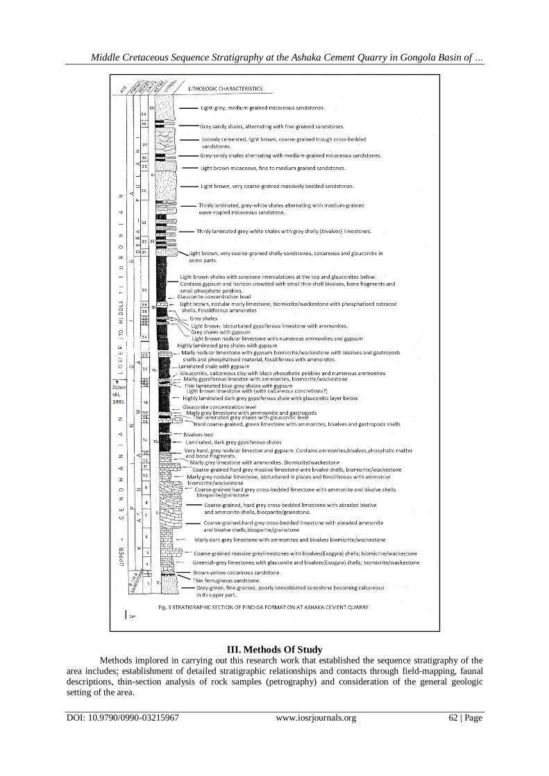
Kanawa Member is only about 4 m thick made up of dominantly limestone beds but ammonites
occurring there demonstrate at least the Paravascoceras cauvini to Pseudotissotia nigeriensis zones that is the
age equivalent of the greater part of the unit (Zaborski et al., 1998) as shown in Fig. 3. In the Ashaka quarry section, the Kanawa Member is a condensed section and is only about 27 m thick (Fig. 3). Here, they reported
an unconformity between the Kanawa Member and the Dumbulwa Member with the later having a deeply
erosional contact with the former. The erosional contact here was a result of local upliftment and subsequent
erosion of the Kanawa Member before the Middle Turonian regression that deposited the Dumbulwa Member
(Zaborski et al., 1998).
The Dumbulwa Member (equivalent to the beds referred to as the Bima Group) in the Dumbulwa and
Bage Hills by Carter et al. (1963) forms the flanks of the Dumbulwa-Bage High. In the southern part of the
Dumbulwa-Bage High and the Ashaka Cement Quarry, the Dumbulwa Member passes laterally into the
sandstones of the Deba-Fulani Member. These sandy members of the Pindiga Formation are almost always
overlain by the Fika Member which is exposed on the northern flank of the Dumbulwa-Bage High. The Fika
Member here is equivalent to the “Shale Member” of the Pindiga Formation and Fika Shales of Carter et al. (1963). The Gombe Sandstone is exposed to the west of the Ashaka area.
The Kanawa Member at Ashaka Cement Quarry section is overlain by the Deba-Fulani Member and
rest unconformably on the red to light brown, medium-grained sandstone of the Upper Bima Sandstone.
Zaborski et al. (1998) recognized a 9 cm thick ferruginous sandstone (unit 2, Fig. 3) horizon separating the
sandstone of the Upper Bima Sandstone from the basal Kanawa Member of the Pindiga Formation. The Upper
Bima Sandstone also forms the quarry section floor at the northern end of the quarry. The overlying Deba-
Fulani Member has a transitional boundary with the Kanawa Member, occurring through a sequence of
glauconitic, feldspathic, calcareous sandstone, sandy shelly limestones and shales (Zaborski et al., 1998).
The Kanawa Member as shown in Fig. 3 is a shale-limestone succession about 27 m thick. Unlike in
the Pindiga – Gombe sub-basin, the Kanawa in the quarry is made up of directly superposed limestones below
and the usual thick shales with limestone intercalations above. The superposed lower limestones are generally
grey when fresh but weather to white or cream-brown colours and are often highly fossiliferous. These limestones which are mostly wackestones are made up of 10 individual units with each unit rarely exceeding 1
m in thickness. The contacts between them are usually sharp representing minor intermittent breaks in
sedimentation. The units can be persistent but are in some cases discontinuous from the north to the south of the
quarry. The units are either hard limestones, marly limestones or limestones with clay seams. Fossils within
these units often appear as whole (in the marly limestone units) or broken but recognizable fragments (in the
hard limestone units). Ammonites, bivalves and gastropods are the most frequently seen fossils at the outcrop
scale in these units. Structures such as cross-bedding are evident within certain of the hard limestones (units 7, 8
and 9, Fig. 3). The upper surfaces of the limestones sometimes show Thalassinoides burrows particularly the
marly or nodular limestone units. Above the lower superposed limestones are the thick shales with limestone
intercalations which are overburden on the lower exploitable limestones. This upper succession contains 8
limestone units. Calcareous sandstones and shelly (bivalve) limestones occur at the transition with the Deba-Fulani Member. The shales are dark in colour when fresh but show much lighter blue to greenish-grey colours
when weathered, while the limestones are grey in colour. Thin layers of gypsum occur frequently within the
shales and limestone units. Glauconite occurs as grains at specific horizons (units 15, 18 and 30, Fig. 3). Some
of the units contain vertebrate bone fragments, reworked fossils, epifaunas and phosphatic matter which mark
discontinuity surfaces or horizons signifying hiatuses.
Middle Cretaceous Sequence Stratigraphy at the Ashaka Cement Quarry in Gongola Basin of …
DOI: 10.9790/0990-03215967 www.iosrjournals.org 62 | Page
III. Methods Of Study Methods implored in carrying out this research work that established the sequence stratigraphy of the
area includes; establishment of detailed stratigraphic relationships and contacts through field-mapping, faunal
descriptions, thin-section analysis of rock samples (petrography) and consideration of the general geologic
setting of the area.
Middle Cretaceous Sequence Stratigraphy at the Ashaka Cement Quarry in Gongola Basin of …
DOI: 10.9790/0990-03215967 www.iosrjournals.org 63 | Page
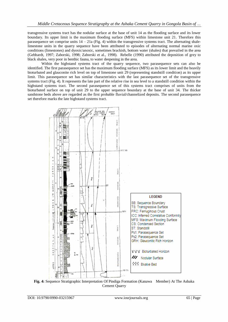
IV. Discussion On The Sequence Stratigraphic Interpretation Of The Study Area The Pindiga Formation at Ashaka Cement Quarry section is considered here to comprise a single
sequence which is made up of a transgressive systems tract and the highstand systems tract but without the
lowstand systems tract and within this sequence parasequences and parasequence sets also occur.
The lower boundary of the sequence is a thin ferruginous crust on top of the Upper Bima Sandstone.
The intervening Yolde Formation is not seen at the quarry section; hence it is an unconformity surface marking
the onset of the Late Cenomanian–Early Turonian marine incursion that deposited the Kanawa Member. The
Late Cenomanian–Early Turonian marine transgression was regional and the most extensive in Nigeria and
Niger (Zaborski, 2000). The upper boundary of the sequence is proposed at the base of unit 34 at the quarry
which is the correlative conformity of the erosional unconformity seen at the base of the Dumbulwa Member in
the Dumbulwa-Bage High area. The erosional contact here was as a result of the erosion of the Kanawa Member
at the beginning of the Middle Turonian regression during which the Dumbulwa and Deba-Fulani Members were deposited (Zaborski, 2000).
The Lower Sequence Boundary
The thin ferruginous crust (unit 2, Fig.4) at the top of the Bima Sandstone at the Ashaka Cement
Quarry section is the lower boundary of the sequence. The Yolde Formation is totally absent as a result of uplift
of the Dumbulwa-Bage High area during late Early Cretaceous to early Late Cretaceous times. This is therefore
an unconformity surface, the ferruginization indicating subaerial exposure. It is also a transgressive surface,
since above it is the marine deposits of the Kanawa Member. Because of the subaerial erosion associated with
the subaerial exposure, the unconformity (sequence boundary) is a Type 1 unconformity hence the Ashaka
Cement Quarry section is a Type 1 sequence.
The basal Kanawa Member (unit 3, Fig. 4) found above the ferruginous crust in the quarry is a calcareous sandstone (Zaborski, 1995) and the basal limestone is quartz- rich. The transgressive surface was
marked by marine erosion which recycled sands from the upper parts of the Bima Sandstone and Yolde
Formation. Fossils in this unit include hedbergellid foraminifers, Exogyra columba, bryozoans and Nigericeras
gadeni. Gebhardt (1997) reported the existence of non-keeled hetrohelicid and hedbergellid foraminifers in the
basal limestones of the quarry section. Heterohelicids and globigerinid-shaped hedbergellids are the first to
colonize new sea ways and the last survivors, being able to withstand harsh conditions such as shallow and/or
dysoxic waters (Eicher and Worstell, 1970; Petters, 1980, 1983).
The Upper Sequence Boundary
Regionally the Type 1 unconformity between the Kanawa Member and the Dumbulwa Member in the
Dumbulwa-Bage High area may be taken as the next sequence boundary. However, at the quarry section, this
major unconformity is missing. The point which is here regarded as the upper sequence boundary is the base of unit 34 (Fig. 4) within the Deba-Fulani Member. This point is regarded here as the correlative conformity of the
regional unconformity between the Kanawa Member and the Deba-Fulani Member. Above this point, the units
became dominantly arenaceous and characteristically continental in nature. The sequence boundary here does
not coincide with the boundary between the Kanawa Member and the Deba-Fulani Member (taken at the first
appearance of sandstone) because the lowermost units of the Deba-Fulani Member are characteristically marine.
The sandstones contain bivalves and are wave rippled. These are probably deposits formed during the early
stages of relative sea level fall and belong within the highstand systems tract.
Maximum Flooding Surface
The maximum flooding surface is a surface that marks the change from a retrogradational to an
aggradational parasequence set and is commonly indicated by condensed section. Condensed sections are beds which are product of low rates of sediment accumulation. They occur largely within the transgressive and distal
highstand systems tracts (Van Wagoner et al., 1987). They also often contain reworked fossils, phosphatic
matter; phosphatised fossils bone fragments and glauconite. The maximum flooding surface (MFS) of the quarry
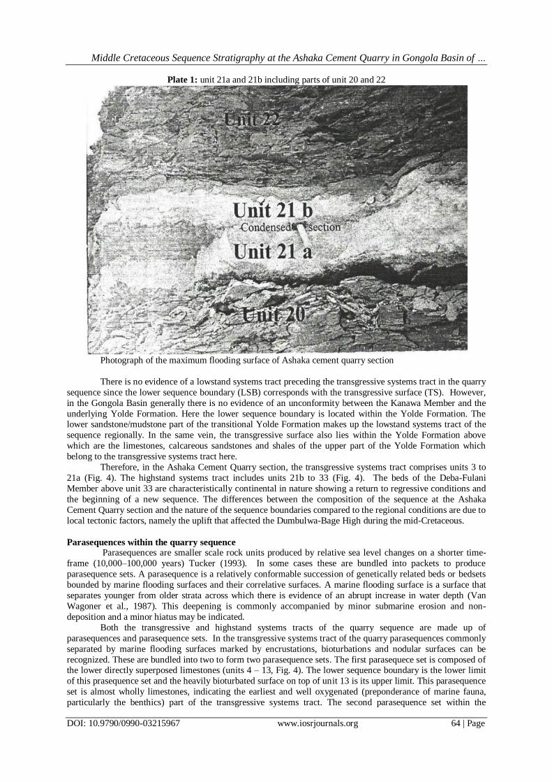
sequence is found within unit 21 (Fig. 4). This unit is in two parts with a minor hiatus in-between as shown in
Plate 1. The lower part is rather hard limestone with Pseudotissotia nigeriensis. The upper part is condensed. It
is a gypsiferous, glauconitic marl with black phosphatic nodules. Its ammonite fauna includes Vascoceras
propium propium, Pseudospidoceras flexuosum, Watinoceras aff. coloradoense, Vascoceras obscurum,
Thomasites gogilensis, Pseudotissotia nigeriensis, Wrightoceras munieri and Bageites bakui Zaborski. This is
the most exotic (deepest water?) fauna in the Ashaka Cement Quarry section. Gebhardt (1997) also reported the
existence of some species of foraminifers here to include; Guembeliria cenomana, Heterohelix fayose,
Heterohelix reussi and Ammobaculites bauchensis.
Middle Cretaceous Sequence Stratigraphy at the Ashaka Cement Quarry in Gongola Basin of …
DOI: 10.9790/0990-03215967 www.iosrjournals.org 64 | Page
Plate 1: unit 21a and 21b including parts of unit 20 and 22
Photograph of the maximum flooding surface of Ashaka cement quarry section
There is no evidence of a lowstand systems tract preceding the transgressive systems tract in the quarry
sequence since the lower sequence boundary (LSB) corresponds with the transgressive surface (TS). However,
in the Gongola Basin generally there is no evidence of an unconformity between the Kanawa Member and the
underlying Yolde Formation. Here the lower sequence boundary is located within the Yolde Formation. The lower sandstone/mudstone part of the transitional Yolde Formation makes up the lowstand systems tract of the
sequence regionally. In the same vein, the transgressive surface also lies within the Yolde Formation above
which are the limestones, calcareous sandstones and shales of the upper part of the Yolde Formation which
belong to the transgressive systems tract here.
Therefore, in the Ashaka Cement Quarry section, the transgressive systems tract comprises units 3 to
21a (Fig. 4). The highstand systems tract includes units 21b to 33 (Fig. 4). The beds of the Deba-Fulani
Member above unit 33 are characteristically continental in nature showing a return to regressive conditions and
the beginning of a new sequence. The differences between the composition of the sequence at the Ashaka
Cement Quarry section and the nature of the sequence boundaries compared to the regional conditions are due to
local tectonic factors, namely the uplift that affected the Dumbulwa-Bage High during the mid-Cretaceous.
Parasequences within the quarry sequence Parasequences are smaller scale rock units produced by relative sea level changes on a shorter time-
frame (10,000–100,000 years) Tucker (1993). In some cases these are bundled into packets to produce
parasequence sets. A parasequence is a relatively conformable succession of genetically related beds or bedsets
bounded by marine flooding surfaces and their correlative surfaces. A marine flooding surface is a surface that
separates younger from older strata across which there is evidence of an abrupt increase in water depth (Van
Wagoner et al., 1987). This deepening is commonly accompanied by minor submarine erosion and non-
deposition and a minor hiatus may be indicated.
Both the transgressive and highstand systems tracts of the quarry sequence are made up of
parasequences and parasequence sets. In the transgressive systems tract of the quarry parasequences commonly
separated by marine flooding surfaces marked by encrustations, bioturbations and nodular surfaces can be
recognized. These are bundled into two to form two parasequence sets. The first parasequece set is composed of the lower directly superposed limestones (units 4 – 13, Fig. 4). The lower sequence boundary is the lower limit
of this prasequence set and the heavily bioturbated surface on top of unit 13 is its upper limit. This parasequence
set is almost wholly limestones, indicating the earliest and well oxygenated (preponderance of marine fauna,
particularly the benthics) part of the transgressive systems tract. The second parasequence set within the
Middle Cretaceous Sequence Stratigraphy at the Ashaka Cement Quarry in Gongola Basin of …
DOI: 10.9790/0990-03215967 www.iosrjournals.org 65 | Page
transgressive systems tract has the nodular surface at the base of unit 14 as the flooding surface and its lower
boundary. Its upper limit is the maximum flooding surface (MFS) within limestone unit 21. Therefore this
parasequence set comprise units 14 – 21a (Fig. 4) within the transgressive systems tract. The alternating shale-limestone units in the quarry sequence have been attributed to episodes of alternating normal marine oxic
conditions (limestones) and dyoxic/anoxic, sometimes brackish, bottom water (shales) that prevailed in the area
(Gebhardt, 1997; Zaborski, 1998; Zaborski et al., 1998). Rebelle (1990) attributed the deposition of grey to
black shales, very poor in benthic fauna, to water deepening in the area.
Within the highstand systems tract of the quarry sequence, two parasequence sets can also be
identified. The first parasequence set has the maximum flooding surface (MFS) as its lower limit and the heavily
bioturbated and glauconite rich level on top of limestone unit 29 (representing standstill condition) as its upper
limit. This parasequence set has similar characteristics with the last parasequence set of the transgressive
systems tract (Fig. 4). It represents the late part of the relative rise in sea level to a standstill condition within the
highstand systems tract. The second parasequence set of this systems tract comprises of units from the
bioturbated surface on top of unit 29 to the upper sequence boundary at the base of unit 34. The thicker sandstone beds above are regarded as the first probable fluvial/channelized deposits. The second parasequence
set therefore marks the late highstand systems tract.
Fig. 4: Sequence Stratigraphic Interpretation Of Pindiga Formation (Kanawa Member) At The Ashaka
Cement Quarry

Middle Cretaceous Sequence Stratigraphy at the Ashaka Cement Quarry in Gongola Basin of …
DOI: 10.9790/0990-03215967 www.iosrjournals.org 66 | Page
Depositional environment of the Kanawa Member at the quarry section The rich marine macrofossils/microfossils of the Pindiga Formation (Kanawa Member) at the Ashaka
Cement Quarry section are indication of marine environment of deposition. However, the possible submarine environments of deposition could only be deduced by considering other parameters. The dominantly limestone
part (units 3 – 13, Fig. 3) of the quarry section is an indication of well oxygenated shallow marine environment
for this part. The ammonites are vascoceratid dominated. They are known to be shallow water dwellers and
thrive in oxic environments. The benthonics; bivalves, gastropods, bryozoans, dasyclads (green algae) and
echinoderms, also occur in this part, indicating oxygenated bottom conditions as do the frequent bioturbation on
the upper surfaces of some of the limestone units. Hedbergellid and non-keeled planktonic foraminifers were
observed here, also pointing to deposition under fairly oxygenated condition. Detrital quartz and feldspars are
common towards the base. Oti (1990) indicated that these might have been transported into this area but are here
regarded as mostly the result of local submarine erosion of pre-existing sands. Some of the limestone units are
cross-bedded without ammonites, packstones/grainstones formed under shallow well agitated water conditions.
However, most are marly limestones (wackestones) generally with ammonites attributable to low energy, slightly deeper waters. This part of the section was deposited under normal open marine, sometimes agitated
water conditions typical of a marine shelf. Gebhardt (1997) in his tripartite division of the quarry section
assigned this part to a lagoon-shelf environment with normal marine salinity and a non-stratified water body.
The marine environment becomes progressively quieter and deeper passing up the quarry section (units
14 -33, Fig. 3). This is indicated by the laminated shales with lesser limestone intercalations. Here the benthonic
faunas are mainly restricted to the limestones. Gebhardt (1997) also reported an increasing content of planktonic
foraminifers here. Glauconite-rich horizons marking water deepening are observed (units 16, 17 and 29, Fig. 3)
as is generally increasing glauconite content. The detrital quartz and feldspars disappear.
The typical limestone/shale alternation here shows alternating normal marine oxic (limestones) and
sometimes brackish bottom water (shales). This can be attributed to stratification resulting from fresh water
influx. In his tripartite division Gebhardt (1997) assigned this part of the section to a shelf environment.
Reduced salinities and low oxygen levels may have caused mass mortalities at quarry section (Gebhardt, 1997) and not hypersaline conditions. Therefore, the gypsum lenses were not formed as a result of hypersalinity. These
are secondary in origin and have been attributed to late oxidation of sulphides by circulating groundwater
(Rebelle, 1990).
According to this study therefore, the Ashaka Cement Quarry section is assigned to a shelf/lagoon environment
with fluctuating salinities and oxygen levels.
Microfacies analysis has also revealed more post-depositional characteristics of the Kanawa Member in
the quarry section. It is evident that the original sediments were mainly bioclastic lime-muds. Overburden
pressure has sometimes caused the development of stylolites and fragmentation of some of the bioclasts. There
was dissolution of bioclastic materials with the more aragonitic shells being completely dissolved while the
calcitic varieties were retained. The muds originally forming the rock fabric were mostly recrystallised during
aggrading neomorphism to microsparite. Voids were filled by drusy sparite. This sparite may have originated from fresh water circulation in the emergent carbonate platform deposits during a subsequent fall of sea level
(Rebelle, 1990).
V. Conclusion It is evident from the various deductions according to this study, that the limestones of the Kanawa
Member of the Pindiga Formation at the Ashaka Cement Quarry section are dominantly neomorphosed
biomicrites or wackestones. Depositional environments of the Kanawa Member and the basal Deba-Fulani
Member was generally shallow marine and in most cases low energy, with few instances of agitated conditions
(units 7, 8 and 9, Fig. 3). Marine fauna (mollusk dominated) indicated fairly well oxygenated bottom conditions at least for the lower limestones. This however was succeeded by alternating normal marine oxic and
dysoxic/anoxic conditions (limestones/shale alternations) attributed to stratification resulting from freshwater
influx. This has also caused fluctuating salinities and reduced oxygen levels that killed the rich marine fauna.
This stage has also shown the basin to experience calm and water deepening conditions marked by the
glauconite-rich horizons. The basin also experienced terrigenous influx at the earliest stage.
The Kanawa Member together with the basal Deba-Fulani Member of Pindiga Formation forms a
single Type 1 sequence. The ferruginous crust at the top of the Bima Sandstone forms the lower sequence
boundary while an inferred correlative conformity at the base of unit 34 (Fig. 4) within the Deba-Fulani Member
is the upper sequence boundary. In the quarry section, the lowstand systems tract preceding the transgressive
systems tract is lacking. This, points to the shallow water marginal position of the depositional basin.
Middle Cretaceous Sequence Stratigraphy at the Ashaka Cement Quarry in Gongola Basin of …
DOI: 10.9790/0990-03215967 www.iosrjournals.org 67 | Page
Acknowledgements The authors wish to thank the department of Geology, Ahmadu Bello University Zaria then under the
leadership of Professor Ibrahim Garba. The department provided logistic support particularly during our first
fieldtrip to Ashaka quarry as the departmental vehicle was released to us for three days in the month of April of
2001.We were also allowed the used of the departmental equipments such as measuring tapes, GPS and
compass/clinometres. Technological staff of the department are also not left in this regard. Mr. Samuel Adegbo
and Mr. Robert Lamja assisted in the preparations of Thin-sections of the samples brought from the field. Mr.
Emmanuel Animashaun aided in the sedimentological laboratory work while Mr. Linus produced the
photographs of the faunas.
The authors also wish to express gratitude to Professor N. G Obaje then of ATBU Bauchi for offering a
lot of useful suggestions.
References [1]. Carter, J. D., Barber, W., Taite, E. A. and Jones, G. P. 1963. The geology of parts of Adamawa, Bauchi and Bornu provinces in
Northern Nigeria. Bulletin of the Geological Survey of Nigeria. 30, 99pp.
[2]. Eicher, D. L. and Worstell, P. 1970. Cenomanian and Turonian, Foraminifers from the great plains, United States.
Micropaleontology, 16, 269 – 324.
[3]. Gebhardt, H. 1997. Cenomanian to Turonian foraminifera from Ashaka (NE Nigeria): quantitative analysis and palaoenvironmental
interpretation. Cretaceous Research, 18, 17 – 36.
[4]. Guiraud, M. 1990. Tectono – sedimentary framework of the Early Cretaceous – continental Bima Formation (Upper Benue Trough,
NE, Nigeria). Journal of African Earth Science, 10, 341 – 353.
[5]. Oti, M. N. 1990. Lower Turonian carbonates on the Zambuk Ridge, south eastern Chad Basin: the Ashaka limestone. In Ofoegbu,
C.O. (ed): The Benue Trough: structure and evolution. Vieweg, Braunschweig, 287 – 320.
[6]. Petters, S. W. 1980. Biostratigraphy of Upper Cretaceous foraminifera of the Benue Trough, Nigeria. Journal of Foraminiferal
Research, 10, 191 – 204.
[7]. Petters, S. W. 1983. Gulf of Guinea planktonic foraminifera biochronology and geological history of the South Atlantic. Journal of
Foraminiferal Research 13, 32 – 59.
[8]. Rebelle, M. 1990. The marine transgression in the Benue Trough (NE-Nigeria): a paleogeographic interpretation of the Gongila
Formation. Journal of African Earth Sciences 10, 643 – 655.
[9]. Tucker, M. E. 1993. Carbonate diagenesis and sequence stratigraphy. Sedimentology Review| 1.51 – 72.
[10]. Van Wagoner, J. C., Mitchum, R. M., Posamentier, H. W. and Vail, P. R. 1987. Title of contribution in A. W. Bally (ed). Atlas of
Seismic Stratigraphy. American Association of Petroleum Geologists in Geology 27 (1): 11 – 14.
[11]. Zaborski, P. M. 1995. The Upper Cretaceous ammonite Pseudaspidoceras Hyatt, 1903 in north-eastern Nigeria. Bulletin of British
Museum of Natural History (Geology), 51, 53 – 72.
[12]. Zaborski, P. M. 1998. A review of the Cretaceous Systems in Nigeria. African Geoscience Review, 5, 385 – 483.
[13]. Zaborski, P. M., Ugodulunwa, F., Idornige, A., Nnabo, P. and Ibe, K. 1998. Stratigraphy and Structure of the Cretaceous Gongola
Basin, north – east Nigeria. Bulletin des Centre de Recherché Exploration – Production Elf-Aquitaine, 21, 153 – 186.
[14]. Zaborski, P. M. 2000. The Cretaceous and Paleocene transgression in Nigeria and Niger. Journal of Mining and Geology, 36 (2),
153 – 173.