SEPL51996 - Utah · · 2006-01-18be a minimum 2" check valve. ... Sec. 1 6, T. 30 S., R. 6 E....
112
cm a STATE OF UTAH DIVISION C >lL,GAS AND MfNING 5. Laase Designation and Serial Number: ML-46342 APPLICATION FOR PERMIT TO DRILL OR DEEPEN B.Nindu,NbueemTdbeName: N/A 1A Typ••«work: DRILL DEEPEN O N/A e.Typeerwen: OfL GAS OTHER: SINGLEZONEg MULTIPLEZONED e.Fannorwm TEASDALE 2. Name of Operalor: 9. Wel Number: RANGELAND PETROLEUM CORPORATION #1 3. Address and Telephone Number: 10. Field and Pool, m WUdcat 210 NORTH MAIN ST., MIDLAND, TX. 79701 (915) 686-8983 WILDCAT 4. Locatkmof Wen (Fontages) 11. Otr/Ott, Secdon, Township, Range, Meria:sc.: neu,,.o.: 540' FNL & 660' FWL NWNW 16-30S-6E n P..po..a eroa.eing zon.: S AME 14. Distance in miles and dhecdon from nearest town a post oNice: 12. County: 13. State: 9 MILES SE OF TORREY WAYNE UNH 15. Distance to nearest 16. Number af acres In tease: 17. Number of acres assigned to this wei: property a taase Sne geog: 5 6 O ' 6 4 0 40 10. Dietance to nearest well, dtWIIng, 19. Proposed Depth: 20. Antary a cable tools: completed, m appned for, on this lease geog: N/ A 6 , OOO · ROTARY 21. Bevadons (show wheUser DF, NT,GR, etc.): 7, 8 8 2 ' UNGRADED Opprould d win f 1996 23 PROPOSED CASING ANE CEMENTING PROGRAM 812EOF HOLE GRADE,812EOF CASING WEIGHTPER FOOT SEnlNG DEPM OUANNY OF CEMENT 70" 16" CONDUCTOR 50' bU CU. EI. öt IU SUKVAtt 17-1(4" 9-5/0" K-55 36# 2,150' 1350 LU. E I. at tu muutAtt 7-7/8" 5-1/2" J-55 17# 6,000' Isub Lu. E I. 6e iù ¿,ùùù' DESCAIBE PROPOSED PROGRAM: Wproposal is to deepen, give data on present productive zone and proposed new producdve anne. E proposal is to drgi m deepen direedonally, give pertinent subsurface locadone and fneasured and true verdcel depths. Give blowout preventer program, Wany. SEPL51996 am.asion.tur.: (505) 466-8120 CONSULTDIVOF OIL GAS & N G20-96 (Thie space for State use enig) API Number Ass o (1\934 (See instructions on Reverse
-
Upload
nguyenkhuong -
Category
Documents
-
view
213 -
download
0
Transcript of SEPL51996 - Utah · · 2006-01-18be a minimum 2" check valve. ... Sec. 1 6, T. 30 S., R. 6 E....

cm a STATE OF UTAH
DIVISION C >lL,GAS AND MfNING5. Laase Designation and Serial Number:
ML-46342
APPLICATION FOR PERMIT TO DRILL OR DEEPEN B.Nindu,NbueemTdbeName:
N/A1A Typ••«work: DRILL DEEPEN O N/Ae.Typeerwen: OfL GAS OTHER: SINGLEZONEg MULTIPLEZONEDe.Fannorwm
TEASDALE2. Name of Operalor: 9. Wel Number:
RANGELAND PETROLEUM CORPORATION # 13. Address and Telephone Number: 10. Field and Pool, m WUdcat
210 NORTH MAIN ST., MIDLAND, TX. 79701 (915) 686-8983 WILDCAT4. Locatkmof Wen (Fontages) 11. Otr/Ott, Secdon, Township, Range, Meria:sc.:
neu,,.o.: 540' FNL & 660' FWL NWNW 16-30S-6E
n P..po..a eroa.eingzon.:SAME
14. Distance in miles and dhecdon from nearest town a post oNice: 12. County: 13. State:
9 MILES SE OF TORREY WAYNE UNH
15. Distance to nearest 16. Number af acres In tease: 17. Number of acres assigned to thiswei:property a taase Sne geog: 5 6 O ' 6 4 0 4 0
10. Dietance to nearest well, dtWIIng, 19. Proposed Depth: 20. Antary a cable tools:completed, m appned for, on this lease geog: N/ A 6 , OOO · ROTARY
21. Bevadons (show wheUser DF, NT,GR, etc.):7, 8 8 2 ' UNGRADED
Opprould d winf 1996
23 PROPOSED CASING ANE CEMENTING PROGRAM812EOF HOLE GRADE,812EOF CASING WEIGHTPER FOOT SEnlNG DEPM OUANNY OF CEMENT
70" 16" CONDUCTOR 50' bU CU. EI. öt IU SUKVAtt17-1(4" 9-5/0" K-55 36# 2,150' 1350 LU. E I. at tu muutAtt7-7/8" 5-1/2" J-55 17# 6,000' Isub Lu. E I. 6e iù ¿,ùùù'
DESCAIBEPROPOSEDPROGRAM:Wproposal is to deepen, give data on present productive zone and proposed new producdve anne. E proposal is to drgi m deepen direedonally, give pertinentsubsurface locadone and fneasured and trueverdcel depths. Give blowout preventer program, Wany.
SEPL51996
am.asion.tur.:(505) 466-8120
CONSULTDIVOFOILGAS& N G20-96
(Thie space for State use enig)
API Number Ass o
(1\934 (See instructions on Reverse

WellL.ocationPlaiS 89 58° \N 80.06 chains record
I
660
NORTHo oO' \000o ----- - - --- --- 16 ---- - - - o L-l~
- 1000'
brass cap
o oo sioneo i z
West 80.00 chains record
WellLocationDescriptionRNolGELANDEXPLORATIONCOMPANY
Teasdale V I540' FNL& 660 FWLSection 16. T.30 S., R.5 E., SLM7882' grd el.Wayne county. UT No.teten
- Ëž Gerald G. I luddleston.LSThe above is true and coreact to my knowledgeand belief.
HUDDLESTONLANDSURVEYNO- BOXKK - CORTEZ.CO - (970) 565

Rangeland Petroleum Corporation PAGE 1Teasdale #1540' FNL & 660' FWLSec. 16, T. 30 S., R. 6 E.Wayne County, Utah
Drillinq Program
1. Formation Name Depth from GL Depth from KB Subsea DepthSinbad Ls O' 12' +7,882'
Kaibab Ls 150' 162' +7,732'
Coconino Ss 290' 302' +7,592'
Cedar Mesa Ss 550' 562' +7,332'
Upper Hermosa 1,540' 1,552' +6,342'
Redwall Ls 2,650' 2,662' +5,232'
Devo nian 3,1 60' 3, 172' +4,722
Lynch (Muav) Ls 3,710' 3,722' +4,172'
Bright Angel 4,930' 4,942' +2,592'
Tapeats Ss 5,600' 5,612' +2,282'
Precambrian Shale 5,800' 5,812' +2,082'
Total Depth (TD) 6,000' 6,012' +1,882'* All depths are based on an ungraded ground level of 7,882'.
2. NOTABLEZONES
Tapeats sandstone is the target zone. No other mineral zones are expected.Redwall is the only expected water zone.
3. PRESSURECONTROL(Also see "5." on PAGE 2)
An 11" x 3,000 psi double ram BOP with 3,000 psi choke manifold will beused from bottom of surface casing to TD. (A typical 3,000 psi BOP is onPage 4. The actual model will not be known until the bid is let.) Pressuretest casing to 1,000 psi and annular preventer to 1,500 psi before drillingout. Test valves, manifold, lines, pipe, and blank to 3,000 psi. Place testplug in bottom of wellhead and retest surface equipment every 30 days.
PER S WEST.lNC
PROVIDING PERMlls im I ANI) lisl

Rangeland Petroleum Corporation PAGE 2Teasdale #1540' FNL & 660' FWLSec. 1 6, T. 30 S., R. 6 E.Wayne County, Utah
BOP system will be consistent with API RP53. Pressure tests will beconducted before drilling out from under all casing strings which are setand cemented in place. BOP controls will be installed before drilling thesurface casing plug, and will stay in use until the well is completed orabandoned. BOPs will be inspected and operated daily to assure goodmechanical working order. All BOP mechanical tests, pressure tests, andinspections will be recorded on the drillers tog or daily drilling report.
4. CASING& CEMENTING
Hole Size O.D. Weight Grade Tvoe =Settinq Depth20" 16" Conductor Pipe New 50'12-1/4" 9-5/8" 36 K-55 ST&C New 2,150'
7-7/8" 5-1/2" 17 J-55 LT&C New 6,000'
Surface casing cement will be circulated to surface. Premium cement(~190 cu. ft.) will be run from ~2,150' to ~1,850'. Lite cement (~~1,160cu.ft.) will be run from ~1,850' to surface. An additional ~300 sx will beused to top out cement if there are no returns. Volumes are calculated at100% excess.
Long string will be cemented from TD to 2,000'. Premium cement (260 cu.ft.) will be run from TD to ~5,000'. Light cement (~600 cu. ft.) will be runfrom ~5,000' to ~3,700'. Stage tool will be set at ~3,700'. Premiumcement (~130 cu. ft.) will be run from ~3,700' to ~3,200'. Light cement(~315 cu. ft.) will be run from ~3,200' to ~2,000'. Vol.umes are calculatedat 50% excess. Actual volumes will be determined by caliper log.
5. MUDPROGRAM
Aerated LSND will be used from surface to ~2,150'. Mud or aerated LSNDwill be used from ~~2,150' to TD depending upon hole conditions. Weighted
PER TS WEST,INC
PROVIDING PERMI I S tot I \N1)
Rangeland Petroleum Corporation PAGE 3Teasdale #1540' FNL & 660' FWLSec. 16, T. 30 S., R. 6 E.Wayne County, Utah
mud and lost circulation material will be on site. A mud logger will be onsite once the well is below 5,000' to collect samples at 10' intervals.
6. CORING,TESTING,& LOGGING
No cores are planned. A DST may be run in the Tapeats. Mud, compensatedneutron, formation density, dual induction/SP, microlog, sonic, anddipmeter logs may be run from ~2,150' to TD.
7. DOWNHOLECONDITIONS
The maximum anticipated bottom hole pressure is ~2,300 psi. No abnormalpressures, temperatures, or hydrogen sulfide are expected. Water flowsand lost circulation are expected.
8. MISCELLANEOUS
The anticipated spud date is November 1, 1996. It is expected it will take~30 days to drill the well and ~1 5 days to complete the well.
PERMITS WEST, NC
PROVIDING PERMllS lor i AND
Rangeland Petroleum Corporation PAGE 4Teasdale #1540' FNL & 660' FWLSec. 16, T. 30 S., R. 6 E.Wayne County, Utah
FLOWLINEFILL
TYPICALBOPSTACKANNULAR &CHOKEMANIFOLD
RAM There will be et least 2 chokesand2 chokeline valves (3" minimum).The choke linewill be 3" in diameter. There will be apressure gaugeon thechokemanifold.
Kill sideoutlet mustbe Chokeside outletmustbeminimum2" diameter. minimum3" diameter. TOPIT
TO ÞlT 4Ki!Iline will beminimum2" diameterandhave 2 valves, oneof which shall .
be a minimum 2" check valve.Upperkelly cockwill havehandle available.
Safety valve andsubswill fit all drill string connectionsin use.All BOPEconnectionssubjectedtowellpressure will be flanged, welded,or clamped.
PER S WEST.mo.PROVIDING PERMITS for the ENEROY
Rangeland Petroleum Corporation PAGE 5Teasdale #1540' FNL & 660' FWLSec. 16, T. 30 S., R. 6 E.Wayne County, Utah
Surface Use Plan
1. EXISTINGROADS& DIRECTIONS(See PAGES 10 & 11)
From the junction of U-12 and U-24 on the east side of Torrey, Utah ...
Go S ~7 miles on Utah 12Then turn left and go SE and then NE 3.9 mi. on the Miners Mountain RoadThen turn right and go SE 0.25 mi. on a good dirt road to an old cabinThen turn left and go NE 0.45 mi. on a dirt roadThen turn left and go N 175' on a dirt roadThen turn right and E 400' on a dirt roadThen turn right and go SE 20' to the NW corner of the pad
2. ROADTO BE BUILTOR UPGRADED
Twenty feet of new road will be built and 0.55 mi. of existing road willbe upgraded. Improvements will initially be limited to flat blading a 16'wide travel surface and limbing and felling trees where needed. Limbing(cut at trunk so as not to leave stubs) will be used instead of felling ifit will provide adequate safe passage. The south road of the two roadswhich bracket the wellsite will be blocked.
If production results, then all of the road from the well to the countyroad (Miners Mountain Road) will be crowned, ditched, and culverted.Travel surface will remain 16' and maximum disturbed width will notexceed 50'. Fifty feet will only be necessary on turns.
3. EXISTINGWELLS
There are no existing oil, gas, water, injection, or disposal wells withina 1 mile radius.
PER S WEST.INC
PROVIDING PERMITS tar IAND

Rangeland Petroleum Corporation PAGE 6Teasdale #1540' FNL & 660' FWLSec. 1 6, T. 30 S., R. 6 E.Wayne County, Utah
4. PROPOSED PRODUCTIONFACILITIES
Production facilities may include four 16' to 20' high 500 bbl tanks.Three steel tanks will for oil. One fiberglass tank will be for water.Vertical 4 x 20 heater-treater and 2 x 10 two stage separators may alsobe on site. The pumpjack and these facilities will be painted a flatjuniper green color. Painting will be completed within 6 months ofinstallation. Parts required to comply with OSHA colors will beexcluded.
The tank battery will be surrounded by a dike of sufficient capacity tocontain 150% of the storage capacity of the battery. All loading lineswill be placed inside the dike.
5. WATER SUPPLY
Water will be piped from Carcass Creek in 11-30s-5e. Pace Ranch willprovide the water right. A surface pipeline (<_6"diameter) will be laidalong the access road. If water in the pipe freezes, then water will betrucked to the wellsite. An Application to Appropriate Water will befiled with the Utah Div. of Water Rights.
6. CONSTRUCTIONMATERIALS& METHODS
Topsoil, brush, and trees will be stripped and stockpiled north and southof the pad. The reserve pit will be lined with minifnum 12 mil plastic.The south road which crosses the pad will be blocked.
7. WASTE DISPOSAL
At least 80% of the reserve pit capacity will be in cut. The pit will be
PER I S WEST.INC.
PROVIDING PERMI(S lor i AND

Rangeland Petroleum Corporation PAGE 7Teasdale #1540' FNL & 660' FWLSec. 1 6, T. 30 S., R. 6 E.Wayne County, Utah
fenced 4' high on 3 sides with 4 strands of barbed wire or woven wiretopped with barbed wire. The 4th side will be fenced once the rig movesoff hole. The fence will be kept in good repair while the pit dries.
All trash will be placed in a trash cage. When full, it will be hauled to astate approved landfill. There will be no trash burning or disposal oftrash in the reserve pit. Chemical toilets will be used for human waste.
8. ANCILLARY FACILITIES
There will be no airstrip or formal camp. Camper trailers will be on sitefor the company man, roughnecks, mud logger, tool pusher, etc.
9. WELL SITE LAYOUT
See PAGES 12 & 13 for depictions of the well pad, cross sections, cutand fill diagrams, reserve pit, burn pit, access road onto the pad,parking, living facilities, and rig orientation.
10. RECLAMATION
After completing drilling, the wellsite and immediate area will becleared of all debris and material not needed for production.
Reclamation will start when the reserve pit is dry. A'll areas not neededfor production will be backfilled, recontoured to match natural contours,and reserved topsoil, trees, and brush evenly spread. If the well is aproducer, then enough topsoil will be kept aside to reclaim the rest ofthe pad. Disturbed areas will be ripped, harrowed, or scarified beforeseeding. The south road which crosses the pad will be left closed andreclaimed. Areas widened by road upgrading will be similarly reclaimed.
PER S WEST-PROVIDING PERMITS for ! \ND
Rangeland Petroleum Corporation PAGE 8Teasdale #1540' FNL & 660' FWLSec. 16, T. 30 S., R. 6 E.Wayne County, Utah
All reclaimed areas will be broadcast seeded in late fall or winter withseed mixes specified by the state (Sec. 16) and BLM (Sec. 17). Seededareas will be left rough and lightly harrowed or drug with a chain afterseeding.
11. SURFACEOWNER
The pad is all on one lease on state land managed by the Utah School andInstitutional Trust Lands Administration. The upgraded road is on stateand BLM. The 175' of existing road which runs north-south is all on BLM.
12. OTHER INFORMATION
If cultural resources are found during construction, all work will stop inthat area and the State Historic Preservation Office notified. Rangelandwill inform everyone in the area associated with the well that they aresubject to prosecution for disturbing historic or archaeology sites or forcollecting artifacts.
13. REPRESENTATIONAND CERTIFICATIONS
Anyone having questions concerning the APD should contact:
Brian WoodPermits West, Inc.37 Verano LoopSanta Fe, NM 87505(505) 466-8120 FAX: (505) 466-9682 Mobile: (505) 699-2276
The field representative for Rangeland will be:
PERMITS WEST,INC
PROVIDING PERMITS tor iAND

Rangeland Petroleum Corporation PAGE 9Teasdale #1540' FNL & 660' FWLSec. 16, T. 30 S., R. 6 E.Wayne County, Utah
Terry MichaelRangeland Petroleum Corporation210 North Main St.Midland, Tx. 79701(915) 686-8983
I hereby certify Rangeland Petroleum Corporation has the necessaryconsents from the proper lease and unit interest owners to conductlease and unit operations in conjunction with this APD. Bond coveragefor lease activities will be provided by Rangeland PetroleumCorporation.
I hereby certify I have inspected the proposed drill site and accessroute; that I am familiar with the conditions which currently exist; thatthe statements made in this plan are, to the best of my knowledge, trueand correct; and that the work associated with operations proposedherein will be performed by Rangeland Petroleum Corporation and itscontractors and subcontractors in conformity with this plan and theterms and conditions under which it is approved.
September 20, 1996Brian Wood, Consultant Date
PER S WEST. INC
PROVIDING PERMITS for i AND

Rangeland Petroleum Corporation PAGE 1 0Teasdale #1540' FNL & 660' FWLSec. 16, T. 30 S., R. 6 E.Wayne County, Utah
5' 46 7 15 4 ag
£5CALANTE 40 ML
PROPOSEDWELL: ACCESSROUTE: ËE W T c.PROVID\NG PERMITN un I \ND l

Rangeland Petroleum Corporation PAGE 12Teasdale #1540' FNL & 660' FWLSec. 16, T. 30 S., R. 6 E.Wayne County, Utah
ToPSOIL TREE BRUSHPILE.
ACCESSTRAILER TRAILER|
GENERATOR\ N FUELP IPE RACKS : i s
DOOHOUSE, RIG, AND I PUMP jCATVA K VATER TANK PUMP
PIPE RACKS MUDTANK TRASH CAGELMUDLOGTRL
RESERYEPIT
FLAREPIT
'TOPSOIL, TRE BRU I
/PER S WEST.INC
PROVil)lNG PERMil¾ lor ! \NI) l

TEASDALE* Iwe l pod & section
Ts'
.. 8O e /'
o- so85
Sode ? - 50'
/ cut
7882° grd et /e wood stake
--' ISO /' Cf
125
reserveit
10' deep
c 8°
C
D90

MEP-20-BM 12.14 FROMsNABORU DRILLINu umm waas. .--------.
$ettien 2 of the Act of June D, 1906 (34 stat. 225,16 U.S.C. 431) authortges the Fresident, in his discretion,to declare by publie proclamation historie landaarks, historicand prehistoric structures, and other objects of historic orscientific inteseat that age situated upon the lands owned orcontrolled by the Government of the United States to be nationalmonuments, and to reserve as a part thereof parcels of land, thelimits of which in all casea shall be Confined to the smallestarea compatible With the proper care and management of theobjects no be proteemed.
NOW, TßBREroRE, I, WILLIAM J. CLINTON, President 0$ theUnited grates of Ameries, by the auchority vested in me by ,
aestion 2 of the Act of June 8, 1900 (34 feet. 225, 16 U.S.C.481), de psoulaim that there are hereby get apart and gegervedas the Grand Staircase-Eseslanta National Monument, for thepurpose of protantin¶ the objects identified above, all landsand interests in lands awaad or controlled by the United Stateswithin the boundarias oE the area describad on the documententitled "Grand staircasemascalante National Monument* attachedto and forming a part of this prootmaation. The Federal landand interests in land reserved consist of approximately 1.7million screa, which As the smalleet area compatible with theproper came and management of the objects to be protected.
All rederal lands .and ategge.ty.injiande yithin engmanndarias.o.i th4s monument .axe h•reby •ParoPrias.ed andwgi un from enstv. Location, anlactíon; *Alma-leasina,os other disposition undog the agglig lay.p laws, othem thanh2L**change t.,hat furthers the protective purposes of theimonume Ta_gand intermes i 1Anda hoc ex-a hy REUgd states sha2.1 he reserved an. a pax.t of the monument
The establish ent of this onument te subject to valid 2existing rights, ,41
Nothing in this proclamation shall be deemed to diminishthe responsibility and authority of the state of Utah termAnagement of fish and wildlife, including regulation of hearingand fishing, on Faderal lands Within the monument.
more
(OVER)
4
Nothing in this proclamation shall be.deemed to attesttags og pedgodes_ses for, or levels of, livestock _gra.BARRon fedegal landt within the monument, existing gratin useaghall continue to be governed by appliciële láus in ionsogT ihafth nãElamiiloi
Nothing in this proclamation shall he deemed to gayggeany exist‡ng withdrawal, reservation, or appropriation;however, the national monumenoshall be the daniaantreattvation.
The Beoretary of the Interior shall manage the monumentthrough the Bureau of Land Management, pursuant to applicablelegal authorities, to implement the purposes of this
nanogMi 64 rytyi! r.ua-aa-ush.

\
lAlbᯯ
LEGALFOUNIXTION
707 lith StreetSuite 3030Ottiver, CO 80202
Steven ). Ledmer m292-2onStaff Attomty Fax 303-292-1980
Post it ax N¾e 7671To From
Ca /DeWt/ Co.
Phone 4 Ph000
tand Sta ca Escalan N onaÐon
er
Bry¢eCanydNatio
Kanab 89
ARíZONA
E 'd .. NI 'lS]M S1I B]d ET OI 96 E2 d]S

uNotow
VE
24
NEC
I CHOKE RRY G ogt
b PL SANT 9 EEV
T. 31 $
c4Cincie tu
MPÒ55iBL
o
DXIE NA NAL
787
NCH 1
3

, INC.
PROVIDING PERMITS for LAND IJSERS37 Verano Loop Santa Fe New Mexico 87505 (505) 466-81
NOTICE OF STAKING
1. Type of Well 5. Lease NumberOIL {XX} GAS { } OTHER ML-46342
RANGELANDPETROLEUMCORPORATION N/A
2.(b) Name of Agent 7. Unit Agreement NamePERMITSWEST, INC. (Brian Wood) N/A
d f0 N210 NORTHMAINST. TEASDALEMIDLAND,TX. 79701
3.(b) Address of Agent 9. Well Number37 VERANOLP., SANTA FE, NM 87505 #1
4. Surface Location of Well 10. Field or Wildcat NameNWNW WILDCAT
4 m (TAPEATS 16-30s-6e
..
c s7,000' WAYNE UT
16. Location will be staked & access road flagged before onsite. A sketch showing the road, paddimensions, reserve pit, cuts, and fills will be ready at the onsite.
17. Other Considerationsa. Hydrogen Sulfide Potential: NOb. Surface Ownership: STATEc. Cultural Resources: TO BE DONEBYCASA
Date: SEPTEMBER 1 6
Brian Wood, Consultant to Rangeland Petroleum Corporation
cc: Rangeland, UDOGM
DIV.OF DILGAS&

SEP21'9615:07PERMITSWEST,INC.P.1«a
biei

UhŒ

6782
34
3 25' $4 MS 98 °22'l30"
(NTERICA-GEOLOGICAL SuavEY RESTON, venG - Gas
ROAD LEGEND2000 UTAH
Improved Road .........................................
7000 8000 9000 10 000 Unimproved Road .....,..............................
QUADRANGLE LOCATION ÎTaiÎ ........
Interstate Route U.S. Route State
7.5 MINUTE SERIES (TOPOGRAPHIO4 5 MOOOOlFEET
0
30

GEOLOGICAL SURVEY
15 4
5

Status=0

7.5

STATE OF UTAH, DIV OF OIL, GAS & MINERALS
Operator: RANGELAND PETROLEUM CO Well Name: TEASDALE # 1
Project ID: 43-055-30040 Location: SEC. 16 - T30S - R6E
Design Parameters: Design Factors:Mud weight (19.20 ppg) : 0.997 psi/ft Collapse : 1.125
Shut in surface pressure : 2031 psi Burst : 1.00
Internal gradient (burst) : 0.053 psi/ft 8 Round : 1.80 (J)
Annular gradient (burst) : 0.000 psi/ft Buttress : 1.60 (J)
Tensile load is determined using air weight Other : 1.50 (J)
Service rating is "Sweet" Body Yield : 1.50 (B)
*** WARNING *** Design factor for collapse exceeded in design!
Length Size Weight Grade Joint Depth Drift Cost(feet) (in.) (lb/ft) (feet) (in.)
1 2,150 9.625 36.00 K-55 ST&C 2,150 8.765
Collapse Burst Min Int Yield TensionLoad Strgth S.F. Load Strgth S.F. Load Strgth S.F.
(psi) (psi) (psi) (psi) (kips) (kips)
1 2144 2020 0.942 2144 3520 1.64 77.40 423 5.47 J
Prepared by : MATTHEWS, Salt Lake City, UtahDate : 10-31-1996Remarks :
TEASDALE
Minimum segment length for the 2,150 foot well is 1,500 feet.
SICP is based on the ideal gas law, a gas gravity of 0.69, and a mean gas
temperature of 116°F (Surface 74°F, BHT 104°F & temp. gradient 1.400°/100 ft.)
String type: Surface
Next string will set at 2,150 ft. with 7,37 ppg mud (pore pressure of 823
psi.) The frac gradient of 1.000 psi/ft at 2,150 feet results in an injection
pressure of 2,150 psi Effective BHP (for burst) is 2,144 psi.
NOTE : The design factors used in this casing string design are as shown above. As a generalguideline, Lone Star Steel recommends using minimum design factors of 1.125 - collapse (withevacuated casing), 1.0 - (uniaxial) burst, 1.8 - API Brd tension, 1.6 - buttress tension,1.5 - body yield tension, and 1.6 - EUE Srd tension. Collapse strength under axial tensionwas calculated based on the Westcott, Dunlop and Kemler curve. Engineering responsibilityfor use of this design will be that of the purchaser.Costs for this design are based on a 1987 pricing model. (Version

STATE OF UTAH, DIV OF OIL, GAS & MINERALS
Operator: RANGELAND PETROLEUM CO | Well Name: TEASDALE # 1
Project ID: 43-055-30040 | Location: SEC. 16 - T30S - R6E
Design Parameters: Design Factors:Mud weight ( 7.37 ppg) : 0.383 psi/ft Collapse : 1.125
Shut in surface pressure : 1989 psi Burst : 1.00
Internal gradient (burst) : 0.051 psi/ft 8 Round : 1.80 (J)
Annular gradient (burst) : 0.000 psi/ft Buttress : 1.60 (J)
Tensile load is determined using air weight Other : 1.50 (J)
Service rating is "Sweet" Body Yield : 1.50 (B)
Length Size Weight Grade Joint Depth Drift Cost(feet) (in.) (lb/ft) (feet) (in.)
1 6,000 5.500 17.00 J-55 LT&C 6,000 4.767
Collapse Burst Min Int Yield TensionLoad Strgth S.F. Load Strgth S.F. Load Strgth S.F.
(psi) (psi) (psi) (psi) (kips) (kips)
1 2297 4910 2.138 2297 5320 2.32 102.00 247 2.42 J
Prepared by : MATTHEWS, Salt Lake City, UtahDate : 10-31-1996Remarks :
TEASDALE
Minimum segment length for the 6,000 foot well is 1,500 feet.
SICP is based on the ideal gas law, a gas gravity of 0.69, and a mean gas
temperature of 116°F (Surface 74°F, BHT 158°F & temp. gradient 1.400°/100 ft.)
String type: Production
The mud gradient and bottom hole pressures (for burst) are 0.383 psi/ft and
2,297 psi, respectively.
NOTE: The design factors used in this casing string design are as shown above. As a generalguideline, Lone Star Steel recommends using minimum design factors of 1.125 - collapse (withevacuated casing), 1.0 - (uniaxial) burst, 1.8 - API Brd tension, 1.6 - buttress tension,1.5 - body yield tension, and 1.6 - EUE Brd tension. Collapse strength under axial tensionwas calculated based on the Westcott, Dunlop and Kemler curve. Engineering responsibilityfor use of this design will be that of the purchaser.Costs for this design are based on a 1987 pricing model. (Version

WORKSHEETAPPLICATION FOR PERMIT TO DRILL
APD RECEIVED: 09/25/96 API NO. ASSIGNED: 43-055-30040
WELL NAME: TEASDALE #1OPERATOR: RANGELAND PETROLEUM CORP (N8690)
PROPOSED LOCATION: INSPECT LOCATION BY: 10/02/96NWNW 16 - T30S - RO6ESURFACE: 0540-FNL-0660-FWL TECH REVIEW Initials DateBOTTOM: 0540-FNL-0660-FWLWAYNE COUNTY EngineeringWILDCAT FIELD (001)
GeologyLEASE TYPE: STALEASE NUMBER: ML - 46342 Surface
PROPOSED PRODUCING FORMATION: PRCAM
RECEIVED AND/OR REVIEWED: LOCATION AND SITING:
lat R649-2-3. Unit:Bond: Federal[F State[¥ Fee[]
'Number ) y R649-3-2. General.Potash (Y/N)Oil shale (Y/N) R649-3-3. Exception.Water permit &V ER** V
(Number gom eg¿«,is; NG/o Drilling Unit.RDCC Review (Y/N)
¯¯¯
Board Cause no:(Date: la r¶/g£ ) Date:
COMMENTS:

STATE ACTIONS
Mail to:RDCC Coordinator
116 State CapitolSalt Lake City, Utah 84114
1. ADMINISTERING STATE AGENCY 2. STATE APPLICATION IDENTIFIER NUMBER:OIL, GAS AND MINING (assigned by State Clearinghouse)1594 West North Temple, Suite 1210P.O. Box 145801Salt Lake City, Utah 84114-5801 3. APPROXIMATE DATE PROJECT WILL START:
October 30, 1996
4. AREAWIDE CLEARING HOUSE(s) RECEIVING STATE ACTIONS:(to be sent out by agency in block 1)Five County Association of Governments
5. TYPE OF ACTION: / / Lease IX/ Permit / / License /_/ Land Acquisition/ / Land Sale / / Land Exchange / / Other
6. TITLE OF PROPOSED ACTION:Application for Permit to Drill
7. DESCRIPTION:Rangeland Petroleum Corporation proposes to drill the Teasdale #1 well (wildcat) on state leaseML-46342, Wayne County, Utah. This action is being presented to RDCC for consideration of resource issuesaffecting state interests. The Division of Oil, Gas and Mining is the primary administrative agency in this actionand must issue approval before operations commence.
8. LAND AFFECTED (site location map required) (indicate county)NWl4, NWl4, Section 16, Township 30 South, Range 6 East, Wayne County, Utah
9. HAS THE LOCAL GOVERNMENT(s) BEEN CONTACTED?
10. POSSIBLE SIGNIFICANT IMPACTS LIKELY TO OCCUR:Degree of impact is based on the discovery of oil or gas in commercial quantities.
11. NAME AND PHONE NUMBER OF DISTRICT REPRESENTATIVE FROM YOUR AGENCY NEARPROJECT SITE, IF APPLICABLE:
12. FOR FURTHER INFORMATION, CONTACT: 13. SIGNATURE AND ITLE OF AUT RIZEDOFFICIAL:
Frank R. MatthewsPHONE: 538-5334 DATE: 10-15-96 Petroleum ngineer

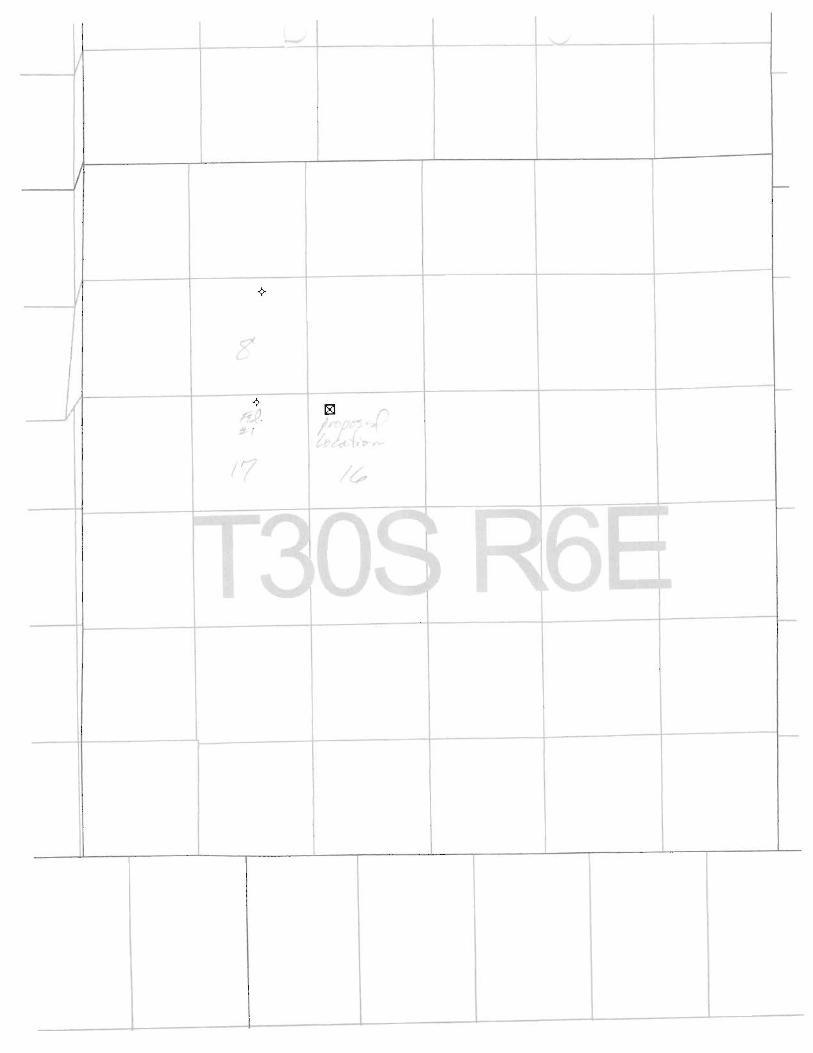
RangelandTeasdale #1Sec, 16,T30S,R6E
DIVISION OF OIL, GAS AND MININGAPPLICATION FOR PERMIT TO DRILL
STATEMENT OF BASIS
Operator Name: Rangeland Petroleum Corporation
Name & Number: Teasdale #1
API Number:
Location: 1/4,1/4 NWNW Sec. 16 T. 30S R. 6E
Geology/Ground Water:
Casing program proposed should adequately protect any ground-water aquifers penetrated.Review of files for P&A's in this townshipshow that loss circulation could be a problem in thiswell. Several oil shows were reported but no high pressure zones. A review of Division of WaterRights database shows one water well in the townshipin section 31, several miles to thesouthwest of this well.
Reviewer: G. L. Hunt
Date: October 10, 1996
Surface:
Proposed location is on State Trust Lands. S&lTLA was notified of the onsite date and time, arepresentative did not participate. Part of the access road is on BLM administered land. A BLMrepresentative was present at the onsite. There are no private ownership issues concerning thislocation. A local rancher has been contacted concerning acquisition of water for drilling,documentation will be forwarded to the Division. They plan to run a water line along the existingroad way, a temporary use permit will be issued by the BLM for this.
Reviewer: G.L. Hunt
Date: October 4, 1996
Conditions of ApprovallApplication for Permit to Drill:
Reserve pit shall be lined with minimum 12 mil synthetic liner properly installed and maintained.

ON-SITE PREDRILL EVALUATION
Division of Oil, Gas and Mining
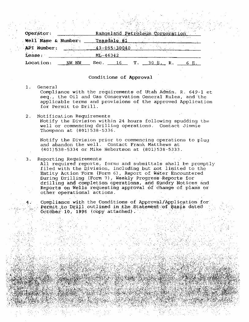
OPERATOR: Ranqefand Petroleum CorporationWELL NAME & NUMBER: Teasdale #1API NUMBER:
LEASE: ML-46342 State FIELDIUNIT: WildcatLOCATION: 1/4,1/4 NWNW Sec:16 TWP:30S RNG:06E 540' FNL 660' FWL
LEGAL WELL SITING: 460 F SEC. LINE; 460 F 1/4,1/4 LINE; 920 F ANOTHER WELL
GPS COORD (UTM):SURFACE OWNER: School and Institutional Trust Lands Administration (State)
PARTICIPANTS
Brian Wood-Permits West consultant for Rangeland, Gil Hunt-DOGM, Bruce Bonebrake-DWR, Kay Erickson-BLM.
REGIONALILOCAL SETTING & TOPOGRAPHY
This location is on Miners Mountain (Teasdale Anticline) between Capitol Reef National Park(Waterpocket Fold) to the east and Boulder Mountain to the west. The proposed site isalmost level with a very gentle slope to the southeast which is the head of Capitol Wash.
SURFACE USE PLAN
CURRENT SURFACE USE: Grazing, wildlife, prospecting, area has been logged in the pastall Ponderosa pines have been removed from the State section.
PROPOSED SURFACE DISTURBANCE: A drill pad of roughly 2 acres will be constructed.The area is almost level so little cut/fill is required. The pad area will require removal ofpinion-juniper trees which now exist there. Existing roads will be used except for a shortsection (~100')to be constructed on BLM land. A right-of-way will be obtained from BLM forthis and upgrade and use of the other portion of road on BLM administered land. Thesection of road on State land is already in place.
LOCATION OF EXISTING WELLS WITHIN A 1 MILE RADIUS: There are two plugged andabandoned wells in the area. One in NWNE of section 17, the other in the NWNE of section8 of the same townshipand range as the proposed well.
LOCATION OF PRODUCTION FACILITIES AND PIPELINES: If necessary will include 500bbl tanks for oil, a fiberglass tank for water, heater-treater, separators, and pumpjack, allpainted flat juniper green. Any tank battery will be bermed to contain possible spills.

RangelandTeasdale #1Sec. 16,T30S,R6E
SOURCE OF CONSTRUCTION MATERIAL: On location.
ANCILLARY FACILITIES: Trailers will be located on site for company men, mud logger, etc.
WASTE MANAGEMENT PLAN
Trash will be collected and hauled to the county landfill. Chemical toiletswill be used. Allwater and drilling mud will be kept on location and handled or treated as necessaryaccording to Division rules and guidance.
ENVIRONMENTAL PARAMETERS
AFFECTED FLOOD PLAIN ANDIOR WETLANDS: None to be affected.
FLORA/FAUNA: Pinion-Juniper, Broom Snake Weed, Indian Rice Grass, some small forbes,vegetation is very sparse except for Pinion-Juniper trees. Deer, wild turkeys, rabbits,raptors, rodents. DWR representative concerned about avoiding turkey roosting (Ponderosa)trees located along access route.
SOIL TYPE AND CHARACTERISTICS: Eolian sand, detritus from Sinbad LS, SS andLS fragments, bedrock exposed in some areas.
SURFACE FORMATION & CHARACTERISTICS: Triassic Moenkopi (Sinbad LimestoneMember) thin to medium bedded, brownish-orange and yellow conglomeratic and sandydolomite.
EROSIONISEDIMENTATIONISTABILITY: Flat and stable, minimal erosion mainly windcaused.
PALEONTOLOGICAL POTENTIAL: None observed.
RESERVE PIT
CHARACTERISTICS: Located on southeast corner of location, 100'x150'x10'.
LINER REQUIREMENTS (Site Ranking Form attached): 12 mil, 35 point ranking score.
SURFACE RESTORATIONIRECLAMATION PLAN
All areas not needed for production will be backfilled, recontoured to match natural contours,and reserved topsoil,trees, and brush evenly spread. Disturbed areas will be ripped,harrowed, or scarified before seeding. The south road which crosses the pad will be leftclosed and reclaimed. Areas widened by road upgrading will be similarly reclaimed. Allareas will be broadcast seeded in late fall or winter. DWR will provide a suitable seed mix.

RangelandTeasdale #1Sec. 16,T30S,R6E
SURFACE AGREEMENT
NA, Trust Land.
CULTURAL RESOURCES/ARCHAEOLOGY
Survey conducted by CASA (Mary Errickson), a copy will be provided. It will cover pipelineroute along existing roads as well as new disturbance.
OTHER OBSERVATIONSICOMMENTS
According to Ed Bonner (S&lTLA) Rangeland has not yet provided adequate bonding for thewell (10-9-96).
ATTACHMENTS
Liner ranking sheet, pictures, Water Rights points of diversion for the township.
G.L. Hunt 10-4-96 @ 9:30 AMDOGM REPRESENTATIVE DATEITIME

RangelandTeasdale #1Sec. 16,T30S,R6E
Evaluation Ranking Criteria and Ranking ScoreFor Reserve and Onsite Pit Liner Requirements
Site-Specific Factors Ranking Site Ranking
Distance to Groundwater (feet)>200 0100 to 200 575 to 100 1025 to 75 15<25 or recharge area 20 5
Distance to Surf. Water (feet)>1000 0300 to 1000 2200 to 300 10100 to 200 15< 100 20 0
Distance to Nearest Municipal Well (feet)>5280 01320 to 5280 5500 to 1320 10<500 15 0
Distance to Other Wells (feet)>1320 0300 to 1320 10<300 20 0
Native Soil TypeLow permeability 0Mod. permeability 10High permeability 20 20
Fluid TypeAir/mist 0Fresh Water 5TDS >5000 and <10000 10TDS >10000 or Oil Base 15Mud Fluid containing highlevels of hazardous constituents 20 10
Drill CuttingsNormal Rock 0Salt or detrimental 10 0
Annual Precipitation (inches)<10 010 to 20 5>20 10 0
Affected Populations<10 010 to 30 630 to 50 8>50 10 0
Presence of Nearby UtilityConduits
Not Present 0Unknown 10Present 15 0
Final Score (Level I Sensitivity) 35

2Oth CEOÌUfy Pla5Ík1-800-767-0
ST CK P 84

20th Century Plasta1 -800-767Oc
.

PointsofDiversion ...//nrwrt1.nr.state.ut.us/cgi-bin/' wplat?sec=&town=30S&range=6E&bem=SL
ONE MOMENT. HARDCOPY BEING PRINTED ON DEVICE O
UTAH DIVISION OF WATER RIGHTSWATER RIGHT POINT OF DIVERSION PLOT CREATED WED, OCT
PLOT SHOWS LOCATION OF 66 POINTS OF DIV
PLOT OF TOWNSHIP 30S RANGE 6E SL BASE AND
PLOT SCALE IS APPROXIMATELY 1 INCH = 6000 FE
NORTH*****************************************************
* O *
* *
* *
* *
* *
* *
* *
* 2 1 *
* *
* *
* 4 3 *
* *
* *
* *
* 6 5 *
* 9 8 7 *
* *
* *
* *
*B A *
*C D *
* *
*E F *
* *
* G H *
* I *
* *
* J** *
* *
* *
* LK M N** O P *
* *
* V QR STWU *
* *
*ZaY X *
*f e c d b *
*ghi *
*o 1 p m kj n *
******q**********************************************
1 UTAH DIVISION OF WATER RIGHTSNWPLAT POINT OF DIVERSION LOCATION PRO
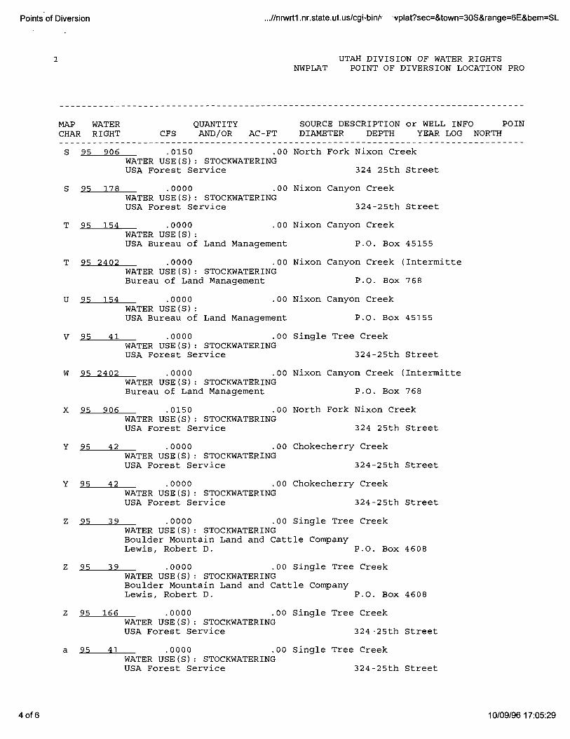
MAP WATER QUANTITY SOURCE DESCRIPTION or WELL INFO POINCHAR RIGHT CFS AND/OR AC-FT DIAMETER DEPTH YEAR LOG NORTH
1 of 6 10/09/96

PointsofDiversion ...//nrwrt1.nr.state.ut.us/cgi-bin/s wplat?sec=&town=30S&range=6E&bem=SL
2 amed In ermi en S eamWATER USE(S): STOCKWATERINGBureau of Land Management P.O. Box 768
1 95 2397 .0000 .00 Unnamed Intermittent StreamWATER USE(S): STOCKWATERINGBureau of Land Management P.O. Box 768
2 95 2404 .0000 .00 Cuts Canyon (Intermittent)WATER USE(S): STOCKWATERINGBureau of Land Management P.O. Box 768
2 95 2405 .0000 .00 Cuts Canyon (Intermittent)WATER USE(S): STOCKWATERINGBureau of Land Management P.O. Box 768
2 95 2416 .0000 .00 Unnamed Intermittent streamWATER USE(S): STOCKWATERINGBureau of Land Management P.O. Box 768
3 95 2397 .0000 .00 Unnamed Intermittent StreamWATER USE(S): STOCKWATERINGBureau of Land Management P.O. Box 768
4 95 2398 .0000 .00 Unnamed Intermittent StreamWATER USE(S): STOCKWATERINGBureau of Land Management P.O. Box 768
5 95 2392 .0000 .00 Unnamed Intermittent StreamWATER USE(S): STOCKWATERINGBureau of Land Management P.O. Box 768
6 95 2403 .0000 .00 Captitol Wash (Intermittent)WATER USE(S): STOCKWATERINGBureau of Land Management P.O. Box 768
7 95 2392 .0000 .00 Unnamed Intermittent StreamWATER USE(S): STOCKWATERINGBureau of Land Management P.O. Box 768
8 95 2395 .0000 .00 Unnamed Intermittent StreamWATER USE(S): STOCKWATERINGBureau of Land Management P.O. Box 768
9 95 2403 .0000 .00 Captitol Wash (Intermittent)WATER USE(S): STOCKWATERING 'Bureau of Land Management P.O. Box 768
A 95 2394 .0000 .00 Unnamed Intermittent StreamWATER USE(S): STOCKWATERINGBureau of Land Management P.O. Box 768
B 95 2399 .0000 .00 Unnamed Intermittent StreamWATER USE(S): STOCKWATERINGBureau of Land Management P.O. Box 768
C 95 36 .0000 .00 Sulphur CreekWATER USE(S): STOCKWATERINGUSA Forest Service 324-25th Street
D 95 2396 .0000 .00 Miners Mountain ReservoirWATER USE(S): STOCKWATERINGUSA Bureau of Land Management P. O. 768
1 UTAH DIVISION OF WATER RIGHTSNWPLAT POINT OF DIVERSION LOCATION PRO
2of6

PointsofDiversion ...//nrwrt1.nr.state.ut.us/cgi-bin/' wplat?sec=&town=30S&range=6E&bem=SL
MAP WATER QUANTITY SOURCE DESCRIPTION or WELL INFO POINCHAR RIGHT CFS AND/OR AC-FT DIAMETER DEPTH YEAR LOG NORTH
E O 00 Lion Moun an-Eas
WATER USE(S): STOCKWATERINGUSA Forest Service 324 25th Street
F 95 2395 .0000 .00 Unnamed Intermittent StreamWATER USE(S): STOCKWATERINGBureau of Land Management P.O. Box 768
G 95 903 .0150 .00 Headwater CreekWATER USE(S): STOCKWATERINGUSA Forest Service 324 25th Street
H 95 2393 .0000 .00 Unnamed Intermittent StreamWATER USE(S): STOCKWATERINGBureau of Land Management P.O. Box 768
I 95 2394 .0000 .00 Unnamed Intermittent StreamWATER USE(S): STOCKWATERINGBureau of Land Management P.O. Box 768
J 95 2391 .0000 .00 Unnamed Intermittent StreamWATER USE(S): STOCKWATERINGBureau of Land Management P.O. Box 768
K 95 153 .0000 .00 Sulphur CreekWATER USE(S): STOCKWATERINGUSA Bureau of Land Management P.O. Box 45155
K 95 2401 .0150 .00 Sulfer CreekWATER USE(S): STOCKWATERINGUSA Bureau of Land Management P. O. Box 768
K 95 177 .0000 .00 Single Tree CreekWATER USE(S): STOCKWATERINGUSA Forest Service 324-25th Street
L 95 36 .0000 .00 Sulphur CreekWATER USE(S): STOCKWATERINGUSA Forest Service 324-25th Street
M 95 2391 .0000 .00 Unnamed Intermittent StreamWATER USE(S): STOCKWATERINGBureau of Land Management P.O. Box 768
N 95 2393 .0000 .00 Unnamed Intermittent StreamWATER USE(S): STOCKWATERINGBureau of Land Management P.O. Box 768
O 95 177 .0000 .00 Single Tree CreekWATER USE(S): STOCKWATERINGUSA Forest Service 324-25th Street
P 95 905 .0150 .00 Nixon SpringWATER USE(S): STOCKWATERINGUSA Forest Service 324 25th Street
Q 95 175 .0000 .00 Single Tree CreekWATER USE(S): STOCKWATERINGState of Utah School & Institutional Tru 3 Triad Center, Suite 400 -- 3
R 95 175 .0000 .00 Single Tree CreekWATER USE(S): STOCKWATERINGState of Utah School & Institutional Tru 3 Triad Center, Suite 400 -- 3
3of6
PointsofDiversion ...//nrwrt1.nr.state.ut.us/cgi-bin/v 'vplat?sec=&town=30S&range=6E&bem=SL
1 UTAH DIVISION OF WATER RIGHTSNWPLAT POINT OF DIVERSION LOCATION PRO
MAP WATER QUANTITY SOURCE DESCRIPTION or WELL INFO POINCHAR RIGHT CFS AND/OR AC-FT DIAMETER DEPTH YEAR LOG NORTH
Nor Fork Nixon reekWATER USE(S): STOCKWATERINGUSA Forest Service 324 25th Street
S 95 178 .0000 .00 Nixon Canyon CreekWATER USE(S): STOCKWATERINGUSA Forest Service 324-25th Street
T 95 154 .0000 .00 Nixon Canyon CreekWATER USE(S):USA Bureau of Land Management P.O. Box 45155
T 95 2402 .0000 .00 Nixon Canyon Creek (IntermitteWATER USE(S): STOCKWATERINGBureau of Land Management P.O. Box 768
U 95 154 .0000 .00 Nixon Canyon CreekWATER USE(S):USA Bureau of Land Management P.O. Box 45155
V 95 41 .0000 .00 Single Tree CreekWATER USE(S): STOCKWATERINGUSA Forest Service 324-25th Street
W 95 2402 .0000 .00 Nixon Canyon Creek (IntermitteWATER USE(S): STOCKWATERINGBureau of Land Management P.O. Box 768
X 95 906 .0150 .00 North Fork Nixon CreekWATER USE(S): STOCKWATERINGUSA Forest Service 324 25th Street
Y 95 42 .0000 .00 Chokecherry CreekWATER USE(S): STOCKWATERINGUSA Forest Service 324-25th Street
Y 95 42 .0000 .00 Chokecherry CreekWATER USE(S): STOCKWATERINGUSA Forest Service 324-25th Street
Z 95 39 .0000 .00 Single Tree CreekWATER USE(S): STOCKWATERINGBoulder Mountain Land and Cattle CompanyLewis, Robert D. P.O. Box 4608
Z 95 39 .0000 .00 Single Tree CreekWATER USE(S): STOCKWATERINGBoulder Mountain Land and Cattle CompanyLewis, Robert D. P.O. Box 4608
Z 95 166 .0000 .00 Single Tree CreekWATER USE(S): STOCKWATERINGUSA Forest Service 324-25th Street
a 95 41 .0000 .00 Single Tree CreekWATER USE(S): STOCKWATERINGUSA Forest Service 324-25th Street
4 of 6 10/09/96

PointsofDiversion ...//nrwrt1.nr.state.ut.us/cgi-bin/' vplat?sec=&town=30S&range=6E&bem=SL
b 95 37 .0000 .00 Single Tree CreekWATER USE(S): STOCKWATERINGUSA Forest Service 324-25th Street
1 UTAH DIVISION OF WATER RIGHTSNWPLAT POINT OF DIVERSION LOCATION PRO
MAP WATER QUANTITY SOURCE DESCRIPTION or WELL INFO POINCHAR RIGHT CFS AND/OR AC-FT DIAMETER DEPTH YEAR LOG NORTH
Nixon CanyoncreekWATER USE(S): STOCKWATERINGState of Utah School & Institutional Tru 3 Triad Center, Suite 400 -- 3
d 95 2390 .0150 .00 N. Fork Spring CreekWATER USE(S): STOCKWATERINGUSA Bureau of Land Management P. O. Box 768
e 95 40 .0000 .00 Chokecherry CreekWATER USE(S): DOMESTIC STOCKWATERINGBoulder Mountain Land and Cattle CompanyLewis, Robert D. P.O. Box 4608
f 95 166 .0000 .00 Single Tree CreekWATER USE(S): STOCKWATERINGUSA Forest Service 324-25th Street
g 95 40 .0000 .00 Chokecherry CreekWATER USE(S): DOMESTIC STOCKWATERINGBoulder Mountain Land and Cattle CompanyLewis, Robert D. P.O. Box 4608
g 95 184 .0000 .00 Chokecherry CreekWATER USE(S): STOCKWATERINGUSA Forest Service 324-25th Street
h 95 44 .2000 .00 Chokecherry Creek N 1550WATER USE(S): IRRIGATION STOCKWATERINGBoulder Mountain Land and Cattle CompanyLewis, Robert D. P.O. Box 4608
i 95 4820 .0150 .00 6 200 - 500 N__ N 1320WATER USE(S): IRRIGATION DOMESTIC STOCKWATERINGBoulder Mountain Land & Cattle Co.
j 95 153 .0000 .00 Sulphur CreekWATER USE(S): STOCKWATERINGUSA Bureau of Land Management P.O. Box 45155
k 95 2401 .0150 .00 Sulfer CreekWATER USE(S): STOCKWATERINGUSA Bureau of Land Management P. O. Box 768
1 95 176 .0000 .00 Nixon CanyonCreekWATER USE(S): STOCKWATERINGState of Utah School & Institutional Tru 3 Triad Center, Suite 400 -- 3
m 95 2390 .0150 .00 N. Fork Spring CreekWATER USE(S): STOCKWATERINGUSA Bureau of Land Management P. O. Box 768
n 95 152 .0000 .00 Sulphur CreekWATER USE(S): STOCKWATERINGUSA Bureau of Land Management P.O. Box 45155
5of6
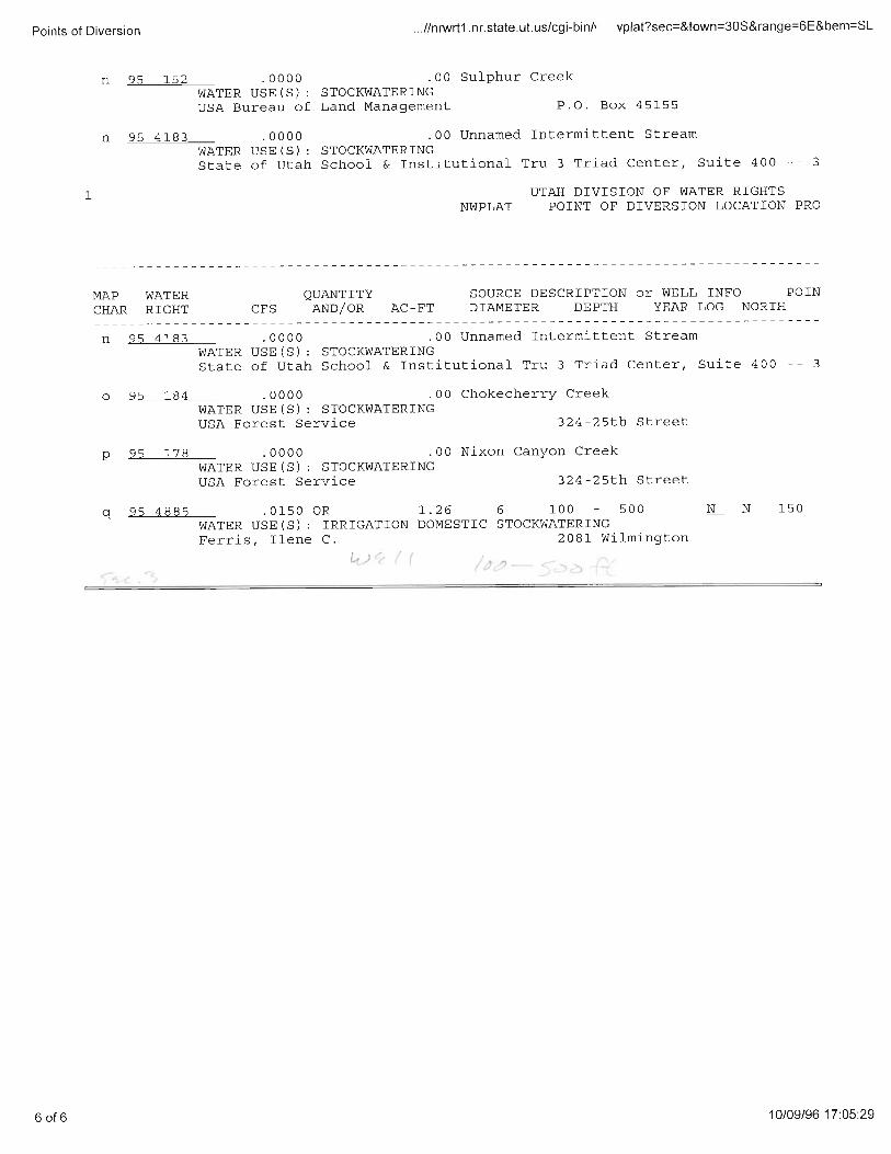
PointsofDiversion ...//nnWrt1.nr.state.ut.us/cgi-bin/v vplat?sec=&town=30S&range=6E&bem=SL
n 95 152 .0000 .00 Sulphur CreekWATER USE(S): STOCKWATERINGUSA Bureau of Land Management P.O. Box 45155
n 95 4183 .0000 .00 Unnamed Intermittent StreamWATER USE(S): STOCKWATERINGState of Utah School & Institutional Tru 3 Triad Center, Suite 400 -- 3
1 UTAH DIVISION OF WATER RIGHTSNWPLAT POINT OF DIVERSION LOCATION PRO
MAP WATER QUANTITY SOURCE DESCRIPTION or WELL INFO POINCHAR RIGHT CFS AND/OR AC-FT DIAMETER DEPTH YEAR LOG NORTH
WATER USE(S): STOCKWATERINGState of Utah School & Institutional Tru 3 Triad Center, Suite 400 -- 3
o 95 184 .0000 .00 Chokecherry CreekWATER USE(S): STOCKWATERINGUSA Forest Service 324-25th Street
p 95 178 .0000 .00 Nixon Canyon CreekWATER USE(S): STOCKWATERINGUSA Forest Service 324-25th Street
q 95 4885 .0150 OR 1.26 6 100 - 500 N__ N 150WATER USE(S): IRRIGATION DOMESTIC STOCKWATERINGFerris, Ilene C. 2081 Wilmington
60f6
II
L
* I
r'

CES
$5 st t TempleMichael TÁadOe lley, Sulle 340
Te¢ Stew all t.akeCity, Utah 04180-1203
Executive IÑreter 01.ge-5340
James W. Carter 001-$59-3940(Fax)Division Director 601-538-5319 (TOD)
November 1, 1996
Rangeland Petroleum Corporation210 North Main StreetMidland, Texas 79701
Re: Teasdale #1 Well, 540' FNL, 660' FWL, NW NW, Sec. 16,T. 30 S., R. 6 E., Wayne County, Utah
Gentlemen:
Pursuant to the provisions and requirements of Utah CodeAxin. 40-6 1 et seq., Utah Administrative Code R649-3-1 et seq.,and the attached Conditions of Approval, approval to drill thereferenced well is granted.
This approval shall expire one year from the above dateunless substantial and continuous operation is underway, or arequest for,extension is made prior to the expiration date. TheAPI identification number assigned to this weil is 43-056-30040.
Sin erely,
Assóciä Directdr
andios esc: W¾yne Coun sesgdg
ufed fL hd änågeinent Richfiei bgs Biot ffi
eli Name &. Muttiber: Te¢ààie #‡API Númber: 43-05540040
Léase: ML-46340
Location: NR NW Sec. 16 T. 30 S. R. 6 E.
Conditions of Approval
1. GeneralCompliance with the requirements of Utah Admin. R..649-1 etseq., the Oil and Gas Conservation General Rules, and theapplicable terms and provisions of the approved Applicationfor Permit to Drill.
2. Notification RequirementsNotify the Division within 24 hours following spudding thewell or commencing drilling operations. Contact JimmieThompson at (801)538-5336.
Notify the Division prior to commencing operations to plugand abandon the well. Contact Frank Matthews at(801)538-5334 or Mike Hebertson at (801)538-5333.
3. Reporting RequirementsAll required reports, forms and submittals shall be promptlyfiled with the Division, including but not limited to theEntity Action Form (Form 6), Report of Wä6er EncounteredDuring Drilling (Form 7), Weekly Progresi Reports fordrilling and completion operations, and Sµndry Notices andReports on Ñelis requesting appròëal f dhange of plans orother operational actions.
4. Compliance with the Conditions-of ApprovalfApplication .for.
tÈq Ogil utlined inyhe Statembrit of BAegs détäd -Octóbär 10, 1996 (copy

DIVISION OF OIL, GAS AND MINING
SPUDDING INFORMATION
Name of Company: RANGELAND PETROLEUM CO.
Well Name: TEASDALE # 1
Api No. 43-055-30040
Section 16 Township 30S Range 6E County WAYNE
Drilling Contractor MABORS
Rig #: 903
SPUDDED:
Date: 12/14/96
Time:
How: DRY HOLE
Drilling will commence: 12/28/96
Reported by: ROBERT DAWTSON
Telephone #: 1-915-686-8983
Date: 12/23/96 Signed:
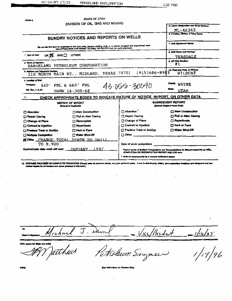
01-1561 11:33 RANGELAND E×PLORATION 112 PO2
rome STATE OF LifAM
DMSION OF OIL GAS AND MINING
ML-46342a. &kyllut. Angissa or Tdbo Name:
SUNDRY NOTICES AND REPORTS ON WELLS7 Unt Agreensatt Nene:
g...n.. se m.. merpop...I. m em n,....... a.,p...w.ung ...n., e, in ......« mune.eand - -a.
u.sMTKW FM PUMM O (WILLCA OgGPËN forta for auch peeposale
a wasnam..ng Numeer1 ***** 04 GAS OTHER:
TEA§D ALEa n... « op.m.« • weW.s ansia.e
RANGELAND PETROLEUM CORPORATION #1
a As ansangidsphone Nulnber: 14 ftaM and Wang, or WM:*
210 NORTH MAIN ST. , MIDLAND, TEXAS 7970] (915)686-891 3 WILDCAT
4 ww.u540' FNL fu 660 ' FWL WAYNE
*** NWNW16-308-6E UTAH
CHECK APPROPHIATEBOXES TO 1NDICATENtTURE OF NOTICE, REPORT, OR OTNERDATANOTICE OF INTENT SUSSEOUENT REPORT
O Abandon O New Construction O Abandon O New Conmoucdon
D Aspair casino O Pull or Alter casing O n.p.ir casing a Pullor Aaer casingO chang.esPs.n. O B•oompl•t• D changeof Plans O noperforsteO coewestto In¡ection 0 noperford• D convestto injection a ventor Flere
O FranhaeTreator Acidhe O VeMor Aare O Fracture Treat or AcW4e O Weer Shut-OW
O Mutiple Centplodon O Weier Shutar O Othergother CHANGE . TOTA.L DRPTH 'rn DR T i.f.
TO 8 , 900 '. Den of work oompi.tion
Approximale date work wel start. . .7 ANIIARY 19 9 7 n,,..,•••••« mumm•*-ra-en- and Wooom¢sdeem a dNasent lesensin onWELL
COMPLEngN OR REGOMPLEDONREPORT ANDLOG ima* tha be secomperded by a cessent voglicamientappia
12, OBIK2tBEPMDF GED08 COMPLETEDCPgnatoo icamenyem enpanksent asians,we goe pwynern desse a wou k elecfksnantmesa, she subestens bassens and measumr and onemesissi espSo br mi masse md -nos pelinert gr @damut)
Imag seetastruedanson neverse

01-12-91 09:40 RANGELAND EXPLORATION 031 PO2
RANGELAND PETROLEUMCORPORATION
2EASDAIÆ Well #1 , conunued Page 293fesse Maintain this Irgfomxation in Confidence]
12/26/96 TD: 40 AREMARKS: Continue to haul water to reserve pits as weather allows. Have hauled over
100 loads (approx. 10.500 bbis) & currently able to haul 5 or 6 loads per day, with sufHcient water onhand to begin drilling as soon as rig is available. (Per conversation with Nabors DrIg. anticipated move-in and rig-up for Nabors Rig 903 is December 29th}
Daily Cost: $1,000 To-Date Curn. Cost: 851,210
12/28/96 TD: 40 ApipMARKS:Continue to haul water to reserve pits. Currently waiting on Rig 903 & crews
to move-in. {Per conversation with Nabors Drlg, anticipated move-in for Rig 903 is Dec 31 & an approxdrilling date of Jan. 3.1997}
Daily Cost: 81,080 To-Date Cum. Cost: SO2.200
DAILY PROGRESS REPORTt[mi: Each report reflects a 24-hr mcord of operations from 7:00am the previous day to 7:00am on report day.
1/6/97 TD: 40 &REM¾¶: Reserve pit full, hauled 200+ loads. Met with Gary Hall assistant BLM area
manager on 1/3/97. Posted $2,500 reclamation bond & moved in three rig loads on 1/5/97. Haveapprox. 20 loads still to move. Expect to have all loads moved by 1/8/97 & begin rig up 1/8/97.
Daily Cost: 82,710 To-Date Cum. Cost: $55,0001/7/97 TD: 40 &
REMARKS: Limb additional trees along county road. Contact Kay Erickson with BLM &obtain permission to cut down one Ponderosa Pine tree. Move in 8 loads and continue to move in rig.
Daily Cost: S740 To-Date Cum. Cost: $58.7401/8/97 TD: 40 &
REMARKS:Movedin 6 more rig loads, Move-in should be completed this afternoon.Expect to rig-up tomorrowmorning.
Daily Cost: $250 ' To-Date Cum. Cost: $88,9901/9/97 TD: 40 A
REMARES: Rigging Up.DadU Cost: $250 To-Date Cum. Cost: $58,240
1 / 10 / 97 TD: 40 &REMARKS: Rigging Up. Waiting on main mud pump to be delivered to complete rig-up.
Anticipate drilling operations to begin this afternoon (1 / 10).Dany cost: 8250 To-Date cum.cost: sas,deo
1/11/97 TD: 40 ARygggg: Continue to wait on main mud pump. Pit liner appears to be leaking: water
level in pit dropped approx. 1 foot in last 24 hours. Hauled 9 loads water. Main mud pump arrived onlocation at 7:30 pm & mudloggers trailer delivered. Prep to complete rig up & commence drilling.
Doñy Cost: So,150 To-Date Cum. Cost: $61,8901/12197 TD:460': (Day 1)(Sun) Progress: 420'; Present Oper: DRLG; Formation: Lime & Sand: Bit#1: 12 1/4" Smith/SI'20 3-24 Jets: WOB: All; RPM: 85/120: ROP: 56 fph: Hrs. on Bit; 7.5: BHA: Bit.8"Mud Motor, 3 - 8" DC's ,
XO, 11 - 6"DC; MW: 14; Visc:28: pH: na; Pump#1: 5x16, SPM: 60: Press: 1000 pel: Hourly Summary:14.& RigUp. 1.0- Pick Up BHA. 4.0- Drilling. 0.5-Survey. 1.O-Drilling, 0.5- Service Rig, 2.5- Drilling
REMARES:Haul 1900bbt water to fill pit. RigUp mudiogger. Commence drilling e 9:30p1/11/97. Rotary table o 85rpm & mud motor o 12Orpm. Not using air & Hole began taking smillamount of fluid at 400 ft & Pumped a sawdust sweep.
DadU Cost· $7,700 To-Date Cum. Cost:

01-14-91 10: 35 RANGELAND EXPLORATION 012 PO2
RANGELAND PETROLEUMCORPORATION
TEASDALE WeM #1 , conunued Page 3IPlease Maintain this Infomiation in Confidence]
1/15/97 TO: 1480'; (Day 2)(Mon) Progress: 1025°; Present Oper: DRID; SS; sit#1:12 1/4" Smith/ST20 3-24 Jets: WOB: 50;RPM: 120/150: ROP: 50 fph: Hrs, on Bit: 29: BHA: Bit,8"Mud Motor. 3 - 8" DC's , XO. 18 - 6"DC: MW:AH Water; Pump#1: 6x16. SPM: 60: Press: 800-1200 psi: Hourly Summary: 21.5. Drilling. 0.5-Service Rig. 1.4 Survey. 1.0-Rig repair
REMARKS: Started mudlogging Sunday afternoon. Roughnecks catching 30' samples.Inst returns at 900'. Start adding air at 900 efm. got back 80% returns. Started snowing at 6:00 p.m.and reserve pit was full. (Approx.19.000 bbis in reserve, Shut down water haulers. Inst completereturns at 1150' (9:00 p.m.) Increased air to 1800 efm, pump rate to 325 bpm. No returns and noattempt to mud up was made. Dry drilled thru the night to 1485'. Estimated 2.000 bbis left in reserveat report time. WIII msume water hauling as soon as access road is cleared of snow. (Snowed 3 feetover night.)
Daily Cost· $1,400 To-Dale Cum. Cost: $70,580
1/14/97 TD: 1843'; (Day a)(Tue) Progress: 58'; Present Oper: TOH: Formation: SS; Bit#1: 12 1/4" Smith/SI'20 3-24 Jets:WOB: 45: RPM: 85/120: ROP: 48 fph; Hrs. on Bit: 31: Out at 1544"; BHA: Bit.2 - 8" DC's , XO. 18 -
6'DC: MW: Not Available: Pump#1: 6x16. SPM: 55; Press: N/A: Hourly Summary: 2.4 Drilled and10% 1485' -1543', 0.5-Circulate, 8.5-TOH for bit. 8.0 fight lost circulation, mix 100 bbl pill w/40 vislßM and pump down backside. Butid volume and mix mud in steel pits and pre mix tank. (40 vis w/15% LCM, 8.5- Stand back 8° DC and mud motor and TlH. 1.0- Try to break circulation. Drul stringplugged. 4.0. 'IDH wet. Clean out 45' drill collars plugged w/ LCM, TIH to 800'. 1.4 Try to breakcirculation. Drill string plugged., 0.5-'II)H wet.
REMgŒS: Began blading snow on access road at 2:00 p.m. Had road to locationpassable by 6:00 p.m. Broke blade off of motor grader on second pass thru on access road. Snowedadditional 10 inches overnight. Try to locate another motorgrader. Access is still impassable to watertrucks.
Daß¾ Cost: $1,250 To-Date Currt Cost: $71,800
210 N. Main St.• Midland, Texas 79701• (915) 686-8983 • Fax (915)

DJ. 1.0 ) I D.J f J ODINGELOINU EAri_Unn I lUIN CVJi Vidd
RANGELAND PETROLEUMCORPORATION
TEASDMS Well #1 , contmoed Page 4JPfeuse Maintain this lofomiation in Conßdence]
/ 17 /97 TD: 2350': (Day 6)(Fri) Progress: 370°: Present Oper: DRLG w/ NO RETURNS; Formation: LIME: Bit#2: 12 1/4"EICIF-2 3·24 Jets: WOB: 45: RPM: 120 ROP: 21 fph: Hrs, on Bit: 33: OUT @ 2235': BIT #3: 12 1/4"SIC SF2D Open Jets; WOB: 45: RPM: 120: ROP: 21:BHA: Bit, 3 - 8" DC's ,17
- 6'DC, 3-HWDP: MW:8.7; Visc: 38: PV: 13: YP: 10; PH: 10.5; Pump#l: 6×16, SPM:40: AIR: 1900 cfm: Press: 0; HourlySummary: 4,5-Drlg 1980'-2051', 0.50.Rig Service. 0.50-WLS. 7.5- Drlg 2051°-2221, 2.0- Lostreturns, mix mud & LCM. gained returns, 1.5-Drlg 2221'.2235°, 4.O·'IUH for Bit #2. Clean LCM out ofbit sub,'HH w/ bit #3, 0.8&Ream 2200'-2235', No (111,3.0- Drlg 2235'-2350' & lost mturns at 2250'
REMARKS: Surveys: 1 3/4 deg @ 2051'. Wat complete returns @ dr1g break 218T-2209'. Mix mud & LCM. Got mturns after 3 brs. gained 100 bb1s. Drlg mud is watered back, lostreturns o 2250' & unable to get returns back. DrIg w/ 1900 cfm air, 6.25 bpm mud. Will TD surf holeo +-2390°. Lost 1300 bbla & losing e 500 bbls/hr. Haul 17 loads wtr w/ 1 truck. ælease second truck.
Dañy Cost: $2,860 To-Date Cum. Cost: SSO,50ð/18/97 TD: 2394': (Day 7)
(Sat) Progress: 44'; Present Oper: Drtg Insert Float: Formation: LIME: BIT #3: 12 1/4" &I,C SF2DOpen Jets; WOB; 45: RPM: 120; ROP: 22; Com Hrs: 69: BHA: Same: MW: Water; Vise:-; PV:-; YP:-;PH: Pump#1: 6x16. SPM;45; AIR: none; Press: 0-350; Hourly Summary: 2.O-Dr1g 2350'-2394', 3.4Mix Mud & Pump 400 bbl Pill, 1.50-Strap Out of Hole, 2.6- Rig Up Csg crew & run 9-5/8° Csg. 4.O·Rig Up BJ & Casing Plugged, 1.O·Rig Down BJ & Back Off Top Jt Csg, 9.O-Rig Up to drill out pluggedesg. 1.0- Drlg out insert float & guide shoe
REMARKS: Drill 2350° 2394' without returns. TD surf hole @ 2394'. Strap out (2389.3°)& mix 400 bbl mud w/ 60 vis, 15% LCM. Spot pill on btm. POH & run guide shoe, 1 Jt csg, insertfloat,& 55 Jts csg. (total 56 Jts new 9-5/8° 36#/ ft K55 STC esg to 2394.89 ft). Ran centralizers on Jts.1.3.5.7,9,11 & ran cmt baskets on jts 34 & 43. Landed csg @ 2354' & could not wash esg down & csgplugged. Pressured to 1700 psiw/ no success. Rig down cementers & ran 7-7/8' bit, mud motor, drillcollars & drill pipe in esg to drill out float. Now drilling on guide shoe.¯
Dafly Cost: 32.910 To-Dgfe Cum. Cost: 883,4151/19/97 TD: 2394'; (Day 8)(Sun) Progress: O'; Present Oper: WOC ; Formation: LIME; Hourly Summary: 3,5-Drill out guideshoe, g.0-Walthig on Welder 2.0-Tylp_Og, 0.5- Lay Down landing joint & PU 1 Jt 9-5/8". 0.5-Rig Up BJ & Circulate, 1.5-Cement Casing, 1.5-Wait on Cmt, 1,5- Run 1" down annulus & pump 50sx Cmt to surface, 10.0- WOC & wait on baseplate
REMARKS:Drill out guide shoe & pump down esg for 20 mins. TOH. Land shoe at 2360'& Rig up BJ & cmt casing w/ 635sx 50/50 Poz(12.6ppg) w/6%gel, 2% CaCl, 1/4pps cellaflake& 2#/skKolscal (groundrubber). Tail in w/175 sx Class G(t5ppg) w/ 2% CaCI & l /4pps cellallake. Flush w/174 BW & I ft 50' cmt in casing. No returns during cementing. Rig up 1" tbg & pump 50 sx Class G(15ppg) w/ 3% CaCI down backside. Cement to surface. WOC. Prep to weld on wellhead & baseplate.Hauled 19 loads water to pRs (1800 bbls).
Dafy Cost: $2,660 To-Date Cum. Cost: $86,07ð1/20/97 TD: 2394': (Day 9)(Mon) Progress: O'; Present Oper: PREP TO CEMENT ; Formation: LIME; HourlY Summary: 1.0-WOC, 9.0-Cut off conductor pipe and 9-5/8" esg., weld on. 5.0-NUBOP, 2.5-T1H, 2.O-Wash to 238T ,
1.5-3DH, 0,5-TIH open ended to cement shoe, 2.5- Rig up BJ and WOOREMARKS: Drill out wiper plug at shoe. Washed down to 2375' w/ good circulation-no
air. Lost returns at 2375'. 900 psi, standpipe pressure. Washed to 238T and circulate. Lost estimated600 bbla., POH and lay down bit, RIH open ended. Prep to pump air down 9-5/8" esg. to displace fluidin hole.Hauled 21 loads water.
Daify Cost: $2,700 To-Date Cum. Cost: 888,775
210 N. Main St.• Midland, Texas 79101•(915) 686-8983 • Fax (915)

01-24-91 11:21 RANGELANDE×PLORATION 346 PO2
RANGELAND PETROLEUMCORPORATION
TEASDAIB Well #1 , conunued Page 6IPlease Maintain this Ir¡forrnation in Confidence]
1/21/97 TD: 239& : (Day 10)(Tues) Progress: O'; Present Oper: TIH ; Formation: LIME; BIT #4: 8 3/4" Reed HPSIA Jets: 3/ 14: INO 2394' WOB: RPM: ROP; Cum Hrs:: BHA: Bit. 6-l/2" MM, 17 6-1/4" DC, 3- HWDP (641.5'); MW: Wtr;Visc:-; PV:-; YP:-; PH; Pump#1: Oxl6, SPM:; AIR; none: Press:; Hourly Summary: 2.GDisplace holewlair & pump 225 sks cmt. 1.4TOH. 10.5-WOC, 3.0-TIH, tag top of cmt at 2115', break circ. & TOH,8.5.WOC, 1.411H w / bit
REMARKS:Pump 1900 cfm air down 9-5/8' esg while pumping 34 bols, cement down4·1/2" DP. Shut off air & pump 10 bbis. cement & open bypass to bleed pressure off casing. Pump 10bbla. cement & 6 bbls. flush. Shut down & 'IDH w/ DP, Pumped total of 225 sks. Class G w/ 1% CaCl.Rig down BJ & WOC 12 hrs., RlH & tag top of cement at 2115', WOC 6.5 hrs. RIH wi bit & BHA &prep to drill out. Call dozer to push snow off road. Road is sloppy as water truck slid off road & gotstuck in snow bank. Hauled 19 loads water a mudlogger on standby last 3 days.
Daily Cost: 82,990 To-Date Cum. Cost: .$91.785
1/22/97 TD•2640': (Day 11)(Wed) Progress: 246'; Present Oper: DRID ; Formation: LIME/SS ; BIT #4: 8 3/4" Reed HPSIA Jets:3/14: IN O 2394' WOB: 25-30; RPM:20 (MM 112); ROP:49; Cum Hrs:: BHA: Bit, 6-1/2" MM, 17 6-1/4"DC. 3- HWDP (641.5'); MW: Water; Visc:-; PV:·: YP:-: PH: Pump#1: 6x16, SPM:52; Press:1000: MSummary: 2.0-Tag top of cement at 2115', cement soft,, 7.5-WOC. 2.O-Drill soft cement to 2320'.0.8 Test pipe rams to 1500psi. 1.5-Strap out of hole, 0.54Test blind rams 1500psi. 1.4 'HH, 4.0-Drilled good cement to 2294', 5.4 Drilled 2294'-2454' w/ water only, getting good returns. Drilled2454' to 2640 w/1800 cfm air and used one cup of foamer with each drill pipe connection.-
REMARitS: Hauled 20 loads water to location, pit almost fullDagy Cost· $2,690 To-Date Cum. Cost: $94,455
1/23/97 TD: 3528': (Day 12)(Thurs) Progress: 888'; Present Oper: DRLO W/ OUT RETURNS, Formation: LIME/DOLO; BIT #4: 83/4" Reed HPSIA Jets: 3/14; OUT @3244' Bit #5: 7-7/8° Hughes AD446 Jets 3/14 In O 3244';WOB:25-30: RPM:20 (MM N/A); ROP:55; Cum Hrs:15; BHA: Bit. 7- 7/8'. MM, 17 6-1/4' DC, 3- HWDP; MW:Water: Vise:-; PV:-: YP:-: PH: Pump#1: 6xl6. SPM:28; Press:350; Hourly Summary: 2.0-Drill 2640' to2753', aerate w/1200 efm.0.54Rig service and operate pipe rams. 8.5-Drill 2753' to 3244' w/ outreturns, 0.04WLS. 2.5-Strap out of hole, 3.O-Mix LCM pill and pump down hole, 1.5-11H. 5.5-Drill3244' to 3528'.
REMARKS:Surveys: 6-1/4 deg @ 3244': Lost returns at 2753' at 8:00 a.m. Drilled wloutreturns to 3244°. TOH and mixed 250 bbl. pill w/45 vise,, 25 sks cedar fiber, 15 sks sawdust, 20 sksmaxisaal, 20 sks nutshells, 20 shredded paper sacks and rope strands. Pump pill down hole and wait30 minutes, flush w/ 150 bbis water. No pressure increase. TIH and continue drilling w/out returns,estimated top of fluid o 2900'. Hauled 15 loads water, began hauling w/ two trucks O 2:00 a.m.
Daßy Cost: $3,190 7b-Date Cum. Cost: $97.648
1/24/97 TO:4268': (Day 13)(Fri) Progress: 740': Present Oper: THI; Formation: Cambrian Lynch: Bit #5: 7-7/8" Hughes AD446Jets 3/14 In e 3244';WOB: 25-30; RPM:40 ROP;55; Cum Hrs:15: BHA; Bit. 7- 7/8", MM. 17 6-1/4"DC, 3- HWDP: MW: Water: Visc:-; PV:-: YP:-: PH: Pump#l; 6xl6, SPM:28; Press: 350; MSummary: 2.0-Drill 3528° to 3646, 5.4 Drill 3646' to 3833'. 0.54 WLS, 9.4 Drill 3833' to 4266', 4.6TOH and try to unplug motor, 2.5-LD mud motor and prepare to stifT foam, 1.4 71H.
REMARKS: Surveys: 6- deg o 3833', 4-1 /2 deg @4266; Drilled from 3528' to 4268'without returns. Plugged mud motor w/walnut hulls from pre-mix tank. TOH and laid down mudmotor.11H and prepare to stiff foam to try to get circulation. Lincoln hauled 21 loads, Dalbo hauled 20loads.
Daily Cost: $3,500 To-Date Cum. Cost: $101.236
210 N. Main St.• Midland, Texas 79701 •(915) 686-8983 • Fax (915)
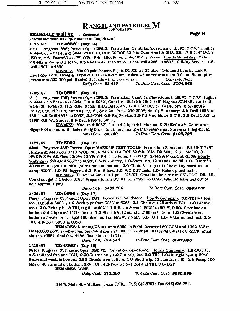
01-29--91 11: 31 RANGELAND EXPLORATION SO1 PO2
RANGELAND PETROLEUMCORPORATION
TRASDALE WeU #1 , conteued Page 6IPlease Maintain this Ir¡forruztfon in ConJ1dence)1/26/97 TO: 4860'; (Day 14)(Sat) Progress: 588'; Present Oper: DRLG: Formation: Cambrian(no returns): Bit #5: 7-7 /8" HughesATJ446 Jets 3/14 In @ 3244';WOB: 40; RPM:60 ROP:30 fph; Cum Hrs:40: BHA: Bit, 17 6-1/4' DC, 3-HWDP; MW: Foam;Vise:-:PV:.;YP:.: PH: ; Mist Pump Only, SPM: : Press: : Hourly Summary: 2.O-TIH.2.5.Mix & Pump stiff foam, 0.54Ream 4176' to 4266 .
17.O-Drill 4266' to 480T. 0.5-Rig Service, 1,5-Drill 480T to 4856
REMARKS: Mix 20 gals foamer. 5 gals DC305 w/ 25 bbls 40vis mud in mist tank &inject down drili string e 8 bph & l 100-1400cfm air. Drilled w / no returns on stiff foam. Stand pipepressure @ 300-500 psi. Hauled 31 loads wtr to reserve pit. Surveys: None
Daily Cost: 83,410 To-Date Cum. Cost: $104,648
1/26/97 TD. 6666'; (Day 15)(Sun) Progress: 799'; Present Oper: DRLG; Formation: Cambrian?(no retums); Bit #5: 7-7/8" HughesATJ446 Jets 3/14 in @ 3244',Out e 5052'; Cum Hrs:46.5: Bit #8: 7-7/8° Hughes ATJ446 Jets 3/18WOB: 30: RPM:70/110; ROP:50 fph;; BHA: Bit#6,MM, 17 6-1/4" DC, 3- HWDP: MW: 8.5:Vise:42:PV:12;YP:8; PH:11.5:Pump #1: 6Xl6', SPM:28: Press:250-350#; Hourly Summary: 2.0-Drill 4856' to489T, 4.5-Drill 489T to 5052', 2.5-TOH. O.5-Rig Service, 2. PU Mud Motor & TlH, 3.5-Drill 5052° to5195', O.S.WL Survey. 8.5-Drill 5195' to $655',
REMARK : Mud up @5052'. Pump 4.4 hpm 40+ vis mud & 2000cfm air. No returns.Rigup H2S monitors @ shaker & rig floor. Continue hauling wtr to reserve pit. Surveys: 1 deg 65195'
Daily Cost: $4,150 To-Dute Cum. Cost: $108.798
1/27/97 TD:6093'; (Day 16)(Mon) Progress: 438'; Present Oper; MAKE UP TEST TOOLS: Formation: Sandstone: Bit #6: 7-7/8"Hughes ATJ446 Jets 3/18 WOB: 30; RPM:70/110: ROP:62 fph: BHA: Bit.MM, 17 6-1/4" DC, 3-HWDP: MW: 8.5;VIse: 42: PV: 12:YP: 8: PH: 11,5;Pump #1: 6X16", SPM:28; Press:250-350#: MSummary: 2,O-Drill 5655' to 6093', 0.5-WL Survey, 1. Short trip, 12 stands, no flll, 1.4 Cire w/ a40 vis mud, spot 100 bbls. (80 vis mud on bottom), 3,4Chain & strap out of hole. Lay down motor.(strap 6096'). 1.0- RU loggers, 6.0- Run E-logs, 3.0- WO DST tools, 1.4 Make up test tools.
REMARKS: TD well at 6093' at 1 pm 1/26/97. Condition hole & run CNL-FDC, DIL, ML,Could not get DIL below 6063', Prepare to run DST#1 fmm 5950' to 6096'. (Should have tool out ofhole approx. 7 pm)
Daily Cost: S483,760 To-Date Cum. Cost: .$592,555
1/28/97 TD: 6096'; (Day 17)(Tues) Progress: 0°: Present Oper: DST: Formation: Sandstone: Hourly Summary: 3.5-TIH w/ testtool, tag fill @ 6033' , 1.O-Work pipe from 6033' to 6063'. 2.5-Chain out 25 stds & 'lUH, 1.0.LD testtools, 2.4Plck up bit & TIH, tag fill o 6021'. 1.4 Ream & wash 6021' to 6096', 0.00- Circulate onbottom e 4.4 bpm w/ 1100 cfm air. 1.0-Short trip.12 stands, 2' fill on bottom. 1.4 Circulate onbottomw/ water & air, spot 100 bbis mud on htm w/ no air, 3.0-TOH, 1.O· Make up test tool, 2.5-TlH, 4.4DST 5950' to 6096'.
REMARKS: Running Dslyt i from 5950' to 6096. Recoverd 60' GCM and 1022' SW InDP (40,000 ppm) sample chamber-.54 ef gas and .800 cc water (40,000 ppm) intial floW -227#, intialshut in-lO98#, final flow-446#, final shut In-1124#
Daily Cost: 814,540 To-Date Cum. Cost: $607,0951/29/97 TD: 6096': (Day 18)(Wed) Progress: O'; Present Oper: DST #2; Fonnation: Sandstone: Hourly Summary: 1.5-DST #1,4.5- Pull tool free and 'fDH, 0,5 TlH w/ bit ,
1.0-Cut drlg line. 2.0-TIH, 1.WHit tight spot @ 5940'.Ream and wash to bottom, 0.6 Circulate on bottom, 1,O-Short trip. 12 stands, no fl11,1.5-Pump 100bble of40 vis mud on bottom. 8.O· 'IUH, 4.0-Pick up test tool and TIH, 3.5- DST
REMARKS: NONEDaßy Cost: SI 3,500 To-Date Cum. Cost: $620.595
210 N. Main St.•Midland, Texas 79701•(915) 686-8983•Fax (915)
01-30-9'l 09:4G RANGELAND EXPLORATION 549 PO2
RANGELAND PETROLEUMCORPORA TION
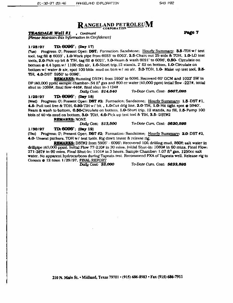
TRASDAfÆ Well #1 , contmued Page 7[Pfense Mairttain this Ir¡formation in CorlJidenceJ
1/28/97 TD:0000'; (Day 17)(Tue) Pogoss; O'; Present Oper: DST: Formation: Sandstone: Hourly Summary: 3.5-TlH w/ testtool. tag flll @ 6033' , 1.0-Work pipe from 6033' to 6063'. 2.5-Chain out 25 stds & TOH, 1.& LD testtools, 2.0-Pick up bit & TIH, tag till @ 6021'. 1. Ream & wash 6021' to 6096', 0.54 Circulate onbottom @ 4.4 bpm w / 1100 cfm air, 1.0-Short trip, 12 stands, 2' 111]on bottom, 1.O· Circulate onbottom w/ water & air, spot 100 bb1s mud on htm w/ no air. 3.0-TOH, 1. Make up test tool, 2.5-11H. 4. DST 5950' to 6096'.
REMARKS: Running DST#1 from 5950° to 6096. Recoverd 60° GCM and 1022' SW inDP (40,000 ppm) sample chamber-.54 ft gas and 800 cc water (40,000 ppm) intial 11ow-227#, intialshut in-1098#, final flow-446#. final shut in-1124#
Dagy Cost: 814,540 To-Date Cum. Cost: $607,0951/29/97 TO:8090'; (Day 18)(Wed) Progress: O':Present Oper: DST #2: Formation; Sandstone; Hourly Summary: 1.5-DST #1.4.5- Pull tool free & TOH. O.50-TIH w/ bit , 1. Out drlg line, 2.O-TIH, 1. Hit tight spot o 5940'.Ream & wash to bottom, 0.54Circulate on bottorn. I.O-Short trip, 12 stands, no fill, 1.5-Pump 100bble of 40 vis mud on bottom. 3.& TOH. 4,4Pick up test tool & TlH. 3.5- DRIW2
REMARES: NONEDaily Cost; $13,500 To-Date Cum. Cost: $620,598
1/30/97 TD:0096': (Day 19)(Thu) Progress; O';Present Oper: DST #2; Formation: Sandstone; Hourly Summary: 2.0-DST #2,4.0- Unseat packers, TOH w/ test tools. Rig down tester & release rig.
REMARKS:DSIW2 from 5905' - 6096'; Recovered 10ft drilling mud, 860ft salt water indrillpipe (40,000 ppm). Initial Flow 77-210# in 30 Inins, initial Shut-in: 1080# in 60 mins. Final Flow:271-387# in 60 mins. Final Shut.In: 1101# in 3 hours. Sample Chamber: 1.07 ft" gas, I250cc saltwater. No apparent hydrocarbons during Tapaats test. Rccommend PXA of Tapeats well. Release rig toConoco e 12 noon 1/29/97. FINAL REPORT
Dady Cost: $2,000 To-Date Cum. Cost: $622,595
210N. Main St.•Midland, Texas 79701 •(915) 686-8983•Fax (915)
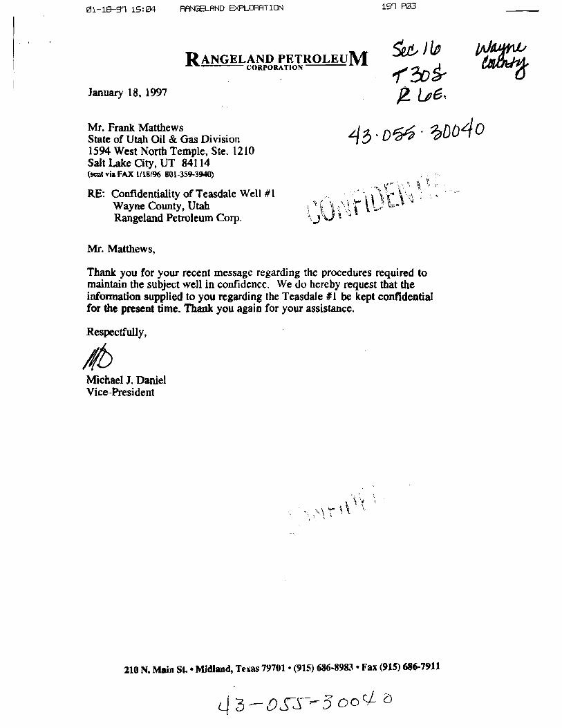
01-18-91 15:04 RANGELANDE×PLORATION 151 PØ3
RANGELAND PETROLEUMCORPORATION
January 18, 1997
teF UktahM emGasDivision
1594 West North Temple, Ste. 1210Salt Lake City, UT 84114(sent via FAX 1/18/96 801-359-3940)
RE: Confidentiality of Teasdale Welt #1Wayne County, UtahRangeland Petroleum Corp.
Mr. Matthews,
Thank you for your recent message regarding the procedures required tomaintain the subject well in confidencc. We do hereby request that theinformationsupplied to you regarding the Teasdale #1 be kept confidentialfor thepresent dme. Thank you again for your assistance.
Respectfully,
MichaelJ. DanielVice-President
210 N. Main St. • Midland, Texas 79701 • (915) 686-8983 • Fax (915) 686-7911
43-OST S0°sí
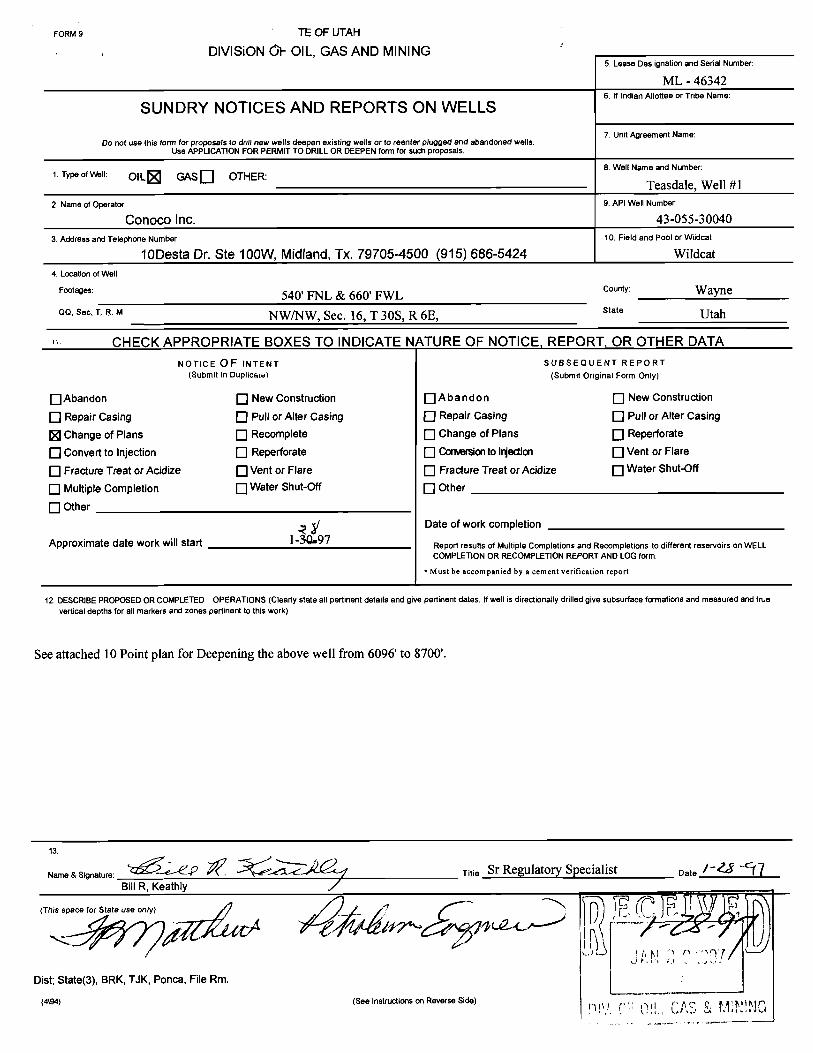
FORM 9 TE OF UTAH
DIVISiON01-OIL, GAS AND MININGS. Lease Des ignation and Serial Number:
ML - 463426. If Indian Allottee or Tribe Name:
SUNDRY NOTICES AND REPORTS ON WELLS
Do not use this form for proposals to drill new wells deepen existing wells or to reenter plugged and abandoned wells7. Unit Agreement Name:
Use APPLICATION FOR PERMIT TO DRILL OR DEEPEN form for such proposals.
8. Well Name and Number:1. Type ofWell: OIL GASD OTHER:
Teasdale, Well #12. Name of Operator: 9. API Well Number
Conoco Inc. 43-055-30040
3. Address and Telephone Number: 10. Field and Pool or Wildcat:
10Desta Dr. Ste 100W, Midland, Tx. 79705-4500 (915) 686-5424 Wildcat4. Location of Well
Footages: 540' FNL & 660' FWL county: WayneQQ, Sec, T. 8. M NW/NW, Sec. 16, T 30S, R 6E, stat" Utah
CHECK APPROPRIATE BOXES TO INDICATE NATURE OF NOTICE, REPORT, OR OTHER DATANOTICEOF INTENT SUBSEQUENT REPORT
(Submit in Duplicate) (Submit Original Form Only)
O Abandon New Construction A b a ndon New Construction
O Repair casing O Pull or Alter casing O Repair casing O Pull or^iter casingChange of Plans Recomplete Change of Plans Reperforate
O convertto injection O Reperforate O Comon to Injdon Vent or Flare
O Fracture Treat or Acidize O Vent or Flare Fracture Treat or Acidize Water Shut-Off
O Multiple Completion O Water Shut-Œf Other
O Other
Date of work completion
Approximate date work will start I-SÛ•9Report results of Multiple Completions and Recompletions to different reservoirs on WELLCOMPLETION OR RECOMPLETION REPORT AND LOGform.
• Must be accompanied by a cement verification report
12. DESCRIBE PROPOSED OR COMPLETED OPERATIONS(Clearly state all pertinent details and give pertinent dates. If well is directionally drilled give subsurface formations and measured and truevertical depths for all markers and zones pertinent to this work)
See attached 10 Point plan for Deepening the above well from 6096' to 8700'.
me & Signature: Titie Sr Regulatory Specialist Date
Dist, State(3), BRK, TJK, Ponca, File Rm.
(4\94) (See Instructions on Reverse

DRILLING PLANTreasdale #1January 27, 1997Page l
DRILLING PLAN - Teasedale #1
1. Location: Section 16, R6E, T30S 540' FNL & 660' FWL
2. Present Status: Operator - RangelandPresent TD - 6096'Present Hole Size - 7-7/8"Last Casing Point - 9-5/8", 36 ppf, K-55, new casing set @2360'Cement - Cemented with 635 sx 50/50 Poz and 175 sx G neat. Top
out job 50 sx G neat. Cmt to surface
3. Geological Marker Tops: (RKB: 7892' est.)
Formation Drilled Depth Datum Estimated Fluid /(RKB) Pressure Mineral
Ground Level 0.00 +7882
RKB +10.00 +7892
Sixtymile Redbeds 6052 +1840 Normal tosubnormal
Walcott 6252 +1640 "Ditto"
Awatubi 7092 +800 "Ditto"
Carbon Butte 8322 -430 "Ditto" Oil / Gas
Duppa 8572 -680 "Ditto"
TD 8700 -808 "Ditto"
4. Casing Program: (all new):
Depth Size Weight Grade Thread Collapse Burst Tension
0 - 2630' 9-5/8" 36# K-55 LTC 2020 3520 423,000
0 - 8700' 5-1/2" 15.5# K-55 LTC 4040 4810

DRILLING PLANTreasdale #1January 27, 1997Page 2
5. Cementing Program:
Casing Coverage Slurry Weight Volume Type & Adatives(#/gal)
Surface 0 - 1860' Lead 12.1 635sx 50:50 Poz (50% Poz:50%Class G + 2%CACL2 +
.25#/sx cello flake + 2 #/sxKolscal + 6% Gel
1860 - 2360' Tail 15.6 175sx Claas G + 2%CACL2 +
.25#/sx cello flake
Prod 5300-8700' Tail 16.2 700sx Class H + 3#/sx gilsonite +
cuft .25#/sx cello flake + .5%
FL-62
Note: 1. Actual Cement Volumes will be calculated from caliper logs.
6. Pressure Control Equipment:
A. BOP: 3000 psi w.p. Double ram blowout preventer with appropriate extensionhandwheels to 8700'. The pipe rams will be on top and blind rams on the bottom.
B. A function test and visual inspection of the BOP will be performed daily.
C. BOP equipment will be tested at least every 14 days. The BOP and casing test willconform to Onshore order No. 2.
7. Auxiliary Equipment:
A. Kelly cock
B. Drill pipe float
C. Visual monitoring of the mud system.
D. Rotating head
8. Variance Request:
A. Conoco request a variance from the requirement to use a straight run blooie line.Where possible a straight blooie line will be used. Where it is not possible, any teesor ells in the lines will be

DRILLING PLANTreasdale #1January 27, 1997Page 3
9. Drilling Fluids Program:
Interval Mud Type Density Funnel Viscosity Water Loss(Ib/gal) (Sec/Qt)
6092-8700' Gel/Lime / Aerated Mud 8.5-8.8 28 - 50 20 cc
10. Testing, Logging and Coring:
A. Logging - Open hole:
DIL/GR/Sonic/LDT/CNL from TD to 6092'Dipmeter - 5480 to TDRotary Sidewall Cores - As per Geologist
B. No Cores planned
C. Possible DST in the Carbon Butte Sandstone
D. Final determination of the completion interval will be made by analysis of logs.
E.. Directional control shall be maintained by running a drift shot survey after every1,000' of drilling.
11. Abnormal Pressure or Temperatures: Potential Hazards.
A. Lost circulation is possible throughout wellbore.
12. Additional Information:It is Conoco's intention to bury the cuttings on location once the pit has evaporated
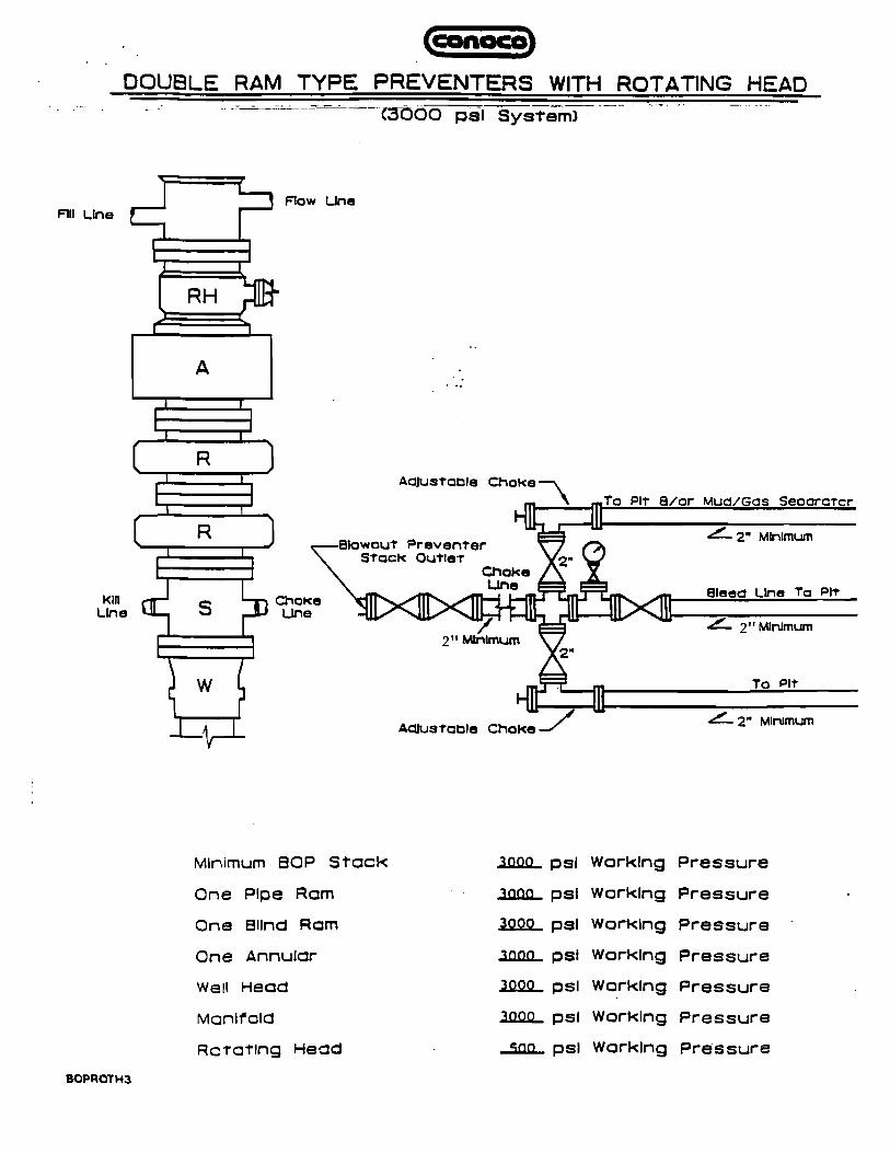
DOUBLE RAM TYPE PREVENTERS WITH ROTATING HEADC3ÒOO ps! System)
Flow LineF111Line
L_ I
RHI
I I
A
IR )
Adjustoble ChokeTo PIT 8/or Mud/Gos Seocratcr
2" MinimumBlowout PreventerStock Quttet 2"
ChokeLine Bleed Line To PitKill ChcKe
Line Line2" Minimum
I \ 2" MinimumI I 2"
2" MinimumAdlustoble Choke
Minimum BOP Stock 3000 psi Working Pressure
One Plpe Aom .100&L ps! Working Pressure -
One ellnd Acm 3000 psi Working Pressure
One Annular .30ûtL psi Working Pressure
Well Head 3000 psi Working Pressure
Manifold 10ûlL ps! Working Pressure
Rotating Head JiߣL psl Working Pressure

Divisina of Oil, Gas and Mining Rou n /
OPERATOR CHANGE WORKSHEET
Attach all documentation received by the division regarding this change. .MM- $$.Initial each listed item when completed. Write N/A if item is not applicable. 4-VI,D 9-Fif,E
W Change of Operator (well sold) O Designation of AgentO Designation of Operator O Operator Name Change Only
The operator of the well(s) listed below has changed, effective: 1-28--97
TO: (new operator) CONOCO INC FROM: (old operator) RANGELAND PETROLEUM CORP
(address) 10 DESTA DR STE 100w (address) 210 N MAIN STMIDLAND TX 79705-4500 MIDLAND TX 79701
Phone: (915) 686-5424 Phone: (915)686-8983
Account no. NO260 Account no. NB690
WELL(S) attach additional page if needed:
Name: TEASDALE 1/DRL API: 43-055-30040 Entity: 99999 S _16_ y 305 RS Lease: ML46342
Name: API: Entity: S T R Lease:Name: API: Entity: S T R Lease:Name: API: Entity: S T R Lease:Name: API: Entity: S T R Lease:Name: API: Entity: S T R Lease:Name: API: Entity: S T R Lease:
OPERATOR CHANGE DOCUMENTATION
l. (r649-8-10) Sundry or other legal documentation has been received from the FORMER operator (attach to thisform)· (&S |-zi17)
2. (r649-8-10) Sundry or other legal documentation has been received from the NEW operator (Attach to thisform). (i /-27†?
3. The Department of Commerce has been contacted if the new operator above is not currently operating anywells in Utah. Is the company registered with the state? (yes/no) If yes, show company file number:
4. FOR INDIAN AND FEDERAL WELLS ONLY. The BLM has been contacted regarding this change. Makenote of BLM status in comments section of this form. BLM approval of Federal and Indian well operatorchanges should ordinarily take place prior to the division's approval, and before the completion of steps 5through 9 below.
5. Changes h ve been entered in the Oil and Gas Information System (3270) for each well listed above.
6. Cardex file has been updated for each well listed above. (2-3-T7)
7. Well file labels have been updated for each well listed above. (2-1-Ñ8. Changes have been includedon the monthly "Operator, Address, and Account Changes" memo for distribution
to Trust Lands, Sovereign Lands, UGS, Tax Commission, etc· (2-3-77)
9. A folder has been set up for the Operator Change file, and a copy of this page has been placed there forreference during routing and processing of the original documents.
\dons\wpdocs\forms\operchng- OVER

DOGM SPEED LETTER
To: Ed Bonner From: Don Staley
School & Institutional Trust Division of Oil, Gas & Mining
Lands Administration
Subject: Operator Change
MESSAGE Date 2/7 19 97
Ed,
For your information, attached are copies of documents regarding an operator change on a state lease(s)
These companies have complied with our requirments. Our records have been updated. Bonding should
be reviewed by your agency ASAP.
Former Operator: Rangeland Petroleum Corp (N8690)
New Operator: Conoco Inc. (NO260)
Well(s): API: Entity: S-T-R: Lease:
Teasdale 1 43-055-30040 12062 16-30S-6E ML46342
(Note: well is in drilling status)
cc: Operator File
Signede
REPLY Date 19
Signed
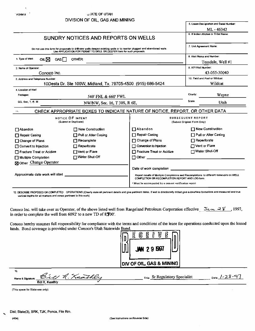
FORM 9 o I ATE OF UTAH
DIVISiONOF OIL, GASAND MINING5. Lease Des ignation and Serial Number
ML - 463426. If Indian A11otteeor Tribe Name:
SUNDRY NOTICES AND REPORTS ON WELLS
Do not use this form for proposals to drill new wells deepen existing wells or to reenter plugged and abandoned wells7. Unit Agreement Name:
Use APPLICATION FOR PERMIT TO DRILLOR DEEPEN form for such proposals.
8. Well Name and Number:1 Type of Well: OIL GAS Q OTHER
Teasdale, Well #12 Name of Operator 9. API Well Numbec
Conoco Inc. 43-055-30040
3 Address and Telephone Number 10. Field and Pool or Wildcat:
10Desta Dr. Ste 100W, Midland, Tx. 79705-4500 (915) 686-5424 Wildcat4 Locatlon ofWell
Footages: 540' FNL & 660' FWL counV Wayne
QQ, Sec, T. R. M NW/NW, Sec. 16, T 30S, R 6E, state Utah
CHECK APPROPRIATE BOXES TO INDICATE NATURE OF NOTICE, REPORT, OR OTHER DATANOTICE OF INTENT SUBSEQUENT REPORT
(Submit in Duplicate) (Submit Original Form Only)
O Abandon O New Construction O A b a ndon O New Construction
O Repair Casing O Pull or Alter Casing O Repair Casing O Pull or Alter Casing
O Change of Plans O Recomplete O Change of Plans O Reperforate
O convertto injection O Reperforate Comon to I ection Vent or Flare
O Fracture Treat or Acidize O Vent or Flare O Fracture Treat or Acidize Water Shut-Off
O Multiple Completion O Water Shut-Off O Other
Other Change OperatorDate of work completion
Approximate date work will start Report results of Multiple Completions and Recompletions to different reservoirs on WELLCOMPLETION OR RECOMPLETION REPORT AND LOG form.
•Must be accompanied by a cement verification report
12 DESCRIBE PROPOSED OR COMPLETED OPERATIONS (Clearly state all pertinent details and give pertinent dates. If well is directionally drilled give subsurface formations and measured and truevertical depths for all markers and zones pertinent to this work)
Conoco Inc. will take over as Operator, of the above listed well from Rangeland Petroleum Corporation effective 14. 2 Ÿ , 1997,in order to complete the well from 6092' to a new TD of 870'.
Conoco hereby assumes full responsibility for compliance with the terms and conditions of the lease for operations conducted upon the leasedlands. Bond coverage is provided under Conoco's Utah Statewide Bond.
DIVOF OIL, GAS& MINING
ame & Signature: Titie Sr Regulatory Specialist Date
BillR, Keathly
(This space for State use only)
Dist; State(3), BRK, TJK, Ponca, File Rm.
(4\94) (See instructions on Reverse
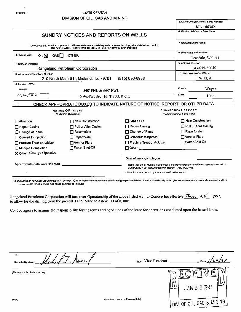
FORM 9 -, (ATE OF UTAH
DIVISiONOF OIL, GAS AND MINING5. Lease Des ignation and Serial Number
ML - 463426. If indian Allottee or Tribe Name:
SUNDRY NOTICES AND REPORTS ON WELLS
Do not use this form for proposals to drill new wells deepen existing wells or to reenter plugged and abandoned wells7. Unit Agreement Name:
Use APPLICATION FOR PERMIT TO DRILLOR DEEPEN form for such proposals.
8. Well Name and Number:1. Type of Well: OIL CR Q OTHER:
Teasdale, Well #12. Name of Operator 9. API Well Number
Rangeland Petroleum Corporation 43-055-30040
3. Address and Telephone Number 10. Field and Pool or Wiidcat:
210 North Main ST., Midland, Tx. 79701 (915) 686-8983 Wildcat4. LocalJon of Well
Footages: 540' FNL & 660' FWL County: Wayneoo, see, I R. M NWINW, Sec. 16, T 30S, R 6E, stat Utah
CHECK APPROPRIATE BOXES TO INDICATE NATURE OF NOTICE, REPORT, OR OTHER DATANOTICE OF INTENT SUBSEQUENT REPORT
(Submit in Duplicate) (Submit Original Form Only)
O Abandon Q New Construction Q A ba ndon O New Construction
O Repair Casing Pull or Alter Casing Repair Casing Pull or Alter Casing
O Change of Plans O Recomplete Change of Plans Reperforate
O convertto injection O Reperforate Monto Injedian Vent or Flare
O Fracture Treat or Acidize O Vent or Flare Fracture Treat or Acidize Water Shut-Off
O iviuitiplecompletion O Water Shut-Off OtherOther Change Operator
Date of work completion
Approximate date work will start Report results of Multiple Completions and Recompletions to different reservoirs on WELLCOMPLET10N OR RECOMPLETION REPORT AND LOG form.
• Must be accompanied by a cement verification report
12 DESCRIBE PROPOSED OR COMPLETED OPERATIONS (Clearly state all pertinent details and give pertinent dates. If well is directionally drilled give subsurface formations and measured and truevertical depths for all markers and zones pertinent to this work)
Rangeland Petroleum Corporation will turn over Operatorship of the above listed well to Conoco Inc effective o A f , 1997,to allow for the drilling from the present TD of 6092' to a new TD of 8,')00'.
Conoco agrees to assume the responsibility for the terms and conditions of the lease for operations conducted upon the leased lands.
me a signature: VI Title Vice President Date / e 7
(This space for State use only)
J AN 2 0 297
(4\94) (See Instructions on Reverse Side)
DN.OFOIL,GASSt

AV510011lL, GAS AND H1NING OPERATOR CONOCO INC OPERATOR ACCT. No. N 0260
ENTITY ACTION FORM- FORM 6 ADDRESS
ACTION CUInlENT NEW API NUMBER WELLNAHE WFil lOCATIDM SPUD EFFECTIVECODE ENTITY NO. ENTITY NO. QQ SC TP RG COUNTY DATE DATE
A 99999 12062 43-055-30040 TEASDALE 1 NWNW 16 30S 6E WAYNE 12-14-96
WELL 1 COMMENTS:
WELL 2 CONHENTS:
WELL 3 COHNENTS:
WELL 4 COMMENTS:
I | |WELL 5 CONHENTS:
ACTION CODES (See instructions on back of form)A - Establish new entity for new well (single well only) L. CORDOVA (DOGM)D - Add new well to existing entity (group or unit well) SignatureC - Re-assign well from one existing entity to another existing entity ADMIN. ANALYST 2-3-97O - Re-assign well from one existing entity to a new entityE - Other (explain in connents section) . Title Date °
NOTE: Use COMMErlT section to explain why each Action Code was selected. Phone No. ( )

02-0 -9 14: 19 RANGELAND EXPLORATION 168 PO3
FEB-OG-ST 17902 PROM=CORI 48 10-3072E i'cs
RANGELAND PETROLEUM CORPORATION DATE: 02-06-97JOB: 970132-3TECH:g-S 06E.. /G LOCATION: CASPGA , WŸ.
D ws-.sooç oHELL: TEASDALE #1 SAMPLING POINT 'bsY *IFIELD: SAMPLE TEMP:PORMATION: SAMPLE ERESSURE: 119 9544COUNTY: REMARKS: SCHT..UMBERG.€AC uAS.BTATE: MEASURED etÞ5 64DATE SAMPLED:
CHROMATOGRAPHIC ANALYST'
MOLE 14.696 ÞSPAPERCENT GPS
HYDROGEN SULFIDE 0.00CARBON DIOXIDE 64.46NITROGEN 34.45METHANE 0.00ETHANE 0.00 0.000UNIDENTIFIED (,APPROX.) 1.07 0-000PROPANE 0.02 0.005ISO-BUTANE 0.00 C.DOON-BUTANE O . OO O . 0 0 0ISO-PENTANE 0.00 0.000N-PENTANE 0.00 e.coo
TOTALS 100.00 0.000
There was at least one unidentified constituent in the Akvesample- Normalized percentages, therefore, should be con.s'deredapproximate.
AgWMMg agresti gg lyme g gi ¾ gainr*¾ u t.gtWS§ë¾ ¾hs u. asahus tn anregisty O topre:Kunsh Y AbifM y iñ¶iFad. nl vag g >mt em. ..
myei. pL emmy gmy ppympg gepen, w0k W ¾rgi ni cogerg-Ipa w proch ainti ngsm A utid :r choe upot w a ly a;aca s iastreet Ynnprçµwl e yaw nêt W »Ans I
951 PO1 RANGELAND

74

Lease No. ML - 46342Lease & Well # Teasdale Well #1Location: 540' FNL & 660' FWL, (NWINW) Sec. 16, T 30S, R 6ECounty: Wayne, Utah
Listing of Logs
6976-8700: Long Spaced Sonic, Dual Induction-Guard Spectral Density-Dual spacedNeutron, MicrKog,Six Arm Dipmeter, Rotary Coring Tool.
100-6090': Dual Induction-Guard, Microlog, Spectral Den.-Dual Spaced

02-01-91 14: 18 RANGELANDEXPLORATION 168 PO2
4 DSS-w4e210 N. Main Streetg MGER PEROLEUM Midland, Texas 79701
COREQßm0N Phone#: (915) 686-8983FAX #: (915) 686-7911
FAX TRANSMISSIONPage: 1 ,
TO:.;¡;,,
· ALL WURKUNG Il¾TEREST OWNERS ^TE^N gggyANsMl$510N
co-r TEASDKLE #1 ¯¯
MX NUMO
From:NAMs IERRY MICHAEL
-- Rangeland Petroleum Corp.
sesi SDALE »I
mummus-ms-mumumsmaammmmmmmmememmatääasi:näääähädã¾¾ŒúER Súanmâñomummmmmmm
Message:
WORKING INTEREST OWNERS:
FOLLOWING IS A COPY OF THE GAS ANALYSIS OF GAS TAKEN FROM THETAPEATS DRILL STEM TEST.
PLEASE CALL SROULD YOU HAVE ANY QUESTIONS.
TERRY MICHAEL
If this transmission is received incomplete or illegible, please call 915/

1r
210CKV bbAB -t-900-191¯
50;W Ceugnt.ii
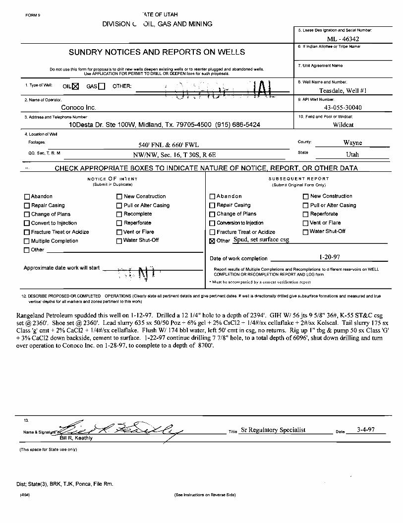
FORM 9 4TE OF UTAH
DIVISiON L DIL, GAS AND MINING5. Lease Des ignation and Serial Number:
ML - 463426. If Indian Allottee or Tribe Name:
SUNDRY NOTICES AND REPORTS ON WELLS
Do not use this form for proposals to drill new wells deepen existing wells or to reenter plugged and abandoned wells.7. Unit Agreement Name:
Use APPLICATION FOR PERMIT TO DRILL OR DEEPEN form for such proposals
1 Type of Well: OIL GAS OTHER:8. Well Name nd Number
i i kJ 9. API Well Number:2 Name of Operator:
Conoco Inc. 43-055-30040
3 Address and Telephone Number: 10. Field and Pool or Wiidcat:
10Desta Dr. Ste 100W, Midland, Tx. 79705-4500 (915) 686-5424 Wildcat4 Location ofWell
Footages: 540' FNL & 660' FWL County: Wayne
QQ, Sec T. 8. M NW/NW, Sec. 16, T 30S, R 6E sta** Utah
CHECK APPROPRIATE BOXES TO INDICATE NATURE OF NOTICE, REPORT, OR OTHER DATANOTICE OF INÏENT SUBSEQUENT REPORT
(Submit in Duplicate) (Submit Original Form Only)
OAbandon New Construction Abandon New Construction
O Repair Casing Pull or Alter Casing Repair Casing Pull or Alter Casing
O Change of Plans Recomplete Change of Plans Reperforate
O Convert to Injection Reperforate Convemon to Injedian Vent or Flare
O Fracture Treat or Acidize Vent or Flare Fracture Treat or Acidize Water Shut-Off
O Multiple Completion Water Shut-Off Other Spud, set surface esg
O Other
Date of work completion 1-20-97
Approximate date work will start Report results of Multiple Completions and Recompletions to different reservoirs on WELLCOMPLETION OR RECOMPLETION REPORT AND LOG form.
* Must be accompanied by a cement verification report
12. DESCRIBE PROPOSED OR COMPLETED OPERATIONS (Clearly state all pertinent details and give pertinent dates. If well is directionally drilled give subsurface formations and measured and truevertica! depths for all markers and zones pertinent to this work)
Rangeland Petroleum spudded this well on 1-12-97. Drilled a 12 1/4" hole to a depth of 2394'. GIH W/ 56 jts 9 5/8" 36#, K-55 ST&C esgset @2360'. Shoe set @2360'. Lead slurry 635 sx 50/50 Poz + 6% gel + 2% CsCl2 + 1/4#/sx cellaflake + 2#/sx Kolscal. Tail slurry 175 sxClass 'g'cmt + 2% CaCl2 + 1/4#/sx cellaflake. Flush W/ 174 bbl water, left 50' cmt in esg, no returns. Rig up 1" tbg & pump 50 sx Class 'G'+ 3% CaCl2 down backside, cement to surface. 1-22-97 continue drilling 7 7/8" hole, to a total depth of 6096', shut down drilling and turnover operation to Conoco Inc. on 1-28-97, to complete to a depth of 8700'.
13ame
& Signat Titie Sr Regulatory Specialist Date 3-4-97
(This space for State use only)
Dist; State(3), BRK, TJK, Ponca, File Rm.
(4\94) (See Instructions on Reverse

FORM 9 NTE OF UTAH
DIVISiONL 31L, GAS AND MINING5. Lease Des ignation and Serial Number:
ML - 463426. If Indian Allottee or Tribe Name:
SUNDRY NOTICES AND REPORTS ON WELLS
Do not use this form for proposals to drill new wells deepen existing wells or to reenter plugged and abandoned wells7. Unit Agreement Name:
Use APPLICATION FOR PERMIT TO DRILL OR DEEPEN form for such proposals
8. Well Name and Number:1 Type of Well: OIL GASD OTHER:
Teasdale, Well #1na
9.APIWellNumber:2 NameofOperator:ConocoInc. L/ 43-055-30040
3 Address and Telephone Number: 10. Field and Pool or Wiidcat:
10Desta Dr. Ste 100W, Midland, Tx. 79705-4500 (915) 686-5424 Wildcat4 Location of Well
Footages: 540' FNL & 660' FWL County: Wayneoo, see, T R. M NW/NW, Sec. 16, T 30S, R 6E stat" Utah
CHECK APPROPRIATE BOXES TO INDICATE NATURE OF NOTICE, REPORT, OR OTHER DATANOTICEOF INTENT SUBSEQUENT REPORT
(Submit in Duplicate) (Submit Original Form Only)
O Abandon New Construction Abandon New Construction
O Repair Casing Pull or Alter Casing O Repair Casing Pull or Alter Casing
O Change of Plans Recomplete O Change of Plans Reperforate
O convertto injection O Reperforate O ConvemontoInjection O Vent or Flare
O Fracture Treat or Acidize Vent or Flare Fracture Treat or Acidize O Water Shut-Off
O Multiple Completion O Water Shut-Off Other Drill to TD
O Other
Date of work completion 2-9-97
Approximate date work willstart Report results of Multiple Completions and Recompletions to different reservoirs on WELL
) NFiDENTlAOR C ON ANDLOGform.
12. DESCRIBE PROPOSED OR COMPLETED OPERATIONS (Clearly state all pertinent details and give pertinent dates If well is directionally drilled give subsurface formations and measured and truevertical depths for all markers and zones pertinent to this work)
1-30-97 Conoco Inc assumed operations of this well. Continue drilling 7 7/8" hole from 6096' to 8700'. Total depth reached on 2-7-97.
Received verbal approval from Gil Hunt with the State of Utah Division of Oil, Gas & Mining to plug and abandon well.
Rig up BJ, pump 150 sx Class 'G' balanced plug from 5705' to 6205', POOH. GIH set 9 5/8" cement retainer @2308', Sting in retainerpump 170 sx Class 'G' cmt, 100# psi during squeeze, sting out leave 2 bbi slurry on top of retainer. Spot 20 sx class 'G' cmt from 60' tosurface, good plug. Well is plugged and abandoned.2-9-97 released rig @6 am.
13ame
& Slgnature Titie Sr Regulatory Specialist Date3-4-97
BillR, Keathly
(This space for State use only)
Dist; State(3), BRK, TJK, Ponca, File Rm.
(4\94) (See Instructions on Reverse
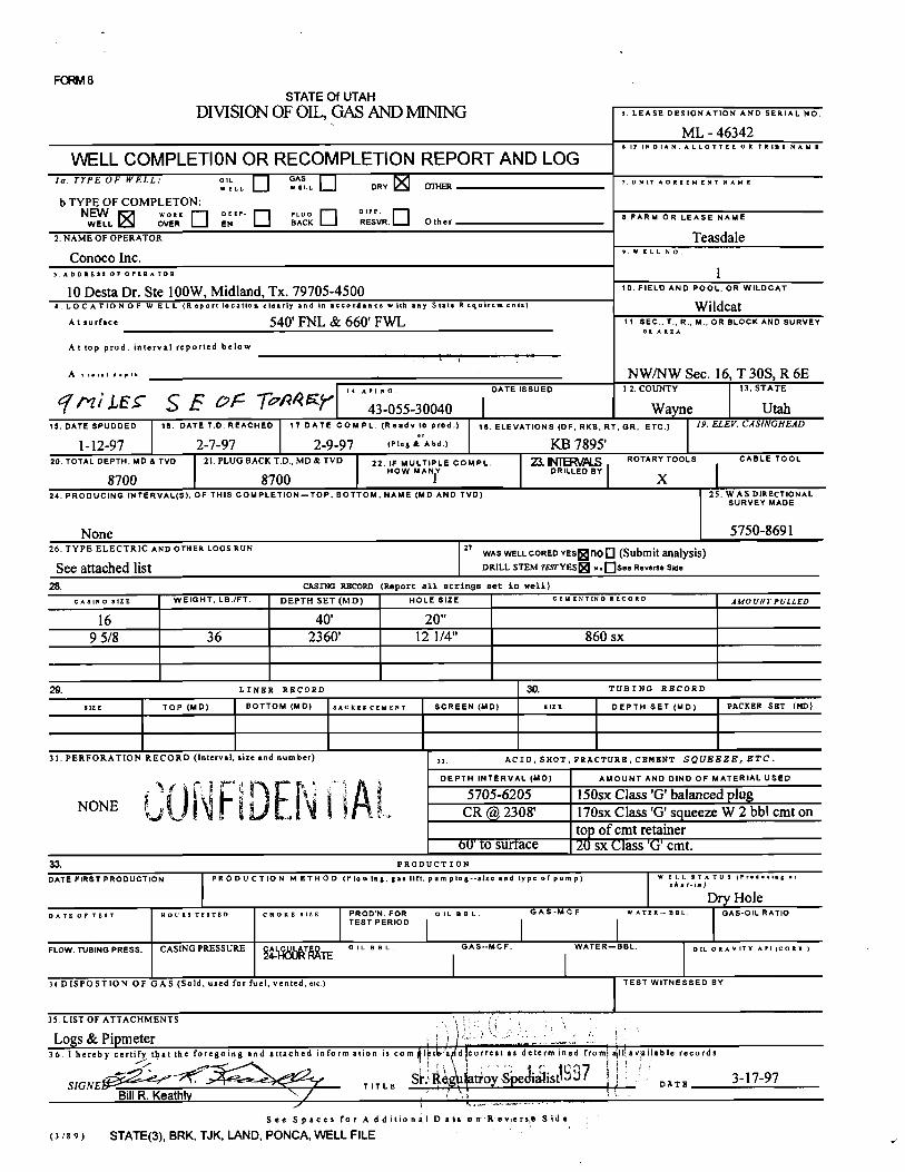
FORM8STATE Of UTAH
DIVISION OF OIL, GASAND MINING s. LEASE DESIGNATION AND SERIAL NO.
ML - 463426 I) INDIAN.ALLOTTBB OR TRIBE NAME
WELL COMPLETION OR RECOMPLETION REPORT AND LOGIa.TYPEOFWELL: os AsLL
DRY - 7.UNITAOREEMENTNAME
b TYPE OF COMPLETON:N oER NEF LUCoK
RESVR. Other 8 FARM OR LEASE NAME
2. NAME OF OPERATOR TCSSdale
ConocoInc. 9.WELLNO.
3.ADDREssOFOFERATOR
10 Desta Dr. Ste 100W, Midland, Tx. 79705-4500 10. FIELD AND POOL, OR WILDCAT
4. LOCATIONOF W ELL (Report location cicarly and in accordance with any State Requirements) WildcatAt surface 540' FNL & 660' FWL 11. SEC., T., R., M., OR BLOCK AND SURVEY
om AREA
At top prod. interval reported below
^ · •r • NW/NW Sec. 16, T 30S, R 6E
??/LET SE F TrMW '"^
3-055-30040DATEISSUED 12.COUNTY 13.STATE
15. DATE SPUDDED 16. DATE T.D. REACHED 17 DATE COMPL. (Readv to prod.) 18. ELEVATIONS (DP, RKB, R , GR, ETC.) 19. ELEV. CASINGHEAD
1-12-97 2-7-97 2-9-97 (P =s Abd.) KB 7895'20. TOTAL DEPTH, MD & TVD 21.PLUGBACK T,D., MD& TVD 22. IF MULTIPLE COMPL. 2. ROTARY TOOLS CABLE TOOL
8700 8700HOW MANY DRILLED BY
X24. PRODUCING INTERVAL(5), OF THIS COMPLETION-TOP, BOTTOM, NAME (MD AND TVD) 25. WAS DIRECTIONAL
SURVEY MADE
None 5750-869126. TYPE ELECTRIC AND OTHER LOGS RUN 27
WASWELL CORED YEsgnOO(Submit analysis)See attached list DRILL STEM TEsrYES n.OseeRevene sue
28. CASING RECORD (Report all strings set in we11}
cAslNO 51ZE WEIGHT, LB.IFT DEPTH SET (MD) HOLE SIZE CEM ENTINO RECORD AMOUNTPULLED
16 40' 20"9 5/8 36 2360' 12 1/4" 860 sx
29. LINER RECORD 3(). TUBING RECORD
51ZE TOP (MD) BOTTOM (MD) sAcKsscruENT SCREEN (MD) BIZE DEPTH SET (MD) PACKER SET (MD}
31. PERFORATION RECORD (Interval, size and number) >2. ACID, SHoT, FRACTURE, CEMENT SQUEEZE, ETC.
DEPTH INTERVAL (MD) AMOUNT AND DIND OF MATERIAL USED
5705-6205 150sx Class'G' balanced plugNONE CR @2308' 170sx Class 'G' squeeze W 2 bbl cmt on
top of omt retainer60' to surface 20 sx Llass 'G' cmt.
33. PRODUCTION
DATEFIRSTPRODUCTION PRODUCTION METHOD (Flowing,gaslift,pumping--sizcand typcofpunip) W ELL UTA TUs (Producing er
shut-in)
Dry HoleDATEOFTEST NOURSTE5TED CHOKEslZE PROD'N.FOR ottant GAS-MCF WATER-BBL GAS-OILRATIO
TEST PERIOD
FLOW.TUBINGPRESS. CASINGPRESSURE T o it a no. GAS--McF. WATER-BBL olt onAvlTY Arl(conx.)
| |34 DISPOSTION OF GAS (Sold, used for fuel, vented.etc) TEsT WITNESSED BY
35 LIST OF ATTACHMENTS
Logs & Pipmeter36. I hereby certify tilat the foregoing and attached inform ation is com I t a d correst as determined from all available records
SIGNE T IT LE DATEBillR. Keathly
See Spaces for A dditional Data orr IVeverst Side
(318 9) STATE(3), BRK, TJK, LAND, PONCA, WELL

I NSTRUCT10NS
This form should be completed an compliance with the Utah Oil and Gas Conservation General Rules. If not filed prior to this time all logs,tests and directianal surveys as required by Utah Rules should be attached and submitted with this report.ITEM 18. Indicate which elevation IS used as reference for depth measurements given in other spaces on this form and on any attachments.ITEMS 22 and 24: If this well is completed for separate production from more than one interval zone (multiple completion) so state in item 22
and in item 24 show the producing interval or intervals top(s) bottom(s) and nane(s) for only the interval reported in item 33. Submit aseparate report (page) on this form adequately identified for each additional interval to be separately produced showing the additional datapertinent to such interval.ITER 29: Sacks Cement : Attached supplemental records for this well should show the details of any multiple stage cementing and the location ofthe cerœnting tool.ITEM 33: Submit a separate copletion report an this form for each interval to be separately produced (see instruction for items 22 and 24 above) .
37. SUMMRY Of POROUS2ŒES: 38. GEOLOGIC MARKERSShow all important zones of porosity and cantents thereof; cored intervals;and all drill-stem tests including depth interval tested cushion usedtime tool ppeµ. g).gwinc and shut-in pressures. arx1 reæveries.
Formation '[pp Bottom Description. contents. etc. Name .
Meas. Death Tnie vert.DepthTopeats (DST1) 5950 6096 IOP 30" ISI 60", FOP 60", FSI 180", HP 1163-1123, IFP Low Moenkop 110 110
76-227, SIP 1098-1123,FF-P: 311-446. Pipe rec, 9' mud, 951' Kaibob 171 171water (40,000 ppm chlorides). Splr: 0.54 CFG @110 psig, White Rim 243 2431800 cc water (40,000 ppm chlorides) Gas = 64.46% CO2, Organ Rock 1530 153034.45% N2, 1.07 unidentified Hermosa 1643 1643
Molas 2420 2420Tapeats (DST2) 5905 6090 IOP 30", ISI 60", FOP 60", FSI 180", HP 1606-830, IFP Redwall 2498 2498
77-210, SIP 1080-1100, FFP 271-387. Pipe rec: 10' mud, 860' Ouray 3394 3394water (40,000 ppm chlorides). Splril .07 CFC @280psig, Aneth 3687 36871250 cc water (40,000 ppm chlorides). Lynch 3693 3693
Granite (DST) 8069 8700 IOP 15", ISI 33", FOP 90", FSI 180", HP 2099-2081, IFP Bowman 4395 4395287-505, SIP 2003-2029,FFP 541-1086. Pipe rec: 558', 8 bbl MaxField 4830 4830water cut mud, 195 l' 22.5 bbl saltwater (23,000 ppm Mauv 5070 5070chlorides). Splr: 100 cc mud, 2050 cc saltwater (48,000 ppm Bright Argel 5481 5481chlorides). (Pit chlorides = 1,250 ppm) Tapeats 5855 5855
Granite 6052 6055Sidewall cores: Tapeats: 5858, 5872, 5889, 5910, 5924, 5933,5981, 5993, 6031. Granite: 7027, 8179, 8186, 8196, 8203,8221, 8390,

pg a ATEOF UTAH
DIVISION OF OIL, GAS AND MINING5. Lasse Designation and Sedal Number
ML-463426. If indian, AI6ouse or Tdbe Name:
SUNDRY NOTICES AND REPORTS ON WELLS N/A
Do not use this form for proposals to drill new wells, deepen existing wells, or to teenter plugged and abandoned wells7. Una A0reement Name:
u.. APPucAvioN FOR PERMIT TO DRIU. OR DEEPEN form for such proposals.
8 Well Name and Number1. Type of Well: OIL GAS OTHER: Teasdale #1
2 Name of 9 API WeD Nurriber
Rangeland Petroleum Corporation 43-055-30040
3. Address and TOW¶. Main Street, Midland, Texas 79701-- 915/686-898310. Reid and Wident
AFootages:"" 540' FNL & 660' FWL o...,,, GarfieldQQ. Sec..T..R,M.: NWNW Sec 16-30 S-6E s....: Utah
11 CHECK APPROPRIATE BOXES TO INDICATE NATURE OF NOTICE, REPORT, OR OTHER DATANOTICE OF INTENT SUBSEOUENT REPORT
(Bubmn in DupUcete) (submmOriginsi Form Only)
O Abandon O New Construction O Abandon O New Construction
O Repair casing O Puli or Aner casing O Repair casing O Pull or Aner casingO Change of Plans O Recomplete O Change of Plans O Reperforate
O convertto injection O Reperforate O convertto injection O ventor Flare
O Fracture Treat or Acidize O ventor Flare O Fracture Treat or Acidirp O Water Shut-Off
O Multiple Completion O Water Shut-Off O Other Ragnact for honrl relapse
O otherDate of work completion N/A
Approximate date work will start Aaport mouts of Mumi¢e e-¢ - and --Ø-•*- k>dmetent meelvatreen WELLCOMPLERON OR AECOMPLEDON AEPORT NO LOG k
* Must be accompanted by a cementwortlicadon report
11 DESCASE PADPOSED OA COMPLBED OPERUKNIS (Ctmady stale all gnent M and give pertinent dates. Wwell is directionally ddlied, ghe subsurface locadons and measuredand truevertical dap@as ior al maricatsand zones perdnent io this work.)
The Teasdale #1 was drilled to a depth of 6096' by Rangeland Petroleum. Conoco assumed operations of the wellon 1/29/97 and drilled the well to a depth of 8700'. Conoco plugged the well as a dry hole on 2/9/97. It is ourunderstanding that Conoco completed the location restoration in April of 1997.
Rangeland herebyrequests a release of its well bond for the Teasdale #1. Conoco's statewide bond will cover anyfuture operations since Conoco has replaced Rangeland as Operator.
Terry W. Michael President 5/15/98
(ma space for State use only)
(4\94) (See Insbuctions on Reverse

P.01 *
TRANSACTIONREPORT *JUN-10-98TUE02:44 PN :
SEND(N)
DATESTART RECEIVER TXTINEPAGESTYPE NOTE N# DP :
JUN-1002:41 PN3550922 3'07" 6 SEND ( N) CANCEL 135 :
TOTAL 3N 75 PAGES: 6 :
Alllllt‡‡XXXXX‡‡X‡X‡XX%A‡‡X‡$$‡XXX‡‡‡‡‡‡‡%AX‡‡‡$‡‡X‡‡‡‡‡‡X‡‡%A%A‡XXX%%%%%%%%%%%AX%AXX1%%%%%%%%%%%%%%%%%%
O State of UtahDEPARTMENT OF NATURAL RESOURCESDIVISION OF OIL, GAS AND MINING1594 West North Temple, Suite 1210Michael O. Leavitt
Governor M Box 145801
Ted Stewatt SaltLake City,Utan 84114-5801€xecutiveDirector 801-538-5340
Iwwell P Braxton 801-S$9.3940(Fax)Divimon Direuer $Qt-538-7223(TOO\
UTAH DIVISION OF OIL, GAS AND MININGFACSIMILE COVER SHEET
DATE: JUNE 10, 1998
FAX#: 355-0922
ATTN: ED BONNER
COMPANY: SITLA
DEPARTMENT:
NUMBER OF PAGES (INCLUDING THIS ONE)
From: LISRA CORDOVA
If you do not receive all of the pages, or if they are illegible,please call

State of UtahDEPARTMENT OF NATURAL RESOURCESDIVISION OF OIL, GAS AND MINING1594 West North Temple, Suite 1210
Michael a PO Box 145801
Ted Stewart Salt Lake City, Utah 84114-5801
Executive Director 801-538-5340
inwell P Braxton 801-359-3940 (Fax)Division Director 801-538-7223 (TDD)
UTAH DIVISION OF OIL, GAS AND MININGFACSIMILE COVER SHEET
DATE: JUNE 10, 1998
FAX#: 355-0922
ATTN: ED BONNER
COMPANY: SITLA
NDEPARI'MINT
AGES (INCLUDING THIS ONE)
From: LISHA CORDOVA
If you do not receive all of the pages, or if they are illegible,please call (801)538-5340.
We are sending from a sharp facsimile machine. Our telecopiernumber is (801)359-3940.
MESSAGES:
*OPERATOR REQUEST FOR BOND RELEASE;I HAVE NOTIFIED RANGELAND PETRO. CORP.
THAT THEIR REQUEST FOR BOND RELEASE WAS BEING SENT TO SITLA. (SEE ATTACHED)
Important: This message is intended for the use of the individual or entity of which it is addressedand may contain information that is privileged, confidential and exempt from disclosure underapplicable law. If the reader of this message is not the intended recipient, you are hereby notifiedthat any dissemination, distribution, or copying of this communication is strictly prohibited. if youhave recieved this communication in error, please notify us immediately by telephone and returnthis original message to us at the above address via regular postal service. Thank
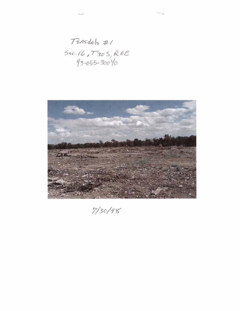
dà le * /c w 5
6 6 - :To 0

I
COMPANY: CONOCO - fi Är e j]
WELL: NO. 1
AREA: WILDCAT FIELD, WAYNE COUNTY, UTAH
TEST: DST-OfŸ-30d4Ò
DATE: FEBRUARY 7TH, 1997 PR

COMPANY: CONOCO - |¾ ,
WELL: NO. 1 Tag s
AREA: WILDCAT FIELD, WAYNE COUNTY, UTAH
TEST: DST g¶] f Ÿ~Off-JØd4Ò
DATE: FEBRUARY 7TH, 1997

HALLIBURTONRESERVOIRSERVICES
REPORT TICKET NO: 134229MEMORY GAUGE TICKET NO: 134229DATE: 07 02 97HALLIBURTON CAMP: CASPERTESTER: TOM EATONWITNESS: CRESS DEBUSK
DRILLING CONTRACTOR: EXETER DRILLINGLEGAL LOCATION: SEC.16T.30SR.6E
OPERATOR: CONOCOLEASE NAME : TEASDALEWELL NO: 1TEST NO: 3TESTED INTERVAL: 8069.30 - 8700.00 ft
FIELD AREA: WILDCATCOUNTY/LSD: WAYNESTATE/PROVINCE: UTAHCOUNTRY: USA
NOTICE: THIS REPORT IS BASED ON SOUND ENGINEERING PRACTICES, BUTBECAUSE OF VARIABLE WELL CONDITIONS AND OTHER INFORMATION WHICH MUSTBE RELIED UPON HALLIBURTON MAKES NO WARRANTY, EXPRESS OR IMPLIED ASTO THE ACCURACY OF THE DATA OR OF ANY CALCULATIONS OR OPINIONSEXPRESSED HEREIN. YOU AGREE THAT HALLIBURTON SHALL NOT BE LIABLE FORANY LOSS OR DAMAGE, WHETHER DUE TO NEGLIGENCE OR OTHERWISE ARISINGOUT OF OR IN CONNECTION WITH SUCH DATA, CALCULATIONS OR
TABLE OF CONTENTS
SECTION 1: TEST SUMMARY & INFORMATION
Swamary of Test Results 1.1Test Period Summary 1.2PreSaure vs. Time Plot 1.3Test and Formation Data 1.4Rate History Täble 1.5Tool String Configuration 1.6Operator Job Log 1.7
SECTION 3 : MEMORY GAUGE DATA
Gauge No. 76599

SECTIO
N

Date: 07 02 97 Ticket No: 134229 Page No: 1.1
SUMMARY OF TEST
Lease Owner: CONOCO Lease Name: TEASDALE
Well No.: 1 Test No.: 3
County/LSD: WAYNE State/Province: UTAH
Country: USA
Formation Tested: PRECAMB. GRAN.
Hole Temp: 105.00 F
Total Depth: 8700.00 ft
Net Pay: 64.00 ft
Gross Teated Laterval: 8069.30 - 8700.00 ft
Perforated Interval (ft):
RECOVERY:
2509 FT. (30.5 BBLS) OF TOTAL FLUID RECOVERED558 FT. (8 BBLS) OF MUD CUT WITH WATER1951 FT. (22.5 BBLS) OF FORMATION FLUID
REMARKS:
COULD NOT LOAD HOLE, BECAUSE OF A LOSS ZONE. COULD NOT SEEFLUID ON ANNULUS DURING

Date: 07 02 97 Ticket No: 134229 Page No: 1.2
TEST PERIOD SUMMARY
Gauge No.: 76599 Depth: 8044.90 ft Blanked off: No
ID PERIOD DESCRIPTION PRESSURE (psi) DURATION (min)
A Initial Hydrostatic 2099.48B 1 Start Draw-down 286.73C End Draw-down 504.56 15.48C 2 Start Build-up 504.56D End Build-up 2002.95 33.30E 3 Start Draw-down 540.96F End Draw-down 1086.29 90.36F 4 Start Build-up 1086.29G End Build-up 2028.61 181.80H Final Hydrostatic 2080.51
NOTE: for Pressure vs. Time Plot, see next

Pressure/Temperature HistoryTest No: 3Gauge No: 76599 Well No: 1 Company: CONOCO
11 I IIII Illi (-Q
2.0_ 80
1.0 F 4 O -
EC
D , , o o3 æ mo oo HRS

Pressure Vs Delta Time
55C
-- o
50C
45C
CL
40C
CL"
35C
30C.
Test No: 3Gauge No: 76599 bPeriod No: 1 -
Well: 1 .
Company: CONOCO¯ Analyst ROB HAML ¯
25C i i , i i . . . i i i , i ll i ll , I T ,
0.00 0.04 0.08 0.12 0.16 0.20 0.24 0.28 0.32 0.36Delta Time (hours)

Pressure Vs Delta Time2.9
o
2.5to
o 2.1o
1.7
CL -
1.3
0.9Test No: 3Gauge No: 76599 - aPeriod No: 2Well: 1 ~
Company: CONOCO .
Ano st: ROB HAM..o.5,,,,,,,,,i........,i...,,,,,,i,,,,,,,,,i,,,,,,,,,i,,,,,,,,,i,,,,,,,,,i,,,,,,,,0.0 0.1 0.2 0.3 0.4 0.5 0.6 0.7 0.8 0.9
Delta Time (hours)

Pressure Vs Delta Time
1.10-
'l'''''''''I'''''''''I''''''''lli''''''''l'''I'''''l'''''''''l''' III. aO
- o
1.0(: to
o 0.9(L
0.8tL
(0 - to
0.7tL- - o
- LO
O.6(LTest No: 3
- .. Gauge No: 76599 - à- ' Period No: 3 -
Well: 1 ¯
- Comporry: CONOCO -
Analyst· ROB HAML"O.5(i.,,.....,\,,,,,,,,,\,,,,,,,,,i.........I.......,,l......,,,i.,,,,,,,1.,,,,,,,,T,0.0 0.2 0.4 0.6 0.8 1.0 12 1.4 1.6 1.8
Delta Time (hours)

Pressure Vs Delta Time
2.2i i i ¡ ¡ i i i i ¡ i i i i i i o
O
- o
2.0. . . .
-----
o 1.8 -
.
1.6
L.0
1.4-
-a
- OEC
z
1.2Test No: 3Gauge No: 76599 - OPeriod No: 4Weli: 1Company: CONOCO -
Analyst ROB HAM..1.0 iill liilliilliill siliii ,
0.0 0.4 0.8 1.2 1.6 2.0 2.4 2.8 3.2 3.EDelta Time (hours)

Date: 07 02 97 Ticket No: 134229 Page No: 1.4
TEST AND FORMATION DATA
Formation Tested: PRECAMB. GRAN.All Depths Measured From: RKBElevation: 7895.00 ftTotal Depth: 8700.00 ftNet Pay: 64.00 ftHole or Casing Size: 7.875 inGross Tested Interval: 8069.30 - 8700.00 ftPerforated Interval (ft):
HOLE FLUID HOLE TEMPERATURE
Type: POLYMER WATER Depth: 8044.90 ftWeight: 8.50 lbm/gal Estimated: FViscosity: 50.00 cp Actual: 105.00 F
HYDROCARBON PROPERTIES CUSHION DATA
Oil Gravity (API): @ 60 F TYPE AMOUNT WEIGHTGas/Oil ratio (ScF/STB): NONEGas Gravity (SG):
FLUID PROPERTIES FOR RECOVERED MUD AND WATER
SOURCE RESISTIVITY CHLORIDES SG PHPIT 6.000 @ F 1250 PPMTOP 10.000 @ F 200 PPMMIDDLE 0.330 @ F 23000 PPMSAMPLE CHAMBER 0.190 @ F 48000 PPM
@ F@ F
SAMPLER DATA
Surface Pressure: 65 psiVolume of Gas: O ft3Volume of Oil: O ccVolume of Water: 2050 ccVolume of Mud: 100 ccTotal Liquids: 2150 cc
REMARKS:COULD NOT LOAD HOLE, BECAUSE OF A LOSS ZONE. COULD NOT SEEFLUID ON ANNULUS DURING

Date: 07 02 97 Ticket No: 134229 Page No: 1.5
RATE HISTORY TABLE
Period Test j Prod Rate q(j) Duration Cum. Time t(j)No Type (bbl/D) (hrs) (hrs)
O 0.0 0.00 0.001 DD 1 218.4 0.26 0.262 BU 2 0.0 0.55 0.813 DD 3 275.4 1.51 2.324 BU 4 0.0 3.03

Date:07 02 97 Ticket no: 134229 Page no: 1.6.1
TEST STRlNG CONFlGURATION
0.D. 1.D. LENGTH DEPTH(¡n) (in) (ft) (f t)
DRLL PIPE..................... 4.500 3.826 7472.600
FLEX WElGHT.................. 4.500 2.750 184.400
CTCOLLARS.. ..S .... 50 32.2 279.
0 7937.000
PUMP OUT REVERSlNG SUB ... 6.000 3,000 1.000 7938.000
DRLL COLLARS................ 6.250 2.250 90.000I
CROSSOVER.................... 6.000 2.250 1.000DUAL CIP SAMPLER............ 5.000 0.750 6.800
HYDROSPRINGTESTER ......... 5.000 0.750 5.000 8039,800
ELECTRONlCGAUGERUNNlNGCASE 5.000 2.250 5.100 8044.900
AP RUNNINGCASE............. 5.000 2.250 4.100 8047.000
JAR............................ 5.000 1.750 5.000
VR SAFETYJOlNT ............. 5.000 1.000 2.800
OPEN HOLE PACKER........... 5,060 1.530 5.800 8061.900
OPEN HOLE PACKER.,......... 5.060 1.530 7.400 8069.300
ANCHORPlPE SAFETYJOINT .. 5.000 1.500 4.000
FLUSH JOINTANCHOR......... 5.000 2.370 25.000
CROSSOVER.................... 6.000 2.250 1.000
DRLL PlPE..................... 4.500 3.826 588.900
CROSSOVER.................... 6.000 2.250 1.000
FLUSH JOINTANCHOR......... 5.000 2.370 5.000
CONTINUED

Date:07 02 97 Ticket no: 134229 Page no: 1.6.2
TEST STRING CONFIGURATION
0.D. l.D. LENGTH DEPTH
BLANKED-OFF RUNNINGCASE .. 5.000 0.000 4.100 8697.000
TOTAL DEPTH 8700.00II
I
I

Date: 07 02 97 Ticket No: 134229 Page No: 1.7.1Test No: 3
OPKRATOR JOB LOG
Type of Flow Measuring Device: 6"CERAMIC CHOKE
CHOKE SURFACE GAS LIQUIDTIME SIZE PRESSURE RATE RATE REMARKS
HH:MM:SS (in) (psi) (Mscf/D) (bbl/D)
6-Feb-9720:00:00 ON LOCATION22:30:00 PICK UP TOOLS23:45:00 START EMR GAUGE #76599
7-Feb-9700:35:00 START TOOL IN HOLE04:15:00 TAG BOTTOM AND RIG UP SUR. EQP04:45:00 WAIT ON DAYLIGHT06:08:00 TOOL TAKING WEIGHT06:11:00 TOOL OPEN WITH 4" BLOW06:13:00 8" BLOW06:17:00 BLOW ON BOTTOM OF BUCKET06:29:00 30" BLOW, CLOSE TOOL IN07:01:00 OPEN TOOL WITH 14" BLOW07:16:00 25" BLOW07:25:00 8/64 1.00 OPEN THRU CHOKE07:31:00 8/64 1.00 OPEN THRU CHOKE07:46:00 8/64 1.00 OPEN THRU CHOKE08:01:00 8/64 1.00 OPEN THRU CHOKE08:16:00 8/64 1.00 OPEN THRU CHOKE08:31:00 8/64 1.00 CLOSED TOOL IN11:32:00 OPEN BY-PASS12:00:00 START OUT OF HOLE15:40:00 DROP BAR TO DRAIN DRILL PIPE16:15:00 TOOLS AT SURFACE19:00:00 TOOLS LOADED19:30:00 JOB

SECTIO
N

Date: 07 02 97 Ticket No: 134229 Page No: 3.1
TEST PERIOD SUMMARY
Gauge No.: 76599 Depth: 8044.90 ft Blanked off: No
ID PERIOD DESCRIPTION PRESSURE (psi) DURATION (min)
A Initial Hydrostatic 2099.48B 1 Start Draw-down 286.73C End Draw-down 504.56 15.48C 2 Start Build-up 504.56D End Build-up 2002.95 33.30E 3 Start Draw-down 540.96F End Draw-down 1086.29 90.36F 4 Start Build-up 1086.29G End Build-up 2028.61 181.80H Final Hydrostatic 2080.51
NOTE: for Pressure vs. Time Plot, see next

Pressure/Temperature HistoryTest No: 3Gauge No: 76599 Wen No: 1 Company: CONOCO pglill IIII IIII
OO
- O
2.0 D
1.0_
F_
4 O-
(OO
EC
0 .0 ,
o , , o , oo o oco HRS

Date: 07 02 97 Ticket No: 134229 Page No: 3.1.1
PRESSURE VS TIMEGRC gauge no.: 76599 Gauge Depth: 8044.90 ftMemory Recorder No.: 76599
TIME D TIME PRESSURE TEMP COMMENTSHH:MM:SS ( hr) (psi) (F)
6-Feb-97 Data Print Frequency: 1020:00:00 ON LOCATION22:30:00 PICK UP TOOLS23:45:00 START EMR GAUGE #7659923:51:36 20.280 37.923:58:48 20.930 35.2
7-Feb-9700:06:36 21.890 32.800:13:48 22.740 30.900:21:36 23.850 29.500:28:48 24.720 28.100:35:00 START TOOL IN HOLE00:36:36 24.750 26.800:43:48 24.640 25.900:51:36 24.760 25.300:58:48 25.090 24.801:06:36 25.130 24.401:13:48 25.020 24.301:21:36 24.870 24.301:28:48 25.190 24.501:36:36 24.830 24.901:43:48 24.850 25.501:51:36 24.630 26.301:58:48 24.270 27.302:06:36 23.160 28.502:13:48 23.490 29.402:21:36 81.700 41.102:28:48 232.220 54.302:36:36 280.410 57.802:43:23 445.130 61.602:45:43 483.940 63.402:47:53 524.280 64.602:50:13 582.800 65.602:52:23 655.800 66.302:54:43 689.270 67.002:56:53 702.840 67.402:59:13 702.820 67.603:01:23 755.970 67.803:03:43 821.010 68.303:05:53 854.970 68.803:08:13 897.600 69.403:10:23 982.150 70.203:12:43 1024.080 70.803:14:53 1066.110 71.303:17:13 1113.680 7-1.903:19:23 1157.400 72.903:21:43 1174.520

Date: 07 02 97 Ticket No: 134229 Page No: 3.1.2
PRESSURE VS TIMEGRC gauge no.: 76599 Gauge Depth: 8044.90 ftMemory Recorder No.: 76599
TIME D TIME PRESSURE TEMP COMMENTSHH:MM:SS ( hr) (psi) (F)
7-Feb-97 Data Print Frequency: 1003:23:53 1189.800 74.303:26:13 1265.330 75.603:28:23 1315.190 77.003:30:43 1413.970 78.203:32:53 1437.760 79.103:35:13 1481.970 80.303:37:23 1538.810 81.603:39:43 1624.620 82.803:41:53 1614.120 83.603:44:13 1628.790 84.103:46:23 1641.190 84.303:48:43 1674.350 84.703:50:53 1723.190 85.403:53:13 1763.580 86.803:55:23 1853.990 88.303:57:43 1908.490 89.803:59:53 1915.090 91.Q04:02:13 1904.120 92.004:04:23 1935.740 92.404:06:43 1994.830 93.104:08:53 2007.070 93.704:11:13 2036.690 94.504:13:23 2075.880 95.004:15:00 TAG BOTTOM AND RIG UP SUR. EQP04:15:43 2068.790 95.404:17:53 2081.460 95.804:20:13 2086.210 96.004:22:23 2086.990 96.104:24:43 2087.280 96.304:26:53 2087.450 96.404:29:13 2087.530 96.504:31:23 2087.550 96.604:33:43 2087.650 96.804:35:53 2087.760 96.804:38:13 2087.820 96.904:40:23 2087.880 97.004:42:43 2087.880 97.104:44:53 2087.910 97.204:45:00 WAIT ON DAYLIGHT04:47:13 2060.380 97.204:49:23 2084.260 97.104:51:43 2087.360 97.104:53:53 2086.860 97.204:56:13 2086.870 97.204:58:23 2076.680 97.305:00:4) 7nRA 190

Date: 07 02 97 Ticket No: 134229 Page No: 3.1.3
PRESSURE VS TIMEGRC gauge no.: 76599 Gauge Depth: 8044.90 ftMemory Recorder No.: 76599
TIME D TIME PRESSURE TEMP COMMENTSHH:MM:SS ( hr) (psi) (F)
7-Feb-97 Data Print Frequency: 1005:02:53 2085.820 97.305:05:13 2060.990 97.405:07:23 2084.630 97.405:09:43 2086.990 97.505:11:53 2086.540 97.505:14:13 2082.270 97.605:16:23 2084.350 97.705:18:43 2083.230 97.705:20:53 2085.990 97.705:23:13 2086.770 97.805:25:23 2071.450 97.805:27:43 2083.700 97.905:29:53 2084.440 97.905:32:13 2084.930 98.005:34:23 2085.510 98.005:36:43 2085.610 98.005:38:53 2085.540 98.105:41:13 2086.220 98.105:43:23 2062.810 98.105:45:43 2084.090 98.205:47:53 2085.690 98.205:50:13 2084.630 98.305:52:23 2085.070 98.305:54:43 2085.680 98.305:56:53 2078.190 98.305:59:13 2083.730 98.406:01:23 2084.000 98.406:03:43 2084.190 98.506:05:53 2094.250 98.506:08:00 TOOL TAKING WEIGHT06:08:13 2099.710 99.006:10:23 2099.480 99.406:11:00 TOOL OPEN WITH 4"

Date: 07 02 97 Ticket No: 134229 Page No: 3.1.4
PRESSURE VS TIMEGRC gauge no.: 76599 Gauge Depth: 8044.90 ftMemory Recorder No.: 76599
TIME D TIME PRESSURE TEMP COMMENTSHH:MM:SS ( hr) (psi) (F)
7-Feb-97 Data Print Frequency: 3*** Start of Period 1 ***
06:11:06 0.0000 286.730 99.606:11:49 0.0120 298.190 99.706:12:33 0.0240 314.050 99.906:13:00 8" BLOW06:13:05 0.0330 324.840 100.006:13:48 0.0450 334.450 100.106:14:31 0.0570 348.050 100.006:15:15 0.0690 371.730 100.006:15:47 0.0780 374.090 100.106:16:30 0.0900 385.300 100.206:17:00 BLOW ON BOTTOM OF BUCKET06:17:13 0.1020 395.040 100.306:17:57 0.1140 405.720 100.306:18:29 0.1230 413.230 100.406:19:12 0.1350 422.460 100.406:19:55 0.1470 431.270 100.506:20:39 0.1590 440.780 100.606:21:11 0.1680 446.400 100.606:21:54 0.1800 454.770 100.706:22:37 0.1920 462.560 100.806:23:21 0.2040 469.890 100.906:23:53 0.2130 475.700 101.006:24:36 0.2250 483.280 101.106:25:19 0.2370 491.410 101.206:26:03 0.2490 498.700 101.506:26:35 0.2580 504.560 101.706:26:35 0.2580 504.560
*** End of Period 1

Date: 07 02 97 Ticket No: 134229 Page No: 3.1.5
PRESSURE VS TIMEGRC gauge no.: 76599 Gauge Depth: 8044.90 ftMemory Recorder No.: 76599
TIME D TIME PRESSURE TEMP COMMENTSHH:MM:SS ( hr) (psi) (F)
7-Feb-97 Data Print Frequency: 3*** Start of Period 2 ***
06:26:57 0.0060 575.130 101.806:27:29 0.0150 976.410 102.006:28:12 0.0270 1321.090 102.206:28:55 0.0390 1501.760 102.306:29:00 30" BLOW, CLOSE TOOL IN06:29:39 0.0510 1605.260 102.406:30:11 0.0600 1656.970 102.506:30:54 0.0720 1707.140 102.506:31:37 0.0840 1745.200 102.606:32:21 0.0960 1774.540 102.606:32:53 0.1050 1792.900 102.606:33:36 0.1170 1813.530 102.606:34:19 0.1290 1830.870 102.606:35:03 0.1410 1845.910 102.606:35:35 0.1500 1855.840 102.606:36:18 0.1620 1867.720 102.606:37:01 0.1740 1878.370 102.606:37:45 0.1860 1887.950 102.506:38:17 0.1950 1894.510 102.506:39:00 0.2070 1902.490 102.506:39:43 0.2190 1909.790 102.506:40:27 0.2310 1916.530 102.406:40:59 0.2400 1921.250 102.406:41:42 0.2520 1927.120 102.406:42:25 0.2640 1932.580 102.406:43:09 0.2760 1937.660 102.406:43:41 0.2850 1941.240 102.306:44:24 0.2970 1945.720 102.306:45:07 0.3090 1949.940 102.306:45:51 0.3210 1953.930 102.206:46:23 0.3300 1956.770 102.206:47:06 0.3420 1960.310 102.206:47:49 0.3540 1963.710 102.206:48:33 0.3660 1966.960 102.206:49:05 0.3750 1969.230 102.106:49:48 0.3870 1972.230 102.106:50:31 0.3990 1975.020 102.106:51:15 0.4110 1977.710 102.106:51:47 0.4200 1979.630 102.006:52:30 0.4320 1982.150 102.006:53:13 0.4440 1984.540 102.006:53:57 0.4560 1986.850 102.006:54:29 0.4650 1988.460 102.006:55:12 0.4770 1990.590 102.006:55:55 0.4âSO 1992.650

Date: 07 02 97 Ticket No: 134229 Page No: 3.1.6
PRESSURE VS TIMEGRC gauge no.: 76599 Gauge Depth: 8044.90 ftMemory Recorder No.: 76599
TIME D TIME PRESSURE TEMP COMMENTSHH:MM:SS ( hr) (psi) (F)
7-Feb-97 Data Print Frequency: 306:56:39 0.5010 1994.620 101.906:57:11 0.5100 1996.060 101.906:57:54 0.5220 1997.900 101.906:58:37 0.5340 1999.690 101.906:59:21 0.5460 2001.430 101.906:59:53 0.5550 2002.950 101.906:59:53 0.5550 2002.950
*** End of Period 2 ***
Data Print Frequency: 1007:00:15 1918.490

Date: 07 02 97 Ticket No: 134229 Page No: 3.1.7
PRESSURE VS TIMEGRC gauge no.: 76599 Gauge Depth: 8044.90 ftMemory Recorder No.: 76599
TIME D TIME PRESSURE TEMP COMMENTSHH:MM:SS ( hr) (psi) (F)
7-Feb-97 Data Print Frequency: 5*** Start of Period 3 ***
07:00:47 0.0000 540.960 101.907:01:00 OPEN TOOL WITH 14" BLOW07:02:03 0.0210 555.990 102.107:03:07 0.0390 567.490 102.307:04:12 0.0570 584.810 102.507:05:17 0.0750 588.280 102.707:06:33 0.0960 600.560 102.807:07:37 0.1140 610.700 103.007:08:42 0.1320 620.520 103.107:09:47 0.1500 629.700 103.207:11:03 0.1710 640.680 103.307:12:07 0.1890 649.340 103.407:13:12 0.2070 658.480 103.607:14:17 0.2250 666.910 103.707:15:33 0.2460 676.610 103.907:16:00 25" BLOW07:16:37 0.2640 684.990 104.007:17:42 0.2820 692.590 104.107:18:47 0.3000 700.920 104.307:20:03 0.3210 709.960 104.407:21:07 0.3390 717.380 104.407:22:12 0.3570 724.890 104.507:23:17 0.3750 732.050 104.607:24:33 0.3960 740.480 104.607:25:00 OPEN THRU CHOKE07:25:37 0.4140 747.480 104.707:26:42 0.4320 755.030 104.707:27:47 0.4500 762.230 104.807:29:03 0.4710 770.360 104.807:30:07 0.4890 776.940 104.907:31:00 OPEN THRU CHOKE07:31:12 0.5070 783.820 104.907:32:17 0.5250 790.380 104.907:33:33 0.5460 798.040 105.007:34:37 0.5640 804.200 105.007:35:42 0.5820 810.710 105.107:36:47 0.6000 816.970 105.107:38:03 0.6210 824.420 105.107:39:07 0.6390 830.320 105.207:40:12 0.6570 836.560 105.207:41:17 0.6750 842.450 105.207:42:33 0.6960 849.420 105.307:43:37 0.7140 855.190 105.307:44:42 0.7320 860.830 105.307:45:47 0.7500 ARE.880

Date: 07 02 97 Ticket No: 134229 Page No: 3.1.8
PRESSURE VS TIMEGRC gauge no.: 76599 Gauge Depth: 8044.90 ftMemory Recorder No.: 76599
TIME D TIME PRESSURE TEMP COMMENTSHH:MM:SS ( hr) (psi) (F)
7-Feb-97 Data Print Frequency: 507:46:00 OPEN THRU CHOKE07:47:03 0.7710 873.530 105.407:48:07 0.7890 879.580 105.407:49:12 0.8070 885.210 105.407:50:17 0.8250 890.980 105.507:51:33 0.8460 897.410 105.507:52:37 0.8640 902.790 105.507:53:42 0.8820 908.460 105.507:54:47 0.9000 913.820 105.607:56:03 0.9210 920.280 105.607:57:07 0.9390 925.440 105.607:58:12 0.9570 930.570 105.607:59:17 0.9750 935.960 105.708:00:33 0.9960 941.810 105.708:01:00 OPEN THRU CHOKE08:01:37 1.0140 946.880 105.708:02:42 1.0320 952.440 105.708:03:47 1.0500 957.710 105.808:05:03 1.0710 964.070 105.808:06:07 1.0890 968.930 105.808:07:12 1.1070 973.780 105.808:08:17 1.1250 979.250 105.808:09:33 1.1460 985.260 105.908:10:37 1.1640 990.750 105.908:11:42 1.1820 995.450 105.908:12:47 1.2000 1000.100 105.908:14:03 1.2210 1005.770 105.908:15:07 1.2390 1010.410 105.908:16:00 OPEN THRU CHOKE08:16:12 1.2570 1015.050 106.008:17:17 1.2750 1020.040 106.008:18:33 1.2960 1025.320 106.008:19:37 1.3140 1029.790 106.008:20:42 1.3320 1034.600 106.008:21:47 1.3500 1039.030 106.008:23:03 1.3710 1044.170 106.008:24:07 1.3890 1049.130 106.008:25:12 1.4070 1053.770 106.108:26:17 1.4250 1058.410 106.108:27:33 1.4460 1064.300 106.108:28:37 1.4640 1068.950 106.108:29:42 1.4820 1073.670 106.108:30:47 1.5000 1078.400 106.108:31:00 CLOSED TOOL IN08:31:09 1.5060 1086.290
*** End of Period 3

Date: 07 02 97 Ticket No: 134229 Page No: 3.1.9
PRESSURE VS TIMEGRC gauge no.: 76599 Gauge Depth: 8044.90 ftMemory Recorder No.: 76599
TIME D TIME PRESSURE TEMP COMMENTSHH:MM:SS ( hr) (psi) (F)
7-Feb-97 Data Print Frequency: 5*** Start of Period 4 ***
08:31:19 0.0030 1128.060 106.208:32:24 0.0210 1424.810 106.208:33:29 0.0390 1551.980 106.208:34:45 0.0600 1630.690 106.208:35:49 0.0780 1673.400 106.108:36:54 0.0960 1704.050 106.108:37:59 0.1140 1727.660 106.008:39:15 0.1350 1749.840 106.008:40:19 0.1530 1765.580 105.908:41:24 0.1710 1778.910 105.908:42:29 0.1890 1790.560 105.908:43:45 0.2100 1802.490 105.908:44:49 0.2280 1811.450 105.808:45:54 0.2460 1819.670 105.808:46:59 0.2640 1827.120 105.808:48:15 0.2850 1834.970 105.708:49:19 0.3030 1841.200 105.708:50:24 0.3210 1847.010 105.708:51:29 0.3390 1852.430 105.608:52:45 0.3600 1858.320 105.608:53:49 0.3780 1863.040 105.608:54:54 0.3960 1867.510 105.608:55:59 0.4140 1871.560 105.508:57:15 0.4350 1876.210 105.508:58:19 0.4530 1880.090 105.508:59:24 0.4710 1883.670 105.509:00:29 0.4890 1887.130 105.509:01:45 0.5100 1890.950 105.409:02:49 0.5280 1894.110 105.409:03:54 0.5460 1897.040 105.409:04:59 0.5640 1899.970 105.409:06:15 0.5850 1903.260 105.309:07:19 0.6030 1905.980 105.309:08:24 0.6210 1908.590 105.309:09:29 0.6390 1911.090 105.309:10:45 0.6600 1913.960 105.209:11:49 0.6780 1916.310 105.209:12:54 0.6960 1918.630 105.209:13:59 0.7140 1920.930 105.209:15:15 0.7350 1923.420 105.109:16:19 0.7530 1925.510 105.109:17:24 0.7710 1927.530 105.109:18:29 0.7890 1929.540 105.109:19:23 0.8040 1931.150 105.109:20:39 0.8250 1933.400

Date: 07 02 97 Ticket No: 134229 Page No: 3.1.10
PRESSURE VS TIMEGRC gauge no.: 76599 Gauge Depth: 8044.90 ftMemory Recorder No.: 76599
TIME D TIME PRESSURE TEMP COMMENTSHH:MM:SS ( hr) (psi) (F)
7-Feb-97 Data Print Frequency: 509:21:43 0.8430 1935.240 105.009:22:48 0.8610 1936.920 105.009:23:53 0.8790 1938.690 105.009:25:09 0.9000 1940.760 105.009:26:13 0.9180 1942.420 105.009:27:18 0.9360 1944.030 105.009:28:23 0.9540 1945.610 105.009:29:39 0.9750 1947.330 104.909:30:43 0.9930 1948.720 104.909:31:48 1.0110 1950.230 104.909:32:53 1.0290 1951.690 104.909:34:09 1.0500 1953.430 104.909:35:13 1.0680 1954.820 104.809:36:18 1.0860 1956.150 104.809:37:23 1.1040 1957.580 104.809:38:39 1.1250 1959.150 104.809:39:43 1.1430 1960.370 104.809:40:48 1.1610 1961.580 104.809:41:53 1.1790 1962.810 104.809:43:09 1.2000 1964.190 104.809:44:13 1.2180 1965.390 104.809:45:18 1.2360 1966.480 104.709:46:23 1.2540 1967.510 104.709:47:39 1.2750 1968.800 104.709:48:43 1.2930 1969.820 104.709:49:48 1.3110 1970.870 104.709:50:53 1.3290 1971.940 104.709:52:09 1.3500 1972.980 104.709:53:13 1.3680 1974.160 104.709:54:18 1.3860 1975.220 104.709:55:23 1.4040 1976.130 104.609:56:39 1.4250 1977.400 104.609:57:43 1.4430 1978.370 104.609:58:48 1.4610 1979.350 104.609:59:53 1.4790 1980.410 104.610:01:09 1.5000 1981.500 104.610:02:13 1.5180 1982.400 104.610:03:18 1.5360 1983.300 104.610:04:23 1.5540 1984.220 104.610:05:39 1.5750 1985.290 104.610:06:43 1.5930 1986.190 104.610:07:48 1.6110 1987.000 104.510:08:53 1.6290 1987.870 104.510:10:09 1.6500 1988.850 104.510:11:13 1.6680 1989.670 104.510:12:18 1.6860 1990.490

Date: 07 02 97 Ticket No: 134229 Page No: 3.1.11
PRESSURE VS TIMEGRC gauge no.: 76599 Gauge Depth: 8044.90 ftMemory Recorder No.: 76599
TIME D TIME PRESSURE TEMP COMMENTSHH:MM:SS ( hr) (psi) (F)
7-Feb-97 Data Print Frequency: 510:13:23 1.7040 1991.280 104.510:14:39 1.7250 1992.190 104.510:15:43 1.7430 1992.990 104.510:16:48 1.7610 1993.760 104.510:17:53 1.7790 1994.490 104.510:19:09 1.8000 1995.380 104.510:20:13 1.8180 1996.100 104.510:21:18 1.8360 1996.840 104.510:22:23 1.8540 1997.550 104.510:23:39 1.8750 1998.370 104.410:24:43 1.8930 1999.070 104.410:25:48 1.9110 1999.760 104.410:26:53 1.9290 2000.420 104.410:28:09 1.9500 2001.210 104.410:29:13 1.9680 2001.880 104.410:30:18 1.9860 2002.550 104.410:31:23 2.0040 2003.190 104.410:32:39 2.0250 2003.910 104.410:33:43 2.0430 2004.520 104.410:34:48 2.0610 2005.160 104.410:35:53 2.0790 2005.750 104.410:37:09 2.1000 2006.470 104.410:38:13 2.1180 2007.050 104.410:39:18 2.1360 2007.670 104.410:40:23 2.1540 2008.260 104.410:41:39 2.1750 2008.930 104.410:42:43 2.1930 2009.520 104.410:43:48 2.2110 2010.060 104.310:44:53 2.2290 2010.670 104.310:46:09 2.2500 2011.320 104.310:47:13 2.2680 2011.880 104.310:48:18 2.2860 2012.390 104.310:49:23 2.3040 2012.930 104.310:50:39 2.3250 2013.520 104.310:51:43 2.3430 2014.030 104.310:52:48 2.3610 2014.550 104.310:53:53 2.3790 2015.060 104.310:55:09 2.4000 2015.640 104.310:56:13 2.4180 2016.160 104.310:57:18 2.4360 2016.650 104.310:58:23 2.4540 2017.130 104.310:59:39 2.4750 2017.700 104.311:00:43 2.4930 2018.180 104.311:01:48 2.5110 2018.640 104.311:02:53 2.5290 2019.110 104.311:04:09 2.5500 2019.660
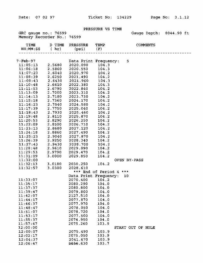
Date: 07 02 97 Ticket No: 134229 Page No: 3.1.12
PRESSURE VS TIMEGRC gauge no.: 76599 Gauge Depth: 8044.90 ftMemory Recorder No.: 76599
TIME D TIME PRESSURE TEMP COMMENTSHH:MM:SS ( hr) (psi) (F)
7-Feb-97 Data Print Frequency: 511:05:13 2.5680 2020.090 104.311:06:18 2.5860 2020.550 104.311:07:23 2.6040 2020.970 104.211:08:39 2.6250 2021.490 104.211:09:43 2.6430 2021.960 104.311:10:48 2.6610 2022.380 104.311:11:53 2.6790 2022.840 104.211:13:09 2.7000 2023.310 104.211:14:13 2.7180 2023.730 104.211:15:18 2.7360 2024.170 104.211:16:23 2.7540 2024.580 104.211:17:39 2.7750 2025.040 104.211:18:43 2.7930 2025.460 104.211:19:48 2.8110 2025.870 104.211:20:53 2.8290 2026.250 104.211:22:09 2.8500 2026.710 104.211:23:13 2.8680 2027.120 104.211:24:18 2.8860 2027.490 104.211:25:23 2.9040 2027.870 104.211:26:39 2.9250 2028.340 104.211:27:43 2.9430 2028.700 104.211:28:48 2.9610 2029.090 104.211:29:53 2.9790 2029.470 104.211:31:09 3.0000 2029.850 104.211:32:00 OPEN BY-PASS11:32:13 3.0180 2030.250 104.211:32:57 3.0300 2028.610
*** End of Period 4 ***
Data Print Frequency: 1011:33:07 2070.400 104.211:35:17 2080.290 104.011:37:37 2080.800 104.011:39:47 2079.800 104.011:42:07 2127.510 104.011:44:17 2077.870 104.011:46:37 2077.970 104.011:48:47 2078.050 104.011:51:07 2078.720 104.011:53:17 2077.500 104.011:55:37 2074.950 104.011:57:47 2075.260 103.912:00:00 START OUT OF HOLE12:00:07 2075.490 103.912:02:17 2075.050 103.912:04:37 2041.670 103.912:06:47 G.630

Date: 07 02 97 Ticket No: 134229 Page No: 3.1.13
PRESSURE VS TIMEGRC gauge no.: 76599 Gauge Depth: 8044.90 ftMemory Recorder No.: 76599
TIME D TIME PRESSURE TEMP COMMENTSHH:MM:SS ( hr) (psi) (F)
7-Feb-97 Data Print Frequency: 1012:09:07 2009.090 103.412:11:17 1997.470 102.612:13:37 1954.430 102.012:15:47 1943.610 101.412:18:07 1920.970 100.812:20:17 1881.540 100.212:22:37 1834.720 99.512:24:47 1822.840 98.812:27:07 1802.630 97.912:29:17 1746.550 97.412:31:37 1718.100 96.612:33:47 1695.830 95.812:36:07 1669.250 95.012:38:17 1641.160 94.312:40:37 1604.120 93.612:42:47 1603.180 93.112:49:12 1563.420 92.612:57:00 1439.900 91.213:04:12 1357.650 89.013:12:00 1232.790 85.213:19:12 1151.200 82.613:27:00 1025.630 80.413:34:12 942.580 78.213:42:00 818.650 75.413:49:12 695.990 73.113:57:00 547.430 70.314:04:12 414.620 68.214:12:00 291.970 66.914:19:12 158.480 65.614:27:00 18.960 63.514:34:12 18.790 63.014:42:00 19.630 63.014:49:12 19.030 62.914:57:00 22.130 62.715:04:12 20.820 62.415:12:00 24.110 62.215:19:12 23.260 61.915:27:00 22.110 61.815:34:12 22.380 61.515:40:00 DROP BAR TO DRAIN DRILL PIPE15:42:00 22.120 61.215:49:12 20.650 59.915:57:00 20.100 59.516:04:12 18.670 59.316:12:00 20.280 59.016:15:00 TOOLS AT

Date: 07 02 97 Ticket No: 134229 Page No: 3.1.14
PRESSURE VS TIMEGRC gauge no.: 76599 Gauge Depth: 8044.90 ftMemory Recorder No.: 76599
TIME D TIME PRESSURE TEMP COMMENTSHH:MM:SS ( hr) (psi) (F)
7-Feb-97 Data Print Frequency: 1016:19:12 25.590 58.716:27:00 20.300 58.416:34:12 19.400 58.116:42:00 18.100 57.816:49:12 18.240 57.716:57:00 18.380 57.717:04:12 18.500 57.817:12:00 20.530 58.017:19:12 17.720 57.217:27:00 16.850 54.217:34:12 16.490 51.117:42:00 17.120 46.117:45:36 23.780 52.019:00:00 TOOLS LOADED19:30:00 JOB

Because of the uncertainty of variable well conditions and the necessity of relyingon facts and supporting services fumished by others, Halliburton is unable to guar-antee the accuracy of any chart interpretation, research analysis, job recommen-dation or other data furnished by Halliburton. Halliburton personnel will use theirbest efforts in gathering such information and their best judgement in interpretingit but customer agrees that Halliburton shall not be responsible for any damagesarising from the use of such infonnation except where due to Halliburton grossnegligence or willfulmisconduct in the preparation or furnishing of information.