SEP 2 9 2014 REPLY TO THE ATTENTION OF
26
UNITED STATES ENVIRONMENTAL PROTECTION AGENCY REGION 5 77 WEST JACKSON BOULEVARD CHICAGO, IL 60604-3590 SEP 2 9 2014 REPLY TO THE ATTENTION OF: WW-16J Rebecca J. Flood, Assistant Commissioner Minnesota Pollution Control Agency 520 Lafayette Road North St. Paul, Minnesota 55155-4194 Dear Ms. Flood: The U.S. Environmental Protection Agency has conducted a complete review of the final Total Maximum Daily Loads (TMDL) for segments in the Chippewa River, including support documentation and follow up information. The Chippewa River is located in western Minnesota in Chippewa, Swift, Kandiyohi, Pope, Stevens, Grant, Douglas, Stearns and Otter Tail Counties. The Chippewa River TMDLs address impaired aquatic recreation and aquatic life use due to EPA has determined that the Chippewa River TMDLs meet the requirements of Section 303(d) of the Clean Water Act and EPA's implementing regulations set forth at 40 C.F.R. Part 130. Therefore, EPA approves Minnesota's nine total suspended solid TMDLs to address turbidity impairments. The statutory and regulatory requirements, and EPA's review of Minnesota's compliance with each requirement, are described in the enclosed decision document. We wish to acknowledge Minnesota's efforts in submitting these TMDLs and look forward to future TMDL submissions by the State of Minnesota. If you have any questions, please contact Mr. Peter Swenson, Chief of the Watersheds and Wetlands Branch, at 312-886-0236. turbidity. Sincerely, Tinka G. Hyde Director, Water Division Enclosure cc: Celine Lyman, MPCA Recycled/Recyclable • Printed with Vegetable Oil Based Inks on 100% Recycled Paper (100% Post-Consumer) wq-iw7-19g
Transcript of SEP 2 9 2014 REPLY TO THE ATTENTION OF

UNITED S T A T E S ENVIRONMENTAL PROTECTION A G E N C Y
REGION 5
77 W E S T J A C K S O N BOULEVARD
CHICAGO, IL 60604-3590
SEP 2 9 2014 R E P L Y TO T H E ATTENTION O F :
WW-16J
Rebecca J. Flood, Assistant Commissioner Minnesota Pollution Control Agency 520 Lafayette Road North St. Paul, Minnesota 55155-4194
Dear Ms. Flood:
The U.S. Environmental Protection Agency has conducted a complete review of the final Total Maximum Daily Loads (TMDL) for segments in the Chippewa River, including support documentation and follow up information. The Chippewa River is located in western Minnesota in Chippewa, Swift, Kandiyohi, Pope, Stevens, Grant, Douglas, Stearns and Otter Tail Counties. The Chippewa River TMDLs address impaired aquatic recreation and aquatic life use due to
EPA has determined that the Chippewa River TMDLs meet the requirements of Section 303(d) of the Clean Water Act and EPA's implementing regulations set forth at 40 C.F.R. Part 130. Therefore, EPA approves Minnesota's nine total suspended solid TMDLs to address turbidity impairments. The statutory and regulatory requirements, and EPA's review of Minnesota's compliance with each requirement, are described in the enclosed decision document.
We wish to acknowledge Minnesota's efforts in submitting these TMDLs and look forward to future T M D L submissions by the State of Minnesota. If you have any questions, please contact Mr. Peter Swenson, Chief of the Watersheds and Wetlands Branch, at 312-886-0236.
turbidity.
Sincerely,
Tinka G. Hyde Director, Water Division
Enclosure
cc: Celine Lyman, M P C A
Recycled/Recyclable • Printed with Vegetable Oil Based Inks on 100% Recycled Paper (100% Post-Consumer)
wq-iw7-19g

TMDL: Chippewa River TSS TMDL, Chippewa, Swift, Kandiyohi, Pope, Stevens, Grant, Douglas, Stearns and Otter Tail Counties, Minnesota Date: September 29, 2014
DECISION DOCUMENT FOR THE CHIPPEWA RIVER TOTAL SUSPENDED SOLIDS TMDL, MINNESOTA
Section 303(d) ofthe Clean Water Act (CWA) and EPA's implementing regulations at 40 C.F.R. Part 130 describe the statutory and regulatory requirements for approvable TMDLs. Additional information is generally necessary for EPA to determine i f a submitted T M D L fulfills the legal requirements for approval under Section 303(d) and EPA regulations, and should be included in the submittal package. Use of the verb "must" below denotes information that is required to be submitted because it relates to elements of the T M D L required by the C W A and by regulation. Use of the term "should" below denotes information that is generally necessary for EPA to determine i f a submitted T M D L is approvable. These T M D L review guidelines are not themselves regulations. They are an attempt to summarize and provide guidance regarding currently effective statutory and regulatory requirements relating to TMDLs. Any differences between these guidelines and EPA's T M D L regulations should be resolved in favor of the regulations themselves.
1. Identification of Waterbody, Pollutant of Concern, Pollutant Sources, and Priority Ranking
The T M D L submittal should identify the waterbody as it appears on the State's/Tribe's 303(d) list. The waterbody should be identified/georeferenced using the National Hydrography Dataset (NHD), and the T M D L should clearly identify the pollutant for which the T M D L is being established. In addition, the T M D L should identify the priority ranking of the waterbody and specify the link between the pollutant of concern and the water quality standard (see Section 2 below).
The T M D L submittal should include an identification of the point and nonpoint sources of the pollutant of concern, including location of the source(s) and the quantity of the loading, e.g., lbs/per day. The T M D L should provide the identification numbers of the NPDES permits within the waterbody. Where it is possible to separate natural background from nonpoint sources, the T M D L should include a description of the natural background. This information is necessary for EPA's review of the load and wasteload allocations, which are required by regulation.
The T M D L submittal should also contain a description of any important assumptions made in developing the T M D L , such as:
(1) the spatial extent of the watershed in which the impaired waterbody is located; (2) the assumed distribution of land use in the watershed (e.g., urban, forested, agriculture); (3) population characteristics, wildlife resources, and other relevant information affecting the characterization of the pollutant of concern and its allocation to sources; (4) present and future growth trends, i f taken into consideration in preparing the T M D L (e.g., the T M D L could include the design capacity of a wastewater treatment facility); and (5) an explanation and analytical basis for expressing the T M D L through surrogate measures, i f applicable. Surrogate measures are parameters such as percent fines and turbidity for sediment

impairments; chlorophyll a and phosphorus loadings for excess algae; length of riparian buffer; or number of acres of best management practices.
Comment: Location Description/Spatial Extent: The Chippewa River (HUC-8, 07020005) is one of thirteen major tributaries to the Minnesota River and drains approximately 1,331,200 acres (2,080 square miles (mile2)) in western-central Minnesota. The Chippewa River watershed (CRW) occupies portions of Chippewa, Swift, Kandiyohi, Pope, Stevens, Grant, Douglas, Stearns and Otter Tail Counties (Figure 2-1 of the final T M D L document). The source of the Chippewa River is near Fish Lake in southern Otter Tail County. The Chippewa River flows in a southern direction approximately 130-miles until it joins the Minnesota River at Montevideo, Minnesota.
The main tributaries to the Chippewa River are: the Little Chippewa River, East Branch Chippewa River, and Shakopee Creek. There are approximately 2,091 miles of streams and ditches within the Chippewa River basin. Nine assessment units (AUs) within the CRW (Table 1 of this Decision Document) were identified as being impaired for aquatic recreational use and aquatic life use.
Table 1: Summary of Impairments in the Chippewa River Watershed MPCA River
Assessment ID Stream Name Impaired Beneficial Use Action
07020005-504 Chippewa River Aquatic Life & Recreation Use TSS T M D L 07020005-530 Little Chippewa River Aquatic Life & Recreation Use TSS T M D L 07020005-559 Shakopee Creek Aquatic Life & Recreation Use TSS T M D L 0702005-574 Unnamed Creek Aquatic Life & Recreation Use TSS T M D L
07020005-901 Unnamed Creek Aquatic Life & Recreation Use TSS T M D L 07020005-503 Chippewa River Aquatic Life & Recreation Use TSS T M D L 07020005-505 Chippewa River Aquatic Life & Recreation Use TSS T M D L 07020005-508 Chippewa River Aquatic Life & Recreation Use TSS T M D L
07020005-514 East Branch Chippewa River Aquatic Life & Recreation Use TSS T M D L
Land Use: The Minnesota Pollution Control Agency (MPCA) concluded that land use in the CRW is predominantly comprised of agricultural lands. Land uses within the C R W include; cultivated croplands (inclusive of corn, soybeans, sugar beets and grain), grasslands, forested areas, open water, wetlands, urban or residential land uses, and gravel pit/exposed lands (Table 2 of this Decision Document).
2

Table 2: Land use in the Chippewa River Watershed
Description Acreage in the Chippewa
River watershed Distribution (% of the total area in
the Chippewa River Watershed)
Cultivated Crops (Corn, Soybeans & Sugar Beets) 978,432 73.5
Grassland 148,295.68 11.14
Forest 71,618.56 5.38
Water 71,485.44 5.37
Wetlands 37,007.36 2.78
Urban / Residential 23,562.24 1.77
Gravel Pits / Exposed 665.6 0.05
Unclassified (> 0.01) 133.12 0.01
Total 1,331,200 100
Problem Identification: Stream assessments conducted within the Chippewa River basin found water quality impairments in nine stream segments. Impaired stream segments were listed on the Minnesota Impaired Waters List (i.e., the 303(d) list) between 2006 and 2010 for aquatic life and recreational use impairments due to turbidity. Total suspended solids (TSS) is a measurement ofthe sediment and organic material that inhibits natural light from penetrating the surface water column. Excessive sediment and organic material within the water column can negatively impact fish and macroinvertebrates within the ecosystem. Excess sediment and organic material may create turbid conditions within the water column and may increase the costs of treating surface waters used for drinking water or other industrial purposes (ex. food processing).
Excessive amounts of fine sediment in stream environments can degrade aquatic communities. Sediment can reduce spawning and rearing areas for certain fish species. Excess suspended sediment can clog the gills offish, stress certain sensitive species by abrading their tissue, and thus reduce fish health. When in suspension, sediment can limit visibility and light penetration which may impair foraging and predation activities by certain species.
Excessive fine sediment also may degrade aquatic habitats, alter natural flow conditions in stream environments and add organic materials to the water column. The potential addition of fine organic materials may lead to nuisance algal blooms which can negatively impact aquatic life and recreation (swimming, boating, fishing, etc.). Algal decomposition depletes oxygen levels which stresses benthic macroinvertebrates and fish. Excess algae can shade the water column and limit the distribution of aquatic vegetation. Established aquatic vegetation stabilizes bottom sediments and provides important habitat areas for healthy macroinvertebrates and fish communities.
Degradations in aquatic habitats or water quality (ex. low dissolved oxygen) can negatively impact aquatic life use. Increased turbidity, brought on by elevated levels of nutrients within the water column, can reduce dissolved oxygen in the water column, and cause large shifts in dissolved oxygen and pH throughout the day. Shifting chemical conditions within the water column may stress aquatic biota (fish and macroinvertebrate species). In some instances, degradations in aquatic habitats or water quality have reduced fish populations or altered fish communities from those communities supporting sport fish species to communities which support more tolerant rough fish species.
3

Excess siltation and flow alteration in streams impacts aquatic life by altering habitats. Excess sediment can f i l l pools, embed substrates, and reduce connectivity between different stream habitats. The result is a decline in habitat types that, in healthy streams, support diverse macroinvertebrate communities. Excess sediment can reduce spawning and rearing habitats for certain fish species. Flow alterations in the CRW have resulted from drainage improvements on or near agricultural lands. Specifically, tile drains and land smoothing have increased surface and subsurface flow to streams. This results in higher peak flows during storm events and flashier flows which carry sediment loads to streams and erode streambanks. As a result, TSS surrogate TMDLs were completed to directly address waters impaired by excess sediment.
Priority Ranking: The Chippewa River TSS T M D L was given a priority ranking for T M D L development due to: the impairment impacts on public health and aquatic life, the public value ofthe impaired water resource, the likelihood of completing the T M D L in an expedient manner, the inclusion of a strong base of existing data and the restorability of the water body, the technical capability and the willingness of local partners to assist with the T M D L , and the appropriate sequencing of TMDLs within a watershed or basin. Areas within the CRW are popular locations for aquatic recreation. Water quality degradation has led to efforts to improve the overall water quality within the CRW, and to the development of a T M D L .
Pollutant of Concern: The pollutant of concern is sediment. M P C A identified turbid conditions within the surface waters of the CRW and linked those conditions to the introduction of fine sediment.
Source Identification (point and nonpoint sources): Point Source Identification: The potential point sources to the CRW are:
National Pollutant Discharge Elimination System (NPDES) permit holders: NPDES permitted facilities may contribute pollutant loads to surface waters through facility discharges of treated wastewater. Permitted treatment facilities, such as wastewater treatment facilities (WWTF), discharge treated wastewater according to limitations described within their NPDES permit. Permit limits for TSS are typically 30 mg/L or 45 mg/L (Table 3 of this Decision Document). Table 3 in this Decision Document identifies facilities in the CRW which were assigned a portion of the wasteload allocation (WLA).
Table 3: NPDES permitted facilities within the Chippewa River watershed which received a portion ofthe WLA
Nested Subwatershed Facility name NPDESID #
WLA for TSS TMDLs
503
Farwell-Kensington WWTF MNG5 80220
503
Evansville WWTF MN0023329
503 Hoffman WWTF MNG580134 503
Millerville WWTF MN0054305
503
Urbank WWTF MN0068446
505 CIontarfWWTF MNG580108
506*
Chippewa Valley Ethanol Co. MN0062898
506* Benson WWTF MN0020036 506*
Hancock WWTF MN0023582
4

508 Danvers WWTF MNG580119
514 Murdock WWTF MNG580086
514 Sunburg WWTF MNG580125
530 Starbuck WWTF MN0021415
530 Lowry WWTF MN0024007
574 Kerkhoven WWTF MN0020583
* = Reach 506 is not impaired for turbidity but is located upstream of impaired reach 508. Facilities included in reach 506 are included in the allocations for reach 508 (Table 4 ofthis Decision Document).
Several municipal areas are located on the main stem ofthe Chippewa River or on a major tributary to the Chippewa River. The Chippewa River is not used as a source for drinking water and the M P C A determined that there are no industrial facilities which draw water from the Chippewa River. The municipal areas do discharge treated wastewater (from wastewater treatment plants) and stormwater effluents into the Chippewa River.
Regulated stormwater runoff from Municipal Separate Storm Sewer Systems (MS4): Stormwater may transport sediment to surface waters in the CRW via stormwater runoff events. There is one MS4 community in the CRW, the City of Montevideo (MS400261). M P C A determined that the City of Montevideo is located downstream of impaired segments and is not contributing sediment to the subwatersheds of any of the segments addressed by the Chippewa River TSS TMDLs.
Permitted Construction and Industrial Areas: Construction and industrial sites may contribute sediment during stormwater runoff events. Areas under construction may contribute sediment via runoff from construction sites during stormwater events. The Chippewa River T M D L assumes that there will be sediment inputs from construction activities and therefore a W L A was assigned to construction stormwater.
Additionally, the Chippewa River TMDL assumes that there will be sediment inputs from industrial activities within the C R W and assigned a portion of the W L A to industrial stormwater. Construction and industrial areas within the CRW must comply with the requirements of the MPCA's Stormwater Program. The NPDES program requires construction and industrial sites to create a Stormwater Pollution Prevention Plan (SWPPP) that summarizes how stormwater pollutants will be minimized from the site.
Nonpoint Source Identification: The potential nonpoint sources to the CRW are:
Stormwater contributions/runoff from agricultural areas: Stormwater may contribute sediment inputs to surface waters as water moves over cropland and feedlots. Fields that utilize tile drains may enhance erosion on the fields and in the drainage ditches. Overgrazing by livestock may also augment soil loss from fields.
Livestock within Stream Environments: Livestock in streams or on streambanks destabilizes the streambanks and may lead to streambank degradation and erosion. Livestock within the stream may resuspend sediments which have settled on the stream bottom and also may displace aquatic plants whose roots provide stability for stream sediment. The loss of these aquatic plants may lead to sediment erosion of the stream bottom during stormwater events.
5

Stream channelization and stream erosion: Eroding streambanks and channelization efforts may add sediment to local surface waters. Eroding riparian areas may be linked to soil inputs within the water column and potentially to changes in flow patterns. Changes in flow patterns may encourage down-cutting ofthe streambed and streambanks. Stream channelization efforts can increase the velocity of flow (via the removal of the sinuosity of a natural channel) and disturb the natural sedimentation processes of the streambed.
Non-regulated stormwater contributions/runoff from non-MS4 permitted urban areas: Stormwater from urban areas which drain impervious surfaces may add sediment and other particulate matter to local surface waters. Channelized stormwater conveyance systems may transport untreated stormwater, which may contain mobilized soil particulate materials, to surface waters.
Wetland Sources: Sediment may be added to surface waters by stormwater flows through wetland areas in the CRW. Storm events may mobilize sediment through the transport of suspended solids and other organic debris.
Shoreline Erosion: Sediment may be added to surface waters of the C R W by erosional processes impacting lake shoreline areas. Sediment may be mobilized through the transport of sediment and suspended solids.
Forest Sources: Sediment may be added to surface waters via runoff from forested areas within the watershed. Runoff from forested areas may include debris from decomposing vegetation and organic soil particles.
Future Growth: Significant development is not expected in the CRW. The land use within the watershed is primarily agricultural with small cities and towns scattered throughout the CRW. Approximately one half of the residents in the CRW live in cities and towns and the other half reside in rural areas. M P C A expects that land use in the CRW will remain unchanged for the foreseeable future. The W L A and load allocations (LA) for the Chippewa River TSS TMDLs were calculated for all current and future sources. Any expansion of point or nonpoint sources will need to comply with the respective W L A and L A values calculated in the Chippewa River TSS TMDLs.
The EPA finds that the T M D L document submitted by the M P C A satisfies the requirements of the first criterion.
2. Description of the Applicable Water Quality Standards and Numeric Water Quality Target
The T M D L submittal must include a description ofthe applicable State/Tribal water quality standard, including the designated use(s) of the waterbody, the applicable numeric or narrative water quality criterion, and the antidegradation policy (40 C.F.R. §130.7(c)(1)). EPA needs this information to review the loading capacity determination, and load and wasteload allocations, which are required by regulation.
6
The T M D L submittal must identify a numeric water quality target(s) - a quantitative value used to measure whether or not the applicable water quality standard is attained. Generally, the pollutant of concern and the numeric water quality target are, respectively, the chemical causing the impairment and the numeric criteria for that chemical (e.g., chromium) contained in the water quality standard. The T M D L expresses the relationship between any necessary reduction of the pollutant of concern and the attainment of the numeric water quality target. Occasionally, the pollutant of concern is different from the pollutant that is the subject of the numeric water quality target (e.g., when the pollutant of concern is phosphorus and the numeric water quality target is expressed as Dissolved Oxygen (DO) criteria). In such cases, the T M D L submittal should explain the linkage between the pollutant of concern and the chosen numeric water quality target.
Comment: Designated Uses: The designated uses for waters assessed and addressed by the Chippewa River TSS TMDLs are for aquatic life use and aquatic recreational use. Waters within the CRW are designated as Class 2B waters (MN Rule 7050.0222 Subpart 4, Class 2B). The quality of Class 2B waters, relative to aquatic life and recreation, "shall be as to permit the propagation and maintenance of a healthy community of cool or warm water sport or commercial fish and associated aquatic life, and their habitats. These waters shall be suitable for aquatic recreation of all kinds, including bathing, for which the waters may be usable. "
Standards and Targets: Narrative Criteria: Minnesota Rule 7050.0150 (3) set forth narrative criteria for Class 2 waters ofthe State:
"For all Class 2 waters, the aquatic habitat, which includes the waters of the state and stream bed, shall not be degraded in any material manner, there shall be no material increase in undesirable slime growths or aquatic plants, including algae, nor shall there be any significant increase in harmful pesticide or other residues in the waters, sediments, and aquatic flora and fauna; the normal fishery and lower aquatic biota upon which it is dependent and the use thereof shall not be seriously impaired or endangered, the species composition shall not be altered materially, and the propagation or migration of the fish and other biota normally present shall not be prevented or hindered by the discharge of any sewage, industrial waste, or other wastes to the waters. "
Numeric Criteria: Minnesota's water quality standards (WQS) for Class 2B waters for turbidity are 25 Nephelometic Turbidity Units (NTUs). Turbidity is not a measure of mass, but rather is a measure of light scatter and absorption that occurs proportional to the amount of sediment, algae, and organic matter in the water column. Thus, in order to develop a mass per unit time load for the T M D L , TSS was used as a surrogate pollutant.
T M D L loading capacities are normally represented via loading measurements. A loading measure is typically a mass per time measurement (example kilogram per day). NTUs are not transferrable to a loading value. M P C A calculated loading capacities for the Chippewa River TSS TMDLs using a TSS surrogate value (Section 2.5 of the final T M D L document). M P C A explained that it was appropriate to use a TSS surrogate due to TSS and turbidity both being measurements of suspended materials within a water column.
7

Target: M P C A employed a TSS surrogate water quality concentration target (WQCT) of 54 mg/L (53.7 mg/L which was rounded to 54 mg/L) to calculate loading capacities. To derive a TSS target, it is ideal for both variables to be measured at the same time and through various flow conditions. The TSS WQCT was supported by paired turbidity and TSS field measurements collected in the Chippewa River basin at eleven locations from 2001 to 2008 (Section 2.5 and Table 2-4 of the final T M D L document) and mathematical relationships of that field data, plus a smearing correction1 which adjusted the final WQCT for sample bias. M P C A is confident that the 54 mg/L TSS WQCT is appropriate to use for the Chippewa River TSS TMDLs and aligns with the 25 N T U turbidity water quality criteria.
The EPA finds that the T M D L document submitted by the M P C A satisfies the requirements of the second criterion.
3. Loading Capacity - Linking Water Quality and Pollutant Sources
A T M D L must identify the loading capacity of a waterbody for the applicable pollutant. EPA regulations define loading capacity as the greatest amount of a pollutant that a water can receive without violating water quality standards (40 C.F.R. §130.2(1)).
The pollutant loadings may be expressed as either mass-per-time, toxicity or other appropriate measure (40 C.F.R. §130.2(i)). If the T M D L is expressed in terms other than a daily load, e.g., an annual load, the submittal should explain why it is appropriate to express the T M D L in the unit of measurement chosen. The T M D L submittal should describe the method used to establish the cause-and-effect relationship between the numeric target and the identified pollutant sources. In many instances, this method will be a water quality model.
The T M D L submittal should contain documentation supporting the T M D L analysis, including the basis for any assumptions; a discussion of strengths and weaknesses in the analytical process; and results from any water quality modeling. EPA needs this information to review the loading capacity determination, and load and wasteload allocations, which are required by regulation.
TMDLs must take into account critical conditions for steam flow, loading, and water quality parameters as part of the analysis of loading capacity (40 C.F.R. §130.7(c)(1)). TMDLs should define applicable critical conditions and describe their approach to estimating both point and nonpoint source loadings under such critical conditions. In particular, the T M D L should discuss the approach used to compute and allocate nonpoint source loadings, e.g., meteorological conditions and land use distribution.
Comment: The Load Duration Curve (LDC) approach was selected by M P C A to calculate the loading capacities for the nine segments addressed by the Chippewa River TSS TMDLs. The L D C approach calculates loading capacities for each flow regime of the L D C (Table 4 of this Decision Document). A l l loading capacity (LC) calculations are based on measured flows within the CRW. The Chippewa River TSS TMDLs were determined by multiplying the TSS target of 54 mg/L by the flow duration curve (FDC) to develop a load duration curve that illustrates the assimilative capacity, or TMDL, for the stream. From the load
1 Page 2-8 of the final T M D L document. (Based on Duan's smearing correction, Duan, N . 1983. Smearing estimate - a nonparametric retransformation method. Journal ofthe American Statistical Association, 78, 383, pg. 605-610.)
8

duration curve, the loading capacities for five representative flow regimes were calculated. These are the loads that are needed to meet water quality standards.
To calculate the T M D L , flow duration curves were developed from flow frequency tables based on recorded and scaled flow volumes measured at the outlet point of the CRW (USGS gage on the Chippewa River (05304500)). Each of the segments addressed in the Chippewa River TSS TMDL employed the flow record from the USGS gage (05304500) to create the FDC and the LDC.
FDCs were calculated based on continuous daily flow values, measured at USGS gage, from 1999 to 2008 (10 years of flow data). FDCs graphs have the flow duration interval (percentage of time flow exceeded) on the X-axis and discharge (flow per unit time) on the Y-axis. FDCs were then transformed into LDCs by multiplying individual flow values by the applicable TSS WQCT of 53.7 mg/L and then by a conversion factor. The resulting curve on a graph is the T M D L , identifying how many tons per day a stream can assimilate for a given flow value and still attain the TSS WQCT.
LDCs were created for each of the nine impaired segments. The L D C plots were subdivided into five flow regimes:
• Very High Flow Conditions, exceeded 0% - 10% of the time; • High Flow Conditions, exceeded 10% - 40% of the time; • Mid Range Flow Conditions, exceeded 40% - 60% ofthe time; • Dry Flow Conditions, exceeded 60% - 90% of the time; and • Low Flow Conditions, exceeded 90% -100% of the time.
The median flow value for each flow regime was determined and used to calculate the total daily loading capacity (TDLC) for each flow regime. The MOS was set at 10% of the TDLC. The LDC plots, showing the individual sampling loads and the LDC, display the flow conditions under which water quality exceedances occur. Individual sampling loads which plot above the LDC represent violations of the TSS WQCT and the allowable load under those flow conditions. The difference between individual sampling loads plotting above the LDC and the LDC, measured at the same flow is the amount of reduction necessary to meet TSS WQCT.
For each impaired reach and flow regime, the total loading capacity was divided into its component W L A , L A , and margin of safety (MOS) (Table 4 of this Decision Document). The WLAs were divided into contributions from WWTFs, contributions from construction stormwater and contributions from industrial stormwater. WLAs calculated for continuous point sources (WWTF) were estimated from the wet weather design flow and the monthly TSS concentration limit (for TSS typically 30 mg/L or 45 mg/L). Fifteen (15) NPDES permitted facilities received a portion ofthe W L A .
A W L A assigned to construction stormwater is normally calculated from the cumulative watershed area which is determined to be "under construction" on an annual basis. Annual measurements are typically averaged over a period of time (ex. the most recent five years of records) and based on information included within construction stormwater permitting records. For the Chippewa River TSS TMDLs, M P C A explained that there was a lack of reliable construction permitting information in the Chippewa River watershed. Due to this lack of information, M P C A estimated the average annual cumulative fraction of watershed area under construction to be 0.001.
9

M P C A multiplied 0.001 by the TDLC in order to calculate the fraction of the TDLC assigned to construction stormwater. This multiplication was carried out in each impaired segment and reflected as the W L A contribution of stormwater from construction sources in that particular reach. Other M P C A T M D L studies, which have a scarcity of construction stormwater related information, have used a similar approach and utilized an average annual cumulative fraction of watershed area value of 0.0003 to 0.0015.
A similar approach was used for the estimation of the W L A contribution from industrial stormwater. Industrial stormwater permit data was also difficult for the M P C A to attain, and similar to the construction stormwater approach, the M P C A multiplied 0.001 by the TDLC to estimate the industrial stormwater contribution on a reach by reach basis. The M P C A Industrial Stormwater Program supported this assumption and advocated assigning a portion of the loading capacity which was equal to or less than the fraction of the loading capacity assigned to construction stormwater. Thus, M P C A multiplied the TDLC by 0.001 to calculate industrial stormwater contributions throughout the listed reaches of the CRW.
The L A was determined after the W L A , MOS and loading capacity were calculated. The L A is the L C value subtracted from the W L A plus the MOS (LA = L C - (WLA + MOS)). The L A term was not split amongst potential nonpoint contributors (ex. agricultural nonpoint contributions, livestock in stream environments, streambank erosion etc.), instead it was represented as a combined L A value for each segment.
The strengths of using the LDC method are that critical conditions and seasonal variation are considered in the creation of the FDC by plotting hydrologic conditions over the flows measured during the recreation season. Additionally, the L D C methodology is relatively easy to use and cost-effective. The weaknesses of the LDC method are that nonpoint source allocations cannot be assigned to specific sources, and specific source reductions are not quantified. Overall, M P C A believes and EPA concurs that the strengths outweigh the weaknesses for the LDC method.
Implementing the results shown by the L D C requires watershed managers to understand the sources contributing to the water quality impairment and which Best Management Practices (BMPs) may be the most effective for reducing sediment loads based on flow magnitudes. Different sources will contribute sediment loads under varying flow conditions. For example, i f loads are significant during storm events, implementation efforts can target B M P that will reduce stormwater runoff and consequently sediment loading into surface waters.
Table 4 of this Decision Document reports five points (the midpoints ofthe designated flow regime) on the loading capacity curve. However, it should be understood that the components of the T M D L equation could be illustrated for any point on the entire loading capacity curve. The load duration curve method can be used to display collected TSS monitoring data and allows for the estimation of load reductions necessary for attainment of the TSS surrogate WQCT. Using this method, daily loads were developed based upon the flow in the water body. Loading capacities were determined for the segment for multiple flow regimes. This allows the T M D L to be represented by an allowable daily load across all flow conditions. Table 4 of this Decision Document identifies the loading capacity for the water body at each flow regime. Although there are numeric loads for each flow regime, the L D C is what is being approved for this T M D L .
10

M P C A included the LDCs for each individual subwatershed in Section 4.5 of the final T M D L document. M P C A explained that, for a majority of the subwatersheds, TSS concentration measurements exceed the 54 mg/L TSS WQCT across all flow regimes. Certain subwatersheds have more exceedances of the 54 mg/L TSS WQCT than other reaches. Therefore, sediment implementation efforts should aim to reduce nutrient and sediment contributions during times of high flows and times of lower flows within the CRW.
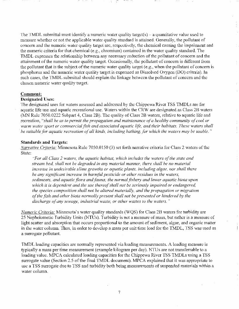
Table 4: Total Suspended Solids (TSS) TMDLs for the Chippewa River segments (07020005)
HUC Code
12-digit
Flow Regime TMDL analysis TSS Load (tons/day)
Very High Flows
High Flows
Mid Range Flows
Low Flows
Dry Flows HUC Code
12-digit Duration Interval 0-10% 10-40% 40-60% 60-90% 90-100%
1 VIOL (Upper Chippewa Ri\er (07020005-503) 40.JT3 23.305 11.734 5.127 0.902
Wasteload Allocation (WLA): Total 0.856 0 820 0.798 0.784 0.776
Farewell-Kensington WWTF (MNG580220) 0.107 0.107 0.107 0.107 0.107
Evansville WWTF (MN0023329) 0.140 0.140 0.140 0.140 0.140
Hoffman WWTF (MNG580134) 0.464 0.464 0.464 0.464 0.464
503 Millerville WWTF (MN0054305) 0.048 0.048 0.048 0.048 0.048
Urbank WWTF (MN0068446) 0.015 0.015 . 0.015 0.015 0.015
NPDES permitted source: Total 0.774 0.774 0.774 0.774 0.774
Construction Stormwater (0.1%) 0.041 0.023 0.012 0.005 0.001
Industrial Stormwater (0.1%) 0.041 0.023 0.012 0.005 0.001
Load Allocation (LA) 35.930 20.154 9.763 3.830 0.036
Margin Of Safety (MOS) (10%) 4.0X7 2.331 1.173 0.513 0.090
TMDL (I nnamed Creek - Free ho in Lake In lei (07020005-901))
0.327 0.186 (1.093 0.041 0.007
Wasteload A llocation (WLA): Total 0.000 0.000 0.000 0.000 0.000
901 NPDES permitted source: Total 0.000 0.000 0.000 0.000 0.000
901 Construction Stormwater (0.1%) < 0.001 < 0.001 < 0.001 < 0.001 < 0.001
Industrial Stormwater (0.1%) < 0.001 < 0.001 < 0.001 < 0.001 < 0.001
Load Allocation (LA) 0.294 0.167 0.084 0.037 0.006
Margin Of Safety (MOS) (10%) 0.033 0.019 0.009 0.004 (1.001
TMDL (Middle Chippewa River (07020005-
504)) 59.143
fulfil; >|||||siil||||||
34.825 17.961 8.934 2.139
Wasteload Allocation (WLA): Total 0.118 0.070 0.036 0.018 0.004
504 NPDES permitted source: Total 0.000 0.000 0.000 0.000 0.000
504 Construction Stormwater (0.1%) 0.059 0.035 0.018 0.009 0.002
Industrial Stormwater (0.1%) 0.059 0.035 0.018 0.009 0.002
Load Allocation (LA) 53.111 31.272 16.129 8.023 1.921
Margin Of Safety (MOS) (10%) 5.914 3.483 1.796 0.893 0.214
505
TMDL (Middle Chippewa Ri\er (07020005-505))
[ 98.573 58.153 ! 30.147 1
15.003 3.631
505 Wasteload Allocation (WLA): Total 0.238 0.156 0.100 0.070 0.048
Clontarf WWTF (MNG580108) 0.040 0.040 0.040 0.040 0.040
11
NPDES permitted source: Total 0.040 0.040 0.040 0.040 0.040
Construction Stormwater (0.1%) 0.099 0.058 0.030 0.015 0.004
Industrial Stonn water (0.1%) 0.099 0.058 0.030 0.015 0.004
Load Allocation (LA) 88.478 52.182 27.032 13.433 3.220
Margin Of Safety (MOS) (10%) 9.857 5.815 3.015 1.500 0.363
530
1MDL (Little Chippewa Rher (07020005-530)) 11.141 6.407 1.530 0.232 0.098
530
Wasteload Allocation (WLA): Total 0.145 0.135 0.127 0.123 0 000
530
Starbuck WWTF (MN0021415) 0.044 0.044 0.044 0.044 *
530 Lowry WWTF (MN0024007) 0.079 0.079 0.079 0.079 *
530 NPDES permitted source: Total 0.123 0.123 0.123 0.123 * 530
Construction Stormwater (0.1%) 0.011 0.006 0.002 < 0.001 < 0.001
530
Industrial Stormwater (0.1%) 0.011 0.006 0.002 < 0.001 < 0.001
530
Load Allocation (LA) 9.882 5.631 1.250 0.086 0.088
530
Margin Of Safety (MOS) (10%) 1.114 0.641 0.153 0.023 0.010
T M D L (East Biam-h ("7020(105-514)) 89.731 44.817 22.42- 11.132 3.349
Wasteload Allocation (WLA): Total 0.261 0.171 0.125 0.103 0.087
Murdock WWTF (MNG580086) 0.059 0.059 0.059 0.059 0.059
Sunburg W W T F (MNG580125) 0.022 0.022 0.022 0.022 0.022
NPDES permitted source: Total 0.081 0.081 0.081 0.081 0.081
Construction Stormwater (0.1%) 0.090 0.045 0.022 0.011 0.003
Industrial Stormwater (0.1%) 0.090 0.045 0.022 0.011 0.003
Load Allocation (LA) 80.497 40.164 20.059 9.916 2.927
Margin Of Sa fety (MOS) (10%) 8.973 4.482 2.243 1.113 0.335
559
1 MDL (Shakopee Creek (07020005-559)) 50.834 22.208 9.401 3.680 0.282
559
Wasteload Allocation (WLA): Total 0.102 0.044 0.018 0.008 0.000
559
NPDES permitted source: Total 0.000 0.000 0.000 0.000 0.000
559 Construction Stormwater (0.1%) 0.051 0.022 0.009 0.004 < 0.001 559
Industrial Stormwater (0.1%) 0.051 0.022 0.009 0.004 < 0.001
559
Load Allocation (LA) 45.649 19.943 8.443 3.304 0.254
559
Margin Of Safety (MOS) (10%) 5.083 2.221 0.940 0.368 0.028
• 574 .
TMDL (Unnamed Creek (07020005-574)) 2.542 1.110 0.469 0.183 0.014
• 574 .
Wasteload Allocation (WLA): Total 0.025 0.021 0.019 0.019 0.000
• 574 .
Kerkhoven WWTF (MN0020583) 0.019 0.019 0.019 0.019 *
• 574 . NPDES permitted source: Total 0.019 0.019 0.019 0.019
• 574 . Construction Stormwater (0.1%) 0.003 0.001 < 0.001 < 0.001 < 0.001
• 574 .
Industrial Stormwater (0.1%) 0.003 0.001 < 0.001 < 0.001 < 0.001
• 574 .
Load Allocation (LA) 2.263 0.978 0.403 0.146 0.013
• 574 .
Margin Of Saf ety (MOS) (10%) 0.254 0.111 0.047 0.018 0.001
508
I'MDL (Little Chippewa Ri\er (07020005-508)) 247.583 ! 127.286 66.993 30.948 ! 9.903
508 Wasteload Allocation (WLA): Total U.88V 0.647 0.527 0.455 0.413
508 Danvers WWTF (MNG580119) 0.034 0.034 0.034 0.034 0.034 508
Chippewa Valley Ethanol Co. (MN0062898) 0.004 0.004 0.004 0.004 0.004
Benson W W T F (MN0020036) ** 0.098 0.098 0.098 0.098 0.098
Hancock WWTF (MN0023582) 0.257 0.257 0.257 0.257 0.257
12

NPDES permitted source: Total 0.393 0.393 0.393 0.393 0.393
Construction Stormwater (0.1%) 0.248 0.127 0.067 0.031 0.010
Industrial Stormwater (0.1%) 0.248 0.127 0.067 0.031 0.010
Load Allocation (LA) 221.936 113.910 59.767 27.398 8.501)
Margin Of Safety (MOS) (10%) 24.758 12.729 6.699 3 095 0.990 * = Effluent TSS concentrations under this T M D L shall not exceed their pennitted limit (30 mg/L for Starbuck WWTF and Kerkhoven WWTF and 45 mg/L for Lowry WWTF) as a calendar month average. Permitted point source allocation values were calculated but not factored into the 'dry' flow regime since the facilities do not operate at their permitted design flow under these flow conditions. Instead, the point source discharge allocation for the dry flow regime is represented by the following equation: Allocation = (flow contribution from source) multiplied by the (permitted TSS monthly average).
** = W L A based on the TSS calendar month average permit limit which is based on the facility's non-degradation design flow of 0.782 mgd.
The reduction from current conditions needed to meet the TSS surrogate WQCT was estimated for each subwatershed (Table 5 ofthis Decision Document). The estimated reductions were calculated based on the difference between the loading capacity for the flow regime and the 90 t h percentile TSS load for the flow regime (Figures 4-3 to 4-17 of the final T M D L document). M P C A stated that these estimated reductions are intended to be approximate, and are meant to give a relative magnitude of reductions needed across each flow regime within each individual subwatershed (Figures 3.3 to 3.5 ofthe final TMDL).
Table 5: Estimated percent reductions for TSS TMDLs for the Chippewa River segments (07020005)
HUC Code
12-digit
Estimated percent reductions for TSS (tons/day) - Difference between the loading capacity and
the 90th percentile
Very High Flows
High Flows
Mid Range Flows
Low Flows
Dry Flows HUC Code
12-digit
Estimated percent reductions for TSS (tons/day) - Difference between the loading capacity and
the 90th percentile Reductions by flow regime (as a percent)
503 T M D L - Upper Chippewa River (07020005-503) 0.0 38.0 63.0 46.0 4.0
901 T M D L - Unnamed Creek - Freeborn Lake Inlet
(07020005-901) 0.0 30.0 27.0 7.0 -
504 T M D L - Middle Chippewa River (07020005-504) 41.0 44.0 58.0 67.0 50.0
505 T M D L - Middle Chippewa River (07020005-505) 0.0 45.0 63.0 70.0 23.0
530 T M D L - Little Chippewa River (07020005-530) 74.0 38.0 34.0 7.0 0.0
514 T M D L - East Branch (07020005-514) 59.0 49.0 33.0 57.0 0.0
559 T M D L - Shakopee Creek (07020005-559) 67.0 64.0 81.0 85.0 88.0
574 T M D L - Unnamed Creek (07020005-574) 70.0 5.0 0.0 0.0 0.0
508 T M D L - Little Chippewa River (07020005-508) 78.0 54.0 62.0 58.0 0.0
EPA supports the data analysis and modeling approach utilized by M P C A in their calculation of wasteload allocations, load allocations and the margin of safety for the Chippewa River TMDL. The process M P C A used is consistent with EPA's T M D L protocols.
The EPA finds that the T M D L document submitted by the M P C A satisfies the requirements ofthe third criterion.
13

4. Load Allocations (LA)
EPA regulations require that a T M D L include LAs, which identify the portion of the loading capacity attributed to existing and future nonpoint sources and to natural background. Load allocations may range from reasonably accurate estimates to gross allotments (40 C.F.R. § 130.2(g)). Where possible, load allocations should be described separately for natural background and nonpoint sources.
Comment: M P C A states that assigned load allocations were not partitioned to potential sources based on their proportional contribution. Rather, load allocations were back-calculated once wasteload allocations, margin of safety, and reserve capacity were determined. The load allocation is aggregated for the following nonpoint sources: agricultural runoff, stormwater runoff, wetland nonpoint source contributions, livestock within stream environments, atmospheric deposition, nonpoint sources not subject to NPDES permits, and soil erosion from stream channels and upland areas. Potential loading from these nonpoint sources was estimated in Tables 3-2 to 3-10 of the final T M D L document. The nonpoint source contribution of the individual TMDLs was approximately 70% to 85% of the loading capacity.
EPA finds the M P C A ' s approach for calculating the L A to be reasonable.
The EPA finds that the T M D L document submitted by the M P C A satisfies the requirements ofthe fourth criterion.
5. Wasteload Allocations (WLAs)
EPA regulations require that a T M D L include WLAs, which identify the portion of the loading capacity allocated to individual existing and future point source(s) (40 C.F.R. § 130.2(h), 40 C.F.R. §130.2(i)). In some cases, WLAs may cover more than one discharger, e.g., i f the source is contained within a general permit.
The individual WLAs may take the form of uniform percentage reductions or individual mass based limitations for dischargers where it can be shown that this solution meets WQSs and does not result in localized impairments. These individual WLAs may be adjusted during the NPDES permitting process. If the WLAs are adjusted, the individual effluent limits for each permit issued to a discharger on the impaired water must be consistent with the assumptions and requirements of the adjusted WLAs in the T M D L . If the WLAs are not adjusted, effluent limits contained in the permit must be consistent with the individual WLAs specified in the T M D L . If a draft permit provides for a higher load for a discharger than the corresponding individual W L A in the TMDL, the State/Tribe must demonstrate that the total W L A in the T M D L will be achieved tlirough reductions in the remaining individual WLAs and that localized impairments will not result. A l l permittees should be notified of any deviations from the initial individual WLAs contained in the T M D L . EPA does not require the establishment of a new T M D L to reflect these revised allocations as long as the total W L A , as expressed in the T M D L , remains the same or decreases, and there is no reallocation between the total W L A and the total L A .
14

Comment: WLAs were assigned to NPDES permitted facilities, construction stormwater and industrial stormwater. Fifteen NPDES permitted facilities were assigned a portion of the W L A . WLAs for WWTFs were calculated from the facility's wet weather design flow and facility's monthly TSS concentration limit (Table 6 of this Decision Document). M P C A compared the in-stream TSS targets and the technology-driven TSS effluent limits contained in the facility's NPDES permit and found that the effluent limits were below the in-stream targets (Page 3-15 of the final T M D L document). Facilities in the CRW discharging treated wastewater below their in-stream target are still discharging the pollutant of concern (TSS) and therefore, are required to be assigned an individual W L A .
Table 6: NPDES permitted facilities within the Chippewa River watershed which received a portion ofthe WLA
Nested Subwatershed
Facility name NPDESID # Discharge Design
Flow (MGD)
Permitted TSS Calendar
Month Average (mg/L)
TMDL Allocation (tons/day)
WLA lor TSS TMDL
503
Farwell-Kensington WWTF
MNG580220 0.570 45 0.107
503 Evansville WWTF MN0023329 0.749 45 0.140
503 Hoffinan WWTF MNG580134 2.473 45 0.464
503
Millerville WWTF MN0054305 0.254 45 0.048
503
Urbank WWTF MN0068446 0.080
•i;v : ^>^235^
45 0.015
505 Clontarf WWTF MNG580108
0.080
•i;v : ^>^235^ (1.040
506*
Chippewa Valley Ethanol Co.
MN0062898 0.072 45 0.004
506* Benson WWTF MN0020036 0.781 30 0.098
506*
Hancock WWTF MN0023582 1.370 45 0.257
508 Danvers WWTF MNG580119 0.184 0.034
514 Murdock WWTF MNG580086 0.317 45 0.059
514 Sunburg WWTF MNG580125 0.118 45 0.022
530 Starbuck WWTF MN0021415 0.350 30 0.044
530 Lowry WWTF MN0024007 0.079
574 Kerkhoven WWTF MN0020583 0.150 30 0.019
* = Reach 506 is not impaired for turbidity but is located upstream of impaired reach 508. Facilities included in reach 506 are included in the allocations for reach 508 (Table 4 ofthis Decision Document).
The calculation for the WLAs assigned to construction and industrial stormwater were based on an estimated average annual cumulative fraction ofthe watershed area under construction multiplied by the total loading capacity for the subwatershed. M P C A explained that there is no reliable construction areal estimates which are normally part of construction stormwater permitting information. M P C A estimated an areal fraction of construction activity for the CRW and applied that estimate to each individual subwatershed. M P C A used an areal estimate of 0.001 and multiplied that value by the total loading capacity for each subwatershed to calculate construction stormwater WLAs. The W L A assigned to industrial stormwater was identical to the WLAs for construction stormwater (Table 4 ofthis Decision Document and Section 3.2 of the final TMDL document).
15

M P C A expects that construction sites within the CRW will employ BMPs and other stormwater control measures to limit the discharge of sediment. The suite of BMPs which should be implemented are defined in the State's NPDES/SDS General Stormwater Permit for Construction Activity (MNR100001). If a construction site owner/operator obtains coverage under the NPDES/SDS General Stormwater Permit and properly selects, installs and maintains all BMPs required under the permit, including those related to impaired waters discharges and any applicable additional requirements found in Appendix A of the Construction General Permit, the stormwater discharges would be expected to be consistent with the W L A in this T M D L .
M P C A expects that industrial sites within the CRW will employ BMPs and other stormwater control measures to limit the discharge of sediment. BMPs and other stormwater control measures which should be implemented at the industrial sites are defined in the State's NPDES/SDS Industrial Stormwater Multi-Sector General Permit (MNR050000) or NPDES/SDS General Permit for Construction Sand and Gravel, Rock Quarrying and Hot Mix Asphalt Production facilities (MNG490000). If a facility owner/operator obtains coverage under the appropriate NPDES/SDS General Stormwater Permit and properly selects, installs and maintains all BMPs required under the permit, the stormwater discharges would be expected to be consistent with the W L A in this T M D L .
Under M P C A ' s Stormwater General Permit, managers of sites under construction or industrial stormwater permits must review the adequacy of local Stormwater Pollution Prevention Plans (SWPPPs) to ensure that each plan meets W L A set by EPA approved TMDLs. If the SWPPP does not meet the WLA, the SWPPP will need to be modified.
EPA finds the M P C A ' s approach for calculating the W L A to be reasonable.
The EPA finds that the T M D L document submitted by the M P C A satisfies the requirements of the fifth criterion.
6. Margin of Safety (MOS)
The statute and regulations require that a T M D L include a margin of safety (MOS) to account for any lack of knowledge concerning the relationship between load and wasteload allocations and water quality (CWA §303(d)(l)(C), 40 C.F.R. §130.7(c)(l)). EPA's 1991 T M D L Guidance explains that the MOS may be implicit, i.e., incorporated into the T M D L through conservative assumptions in the analysis, or explicit, i.e., expressed in the T M D L as loadings set aside for the MOS. If the MOS is implicit, the conservative assumptions in the analysis that account for the MOS must be described. If the MOS is explicit, the loading set aside for the MOS riiust be identified.
Comment: An explicit MOS was applied to the Chippewa River T M D L by reserving approximately 10% ofthe total loading capacity, then allocating the remaining loads to point (WLA) and nonpoint sources (LA) (Table 4 of this Decision Document). The MOS was calculated for each flow regime (ex. Very High Flows, High Flows, etc.). The explicit MOS of 10% was designated by M P C A to account for uncertainty that the calculated pollutant allocations would ultimately result in the attainment of the water quality targets. M P C A ' s uncertainty was centered on:
16

Limited sampling data within the Chippewa River watershed and how the limited water quality data set may influence the loading capacity calculations; Limited flow data within the Chippewa River watershed and how the limited flow measurements may influence the loading capacity calculations; Potential flow variability in the watershed and flow measurement location, which was a USGS gage on the Chippewa River (USGS 05304500) at the outlet point ofthe CRW; and The relationship between the TSS surrogate and the turbidity water quality standard.
The EPA finds that the TMDL document submitted by the M P C A contains an appropriate MOS satisfying the requirements of the sixth criterion.
7. Seasonal Variation
The statute and regulations require that a T M D L be established with consideration of seasonal variations. The T M D L must describe the method chosen for including seasonal variations. (CWA §303(d)(l)(C), 40 C.F.R. §130.7(c)(l)).
Comment: The seasonality of the Chippewa River TSS TMDLs was discussed in Section 3.2.3 ofthe final T M D L document. M P C A used field water chemistry data and flow measurements collected over a multi-year period to develop the CRW TMDLs. Field data was gathered for turbidity, TSS and transparency at 34 locations throughout the watershed by staff of the Chippewa River Watershed project (CRWP). Field measurements were taken year round by the CRWP staff. Daily flow measurements were collected from the USGS gage on the Chippewa River (05304500). The load duration curve method accounts for seasonal conditions in flow via the use of USGS flow information across a wide range of flows measured in the CRW. Seasonal water chemistry information was collected across a variety of flow conditions as well.
Historically, the spring months displayed the greatest occurrence of turbidity exceedances in the Chippewa River watershed. The spring months were also the time of the year when stream segments in the C R W typically have the highest stream flow conditions due to spring melt and precipitation events with varying and greater intensities. Spring conditions in the CRW may enhance stormwater transport to surface water environments. Agricultural fields are not protected by crop canopies, streambanks and ravines are normally saturated, and sand and debris from the winter months are being moved via urban stormwater systems (permitted and unpermitted MS4 communities). The EPA agrees that this properly accounts for seasonal variation in the CRW.
The E P A finds that the TMDL document submitted by the M P C A satisfies the requirements of the seventh criterion.
8. Reasonable Assurance
When a T M D L is developed for waters impaired by point sources only, the issuance of a NPDES permit(s) provides the reasonable assurance that the wasteload allocations contained in the T M D L wil l
17

be achieved. This is because 40 C.F.R. 122.44(d)(l)(vii)(B) requires that effluent limits in permits be consistent with, "the assumptions and requirements of any available wasteload allocation" in an approved T M D L .
When a T M D L is developed for waters impaired by both point and nonpoint sources, and the W L A is based on an assumption that nonpoint source load reductions will occur, EPA's 1991 T M D L Guidance states that the T M D L should provide reasonable assurances that nonpoint source control measures will achieve expected load reductions in order for the T M D L to be approvable. This information is necessary for EPA to determine that the T M D L , including the load and wasteload allocations, has been established at a level necessary to implement water quality standards.
EPA's August 1997 T M D L Guidance also directs Regions to work with States to achieve T M D L load allocations in waters impaired only by nonpoint sources. However, EPA cannot disapprove a T M D L for nonpoint source-only impaired waters, which do not have a demonstration of reasonable assurance that LAs will be achieved, because such a showing is not required by current regulations.
Comment: The State of Minnesota requires an Implementation Plan to be developed within one year of the approval of the final T M D L document. The Implementation Plan will include BMPs and other strategies necessary to address the aquatic use impairment and reduce sediment inputs into surface waters of the CRW. The Chippewa River TSS T M D L outlines reasonable assurance activities within Section 6.0 of the final T M D L document.
Reasonable assurance that the W L A set forth will be implemented is provided by regulatory actions. According to 40 CFR 122.44(d)(l)(vii)(B), NPDES permit effluent limits must be consistent with assumptions and requirements of all WLAs in an approved T M D L . M P C A ' s stormwater program and the NPDES permit program are some of the implementing programs for ensuring W L A are consistent with the T M D L . The NPDES program requires construction and industrial sites to create SWPPPs which summarize how stormwater will be minimized from construction and industrial sites. Under the M P C A ' s Stormwater General Permit, managers of sites under construction or industrial stormwater pennits must review the adequacy of local SWPPPs to ensure that each plan meets W L A set in the CRW T M D L . In the event that the SWPPP does not meet the W L A , the SWPPP will need to be modified. . This applies to sites under the M P C A ' s General Stormwater Permit for Construction Activity (MNR100001) and its NPDES/SDS Industrial Stormwater Multi-Sector General Permit (MNR050000) or NPDES/SDS General Permit for Construction Sand & Gravel, Rock Quarrying and Hot M i x Asphalt Production facilities (MNG490000).
There are several groups which will have a role in ensuring that sediment reductions outlined in the C R W T M D L will be achieved in the coming years. The following groups will need to work closely with one another to ensure that sediment reduction efforts are being implemented within the CRW; the Chippewa River Watershed project staff, participants from the Soil and Water Conservation Districts (SWCD), county commissioners, and county land and resource management staff of Chippewa, Swift, Kandiyohi, Pope, Stevens, Grant, Douglas, Stearns and Otter Tail Counties.
Various funding mechanisms will be utilized to execute the recommendations made in the implementation section of this T M D L . A n implementation plan based on the recommendations from the
18

Chippewa River T M D L will be finalized within one year of the approval of the Chippewa River TMDL. Funding for these efforts will be a mixture of local, state and federal funding vehicles. Local funding may be through SWCD cost-share funds, Natural Resources Conservation Service (NRCS) cost-share funds, and CRWP cost-share funds. Federal funding, via the Section 319 grants program, may provide money to implement voluntary nonpoint source programs within the CRW. State efforts may be via Clean Water Legacy Act (CWLA) grant money and the Minnesota Clean Water Partnership program.
Clean Water Legacy Act (CWLA): The C W L A is a statute passed in Minnesota in 2006 for the purposes of protecting, restoring, and preserving Minnesota water. The C W L A provides the process to be used in Minnesota to develop TMDL implementation plans, which detail the restoration activities needed to achieve the allocations in the T M D L . The T M D L implementation plans are required by the State to obtain funding from the Clean Water Fund. The Act discusses how M P C A and the involved public agencies and private entities will coordinate efforts regarding land use, land management, water management, etc. Cooperation is also expected between agencies and other entities regarding planning efforts, and various local authorities and responsibilities. This would also include informal and formal agreements and to jointly utilize technical educational, and financial resources. M P C A expects the implementation plans to be developed within a year of T M D L approval.
The C W L A also provides details on public and stakeholder participation, and how the funding will be used. The implementation plans are required to contain ranges of cost estimates for both point and nonpoint source load reductions, as well as monitoring efforts to determine effectiveness. M P C A has developed guidance on what is required in the implementation plans (Implementation Plan Review Combined Checklist and Comment, MPCA), which includes cost estimates, general timelines for implementation, and interim milestones and measures. The Minnesota Board of Soil and Water Resources administers the Clean Water Fund as well, and has developed a detailed grants policy explaining what is required to be eligible to receive Clean Water Fund money (FY ' 11 Clean Water Fund Competitive Grants Policy; Minnesota Board of Soil and Water Resources, 2011). The M P C A has regulatory authority over the point sources (WWTP and other NPDES permitted facilities) ofthe Chippewa River TSS T M D L . The nonpoint sources, where a majority of the sediment loading is thought to be originating from, are not regulated by state or federal agencies. The M P C A recommends a diverse array of Best Management Practices to be employed within the watershed to reduce sediment inputs from nonpoint sources. Concentrating sediment reduction efforts in high priority areas, i.e. areas suspected of contributing sediment during high flow conditions, may be the most efficient strategy to address the sources of sediment in the CRW.
A comprehensive hydrologic management plan may also be employed to identify and characterize stormwater source locations within the CRW. Identifying stormwater outlet points (ex. MS4 or agricultural conveyance structures which transport stormwater to stream or river environments) and designing BMPs to reduce stormwater flow into surface waterbodies at these locations may reduce the erosive capacity of stormwater flows. A summary of other sediment reduction BMPs is provided below.
Riparian Area Management Practices: Protection of stream and river banks via planting of vegetated/buffer areas with grasses, legumes, shrubs or trees may be deemed a priority to stabilize streambanks. These areas will filter stormwater and agricultural stormwater derived runoff before the runoff enters the surface waterbodies in the CRW. Reducing sediment loads to surface waters via erosion control BMPs will also aid in reducing sediment inputs.
19

Agricultural Practices Designed to Reduce Sediment Runoff: Sediment runoff reduction strategies maybe explored in the CRW. A sampling of possible runoff reduction efforts include implementing: conservation tillage practices, effective erosion control structures, sediment traps in tile drainage systems, grassed waterways, or stream corridor restoration. Specific CRW sediment reduction strategies will be outlined in the Implementation Plan.
Conservation Reserve Enhancement Program (CREP) and Conservation Reserve Program (CRP): Both of these programs involve land restoration programs in the CRW. Since 2000, there has been an estimated 19,000 acres of land within the basin that has been restored under CREP easements.
Water quality monitoring in the CRW: CRW water quality monitoring efforts will be utilized in the future to monitor and evaluate the success or failure of B M P systems designed to reduce sediment loading into the watershed. The Intensive Watershed Monitoring program, Minnesota Milestone River Monitoring Program, and Clean Water Partnership projects will continue in the CRW to measure water quality and possible water quality improvements as a result of implementation and sediment mitigation efforts.
The EPA finds that this criterion has been adequately addressed.
9. Monitoring Plan to Track TMDL Effectiveness
EPA's 1991 document, Guidance for Water Quality-Based Decisions: The TMDL Process (EPA 440/4-91-001), recommends a monitoring plan to track the effectiveness of a T M D L , particularly when a T M D L involves both point and nonpoint sources, and the W L A is based on an assumption that nonpoint source load reductions will occur. Such a T M D L should provide assurances that nonpoint source controls will achieve expected load reductions and, such T M D L should include a monitoring plan that describes the additional data to be collected to determine if the load reductions provided for in the T M D L are occurring and leading to attainment of water quality standards.
Comment: The final T M D L document outlines the water monitoring efforts in the CRW (Section 7 of the final T M D L document). The CRWP expects to continue to conduct water quality monitoring efforts in the C R W as time and resources permit. The Chippewa River watershed is on M P C A ' s schedule for intensive watershed monitoring. The intensive watershed monitoring program monitors 81 major watersheds throughout Minnesota on a 10-year basis. The Chippewa River watershed was monitored in 2009-2010 via this program.
Water quality monitoring is a critical component of the adaptive management strategy employed as part of the CRW implementation activities. Water quality information will aid watershed managers in understanding how B M P sediment removal efforts are impacting water quality within the Chippewa River watershed. Water quality monitoring combined with an annual review of BMP efficiency will provide information on the success or failure of B M P systems designed to reduce sediment loading into the Chippewa River and its tributaries. Watershed managers will have the opportunity to reflect on the progress or lack of progress, and will have the opportunity to change course i f progress is unsatisfactory.
20
The EPA finds that this criterion has been adequately addressed.
10. Implementation
EPA policy encourages Regions to work in partnership with States/Tribes to achieve nonpoint source load allocations established for 303(d)-listed waters impaired by nonpoint sources. Regions may assist States/Tribes in developing implementation plans that include reasonable assurances that nonpoint source LAs established in TMDLs for waters impaired solely or primarily by nonpoint sources will in fact be achieved. In addition, EPA policy recognizes that other relevant watershed management processes may be used in the T M D L process. EPA is not required to and does not approve T M D L implementation plans.
Comment: Implementation strategies are outlined in Section 5.0 of the final T M D L document. The M P C A presented a variety of possible implementation activities which could be undertaken within the CRW. The M P C A will employ a watershed scale effort to mitigate sediment inputs to the CRW and improve water quality. The main sources of sediment inputs into the C R W are from urban and agricultural areas. Focusing on the volume and timing of stormwater runoff should also be addressed to mitigate the main sediment transport mechanism. It should also be noted that sediment inputs from agricultural areas may have an impact on the overall turbidity observed within surface waters of the CRW. Reducing soil erosion from croplands will aid in the overall reduction of sediment and other organic materials which affect water clarity.
Some of these BMPs include: installation of streamside buffers, stream stabilization, alternative field tile drains/intakes to the tile drainage system, grassed waterways, cover cropping and residue management programs, wetland restoration or construction and sediment catch basins. Other methods to reduce the direct conveyance to surface waterbodies and sediment transport through erosion processes include:
Urban stormwater and feedlot runoff controls: Installing infiltration swales, urban rain gardens, pervious pavements, utilizing rain barrels and rehabilitating degraded wetlands and restoring previously converted wetlands can all aid in the reduction of stormwater and sediment carried by stormwater into the CRW. Overland flow from agricultural areas can be mitigated via: stormwater diversion structures, stormwater holding/storage areas, and the installation of stream buffering areas to reduce the transmission of stormwater and sediment to surface water environments.
Urban/Residential Stormwater Reduction Strategies: These strategies involve reducing stormwater runoff from urban areas and single family residences within the CRW. These practices could include the installation of rain gardens/bio-swales/infiltration trenches, planting buffer strips near waterbodies, and vegetation management.
Wastewater treatment facilities: More frequent inspections and maintenance on existing wastewater treatment facilities will ensure compliance with NPDES permits.
21

Identification of Stream, River, and Lakeshore Erosional Areas: An assessment of stream channel, river channel, and lakeshore erosional areas should be completed to evaluate areas where erosion control strategies could be implemented in the CRW. Implementation actions (ex. planting deep-rooted vegetation near waterbodies to stabilize streambanks) could be prioritized to target areas which are actively eroding. This strategy could prevent additional sediment inputs into surface waters of the CRW and minimize or eliminate degradation of habitat.
Improved Agricultural Drainage Practices: A review of local agricultural drainage networks should be completed to examine how improving drainage ditches and drainage channels could reduce the influx of sediments to the surface waters in the CRW. The reorganization of the drainage network could include the installation of drainage ditches or sediment traps to encourage particle settling during high flow events.
Reducing Livestock Access to Stream Environments: Livestock managers should be encouraged to implement measures to protect riparian areas. Managers should install exclusion fencing near stream environments to prevent direct access to these areas by livestock. Additionally, installing alternative watering locations and stream crossings between pastures may aid in reducing sediments to surface waters. Introducing rotational grazing to increase grass coverage in pastures, and maintaining appropriate numbers of livestock per acre for grazing, are all strategies to aid in the reduction of sediment inputs.
Public Education Efforts: Public programs may be developed to provide guidance to the general public on sediment reduction efforts and their impact on water quality. These educational efforts could also be used to inform the general public on what they can do to protect the overall health the CRW. Local watershed partners could assume addition responsibilities in communicating sediment reduction strategies to stakeholders, via mailing annual newsletters or setting up a website with sediment reduction strategies.
The M P C A projects that it will take an extended amount of time to improve the water quality in the CRW. Implementation efforts should be scheduled as a phased approach, which allows for corrections to implementation plans, adjustments to BMPs due to advances in technology, and modification to the implementation plan based on the changing demands on the watershed by stakeholders.
The E P A finds that this criterion has been adequately addressed. The EPA reviews but does not approve implementation plans.
11. Public Participation
EPA policy is that there should be full and meaningful public participation in the T M D L development process. The T M D L regulations require that each State/Tribe must subject calculations to establish TMDLs to public review consistent with its own continuing planning process (40 C.F.R. §130.7(c)(l)(ii)). In guidance, EPA has explained that final TMDLs submitted to EPA for review and approval should describe the State's/Tribe's public participation process, including a summary of significant comments and the State's/Tribe's responses to those comments. When EPA
22

establishes a T M D L , EPA regulations require EPA to publish a notice seeking public comment (40 C.F.R. § 130.7(d)(2)).
Provision of inadequate public participation may be a basis for disapproving a TMDL. If EPA determines that a State/Tribe has not provided adequate public participation, EPA may defer its approval action until adequate public participation has been provided for, either by the State/Tribe or by EPA.
Comment: The public participation section of the T M D L submittal is found in Section 8.0 of the final T M D L document. Throughout the development of the Chippewa River T M D L the public was given various opportunities to participate in the T M D L process. The M P C A encouraged public participation through public meetings and small group discussions. The M P C A worked with members of the citizen's lake association, the corn and soybeans growers associations, and local citizens to solicit their input for potential implementation strategies. M P C A also presented the T M D L development process and the draft T M D L to these groups during meetings within the CRW in 2011. M P C A held meetings within the C R W in 2009 and 2011 to inform interested parties ofthe T M D L development efforts, to share Chippewa River monitoring data which would eventually be utilized in the TMDL process, and to present the public notice draft of the Chippewa River T M D L .
The draft T M D L was posted online by the M P C A at (http://wvvw.pca.sMe.rrm.us/water/tmdl). The 30-day public comment period was started on September 24, 2012 and ended on October 24, 2012. The M P C A received four public comments from Minnesota Corn Growers Association, the Swift County Corn Growers Association, Commenter Michael O'Leary, and Commenter Anthony Hughes (Appendix A of the final T M D L document).
The Minnesota Corn Growers Association (MCGA) and the Swift County Corn Growers Association (SCCGA) requested that M P C A amend some of the language and description used within the final T M D L document. Specifically, M C G A asked M P C A to adjust language describing land use conditions and drainage descriptions and reference to the participation of the Stakeholder Advisory Group. The SCCGA asked that the M P C A revise language within its source discussion related to the tiling, impervious cover, and water retention discussion. M P C A updated the language of the T M D L to meet the suggestions of the M C G A and the SCCGA.
Commenter O'Leary requested additional clarification how the Chippewa River Watershed Restoration and Protection Strategy (WRAPS) aligns with this T M D L effort and requested that the WRAPS process include stakeholder input. M P C A explained that the T M D L calculations for the stream reaches completed in the CRW TMDL will not be re-done as part ofthe WRAPS. Once the CRW T M D L is approved by EPA, the T M D L will be considered 'complete' and the TMDL calculations will be in effect going forward. Additionally, M P C A explained that one ofthe objectives of the WRAPS process is civic engagement which involves stakeholder input. The WRAPS for the Chippewa River watershed will not directly relate to this T M D L because it will cover more issues than just turbidity. It will relate indirectly in that the WRAPS will represent comprehensive water restoration and protection strategies for the whole Chippewa River watershed, many of which will address turbidity (i.e., sediment loading to the CRW).
Commenter Hughes asked that the M P C A revise language within the reasonable assurance discussion of the final T M D L . Specifically, the reference to the Land Stewardship Project's Chippewa 10% Project
23
and the Minnesota Agricultural Water Quality Certification Program (MAWQCP). M P C A explained that it would continue to include the reference to this Chippewa 10% Project and the M A W Q C P because these efforts were important to recognize in the context of reasonable assurance. M P C A clarified that the Chippewa 10% Project has shown promise toward creating a collaborative approach to water quality implementation and the M A W Q C P represents a long term commitment on the part of many groups to work collaboratively toward water quality efforts.
EPA believes that M P C A adequately addressed each of these comments and updated the final T M D L with appropriate language to address these comments. The M P C A submitted all of the public comments and responses in the final T M D L submittal packet received by the EPA on September 2, 2014.
The EPA finds that the T M D L document submitted by the M P C A satisfies the requirements of this eleventh element.
12. Submittal Letter
A submittal letter should be included with the T M D L submittal, and should specify whether the T M D L is being submitted for a technical review or final review and approval. Each final T M D L submitted to EPA should be accompanied by a submittal letter that explicitly states that the submittal is a final T M D L submitted under Section 303(d) of the Clean Water Act for EPA review and approval. This clearly establishes the State's/Tribe's intent to submit, and EPA's duty to review, the T M D L under the statute. The submittal letter, whether for technical review or final review and approval, should contain such identifying information as the name and location of the waterbody, and the pollutant(s) of concern.
Comment: The U.S. EPA received the final Chippewa River (HUC-8, 07020005) turbidity T M D L document, submittal letter and accompanying documentation from the M P C A on September 2, 2014. The transmittal letter explicitly stated that the final Chippewa River T M D L addresses aquatic life and recreation use impairments due to turbidity. The Chippewa River TMDLs include the following impaired reaches:
- 07020005--504 (Chippewa River); - 07020005--530 (Little Chippewa River); - 07020005--559 (Shakopee Creek); - 07020005--574 (Unnamed Creek); - 07020005--901 (Unnamed Creek); - 07020005--503 (Chippewa River); - 07020005--505 (Chippewa River); - 07020005--508 (Chippewa River); and - 07020005--514 (East Branch Chippewa River)
TMDLs within these segments were being submitted to U.S. EPA pursuant to Section 303(d) of the Clean Water Act for U.S. E P A review and approval. The letter clearly stated that this was a final T M D L submittal under Section 303(d) of CWA. The letter also contained the name of the watershed as it appears on Minnesota's 303(d) list, and the causes/pollutants of concern. This T M D L was submitted per the requirements under Section 303(d) of the Clean Water Act and 40 CFR 130.
24
The E P A finds that the T M D L transmittal letter submitted for the Chippewa River by the M P C A satisfies the requirements of this twelfth element.
13. Conclusion
After a full and complete review, the EPA finds that the T M D L for the Chippewa River (HUC-8, 07020005) satisfies all of the elements of an approvable TMDL. This approval is for nine sediment (TSS) TMDLs, addressing nine waterbodies for aquatic life and recreational use impairments, for the Chippewa River.
EPA's approval ofthis T M D L extends to the water bodies which are identified as Chippewa River (HUC-8, 07020005), with the exception of any portions of the water bodies that are within Indian Country, as defined in 18 U.S.C. Section 1151. EPA is taking no action to approve or disapprove TMDLs for those waters at this time. EPA, or eligible Indian Tribes, as appropriate, will retain responsibilities under the C W A Section 303(d) for those waters.
25