SenseI/O: Realistic Ubiquitous Indoor Outdoor Detection...
90
SENSEI/O: REALISTIC UBIQUITOUS INDOOR OUTDOOR DETECTION SYSTEM USING SMARTPHONES by Mohsen Ali Mohsen Al-awami A Thesis Submitted to the Faculty of Engineering at Cairo University in Partial Fulfillment of the Requirements for the Degree of MASTER OF SCIENCE in ELECTRONICS AND COMMUNICATIONS ENGINEERING FACULTY OF ENGINEERING, CAIRO UNIVERSITY GIZA, EGYPT 2014
Transcript of SenseI/O: Realistic Ubiquitous Indoor Outdoor Detection...

SENSEI/O: REALISTIC UBIQUITOUS INDOOR
OUTDOOR DETECTION SYSTEM USING
SMARTPHONES
byMohsen Ali Mohsen Al-awami
A Thesis Submitted to theFaculty of Engineering at Cairo University
in Partial Fulfillment of theRequirements for the Degree of
MASTER OF SCIENCEin
ELECTRONICS AND COMMUNICATIONS ENGINEERING
FACULTY OF ENGINEERING, CAIRO UNIVERSITYGIZA, EGYPT
2014
SENSEI/O: REALISTIC UBIQUITOUS INDOOR
OUTDOOR DETECTION SYSTEM USING
SMARTPHONES
byMohsen Ali Mohsen Al-awami
A Thesis Submitted to theFaculty of Engineering at Cairo University
in Partial Fulfillment of theRequirements for the Degree of
MASTER OF SCIENCEin
ELECTRONICS AND COMMUNICATIONS ENGINEERING
Under the Supervision of
Associate Prof. Hossam A. H. FahmyPrincipal Adviser
*Adviser
FACULTY OF ENGINEERING, CAIRO UNIVERSITYGIZA, EGYPT
2014

SENSEI/O: REALISTIC UBIQUITOUS INDOOR
OUTDOOR DETECTION SYSTEM USING
SMARTPHONES
byMohsen Ali Mohsen Al-awami
A Thesis Submitted to theFaculty of Engineering at Cairo University
in Partial Fulfillment of theRequirements for the Degree of
MASTER OF SCIENCEin
ELECTRONICS AND COMMUNICATIONS ENGINEERING
Approved by theExamining Committee
Associate Prof. Hossam A. H. Fahmy, Thesis Main Advisor
Associate Prof. Tamer ElBatt, Member
Associate Prof. Moustafa Ameen Youssef, Member
Prof. Sherif Gamal Aly, Member
FACULTY OF ENGINEERING, CAIRO UNIVERSITYGIZA, EGYPT
2014

c©Mohsen Ali Mohsen Al-awami 2014
All Rights Reserved
iv

AcknowledgmentIn the name of Allah the most merciful the most gracious; all thanks to Al-
lah the Lord of the Heavens and Earth and peace be upon Muhammad and hiscompanions.
First of all I want to thank my family, especially my parents and my wife, fortheir invaluable support during my whole life. After Allah, without their help andsupport I wouldn’t have accomplished anything in my life.
Furthermore, many thanks to my colleagues and friends, especially 2011 TAs,who were more than supportive during my journey.
Finally, I would like to express my sincere gratitude to my advisors and men-tors Dr. Hossam Fahmy, Dr.Tamer ElBatt and Dr.Moustafa Yousef for thier en-riching advice, help, and support during master’s degree years.
Mohsen Ali Mohsen Al-awami,Sep, 2014.
v

Abstract
A lot of indoor/outdoor location, tracking, context awareness and activityrecognition technologies which have been proposed over the years are based onGPS receiver, Bluetooth, infrared, ultrasound and radio frequency RF (Wi-Fi andGSM) signals. These technologies provide varying levels of accuracy supportingdifferent application needs. Actually, these upper layer applications are applied
either in outdoor or indoor environments during identified and controlled areaswhich should be pre-known. Most of those proposed applications suffer from nu-merous problems and challenges such as accuracy is related and affected by am-bient environment type, energy consumption aspects, continuous sensing and thedeployment of special hardware and/or special calibration of the area of interest toprovide an accurate performance.
In this thesis, we address the problem of realizing a realistic and ubiquitousindoor/outdoor detection system (SenseI/O) which is envisioned to be deployedon a large scale worldwide, with minimum overhead using heterogeneous de-vices. Thus, such efficient detection of the surrounding environment (indoor vs.outdoor) definitely serves those upper layer applications to improve their perfor-mance, make a clever decision about whether suitable to turn ON/OFF the usedsensors which leads to reduce the energy consumption aspects as well. SenseI/Oleverages the ubiquity of sensor-rich cell phones, e.g., accelerometer, proximity,light and system time clock as well as multiple radio interfaces; 3G Cellular andWi-Fi . It tries to use the measurements of those sensors to infer the current userambient environment. We propose a novel SenseI/O system which consists offour main modules and they are (1) Single smoothed cell tower, (2) Wi-Fi based,(3) Activity recognition and (4) Light intensity to ensure our aimed realistic andubiquitous principles.
In order to present a realistic system applicable on most of smartphones, wedesigned single smoothed 3G cellular module which relies on single associated
vi

cell readings rather than multiples visible cell towers readings. Moreover, to meetupper layer applications performance requirements, we present a fine-grained ru-ral, urban and indoor environment detection instead of binary indoor/outdooronly. An activity recognition module is designed, where we employed a hierar-chical multi-class classifier to infer current user activity type (e.g., In-vehicle, On-foot and Still) which represents direct approach to infer ambient user environmenttype even in complex places (e.g., Tunnels and underground stations).
We used moving average sliding window technique to smooth absolute sin-gle cell towers readings in order to eliminate such previous work challenges (e.g.,Handover and corner effect). According to these single smoothed associated 3Gcellular readings, we filtered ambient environment into two upper classes (clearand ambiguous) in order to facilitate inferring a fine-grained detection afterwards.In case of ambiguity detection, we designed a Wi-Fi based module which ex-ploited indoor established Wi-Fi APs to resolve such ambiguity (esp. betweenUrban/Indoor) and infer accurately ambient environment. In addition, a uniquepattern of light intensity module through indoor and outdoor areas is exploitedto differentiate between such environments efficiently. Each module has an in-dividual algorithm designed according to observed features. Finally, we utilizedsenseI/O into three main scenarios which rely on combinations of two or moremodules to provide realistic and ubiquitous service.
We evaluated SenseI/O in every place of ambient environments such as Ru-ral outdoor (open squares, long bridges, highways, wide and open residential ar-eas), Urban outdoor (downtown, crowded metropolitan areas and narrow streetsbounded by tall buildings), Indoor (inside buildings such as houses, malls, com-panies and universities) and inside complex places (e.g., Tunnels and undergroundstations). Our implementation of SenseI/O was by using different types of androidsmartphones equipped with different android version levels. Evaluation was in twolevels: level 1, we evaluated each SenseI/O module individually and estimated thedetection ratio compared with ground truth reference. Level 2: we evaluated threemain SenseI/O scenarios through a long paths (2-5 Km) to infer a fine-graineddetection and compare them with ground truth and other single modules. All eval-uation results for both levels are listed in chapter 5 in detail.
vii

Contents
Acknowledgment v
Abstract vi
List of Tables x
List of Figures xiii
List of Symbols and Abbreviations xv
1 Introduction 11.1 Overview and Motivation . . . . . . . . . . . . . . . . . . . . . . 11.2 Thesis contributions . . . . . . . . . . . . . . . . . . . . . . . . 41.3 Thesis Outline . . . . . . . . . . . . . . . . . . . . . . . . . . . . 5
2 Background and Related Work 62.1 Background . . . . . . . . . . . . . . . . . . . . . . . . . . . . . 6
2.1.1 localization-based and tracking applications . . . . . . . . 72.1.2 Indoor positioning systems . . . . . . . . . . . . . . . . . 82.1.3 Context-aware schemes and activity recognition applications 92.1.4 logical localization applications . . . . . . . . . . . . . . 11
2.2 Related work . . . . . . . . . . . . . . . . . . . . . . . . . . . . 13
3 SenseI/O System Design 173.1 Overview . . . . . . . . . . . . . . . . . . . . . . . . . . . . . . 173.2 SenseI/O system architecture . . . . . . . . . . . . . . . . . . . . 203.3 SenseI/O System Block Diagram . . . . . . . . . . . . . . . . . . 223.4 Activity Recognition Phase . . . . . . . . . . . . . . . . . . . . . 243.5 Environment Filtering Phase . . . . . . . . . . . . . . . . . . . . 25
viii

4 SenseI/O Modules 284.1 Activity recognition: first step of I/O detection . . . . . . . . . . . 28
4.1.1 Activity Recognition Android Application . . . . . . . . . 304.1.2 Optimized activity recognition module . . . . . . . . . . 32
4.2 Single smoothed cell tower RSSI for I/O detection . . . . . . . . . 344.2.1 Serving Single cell tower advantages . . . . . . . . . . . 344.2.2 Serving single cell tower limitations . . . . . . . . . . . . 35
4.2.2.1 Handoff and Corner effects: . . . . . . . . . . . 364.2.3 Moving average smoothing . . . . . . . . . . . . . . . . . 364.2.4 Single smoothed cell tower android application . . . . . . 38
4.3 Leveraging WiFi for the urban/indoor ambiguity problem . . . . . 394.3.1 Module Description . . . . . . . . . . . . . . . . . . . . 394.3.2 Android application . . . . . . . . . . . . . . . . . . . . 404.3.3 Module features . . . . . . . . . . . . . . . . . . . . . . 41
4.4 Light detector: last resort for WiFi-less buildings . . . . . . . . . 474.4.1 Module Description . . . . . . . . . . . . . . . . . . . . 474.4.2 Related-used sensors . . . . . . . . . . . . . . . . . . . . 47
4.4.2.1 Proximity Sensor . . . . . . . . . . . . . . . . 474.4.2.2 Light Sensor . . . . . . . . . . . . . . . . . . . 484.4.2.3 System time clock sensor . . . . . . . . . . . . 48
4.4.3 Light android application . . . . . . . . . . . . . . . . . 494.4.4 Light intensity module design . . . . . . . . . . . . . . . 50
5 SenseI/O Performance Evaluation 545.1 Experimental Setup . . . . . . . . . . . . . . . . . . . . . . . . . 545.2 Performance Results for Individual SenseI/O Modules . . . . . . 55
5.2.1 Performance of activity recognition . . . . . . . . . . . . 555.2.2 Performance of single smoothed 3G cellular . . . . . . . . 585.2.3 Performance of Wi-Fi based . . . . . . . . . . . . . . . . 595.2.4 Performance of light intensity . . . . . . . . . . . . . . . 61
5.3 Overall SenseI/O Detection Performance . . . . . . . . . . . . . . 635.3.1 SenseI/O scenarios evaluation . . . . . . . . . . . . . . . 64
6 Conclusion And Future Work 686.1 Conclusion . . . . . . . . . . . . . . . . . . . . . . . . . . . . . 686.2 Future Work . . . . . . . . . . . . . . . . . . . . . . . . . . . . . 69
References 70
ix

List of Tables
2.1 Energy consumption of different smartphone sensors. . . . . . . . 9
3.1 Environments types and the representative sites . . . . . . . . . . 193.2 Confusion matrix for filtering different environments based on sin-
gle smoothed serving cellular RSSI. . . . . . . . . . . . . . . . . 27
5.1 Confusion matrix of classifying different personal user activities . 565.2 List of the thresholds used in the Smoothed 3G RSSI cellular fil-
tering for ambient environments. . . . . . . . . . . . . . . . . . . 585.3 List of the thresholds used in the Wi-Fi based detection module
algorithm. . . . . . . . . . . . . . . . . . . . . . . . . . . . . . . 595.4 Detection accuracy matrix for fine-grained detection of differ-
ent ambient environments between SenseI/O scenario_A andSmoothed 3G Cellular compared to ground truth. . . . . . . . . . 65
x

List of Figures
2.1 Accuracy and power consumption trade-off in GPS-based local-ization applications . . . . . . . . . . . . . . . . . . . . . . . . . 7
2.2 Accurate Outdoor Pedestrian Tracking System with Smartphones . 82.3 (a) Signal Strength fluctuation when stationary, walking and trav-
elling in a motor car. (b) The number of distinct cells monitoredduring the 15-second intervals. . . . . . . . . . . . . . . . . . . . 10
2.4 PBN activity recognition experiment settings . . . . . . . . . . . 112.5 SurroundSense architecture: an example of logical localization
based on fingerprinting ambient signals . . . . . . . . . . . . . . 122.6 (a): Typical user motion traces inside buildings. (b) Estimating the
building entrance location using GPS samples from different users. 142.7 Multiple cell towers’ RSS variation in environmental change. . . . 15
3.1 SenseI/O System Architecture. . . . . . . . . . . . . . . . . . . . 213.2 SenseI/O Proposed Modules Block Diagram . . . . . . . . . . . . 233.3 Coordinate system (relative to a device) that’s used by the Ac-
celerometer Sensor API. . . . . . . . . . . . . . . . . . . . . . . 243.4 Illustration of the overlapping among Rural, Urban and Indoor en-
vironments based on single serving cellular RSSI measurements. . 25
4.1 User activity recognition multi-level classifier. . . . . . . . . . . . 294.2 Classification between On-foot, In-vehicle and Stationary of user
activities based on accelerometer sensor readings. . . . . . . . . . 304.3 Resolving an observed 3G smoothed cellular detection problem
inside some complex places (e.g, Tunnels and underground sta-tions) using activity recognition module. . . . . . . . . . . . . . . 31
4.4 Activity recognition application screenshot explains false activitydetection concept . . . . . . . . . . . . . . . . . . . . . . . . . . 32
xi

4.5 Moving average sliding window smoothing of single 3G cellularRSSI readings . . . . . . . . . . . . . . . . . . . . . . . . . . . . 35
4.6 Effect of Moving average sliding window method on single celltower readings to overcome handover and corner effect errors. . . 37
4.7 Single smoothed cell tower android application screenshot . . . . 384.8 Distribution of all visible Wi-Fi access points number density at
surrounding urban/indoor environments. . . . . . . . . . . . . . . 404.9 Wi-Fi based module android application screen shot . . . . . . . . 424.10 Distribution of RSSI average for all visibleWi-Fi access points at
surrounding urban/indoor environments. . . . . . . . . . . . . . . 434.11 (a): Distribution of the 1st order class Wi-Fi APs number at Ur-
ban/Indoor environments. (b): Distribution of the 2nd order classWi-Fi APs number at Urban/Indoor environments. . . . . . . . . . 44
4.12 CDF number of Wi-Fi APs in the 1st and the 2nd order classes inurban and indoor environments. . . . . . . . . . . . . . . . . . . 45
4.13 (a): Proximity Sensor concept. (b): Proximity sensor outputs. (c):light/proximity sensors position. . . . . . . . . . . . . . . . . . . 48
4.14 Light intensity android application screenshots . . . . . . . . . . 494.15 Light intensity pattern when user moves into indoor, then return
out to outdoor during a sunny day with smartphone in hand andscreen facing up. . . . . . . . . . . . . . . . . . . . . . . . . . . 50
4.16 Light intensity readings signature all day (24 hour) with clear over-lapping between outdoor and indoor environments. . . . . . . . . 51
5.1 Detection accuracy evaluation of optimized vs. normal user activ-ity recognition module in order to infer ambient Outdoor/Indoorenvironments. . . . . . . . . . . . . . . . . . . . . . . . . . . . . 57
5.2 Single smoothed 3G cellular based detection between outdoor(Rural/urban) and indoor areas according to clear/ambiguity envi-ronments assumption. . . . . . . . . . . . . . . . . . . . . . . . . 59
5.3 Wi-Fi based module detection accuracy for Urban-Indoor environ-ments. . . . . . . . . . . . . . . . . . . . . . . . . . . . . . . . . 60
5.4 Detection accuracy evaluation of light intensity module for In-door/Outdoor ambient environments. . . . . . . . . . . . . . . . . 61
5.5 SenseI/O behavior under Scenarios A. . . . . . . . . . . . . . . . 635.6 (a): SenseI/O behavior under Scenarios B. (b): SenseI/O behavior
under Scenarios C. . . . . . . . . . . . . . . . . . . . . . . . . . 64
xii

5.7 (a): SenseI/O scenario_A path 1 with rural/urban areas. (b): Sen-seI/O scenario_A path 2 with rural, urban and underground metrostations. (c): SenseI/O scenario_A path 3 in a rural area. . . . . . 65
5.8 Detection accuracy of SenseI/O scenario_A vs. smoothed 3G sce-nario_A only for different outdoor areas such as Rural, Urban andUnderground. . . . . . . . . . . . . . . . . . . . . . . . . . . . . 66
5.9 (a): Corresponding trace of the SenseI/O scenario_B in Ru-ral/Indoor environments. (b): Corresponding trace of the SenseI/Oscenario_C in Urban/Indoor environments. . . . . . . . . . . . . . 67
5.10 (a): Detection accuracy for SenseI/O scenario_B vs. smoothed3G. (b): Detection accuracy for SenseI/O scenario_C. . . . . . . . 67
xiii

List of Symbols andAbbreviations
Abbreviations
API Application Programming Interface .
APK Android Application Package File.
BS Base station.
BSSID Basic Service Set Identifier.
C Certainty Value.
CDF Cumulative distribution function.
Cmax Maximum Certainty Value.
dBm Decibel-milliwatts.
Env Environment.
EPU Environment Processing Unit.
Lux the SI unit of illuminance and luminous emittance.
FN False Negative.
FP False Positive.
GPS Global Positioning System.
GSM Global System for Mobile Communications.
xiv

I/O Indoor/Outdoor.
iOS iPhone Operating System.
MS Mobile Station.
OS Operating System.
R-IAR Readings of Indoor Area Range.
R-RAR Readings of Rural Area Range.
R-UAR Readings of Unknown Area Range.
RFID Radio-Frequency Identification.
RSSI Received Signal Strength Indication.
UWB Ultra-Wide band.
WAP-Avg Wi-Fi Access Points RSSI Average.
WAP-D Wi-Fi Access Points Density.
Wi-Fi APs Wi-Fi Access Points.
xv

This thesis is dedicated to my family and friends.
xvi

Chapter 1
Introduction
1.1 Overview and MotivationOver the last few years, the observation is generally that most of today’s cellphones become high-end smartphones. In addition to having many advantages likedeveloping basic communication functionality, record audio and photo-taking ca-pabilities, the being truly ubiquitous, equipped with multiple sensors, and carriedby people all day representes sufficient features which have already been devel-oped as well. This continuous development makes it smarter and becomes mostimportant platforms to use for more than just of basic communication functions.As it’s known that these smartphones rely on sensing and contextual informationto be used efficiently in improving performance of localization-based, navigationand tracking applications,...etc.
An effective pre-detection and classification systems for ambient environ-ments will be required in order to optimize and enhance the performance of suchupper layer applications that use smartphones efficiently.
Most of those upper layer techniques actually applied in indoor and/or outdoorenvironments. For instance, a lot of outdoor localization and tracking applicationsimplemented in such highways, campus, parks and intra-city driving environmentsusing GPS source and/or other internal equipped sensors to estimate an accuratelocation [34,39,43]. On the other hand, numerous indoor localization and trackingapplications proposed solutions based on Wi-Fi access points, GSM-RSSI, blue-tooth, ultrasound, infrared or RFID fingerprints were presented in [8, 28]. How-ever, most of those upper layer related works applications simply suppose that thetype of ambient environment has already been known.
1

Furthermore, in context of awareness and activity recognition schemes, it’snaturally known that person’s daily motion-styles in open outdoor regions dif-fer from those in indoor regions. Moreover, activity recognition determinationsrely on continuous sensing information of GPS source and internal sensors likeaccelerometer, compass and/or gyroscope to get an efficient estimation of userposition and pedestrian tracking [10, 23] and other applications adopt some fea-tures like sampling frequency and duty cycled sensing to reduce the energy drainpainful challenge [42]. Then the pre-determination of ambient indoor/outdoor en-vironment type helps to predict the general style of user motion activity and leadsto more realistic indication about user pedestrian and activity type classification.
Therefore, the pre-determination of the surrounding environment type accu-rately serves at upper layer applications to improve its performance, make a cleverdecision about whether it’s suitable to turn on the used sensors or not and leads toconserving the energy as well.
In this thesis, we present a Realistic Ubiquitous Indoor Outdoor detection Sys-tem for mobile applications, coined SenseI/O. The whole proposed system frame-work constrained by three main principles are the realistic, ubiquitous and en-ergy consumption budget. In its core, the proposed system includes four moduleswhich use lightweight sensors equipped in today’s smartphones such as servingcell tower, Wi-Fi, activity recognition and light intensity. Briefly, each moduleuses one or more of the installed smartphone sensors like GSM, Wi-Fi, light, prox-imity and accelerometer.
During experiments, we observe that each module can present a unique pat-tern in indoor and outdoor environments respectively. These patterns should beexpolited to make an accurate environment detection. Serving cell tower moduleexhibits a dramatic drop in received signal strength measurements when transitionoccurs through the rural outdoor, urban outdoor and indoor environments respec-tively. It’s known that Wi-Fi access points are considered as indoor base stationsand they are often available in common buildings such as malls, companies anduniversities, hence we observe that the detected indoor Wi-Fi model RSSI read-ings are stronger than those in urban outdoor areas. In addition to that, anotherobservation is that the light model measurements from artificial light resourcesin indoor areas differ from those sunlight measurements in outdoor areas. Fur-thermore, indoor light intensity definitely provides a unique patterns not existingin outdoor environments which is considered as useful information to resolve the
2

problem of traditional environments and buildings which suffer from the lack ofsuch Wi-Fi access points.
The main purpose of activity recognition module is to determine user activitytype (e.g. in vehicle, on foot or still) based on the gathered data from accelerometersensor. For instance, if the type of user activity is in vehicle thus the ambientenvironment type will be outdoor with high level of confidence.
SenseI/O has to address a number of challenges including:
• the impossibility of getting all visible neighboring cell towers informationon most of today’s mobile models due to the lack of android API supportand limitations of getting required number of visible neighboring cell tow-ers in some environments.
• Furthermore, absolute cell tower readings have a significant fluctuationsand variations in different places due to such fading, handover, corner effectand environment noises.
• The difficulty of classifying and distinguishing the urban outdoor from in-door areas due to cell tower readings , in urban environments, influencedby crowded and tall buildings which lead to dropping RSSI readings signif-icantly to become similar to those in indoor environments.
• Unavailability of light sensor on most of today’s mobile models in additionto that the ambient light intensity exhibits the same patterns in outdoor andindoor environments through a couple of hours a day.
• Challenge of buildings and environments which suffer from the lack of Wi-Fi access points.
3

1.2 Thesis contributions
In summary, we provide the following contributions in this thesis:
• We present a realistic SenseI/O system which has the following unique fea-tures:
1. We get RSSI information from the associated serving cell tower only, whichis available in all of today’s cell phones. This is more realistic than previ-ous work [16, 19, 45] which assumes cell phones can get information frommultiple cell towers simultaneously. This assumption is problematic sincelow-end phones and most of high-end phones connect only to serve celltower due to lack of API support.
2. We resolve the long-standing ambiguity between the urban and indoor en-vironments. Thus, we extend prior indoor/outdoor classification [24,29,45]to a fine-grained rural,urban or indoor environment detection.
• We present a novel ubiquitous multi-model sensor approach which includesfour sensing modules (serving cell tower, Wi-Fi based , light intensity andactivity recognition). Our system may utilize a subset of these sensingmodalities to develope some of the detection scenarios depending on mo-bile devices types and environment complexity as will be shown later.
• We exploit Wi-Fi RSSI fluctuations to accurately distinguish urban/indoorenvironments.
• We leverage the acceleration sensor to differentiate between In vehicle/ Onfoot / Still user activities which has direct impact on the indoor/outdoorclassification problem.
• For Wi-Fi-less traditional buildings, we exploit the availability of such lightintensity module in today’s smartphones to estimate an accurate indoor/outdoor detection.
• Finally, we implement our SenseI/O system on different Android phones(Samsung S plus, Samsung Duos, LGE615 and T-mobile G1 ) and test it indiverse rural, urban and indoor environments.
4

1.3 Thesis OutlineThe rest of this thesis is organized as follows:
Chapter 2 shows the background and related works done in the localization,tracking, positioning and environment techniques.
Chapter 3 shows the overall system architecture of the senseI/O system, andcovers overview of senseI/O blocks diagram.
Chapter 4 shows our proposed “senseI/O modules” designs and covers indetail our methods for detecting the user ambient environments.
Chapter 5 shows the senseI/O system performance evaluation in detail.Chapter 6 concludes the thesis and discusses the possible future directions
through which we plan to extend our work.
5

Chapter 2
Background and RelatedWork
In this chapter we start by explaining a wide research works which have repre-sented an important implicit background to our proposed work and end by dis-cussing on most explicit related works.
2.1 BackgroundAs computing moves off the desktop into the hands of mobile users, it is becomingmore important for mobile devices to be aware of the user’s context. Importantpieces of context include the user’s location, activities, nearby people and devices,and mode of transportation. One important piece of context is related to whetherthe user is outside or not. This can be used to help infer the user’s location (e.g. ina building) and her mode of activity (e.g. in a vehicle).
Inferring a prompt, primitive and accurate information on the ambient environ-ment using an indoor/outdoor detection system makes most of upper layer mobileapplications practical and realistic. Basically, many of upper layer applicationswhich implicitly deal with such indoor/outdoor detection can be classified intofour categories: localization and tracking, indoor positioning, context awarenessand activity recognition and logical localization techniques.
6

(a) Accuracy of GPS,WPS, and GSM-based Position-ing
(b) GPS power consumption life time in case ofcontinuous sensing
Figure 2.1: Accuracy and power consumption trade-off in GPS-based localizationapplications
2.1.1 localization-based and tracking applicationsAn important feature of a modern mobile device is that it can periodically posi-tion itself using the built-in sensors. Not only for use locally on the device butalso for remote applications that require tracking of the device. Examples of suchapplications are geo-based information applications [15] or proximity and separa-tion detection for social networking applications [26]. To be useful, such positiontracking has to be energy-efficient to avoid having a major impact on the powerconsumption of the mobile device. In this categroy, many emerging smartphoneapplications require position information to provide location-based or tracking ser-vices. Many of these localization-based and tracking applications often preferredbuilt-in GPS sensor over its alternatives such as GSM/WiFi based positioning sys-tems because it is known to be more accurate as shown in Fig. 2.1(a).
Unfortunately, these types of applications suffer from that the GPS sourcedoesn’t work properly to infer accurate user location in urban canyons and semi-outdoor places especially for pedestrian use. Furthermore, the GPS is consideredas a useless tool in localization techniques in case of indoor environments becauseline-of-sight paths to GPS satellites are blocked [14,22,34]. However, GPS is stillextremely power hungry where typical battery can be depleted in merely 6 hoursin case of continuous GPS sensing as shown in Fig. 2.1(b). Also, GPS requiresconnecting with at least four satellites in case of clear sky and needs long time towake up for conducting the GPS satellite scanning on mobile phones [23, 47]. Somany related techniques tried to resolve this problem through queried GPS signalwith a low duty cycle concept during user’s transition from outdoors to indoors inorder to reduce this challenge with small dropping in accuracy.
7

Figure 2.2: Accurate Outdoor Pedestrian Tracking System with Smartphones
Moreover, many of the newest related sensing works start to leverage otherlightweight sensors equipped in smartphones to be used often more (e.g, ac-celerometer and gyroscope) rather than the expensive and problematic sensorswhich are used less frequently (e.g, GPS and Wi-Fi) [14]. However, other lo-calization systems for outdoor pedestrians with smartphones perform better thanthe built-in GPS module of the smartphone in terms of accuracy through intro-ducing a robust dead reckoning algorithm and an error-tolerant algorithm for mapmatching as shown in Fig. 2.2.
Then, our proposed solution (SenseI/O) helps localization-based upper layerapplications to avoid those GPS drawbacks existing especially in urban environ-ments and can also be used to turn it off directly inside indoor environmentsthrough an accurate prior, prompt and accurate decision whether it is a Rural,Urban or indoor environment. For tracking systems (SenseI/O) support that ac-cordingly users decide cleverly when they can activate or deactivate GPS sensor toensure tracking performance and definitely leads to reducing energy consumptionchallenges.
2.1.2 Indoor positioning systemsMany of the proposed mobile applications which work in indoor environments areperformed mainly within specific indoor space settings such as offices, rooms andcorridors of buildings or malls, where they do assume knowledge of the physi-cal layout. So, can they perform these indoor positioning systems without pre-knowledge decision? Typically, many proposed related works exploit that bothWi-Fi access points and Wi-Fi mobile devices are becoming more ubiquitous aswell as those short range scans of Bluetooth, Infrared, UWB or RFID readings todevelop these positioning and tracking techniques [14, 22, 28]. All these applica-tions also rely on the indoor/outdoor prior knowledge for a proper working schemeand collect required data from specific experiment test-beds include certain floorsin specified buildings as in [13]. Then, answering the above question makes these
8

Table 2.1: Energy consumption of different smartphone sensors.
applications practical and realistic, so we need to apply a prompt system that giveus a prior indication about the ambient environment type to enhance upper layerapplications performance, leads to saving energy and extend smartphones batterylife.
For example, WiFi-based indoor localization is attractive and used especiallyin many of the indoor positioning schemes, so it’s necessary that before searchingfor WiFi access points, one may check whether it is inside or near buildings andadapt the scanning strategy accordingly. On the contrary, these sensors known as abattery hungry and require a continuous scanning to get accurate results reachingfew meters as shown in table 2.1 which describe the amount of energy consumedby each sensor equipped in smartphone in case of continuous running until the bat-tery was depleted. Moreover, the Wi-Fi sensing exhibits a little bit benefit in ruralenvironments with long ranges (e.g, highways, bridges, tunnels), then a promptprior-decision separates rural from urban/indoor environments without extra over-heads will be useful to help user to decide when to activate and deactivate sensingwhich imply enhancing their performance and adopting scanning scenarios ac-cordingly.
2.1.3 Context-aware schemes and activity recognition
applicationsMany of the context-aware and activity recognition applications rely on the na-ture of test-bed environments [11, 25, 33, 46]. For example, A context awarenessvia GSM Signal Strength Fluctuation system [11] demonstrates how a cell phonecan infer contextual information which distinguishes between various states ofmovement such as walking, traveling in a motor car and staying still by monitor-ing the fluctuation of GSM signal strength levels, neighbouring cells information
9

Figure 2.3: (a) Signal Strength fluctuation when stationary, walking and travellingin a motor car. (b) The number of distinct cells monitored during the 15-secondintervals.
(up to 7 cells) and the number of distinct cells monitored over a given time inter-val. Also, they used an artificial neural networks to implement thier application inoutdoor and indoor environments and collected datasets using Orange SPV C500cell phones. Then, they expected that the list of neighbouring cells will typi-cally vary minimally when the cell phone is static, however, whilst moving therate of change will be more apparent, particularly in metropolitan environmentswith a large number of cells. Hence, a change to neighboring cells and signalstrength levels typically occurs according to a change in the user context-awarewhich may rely on shape of surrounding environment as shown in Fig. 2.3. Fur-thermore, CROWDINSIDE [9] presented an automatic indoor floorplan generationaccording to users motion traces which are constrained by pedestrian trajectoriesof rooms and corridors using lightweight smartphones sensors such as accelerom-eter, compass and gyroscope as shown in Fig. 2.6 (b). It’s known that indoorenvironments are controlled area and constrained by some rooms and corridorsshapes which make mobility behaviors and pedestrian trajectories inside indoorenvironments differ from those in outdoor which are more freely with open roadsand highways.
Also, proposed activity recognition applications are able to accurately andefficiently classify typical daily activities, postures, and environmental contextsbased on data gathered from specific sensors and reported to central servers oraggregation nodes. For instance, PBN system (a practical on-body networking ap-plication) [21] for activity recognition classification. Data from multiple on-bodysensors is reported to a mobile aggregator which makes classification decisionsin real time. They break down target classifications of typical activities in whicha user engages into many categories such as watching TV, driving, meeting withcolleagues, and cleaning. PBN system consists of Crossbow IRIS on-body sensor
10

Figure 2.4: PBN activity recognition experiment settings
motes and a TelosB base station connected to an Android HTC G1 smartphone viaUSB as shown in Fig. 2.4.
Pbn system tested on two subjects where each subject wore five CrossbowIRIS motes wirelessly linked to a TelosB base station and Android HTC G1 smart-phone. Pbn system implementation was at indoor and outdoor environment, whereon the phone, which they attached to the waist, they used of certain sensors likeaccelerometer, WiFi and GPS, with GPS active only they decide that the user isoutdoors. So, they actually take a pre-decision that the ambient environment typeis already known, then such (SenseI/O) pre-determination for ambient environ-ment type (I/O) potentially gives sense sound about expected human behavior,enhances system accuracy and makes it looks like more practical.
2.1.4 logical localization applicationsConsider GPS (latitude/longitude), the most popular physical localization methodon mobile devices. While GPS can achieve high accuracy in outdoor environ-ments, they do not work indoors. A variety of WiFi and GSM based alternateshave been proposed for indoor operation [13, 27], each associated with distincttrade-offs between accuracy and scalability. While extensive research has beenperformed in physical localization, there have been few recent works which tries
11

Figure 2.5: SurroundSense architecture: an example of logical localization basedon fingerprinting ambient signals
to study the problem of logical localization by sensing the surrounding environ-ment [12,30]. Increasing number of sensors on mobile phones presents new oppor-tunities for logical localization. In fact, ambient sound, light, and color in a placeconvey a photo-acoustic signature that can be sensed by the phone’s camera andmicrophone. Moreover, in-built accelerometers in some phones may also be usefulin inferring broad classes of user-motion, often dictated by the nature of the place.A central server is normally needed to store such ambient fingerprints and answerqueries from users as shown in figure 2.5. Such an approach is unlikely to begeneralized to deal with universal indoor/outdoor detection. Hence, such systemsmay prefer to be supported by a primitive, prompt and non-painful indoor/outdoorknowledge to work properly and enhance localization performance.
It’s argues that combining these optical, acoustic, and motion attributes, it maybe possible to construct an identifiable fingerprint for logical localization.
Our work primarily differs from them in that SenseI/O instantly detects theprimitive ambient context without any labor-intensive site survey, any remote sup-ports and user feedback. Those works may not only benefit from SenseI/O bytaking the indoor/outdoor information as a primary filter, but also provide fine-graind (Rural, Urban or Indoor) information for localization, tracking and contextrecognition.
12

2.2 Related workAll the above mentioned background performs a wide body of related works thatimplicitly deal with such indoor/outdoor detection. But, there have been manyrelated approaches proposed explicitly which deal with such a problem.
• In CROWDINSIDE [9], they used GPS lock status not only to infer theambient indoor/outdoor environment type, but in estimating the buildingentrances/ windows locations based on monitoring GPS signal availabil-ity status as well. They proposed that the required building locations (en-trances/windows) will fall in intervals between last GPS signal fix and firstGPS signal loss. Because GPS is usually high latency and consumes largeamount of substantial energy especially in case of requiring the GPS to bealways ON. Then, they also proposed querying GPS signal with a low dutycycle to detect the user’s transition from outdoors to indoors in order toreduce these challenges, but this will affect on the accuracy and come toincrease errors in estimating the required locations as shown in Fig. 2.6(a). Furthermore, GPS act as a useful sensor in upper layer localization andtracking systems to estimate locations accurately or present an indicationabout ambient environment either indoor or outdoor. But, actually, in ourobjective (inferring ambient environment), we consider that the GPS sensorcan give a limited information (i.e, signals are fix or loss only) and doesn’tnecessarily imply that the the user ambient environment is outdoor/indooraccordingly. This is because that losing GPS signal can occur in manyplaces rather than when user is inside buildings such as inside tunnels, un-derground places (metro-stations) and semi-outdoors places. Moreover, incase of any user walking inside the building and passing near to a win-dow/entrance, the GPS signal should be detected which means that the de-tected user ambient environment is outdoors while it’s indoor environmentin truth and this represents a wrong indication. GPS will not benefit in caseof fine-grained and ubiquitous environment detection (Rural, Urban and In-door) where fixing and losing signals will not be enough.
• Some works in image processing and pattern recognition [29,31] also studythe problem of the indoor/outdoor image classification and automatic imagetagging according to ambient environments. Those works can provide par-tial indication on indoor/outdoor environment, and such approaches cannot
13

(a) (b)
Figure 2.6: (a): Typical user motion traces inside buildings. (b) Estimating thebuilding entrance location using GPS samples from different users.
directly be applied to our problem since they require explicit manual inputfrom users. As taking photos normally incurs substantial human effort andenergy cost, we can hardly rely on such classification approaches to buildgeneric and automatic indoor/outdoor detection service. TagSense [35]classifies the ambient environments to automatically annotate images dur-ing the picture-click.
• TempIO [Tempio] classifies the ambient environment by comparing the en-vironment temperature with the current outdoor temperature through thenetwork query. Yet temperature sensors are not widely available on currentmobile phones. Along with many other sensing resources, the temperaturesensor if available on mobile phones can be used to complement our work.
• FLIGHT [flight] explores the fact that the light intensity changes with astable period in the indoor environment and uses the feature to performclock calibration.
• En-Tracked [23] focuses on outdoor pedestrian tracking using lightweightaccelerometer to trigger GPS to reduce power consumption. GPS lock sta-tus can be used to indirectly infer the ambient environment [36], but it usu-ally incurs substantial energy cost and high latency.
• IOdetector [45] is a closer explicit related work to our work which classifiesthe surrounding environment into three main categories and they are indoor,
14

Figure 2.7: Multiple cell towers’ RSS variation in environmental change.
semi-outdoor and outdoor based on signatures observed from lightweightsensors like light , magnesium and multiple cell towers signals during userstransitions from inside buildings into outdoor and return back. They con-ducted experiments in controlled areas where data was collected from fixedrouting traces (i.e., inside buildings and outside environments near to build-ings) which makes it limited in usage (not ubiquitous). Furthermore, IOde-tector is not considered a smartphone stand-alone system where it used ex-tra devices like external sensors such as TelosB motes which are used toachieve a fine-grained control of the light sensors on the TinyOS platform.There are many disadvantages in IOdetector which they disregard them:
1. Light intensity sensor should be exposed in the space facing to the sun tobe usable and provides detection result. While it’s inside the pocket, screenfaces the ground or light sensor unavailable in smartphone, then in this casethe light intensity sub-detector will be useless.
2. Relying IOdetector on information that is recorded from all visible neigh-boring cell towers makes it unrealistic and suffers from two main problems:(a) it needs sufficient cell tower coverage to confidently detect the ambientcontext, and then it’s difficult to ensure that at every environment. For ex-ample, rural environments actually require a number of 3G cell towers, toensure sufficient coverage, less than the number of available cell towers aturban environments. In contrast, it’s known that urban environments arecovered by a large number of cell towers to ensure presenting communi-cation service with high quality for all users, and then such environmentsmay provide the required number of cell towers. But, it suffers from an-other problem where the variations of those cell tower signals when user
15

transit from urban into indoor areas or vice versa are not sufficient becausesignals dropping happen at urban areas make it look like those in indoor en-vironments. (b) Also, recently, getting RSSI information on all visible 3Gcell towers constrained to certain types of smartphones, where most high-ends smartphones types can’t get these information due to lacking in APIsupport.
3. The magnetism detector is only available when the user is moving aroundin such away the magnetic disturbance inside buildings can be detected.
Unlike IOdetector, SenseI/O proactively present a realistic and ubiquitous in-door/outdoor ambient environment detection using smartphones only without anyexternal additional devices or remote supports. Where we rely on getting RSSIinformation from single serving cell towers rather than those of all visible celltowers (as shown in Fig. 2.7) which are considered realistic and available on alltypes of mobile devices either high-end or low-end types. Furthermore, we infera fine-grained (Rural, Urban and Indoor) detection of ambient environment ratherthan indoor/outdoor detection only to meet upper layer applications requirementseffectively.
16

Chapter 3
SenseI/O System Design
3.1 OverviewIn this thesis, we introduce SenseI/O, “a Realistic Ubiquitous Indoor Outdoor De-tection System using smartphones” which has large flexibility and scalability torun proactively on all of today’s smartphones and provides a fine-grained (Rural,Urban and Indoor) ambient environment detection service for upper-layer appli-cations. The main goal of our system is leveraging the realistic functions andcapabilities allowed in lightweight and inexpensive sensors embedded in almosttoday’s smartphones rather than those in baseline sensor (i.e, GPS receiver). Theintuition behind our system, for it simply performs real time android applicationrunning on mobile devices that can be activated by any user or upper layer ap-plications when needed, is that SenseI/O mainly achieves many practical designrequirements like:
1. Realistic: getting information (RSSI) from a single associated serving celltower rather than that from up to seven visible neighboring cells makes oursystem applicable on all types of today’s android smartphones, even on low-end mobile devices. Furthermore, we infer a fine-grained (rural, urban orindoor) environment type rather than outdoor/indoor only which consideredmore realistic compared with previous related works.
2. Ubiquitous: presenting a multi-modal framework which contains fourmain modules aiming to improve system capabilities to cover most of user’sstates in a wide range of ambient indoor/outdoor environments kinds. Also,
17

these modules ensure that senseI/O is applicable on all mobile devices mod-els. For instance, in light intensity module, if the light sensor is not availableon any smartphone type, then senseI/O can trigger to the other module (e.g.,Wi-Fi based or single cell tower modules) to ensure that indoor/outdoor de-tection service is available regardless of the smartphone type.
3. Energy consumption: such SenseI/O system, which many of upper layerapplications would rely on, should run on mobile phones with constrainedenergy budgets because mobile phones mainly suffer from energy drainchallenges. So, our SenseI/O should be energy efficient and use the in-expensive sensors resources of mobile phones more often. We build allsensing modules in our senseI/O framework based on lightweight sensortypes like single cell tower, accelerometer, light and proximity which isalmost known as energy negligible sensors even in case of continuous sens-ing [14,47], except Wi-Fi based sensing module equipped with wi-fi sensorwhich is known as a energy hungry sensor as shown in table 2.1. But,we impose some constraints on Wi-Fi sensing module to limit energy con-sumption challenges and reduce the demand energy like enabling/disablingWi-Fi sensor for sensing within a specific interval period only, and senseI/Ojust cleverly calls Wi-Fi based module according to certain quired sensingscenarios to log required information that resolves specific problem and au-tomatically after that switch to another module.
4. Instantaneous: as many other rapid applications should rely on our sys-tem, therefore this senseI/O system should have an instantaneous reactionand promptly distinguish the indoor/outdoor environment to be valid andacceptable to use. An outdated detection result may be less valuable formany upper layer instantaneous applications.
5. Universal applicability: to ensure that our SenseI/O system has a widelyapplicability on upper layer applications, so it should avoid relying on apriori knowledge or site survey, special additional and external devices orexplicit user feedback.
Table 3.1 shows that our proposed SenseI/O system doesn’t only simply inferbinary indoor/outdoor detection as previous works [24,29,45] , but also provides a
18

Environment Rural Urban Indoor
SiteSite Example Smart Village Down Town Comm. Building
Table 3.1: Environments types and the representative sites
fine-grained normal rural, urban, and indoor environment detection types. Further-more, our senseI/O can infer user ambient environment type in abnormal placessuch as tunnels and underground metro stations which are considered a complexdetection environments because it exhibits an environment signatures similar tothose in other places as will described later. The main reason behind such fine-grained detection is to better meet requirements of upper-layer applications. In
our work, we assumed that Rural environments represent the open and widely out-door areas such as open squares, long bridges, highways, wide and open residentialareas, wide sports fields and parks. Table 3.1 shows a Smart Village is a represen-tative site example of rural environment type in our work which is considered awide and open space of residential area which contains buildings of some localand international companies. The advantage of such site is that these buildings arespaced enough from each other and mid-rise where most of the buildings consistof two floors at most and these features potentially reduce dropping happening on3G signal strength.
Also, Urban environments represent the downtown, crowded metropolitan ar-eas and narrow streets bounded by tall buildings, hills and trees. Table 3.1 showsa downtown site example of urban environments type in our work which showingit’s a crowded area bounded by tall buildings where it potentially leads to dropping3G signal strength especially when user passing into branches of narrow streets.
We consider that any inside areas of any building such as houses, malls, com-panies and universities are indoor environments. Table 3.1 shows the gground floorcorridor of our department inside communication building in Cairo university asrepresentative site example of indoor environments.
19

So, the distinction of outside environments into rural and urban areas is consid-ered sufficient, realistic and useful to serve upper layer applications which changetheir functionality accordingly. For instance, some outdoor upper localizationsapplications use GPS sensor to achieve high location estimation accuracy, butactually this can be achieved in rural outdoor area with high level confidence.But, it’s difficult to be achieved in urban areas because GPS exhibits many draw-backs which make it works badly and hence provide inaccurate locations estima-tions [47]. Then, launching GPS component in such urban areas will be unnec-essary and prefer that the ambient environment be known before. Our System
Design is based on a data-collection approach, where measurements from usedsensors equipped in mobile devices are collected from Rural, Urban and/or IndoorAreas. The intuition behind this is that a large number of measurements and tracescan provide an enough description and enhance the certainty about type of thosethree surrounded environments.
In this chapter, we start to describe SenseI/O system architecture, introducethe whole system block diagram and end by explaining the first two phases indetail. In the following chapters, we describe each four modules individually,specify how to utilize the compound modules, and evaluate Sense I/O for inferringan effective output.
3.2 SenseI/O system architectureFigure 3.1. shows that the SenseI/O system architecture consists of three mainphases:
• Activity Recognition Phase: is responsible for recognizing current user’sactivity type based on data collected from accelerometer sensor available inthe user’s mobile devices. Section 3.4 provides more details about ActivityRecognition Phase.
• Environment Filtering Phase: the goal of this phase is to provide an in-stantaneous clear/ambiguous primitive filtering environment type based ondata collected from smoothed 3G single cell tower module. Section 3.5provides more details about Environment Filtering Phase.
20

Figure 3.1: SenseI/O System Architecture.
• Environment Estimation Phase: is responsible for utilizing a suitablemodule and estimating the final fine-grained environment based on prim-itive output of the Environment Filtering Phase. In this phase, shortly, sen-seI/O starts to select a typical module, collect module measurements, applymodule algorithm and infer the final detected environment type.
Description: SenseI/O architecture figure clearly explains the flow of our pro-posed system too. SenseI/O should start by calling first phase (ActivityRecognition) to gather acceleration readings of accelerometer inertial sen-sor, and then EPU unit computes acceleration magnitude values accord-ingly. These values represent an input into activity recognition API sup-ported by google play services, the expected outcomes from activity recog-nition phase are In-vehicle, On-foot or Still. Now, we have two expectedapproaches, according to activity type, the first one called Direct Detectionif the detected activity output type is In-vehicle. In this case, EPU unitimmediately invokes the single smoothed cell tower module and collects
21

RSSI readings, according to those readings, senseI/O rapidly determinesthe required fine-grained ambient environment type as one of the followingthree outdoor types Rural, Urban or underground (Tunnels and metro sta-tions cases). The second, when the activity recognition phase outcomes areOn-foot or Still, so the other approach will be invoked. In this case, EPUshould need to utilize another module such as single smoothed cell towerto decide either the surrounding environment is clear or ambiguous (i.e.,invoke Environment Filtering Phase). Afterwards, according to those out-comes, EPU unit invokes third senseI/O phase which is called EnvironmentEstimation, where this phase contains the rest of senseI/O modules (i.e.,Light intensity and Wi-Fi based). EPU should select one of these modulesaccording to certain conditions (see section 3.3), then starts collecting itsdata and by applying related algorithm, senseI/O can finally provides finaldetected environments type.
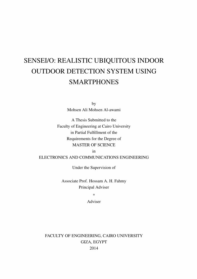
3.3 SenseI/O System Block DiagramFigure 3.2 shows inner view of senseI/O system. This system consists of fourmain blocks which represent sensing modules and they are Activity Recognition,Single smoothed cell tower, Wi- Fi based and Light Intensity. Also, one other soft-ware module (Virtual module) called environment processing unit (EPU) which isconsidered as control unit that organizes senseI/O system workflow. Each modulerelies on getting surrounding environment measurements on one or more types ofembedded sensors in today’s smartphones. For instance, all these modules col-lect their data from single sensor except intensity module which relies on threesensors, and they are light, proximity and time. Moreover, senseI/O should startsby accessing activity recognition module and then environment processing unit(EPU) selects cleverly which a next typical module will be used to provide finaloutput. This selection generally is based on some grounds like:
• User Activity Type: according to the resulted user activity type (In-vehicle,On-foot or Still), the environment processing unit (EPU) selects cleverlywhich a typical next module will be used to provide final output. For in-stance, next selected module will be single smoothed cell tower when thedetected user activity is inside vehicle (Direct detection case).
22
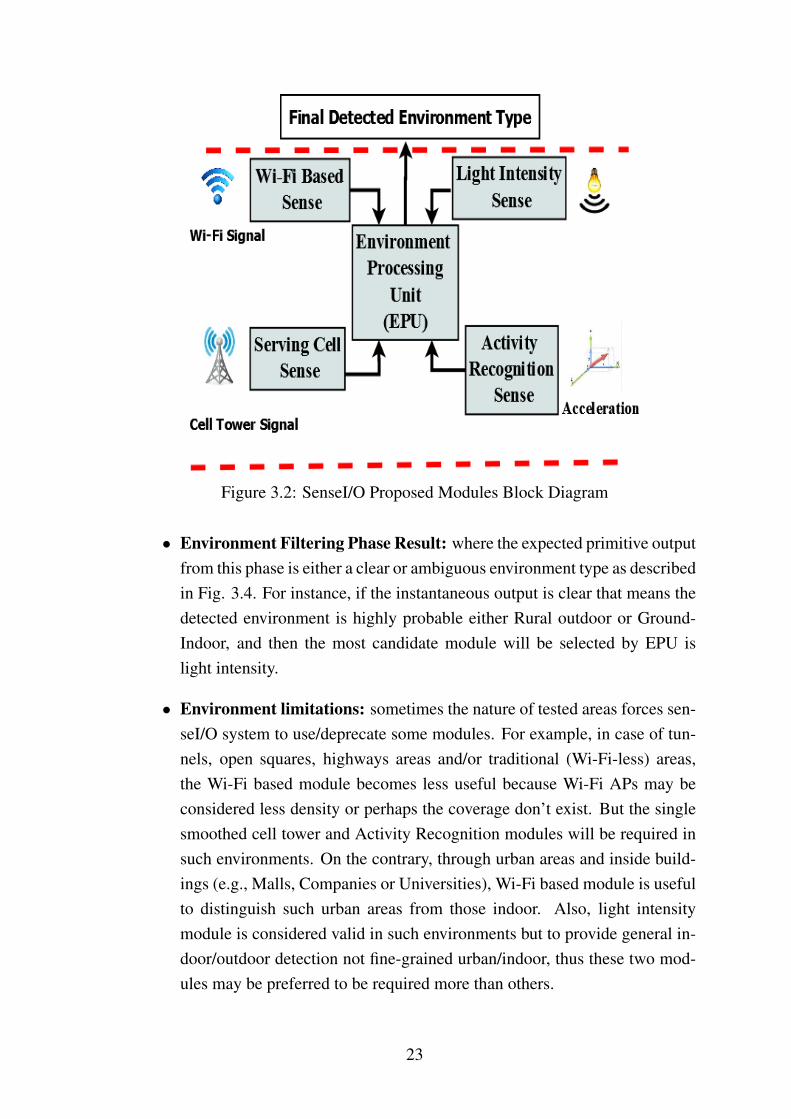
Figure 3.2: SenseI/O Proposed Modules Block Diagram
• Environment Filtering Phase Result: where the expected primitive outputfrom this phase is either a clear or ambiguous environment type as describedin Fig. 3.4. For instance, if the instantaneous output is clear that means thedetected environment is highly probable either Rural outdoor or Ground-Indoor, and then the most candidate module will be selected by EPU islight intensity.
• Environment limitations: sometimes the nature of tested areas forces sen-seI/O system to use/deprecate some modules. For example, in case of tun-nels, open squares, highways areas and/or traditional (Wi-Fi-less) areas,the Wi-Fi based module becomes less useful because Wi-Fi APs may beconsidered less density or perhaps the coverage don’t exist. But the singlesmoothed cell tower and Activity Recognition modules will be required insuch environments. On the contrary, through urban areas and inside build-ings (e.g., Malls, Companies or Universities), Wi-Fi based module is usefulto distinguish such urban areas from those indoor. Also, light intensitymodule is considered valid in such environments but to provide general in-door/outdoor detection not fine-grained urban/indoor, thus these two mod-ules may be preferred to be required more than others.
23

Figure 3.3: Coordinate system (relative to a device) that’s used by the Accelerom-eter Sensor API.
• Sensors Availability: it’s known that light sensor is unavailable on manyof today’s smartphones, so before selecting this module, sense I/O shouldcheck sensor availability first or jump to another typical module.
3.4 Activity Recognition PhaseThis phase is implemented as a software service running on android mobile de-vices. It is responsible for querying the accelerometer sensor in the mobile devicesand collecting their measurements. These measured values are defined in terms ofthe local coordinate system of the mobile devices ( x, y and z) as shown in Fig. 3.3.Accelerometer sensor are queried at the SENSOR_DELAY_UI query rate whichwas experimentally found to be corresponding to approximately 50 sample persecond on android mobile devices. This is the same rate used to detect the screenorientation change. This has the advantage of using nothing additional for the ac-tivity recognition over the normal energy for querying the inertial sensors. Then,we compute acceleration magnitude from those measured values and based on re-sulted values we classify current user activity into three main classes: In-vehicle,On-foot or Still as shown in next chapter in detail.
24

Figure 3.4: Illustration of the overlapping among Rural, Urban and Indoor envi-ronments based on single serving cellular RSSI measurements.
3.5 Environment Filtering Phase
The intuition behind this phase is that providing an instantaneous primitive fil-tering for surrounding environment whether clear or ambiguous based on singlesmoothed serving cellular RSSI collected readings. This phase is considered avery important one as it performs the first step of resolving ambiguity between in-door and urban environments, and accordingly senseI/O selects a typical modulewhich is responsible to provide the final environment detection afterwards. Thisphase will be invoked only when the outcome of the previous activity recognitionphase is On-foot or Still only.
Figure 3.4 describes more about such filtering. As we explained that oursenseI/O aims not only to cover indoor/outdoor detection, but to present a fine-grained rural, urban and indoor environments detection as well. Then, based onexperiments observations, we indeed proposed to study the relation between theseenvironments and single 3G cellular RSSI readings to provide more precise andrealistic distinction.
25

Methodology: all the absolute cellular RSSI measurements are collected fromthese environments separately using different android mobile phone mod-els (Samsung Galaxy S1 plus, LG and Samsung duos) which is in handwith screen facing up and in pocket scenarios. Actually, we implement 305experiments which cover 36 rural,urban and indoor different sites at Cairoand Alexandria cities. Each experiment consists of 90 RSSI values over pe-riod equal to 90 seconds (i.e., one value per second) with walking/stationarycases under different weather conditions during daytime and night. After-wards, experiment average is estimated to get final value per experiment ineach environment individually.
Observations: as shown in Fig. 3.4, dashed rectangles exhibit two clearRSSI-based environments overlapping and they are Rural/Urban and Ur-ban/indoor. This may occur due to many reasons such as natur of places,changes in mobiles connectivity and/or variations of antenna gain acrossdifferent mobile phone models. Therefore, this introduces realistic ambigu-ous problems in detection. In short, lower dashed rectangle, for instance,shows an overlapping between urban-outdoor and indoor areas, this will oc-cur due to that obstacles such as tall buildings, hills and/or trees which in-crease in such urban areas and lead to dropping dramatically in single cellu-lar RSSI measurements and look like those in indoor areas. Therefore, anytransition from urban into indoor will be undetectable because there is nohigh variation achieved. Similarly, for overlapping between Rural-outdoorand urban-outdoor areas. On the other hand, no overlapping between Ruraland indoor areas where single 3G cellular RSSI exhibits separated valueswhich lead to presenting a clear detection when experiment is within suchareas. Table 1 shows the tracing results of tested environments in detail.
Finally, based on these observations, we divided Surrounding environment intotwo main virtual and primitive categories which are Clear (Rural and indoor) andAmbiguous (Rural/Urban and Urban/indoor). It’s known that both classes rep-resent mainly outdoor/indoor environments, so querying another module to dis-tinguish these classes is required. In short, it’s known that light intensity moduleprovides only general indoor/outdoor detection, then applying such module in caseof the first class will be useful and efficient. In contrast, Wi-Fi based module isconsidered the suitable one that used to resolve ambiguity between Rural/Urbanor Urban/Indoor, as it’s known, the Wi-Fi APs density in rural areas are less than
26
Environment Type Rural Urban G-indoor-50→ -60 dBm 31 0 0-60→ -70 dBm 34 15 0-70→ -80 dBm 29 40 6-80→ -90 dBm 0 48 47-90→-100 dBm 0 0 48
-100→-110 dBm 0 0 7Overall 94 103 108
Table 3.2: Confusion matrix for filtering different environments based on singlesmoothed serving cellular RSSI.
those in urban or approximately doesnot exist. Also, Wi-Fi received signals inindoor areas are stronger than those in urban environments.
27

Chapter 4
SenseI/O Modules
As described in the previous chapter that the SenseI/O system block diagram con-sists of four main sensing sub-systems or called modules, these modules com-plement each other to infer the final fine-grained user surrounding environments.Also, SenseI/O contains an additional virtual software unit called Environmentprocessing Unit (EPU) to organize detection processing. In this chapter, we de-scribe proposed senseI/O activity recognition, single smoothed cell tower, Wi-Fi based and light intensity modules from side of android application develop-ment [32], challenges, solutions, and algorithms in detail as follows.
4.1 Activity recognition: first step of I/O detec-tion
In this module, we present simple, ubiquitous and accurate technique which at-tempts to infer user’s physical activity based on sensing readings of accelerometersensor equipped ubiquitously on most of today’s smartphones and deploy it toproduce an accurate indoor/ outdoor detection afterwards.
Figure 4.1 shows the method of classifying client activities and infer surround-ing environments. Activity recognition classifier is divided into two main classi-fication levels: the first level differentiates between shaken and fixed states ofsmartphones. For example, when smartphone being put on table or in the pocketof a stationary user either standing or setting down. The second level exhibits moreefficient activities classification called: Still, On-foot and Invehicle. Once the type
28

Figure 4.1: User activity recognition multi-level classifier.
of activity is identified , the senseI/O either returns the type of surrounding envi-ronment directly (through rapid detection method) or triggers another module toinfer the final ambient environment type.
For instance, while the detected activity client is In-vehicle, senseI/O logicallydecides that the detected surrounding environment is outdoor with high confidencelevel, but if it’s On-foot or still , hence SenseI/O will trigger to another module forproper detection. If detected client activity is Unknown, then senseI/O stays in thesame state till user activity state changes.
Unlike previous works, we group seven activities such as transportation modes(e.g., Train, Metro, Car and Bus) [17], user on-foot motion modes (e.g., Walking,Jogging and Running) [10] and Stationary mode into those three main categoriescalled: Still, On-foot and In-vehicle according to two main reasons. The first, in-ferring such fine-grained seven activities will be unnecessary due to our objective(Indoor/Outdoor Detection). The second is according to the similarities of accel-eration magnitude readings, estimated of three coordinates acceleration (X, Y, Z)of smartphones, observed among them as shown in Fig. 4.2. This figure generallyshows that the On-foot group activity types (Walking, Jogging and Running) haveacceleration magnitude values similar to each other and larger than the other In-vehicle and Still activities, and In-vehicle group activity types (Train, Metro, Car
29

Figure 4.2: Classification between On-foot, In-vehicle and Stationary of user ac-tivities based on accelerometer sensor readings.
and Bus) have acceleration magnitude values similar to each other and closer tostationary activity type. So, we simply consider that detection of all inside trans-portation modes is In-vehicle, all of motions modes is On-foot and Still when themobile is fixed.
Moreover, Figure 4.3 shows that the 3G smoothed RSSI cellular measure-ments drop dramatically inside some complex places (e.g., Tunnels and Under-ground stations) and look like those inside buildings. Such problems are accu-rately solved through exploiting such In-vehicle detection too.
SenseI/O system doesn’t only simply exploit In-vehicle user activity detectionto infer that the ambient environment is outdoor, but also utilize another senseI/Omodule called single smoothed cell tower which rely on 3G detected RSSI to infera fine-grained Rural, Urban or Underground (Tunnels and Underground stationscases) areas as shown in detail in the following chapter.
4.1.1 Activity Recognition Android ApplicationThis module is constructed based on Google Play services [41] which providesa very interesting, simple, and commercial API called Activity Recognition client[37] which is considered a part of Location Services. This API can open a gate of
30

Figure 4.3: Resolving an observed 3G smoothed cellular detection problem in-side some complex places (e.g, Tunnels and underground stations) using activityrecognition module.
whole new kinds of applications on most android smartphones. Activity Recogni-tion recognizes four activities 1] In-vehicle, 2] On-foot, 3] Still and 4] Unknownand provides each activity type with thier specific confidence levels. Also, wesummarize Activity Recognition client API advantages as follows:
• Activity recognition application is considered ubiquitous and simpler thanprevious related work to infer current client activity type [17].
• Possibility of connecting/disconnecting, when this module invoked to rec-ognize current client activity, the activity recognition client API immedi-ately connects with the location services using built in connect() and callRequest Activity Recognition Updates [6] methods. Similary activity recog-nition client API immediately disconnects the location services using builtin disconnect() and Stop Activity Recognition Updates [6] methods whenuser needs to leave activity recognition module.
• We can choose a suitable interval in milliseconds to request activity recog-nition updates from Location Services during connecting state. So, we canmaximize update intervals in order to save energy consumed or minimizethem to increase user activity detection accuracy.
31

Figure 4.4: Activity recognition application screenshot explains false activity de-tection concept
Figure 4.4 shows an android application screenshot of activity recognitionmodule where user activities and confidence levels are sent out periodically. Si-multaneously, logged data is stored on designed database inside smartphones fornext processing. Start and Stop buttons are for manually user control.
4.1.2 Optimized activity recognition moduleFalse activity detection
During experiments, we observed that reliance on the activity recognition resultsdirectly is not proper and leads to inaccurate detection where false activity detec-tion rates will increase. False activity detection implies that activity recognitionmodule indicates false activity type due to rapid user activities fluctuations.
Black rectangule in Fig. 4.4, for example, clearly shows that the detectedactivity is On-foot while user is walking. Suddenly, when user decides to changehis state and starts to slow down pedestrians, hence acceleration readings will dropand seem like those inside the vehicle according to figure 4.2. Then the detectedactivity will be In-vehicle rather than on-foot/Still for couple of times then being
32

Algorithm 4.1 Activity recognition module algorithm>> C : Certainty value>> Cmax : Maximum certainty threshold
1. Detect the current recognized user activity
2. Previous detected user activity is saved and compared to the current de-tected activity
3. If both are similar
4. Increase C→ C+1
5. Check if C equal Cmax
6. Final activity type is declared and C→ 0
7. Else return to line 1
8. Else if both are not similar and (C < Cmax)
9. Put C→0 and return to line 1
10. End
stable still afterwards. Similarly, when the user is In-vehicle and if the speed ofthe vehicle slows down due to traffic congestion, the detected activity will be Stilltype while in fact user still In-vehicle. This observation definitely affects detectionaccuracy sufficiently, so we optimize such module to rely on a couple of detectedsequences activities instead of single activity.
We propose a certainty concept which implies focusing on a series of iden-tical activities rather than single activity and decides final user activity whenthe number of these activities reaches specific threshold value called C_{max}.Current detected activity is saved and compared with the following detectedactivity type, C is increased when both the previous and current are simi-lar. Otherwise, we reset C to 0, detection identified as error (False Detection)and clear these activities. Then, similar determined activites are merged andcompared with the next detection. A final activity type is declared when Creaches C_{max} as described in activity recognition algorithm (algorithm 4.1).
33

4.2 Single smoothed cell tower RSSI for I/O de-tection
It’s known, the correlation between single 3G cellular RSSI readings and surround-ing environments varies according to the type of ambient environment. So, we aimto exploit such variation in our objective where it demonstrate the reason behinddividing surrounding environments into fine-grained areas such as Rural outdoor,Urban outdoor and Indoor. Then, we exploit this phenomenon to infer an accuratedistinction for these environments based on those RSSI values.
4.2.1 Serving Single cell tower advantagesIn this module, we first describe some single cell tower features which have beenexploited in our work and the motivation to choose single cell tower:
• Reliability: as it’s known that all kinds of mobile devices constantly searchfor the closest neighbor cell towers and sense their signal strengths, thenlock on the strongest one called serving single cell tower. So, such devicescan simply guarantee connect to at least one cell tower called serving celltower and log its information any where as long as it is ON and connectedto the base station.
• Realistic: most of mobile devices can’t sense and log RSSI values of allvisible cell towers simultaneously especially in high-end smartphones dueto lack of API support. In addition, availability density of all visible celltowers in many places is very limited [18]. Therefore, reliance on sensingmultiple cell towers needs sufficient coverage to detect the required numberof surrounding cell towers (up to 7 cell towers) and confidently infer theambient context. These challenges donot exist in case of single cell towerwhich are considered as an advantage exploited in our work to avoid suchlimitations on previous works and present a realistic system.
• Availability: single cell tower RSSI values are always available ubiqui-tously and can still be heard and log its information (e.g., Cell-ID andRSSI) even in difficult places like tunnels, stores and underground areas.However, (e.g., GPS) exhibits unavailable in indoor places and provides in-accurate performance in urban areas especially for pedestrian smartphone
34

Figure 4.5: Moving average sliding window smoothing of single 3G cellular RSSIreadings
usage [34]. Also (e.g., Wi-Fi) is a short range connectivity and may beunavailable in large open areas like highways, bridges and open squares.
• Energy cost-less: some sensors are extremely power-hungry especiallyfor continuous scanning and consume much extra unnecessary energy ina problematic areas (e.g., GPS). In addition, it exhibits inaccurate perfor-mance in urban/indoor places which is well known. But, cost of sensingassociated cell tower is negligible and mainly there is no extra energy con-sumption because mobile phones have to maintain connecting to associatedcell tower for basic communications.
4.2.2 Serving single cell tower limitationsWe first implement large number of experiments to sense single cell tower RSSIin numerous sites in Cairo such as open squares, bridges, highways and smartvillage (Rural-outdoor), through our university campus buildings, crowded areasand narrow streets (Urban-outdoor), inside stores, our college buildings groundfloor and mosques (indoor). During these experiments, the key challenges weobserve that single serving RSSI measurements suffer from two main limitationshandover and corner effect [40] .
35

4.2.2.1 Handoff and Corner effects:
Handoff is the process of changing the channel (frequency, time slot, spreadingcode, or combination of them) of associated current connection while a call is inprogress [44]. Handoff effect happens because such many mobile phones handoverfrom one cell tower to another, this limitation clearly appears in case of in-vehicleuser mobility where a number of occurrence handoffs will increase. Handoffs alsohappen due to many reasons like relative signal strength, relative channal capcityor MS moving out from connected BS range into another BS range as follows:
1. When the strength of the signal from the base station that the mobile is usingstarts to fall to a level where action needs to be taken. The cellular networklooks at the reported strength of the signals from other cells reported by themobile.
2. When the base transceiver station nears its capacity, which mobile is servingwith, the network may decide to hand some mobiles over to another basetransceiver station they are receiving that has more capacity, and in thisway reduce the load on the base transceiver station that is nearly running tocapacity.
3. When the user activity is In-vehicle and MS moving out from connected BSrange of coverage into another BS range of coverage and so on [20], thensuch multiple handoffs will occure to ensure maintaining mobile devicebeing associated to idenitifed base station.
Corner effect happens when user moves around environments and mobile phonemay immediately pass near some obstacles such as corners which affect 3G cellu-lar RSSI values to drop dramatically. These significant variation drops may looklike false ambient environment detection. For example, while the user is in openareas, the detected RSSI readings are in rural readings range, then suddenly userpasses near such big corner obstacle which make RSSI readings immediately dropto looks like those in urban or indoor readings range which gives false indication .
4.2.3 Moving average smoothingActually, we consider such handover and corner effect limitations as noises be-cause they represent short-time rapid fluctuations (Milliseconds) and need somesmoothing.
36

Figure 4.6: Effect of Moving average sliding window method on single cell towerreadings to overcome handover and corner effect errors.
We remove this kind of noises using the most common noise removal methodcalled Moving Average Smoothing [38]. We rely on the averaged value of the WRSSI samples defined as RSSIAVi rather than absolute samples. We denote i asindex of slide window, W as sliding window size and K as index of absolute RSSIsample.
More precisely, if the input absolute RSSI values are RSSI =RSSI1,RSSI2,..,RSSIn
,n defined as total number of logged RSSI samples. The output of the movingaverage filter is: RSSIAVi = [(RSSIK + RSSIk+1 +RSSIk+2 +.....+RSSIk+w) / W ],1 ≤k ≤n , as shown in Fig. 4.5. Figure 4.6 demonstrates the effect of handoverand/or corner limitations where dashed rectangle clearly shows a spike in single3G cellular RSSI readings and leads surely to erroneous decisions. After applyingmoving averaging smoothing, the spike is almost eliminated. Smoothing degreechanges according to sliding window size, then we try to set W= 10, and W= 20.As shown in the Fig. 4.6, when sliding window size is large enough, we eliminatethe spike more effectively. This section should close with the serving cell towerRSSI urban/indoor ambiguity problem that we demonstrate using Fig. 3.4, andhow its a major challenge not studied before in the literature.
37

Figure 4.7: Single smoothed cell tower android application screenshot
4.2.4 Single smoothed cell tower android applicationFigure 4.7 shows a screenshot of the developed single smoothed cell tower moduleandroid application where it’s applicable to most brands of smartphones such asSamsung, HTC and LG [32]. The class we used was TelephonyMananger [5]where it provides access to information about the telephony services on the device.Applications can use the methods in this class to determine telephony services andstates, as well as accessing some types of subscriber information. As shown, byusing this module, we can get extra information related to single 3G cell towers,part of this information is fixed and the other is variable. Fixed information partis phone type (GSM or CDMA) and Networks information (Name, type, MCC,MNC and network operational name) while the variable part is associated cellinformation (Cell-ID and Cell-lac) and signal strength in dBm. Such smoothingoperation is online, prompt and infrastructure-less (mobile-stand alone). When
user activates such application a specific listener class called PhoneStateListener[4] immediately registered. Such listener class continuously retrieves informationupdates when such cell location or signal strength information changes. All thisinformation will continuously be stored in a designed database or inside certainfiles inside device’s memory for later processing.
38

4.3 Leveraging WiFi for the urban/indoor am-biguity problem
Motivated by the urban/indoor ambiguity problem faced by 3G RSSI solutions,which have not been addressed before in the open literature and we demonstratedusing realistic results, we propose to bypass this hurdle using WiFi APs, typicallydeployed indoors.
4.3.1 Module DescriptionWith the ubiquity of WiFi-enabled smartphones, and large scale access point de-ployment, WiFi-based sensing is one of the most promising indoor/outdoor de-tection signatures. Due to GPS limitations in urban/indoor environments, manyurban tracking and indoor localization systems use WiFi received signal strengthindicators (RSSI) updates to be one of the most attractive techniques due to it’sreliance on ubiquitously deployed infrastructure.
In this module, we aim to collect Wi-Fi based sensing information (i.e., BSSID,RSSI and SSID) especially to present an accurate urban/indoor environments de-tection. As it’s known, most high-end smartphones support Wi-Fi technology andnowadays most users automatically enable their Wi-Fi connections for self usagewhen becoming inside buildings like (homes, companies, universities and malls).
Then this will reduce the energy demand pain in our work. Furthermore, Wi-Fi sensing exhibits high power demand especially in case of periodic and con-tinuous sensing and this acted as the most challenge which faced us during im-plementing Wi-Fi based sense module. Therefore, we present some solutions toreduce energy demand challenge through:
• We use less expensive sensors (e.g., accelerometer) more often, therebyadopt usage of expensive sensors (e.g, Wi-Fi) accordingly. More precisely,user has three main activities and they are In-vehicle, On-foot and Stillprovided by activity recognition module based on accelerometer embed-ded sensor on most smartphones that can be used to determine movementor orientation. Then the EPU unit on senseI/O system periodically moni-tors activity recognition output and should decide to enable/disable Wi-Fisensing accordingly. Once the single serving cellular RSSI failed to detectsurrounding environment and environment filtering phase exhibits an am-biguity case, then EPU first triggers activity recognition module to detect
39

Figure 4.8: Distribution of all visible Wi-Fi access points number density at sur-rounding urban/indoor environments.
user activity type and wakes Wi-Fi sense if that detected user activity isOn-foot or In-vehicle. Otherwise, if activity recognition movement is Still,EPU will trigger Wi-Fi sense to sleep.
• We use Wi-Fi based module through certain user movement scenarios (justthrough urban/indoor), for short scan periods and in case of lacking othermodules. For example, in case of rural outdoor scenarios, light intensitymodule will be more useful than Wi-Fi becuase Wi-Fi RSSI will be nonexistent and difficult to be heard than those in urban/indoor environmentsas explianed next.
4.3.2 Android applicationFigure 4.9 shows a screenshot of the developed Wi-Fi based sense module androidapplication where it’s applicable to most brands of android phones such as Sam-sung, HTC and LG [32]. The class we used was Wi-Fi manger [3] where this classprovides the primary API for managing all aspects of Wi-Fi connectivity, it dealswith several categories of items:
40

• The list of configured networks. The list can be viewed and updated, andattributes of individual entries can be modified.
• The currently active Wi-Fi network, if any. Connectivity can be establishedor torn down, and dynamic information about the state of the network canbe queried.
• Results of access point scans, containing enough information to make deci-sions about what access point to connect to.
As shown in this android application, we try to get some information relatedto Wi-Fi based module, part of this information is BSSID (the address of the ac-cess point), (SSID) the network name and the final part is the detected signal levelin dBm. The class we used to get all this information was ScanResult [2] whichdescribes information about detected access points. Also, we can control Wi-Fisensor and enable/disable it easily by using wifiManager.setWifiEnabled() methodin order to extend battery life and reduce energy consumption. All the requiredparameters will be gathered with each scan and based on Wi-Fi proposed algo-rithm, the final detected ambient environment immediately will be inferred in realtime as shown in the android application. All this information continuously willbe stored in a designed database or inside certain files inside device’s memory forlater processing.
4.3.3 Module featuresThe intuition behind such module to identify that type of surrounding environmentis one of the two following categories: urban or indoor. Our approach is based onsome important Wi-Fi features to differentiate between them as follows:
1. All visible Wi-Fi APs number: the intuition is the number of all visi-ble detected Wi-Fi nodes , based on their MAC addresses (BSSID) whereeach AP has unique MAC address, inside buildings will be less than thosein urban outdoor environment because that mobile device inside buildingwill be able to sense nearby and line of sight access points exist inside thesame building only. In contrast, in urban outside areas, especially near tosurrounding buildings and through narrow streets, mobile device is able tohear much more number of Wi-Fi access points.
2. RSSI average of all visible Wi-Fi APs: we can sense power strength(RSSI) of all visible Wi-Fi access points every scan at urban and indoor
41

Figure 4.9: Wi-Fi based module android application screen shot
environments by using mobile devices. Then, this feature captures the in-tuition that these APs exhibit RSSI average in indoor areas stronger than inurban outside areas. This is because user inside the building will be nearbyand line of sight with many of indoor nodes where correctness percentagevaries according to user mobility scenario. On the other hand, APs exhibitvery weak RSSI records but still heard by client’s mobile when passing inurban outside areas like through buildings and narrow streets.
3. Number of Wi-Fi APs in the 1st and 2nd classes: we are able to mea-sure, every scan, the received signals strength from all visible Wi-Fi accesspoints. Then we aimed, in addition to estimating their average and number,to infer other useful features which classify Wi-Fi APs seen by smartphonesuser into two main classes called 1st and 2nd classes based on absoluteRSSI value of each AP individually. Consequently, for each access point, ifits RSSI value falls within the strong RSSI range, so it belongs to 1st APsclass. Similarly, the AP which presents RSSI value within the lower RSSIrange will belong into 2nd APs class. Hence, we count the number of Wi-FiAPs in each class to give us an indication whether the surrounding site isurban or indoor areas.
42

Figure 4.10: Distribution of RSSI average for all visibleWi-Fi access points atsurrounding urban/indoor environments.
To infer these features, we developed an android application to log all visibleWi-Fi APs information (RSSI and BSSID) from surrounding urban/indoor envi-ronments. Then we experiment this application on many types of android smart-phones to ensure avoiding the issue of varying measurements over different mobilemodels. During experiments, we implement more than 300 scans through 26 sitesin indoor areas like (Malls, Universities, companies and Homes) and during thesurrounding urban areas with different mobility scenarios (Still and walking).
Figure 4.8 shows how the Wi-Fi APs density varies significantly in urban andindoor areas respectively. This figure says clearly that, during the first 160 scans,urban sites exhibit all visible Wi-Fi APs density confined between thresholds α1and α2, and sometimes upper than threshold α1 reach to 35 APs. In contrast, theother 160 scans, indoor sites often exhibit visible Wi-Fi APs density lower thanthreshold α2 reach some times less than 5 APs.
Figure 4.10 shows that average of all visible Wi-Fi APs RSSI exhibit distinc-tive signature in urban and indoor sites. We observe that most collected averagevalues of all visible Wi-Fi APs RSSI in indoor sites are higher than β1 thresh-old. This is seen logical because the majority of these nodes should provide strong
43

(a) (b)
Figure 4.11: (a): Distribution of the 1st order class Wi-Fi APs number at Ur-ban/Indoor environments. (b): Distribution of the 2nd order class Wi-Fi APs num-ber at Urban/Indoor environments.
RSSI readings to meet connectivity considerations. Unlike average values col-lected at urban sites where most of them are lower than β2 because most detectedsignals are weak signals, but still can be heard, due to buildings structure anddistances considerations.
Figure 4.11 shows the number of detected Wi-Fi APs belongs to 1st and 2ndclasses during experiments implemented in many indoor and urban areas. In short,Fig. 4.11 (a) shows through the first 160 scans, in indoor areas, that the number ofdetected Wi-Fi APs belong to the 1st order class which is defined by RSSI valueshigher than (-69 dBm) varies between one AP and reaches Four APs sometimes.In contrast, through the second 160 scans in urban environments, the number ofdetected Wi-Fi APs belonging to the same class is usually zero AP and sometimesreaches one AP at most.
Similarly, Fig. 4.11 (b) shows through the first 160 scans, in indoor environ-ments, the number of detected Wi-Fi APs belong to the 2nd order class which isdefined by RSSI values within range (-80≤ RSSI ≤ -70) dBm varies between oneAP and reaches six APs sometimes. In contrast, through the second 160 scans,in urban environments, the number of detected Wi-Fi APs belonging to the sameclass is usually between one AP and sometimes reaches three APs at most.
During tracing all tested indoor and urban sites, we observe almost all in-door sites exhibit APs number of the 1st order class is larger than at urban sites.
44

Figure 4.12: CDF number of Wi-Fi APs in the 1st and the 2nd order classes inurban and indoor environments.
This occurs because the probability of the expectation that the user, during indoormovements, becomes very close to such APs will be high. Furthermore, it is ex-pected that the number of APs which have RSSI values belongs to the 2nd orderclass during indoor sites are larger than those in urban sites as shown in plottedFig. 4.12. Figure 4.12 clearly shows the CDF plot of number Wi-Fi APs belongsto the 1st and the 2nd order classes at indoor sites versus urban sites.
45

Algorithm 4.2 Wi-Fi Based sense module algorithm>> WAP_D: All visible Wi-Fi APs density per scan.>> WAP_Avg: RSSI Average of All visible Wi-Fi APs per scan (dBm).>> 1st_APs: Number of the 1st Order class Wi-Fi APs per scan.>> 2nd_APs: Number of the 2nd Order class Wi-Fi APs per scan.
1. if (WAP_D≥α1 & WAP_Avg ≤β2 )
2. Then, detected env is Urban-Outdoor with high level confidence.
3. elseif (1st_APs ≥1 or (2nd_APs≥ 3 & WAP_Avg ≥ β1))
4. Detected Env is Indoor
5. elseif(WAP_D≤α2 & 2nd_APs ≤ 3 & WAP_Avg ≥ β2 )
6. Detected Env is Indoor.
7. elseif((WAP_D ≥ α2 & WAP_Avg ≤ β2) or (2nd_APs ≤3 &WAP_Avg ≥β2))
8. Detected Env is Urban-Outdoor.
9. End.
Based on these significant features, we construct Wi-Fi sense module algo-rithm as shown in algorithm 2.
46

4.4 Light detector: last resort for WiFi-lessbuildings
As a last line of defense against the urban/indoor ambiguity problem for WiFi-lessbuildings, we resort to the low-energy ambient light sensor onboard smartphonestoday.
4.4.1 Module DescriptionThe Android platform provides numerous environment sensors that let us monitorvarious environmental properties. In this module, we use some of these sensorslike light and proximity sensors equipped with Android-powered devices to mon-itor ambient light intensity and record relative measurements. Most environmentsensors are hardware-based sensors where they will be available only if devicemanufacturers have built them into a device. Environment sensors are not alwaysavailable on devices. Because of this, it’s particularly important that you verify atruntime whether an environment sensor exists before you try to acquire data fromit.
4.4.2 Related-used sensorsIn this module, we used three main sensors are light, proximity and system timeclock as follows:
4.4.2.1 Proximity Sensor
The proximity sensor is common on most smartphones, the ones that have a touch-screen [7]. This is because the primary function of proximity sensor is to disableaccidental touch events. Proximity sensors would be useful to reveal the nearnessof an object to the phone. We might often experience that screen of smartphoneswould turn off when we bring the phone to our ears when we are in a call and thescreen will turn on when we take it back. This is because the proximity sensor rec-ognizes the object near the phone, the optical proximity sensors can detect bodiesin the vicinity of the device up to 5cm as shown in Fig. 4.13(a). Proximity sensorreturns two binary values only for each data event either far or near as shown inFig. 4.13(b). The position of light/proximity sensors are in the upper-left side onmost of today’s smartphone types as shown in Fig. 4.13(c).
47

(a) (b) (c)
Figure 4.13: (a): Proximity Sensor concept. (b): Proximity sensor outputs. (c):light/proximity sensors position.
In our work, we exploit this feature to give an indication whether the androiddevice is in the pocket, on table with screen facing down or on the hand with screenup to ensure intensity record values correctness.
4.4.2.2 Light Sensor
Unlike most motion sensors and position sensors, which return a multi-dimensional array of sensor values for each sensor event, environment sensorsreturns a single sensor value for each data event. For example, light sensor returna single sensor value of ambient light intensity for each sensor event where unit ofmeasured light readings is lx (Illuminance).
4.4.2.3 System time clock sensor
This sensor is common on most smartphones, it is responsible for returning thecurrent date and time data according to the smartphone setting. In our work, weexploit such sensor and measurements to determine current user time either inthedaytime or at night to enhance light intensity module performance as it will belater.
48

(a) (b)
Figure 4.14: Light intensity android application screenshots
4.4.3 Light android applicationFigure 4.14 shows a screenshot of the developed light intensity based sense moduleandroid application where it’s applicable to most brands of android phones suchas Samsung, HTC and LG [32]. The class we used was Sensor manager [1] wherethis class lets developers access the device’s sensors and provides the primary APIfor managing all aspects of sensors enabling, disabling and collecting information.
The raw data acquired from the light, proximity, and system time clock sensorsusually requires no calibration, filtering, or modification, which makes them easyto use. To acquire data from these sensors, we first need to create an instance ofthe SensorManager class, which we can use to get an instance of a physical sensor.Then, we register a sensor listener in the onResume() method, and start handlingincoming sensor data in the onSensorChanged() callback method.
As shown in this android application, we try to get some information related tolight intensity module like maximum and current light measurements, proximity(Far or Near) and current system time clock. We always make sure to disablesensors that we don’t need, especially when the application activity is paused. If
49

Figure 4.15: Light intensity pattern when user moves into indoor, then return outto outdoor during a sunny day with smartphone in hand and screen facing up.
it failed to do so, the battery could drain in just a few hours. We noted that thesystem will not disable sensors automatically when the screen turns off.
4.4.4 Light intensity module designWe normally observe that during daytime, brightness inside a building is muchlower than outside because brightness source for outdoor sites is sunlight whereintensity much higher than indoor light intensity that relies on artificial light evenon cloudy or rainy days. The major reason is that the intensity of sunlight withinthe visible spectrum is normally much higher than that from ordinary lightinglamps. During experiments, we observe that environment sensors exhibit benefi-
cial signature pattern when user moves from indoor out to outdoor areas or viceversa. Unfortunately, most of today’s android smartphones don’t support preciselight intensity readings because full accessing to the light sensor on android OSplatform is still locked. Thus, we rely on supported discrete light sensor readingslevels only, where the light intensity value will round to the closest level. To furtherinvestigate that, we develop light intensity android application on different typesof smartphones like (Samsung S plus, Samsung S2 and HTC Desire S), all havealready been equipped with light and proximity sensors. Then, we conduct a set of
50

Figure 4.16: Light intensity readings signature all day (24 hour) with clear over-lapping between outdoor and indoor environments.
experiments to collect light intensity readings at many indoor/outdoor sites duringdaytime and night periods under sunny/cloudy weather. For example, Samsung Splus smartphone provides five discrete reading levels (6,1000,5000,9000,15000)in case of mobile device in hand and screen facing up.
Figure 4.15 shows that the collected discrete readings clearly exhibit distinc-tive indoor/outdoor pattern during user transition with smartphone in hand andscreen facing up. When user moves from outdoor to indoor at 50 sec the lightreadings significantly drop to be equal or less 5000 (Lux),then it raises up to bemore than 5000 (Lux) when the user return again out to outdoor area.
Unlike previous work, we address and resolve some realistic challenges asfollows:
• Lack of fine-grained environment detection: SenseI/O framework aimsto present a fine-grained rural, urban and indoor environments detection.Unfortunately, light intensity module is limited to support such detec-tion where light intensity sense module, in fact, can provide accurateindoor/outdoor detection only without additional distinction between ru-ral/urban outdoor areas.
51

• Ambiguity periods (namely dawn and dusk): as shown in Fig. 4.16, wecollect 24 hour light intensity readings to monitor light signature variationsin indoor/outdoor environments all day by using discrete readings of mobiledevice only (Mobile stand alone) and discovered another challenge calledambiguous periods. This figure shows that at night (i.e., 1:00 to 5:00 and18:00 to 24:00) smartphones provide outdoor light intensity readings whereare much lower than in indoor ones. Similarly, in the daytime (i.e., 8:00 to16:00) light intensity at outdoors is much higher than at indoors. These pe-riods called clear periods, also we notice that there are ambiguous periods(i.e., 5:00 to 7:00 and 16:00 to 18:00) in the day where smartphones ex-hibit the same intensity levels in both indoor/outdoor environments and thisleads to failing in detection. The major reason behind this is that, these peri-ods represent critical times where outdoor environment brightness is muchless. This ambiguity challenge wasn’t investigated in previous work [45]because they used TelosB motes light sensor which precisely provides lightreadings (not discrete levels) to monitor light intensity all day. So, lightmodule should first start checking current time by using system clock tocheck either clear or ambiguous periods.
Finally, based on those observations and challenges, we construct light intensitymodule algorithm as shown in algorithm 4.3.
52

Algorithm 4.3 Light intensity sense module algorithm>> BL1 : First light intensity threshold>> BL2: Second light intensity threshold>> Li : Current light intensity measurement
1. Check light sensor availability on Smartphone
2. if available , check Proximity Smartphone status
3. if FAR
4. Check Current Time System clock
5. if Clear Time
6. Get Li
7. if (Li > BL1) and Current Time is a Daytime
8. The ambient Environment is OUTDOOR
9. elseif (Li ≤ BL1) and Current Time is a Daytime
10. The ambient Environment is INDOOR
11. elseif (BL2 <Li ≤ BL1) and Current Time is a Night
12. The ambient Environment is INDOOR
13. elseif (Li ≤ BL2) and Current Time is a Night
14. The ambient Environment is OUTDOOR
15. else (Light sensor unavailable, Ambiguity Time or In pocket)
16. Skip light intensity module
17. end
53

Chapter 5
SenseI/O PerformanceEvaluation
In this chapter, we evaluate the performance of SenseI/O framework through twomain levels: (1) SenseI/O modules individually in order to assess their merits andlimitations, (2) The entire SenseI/O system, under plausible scenarios.
The following details are the experiment setup, evaluates the performance ofeach module individually and the performance of specific scenarios of the wholesystem.
5.1 Experimental SetupThroughout our experiments, measurements are collected using different mobileusers walking multiple trips over different paths to assess the performance of eachSenseI/O module over diverse scenarios. Some trips are made indoors (insidebuildings, e.g., home, companies, universities and malls), others are made in ruralareas (e.g., open areas, squares and bridges), others are made in urban areas (e.g.,narrow streets, between tall buildings and crowded areas) and others are made incomplex areas (e.g, tunnels and underground metro stations).
Usable Devices: We implemente and evaluate the SenseI/O prototype
system on Android Platform and tested its performance on different types of mo-bile phones including Samsung Galaxy S1 Plus, Samsung Galaxy Duos GT-S7562,LG-E615 and T-mobile G1. These mobile phones are equipped with all sensorsneeded by SenseI/O, that is, proximity, time, accelerometer, 3G cellular, Wi-Fi.
54

The light sensor is available only in Samsung Galaxy S1 Plus device. In addition,these mobile devices support a variety of Android versions like 1.5, 2.3, 4.0.4and 4.2.0, ensures the comparability and portability of SenseI/O to different O/Sversions, phone vendors and models.
Datasets: to evaluate the performance of SenseI/O, we have collected 56hours worth of data for different mobile user modes, namely riding transportationmeans, walking and stationary. This has been done in more than 52 different sitesin the two largest cities in Egypt, namely Cairo and Alexandria. The measurementsthat we have collected comprise two different datasets.. The measurements that wehave collected consist of two different datasets.
• Data collected by individual SenseI/O modules, namely single smoothed3G cellular, Wi-Fi based, activity recognition and light intensity detectorduring winter 2014. Approximately 35 hours of data were collected overdifferent rural, urban, indoor, tunnels and underground metro stations.
• Data collected for three specific SenseI/O test scenarios during summer2014. This dataset constitutes approximately 21 hours collected from anumber of paths of 2-5 km length, on the average.
5.2 Performance Results for Individual Sen-seI/O Modules
In this section, we compare the performance of the four major SenseI/O modulesto the ground truth and select baseline schemes from the literature.
5.2.1 Performance of activity recognitionThe approach of this module represents a typical system based on the accelerom-eter magnitude. We consider the following eight fine-grained user activities in ourevaluation: Stationary, Walk, Jogging, Running, Car, Bus, Metro and Train. Un-like previous work, we omit the detection of these eight user activities, focusinginstead on the detection of three main activities which are In-vehicle, On-foot andStationary according to our objective (i.e., inferring indoor/outdoor detection) andthe similarities on the acceleration magnitude values which are observed amongthose eight activities.
55

In-vehicle On-foot Still FP FN Correctness TotalTrain 146 0 12 7.6% 0% 92.4% 158Metro 204 0 25 10.91% 0% 89.09% 229Bus 153 0 15 8.9% 0% 91.1% 168Car 119 0 17 12.5% 0% 87.5% 136
Walking 10 150 0 0% 6.25% 93.75% 160Jogging 2 40 0 0% 4.76% 95.24% 42Running 3 45 0 0% 6.25% 93.75% 48
Stationary 26 0 244 0% 9.62% 90.38% 270Overall 9.97% 6.72% 1211
Table 5.1: Confusion matrix of classifying different personal user activities
We evaluate the performance of the two cases and they are : (1) normal activ-ity recognition which directly relies on the module’s outputs (i.e., before applyingour designed certainty algorithm), (2): optimized activity recognition which re-lies on the outputs after applying certainty algorithm. The same data collectionbehavior is used for the both, tested through a large variety of everyday trans-portation lines for a period of several minutes per experiment for each participant.Moreover, because the phone in the pocket placement is considered noisy and notprovided by activity recognition API client, the data is collected from only In-hand sensor placement regardless the screen is facing up or turning down to theground. Furthermore, we have collected everyday transportation, on-foot motionsand stationary activity data from four individuals. The participants were askedto collect such sensor data during their normal everyday behaviors and to recordground truth labels. The everyday data covers a total of over 20 different routeswhich were tested during various times and traffic conditions.
Table 5.1 shows the confusion matrix of classifying different personal useractivities after applying optimized activity recognition certainty algorithm. Thetable clearly shows that the total number of tested traces for each activity type andthe false detection (FP and FN) percentages. The overall FP (false positive meansthat the user in fact is in-vehicle whereas the detected activity is on-foot/stationary)and FN (false negative means that the user in fact is on-foot/stationary whereas thedetected activity is in-vehicle) ratios are 9.97% and 6.72% respectively.
Figure 5.1 compares the detection accuracy of optimized activity recognitioncase with the detection accuracy of normal activity recognition case. The resultshows that the optimized module is much better, where the detection accuracyratio is enhanced in case of In-vehicle and On-foot/Still by approximately 7.3%and 8.8% respectively compared to the ground truth. Such enhancing leads to
56

(a) Optomized Activity Recognition Module (b) Normal Activity Recognition Module
Figure 5.1: Detection accuracy evaluation of optimized vs. normal user activityrecognition module in order to infer ambient Outdoor/Indoor environments.
increasing the opportunities of indoor/outdoor detection, where such In-vehicleactivity detection should mean that the ambient environment is outdoors (outsidebuildings) with high level of confidence.
57

5.2.2 Performance of single smoothed 3G cellular
Environment type Clear AmbiguousRural Indoor Rural/Urban,Urban/Indoor
Range RRAR RIAR RUARValue (dBm) Higher -60 Lower -90 Between (-61 & -89)
Table 5.2: List of the thresholds used in the Smoothed 3G RSSI cellular filteringfor ambient environments.
In this module, we omit the noisy absolute 3G RSSI measurements, focusinginstead on single smoothed 3G RSSI measurements based on moving averagingsliding window method. As mentioned in chapter 2 that 3G RSSI measurementsis problematic and suffer from sufficient ambiguity in detection especially in Ru-ral/Urban and Urban/Indoor environments. Therefore, we examine the detectionperformance of this module to report and evaluate the capability of resolving suchchallenge independently. We find it effective to distinguish Indoor environmentfrom the Rural/Urban (Outdoor) environments.
A number of the used thresholds are applied to decide each ambient environ-ment type and to differentiate clear from ambiguous ranges accordingly. Thesethresholds are found to be stable and their values are listed in table 5.2. The valuesof these thresholds are selected based on our experiments observations explainedin Fig. 3.4 .
Figure 5.2 shows the evaluation results, once the mobile phones are in therural/urban (outdoor) environments, the detection accuracy ratio is around 72%.When the phones are in the indoor environment, the detection accuracy is around50.9% only whereas ratio 49.1% of traces is classified as a detection error, becausethe ambiguous problem is between indoor/urban-outdoor. The results clearly showthat this module is independently ineffective to infer fine-grained rural, urban orindoor ambient environments or even indoors/outdoors. So, we decide to exploitthis module only to infer a primary indication of the type of ambient environment(i.e., clear or ambiguous) as described in chapter 3.
58

Figure 5.2: Single smoothed 3G cellular based detection between outdoor( Ru-ral/urban) and indoor areas according to clear/ambiguity environments assump-tion.
5.2.3 Performance of Wi-Fi based
Symbole α1 α2 β1 β2 1st_order_thr 2nd_order_thrValue 15 8 -80 dBm -85 dBm 1 3
Table 5.3: List of the thresholds used in the Wi-Fi based detection module algo-rithm.
In this module, we focus on collecting specific information parameters whichare RSSI, SSID and BSSID per scan. This data is collected in specific envi-ronments are urban/indoor environments only, in order to resolve the ambiguousdetection challenge as described in chapter 3. We experiment and evaluate thismodule independently over 36 urban/indoor sites which include buildings (e.g.,houses, companies, malls and universities) in 2 different cities in Egypt (Cairo andAlexandria). Data is collected by different individuals when the phone is kept
59

in hand and in pocket for a number of trips with different paths of surroundingindoor/urban environments. Some trips are made outside buildings (i.e., throughurban areas near to buildings) and others are made inside mentioned buildings. Anumber of thresholds are applied to the designed Wi-Fi based algorithm to effec-tively decide ambient environment type. These thresholds are found to be stableand their values are listed in Table 5.3. The values of these thresholds are selectedaccording to our experiments observations explained in section 4.3 .
Figure 5.3: Wi-Fi based module detection accuracy for Urban-Indoor environ-ments.
Figure 5.3 shows the result of applying the Wi-Fi based module algorithm onmeasured Wi-Fi measurements (RSSI, BSSID and SSID). Once mobile phones arein urban (outdoor) environments, the detection accuracy ratio is around 90.12%,
60

whereas when mobile phones are in the indoor environments, the detection accu-racy ratio is around 84.9% only. An average error ratio is arround 7.5% in both in-door/urban experiments. This average error detection significantly decreases whenthe Wi-Fi APs are available-rich and more ubiquous in the ambient environment.
Figure 5.4: Detection accuracy evaluation of light intensity module for In-door/Outdoor ambient environments.
5.2.4 Performance of light intensityLight intensity module represents a useful detection module only when some con-ditions are met : (1) The availability of clear paths between mobile phones andambient light sources (i.e., when proximity sensor readings are Far, not in pocket),(2) guaranteeing that used smartphones should be equipped by light sensors, (3)avoiding ambiguous time periods as described in section 4.4. Figure 5.4 depictsthe detection accuracy of the light intensity module independently. We find out
61

that this module can effectively distinguish the indoor environment from the out-door environment. But, it can’t satisfy our precise objective to infer a fine-grainedRural/Urban (outdoor) and indoor detection. The collected data, which are light,
proximity and current time readings for every scan, is applied to the designed al-gorithm. Mobile phones should be placed in-hand with screen facing up to skyduring all experiments. Figure 5.4 shows light module evaluation results, oncemobile phones are in indoor environment, the detection accuracy ratio is around91.2%. Also, when they are in outdoor environment, the detection accuracy ratiois around 89.4%.
62

5.3 Overall SenseI/O Detection PerformanceBased on the state-of-the-art, each of the SenseI/O four major modules could pro-vide an I/O detection services, yet, has its own limitations and challenges. Forinstance, the serving cell smoothed RSSI module works on virtually all smart-phones, yet, it fails to distinguish rural/urban and urban/indoor areas. Also, Inaddition, the light intensity module is simple, accurate and energy-efficient, yet,it fails to perform when the phone is in the pocket or purse. Wi-Fi based mod-ule accurately can resolve an urban/indoor ambiguity. However, it fails to providea detection for the ambient rural environments because of lacking APs densityand suffer from energy consumption aspects. Finally, WiFi-based I/O detectionresolves the urban/indoor challenge, yet, exhibits high energy consumption andcannot detect rural areas due to the lack of adequate APs density.
Motivated by the above limitations, SenseI/O hosts all four modules to get thebast of all worlds and collectively overcome their individual limitations.
Figure 5.5: SenseI/O behavior under Scenarios A.
We test SenseI/O under three scenarios, namely A, B and C, tailored to un-veil its main strengths and showcase its salient features. For instance, Scenario_Autilizes three modules which are activity recognition, Single smoothed 3G andWi-Fi based. It can cover all user behavior under condition that only the user ac-tivity is In-vehicle which means that the ambient environment is highly outdoors.Then, the rest of scenario_A modules will be utilized in order to provide a fine-grained outdoor detection such as Rural, Urban and complex places (e.g., Tunnels)as shown in Fig. 5.5 . Otherwise, when the user activity is On-foot/Stationary,
63

both scenarios B and C will directly be invoked. Also, these scenarios should re-quire additional modules in order to overcome their individual disadvantages andprovide ubiquitous detection as shown in Fig. 5.6 .
(a) (b)
Figure 5.6: (a): SenseI/O behavior under Scenarios B. (b): SenseI/O behaviorunder Scenarios C.
SenseI/O exploits the output of environment phase to separate scenarios Bfrom C as shown in table 5.2. For instance, if the output of environment phaseis clear, based on the detected RSSI values, then scenario_B will be selected andthe ambient environment is initially either Rural-outdoor or Indoor. But, becauseRSSI readings have less detection accuracy, so it will be not enough. Afterwards,scenario_B would use the light intensity module, which effectively provides in-door/outdoor classification output, in order to enhance detection certainty and re-duce errors.
Similarly, if the output of environment phase is ambiguous, this means thescenario_C will be selected and the ambient environment is initially either Urban-outdoor or Indoor. Afterwards, scenario_C uses Wi-Fi based module to resolvesuch ambiguity because Wi-Fi sensor is available on all smartphons types morethan light intensity. But, in case of traditional regions where Wi-Fi APs mostly donot exist, light intensity will be used instead.
5.3.1 SenseI/O scenarios evaluationWe consider some trips to evaluate the performance of SenseI/O scenarios A, Band C. During scenario_A, we experiment 3 separate traces (path1, 2, 3) while theuser is In-vehicle according to the Fig. 5.5. Figure 5.7 shows the results of thetested environments using scenario_A compared to the ground truth for each path.During data collection of each path, the participants are in-vehicle (bus, car and
64

(a) Path1 (b) Path2 (c) Path3
Figure 5.7: (a): SenseI/O scenario_A path 1 with rural/urban areas. (b): SenseI/Oscenario_A path 2 with rural, urban and underground metro stations. (c): SenseI/Oscenario_A path 3 in a rural area.
metro) where the length of each path reaches to several Kms. Experiments arerepeated on same paths at different times and under different weather conditions.
Readings per pathDetection Ratio [%]
SenseI/O Scenario_A Smoothed 3G CellularRural Urban Underground Rural Urban Underground
Path1 365 91.6 89.7 —— 81.5 78.6 ——Path2 510 93.14 88.9 87.55 82.2 75.9 80.3Path3 539 92.6 —- —— 80.2 —– ——
Table 5.4: Detection accuracy matrix for fine-grained detection of different ambi-ent environments between SenseI/O scenario_A and Smoothed 3G Cellular com-pared to ground truth.
Table 5.4 explains the amount of collected readings per path and the detectionaccuracy ratios of the Scenario_A and Single smoothed 3G cellular. Also, theseratios are compared with the ground truth for all these 3 paths.
Figure 5.8 shows the final aggregate values of the detection accuracy ratios forthe both (scenario_A and smoothed 3G cellular) which included different outdoorenvironments such as Rural, Urban and Underground in all 3 tested paths.
Similarly, during scenario_B, we experiment the trace shown in figure 5.9(a) while the user is On-foot/Stationary according to figure 5.6. The correspond-ing trace is in Smart Village in Cairo which represents a Rural/Indoor environ-ment. Through this trace,we collected 479 of Single 3G cellular and light intensityreadings from rural-outdoor areas and inside some buildings (Ground and upper
65
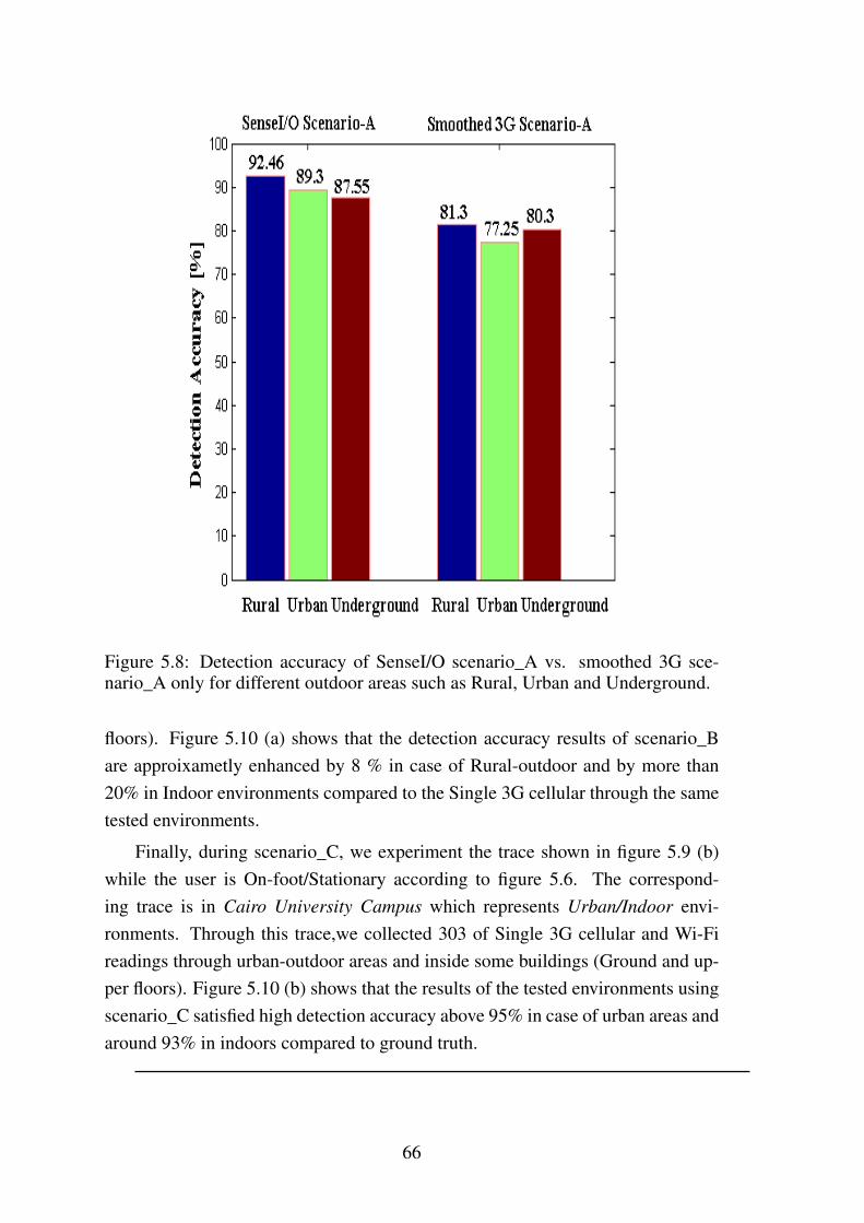
Figure 5.8: Detection accuracy of SenseI/O scenario_A vs. smoothed 3G sce-nario_A only for different outdoor areas such as Rural, Urban and Underground.
floors). Figure 5.10 (a) shows that the detection accuracy results of scenario_Bare approixametly enhanced by 8 % in case of Rural-outdoor and by more than20% in Indoor environments compared to the Single 3G cellular through the sametested environments.
Finally, during scenario_C, we experiment the trace shown in figure 5.9 (b)while the user is On-foot/Stationary according to figure 5.6. The correspond-ing trace is in Cairo University Campus which represents Urban/Indoor envi-ronments. Through this trace,we collected 303 of Single 3G cellular and Wi-Fireadings through urban-outdoor areas and inside some buildings (Ground and up-per floors). Figure 5.10 (b) shows that the results of the tested environments usingscenario_C satisfied high detection accuracy above 95% in case of urban areas andaround 93% in indoors compared to ground truth.
66

(a) (b)
Figure 5.9: (a): Corresponding trace of the SenseI/O scenario_B in Rural/Indoorenvironments. (b): Corresponding trace of the SenseI/O scenario_C in Ur-ban/Indoor environments.
(a) (b)
Figure 5.10: (a): Detection accuracy for SenseI/O scenario_B vs. smoothed 3G.(b): Detection accuracy for SenseI/O scenario_C.
67
Chapter 6
Conclusion And FutureWork
6.1 ConclusionIn this thesis, we presented SenseI/O a realistic ubiquitous indoor outdoor detec-tion system using smartphone. Our system employs the ubiquity of lightweightsensors equipped in sensor-rich today’s smartphones to address upper layer chal-lenges and resolve it as well. SenseI/O tries to use measurements of these sensorsto infer current user ambient environment type. By intelligently utilizing a novelmulti-models technique consists of four main models to infer not only binary in-door/outdoor environments but also fine-grained (Rural, Urban and Indoor). Thedeveloped system serves upper layer applications, makes a clever decision whetherit’s suitable to turn ON/OFF used sensors to minimize energy budget aspects andimprove their performance. Furthermore, such fine -grained detection of sur-
rounding environment is definitely considered a practical solution that makes thoseupper layer applications more realistic and practical in use.
We have also shown that using a utilized scenarios (A, B and C), it becomesmore accurate and possible to be applicable for most upper layer applicationsworldwide.
68

6.2 Future WorkIn our experiments, however, we find that the current environment state of userbeing is usually related to the previous state. The stateless SenseI/O does notconsider previous states and thus may suffer from noises. So, several interestingissues remain for future work including (1): developing SenseI/O to consider al-ternatively a stateful integration of these four modules which makes decisions ontop of both current and previous observations. (2): the stateless SenseI/O providesus instant detection results. Users can activate SenseI/O on need basis. Therefore,functionality ensures the energy efficiency of stateless SenseI/O. So, expandingstudy of energy-accuracy trade-off aspects in both stateless and stateful will con-sider another interesting issue.
69

References
[1] http://developer.android.com/reference/android/hardware/sensormanager.html.sensor-manager-Android.
[2] http://developer.android.com/reference/android/net/wifi/scanresult.html.scanresults-Android.
[3] http://developer.android.com/reference/android/net/wifi/wifimanager.html.WiFimanger-Android.
[4] http://developer.android.com/reference/android/telephony/phonestatelistener.html.PhoneStateListener-Android.
[5] http://developer.android.com/reference/android/telephony/telephonymanager.html.TelephonyManage-Android.
[6] http://developer.android.com/training/location/activity-recognition.html.
[7] http://thecodeartist.blogspot.com/2011/01/proximity-sensor-on-android-gingerbread.html. proximity-sensor-Android.
[8] Muhammad Abdellatif, Abderrahmen Mtibaa, Khaled A. Harras, andMoustafa. Youssef. Greenloc: An energy efficient architecture for wifi-basedindoor localization on mobile phones. pages 4425–4430, June 2013.
[9] Moustafa Alzantot and Moustafa Youssef. Crowdinside: Automatic con-struction of indoor floorplans. SIGSPATIAL ’12, pages 99–108, New York,NY, USA, 2012. ACM.
[10] Moustafa. Alzantot and Moustafa. Youssef. Uptime: Ubiquitous pedestriantracking using mobile phones. In Wireless Communications and NetworkingConference (WCNC), 2012 IEEE, pages 3204–3209, April 2012.
70

[11] Ian Anderson and Henk Muller. Context awareness via gsm signal strengthfluctuation. In 4th international conference on pervasive computing, latebreaking results. Citeseer, 2006.
[12] Martin Azizyan, Ionut Constandache, and Romit Roy Choudhury. Surround-sense: Mobile phone localization via ambience fingerprinting. MobiCom’09, pages 261–272, New York, NY, USA, 2009. ACM.
[13] Paramvir Bahl and V.N. Padmanabhan. Radar: an in-building rf-based userlocation and tracking system. In INFOCOM 2000. Nineteenth Annual JointConference of the IEEE Computer and Communications Societies. Proceed-ings. IEEE, volume 2, pages 775–784 vol.2, 2000.
[14] Fehmi Ben Abdesslem, Andrew Phillips, and Tristan Henderson. Less ismore: Energy-efficient mobile sensing with senseless. MobiHeld ’09, pages61–62, New York, NY, USA, 2009. ACM.
[15] Ying Cai and Toby Xu. Design, analysis, and implementation of a large-scalereal-time location-based information sharing system. In Proceedings of the6th International Conference on Mobile Systems, Applications, and Services,MobiSys ’08, pages 106–117, New York, NY, USA, 2008. ACM.
[16] MikeY. Chen, Timothy Sohn, Dmitri Chmelev, Dirk Haehnel, Jeffrey High-tower, Jeff Hughes, Anthony LaMarca, Fred Potter, Ian Smith, and AlexVarshavsky. Practical metropolitan-scale positioning for gsm phones. InPaul Dourish and Adrian Friday, editors, UbiComp 2006: Ubiquitous Com-puting, volume 4206 of Lecture Notes in Computer Science, pages 225–242.Springer Berlin Heidelberg, 2006.
[17] Samuli Hemminki, Petteri Nurmi, and Sasu Tarkoma. Accelerometer-basedtransportation mode detection on smartphones. In Proceedings of the 11thACM Conference on Embedded Networked Sensor Systems, SenSys ’13,pages 13:1–13:14, New York, NY, USA, 2013. ACM.
[18] Mohamed Ibrahim and Moustafa Youssef. A hidden markov model for lo-calization using low-end gsm cell phones. In Communications (ICC), 2011IEEE International Conference on, pages 1–5. IEEE, 2011.
[19] Mohamed. Ibrahim and Moustafa. Youssef. Cellsense: An accurate energy-efficient gsm positioning system. Vehicular Technology, IEEE Transactionson, 61(1):286–296, Jan 2012.
71

[20] Handoff in wireless communication. http://www.radio-electronics.com/info/cellulartelecomms/cellularconcepts/handoverhandoff.php.
[21] Matthew Keally, Gang Zhou, Guoliang Xing, Jianxin Wu, and Andrew Pyles.Pbn: Towards practical activity recognition using smartphone-based bodysensor networks. In Proceedings of the 9th ACM Conference on Embed-ded Networked Sensor Systems, SenSys ’11, pages 246–259, New York, NY,USA, 2011. ACM.
[22] Donnie H. Kim, Younghun Kim, Deborah Estrin, and Mani B. Srivastava.Sensloc: Sensing everyday places and paths using less energy. SenSys ’10,pages 43–56, New York, NY, USA, 2010. ACM.
[23] Mikkel Baun Kjærgaard, Jakob Langdal, Torben Godsk, and ThomasToftkjær. Entracked: Energy-efficient robust position tracking for mobiledevices. MobiSys ’09, pages 221–234, New York, NY, USA, 2009. ACM.
[24] John Krumm and Ramaswamy Hariharan. Tempio: inside/outside classifica-tion with temperature. In Second International Workshop on Man-MachineSymbiotic Systems, 2004.
[25] John. Krumm and Eric Horvitz. Locadio: inferring motion and locationfrom wi-fi signal strengths. In Mobile and Ubiquitous Systems: Networkingand Services, 2004. MOBIQUITOUS 2004. The First Annual InternationalConference on, pages 4–13, Aug 2004.
[26] Axel Küpper and Georg Treu. Efficient proximity and separation detectionamong mobile targets for supporting location-based community services.SIGMOBILE Mob. Comput. Commun. Rev., 10(3):1–12, July 2006.
[27] Anthony LaMarca, Yatin Chawathe, Sunny Consolvo, Jeffrey Hightower, IanSmith, James Scott, Timothy Sohn, James Howard, Jeff Hughes, Fred Potter,et al. Place lab: Device positioning using radio beacons in the wild. InPervasive computing, pages 116–133. Springer, 2005.
[28] Hui Liu, H. Darabi, P. Banerjee, and Jing Liu. Survey of wireless indoorpositioning techniques and systems. Systems, Man, and Cybernetics, PartC: Applications and Reviews, IEEE Transactions on, 37(6):1067–1080, Nov2007.
72
[29] Yang Liu and Xueqing Li. Indoor-outdoor image classification using mid-level cues. In Signal and Information Processing Association Annual Summitand Conference (APSIPA), 2013 Asia-Pacific, pages 1–5, Oct 2013.
[30] Hong Lu, Wei Pan, Nicholas D. Lane, Tanzeem Choudhury, and Andrew T.Campbell. Soundsense: Scalable sound sensing for people-centric applica-tions on mobile phones. MobiSys ’09, pages 165–178, New York, NY, USA,2009. ACM.
[31] Jiebo Luo and A. Savakis. Indoor vs outdoor classification of consumerphotographs using low-level and semantic features. In Image Processing,2001. Proceedings. 2001 International Conference on, volume 2, pages 745–748 vol.2, Oct 2001.
[32] Reto Meier. Professional android 4 application development. pages 1–399.Wiley Publishing, Inc., Indianapolis, Indiana, 2009.
[33] M Mun, Deborah Estrin, Jeff Burke, and Mark Hansen. Parsimonious mo-bility classification using gsm and wifi traces. In Proceedings of the FifthWorkshop on Embedded Networked Sensors (HotEmNets), 2008.
[34] Jeongyeup Paek, Joongheon Kim, and Ramesh Govindan. Energy-efficientrate-adaptive gps-based positioning for smartphones. MobiSys ’10, pages299–314, New York, NY, USA, 2010. ACM.
[35] Chuan Qin, Xuan Bao, Romit Roy Choudhury, and Srihari Nelakuditi.Tagsense: A smartphone-based approach to automatic image tagging. InProceedings of the 9th International Conference on Mobile Systems, Appli-cations, and Services, MobiSys ’11, pages 1–14, New York, NY, USA, 2011.ACM.
[36] Lenin Ravindranath, Calvin Newport, Hari Balakrishnan, and Samuel Mad-den. Improving wireless network performance using sensor hints. In Pro-ceedings of the 8th USENIX conference on Networked systems design andimplementation, pages 21–21. USENIX Association, 2011.
[37] Activity Recognition. http://developer.android.com/training/location/activity-recognition.html.
[38] Moving Average Smoothing. https://docs.google.com/document/d/11g0obkot-4-9edf52qgvoww9aflcrq4ybkouhxdivda/pub.
73

[39] Arvind Thiagarajan, Lenin Ravindranath, Katrina LaCurts, Samuel Madden,Hari Balakrishnan, Sivan Toledo, and Jakob Eriksson. Vtrack: Accurate,energy-aware road traffic delay estimation using mobile phones. SenSys’09, pages 85–98, New York, NY, USA, 2009. ACM.
[40] Nishith D. Tripathi, Jeffrey H. Reed, and Hugh F. VanLandingham. Handoffin cellular systems. IEEE PERSONAL COMMUNICATIONS, 5:26–37, 1998.
[41] Google Play Services Util. http://developer.android.com/training/location/activity-recognition.html.
[42] Zhixian Yan, V. Subbaraju, D. Chakraborty, A. Misra, and K. Aberer.Energy-efficient continuous activity recognition on mobile phones: Anactivity-adaptive approach. In Wearable Computers (ISWC), 2012 16th In-ternational Symposium on, pages 17–24, June 2012.
[43] Moustafa. Youssef, Mohamed Amir Yosef, and Mohamed El-Derini. Gac:Energy-efficient hybrid gps-accelerometer-compass gsm localization. InGlobal Telecommunications Conference (GLOBECOM 2010), 2010 IEEE,pages 1–5, Dec 2010.
[44] Qing-An Zeng and Dharma P Agrawal. Handoff in wireless mobile net-works.
[45] Pengfei Zhou, Yuanqing Zheng, Zhenjiang Li, Mo Li, and Guobin Shen.Iodetector: A generic service for indoor outdoor detection. In Proceedingsof the 10th ACM Conference on Embedded Network Sensor Systems, SenSys’12, pages 113–126, New York, NY, USA, 2012. ACM.
[46] Xiaojun Zhu, Qun Li, and Guihai Chen. Apt: Accurate outdoor pedestriantracking with smartphones. In INFOCOM, 2013 Proceedings IEEE, pages2508–2516, April 2013.
[47] Zhenyun Zhuang, Kyu-Han Kim, and Jatinder Pal Singh. Improving energyefficiency of location sensing on smartphones. MobiSys ’10, pages 315–330,New York, NY, USA, 2010. ACM.
74