Senior Project Manager-Cardno PO BOX 19 · Godden Mackay Logan Pty Ltd ABN 60 001 179 362...
23
Sydney 78 George Street Redfern NSW Australia 2016 T +61 2 9319 4811 F +61 2 9319 4383 Canberra 2A Mugga Way Red Hill PO Box 3171 Manuka ACT 2603 T +61 2 6273 7540 F +61 2 6273 8114 Melbourne PO Box 434 South Melbourne BC VIC 3205 T +61 3 9380 1933 F +61 3 9380 4066 Hobart GPO Box 554 Hobart TAS Australia 7001 T +61 3 6223 2810 F +61 3 6223 2820 Godden Mackay Logan Pty Ltd ABN 60 001 179 362 www.gml.com.au [email protected] 10 October 2013 Megan Bonner Senior Project Manager-Cardno PO BOX 19 ST LEONARDS NSW 1590 Our Ref: 13-0234mbc3 Re: Marsden Park – Aboriginal Heritage Management in Relation to Proposed Bulk Earthworks Dear Megan This letter provides an overview of Aboriginal heritage work undertaken to date for Stockland’s future landholdings at Marsden Park. The letter details the proposed mechanism for Aboriginal heritage management, under Section 90 consent, if issued by the Office of Environment and Heritage (OEH) under the National Parks and Wildlife Act 1974. Prior Aboriginal Heritage Work On behalf of Stockland, in accordance with NSW legislation and OEH policy, GML is in the process of undertaking an Aboriginal heritage assessment for the Marsden Park study area. Kelleher Nightingale Consulting Pty Ltd completed the Marsden Park Precinct North West Growth Centre Precinct Planning Aboriginal consultation and reporting as part of the Department of Planning and Infrastructure precinct planning processes in 2012. The current work in train by GML is being undertaken in order to obtain a thorough understanding of Aboriginal cultural and scientific values across the Marsden Park study area to allow Stockland to apply for a precinct wide Section 90 consent to ‘harm’ Aboriginal objects. Work undertaken thus far includes: Aboriginal community consultation; consultation with the OEH; archaeological field survey with the Aboriginal community (29 – 30 October 2012); preparation of an Archaeological Research Design (ARD) to guide the test excavation program (November 2012); test excavation (July – August 2013);
Transcript of Senior Project Manager-Cardno PO BOX 19 · Godden Mackay Logan Pty Ltd ABN 60 001 179 362...

Sydney
78 George Street Redfern
NSW Australia 2016
T +61 2 9319 4811
F +61 2 9319 4383
Canberra
2A Mugga Way Red Hill
PO Box 3171 Manuka
ACT 2603
T +61 2 6273 7540
F +61 2 6273 8114
Melbourne
PO Box 434
South Melbourne BC
VIC 3205
T +61 3 9380 1933
F +61 3 9380 4066
Hobart
GPO Box 554 Hobart
TAS Australia 7001
T +61 3 6223 2810
F +61 3 6223 2820
Godden Mackay Logan Pty Ltd
ABN 60 001 179 362
www.gml.com.au
10 October 2013
Megan Bonner
Senior Project Manager-Cardno
PO BOX 19
ST LEONARDS NSW 1590
Our Ref: 13-0234mbc3
Re: Marsden Park – Aboriginal Heritage Management in Relation to Proposed
Bulk Earthworks
Dear Megan
This letter provides an overview of Aboriginal heritage work undertaken to date for
Stockland’s future landholdings at Marsden Park.
The letter details the proposed mechanism for Aboriginal heritage management,
under Section 90 consent, if issued by the Office of Environment and Heritage
(OEH) under the National Parks and Wildlife Act 1974.
Prior Aboriginal Heritage Work
On behalf of Stockland, in accordance with NSW legislation and OEH policy, GML
is in the process of undertaking an Aboriginal heritage assessment for the Marsden
Park study area. Kelleher Nightingale Consulting Pty Ltd completed the Marsden
Park Precinct North West Growth Centre Precinct Planning Aboriginal consultation
and reporting as part of the Department of Planning and Infrastructure precinct
planning processes in 2012.
The current work in train by GML is being undertaken in order to obtain a thorough
understanding of Aboriginal cultural and scientific values across the Marsden Park
study area to allow Stockland to apply for a precinct wide Section 90 consent to
‘harm’ Aboriginal objects. Work undertaken thus far includes:
Aboriginal community consultation;
consultation with the OEH;
archaeological field survey with the Aboriginal community (29 – 30
October 2012);
preparation of an Archaeological Research Design (ARD) to guide the test
excavation program (November 2012);
test excavation (July – August 2013);
13-0234mbc3 2
commencement of preparation of the draft Aboriginal Cultural Heritage Assessment Report
(ACHAR); and
commencement of the preparation of the draft Archaeological Technical Report (ATR).
Key to undertaking work to date has been the consultation processes (Aboriginal community and OEH).
OEH consultation commenced at the beginning of the assessment process (January 2012) and confirmed
that GML’s proposed methodology was appropriate for the submission of a precinct wide Section 90
application.
Test excavation was undertaken by GML and the Registered Aboriginal Parties (RAPs) between the 23
July 2013 and 5 August 2013 in accordance with the Marsden Park—Archaeological Research Design
prepared by GML (November 2012). The test excavation revealed a very low density Aboriginal
archaeological deposit which has low archaeological and scientific significance across the Marsden Park
study area. Previously recorded isolated finds were not relocated during works, despite surveying for
these in order to mark their location and provide a buffer for their protection. There is a low potential for
further isolated Aboriginal objects to be present within the study area; as well as a low potential for
archaeological deposits with a high density of Aboriginal objects to exist within the study area. As such,
from our preliminary assessment of the test excavation results, no salvage excavation work is required as
part of future Aboriginal heritage management across the Marsden Park study area. Please note the
Aboriginal community will still need to review and endorse this recommendation once the draft ACHAR
and draft ATR are finalised.
Future Aboriginal Heritage Management & Section 90 submission
Now that test excavation is complete, we are in the process of finalising the draft ACHAR and draft ATR
for submission to the Registered Aboriginal Parties (RAPs) for their review and comment. Our reports will
recommend that no further archaeological excavation is required to mitigate sites within Stockland’s
landholding at Marsden Park. The study area at present does not contain a known Aboriginal place of
heritage significance.
However, under a future Aboriginal Heritage Impact Permit (AHIP), management would see the Aboriginal
community offered the opportunity to collect any surface based material or objects after topsoil scraping.
These objects can be temporarily held by GML or in an appropriate secure temporary location as agreed
to by the RAPs, with the objects from test excavation, until they can be reburied within the development
site — an area must be allocated and this area cannot be disturbed once the objects are reburied, without
a new AHIP. Once the statutory review period (28 days) for the reports has completed, the final ACHAR
and ATR will be submitted to OEH, in support of an AHIP application under Section 90A of the National
Parks and Wildlife Act (1974). Bulk earthworks would not be permissible prior to the awarding of the
Section 90 AHIP and subject to any S90 conditions of consent. Following topsoil removal, all surface
collection would need to be completed before any further development impacts could occur.
I hope that this letter provides sufficient detail of Aboriginal heritage undertaken to date and is sufficient to
support the submission of the bulk earthworks development application to Blacktown City Council.

13-0234mbc3 3
Yours sincerely
Godden Mackay Logan Pty Ltd
Natalie Vinton
Archaeology Manager
Attachments:
Marsden Park—Archaeological Research Design
Marsden Park Registered Aboriginal Parties

Marsden Park —Archaeological Research Design—Draft Report, November 2012 1
Marsden Park—Archaeological Research Design
1.1 Introduction
This Archaeological Research Design (ARD) has been prepared to define the methodology and
research parameters for test excavation at the Marsden Park study area, Marsden Park, NSW. The
background context for this ARD has been presented in the Marsden Park Heritage Assessment
draft report prepared by GML for Stocklands, November 2012. This ARD provides a brief summary
of the results of the Aboriginal heritage survey and archaeological context. Reference should be
made to the GML report for a complete overview of environmental conditions and the Aboriginal
heritage background which underpins this ARD.
This ARD presents:
a basic landscape characterisation and mapping;
a synopsis of the results from the Aboriginal survey of the Marsden Park study area, 29-30
October 2012; and
the test excavation methodology.
1.2 Landscape Characterisation
The purpose of this section is to provide an overview of contextual information for use in developing
a predictive model relating to the remains for evidence of Aboriginal occupation and use of the
study area. Interactions between people and their surroundings are of integral importance in both
the initial formation and the subsequent preservation of the archaeological record. The nature and
availability of resources, including water, flora and fauna and suitable raw materials for the
manufacture of stone tools and other items had (and continues to have) a significant influence over
the way in which people utilise the landscape.
Alterations to the natural environment also impact upon the preservation and integrity of any cultural
materials that may have been deposited while current vegetation and erosional regimes affect the
visibility and detectability of Aboriginal sites and objects. For these reasons, it is essential to
consider the environmental context as a component of any heritage assessment.
1.2.1 Geomorphology
The geomorphology of the Marsden Park study area is based upon an alluvial floodplain associated
with a number of first and second order tributaries of South Creek. Alluvial flood deposits are
evident beneath loam topsoil units, in areas where erosion processes have exposed sections
associated with drainage channels (Fig 1.1). Bands of alluvium would have been deposited during
periodic flood events, and/or built up with the inclusion of by long-term wind deposition of Aeolian
sands against shallow landforms. The location and size of such alluvial and Aeolian deposits is not
possible to predict from a surface inspection of the study area. As such, a number of elevated
areas, ranging from low slopes to hilltop areas, may contain intact subsurface archaeological
deposits; these landforms are considered to have a low-moderate archaeological potential. The
lower portion these elevated areas, particularly those directly associate with drainage channels, will
certainly contain alluvial deposits.

Marsden Park —Archaeological Research Design—Draft Report, November 2012 2
Figure 1.1 Stratigraphy associated with an exposed section along a drainage channel (alluvium clearly present beneath a browner sandy loam topsoil)
1.2.2 Water Resources
The closest permanent water source to the study area is South Creek which lies approximately
900m to the north of the study area. South Creek is one of the largest catchments on the
Cumberland Plain and is considered a major watercourse. A total of twelve first order, four second
order, and one third order tributaries, are present within the study area. These semi-permanent
watercourses enter the study area from the north and west, forming a series of floodplains
associated with areas of low elevation. The first, second and third order tributaries would have
provided Aboriginal people with localised access to water, away from South Creek. The floodplains
created by the flooding of these tributaries would have formed important ecological zones rich in
flora and fauna resources.
A total of four dams were identified during survey of the study area, all of which had been built along
tributaries. Analysis of historic aerial imagery indicates all four dams were constructed in the last 40
years.
1.3 Landscape Impacts and Disturbances
The identification of previous disturbance to soil horizons is important and has implications for the
survival of Aboriginal archaeological deposits.
The intention for this project is to test excavate representative portions of the landscape that have a
low level of disturbance with good soil integrity (i.e. soils that have not been mixed and/or interfered
with) and retain a high level of soil condition (i.e. soils that have not been eroded). Such soils may
contain spatially intact archaeological deposits, which can provide evidence for past Aboriginal
activities and thus an understanding of how a location was used.

Marsden Park —Archaeological Research Design—Draft Report, November 2012 3
In order to determine the condition and integrity of soils, and thus the level of impact, within the
study area a number of tasks were undertaken: a field inspection, over one day in September 2011;
an analysis of the 1947-present aerial photographs; and consideration of historical landscape use
(derived from GML’s assessment of historical heritage).
These tasks have led to the identification of a number of historical impacts primarily associated with
historical vegetation clearing, construction, earthworks, farming and the consequential erosion to
the landscape, resulting in an alteration to the soil’s integrity and condition.
1.3.1 Levels of Disturbance
The implications of disturbance relates to the potential preservation of Aboriginal archaeological
deposits, such as stone artefact sites, hearths and other possible features.
Zones with low levels of disturbance are likely to retain intact soil horizons, which could hold
spatially intact archaeological deposits. Such zones can be assessed to determine their condition,
which can be related to the level of erosion or other similar formation processes. On a fundamental
level, areas with high soil integrity, also possessing good condition, can be assigned with a low level
of impact or disturbance.
Such landforms then need to be assessed in terms of their likelihood of bearing archaeological
deposits. Only then can a level of archaeological sensitivity and/or potential be assigned to an
area. Figure 1.2 provides an overview of the disturbance zones within the study area, allocated
under three categories: low, moderate and high disturbance.
One of the objectives of archaeological test excavation will be to sample a range of landforms with
different disturbance levels, in order to determine and assess the level of impact on Aboriginal
heritage across the study area.

Marsden Park —Archaeological Research Design—Draft Report, November 2012 4
Figure 1.2 Aerial of the study area with colour coded zones of disturbance; red representing high, orange representing moderate, and
green representing low (AHIMS sites are represented by yellow dots) (blacked out area not part of the study area, despite blue outline)
1.4 Aboriginal Heritage Predictive Site Modelling
Stream order is the basis for a Cumberland Plain predictive model for Aboriginal site location
(McDonald and Mitchell 19941; White and McDonald 20102). The model assumes that people will
preferentially select places where the water supply is more permanent and predictable for their
usual camping locations. The smallest tributary streams are first order streams and the
classification continues stepwise downstream. Two first order streams join at a first order node to
form a second order stream; two second order streams join at a second order node to form a third
order stream and so on.
The logic behind the stream order model is that in any particular climate and landscape a threshold
catchment area is probably necessary to allow permanent stream flow or the establishment of
waterholes with extended longevity (i.e. months to years). On the Cumberland Plain, where the
average annual rainfall is between 700–900mm, the critical point for human habitation appears to
be at the junction of two second or third order streams (second and third order nodes).
The following is a summary of the findings of previous archaeological work on the Cumberland
Plain:

Marsden Park —Archaeological Research Design—Draft Report, November 2012 5
the complexity of the Cumberland Plain’s archaeological record and time span of Aboriginal
occupation is far greater than was previously identified on the basis of surface recording and
more limited test excavation; and
archaeological landscapes on permanent water, as reflected by Aboriginal people’s
preference for artefact discard, are more complex than sites on ephemeral or temporary
water lines (McDonald 20083, White & McDonald 2010).
Based upon an understanding of the prior work, landforms and disturbances associated with the
study area, it can be stated that:
Aboriginal sites are most likely to be in the form of stone objects and scarred trees. There is
a possibility that hearths and ovens may remain. Other types of Aboriginal site are unlikely to
occur within the study area;
most areas within the study area that contain residual soil horizons, even those with sparse
or no surface manifestations of Aboriginal objects, will contain subsurface archaeological
deposits, albeit in low densities >1/m2;
where lithic concentrations are found in aggrading or stable landscapes, they will largely be
intact and have the potential for internal structural integrity. Sites in alluvium possess
potential for stratification. These locations are identified as being adjacent to South Creek;
most sites will be of mid- to late-Holocene age. Suitable geomorphic conditions (eg deep
sand bodies) for the preservation of Pleistocene–aged assemblages are unlikely to occur
within the study area (such deposits have been identified at Tempe and Parramatta);
frequently, the density and diversity of implements and debitage is conditioned by
permanence of water (stream order) and landscape unit;
distance to known silcrete sources seems to have little influence on artefact discard
generally, although many silcrete sources are perhaps still to be identified. Proximity to
known sources does influence the proportion of flaked to blocky silcrete material on sites.
around the periphery of the Cumberland Plain, sandstone features such as overhangs and/or
platforms may have been used for habitation, processing basalt ground-edged axes and/or
the production of art. Such locations are situated a few kilometres to the east of the study
area, and contrary to earlier models for the region (eg Kohen 1986, Smith 19894) many areas
contain extremely high artefact densities, with variability appearing to depend on the range of
lithic activities present. Densities in excess of 600 artefacts per square metre are not
uncommon adjacent to major streams on the Cumberland Plain (cf JMCHM 20015 and
20076).
1.5 Aboriginal Heritage—Survey Results
A two day archaeological survey was undertaken with the RAPs on 29 and 30 October 2012. The
survey resulted in the identification of three PADs, four stone artefact concentrations (SACs), and
eight isolated finds (If).
Marsden Park —Archaeological Research Design—Draft Report, November 2012 6
PAD1 is situated on a hilltop/slope with views towards South Creek and the Blue Mountains (north,
north-west). Although no cultural material was identified on the surface of the hilltop, sub-surface
deposits are suspected to be largely intact. The hilltop would have provided an excellent view
across a number of important “economic zones”, (localised areas that may have provided sources
of edible plans and other non-stone resources); the archaeological potential of sub-surface deposits
in PAD1 is considered to be low to moderate.
PAD2 is situated on a hilltop/slope with views towards South Creek and the Blue Mountains (north,
north-west. Although no cultural material was identified on the surface of the hilltop, sub-surface
deposits are suspected to be largely intact. The hilltop would have provided an excellent view
across a number of important “economic zones” (localised areas that may have provided sources of
edible plans and other non-stone resources); the archaeological potential of sub-surface deposits is
considered to be low to moderate.
PAD3 is situated on a small hilltop/rise in close proximity to a third order tributary of South Creek.
Although no cultural material was identified on the surface of the hilltop, sub-surface deposits are
suspected to be largely intact, and a number of stone artefact scatters and isolated finds were
identified in close proximity. PAD3 is suspected to be associated with a stone artefact scatter
registered in the AHIMs database. The area surrounding PAD3 would have provided immediate
access to a semi-permanent water source, as well as a range of flora and fauna associated with this
“economic zone” (localised areas that may have provided sources of edible plans and other non-
stone resources). The archaeological potential of sub-surface deposits is considered to be low to
moderate.
PAD4 is situated on a hilltop/slope with views towards South Creek and the Blue Mountains (north,
north-west), as well as back across the landscape to the east. Although no cultural material was
identified on the surface of the hilltop, sub-surface deposits are suspected to be largely intact. The
hilltop represents the best vantage point within the study area, providing the most complete view of
the surrounding landscape. Although no cultural material was identified on the surface of the hilltop,
sub-surface deposits are suspected to be largely intact. The hilltop would have provided an
excellent view across a number of important “economic zones” (localised areas that may have
provided sources of edible plans and other non-stone resources); the archaeological potential of
sub-surface deposits is considered to be low to moderate.
SAC1 is comprised of single piece of tuff, and four pieces of red silcrete, one of which show clear
evidence of working. SAC1 is located within an exposed area associated with two established trees,
on a slope rising above a drainage channel (associated with a 1st order tributary of South Creek).
While erosion processes (probably wind and water) have stripped some of the topsoil at SAC1,
subsurface deposits are probably largely intact, and the archaeological potential of the site is
considered to be low to moderate.
SAC2 is comprised of a single piece of red silcrete, and a mudstone point with evidence of backing.
Located on a slope slightly above a drainage channel, SAC2 is potentially the result of erosion
processes that have transported cultural material down towards the drainage channel (i.e. the stone
objects are not insitu). This suggests that artefact density may be greater in subsurface deposits
associated with increasing elevation in surrounding areas. The archaeological potential of the area
surrounding SAC2 is considered to be low to moderate.
SAC3 is comprised of two pieces of red silcrete, and a single piece of tuff. Located on a slope
slightly above a drainage channel, SAC3 is potentially the result of erosion processes that have

Marsden Park —Archaeological Research Design—Draft Report, November 2012 7
transported cultural material down towards the drainage channel. This suggests that artefact density
may be greater in subsurface deposits associated with increasing elevation in surrounding areas.
The archaeological potential of the area surrounding SAC3 is considered to be low to moderate.
SAC4 is comprised of a single piece of red silcrete, and a single piece of tuff. Located on a slope
slightly above a drainage channel, SAC4 is potentially the result of erosion processes that have
transported cultural material down towards the drainage channel. This suggests that artefact density
may be greater in subsurface deposits associated with increasing elevation in surrounding areas.
The archaeological potential of the area surrounding SAC4 is considered to be low to moderate.
SAC5 is comprised of a single piece of red silcrete, and a single piece of tuff. Located on a slope
slightly above a drainage channel, SAC5 is potentially the result of erosion processes that have
transported cultural material down towards the drainage channel. This suggests that artefact density
may be greater in subsurface deposits associated with increasing elevation in surrounding areas.
The archaeological potential of the area surrounding SAC5 is considered to be low to moderate.
IF1 consists of a single mudstone core with possible evidence of negative flake scars. Located on a
slope above a drainage channel, IF1 is probably the result of erosion processes that have
transported cultural material down towards the drainage channel. The archaeological potential of
the area surrounding IF1 is considered to be low to moderate.
IF2 consists of a single silcrete flake located in an exposed area on a slope above a drainage
channel. IF1 is probably the result of erosion processes that have transported cultural material
down towards the drainage channel. The archaeological potential of the area surrounding SAC1 is
considered to be low-moderate.
IF3 consists of a single quartz pebble that may be derived from alluvial gravels that have been
transported into the study area. Located on a slope above a drainage channel, IF3 is probably the
result of erosion processes that have transported cultural material down towards the drainage
channel. The presence of medium to large river pebbles eroding from this area further supports this
hypothesis. The archaeological potential of the area surrounding IF3 is considered to be low-
moderate.
IF4 consists of a single piece of quartz that may be derived from alluvial gravels that have been
transported into the study area. Located on a slope above a drainage channel, IF4 is probably the
result of erosion processes that have transported cultural material down towards the drainage
channel. The presence of medium to large river pebbles eroding from this area further supports this
hypothesis. The archaeological potential of the area surrounding IF4 is considered to be low-
moderate.
IF5 consists of a single piece of mudstone with evidence of negative flake scars. Located in an
exposed area on a slope above a drainage channel, IF5 is probably the result of erosion processes
that have transported cultural material down towards the drainage channel. The archaeological
potential of the area surrounding IF5 is considered to be low-moderate.
IF6 consists of a single piece of red silcrete. Located in an exposed area on a slope above a
drainage channel, IF6 is probably the result of erosion processes that have transported cultural
material down towards the drainage channel. The archaeological potential of the area surrounding
IF6 is considered to be low-moderate.

Marsden Park —Archaeological Research Design—Draft Report, November 2012 8
IF7 consists of a single mudstone flake. Located in an exposed area on an embankment, IF7 was
probably transported in the material used to build the embankment. The embankment is not
considered to have any archaeological potential, however, the potential of the area surrounding the
embankment is considered to be very low.
IF8 consists of a single piece of mudstone. Located in an exposed area associated with a pond, IF8
may have been transported in the material used to build the embankment of the pond. The
archaeological potential of the pond and embankment is considered to be very low to none,
however the area surrounding these features is considered to have very low archaeological
potential.
1.6 Test Excavation
1.6.1 Rationale for Test Excavation
As a component of the due diligence process for the development of the Marsden Park study area,
GML will be conducting a program of test excavation over a two week period. The purpose of test
excavation under the Code of Practice is to determine the nature and extent of subsurface
archaeological deposits, and to understand and refine the geomorphological context of the study
area and provide sufficient scientific understanding, so as to allow for appropriate heritage
management during the rezoning and consequential development process.
The rational for the current archaeological excavation proposes to utilise a similar methodology as
that employed of the Rouse Hill Development Area/Second Ponds Creek Area, and East
Leppington7.
The outcome Rouse Hill project was the identification of archaeological landscapes which exhibited
significant variation in their scale and nature, with particular reference to stone procurement
strategies, as evidenced by the size and weight of assemblages, along with the incidence of cortex
and the flaking quality of the stone. The outcome of the East Leppington project was the
identification of spatially discrete archaeological assemblages, along with a rare geo-chronofied
stratigraphic sequence.
1.6.2 Mechanism for Archaeological Test Excavation
Archaeological test excavation is permitted under the Code8 without the need for a Section 90
permit (ie excluded from the definition of harm under the NPW Act 1974), provided that the sub-
surface investigations are not carried out in the following areas:
in or within 50m of an area where burial sites are known or are likely to exist;
in or within 50m of a declared Aboriginal place;
in or within 50m of a rock shelter, shell midden or earth mound; and/or
in areas known or suspected to be Aboriginal missions or previous Aboriginal reserves or
institutes.
As described by OEH the purpose of test excavation is to:

Marsden Park —Archaeological Research Design—Draft Report, November 2012 9
collect information about the nature and extent of sub-surface Aboriginal objects, based on a sample derived
from sub-surface investigations. Test excavations contribute to the understanding of site characteristics and
local and regional prehistory and they can be used to inform conservation goals and harm mitigation
measures for the proposed activity8.
The archaeological test excavation described in this chapter has been undertaken in accordance
with OEH Code of Practice for Archaeological Investigation.8 This ARD provides details and
analysis of the test excavation in accordance with Requirements 14–17 of the Code. This section
presents:
the test excavation sampling strategy;
details of OEH notification; and
the methodology for test excavation
Aboriginal community consultation was undertaken in accordance with NPW Regulation, subclause
80C(6), prior to archaeological test excavation commencing.
1.7 Test Excavation Sampling Strategy
The methodology for archaeological test excavation has been defined by OEH.8 However, the
sampling strategy for undertaking test excavation remains to be defined in accordance with each
project, subject to the specific requirements of the subject area.
An understanding of previous archaeological work and AHIMS data provides a context for
previously identified Aboriginal objects and scarred trees. Acknowledging the data and recording
limitations of the AHIMS system, there is a basic correlation between densities of previously
recorded Aboriginal features and zoning identified as having a potential for archaeological deposits.
In an ideal situation, where no post Aboriginal occupation impacts had occurred, all the zones
identified as possessing archaeological potential should be sampled. However, in order to develop
a strategic sampling model, consideration has been given to natural and historical processes that
have impacted, and removed, archaeological deposits associated with the study area. Analysis of
these factors has limited and restricted the need for archaeological sampling within the study area,
allowing for a focus on zones that have both good soil integrity and archaeological potential.
1.7.1 Archaeological Sampling Strategy
The archaeological sampling strategy to be employed during the excavation at Marsden Park is
based upon the methodology for sampling, as presented by Orton.9 Orton presents a 12-step
process9 for determining a suitable process of sampling and to provide a suitable test excavation
methodology. This methodology, following Orton’s categories, is presented below.
Existing Knowledge
Existing knowledge has been gathered and presented by this report in terms of registered site data
and prior reports; the landscape context, the known impacts to the study area; and consequentially
archaeological predictive modelling. The combination of these aspects defines the zones within the
study area that are suitable for archaeological testing. Test excavation units have only be located
within zones that have a low to moderate level of archaeological potential.

Marsden Park —Archaeological Research Design—Draft Report, November 2012 10
Objectives (and Research Questions)
The first objective of the archaeological test excavation for Marsden Park is to undertake excavation
that allows the clarification, characterisation, description and archaeological potential of the PADs
identified within the study area.
The second objective is to determine whether further soil profiles not identified with PAD, contain
archaeological materials and to undertake an assessment of these materials, within a regional
context.
In order to achieve these two objectives, research questions have been established to guide the
archaeological process, and to provide framework in which the question the resulting data..
Relevant research questions include:
1. What are the characteristics of soil horizons across the study area?
a. Are there two soil landscapes (South Creek and Berkshire Park) present? Are
these found where they are mapped at the regional level? Does the archaeological
deposit vary on each landscape? How do these soil landscapes interact? And does
the archaeological deposit vary by soil landscape?
b. At each location, is the deposit consistent? Or, does it possess characteristics that
tell of different depositional events?
c. How has the land use history impacted the study area and survival of soils and
thus, archaeological material?
d. Is there a difference in the soil landscape’s integrity across the study area due to
different ploughing regimes?
e. How has the land use history impacted the study area and survival of soils and
thus, archaeological material?
f. Is there alluvium present, and if so is this a component of the South Creek soil
landscape? How deep is the alluvium? And, what are its characteristics? Is there
evidence for former alluvial terraces and ‘ancient’ modifications to the water
courses? How does the alluvium interact with the associated soil landscape?
g. Are buried alluvial terraces present within the study area? If so, is any
archaeological material associated with them? Is stratigraphy present in alluvial
deposits?
2. Is there a relationship between the distribution of archaeological evidence and the transition
between geological formations? (i.e. Londonderry Clay to Bringelly Shale)
a. Is there discernible archaeological patterning associated with the geological
transition?
b. Does the clustering of archaeological evidence in the study area suggest that
proximity to water was a more important criterion when selecting sites than
proximity to a raw stone source suitable for tool production?
3. What are the characteristics of archaeological deposits across the study area?

Marsden Park —Archaeological Research Design—Draft Report, November 2012 11
a. What types and densities of archaeological materials are present? What is the
nature (type) of the deposit? Is the deposit stratified? Is the deposit associated
with a particular flood event? Does the deposit have different degrees of
archaeological potential with depth?
b. What, if any, evidence other than stone is present for Aboriginal occupation of this
region? Is it correct to infer that stone equates to Aboriginal use of a landform? Or
were other landforms without an archaeological signature used by Aboriginal
people?
c. How was stone used on site? Is there a relationship between artefact creation and
use of landscape and/or landform?
d. Are stone deposits spatially discrete within areas of PAD? What information does
this provide in terms of Aboriginal landscape occupation and use over both space
and time?
e. Can deposits be dated? What is the antiquity of the evidence?
f. What are the physical attributes of the deposit (stone, carbon, clay or other)?
g. Is there a geo-chronofied stratigraphic sequence? Is this associated with alluvial
deposits? How does this correlate with the regional research into stone resources
and use?
h. What is the source of the artefactual stone at any particular site? How does this
correlate with the regional research into stone resources and use?
4. How can the deposit be interpreted?
a. Is there evidence of archaeological spatial patterning of deposits on continuous
landforms? How long has it taken for such evidence to be created?
b. If spatial patterning is present, what does this mean in terms of Aboriginal
landscape use?
c. If archaeological deposits are absent from a landform, where they were expected
(and soils have good condition and integrity), what does this mean in terms of
Aboriginal landscape use?
d. Can archaeological deposits be assessed in terms of hill slope shade analysis?
Can this analysis be used to inform seasonal use of this landscape?
e. For stone deposits, what are the physical characteristics and do they indicate a
specialised use? Is there a difference in stone tool types between the different
locations tested?
5. Can the archaeology be interpreted in a regional context?
a. Is there evidence of long term occupation within the study area? If there is, on what
landforms, aspects etc?

Marsden Park —Archaeological Research Design—Draft Report, November 2012 12
b. Where did raw stone materials originate from? Have they been brought into the
study area? From how far away has the stone been brought?
c. How old is the archaeological deposit and how does this relate to regional use of
this landscape?
d. What is the relationship of the archaeological material within the study area to the
broader region; what if any, is the relationship between sites identified within the
Marsden Park Investigation Area and the surrounding landscape, particularly those
sites identified immediately to the south east?
e. Is there evidence of trade in connection to stone deposits?
f. Does the spatial distribution/density of artefacts/sites conform to current models of
spatial distribution/density (i.e. the work of Jo MacDonald regarding stream
ranking)?
g. What natural and human post-depositional processes have affected the spatial
distribution/density of artefacts, and to what degree?
h. To what degree is the spatial distribution/density of artefacts a reflection of the lack
of elevation differential within the study area?
i. To what degree is spatial distribution/density of artefacts a reflection of stream
ranking?
j. To what degree is spatial distribution/density of artefacts a reflection of site aspect?
k. To what degree is spatial distribution/density of artefacts a reflection of processes
that are not physically observable (i.e. cultural attitudes etc)?
6. Is the archaeological deposit culturally significant?
a. What is the heritage value of the deposit, both scientifically and culturally?
b. How does the Aboriginal community view and value the deposit identified?
7. Is there a deposit worthy of conservation or of future research?
a. Where and what deposits should be conserved for future generations?
b. Which deposits should be subject to more extensive investigations?
c. How should a boundary be drawn around a site? Are identifiable places present
within a cultural landscape?
8. Does the archaeological evidence at Marsden Park support the predictive model, or does
the data challenge it?
a. Has the environmental data utilized within the predictive model been effective in
identifying areas of archaeological potential?
b. Does the archaeological evidence fit alternative prediction models such as the
economic zone model (ERM 2006/2010) or recent spatial patterns observed at East
Leppington (GML 2012)?

Marsden Park —Archaeological Research Design—Draft Report, November 2012 13
Population
The sampling strategy for test excavation has been defined by the number of areas identified with
archaeological potential, either through the presence of surface material, or the identification of
subsurface deposits with archaeological potential.
The archaeological sampling strategy is designed to maximise coverage across areas of identified
archaeological potential, however, it is acknowledged that the archaeological sampling strategy is
limited spatially and has the potential to miss archaeological deposits within the areas allocated with
archaeological potential. Should no further Aboriginal archaeological deposits be recovered during
test excavation, the investigations will have provided additional information of the geomorphology
and archaeology within the Marsden Park study area.
Data to be Collected
Data will be collected for each TU during the test excavation on a specific TU context sheet. Data
collected will include: TU number, location, depth of each spit as excavated, description of alluvium
in each spit, number of stone objects (or other feature) per spit, the identification of any features or
inclusion (such as carbon), taphonomic factors (disturbance, bioturbation, etc), soil characteristics
(pH and colour), section and plan diagrams (especially where features are present).
Degree of Precision Required
The location of each TU has been established using ArcGIS to plot transects of test pits across
areas of potential in the landscape. Each TU’s location will be marked with survey markers by a
professional surveyor, with an accuracy of 100mm.
Vertical excavation will be measured against the survey marker placed at the northwest corner of
each test pit, given that vertical measurements of ground surface at this point will already have
been established by the surveyor. The vertical depth of each spit and/or stratigraphic unit will be
recorded by the excavation team, under the supervision of archaeological director and 2IC.
Method of Measure
The natural background density of Aboriginal objects across the wider region ranges from low to
high. Site density in the broader Marsden Park area has been recorded as 1 site per 0.8 hectares.
All of the Aboriginal stone material identified within the study area has been transported from
external sources. It is most likely that this material was transported into the study area as part of
Aboriginal occupation of the landscape. It is also possible that cultural material was transported into
the study area by the tributaries of South Creek.
Surface inspection during survey did not identify any cultural features that reflect long term
occupation. A number of PADs were identified however, and subsurface testing of these area may
reveal evidence that reflects a long term utilization of the area.
The Frame for Sampling
With reference to the units of sampling, Orton states that:
…surveys does not have to be based on grid squares or transects: other shapes (even ones without straight
lines) are statistically permitted…9
Marsden Park —Archaeological Research Design—Draft Report, November 2012 14
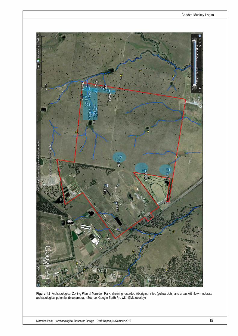
OEH’s requirements for sampling are fairly basic—the sampling framework for the test excavation
has been determined by the need to characterise and define the nature and extent of
archaeological deposits within the study area (Figure 1.3). As such three distinct and separate
zones of archaeological potential can be holistically applied to the whole of the study area:
Zone 1—a zone, in the south west corner, associated with an open depression and shallow slopes,
which contains most of the recorded Aboriginal sites, and possesses a low to moderate potential for
further subsurface archaeological deposits;
Zone 2—a zone, centre to mid north, associated with an undulating slope and saddle, which has
been identified as containing PAD, with a low to moderate potential for further subsurface
archaeological deposits; and
Zone 3—the remainder of the study area, which contains a number of distinct view points, albeit
without an allocated archaeological potential.
Therefore the extent and density of archaeological test excavation sampling will be defined in
accordance with these three zones (Figure 1.4). Each sample transect has been defined according
to soil landscape, landforms within that landscape, avoiding areas with known diminished soil
condition and/or integrity. TU have positioned to intersect known expressions of archaeology and to
sample areas with PAD.
Zone 1—TU will be located on a 20m by 20m grid, across the area with identified Aboriginal sites.
Within this zone all TU will be excavated, and further TU may be placed at 10m intervals, to
determine the precise extent of archaeological deposits;
Zone 2—TU will be located on a 40m by 40m grid, across landforms with the areas with PAD,
extending away from these landforms into areas with no allocated PAD. It is proposed that the
extent of sampling in zone 2 will be based upon the initial results of TU excavation; that is, if no
archaeological deposits are recovered from the initial TU, then excavation can cease and move into
a new adjacent areas. This methodology allows for confirmation, or not, of an archaeological
deposit, but provides the ability to move into and sample further landforms within the study area,
preventing unnecessary excavation on a landform, which has been proven to be archaeologically
sterile. Conversely, should a landform within zone 2 contain a dense archaeological deposit, then
further TU may be placed on either a 20m or 10m grid, to define the extent of the deposit; and
Zone 3—TU will be located on a 40m by 40m grid, across landforms in an area with no PAD. Zone
3 excavation aims to link excavation between zones 1 and 2, providing evidence for the presence,
or not, of archaeological deposits. The extent of TU excavation in zone 3, will follow that from zone
2, where the excavation director (and RAPs) will assess the results of initial TU excavation and
determine how and where further excavation would occur.
Marsden Park —Archaeological Research Design—Draft Report, November 2012 15
Figure 1.3 Archaeological Zoning Plan of Marsden Park, showing recorded Aboriginal sites (yellow dots) and areas with low-moderate archaeological potential (blue areas). (Source: Google Earth Pro with GML overlay)
Marsden Park —Archaeological Research Design—Draft Report, November 2012 16
The offset between transects is either 20m (zone 1) or 40m (zones 2 and 3), thus allowing for a
regular pattern of sample TUs. Orton9 has examined the relationship between site diameter to grid
interval and the probability of discovering a site. He contrasted a square grid against a staggered
square grid and found that ‘a staggered grid is considerably more efficient than a square grid…’11
with an increased probability of discovering sites using the staggered grid. Thus a staggered grid
pattern has been applied to the relationship of TUs on parallel transects.
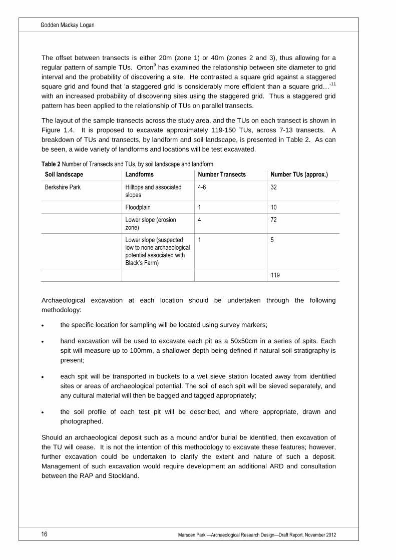
The layout of the sample transects across the study area, and the TUs on each transect is shown in
Figure 1.4. It is proposed to excavate approximately 119-150 TUs, across 7-13 transects. A
breakdown of TUs and transects, by landform and soil landscape, is presented in Table 2. As can
be seen, a wide variety of landforms and locations will be test excavated.
Table 2 Number of Transects and TUs, by soil landscape and landform
Soil landscape Landforms Number Transects Number TUs (approx.)
Berkshire Park Hilltops and associated slopes
4-6 32
Floodplain 1 10
Lower slope (erosion zone)
4 72
Lower slope (suspected low to none archaeological potential associated with Black’s Farm)
1 5
119
Archaeological excavation at each location should be undertaken through the following
methodology:
the specific location for sampling will be located using survey markers;
hand excavation will be used to excavate each pit as a 50x50cm in a series of spits. Each
spit will measure up to 100mm, a shallower depth being defined if natural soil stratigraphy is
present;
each spit will be transported in buckets to a wet sieve station located away from identified
sites or areas of archaeological potential. The soil of each spit will be sieved separately, and
any cultural material will then be bagged and tagged appropriately;
the soil profile of each test pit will be described, and where appropriate, drawn and
photographed.
Should an archaeological deposit such as a mound and/or burial be identified, then excavation of
the TU will cease. It is not the intention of this methodology to excavate these features; however,
further excavation could be undertaken to clarify the extent and nature of such a deposit.
Management of such excavation would require development an additional ARD and consultation
between the RAP and Stockland.

Marsden Park —Archaeological Research Design—Draft Report, November 2012 17
Figure 1.4 Proposed TU locations along transects and their relationship to the two primary zones of archaeological potential (green 1
associated with identification of sites during survey; green 2 associated with identification of PADs and important vistas)

Marsden Park —Archaeological Research Design—Draft Report, November 2012 18
The Pre-Test or Pilot Survey
Orton notes that the best survey designs can be made when the survey is over and that a pilot
survey can serve to remove some of the bugs from the sampling process.9 The current survey
design has been based upon a recent field inspection, with GIS-based identification of areas that
have a moderate level of archaeological potential and which are suitable for sub-surface sampling.
Excavation within these areas is more likely to recover archaeological deposits than other zones
within the Marsden Park study area.
Organisation
The test excavation will be undertaken by a team which will include an archaeological director, four
field archaeologists, and four RAPs for each day on site.
Summary and Analysis
Following test excavation, any recovered Aboriginal stone objects will be subject to specialist
analysis (by GML’s artefact specialist Beth White), recording all relevant attributes in a comparable
manner to other regional lithic studies and in accordance with Holdaway and Stern (2004)10. A
technical report will be prepared that assesses the stone materials against other recent excavations
in the region.
During fieldwork the management of cultural material resulting from excavation will be discussed
with Aboriginal stakeholders. It is intended that Aboriginal artefacts will be transferred under a Care
and Control Agreement to an Aboriginal person or organisation representing the Aboriginal people
in accordance with section 85A(1)(c) of the NPW Act. Until a Care and Control Agreement is in
place all archaeological materials will be stores at either GML’s office or Beth White’s office-in a
manner consistent with best heritage practices.
If required, faunal analysis will be undertaken by Dr. Tim Owen. Should shell material and/or
human skeletal material be identified during the test excavation, work will cease in the immediate
area and OEH—and in the case of the latter, the NSW Police—will be notified. The project
archaeologist will be responsible for the positive identification of such materials.
The results of the test excavation will be incorporated into the Marsden Park heritage assessment
report prepared for Stockland (draft, December 2012) by GML.
Information Gained for Future Survey
The information derived from test excavation will be used to expand the heritage values
assessment of the study area. The report will provide direction for conservation of Aboriginal
heritage and an impact analysis for all known objects, sites, places and values within the study
area. The report will detail sites and places that would require further study, and possibly
excavation if they cannot be conserved during any future development process.
The report will also contrast and compare the study area within the wider region and provide
direction for future studies.

Marsden Park —Archaeological Research Design—Draft Report, November 2012 19
1.8 Endnotes
1 McDonald, J. and Mitchell, P. 1994. An assessment of the archaeological context, landuse history and management requirements
for Aboriginal Archaeology in the Australian Defence Industries Site, St. Marys, NSW. JMcD CHM Pty Ltd Report to ADI Ltd, NSW
Property Group. 2 White, E. and McDonald, J. 2010. Lithic Artefact Distribution in the Rouse Hill Development Area, Cumberland Plain, New South
Wales. Australian Archaeology. 70 3 McDonald, J. 2008. Dreamtime superhighway: Sydney Basin rock art and prehistoric information exchange. Terra Australis 27.
Australian University Press, Canberra. 4 Smith, L. 1989 Aboriginal site planning study in the Sydney Basin: the Cumberland Plain. Stage I. Report to NPWS. 5 JMCHM 2001. Salvage excavation of six sites along Caddies, Second Ponds, Smalls and Cattai Creeks in the Rouse Hill
Development Area NSW. Report to Rouse Hill Infrastructure Consortium. 6 JMCHM 2007. Salvage Excavation of Four Archaeological Sites in the Caddies Creek Precinct Rouse Hill Regional Centre, NSW.
Report to Lend Lease GPT (Rouse Hill) Pty Ltd. 7 GML 2012. East Leppington Rezoning Assessment: Heritage Management Strategy (Draft Report), NSW, Report to NSW
Department of Planning and Infrastructure. 8 DECCW 2010. Code of Practice for Archaeological Investigation of Aboriginal Objects in New South Wales 9 Orton 2002. Sampling in Archaeology, Cambridge University Press, UK 10 Holdaway, S. & Stern, N. 2005. A Record in Stone: Australia’s Flaked Stone Artefacts

Marsden Park Registered Aboriginal Parties
Deerubbin Local Aboriginal Land Council (DLALC)
Darug Aboriginal Cultural Heritage Assessments (DACHA)
Darug Land Observations (DLO)
Darug Tribal Aboriginal Corporation (DTAC)
Darug Custodian Aboriginal Corporation (DCAC)
Tocomwall