selected geological and historical aspects of the julian gold mining ...
9
SELECTED GEOLOGICAL AND HISTORICAL ASPECTS OF THE JULIAN GOLD MINING DISTRICT SEPTEMBER 1987 SAN DIEGO ASSOCIATION OF GEOLOGISTS Field Trip Leaders George Copenhaver Ron Kofron Geocon, Inc. Kleinfelder & Associates Field Trip Planning Committee John Franklin and Jim Glaze SDAG Executive Committee 1987 John Franklin Owen Geotechnical Chairperson Jim Glaze American Geotechnical Vice Chairperson James R. Evans Engineering Geology Consultant Secretary Diane Murbach Murbach Geotechnical Treasurer Curtis Burdett So. Calif. Soil & Testing, Inc. Publications Coordinator ACKNOWLEDGEMENTS THANKS TO: 1 James R. Evans, consulting geologist, who suggested the topic and initiated the idea of reviewing local mining geology and history. 2 Joe Johanek, owner of the Keystone claims, for permission to trespass and tour property, and his help in locating mine owners in the Julian area and other areas. 3 George Vrable, owner of the Warlock Mine, for permission to trespass and tour properties. 4 Ken Donlan, owner of the Chariot Mine, for his hospitality and helpfulness in tours and information on the Chariot Mine and Mill. 5 George Hernington, owner of the Cold Beef Mine, for his hospitality and helpfulness in review of his experiences in the Julian district. 6 Owners of the Eagle and High Peak Mines for their helpfulness and cooperation in the mine tours. 7 George Copenhaver and Ron Kofron for their willingness to share their knowledge of the Julian District and to help organize this field trip. 8 American Geotechnical for their help in typing and preparing this road log.
Transcript of selected geological and historical aspects of the julian gold mining ...

SELECTED GEOLOGICAL AND HISTORICAL ASPECTS
OF THE
JULIAN GOLD MINING DISTRICT
SEPTEMBER 1987
SAN DIEGO ASSOCIATION OF GEOLOGISTS
Field Trip Leaders George Copenhaver Ron Kofron
Geocon, Inc. Kleinfelder & Associates
Field Trip Planning Committee John Franklin and Jim Glaze
SDAG Executive Committee 1987
John Franklin Owen Geotechnical Chairperson
Jim Glaze American Geotechnical Vice Chairperson
James R. Evans Engineering Geology Consultant Secretary
Diane Murbach Murbach Geotechnical Treasurer
Curtis Burdett So. Calif. Soil & Testing, Inc. Publications Coordinator
ACKNOWLEDGEMENTS
THANKS TO:
1 James R. Evans, consulting geologist, who suggested the topic and initiated the idea of reviewing local mining geology and history.
2 Joe Johanek, owner of the Keystone claims, for permission to trespass and tour property, and his help in locating mine owners in the Julian area and other areas.
3 George Vrable, owner of the Warlock Mine, for permission to trespass and tour properties.
4 Ken Donlan, owner of the Chariot Mine, for his hospitality and helpfulness in tours and information on the Chariot Mine and Mill.
5 George Hernington, owner of the Cold Beef Mine, for his hospitality and helpfulness in review of his experiences in the Julian district.
6 Owners of the Eagle and High Peak Mines for their helpfulness and cooperation in the mine tours.
7 George Copenhaver and Ron Kofron for their willingness to share their knowledge of the Julian District and to help organize this field trip.
8 American Geotechnical for their help in typing and preparing this road log.

SDAG 1987 FIELD TRIP ROAD LOG ‐ COPENHAVER
2
INTRODUCTION
The Julian gold mining district was significant in its initial production of new wealth (and the hope for new
wealth) for the early discoverers of a number of gold deposits. Some of which will be visited on this field
trip. These early discoveries were made during hard times after the Civil War and largely by Southerners or
ex‐Confederate soldiers who had already settled in the area (Pourade, 1964). Despite the prejudice against
the Southerners by largely northern‐based mining investors, the Julian‐Banner‐Cuyamaca miners produced
a surprisingly large amount of gold ‐over 219,000 troy ounces, mostly prior to 1900. This ranks as one of
the principal gold‐producing districts of the U.S. (Koschmann and Bergandahl, 1968).
The failure of a plan in 1874 establishing a terminus for a transcontinental railroad in San Diego (which
initially attracted many settlers), still‐fresh anti‐Southerner feelings by potential investors, and a
nationwide depression, all combined to hamper development of a relatively untapped resource. As a
recent study (Kofron, 1984) pointed out, "Political considerations [still] pose the largest obstacle to large‐
scale mining in the Julian district.”
Politics could possibly work in favor of a new era of precious metals mining in San Diego County. After all,
the San Diego County Health Department recently cooperated with our neighbor Imperial County in the
mitigation of potential hazardous waste problems associated with the new, and very successful, Mesquite
gold mine near Ogilby. This mine has been approved and permitted and is presently producing over
100,000 troy ounces of gold per year. New technology in ore and waste treatment can benefit both small
and large‐scale mining operations. Another environmentally sensitive area is Napa County, California, near
the heart of vineyard and fruit growing country. A major gold mine, called the McLaughlin Mine, has been
approved and permitted, and is producing over 200,000 troy ounces of gold per year. The mine utilizes a
unique system designed to not only remove gold from the ore, but also remove mercury which is naturally
abundant in the area, and constituted a potential natural hazard. The new mines recovery s stem is actually
cleaning up the environment and meets the California Department of Health Services tough tests for a non‐
hazardous classification. The McLaughlin tailings facility is classed as a "zero discharge system" with no
consequential discharge of mill process water or effluent to the environment.
The point of this field trip is not just that the Julian gold district "is history," but that we may have a
potential resource which should be studied and understood from both geologic and environmental
perspectives.
George Copenhaver
Figure 1. Map of Field Trip Stops 1‐7
Figure 2. Geology and Mineral Deposits of the Julian District, San Diego County, California. Portion of Plate 7, County Report 3 (Weber, 1963)
Figure 3. Map of Underground Workings of the Eagle and High Peak Mines Showing Geology and Typical Vein System of the Julian District, San Diego County, California. Portion of Plate 8 (Weber, 1963)
SDAG 1987 FIELD TRIP ROAD LOG ‐ COPENHAVER
3
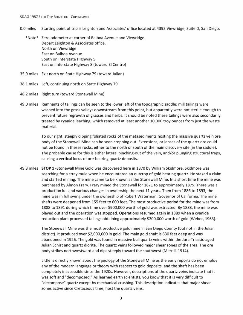
0.0 miles Starting point of trip is Leighton and Associates' office located at 4393 Viewridge, Suite D, San Diego.
*Note* Zero odometer at corner of Balboa Avenue and Viewridge. Depart Leighton & Associates office. North on Viewridge East on Balboa Avenue South on Interstate Highway 5 East on Interstate Highway 8 (toward El Centro)
35.9 miles Exit north on State Highway 79 (toward Julian)
38.1 miles Left, continuing north on State Highway 79
48.2 miles Right turn (toward Stonewall Mine)
49.0 miles Remnants of tailings can be seen to the lower left of the topographic saddle; mill tailings were
washed into the grass valleys downstream from this point, but apparently were not sterile enough to
prevent future regrowth of grasses and herbs. It should be noted these tailings were also secondarily
treated by cyanide leaching, which removed at least another 10,000 troy ounces from just the waste
material.
To our right, steeply dipping foliated rocks of the metasediments hosting the massive quartz vein ore
body of the Stonewall Mine can be seen cropping out. Extensions, or lenses of the quartz ore could
not be found in theses rocks, either to the north or south of the main discovery site (in the saddle).
The probable cause for this is either lateral pinching‐out of the vein, and/or plunging structural traps,
causing a vertical locus of ore‐bearing quartz deposits.
49.3 miles STOP 1 ‐Stonewall Mine Gold was discovered here in 1870 by William Skidmore. Skidmore was
searching for a stray mule when he encountered an outcrop of gold bearing quartz. He staked a claim
and started mining. The mine came to be known as the Stonewall Mine. In a short time the mine was
purchased by Almon Frary. Frary mined the Stonewall for 1871 to approximately 1875. There was a
production lull and various changes in ownership the next 11 years. Then from 1886 to 1893, the
mine was in full swing under the ownership of Robert Waterman, Governor of California. The mine
shafts were deepened from 155 feet to 600 feet. The most productive period for the mine was from
1888 to 1891 during which time over $900,000 worth of gold was extracted. By 1883, the mine was
played out and the operation was stopped. Operations resumed again in 1889 when a cyanide
reduction plant processed tailings obtaining approximately $200,000 worth of gold (Weber, 1963).
The Stonewall Mine was the most productive gold mine in San Diego County (but not in the Julian
district). It produced over $2,000,000 in gold. The main gold shaft is 630 feet deep and was
abandoned in 1926. The gold was found in massive bull quartz veins within the Jura‐Triassic‐aged
Julian Schist and quartz diorite. The quartz veins followed major shear zones of the area. The ore
body strikes northwestward and dips steeply toward the southwest (Merrill, 1914).
Little is directly known about the geology of the Stonewall Mine as the early reports do not employ
any of the modern language or theory with respect to gold deposits, and the shaft has been
completely inaccessible since the 1920s. However, descriptions of the quartz veins indicate that it
was soft and "decomposed.” As learned earth scientists, you know that it is very difficult to
"decompose" quartz except by mechanical crushing. This description indicates that major shear
zones active since Cretaceous time, host the quartz veins.

SDAG 1987 FIELD TRIP ROAD LOG ‐ COPENHAVER
4
Exit Park.
50.4 miles Right turn on Highway 79, continue north
51.4 miles Cuyamaca Reservoir is on the right. According to Merriam, 1951, rocks immediately adjacent the
road towards the north end of the reservoir are mapped as mixed rocks (Jurassic‐aged quartz diorite
and schist).
56.9 miles Red material on the right is lateritic or ferralitic soil derived from oxidation of sulfide (pyrrhotite‐
pentlandite) ‐rich gabbroic and ultramafic rocks of the San Marcos Gabbro1. Small tonnage nickel‐
cobalt ore bodies were mined near here in the early 1900s.
57.7 miles STOP 2 ‐Right turn at View Point. The view point, according to Merriam, is located at the contact of
the Cretaceous‐aged San Marcos Gabbro, Jurassic‐aged mixed rocks and Jura‐Triassic‐aged Julian
Schist. Looking northeast, the Julian Schist extends downhill from the view point. This side
(southwest) of the town of Banner, the schist contacts Merriam's mixed rocks. The Elsinore Fault can
be seen trending in a northwest‐southeasterly direction through the town of Banner. The gold
mineralization occurred within the Julian Schist, generally closer to its northeastern contact with the
mixed rocks.
58.0 miles Back to Highway 79, turn right continue to Julian.
59.5 miles Outcrops of Merriam's mixed rocks on right (quartz diorite and schist).
60.5 miles Left turn to Julian.
60.6 miles Right turn on road just past real estate office. Continue straight on this road; follow signs to the Eagle and High Peak Mines.
61.0 miles STOP 3 ‐Eagle and High Peak Mine. Groups of approximately 15 will be taken through the mine.
Lunch may be here at the mine or at our next stop on Banner Grade depending upon time and traffic.
According to CDMG County Report 3, the geology for the two mines is as follows:
Eagle Mine
"One west‐northwest trending claim that adjoins the south‐southwest side of the High Peak claim. The claim was located in 1870; it is unpatented. Principal working is a north‐northeast trending crosscut adit 358 ft. long. This working intersects the northwest‐trending drift adit of the High Peak mine. Appended to the crosscut adit are 3 west‐northwest trending drifts which from the south‐southeast to north‐northeast are 143, 37, and 157 ft. long. About 170 ft. west of the portal of the crosscut adit, a 260 ft. drift adit extends northwestward on the same vein explored by the 37 ft. drift. Ore was mined from narrow stopes in the drifts and drift adit. Total value of production was estimated by Donnelly (1934) to be between $25,000 and $50,000. Mine operated during early 1870's, then mine and/or mill operated nearly continuously on a small scale from late 1880's to 1939. Operated from 1925 to 1939 by Sid Dodge of Julian. (Crawford 96:335; Donnelly 34:350, 352, 362, pl.4; Eric 48:320; Goodyear 90:145; Hanks 86:83, 85; Hubon 02:6; Merrill 14:656, 658; Tucker 25:335, 336; Tucker and Reed 39:17‐18, pl.1)."
1 The San Marcos Gabbro may also be referred to in some texts as the Cuyamaca Gabbro.

SDAG 1987 FIELD TRIP ROAD LOG ‐ COPENHAVER
5
High Peak Mine
"Located March 1880. Unpatented. Adjoins Eagle claim which lies to southwest. Formerly included High Peak South and Rossland claims reported by local resident (1957) to have been adjudicated out as mining claims. Developed by a 462‐ft partly stoped drift adit drive N. 65 degrees W. along the mineralized shear zone. Adit intersected north‐northeast trending cross cut adit driven from Eagle property. Vertical winze was sunk at end of Eagle crosscut on quartz vein 25 ft. northeast of main mineralized zone. A drift on this vein extends southeast from the winze for 60 ft. In 1957, the winze was caved 50 ft. below its collar. Additional caved workings lie to the southeast of the portal of the main adit along the main mineralized zone. The mine was worked sporadically from 1870 to 1902 and from 1928 to 1932. Value of total production estimated by Donnelly (1934, p. 352) to be between $25,000 and $50,000. (Crawford 94:241; 96:339; Donnelly 34:350, 352, pl.4; Hanks 86:83, 85; Hubon 02:7; Merrill 14:656, 659; Preston 90;542; Tucker 25:339‐340; Tucker and Reed 39:14, 21, pl.1)."
62.1 miles Back to Main Street, make a left turn, continue east on 78 toward Banner Grade.
64.2 miles Starting down Banner Grade.
64.6 miles OPTIONAL STOP 4 ‐Mixed rock sequence exposed in the rock cut on the right side of Banner Grade.
Composition is granodiorite with lineations subparallel to the Elsinore fault zone. Shear zones are
evident.
64.4 miles STOP 5 ‐Elsinore Fault is on the left. Notice offset drainages, vegetation changes, benches and
triangular facets. Approximately 4 miles of the Elsinore Fault trace is visible.
66.4 miles Road to the right goes to the Warlock Mine. Do not take it. The Warlock Mine crosscut‐tunnel
extends over 1400 feet southward, penetrating Julian Schist, a strand, or branch of the Elsinore Fault,
and a host of subparallel gold‐bearing quartz veins. The primary targets in the mine were the
Shamrock, Neptune and Padlock Veins (approximately 1300 feet S). Over 2 ounces per ton has been
assayed at surface outcrops of these veins. Abundant wall rock alteration of meta‐sediments can be
observed on these vein systems.
Continue down Highway 78 toward Banner.
66.5 miles OPTIONAL STOP 6 ‐Gold Panning Demonstration
A tributary drainage fed by erosion of the Warlock mine group veins has contributed fine‐grained
placer gold to the deeper, coarse‐gravels of the stream bed. A few shorels full of these gravels can be
hand‐washed in a gold pan to prospect for gold upstream. This technique is still used by modern
geologists in narrowing target‐areas for further exploration. More commonly, approximately 80
mesh, field‐screening of dry stream sediments is used by exploration geologists.
68.2 miles Right turn onto dirt road to Chariot Mine. This road roughly follows Chariot Canyon Fault.
70.8 miles STOP 7 ‐Chariot Gold Mine entrance on right.
*Important Note: Absolutely No Alcoholic Beverages maybe consumed on‐site as per the owners
request and MSHA Mining Regulations.
The Golden Chariot Mine is perhaps the single most productive mine in the Julian‐Banner districts. It
is credited with some $800,000 worth of gold production, but a substantial portion of the gold

SDAG 1987 FIELD TRIP ROAD LOG ‐ COPENHAVER
6
produced from this mine was probably not recorded. This mine was discovered in February 1871,
one year after the discovery of gold in the town of Julian. The mine operated from 1871 to 1876
when it was closed upon the death of the owner, Mr. Mark McDonald. The mine laid idle until 1913.
Some work was done but it was not until 1923 that the mine was reopened on a larger scale. Work
continued until 1931 when mining again ceased. The mine has not been operated on a large scale
since 1931. The current owner acquired the property in 1981 and has reconditioned the #1 Working
Shaft, erected a new head frame and hoist house, and has constructed a modern mill, assay lab and
office.
The ore body of the Golden Chariot mine appears to be located wholly within the Chariot Canyon
Fault. The Chariot Canyon Fault is not a single fault, but a broad shear zone at least 600 feet wide,
perhaps more. The fault may be recognized beginning at the head of the canyon as crush zones,
slickensided surfaces and faulted pegmatite dikes in the road cuts. The Chariot Canyon Fault zone is
somewhat unique in that a younger cataclastic (brittle) style of deformation is overprinted
(superimposed) upon a much older fault zone with a mylonitic (ductile) fabric. To the west of the
mine, the Julian Schist is a Late Paleozoic‐Early Mesozoic clastic wedge of marine sediments that was
metamorphosed and deformed by Late Cretaceous time. To the east, the granitoids range in
composition from tonalite to granodiorite and are part of the enormous La Posta pluton, an intrusive
body at least 45 km wide and some 80 km long.
The Chariot Canyon fault separates these two units but affects both. Both the schistose and granitic
rocks have a strong mylonitic fabric imposed on them that disappears laterally from the shear zone.
The gold is produced from at least four quartz veins, but recent evidence suggest there may be as
many as eight. The veins may be up to 10 feet thick. The gangue minerals include pyrrhotite,
arsenopyrite, sericite tourmaline, and garnet. Tellurides have been reported from this mine. Recent
work indicates that the gold‐bearing quartz veins were emplaced about 91 m.y.a. at a temperature of
530 degrees centigrade. The ore forming fluids were probably derived from water that was
"sweated" out of micas in the Julian Schist as the huge La Posta Pluton was intruded. The ore forming
fluids circulated through dilatant zones in the ancient Chariot Canyon Fault, depositing the gold‐
quartz veins.
REFERENCES
1 Ellsberg, Helen, "Mines of Julian," La Siesta Press, 1972.
2 "Geology and Mineral Resources of Santa Ysabel Quadrangle, San Diego County, California," California Division of Mines and Geology Bulletin 177, 1958.
3 Kofron, Ronald J., "Age and Origin of Gold Mineralization in the Southern Portion of the Julian Mining District, Southern California," Unpublished Master’s Thesis, San Diego State University Department of Geological Sciences, 1984.
4 Koschmann, A. H. and Bergendahl, M. H., "Principal Gold‐Producing Districts of the United States,” U.S. Geological Survey Professional Paper 610, p. 76, 1968.
5 Pourade, R. F., "The Glory Years," Volume 4, The History of San Diego, Union‐Tribune Publishing Co., San Diego, CA, p. 274, 1964.
6 Weber, F. Harold, Jr., "Geology and Mineral Resources of San Diego County, California," California Division of Mines and Geology County Report 3, 1963.

!(
!!
!!
!!
!!!!
!!
!! 7
65
4
3
2
1
JULIAN
Boulde
r Cree
k
Swee
twater
Rive
r
San D
iego R
iver
SUNRISE HIGHWAY
STOP DESCRIPTION 1 Stonewall Gold Mine 2 View Point (Inspiration Point) 3 Eagle and High Peak Mine 4 Mixed Rock road cut, Banner Grade 5 Elsinore Fault 6 Gold Panning Demonstration 7 Chariot Gold Mine
FIGURE 1. MAP OF FIELD TRIP STOPS 1 THROUGH 7.
CUYAMACA LAKE
Ü0 2 4 Miles
HIGHWAY 79
BANNER GRADE