
Seismic reflection imaging of mineral systems: Three case ...
10
GEOPHYSICS, VOL. 65, NO. 6 (NOVEMBER-DECEMBER 2000); P. 1852–1861, 10 FIGS. Seismic reflection imaging of mineral systems: Three case histories Barry J. Drummond * , Bruce R. Goleby * , A. J. Owen * , A. N. Yeates * , C. Swager ‡ , Y. Zhang ** , and J. K. Jackson § ABSTRACT Mineral deposits can be described in terms of their mineral systems, i.e., fluid source, migration pathway, and trap. Source regions are difficult to recognize in seis- mic images. Many orebodies lie on or adjacent to major fault systems, suggesting that the faults acted as fluid mi- gration pathways through the crust. Large faults often have broad internal zones of deformation fabric, which is anisotropic. This, coupled with the metasomatic ef- fects of fluids moving along faults while they are active, can make the faults seismically reflective. For exam- ple, major gold deposits in the Archaean Eastern Gold- fields province of Western Australia lie in the hanging- wall block of regional-scale faults that differ from other nearby faults by being highly reflective and penetrating to greater depths in the lower crust. Coupled thermal, mechanical, and fluid-flow modeling supports the the- ory that these faults were fluid migration pathways from the lower to the upper crust. Strong reflections are also recorded from two deeply penetrating faults in the Pro- terozoic Mt. Isa province in northeastern Australia. Both are closely related spatially to copper and copper–gold deposits. One, the Adelheid fault, is also adjacent to the large Mt. Isa silver–lead–zinc deposit. In contrast, other deeply penetrating faults that are not intrinsically reflec- tive but are mapped in the seismic section on the basis of truncating reflections have no known mineralization. Regional seismic profiles can therefore be applied in the precompetitive area selection stage of exploration. Ap- plying seismic techniques at the orebody scale can be difficult. Orebodies often have complex shapes and re- flecting surfaces that are small compared to the diame- ter of the Fresnel zone for practical seismic frequencies. However, if the structures and alteration haloes around the orebodies are targeted rather than the orebodies themselves, seismic techniques may be more successful. Strong bedding-parallel reflections were observed from the region of alteration around the Mt. Isa silver–lead– zinc orebodies using high-resolution profiling. In addi- tion, a profile in Tasmania imaged an internally nonre- flective bulge within the Que Hellyer volcanics, suggest- ing a good location to explore for a volcanic hosted mas- sive sulfide deposit. These case studies provide a pointer to how seismic techniques could be applied during min- eral exploration, especially at depths greater than those being explored with other techniques. INTRODUCTION Deep seismic reflection programs around the world are mostly directed toward understanding the tectonic evolution of the regions studied and therefore have often led only indi- rectly to an improved understanding of their mineral potential. In contrast, a seismic transect of the Mt. Isa inlier of northeast- ern Australia, sponsored by the Australian Geodynamics Co- operative Research Centre, was deliberately designed to place Manuscript received by the Editor March 22, 1999; revised manuscript received June 4, 2000. * Australian Geological Survey Org., P.O. Box 378, Canberra, A.C.T. 2601, Australia. E-mail: [email protected]; Barry.Drummond@agso. gov.au. ‡Formerly Geological Survey of Western Australia, 100 Plain Street, Perth, Western Australia 6000, Australia; presently North Ltd., P.O. Box 231, Cloverdale, Western Australia6105, Australia. ** CSIRO, Div. of Exploration and Mining, Nedlands, Western Australia 6009, Australia. §Formerly Mount Isa Mines Exploration, GPO Box 1042, Brisbane, Queensland 4001, Australia; presently Sons of Gwalia, 16 Parliament Place, West Perth, Western Australia 6005, Australia. c 2000 Society of Exploration Geophysicists. All rights reserved. major orebodies in the inlier into their regional geodynamic framework (Drummond et al., 1997). The results from the Mt. Isa transect, together with the findings of Drummond and Goleby (1993) from the Eastern Goldfields province of Western Australia, suggest that the seis- mic profiling technique could be imaging fluid migration path- ways within the crust. Higher resolution studies (e.g., Milkereit et al., 1996; Yeates et al., 1997; and Goleby et al., 1997) suggest that seismic techniques can also be successful at the orebody 1852
Transcript of Seismic reflection imaging of mineral systems: Three case ...

GEOPHYSICS, VOL. 65, NO. 6 (NOVEMBER-DECEMBER 2000); P. 1852–1861, 10 FIGS.
Seismic reflection imaging of mineral systems: Three case histories
Barry J. Drummond∗, Bruce R. Goleby∗, A. J. Owen∗, A. N. Yeates∗,C. Swager‡, Y. Zhang∗∗, and J. K. Jackson§
ABSTRACT
Mineral deposits can be described in terms of theirmineral systems, i.e., fluid source, migration pathway,and trap. Source regions are difficult to recognize in seis-mic images. Many orebodies lie on or adjacent to majorfault systems, suggesting that the faults acted as fluid mi-gration pathways through the crust. Large faults oftenhave broad internal zones of deformation fabric, whichis anisotropic. This, coupled with the metasomatic ef-fects of fluids moving along faults while they are active,can make the faults seismically reflective. For exam-ple, major gold deposits in the Archaean Eastern Gold-fields province of Western Australia lie in the hanging-wall block of regional-scale faults that differ from othernearby faults by being highly reflective and penetratingto greater depths in the lower crust. Coupled thermal,mechanical, and fluid-flow modeling supports the the-ory that these faults were fluid migration pathways fromthe lower to the upper crust. Strong reflections are alsorecorded from two deeply penetrating faults in the Pro-terozoic Mt. Isa province in northeastern Australia. Bothare closely related spatially to copper and copper–golddeposits. One, the Adelheid fault, is also adjacent to the
large Mt. Isa silver–lead–zinc deposit. In contrast, otherdeeply penetrating faults that are not intrinsically reflec-tive but are mapped in the seismic section on the basisof truncating reflections have no known mineralization.Regional seismic profiles can therefore be applied in theprecompetitive area selection stage of exploration. Ap-plying seismic techniques at the orebody scale can bedifficult. Orebodies often have complex shapes and re-flecting surfaces that are small compared to the diame-ter of the Fresnel zone for practical seismic frequencies.However, if the structures and alteration haloes aroundthe orebodies are targeted rather than the orebodiesthemselves, seismic techniques may be more successful.Strong bedding-parallel reflections were observed fromthe region of alteration around the Mt. Isa silver–lead–zinc orebodies using high-resolution profiling. In addi-tion, a profile in Tasmania imaged an internally nonre-flective bulge within the Que Hellyer volcanics, suggest-ing a good location to explore for a volcanic hosted mas-sive sulfide deposit. These case studies provide a pointerto how seismic techniques could be applied during min-eral exploration, especially at depths greater than thosebeing explored with other techniques.
INTRODUCTION
Deep seismic reflection programs around the world aremostly directed toward understanding the tectonic evolutionof the regions studied and therefore have often led only indi-rectly to an improved understanding of their mineral potential.In contrast, a seismic transect of the Mt. Isa inlier of northeast-ern Australia, sponsored by the Australian Geodynamics Co-operative Research Centre, was deliberately designed to place
Manuscript received by the Editor March 22, 1999; revised manuscript received June 4, 2000.∗Australian Geological Survey Org., P.O. Box 378, Canberra, A.C.T. 2601, Australia. E-mail: [email protected]; [email protected].‡Formerly Geological Survey of Western Australia, 100 Plain Street, Perth, Western Australia 6000, Australia; presently North Ltd., P.O. Box 231,Cloverdale, Western Australia 6105, Australia.∗∗CSIRO, Div. of Exploration and Mining, Nedlands, Western Australia 6009, Australia.§Formerly Mount Isa Mines Exploration, GPO Box 1042, Brisbane, Queensland 4001, Australia; presently Sons of Gwalia, 16 Parliament Place,West Perth, Western Australia 6005, Australia.c© 2000 Society of Exploration Geophysicists. All rights reserved.
major orebodies in the inlier into their regional geodynamicframework (Drummond et al., 1997).
The results from the Mt. Isa transect, together with thefindings of Drummond and Goleby (1993) from the EasternGoldfields province of Western Australia, suggest that the seis-mic profiling technique could be imaging fluid migration path-ways within the crust. Higher resolution studies (e.g., Milkereitet al., 1996; Yeates et al., 1997; and Goleby et al., 1997) suggestthat seismic techniques can also be successful at the orebody
1852
Seismic Imaging of Mineral Systems 1853
scale, especially if they are used to image the structures andalteration zones around the orebody rather than the orebodyitself.
In this paper, we place the seismic results from three unre-lated and widely separated terranes of different ages, i.e., theEastern Goldfields province (Drummond and Goleby, 1993),the Mt. Isa Inlier (Drummond et al., 1997) and Tasmania(Yeates et al., 1997), into a mineral system framework. Al-though the mineral deposits studied differ in many ways, theapproach of simplifying mineral systems provides pointers onhow seismic techniques can be effective in the precompetitivearea selection stage and in direct exploration.
MINERAL SYSTEMS
Mineral systems are analogous to petroleum systems, whichdescribe the genetic relationship between a petroleum sourcerock and an accumulation (Magoon and Dow, 1991). Using thisdefinition, a mineral system can be described in its simplestform as a fluid source, a migration pathway, and a trappingmechanism that scavenges the minerals from the fluids. Thefluid source could be basin brines in the case of strata-bounddeposits, or it could be more deep-seated lower crustal or evenupper mantle hydrated rocks in the case of other deposits.
Migration pathways are needed to focus the fluids from theirsource into the trap. Many mineral deposits lie on, or adjacentto, major fault zones, suggesting a causal relationship. Fault sys-tems provide fracture porosity as well as a focusing mechanism.In the case of basin brines, the general distribution of perme-able and impermeable rocks of the basin strata also allows fluidflow and influences its form.
Trapping mechanisms take a variety of forms and requirethe superposition of physical barriers to fluid flow, e.g., localstructure, stratigraphy, and permeability, whether intrinsic orfracture induced, with the appropriate chemical, thermal, andprobably palaeogeographic settings for the minerals to be de-posited. Hence, studies that describe mineral deposits ratherthan mineral systems and that focus mainly on the trappingmechanisms tend to describe the unique and often complexcombinations of elements in the trapping mechanism for eachdeposit but do not see the underlying unifying elements of themineral system.
Mineral systems are usually triggered by a thermal pulse,which in turn can often be related to intraplate tectonics re-sulting from interplate activity (Loutit et al., 1994). Whereaspetroleum systems are usually characterized according to theage and type of source rock (the fluid source) (Bradshaw, 1993),the ages of mineral deposits are often less certain. Mineral sys-tems may be characterized according to the age of the hostrocks or the age of the thermal event that triggered them. Just asa sedimentary basin can have several superimposed petroleumsystems reflecting the maturing through time of a number ofstacked source rocks and their associated fluid pathways andtraps, so also can a mineral province be host to several mineralsystems.
Identifying fluid source regions in seismic images may be dif-ficult. The dehydration of a large area of crust to create miner-alizing fluids will not necessarily leave an observable physicalimprint on the rocks that distinguishes that region from anyother region, especially in metamorphic rocks. This is becausethe physical effects of dehydration may be similar to those ofmetamorphism (higher densities and seismic velocities).
Large volumes of rock can be effectively dehydrated overtime by relatively low fluid flux rates. But if the fluids areconcentrated into fracture-induced permeability zones alongfaults, higher flux rates will occur along the faults. This canlead to wide alteration haloes along faults and metasomatismwithin the fault zone. Where the fault zone is the focus of highstrain, mylonite zones develop. They characteristically have awell-developed anisotropic fabric (e.g., Jones and Nur, 1984;Siegesmund and Kern, 1990). Mylonite zones can be good re-flectors (Jones and Nur, 1984; Goodwin and Thompson, 1988).The seismic reflectivity results from the constructive interfer-ence of reflections from the bands of altered and strainedanisotropic rock within the mylonite zones. The case histo-ries presented in this paper describe the seismic effect of themineral system in terms of migration pathway and trappingmechanism.
In the first case history, the crustal structure of the East-ern Goldfields is interpreted in terms of linked fluid pathways.Drummond and Goleby (1993) interpret some elements ofcrustal reflectivity in the Archaean Eastern Goldfields provinceof Western Australia in terms of fluid pathways through thecrust based on the geometry of the fault zones and their spatialrelationship to known mineralization. They make no attemptto link this regional study with local studies at the orebodyscale.
The second case history, at Mt. Isa, tries to link from theregional scale into the orebody scale. Salisbury et al. (1996)demonstrat that many of the sulfide minerals that typicallymake up the bulk of mineralization constituting orebodies haveseismic velocities similar to felsic and mafic igneous rocks, andalso some sedimentary rocks, but much higher densities. Pyritehas both higher density and higher seismic velocity. Therefore,in many cases the orebody should have a significant impedancecontrast with country rock of most compositions. However,orebodies can have very complex shapes and often lie in com-plexly folded or deformed host rocks. Orebody reflections maybe lost among the reflections and interference signals from thesurrounding host material. Orebodies are often very small insize compared to the wavelength of seismic energy returnedfrom the earth. Therefore, to maximize the chance of successin using seismic methods at the trap or orebody part of themineral system, we recommend targeting the controlling struc-tures around the trap and perhaps the broader alteration haloesaround the orebodies.
In the Mt. Isa study, the strategy was not to try to image theorebody itself but rather to target a known larger alterationzone characteristic of the environment where mineralizationmight occur—the fluid migration pathways adjacent to the ore-body and the structure of the trap. This is analogous to the ap-proach used in petroleum exploration, where the structure ofthe reservoir would be the seismic target rather than the poolof oil it might contain.
The third case history, in Tasmania, studies a totally differentstyle of ore environment and demonstrates that by targetingthe mineral system rather than the orebody, seismic methodscan be applied successfully in a range of environments.
SEISMIC METHODOLOGY CONSIDERATIONS
Typically, the geology and structure of the three mineralizedregions described in these case histories is complex, with arange of lithologies subjected to at least three deformational

1854 Drummond et al.
and/or metamorphic events prior to the mineralizing event.However, in all cases the available geological control is good,with information from mining in the region, deep drillholes,and detailed surface geological mapping. Two-dimensional andsome low-fold 3-D seismic reflection as well as 2-D and 3-Dcrustal-scale refraction techniques were used. However, onlyseismic reflection results are presented here.
The case studies used regional transects that were focused onstructure within the middle to upper crust and higher resolutionseismic surveys of mine-scale structures.
Explosive charges in deep drillholes provided the energysources. The seismic data were collected with 96 or 120 chan-nels, and quality control was primarily through field monitorsand in-field data processing to at least brute stack stage, espe-cially for the high-resolution data. Typically, the station spac-ing was 40 m for the regional surveys and 10–20 m for thehigher resolution surveys. Shot-hole spacings were variable,but a nominal stacking fold of between 12 and 24 was achieved.Symmetrical split-spread geometries were used, which resultedin a maximum shot–receiver offset of 2400 m for the regionalsurveys.
In this type of project, the main data processing problemsresult from difficult static corrections and large velocity vari-ations. Detailed refraction static analysis is required to adjustfor the effects of a highly variable regolith in most parts ofAustralia, especially with the higher frequencies needed in highresolution studies. Near-surface velocity variations are high,ranging from around 1000 m/s within parts of the regolith up to7000 m/s in metamorphosed ultramafic bedrock in the EasternGoldfields province.
The rocks are mostly highly deformed, so reflector continu-ity, although variable, is usually far shorter that that encoun-tered within sedimentary basins. The amplitudes of reflectionsare often excellent, but they may not be primary reflections.We adopted a strategy of identifying regions of similar reflec-tor coherency and dip. We correlated those regions with thesurface geology or with seismic velocities from crustal-scalerefraction or tomography studies to assign rock type. Then weuse, the geometry and spatial relationships of regions of similarreflection character to infer tectonic processes. Interpretationsare usually confirmed with both qualitative and quantitativeinterpretation of gravity and magnetic data, supplemented byavailable geological evidence.
CASE HISTORY 1: THE EASTERN GOLDFIELDSOF WESTERN AUSTRALIA
The Yilgarn craton in Western Australia (Figure 1) consists ofseveral geological provinces. Gneissic granitoid with granitoidplutons and greenstone supracrustal rocks are common in allprovinces. Each province can be divided into a number of ter-ranes, each defined by the distinct stratigraphy of its volcanicand sedimentary supracrustal rocks. The Eastern Goldfieldsprovince is host to much of the region’s known gold deposits,most of which occur in the west of the province. The Ida faultseparates it from the Southern Cross province to the west.
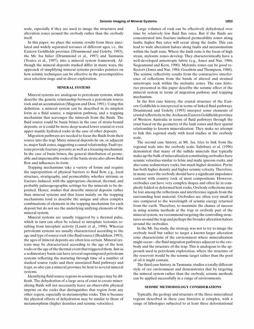
A regional-scale, 213-km-long seismic reflection traversewas positioned east–west across the regional strike (Figure 1)(Goleby et al., 1993). The interpretation of the shallow part ofthe seismic data is given by Swager et al. (1997). The green-stone supracrustal rocks lie above a subhorizontal detachment
between 1.5 and 2.5 s (4.5 and 7.5 km) and therefore havea tectonic boundary with the underlying, presumably felsicgneissic basement (Figure 2). Many of the faults in the green-stones, e.g., the Zuleika shear (Figure 2), are not reflective andare interpreted by their truncations of greenstone stratigra-phy. These faults can be mapped laterally over considerabledistances within the greenstones, but they are not deeply pen-etrating and sole on the detachment surface.
However, several faults penetrate the detachment. Thesefaults are often reflective. Within the seismic section, the Idafault and the Bardoc shear are the prominent examples (Fig-ure 2). The Ida fault dips approximately 30◦ to the east andextends to 25–30 km depth. The Bardoc shear dips west, pen-etrates the detachment surface, and truncates against the Idafault at about 15 km depth. Bottomhole cuttings from the shotholes along the traverse were chemically analyzed. Those fromnear the Ida fault and Bardoc shear have comparable alteration
FIG. 1. Major structural subdivisions of the southern EasternGoldfields province, Yilgarn block, Western Australia. Positionof 1991 seismic transect is also shown (modified from Swagerand Griffin, 1990).
Seismic Imaging of Mineral Systems 1855
patterns, indicating that similar or the same fluids moved alongboth of the faults in the past. This supports the seismic obser-vation that the faults are probably linked at depth (Golebyet al., 1993).
Many of the faults in the region, including those that do notpenetrate the detachment, can be associated spatially with golddeposits. However, the Bardoc shear and its southern extension(Boorara shear near Kalgoorlie, Lefroy fault near Kambalda)
FIG. 2. Portion of the 1991 deep seismic transect recorded within the Archaean Yilgarn block. Arrows indicate fluid-flow directionspredicted by Drummond and Goleby (1993). D= diffraction, S= sill. Detailed images of the interpretation, particularly the top 2 s,are found in Goleby et al. (1993) and Swager et al. (1997).
are associated spatially with major gold districts, including theGolden Mile at Kalgoorlie and the Kamdalda–St. Ives deposits.Many of the gold deposits lie to the west of the shear, i.e., inthe hanging-wall block.
Based on near-surface fluid flow patterns suggested byGoleby et al. (1993), Drummond and Goleby (1993) proposedthat mineralizing fluids migrating from the lower crust to higherlevels in the greenstones followed a path—first into and along
1856 Drummond et al.
east-dipping shear zones within the lower crust, then intothe Bardoc shear. From there they were able to percolateinto the hanging-wall block (arrows, Figure 2). Some leakedalong the detachment and into other faults within the green-stone sequence that splay from the detachment (e.g., Zuleikashear; Figure 2), but most concentrated in the greenstonesimmediately above and to the west of the Bardoc shear.
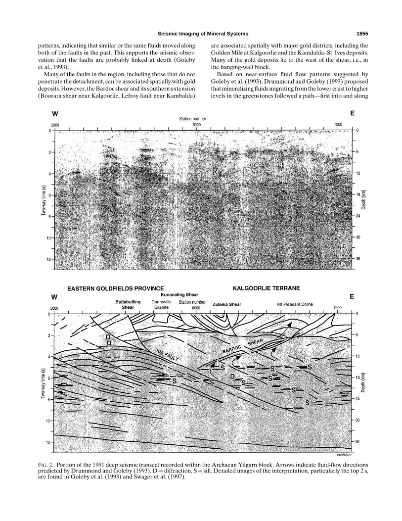
Numerical modeling of fluid flow within the EasternGoldfields province supports this linked fluid-pathway model(Figure 3) (Upton et al., 1997). The numerical modeling usedthe crustal structure defined by the seismic profiling; otherphysical properties of the crust were assumed. The order ofdeformational and thermal events was derived from the geo-logical record. The modeling predicted an initial, single crustal-scale convection cell in which fluids were driven up the Ida faultfrom depth and down the Ida fault from the surface. Thesemixed and flowed up the Bardoc shear, resulting in a highdegree of chemical alteration and hence mineral depositionwithin the upper crust, particularly within the greenstones. Astemperatures dropped, the single convection cell broke downinto smaller cells within the upper crust. These concentratedthe mineral species in the upper crust. Coupled deformation-fluid flow modeling predicted the occurrance of east-dippingfaults within the crust. These were seen in the seismic data. Themodel also predicted focused fluid flow into the east-dippingshear zones.
FIG. 3. Fluid-flow modeling of the Yilgarn block. The fault geometry is derived from the seismic data. Crustal layering is impliedfrom reflectivity patterns along the profile. The topmost layer was added to account for crust removed by erosion since the oredeposits were formed. Arrows represent fluid-flow vectors. East-dipping zones of longer vectors in the greenstones and base-ment are predicted by the modeling and coincide with weak reflections in the seismic data. LC= lower crust, UC= upper crust,G= greenstones, C= crust removed by erosion.
CASE HISTORY 2: MT. ISA
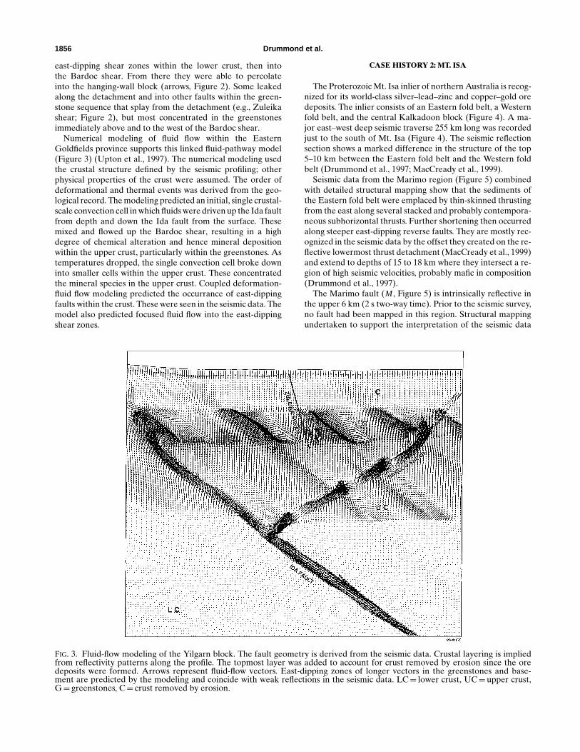
The Proterozoic Mt. Isa inlier of northern Australia is recog-nized for its world-class silver–lead–zinc and copper–gold oredeposits. The inlier consists of an Eastern fold belt, a Westernfold belt, and the central Kalkadoon block (Figure 4). A ma-jor east–west deep seismic traverse 255 km long was recordedjust to the south of Mt. Isa (Figure 4). The seismic reflectionsection shows a marked difference in the structure of the top5–10 km between the Eastern fold belt and the Western foldbelt (Drummond et al., 1997; MacCready et al., 1999).
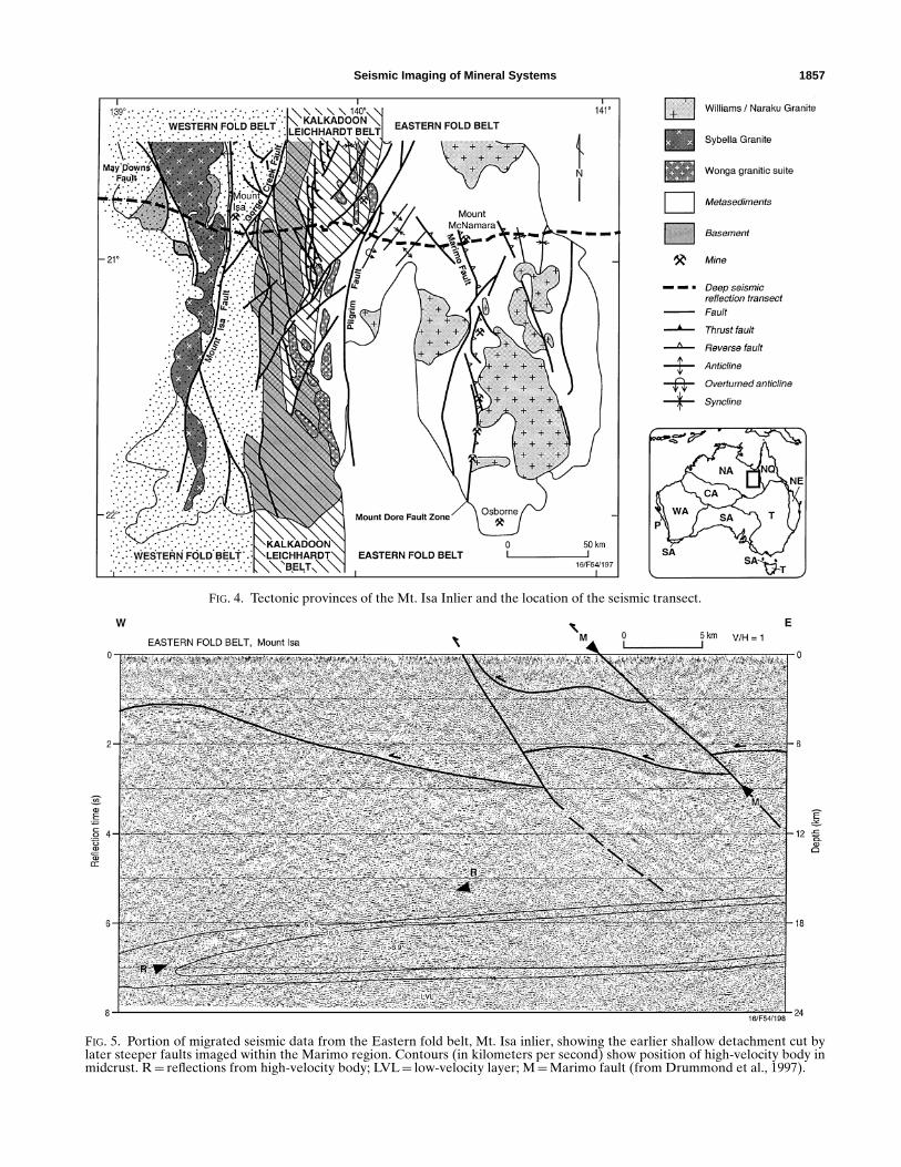
Seismic data from the Marimo region (Figure 5) combinedwith detailed structural mapping show that the sediments ofthe Eastern fold belt were emplaced by thin-skinned thrustingfrom the east along several stacked and probably contempora-neous subhorizontal thrusts. Further shortening then occurredalong steeper east-dipping reverse faults. They are mostly rec-ognized in the seismic data by the offset they created on the re-flective lowermost thrust detachment (MacCready et al., 1999)and extend to depths of 15 to 18 km where they intersect a re-gion of high seismic velocities, probably mafic in composition(Drummond et al., 1997).
The Marimo fault (M , Figure 5) is intrinsically reflective inthe upper 6 km (2 s two-way time). Prior to the seismic survey,no fault had been mapped in this region. Structural mappingundertaken to support the interpretation of the seismic data
Seismic Imaging of Mineral Systems 1857
FIG. 4. Tectonic provinces of the Mt. Isa Inlier and the location of the seismic transect.
FIG. 5. Portion of migrated seismic data from the Eastern fold belt, Mt. Isa inlier, showing the earlier shallow detachment cut bylater steeper faults imaged within the Marimo region. Contours (in kilometers per second) show position of high-velocity body inmidcrust. R= reflections from high-velocity body; LVL= low-velocity layer; M=Marimo fault (from Drummond et al., 1997).
1858 Drummond et al.
found an east-dipping, 200-m-wide zone of hydrothermal alter-ation. The reflectivity of the fault is believed to result from thebroad zone of alteration. The spatial relationship of this faultto mineral deposits in the region is seen as further evidencethat this fault acted as a fluid pathway. The Mount McNamaracopper–gold mine lies near the transect, and the Hampden,Mount Dore, Selwyn, and Osborne copper–gold mines lie ona linear trend to the south (Figure 4).
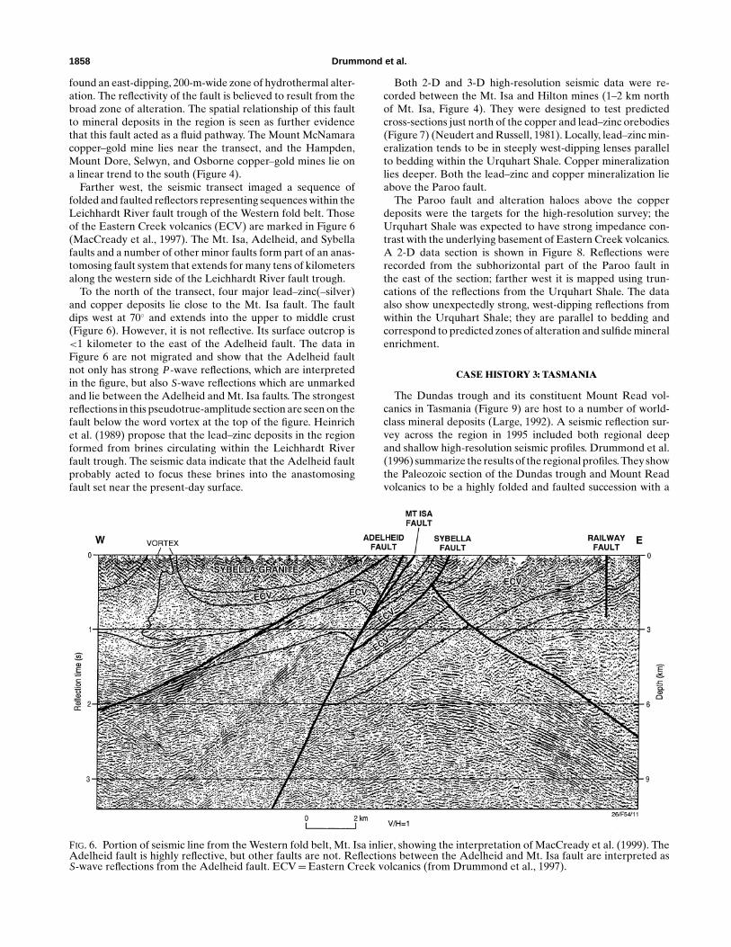
Farther west, the seismic transect imaged a sequence offolded and faulted reflectors representing sequences within theLeichhardt River fault trough of the Western fold belt. Thoseof the Eastern Creek volcanics (ECV) are marked in Figure 6(MacCready et al., 1997). The Mt. Isa, Adelheid, and Sybellafaults and a number of other minor faults form part of an anas-tomosing fault system that extends for many tens of kilometersalong the western side of the Leichhardt River fault trough.
To the north of the transect, four major lead–zinc(–silver)and copper deposits lie close to the Mt. Isa fault. The faultdips west at 70◦ and extends into the upper to middle crust(Figure 6). However, it is not reflective. Its surface outcrop is<1 kilometer to the east of the Adelheid fault. The data inFigure 6 are not migrated and show that the Adelheid faultnot only has strong P-wave reflections, which are interpretedin the figure, but also S-wave reflections which are unmarkedand lie between the Adelheid and Mt. Isa faults. The strongestreflections in this pseudotrue-amplitude section are seen on thefault below the word vortex at the top of the figure. Heinrichet al. (1989) propose that the lead–zinc deposits in the regionformed from brines circulating within the Leichhardt Riverfault trough. The seismic data indicate that the Adelheid faultprobably acted to focus these brines into the anastomosingfault set near the present-day surface.
FIG. 6. Portion of seismic line from the Western fold belt, Mt. Isa inlier, showing the interpretation of MacCready et al. (1999). TheAdelheid fault is highly reflective, but other faults are not. Reflections between the Adelheid and Mt. Isa fault are interpreted asS-wave reflections from the Adelheid fault. ECV=Eastern Creek volcanics (from Drummond et al., 1997).
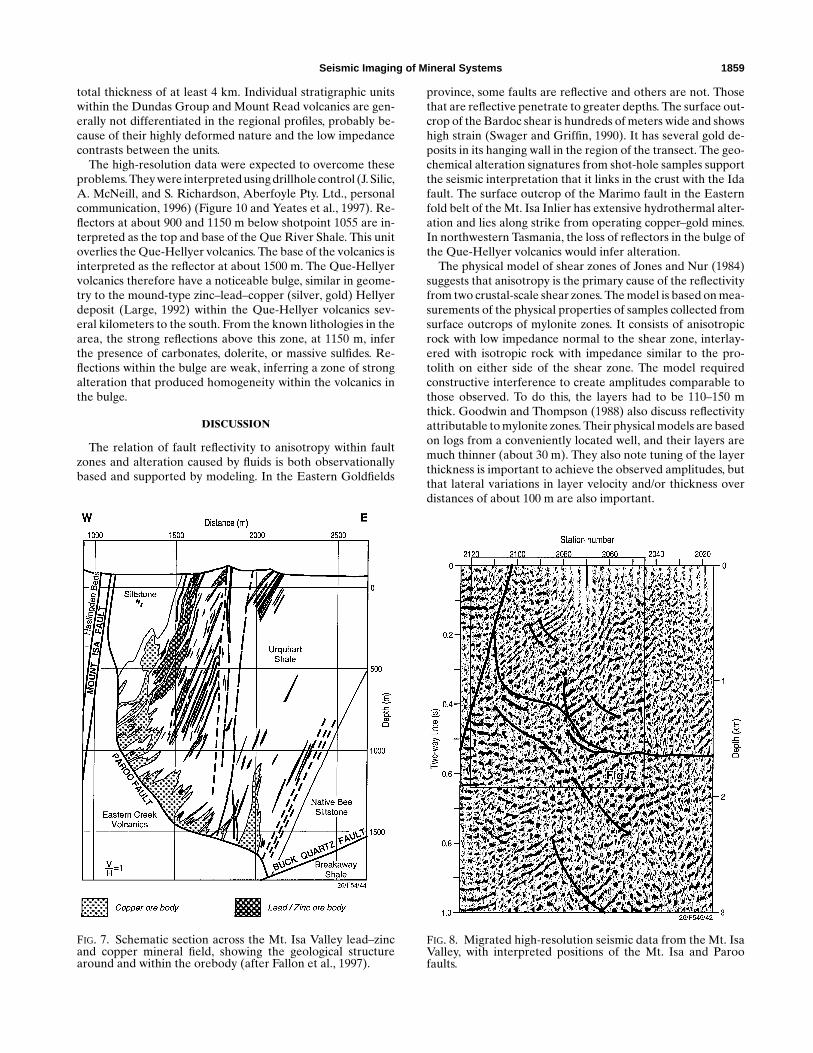
Both 2-D and 3-D high-resolution seismic data were re-corded between the Mt. Isa and Hilton mines (1–2 km northof Mt. Isa, Figure 4). They were designed to test predictedcross-sections just north of the copper and lead–zinc orebodies(Figure 7) (Neudert and Russell, 1981). Locally, lead–zinc min-eralization tends to be in steeply west-dipping lenses parallelto bedding within the Urquhart Shale. Copper mineralizationlies deeper. Both the lead–zinc and copper mineralization lieabove the Paroo fault.
The Paroo fault and alteration haloes above the copperdeposits were the targets for the high-resolution survey; theUrquhart Shale was expected to have strong impedance con-trast with the underlying basement of Eastern Creek volcanics.A 2-D data section is shown in Figure 8. Reflections wererecorded from the subhorizontal part of the Paroo fault inthe east of the section; farther west it is mapped using trun-cations of the reflections from the Urquhart Shale. The dataalso show unexpectedly strong, west-dipping reflections fromwithin the Urquhart Shale; they are parallel to bedding andcorrespond to predicted zones of alteration and sulfide mineralenrichment.
CASE HISTORY 3: TASMANIA
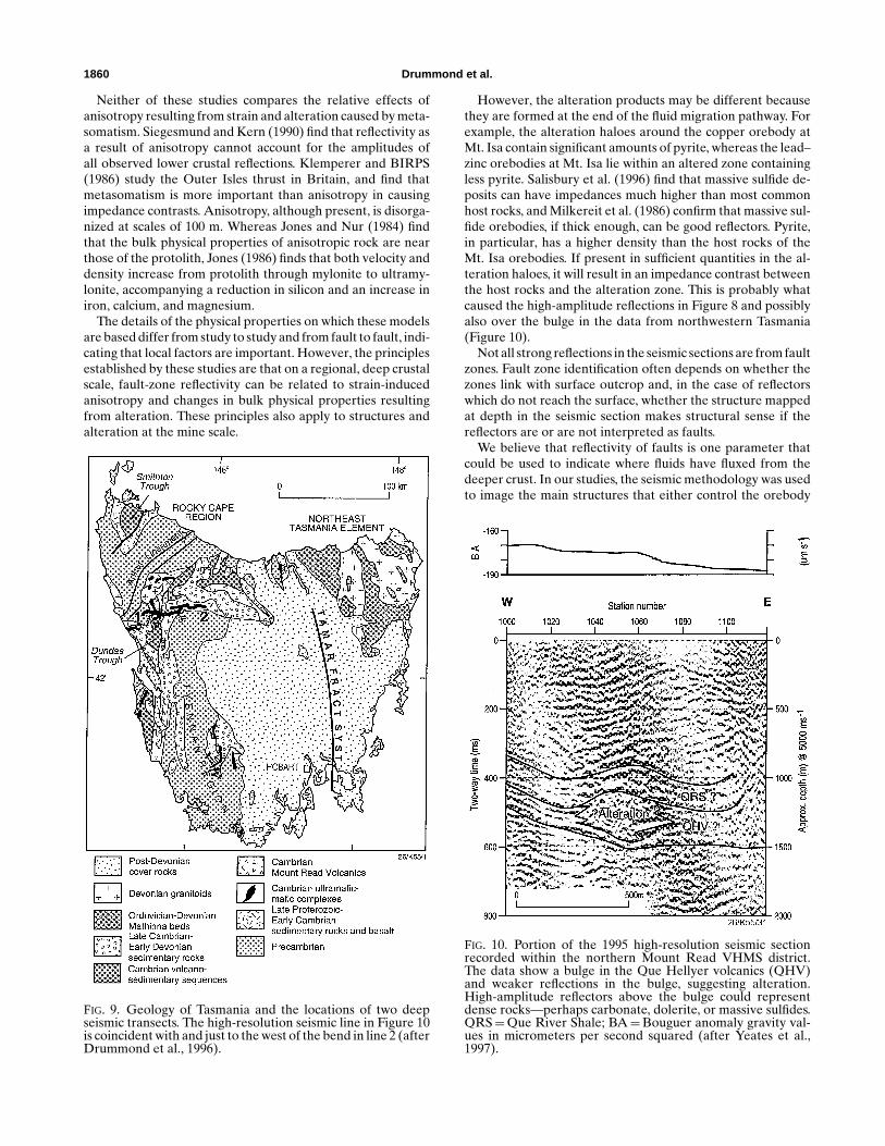
The Dundas trough and its constituent Mount Read vol-canics in Tasmania (Figure 9) are host to a number of world-class mineral deposits (Large, 1992). A seismic reflection sur-vey across the region in 1995 included both regional deepand shallow high-resolution seismic profiles. Drummond et al.(1996) summarize the results of the regional profiles. They showthe Paleozoic section of the Dundas trough and Mount Readvolcanics to be a highly folded and faulted succession with a
Seismic Imaging of Mineral Systems 1859
total thickness of at least 4 km. Individual stratigraphic unitswithin the Dundas Group and Mount Read volcanics are gen-erally not differentiated in the regional profiles, probably be-cause of their highly deformed nature and the low impedancecontrasts between the units.
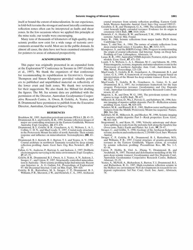
The high-resolution data were expected to overcome theseproblems. They were interpreted using drillhole control (J. Silic,A. McNeill, and S. Richardson, Aberfoyle Pty. Ltd., personalcommunication, 1996) (Figure 10 and Yeates et al., 1997). Re-flectors at about 900 and 1150 m below shotpoint 1055 are in-terpreted as the top and base of the Que River Shale. This unitoverlies the Que-Hellyer volcanics. The base of the volcanics isinterpreted as the reflector at about 1500 m. The Que-Hellyervolcanics therefore have a noticeable bulge, similar in geome-try to the mound-type zinc–lead–copper (silver, gold) Hellyerdeposit (Large, 1992) within the Que-Hellyer volcanics sev-eral kilometers to the south. From the known lithologies in thearea, the strong reflections above this zone, at 1150 m, inferthe presence of carbonates, dolerite, or massive sulfides. Re-flections within the bulge are weak, inferring a zone of strongalteration that produced homogeneity within the volcanics inthe bulge.
DISCUSSION
The relation of fault reflectivity to anisotropy within faultzones and alteration caused by fluids is both observationallybased and supported by modeling. In the Eastern Goldfields
FIG. 7. Schematic section across the Mt. Isa Valley lead–zincand copper mineral field, showing the geological structurearound and within the orebody (after Fallon et al., 1997).
province, some faults are reflective and others are not. Thosethat are reflective penetrate to greater depths. The surface out-crop of the Bardoc shear is hundreds of meters wide and showshigh strain (Swager and Griffin, 1990). It has several gold de-posits in its hanging wall in the region of the transect. The geo-chemical alteration signatures from shot-hole samples supportthe seismic interpretation that it links in the crust with the Idafault. The surface outcrop of the Marimo fault in the Easternfold belt of the Mt. Isa Inlier has extensive hydrothermal alter-ation and lies along strike from operating copper–gold mines.In northwestern Tasmania, the loss of reflectors in the bulge ofthe Que-Hellyer volcanics would infer alteration.
The physical model of shear zones of Jones and Nur (1984)suggests that anisotropy is the primary cause of the reflectivityfrom two crustal-scale shear zones. The model is based on mea-surements of the physical properties of samples collected fromsurface outcrops of mylonite zones. It consists of anisotropicrock with low impedance normal to the shear zone, interlay-ered with isotropic rock with impedance similar to the pro-tolith on either side of the shear zone. The model requiredconstructive interference to create amplitudes comparable tothose observed. To do this, the layers had to be 110–150 mthick. Goodwin and Thompson (1988) also discuss reflectivityattributable to mylonite zones. Their physical models are basedon logs from a conveniently located well, and their layers aremuch thinner (about 30 m). They also note tuning of the layerthickness is important to achieve the observed amplitudes, butthat lateral variations in layer velocity and/or thickness overdistances of about 100 m are also important.
FIG. 8. Migrated high-resolution seismic data from the Mt. IsaValley, with interpreted positions of the Mt. Isa and Paroofaults.
1860 Drummond et al.
Neither of these studies compares the relative effects ofanisotropy resulting from strain and alteration caused by meta-somatism. Siegesmund and Kern (1990) find that reflectivity asa result of anisotropy cannot account for the amplitudes ofall observed lower crustal reflections. Klemperer and BIRPS(1986) study the Outer Isles thrust in Britain, and find thatmetasomatism is more important than anisotropy in causingimpedance contrasts. Anisotropy, although present, is disorga-nized at scales of 100 m. Whereas Jones and Nur (1984) findthat the bulk physical properties of anisotropic rock are nearthose of the protolith, Jones (1986) finds that both velocity anddensity increase from protolith through mylonite to ultramy-lonite, accompanying a reduction in silicon and an increase iniron, calcium, and magnesium.
The details of the physical properties on which these modelsare based differ from study to study and from fault to fault, indi-cating that local factors are important. However, the principlesestablished by these studies are that on a regional, deep crustalscale, fault-zone reflectivity can be related to strain-inducedanisotropy and changes in bulk physical properties resultingfrom alteration. These principles also apply to structures andalteration at the mine scale.
FIG. 9. Geology of Tasmania and the locations of two deepseismic transects. The high-resolution seismic line in Figure 10is coincident with and just to the west of the bend in line 2 (afterDrummond et al., 1996).
However, the alteration products may be different becausethey are formed at the end of the fluid migration pathway. Forexample, the alteration haloes around the copper orebody atMt. Isa contain significant amounts of pyrite, whereas the lead–zinc orebodies at Mt. Isa lie within an altered zone containingless pyrite. Salisbury et al. (1996) find that massive sulfide de-posits can have impedances much higher than most commonhost rocks, and Milkereit et al. (1986) confirm that massive sul-fide orebodies, if thick enough, can be good reflectors. Pyrite,in particular, has a higher density than the host rocks of theMt. Isa orebodies. If present in sufficient quantities in the al-teration haloes, it will result in an impedance contrast betweenthe host rocks and the alteration zone. This is probably whatcaused the high-amplitude reflections in Figure 8 and possiblyalso over the bulge in the data from northwestern Tasmania(Figure 10).
Not all strong reflections in the seismic sections are from faultzones. Fault zone identification often depends on whether thezones link with surface outcrop and, in the case of reflectorswhich do not reach the surface, whether the structure mappedat depth in the seismic section makes structural sense if thereflectors are or are not interpreted as faults.
We believe that reflectivity of faults is one parameter thatcould be used to indicate where fluids have fluxed from thedeeper crust. In our studies, the seismic methodology was usedto image the main structures that either control the orebody
FIG. 10. Portion of the 1995 high-resolution seismic sectionrecorded within the northern Mount Read VHMS district.The data show a bulge in the Que Hellyer volcanics (QHV)and weaker reflections in the bulge, suggesting alteration.High-amplitude reflectors above the bulge could representdense rocks—perhaps carbonate, dolerite, or massive sulfides.QRS=Que River Shale; BA=Bouguer anomaly gravity val-ues in micrometers per second squared (after Yeates et al.,1997).
Seismic Imaging of Mineral Systems 1861
itself or bound the extent of mineralization. In our experience,in fold-belt terrains the strongest and most laterally continuousreflection zones often can be interpreted as faults and shearzones. In the few occasions where we applied this principle atthe mine scale, our results were encouraging.
Many tens of thousands of kilometers of high-quality, deepseismic profiles now exist for a wide range of tectonic envi-ronments around the world. Most are in the public domain. Inalmost all cases, the data have not been examined extensivelyfor pointers to areas of enhanced prospectivity.
ACKNOWLEDGMENTS
This paper was originally presented in an expanded format the Exploration’97 Conference in Toronto in 1997 (Golebyet al., 1997). We thank the organizers of that conferencefor recommending its republication in GEOPHYSICS. GeorgeThompson and Simon Klemperer provided valuable point-ers to published and unpublished material on reflectivity ofthe lower crust and fault zones. We thank two reviewersfor their suggestions. We also thank Joe Mifsud for draftingthe figures. The Mt. Isa seismic data are published with thepermission of the Director, Australian Geodynamics Cooper-ative Research Centre. A. Owen, B. Goleby, A. Yeates, andB. Drummond have permission to publish from the ExecutiveDirector, Australian, Geological Survey Org.
REFERENCES
Bradshaw, M., 1993, Australian petroleum systems: PESA J., 21, 43–53.Drummond, B. J., and Goleby, B. R., 1993, Seismic reflection images of
major ore-controlling structures in the Eastern Goldfields, WesternAustralia: Expl. Geophys., 24, 473–478.
Drummond, B. J., Goleby, B. R., Goncharov, A. G., Wyborn, L. A. I.,Collins, C. D. N., and MacCready, T., 1997, Crustal-scale structuresin the Proterozoic Mount Isa inlier of north Australia: Their seismicresponse and influence on mineralisation: Tectonophysics, 288, 43–56.
Drummond, B. J., Korsch, R. J., Barton, T. J., and Yeates, A. V., 1996,Crustal architure in northwest Tasmania revealed by deep seismicreflection profiling: Austr. Geol. Surv. Org. Res. Newslett., 25, 17–19.
Fallon, G. N., Andrews, P., Bartrop, S., and Jackson, J., 1997, Drillholeelectromagnetic surveying in the mine environment: Expl. Geophys.,27, 67–75.
Goleby, B. R., Drummond, B. J., Owen, A. J., Yeates, A. N., Jackson, J.,Swager, C., and Upton, P., 1997, Structurally controlled mineralisa-tion in Australia—How seismic profiling helps find minerals: Recentcase histories: in A. G. Gubins, Ed., Proceedings, of Exploration’97: 4th Decennial Internat. Conf. on Min. Expl., 409–420.
Goleby, B. R., Rattenbury, M. S., Swager, C. P., Drummond, B. J.,Williams, P. R., Sheraton, J. W., and Heinrich, C. A., 1993, Archaean
crustal structure from seismic reflection profiling, Eastern Gold-fields, Western Australia: Austral. Geol. Surv. Org. record 1993/15.
Goodwin, E. B., and Thompson, G. A., 1988, The seismically reflectivecrust beneath highly extended terranes: Evidence for its origin inextension: GSA Bull., 100, 1616–1626.
Heinrich, C. A., Henley, R. W., and Seward, T. M., 1989, Hydrothermalsystems: Austral. Min. Found.
Jones, R., 1986, Seismic reflections from major faults: Ph.D. thesis,Cambridge Univ.
Jones, T., and Nur, A., 1984, The nature of seismic reflections fromdeep crustal fault zones: J. Geophys. Res., 89, 3153–3171.
Klemperer, S., and the BIRPS Group, 1986, Progress in understandingthe origin of crustal reflections: 2nd Internat. Symp. on Deep Seis.Profiling of Cont. Lithosphere, Abstracts, 19.
Large, R. R., 1992, Australian VHMS deposits: Features, styles, geneticmodels: Econ. Geol., 87, 471–510.
Loutit, T. S., Wyborn, L. A. I., Hinman, M. C., and Idnurm, M., 1994,Palaeomagnetic, tectonic, magmatic and mineralisation events in theProterozoic of northern Australia: Ann. Conf., Australasian Inst.Min. Metal., Proceedings, 123–128.
MacCready, T., Goleby, B. R., Goncharov, A., Drummond, B. J., andLister, G. S., 1999, A framework of overprinting orogens based oninterpretation of the Mount Isa deep seismic transect: Econ. Geol.,93, 1422–1434.
MacCready, T., Goleby, B. R., Goncharov, A., Lister, G. S., andDrummond, B. J., 1997, An evolutionary framework for the Isanorogeny Proterozoic terranes: Geodynamics and Ore DepositsConf., Australian Geodynamics Cooperative Research Centre, Ab-stracts, 42–45.
Magoon, L. B., and Dow, W. G., 1991, The petroleum system—Fromsource to trap: AAPG Bull., 75, 627.
Milkereit, B., Eaton, D., Wu, J., Perron, G., and Salisbury, M., 1996, Seis-mic imaging of massive sulfide deposits: Part II—Reflection seismicprofiling: Econ. Geol., 91, 829–834.
Neudert, M. K., and Russell, R. E., 1981, Shallow water and hypersalinefeatures from the Middle Proterozoic Mount Isa sequence: Nature,293, 284–286.
Salisbury, M. H., Milkereit, B., and Bleeker, W., 1996, Seismic imagingof massive sulfide deposits: Part I—Rock properties: Econ. Geol.,91, 821–828.
Siegesmund, S., and Kern, H., 1990, Velocity anisotropy and shear-wave splitting in rocks from the mylonite belt along the Insubric line(Ivrea zone, Italy): Earth and Planet. Sci. Lett., 99, 29–47.
Swager, C., and Griffin, T., 1990, Geology of the Archaean Kalgoorlieterrane, northern and southern sheets, 1:250 000: Geol. Surv. WesternAustral.
Swager, C. P., Goleby, B. R., Drummond, B. J., Rattenbury, M.S.,and Williams, P. R., 1997, Crustal structure of granite-greenstoneterranes in the Eastern Goldfields, Yilgarn craton, as revealedby seismic reflection profiling: Precambrian Res., 83, No. 1–3,43–56.
Upton, P., Hobbs, B., Ord, A., Zhang, Y., Drummond, B., andArchibald, N., 1997, Thermal and deformation modelling of the Yil-garn deep seismic transect: Geodynamics and Ore Deposits Conf.,Australian Geodynamics Cooperative Research Centre, Ballarat,Abstract, 22–25.
Yeates, A., McNeill, A., Richardson, S., Barton, T. J., Drummond, B. J.,and Richardson, R. G., 1997, High-resolution reflection seismic inthe Hellyer ore environment: New developments in research for oredeposit exploration: 3rd Nat. Conf., Geol. Soc. Austr., Abstracts,78.