Seismic Monitoring and the Advanced National Seismic · PDF file• Kobe, Japan, M 6.8...
15
1 U.S. Department of the Interior U.S. Geological Survey Earthquake Monitoring and Reporting through the Advanced National Seismic System Briefing for the Natural Hazards Caucus February 3, 2006 Dr. William Leith ANSS Coordinator Earthquake Hazards Program
Transcript of Seismic Monitoring and the Advanced National Seismic · PDF file• Kobe, Japan, M 6.8...
1
U.S. Department of the Interior
U.S. Geological Survey
Earthquake Monitoring and Reporting through the Advanced National Seismic System Briefing for the Natural Hazards Caucus February 3, 2006 Dr. William Leith ANSS Coordinator Earthquake Hazards Program

2
Earthquake Losses:
• Earthquakes pose the highest, single-event financial risk of any natural hazard.
• Northridge, California, M 6.8 event of 1994 caused an estimated $40 billion in losses.
• Kobe, Japan, M 6.8 event of 1995 caused over $100 billion in direct losses, estimated over $300 billion total losses
• FEMA estimates annual earthquake losses now $5.6 billion

3
What can an advanced earthquake monitoring system do?
• Provide rapid notification of earthquake occurrences and effects to speed emergency response and recovery.
• Promote mitigation through application of earthquake hazard assessments and data in building codes, structure design, and civic planning.
• Provide data for basic and applied research on earthquake effects and to improve hazard assessments.
• Improve public education and awareness.
All of these activities rely on improved monitoring data…
4
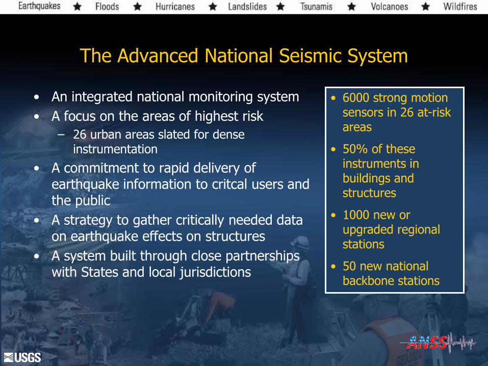
The Advanced National Seismic System
• An integrated national monitoring system
• A focus on the areas of highest risk
– 26 urban areas slated for dense instrumentation
• A commitment to rapid delivery of earthquake information to critcal users and the public
• A strategy to gather critically needed data on earthquake effects on structures
• A system built through close partnerships with States and local jurisdictions
• 6000 strong motion sensors in 26 at-risk areas
• 50% of these instruments in buildings and structures
• 1000 new or upgraded regional stations
• 50 new national backbone stations

5
The Building Blocks of the ANSS
• National Earthquake Information Center – NEIC, Golden, Colorado
• National Seismic Network
– (“ANSS Backbone”)
• 15 Regional Seismic Networks
– and data centers at Fairbanks, Seattle, Menlo Park CA, Pasadena CA, Reno. Salt Lake, Memphis, Weston MA
• National Strong Motion Network

Growth of ANSS Stations Since Inception
43
171
709669
563523
428
382
303
0
200
400
600
800
1000
Pre-
ANSS
FY00 FY01 FY02 FY03 FY04 FY05 FY06 FY07
est.
Fiscal Year
Nu
mber
of
Sta
tion
s
ANSS Costs: Capitalization $172M, Operations $43M/yr
Annual Funds: $8M $4M
ANSS Funding, FY00-FY04
0.00
10.00
20.00
30.00
40.00
2000 2001 2002 2003 2004 2005 2006
FISCAL YEAR
Dollars
($M
)
Authorization
Appropriation
ANSS Funding

7
ANSS Accomplishments
• Over 600 new earthquake sensors installed; National and Regional Network Upgrades begun.
• ShakeMap capability implemented in Los Angeles, San Francisco, Seattle, Salt Lake and Anchorage
• Real-time products and integrated communications, data analysis, and reporting under development
• Management and technical plans completed; National and regional structures in place and working.

8
ANSS Products: ShakeMap rapid mapping of strong ground shaking grew out of the Northridge earthquake experience
Newhall: Intensity IX
Collapse of Overpass
Northridge: Intensity IX Parking Garage Collapse
Granada Hills: IX Gas/Water Line Rupture
Provides a rapid indication of probable areas of earthquake damage

9
In partnership with:

10
ANSS Backbone: Estimated Detection Capability
Mw
Simulated future detection capabilities with 22
planned ANSS backbone stations added

11 M. Çelebi
Structural Array in Atwood Building, Anchorage
Instrumentation monitors for drift, translation, torsion, and rocking

12
ANSS Performance Goals
Through the modernization, expansion, and integration of earthquake monitoring and notification nationwide the completed ANSS will:
• Provide an accurate assessment of the severity and distribution of strong ground shaking in high-risk urban areas at risk within 10 minutes
• Acquire the seismic data necessary to improve earthquake hazards assessments and improved earthquake resistant construction and performance based design.
• Provide a few tens of seconds warning of imminent strong ground shaking in urban areas.

13
FaultEarthquake
Strong motion sensor
with communications
Data Center
Combination strong motion/
weak motion sensor
with communications
Modern networks can give detailed picture of seismic shaking in urban areas and possibly give tens seconds warning of imminent ground shaking

14
Network Completion Phase
NEIC 24x7 Operation
Subsystem C&A
Hydra Development Work
Planning Stage
Requirements Developmt.
2001 2002 200319991998
Urban SM: LA
Eng Data Ctr
Install X Structures
Urban SM: SF
Urban SM: SEA
Urban SM: SLC
Urban SM: Anchorage
System C&A, Recert.
Develop System Tools (EIDS, INV , SNW, etc .)
Proof of Concept Phase System Development Phase
Guidel. Dev.
Teton net.
Initial Building Instr. (Calif, A laska)
2004 2005 2006 20072000 2008 2009 2010
EA Devel.
Proj Mgmt Development (Ex300, EVMS, PM Cert.)
ANSS Mgmt. Plan
Tech. Specs. I
Develop Performance Stds
Product Ctr
Data Archive
Tech. Specs. II
RFP & Proc.
Backbone Network DME in 49 States
NEIC Upgrades
Timeline budget
dependent
Continued Expansion of the System
• Expect completion of system development phase in 2007
• Expected 2007 funding will cover only O&M of the existing system and small expansion in the number of instrumented structures
• Over 20 urban areas remain to be instrumented for ShakeMap, and the 4 of 5 instrumented cities need additional sensors
• Event reporting will be at minimum perfor-mance standards in most areas of the country
• Early warning requires considerable new investment

15