Seismic Hazards 14-07-0151
8
The 14 th World Conference on Earthquake Engineering October 12-17, 2008, Beijing, China SEISMIC HAZARD AND SEISMIC DESIGN REQUIREMENTS FOR THE ARABIAN PENINSULA REGION V. Pascucci 1 , M.W. Free 2 and Z.A. Lubkowski 2 1 Seismic Engineer, Arup, London W1T 4BQ, UK 2 Associate Director, Arup, London W1T 4BQ, UK Email: [email protected] ABSTRACT : This paper presents the results of a regional seismic hazard assessment undertaken for the Arabian Peninsula region. This area includes a number of major regional tectonic features including the Zagros and Makran regions to the north and east, the Dead Sea and Red Sea to the west and the Gulf of Aden and Owen Fracture Zone to the south and southeast, with the stable continental Arabian Plate in the centre of the region. An earthquake catalogue has been compiled and critically reviewed for this region and seismic source zones and their associated magnitude recurrence parameters defined. Attenuation relationships have been selected based on the tectonic character of the source zones. The uncertainty in each element of the hazard assessment has been included in the assessment using logic tree methodology. The seismic hazard results are presented in the form of peak ground mo tions and uniform hazard resp onse spectra for selected cities in the region . The paper also discusses how these results compare with design values typically used for seismic design purposes in the region. KEYWORDS: seismic hazard, ground motion, Arabia, United Arab Emirates 1. INTRODUCTION Until quite recently, the seismic hazard i n the Arabian Gulf states was considered to be negligible. For example, UBC (1997) and Al-Haddad et al. (1994) classify Dubai, Abu Dhabi, Bahrain an d Doha to be in Zone 0, i.e. no seismic design requirements. In contrast, the publication of the Global Seismic Hazard Assessment Program (GSHAP) map (Shedlock et al., 2000) as well as the recent occurrence of locally felt earthquakes, such as the March 11, 2002 Masafi event, have led to a perceived need for revision of this assessment. There are currently no well established seismic code requirements for structures in the Arabian Peninsula states. However, both the Abu Dhabi and Dubai Municipalities recommend that for buildings of fi ve or more storeys the Zone 2A design criteria in UBC 1997 should be employed. Further recommendations on seismic hazard levels in the Arabian Peninsula can be found in the “Guide to Design of Concrete Structures in the Arabian Peninsula” prepared by the Concrete Society (2007) which indicates moderately low seismic hazard for most of the cities in the Arabian Gulf region. A seismic hazard assessment has therefore been undertaken to determine seismic ground-motion parameters for seismic design of facilities located in the Arabian Gulf region. This study represents an update to that produced by Peiris et al. (2006). The study area for this assessment extends from 10 ° N to 35° N and 35°E to 65°E. This area is centred on the stable continental Arabian Plate with major active tectonic features forming the boundaries to this stable plate; the Zagros Fold Belt and Makran subduction zone to the north and northeast, the Red Sea Rift and Dead Sea Rift to the northwest and west and the Gulf of Aden and Owen Fracture Zone to the south and southeast.
-
Upload
vincent-porrazzo -
Category
Documents
-
view
218 -
download
0
Transcript of Seismic Hazards 14-07-0151

8/3/2019 Seismic Hazards 14-07-0151
http://slidepdf.com/reader/full/seismic-hazards-14-07-0151 1/8
The 14th
World Conference on Earthquake Engineering
October 12-17, 2008, Beijing, China
SEISMIC HAZARD AND SEISMIC DESIGN REQUIREMENTS FOR THE
ARABIAN PENINSULA REGION
V. Pascucci1, M.W. Free
2and Z.A. Lubkowski
2
1
Seismic Engineer, Arup, London W1T 4BQ, UK 2
Associate Director, Arup, London W1T 4BQ, UK
Email: [email protected]
ABSTRACT :
This paper presents the results of a regional seismic hazard assessment undertaken for the Arabian Peninsula
region. This area includes a number of major regional tectonic features including the Zagros and Makran
regions to the north and east, the Dead Sea and Red Sea to the west and the Gulf of Aden and Owen Fracture
Zone to the south and southeast, with the stable continental Arabian Plate in the centre of the region. Anearthquake catalogue has been compiled and critically reviewed for this region and seismic source zones and
their associated magnitude recurrence parameters defined. Attenuation relationships have been selected based
on the tectonic character of the source zones. The uncertainty in each element of the hazard assessment has
been included in the assessment using logic tree methodology. The seismic hazard results are presented in the
form of peak ground motions and uniform hazard response spectra for selected cities in the region. The paper
also discusses how these results compare with design values typically used for seismic design purposes in the
region.
KEYWORDS: seismic hazard, ground motion, Arabia, United Arab Emirates
1. INTRODUCTION
Until quite recently, the seismic hazard in the Arabian Gulf states was considered to be negligible. For example,
UBC (1997) and Al-Haddad et al. (1994) classify Dubai, Abu Dhabi, Bahrain and Doha to be in Zone 0, i.e. no
seismic design requirements. In contrast, the publication of the Global Seismic Hazard Assessment Program
(GSHAP) map (Shedlock et al., 2000) as well as the recent occurrence of locally felt earthquakes, such as the
March 11, 2002 Masafi event, have led to a perceived need for revision of this assessment.
There are currently no well established seismic code requirements for structures in the Arabian Peninsula states.
However, both the Abu Dhabi and Dubai Municipalities recommend that for buildings of five or more storeys
the Zone 2A design criteria in UBC 1997 should be employed. Further recommendations on seismic hazard
levels in the Arabian Peninsula can be found in the “Guide to Design of Concrete Structures in the Arabian
Peninsula” prepared by the Concrete Society (2007) which indicates moderately low seismic hazard for most of the cities in the Arabian Gulf region.
A seismic hazard assessment has therefore been undertaken to determine seismic ground-motion parameters for
seismic design of facilities located in the Arabian Gulf region. This study represents an update to that produced
by Peiris et al. (2006). The study area for this assessment extends from 10° N to 35° N and 35°E to 65°E. This
area is centred on the stable continental Arabian Plate with major active tectonic features forming the
boundaries to this stable plate; the Zagros Fold Belt and Makran subduction zone to the north and northeast, the
Red Sea Rift and Dead Sea Rift to the northwest and west and the Gulf of Aden and Owen Fracture Zone to the
south and southeast.
8/3/2019 Seismic Hazards 14-07-0151
http://slidepdf.com/reader/full/seismic-hazards-14-07-0151 2/8
The 14th
World Conference on Earthquake Engineering
October 12-17, 2008, Beijing, China
An earthquake catalogue extending back over 2000 years has been compiled and critically reviewed for the
study area. A seismic source model has been developed based on the regional geology and tectonics, the
historical and recent seismicity, and taking into consideration hazard models developed by other researchers for
the region. The Next Generation of Attenuation (NGA) equations have been used for those seismic sources
characterized by shallow crustal earthquakes.
The results of the seismic hazard assessment are presented in terms of peak ground acceleration (PGA) and
uniform hazard response spectra (UHRS) for 475 year (10% probability of exceedance in 50 years) and 2475
year (2% probability of exceedance in 50 years) return periods for rock sites (Vs ≥ 760 m/s). Seismic
ground-motion parameters are presented for the cities of Dubai, Abu Dhabi, Kuwait City, Bahrain, Doha,
Muscat and Jeddah. It is also illustrated how the ground motion parameters determined compare with those in a
range of current international building codes; the Uniform Building Code 1997, Eurocode 8 and the
International Building Code 2005.
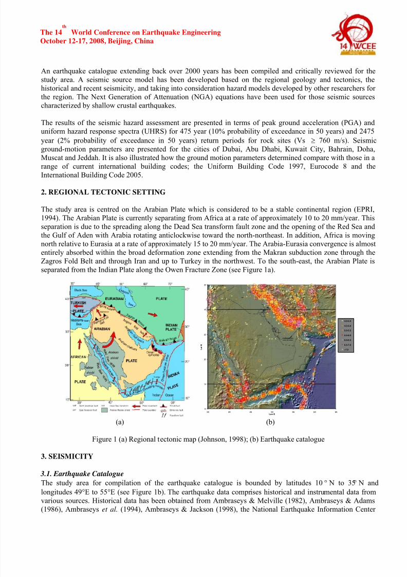
2. REGIONAL TECTONIC SETTING
The study area is centred on the Arabian Plate which is considered to be a stable continental region (EPRI,
1994). The Arabian Plate is currently separating from Africa at a rate of approximately 10 to 20 mm/year. This
separation is due to the spreading along the Dead Sea transform fault zone and the opening of the Red Sea and
the Gulf of Aden with Arabia rotating anticlockwise toward the north-northeast. In addition, Africa is moving
north relative to Eurasia at a rate of approximately 15 to 20 mm/year. The Arabia-Eurasia convergence is almost
entirely absorbed within the broad deformation zone extending from the Makran subduction zone through the
Zagros Fold Belt and through Iran and up to Turkey in the northwest. To the south-east, the Arabian Plate is
separated from the Indian Plate along the Owen Fracture Zone (see Figure 1a).
10
15
20
25
30
35
35 40 45 50 55 60 65Lon E
L a t N
4.0-4.5
4.5-5.0
5.0-5.5
5.5-6.0
6.0-6.5
6.5-7.0
>7.0
(a) (b)
Figure 1 (a) Regional tectonic map (Johnson, 1998); (b) Earthquake catalogue
3. SEISMICITY
3.1. Earthquake Catalogue
The study area for compilation of the earthquake catalogue is bounded by latitudes 10° N to 35° N and
longitudes 49°E to 55°E (see Figure 1b). The earthquake data comprises historical and instrumental data from
various sources. Historical data has been obtained from Ambraseys & Melville (1982), Ambraseys & Adams
(1986), Ambraseys et al. (1994), Ambraseys & Jackson (1998), the National Earthquake Information Center

8/3/2019 Seismic Hazards 14-07-0151
http://slidepdf.com/reader/full/seismic-hazards-14-07-0151 3/8
The 14th
World Conference on Earthquake Engineering
October 12-17, 2008, Beijing, China
(NEIC) and the Iranian Institute of Earthquake Engineering and Seismology (IIEES). These catalogues present
all the known historical events that have occurred in the past 2000 years. Instrumental earthquake data has been
obtained from Ambraseys & Melville (1982), Ambraseys & Adams (1986), Ambraseys et al. (1994), Ambraseys
& Jackson (1998), Ambraseys (2001), Engdahl & Villasenor (2002), the Global Seismic Hazard Assessment
Program (GSHAP) East African Rift (1999), the International Seismological Centre (ISC) and the National
Earthquake Information Center (NEIC).
3.2. Catalogue Processing
The reliability and quality of earthquake data sources have been investigated and considered for the catalogue
compilation when conflicting information and duplicates have been encountered. Foreshock and aftershock
sequences have been removed from the catalogue using the windowing procedure proposed by Gardner &
Knopoff (1974).
3.3. Magnitude ScaleThe moment magnitude scale Mw has been used for the catalogue. For events for which a surface wave
magnitude (Ms) is reported, the following equations proposed by Ambraseys (2001) have been used:
Log Mo = 19.08 + Ms for Ms ≤ 6.0
Log Mo = 16.07 + 1.5*Ms for Ms > 6.0
Where Mw = 2/3*log Mo - 10.73 (Kanamori, 1977)
For events with a reported body-magnitude (m b) the following conversion equations have been adopted:
• f or events in Europe and Middle East: Mw = 1.203*m b – 1.14 (Ambraseys, 1990)
• for events in Iran: Mw = 0.62*m b +2.3 (Ambraseys & Melville, 1982)
3.4. Catalogue Completeness
The earthquake catalogue dates back approximately 2000 years but cannot be considered to be statistically
complete due to inconsistent reporting of earthquake data of different magnitudes over different time intervals.The statistical completeness of the catalogue has been assessed using two methods: the conventional magnitude
recurrence relationship proposed by Gutenberg and Richter (1965); and the Stepp (1972) methodology (see
Figure 2). Based on these two methods, the earthquake catalogue has been considered complete for the
following time periods and corresponding minimum magnitudes; 1998 to 2006 for M BwB
≥ 4.0; 1978 to 2006 for
MBwB
≥ 4.5; 1964 to 2006 for MBwB
≥ 5.0; 1900 to 2006 for MBwB
≥ 5.5; 1850 to 2006 for MBwB
≥ 6.0. It has not been
possible to investigate the completeness of the catalogue within sub-regions.
Figure 2 Magnitude completeness
4. SEISMIC HAZARD ASSESSMENT
The seismic hazard assessment has been carried out following the probabilistic methodology (Cornell, 1968;
Reiter, 1990) using the program SISMIC. This methodology combines seismic source zoning, earthquake
recurrence and ground motion attenuation to produce hazard curves in terms of ground motion and anassociated annual frequency of exceedance.
8/3/2019 Seismic Hazards 14-07-0151
http://slidepdf.com/reader/full/seismic-hazards-14-07-0151 4/8
The 14th
World Conference on Earthquake Engineering
October 12-17, 2008, Beijing, China
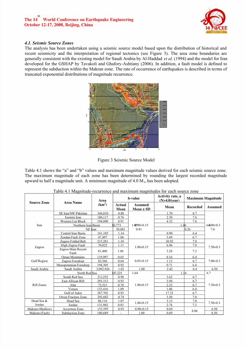
4.1. Seismic Source Zones
The analysis has been undertaken using a seismic source model based upon the distribution of historical and
recent seismicity and the interpretation of regional tectonics (see Figure 3). The area zone boundaries are
generally consistent with the existing model for Saudi Arabia by Al-Haddad et al. (1994) and the model for Iran
developed for the GSHAP by Tavakoli and Ghafory-Ashtiany (2006). In addition, a fault model is defined to
represent the subduction within the Makran zone. The rate of occurrence of earthquakes is described in terms of
truncated exponential distributions of magnitude recurrence.
10
15
20
25
30
35
35 40 45 50 55 60 65Lon E
L a t N
4.0-4.5
4.5-5.0
5.0-5.5
5.5-6.0
6.0-6.5
6.5-7.0
>7.0
Makran
SEIran/SW Pakistan
Eastern Iran
W e s t e r n L u t B l o c k
North Iran BasinNEIran
Central Iran
Basin
Zendan
Fault Zone
Zagros
Folded Belt
High Zagros
Fault
Zagros Main
Recent Fault
Oman
Mountains
Saudi ArabiaNorth Red
Sea
South Red
Sea
East African
Rift
Afar
Yemen
Gulf of
Aden
Owen Fracture
Zone
D e a d S e a
J o r d a n
Zagros
Foredeep
Mesopotamian
Foredeep
Figure 3 Seismic Source Model
Table 4.1 shows the “a” and “b” values and maximum magnitude values derived for each seismic source zone.
The maximum magnitude of each zone has been determined by rounding the largest recorded magnitude
upward to half a magnitude unit. A minimum magnitude of 4.0 Mw has been adopted.
Table 4.1 Magnitude-recurrence and maximum magnitudes for each source zone
b-valueActivity rate, a
(N>4.0/year)Maximum Magnitude
Source Zone Area NameArea
(km2) Actual
Mean
Assumed
Mean ± SDMean Recorded Assumed
SE Iran/SW Pakistan 166,810 0.80 1.70 6.7
Eastern Iran 180,117 0.76 2.30 7.6
Western Lut Block 194,090 0.91 4.32 7.6
Northern Iran Basin 80,773 1.07 1.40 6.4
NE Iran 50,081 0.81 0.26 7.6
Central Iran Basin 161,105 1.14 0.90 6.4
Iran
Zendan Fault Zone 47,497 1.06
0.90±0.15
3.69 6.7
8.00±0.3
Zagros Folded Belt 215,281 1.10 30.92 7.0
High Zagros Fault 70,822 1.11 6.96 7.0ZagrosZagros Main Recent
Fault81,400 1.06
1.00±0.15
3.28 7.3
7.50±0.3
Oman Mountains 119,997 0.65 0.16 6.4
Zagros Foredeep 82,566 0.64 1.12 6.7Gulf Region
Mesopotamian Foredeep 194,305 0.92
0.85±0.15
0.71 6.4
7.00±0.3
Saudi Arabia Saudi Arabia 3,092,926 1.02 1.00 2.42 6.4 6.50
North Red Sea 147,225 1.64 1.14 6.7
South Red Sea 211,252 0.98 3.62 6.7
East African Rift 293,312 0.92 3.94 6.7
Afar 72,521 0.78 2.32 6.7
Yemen 133,416 1.09 1.06 6.4
Gulf of Aden 387,702 0.93 17.32 6.7
Rift Zones
Owen Fracture Zone 292,682 0.74
1.00±0.15
3.50 7.0
7.50±0.3
Dead Sea 86,116 1.07 3.12 7.0Dead Sea &
Jordan Jordan 131,982 0.83
1.00±0.15
2.74 7.3
7.50±0.3
Makran (Shallow) Accretion Zone 153,595 0.93 0.90±0.15 0.69 6.50
Makran (Fault) Subduction Zone 180,689 - 1.00 0.698.06
8.50

8/3/2019 Seismic Hazards 14-07-0151
http://slidepdf.com/reader/full/seismic-hazards-14-07-0151 5/8
The 14th
World Conference on Earthquake Engineering
October 12-17, 2008, Beijing, China
4.2. Ground-Motion Prediction Equations
The ground motion prediction equations have been selected according to the tectonic regime associated with the
earthquakes in each source zone. The model of Youngs et al. (1997) has been used for the Makran subduction
zone. Akkar & Bommer (2007) and Campbell & Bozorgnia (2007) have been used for active shallow crustal
sources (i.e. Iran, Zagros, Gulf Region, Dead Sea & Jordan, shallow Makran seismicity). The Campbell &
Bozorgnia (2007) attenuation equation is one of the Next Generation of Attenuation (NGA) equations.
Although the NGA database includes earthquakes recorded worldwide, the majority of the data is from
earthquakes in Western North America. However, a study by Stafford et al. (2007) demonstrated, through
comparisons of the NGA model of Boore & Atkinson (2007) and the European model of Akkar and Bommer
(2007) that, for spectral ordinates and peak ground velocity, the NGA equations provide suitable predictive
equations for a database of European earthquake records. The Atkinson & Boore (2006) model has been used
for stable continental region (i.e. Saudi Arabia). The attenuation equation of Spudich et al. (1999) has been
used for extensional zones in the Red Sea and the Indian Ocean.
4.3. Logic Tree
Uncertainties in the “b” value, maximum magnitude and slip rate of each source zone have been taken intoaccount by assigning weights of 60% and 20% to the mean and to the mean ± 1 standard deviation values,
respectively. The logic tree framework also incorporates the alternative ground motion models for those seismic
sources associated to more than one ground motion model.
5. SEISMIC HAZARD ASSESSMENT RESULTS
5.1. Peak Ground Acceleration
Bedrock horizontal peak ground accelerations (PGA) for rock sites (Vs ≥ 760m/s) have been derived from the
probabilistic seismic hazard assessment for two return periods (475 years and 2475 years) for various cities in
the Arabian Peninsula: Dubai, Abu Dhabi, Kuwait City, Bahrain, Doha, Muscat and Jeddah. Figure 4 shows the
best estimate hazard curves for these cities. The hazard curves and PGA values (see Table 5.1) indicate a
generally low seismic hazard in the Arabian Peninsula, with slightly higher hazard for cities close to thesubduction Makran source and more seismically active zones.
0
0.1
0.2
0.3
0.4
0.5
0.6
0.7
100 1000 10000 100000
Return Period (years)
P G A ( g
)
Dubai
Abu Dhabi
Kuwait City
Bahrain
Doha
Muscat
Jeddah
Figure 4 Best estimate hazard curves for PGA (rock site) for cities in the Arabian Peninsula
5.2. Uniform Hazard Response SpectraValues of horizontal spectral acceleration (5% damping) for 0.2s (short period), 1.0s and 2.0s (long period) are
presented in Table 5.1 for 475 year and 2475 year return periods for the selected cities in the Arabian Peninsula.

8/3/2019 Seismic Hazards 14-07-0151
http://slidepdf.com/reader/full/seismic-hazards-14-07-0151 6/8
The 14th
World Conference on Earthquake Engineering
October 12-17, 2008, Beijing, China
As for the PGA values, higher spectral accelerations are expected for those cities close to the Makran
subduction zone or to the more seismically active regions. Figure 5 compares the bedrock horizontal uniform
hazard response spectra (UHRS) for 475 year and 2475 year return periods for rock site in Dubai with the
UHRS presented fro Dubai in Peiris et al. (2006). The updated probabilistic seismic model indicates spectral
accelerations at short periods higher than those obtained in the Peiris et al. model, whereas slightly lower
spectral accelerations are observed at longer periods.
Table 5.1 PGA and spectral accelerations at 0.2s, 1.0s and 2.0s for 475 year and 2475 year return periodsPGA (g) 0.2s SA (g) 1.0s SA (g) 2.0s SA (g)
Location475year 2475year 475year 2475year 475year 2475year 475year 2475year
Dubai 0.06 0.11 0.160 0.277 0.056 0.097 0.022 0.041
Abu Dhabi 0.04 0.07 0.102 0.173 0.039 0.068 0.015 0.028
Kuwait
City0.05 0.08 0.113 0.186 0.044 0.070 0.017 0.028
Bahrain 0.04 0.06 0.092 0.149 0.037 0.057 0.013 0.023
Doha 0.04 0.06 0.090 0.145 0.045 0.056 0.013 0.022
Muscat 0.05 0.15 0.125 0.338 0.045 0.118 0.017 0.054
Jeddah 0.07 0.15 0.182 0.374 0.041 0.102 0.020 0.049
0
0.05
0.1
0.15
0.2
0.25
0.3
0.35
0.4
0 0.5 1 1.5 2
Period (s)
A c c e l e r a t i o n ( g )
475 year ( Peiris et al., 2006)
2475 year_(Peiris et al., 2006)
475 year (This study, 2008)
2475 year (This study, 2008)
Figure 5 Bedrock UHRS for Dubai (5% damping) for 475 year and 2475 year return periods
7. SEISMIC DESIGN REQUIREMENTS
There are no specific seismic code requirements for building structures in the Arabian Peninsula states.However, the Abu Dhabi and Dubai Municipalities currently specify UBC97 Zone 2A design criteria for
buildings of five or more storeys. A comparison between the seismic hazard assessment results in terms of
UHRS and the internationally used seismic design codes is presented for Dubai in Figure 6. It can be observed
that all codes are conservative both at short and long periods. In particular, UBC97 Zone 2A design spectrum is
highly conservative with values far greater than both the 475 year and 2475 year UHRS accelerations. The EC8
gives a good match to the 475 year UHRS, in particular beyond 1.0s spectral period, i.e. in the long period
range; whereas, a good match can be observed at short as well as long periods between the IBC2005 (MCE)
spectrum and the 2475 year UHRS accelerations.
A discussion of seismic site response and appropriate requirements for consideration at site specific ground
conditions and other related seismic hazards is not provided in this paper due to limitation of space.

8/3/2019 Seismic Hazards 14-07-0151
http://slidepdf.com/reader/full/seismic-hazards-14-07-0151 7/8
The 14th
World Conference on Earthquake Engineering
October 12-17, 2008, Beijing, China
0
0.05
0.1
0.15
0.2
0.25
0.3
0.35
0.4
0 1 2 3 4
Period (s)
A c c e l e r a t i o n ( g )
475 year (Arup, 2008)
2475 year (A rup, 2008)
UBC1997_Zone 1
UBC1997_Zone 2A
IBC 2005 (MCE)
EC8
Figure 6 Comparison Code Spectra with UHRS for Dubai (rock site, 5% damping)
8. CONCLUSIONS
Results of a probabilistic seismic hazard assessment undertaken for the Arabian Peninsula region are presented
in terms of ground motions in rock and spectral accelerations at short and long periods for various cities in the
region. Uncertainties in seismic sources and ground motion models have been incorporated in the seismic
hazard model using a logic-tree framework. The study shows that the seismic hazard level is low with expected
bedrock horizontal PGA in the range 0.04 to 0.06g for 475 year return period and 0.06 to 0.11g for 2475 year
return period with slightly higher values for those cities close to the more seismically active regions. These
results generally agree with recent seismic hazard studies carried out for the Arabian Gulf region (e.g. Peiris et
al., 2006; Aldama-Bustos et al., 2007).
REFERENCES
Aldama, G., J. Bommer & C. Fenton. (2006). Probabilistic seismic hazard analysis for three sites in the United
Arab Emirates. Proceedings of the 1st European Conference on Earthquake Engineering and Seismology,
Geneva, Paper No. 662.
Aldama-Bustos, G., Bommer, J.J., Fenton, C.H. & Stafford, P.J. (2007). Probabilistic seismic hazard analysis for
the cities of Abu Dhabi, Dubai and Ras Al-Khaymah, United Arab Emirates.
Al-Haddad, M., Siddiqi, R., Al-Zaid, R., Arafah, A., Necioglu, A. and Turkelli, N. (1994). A Basis for
Evaluation of Seismic Hazard and design Criteria for Saudi Arabia, Earthquake Spectra, 10, No. 2.
Ambraseys, N.N. & Melville, C.P. (1982). A History of Persian Earthquakes, Cambridge University Press, pp
219.Ambraseys, N.N. & R.D. Adams (1986). Seismicity of the Sudan, Bulletin of the Seismological Society of
America, Vol. 76, No.2, pp 483-493.
Ambraseys, N.N. & J.A. Jackson (1998). Faulting associated with historical and recent earthquakes in the
Eastern Mediterranean region, Geophysical Journal International, Vol. 133, pp 390-406.
Ambraseys, N.N. (1990). Uniform magnitude re-evaluation of European earthquakes associated with strong
motion records, Proceedings of the Ninth European Conference on earthquake Engineering, Vol. A, Moscow.
Ambraseys, N.N. (2001). Reassessment of Earthquakes, 1900-1999, in the Eastern Mediterranean and Middle
East, Geophysical Journal International, Vol. 145, No.2, pp 471-485.
Akkar, S. & J.J. Bommer (2007b). Prediction of elastic displacement response spectra in Europe and the Middle
East. Earthquake Engineering and Structural Dynamics, 36, pp 1275-1301.
Atkinson, G.M. & Boore, D. M. (2006). Earthquake Ground-Motion Prediction Equations for Eastern North
America. Bulletin of the Seismological Society of America 96, 2181-2205.
8/3/2019 Seismic Hazards 14-07-0151
http://slidepdf.com/reader/full/seismic-hazards-14-07-0151 8/8
The 14th
World Conference on Earthquake Engineering
October 12-17, 2008, Beijing, China
Campbell, K.W. & Bozorgnia, Y. (2007). Campbell-Bozorgnia NGA Ground Motion Relations for the
Geometric Mean Horizontal Component of Peak and Spectral Ground Motion Parameters. Pacific Earthquake
Engineering Research Center, http://peer.berkeley.edu/ngaeast/index.html.
EC8 (1998). Eurocode 8: Design of Structures for Earthquake Resistance, EN 1998-1: 2004, European
Committee of Standardization.
Engdahl & Villaseñor (2002b). http://earthquake.usgs.gov/research/data/centennial.php.
EPRI (1994). The Earthquakes of Stable Continental Regions, Volume1: Assessment of Large Earthquake
Potential, Report prepared for Electric Power Research Institute by Johnston, A. C., Coppersmith, K. J., Kanter,
L. R. and Cornell C. A.
Gardner, J.K. and Knopoff, L. (1974). Is the Sequence of Earthquakes in Southern California, with Aftershocks
Removed, Poissonian?, Bulletin of the Seismological Society of America, Vol. 64, No 5, pp 1363-1367.
GSHAP (1999). Earthquake catalogue for GSHAP East African Rift Test Area,
http://www.seismo.ethz.ch/gshap/earift/.
Gutenberg, B. & Richter, C.F. (1965). Seismicity of the Earth and Associated Phenomena.
IBC (2005). International Building Code, International Conference of Building Officials, Whittier, California.
Johnson, P. R. (1998). Tectonic map of Saudi Arabia and adjacent areas, Technical Report USGS-TR-98-3 (IR 948), Ministry of Petroleum and Mineral Resources, Kingdom of Saudi Arabia.
IIEES (2001). Seismic Hazard and Geotechnical Hazard Zonation of Assaluyeh (910 Hectare Area), Summary
Report for Petrochemical Industries Development Company, International Institute of Earthquake Engineering
and Seismology.
International Seismological Centre (ISC) website: http://www.isc.ac.uk/index.html.
Kanamori, H. (1977). The energy release in great earthquakes, J. Geophys. Res., Vol. 82, pp 2981-2987.
National Earthquake Information Center (NEIC) website: http://earthquake.usgs.gov/regional/neic/.
Peiris, N., M. Free, Z. Lubkowski & A.T. Hussein. Seismic hazard and seismic design requirements for the
Arabian Gulf region. Proceedings of the 1st European Conference on Earthquake Engineering and Seismology,
Geneva, September 2006, Paper No. 1121.
Shedlock, K.M., Giardini, D., Grünthal, G., Zhang, P. (2000). The GSHAP Global Seismic Hazard Map.
Seismological Research Letters, 71-6, pp 679-686.Spudich, P., Joyner, W. B., Lindh, A. G., Boore, D M., Margaris and Fletcher, J. B. (1999). SEA99: A Revised
Ground Motion Prediction Relation for Use in Extensional Tectonic Regimes, Bulletin of Seismological Society
of America, 89, 5, pp 1156-1170.
Stepp, J.C. (1972). Analysis of Completeness of the Earthquake Sample in the Puget Sound Area and its effects
on Statistical Estimates of Earthquake Hazard, Proceedings of the International Conference on Micro-zonation
for Safer Construction, Research and Application, Vol. 2, pp 897-909, Seattle.
Tavakoli, B. and Ghafory-Ashtiany, M. (2006). Seismic Hazard Assessment of Iran, International Institute of
Earthquake Engineering and Seismology (IIEES), Tehran, Iran, www.seismo.ethz.ch/gshap/iran.
The Concrete Society. (2008). Guide to the Design of Concrete Structures in the Arabian Peninsula.
UBC (1997). Uniform Building Code, International Conference of Building Officials, Whittier, California.
Youngs, R.R., Chiou, S. -J., Silva, W. J. & Humphrey, J. R. (1997). Strong Ground Motion Attenuation
Relationships for Subduction Zone Earthquakes, Seismological Research Letters, 68 (1), pp 58-73.