Sedimentation in channels and ports - Deltares - Enabling … · 2014-12-19 · This brochure...
4
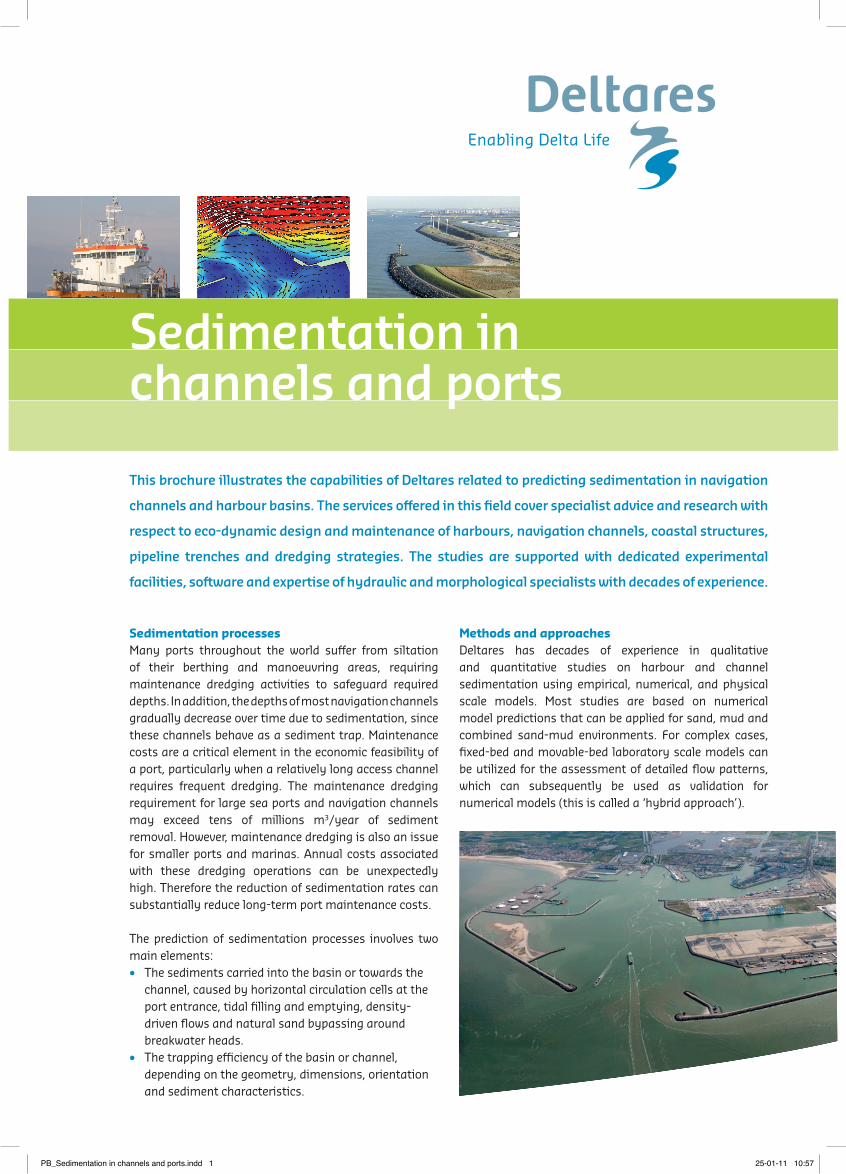
This brochure illustrates the capabilities of Deltares related to predicting sedimentation in navigation channels and harbour basins. The services offered in this field cover specialist advice and research with respect to eco-dynamic design and maintenance of harbours, navigation channels, coastal structures, pipeline trenches and dredging strategies. The studies are supported with dedicated experimental facilities, soſtware and expertise of hydraulic and morphological specialists with decades of experience. Sedimentation processes Many ports throughout the world suffer from siltation of their berthing and manoeuvring areas, requiring maintenance dredging activities to safeguard required depths. In addition, the depths of most navigation channels gradually decrease over time due to sedimentation, since these channels behave as a sediment trap. Maintenance costs are a critical element in the economic feasibility of a port, particularly when a relatively long access channel requires frequent dredging. The maintenance dredging requirement for large sea ports and navigation channels may exceed tens of millions m 3 /year of sediment removal. However, maintenance dredging is also an issue for smaller ports and marinas. Annual costs associated with these dredging operations can be unexpectedly high. Therefore the reduction of sedimentation rates can substantially reduce long-term port maintenance costs. The prediction of sedimentation processes involves two main elements: • The sediments carried into the basin or towards the channel, caused by horizontal circulation cells at the port entrance, tidal filling and emptying, density- driven flows and natural sand bypassing around breakwater heads. • The trapping efficiency of the basin or channel, depending on the geometry, dimensions, orientation and sediment characteristics. Methods and approaches Deltares has decades of experience in qualitative and quantitative studies on harbour and channel sedimentation using empirical, numerical, and physical scale models. Most studies are based on numerical model predictions that can be applied for sand, mud and combined sand-mud environments. For complex cases, fixed-bed and movable-bed laboratory scale models can be utilized for the assessment of detailed flow patterns, which can subsequently be used as validation for numerical models (this is called a ‘hybrid approach’). Sedimentation in channels and ports PB_Sedimentation in channels and ports.indd 1 25-01-11 10:57
Transcript of Sedimentation in channels and ports - Deltares - Enabling … · 2014-12-19 · This brochure...
This brochure illustrates the capabilities of Deltares related to predicting sedimentation in navigation
channels and harbour basins. The services offered in this field cover specialist advice and research with
respect to eco-dynamic design and maintenance of harbours, navigation channels, coastal structures,
pipeline trenches and dredging strategies. The studies are supported with dedicated experimental
facilities, software and expertise of hydraulic and morphological specialists with decades of experience.
Sedimentation processes Many ports throughout the world suffer from siltation of their berthing and manoeuvring areas, requiring maintenance dredging activities to safeguard required depths. In addition, the depths of most navigation channels gradually decrease over time due to sedimentation, since these channels behave as a sediment trap. Maintenance costs are a critical element in the economic feasibility of a port, particularly when a relatively long access channel requires frequent dredging. The maintenance dredging requirement for large sea ports and navigation channels may exceed tens of millions m3/year of sediment removal. However, maintenance dredging is also an issue for smaller ports and marinas. Annual costs associated with these dredging operations can be unexpectedly high. Therefore the reduction of sedimentation rates can substantially reduce long-term port maintenance costs.
The prediction of sedimentation processes involves two main elements:• The sediments carried into the basin or towards the
channel, caused by horizontal circulation cells at the port entrance, tidal filling and emptying, density-driven flows and natural sand bypassing around breakwater heads.
• The trapping efficiency of the basin or channel, depending on the geometry, dimensions, orientation and sediment characteristics.
Methods and approachesDeltares has decades of experience in qualitative and quantitative studies on harbour and channel sedimentation using empirical, numerical, and physical scale models. Most studies are based on numerical model predictions that can be applied for sand, mud and combined sand-mud environments. For complex cases, fixed-bed and movable-bed laboratory scale models can be utilized for the assessment of detailed flow patterns, which can subsequently be used as validation for numerical models (this is called a ‘hybrid approach’).
Sedimentation in channels and ports
PB_Sedimentation in channels and ports.indd 1 25-01-11 10:57
Design phaseIn the hydraulic design phase of a port or navigation channel, minimization of sedimentation should be included as an important design criterion. Harbour sedimentation problems can be minimized by means of three main strategies: keep sediment out, keep sediment moving, or keep sediment navigable. Insight into the governing physics is essential to optimise the representation of these mechanisms and to make a reliable prediction of future maintenance dredging requirements. Optimisation of (1) the layout, in combination with (2) dredging and dumping cycles and (3) the selected dumping location can reduce maintenance activities, resulting in a reduction of the maintenance costs and environmental impacts.
Optimising existing layoutGiven an existing harbour and channel layout, reduction of sedimentation rates may be achieved through the design of mitigating measures based on detailed analysis of the governing sedimentation mechanisms. Various measures are available to minimize maintenance dredging activities. In some cases, construction of sand traps or the construction of training/deflection walls and submerged walls and sills may be considered. For the reduction of sedimentation of navigation channels, the extension of port breakwaters may be considered. In other cases, optimization of existing maintenance dredging schemes (e.g. by manipulating the recurrence intervals for dredging via over-dredging) can result in cost savings and reduction of environmental impacts. Depending upon the dominant mechanisms of the sedimentation, the entrance layout may be modified to reduce intrusion of sediment-laden eddies or efforts can be made to reduce the effects of density currents which carry high suspended sediment loads in the case of very fine silts and mud.
In each project, a tailor-made approach is determined depending upon the client’s questions and the complexity
of the situation. Either a numerical, physical or a hybrid modelling approach can be the most efficient way for obtaining the information required for a design project. Deltares has state-of-the-art tools and methods for both physical and numerical study approaches. For over 50 years, Deltares has been in the forefront of these types of combined morphological simulation techniques.
Software and FacilitiesDeltares has state-of-the-art tools and methods for both physical and numerical study approaches to evaluate sustainable and eco-dynamic designs and measures.
Process-based modelling (DELFT3D & SUTRENCH)Delft3D is an open source, flexible, integrated modelling framework, developed by Deltares, which simulates two and three-dimensional flow, waves, sediment transport and morphology, water quality and ecology and is capable of handling many of the interactions between those processes. The sediment transport module includes both suspended and bed/total load transport processes as well as morphological changes for an arbitrary number of cohesive and non-cohesive fractions. It can keep track of the bed composition to build up a stratigraphic record. The suspended load solver is connected to the 2D or 3D advection-diffusion solver of the FLOW module (density effects may be taken into account). An essential feature
Physical modelling of a current deflecting wall (CDW) at Deltares.
Impact assessment of a CDW by visualising the effect on currents with dye.
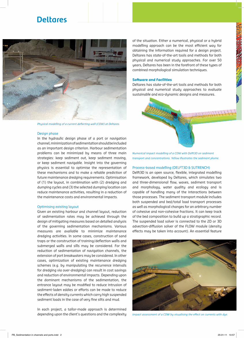
Numerical impact modelling of a CDW with Delft3D on sediment
transport and concentrations. Yellow illustrates the sediment plume.
PB_Sedimentation in channels and ports.indd 2 25-01-11 10:57

of this module is the dynamic feedback between the FLOW and WAVE (SWAN) modules, which allow the flows and waves to adjust to the local bathymetry changes as the simulation progresses. Simulations on any time scale, from days (storm impact) to decades (system dynamics) are possible. Additionally, the module includes a wide-range of features to include dredging and dumping scenarios. Sub- and supercritical fluid mud flow and vertical exchange between the mud layer and the water flow can be simulated with the 2L FLUID MUD model. This model has been extended to quantify the effects of Water Injection Dredging by including consolidation and transport of the fluid mud layer as well as the resuspension, dispersion and deposition of sediments in the water column.
The 3D MUD model is a special version of Delft3D Online Morphology specifically developed to model harbour sedimentation from mud (very fine sediments). This model has a flocculation module that relates the settling velocity to turbulence properties and the sediment concentration, a consolidation module that simulates the self-weight consolidation of sediments, a rheology module that simulates the transport of subaqueous fluid mud layers over a slope, and an erosion module, to simulate the entrainment of fluid mud layers in the water column.
SUTRENCH is a two-dimensional model in the vertical plane developed for the computation of bed level changes in and around trenches dredged into the seabed (channels). SUTRENCH computes the sediment transports caused by currents and waves (no wave breaking) and confronts these with the dredged channel geometry to derive in-filling rates. SUTRENCH may be applied during studies where a trial dredge has been carried out to support the calibration of numerical models predicting sediment transport.
Empirical modelling (SILTHAR and SILTAC)SILTHAR is a rapid assessment and empirical modelling tool with diagnostic and prognostic capabilities to assess harbour sedimentation (fine sediments and mud) in relatively simple harbour layouts. It can also be used to predict the effect of mitigating measures, changes or extensions of an existing harbour, on the harbour sedimentation rate. This is an important input for the economic feasibility of a harbour. It is suitable for situations with tidal flow, discharge into, or withdrawal of water from, the harbour basin and can be applied with or without density currents.
SILTAC is a rapid assessment and empirical modelling tool to predict the sedimentation in dredged channels in a tidal area with a sandy or muddy seabed. SILTAC computes the sedimentation rates of suspended sediment transports (fine sand, silt or mixture) over a tidal cycle under different wave and flow conditions.
Physical modelling: basinA dedicated basin is available to perform physical model tests of sedimentation around structures. The facilities can be easily accessed and have viewing windows for the observation of flow and wave phenomena around
Sedimentation in a navigation channel (cross section) calculated by SILTAC.
Physical modelling of a harbour basin at Deltares.Impact assessment of a CDW by visualising the effect on currents with dye.
Numerical modelling of tidal currents in the port of Dunkerque
with Delft3D-FLOW.
PB_Sedimentation in channels and ports.indd 3 25-01-11 10:57

the structure. Dedicated equipment for measuring flows, waves and water levels, is standard available. If required, additional measurement equipment can easily be installed.
Monitoring and ForecastingWith help of the available numerical models and the experience of specialists, Deltares can assist in the development, application, and operation of specific instruments to monitor water movement and sedimentation rates. These include ADCP’s, tidal gauges, wave buoys, sediment sample grab devices and various turbidity sensors. In addition, the numerical models (especially Delft3D) can be applied for forecasting purposes by setting up site-specific operational models, which can compute tidal elevation, wind driven flows and waves, providing an indication of sediment transport for the following days.
Our ClientsOur large national and international client base includes governmental authorities (ministries, institutes etc.), local authorities (harbours, municipalities and provinces), consultants, contractors, private industrial clients, and project developers. The Netherlands, being a delta location with large port development projects that are vulnerable to coastal erosion and flooding, contributes to the close cooperation between Dutch ministries, local authorities and Deltares. Our strong performance in serving our local clients ensures that the highest level of technology is developed and made available to all of our clients.
Example ProjectsSince the founding in 1927, the institute has been involved in the research and projects related to sedimentation problems in coastal areas. Several recent projects and ongoing research, utilizing numerical models, desk studies and physical models are briefly described below.• Port of Rotterdam: Assessment of the effects of the
land reclamation of the 2nd Maasvlakte on the siltation in the Maasmond area using 3D-physical models and numerical models (Delft3D).
• Port of Antwerp: Detailed assessment of the effects of different geometries of a current deflecting wall (CDW) on sedimentation patterns in the Deurganckdok and Saeftinghedock (Belgium), by means of numerical and physical-scale modelling as well as by measurement analysis.
• Port of Hong Kong: Assessment of the siltation and maintenance dredging volumes for two candidate LNG terminal sites in the Hong-Kong area, near Black Point and near the Soko Islands, in support of the environmental impact assessment.
• Port of Hamburg: Assessment of the effects of different geometries of a current deflecting wall (CDW) for the Parkhafen on sedimentation patterns, by means of physical-scale modelling and by measurements analysis.
For more information: [email protected]
Corresponding Capability Statements:
• Environmental studies in support of dredging operations
• Behaviour of dredging plumes
• Toxicological impact assessment of sediment and dredged material
• Harbour and marina development
Dredger at sea.
Navigation channel of the port of Rotterdam.
ww
w.B
eeld
bank
VenW
.nl,
Rijk
swat
erst
aat.
ww
w.B
eeld
bank
VenW
.nl,
Rijk
swat
erst
aat.
Deltares is a leading, independent, Dutch-based research
institute and specialist consultancy for matters relating
to water, soil and the subsurface. We apply our advanced
expertise worldwide, to help people live safely and
sustainably in delta areas, coastal zones and river basins.
PO Box 1772600 MH Delft, The NetherlandsT +31 (0)88 335 82 [email protected]
PB_Sedimentation in channels and ports.indd 4 25-01-11 10:57