Sediment Diversions: Project Planning, Permitting and...
29
committed to our coast committed to our coast Sediment Diversions: Project Planning, Permitting and Implementation Bren Haase Governor’s Commission Diversion Sub-Committee July 23, 2014
Transcript of Sediment Diversions: Project Planning, Permitting and...
committed to our coast committed to our coast
Sediment Diversions: Project
Planning, Permitting and
Implementation
Bren Haase
Governor’s Commission Diversion Sub-Committee
July 23, 2014
Coastal Protection and Restoration Authority of Louisiana
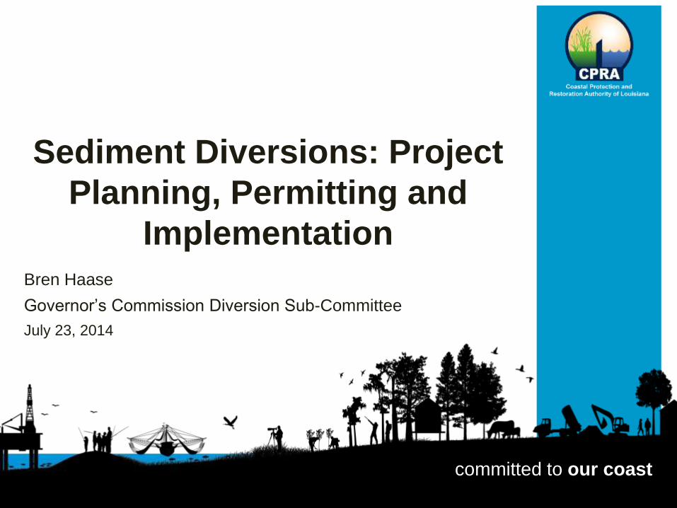
When discussing the Mississippi River Commission 1894 report of survey on the delta to account for the sinking land it was noted: “The conditions are very different now from those existing prior to the existence of levees. There are at present no annual accretions of sedimentary matters from the periodical overflows of the river. These accretions formerly were a little more than equal to the annual subsidence of the lands…”
Coastal Protection and Restoration Authority of Louisiana
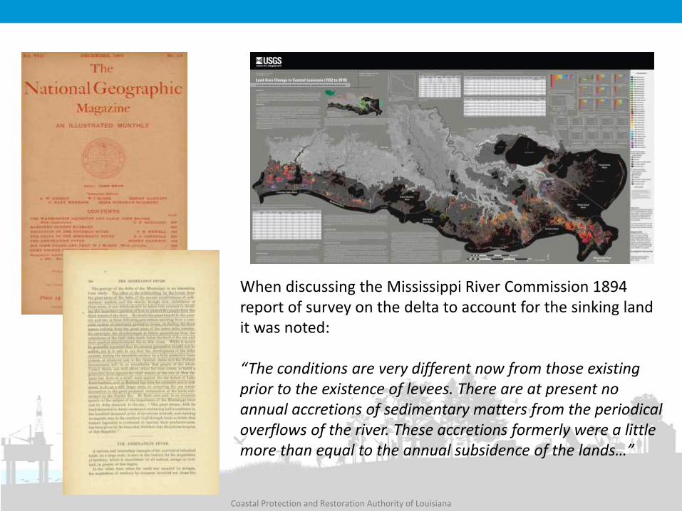
Long History of Planning…
Diversions are part of all

Coastal Protection and Restoration Authority of Louisiana
Existing Diversions
Davis Pond Freshwater Diversion Open: July 2002 Max. Flow: 10,650 cfs
Caernarvon Freshwater Diversion
Open: August 1991 Max. Flow: 8,000 cfs
Existing Diversions, Siphons, Crevasses
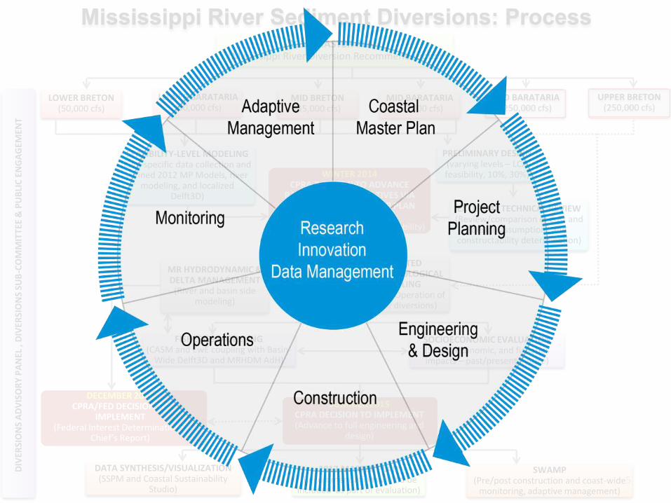
2012 MASTER PLAN (Mississippi River Diversion Recommendations)
EXTERNAL TECHNICAL REVIEW (Review/comparison of cost and
design assumptions and constructability determination)
LOWER BRETON (50,000 cfs)
LOWER BARATARIA (50,000 cfs)
MID BARATARIA (50,000 cfs)
FISHERIES MODELING (CASM and EwE coupling with Basin-
Wide Delft3D and MRHDM AdH)
SOCIOECONOMIC EVALUATION (Social, economic, and fisheries impacts – past/present/future)
2017 MASTER PLAN (Recommendations would be
included as part of evaluation)
DATA SYNTHESIS/VISUALIZATION (SSPM and Coastal Sustainability
Studio)
SWAMP (Pre/post construction and coast-wide
monitoring, adaptive management)
SUMMER 2015 CPRA DECISION TO IMPLEMENT (Advance to full engineering and
design)
WINTER 2014 CPRA DECISION TO ADVANCE
PARTICULAR ALTERNATIVES VIA VERIFICATION OF MASTER PLAN
BENEFITS AND COSTS (Land/Site/Size/Cost/Constructability)
FEASIBILITY-LEVEL MODELING (Site specific data collection and refined 2012 MP Models, river
modeling, and localized Delft3D)
MR HYDRODYNAMIC & DELTA MANAGEMENT
(River and basin side modeling)
PRELIMINARY DESIGN (varying levels – LCA feasibility, 10%, 30%)
MID BARATARIA (250,000 cfs)
UPPER BRETON (250,000 cfs)
MID BRETON (35,000 cfs)
BASIN-WIDE INTEGRATED HYDRODYNAMIC, MORPHOLOGICAL
& NUTRIENTS MODELING (Analyze Sequencing and Operation of
recommended suite of diversions)
DIV
ERSI
ON
S A
DV
ISO
RY
PA
NEL
, D
IVER
SIO
NS
SUB
-CO
MM
ITTE
E &
PU
BLI
C E
NG
AG
EMEN
T
DECEMBER 2016 CPRA/FED DECISION TO
IMPLEMENT (Federal Interest Determination –
Chief’s Report)
5
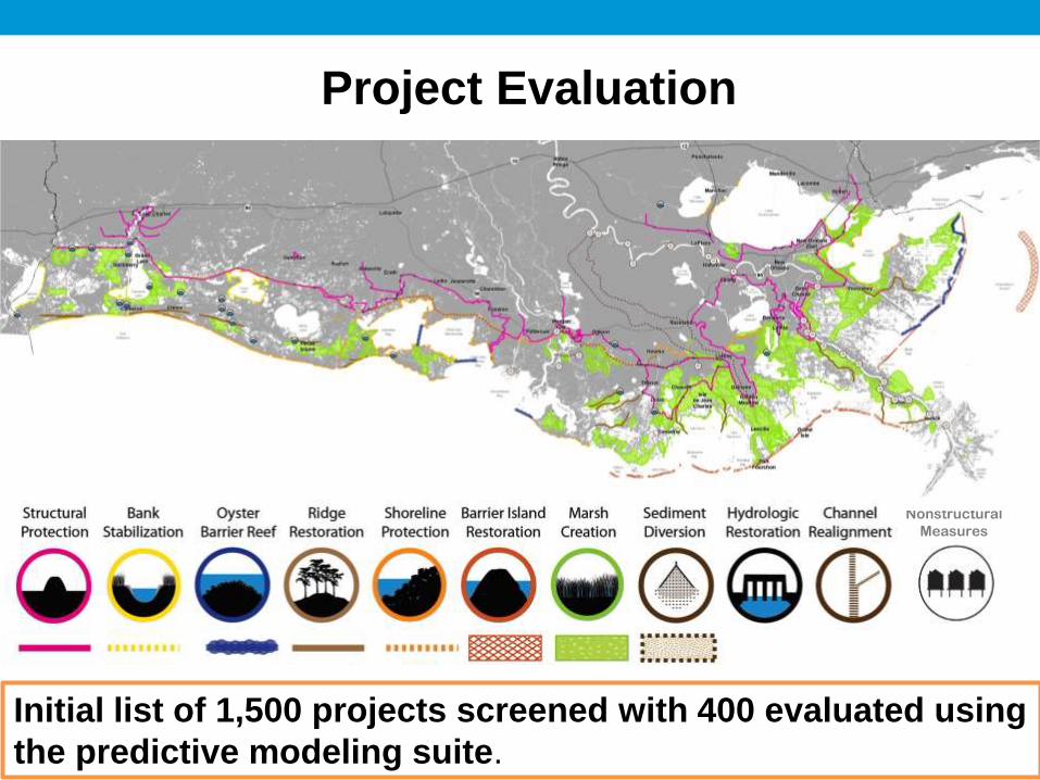
Project Evaluation
Nonstructural
Measures
Initial list of 1,500 projects screened with 400 evaluated using
the predictive modeling suite.
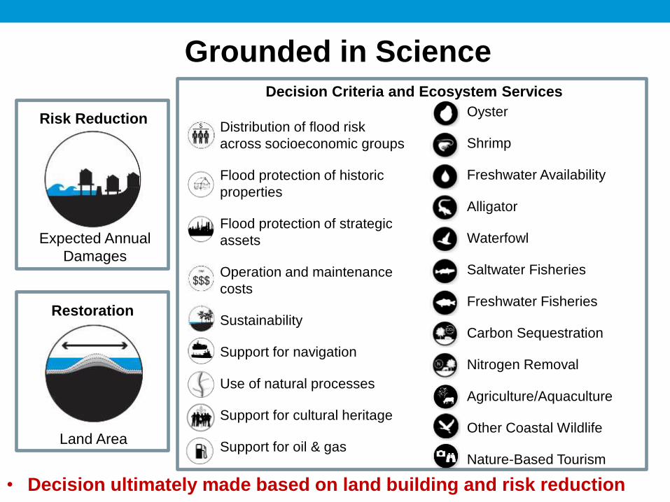
Land Area
Risk Reduction
Expected Annual
Damages
Decision Criteria and Ecosystem Services
Distribution of flood risk
across socioeconomic groups
Flood protection of historic
properties
Flood protection of strategic
assets
Operation and maintenance
costs
Sustainability
Support for navigation
Use of natural processes
Support for cultural heritage
Support for oil & gas
Oyster
Shrimp
Freshwater Availability
Alligator
Waterfowl
Saltwater Fisheries
Freshwater Fisheries
Carbon Sequestration
Nitrogen Removal
Agriculture/Aquaculture
Other Coastal Wildlife
Nature-Based Tourism
Restoration
Grounded in Science
• Decision ultimately made based on land building and risk reduction

2012 Science and Engineering Board
Ecosystem Science / Coastal Ecology
• William Dennison, PhD, University of Maryland
• Edward Houde, PhD, University of Maryland
• Katherine Ewel, PhD, University of Florida
Engineering
• Robert Dalrymple, PhD, PE, Johns Hopkins University
• Jos Dijkman, MsC, PE, Dijkman Delft
Geosciences
• Charles Groat, PhD, University of Texas at Austin
Social Science and Risk
• Greg Baecher, PhD, PE, University of Maryland
• Philip Berke, PhD, University of North Carolina – Chapel Hill
Climate Change
• Virginia Burkett, PhD, U.S. Geological Survey
Environmental/Natural Resource Economics
• Edward Barbier, PhD, University of Wyoming

2012 Technical Advisory Committees
Predictive Models
• Steve Ashby, PhD, USACE Eng. Res. Dev. Center
• John Callaway, PhD, University of San Francisco
• Fred Sklar, PhD, South Florida Water Mgmt. District
• Si Simenstad, MS, University of Washington
Planning Tool
• John Boland, PhD, PE, John Hopkins
• Ben Hobbs, PhD, John Hopkins
• Len Shabman, PhD, Virginia Tech
Cultural Heritage
• Don Davis, PhD, Louisiana State University
• Maida Owens, LA Dept. of Culture, Recreation, and Tourism
• Carl Brasseaux, PhD, University of Louisiana Lafayette

2012 Framework Development Team
Over 30 Federal, State, NGO, Academic, Community, and Industry Organizations

• Key industries are impacted by land loss and large scale protection and restoration efforts
• Created three focus groups:
– Navigation
– Fisheries
– Oil and Gas
• Expanding membership to:
– Landowners
– Community groups
Focus Groups
Coastal Protection and Restoration Authority of Louisiana
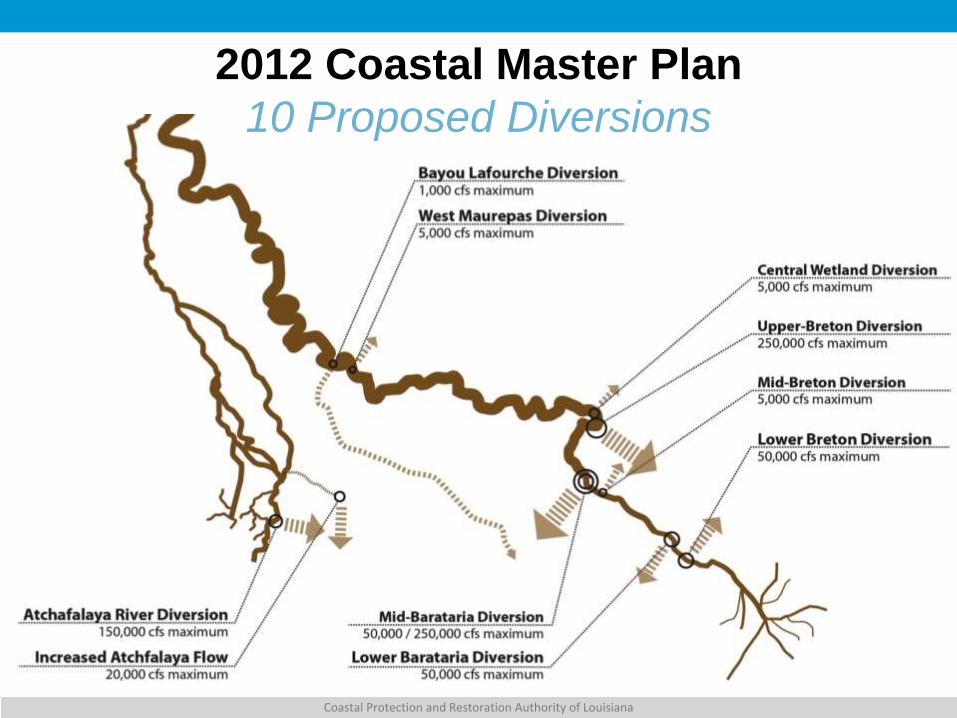
2012 Coastal Master Plan
10 Proposed Diversions
Coastal Protection and Restoration Authority of Louisiana
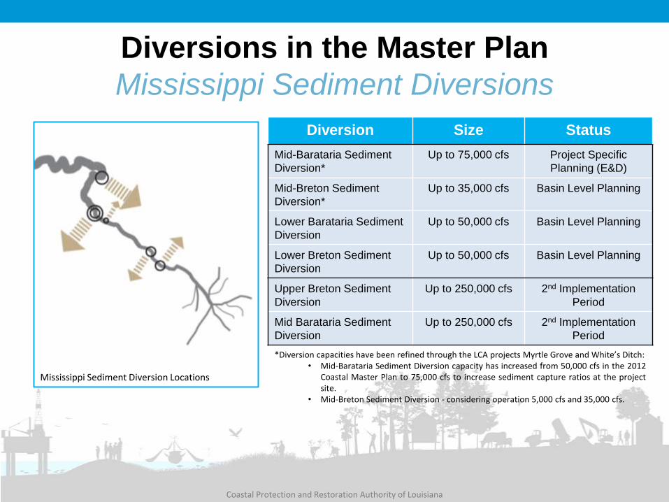
Diversions in the Master Plan
Mississippi Sediment Diversions
Diversion Size Status
Mid-Barataria Sediment
Diversion*
Up to 75,000 cfs Project Specific
Planning (E&D)
Mid-Breton Sediment
Diversion*
Up to 35,000 cfs Basin Level Planning
Lower Barataria Sediment
Diversion
Up to 50,000 cfs Basin Level Planning
Lower Breton Sediment
Diversion
Up to 50,000 cfs Basin Level Planning
Upper Breton Sediment
Diversion
Up to 250,000 cfs 2nd Implementation
Period
Mid Barataria Sediment
Diversion
Up to 250,000 cfs 2nd Implementation
Period
*Diversion capacities have been refined through the LCA projects Myrtle Grove and White’s Ditch: • Mid-Barataria Sediment Diversion capacity has increased from 50,000 cfs in the 2012
Coastal Master Plan to 75,000 cfs to increase sediment capture ratios at the project site.
• Mid-Breton Sediment Diversion - considering operation 5,000 cfs and 35,000 cfs.
Mississippi Sediment Diversion Locations

EXTERNAL TECHNICAL REVIEW (Review/comparison of cost and
design assumptions and constructability determination)
LOWER BRETON (50,000 cfs)
LOWER BARATARIA (50,000 cfs)
MID BARATARIA (50,000 cfs)
FEASIBILITY-LEVEL MODELING (Site specific data collection and refined 2012 MP Models, river
modeling, and localized Delft3D)
PRELIMINARY DESIGN (varying levels – LCA feasibility, 10%, 30%)
MID BRETON (35,000 cfs)
Project Concept
CWPPRA Planning
CPRA Master Plan Preliminary E&D
State/NGO Effort Feasibility
LCA Myrtle Grove Detailed E&D
CPRA Mid-Barataria
DIV
ERSI
ON
S A
DV
ISO
RY
PA
NEL
, D
IVER
SIO
NS
SUB
-CO
MM
ITTE
E &
PU
BLI
C E
NG
AG
EMEN
T
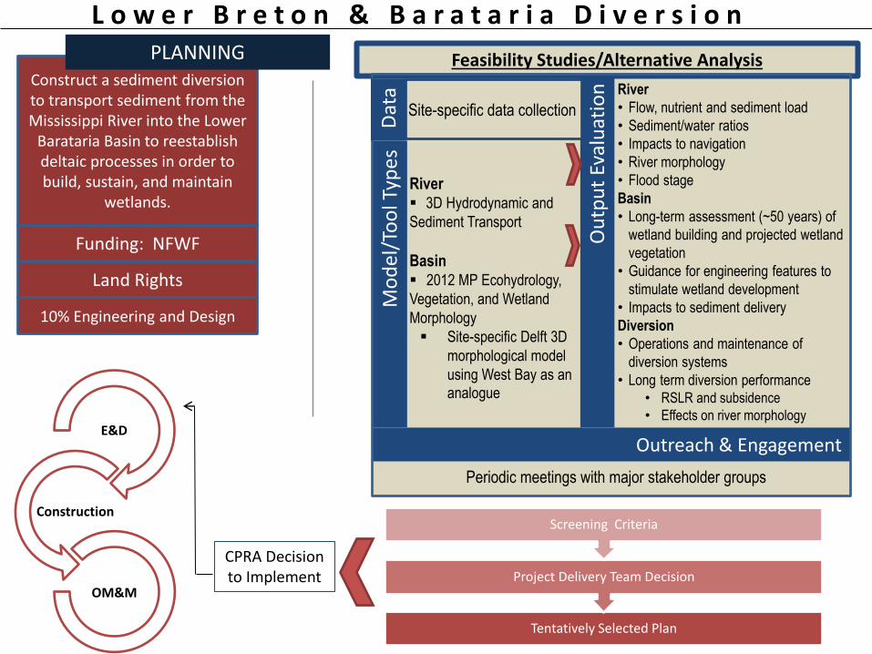
River
• Flow, nutrient and sediment load
• Sediment/water ratios
• Impacts to navigation
• River morphology
• Flood stage
Basin
• Long-term assessment (~50 years) of
wetland building and projected wetland
vegetation
• Guidance for engineering features to
stimulate wetland development
• Impacts to sediment delivery
Diversion
• Operations and maintenance of
diversion systems
• Long term diversion performance • RSLR and subsidence
• Effects on river morphology
L o w e r B r e t o n & B a r a t a r i a D i v e r s i o n
Funding: NFWF Ou
tpu
t Ev
alu
atio
n
River 3D Hydrodynamic and
Sediment Transport
Basin 2012 MP Ecohydrology,
Vegetation, and Wetland
Morphology
Site-specific Delft 3D
morphological model
using West Bay as an analogue
Mo
del
/To
ol T
ype
s
Tentatively Selected Plan
Project Delivery Team Decision
Screening Criteria
CPRA Decision to Implement
E&D
Construction
OM&M
Feasibility Studies/Alternative Analysis Construct a sediment diversion to transport sediment from the Mississippi River into the Lower
Barataria Basin to reestablish deltaic processes in order to build, sustain, and maintain
wetlands.
PLANNING
Periodic meetings with major stakeholder groups
Outreach & Engagement
Land Rights
10% Engineering and Design
Site-specific data collection
Dat
a

M i d - B r e t o n D i v e r s i o n
Funding: NFWF Ou
tpu
t Ev
alu
atio
n
River
3D Hydrodynamic and
sediment transport
Basin
2012 MP
Ecohydrology,
Vegetation, and Wetland
Morphology
Mo
del
/To
ol T
ype
s
Tentatively Selected Plan
Project Delivery Team Decision
Screening Criteria
E&D
Construction
OM&M
Identify the most promising location for the diversion,
evaluate the best alignment for the outfall channel, and
investigate how variations in the structure’s design could affect its
ability to capture sediment
PLANNING
Periodic meetings with major stakeholder groups
Outreach & Engagement
Land Rights
10% Engineering and Design
Sediment,
hydrodynamic, and
nutrient load into the
basin
Long-term assessment
(~50 yrs)
Preliminary estimates
of wetland building
Future projections of
wetland vegetation
Site-specific data
collection
Dat
a
Also evaluated
under LCA. Recommended
a 35,000 cfs diversion
operated for two months each spring.
Feasibility Studies/Alternative Analysis
CPRA Decision to Implement

Construction
OM&M
M I D B A R A T A R I A
River and Channel • Site characteristics
• Channel size and location
• Channel dimensions
• Intake and outfall configuration
• Sediment to water ratio
• Sediment transport
• Flow characteristics
• Effects on navigating ships
• Guide levees
• Tie-in structures
• Flood gates or back levee
structures
• Water surface elevation
Basin/Outfall) • Long-term assessment (50 yrs) of
wetland building, projected wetland
vegetation, and nutrient dynamics
• Impacts to rail and road
• Drainage Studies
• Water surface elevation
Ou
tpu
t Ev
alu
atio
n
River and Channel Multi-Dimensional
Models of River,
Channel and Outfall Delft 3D, Flow3D,
HEC RAS
Ship Simulation Gate Hydraulic
Models
Basin/Outfall) Hydrodynamic,
Sediment Transport,
and Morphological Delft 3D
2012 MP
Ecohydrology,
Vegetation, and
Wetland Morphology
Mo
del
/To
ol T
ype
s
Final Selected Plan
Screening Criteria
Dat
a C
olle
ctio
n
Lidar,
Bathymetric,
and Topographic
Surveys
Boring Logs,
In-situ and lab
measurements
Geomorphic
Assessments
Material
Strengths,
Design Loads,
Soil Properties
Reintroduce freshwater and
sediment from the Mississippi
River to the Basin to reestablish
deltaic processes in order to
build, sustain, maintain wetlands.
Engineering & Design
Land Rights
Permitting
30% Engineering and Design
Planning
Funding: NFWF
Periodic meetings with major stakeholder groups and public scoping for EIS
Outreach & Engagement
Project Plans and Specifications: Mississippi River, Diversion Channel, and Outfall
CPRA Decision to Implement
Coastal Protection and Restoration Authority of Louisiana
Basin Wide Model Development and
Evaluation
DECEMBER 2014 DECISION TO ADVANCE
PARTICULAR ALTERNATIVES VIA VERIFICATION OF MASTER PLAN
BENEFITS AND COSTS (Siting/Sizing/Cost/Constructability)
MR HYDRODYNAMIC & DELTA MANAGEMENT
(River and basin side modeling)
BASIN-WIDE INTEGRATED HYDRODYNAMIC, MORPHOLOGICAL
& NUTRIENTS MODELING (Analyze Sequencing and Operation of
recommended suite of diversions)
DIV
ERSI
ON
S A
DV
ISO
RY
PA
NEL
, D
IVER
SIO
NS
SUB
-CO
MM
ITTE
E &
PU
BLI
C E
NG
AG
EMEN
T
Project-Level E&D,
Construction, and OM&M
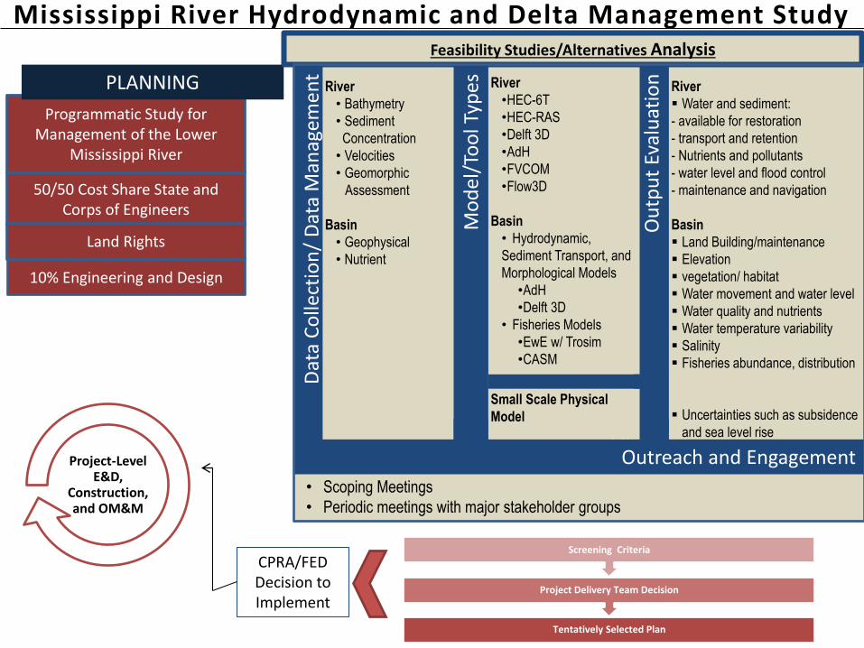
Mississippi River Hydrodynamic and Delta Management Study
50/50 Cost Share State and Corps of Engineers
Tentatively Selected Plan
Project Delivery Team Decision
Screening Criteria
CPRA/FED Decision to Implement
Programmatic Study for Management of the Lower
Mississippi River
PLANNING
• Scoping Meetings
• Periodic meetings with major stakeholder groups
Outreach & Engagement
10% Engineering and Design
River
Water and sediment:
- available for restoration
- transport and retention
- Nutrients and pollutants
- water level and flood control
- maintenance and navigation
Basin
Land Building/maintenance
Elevation
vegetation/ habitat
Water movement and water level
Water quality and nutrients
Water temperature variability
Salinity
Fisheries abundance, distribution
Uncertainties such as subsidence
and sea level rise
Ou
tpu
t Ev
alu
atio
n
River
•HEC-6T
•HEC-RAS
•Delft 3D
•AdH
•FVCOM
•Flow3D
Basin
• Hydrodynamic,
Sediment Transport, and
Morphological Models
•AdH
•Delft 3D
• Fisheries Models
•EwE w/ Trosim
•CASM
Mo
del
/To
ol T
ype
s
Dat
a C
olle
ctio
n/
Dat
a M
anag
eme
nt
River
• Bathymetry
• Sediment
Concentration
• Velocities
• Geomorphic
Assessment
Basin
• Geophysical
• Nutrient
Outreach and Engagement
Small Scale Physical
Model
Land Rights
Feasibility Studies/Alternatives Analysis
Coastal Protection and Restoration Authority of Louisiana
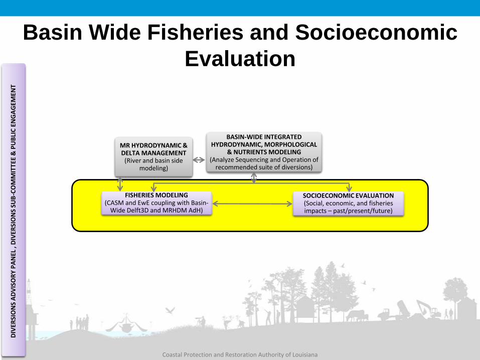
Basin Wide Fisheries and Socioeconomic
Evaluation
FISHERIES MODELING (CASM and EwE coupling with Basin-
Wide Delft3D and MRHDM AdH)
SOCIOECONOMIC EVALUATION (Social, economic, and fisheries impacts – past/present/future)
MR HYDRODYNAMIC & DELTA MANAGEMENT
(River and basin side modeling)
BASIN-WIDE INTEGRATED HYDRODYNAMIC, MORPHOLOGICAL
& NUTRIENTS MODELING (Analyze Sequencing and Operation of
recommended suite of diversions)
DIV
ERSI
ON
S A
DV
ISO
RY
PA
NEL
, D
IVER
SIO
NS
SUB
-CO
MM
ITTE
E &
PU
BLI
C E
NG
AG
EMEN
T
Coastal Protection and Restoration Authority of
Louisiana
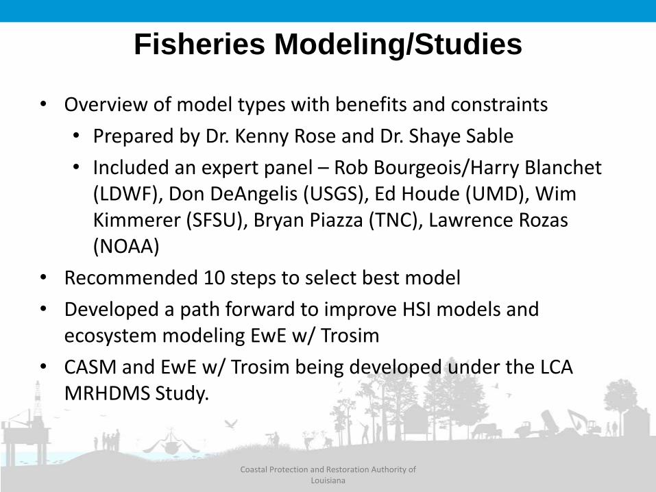
Fisheries Modeling/Studies
• Overview of model types with benefits and constraints
• Prepared by Dr. Kenny Rose and Dr. Shaye Sable
• Included an expert panel – Rob Bourgeois/Harry Blanchet (LDWF), Don DeAngelis (USGS), Ed Houde (UMD), Wim Kimmerer (SFSU), Bryan Piazza (TNC), Lawrence Rozas (NOAA)
• Recommended 10 steps to select best model
• Developed a path forward to improve HSI models and ecosystem modeling EwE w/ Trosim
• CASM and EwE w/ Trosim being developed under the LCA MRHDMS Study.

• The first phase of this project will take a systematic approach
to assess the historic, current, and predicted future social,
economic and fisheries related impacts of coastal restoration
projects in the Barataria, Breton, and Terrebonne areas.
• The second phase of this project will build on the socio-
economic analysis conducted for the three basins and include
coast wide socio-economic projections based on the 2017
Master Plan analysis.
The duration of the project is approximately two years and begins
in July 2014. Phase 1 is expected to be complete in July 2015 and
Phase 2 in May 2016.
Socio-Economic Analysis
Coastal Protection and Restoration Authority of Louisiana

Socioeconomic Evaluation
Tools Being Developed:
• Social Impact Assessment, including
economics (Stephen Barnes-LSU; Nick Burger-
RAND; Craig Colten-Water Institute of the Gulf; Jeff
Carney-LSU CSS)
• Coastal Community Resilience Program
Development (Lawrence Frank-URS)
What we will evaluate:
Contribution of projects to
storm surge risk reduction and
land building
Localized flooding potential
Social impact assessment
including cultural effects and
future fisheries distribution
Economic evaluation of
coastal land loss on industry,
infrastructure, habitat, etc.
Coastal resiliency and
nonstructural mitigation
projects
Population and demographic
trends and historic fisheries
locations

Coastal Protection and Restoration Authority of Louisiana
Diversion Path Forward
Three Outcomes:
1) Engineering and Design
2) Construction
3) Not Feasible
How do we achieve?
2017 MASTER PLAN (Include projects in E&D as
existing condition)
DATA SYNTHESIS/VISUALIZATION (SSPM and Coastal Sustainability
Studio)
SWAMP MONITORING (Pre/post construction, coast-wide
monitoring, and adaptive management)
SUMMER 2015
DECISION TO IMPLEMENT (Advance to full engineering and
design)
DECEMBER 2016 DECISION TO IMPLEMENT
(Federal Interest Determination – Chief’s
Report)
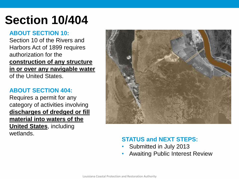
Section 10/404 ABOUT SECTION 10:
Section 10 of the Rivers and
Harbors Act of 1899 requires
authorization for the
construction of any structure
in or over any navigable water
of the United States.
ABOUT SECTION 404:
Requires a permit for any
category of activities involving
discharges of dredged or fill
material into waters of the
United States, including
wetlands. STATUS and NEXT STEPS:
• Submitted in July 2013
• Awaiting Public Interest Review
Louisiana Coastal Protection and Restoration Authority
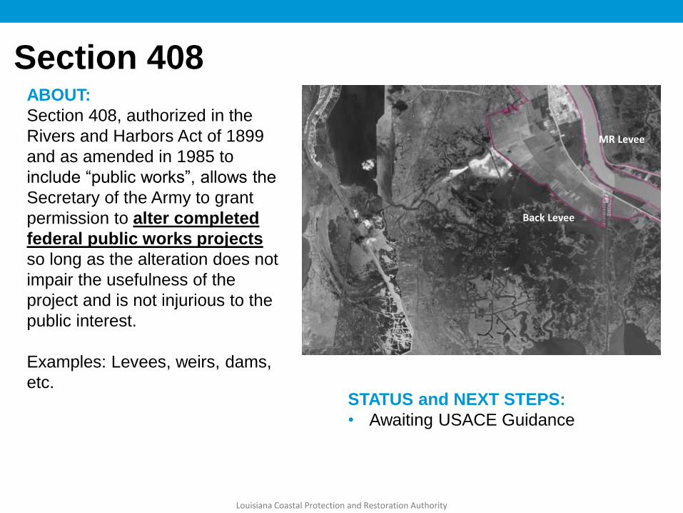
Section 408 ABOUT:
Section 408, authorized in the
Rivers and Harbors Act of 1899
and as amended in 1985 to
include “public works”, allows the
Secretary of the Army to grant
permission to alter completed
federal public works projects
so long as the alteration does not
impair the usefulness of the
project and is not injurious to the
public interest.
Examples: Levees, weirs, dams,
etc. STATUS and NEXT STEPS:
• Awaiting USACE Guidance
Back Levee
MR Levee
Louisiana Coastal Protection and Restoration Authority

Environmental Impact Statement ABOUT :
An Environmental Impact
Statement (EIS) is an
environmental document
required by the National
Environmental Policy Act
(NEPA) for actions that
significantly affect the
quality of the human
environment (42 USC §4332).
STATUS and NEXT STEPS:
• Negotiating 3rd Party Contractor Scope
with USACE
• Scoping Meetings
Louisiana Coastal Protection and Restoration Authority

Coastal Protection and Restoration Authority of Louisiana
Environmental Review
• Endangered Species Act Informal Consultation—30 days for consultation
• Endangered Species Act Formal Consultation—90 days for consultation, 45 days following completion of consultation for issuance of Biological Opinion
• Migratory Bird Treaty Act Consultation—45 days
• Section 106 Consultation with SHPO on Project Effects—30 days

Coastal Protection and Restoration Authority of Louisiana
QUESTIONS?