Section One - Greenwood, IN
12
City of Greenwood Comprehensive Plan 2007 - 2027 Introduction 1 Section One
Transcript of Section One - Greenwood, IN
City of GreenwoodComprehensive Plan
2007 - 2027
Introduction
1Section One


Page 13 IntroductionAdopted Dec 17, 2007
Moving ForwardChange is a reality in our communities. It may occur slowly over time, or faster than we feel we can seemingly adjust to it. When communities engage in the comprehensive planning process they are both responding to changes that have happened, or are happening, and planning for changes that will likely occur in the future. The Indianapolis Metropolitan Area is experiencing tremendous growth. The City of Greenwood could have chosen to simply react to the growth pressures. However, the city is taking an active approach to community planning by anticipating change and taking the necessary steps to directly impact future growth and development.
In order to establish a long term community vision which defines the quantity, quality, and location of growth that the community desires, the City of Greenwood has undergone the comprehensive planning process described herein. Last updated in 1988, this plan accounts for the changes that are occurring in and around the city, while planning for the changes likely to occur in the community over the next twenty years. This plan also serves as an inventory of the community’s resources and existing conditions; envisions the future character of Greenwood; and creates a framework for planned and diversified growth.
Compliance with State StatuteThe City of Greenwood is within the jurisdiction of the Greenwood Advisory Plan Commission, which was legally established under the provisions of IC 36-7-4-202 for the purpose of managing development in a manner consistent with the health, safety, morals, and general welfare of the residents of the City of Greenwood.
In Indiana, comprehensive planning is governed by the 500 Series of Title 36-7-4 of the Indiana Code. This law empowers cities, towns, and counties to adopt plans. Any comprehensive plan adopted in Indiana must contain at least the following three elements:
A statement of objectives for the future development of the jurisdiction;1.
A statement of policy for the land use development of the jurisdiction; and 2.
A statement of policy for the development of public ways, public places, public lands, public structures, and 3.
public utilities.
In addition, Indiana state statute provides for a number of optional elements, including parks and recreation, flood control, transit, natural resource protection, conservation, flood control, farmland protection, education, and redevelopment of blighted areas. Like Greenwood’s Comprehensive Plan, most comprehensive plans in Indiana have at least some of these optional elements.
The Greenwood Comprehensive Plan is comprised of the following Sections and Appendices:
Section 1: Introduction z
Section 2: Trends z
Section 3: Guiding Principles & Vision z
Section 4: Goals & Objectives z
Section 5: Land Use z
Section 6: Transportation z
Section 7: Old Town z
Quantity Location
Quality
City of Greenwood, INComprehensive Plan 2007 - 2027
Page 14IntroductionAdopted Dec 17, 2007
Section 8: Urban Design z
Section 9: Public Facilities z
Section 10: Strategic Action Plan z
Appendix A: Public Participation z
Appendix B: Plan Evaluation & Revision z
More specifically, the City of Greenwood’s statement of objectives for the future development of its jurisdictional area is covered, in part, by the relevant goals and objectives identified in Section 4, which are further supplemented by the contents of Section 5, Land Use through Section 8, Urban Design, and including the City of Greenwood 5-yr Parks & Recreation Master Plan, as amended from time to time. While the entire plan is an holistic view of the community, these five sections are a closer examination of the existing conditions and future development of the city’s land uses, transportation system, Old Town, parks, and a testament to the community’s desire for higher design aesthetics.
The city’s statement of policy for the land use development of the jurisdiction is covered, in part, in Sections 3, Guiding Principles & Vision and Section 4, Goals & Objectives. Like the statement of objectives for future development, this policy statement is further supplemented by the contents of Section 5, Land Use through Section 8, Urban Design, and including the City of Greenwood 5-yr Parks & Recreation Master Plan, as amended from time to time.
Similarly, the community’s statement of policy for the development of all things public (i.e. public ways, places, lands, structures and utilities) is addressed in Section 3, Guiding Principles & Vision, Section 4, Goals & Objectives, and Section 9, Public Facilities, which is supplemented by Sections 5, Land Use through Section 8, Urban Design, and including the City of Greenwood 5-yr Parks & Recreation Master Plan, as amended from time to time..
The City of Greenwood uses a system of plans. This document, and the documents listed below, constitute the Comprehensive Plan of the City of Greenwood. Each document adopted as part of the city’s comprehensive plan can be obtained from the Greenwood Planning Department.
City of Greenwood 5-yr Parks & Recreation Master Plan z
Greenwood Municipal Airport Master Plan z
BSU Working Comprehensive Plan z
Greenwood East Side Economic Development Area (TIF District) z
Greenwood Fry Rd./US Hwy 31 Economic Development Area (TIF District) z
Project BackgroundThis plan is the capstone project of a few preceding projects. Specifically, this plan ties together the recently completed 5-yr Park & Recreation Master Plan, the Working Comprehensive Plan, and other relevant plans completed by various departments of the City of Greenwood.
The most applicable document, the Working Comprehensive Plan (BSU Study), was completed by the Urban Planning Department’s PLAN 401 Fall 2005 Studio at the College of Architecture and Planning at Ball State University (BSU). The studio class was assisted by the Greenwood City Planning Department, the Greenwood Planning Commission, the Greenwood City Council, and the Community Based Projects program at Ball State University.
BSU Working Comprehensive Plan Summary The Working Comprehensive Plan for the City of Greenwood developed by the Ball State University studio class served as a primary reference document for this Comprehensive Plan update.
Page 15 IntroductionAdopted Dec 17, 2007
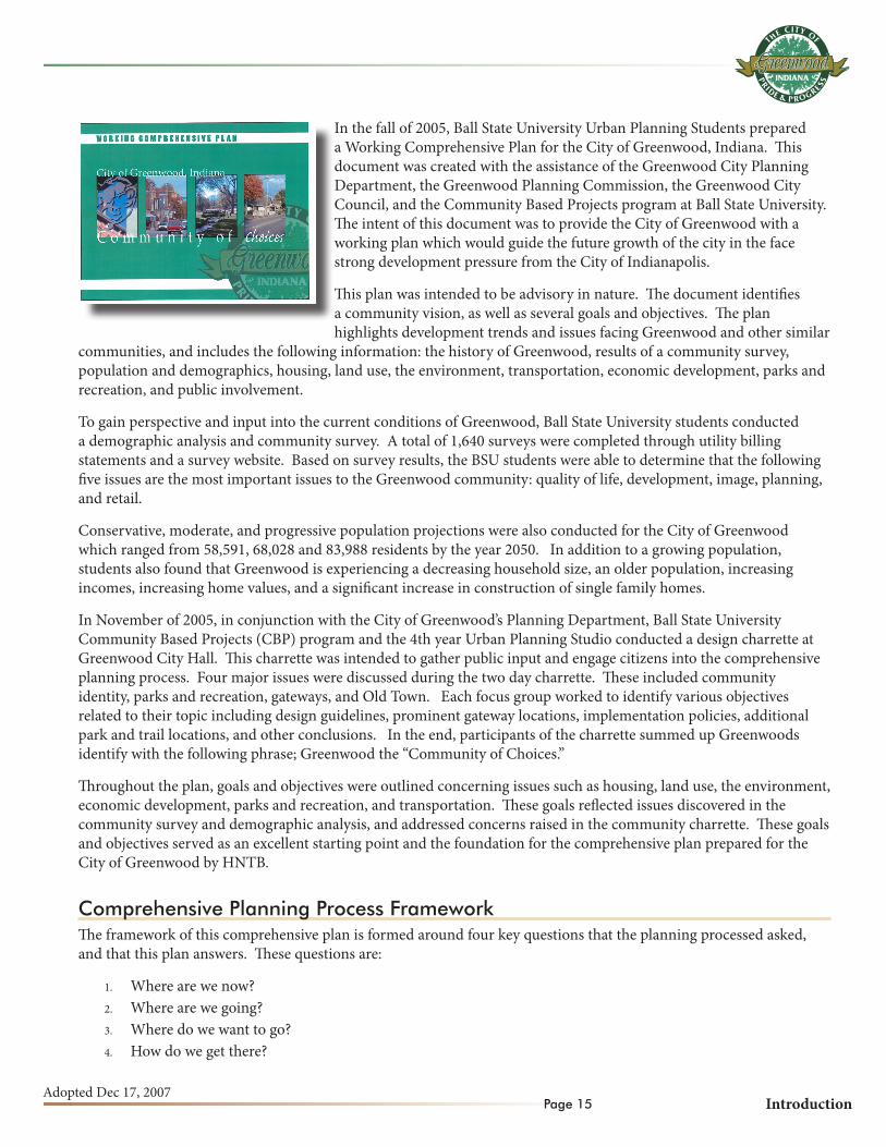
In the fall of 2005, Ball State University Urban Planning Students prepared a Working Comprehensive Plan for the City of Greenwood, Indiana. This document was created with the assistance of the Greenwood City Planning Department, the Greenwood Planning Commission, the Greenwood City Council, and the Community Based Projects program at Ball State University. The intent of this document was to provide the City of Greenwood with a working plan which would guide the future growth of the city in the face strong development pressure from the City of Indianapolis.
This plan was intended to be advisory in nature. The document identifies a community vision, as well as several goals and objectives. The plan highlights development trends and issues facing Greenwood and other similar
communities, and includes the following information: the history of Greenwood, results of a community survey, population and demographics, housing, land use, the environment, transportation, economic development, parks and recreation, and public involvement.
To gain perspective and input into the current conditions of Greenwood, Ball State University students conducted a demographic analysis and community survey. A total of 1,640 surveys were completed through utility billing statements and a survey website. Based on survey results, the BSU students were able to determine that the following five issues are the most important issues to the Greenwood community: quality of life, development, image, planning, and retail.
Conservative, moderate, and progressive population projections were also conducted for the City of Greenwood which ranged from 58,591, 68,028 and 83,988 residents by the year 2050. In addition to a growing population, students also found that Greenwood is experiencing a decreasing household size, an older population, increasing incomes, increasing home values, and a significant increase in construction of single family homes.
In November of 2005, in conjunction with the City of Greenwood’s Planning Department, Ball State University Community Based Projects (CBP) program and the 4th year Urban Planning Studio conducted a design charrette at Greenwood City Hall. This charrette was intended to gather public input and engage citizens into the comprehensive planning process. Four major issues were discussed during the two day charrette. These included community identity, parks and recreation, gateways, and Old Town. Each focus group worked to identify various objectives related to their topic including design guidelines, prominent gateway locations, implementation policies, additional park and trail locations, and other conclusions. In the end, participants of the charrette summed up Greenwoods identify with the following phrase; Greenwood the “Community of Choices.”
Throughout the plan, goals and objectives were outlined concerning issues such as housing, land use, the environment, economic development, parks and recreation, and transportation. These goals reflected issues discovered in the community survey and demographic analysis, and addressed concerns raised in the community charrette. These goals and objectives served as an excellent starting point and the foundation for the comprehensive plan prepared for the City of Greenwood by HNTB.
Comprehensive Planning Process FrameworkThe framework of this comprehensive plan is formed around four key questions that the planning processed asked, and that this plan answers. These questions are:
Where are we now?1.
Where are we going?2.
Where do we want to go?3.
How do we get there?4.

City of Greenwood, INComprehensive Plan 2007 - 2027
Page 16IntroductionAdopted Dec 17, 2007
The question of “Where are we now?” depicts the community’s history and setting including the local dynamics and the current demographic (population and housing) and economic conditions. The responses to this question are descriptive and are largely based on published data and observed characteristics.
The question of “Where are we going?” determines the current direction of the city’s growth and development. This path is the likely outcome for the future of the community assuming that there are no changes made to the city’s land use and growth policies and programs. The size of the future population, the amount of new development that will be required to serve that population, and the location of new development based on current trends are some indicators that determine the community’s current course of direction.
We ask, “Where do we want to go?” to identify the desired community characteristics for the future. Responses to this question are a result of input obtained from the public and the plan’s steering committee, focus groups, and key stakeholders. The responses to this particular question take the form of a desired land use scenario, a unified vision statement, a set of planning principles, and a set of goals and objectives.
Finally, we ask “How do we get there?” to provide city officials with the tools necessary for the successful implementation of this comprehensive plan. By enabling decision makers to make informed decisions about the present and future state of the City of Greenwood, city officials are better able to shape the community in a way that is consistent with the desired vision of the future. The primary tool for implementation is Section 10, Strategic Action Plan. The strategic action plan includes action steps, parties responsible for implementation, potential funding sources, a timeline of events, and other details that will assist the community in realizing its desired vision.
Planning Area BoundaryThe physical boundaries of this planning process are represented by the planning area boundary. Refer to the Planning Area Boundary Map. The planning area boundary is independent of the city’s corporate limits and the city’s extraterritorial jurisdictional area.
Most people are familiar with the purpose and function of a municipality’s corporate boundary. Every municipal corporation must have its boundaries fixed, definite and certain, in order that they may be identified, and that all may know the exact scope or section of territory or geographical division embraced within the corporate limits, and over which the local corporation has jurisdiction.
There are however properties outside of the city’s incorporated area, but within the city’s extraterritorial planning and zoning jurisdiction. These properties typically abut the existing corporate boundary. Often times, residents and businesses within the extraterritorial jurisdiction receive the same capital and non-capital services (e.g. trash service and emergency response) as residents and businesses within the municipal corporate limits. The City of Greenwood’s extraterritorial jurisdiction is limited to property within Pleasant Township. The city’s extraterritorial jurisdiction is composed of contiguous unincorporated territory abutting the City of Greenwood, as well as contiguous unincorporated parcels which are completely surrounded by the city.
To the extent possible, this comprehensive plan addresses the growth potential of the areas of the planning area boundary rather than just the corporate limits or the extraterritorial jurisdictional area. The city’s planning area boundary extends beyond both of the corporate limits and the extraterritorial jurisdictional areas. The planning area boundary further anticipates the need for long range planning for future growth and development is likely to extend beyond even the extraterritorial jurisdiction.
Planning area boundaries, such as this one, are typically determined by the availability of public utilities, particularly

Greenwood Comprehensive PlanAdopted Dec 17, 2007 (Resolution No. 07-12)
0 1
miles (approximate)
Wh
ite
Riv
er T
ow
nsh
ip Pleasant To
wn
ship
Plea
san
t To
wn
ship C
lark Tow
nsh
ip
Louisville & Ind
iana RR
Louisville & Ind
iana RR
Plan
nin
g A
rea
Bo
un
dar
y M
ap
Legend
Corporate Limits
Extraterritorial Jurisdiction
Planning Area Boundary
Township Boundary
I-65
I-65
W County Line Rd
N M
adison
E County Line Rd
Franklin Rd
SR
135S
R 135
CR 600 N
CR 700 NStones Crossing Rd
CR 600 N
W Worthsville Rd
Pushville Rd
Stop 18 Rd
Main St
Smith Valley Rd
US
31
US 31
Em
erson Ave
Whiteland Rd
Fry Rd
Rocklane Rd/Main St
Curry Rd
E Worthsville Rd
CR 850 N/Allen Rd
CR
325 E/G
riffith
CR
300 E/5 P
oints RD
CR
250 E/C
ombs R
d
CR
200 E
CR
250 E
Sheek R
dC
R 125 E
N M
eridian St
CR 700 N
Honey C
reek Rd
CR
125 W
CR
75 W
CR
25 W
Demaree Rd
Cutsinger RdC
R 200 E
CR
100 E
CR
300 E
Graham
Rd
Clark School Road
Stones Crossing
Greenwood Park Mall Greenwood
MunicipalAirport
Plann
ing
Area B
ou
nd
ary
Planning Area Boundary
Plann
ing
Area B
ou
nd
ary

This page intentionally left blank.

Page 19 IntroductionAdopted Dec 17, 2007
sanitary sewer, water distribution systems, and storm water management. Public utilities are discussed in further detail in Section 9, Public Facilities
It is therefore expected that Clark Township will be subject to significant growth and development in the future. The City of Greenwood has established sanitary sewer service across I-65, and is well positioned to address the need for sanitary sewer service in this high-growth area. Refer to the Eastside Interceptor Sewer Map in Section 9, Public Facilities.
The Planning ProcessDocumentation of the quantity, quality, and location of development within the planning area of the Greenwood Advisory Plan Commission process, which has been combined with the initial results of the BSU Working Comprehensive Plan and the 5-yr Park & Recreation Master Plan, have been compiled using the following planning process:
Community Analysis and Inventory The existing community conditions and trends of the City of Greenwood were evaluated and analyzed. Basic demographic analyses were performed with respect to population, housing, employment and income characteristics. An inventory of community land use patterns, public facilities, and transportation systems were also completed in order to better understand how existing community features are likely to influence future development scenarios.
Public ParticipationGreenwood residents, business owners, elected officials, and city staff contributed extensively to the comprehensive plan document. They were engaged throughout every phase of the planning processes. Participation in public meetings happens for many reasons. Some participants exhibited a passion for one particular topic or issue; many attended out of general interest or curiosity of the process. By engaging the public in discussions and other exercises, the comprehensive plan update process is better able to reflect the desires of the entire community. The public participation process was also important in that it has gained a wide-spread community buy-in for the end product. This is the City of Greenwood’s Comprehensive Plan.
Development of Policies, Goals, and Objectives Armed with input from the public and a baseline of information depicting how development has occurred in and around the city in the past, it was then necessary to formulate policy statements, or goals, and shor and long-term objectives. These were established and refined by four subcommittees. Membership of the individual subcommittees, which were chaired by members of the Greenwood Comprehensive Plan Steering Committee, consisted of citizens of the Greenwood community and surrounding areas who had expressed interest during the public participation phase of the planning process. Each subcommittee worked to further develop the goals and objectives identified during the previous phases of the planning process.
Plan DevelopmentThe development of the plan included the formation of a strategic action plan designed to outline the steps necessary to achieve each plan objective. In addition to the action steps, the strategic action plan outlines the possible resources required and a short-term, mid-term, or long-term designation for accomplishing each step.
Comprehensive Planning Process

City of Greenwood, INComprehensive Plan 2007 - 2027
Page 20IntroductionAdopted Dec 17, 2007
Plan ImplementationAs the name suggests, plan implementation will involve the active implementation of the planning strategies chosen by the community. It will be the responsibility of the Greenwood Advisory Plan Commission to oversee implementation of the plan; moving forth with the projects and programs outlined in the various short-term strategic action plans, as well as periodically developing additional strategic action plans with each revision of the plan.
Plan Evaluation & Revision This phase recognizes the fact that communities are dynamic and ever changing. Because of this, the plan must be evaluated periodically, and when necessary, revised. This does not have to be a difficult or time-consuming process. Plan Evaluation simply requires that the Greenwood Advisory Plan Commission evaluate and revise the plan in order to ensure that the plan remains responsive to changing conditions in and around the City of Greenwood.
How to use this DocumentGreenwood’s Comprehensive Plan is intended as a working document to be used by elected and appointed officials to make decisions about the future growth and development of land within the jurisdiction of the Greenwood Advisory Plan Commission. It is further structured to allow for evaluations and periodic revisions.
Key Words & PhrasesThere are some key words and phrases used throughout this document. It is important that these words and phrases be defined in order to ensure the effective use and understanding of the contents of this document. These words and phrases are defined on the following page.
Action plan/stepA specific step to be taken to implement an objective and its subsequent goal if the vision is to be realized.
GoalA broad statement that supports the vision while adding a specific area of focus. A goal is lofty, but attainable within the planning horizon.
Key person/StakeholderAn individual who is in some way responsible for implementing the plan or who has a vested interest in the outcome of the plan, whose input should be considered early in the planning process.
ObjectiveA statement that adds a level of specificity to the goal, without identifying the individual actions that must be taken for implementation. Objectives are generally measurable so that the community can identify and acknowledge their accomplishments through the successful implementation of this plan.
Planning HorizonThe period of time considered by the plan. A comprehensive plan generally considers a twenty-year period, however, communities are encouraged to review and, if necessary, update their comprehensive plan every five years, to ensure that its contents accurately reflect changing community conditions and the appropriate prioritization of goals, objectives, and action steps.

Page 21 IntroductionAdopted Dec 17, 2007
PolicyA definite course or method of action to guide present and future decisions. Policies may be legislative or administrative in nature.
Steering CommitteeThe group of people, assigned by the Plan Commission, to represent the community and guide the comprehensive planning process. The Steering Committee members serve as a liaison between the community and the consultant during the planning process. The steering committee is ultimately responsible for the content of the plan.
Vision StatementA broad statement describing the desired future of the community, as shared by members of the community.

City of Greenwood, INComprehensive Plan 2007 - 2027
Page 22IntroductionAdopted Dec 17, 2007
This page intentionally left blank.