Section IV. District Zoning Regulations, N.J.A.C. 19:4
81
Section IV. District Zoning Regulations, N.J.A.C. 19:4 The NJMC Master Plan sets forth policies that guide development in the District. These policies are enforced through implementation of the District Zoning Regulations. From 1980 to 2004, the Master Plan and zoning regulations have served as enforceable policies under the NJCMP. In order to reflect the new vision of the NJMC Master Plan adopted in 2004, and to better respond to changes in land use trends and development patterns within the District, the NJMC amended the District Zoning Regulations, N.J.A.C. 19:4. Although the 1972 District Zoning Regulations were incorporated into the NJCMP in their entirety, much of the regulations are not relevant to the NJCMP today. Hence, the 1972 District Zoning Regulations are being deleted from the NJCMP in their entirety, and only the relevant enforceable policies of Subchapters 2, 3, 4, 5, 7, 8 and 9 are being incorporated into the NJCMP. An overview of each of these subchapters follows: • Subchapter 2. Intent, Word Usage and Definitions: This subchapter defines terms used throughout the District Zoning Regulations. • Subchapter 3. Application of Regulations: This subchapter sets forth the areas to which the zoning regulations apply; exemptions from the District Zoning Regulations; and the zones that comprise the District and provides that the Official Zoning Map of the NJMC is part of the District Zoning regulation. This subchapter also provides for temporary uses and structures, procedures for establishing a zoning lot of record, and easement requirements. • Subchapter 4. Administration: This subchapter provides the application procedure for the development of land or occupancy of structures in the District. It includes procedures and technical requirements for applications for zoning certificates, occupancy certification, special exception, and variance applications; public notice and hearing requirements and appeals. • Subchapter 5. Districts, Uses and Standards: This subchapter outlines the different zones that comprise the District and provides the use and bulk requirements for the development and occupancy of land therein. • Subchapter 7. Performance Standards : This subchapter provides performance standards required to be met by development, including the standards for noise, vibrations, glare, airborne emissions, hazardous and radioactive materials, wastewater and traffic. • Subchapter 8. Site Plan Requirements: This subchapter outlines the site design requirements for development in the District, including provisions for the design and arrangement of parking and loading area, line-of-sight triangles, drainage, buffers, open space, landscaping, lighting, signage, site service improvements, and the placement of fill. • Subchapter 9. Floodplain Management: This subchapter incorporates the standards for development within a floodplain based on the rules of the Federal Emergency Management Agency and provides the basis for establishing the areas of special flood hazard, identified by the Federal Insurance Administration. This subchapter also sets forth the duties and responsibilities of the NJMC Chief Engineer, procedures and criteria for granting variances from the floodplain regulations, requirements for written records of decision, and appeals procedures. 100
Transcript of Section IV. District Zoning Regulations, N.J.A.C. 19:4

Section IV. District Zoning Regulations, N.J.A.C. 19:4 The NJMC Master Plan sets forth policies that guide development in the District. These policies are enforced through implementation of the District Zoning Regulations. From 1980 to 2004, the Master Plan and zoning regulations have served as enforceable policies under the NJCMP. In order to reflect the new vision of the NJMC Master Plan adopted in 2004, and to better respond to changes in land use trends and development patterns within the District, the NJMC amended the District Zoning Regulations, N.J.A.C. 19:4. Although the 1972 District Zoning Regulations were incorporated into the NJCMP in their entirety, much of the regulations are not relevant to the NJCMP today. Hence, the 1972 District Zoning Regulations are being deleted from the NJCMP in their entirety, and only the relevant enforceable policies of Subchapters 2, 3, 4, 5, 7, 8 and 9 are being incorporated into the NJCMP. An overview of each of these subchapters follows:
• Subchapter 2. Intent, Word Usage and Definitions: This subchapter defines terms used throughout the District Zoning Regulations.
• Subchapter 3. Application of Regulations: This subchapter sets forth the areas to which the zoning regulations apply; exemptions from the District Zoning Regulations; and the zones that comprise the District and provides that the Official Zoning Map of the NJMC is part of the District Zoning regulation. This subchapter also provides for temporary uses and structures, procedures for establishing a zoning lot of record, and easement requirements.
• Subchapter 4. Administration: This subchapter provides the application procedure for the development of land or occupancy of structures in the District. It includes procedures and technical requirements for applications for zoning certificates, occupancy certification, special exception, and variance applications; public notice and hearing requirements and appeals.
• Subchapter 5. Districts, Uses and Standards: This subchapter outlines the different zones that comprise the District and provides the use and bulk requirements for the development and occupancy of land therein.
• Subchapter 7. Performance Standards: This subchapter provides performance standards required to be met by development, including the standards for noise, vibrations, glare, airborne emissions, hazardous and radioactive materials, wastewater and traffic.
• Subchapter 8. Site Plan Requirements: This subchapter outlines the site design requirements for development in the District, including provisions for the design and arrangement of parking and loading area, line-of-sight triangles, drainage, buffers, open space, landscaping, lighting, signage, site service improvements, and the placement of fill.
• Subchapter 9. Floodplain Management: This subchapter incorporates the standards for development within a floodplain based on the rules of the Federal Emergency Management Agency and provides the basis for establishing the areas of special flood hazard, identified by the Federal Insurance Administration. This subchapter also sets forth the duties and responsibilities of the NJMC Chief Engineer, procedures and criteria for granting variances from the floodplain regulations, requirements for written records of decision, and appeals procedures.
100

In addition, it contains the flood proofing requirements for residential and non-residential construction for buildings and building sites, penalties and enforcement provisions.
The Hackensack Meadowlands Reclamation and Development Act, N.J.S.A. 13:17-6(i) provides that the NJMC has the power to prepare, adopt and implement a master plan for the physical development of all lands, or a portion thereof, lying within the district; and to adopt and enforce codes and standards for the effectuation of such plan. Table B, Routine Program Change, District Zoning Regulations, N.J.A.C. 19:4, identifies the policies of the District Zoning Regulations the NJCMP intends to incorporate into its approved program as enforceable policies. These policies are enforced through the Hackensack Meadowlands Reclamation and Development Act and the Coastal Zone Management rules’ Hackensack Meadowlands District Rule (N.J.A.C. 7:7E-3.45). Table B compares the 1972 District Zoning Regulations with the District Zoning Regulations as amended through January 20, 2009 and contains an analysis describing the changes between these regulations. These changes do not change the program approvability area of boundaries nor do they change the District’s designation as a special management area. While the changes may affect the program approvability areas of uses subject to management, authorities and organization, or consideration of the national interest, these changes are not substantial for the reasons described in the analysis portion of Table B. A copy of the District Zoning Regulations subject to the Routine Program Change is included in this submission.
101

Table B Routine Program Change Incorporating
District Zoning Regulations of the Hackensack Meadowlands District September 8, 2009
NOTE: OCRM does not consider the rules with asterisks (*) to be enforceable policies, the NJCMP is incorporating them into the approved CMP for informational purposes.
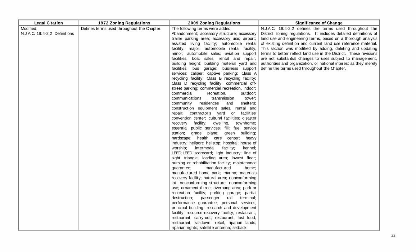
Legal Citation 1972 Zoning Regulations 2009 Zoning Regulations Significance of Change Subchapter 2. Intent, Word Usage and Definitions
Modified: N.J.A.C. 19:4-2.1 Intent and word usage
Sets forth the intent, and word usage of certain terms used throughout the Chapter.
Added following word usages: terms in future tense; “masculine gender;” “adjacent,” “next to” and “abut;” “such as” and “for example;” and “building” and “structure.” Added definitions of the following terms: Board of Commissioners; District; Official Zoning Map; Secretary; Executive Director and Chief Engineer. Added the following provisions: • Undefined terms have the meaning of that found in the most recent edition of the Merriam-Webster’s Collegiate Dictionary; • No word, action, process, procedure, decision, or other action under this Chapter shall necessarily be interpreted to operate under or in the same manner as the Municipal Land Use Law; • Where this Chapter imposes greater restrictions than other laws, rules, resolutions or ordinances, provisions of this Chapter govern; and • References to statutes, laws, rules, regulations or ordinances refer to the “as amended” versions. Modified definition of New Jersey Meadowlands Commission and constituent municipality and usage of the phrase “used for.”
N.J.A.C. 19:4-2.1 contains the intent and usage of certain words as well as frequently used abbreviations and acronyms of relevant terms used in the construction of these regulations. This section has been revised by incorporating additional terms and word usages and by providing a figure listing abbreviations and acronyms used frequently throughout the regulations. These changes are not substantial changes to uses subject to management, authorities and organization, or national interest as they merely define the terms used throughout the Chapter.
21
Legal Citation 1972 Zoning Regulations 2009 Zoning Regulations Significance of Change
Modified: N.J.A.C. 19:4-2.2 Definitions
Defines terms used throughout the Chapter. The following terms were added: Abandonment; accessory structure; accessory trailer parking area; accessory use; airport; assisted living facility; automobile rental facility, major; automobile rental facility, minor; automobile sales; aviation support facilities; boat sales, rental and repair; building height; building material yard and facilities; bus garage; business support services; caliper; captive parking; Class A recycling facility; Class B recycling facility; Class D recycling facility; commercial off-street parking; commercial recreation, indoor; commercial recreation, outdoor; communications transmission tower; community residences and shelters; construction equipment sales, rental and repair; contractor’s yard or facilities’ convention center; cultural facilities; disaster recovery facility; dwelling, townhome; essential public services; fill; fuel service station; grade plane; green building; hardscape; health care center; heavy industry; heliport; helistop; hospital; house of worship; intermodal facility; kennel; LEED;LEED scorecard; light industry; line of sight triangle; loading area; lowest floor; nursing or rehabilitation facility; maintenance guarantee; manufactured home; manufactured home park; marina; materials recovery facility; natural area; nonconforming lot; nonconforming structure; nonconforming use; ornamental tree; overhang area; park or recreation facility; parking garage; partial destruction; passenger rail terminal; performance guarantee; personal services, principal building; research and development facility; resource recovery facility; restaurant; restaurant, carry-out; restaurant, fast food; restaurant, sit-down; retail, riparian lands; riparian rights; satellite antenna; setback;
N.J.A.C. 19:4-2.2 defines the terms used throughout the District zoning regulations. It includes detailed definitions of land use and engineering terms, based on a thorough analysis of existing definition and current land use reference material. This section was modified by adding, deleting and updating terms to better reflect land use in the District. These revisions are not substantial changes to uses subject to management, authorities and organization, or national interest as they merely define the terms used throughout the Chapter.
22

Legal Citation 1972 Zoning Regulations 2009 Zoning Regulations Significance of Change
N.J.A.C. 19:4-2.2 (continued) shade tree; sidewalk; social services; solid waste transfer station; special exception; stormwater management area; studio; substantial destruction; taxi and limousine service; trailer; tributary; truck rental facility; truck repair facility; truck sales; truck stop; truck terminal; truck wash; variance; vehicular use area; veterinary facility; wetland; wholesale establishment; yard, required; and, zoning summary table. The following terms were modified: Building area; dare care facility; dwelling’ dwelling, single family; dwelling, two family; dwelling unit; floor area; floor area ration; hotel or motel; institutional use; landscaping; lot; lot corner; lot coverage; lot depth; lot line; front; lot line, rear; lot line, side; open space; outdoor storage; public utilities, heavy; public utilities, light; remodeling; screening; structure; warehouse and distribution facility; yard; yard, front; and, yard, rear. The following terms were deleted: Agriculture; alley; awning; canopy; capacity in persons; development board; district; duplex; family; governmental uses; housing for low-income families; housing for middle-income families; housing for moderate-income families; lot area; lot line; lot of record; lot size requirements; motor freight terminal; neighborhood; nursing or convalescent home; open area; parcel; principal structure; re- occupied use; retail sales; section; specially planned area; uplands; useable roof area; use; vehicular area; and, zoning map
23

Legal Citation 1972 Zoning Regulations 2009 Zoning Regulations Significance of Change
Subchapter 3. Application of Regulations
Modified: N.J.A.C. 19:4-3.2 Exemptions Formerly N.J.A.C. 19:4-3.2(b)
Exempts from zoning regulations: • Home occupations; and • Maintenance and repairs of railroad signals, bridges, and similar facilities and equipment located in railroad rights-of-way
Exempts from zoning regulations: • Maintenance and repair work within railroad and roadway ROWs; • Development and improvement plans sponsored by NJMC: and • Municipal review of one, two and three family residences in the Low Density Residential zone within District.
N.J.A.C. 19:4-3.2 sets forth the exemptions from the District’s zoning regulations. Exemptions for work within ROWs recognize the authority of quasi-public bodies such as utilities and railroads to conduct maintenance work without prior approval by the NJMC; however, new projects would require NJMC approval. Likewise, NJMC development and improvement plans are exempt for the zoning regulations because NJMC cannot review its own projects. The NJMC is affiliated with the NJ Dept. of Community Affairs which reviews all state building projects. Finally, the exemption of residences up to 3 units merely allows the municipality to review the application in accordance with the NJMC regulations. These changes are not a substantial change to uses subject to management, authorities and organization, or national interest as it codifies jurisdictional matters. The CZM rules at N.J.A.C. 7:7E-3.45 set forth the standards for review of proposed coastal activities or developments within the District. These standards are dependent upon whether a zoning certificate or statement of consistency from the NJMC is required. Certain coastal activities or developments do not require a zoning certificate but follow an alternative process established by the NJMC. N.J.A.C. 7:7E-3.45(c) provides that issuance of a statement of consistency by the NJMC serves as evidence that those coastal activities or developments that do not require a zoning certificate are consistent with the NJMC master plan. These projects fall into 3 categories. The first two categories are municipal or county projects necessitating the expenditure of any public funds, and requiring a resolution from the NJMC in accordance with N.J.S.A. 13:17-12(b); and exempt municipal projects located on land owned by a municipality that is in compliance with all applicable NJMC District Zoning Regulations, at N.J.A.C. 19:4-3.2(a)5. In accordance with the MOA between the Department and the NJMC, the Commission will issue either a resolution or a statement of consistency with the master plan for these developments and activities. The third category of projects, are developments and improvements proposed or sponsored by the NJMC, in accordance with the District Zoning
24

Legal Citation 1972 Zoning Regulations 2009 Zoning Regulations Significance of Change N.J.A.C. 19:4-3.2 (continued)
Regulations at N.J.A.C. 19:4-3.2(a)3. In accordance with the MOA, the NJMC will also approve a resolution or provide a statement of consistency with the master plan for projects that the NJMC undertakes.
Added: N.J.A.C. 19:4-3.7 Coastal zone management*
No equivalent Provides NJMC Master Plan is an element of NJCMP
N.J.A.C. 19:4-3.7 is a new section that formalizes the fact that the NJMC master plan is an element of New Jersey’s approved Coastal Management Program. This change is not a substantial change to uses subject to management, authorities and organization, or national interest as it merely codifies the master plan’s position as an element of the NJCMP.
Subchapter 4. Administration
Modified: N.J.A.C. 19:4-4.22 Severability Formerly N.J.A.C. 19:4-2.1(i), (j) and (k)
Provisions of the rules are separable. If any court of competent jurisdiction shall adjudge: • Any provision of the regulations to be invalid, such judgment shall not affect any other provisions of the regulations; and • Invalid the application of any provisions of the regulations to a particular property or structure, such judgment shall not affect the application of said provisions to any other property or structure.
Replaced the term “provision” with “section, subsection, paragraph, sentence, clause or phrase” for clarity. Clarified that “structure” includes “buildings.” In addition to “invalid”, the term “unconstitutional” was included for clarity.
N.J.A.C. 19:4-4.22 provides that should one portion of the regulations, or the application of any provision of the regulations to a particular site, be found to be unconstitutional or invalid, the remaining portions of the regulations, or said provision to any other site, shall not be affected. This section is substantially similar to the 1972 regulations and therefore the changes are not substantial changes to the uses subject to management, authorities and organization, or national interest.
Subchapter 5. Districts, Uses and Standards
Added: N.J.A.C. 19:4-5.5 Marinas
Outlines minimum requirements for installation of marinas including provisions related to: • Minimum number and size of docking berths; and • Boat launching ramps; parking, loading and trailer requirements
Outlines minimum requirements for installation of marinas including provisions related to: • Minimum number and size of docking berths; and • Boat launching ramps; parking, loading and trailer requirements
N.J.A.C. 19:4-5.5 consolidates the minimum requirements for the construction of a marina, including provisions relating to minimum number and size of docking berths, boat launching ramps, and parking, loading and trailer requirements. The consolidation of these requirements does not result in a substantial change to the uses subject to management, authorities and organization and national interest. The marina regulations further the 2004 master plan’s strategies for preservation and recreational opportunities, by preserving wide expanses of land for open space, wildlife habitats; and recreation and water resources by enhancing and capitalizing on the District’s waterways as a defining asset of the District
25

Legal Citation 1972 Zoning Regulations 2009 Zoning Regulations Significance of Change
N.J.A.C. 19:4-5.8 through 5.12, Environmental Conservation zone (Formerly Marshland Preservation Zone)
Modified: N.J.A.C. 19:4-5.8 Environmental Conservation zone; purposes Formerly N.J.A.C. 19:4-4.12
Designed to: • Preserve and enhance the ecological values of wetlands and open waters within the District so that real estate development and urbanization will not destroy these areas
Designed to: • Preserve and enhance the ecological values of wetlands, open water and adjacent uplands within the District; • Provide public access to these areas; and • Encourage scientific and educational study of wetland ecology
This section sets forth the purpose of the Environmental Conservation Zone, formerly the Marshland Preservation zone. The purpose of this zone was refined to specify the preservation and enhancement of wetlands rather than aquatic habitats in order to better reflect the diversity of the wetlands ecosystem, which includes both terrestrial and aquatic habitats. In addition, the intent of this zone, to provide public access to these areas and encourage scientific and educational study with regard to wetland ecology has been added. These changes are support and are consistent with the permitted uses of this zone (both 1972 and 2004 regulations) and thus these changes are not substantial changes to uses subject to management and authorities and organization. These changes further the national interest in the provision of public access to tidal waterways and their shores, and protection of the basic values of wetlands as habitat and food sources for waterfowl and aquatic life as well as the functioning of wetlands for flood prevention, water supply, nutrient exchange an as a recreational resource. The regulations concerning the Environmental Conservation zone (N.J.A.C. 19:4-5..8-5.12) further the 2004 master plan’s strategies for preservation and recreational opportunities, by preserving wide expanses of land for open space, wildlife habitats and recreation and water resources by enhancing and capitalizing on the District’s waterways as a defining asset of the District. (System 1, Strategies 1 and 2)
Modified: N.J.A.C. 19:4-5.9 Environmental Conservation zone; permitted uses Formerly N.J.A.C. 19:4-4.13
Permitted uses: • Scientific/educational study and exper-imentation regarding wetland ecology; and • Walkways for nature trails
Permitted uses: • Existing public utility equipment and related activities; • Public access (trails, launches, water crossings, site furnishings, signage and structures that facilitate wildlife observation);
Minor changes to two of the permitted uses were made. First, the permitted use concerning public access was amended to allow for signage that facilitates wildlife observation and the other change was to eliminate redundancy. Second, redundant language concerning mitigation banks was deleted. Minor changes in terminology were also made. Changes in terminology are considered minor changes that do not affect
26

Legal Citation 1972 Zoning Regulations 2009 Zoning Regulations Significance of Change
N.J.A.C. 19:4-5.9 (continued) • Scientific/educational study and exper-imentation regarding wetland ecology; • Wetland enhancement, restoration or creation; and • Wildlife habitat creation.
the 5 program approvability areas, but have been included for notification purposes. Two additional permitted uses were added, one to allow for existing public utility equipment and related activities, and one to allow for wildlife habitat creation. With respect to existing utility lines, the exemption allows for the operation, maintenance, reconstruction, inspection, testing and removal of such equipment. This is not a substantial change to uses subject to management or authorities and organization as these structures are existing and must be maintained and operated. The addition of wetland enhancement, restoration and wildlife habitat creation is consistent with the purpose and intent of this zone and therefore is not a substantial change to uses subject to management and authorities and organization. These changes further the national interest in recreation and wetlands.
Modified: N.J.A.C. 19:4-5.10 Environmental Conservation zone; special exception uses Formerly N.J.A.C. 19:4-4.14
Special exception to this zone: • Construction, maintenance and use of any structures, buildings and improvements in connection with scientific and educational activities pertinent to marshland ecology
Special exceptions to this zone: • Communication transmission towers; • Electric transmission towers • Marinas; • Construction of any element or physical device to fulfill regulatory requirement regarding wetlands enhancement, restoration or creation; and • Structures and improvements essential for and used solely in conjunction with a permitted use. Structures and improvements essential for and used solely in conjunction with a permitted use
Two new special exception uses were added to this zone: marinas and communications/electric transmission towers. Special exceptions are conditional uses. Transmission towers often require significant open spaces without obstructions from nearby buildings. Marinas are required to be located near water. Both types of uses generally require very little impervious cover. Additionally, some properties in the Environmental Conservation zone contain upland areas that could accommodate limited development. The changes to this section permit private landowners within the Environmental Conservation zone to use their property in a manner that minimizes development on a property, if the conditions of the use are met. Applicants for a special exception use are required to show that the proposed use will not have adverse environmental impacts and that the use will promote the public welfare. The changes do not negate the need for permits from any other agency having jurisdiction, such as the NJDEP or US Army Corps of Engineers. The addition of transmission towers is consistent with the provision of the CMP not to exclude uses of a regional benefit. The addition of a marina is consistent with the purpose and intent of this zone and furthers the national interest in access to recreation. Therefore, the changes are not substantial changes to uses subject to management and authorities and organization.
27

Legal Citation 1972 Zoning Regulations 2009 Zoning Regulations Significance of Change
Modified: N.J.A.C. 19:4-5.11 Environmental Conservation zone; use limitations Formerly N.J.A.C. 19:4-4.15
No use shall be operated, conducted or maintained that may impair the quality of the district as a marshland preservation area. • Any use that significantly discourages or interferes with use of zone as a natural habitat for waterfowl and other forms of marsh life is presumed to impair quality of the zone No motor-driven vehicle or equipment shall be used in the zone that interferes with the zone’s purpose
No use shall be operated, conducted or maintained that may impair the water quality of the zone. Any use that discourages or interferes with the purpose of the zone is prohibited
No substantial changes were made to the existing use limitations and thus no substantial changes were made to the uses subject to management, authorities and organization, or national interest. Minor wording changes were made in response to the name change of this zone. In addition, the term “significantly” was deleted to stress that any use that discourages or interferes with the purpose of this zone is prohibited.
Modified: N.J.A.C. 19:4-5.12 Environmental Conservation zone; performance standards Formerly N.J.A.C. 19:4-4.16
Environmental performance standardscategory A: noise, vibration, steam, airborne emissions and glare
All Category A performance standards apply with exception of particulate source emissions where they shall not exceed 0.2 pounds per hour, per acre lot for all uses on the lot, or NJ State Air Pollution Control Laws and Codes (N.J.A.C. 7:27) whichever is more restrictive
Environmental performance standardscategory B: fire and explosion hazards, radioactive materials All water quality standards Particulate source emissions shall not exceed 0.2 pounds per hour, per acre lot for all uses on the lot, or NJ State Standard whichever is more restrictive
The section was renamed “performance standards.” Under the 2004 adoption, the performance standards were consolidated and streamlined. Therefore, instead of listing specific performance standards and which category they fall in, the performance standards were changed to reference all “Category A” performance standards, with the exception of the particulate source emissions. The particulate source emissions section referencing the New Jersey State Air Pollution Control Laws is referenced for specificity. The provision stating that all water quality standards shall apply was recodified as N.J.A.C. 19:4-5.2, General Provisions. N.J.A.C. 19:4-5.2 combines all general provisions of each zone into one cohesive list. These changes are not substantial changes to uses subject to management and authorities and organization. The changes further the national interest in air quality.
N.J.A.C. 19:4-5.13 through 17, Parks and Recreation Zone
Modified: N.J.A.C. 19:4-5.13 Parks and recreation zone; purpose Formerly N.J.A.C. 19:4-4.18
Designed to maintain a necessary supply of open space and recreation space
Designed to provide creation, management and appropriate use of public open space and recreational facilities that allows for public use and enjoyment of these areas.
The original purpose of this zone discussed the need to maintain a necessary supply of open space and recreational facilities. The purpose of this zone was modified in 2004 to include “the creation, management and appropriate use of public open space and recreational facilities within the District.” It also emphasizes the importance of allowing for public use and enjoyment of areas in this zone. As this change refines the purpose, it is not considered a substantial change to uses subject to management or authorities and organization. This change furthers the major objectives identified by the NJCMP
28

Legal Citation 1972 Zoning Regulations 2009 Zoning Regulations Significance of Change
N.J.A.C. 19:4-5.13 (continued) of: consideration of recreation as an equal among competing uses of the coastal region; provision of high quality recreational opportunities to all people while protecting the coastal environment; and, increasing public recreation in high density areas. The regulations concerning the Parks and Recreation zone (N.J.A.C. 19:4-5.13 through 5.17) further the 2004 master plan’s strategies for preservation and recreational opportunities, by preserving wide expanses of land for open space, wildlife habitats and recreation and water resources by enhancing and capitalizing on the District’s waterways as a defining asset of the District. (System 1, Strategy 1)
Modified: N.J.A.C. 19:4-5.14 Parks and recreation zone; permitted uses Formerly N.J.A.C. 19:4-4.19
Permitted uses are: • Any governmental property used for park or recreational purposes; • Privately owned parks open to the public
Permitted uses are: • Cemeteries; • Parks or recreational facilities; and • Wildlife habitat creation.
The permitted uses of this zone have been expanded to include cemeteries and wildlife creation areas. Although cemeteries are not governmental uses, they are quasi-public uses that serve a public purpose and remain largely open space, consistent with the intent of the zone. Wildlife habitat creation allows for passive recreational opportunities and is likewise consistent with the intent of the zone. Therefore, the changes are not substantial changes to uses subject to management, authorities and organization and consideration of the national interest.
Modified: N.J.A.C. 19:4-5.15 Parks and recreation zone; special exception uses Formerly N.J.A.C. 19:4-4.20
• Primary and secondary schools; and • Construction, maintenance and use of any structures, buildings and improvements; including retail services associated with parks and recreational uses
Permitted uses: • Marinas; • Primary and secondary schools; and • Construction, maintenance and use of any structures, buildings and improvements; including retail services associated with parks and recreational uses
Marinas have been added as a special exception use. Marina uses are consistent with the intent of the zone to provide for recreational uses, but the special exception procedure allows additional oversight to ensure the location and intensity of the proposed use is appropriate and will not cause detrimental environmental impacts. This change is not a substantial change to uses subject to management, authorities and organization and consideration of the national interest in public access to tidal waterways and their shores.
Modified: N.J.A.C. 19:4-5.16 Parks and recreation zone; use limitations Formerly N.J.A.C. 19:4-4.21
All uses shall be operated and maintained in a manner consistent with a desirable environment and a park and recreation atmosphere
No use shall be operated, conducted or maintained that may impair the quality and character if the zone
Changes in wording that do not result in a change in the overall meaning of a rule are considered minor changes that do not affect the 5 program approvability areas.
29

Legal Citation 1972 Zoning Regulations 2009 Zoning Regulations Significance of Change
Modified: N.J.A.C. 19:4-5.17 Parks and recreation zone; performance standards Formerly N.J.A.C. 19:4-4.22
Environmental performance standardscategory A: all airborne emission standards, fire and explosion; radioactive materials
Category A performance standards apply, except for glare.
Environmental performance standardscategory B: noise, vibration and glare
Category B performance standards apply to glare.
All water quality standards
This rule was renamed “performance standards.” Under the 2004 amendments to the zoning regulations, noise and vibrations were reassigned to Category A performance standards. In addition, the provision stating that all water quality standards shall apply was recodified as N.J.A.C. 19:4-5.2, General Provisions. N.J.A.C. 19:4-5.2 combines all general provisions of each zone into one cohesive list. These changes are minor changes and do not substantially change the uses subject to management, authorities and organization and consideration of the national interest.
N.J.A.C. 19:4-5.18 through 5.24 Waterfront recreation zone
Modified: N.J.A.C. 19:4-5.18 Waterfront Recreation zone; purpose Formerly N.J.A.C. 19:4-4.33
Designed to accommodate water-oriented recreational facilities
Designed to accommodate marinas in combination with other water-orientated facilities and encourage public access to and visibility of the Hackensack River and its tributaries
The purpose of the Waterfront Recreation zone has been refined to encourage public access to, and visibility of, the Hackensack River and its tributaries. This change merely codifies the intent of this zone and therefore is not a substantial change to the uses subject to management or authorities and organization. This change furthers the national interest in public access to tidal waterways and their shores. The regulations concerning the Waterfront Recreation zone (N.J.A.C. 19:4-5.18 through 5.24) further the 2004 master plan’s strategies for preservation and recreational opportunities by preserving wide expanses of land for open space, wildlife habitats, recreation and water resources; by enhancing and capitalizing on the District’s waterways as a defining asset of the District; and by increasing both active and passive recreational uses. (System 1, Strategy 1)
Modified: N.J.A.C. 19:4-5.19 Waterfront Recreation zone; permitted uses and marina requirements Formerly N.J.A.C. 19:4-4.35
Permitted uses: • Marinas for the docking, repair, sale, servicing and storage of boats; and • Other water recreation oriented uses
Permitted uses: • Day care facilities; • Marinas; • Other water recreation uses; and • Parks or recreation facilities. When included in a marina, the following shall also be permitted uses: • Commercial, recreation, outdoor; • Restaurants; and • Retail accessory to a marina.
The permitted uses of this zone have been expanded to include day care facilities and parks or recreation facilities. Day care facilities were added as a permitted use to be consistent with state law that permits the use in every non-residential zone. Parks and recreation facilities were added as a permitted use to allow expanded recreational opportunities consistent with the intent of the zone to provide and encourage public access to the Hackensack River. A minor change removed the word “oriented” from the permitted “other water recreation uses,” with no change to the intent of the regulated use. Additional uses are permitted only when included with a marina, including
30

Legal Citation 1972 Zoning Regulations 2009 Zoning Regulations Significance of Change N.J.A.C. 19:4-5.19 (continued) outdoor commercial recreation uses, restaurants, and retail
accessory to a marina. In the 1972 regulations, restaurants and retail uses were permitted as a special exception use. The change of these uses to permitted uses when part of a marina development recognizes these uses as suitable to provide amenities to the public. Additionally, the scope of the retail use is reduced in intensity and must be associated with the sale of items related to the marina use, not general retail sales. Outdoor commercial recreation uses allow for expanded recreational opportunities along the river. Therefore, the changes are not substantial changes to uses subject to management, authorities and organization, and further the national interest in public access to tidal waterways and recreation.
Modified: N.J.A.C. 19:4-5.20 Waterfront Recreation zone; special exception uses Formerly N.J.A.C. 19:4-4.36
Small retail shops and restaurants accessory to permitted uses
When included in a marina: • Commercial recreation, indoor; and • Cultural facilities
As stated above, restaurants and retail uses are permitted as part of a marina development in recognition that these uses provide amenities to the public. Indoor commercial recreation and cultural facilities are added as a special exception use, since they would most likely be located within buildings. The special exception process allows additional review of potential impacts to land use, traffic, utilities, and the environment, yet the uses remain appropriate to the intent of the zone to encourage public use of the water resources located within the zone. Therefore, the changes are not substantial changes to uses subject to management, authorities and organization, and further the national interest in public access to tidal waterways and their shores.
Modified: N.J.A.C. 19:4-5.21 Waterfront Recreation zone; use limitations Formerly N.J.A.C. 19:4-4.37
All uses shall be buffered where possible by tidally affected marsh or otherwise screened. No business establishment shall offer or sell food or beverages for consumption on the premises in parked motor vehicles. Structures shall be so located as to not impair the view of the Hackensack River from adjoining and upland properties.
All development shall be designed to permit public access to the edge of the river; development fronting the Hackensack River shall provide a pedestrian walkway along the edge of the river. Uses shall be designed to focus on the river as a recreational and visual resource. Temporary and seasonal storage of boats may occur on open space, not exceeding 15% of required open space No business shall offer or sell food or beverages for consumption on the premises in
The provision for buffers is refined to a general provision applicable to all zones and has been recodified as N.J.A.C. 19:4-8.7, and expanded in scope to provide more detailed buffer requirements from waterways. The provision for structures to avoid impairing views is reworded to be more proactive by stating uses must be designed to focus on the river as a recreational and visual resource, which includes not impairing views. An additional use limitation adds that public access and a pedestrian walkway must be provided along the Hackensack River. Finally, limited temporary boat storage provisions are permitted to allow for boat winterization during cold weather months when a marina would most likely not be in use by recreational boaters. Therefore, the changes are not substantial changes to uses subject to management, authorities and organization, and further the national interest in
31

Legal Citation 1972 Zoning Regulations 2009 Zoning Regulations Significance of Change N.J.A.C. 19:4-5.21 (continued) parked motor vehicles public access to tidal waterways and their shores. Modified: N.J.A.C. 19:4-5.24 Waterfront Recreation zone; performance standards Formerly N.J.A.C. 19:4-4.
Environmental performance standardscategory A: noise, vibration, airborne emissions; and radioactive materials
All category A performance standards apply
Environmental performance standards category B: fire and explosion hazards; and glare All water quality standards Particulate source emissions shall not exceed 0.2 pounds per hour, per acre lot for all uses on the lot, or NJ State Standard whichever is more restrictive
This section was renamed “performance standards.” The performance standards for fire and explosion and glare have been increased to Category A. This change allows for more stringent standards, in consideration of the zone’s location along the Hackensack River. The provision that all water quality standards shall apply was recodified as N.J.A.C. 19:4-5.2, General Provisions. N.J.A.C. 19:4-5.2 combines all general provisions of each zone into one cohesive list. The requirement for particulate source emissions has been deleted and instead, the performance standard of N.J.A.C. 19:4-7.5 applies which states that airborne emissions shall comply with the New Jersey Pollution Laws and codes. This change was made to be consistent with state law regarding emissions. The above changes are not substantial changes to uses subject to management, authorities and organization, and further the national interest in air and water quality.
Subchapter 7. Performance Standards
Added: N.J.A.C. 19:4-7.1 General requirements
No equivalent Applicants are required to provide NJMC with evidence that proposed use, occupancy, structure, process, or equipment complies with all applicable performance standards. Application constitutes certification and agreement that proposed activity or development is designed and intended to comply with performance standards. All applications for zoning certificates, occupancy certifications, special exceptions, variances, or other approvals shall include the following as required by NJMC to ensure compliance with the performance standards: • Certification of tests by appropriate government agencies or recognized testing laboratories; • Specific equipment be installed or specific operating procedures followed if testing finds that such equipment or procedures are
N.J.A.C. 19:4-7.1 outlines the necessity to verify compliance with the applicable performance standards prior to the establishment of any proposed use, occupancy or process; the beginning of construction; or the installation of any equipment. The new language supports strategies of the 2004 master plan designed to make the development review process more efficient and effective, to encourage emission reductions of pollutants from stationary sources, to improve the inter-relationship between land use and the transportation system, and to promote vehicular free flow throughout the District (System 1, Strategy 3; System 2, Strategy 5; System 3, Strategies 2 and 3). The addition of this section is not a substantial change to uses subject to management, authorities and organization, or national interest as it ensures compliance with the performance standards.
32

Legal Citation 1972 Zoning Regulations 2009 Zoning Regulations Significance of Change
N.J.A.C. 19:4-7.1 (continued) necessary; • Submission of permits and certificates required from other government agencies; • If permits, tests and certifications cannot be provided, other means to determine compliance may be required; and Where determination of compliance cannot be made at the time of application, a conditional approval based on submission of evidence may be issued. Prior to issuance of certificate of completion and/or occupancy certification, proof that standards are met shall be submitted.
Added: N.J.A.C. 19:4-7.2 Applicability and enforcement
No equivalent Continued compliance with performance standards is required and enforced. Any existing structure or use that deteriorates or is modified such that compliance with performance standards is reduced constitutes a violation. If Chief Engineer believes that there is a reasonable probability that any performance standards are violated, NJMC can employ qualified technician(s) to determine if performance standards are violated. If violation is found, property owner is liable for costs associated with such determination.
N.J.A.C. 19:4-7.2 sets forth what constitutes a violation of the performance standards and the enforcement procedure. The new language supports strategies of the new master plan designed to encourage emission reductions of pollutants from stationary sources and to improve the inter-relationship between land use and the transportation system (System 1, Strategy 3 and System 3, Strategy 2). This section is not a substantial change to uses subject to management, authorities and organization, or national interest as it ensures compliance with the performance standards.
Modified: N.J.A.C. 19:4-7.3 Performance standards; noise Formerly N.J.A.C. 19:4-6.1 and 6.2
N.J.A.C. 19:4-6.1 contained the performance standards for noise: • Noise shall be measured with a sound level meter meeting American National Standards Institute (ANSI) standard S1.4-1961; • Instrument shall be set to A-weighted response scale and the meter to of slow response and measurements shall be conducted in accordance with ANSI standards; Impact noise shall be measured with an impact noise analysis meeting ANSI or International Electrotechnical Commission (IEC) standards;
Combines performance standards and definitions into one section. Updated references to ANSI standards for measuring noise and impact noises. The maximum permitted sound levels of Table were increased by 10dB. • Construction or other temporary (60 days or less) uses which exceed the maximum permitted sound level in the table may be permitted is a noise mitigation plan is
N.J.A.C. 19:4-7.3 sets forth performance standards for noise in the District. The performance standards and definitions sections were combined into a single section, creating a more effective and comprehensive regulation. Further, the standards set forth in this rule were revised to reflect updated specifications for noise level measurement and impact noise analysis procedures in accordance with ANSI stand S12.50-2002, which describes various methods for determining the sound power levels for machinery and equipment. The new language supports the economic development and transportation systems of the 2004 master plan by implementing policies and procedures designed to make the development review process more efficient and effective, to
33

Legal Citation 1972 Zoning Regulations 2009 Zoning Regulations Significance of Change N.J.A.C. 19:4-7.3 (continued) • Sets forth noise level restrictions. Noise
shall not exceed maximum sound levels specified in Table, except:
o Where more than one sound level applies, the most restrictive shall govern; o In residential zones, residential specially planned area, or residential planned unit development, A-weighted sound level shall not exceed 55dBA between 7:00 AM to 9:00 PM and shall not exceed 45dBA between 9:00 PM and 7:00 AM; o For a single period, no longer than 15 minutes in a given day where the specified level maybe exceeded by 10 dBA; o For impact noise levels, the Table values increased by 20dB shall apply. Impact noises are those whose peak values are more than six dB higher than the values indicated on the sound level meter; and o Noises not under the direct control of a use.
N.J.A.C. 19:4-6.2 Definitions regarding noise regulations, sets forth definitions of: dBA; Decibel (dB); impact noise; impact noise analyzer; noise; sound; and, sound level meter.
approved by NJMC. Provision of N.J.A.C. 19:4-7.3 do not apply to: • Bells, chimes, or carillons used in conjunction with houses of worship; • Emergency public warning systems; • Emergency energy release devices; • Emergency work to provide electricity, water, or other public utilities when public health or safety is involved; • Noise of aircraft flight operations; • Public roadways; • Surface carriers engaged in commerce by rail; • The unamplified human voice; and • Use of explosive devices as regulated by other agencies having jurisdiction. Except for construction or other temporary uses that have a noise mitigation plan approved by NJMC, sound under the direct and indirect control of the property owner is subject to the requirements of subchapter 7
improve the inter-relationship between land use and the transportation system, and to promote vehicular free flow throughout the District (System 2, Strategy 5, System 3, Strategies 2 and 3). These changes are not substantial changes to uses subject to management, authorities and organization, or national interest.
Modified: N.J.A.C. 19:4-7.4 Performance standards; vibration Formerly N.J.A.C. 6.3 and 6.4
N.J.A.C. 19:4-6.3 contained the performance standards for vibrations: • Ground transmitted vibrations shall be measured with a seismograph or complement of instruments that measure vibration displacement and velocity, or acceleration simultaneously in three perpendicular directions; • Set forth the maximum vibration particle velocities:
Combines performance standards and definitions into one section.
N.J.A.C. 19:4-7.4 sets forth the performance standards for vibrations in the District. The definitions and performance standards of the 1972 regulations have been combined into one rule, thereby creating a more effective and comprehensive regulation. The modified language supports the economic development system of the 2004 master plan (System 2, Strategy 5) by implementing policies and procedures designed to make the development review process more efficient and effective. No substantive changes to the performance standards or definitions were made from the 1972 regulations. Hence, these changes are not substantial changes to uses subject to management, authorities and organization, or national interest.
34

Legal Citation 1972 Zoning Regulations 2009 Zoning Regulations Significance of Change N.J.A.C. 19:4-7.4 (continued)
o Where more than one sound level applies, the most restrictive shall govern; and o In residential zones, residential specially planned area, or residential planned unit development, the peak particle velocity shall not exceed 0.02 inches per second between 7:00 AM to 9:00 PM and 0.01 inches between 9:00 PM and 7:00 AM;
• Maximum particle velocity shall be the maximum vector sum of three mutually perpendicular components recorded simultaneously. Particle velocity may be expressed as 6.28 times the displacement in inches multiplied by frequency in cycles per second; and • Steady state vibrations are vibrations which are continuous, or vibration discrete impulses more frequent than 60 per minute. Discrete impulses that do not exceed 60 per minute shall be considered impact vibrations and are limited to values no more than twice the limits set forth in this section. N.J.A.C. 19:4-6.4 Definitions regarding vibration regulations, sets forth definitions of: amplitude; discrete impulses; frequency; impact; particle velocity; steady state vibration; and, vibration.
Modified: N.J.A.C. 19:4-7.5 Performance standards, airborne emissions Formerly N.J.A.C. 19:4-6.5 and 6.6
N.J.A.C. 19:4-6.5 contained the performance standards for vibrations: • In all districts, any activity, operation or device which causes or tends to cause air pollution shall comply with both NJ State Air Pollution Control Laws and Codes and the following: Sets forth the maximum particulate source emissions for visible steam from all stacks, chimneys, processes, and devices; The emission of particulate matter from all stacks, vents chimneys, flues and openings of all
Combines performance standards and definitions into one section. Deleted references to too planned unit developments or specially planned areas. Added citations for NJ State Air Pollution Control Laws and Codes. Deleted restrictions on particulate source emissions.
N.J.A.C. 19:4-7.5 sets forth the performance standards for airborne emissions in the District. The performance standards and definitions sections were combined into a single section, creating a more effective and comprehensive regulation. The references to planned unit development and specially planned area were deleted to correspond to the removal of specially planned area (SPA) regulations from the zoning regulations. The SPA regulations were originally put in place in 1972 to comprehensively plan and develop large, vacant tracts in the District. However, these large tracts were primarily composed of environmentally sensitive areas, including former landfills and significant amounts of wetlands. The SPA regulations were
35

Legal Citation 1972 Zoning Regulations 2009 Zoning Regulations Significance of Change N.J.A.C. 19:4-7.5 (continued) sources of air pollution on a lot shall not
exceed the limitations of Table iv or the NJ State Standards, whichever is more restrictive; • In a planned unit development or specially planned area, emission limit shall apply to the development as a whole, based on the total area of land and water in the development; • If any toxic matter is emitted that listed by the American Conference of Governmental Hygienists or any other lists published by the State of NJ or US Government, the applicant shall certify to the Chief Engineer that the quantity and emission of this matter will be safe to the general population; and Provided that no odor shall be emitted that is detectable by the human olfactory sense at or beyond an adjacent lot line. N.J.A.C. 19:4-6.6 Definitions regarding airborne emissions, sets forth definitions of: equivalent opacity; odorous matter; Ringlemann chart; Ringlemann number; steam; and, toxic matter.
Deleted definitions of equivalent opacity, Ringlemann chart and Ringlemann number.
consequently removed from the 2004 regulations to reflect the NJMC’s focus on wetlands preservation and brownfields redevelopment. The former undeveloped SPAs were instead placed in the Environmental Conservation zone or became redevelopment areas, and developed SPAs became zones. In order to eliminate the potential for conflicting regulations, citations for the NJ State Air Pollution Control Laws and Codes have been added, and restrictions on particulate source emissions, references to equivalent opacity, and the use of the Ringlemann chart to measure opacity were deleted. The regulations concerning airborne emissions furthers the 2004 master plan’s strategies for encouraging reductions of pollutants from mobile and stationary sources to improve air quality in the greater metropolitan area. (System 1, Strategy 3) These changes are not substantial changes to uses subject to management, authorities and organization, or national interest.
Modified: N.J.A.C. 19:4-7.6 Performance standards; Hazardous materials, liquids and chemicals Formerly N.J.A.C. 19:4-6.7 and 6.8
N.J.A.C. 19:4-6.5 contained the performance standards for Fire and explosion hazards. These standards pertain to the storage, utilization, or manufacture of flammable, combustible and/or explosive materials: • Required such activities be conducted in accordance with the regulations promulgated by the Department of Labor and Industry of the State of New Jersey, or with the National Fire Codes of the National Fire Protection Association, whichever are the most restrictive; • Permitted activities involving the storage, utilization, or manufacture of materials or products which decompose by denotation only when performed in accordance with the regulations of each performance standard category;
Combines performance standards and definitions into one section. Requires activities involving the manufacture, utilization or storage of explosive, flammable, highly combustible, highly toxic, corrosive, or unstable materials be conducted in accordance with the NJ Uniform Construction Code; NJ Uniform Fire Code; and the NJ Right-to-Know Law. Sets forth requirements for uses subject to Category A, B and C standards. Deleted definitions of: active to intense burning fire; flash point; incombustible; moderate burning; and standard cubic foot.
N.J.A.C. 19:4-7.6 sets forth the performance standards for hazardous materials, liquids and chemicals in the District. The performance standards and definitions sections were combined into a single section, creating a more effective and comprehensive regulation. The performance standards were modified to coordinate and subjugate these materials to the requirements of the New Jersey Uniform Construction Code, which provides state-wide standards and limits for quantities of hazardous materials pursuant to the building’s construction type. The modified rules support the 2004 master plan’s economic development system (System 2, Strategy 5). These changes are not substantial changes to uses subject to management, authorities and organization, or national interest.
36

Legal Citation 1972 Zoning Regulations 2009 Zoning Regulations Significance of Change
N.J.A.C. 19:4-7.6 (continued)
• Set forth requirements for uses subject to Category A, B and C standard; and • If any part of a facility, including storage dike, was closer than 300 feet from another zone, the more restrictive of the limitations of the districts applied. N.J.A.C. 19:4-6.8 Definitions regarding fire and explosion hazards, sets forth definitions of: active to intense burning fire; Detonation; flash point; incombustible; moderate burning; and standard cubic foot.
Added definitions of health hazard and physical hazards
Modified: N.J.A.C. 19:4-7.7 Performance standards; glare Formerly N.J.A.C. 19:4-6.9 and 6.10
N.J.A.C. 19:4-6.9 contained the performance standards for glare: • Glare shall be measured in accordance with the IES Lighting Handbook; • Requires illumination levels to be measured with a photoelectric photometer with special response similar to human eye, following the standard spectral luminous efficiency curve adopted by the International Commission on Illumination; • Set forth specific requirements for uses subject to Category A, B, and C performance standards with respect to residential zones, marshland preservation zone, and public park and recreation zones. N.J.A.C. 19:4-6.10 Definitions regarding glare set forth definitions of: candle; foot-candle; footlambert; glare; illumination; intrinsically bright sources; photometer; and watt.
Combines performance standards and definitions into one section. Requires glare to be measured in accordance with the Illuminating Engineering Society of North America (IESNA) Lighting Handbook, 9th edition. Requires Outdoor lighting be designed in accordance with the recommended practice, RP-33-00, published by the IESNA. Deleted definition of intrinsically bright sources.
N.J.A.C. 19:4-7.7 sets forth the performance standards for glare in the District. The performance standards and definitions sections were combined into a single section, creating a more effective and comprehensive regulation. Other than the consolidation of the standards and definition into one rule, the standards of this rule remain substantially similar to those of the 1972 regulations, with the exception that standards and procedures described in the Illuminating Engineering Society of North America (IESA) Lighting Handbook, 9th edition, shall be used for the measurement of glare, and the outdoor lighting design shall be in accordance with IESNA recommended practice RP-33-99. The IESNA Lighting Handbook provides general explanations of concepts, techniques, applications, procedures and systems to provide technical accuracy to achieving recommended levels of illumination. Recommended practice RP-33-99 provides detailed descriptions of the methods and practices to achieve the required quality and levels of illumination, avoidance of glare and light trespass, and the methods and procedures for the measurement of light quantity. The change supports the 2004 master plan’s economic development system (System 2, Strategy 5). These changes are not substantial changes to uses subject to management, authorities and organization, or national interest.
37

Legal Citation 1972 Zoning Regulations 2009 Zoning Regulations Significance of Change
Modified: N.J.A.C. 19:4-7.8 Performance standards for radioactive materials Formerly N.J.A.C. 19:4-6.11 and 6.12
N.J.A.C. 19:4-6.11 contained the performance standards for radioactive materials: • Requires that the storage, utilization, manufacture or transportation of radioactive materials comply with the NJ Radiation Protection Code; and • Set forth specific requirements for uses subject to Category A, B, and C performance standards. N.J.A.C. 19:4-6.12 Definitions regarding radioactive materials set forth definitions of: radioactive material and unsealed radioactive materials.
Deleted definitions section. Requires the storage, utilization, manufacture or transportation of radioactive materials comply with the NJDEP radiation protection rules, N.J.A.C. 7:28. Performance standard categories A, B, and C shall be limited to the exempt quantities of radioactive materials pursuant to N.J.A.C. 7:28. Requires submittal of NJDEP license issued for the manufacture or storage of radioactive materials to NJMC
N.J.A.C. 19:4-7.8 sets forth the performance standards for radioactive materials in the District. The definitions of radioactive material and unsealed radioactive materials were deleted and the performance standards were modified to coordinate and subjugate these materials to the NJDEP radiation protection rules, N.J.A.C. 7:28. The modified language supports the 2004 master plan’s economic development system (System 2, Strategy 5). These changes are not substantial changes to uses subject to management, authorities and organization, or national interest.
Modified: N.J.A.C. 19:4-7.9 Performance standards; wastewater Formerly N.J.A.C. 19:4-6.14 and 6.15
Addresses discharges to: • Central sewerage system; • Hackensack River and tributaries; and • Public sewerage system. Addresses discharges to temporary wastewater facilities
Performance standards for permanent sewerage facilities addresses discharges to: • Central sewerage system; • Hackensack River and tributaries; and • Public sewerage system. Addresses discharges to temporary wastewater facilities. Flow from any pipe or other source discharging into the River or its tributaries shall comply with NJMC and NJDEP regulations. The discharge of: • Radioactive materials is not permitted;
and • Oil or other petroleum products causing a
detectable odor, visible slick or in such quantities to injure and/or kill wildlife or marine animals is not permitted.
The new regulation requires submission of proof of compliance with applicable regulations, including NJDEP permits and other associated approvals.
N.J.A.C. 19:4-7.9 is derived from the water quality standards of the 1972 zoning regulations. This section has been modified to coordinate the NJMC and NJDEP regulations. The coordination of regulations provides consistency throughout New Jersey’s coastal zone. These changes further the national interest in water quality and are not substantial changes to uses subject to management and authorities and organization. The regulations concerning wastewater furthers the 2004 master plan’s strategies for preservation and recreational opportunities, by preserving wide expanses of land for open space, wildlife habitats, and recreation and water resources by enhancing and capitalizing on the District’s waterways as a defining asset of the District. (System 1, Strategy 1)
38

Legal Citation 1972 Zoning Regulations 2009 Zoning Regulations Significance of Change
Added: N.J.A.C. 19:4-7.10 Performance standards; traffic
No equivalent This new subchapter sets forth the thresholds that would trigger the need for a Traffic Impact Analysis (TIA). The TIA shall be developed in consultation with NJMC and regional Transportation Management Association(s) and is subject to NJMC approval. The TIA shall be prepared by a NJ-licensed professional engineer or professional planner specializing in transportation or an individual determined by the NJMC to be qualified as an expert in traffic engineering. The regulation sets forth the required elements of a TIA. NJMC may also require additional analysis including accident analyses, sight distance surveys, traffic simulation and modeling and queuing analyses
The performance standards for traffic were created to identify when a traffic impact analysis would be required in relation to major development and to clarify the process and contents to be included in a traffic impact analysis. While this section is a change to uses subject to management, authorities and organization, it furthers the national interest in transportation that was identified by the NJCMP in its 1980 program document by ensuring adequate transportation both to, and within, the coastal zone is provided. The requirements of a TIA support the New Jersey Coastal Management Program’s objective of encouraging new transportation facilities, while permitting additional roads only if a need for them is demonstrated and alternative solutions not feasible. The traffic impact analyses requirement furthers the 2004 master plan’s strategies for the transportation system (System 3, Strategies 1 through 6).
Subchapter 8. Site Plan Requirements
Modified: N.J.A.C. 19:4-8.1 General provisions Formerly N.J.A.C. 19:4-6.18(a)
The design of buildings is required to maximize aesthetic values. The following principles of design should be considered in determining whether any building complies with this section: • Balance; • Proportion of mass and detail; Harmony- façade elements must be in harmony with each other (achievement of such relationship may include the enclosure of space in conjunction with other buildings and creation of focal points with respect to avenues of approach, terrain features, or other buildings) and structure shall not create disharmony with other structures and with
All standards set forth in subchapter are minimum standards. No structure shall be constructed, moved, or altered unless: • Minimum site improvement(s) required
under subchapter is provided; and • All minimum required barrier free
improvements are provided in accordance with the NJ Uniform Construction Code and NJ Barrier Free subcode.
Permitted uses in the Environmental Conservation zone are exempted from the design requirements of Subchapter 8, but shall be designed in consultation with NJMC.
This subchapter outlines the site design requirements for development in the District. This subchapter represents a comprehensive revision to the existing regulations in order to better respond to advances in site design and to provide more predictability in the development process in cases where they were too generalized. For the reasons set forth below, the se changes are not substantial changes to the uses subject to management or authorities and organization. This section sets forth the minimum standards allowed for site improvements and provides that no structure shall be constructed moved or altered unless the minimum required site improvements as outlined in this subchapter are provided. The minimum standards take into consideration the size and shape and general proportions of development within the neighborhood and the surrounding environment, natural
39

Legal Citation 1972 Zoning Regulations 2009 Zoning Regulations Significance of Change N.J.A.C. 19:4-8.1 (continued) their surroundings;
• Scale of structures to the surroundings; and • Relation and use of voids and solids, lines, spaces, shadow and light, colors and building materials
All site plans shall consider and be reviewed in accordance with the following elements: • The average height, massing and general
proportions of development within the neighborhood;
• The surrounding environment and adjacent property;
• Natural features and ecology; • Scenic, cultural, historical, archaeological
or landmark sites; • Open space, parks and recreational
facilities; • Traffic circulation; • Vehicle and pedestrian circulation and
safety; • Access to public transportation; • Availability of utility services, including
sanitary sewers and public water; and • Waste disposal and recycling
features, ecology, historic, cultural and archaeological sites available utilities, access to transportation and more. This is broadly similar to the regulation formerly codified as N.J.A.C. 19:4-6.18(a). These concepts form the basis for reviewing development within the District, and support the type and character of development envisioned by the Area Plans of the 2004 master plan (Chapter 11).
Modified: N.J.A.C. 19:4-8.6 Drainage Formerly N.J.A.C. 19:4-6.18(e)10 and N.J.A.C. 19:5-7.10 (NJMC subdivision regulations)
Subdivisions shall be reviewed by the Chief Engineer to: • Determine the adequacy of all drainage
provisions proposed within the subdivision; and
• Assure potential adverse drainage conditions in all adjacent properties which might result from such development have been eliminated.
Rainfall intensity factors shall be based on a 25-year storm. Sets forth formula to calculate runoff. Sets forth pipeline design requirements.
Sets forth that all plans shall be signed and sealed by NJ-Licensed professional engineer and describes the criteria to be used for the design and construction of stormwater sewers and detention basins. Rainfall intensity factors shall be based on a 25-year storm. Directs the use of the Rational Method in the estimation of stormwater flows for drainage areas of up to 20 acres. For drainage areas larger than 20 acres, the US National Resource Conservation Service Technical Release No. 55, or other equivalent methodology approved by NJMC, shall be used. Incorporates portions of NJDEP’s Stormwater management regulations and Best Management Practices.
The subchapter extends the drainage design requirements to all proposed development and not just subdivisions, The methodology to perform the drainage design calculations is clarified based on the size of the proposed development, and taking into account more current engineering design practices than were available in 1972. This section has also been modified to coordinate the NJMC and NJDEP regulations regarding stormwater management and quality of stormwater runoff, which has a direct effect on the Hackensack River and local tributaries. These changes further the national interest in water quality and are not substantial changes to uses subject to management, authorities and organization. The regulations concerning drainage further the 2004 master plan’s strategy for water resources which includes the development of strategies for flood control and water quality improvement (see System 1, Strategy 2).
40

Legal Citation 1972 Zoning Regulations 2009 Zoning Regulations Significance of Change Modified: N.J.A.C. 19:4-8.7 Buffers Formerly N.J.A.C. 19:4-4.24, 4.32(c), 4.40(a), 4.50, 4.60, 4.71, 4.81, 4.89, 4.99, 4.108, 4.120, 4.130, 4.153 and 4.164
Required 50 foot buffer to Hackensack River and tributaries. Required 25 foot buffer of landscaped open space with heavy vegetative screening where any development borders a specially planned area, residential planned unit development, or low density zone required
Requires 50-foot landscaped buffer from mean high water line or top of bank where development borders Hackensack River, tributaries or streams. Buffer to be determined by NJMC for man-made watercourses. No fill, structures or impervious pavement permitted within buffer unless required by other agencies for environmental remediation. Exempts stormwater management facilities and water dependent aspects of marinas. Requires a 25 foot landscaped buffer for any proposed industrial use abutting a residential use and a 15 foot landscaped buffer for commercial use abutting residential use (except in the Neighborhood commercial zone).
N.J.A.C. 19:4-8.7 sets forth the required undeveloped strip of land to buffer developments from the Hackensack River, tributaries and streams located within the District, in addition buffers between commercial and residential uses. This rule refines the buffer requirements and consolidates into one section the buffer requirements which were previously required in the regulations for each zone. As such, these changes do not substantially change the uses subject to management or authorities and organization. The buffer regulations continue to further the national interest in avoiding the long and short term adverse impacts associated with the occupancy and modification of floodplains and to protect the functioning of wetlands for flood prevention and storm buffering. The regulations concerning buffers further the 2004 master plan’s strategy for water resources which includes the development of strategies for water quality improvement (see System 1, Strategy 2).
Modified: N.J.A.C. 19:4-8.8 Open space Formerly N.J.A.C. 19:4-6.18(k)2
Open space shall be: • A landscaped area, on which certain
limited obstructions are permitted; and • Wetlands upon which no obstructions are
permitted. Required yards which may be considered open space.
Sets forth in detail the areas considered open space for all developed sites and provides the specific information needed as part of the open space plan.
The changes to this section more clearly delineate what can be considered open space. Landscaped areas remain open space areas, as are wetlands. However, since NJMC does not have jurisdiction to regulate wetlands, the section regarding obstructions within wetlands was deleted. Required yards also remain open space areas. Additional requirements for the submittal of an open space plan are provided to ensure open space areas are accurately accounted for. These changes are not substantial changes to uses subject to management, authorities and organization and national interest. The changes further the 2004 master plan’s strategies regarding open space preservation and enhancement (see System 1, Strategy 1) and cultivating a sense of place unique to the District (see System 2, Strategy 2).
Added: N.J.A.C. 19:4-8.9 Landscaping
No equivalent. A landscape plan shall be submitted with all new applications for new construction, additions and site improvements. Provides details on the size and density of planting stock dependent upon location, and
Landscape plans are required to ensure the minimum planting standards set forth by the NJMC are met for aesthetic, environmental, and screening purposes. Details concerning the size and density of plantings ensure that plantings will thrive. The American Standard for Nursery Stock (ANSI Z60.1-1996) published by the American Nursery and Landscape Association,
41

Legal Citation 1972 Zoning Regulations 2009 Zoning Regulations Significance of Change N.J.A.C. 19:4-8.9 (continued) establishes the American Standard for Nursery
Stock (ANSI Z60.1-1996) as the standard for plantings within the District. Requires plantings conform with the Plant Hardiness Zone map developed by the United States Department of Agriculture (USDA).
is the standardized system establishing common terminology and techniques regarding plants and their proper handling to assist in the efficient trading of nursery stock. The Plant Hardiness Zone map developed by the USDA depicts the hardiness needed by a plant to survive minimum temperatures in a specific region. Requiring plantings to conform to this map ensures that the plantings will survive the minimum temperatures within the District. Specifying the planting requirements for new construction is not a substantial change to uses subject to management, authorities and organization and national interest. The changes further the 2004 master plan’s strategies regarding open space preservation and enhancement (see System 1, Strategy 1) and cultivating a sense of place unique to the District (see System 2, Strategy 2).
Subchapter 9. Flood Plain Management
Added: N.J.A.C. 19:4-9.2 Purpose
No equivalent – The Flood Plain Management Regulations were adopted May 2, 1983
Sets forth the procedures, engineering and planning standards by which the NJMC will review and approve or disapprove applications for the development or use of land within the District.
From 1974 through 1983, the NJMC participated in the National Flood Insurance Program and had been enforcing flood plain management standards on new construction in the District under the Emergency Flood Insurance Program. Under FEMA’s regulations at that time, the NJMC was required to convert from the Emergency Program to the Regular Flood Insurance Program. In addition, federal regulations required the Commission to adopt flood plain management regulations to effectuate the Regular Program. As a result, the Commission adopted N.J.A.C. 19:4A, Flood Plain Management Regulations in May 1983 that govern development and use of land within the District. Chapter 19:4A was incorporated into the District zoning regulations in February 2004 as Subchapter 9. The Flood Plain Regulations set forth procedures, engineering and planning standards, rules and regulations in accordance with which the NJMC reviews and approves or disapproves applications for the development or use of land within the District. The intent and purpose of these rules is to promote the public health, safety and welfare and to minimize public and private losses due to flooding. These regulations are designed to accomplish the following: protect human life and health; minimize expenditure of public money for costly flood control projects; minimize the need for rescue and relief efforts
42

Legal Citation 1972 Zoning Regulations 2009 Zoning Regulations Significance of Change N.J.A.C. 19:4-9.2 (continued) associated with flooding and generally undertaken at the
expense of the general public; minimize prolonged business interruptions; minimize damage to new and existing construction; minimize damage to public and private facilities and utilities such as water and gas mains, electric, telephone and sewer lines, streets and bridges located in areas of special flood hazard; help maintain a stable tax base by providing for the second use and development of areas of special flood hazard so as to minimize future flood blight areas; insure that potential buyers are notified that property is in an area of special flood hazard; ensure that those who own or occupy the areas of special flood hazard assume responsibility for their actions; and generally to provide for the exercise of the powers regarding the review and regulation of land use and development conferred upon the Commission by Chapter 404 of the Laws of 1968. In order to accomplish its purpose, this subchapter includes methods and provisions for: restricting or prohibiting uses which are dangerous to health, safety and property due to water hazards, or which result in damaging increases in flood heights; requiring that uses vulnerable to floods, including facilities which serve such uses, be protected against flood damage at the time of initial construction; controlling the alteration of natural flood plains, stream channels and natural protective barriers which help accommodate or channel flood waters; controlling filling, grading, dredging and other development which may increase flood damage; and preventing or regulating the construction of flood barriers which will unnaturally divert flood waster or which may increase flood hazards in other areas. The NJCMP considers the addition of these rules a refinement of the NJMC's existing flood plain management policy as development and use of land within the District has been managed by the NJMC since 1970. These rules preserve the national interest in flood control. The NJCMP’s 1980 program document identifies the avoidance of and long term adverse impacts associated with the occupancy and modification of flood plains as a major objective of the program. Therefore, the change to the management of development and uses of land within the District is not substantial.
43

Legal Citation 1972 Zoning Regulations 2009 Zoning Regulations Significance of Change Added: N.J.A.C. 19:4-9.2 (continued)
The regulations concerning flood plains further the 2004 master plan’s strategy for water resources which includes the development of strategies for flood control (see System 1, Strategy 2). These regulations also further the strategy for emergency planning in the District by identifying risks to the District from flooding; and development of mitigation strategies to eliminate or reduce the probability of a flood disaster. (see System 5, Strategy 3). A summary of the sections of subchapter 9 that are being incorporated into the NJCMP as enforceable policies follows.
Added: N.J.A.C. 19:4-9.3 Definitions
This section sets forth definitions used in this subchapter.
Added: N.J.A.C. 19:4-9.4 Lands to which this subchapter applies
This subchapter applies to all areas of special flood hazards within the boundaries of the District.
Added: N.J.A.C. 19:4-9.8 Other permits
No approvals will be issued until there is compliance with the Subchapter 9. Any approvals issued in conflict with this Subchapter shall be null and void.
Added: N.J.A.C. 19:4-9.9 Abrogation and greater restrictions
Provides that where this subchapter, and other regulations or any existing easement, covenant, or deed restriction, conflict, the more restrictive shall prevail.
Added: N.J.A.C. 19:4-9.11 Development permit required
Sets forth the development permits that are required to be obtained from NJMC prior to developing or changing a structure or land that is in a special flood hazard area.
Added: N.J.A.C. 19:4-9.14 Variances
Sets forth the criteria that the Executive Director of the NJMC must consider when authorizing a variance from the provisions of this subchapter.
Added: N.J.A.C. 19:4-9.15 Standards for granting of variances
Sets forth the conditions under which the issuance of a variance will be considered.
Added: N.J.A.C. 19:4-9.16 Conditions
Provides that the Chief Engineer may attach conditions to the granting of a variance.
Added: N.J.A.C. 19:4-9.19 Scope
Provides that the requirements of this subchapter apply to all areas of special flood hazards.
44

Legal Citation 1972 Zoning Regulations 2009 Zoning Regulations Significance of Change
Added: N.J.A.C. 19:4-9.20 Buildings
Sets forth the flood-proofing requirements for residential and non-residential construction.
Added: N.J.A.C. 19:4-9.21 Building sites
Provides that base flood elevation data be provided for certain projects and that site construction be consistent with the need to minimize flood hazards and damage.
Added: N.J.A.C. 19:4-9.22 Subdivision improvements
Requires base flood duration data be provided for certain subdivisions and that subdivision proposal be consistent with the need to minimize flood hazards and damage.
Added: N.J.A.C. 19:4-9.23 Anchoring
Sets forth the requirements for anchoring structures to resist certain movements.
Added: N.J.A.C. 19:4-9.24 Construction and material methods
Requires improvements be constructed with materials and methods that resist flood damage.
Added: N.J.A.C. 19:4-9.25 Utilities
Provides that utilities be designed and located to resist damage due to flooding.
Added: N.J.A.C. 19:4-9.26 Enclosure openings
Provides that enclosed areas that are subject to flooding allow for the entry and exit of flood waters.
45

District Zoning Regulations as amended through January 20, 2009 Subject to Routine Program Change
SUBCHAPTER 2. INTENT, WORD USAGE AND DEFINITIONS N.J.A.C. 19:4-2.1 Intent and word usage
(a) In the construction of these regulations, the following shall apply, except where the context clearly requires otherwise:
1. Words used in the present tense shall include the future, and words used in the future tense shall include the present;
2. Words in the singular number shall include the plural number, and words in the plural number shall include the singular number;
3. The phrase “used for” shall include the phrases “employed for,” “utilized for,” “arranged for,” “designed for,” “intended for,” “maintained for,” and “occupied for”;
4. The word “shall” is mandatory;
5. The word “may” is permissive;
6. The word "person" includes individuals, firms, corporations, associations, trusts, governmental bodies and agencies and all other legal entities;
7. The masculine gender shall include the feminine and neuter;
8. The words, “adjacent,” and “next to,” shall have the same meaning as the word “abut” and may be used interchangeably;
9. The terms “such as” and “for example” shall be considered as introducing typical or illustrative, rather than an entirely exclusive or inclusive designation of, permitted or prohibited uses, activities, conditions, establishments or structures;
10. The words “building” and “structure” include any part thereof;
11. The words “New Jersey Meadowlands Commission” and “New Jersey Meadowlands Commission” mean a public body corporate and politic, constituting a political subdivision of the State of New Jersey, as defined in N.J.S.A. 13:17-1 et seq., and its staff;
12. The words “Board of Commissioners” mean the seven-member board that constitutes the NJMC, as defined in N.J.S.A. 13:17-5;
13. The word “District” means the Hackensack Meadowlands District, as defined in N.J.S.A. 13:17-3 and 4;
14. The words “constituent municipality” means a municipality with lands in the District;
15. The words “Official Zoning Map” mean the map or maps that are a part of these zoning regulations and delineate the boundaries of zoning districts and redevelopment areas;
16. The word “Secretary” means the Secretary of the NJMC, who shall be the Executive Director of the NJMC, pursuant to N.J.S.A. 13:17-5;
46

17. The words “Executive Director” mean the Executive Director of the NJMC;
18. The words “Chief Engineer” mean the Chief Engineer of the NJMC; and
19. Unless otherwise specified, all distances shall be measured horizontally.
(b) Table 2-1 below provides the meaning for abbreviations and acronyms used in this chapter:
Table 2 -1
Frequently Used Abbreviations and Acronyms
Abbreviation or Acronym Meaning AASHTO American Association of State Highway
and Transportation Officials ADA Americans with Disabilities Act
ADA Americans with Disabilities Act
Abbreviation or Acronym Meaning
ANSI American National Standards Institute
ASTM American Society for Testing and Materials
BMP Best Management Practices
CERCLA Comprehensive Environmental Response, Compensation, and Liability Act
COAH Council on Affordable Housing
CZM Coastal Zone Management
FCC Federal Communications Association
FEMA Federal Emergency Management Agency
FIRM Flood Insurance Rate Map
HMMC Hackensack Meadowlands Municipal Committee
ITE Institute of Transportation Engineers
N.J.A.C. New Jersey Administrative Code
N.J.S.A. New Jersey Statute Annotated
NFIP National Flood Insurance Program
NJ DCA New Jersey Department of Community Affairs
NJ DEP New Jersey Department of Environmental Protection
47

NJ DOT New Jersey Department of Transportation
NJ UCC New Jersey Uniform Construction Code
NJ UFC New Jersey Uniform Fire Code
NJMC New Jersey Meadowlands Commission
NJR New Jersey Register
NJSEA New Jersey Sports and Exposition Authority
OAG Office of the Attorney General
OAL Office of Legal Affairs
OPRA Open Public Records Act
PA NY/NJ Port Authority of New York and New Jersey
ROW Right-of-way
SHPO State Historic Preservation Office
(c) Any word or phrase that is defined in this section, or elsewhere in these regulations, shall have the meaning as so defined whenever the word or phrase is used in these regulations, unless such definition is expressly limited in its meaning or scope.
(d) Any word or phrase that is not defined in this section, or elsewhere in these regulations, shall have the meaning as defined in the most recent edition of Merriam-Webster's Collegiate Dictionary.
(e) No word used in these regulations shall be presumed to have the meaning set forth in the Municipal Land Use Law (MLUL), N.J.S.A. 40:55D-1 et seq., and no process, procedure, decision, or other action required or occurring pursuant to these regulations shall necessarily be interpreted to operate in the same manner set forth in the MLUL, N.J.S.A. 40:55D-1 et seq.
(f) In their interpretation and application, the provisions of these regulations shall be held to be the minimum requirements for the promotion of the public health, safety, morals and welfare.
(g) Where the conditions or regulations imposed by any provisions of these regulations upon the use of land or structures are either more restrictive or less restrictive than comparable conditions or regulations imposed by any other provisions of these regulations, the conditions or regulations which are more restrictive shall govern.
(h) Where these regulations impose a greater restriction than imposed or required by other provisions of law or by other laws, rules, regulations, resolutions or ordinances, the provisions of these regulations shall control.
48

(i) These regulations shall not be deemed to supersede, modify, amend or otherwise invalidate the zoning regulations of any constituent municipality, except to the extent provided by Sections 10(b) and 15(b) of Chapter 404 of the Laws of 1968.
(j) These regulations are not intended to abrogate, annul or otherwise interfere with any existing easement, covenant or any other private agreement or legal relationship; provided, however, that where these regulations are more restrictive or impose higher standards or requirements than such easements, covenants or other private agreements or legal relationships, these regulations shall govern.
(k) No person shall hereinafter create any easement, covenant or any other private agreement or legal relationship which is in conflict with these regulations.
(l) Nothing contained in these regulations shall be deemed to be a consent, license, permit or authorization to use any property or to locate, construct or maintain any structure or facility or to carry on any trade, industry, occupation or activity.
(m) Any citation of a statute, law, rule, regulation or ordinance contained in these regulations shall be deemed to refer to such statute, law, rule, regulation or ordinance as amended, whether or not such designation is included in the citation.
N.J.A.C. 19:4-2.2 Definitions The following words and terms, as used in this chapter, shall have the following meanings unless the context clearly indicates otherwise.
“Abandonment” means the relinquishment of property, or a cessation of the use conducted on the property for a period of 12 continuous months, by the owner, tenant or lessee, for reasons other than an act of nature, without taking concrete and ascertainable steps indicative of the intention of transferring property rights to another owner, tenant or lessee, or resuming the use in which the property was last engaged.
“Accessory structure” means a structure which is customarily subordinate and incidental to a principal structure or use in area, extent or purpose and which contributes to the comfort, convenience or necessity of occupants, business or industry in the principal use or structure served. An accessory structure shall be located on the same lot as the principal structure.
“Accessory trailer parking area” means an off-street parking area accessory to a principal use for the temporary storage of empty, registered and road-worthy trailers.
“Accessory use” means a use which is customarily subordinate and incidental to a principal use or structure in area, extent or purpose and which contributes to the comfort, convenience, or necessity of occupants, business, or industry in the principal use served. An accessory use shall be located on the same lot as the principal use.
“Airport” means a place where aircraft, including helicopters, land and take off, usually equipped with hangars, facilities for refueling and repair, and various accommodations for passengers.
“Assisted living facility” means a residential facility for the elderly licensed by the Department of Health and Senior Services that provides assistance with personal care
49

when needed, and which may include accessory health services, recreational activities, financial services, and transportation for residents only.
“Automobile rental facility” means an establishment primarily engaged in the rental of automobiles, vans, or motorcycles, which may include accessory storage for the parking of rental vehicles on-site and accessory maintenance and fueling facilities for rental vehicles only.
“Automobile repair facility, major” means a facility principally used for the mechanical repair of automobiles, vans, or motorcycles, including major engine and transmission repair and replacement, chassis and suspension repair, body work, and vehicle painting.
“Automobile repair facility, minor” means a facility principally used for the routine maintenance of automobiles, vans, or motorcycles, including activities such as fluid changes, minor engine and transmission repair (not involving the removal or replacement of the major engine and transmission components), filter, belt, tire and shock replacement, brake and muffler repair, and vehicle detailing.
“Automobile sales” means the use of any building or land area for the display or sale of new or used automobiles, vans, or motorcycles, including any warranty repair work or other maintenance service accessory thereto.
“Aviation support facilities” means a use directly related to the support of airport operations, including aircraft storage, maintenance, and repair, flight instruction, and catering services.
“Boat sales, rental and repair” means the use of any building, land area or other premises for the display, sale, rental and repair of new or used boats, including areas used for boat ramps and launches.
“Building” means any structure built for the support, shelter or enclosure of persons, animals or movable property of any kind, which is permanently affixed to the land.
“Building area” means the total ground area covered by enclosed building space, including covered parking spaces. Building area shall not include buildings for public recreational purposes located within open space.
“Building height” means the vertical distance from the grade plane to the average height of the highest roof surface.
“Building material yards and facilities” means a building and/or lot area used for the purposes of storing such items as lumber, masonry materials and general building supplies.
“Bus garage” means a structure used for the parking, storage, fueling, repair, maintenance, and washing of buses.
“Business support services” means establishments primarily engaged in rendering services to business establishments on a fee or contract basis, including, but not limited to, advertising and mailing, business maintenance, and management and consulting services.
50

“Caliper,” for nursery stock, means the diameter of a tree trunk measured six inches above the ground, up to and including four-inch caliper size, and 12 inches above the ground for larger sizes. Caliper for existing trees shall be measured four and one-half feet above the ground.
“Captive parking” means the shared use of a parking area by more than one use on a site based upon an analysis that the peak parking demand for each use is not concurrent.
“Class A recycling facility” means a facility that handles Class A source separated recyclable materials as defined by the NJDEP.
“Class B recycling facility” means a facility that handles Class B source separated recyclable materials as defined by the NJDEP.
“Class D recycling facility” means a facility that handles Class D source separated recyclable materials as defined by the NJDEP.
“Commercial off-street parking” means a parcel of land or portion thereof used for the parking or storage of motor vehicles as a commercial enterprise for which a fee is charged.
“Commercial recreation, indoor” means a commercial establishment designed and equipped for the conduct of sports, leisure activities, and other recreational activities wholly within an enclosed building. Examples of such uses include, but are not limited to, fitness centers, indoor play areas, training studios (dance, gymnastics, martial arts, etc.), video arcades, bowling alleys, skating rinks, and all accessory uses generally associated therewith, such as food services, equipment rental and repairs, and pro-shops.
“Commercial recreation, outdoor” means a commercial establishment designed and equipped for the conduct of sports, leisure activities, and other recreational activities wholly or partially outside of any building or structure. Examples of such use include, but are not limited to, outdoor commercial swimming pools, driving ranges, miniature golf facilities, amusement parks, go-cart tracks, and all accessory uses generally associated therewith, such as food services, equipment rental and repairs, and pro-shops.
“Communications transmission tower” means a structure or monopole used to send and/or receive radio, satellite, cellular and television communications.
“Community residences and shelters” means any community residential facility for the developmentally disabled, pursuant to N.J.S.A. 30:11B-1 et seq., or shelter for victims of domestic violence, pursuant to N.J.S.A. 30:14-1 et seq.
“Construction equipment sales, rental and repair” means the use of any building or land area for the sale, rental, maintenance or repair of construction equipment.
“Contractor's yard or facilities” means a facility used for the provision of general contracting services associated with businesses including, but not limited to, general construction and landscaping trades, which may include office and workshop areas and areas for the storage of equipment and/or materials used in association with the contractor's business.
“Convention center” means a building or portion thereof designed to accommodate the assembly of persons for convention and exposition purposes.
51

“Cultural facilities” means establishments that promote historic, educational cultural, or popular interests, such as museums, art galleries, and theaters for the performing arts.
“Day care facility” means an establishment providing for the care, supervision and protection of persons of all ages who require such services, for a period not exceeding 24 consecutive hours, including nursery schools.
“Disaster recovery facility” means a building used for the continued operation of an off-site business in the event of a natural or manmade disaster that causes the interruption of the business. More than one business may be accommodated at any one time by the facility. Such facilities may include digital storage of business documentation, records, and other information. Offices, computer stations, and uninterrupted power source (UPS) rooms that are necessary for the operation are permitted as a part of the facility.
“Dwelling” means a building or portion thereof permanently connected to utilities and on a permanent foundation, designed and used for residential occupancy.
“Dwelling, multi-family” means a residential building containing three or more dwelling units.
“Dwelling, single family” means a residential building containing one dwelling unit that is not attached to any other dwelling by any means and is surrounded by open space or yards.
“Dwelling, townhome” means a one-family dwelling unit in an attached row of at least three such units in which each unit has its own front and rear access to the outside, no unit is located over another unit, and each unit is separated from any other unit by one or more vertical common fire-resistant walls.
“Dwelling, two family” means a residential building containing two dwelling units, each of which is totally separated from the other by an unpierced wall extending from ground to roof or an unpierced ceiling and floor extending from exterior wall to exterior wall, except for a common stairwell exterior to both dwelling units.
“Dwelling unit” means one or more rooms, designed, occupied, or intended for occupancy as separate living quarters, with cooking, sleeping, and sanitary facilities provided within the dwelling unit for the exclusive use of a single family maintaining a household.
“Essential public services” means those functions of police, fire protection, and emergency medical services that are customarily provided by a governmental entity, including all structures customarily required to provide such services.
“Fill” means any material placed by controlled methods that raises the elevation of the land surface from its natural state or condition.
“Floor area” means the sum of the areas of all floors of a building measured from the faces of the exterior walls, not including porches, balconies, patios, terraces, breezeways, and interior loading areas.
“Floor area ratio” means the floor area of all buildings and structures on a lot divided by the lot area.
52

“Fuel service station” means a facility used primarily for the dispensing of motor vehicle fuels, which may include accessory retail sales and accessory maintenance services.
“Grade plane” means a reference plane representing the average of the finished ground level adjoining the building at the exterior walls.
“Green building” means a building meeting or exceeding the minimum standard required for LEED accreditation.
“Hardscape” means a pedestrian use area, including plazas, steps, and walkways, that may contain walls, benches, planters, fountains, and sculpture.
“Health care center” means an establishment where patients are admitted for examination and treatment by one or more physicians, dentists, psychologists, or other medical practitioners, for a period not exceeding 24 consecutive hours.
“Heavy industry” means any manufacturing, production, processing, assembly or fabrication of goods, materials or products, including any incidental cleaning, servicing, testing, repair or storage of those same goods, materials or products, which may include the limited storage of flammable or explosive materials.
“Heliport” means a location where helicopters may pick up or discharge passengers, take on fuel, undergo maintenance, and be stored for extended periods of time.
“Helistop” means a designated accessory landing pad where helicopters stop momentarily to pick up or discharge passengers, where no fueling, maintenance, or storage functions take place.
“Hospital” means an institution providing primary health services and medical or surgical care to persons, primarily inpatients, suffering from illness, disease, injury, and other abnormal physical or mental conditions, and including, as an integral part of the institution, related facilities such as laboratories, outpatient facilities, or training facilities.
“Hotel or motel” means a building or portion thereof, or a group of buildings, which provides overnight accommodations for transients on a daily, weekly, or extended stay basis, and which may include accessory restaurants, meeting rooms, and recreation facilities.
“House of worship” means a building or group of buildings that, by design and construction, are primarily intended for the conduct of organized religious services and accessory uses associated therewith by fully incorporated nonprofit religious corporations holding tax exempt status.
“Institutional use” means a non-profit or public use, such as a library, public or private school, municipal administrative offices, public recreation facility, cultural facility, or government owned or operated building, structure or land used for public purposes.
“Intermodal facility” means a facility principally used for the transfer of cargo from one mode of transportation to another. The cargo is primarily containerized and is not broken down or consolidated on site. Intermodal facilities may include trailer parking
53

areas and accessory offices and interior areas for the repair and servicing of trailers, containers, and trucks utilized on site.
“Kennel” means a facility operated for the purpose of boarding and/or breeding customary household pets.
“Landscaping” means the improvement of a lot, parcel or tract of land with living plant material including trees, shrubs, vines and groundcovers, and other natural and man-made features. Landscape features include berms, decorative fences, gardens, plazas, certain outdoor recreational facilities, pedestrian walks, and other site furnishings.
“LEED” means Leadership in Energy and Environmental Design, a Green Building Rating System (R) developed by the United States Green Building Council as a standard for developing high-performance, sustainable buildings.
“LEED scorecard” means a voluntary checklist prepared by the applicant rating the subject application to the green building standards of the LEED Green Building Rating System.
“Light industry” means any production, processing, assembly or fabrication of goods, materials or products, including any incidental cleaning, servicing, testing, repair or storage of those same goods, materials or products, but not including the storage of flammable or combustible materials as a principal use.
“Line-of-sight triangle” means a triangular-shaped portion of land established at intersections of streets or at intersections of driveways and streets in which nothing is erected, placed, planted or allowed to grow in such a manner as to limit or obstruct the sight distance of motorists entering or leaving the intersection.
“Loading area” means an off-street area, space, dock, door or berth used for the loading or unloading of cargo, products or materials from commercial vehicles.
“Lot” means a designated parcel, tract or area of land established in the records of local and county registers of deeds by plat, deed, subdivision, zoning lot of record, or as otherwise permitted by law, to be used, developed or built upon as a unit.
“Lot, corner” means a lot abutting two or more rights-of-way at their intersection or upon two parts of the same street forming an interior angle of less than 135 degrees.
“Lot coverage” means the percentage of the lot area covered by a structure or structures, including structure overhang areas, awnings, and canopies, but excluding projecting roof eaves.
“Lot depth” means the shortest distance measured from the front lot line to the rear lot line.
“Lot line, front” means the lot boundary line separating a lot from a public right-of-way.
“Lot line, rear” means the lot boundary line opposite and most distant from the front lot line.
“Lot line, side” means any lot boundary line other than a front or rear lot line.
“Lot width” means the shortest distance between any two side lot lines.
54

“Lowest floor” means the lowest floor of the lowest enclosed area, including basement, cellar, crawl space, garage, and utility room. An unfinished or flood resistant enclosure, usable solely for the parking of vehicles, interior loading areas, building access or storage in an area other than a basement is not considered a building's lowest floor provided that such enclosure is not built so as to render the structure in violation of other applicable non-elevation design requirements.
“Maintenance guarantee” means a security required or accepted to assure that necessary improvements will function as required for a specific period of time.
“Manufactured home” means a structure, transportable in one or more sections, which is built on a permanent chassis and designed to be used as a dwelling and complies with the standards of the NJ UCC, N.J.A.C. 5:23.
“Manufactured home park” means a site with required improvements and utilities for the long-term placement of manufactured homes and which may include accessory services and facilities for the residents.
“Marina” means a facility for the berthing, storage, securing, fueling, servicing, or repair of boats that may include accessory eating and retail facilities.
“Materials recovery facility” means a solid waste facility that is primarily designed, operated and permitted to process a non-hazardous solid waste stream by utilizing manual and/or mechanical methods to separate from the incoming waste stream categories of useful materials which are then returned to the economic mainstream in the form of raw materials or product of reuse.
“Natural area” means open space in a natural state, including areas such as wetlands, tidal marshes, waterways, natural drainage ways, woodlands and grasslands.
“Nonconforming lot” means a lot in which the area, dimension or location was approved by variance or lawful prior to the adoption, revision or amendment to the NJMC District Zoning Regulations but fails to conform to the requirements of the zone in which it is located by reason of such adoption, revision or amendment.
“Nonconforming structure” means a structure of which the size, dimension or location was approved by variance or lawful prior to the adoption, revision or amendment of the NJMC District Zoning Regulations but fails to conform to the requirements of the zone in which it is located by reason of such adoption, revision or amendment.
“Nonconforming use” means a use or activity that was approved by variance or lawful prior to the adoption, revision or amendment of the NJMC District Zoning Regulations but fails to conform to the requirements of the zoning district in which it is located by reason of such adoption, revision or amendment.
“Nursing or rehabilitation facility” means a facility licensed by the Department of Health and Senior Services established as a for-profit, nonprofit, or governmental entity, which provides nursing care and related medical services for aged or chronically or incurably ill persons on a 24-hour per day basis for those generally not in need of hospital care. Such facility may also contain specialized care facilities for persons who need long term care or for the rehabilitation of those with physical injuries.
“Open space” means a landscaped or natural area.
55

“Ornamental tree” generally means a flowering tree used for color and texture.
“Outdoor storage” means the storage of equipment, materials, containers, goods and supplies that is not enclosed, in whole or in part, within a building or structure.
“Overhang area” means:
1. The part of a roof or wall which extends beyond the facade of a lower wall; or
2. The two-foot-wide strip beyond the curb to allow for vehicle overhang.
“Park or recreation facility” means a tract of land or public facility designed and equipped for the conduct of sports, leisure activities, and other customary and usual recreation activities, used by the public for active and/or passive recreation.
“Parking garage” means a structure, or part thereof, above or below ground, used for the parking of vehicles.
“Partial destruction” means a building or structure which is damaged, whether voluntarily or involuntarily, to the extent that repair to restore the building or structure to its original form and use would not require the expenditure of more than 50 percent of the market value of the building or structure immediately before the time of the damage.
“Passenger rail terminal” means a building, structure, or area designed and used for persons utilizing transportation modes.
“Performance guarantee” means security in a form acceptable to the NJMC to assure that improvements required as part of an application for development will be satisfactorily completed.
“Personal services” means establishments primarily engaged in providing services involving the care of a person or his or her apparel, including, but not limited to, dry cleaners, beauty and barber shops, and shoe repair.
“Principal building” means the building in which the principal use of the lot on which the building is located is conducted.
“Principal use” means the main use of land or structures, as distinguished from a subordinate or accessory use.
“Public sewer and water system” means any system, other than an individual septic tank or tile field, or individual well, operated by a municipality or other governmental agency or a public utility for the disposal of wastes and the furnishing of water.
“Public utilities, heavy” means the following uses operated by any public utility authorized to do business in New Jersey:
1. Gas utility service substations;
2. Sewage treatment plants;
3. Water filtration plants;
4. Water towers;
5. Electrical generating stations and transmission towers; and
6. Cogeneration facilities.
56

“Public utilities, light” means the following uses operated by any public utility authorized to do business in New Jersey:
1. Electric and telephone substations, including wireless telecommunication equipment and distribution centers;
2. Gas regulator and meter stations; and
3. Pumping stations.
“Railroad terminals and yards” means an area of land, a portion of which is covered by a system of tracks used by passenger and/or freight systems, whose operations may include the switching, storing, assembling, distributing, consolidating, moving, repairing, weighing or transferring of railcars and/or locomotives.
“Recycling area” means space allocated for the on-site storage of source-separated recyclable materials for regular removal by a recycling hauler or vendor.
“Refuse area” means an on-site area for the temporary storage of trash that generally includes dumpster-type containers, where solid waste is removed on a regular basis.
“Remodeling” means any change in a structure (other than incidental repairs and normal maintenance, installation or relocation of non-bearing walls, non-bearing partitions, fixtures, wiring or plumbing) which may prolong its useful life, or the useful life of its supporting members such as bearing walls or partitions, columns, beams, girders or foundations; or the removal of any portion of the structure.
“Research and development facility” means an establishment for conducting scientific research and development, where the manufacturing, fabrication, production, repair, storage, sale and resale of materials, goods and products are incidental and accessory to the principal use.
“Resource recovery facility” means any place, equipment, device or plan designed and/or operated to separate or process solid or liquid waste into usable secondary materials, including fuel and energy.
“Restaurant” means an establishment where food is prepared, served and consumed primarily within the principal structure on a lot or taken out and consumed elsewhere.
“Restaurant, carry-out” means an establishment where food and/or beverages are prepared within the principal structure on a lot and predominantly taken out and consumed elsewhere.
“Restaurant, fast food” means a sit-down or carry-out restaurant where food and/or beverages are purchased prior to consumption and consumed either within the establishment or taken out and consumed elsewhere; where food is typically served in disposable packaging; where trash receptacles are available in public areas; where no waiter service is available; and which may contain a drive-through facility, where permitted.
“Restaurant, sit-down” means an establishment where food is prepared, served and consumed primarily within the principal structure on a lot.
57
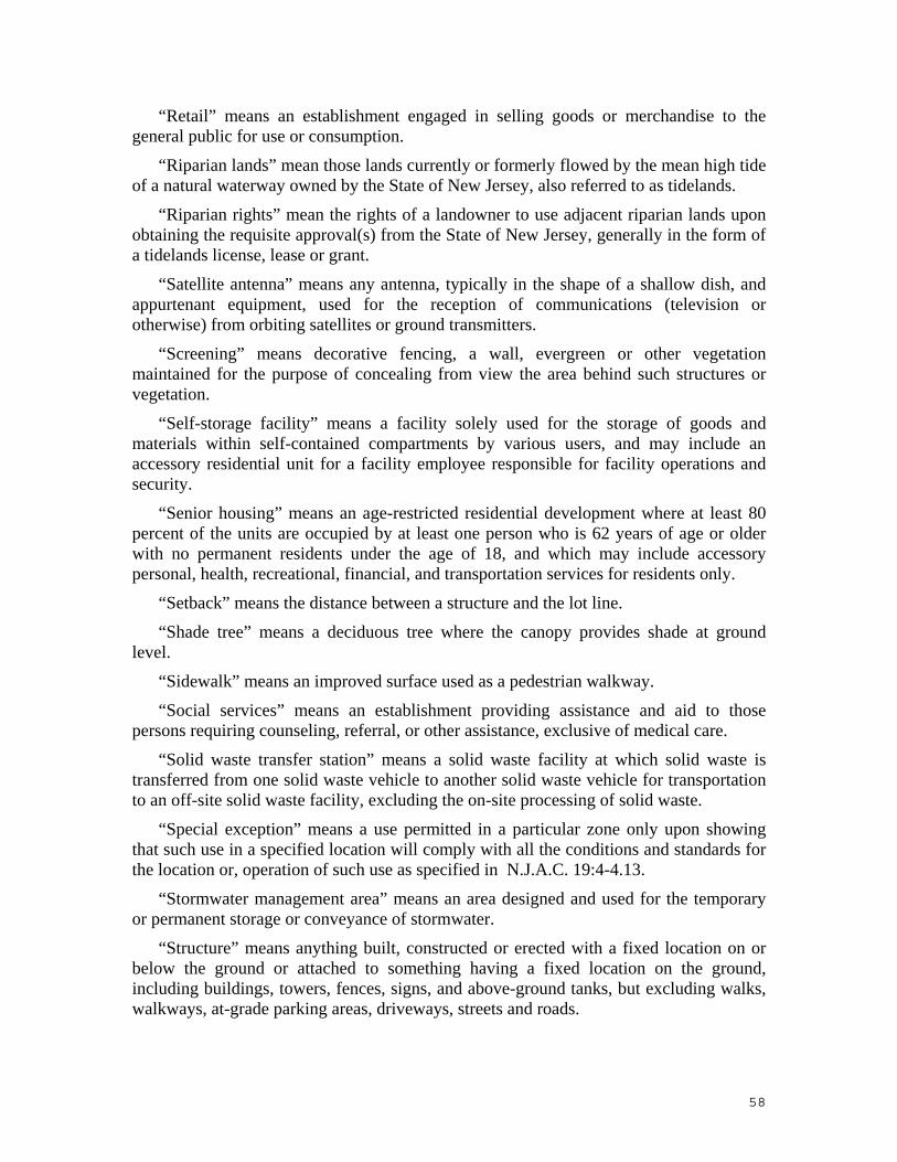
“Retail” means an establishment engaged in selling goods or merchandise to the general public for use or consumption.
“Riparian lands” mean those lands currently or formerly flowed by the mean high tide of a natural waterway owned by the State of New Jersey, also referred to as tidelands.
“Riparian rights” mean the rights of a landowner to use adjacent riparian lands upon obtaining the requisite approval(s) from the State of New Jersey, generally in the form of a tidelands license, lease or grant.
“Satellite antenna” means any antenna, typically in the shape of a shallow dish, and appurtenant equipment, used for the reception of communications (television or otherwise) from orbiting satellites or ground transmitters.
“Screening” means decorative fencing, a wall, evergreen or other vegetation maintained for the purpose of concealing from view the area behind such structures or vegetation.
“Self-storage facility” means a facility solely used for the storage of goods and materials within self-contained compartments by various users, and may include an accessory residential unit for a facility employee responsible for facility operations and security.
“Senior housing” means an age-restricted residential development where at least 80 percent of the units are occupied by at least one person who is 62 years of age or older with no permanent residents under the age of 18, and which may include accessory personal, health, recreational, financial, and transportation services for residents only.
“Setback” means the distance between a structure and the lot line.
“Shade tree” means a deciduous tree where the canopy provides shade at ground level.
“Sidewalk” means an improved surface used as a pedestrian walkway.
“Social services” means an establishment providing assistance and aid to those persons requiring counseling, referral, or other assistance, exclusive of medical care.
“Solid waste transfer station” means a solid waste facility at which solid waste is transferred from one solid waste vehicle to another solid waste vehicle for transportation to an off-site solid waste facility, excluding the on-site processing of solid waste.
“Special exception” means a use permitted in a particular zone only upon showing that such use in a specified location will comply with all the conditions and standards for the location or, operation of such use as specified in N.J.A.C. 19:4-4.13.
“Stormwater management area” means an area designed and used for the temporary or permanent storage or conveyance of stormwater.
“Structure” means anything built, constructed or erected with a fixed location on or below the ground or attached to something having a fixed location on the ground, including buildings, towers, fences, signs, and above-ground tanks, but excluding walks, walkways, at-grade parking areas, driveways, streets and roads.
58

“Studio” means a facility utilized for the filming, recording, photographing, broadcasting, performance, production, and or editing of video, films, motion pictures, television and radio shows, commercials, and/or music.
“Substantial destruction” means a structure which is damaged, whether voluntarily or involuntarily, to the extent that repairs to restore the structure to its original form and use would require the expenditure of 50 percent or more of the market value of the structure immediately before the time of the damage.
“Taxi and limousine service” means an establishment offering transport services in passenger automobiles, vans, limousines, or similar motor vehicles, including accessory office and dispatch facilities, areas for the parking of facility vehicles on-site, and accessory maintenance and fueling facilities for facility vehicles only.
“Trailer” means:
1. A container carrying materials, goods, or objects towed or hauled by another vehicle; or
2. A structure used as a temporary construction office in connection with a construction project.
“Tributary” means any stream, manmade or natural, which contributes to the flow of the Hackensack or Passaic rivers.
“Truck rental facility” means an establishment primarily engaged in the rental of trucks, semi-trailers, or similar motor vehicles, which may include accessory storage for the parking of rental vehicles on-site and accessory maintenance and fueling facilities for rental vehicles only.
“Truck repair facility” means a facility principally used for the routine maintenance and repair of trucks, trailers, semi-trailers, and similar motor vehicles, including activities such as fluid changes, engine and transmission repair or replacement, trailer repair, and body work.
“Truck sales” means the use of any building or land area for the display and sale of new or used trucks, trailers, semi-trailers, buses, recreational vehicles, or similar motor vehicles, including any warranty repair work or other maintenance service accessory thereto.
“Truck stop” means a facility primarily engaged in the fueling of trucks and other commercial vehicles and the temporary accommodation of drivers that may include accessory maintenance facilities, hotels and motels, restaurants, and retail sales.
“Truck terminal” means a warehouse and distribution facility where trucks and trailers are parked or stored as a principal use.
“Truck wash” means any building or premises, or portion thereof, used for washing trucks, trailers, semi-trailers, recreational vehicles, and similar motor vehicles.
“Variance” means a permission to depart from the requirements of a zoning regulation as specified in N.J.A.C. 19:4-4.14.
59

“Vehicular use area” means any area of a lot, not located within any enclosed or partially enclosed structure, devoted to motor vehicle usage, including parking areas, loading areas, service areas, access drives and driveways, and the storage of vehicles, where permitted.
“Veterinary facility” means an establishment where domestic animals are admitted for examination and treatment by one or more veterinarians, and which may include accessory boarding on a temporary basis.
“Warehouse and distribution facility” means an establishment primarily used for the storage, loading, unloading, and/or distribution of goods, products, or materials, which may include accessory consolidation, repacking and value-added services. Such facility may include accessory parking and storage of trucks and trailers, and accessory maintenance of trucks owned by the facility.
“Wetland” means an area that is inundated or saturated by surface or groundwater at a frequency and duration sufficient to support and that, under normal circumstances, does support a prevalence of vegetation typically adapted for life in saturated soil conditions. Wetlands generally include swamps, marshes, bogs, and similar areas.
“Wholesale establishment” means a facility engaged in selling merchandise to retailers; to industrial, commercial, institutional or professional business users; to other wholesalers; or acting as agents or brokers buying merchandise for, or selling merchandise to, such individuals or companies, and not to the public.
“Yard” means an area on a lot that is unoccupied and unobstructed from its lowest level to the sky except as may be permitted elsewhere in these regulations.
“Yard, front” means a yard extending along the full length of a front lot line and to a line paralleling the front lot line and intersecting the front of the building at its nearest point from the front lot line. Each yard that abuts a front lot line shall be considered a front yard.
“Yard, rear” means a yard extending along the full length of the rear lot line and to a line drawn parallel with the rear lot line and intersecting the back of the building at its nearest point from the rear lot line.
“Yard, required” means the minimum-depth yard as required in these regulations.
“Yard, side” means a yard extending along a side lot line and to a line drawn parallel with the side lot line and intersecting the side of the building at its farthest point from the side lot line, but excluding any area encompassed within a front yard or rear yard.
“Zoning summary table” means a tabular component of a site plan that includes an analysis of existing, proposed, and required conditions.
SUBCHAPTER 3. APPLICATION OF REGULATIONS
N.J.A.C. 19:4-3.2 Exemptions (a) The following, except as otherwise provided, shall be exempt from these
regulations:
60

1. Maintenance, repair, or replacement work within municipal, county, and State ROW's or on railroad tracks, signals, bridges, and similar facilities and equipment located in a railroad ROW;
2. Maintenance, repair, or replacement of existing utility structures or the installation of new underground utility structures within utility easements where such work is conducted by the utility company or authorized representative;
3. Development and improvement plans proposed or sponsored by the NJMC;
4. Whenever the governing body of a constituent municipality has enacted zoning ordinances and any other codes or standards that are consistent with, or will effectuate the purposes of, the NJMC Master Plan, that municipality may make final land use decisions within the municipality with respect to applications made concerning individual/detached one-, two- or three-family residences in the Low Density Residential zone. These decisions shall include, but not be limited to, variances, certificates of occupancy, plan review, building permits, and site approvals. Whenever a municipality shall make a zoning and/or land use decision pursuant to this subsection, a copy of the decision, the application and any other pertinent information shall be forwarded to the NJMC within 10 working days of the final action. The foregoing does not apply to subdivisions involving the creation of new streets;
5. Municipal projects, located on land owned by a municipality, provided that the following conditions are met:
i. The governing body and planning board of the municipality have entered into a Memorandum of Understanding (MOU) with the NJMC, and remain in compliance with the MOU, agreeing that municipal projects shall comply with applicable NJMC zoning regulations and that review of the project by the municipality shall utilize NJMC standards;
ii. The municipal project has been reviewed by the municipal planning board, which has certified to the NJMC that the project is in compliance with all applicable NJMC zoning regulations;
iii. A complete copy of the plans for the municipal project, and a certification of the planning board, have been sent to the NJMC for review, and the NJMC has not notified the municipality within 45 days of the receipt thereof of any objection to the project; and
iv. At the completion of the construction of the project, the municipal zoning officer has certified to the NJMC that the project has been constructed in accordance with approved plans; and
6. Site improvements on property resulting from land acquisition by a public entity for a public project, provided that such site improvements shall consist only of the improvements required to restore functional use of the property, as determined by the NJMC.
N.J.A.C. 19:4-3.7 Coastal zone management
61

The NJMC Master Plan is an element of the State of New Jersey's Coastal Zone Management Program for the Hackensack Meadowlands District, as specified in N.J.A.C. 7:7E-3.45(b).
62

SUBCHAPTER 4. ADMINISTRATION N.J.A.C. 19:4-4.22 Severability
(a) The provisions of these regulations shall be separable, in accordance with the following:
1. If any section, subsection, paragraph, sentence, clause or phrase of these regulations is for any reason held to be unconstitutional or invalid, such decision shall not affect the remaining portions of these regulations.
2. If the application of any provision of these regulations to a particular property, building or structure is for any reason held to be unconstitutional or invalid, such decision shall not affect the application of said provisions to any other property or structure.
SUBCHAPTER 5. DISTRICT, USES AND STANDARDS
N.J.A.C. 19:5.5 Marinas (a) Marinas shall meet the following minimum requirements:
1. Every marina shall be open to the public. A fee is optional.
2. Marinas shall provide a minimum of one docking berth for each 20 feet of water frontage in accordance with the following:
i. Docking berths shall be a minimum dimension of 12 feet by 28 feet; and
ii. Aisles between rows of berths shall be a minimum 35 feet wide.
3. Marinas shall provide areas for public boat launching, which shall include the following:
i. A ramp to the adjacent water body with a minimum width of 15 feet;
ii. Sufficient maneuvering space between the ramp and parking areas; and
iii. Trailer parking spaces with a minimum dimension of 10 feet by 40 feet.
4. Marinas shall provide areas for public boat mooring in accordance with the following:
i. A minimum of one space per 100 feet of water frontage; and
ii. A minimum dimension of 12 feet by 28 feet with proper access.
5. Marinas shall provide parking, loading and trailer parking in accordance with N.J.A.C. 19:4-8.4.
N.J.A.C. 19:5.8 Environmental Conservation zone; purposes The Environmental Conservation zone is designed to preserve and enhance the
ecological values of wetlands, open water and adjacent uplands within the District. The zone seeks to provide public access to these areas and encourage scientific and educational study in regard to wetland ecology.
63

N.J.A.C. 19:4-5.9 Environmental Conservation zone; permitted uses (a) The permitted uses in the Environmental Conservation zone are:
1. Existing public utility equipment and appurtenances, including operating, maintaining, reconstructing, inspecting, testing, and removing such equipment;
2. Public access to water features, including trails, boat/canoe launches, water crossings, site furnishings, signage and structures that facilitate wildlife observation;
3. Scientific and educational study and experimentation in regard to wetland ecology;
4. Wetland enhancement, restoration or creation activities, performed either individually or in conjunction with wetland mitigation banks; and
5. Wildlife habitat creation.
64

N.J.A.C. 19:4-5.10 Environmental Conservation zone; special exception uses (a) The special exception uses in the Environmental Conservation zone are:
1. Communications transmission towers;
2. Electric transmission towers;
3. Marinas;
4. The construction of any element or other physical device to fulfill a requirement of another regulatory agency which has an interest in, or some level of jurisdiction over, a wetlands enhancement, restoration or creation activity; and
5. Structures and improvements essential for and used solely in conjunction with a permitted use.
N.J.A.C. 19:4-5.11 Environmental Conservation zone; use limitations The use limitation in the Environmental Conservation zone is that no use shall be
operated, conducted or maintained that may impair the quality of the zone as an environmental conservation area. Any use that discourages or interferes with the purpose of the zone is prohibited. N.J.A.C. 19:4-5.12 Environmental Conservation zone; performance standards
(a) All uses in the Environmental Conservation zone shall comply with the performance standards of N.J.A.C. 19:4-7 as follows:
1. All category A performance standards shall apply, with the exception of particulate source emissions.
2. Particulate source emissions shall not exceed 0.2 pounds per hour, per acre of lot for all uses on the lot, or New Jersey State Air Pollution Control Laws and Codes (N.J.A.C. 7:27), whichever is more restrictive.
N.J.A.C. 19:4-5.13 Parks and Recreational zone; purposes The Parks and Recreation zone is intended to provide for the creation, management
and appropriate use of public open space and recreation facilities within the District in a manner that allows for the public use and enjoyment of these areas.
N.J.A.C. 19:4-5.14 Parks and Recreational zone; permitted uses (a) The permitted uses in the Parks and Recreation zone are:
1. Cemeteries;
2. Parks or recreation facilities; and
3. Wildlife habitat creation.
N.J.A.C. 19:4-5.15 Parks and Recreational zone; special exception uses
65

(a) The special exception uses in the Parks and Recreation zone are:
1. Marinas; and
2. Primary and secondary schools.
N.J.A.C. 19:4-5.16 Parks and Recreational zone; use limitations The use limitation in the Parks and Recreation zone is that no use shall be operated,
conducted or maintained that may impair the quality and character of the zone as a parks and recreation area.
N.J.A.C. 19:4-5.17 Parks and Recreational zone; performance standards (a) All uses in the Parks and Recreation zone shall comply with the performance
standards of N.J.A.C. 19:4-7 as follows:
1. All category A performance standards shall apply, with the exception of glare.
2. Category B performance standards shall apply for glare.
N.J.A.C. 19:4-5.18 Waterfront Recreation zone; purposes The Waterfront Recreation zone is designated to accommodate marinas in
combination with other water-oriented commercial and recreation facilities that provide and encourage public access to and visibility of the Hackensack River or its tributaries. The Waterfront Recreation zone is to be developed in such a way that views of the river are protected.
N.J.A.C. 19:4-5.19 Waterfront Recreation zone; permitted uses and marina requirements
(a) The permitted uses in the Waterfront Recreation zone are:
1. Day care facilities;
2. Marinas;
3. Other water recreation uses; and
4. Parks or recreation facilities.
(b) When included with a marina meeting the minimum requirements set forth in N.J.A.C. 19:4-5.7, the following uses shall be permitted in the Waterfront Recreation zone:
1. Commercial recreation, outdoor;
2. Restaurants; and
3. Retail, accessory to a marina.
N.J.A.C. 19:4-5.20 Waterfront Recreation zone; special exception uses
66

(a) When included with a marina meeting the minimum requirements set forth in N.J.A.C. 19:4-5.7, the following uses shall be special exception uses in the Waterfront Recreation zone:
1. Commercial recreation, indoor; and
2. Cultural facilities.
N.J.A.C. 19:4-5.21 Waterfront Recreation zone; use limitations (a) The use limitations in the Waterfront Recreation zone are as follows:
1. All development shall be designed to permit public access to the edge of the river. Development on lots fronting on the Hackensack River shall provide a pedestrian walkway along the edge of the river.
2. Uses shall be designed to focus on the river as a recreational and visual resource.
3. The temporary seasonal storage of boats may occur on open space, not exceeding 15 percent of the required open space area. This temporary storage shall not exceed a time period of six months.
4. No business establishment shall offer or sell food or beverages for consumption on the premises in parked motor vehicles.
N.J.A.C. 19:4-5.24 Waterfront Recreation zone; performance standards All category A performance standards of N.J.A.C. 19:4-7 shall apply to all uses in the
Waterfront Recreation zone.
SUBCHAPTER 7. PERFORMANCE STANDARDS
N.J.A.C. 19:7.1 General requirements (a) For any proposed use, occupancy, structure, process or equipment, the applicant
shall supply evidence to the NJMC that the proposed use, structure, process or equipment shall conform with all applicable performance standards.
(b) Any application for a zoning certificate, occupancy certification, special exception, variance, or other approval shall be accompanied by submissions, attachments and certifications as required in these regulations, including the following:
1. The submission of an application shall constitute a certification and an agreement on the part of the property owner and applicant that the proposed use, occupancy, structure, process or equipment is designed and intended to conform to the performance standards.
2. The NJMC may require certification of tests by appropriate government agencies or by recognized testing laboratories, any costs thereof to be borne by the applicant, as evidence of compliance.
3. The NJMC may require that specific types of equipment, machinery or devices be installed, or that specific operating procedures or methods be followed, if the government
67

agencies or testing laboratories examining the proposed operation shall determine that the use of such specific types of machinery, equipment, devices, procedures, or methods are required in order to ensure compliance with the applicable performance standards.
4. Permits and certificates required by other government agencies shall be submitted to the NJMC as proof of compliance with applicable standards and requirements.
5. If appropriate permits, tests and certifications are not or cannot be provided by the applicant, the NJMC may require that instruments and/or other devices, or professional reports or laboratory analyses be used to determine compliance with the performance standards for an existing or proposed use, with the cost borne by the applicant.
6. In the event a determination cannot be made at the time of application that a proposed use, process or piece of equipment will meet the standards established in this section, the NJMC may issue a conditional approval, pursuant to these regulations. Issuance of a conditional approval shall be based on submission of evidence that the proposed use, process or equipment will meet the standards established herein after completion or upon installation and operation. Prior to issuance of a certificate of completion and/or occupancy certification, the applicant shall submit proof that all standards established herein have been met.
N.J.A.C. 19:4-7.2 Applicability and enforcement (a) Continued compliance with performance standards is required and shall be
enforced by the NJMC.
(b) Any existing use or structure that is allowed to deteriorate or is modified so as to reduce its compliance with these standards shall constitute a violation.
(c) Whenever, in the opinion of the Chief Engineer, there is a reasonable probability that any use of the performance standards herein are violated, the NJMC is empowered to employ a qualified technician or technicians to perform investigations, measurements and analyses to determine whether or not these regulations are being violated. In the event that a violation is found to exist, the property owner shall be liable for the reasonable fees of the technicians employed to perform such investigations, measurements and analyses.
N.J.A.C. 19:4-7.3 Performance standards; noise (a) The following words and terms, when used in this section, shall have the
following meanings unless the context clearly indicates otherwise:
“dBA” means a unit for describing sound levels measured using an A-weighting network. This network modifies the measured sound pressure level at the various frequencies to account for differences in the sensitivity of the human ear to sounds of different frequency.
“Decibel,” abbreviated “dB,” means a unit that describes the sound pressure level or intensity of sound. The sound pressure level in decibels is 20 times the logarithm to the base 10, of the ratio of the pressure of the sound to a reference pressure of 0.0002 microbar.
68

“Impact noise” means a relatively short duration noise generally produced by the striking of two or more objects so as to be heard as a separate distinct noise.
“Impact noise analyzer” means an instrument that measures the peak sound pressure of an impact noise and meets the standards of the American National Standards Institute (ANSI) or the International Electrotechnical Commission (IEC).
“Noise” means a subjective description of an undesirable or unwanted sound.
“Sound” means rapid fluctuations of atmospheric pressure that are audible to persons.
“Sound level meter” means an instrument used to measure the overall sound pressure level.
(b) Noise shall be measured with a sound level meter meeting the standards of the ANSI specification S1.4-1971 for sound level meters or its successor.
(c) The instrument shall be set to the A-weighted response scale and the meter of the slow response. Measurements shall be conducted in accordance with ANSI specification S12.50-2002, which describes various methods for determining the sound power levels for machinery and equipment. These standards are incorporated herein by reference, as amended and supplemented, and can be obtained from the American National Standards Institute, 25 West 43rd Street, 4th Floor, New York, NY 10036.
(d) Impact noises shall be measured with an impact noise analysis meeting the standards of the ANSI standards S12.50-2002. These standards are incorporated herein by reference, as amended and supplemented.
(e) Noises shall not exceed the maximum sound levels specified in Table 7-1 below, except as otherwise designated. Where more than one specified sound level applies, the most restrictive shall govern. Measurements may be made at points of maximum noise intensity.
Table 7-1
Noise Level Restrictions
Performance Standard Category
Maximum Permitted Sound Level
Where Measured
A 65 dBA On or beyond the subject property boundary line
B 70 dBA On or beyond the subject property boundary line
C 76 dBA On or beyond the zone boundaries
(f) In any residential area or zone, the A-weighted sound level shall not exceed 55 dBA during the hours of 7:00 A.M. to 9:00 P.M. and shall not exceed 45 dBA during the hours of 9:00 P.M. to 7:00 A.M.
69

(g) The levels specified in Table 7-1 may be exceeded by 10 dBA for a single period not to exceed 15 minutes in any one day.
(h) For impact noise levels, the values in Table 7-1, increased by 20 dB, shall apply. For purposes of these regulations, impact noises shall be considered to be those noises whose peak values are more than six dB higher than the values indicated on the sound level meter.
(i) Construction or other temporary (60 days or less) uses which exceed the above limitation may be permitted if a noise mitigation plan is approved by the NJMC.
(j) The provisions of this section shall not apply to:
1. Bells, chimes, or carillons used in conjunction with houses of worship;
2. Emergency public warning systems;
3. Emergency energy release devices;
4. Emergency work to provide electricity, water, or other public utilities when public health or safety is involved;
5. Noise of aircraft flight operations;
6. Public roadways;
7. Surface carriers engaged in commerce by railroad;
8. The unamplified human voice; and
9. Use of explosive devices, as regulated by other agencies having jurisdiction.
(k) Except as provided in (i) above, sound under the direct and indirect control of a use or property owner is subject to the standards set forth in this subchapter.
N.J.A.C. 19:4-7.4 Performance standards; vibrations (a) The following words and terms, when used in this section, shall have the
following meanings, unless the context clearly indicates otherwise.
“Amplitude” means the maximum displacement of the earth from the normal rest position. Amplitude is usually reported as inches or mils.
“Discrete impulses” means a ground transmitted vibration stemming from a source where specific pulses do not exceed 60 per minute or one per second.
“Frequency: means the number of times that a displacement completely repeats itself in one second of time. Frequency may be designated in cycles per second (cps) or hertz (Hz).
“Impact” means an earthborn vibration generally produced by two or more objects striking each other so as to cause separate and distinct pulses.
“Particle velocity” means a characteristic of vibration that depends on both displacement and frequency. If not directly measured, it can be computed by multiplying the frequency by the amplitude times the factor 6.28. The particle velocity will be in
70

inches per second, when the frequency is expressed in cycles per second and the amplitude in inches.
“Steady state vibration” means a vibration which is continuous, as from a fan, compressor, or motor.
“Vibration” means a reciprocating movement transmitted through the earth, both in horizontal and vertical planes.
(b) Ground-transmitted vibration shall be measured with a seismograph or complement of instruments capable of recording vibration displacement and frequency, particle velocity, or acceleration simultaneously in three mutually perpendicular directions.
(c) Table 7-2 below designates the maximum permitted particle velocities, except as otherwise designated. Where more than one set of vibration levels apply, the most restrictive shall govern. Measurements may be made at points of maximum vibration intensity.
Table 7-2
Vibration Level Restrictions
Performance Standard Category
Maximum Peak Particle Velocity, inches per second
Where Measured
A 0.02 On or beyond the subject property boundary line
B 0.05 On or beyond the subject property boundary line
C 0.10 On or beyond the zone boundaries
(d) In any residential area, the peak particle velocity shall not exceed 0.02 inches per second during the hours of 7:00 A.M. to 9:00 P.M. and shall not exceed 0.01 inches per second during the hours of 9:00 P.M. to 7:00 A.M.
(e) The maximum particle velocity shall be the maximum vector sum of three mutually perpendicular components recorded simultaneously. Particle velocity may also be expressed as 6.28 times the displacement in inches multiplied by frequency in cycles per second.
(f) For the purpose of these regulations, steady state vibrations are vibrations which are continuous, or vibrations in discrete impulses more frequent than 60 per minute.
Discrete impulses that do not exceed 60 per minute shall be considered impact vibrations. Impact vibrations are limited to values no more than twice as high as those specified in
Table 7-2.
N.J.A.C. 19:4-7.5 Performance standards; airborne emissions
71

(a) The following words and terms, when used in this section, shall have the following meanings, unless the context clearly indicates otherwise:
“Particulate matter” means airborne material except uncombined water that exists in a finely divided form as a liquid or solid at standard conditions.
“Steam” means condensed water vapor droplets observable as a plume having an equivalent opacity of 60 percent or higher.
“Toxic matter” means material that is capable of causing injury to living organisms by chemical means when present in relatively small amounts.
(b) Any activity, operation, or device that causes, or tends to cause, air pollution shall comply with both the New Jersey State Air Pollution Control Laws and Codes, N.J.A.C. 7:27 and 7:27B, and the standards herein.
(c) The emission of visible steam from all stacks, chimneys, processes, and devices shall not exceed the restrictions in Table 7-3, below.
Table 7-3
Restrictions on Stem
Performance Standard Category
Stem Restrictions
A No visible stem (except as a direct result of a combustion or other process or other process) permitted
B and C No visible stem (except as a direct result of a combustion or other process or other process) within 500 feet of a residential area
(d) The emission of particulate matter from all stacks, vents, chimneys, flues and openings of all sources of air pollution on a lot shall not exceed the limitations in the New Jersey Air Pollution Control Laws and Codes, N.J.A.C. 7:27 and 7:27B.
(e) If any toxic matter is emitted which is listed by the American Conference of Governmental Hygienists or any other lists published by the State of New Jersey or Federal Government, the applicant shall satisfy the NJMC that the quantity and type of emission of this matter will be safe to the general population.
(f) No odor shall be emitted that is detectable by the human olfactory sense at or beyond an adjacent lot line.
N.J.A.C. 19:4-7.6 Performance standards; Hazardous materials, liquids and chemicals
(a) The following words and terms, when used in this section, shall have the following meanings, unless the context clearly indicates otherwise:
72

“Deflagration” means an exothermic reaction, such as the extremely rapid oxidation of a flammable dust or vapor in air, in which the reaction progresses through the unburned material at a rate less than the velocity of sound. A deflagration can have an explosive effect.
“Detonation” means an exothermic reaction characterized by the presence of a shock wave in the material that establishes and maintains the reaction. The reaction zone progresses through the material at a rate greater than the velocity of sound. The principal heating mechanism is one of shock compression. Detonations have an explosive effect.
“Health hazard” means a classification of a chemical for which there is statistically significant evidence that acute or chronic health effects are capable of occurring in exposed persons. The term "health hazard" includes chemicals which are carcinogens, toxic or highly toxic agents, reproductive toxins, irritants, corrosives, sensitizers, hepatotoxins, hephrotoxins, neurotoxins, agents which are capable of acting on the hematopoietic system, and agents which damage the lungs, skin, eyes or mucous membranes.
“Physical hazards” means a chemical for which there is evidence that it is a combustible liquid, compressed gas, cryogenic, explosive, flammable gas, flammable liquid, flammable solid, organic peroxide, oxidizer, pyrophoric or unstable (reactive) or water-reactive material.
(b) In all zones, any activity involving the manufacture, utilization, or storage of explosive, flammable, highly combustible, highly toxic, corrosive, or unstable materials shall be conducted in accordance with the regulations of the NJ UCC, N.J.A.C. 5:23; the NJ UFC, N.J.A.C. 5:18; and the New Jersey Right-to-Know Law, N.J.S.A. 34:5A-1 et seq.
(c) Category A standards are as follows:
1. The storage, utilization or manufacture of materials that pose a detonation hazard are not permitted as a principal use.
2. The storage and/or utilization, but not manufacture, of materials and products classified as deflagration, physical and health hazards by the NJ UCC shall only be permitted as an accessory use to the principal use provided the area devoted to such accessory use does not occupy more than 10 percent of the building's floor area.
3. The storage and/or utilization, but not manufacture, of materials and products classified as deflagration or physical hazards by the NJ UCC shall be permitted as a principal use only as a special exception.
(d) Category B and C standards are as follows:
1. The manufacture of materials and products that pose a detonation hazard shall not be permitted.
2. The storage and/or utilization of materials and products that pose a detonation hazard may be allowed as accessory to a principal use to the extent permitted by the NJ UCC, whereby the premises, or portion thereof, would not be classified as a H-1 (Detonation Hazard) Use Group.
73

(e) Whenever any facility or part thereof, including storage dike, which stores, utilizes or manufactures hazardous materials, liquids and chemicals is within 300 feet from another zone, the more restrictive of the performance standards for the two zones shall apply.
N.J.A.C. 19:4-7.7 Performance standards; glare (a) The following words and terms, when used in this section, shall have the
following meanings, unless the context clearly indicates otherwise:
“Candle” means the luminous intensity of one standard candle.
“Foot-candle” means the unit of illumination on a surface one square foot in area on which there is a uniform distribution of light having a candlepower of one candela.
“Footlambert” means a unit of brightness equal to the brightness of a uniform diffusing surface that emits or reflects one lumen per square foot.
“Glare” means a sensation of brightness within the visual field that causes annoyance, discomfort, or loss in visual performance and visibility.
“Illumination” means the density of luminous energy falling upon a surface, usually measured in foot-candles.
“Photometer” means an instrument for measuring the intensity of light.
“Watt” means a unit of electrical power.
(b) Glare shall be measured in accordance with the standards and procedures set forth in the Illuminating Engineering Society of North America (IESNA) Lighting Handbook, 9th edition, incorporated herein by reference, as amended and supplemented. Outdoor lighting design shall be in accordance with the recommended practice, RP-33-99, published by the IESNA, incorporated herein by reference, as amended and supplemented. Both publications can be obtained from IESNA, 120 Wall Street, Floor 17, New York, NY 10005-4001.
(c) Uses subject to Category A, B, and C performance standards shall not produce glare so as to cause illumination in a residential area or zone, Environmental Conservation zone, or Park and Recreation zone, in excess of 1.0 foot-candles. Sources of illumination shall be controlled so as not to be a nuisance in these areas.
(d) Uses subject to Category A, B, and C performance standards shall limit the use of light sources and illuminated surfaces within 500 feet of, and visible in, a residential area, Environmental Conservation zone, or Park and Recreation zone to comply with the light intensities indicated in Table 7-4 below.
TABLE 7-4
Maximum Intensity of Light Sources
Source Category A Category B and C
Bare incandescent bulbs 15 watts 40 watts
Illuminated buildings 15 foot-candles 30 foot candles
74

Back lighted or luminous background signs 150 foot lamberts 250 lamberts
Outdoor illuminated signs and poster panels
25 foot-candles 50 foot-candles
Any other unshielded sources, intrinsic brightness
50 candles per square centimeter
50 candles per square centimeter
N.J.A.C. 19:4-7.8 Performance standards; radioactive materials
(a) The storage, utilization, manufacture or transportation of radioactive materials shall be in accordance with the NJDEP radiation protection rules, N.J.A.C. 7:28.
(b) Performance standard Categories A, B, and C are that the manufacture, storage, or utilization of unsealed radioactive materials shall be limited to the exempt quantities of radioactive materials as per N.J.A.C. 7:28.
(c) The applicant shall provide a copy of the license for the manufacture or storage of radioactive materials obtained from the NJDEP.
N.J.A.C. 19:4-7.9 Performance standards; wastewater
(a) The following pertains to permanent sewerage facilities:
1. All uses established or changed, or any structure which is constructed, moved, remodeled, or reconstructed in the District shall discharge liquid waste into a central sewerage system. No liquid wastes shall be discharged into the Hackensack River or its tributaries after sewerage interceptors become available.
2. Discharges from a central sewerage system into the Hackensack River shall comply with the regulations of the NJMC and the NJDEP. No discharge from a public sewerage system shall be made into any tributary of the Hackensack River.
3. All discharges into a public sewerage system shall comply with the regulations of the NJMC and the NJDEP.
(b) The following pertains to temporary wastewater facilities:
1. Prior to the availability of public sewerage facilities, uses established or changed, or any structure which is constructed, moved or remodeled, or reconstructed in the District after June 20, 1988 can be utilized only with the following temporary sewerage facilities:
i. Temporary wastewater facilities that discharge directly into the Hackensack River or its tributaries under the following conditions:
(1) The discharge complies with the standards of this paragraph;
(2) The discharge will not impair and/or interfere with the functioning of the river, its tributaries, or the marsh-estuarine ecosystem of the District; and
(3) Application is made pursuant to paragraph (b)2 below.
75

ii. Temporary wastewater facilities that hold or contain wastewater and do not discharge directly into the Hackensack River or its tributaries may be permitted if complying with the following requirements:
(1) The wastewater facility shall be constructed using one or more tanks with a maximum capacity of 6,000 gallons per tank. The facility shall be sized to accommodate the facility's wastewater flow for a 14-day period. The tank(s) shall comply with the following requirements:
(A) The tank(s) shall have a vent and visible/audible high level alarm, and shall be aerated and properly anchored to prevent uplift.
(B) The tank(s) shall be constructed of materials which are impervious, watertight, and noncorrosive.
(C) Tank installations shall be approved by the NJDEP, when required.
(2) Maintenance:
(A) Copies of a contract indicating the terms, conditions, and firm or entity engaged to maintain the wastewater facility shall be provided to the NJMC.
(B) The wastewater facility shall be pumped no less than every 14 days. Receipts shall be maintained on site at all times, and monthly records shall be provided to the NJMC.
(3) Within 90 days of availability of a public sanitary sewer, the temporary wastewater facility shall be decommissioned and removed, and inflows shall be redirected to the public sanitary sewer.
iii. Septic tanks shall not be permitted.
2. The NJMC may, upon application and in connection with an application for a zoning certificate pursuant to N.J.A.C. 19:4-4.2, issue an approval for construction and operation of a temporary sewerage facility. The application shall contain:
i. A written statement by the governing body or appropriate public agency of the municipality within which the premises are located that a connection to a public sewerage system cannot be made available to the applicant prior to the issuance of occupancy certification, as provided in N.J.A.C. 19:4-4.6;
ii. A written statement by the applicant of their willingness and ability to make connection with a public sewerage system when it is made available;
iii. Data sufficient to show that any temporary sewerage facilities to be constructed will be able to treat the discharge so that it will conform with the standards of this subsection; and
iv. Proof of compliance with applicable rules and regulations of the NJDEP.
3. Upon installation of an approved temporary sewerage facility, the NJMC shall issue, upon compliance with the requirements established herein, temporary occupancy certification pursuant to the provisions of N.J.A.C. 19:4-4.6. Said certification shall be valid and remain in effect so long as the applicant has NJDEP approval to construct and
76

operate a temporary sewerage facility. Upon availability of a public sewerage system, a permanent connection shall be made by the property owner pursuant to these regulations.
(c) The flow from any pipe, conduit, or any other source discharging into the river or its tributaries shall comply with the regulations of the NJMC and NJDEP, in addition to the following:
1. The discharge of radioactive materials is not permitted; and
2. The discharge of oil or other petroleum products causing a detectable odor, a visible slick or in such quantities to injure and/or kill wildlife or marine animals is not permitted.
(d) Proof of compliance with the applicable regulations, including copies of all NJDEP permits and other associated approvals, shall be submitted to the NJMC.
N.J.A.C. 19:4-7.10 Performance standards; traffic
(a) A traffic impact analysis (TIA) shall be submitted to the NJMC for the following:
1. All projects described in N.J.A.C. 19:4-10.2;
2. Any proposed development that creates 100 or more vehicle trips during any peak hour of adjacent street traffic, excluding trip reduction credits, as determined by calculations based on the manual, Institute of Transportation Engineers (ITE) Trip Generation, 7th Edition, incorporated herein by reference, as amended and supplemented, a copy of which can be obtained from the Institute of Transportation Engineers, 525 School Street, S.W., Suite 410, Washington, DC 20024;
3. Any proposed development located in an area that the NJMC has found to be a traffic or safety concern; and
4. All petitions for the rezoning of 20 or more lots.
(b) The TIA, and any portion thereof or alternative thereto, shall be developed in consultation with the NJMC staff and the Transportation Management Association(s) serving the Meadowlands region such as Meadowlink or the Hudson Transportation Management Association, and shall be subject to NJMC approval. The TIA shall analyze locations and peak hours as determined by the NJMC.
(c) The TIA shall be prepared by a New Jersey-licensed professional engineer or professional planner specializing in transportation, or other individual determined by the NJMC to be qualified as an expert in traffic engineering, and shall include the following:
1. Introduction:
i. A description of the size, location and nature of the proposed development and the methodology to be used in the development of the TIA;
2. Existing conditions:
i. An inventory and maps showing the existing transportation network in the vicinity of the proposed site, including transit;
ii. A traffic count program, in accordance with the following:
77

(1) Traffic counts shall be conducted for all locations and peak hours determined by the NJMC;
(2) Traffic counts shall not be conducted more than one year prior to the date of application;
(3) Any method used to balance or adjust traffic count data between intersections or roadway sections shall be described; and
(4) An existing condition traffic volume diagram shall be provided, including each peak hour analyzed;
iii. A capacity analysis, in accordance with the following:
(1) The capacity analysis shall be conducted using the methods of the Highway Capacity Manual (HCM), 2000 prepared by the Transportation Research Board (TRB) National Research Council, 2101 Constitution Avenue, N.W., Washington, DC 20418, incorporated herein by reference, as amended and supplemented;
(2) The Highway Capacity Software (HCS+), prepared by the University of Florida's McTrans, P.O. Box 116585, Gainesville, FL 32611, incorporated herein by reference, as amended and supplemented, shall be used to conduct the capacity analysis. The generated capacity analysis reports in HCS detailed report output format shall be included in an appendix to the TIA report. The Synchro 7 software package, prepared by Trafficware Ltd, P.O. Box 499, Sugar Land, TX 77487, incorporated herein by reference, as amended and supplemented, shall also be used to analyze multiple signalized intersections along a corridor as determined by the NJMC;
(3) Capacity analyses shall be conducted for all locations and peak time periods as determined by the NJMC;
(4) All methodology and data sources used to create the capacity analysis shall be described; and
(5) A summary, table, and diagram of all capacity analyses by location and time period shall be provided. The table shall include Level of Service (LOS), volume to capacity (V/C) ratio, density in passenger cars per mile per lane, and delay in seconds for each movement of each analyzed intersection, ramp and/or roadway, as applicable.
3. Trip generation, distribution, modal split and assignment:
i. A trip generation analysis shall be conducted using the procedures described in the ITE Trip Generation Handbook, Second Edition, incorporated herein by reference, as amended and supplemented, a copy of which can be obtained from the Institute of Transportation Engineers, 525 School Street, S.W., Suite 410, Washington, DC 20024. Trip generation shall be calculated using the trip generation rates and/or formulas described in the ITE Trip Generation manual referenced in (a)2 above. All methods, land use codes, rates and formulas used from the manual shall be noted, including appropriate edition and page number. Alternative trip generation from surveys may be used if the process and sources are documented and determined adequate by the NJMC. All trip generation methods, including trip reduction credits such as pass-by, transit, or internal capture, shall be subject to NJMC approval. All trip generation methods shall include written justification, including illustrations.
78

ii. A tabular summary shall be provided indicating the entering, exiting, and total trips for the peak hours determined by the NJMC.
iii. Trip distribution shall be determined by using a gravity model method approved by the NJMC that replicates the flow of traffic by trip origin and destination. Trip distribution documentation including rationale, procedures, and calculations shall be described and illustrated in the TIA.
iv. The modal split, or mode choice, shall be provided describing the means of transportation used, including personal vehicle, transit, walking, or other means. The modal split shall be provided for each existing and future condition and listed by percentage of mode type. The TIA shall provide the source of the modal split information and indicate the relevance of this data to the proposed site development or project. The modal split shall be subject to approval by the NJMC.
v. Trip assignment shall be provided by showing how the trips were assigned on the transportation network for the future conditions. The applicant shall describe and illustrate the methodology used assigning the trips.
vi. A total site traffic volume diagram shall be provided, including each peak hour analyzed.
4. Future no-build conditions:
i. The future no-build conditions that are projected without the proposed development shall include the following:
(1) The identification of any development, other than the proposed project, using the same existing or proposed roadway network as the project in question that is projected to be built by the same proposed build year(s), inclusive of all phases, and the resulting trips. The trip generation of the development shall be calculated in accordance with (c)3 above;
(2) A background growth rate, compounded annually, determined from the Annual Background Growth Rate Table, published by the New Jersey Department of Transportation (NJDOT), April 2007, incorporated herein by reference as amended and supplemented, and applied to the existing traffic volumes of the study area. The Annual Background Growth Rate Table may be obtained from the NJDOT, 1035 Parkway Avenue, PO Box 600, Trenton, NJ 08625-0600, or its website, http://www.state.nj.us/transportation/;
(3) The future no-build traffic volumes derived by combining the resulting volumes generated by (c)4i(1) and (2);
(4) Trips resulting from (c)4i(3), applied to the roadway network, including any proposed transportation improvements projected to be constructed by the build year, exclusive of site-related improvements; and
(5) Traffic volume diagrams, including each peak hour analyzed, for the following:
(A) Any development other than the proposed project;
(B) The total of the other developments; and
79

(C) The no-build condition.
ii. A capacity analysis of the no-build conditions shall be conducted in accordance with (c)2iii above.
5. Future build conditions:
i. The future build conditions that are projected with the proposed development shall include the following:
(1) A description and illustration of proposed site access and the proposed roadway and intersection configurations;
(2) The traffic volume used in the build capacity analysis, derived by combining the site trip generation volumes calculated in accordance with (c)3 above and the no-build volumes of (c)4 above;
(3) Trips resulting from (c)5i(2) above, applied to the roadway network, including any proposed transportation improvements projected to be constructed by the build year, exclusive of site-related improvements; and
(4) A build condition traffic volume diagram, including each peak hour analyzed.
ii. A capacity analysis of the build conditions shall be conducted in accordance with (c)2iii above.
6. Impact assessment and mitigation condition:
i. The TIA shall assess the results of the build analysis by comparing the no-build and build traffic impact, in accordance with the following:
(1) Any roadway, ramp, or intersection that exceeds a LOS "D" or degrades the no-build LOS by more than one LOS letter grade shall be subject to mitigation measures.
(2) Any new roadway, ramp, or intersection shall be designed to operate at a LOS "C" or better.
(3) If the project is built in multiple years, build and mitigation conditions shall reflect the multiple build years separately.
(4) Proposed on-site and off-site transportation improvements supplemental to the no-build or proposed build transportation improvements shall be described and illustrated with a detailed conceptual design showing all geometric elements and dimensions, and detailed cost estimate.
(5) All transportation improvements to be provided by the applicant shall be identified. The TIA shall also identify any improvements to be built as a public/private partnership or as public improvement investment.
(d) The NJMC reserves the right to require additional analyses, including accident analyses, sight distance surveys, traffic simulation and modeling, and queuing analyses.
N.J.A.C. 19:4-8.1 General provisions
(a) All standards specified in this subchapter are the minimum allowed.
80

(b) No structure shall be constructed, moved, or altered unless the minimum required site improvements as outlined in this subchapter are provided.
(c) No structure shall be constructed, moved, or altered, nor site improvements undertaken, unless all of the minimum required barrier free improvements are provided in accordance with the New Jersey Uniform Construction Code (NJ UCC), Barrier Free Subcode, N.J.A.C. 5:23-7.
(d) Permitted uses in the Environmental Conservation zone and public parks in all zones are exempt from the design standards of this subchapter, but shall be designed in consultation with the NJMC staff.
(e) All proposed site plans shall consider and shall be reviewed in accordance with the following elements:
1. The average height, massing and general proportions of development within the neighborhood;
2. The surrounding environment and adjacent property;
3. Natural features and ecology;
4. Scenic, cultural, historical, archeological or landmark sites;
5. Open space, parks and recreational facilities;
6. Traffic circulation;
7. Vehicle and pedestrian circulation and safety;
8. Access to public transportation;
9. Availability of utility services, including sanitary sewers and public water; and
10. Waste disposal and recycling.
N.J.A.C. 19:4-8.6 Drainage
(a) General requirements for drainage are as follows:
1. Drainage plans shall be signed and sealed by a New Jersey-licensed professional engineer or other professional authorized to prepare drainage plans.
2. All vehicular use areas shall be drained so as to direct surface water runoff to a stormwater drainage system for eventual subsurface or stream disposal. Conveyance via vegetated channels is acceptable but shall be supported with calculations verifying stability during peak flows.
3. A watershed runoff hydrograph that displays and compares the peak discharge rate and volume shall be prepared for both pre-and post-development conditions. Runoff volume calculations shall be used to determine the sizing of detention facilities, if necessary.
4. The receiving stormwater drainage system (pipe flow or open channel flow) shall be analyzed to ensure that it has the additional capacity necessary to handle any increase in stormwater flow during the 25-year design storm. The analysis shall include all upstream and downstream runoff peak contributions, estimated per N.J.A.C. 19:4-
81

8.6(b)3, to a downstream point established by the NJMC. If the receiving stormwater drainage system is at or over capacity, or is not analyzed, detention and/or infiltration facilities shall be provided in order to maintain site runoff peak flow at pre-development levels.
5. The size of the drainage area shall include on-site and off-site lands contributing stormwater to the discharge point. Additionally, the pre-development drainage patterns of any off-site contributions shall be maintained unless a compensatory system is provided, which, at a minimum, maintains the pre-development on-site capacity to carry neighboring stormwater runoff peak flow during the 25-year storm.
6. An operation and maintenance manual for stormwater drainage systems, including stormwater quality measures, shall be provided to ensure proper function and operation of the system and in a manner consistent with N.J.A.C. 7:8, the Stormwater Management Rules. The operation and maintenance manual shall be updated as necessary. Updates shall be provided to the NJMC.
(b) Design requirements for drainage are as follows:
1. The applicant shall provide information sufficient for the NJMC to determine compliance with the applicable sections of N.J.A.C. 7:8, the Stormwater Management Rules. With regard to water quality, proposed development and redevelopment that may introduce petroleum hydrocarbons to runoff water shall install stormwater management measures that target and remove such pollutants.
2. All drainage systems shall be designed for a 25-year storm event. The magnitude of the 25-year rainfall depth and/or rainfall intensity specific to each site shall be developed from the "Precipitation-Frequency Atlas of the United States," National Oceanic and Atmospheric Administration (NOAA) Atlas 14, Volume 2, Version 2, incorporated herein by reference, as amended and supplemented. This document is available from the NOAA National Weather Service, Office of Hydrologic Development, Hydro-meteorological Design Studies Center, Bldg. SSMC2 W/OHD13, 1325 East-West Highway, Silver Spring, MD 20910-3283, or online at http://hdsc.nws.noaa.gov/hdsc/pfds/orb/nj_pfds.html. An outline of the above document, specific to New Jersey, is available from the National Resources Conservation Service (NRCS) New Jersey State Office (NJSO). This outline, NJ Bulletin No. NJ210-4-1, dated September 8, 2004, incorporated herein by reference, as amended and supplemented, is available through the NRCS New Jersey State Office, 220 Davidson Avenue, 4th Floor, Somerset, New Jersey 08873, or online at www.state.nj.us/dep/damsafety/nrcs_24hour_rainfall.pdf. Per N.J.A.C. 7:8, the Stormwater Management Rules, properties within the District and outside the FEMA Special Flood Hazard Area (SFHA) may be required to meet water quality control requirements for events greater than the 25-year event. Additionally, the water quality design storm shall be developed pursuant to N.J.A.C. 7:8-5.5.
3. Runoff estimation:
i. The Rational Method, utilizing the rational formula listed in Figure 8-2 below, shall be used for the sizing of storm sewer systems only. The antecedent precipitation factor (Ca) shall be used with the Rational Method, as shown in the Standards for Soil Erosion
82

and Sediment Control in New Jersey at N.J.A.C. 2:90-1.3, incorporated herein by reference, as amended and supplemented. For the sizing of volume-based stormwater systems and for comparing pre- and post-construction peak flows, the National Resources Conservation Service's (NRCS), Technical Release No. 55 (TR-55), "Urban Hydrology for Small Watersheds," incorporated herein by reference, as amended and supplemented, or equivalent approved by the NJMC, shall be used. A copy may obtained from the NRCS New Jersey State Office, 220 Davidson Avenue, 4th floor, Somerset, New Jersey 08873, or online at the NRCS website, http://www.wcc.nrcs.usda.gov/hydro/hydro-tools-models-tr55.html; and
Figure 8-2
Rational Formula Q=ciA
where:
Q=Peak flow in cubic feet per second (cfs)
c=Runoff coefficient (weighted) x the antecedent precipitation factor
i=Rainfall intensity in inches per hour (in/hr)
A=Drainage area in acres (ac)
ii. The runoff coefficients (c) listed in Table 8-2 below shall be used in the rational formula:
TABLE 8-2
Coefficient of Runoff Values
Land Use Description Hydrologic Soils Groups
Cultivated Land: Without conservation treatment
With conservation treatment
0.49
0.27
0.67
0.43
0.81
0.61
0.88
0.67
83

Land Use Description Hydrologic Soils Groups
Pasture:
Grassland or Range Land
Meadow
Poor Condition
Fair Condition
Good Condition
0.38
-----
-----
0.63
0.25
-----
0.78
0.51
0.41
0.84
0.65
0.61
Wood or Forest Land Poor Cover; thin stand no mulch
Good cover
-----
-----
0.34
-----
0.59
0.45
0.70
0.59
Open space:
Lawns, Parks, Golf Course, etc.
Poor Condition (grass cover <50 percent)
Fair Condition (grass cover 50% to 75 percent)
Good Condition (grass cover >75 percent)
-----
-----
-----
0.65
0.45
0.25
0.70
0.63
0.51
0.85
0.74
0.65
Commercial and Business Areas
Industrial Districts:
85 percent impervious
72 percent impervious
0.84
0.67
0.90
0.81
0.93
0.88
0.96
0.92
Residential:
Average Lot size (acres):
1/8
1/4
1/3
1/2
1
Average percent impervious:
65
38
30
25
20
0.59
0.29
-----
-----
-----
0.76
0.55
0.49
0.45
0.41
0.86
0.70
0.67
0.65
0.63
0.90
0.80
0.78
0.76
0.74
Impervious Areas:
Paved
Gravel
Dirt
Parking lots, roofs, driveways etc.
Streets and roads
Streets and roads
Streets and roads
0.99
0.99
0.57
0.49
0.99
0.99
0.76
0.69
0.99
0.99
0.84
0.80
0.99
0.99
0.88
0.84
Note: Hydrologic Soil Groups texture descriptions are the following:
A Sand, loamy sand, or sandy loam
B Silt loam or loam
C Sandy clay loam,
D Clay loam, silty clay loam, sandy clay, silty clay or clay
84

iii. The time of concentration (Tc) used shall be calculated using the NRCS TR-55 methodology or other method approved on a case-by-case basis by the NJMC. The time of concentration shall have a sheet flow component of no greater than 150 feet on paved surfaces. Vegetated surfaces shall have a sheet flow component no greater than 100 feet. The minimum time of concentration shall be six minutes.
4. Stormwater drainage collection system design requirements are as follows:
i. The design of pipes and conduits shall use Manning's equation, listed in Figure 8-3 below, to determine capacity.
Figure 8-3 Manning’s Equation
Q=(1.486/n)AR 2/3 S 1/2 where:
Q= Flow, cubic feet per second (cfs) n=Manning’s roughness coefficient A=Cross-sectional area of flow in square feet (sf) R=Hydraulic radius in feet, R=A/P, where P is the wetted perimeter, measured in feet and defined as the length of the line of contact between the flowing water and the channel (ft)
ii. Pipe sizes shall be determined using the design runoff, conduit entrance conditions and hydraulic capacity. No stormwater systems may be designed to function under a pressure condition unless justified by the design professional and approved by the NJMC.
iii. Design velocities in pipes shall be a minimum of two feet per second, or as otherwise approved on a case-by-case basis by the NJMC, to allow for self-cleaning and a maximum of 15 feet per second to prevent scouring of pipes, manholes, and inlets and erosion at points of discharge.
iv. The materials used in the construction of storm sewers shall be reinforced concrete, ductile iron, corrugated polyethylene, or other as approved by NJMC. Corrugated metal and steel shall not be permitted. Should existing corrugated metal or steel pipes be incorporated into a proposed system, their condition shall be verified.
v. The Manning's roughness coefficient "n" for circular cross section, nonporous concrete pipe shall be 0.013. Other cross sections or pipe materials shall have commensurate friction factors.
vi. All transitions in pipe slopes, junctions and changes in pipe sizes shall be confined to manholes, catch basins, or other accessible structures designed for one or more of these purposes. Additionally, all manhole, catch basin, and other pipe connections to structures shall be equipped with flexible, water-tight joints.
vii. Where a drainage system discharges to a tidal waterway, tide gates, constructed of cast iron or other corrosion-proof material, shall be provided at every discharge point. Additionally, the backwater condition generated by the mean high water (MHW) tide
85

shall be considered in the drainage calculations associated with tidally influenced areas. Data on the tide elevations throughout the District is available from the NJMC.
viii. Where a drainage system discharges to grade or into a stream, ditch or other body of water, a concrete headwall with wing-walls and a rip-rap apron pad, or other as approved by the NJMC, shall be constructed. The apron pad and/or scour hole design shall consider the tailwater elevation to be equal to the mean low water (MLW) elevation if tidally influenced. Additionally, where maximum velocities exceed the allowable velocities for soil stability, as determined in the Standards for Soil Erosion and Sediment Control in New Jersey, N.J.A.C. 2:90, scour control shall be provided.
ix. Roof runoff shall be conveyed via roof leaders to a stormwater collection system, where feasible. Should direct connection to a stormwater collection system be impractical, roof leaders shall first discharge to stable, vegetated areas, where feasible, and then be directed to a stormwater collection system.
x. Roof leaders and their respective receiving systems shall be sized to pass a minimum rainfall intensity per N.J.A.C. 5:23-3.15(b)12ii of the Uniform Construction Code (UCC), or the design storm intensity, whichever is greater.
xi. All concrete pipes shall be minimum ASTM Class III unless loading conditions require stronger pipe.
xii. The minimum depth of cover over the concrete pipe shall be in accordance with Table 8-3 below:
Table 8-3
Minimum Depth of Coverage and Concrete Pipe
Pipe Diameter
(in inches)
ASTM
Class Pipe
Minimum Cover (surface to top of pipe in inches)
12 III
IV
17
12
Pipe Diameter
(in inches)
ASTM
Class Pipe
Minimum Cover (surface to top of pipe in inches)
12 (continued) V 7
15 III
IV
V
16
11
7
18 III
IV
V
16
10
6
24 III 15
86

IV
V
6
6
30 III
IV
V
10
6
6
36 and above III
IV
6
6
xiii. The minimum depth of cover for ductile iron, polyvinyl chloride (PVC), and high-density polyethylene (HDPE) pipe shall conform to the manufacturer's standards.
5. Surface and subsurface detention basins shall be designed in accordance with N.J.A.C. 7:8, the Stormwater Management Rules, and the NJDEP "New Jersey Stormwater BMP Manual," each incorporated herein by reference, as amended and supplemented. The New Jersey Stormwater BMP Manual is available online at http://www.state.nj.us/dep/stormwater/bmp_manual2.htm. The following are exceptions to the above requirements:
i. The design storm shall be reduced to the 25-year storm unless constructed outside of the FEMA Special Flood Hazard Area (SFHA). The NJDEP stormwater quantity requirements, which include larger storm events, shall apply to areas outside of the SFHA.
ii. Backwater calculations shall be included in the design, per (b)4vii, above.
iii. Subsurface detention systems that rely on infiltration for discharge shall only be designed in locations without known soil contamination or other issues which may threaten the quality of groundwater.
iv. Detention basins shall be maintained to prevent clogging and/or siltation.
6. Stormwater pollutant removal shall be performed in compliance with N.J.A.C. 7:8, the Stormwater Management Rules. In addition:
i. Stormwater quality control devices shall be installed off-line unless it is demonstrated that resuspension of collected soils will not occur during storm intensities or depths greater than the NJDEP Water Quality Storm as defined in N.J.A.C. 7:8-5.5.
ii. Similar structural stormwater management measures may not be used in series to achieve the required 80-percent TSS removal unless approved by the Chief Engineer.
iii. Stormwater management measures, such as detention basins, swales and sand filters, shall not receive stormwater runoff until the site has been stabilized per the Standards for Soil Erosion and Sediment Control in New Jersey at N.J.A.C. 2:90-1.3.
iv. All subsurface stormwater management measures shall have a clearly identified method of clean-out.
87

N.J.A.C. 19:4-8.7 Buffers (a) Waterway buffers shall be provided as follows:
1. There shall be a minimum 50-foot-wide landscaped buffer measured from the mean high water line or top of bank where any development borders the Hackensack River, tributaries, or streams located in the District.
2. At man-made watercourses, the location and measured dimension of the buffer shall be determined by the NJMC.
3. No fill, structures, or impervious pavement shall be permitted within the waterway buffer, unless required by other agencies having jurisdiction for the purpose of environmental remediation.
4. Stormwater management facilities are permitted within the waterway buffer.
5. Water dependent aspects of marinas are exempt from this section.
(b) Residential buffers shall be provided as follows, measured from the property line:
1. Where an industrial use is proposed abutting a residential use or zone, a 25-foot landscaped buffer shall be provided in accordance with N.J.A.C. 19:4-8.9.
2. Where a commercial use is proposed abutting a residential use or zone, a 15-foot landscaped buffer shall be provided in accordance with N.J.A.C. 19:4-8.9, except in the Neighborhood commercial zone.
N.J.A.C. 19:4-8.8 Open space
(a) General requirements for open space are as follows:
1. Open space shall be required on all developed sites in the District in accordance with the bulk regulations of the applicable zone in which the property is located.
2. An open space plan shall be submitted in conjunction with all applications for new construction, additions and site improvements, or as otherwise required by these regulations, in accordance with of N.J.A.C. 19:4-4.4.
3. The following areas shall fulfill open space requirements:
i. Landscaped and natural areas at grade level which meet the minimum open space dimensions, in accordance with the following:
(1) Open space areas that have a minimum dimension of five feet in any direction and a minimum area of 50 square feet.
(2) Landscaped safety islands within parking lots equal or greater than five feet dimension in any direction;
ii. Hardscape areas at grade level having a minimum of 20 percent of the total hardscape area planted, inclusive of permanent landscaped planters;
iii. Stormwater management areas that are at least 50 percent vegetated; and
iv. Sidewalks provided within an open space area.
4. The following areas shall not fulfill open space requirements:
88

i. The overhang area for parking stalls in accordance with N.J.A.C. 19:4-8.2(c)10; and
ii. Vehicular use areas including all parking, loading, access drives, accessory trailer parking; outdoor storage; tower foundations; refuse and recycling areas; and foundations for satellite antennas exceeding a diameter of six feet.
(b) Open space plan requirements are as follows:
1. The open space plan shall indicate the location and area of open space proposed on a site with hatch patterns.
2. An open space summary table shall be included on the open space plan indicating the total area of the lot, open space, and vehicular use areas.
89

N.J.A.C. 19:4-8.9 Landscaping (a) A landscape plan shall be submitted with all applications for new construction,
additions and site improvements, or as otherwise required by these regulations, in accordance with N.J.A.C. 19:4-4.4.
(b) The landscape plan shall include the following:
1. Proposed plantings, hardscape areas, stormwater management areas, and items requiring screening;
2. Existing trees with a six-inch caliper or greater;
3. All trees to be preserved or relocated;
4. A plant schedule indicating botanical and common names, quantity, size at time of planting (including plant height and caliper, where applicable), size at time of maturity, and spacing of all proposed plantings; and
5. Construction details and notes for plantings.
(c) Plant standards for landscaping are as follows:
1. All proposed plantings shall conform to the American Standard for Nursery Stock, (ANSI Z60.1-2004), published May 12, 2004 by the American Nursery and Landscape Association, 1000 Vermont Avenue, NW, Suite 300, Washington, DC 20005, incorporated herein by reference, as amended and supplemented. Plantings shall also conform to hardiness zone 6 standards of the United States Department of Agriculture (USDA) Plant Hardiness Zone Map, as developed by the USDA, Miscellaneous Publication No. 1475, issued January 1990, incorporated herein by reference, as amended and supplemented. The map is available through the USDA and other cooperative extensions. A web-based interactive Plant Hardiness Zone Map (2001 US National Arboretum "Web Version" of the USDA Plant Hardiness Zone Map) can be found in the United States National Arboretum website at http://www.usna.usda.gov/Hardzone/ushzmap.html.
2. All shade trees shall be a minimum of two and one-half to three inches in caliper and 12 feet in height at the time of planting.
3. All evergreen and ornamental trees shall not be less than six feet in height at the time of planting.
4. All upright shrubs shall not be less than 24 to 30 inches in height at the time of planting; all spreading shrubs shall not be less than 24 to 30 inches in spread at the time of planting.
(d) Design requirements for landscaping are as follows:
1. Plants located within the line of sight triangles in accordance with N.J.A.C. 19:4-8.5 shall not exceed a height of 30 inches at maturity.
2. Shade trees shall be provided in the required front yard adjacent to public streets. At least one shade tree for each 40 linear feet of frontage shall be provided.
90
3. A minimum of one shade tree shall be provided for every 10 parking spaces or 3,000 square feet of vehicular use area, whichever is greater, which shall be distributed evenly within the vehicular use area.
4. A five-foot-wide landscape strip with shade trees to be planted on 25 to 40 foot centers shall be provided along all side and rear property lines, unless otherwise determined to be infeasible by the NJMC.
5. A minimum of 40 percent of all new trees and shrubs shall be native to the State of New Jersey. The planting of Purple Loosestrife (Lythrum salicaria) and all of its varieties is prohibited in the District. A list of suggested and discouraged plants is available from the NJMC.
6. Screening requirements are as follows:
i. All parking areas containing six or more parking spaces shall be effectively screened from public or private ROWs by a fence, wall, landscaped berm, or densely planted evergreens sufficient to reduce headlight glare. Deciduous shrubs may be used for screening in conjunction with a berm not less than two and one-half feet in height.
ii. All parking areas shall be screened from adjacent residential uses by a solid and continuous fence, wall, landscaped berm or densely planted evergreens capable of maturing to a minimum of six feet in height.
iii. All loading and trailer parking areas shall be effectively screened with a solid and continuous fence in accordance with N.J.A.C. 19:4-8.10, supplemented by evergreens capable of maturing to a height and width sufficient to screen such areas and vehicles from public ROWs and adjacent residential uses.
iv. All site service improvements and utility improvements, such as transformer compounds and external heating and cooling equipment; refuse and recycling areas; and outdoor storage, display or work areas, where permitted, shall be enclosed by a solid and continuous fence, wall, or evergreen plant material sufficient to screen such activity from adjacent properties and public ROWs.
(e) All landscaping shall be completed before occupancy certification is issued by the NJMC. Delay in performance may be permitted by the posting of sufficient security in a form acceptable to the NJMC to ensure completion of this requirement.
SUBCHAPTER 9. FLOOD PLAIN MANAGEMENT N.J.A.C. 19:4-9.2 Purposes
This subchapter sets forth procedures and engineering and planning standards in accordance with which the NJMC shall review and approve or disapprove applications for the development or use of land within the District. It is designed to promote the public health, safety, and general welfare, and to minimize public and private losses due to flood conditions in specific areas by provisions designed: to protect human life and health; to minimize expenditure of public money for costly flood control projects; to minimize the need for rescue and relief efforts associated with flooding and generally undertaken at the expense of the general public; to minimize prolonged business interruptions; to minimize damage to new and existing construction; to minimize damage to public and private
91

facilities and utilities such as water and gas mains, electric, telephone and sewer lines, streets, and bridges located in areas of special flood hazard; to help maintain a stable tax base by providing for the second use and development of areas of special flood hazard so as to minimize future flood blight areas; to ensure that potential buyers are notified that property is in an area of special flood hazard; to ensure that those who own or occupy the areas of special flood hazard assume responsibility for their actions; and generally to provide for the exercise of the powers regarding the review and regulation of land use and development conferred upon the NJMC by Chapter 404 of the Laws of 1968. In order to accomplish its purpose, this subchapter includes methods and provisions for: restricting or prohibiting uses which are dangerous to health, safety and property due to water hazards, or which result in damaging increases in flood heights; requiring that uses vulnerable to floods, including facilities which serve such uses, be protected against flood damage at the time of initial construction; controlling the alteration of natural flood plains, stream channels, and natural protective barriers which help accommodate or channel flood waters; controlling filling, grading, dredging and other development which may increase flood damage; and preventing or regulating the construction of flood barriers which will unnaturally divert flood waters or which may increase flood hazards in other areas.
N.J.A.C. 19:4-9.3 Words and phrases defined
Unless specifically defined in N.J.A.C. 19:4-2 or below, words or phrases used in this subchapter shall be interpreted so as to give them the meaning they have in common usage and to give this chapter its most reasonable application.
“Area of shallow flooding” means a designated AO or AH Zone on the Flood Insurance Rate Map (FIRM) with a one percent or greater chance of flooding to an average depth of one to three feet where a clearly defined channel does not exist; where the path of flooding is unpredictable; and where velocity flow may be evident. Such flooding is characterized by ponding or sheet flow.
“Area of special flood hazard” means the land in the flood plain within a community subject to a one percent or greater change of flooding in any given year.
“Base flood” means the flood having a one percent chance of being equaled or exceeded in any given year. The base flood is also described as the 100-year flood.
“Base flood elevation” means the height of the base flood in relation to the North American Vertical Datum of 1988 (NAVD88) as determined by the National Geodetic Survey of the National Ocean Service, incorporated herein by reference, as amended and supplemented, for which information is available at NGS Information Services, NOAA, N/NGS12, National Geodetic Society, SSMC-3, #9202, 1315 East-West Highway, Silver Spring, MD 20910-3282.
“Basement” means any area of the building having its floor subgrade (below ground level) on all sides.
“Breakaway wall” means a wall that is not part of the structural support of the building and is intended through its design and construction to collapse under specific
92

lateral loading forces without causing damage to the elevated portion of the building or supporting foundation system.
“Development” means any man-made change to improved or unimproved real estate, including, but not limited to, building or other structures, mining, dredging, filling, grading, paving, excavation or drilling operations, or storage of equipment or materials located within the area of special flood hazard.
“Elevated building” means a non-basement building that is:
1. In the case of a building in an area of special flood hazard, built to have the top of the elevated floor, or in the case of a building in a coastal high hazard area, built to have the bottom of the lowest horizontal structural member of the elevated floor, elevated above the ground level by means of piling, columns (posts and piers), or shear walls parallel to the flow of the water; and
2. Adequately anchored so as not to impair the structural integrity of the building during a flood of up to the magnitude of the base flood.
3. In an area of special flood hazard, "elevated building" also includes a building elevated by means of fill or solid foundation perimeter walls with openings sufficient to facilitate the unimpeded movement of flood waters.
“Expansion to an existing mobile home park or mobile home subdivision” means the preparation of additional sites by the construction of facilities for servicing the lots on which the mobile homes are to be affixed (including the installation utilities, either final site grading or pouring of concrete or the construction of streets).
“FIA” means the Federal Insurance Administration.
“Flood” or “flooding” means a general and temporary condition of partial or complete inundation of normally dry land areas from:
1. The overflow of inland or tidal water; and/or
2. The unusual and rapid accumulation or runoff of surface waters from any source.
“Flood Insurance Rate Map” (FIRM) means the official map on which the Federal Insurance Administration has delineated both the areas of special flood hazards and the risk premium zones applicable to the community.
“Flood insurance study” means the official report provided in which the FIA has provided flood profiles, as well as the FIRM's and the water surface elevation to the base flood.
“Highest adjacent grade” means the highest natural elevation of the ground surface prior to construction next to the proposed walls of a structure.
“Historic structure” means any structure that is:
1. Listed individually in the National Register of Historic Places (a listing maintained by the Department of Interior) or preliminarily determined by the Secretary of the Interior as meeting the requirements for individual listing on the National Register;
93

2. Certified or preliminarily determined by the Secretary of the Interior as contributing the historical significance of a registered historic district preliminarily determined by the Secretary to qualify as a registered historic district;
3. Individually listed on a state inventory of historic places in states with historic preservation programs which have been approved by the Secretary of the Interior; or
4. Individually listed on a local inventory of historic places in communities with historic preservation programs that have been certified either by an approved state program as determined by the Secretary of the Interior or directly by the Secretary of the Interior in the states without approved programs.
“Manufactured home” means a structure, transportable in one or more sections, which is built on a permanent chassis and designed to be used as a dwelling and complies with the standards of the New Jersey Uniform Construction Code, N.J.A.C. 5:23. The term "manufactured home" does not include park trailers, travel trailers and other similar vehicles.
“Manufactured home park or manufactured home subdivision” means a parcel, or contiguous parcels, of land divided into two or more manufactured home lots for rent or sale.
“New construction” means structures for which the "start of construction" commenced on or after February 17, 2004 and includes any subsequent improvements to such structures.
“New mobile home park or mobile home subdivision” means a parcel (or contiguous parcels) of land divided into two or more mobile home lots for rent or sale for which the construction of facilities for servicing the lot (including, at a minimum, the installation of utilities, either final site grading or the pouring of concrete pads, and the construction of streets) is completed on or after February 17, 2004.
“Recreational vehicle” means a vehicle that is:
1. Built on a single chassis;
2. 400 square feet or less when measured at the longest horizontal projections;
3. Designed to be self-propelled or permanently towable by a light duty truck; and
4. Designed primarily not for use as a permanent dwelling but as temporary living quarters for recreational, camping, travel, or seasonal use.
“Start of construction” for other than new construction or substantial improvements under the Coastal Barrier Resources Act (P.L. 97-348), includes substantial improvement and means the date the building permit was issued, provided the actual start of construction, repair, reconstruction, placement, or other improvement was within 180 days of the permit date. The actual start means either the first placement of permanent construction of a structure on a site such as the pouring of a slab or footings, the installation of piles, the construction of columns, or any work beyond the stage of excavation; or the placement of a manufactured home on a foundation. Permanent construction does not include land preparation, such as clearings, grading, and filling, nor does it include the excavation for a basement, footings, piers or foundations or the
94

erection of temporary forms; nor does it include the installation on property of accessory buildings, such as garages or sheds not occupied as dwelling units or not as part of the main structure. For a substantial improvement, the actual start of construction means the first alteration of any wall, ceiling, floor, or other structural part of a building whether or not that alteration affects the external dimensions of the building.
“Structure” means a walled and roofed building, a manufactured home or a gas or liquid storage tank that is principally above ground.
“Substantial improvement” means any reconstruction, rehabilitation, addition, or improvement of a structure, the cost of which equals or exceeds 50 percent of the market value of the structure before the start of construction of the improvement. This term includes structures that have incurred substantial destruction, regardless of the actual repair work performed. The term does not, however, include either:
1. Any project for improvement of a structure to comply with existing State or local health, sanitary, or safety code specifications that have been identified by the local code enforcement officer and that are the minimum necessary to assure safe living conditions; or
2. Any alteration of a historic structure provided that the alteration will not preclude the structure's continued designation as a historic structure. N.J.A.C. 19:4-9.4 Lands to which this subchapter applies
This subchapter shall apply to all areas of special flood hazards within the boundaries of the District.
N.J.A.C. 19:4-9.8 Other permits
No building permit, zoning certificate, occupancy certification, subdivision plat approval, or implementation plan approval shall be issued by any official or agency of the NJMC on any land, or portion thereof, that is within an area of special flood hazard until there has been compliance with these regulations. Any approvals issued in conflict with this subchapter shall be null and void.
N.J.A.C. 19:4-9.9 Abrogation and greater restrictions
This subchapter is not intended to repeal, abrogate, or impair any existing easements, covenants, or deed restrictions. However, where this subchapter and other regulations conflict or overlap, whichever imposes the more restrictive regulation shall prevail.
N.J.A.C. 19:4-9.11 Development permit required
No structure or land shall be constructed, moved, located, extended, converted or altered after February 17, 2004 within any area of special flood hazard established in N.J.A.C. 19:4-9.5 unless a zoning certificate, construction permit, occupancy certification, subdivision approval, sanitary landfill approval or other development permit approvals as required by Chapter 404 of the Laws of 1968 (N.J.S.A. 13:17-1 et seq.) shall first have been obtained from the NJMC certifying that the proposed construction, use or development complies with these regulations.
95

N.J.A.C. 19:4-9.14 Variances from floodplain management regulations
(a) In cases in which there is exceptional hardship in carrying out the literal provision of this chapter, whether because of conflicting requirements or otherwise, the Commission may authorize a variance from such provision. In passing upon requests for variances, the Commission shall consider all technical evaluations; all relevant factors and standards specified in other sections of this chapter; and the following:
1. The danger that materials may be swept onto other lands, to the injury of others;
2. The danger to life and property due to flooding or erosion damage;
3. The susceptibility of the proposed facility and its contents to flood damage and the effect of such damage to the individual owner;
4. The importance of the services provided by the proposed facility to the community;
5. The necessity to the facility of a waterfront location, where applicable;
6. The availability of alternative locations for the proposed use that are not subject to flooding or erosion damage;
7. The compatibility of the proposed use with existing and anticipated development;
8. The relationship of the proposed use to the comprehensive plan and flood plain management program of that area;
9. The safety of access to the property in times of flood for ordinary and emergency vehicles;
10. The expected heights, velocity, duration, rate of rise, and sediment transport of the flood waters and the effects of wave action, if applicable, expected at the site; and
11. The costs of providing governmental services during and after flood conditions, including maintenance and repair of public utilities and facilities such as sewer, gas, electrical, and water systems, and streets and bridges.
(b) The procedure to be followed in an application for a variance from this chapter shall be the same as the procedure specified in N.J.A.C. 19:4-4.14. N.J.A.C. 19:4-9.15 Standards for the granting of variances
(a) Variances may be issued for new construction and substantial improvements to be erected on a lot contiguous to and surrounded by lots with existing structures constructed below the base flood level, providing the items in N.J.A.C. 19:4-9.14(a) have been fully considered.
(b) Variances may be issued for the repair or rehabilitation of historic structures upon a determination that the proposed repair or rehabilitation will not preclude the structure's continued designation as a historic structure and the variance is the minimum necessary to preserve the historic character and design of the structure.
(c) Variances shall not be issued within any designated floodway if any increase in flood levels during the base flood discharge would result.
96

(d) Variances shall only be issued upon a determination that the variance is the minimum necessary, considering the flood hazard, to afford relief.
(e) Variances shall only be issued upon:
1. A showing of good and sufficient cause;
2. A determination that failure to grant the variance would result in exceptional hardship to the applicant; and
3. A determination that the granting of a variance will not result in increased flood heights, additional threats to public safety, extraordinary public expense, create nuisances, cause fraud on or victimization of the public as identified in N.J.A.C. 19:4-9.14(a) or conflict with existing local laws or ordinances.
(f) Any applicant to whom a variance is granted shall be given written notice that the structure will be permitted to be built with a lowest floor elevation below the base flood elevation and that the cost of flood insurance will be commensurate with the increased risk resulting from the reduced lowest floor elevation. N.J.A.C. 19:4-9.16 Conditions
Upon consideration of the factors of N.J.A.C. 19:4-9.14(a) and the purposes of this chapter, the decision may impose such conditions to the granting of variances as deemed necessary to reduce or minimize any potentially injurious effect of such variance upon other property in the neighborhood, and to carry out the general purpose and intent of this chapter. Failure to comply with any of the conditions or restrictions placed on a variance shall constitute a violation of this chapter. N.J.A.C. 19:4-9.19 Scope
In all areas of special flood hazards, the standards in this subchapter are required.
N.J.A.C. 19:4-9.20 Buildings
(a) Residential construction: New construction and substantial improvement of any residential structure shall have the lowest floor elevated to a minimum of one foot above the base flood elevation. Adequate drainage paths shall be provided around structures on slopes to guide floodwaters around and away from proposed structures.
(b) Non-residential construction: New construction and substantial improvement of any commercial, industrial or other nonresidential structure shall either have the lowest floor, including basement, elevated a minimum of one foot above the base flood elevation, and have adequate drainage paths around structures on slopes to guide floodwaters around and away from proposed structures, or together with the attendant utilities and sanitary facilities shall:
1. Be floodproofed, so that below the elevation equal to one foot above the base flood elevation, the structure is water tight with walls impermeable to the passage of water;
2. Have structural components capable of resisting hydrostatic and hydrodynamic loads and the effect of buoyancy; and
97

3. Be certified by a registered professional engineer or architect that the design and methods of construction are in accordance with accepted standards of practice for meeting the applicable provisions of this subsection. Such certification shall be provided to the Chief Engineer.
(c) Manufactured homes shall be anchored in accordance with N.J.A.C. 19:4-9.23.
(d) All manufactured homes to be placed or substantially improved within an area of special flood hazard shall be elevated on a permanent foundation such that the top of the lowest floor is elevated to a minimum of one foot above the base flood elevation. N.J.A.C. 19:4-9.21 Building sites
(a) All building site construction, including, but not limited to, parking lots, driveways, sidewalks, truck maneuvering areas, and landscaped areas, shall be consistent with the need to minimize flood hazards and damage.
(b) All building site construction shall have public utilities and facilities such as sewer, gas, electric, and water systems located and constructed to minimize flood hazards and damage.
(c) Base flood elevation data shall be provided for building site proposals which contain at least three acres. N.J.A.C. 19:4-9.22 Subdivision improvements
(a) All subdivision proposals, including roads, culverts, bridges, and tide gates, shall be consistent with the need to minimize flood hazards and damage.
(b) All subdivision proposals shall have public utilities and facilities such as sewer, gas, electric, and water systems located and constructed to minimize flood hazards and damage.
(c) All subdivision proposals shall have adequate drainage provided to reduce exposure to flood damage.
(d) Base flood elevation data shall be provided for subdivision proposals which contain at least three lots or three acres (whichever is less).
N.J.A.C. 19:4-9.23 Anchoring
(a) All new construction and substantial improvements shall be anchored to prevent flotation, collapse, or lateral movement of the structure.
(b) All manufactured homes shall be anchored to resist flotation, collapse, or lateral movement. Methods of anchoring may include, but are not to be limited to, use of over-the-top or frame ties to ground anchors. This requirement is in addition to applicable State and local anchoring requirements for resisting wind forces. N.J.A.C. 19:4-9.24 Construction material and methods
(a) All new construction and substantial improvements shall be constructed with materials and utility equipment resistant to flood damage.
98

(b) All new construction and substantial improvements shall be constructed using methods and practices that minimize flood damage.
N.J.A.C. 19:4-9.25 Utilities
(a) All new and replacement water supply systems shall be designed to minimize or eliminate infiltration of flood waters into the system.
(b) New and replacement sanitary sewage systems shall be designed to minimize or eliminate infiltration of flood waters into the systems and discharge from the systems into flood waters.
(c) On-site water disposal systems shall be located to avoid impairment to them or contamination from them during flooding.
(d) Electrical, heating, ventilation, plumbing and air-conditioning equipment and other service facilities shall be designed and/or located so as to prevent water from entering or accumulating within the components during conditions of flooding.
N.J.A.C. 19:4-9.26 Enclosure openings (a) For all new construction and substantial improvements, fully enclosed areas below
the lowest floor that are usable solely for parking of vehicles, building access or storage in an area other than a basement and that are subject to flooding shall be designed to automatically equalize hydrostatic flood forces on exterior walls by allowing for the entry and exit of floodwaters. Designs for meeting this requirement must either be certified by a licensed professional engineer or registered architect or must meet or exceed the following minimum criteria:
1. A minimum of two openings having a total net area of not less than one square inch for every square foot of enclosed area subject to flooding shall be provided;
2. The bottom of all openings shall be no higher than one foot above grade; and
3. Openings may be equipped with screens, louvers, or other coverings or devices provided that they permit the automatic entry and exit of flood waters.
99