Section 4: Inventory Methodology and FindingsSection 4: Inventory Methodology and Findings Section...
18
City of Rancho Cordova ADA Transition Plan Section 4: Inventory Methodology and Findings Section 4.1: Purpose and Summary of the Inventory Effort The purpose of the inventory is to show a baseline of existing pedestrian facilities in the City of Rancho Cordova. These data were used to improve pedestrian facilities and to comply with ADA and Title 24 requirements and City approved policies. The City has a wide variety of facilities within the public right-of-way. These facilities include streets and roadways, vehicular and pedestrian bridges, underground and above- ground utilities, vehicular and pedestrian signal systems, signage systems, on-street parking facilities, walkways, sidewalks with curb ramps at intersections, improved planting strips, buffers, and pedestrian activity areas, and unimproved open spaces or natural areas. The goal of the overall project is to optimize the pedestrian experience and to provide safe and usable pedestrian facilities for all pedestrians in Rancho Cordova, and to assure compliance with all federal, state, and local regulations and standards. A five-month long period of surveying pedestrian facilities was undertaken to document existing conditions within the public rights-of-way. Surveying, as used in this section, refers to visiting the particular location by a trained accessibility surveyor, and obtaining measurements, dimensions, gradients or other visual determinations as may be appropriate depending on the particular location. Highlights of the survey process and inventory findings pertinent to the City are listed below: • Approximately 72 miles of streets and roadways covering over 578 individual segments of roadway boundaries were traveled and surveyed to document physical conditions along the roadways, including conditions that might be barriers to persons with disabilities. • The inventory focused on more heavily used roadways and intersections and on those roadways and intersections serving governmental, public service and commercial uses. • For roadways surveyed, approximately 85 percent of City roadways have sidewalks on one or both sides, and 15 percent do not have sidewalks on either side of the street. • Approximately 718 intersections or 1,685 street corners were surveyed, and measurements were taken for a variety of dimensions and gradients. • Approximately 73 percent of all corners surveyed have rolled curbs, approximately 19 percent have vertical curbs, and 7 percent do not have curbs. • Approximately 27 percent of all developed corners have curb ramps. Of these, approximately 58 percent were older perpendicular curb ramps with flared sides and approximately 38 percent were newer parallel pan-type curb ramps. May 5, 2005 Page 26
Transcript of Section 4: Inventory Methodology and FindingsSection 4: Inventory Methodology and Findings Section...

City of Rancho Cordova ADA Transition Plan
Section 4: Inventory Methodology and Findings
Section 4.1: Purpose and Summary of the Inventory Effort The purpose of the inventory is to show a baseline of existing pedestrian facilities in the City of Rancho Cordova. These data were used to improve pedestrian facilities and to comply with ADA and Title 24 requirements and City approved policies. The City has a wide variety of facilities within the public right-of-way. These facilities include streets and roadways, vehicular and pedestrian bridges, underground and above-ground utilities, vehicular and pedestrian signal systems, signage systems, on-street parking facilities, walkways, sidewalks with curb ramps at intersections, improved planting strips, buffers, and pedestrian activity areas, and unimproved open spaces or natural areas. The goal of the overall project is to optimize the pedestrian experience and to provide safe and usable pedestrian facilities for all pedestrians in Rancho Cordova, and to assure compliance with all federal, state, and local regulations and standards. A five-month long period of surveying pedestrian facilities was undertaken to document existing conditions within the public rights-of-way. Surveying, as used in this section, refers to visiting the particular location by a trained accessibility surveyor, and obtaining measurements, dimensions, gradients or other visual determinations as may be appropriate depending on the particular location. Highlights of the survey process and inventory findings pertinent to the City are listed below:
• Approximately 72 miles of streets and roadways covering over 578 individual segments of roadway boundaries were traveled and surveyed to document physical conditions along the roadways, including conditions that might be barriers to persons with disabilities.
• The inventory focused on more heavily used roadways and intersections and on those roadways and intersections serving governmental, public service and commercial uses.
• For roadways surveyed, approximately 85 percent of City roadways have sidewalks on one or both sides, and 15 percent do not have sidewalks on either side of the street.
• Approximately 718 intersections or 1,685 street corners were surveyed, and measurements were taken for a variety of dimensions and gradients.
• Approximately 73 percent of all corners surveyed have rolled curbs, approximately 19 percent have vertical curbs, and 7 percent do not have curbs.
• Approximately 27 percent of all developed corners have curb ramps. Of these, approximately 58 percent were older perpendicular curb ramps with flared sides and approximately 38 percent were newer parallel pan-type curb ramps.
May 5, 2005 Page 26

City of Rancho Cordova ADA Transition Plan
• Approximately three walkways leading to schools or park are not ADA compliant (Figure 1).
Figure 1: Walkway Examples
Moraine Court Walkway adjacent to Cordova Gardens School (left) Van Nuys Way Walkway adjacent to Riverview School (center)
Atwood Drive Walkway at Ahlstron Park (right)
May 5, 2005 Page 27

City of Rancho Cordova ADA Transition Plan
Section 4.2. Inventory Methodology Field surveying began on June 3, 2002 and ended on November 8, 2002. During this five-month period, a total of 23 surveyors spent a total of over 9,000 hours collecting detailed measurements and other data within the unincorporated County. Each surveyor underwent at least 80 hours of training on equipment, data collection methods, procedures and ADA principles, including class and in-field instruction. Surveyors followed the procedures outlined in the previously submitted and approved Surveyor's Manual. Two full-time supervisors spent an additional 1,700 hours directing the surveyors' efforts, including preparing survey routes, handling assignments and personnel matters, answering questions and spot checking surveyors' completed data. Prior to beginning all survey work, surveyors were given time goals to complete each type of survey. Time records for all surveyors and their activities were kept by supervisors throughout the survey process, and surveyors as a group met their time allotments to keep the project on schedule. All data for intersections and roadways were collected using personal digital assistants (PDA’s) by Handspring. Surveyors typically worked in teams of two persons, with one person being the lead driver and navigator and the other person being the main PDA operator. Both surveyors would take measurements and collect data. Most teams worked either solely on intersections or on roadways, although a few teams worked on both aspects of data collection. Completed data were downloaded into the master database program at regular intervals, usually at the end of each week, using Pendragon database software. Data were consolidated into tables sorted by data types, stored on compact disks, and transferred into the Microsoft Access database described in Section 4.6.
May 5, 2005 Page 28

City of Rancho Cordova ADA Transition Plan
Section 4.3: Summary of Areas Surveyed and Priorities All intersections and roadway segments in the survey area were classified as Priority Level 1 (High Priority), Priority Level 2 (Medium Priority) or Priority Level 3 (Lower Priority) based upon the criteria contained in these documents. A summary of these priorities and a description of each are as follows:
High Priority Intersections and Roadway Segments (Priority Level 1)
♦ Major roadways (Arterials or thoroughfares with a minimum 80-foot wide right-of-way) and intersections along these arterials or thoroughfares;
♦ Intersections and roadway segments serving Level 1 facilities including: • County-owned facilities; • Public schools (approximately one-quarter mile radius for the main streets); • Hospitals, health clinics and health centers (public and private); • Public housing and homeless shelters, including senior facilities and
rehabilitation facilities; • Sheriff's facilities; • Transportation hubs (includes bus lines and transit stations); • Department of Motor Vehicles offices; • County parks; and • Prisons.
For these high priority intersections and roadway segments, surveyors measured a variety of detailed accessibility and pedestrian data, as described in Section 4.4.
Medium Priority Intersections and Roadway Segments (Priority Level 2)
♦ Collectors (streets with minimum 60-wide right-of-way) and other roadways, and intersections along these highways;
♦ Intersections and roadway segments serving Level 2 facilities including: • Shopping malls, supermarkets and strip retail centers; • Major employment sites; and • Housing complexes, including apartments.
For these medium priority intersections and roadway segments, surveyors also usually measured a detailed variety of accessibility and pedestrian data.
Lower Priority Intersections and Roadway Segments (Priority Level 3)
• Single-family residential areas;
May 5, 2005 Page 29

City of Rancho Cordova ADA Transition Plan
• Industrial areas; and • Other areas not classified as Priority Level 1 and 2.
For the ADA Transition Plan, lower priority intersections were surveyed using either the detailed survey or a simplified survey, specially designed to gather basic data. For these simplified surveys, surveyors were trained to visually inspect intersection elements to make a basic and objective determination of the overall compliance of the various elements, but did not collect all detailed data collection items if these data were not critical to the determination of overall compliance. The survey team used the following criteria to determine which intersections in residential areas were surveyed using detailed measurements:
• Construction year of the adjacent land uses. For example, intersections and roadway segments within a specific subdivision are expected to be built with similar standards. These subdivisions were spot-checked to verify original assumptions;
• Geographic equity using zip codes: The survey team covered the City in an equitable manner;
• Highest pedestrian collision intersections; and • Disabled person density using Paratransit, Inc.’s dataset of 8,000 active riders.
May 5, 2005 Page 30

City of Rancho Cordova ADA Transition Plan
Section 4.4: ADA Data Collection Items For detailed measurements at or near intersections, the survey team collected and analyzed the following data:
Crosswalks: Whether crosswalks are present at any or all crossings. If present, the width, type, alignment, presence of tactile guidestrips, presence of islands and disabled access. Curb Ramps: Whether existing curb ramp(s) are present at any of the corners within the intersection (Figure 2).
Figure 2: Curb Ramp Needs Example - Winn Elementary School on Vanguard Dr and Jupiter Dr
Directional Corner of Intersection: NE, SE, SW and NW. (Note: All corners will be referred to by one of these compass points. If the street is not perfectly aligned north and south, the direction will be assigned within the nearest 45 degrees.) Intersection Geometry: Whether the intersection is standard right angle, T-shaped, Y-shaped, skewed, or any other irregular geometry. Whether there are pedestrian island(s) or right turn lanes. Islands: If present, then presence of curb ramps and push buttons. Obstructions and Obstacles: The general presence and nature of abrupt changes in sidewalk level of greater than one-half inch, paving obstructions or accessibility obstacles immediately adjacent to the corner. The following obstacles near a corner will be recorded: utility pole, traffic light pole, drain inlet, fire hydrant, street furniture and newsstand. (Figure 3)
Figure 3: Utility Pole Obstruction Examples - Mather Field Road at the Mather Sports Complex and Senior Center
May 5, 2005 Page 31

City of Rancho Cordova ADA Transition Plan
Pedestrian Signals: Whether visual or accessible pedestrian signals are present. If present, the type, size, height and location of actuator buttons. The location parameters are “at curb,” “on landing,” “on ramp slope – arm length” and “on ramp slope – not arm length.” Another location question asks if the pedestrian push button is parallel to the crosswalk alignment. Sidewalk Present: Whether a sidewalk leading to and from the curb is present. If present, the paved sidewalk width at the intersection. Tactile Guidestrips: Whether tactile guidestrips are present at any crosswalk. If present, the location, height, width and color of the tactile guidestrips. Traffic Control: Whether traffic signals, stop signs (all way vs. two-way vs. one-way), yield control, roundabout or no control. Transit Stop Type: The parameters of the transit stop type are none, light rail, bus and other (Figure 4).
Figure 4: Bus Stop Path-of-Travel Example - Folsom Blvd and Routier Rd
May 5, 2005 Page 32

City of Rancho Cordova ADA Transition Plan
If a curb ramp is not present at a particular corner, the following data was collected: Curb Type: Whether a curb is present, and if present, the type (vertical or rolled). Flush Corner: If there is no curb, whether a flush transition from the street to the sidewalk is present.
If a curb ramp is present (either one or two at a corner), the following data was collected for each curb ramp:
Car Obstruction: Curb ramp not located so that it could be obstructed by parked vehicle. Common Landing: Dimensions of any common landing for two curb ramps. Curb Ramp Type: A general description of the curb ramp: flared, pan, chute, blended corner or built-up. Detectable Warnings/Truncated Domes: Whether truncated domes are present. If present, the dome location, size, type (e.g., plastic, concrete, concrete tile, brick or other) and color. Truncated domes are placed at level landings to alert visually-impaired individuals of a transition between the sidewalk and the street or railroad tracks. Grooved Border: Whether a 12 inch grooved border around all sides is present and its width. Gutter Slope: Slope in percent of the gutter or street transition. Lip: Whether a lip is present at the bottom of the curb ramp, and if present, the height to the nearest 0.25 inch. Location in Crosswalk: Curb ramp wholly contained in marked crosswalk, if applicable. Main Slope: Main slope of the curb ramp or level landing in percent adjacent to and perpendicular to the street. Main Cross Slope: Cross slope of the main slope of the curb ramp or level landing, parallel to the street. The cross slope is perpendicular to the main slope of a curb ramp. Side Slope(s): Whether a side slope or parallel slope is present, and if present, the slope of each sloping side or flare parallel to the street in percent. Slip-resistant Surface: Whether or not the surface is slip-resistant. Street the curb ramp is facing, or if facing the intersection (diagonal).
May 5, 2005 Page 33

City of Rancho Cordova ADA Transition Plan
Top Landing Depth: Whether a 48 inch deep level landing is provided at the top of the curb ramp, or at the top of each slope of a parallel curb ramp. Transition Slope: Slope of the transition to the sidewalk, verifying slope of five percent or less for the right and left sides. Width: Width of the curb ramp or pan. A pan or level landing exists when there is a lack of vertical separation between the sidewalk and the street.
May 5, 2005 Page 34

City of Rancho Cordova ADA Transition Plan
Section 4.5 Inventory Findings Listed in this section are basic statistics for the survey findings in Rancho Cordova. These statistics generally include only citywide statistics and not a detailed analysis of the findings. Where the maximum allowable dimensions or gradients are noted for specific elements, these dimensions are the proposed standards for new construction.
Intersection Survey Statistics Total number of intersections: 718 The survey records include partially completed intersection information. Total number of all corners: 1,685
Corner Statistics
Types of corners Curb Type Count % Rolled 1215 73% Vertical 315 19% No Curb 121 7% Flush Transition 8 0% Total 1659
Corners with sidewalks at corners Sidewalk Present Count %
N 198 12% Y 1461 88%
Total 1659 Average sidewalk width at corners: 52.98 in.
May 5, 2005 Page 35

City of Rancho Cordova ADA Transition Plan
Corners with sidewalks with changes in level or gaps greater than ½"
Changes In Level Count % N 1324 80% Y 335 20% Total 1659
Corners with sidewalk obstacles limiting access: Obstacles Near Corner Count % No Obstacle 1099 66.2% Drain Inlet 438 26.4% Drain Inlet;Landscaping 34 2.0% Fire Hydrant 1 0.1% Landscaping 61 3.7% Other 8 0.5% Street Furniture 1 0.1% Traffic Light Pole 7 0.4% Traffic Light Pole;Drain Inlet 2 0.1% Utility Pole 3 0.2% Utility Pole;Drain Inlet 2 0.1% Utility Pole;Drain Inlet;Landscaping 1 0.1% Utility Pole;Landscaping 1 0.1% Utility Pole;Traffic Light Pole 1 0.1% Total 1659
Curb Ramp Statistics Number of Curb Ramps Surveyed: 451
Types of curb ramps Ramp Style Count % Flared/Perpendicular (with side slopes) 261 58% Pan/Parallel (landing level with street) 170 38% Chute 15 3% Other 4 1% Blended Corner 1 0% Total 451
May 5, 2005 Page 36

City of Rancho Cordova ADA Transition Plan
Gutter slopes at curb ramps (5% maximum allowed):
Less than or equal to 5% 120 26% Greater than 5% 314 70% Greater than 7% 147 33% Total 451
Main slopes on curb ramps (8.33% maximum allowed):
Less than or equal to 8.33% 255 57% Greater than 8.33% 179 40% Greater than 10% 117 26% Total 451
Cross slopes on curb ramps (2% maximum allowed):
Less than or equal to 2% 297 66% Greater than 2% 137 30% Greater than 3% 65 14% Total 451
Side slopes on perpendicular / flared curb ramps (10% maximum allowed)
Less than or equal to 10% 242 54% Greater than 10% 192 43% Greater than 12% 104 23% Total 451
Widths of curb ramps (48" minimum preferred)
Less than or equal to 36" 9 2% Less than 48" 28 6% Greater or Equal to 48" 415 92% Total 451
May 5, 2005 Page 37

City of Rancho Cordova ADA Transition Plan
Beveled lip height on curb ramps (no lip preferred, ½" max.)
Lip Height Count % No response 5 1%
0 223 49% 0.05 7 2% 0.25 88 20% 0.5 69 15% 0.75 20 4%
1 27 6% 1.25 2 0% 1.5 1 0% 2 8 2% 3 1 0%
Total 451 Grooved borders on curb ramps (12" grooved border preferred) Curb ramps with grooved border: 56% Curb ramps without grooved border: 44% Curb ramps with top landing for perpendicular / flared curb ramps, where top landing is required (48" minimum) Greater than or equal to 48": 47%
Less than 48": 53% Curb ramps with truncated domes
Without truncated domes: 94% With truncated domes: 6%
Crosswalk Statistics Number of Crosswalks Surveyed 167
Types of intersections with crosswalks: Traffic Control Count % Traffic Signals 105 63% No Control 22 13% 4-Way Stop 3 2% 3-Way Stop 14 8% 2-Way Stop 11 7% 1-Way Stop 12 7% Total 167
May 5, 2005 Page 38

City of Rancho Cordova ADA Transition Plan
Types of crosswalks: Crosswalk Type Count % Yellow Lines; Ladder Pattern 11 7% Yellow Lines, parallel 31 19% White Lines; Ladder Pattern 1 1% White Lines, parallel 104 62% Other (diagonal stripes) 20 12% Total 167
Width of crosswalks (96" minimum required) Greater than or equal to 96": 72%
Less than 96": 28% Number of crosswalks with crooked alignment: Without crooked alignment: 96% With crooked alignment: 4% With tactile guidestrips installed (if crooked alignment): 0%
Pedestrian Signal Statistics Number of Pedestrian Signals Surveyed 270 Signalized intersections with accessible pedestrian signals: 11.0% (where pedestrian signals are present)
Push Button Type Count % Other 32 12% Visual 208 77% Visual and Audible 30 11% Total 270
Pedestrian signal push button sizes (2" preferred) With ½" diameter push buttons: 77.0% With 2" diameter push buttons: 23.0% Push button heights (48" preferred, 54" maximum) Less than or equal to 48" height: 84% Between 48" and 54" height: 15% Greater than 54" height: 1%
May 5, 2005 Page 39
City of Rancho Cordova ADA Transition Plan
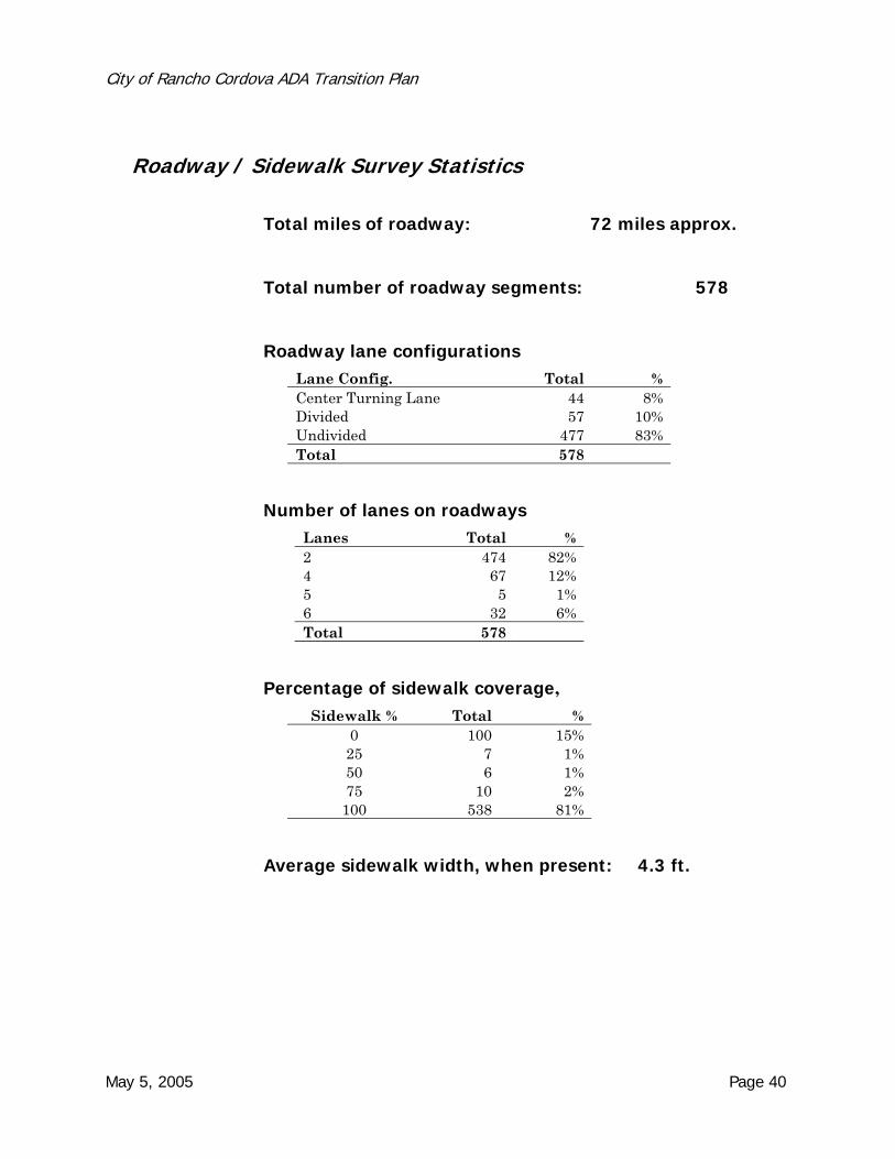
Roadway / Sidewalk Survey Statistics
Total miles of roadway: 72 miles approx.
Total number of roadway segments: 578
Roadway lane configurations Lane Config. Total % Center Turning Lane 44 8% Divided 57 10% Undivided 477 83% Total 578
Number of lanes on roadways Lanes Total % 2 474 82% 4 67 12% 5 5 1% 6 32 6% Total 578
Percentage of sidewalk coverage, Sidewalk % Total %
0 100 15% 25 7 1% 50 6 1% 75 10 2%
100 538 81%
Average sidewalk width, when present: 4.3 ft.
May 5, 2005 Page 40

City of Rancho Cordova ADA Transition Plan
Sidewalk condition, when present: Sidewalk Condition Total % 1 worse 18 3% 2 14 2% 3 504 87% 4 21 4% 5 Best 17 3% No Data 5 1%
Number of fixed obstructions (reducing width to less than 48") along sidewalk
Fixed Obstruction Total % 0 329 73 1 98 22 2 12 3 3 4 1 4 5 1 5 1 0 7 1 0 Total 450 100%
Number of non-fixed obstructions (reducing width to less than 48") along sidewalk
Non Fixed Obstruction Total %
0 312 66 1 125 27 2 24 5 3 3 1 4 6 1 9 1 0
Total 471 100%
Percentage of sidewalks segments with level changes >1/2"
No level changes: 51% 1 or more level changes: 49%
May 5, 2005 Page 41

City of Rancho Cordova ADA Transition Plan
Types of curb along roadway segments
Rolled curb: 78% Vertical curb: 16% No curb (open shoulder): 6%
Percentage of shoulder types, where no curb or sidewalk is present
Shoulder Count Ditch or Canal 13 Flat 38 Swale 17
Percentage of roadway segments with parking allowed Parking allowed: 72% No parking: 28%
Type of parking (where allowed) Parallel: 99.3% Angled/Diagonal: 0.7%
Percentage of occupied parking, where parking is allowed Occupied % %
0 67% 25 26% 50 4% 75 1%
100 1%
Total number of transit stops: 78 Transit Stop Count Bus 77 Light Rail 1 None 1071
Number of transit stops with cross-slope pad > 3%: 32
Number of bus shelters: 6
May 5, 2005 Page 42

City of Rancho Cordova ADA Transition Plan
Section 4.6: ADA Public Rights-of-Way Database Preparation and Contents All survey findings are contained in a Microsoft Access database. The database is designed to be user-friendly, with interactive screens available to access the summary report and reports for each individual intersection or roadway segment. When the database is opened, a "welcome" screen guides the user through a series of buttons, which access the next layer of screens. An "Intersections" or “Roadway” button opens a search screen for finding data for each particular intersection or roadway segment. Data for a specific intersection or roadway segment may be found by either finding a street name or by selecting the intersection ID number. A series of one-page reports are available through buttons on the screen. It should be noted that for those experienced in using and programming Microsoft Access, all data stored in tables and all queries, forms, and reports that manage the presentation of the data are available by opening the "database window". Nevertheless, for those inexperienced in using Access, it should be noted that such usage is not recommended, since data can be easily erased or altered if incorrect procedures are used.
May 5, 2005 Page 43