SECTION 4 COUNTY PROFILE - Putnam County Online · SECTION 4: COUNTY PROFILE DMA 2000 Hazard...
57
SECTION 4: COUNTY PROFILE DMA 2000 Hazard Mitigation Plan – Putnam County, New York 4-1 February 2015 SECTION 4 COUNTY PROFILE This profile describes the general information of the County (physical setting, population and demographics, general building stock, and land use and population trends) as well as critical facilities located within Putnam County. In Section 5, specific profile information is presented and analyzed to develop an understanding of the study area, including the economic, structural, and population assets at risk and the particular concerns that may be present related to hazards analyzed (for example, a high percentage of vulnerable persons in an area). 4.1 GENERAL INFORMATION Putnam County was formed in 1812 from Dutchess County. The County is included in the New York- Newark-Jersey City, NY-NJ-PA Metropolitan Statistical Area. It is one of the most affluent counties in the U.S., ranked 7 th by median household income. Putnam County consists of nine municipalities, covering over 240 square miles and 2013 estimated population of 99,645. The County is one of the 62 counties in New York State and is comprised of six towns and three incorporated villages. Putnam County is the 29 th most populated County in the State and ranks 55 in total land area. Putnam County is located in the Mid-Hudson Region of New York State. It is approximately 50 miles north of New York City and is on the outer ring of the New York City metropolitan area. The County is bordered to the west by the Hudson River, to the north by Dutchess County, to the east by the State of Connecticut, and to the south by Westchester County. The County contains six town governments, three village governments, and the County government. State and federal government statutes and regulations control how the local governments operate. The town and village governments include the towns of Carmel, Kent, Patterson, Philipstown, Putnam Valley and Southeast, and the villages of Brewster, Cold Spring and Nelsonville. The County and each municipality operate under the limits prescribed by various rules and laws of New York State. Each government entity has various responsibilities, funding sources, staffing levels, elected positions, and administrative capacities (Putnam County Division of Planning and Development 2010). 4.1.1 Physical Setting This section presents topography and geology, hydrology and hydrography, climate, land use and land cover. Hydrography and Hydrology Numerous ponds, lakes, creeks, and rivers make up the waterscape of Putnam County. The major waterways within the County include: West Branch Reservoir, Croton Falls Reservoir, East Branch Reservoir, East Branch Croton River, West Branch Croton River, Canopus Creek, and the Hudson River. The eastern half of Putnam County is drained by tributaries of the Croton River. The western half is drained by streams flowing directly into the Hudson River or by tributaries of Canopus and Peekskill Hollow Creeks. The major streams in the County generally follow pre-glacial stream valleys, whose alignment was determined by the structure or hardness of the underlying bedrock (NRCS 1994). Watersheds A watershed is the area of land that drains into a body of water such as a river, lake, stream, or bay. It is separated from other systems by high points in the area such as hills or slopes. It includes not only the waterway itself but also the entire land area that drains to it. For example, the watershed of a lake would
Transcript of SECTION 4 COUNTY PROFILE - Putnam County Online · SECTION 4: COUNTY PROFILE DMA 2000 Hazard...

SECTION 4: COUNTY PROFILE
DMA 2000 Hazard Mitigation Plan – Putnam County, New York 4-1
February 2015
SECTION 4 COUNTY PROFILEThis profile describes the general information of the County (physical setting, population and demographics,
general building stock, and land use and population trends) as well as critical facilities located within Putnam
County. In Section 5, specific profile information is presented and analyzed to develop an understanding of
the study area, including the economic, structural, and population assets at risk and the particular concerns that
may be present related to hazards analyzed (for example, a high percentage of vulnerable persons in an area).
4.1 GENERAL INFORMATION
Putnam County was formed in 1812 from Dutchess County. The County is included in the New York-
Newark-Jersey City, NY-NJ-PA Metropolitan Statistical Area. It is one of the most affluent counties in the
U.S., ranked 7th by median household income. Putnam County consists of nine municipalities, covering over
240 square miles and 2013 estimated population of 99,645. The County is one of the 62 counties in New York
State and is comprised of six towns and three incorporated villages. Putnam County is the 29th most populated
County in the State and ranks 55 in total land area.
Putnam County is located in the Mid-Hudson Region of New York State. It is approximately 50 miles north of
New York City and is on the outer ring of the New York City metropolitan area. The County is bordered to
the west by the Hudson River, to the north by Dutchess County, to the east by the State of Connecticut, and to
the south by Westchester County.
The County contains six town governments, three village governments, and the County government. State and
federal government statutes and regulations control how the local governments operate. The town and village
governments include the towns of Carmel, Kent, Patterson, Philipstown, Putnam Valley and Southeast, and the
villages of Brewster, Cold Spring and Nelsonville. The County and each municipality operate under the limits
prescribed by various rules and laws of New York State. Each government entity has various responsibilities,
funding sources, staffing levels, elected positions, and administrative capacities (Putnam County Division of
Planning and Development 2010).
4.1.1 Physical Setting
This section presents topography and geology, hydrology and hydrography, climate, land use and land cover.
Hydrography and Hydrology
Numerous ponds, lakes, creeks, and rivers make up the waterscape of Putnam County. The major waterways
within the County include: West Branch Reservoir, Croton Falls Reservoir, East Branch Reservoir, East
Branch Croton River, West Branch Croton River, Canopus Creek, and the Hudson River.
The eastern half of Putnam County is drained by tributaries of the Croton River. The western half is drained
by streams flowing directly into the Hudson River or by tributaries of Canopus and Peekskill Hollow Creeks.
The major streams in the County generally follow pre-glacial stream valleys, whose alignment was determined
by the structure or hardness of the underlying bedrock (NRCS 1994).
Watersheds
A watershed is the area of land that drains into a body of water such as a river, lake, stream, or bay. It is
separated from other systems by high points in the area such as hills or slopes. It includes not only the
waterway itself but also the entire land area that drains to it. For example, the watershed of a lake would

SECTION 4: COUNTY PROFILE
DMA 2000 Hazard Mitigation Plan – Putnam County, New York 4-2
February 2015
include not only the streams entering the lake but also the land area that drains into those streams and
eventually the lake. Drainage basins generally refer to large watersheds that encompass the watersheds of
many smaller rivers and streams. Figure 4-1 depicts the hydrologic system of a watershed.
Figure 4-1. Watershed
Source: U.S. Environmental Protection Agency (EPA) 2012
Watersheds come in all shapes and sizes and can cross municipal and county boundaries. New York State’s
waters (lakes, rivers, and streams) fall within one of 17 major watersheds (or drainage basins). Figure 4-2
shows the watersheds located in New York State.

SECTION 4: COUNTY PROFILE
DMA 2000 Hazard Mitigation Plan – Putnam County, New York 4-3
February 2015
Figure 4-2. Watersheds of New York State
Source: NYSDEC 2014
Putnam County is located in the Lower Hudson Watershed (Figure 4-3). The Lower Hudson Watershed makes
up approximately 40% of the larger Hudson/Mohawk River Basin, which is one of the largest drainage areas
on the eastern seaboard of the U.S. The Lower Hudson Watershed extends from the Battery at the southern
end of Manhattan to the Troy Dam at the confluence of the Mohawk River. This watershed covers 4,982
square miles of land and contains 8,861 miles of freshwater rivers and streams. There are 324 significant
freshwater lakes, ponds and reservoirs located within the Watershed that include: Ashokan Reservoir, Rondout
Reservoir, New Croton Reservoir, Alcove Reservoir, Cross River Reservoir, and Muscoot/Upper New Croton
Reservoir (NYSDEC 2014).

SECTION 4: COUNTY PROFILE
DMA 2000 Hazard Mitigation Plan – Putnam County, New York 4-4
February 2015
Figure 4-3. Lower Hudson Watershed
Source: NYSDEC 2014
New York City Watershed
According to Riverkeeper, Putnam County is located in the Croton Watershed (Figure 4-5) which makes up a
portion of the New York City Watershed (Figure 4-4). Over 9 million people live in New York City,
Westchester, Putnam, Orange, and Ulster Counties and most get their drinking water from the Croton, Catskill
and Delaware watersheds. The 6,000-mile network of pipes, shafts, and subterranean aqueducts carry an
average of 1.2 billion gallons of water each day from 19 upstate reservoirs (Riverkeeper 2014). Most of the
waterbodies (Croton Falls Reservoir, Diverting Reservoir, Bog Brook Reservoir, East Branch Reservoir,
Middle Branch Reservoir, and Kirk Lake) within the Croton Watershed are located within the Croton System;

SECTION 4: COUNTY PROFILE
DMA 2000 Hazard Mitigation Plan – Putnam County, New York 4-5
February 2015
the remainder (Boyds Corner Reservoir, West Branch Reservoir, and Lake Gleneida) are part of the
Catskill/Delaware System in Putnam County.
Croton System
The New York City Croton System includes 12 major reservoirs and four controlled lakes that supply drinking
water via aqueduct to New York City. The Croton Rivers begins where the east and west branches of the
River meet downstream from the Croton Falls Reservoir. Excess water leaves the spillway at the New Croton
Dam and the Croton River empties into the Hudson River at Croton-on-Hudson (Westchester County)
(Dutchess Watersheds 2009).
Bog Brook Reservoir is located in the Town of Southeast in Putnam County and is one of the 12 reservoirs in
New York City’s water supply system. The Reservoir has a drainage area of four square miles, all of which lie
within the Town. It was formed by damming Bog Brook, a small tributary of the East Branch of the Croton
River, which continues southwest to the Diverting Reservoir. Bog Brook Reservoir holds 4.4 billion gallons
when at full capacity and was placed into service in 1892. The Reservoir is connected to the East Branch
Reservoir by an underground tunnel. Its main function is to serve as a storage reservoir for the larger East
Branch Reservoir (NYC Environmental Protection 2014).
Croton Falls Reservoir is located in the Towns of Carmel and Southeast in Putnam County. It was formed by
damming the West and Middle Branches of the Croton River, which continue south and drain into the Muscoot
Reservoir. The Croton Falls Reservoir consists of three basins, separated by the Route 35 and Route 36
causeways. Water flows between the basins through culverts under the roadways. Basin 1 is the largest of the
three and holds 70% of the reservoir’s total volume. It receives water from the West Branch of the Croton
River. It also receives water from a smaller tributary which brings water from Lake Gilead. Basin 2 holds
26% of the reservoir’s volume and receives water from the City’s Middle Branch Reservoir. Basin 3 receives
most of its water from a single stream, Michaels Brook. Water leaves all three basins by way of the
continuation of the West Branch of the Croton River, which joins the East Branch, flows into the Muscoot
Reservoir, and then to the New Croton Reservoir. After moving through the New Croton Aqueduct, the water
reaches the Jerome Park Reservoir in the Bronx, where it enters New York City's distribution system. The
Croton Falls Reservoir is also connected to the nearby Diverting Reservoir via a channel and dividing weir.
Water usually passes freely between the two reservoirs. The total drainage basin of the Croton Falls Reservoir
is 16 square miles which includes portions of the Towns of Carmel and Southeast. The Reservoir holds 14.2
billion gallons at full capacity and was placed into service in 1911 (NYC Environmental Protection 2014).
Diverting Reservoir is located in the Town of Southeast in Putnam County. It was formed by damming the
East Branch of the Croton Reservoir which continues southwest to the Muscoot Reservoir. When at full
capacity, the Reservoir holds 900 million gallons, making it the smallest reservoir in the City’s system. It was
placed into service in 1911. The Diverting Reservoir receives most of its water from the East Branch River,
which extends from the East Branch and Bog Brook Reservoirs. It is connected to the Croton Falls Reservoir
by a channel and dividing weir. Water from the Diverting Reservoir flows into the continuation of the East
Branch of the Croton River, into the Muscoot Reservoir and then into the New Croton Reservoir. After
moving through the 24-mile New Croton Aqueduct, the water enters the Jerome Park Reservoir in the Bronx
and goes into New York City's distribution system. The drainage basin of the Diverting Reservoir is eight
square miles which lie entirely within the Town of Southeast (NYC Environmental Protection 2014).
The East Branch Reservoir is located east of the Village of Brewster and the interchange of I-84 and I-684. It
was formed by the damming of the East Branch of the Croton River, which continues southwest into the
Diverting Reservoir. The Reservoir holds 5.2 billion gallons at full capacity and was placed into service in
1891. The East Branch Reservoir receives its water from the Bog Brook Reservoir, as well as the East Branch

SECTION 4: COUNTY PROFILE
DMA 2000 Hazard Mitigation Plan – Putnam County, New York 4-6
February 2015
of the Croton River. East Branch water flows into the continuation of the East Branch of the Croton River,
then into the Diverting Reservoir and eventually into the New Croton River in Westchester County, New York.
The Reservoir has a drainage basin of 75 square miles that includes portions of the Towns of Patterson and
Southeast in Putnam County and Pawling in Dutchess County (NYC Environmental Protection 2014).
The Middle Branch Reservoir is located in the Town of Southeast in Putnam County and was formed by
damming the Middle Branch of the Croton River which flows south from Lake Carmel. The Reservoir holds
4.1 billion gallons at full capacity and was placed into service in 1878. Water from the Reservoir flows into
the Croton Falls Reservoir and eventually into the New Croton Reservoir. From there, it passes through the
New Croton Aqueduct into the Jerome Park Reservoir and enters the New York City distribution system. The
Middle Branch Reservoir drainage basin is 21 square miles and includes portions fo the Towns of Kent,
Patterson, and Southeast in Putnam County and Beekman and East Fishkill in Dutchess County (NYC
Environmental Protection 2014).
Kirk Lake is a controlled lake located in the Town of Kent in Putnam County. The Lake is located on a
tributary of the Muscoot River and used for recreation and drinking water purposes. Kirk Lake is owned by
the NYCDEP. The construction of the lake was completed in 1881. It has a height of 28 feet with a length of
220 feet. Maximum discharge is 439 cubic feet per second and its capacity is 1,822 acre feet. Normal storage
for Kirk Lake is 920 acre feet and drains an area of 2.95 square miles (Findlakes 2014).
Catskill / Delaware System
Boyds Corner Reservoir is located in the Town of Kent in Putnam County. It was formed by damming the
West Branch of the Croton River which continues southeast to the West Branch Reservoir. The Reservoir
consists of one basin that is 1.5 miles in length and holds 1.7 billion gallons when at full capacity. It was
placed into service in 1873; with the dam, spillway and outlet works being rebuilt in 1990. The Reservoir was
originally constructed as part of the City’s Croton System; however, today, it serves mainly as part of the
Delaware System. Water from Boyds Corner Reservoir flows briefly into the Croton River and then enters the
City’s West Branch Reservoir where it mixes with water carried from the Rondout Reservoir. From the West
Branch, it typically flows into the Kensico Reservoir which also receives its water from the Catskill System
through the Catskill Aqueduct. After reaching the Kensico Reservoir, water flows through two aqueducts to
the Hillview Reservoir in Yonkers (Westchester County) where it enters the City’s distribution system. The
Boyds Corner Reservoir has a drainage basin of 22 square miles and includes portions of the Towns of Carmel
and Putnam Valley in Putnam County and East Fishkill in Dutchess County (NYC Environmental Protection
2014).
West Branch Reservoir is located in the Towns of Kent and Carmel in Putnam County. It was formed by
damming the West Branch of the Croton River which continues south to the Croton Falls Reservoir. This
Reservoir consists of two basins, separated by Route 301. It holds eight billion gallons at full capacity. The
Reservoir was placed into service in 1895 as part of the City’s Croton Water Supply System. Today, the West
Branch Reservoir functions primarily as part of the Delaware Water System, serving as a supplementary
settling basin for the water which arrives from the Rondout Reservoir via the Delaware Aqueduct. The West
Branch Reservoir also receives water from its own small watershed and the Boyds Corner Reservoir. In
addition, the West Branch is connected to adjacent Lake Gleneida, one of the three controlled lakes that are
part of the City's water supply. Another function of the West Branch Reservoir is to receive water pumped in
from the Hudson River during drought periods. This water enters the West Branch from the City's Chelsea
Pumping Station in Dutchess County, 65 miles up the Hudson from New York City. The West Branch was
used very briefly for this purpose during May of 1989 and during the 1965-66 and 1985 droughts. Water
withdrawn from the West Branch ordinarily flows via the Delaware Aqueduct into the Kensico Reservoir in
Westchester County for further settling. There it mixes with Catskill system water before entering aqueducts

SECTION 4: COUNTY PROFILE
DMA 2000 Hazard Mitigation Plan – Putnam County, New York 4-7
February 2015
that carry it to the Hillview Reservoir in Yonkers, at the City's northern boundary, where it enters the water
supply distribution system. The West Branch has a drainage area of 20 square miles that includes parts of the
Towns of Carmel and Kent (NYC Environmental Protection 2014).
Lake Gleneida is located off of Route 52 in the Town of Carmel and part of the Catskill/Delaware System. It
covers a surface area of 168 acres and has a maximum depth of 108 feet. It is a controlled lake and part of the
New York City’s water supply system and the Croton Watershed. The NYCDEP owns the lake and is
considered one of the three controlled lakes in the City’s water system. Recreational use of the lakes also falls
under NYCDEP regulations. Fishing, ice fishing, and boating are allowed.

SECTION 4: COUNTY PROFILE
DMA 2000 Hazard Mitigation Plan – Putnam County, New York 4-8
February 2015
Figure 4-4. New York City Watershed
Source: New York City Environmental Protection 2007

SECTION 4: COUNTY PROFILE
DMA 2000 Hazard Mitigation Plan – Putnam County, New York 4-9
February 2015
Figure 4-5. Croton Watershed
Source: New York City Environmental Protection 2007

SECTION 4: COUNTY PROFILE
DMA 2000 Hazard Mitigation Plan – Putnam County, New York 4-10
February 2015
Topography and Geology
Putnam County is situated in the southeastern part of New York State, between the Hudson River on its
western border and the New York State-Connecticut border on its east. The County lies mainly within the
New England uplands physiographic province. The New England uplands area is geologically complex and
exhibits moderate relief. Landforms in this area show a strong correlation to the relative hardness of the
underlying bedrock. Elevation ranges from 200 to 500 feet above mean sea level in southern Westchester
County and is more than 1,000 feet in the Hudson Highlands. The Highlands extend from the southwest
corner of Rockland County, which is west of the Hudson River, through northern Westchester County and into
Putnam County (Putnam County Division of Planning and Development 2010).
The County is largely underlain by heavily metamorphosed complex of Precambrian and Paleozoic
sedimentary and igneous rocks. For the most part, the dominant outcrops are gneiss, schist, and granite
(NRCS 2004).
Approximately three-quarters of Putnam County lie within the New York City Watershed, which is described
below. More than nine-tenths of the County’s land area is part of the Hudson Highlands, which extend from
the northern Housatonic Valley of Connecticut into New Jersey and Pennsylvania. The remainder of the
County consists of a geological formation known as the Manhattan Prong. This area is found in the northeast
and southeast corners of the County (Putnam County Division of Planning and Development 2010).
Putnam County’s highest elevations are in the Town of Philipstown. The Towns of Philipstown and Putnam
Valley and the western part of the Town of Kent have the most rugged terrain, with many high peaks having
elevations of over 1,000 feet. There are several ranges in these municipalities which are significant because
they form a natural east-west barrier. These ranges are separated by Peekskill Hollow Creek. The first range
is known as Granite Mountain and is located west of the Creek. Moving towards the north, elevations increase
up to 1,100 feet above sea level (Putnam County Division of Planning and Development 2010).
The northern border of the County is similar to the west due to its number of high peaks. These peaks range
from Mount Ninham in the Town of Kent (elevation of 1,270 feet above sea level) to Birch Hill in the Town of
Patterson which reaches 1,260 feet above sea level (Putnam County Division of Planning and Development
2010).
The Towns of Carmel, Southeast, Patterson and the eastern portion of the Town of Kent, while all retaining
still relatively high peaks and variable relief, maintain more of a consistent terrain characterized by a greater
number of more level parcels (Putnam County Division of Planning and Development 2010).
Climate
Putnam County has a continental climate. Airflow and weather systems that affect the area are primarily of
continental origin. The climate also is designated as humid because the major circulation patterns of the
atmosphere carry generous quantities of moisture toward the northeastern U.S. (NRCS 2004). The climate of
Putnam County is one of long summers and short winters. The average annual temperature is approximately
50°F, with extremes varying from -24°F to 106°F. The average annual precipitation for the County is
approximately 45 inches with observed annual extremes ranging from 29.54 to 68.31 inches. The distribution
of precipitation throughout the year is fairly uniform with slightly higher amounts during the summer months
(FEMA FIS 2013).

SECTION 4: COUNTY PROFILE
DMA 2000 Hazard Mitigation Plan – Putnam County, New York 4-11
February 2015
Land Use and Land Cover
The most dominant land uses in Putnam County are forested land, wetlands, undeveloped vacant land, and
waterbodies. Residential is the next largest land use in the County (Putnam County Division of Planning and
Development 2010).
Residential land uses are typically represented by single-family, detached homes in Putnam County. More
concentrated areas of residential development occur in the County’s three villages, lake communities, and
several condominium complexes (Putnam County Division of Planning and Development 2010).
Forested land, wetlands, vacant land and waterbodies are found throughout Putnam County. Large blocks of
forested and vacant land are typically found in the western and northwestern portions of the County, while
major lakes and reservoirs are found in the eastern part of the County (Putnam County Division of Planning
and Development 2010).
Commercial and industrial land uses are found in and around the villages of the County and along State Routes
6, 9, 22, and 52. Commercial uses are also found at the intersections of Interstate 84 (I-84) and Route 312 and
I-84 and Ludingtonville Road. Industrial uses are scattered throughout the County and include the hospital,
government buildings, non-profit affiliated facilities, and schools. Significant blocks of land occupied by
institutional uses are found in the Towns of Philipstown, Patterson, Kent, Putnam Valley, and Carmel (Putnam
County Division of Planning and Development 2010).
Wetlands have a dramatic influence on Putnam County’s past growth patterns; they are found throughout the
County. New York State delineated wetlands of 12.4 acres or more are found in all municipalities of Putnam
County. Smaller local wetland areas have been regulated in all the municipalities, at varying degrees. The
most significant wetland in the County is the Great Swamp. The Great Swamp is a 4,200 acre wetland located
in a 62,300 acre watershed that covers portions of New York State (specifically the Town of Patterson in
Putnam County) and Connecticut (Putnam County Division of Planning and Development 2010).
Table 4-1 summarizes the land use for Putnam County. Figure 4-6 shows the distribution of land use
throughout the County.
Table 4-1. Land Use Summary for Putnam County, 2006 & 20011
Land Use Category
2006 Data 2011 Data
Acreage Percent of County Acreage
Percent of
County
Agriculture 5306.8 3.4% 5073.6 3.2%
Barren 360.7 0.2% 342.1 0.2%
Forest 106959.0 67.9% 105295.2 66.9%
Urban 26403.1 16.8% 28005.8 17.8%
Wetlands 9366.5 5.9% 9623.9 6.1%
Source: National Land Cover Database – USGSNote: Urban land includes residential, industrial, transportation, and recreational land. Water is excluded from the table above.

SECTION 4: COUNTY PROFILE
DMA 2000 Hazard Mitigation Plan – Putnam County, New York 4-12
February 2015
Figure 4-6. 2011 Land Use Land Cover for Putnam County
Source: USGS National Land Cover Database, 2011

SECTION 4: COUNTY PROFILE
DMA 2000 Hazard Mitigation Plan – Putnam County, New York 4-13
February 2015
Metropolitan/Urban Area
The Census Bureau classifies ‘urban’ as all territory, population, and housing units located within an urbanized
area (UA) or an urban cluster (UC). It delineates UA and UC boundaries to encompass densely settled
territory, which consist of core census block groups or blocks that have a population density of at least 1,000
people per square mile; and surrounding census blocks that over an overall density of at least 500 people per
square mile. An urbanized area is a densely populated area with a population density of more than 1,000
people per square mile and a population of more than 50,000 (Demographia, 2001). Urban clusters are defined
in the same manner as urbanized areas; however, an urban cluster has a population density of 2,500 people per
square mile and a population of more than 50,000 (Center for Information Development and Service, Date
Unknown). With a population of 99,710 and a population density of 432.9 people per square mile, Putnam
County is not considered an urban area; however, it is located in the New York-White Plains-Wayne, NY-NJ
Metropolitan Division.
Putnam County is one of the 23 counties within the New York–Northern New Jersey–Long Island NY-NJ-PA
Metropolitan Statistical Area, which is the most populous metropolitan area in the United States and the fourth
most populous in the world. The largest urbanized area in the United States is at the heart of the metropolitan
area, the New York-Newark, NY-NJ-CT Urbanized Area (with a 2010 population of 18,897,109 by the U.S.
Census). With approximately 3,353 square miles of land, it is the largest urbanized area in the United States.
It is also the fourth most densely populated urbanized area in the country, with 5,635 persons per square mile
(as of the 2010 Census) (U.S. Census Bureau). Based on commuting patterns, the Census Bureau also defines
a wider functional metropolitan area, the New York-Newark-Bridgeport, NY-NJ-CT-PA Combined Statistical
Area with an estimated population of 22,085, (as of 2012). This metropolitan area is made up of five divisions
as indicated in Figure 4-7.

SECTION 4: COUNTY PROFILE
DMA 2000 Hazard Mitigation Plan – Putnam County, New York 4-14
February 2015
Figure 4-7. New York-Northern New Jersey-Long Island, NY-NJ-PA Metropolitan Statistical Area
Source: U.S. Census, 2007Note: Putnam County is located in the New York-White Plains-Wayne, NY-NJ Metropolitan Division (circle)New York-White Plains-Wayne, NY-NJ Metropolitan DivisionNassau-Suffolk, NY Metropolitan DivisionNewark-Union, NJ-PA Metropolitan DivisionEdison, NJ Metropolitan DivisionRest of the New York-Newark-Bridgeport, NY-NJ-CT Combined Statistical Area

SECTION 4: COUNTY PROFILE
DMA 2000 Hazard Mitigation Plan – Putnam County, New York 4-15
February 2015
4.2 POPULATION AND DEMOGRAPHICS
According to the 2010 U.S. Census, Putnam County had a population of 99,710 people which represents a
slight increase from the 2000 U.S. Census population of 95,745 people. HAZUS-MH demographic data will be
used in the loss estimation analyses in Section 5 of this plan. All demographic data in HAZUS corresponds to
the 2000 U.S. Census data. Table 4-2 presents the population statistics for Putnam County based on the 2000
and 2010 U.S. Census data. Figure 4-7 shows the distribution of the general population density (persons per
square mile) in 2010 by Census block. For the purposes of this plan, the 2010 Census was used where the data
was available and supplemented with HAZUS-MH data (representing 2000 data).
DMA 2000 requires that HMPs consider socially vulnerable populations. These populations can be more
susceptible to hazard events, based on a number of factors including their physical and financial ability to react
or respond during a hazard and the location and construction quality of their housing. For the purposes of this
study, vulnerable populations shall include (1) the elderly (persons aged 65 and over) and (2) those living in
low-income households.
Table 4-2. Putnam County Population Statistics
Municipality
U.S. Census 2010 U.S. Census 2000*
Total
Pop.
65+
% Pop.
65+ Total
Pop.
65+
Percent
Pop.
65+
Low-
Income
Pop.**
% Low-
Income
Pop. of
Total
Village of Brewster 2,390 182 7.62% 2,162 211 9.76% 200 9.25%
Town of Carmel 34,305 4,263 12.43% 33,006 3151 9.55% 808 2.45%
Village of Cold Spring 2,013 342 16.99% 1,983 368 18.56% 179 9.03%
Town of Kent 13,507 1,716 12.70% 14,009 1381 9.86% 391 2.79%
Village of Nelsonville 628 79 12.58% 565 63 11.15% 23 4.07%
Town of Patterson 12,023 1,205 10.02% 11,306 784 6.93% 241 2.13%
Town of Philipstown 7,021 1,076 15.33% 6,874 788 11.46% 171 2.49%
Town of Putnam Valley 11,809 1,374 11.64% 10,686 907 8.49% 301 2.82%
Town of Southeast 16,014 2,180 13.61% 15,154 1477 9.75% 367 2.42%
Putnam County (TOTAL) 99,710 12,417 12.45% 95,745 9130 9.54% 2,681 2.80%
Source: Census 2010 (U.S. Census Bureau); HAZUS-MH (for 2000 U.S. Census data)Note: Pop. = population; * Individuals below poverty level (Census poverty threshold for a 3-person family unit is approximately$18,500)
It is noted that the Census data for household income provided in HAZUS-MH includes two ranges ($0-10,000
and $10,000-$20,000/year) that were totaled to provide the “low-income” data used in this study. This does
not correspond exactly with the “poverty” thresholds established by the 2013 U.S. Census Bureau, which
identifies households with three adults and no children with an annual household income below $18,222 per
year, or households with one adult and two children with an annual household income below $18,769 per year
as “low income” for this region. This difference is not believed to be significant for the purposes of this
planning effort.
The 2012 U.S. Census American Community Survey data identified approximately 3,600 households as
having an annual income of less than $25,000. Figure 4-9 shows the distribution of persons over age 65 in
Putnam County, while Figure 4-10 shows the distribution of low income persons. The following maps indicate
distribution based on Census Block designations.

SECTION 4: COUNTY PROFILE
DMA 2000 Hazard Mitigation Plan – Putnam County, New York 4-16
February 2015
Figure 4-8. Distribution of General Population for Putnam County, New York
Source: U.S. Census 2010

SECTION 4: COUNTY PROFILE
DMA 2000 Hazard Mitigation Plan – Putnam County, New York 4-17
February 2015
Figure 4-9. Distribution of Persons over the Age of 65 in Putnam County, New York
Source: HAZUS-MH

SECTION 4: COUNTY PROFILE
DMA 2000 Hazard Mitigation Plan – Putnam County, New York 4-18
February 2015
Figure 4-10. Distribution of Low-Income Population in Putnam County, New York
Source: HAZUS-MH

SECTION 4: COUNTY PROFILE
DMA 2000 Hazard Mitigation Plan – Putnam County, New York 4-19
February 2015
Population and Demographic Trends
This section discusses population trends to use as a basis for estimating future changes that could result from
the seasonal character of the population and significantly change the character of the area. Population trends
can provide a basis for making decisions on the type of mitigation approaches to consider and the locations in
which these approaches should be applied. This information can also be used to support planning decisions
regarding future development in vulnerable areas.
According to the U.S. Census Bureau, the 2010 population for Putnam County was 99,710 persons, which is a
4.0% increase from the 2000 Census population of 95,745. Over the last 110 years, from 1900 to 2010, the
County has seen an overall growth in population, with the exception of 1920. The largest increase was seen
between 1960 and 1970 when the County experienced a 78.7% increase (24,974 persons). The smallest
increase was experienced from 2000 to 2010 when the County saw only a 4.1% increase in population. The
largest decrease in population occurred from 1910 to 1920, with the County seeing a 26.3% decrease. The
smallest decrease was recently seen from 2010 to 2013 with only a 0.1% decrease. Table 4-3 displays the
population and change in population from 1900 to 2013 in Putnam County.
Table 4-3. Putnam County Population Trends, 1900 to 2013
Year Population Change in Population
Percent (%)
Population Change
1900 13,787 N/A N/A
1910 14,665 878 6.4
1920 10,802 -3,863 -26.3
1930 13,744 2,942 27.2
1940 16,555 2,811 20.5
1950 20,307 3,752 22.7
1960 31,722 11,415 56.2
1970 56,696 24,974 78.7
1980 77,193 20,497 36.2
1990 83,941 6,748 8.7
2000 95,745 11,804 14.1
2010 99,710 3,965 4.1
2013 99,645 -65 -0.1
Source: U.S. Census 1995; U.S. Census 2010; U.S. Census 2014Note: Change in population and percent in population change were calculated from available data.
Cornell University’s Program on Applied Demographics produced population projections by county and by
age and sex for New York State. The projections were completed in 2011 and are in five year intervals up to
the year 2040. The projections are based upon rates of change estimated from historic data. According to this
data, over the next 25 years, Putnam County has a projected population growth of 3.8%. By 2015, the
County’s total population is projected to reach 100,996 persons and by 2040, 104,816 persons (Figure 4-10).

SECTION 4: COUNTY PROFILE
DMA 2000 Hazard Mitigation Plan – Putnam County, New York 4-20
February 2015
Figure 4-11. Putnam County Population Projections, 2010 to 2040
Source: Cornell University 2014
The following table provides population trends for the nine municipalities of Putnam County. Between 2000
and 2010, all but the Town of Kent experienced a positive growth in population. The Village of Nelsonville
saw the largest growth in population, an 11.2% increase. The Town of Putnam Valley and the Village of
Brewster both saw an increase of over 10%. The Village of Cold Spring saw the smallest increase in
population of just 1.5%.
Table 4-4. Population Trends in Putnam County by Municipality
Municipality 2000 Census 2010 Census Change in Population
Percent
Change
Village of Brewster 2,162 2,390 228 10.5
Town of Carmel 33,006 34,305 1,299 3.9
Village of Cold Spring 1,983 2,013 30 1.5
Town of Kent 14,009 13,507 -502 -3.6
Village of Nelsonville 565 628 63 11.2
Town of Patterson 11,306 12,023 717 6.3
Town of Philipstown 6,874 7,021 147 2.1
Town of Putnam Valley 10,686 11,809 1,123 10.5
Town of Southeast 15,154 16,014 860 5.7
Putnam County (TOTAL) 95,745 99,710 3,965 4.1
Source: U.S. Census 2014Note: Change in population and population change were calculated from available data.

SECTION 4: COUNTY PROFILE
DMA 2000 Hazard Mitigation Plan – Putnam County, New York 4-21
February 2015
4.3 GENERAL BUILDING STOCK
The 2000 U.S. Census data identified 32,742 households (35,030 housing units) in Putnam County. The 2010
U.S. Census reported 35,041 households (38,224 housing units) in Putnam County. The County experienced
an increase in both households and housing units from 2000 to 2010. As for households, between 2000 and
2010, the County saw a 7% increase. As for housing units, the County experienced an increase of 8.9%
between 2000 and 2010. The U.S. Census defines household as all the persons who occupy a housing unit,
and a housing unit as a house, an apartment, a mobile home, a group of rooms, or a single room that is
occupied (or if vacant, is intended for occupancy) as separate living quarters. Therefore, you may have more
than one household per housing unit. The median price of an owner-occupied housing unit in Putnam County
was estimated at $385,600 (U.S. Census, 2012).
For this Plan, the default general building stock in HAZUS-MH was updated and replaced with a custom
building inventory for Putnam County both at the aggregate and structure level. The building stock update was
performed using the most current parcel and the New York State Department of Taxation and Finance tax
assessment data provided by Putnam County. The replacement cost value was calculated using the square
footage value of each building and RS Means 2014 data.
For the purposes of this plan, there are approximately 31,346 parcels with structures identified through data
provided by the County (Real Property tax data). These parcels with structures account for a replacement cost
value of approximately $17.9 billion (structure and contents). Estimated content value was calculated by
using 50-percent of the residential replacement cost value, and 100-percent of the non-residential replacement
values. Using this methodology, there is approximately $6.7 billion in contents within these properties.
Approximately 96% of the total buildings in the County are residential, which make up approximately 76.3%
of the building stock structural value associated with residential housing. Tables 4-3 and 4-4 present building
stock statistics by occupancy class for Putnam County.
Table 4-5. Number of Buildings and Improvement Value by Municipality
Municipality
All Occupancies
Count
Estimated
Structure RCV
Estimated Contents
RCV
Total (Structure +
Contents)
Village of Brewster 406 $201,581,179 $131,586,452 $333,167,631
Town of Carmel 10,170 $3,847,178,692 $2,250,459,565 $6,097,638,257
Village of Cold Spring 679 $269,493,110 $173,376,530 $442,869,640
Town of Kent 5,021 $1,329,512,766 $737,018,110 $2,066,530,876
Village of Nelsonville 261 $75,570,251 $45,560,707 $121,130,957
Town of Patterson 3,393 $1,180,896,788 $717,047,385 $1,897,944,173
Town of Philipstown 2,768 $1,048,614,861 $620,677,281 $1,669,292,142
Town of Putnam Valley 4,520 $1,352,509,644 $738,870,207 $2,091,379,851
Town of Southeast 4,128 $1,905,798,783 $1,249,328,164 $3,155,126,947
Putnam County (Total) 31,346 $11,211,156,075 $6,663,924,400 $17,875,080,474
Source: Putnam Count Real Property tax data, 2014
Notes: RCV = Replacement cost value.

SECTION 4: COUNTY PROFILE
DMA 2000 Hazard Mitigation Plan – Putnam County, New York 4-22
February 2015
Table 4-6. Number of Buildings and Total Replacement Value by Occupancy Class
Municipality
Residential Commercial Industrial
Count
Total (Structure +
Contents) Count
Total (Structure
+ Contents) Count
Total (Structure
+ Contents)
Village of Brewster 347 $209,984,181 39 $57,270,009 1 $1,278,893
Town of Carmel 9,793 $4,790,157,382 278 $774,853,838 3 $40,015,436
Village of Cold Spring 625 $288,349,740 31 $60,829,030 7 $15,435,840
Town of Kent 4,891 $1,777,483,970 96 $178,027,590 1 $4,190,150
Village of Nelsonville 244 $90,028,632 8 $13,514,996 8 $47,706,444
Town of Patterson 3,231 $1,391,548,208 114 $320,332,773 3 $12,277,685
Town of Philipstown 2,628 $1,283,812,741 107 $281,145,554 1 $4,440,600
Town of Putnam Valley 4,411 $1,840,918,312 77 $156,157,569 15 $70,124,641
Town of Southeast 3,829 $1,969,411,858 194 $810,692,048 1 $1,278,893
Putnam County (Total) 29,999 $13,641,695,025 944 $2,652,823,409 39 $195,469,689
Source: Putnam Count Real Property tax data, 2014
The 2012 American Community Survey data identified that the majority of housing units (79.2% or 30,215
units) in Putnam County are single-family detached units. The 2012 U.S. Census Bureau’s County Business
Patterns data identified 2,829 business establishments employing 20,519 people in Putnam County. The
construction industry has the most number of establishments in the County, with 582 establishments. This is
followed by the retail trade industry with 332 establishments and the professional, scientific, and technical
services industry with 312 establishments (U.S. Census, 2012).
Figure 4-9 and Figure 4-10 show the distribution and exposure density of residential and commercial
buildings, respectively, in Putnam County based on the New York State Department of Taxation and Finance
Property Class Code. Exposure density is the dollar value of structures per unit area, including building
content value. Generally, contents for residential structures are valued at about 50 percent of the building’s
value. For commercial facilities, the value of the content is generally about equal to the building’s structural
value. Actual content value various widely depending on the usage of the structure. The densities are shown
in units of $1,000 ($K) per square mile.
Viewing exposure distribution maps, such as Figure 4-10 through Figure 4-11 can assist communities in
visualizing areas of high exposure and in evaluating aspects of the study area in relation to the specific hazard
risks.

SECTION 4: COUNTY PROFILE
DMA 2000 Hazard Mitigation Plan – Putnam County, New York 4-23
February 2015
Figure 4-12. Distribution of Residential Building Stock and Value Density in Putnam County
Source: Putnam County, 2014

SECTION 4: COUNTY PROFILE
DMA 2000 Hazard Mitigation Plan – Putnam County, New York 4-24
February 2015
Figure 4-13. Distribution of Commercial Building Stock and Exposure Density in Putnam County
Source: Putnam County, 2014

SECTION 4: COUNTY PROFILE
DMA 2000 Hazard Mitigation Plan – Putnam County, New York 4-25
February 2015
4.3.1 Development Trends and New Development
In New York State, land use regulatory authority is vested in towns, villages, and cities. However, many
development and preservation issues transcend local political boundaries. In Putnam County, each town and
village is empowered by the Municipal Home Rule Law to plan and zone within its boundaries. DMA 2000
requires that communities consider land use trends, which can impact the need for, and priority of, mitigation
options over time. Land use trends can also significantly impact exposure and vulnerability to various hazards.
For example, significant development in a hazard area increases the building stock and population exposed to
that hazard.
This plan provides a general overview of land use trends and types of development occurring within the study
area. An understanding of these development trends can assist in planning for further development and
ensuring that appropriate mitigation, planning, and preparedness measures are in place to protect human health
and community infrastructure.
According to the “Report of the Task Force on Vision 2010, Guiding Putnam into the Next Decade” prepared
by the Putnam County Division of Planning and Development, “despite the historical trend in development
(suburbanization), the most dominant land uses in the County continue to be forested land, wetlands,
undeveloped vacant land, and water bodies. Residential land use would be the next largest land use. Generally
speaking, residential land use occurs throughout the County on large lot subdivisions or in rural areas.”
Table 4-6 identifies known and anticipated new development in Putnam County as of June 2014.
While any development increases the risk of damage and loss to natural hazards, a number of factors indicate
that this increase in risk is low and mitigated by existing Federal, State, County and local regulations, policies
and programs. In general, development occurring in the County is outside of high hazard areas (e.g.
floodplains and steep slopes). All communities have planning and regulatory mechanisms in place that control
and limit the increased natural hazard risk of new development and re-development. All communities have
planning boards and site plan review requirements that include review and appropriate consideration of hazard
areas. All development and construction in the County requires conformance with NYS Building Code.
Further all Putnam County communities participate, and are in good standing, in the National Flood Insurance
Program which by State regulation requires two-feet of freeboard above the FEMA 1% chance base flood
elevation (BFE+2) for all new residential construction and substantial improvement, and BFE+1 for all other
construction types. Certain communities have adopted ordinances to further protect against natural hazards
(e.g. Steep Slope Ordinances) and protect natural resources that provide natural mitigation benefits (e.g.
wetlands and wetland buffers, stream courses and stream banks, areas of retention/detention). Most of the
Putnam municipalities are MS4 communities, and have adopted and enforce Stormwater Management Plans
that minimize the impacts of stormwater resulting from both existing and new development, with respect to
both stormwater quality and quantity.
County and community capabilities to manage development so as to minimize increased natural hazard risk are
discussed in the capability assessment subsection of Chapter 6, as well as within each jurisdictional annex in
Section 9. Also identified within each annex are actions the community has or will take to further integrate the
findings and recommendations of this plan into other planning mechanisms and programs, many of which
support land use and development so as to minimize the increase of natural hazard risk.

SECTION 4: COUNTY PROFILE
DMA 2000 Hazard Mitigation Plan – Putnam County, New York 4-26
February 2015
Table 4-7. Known and Anticipated New Development in Putnam County
Municipality Property Name Project Type AddressTax Parcel
Reference # Acreage
Status withPlanning
Board Building Description/Units
KnownHazardZone*
Carmel (T)Carmel Center Senior
Housing - Lot 3Residential Terrace Dr. 55.14-1-11.3 13.91 Approved 23 units
Carmel (T)Carmel Center Senior
Housing - Lot 5Residential Terrace Dr. 55.14-1-11.1 27.37 Approved 81 units of senior housing
Wildfire:
Intermix
Carmel (T) CVS Commercial Broke ground
Carmel (T)Gateway Summit -
Lot 6Residential Rt. 6 55.-2-24.6 29.35 Approved 150 units of senior housing
Wildfire:
Intermix
Carmel (T)
Gateway Summit -
Staybridge Suites
Hotel
Non-
Residential2054 Rt. 6 55.-2-24.1 11.81 Approved 10,304 sq. ft. 123 room, 4-story hotel
Carmel (T)Guidepost Facility
RedevelopmentPrivate Broke ground
Carmel (T)Hickley Holdings
LLC/ Paladin Group
Non-
Residential39 Seminary Hill Rd. 55.10-1-1 & 3 49.9 Approved 50,000 sq. ft. office building
Wildfire:
Intermix
Carmel (T) Hillcrest Commons Residential Rt. 5244.10-1-4 &
44.9-1-5137.29 Approved 74 units of senior housing
Wildfire:
Intermix
Carmel (T)
Lakeview
Development at
Carmel
Non-
Residential1611 Rt. 6 55.9-1-17 1.64 Approved
12,656 sq. ft. 2-story commercial
building
Wildfire:
Interface
Carmel (T) MacDonald MarineNon-
Residential
681 Union Valley
Rd.76.20-1-13 23.62 Approved 20,000 sq. ft. boat storage building
Wildfire:
Intermix
Carmel (T) McDonald’s Commercial Broke ground
Carmel (T)Meadowlands Car
DealershipCommercial Broke ground
Carmel (T) Nejame & SonsNon-
Residential133 Gleneida Ave. 44.9-1-16 1.32 Approved
10,200 sq. ft. 2-story commercial
building
Wildfire:
Interface
Carmel (T) Old Forge Estates Residential
Baldwin Place Rd.,
opposite Mahopac
Schools Campus
75.15-1-19 39.92 Approved 10 lot residential subdivisionWildfire:
Intermix
Carmel (T) Old Forge Estates Residential Approved 14
Carmel (T)One Hundred Twelve
Crossroads, L.P.Residential 1828 Rt. 6 55.6-1-42 1.42
Approved but
not built22 units of senior housing
Wildfire:
Intermix
Carmel (T)P2 build out Hillcrest
CommonsResidential
Implementing
P2

SECTION 4: COUNTY PROFILE
DMA 2000 Hazard Mitigation Plan – Putnam County, New York 4-27
February 2015
Table 4-7. Known and Anticipated New Development in Putnam County
Municipality Property Name Project Type AddressTax Parcel
Reference # Acreage
Status withPlanning
Board Building Description/Units
KnownHazardZone*
Carmel (T)Parakesh
RedevelopmentCommercial Approved
Carmel (T) Parkash Estates, LLCNon-
Residential870 Rt. 6 65.13-1-54 0.74 Approved 10,304 sq. ft. commercial building
Wildfire:
Interface
Carmel (T)RPK Precision
HomesResidential
Seminary Hill Rd. &
Mechanic St.
55.14-1-5.1,
5.2, 5.3, 5.4, 5.5
& 55.10-1-23,
24 & 25
5.98 Approved 50 attached senior unitsWildfire:
Intermix
Carmel (T) Swan Cove Residential 628 Rt. 6 76.5-1-49 6.74 Approved 10 residential units
100-yr Flood;
500-yr Flood;
Wildfire:
Interface
Carmel (T) The Fairways - Lot 7 Residential Rt. 6 44.-2-1.1 & 1.2 Approved 150 units of senior housingWildfire:
Intermix
Carmel (T) Tompkins RecyclingNon-
Residential60 Old Rt. 6 55.11-1-15 2.58 Approved 20,000 sq. ft. building
100-yr Flood;
500-yr Flood
Carmel (T) Union Place Mixed Use Rt. 6
86.6-1-4, 86.11-
1-1 & 75.19-1-
1.12
300Approved -
2010
575,000 sq. ft of retail, 480 housing
units, 350,000 sq. ft. office space, and 90
room hotel
Wildfire:
Intermix
Carmel (T)
Union Square
Redevelopment
Zipkin Farm
Commercial Approved
Carmel (T)Yankee Land
DevelopmentResidential
Bayberry Hill Rd. &
Owen Dr.76.15-1-12 112.7 Approved 14 lot residential subdivision
Wildfire:
Intermix
Cold Spring (V)Butterfield
RedevelopmentMixed Use
NYS Rt. 9D and
Paulding Ave.49.5-3-45 7.21
Pending
Approval,
Under Review
Redevelopment of site incl. 15,000 sq. ft.
office/retail building, 55 market-rate
condo-units (senior housing) with 1
superintendent unit, and construction of
resident community center. Lahey
Pavillion, 11,500 sq. ft. building, to
continue use as medical
Wildfire:
Interface;
Landslide:
High
Kent (T)Frangle Realty Corp.
- Sewer Installation
Non-
ResidentialNYS Rt. 52 33.48-1-6
Pending
Approval,
Under Review
10,000 sq. ft. sewer lateral installationWildfire:
Intermix
Kent (T)Hilltop Estates
SubdivisionMixed Use Peckslip Rd. 12.-1-38 & 42 48.46
Pending
Approval,
Under Review
10 lot residential subdivision, with 1
commercial lot, for a 2 story, 20,000 sq.
ft. office/commercial building
Wildfire:
Intermix
Kent (T) Patterson CrossingNon-
ResidentialNYS Rt. 311 & I-84 22.-2-47 & 48
16.3 (of
90.46 bal in
Approved but
not built
382,560 sq. ft. retail center, with
management and meeting space, a
Wildfire:
Intermix;

SECTION 4: COUNTY PROFILE
DMA 2000 Hazard Mitigation Plan – Putnam County, New York 4-28
February 2015
Table 4-7. Known and Anticipated New Development in Putnam County
Municipality Property Name Project Type AddressTax Parcel
Reference # Acreage
Status withPlanning
Board Building Description/Units
KnownHazardZone*
Patterson) substation for the Putnam County
Sheriff's Department. and 28,000 sq. ft.
garden center
Karst: Long 1
Kent (T) Route 311 PlazaNon-
Residential
NYS Rt. 311 & Old
Ludingtonville Rd.22.-2-17 2.72
Approved but
not built15,200 sq. ft. retail center
Wildfire:
Intermix;
Karst: Long 2
Patterson (T) Flex BuildingNon-
Residential2160 Rt. 22 35.-5-31 17.02
Approved but
not built
68,900 sq. ft. flex building suitable for
professional, office, warehouse, light
manufacturing, R&D
Wildfire:
Intermix;
Karst: Long 6
Patterson (T) Fox Run Estates Residential 215 Bullet Hole Rd. 34.-3-22 44.1
Pending
Approval,
Under Review
Proposed 80 unit "Active Adult"
residential community
Wildfire:
Intermix;
Karst: Long 4
Patterson (T) Ice Pond Estates Residential272 - 372 Ice Pond
Rd.34.-5-9 & 12 136.89
Preliminary
Approval
received
21 lot residential subdivision
Wildfire:
Intermix;
Karst: Long 5
Patterson (T) Patterson CrossingNon-
ResidentialNYS Rt. 311 & I-84 22.-2-47 & 48
74.1 (of
90.46 bal in
Kent)
Approved but
not built
382,560 sq. ft. retail center, with
management and meeting space, a
substation for the Putnam County
Sheriff's Department. and 28,000 sq. ft.
garden center
Wildfire:
Intermix;
Karst: Long 3
Philipstown (T)20 Hudson Highlands
ReserveResidential
NYS Rt. 9 & East
Mountain Rd. North136.57
Pending
Approval,
Under Review
25 lot residential subdivision
Wildfire:
Intermix;
Landslide:
High
Philipstown (T) ENTERGYNon-
ResidentialHorsemen's Trail 16.-1-5 6.77 Approved
20,000 sq. ft. Emergency Operations
Building with associated access, parking
and on-site utilities
Landslide:
High; Karst:
Short 3
Philipstown (T)Glassbury Court (aka
Quarry Pond)Residential NYS Rt. 9 16.-1-38 38.91
Approved,
Under
Construction
54 single-family homes in Adult Active
community
Wildfire:
Interface;
NEHRP: D;
Landslide:
High
Philipstown (T)Graymoor - New
FriaryResidential NYS Rt. 9 82.-2-41 112.8 Approved
Remove existing 21,750 sq. ft. friary,
construct new 29,270 sq. ft. friary &
related infrastructure improvements
Landslide:
High
Philipstown (T) Olspan, LLCNon-
ResidentialNYS Rt. 9 38.-3-24.2 5
Pending
Approval,
Under Review
Renovation of existing 10,800 sq. ft.
light manufacturing / office building &
Construction of 8,700 sq. ft. addition for
personal property storage
Wildfire:
Intermix;
NEHRP: D;
Landslide:
High

SECTION 4: COUNTY PROFILE
DMA 2000 Hazard Mitigation Plan – Putnam County, New York 4-29
February 2015
Table 4-7. Known and Anticipated New Development in Putnam County
Municipality Property Name Project Type AddressTax Parcel
Reference # Acreage
Status withPlanning
Board Building Description/Units
KnownHazardZone*
Putnam Valley
(T)HYH Subdivision Residential Pudding St.
41.-2-13 &
41.15-1-3236.5
Pending
Approval,
Under Review
15 lot residential subdivisionWildfire:
Intermix
Putnam Valley
(T)Rose Hill Cemetery
Non-
ResidentialNYS Rt. 9 84.-2-35 59.7
Pending
Approval,
Under Review
Develop 4.84 ac. of 59.7 ac. parcel to
create 1,888 grave sites, access
driveway, modify existing drainage,
construct a stormwater management
pond and create a meditation area
Wildfire:
Intermix
Southeast (T) Crossroads 312Non-
ResidentialNYS Rt. 312 & I-84
45.-2-52, 53,
54, 55 & 5651.9
Pending
Approval,
Under Review
Construction of 186,000 sq. ft. mixed-
use commercial, bank, restaurants,
personal & professional services
Wildfire:
Intermix;
Karst: Long 2
Southeast (T)
Fortune Ridge (aka
Meadows at Dean's
Corners)
Residential150 Deans Corner
Rd.
67.-3-79, 78.-3-
28, 29, 78.-4-77
& 78
198.39Approved but
not built162 single family homes
Wildfire:
Intermix;
Karst: Long 1
Southeast (T) Lyons DevelopmentNon-
Residential
Rt. 6 & Starr Ridge
Rd.68.-2-2 3.19
Pending
Approval,
Under Review
Construction of 14,000 2-story
office/retail buildingKarst: Long 1
Southeast (T) Opportunity ParkNon-
Residential
20 Mount Ebo Rd.
South
46.-2-26, 30.21,
30.22 & 316.73
Pending
Approval,
Under Review
Site plan for public recreation area
Wildfire:
Intermix;
Karst: Long 1
Southeast (T) Southeast Plaza, LLCNon-
Residential3601 Rt. 6 68.-2-58 3.8
Pending
Approval,
Under Review
Construction of 2-story 10,000 sq. ft.
business/retail building
Wildfire:
Interface;
Karst: Long1
Southeast (T)Stateline Retail
Center
Non-
Residential
US Rt. 6/202 to the
east of Old Nichols
Rd. to the west of
Dingle Rd. and
immediately north of
I-84
68.-2-48 44
Approved, not
built
Approvals
extended by
PN as of
4/10/2014
184,800 sq. ft. retail center and 14,800
sq. ft. 2-story office building
Wildfire:
Interface;
NEHRP: D;
Karst: Long 1
* Only location-specific hazard zones or vulnerabilities identifiedSource: June 2014 “Large Development Projects Report”, Putnam County Department of Planning, Development and Transportation

SECTION 4: COUNTY PROFILE
DMA 2000 Hazard Mitigation Plan – Putnam County, New York 4-30
February 2015
4.3.2 Potential Sites for Temporary Housing and Relocation
Putnam County has identified the following locations for the placement of temporary housing units to house
residents displaced by disaster:
Philipstown: Grounds of the Town Recreation Center – 107 Glenclyffe Drive, Garrison
Grounds of the Philipstown Highway Center – Fishkill Road, Cold Spring NY
Open area’s designated by T/ Philipstown
Putnam Valley: Grounds of the Town Park - Town Park Lane (off) Oscawana Lake Road, Putnam Valley
Grounds of the Putnam lake VFW – 154 Oscawana Lake Road, Putnam Valley
Grounds of the Clarence Fahnestock State Park (Putnam Valley NY) Route 301
Open area’s designated by T/ Putnam Valley
Kent: Grounds of the Huestis Field Town Park Farmers Mills Road, Kent
Clarence Fahnestock State Park (Putnam Valley NY) Route 301
Open area’s designated by T/ Kent
Carmel: Grounds of the Sycamore Lake Town Park, Long Pond Road, Mahopac
Putnam County Highways / Facilities Stock Pile – Route 6N, Mahopac
Open area’s designated by T/ Carmel
Patterson: Location of the Old Town Hall (Route 311 & 164)
– Community Service Property (open Space)
West Street Open Lot – West Street and South Street, Patterson
The Putnam Lake VFW Hall – Parking area – Fairfield Drive, Brewster
The Green Chimney School, 400 Doansburg Road, Brewster
Open area’s designated by T/ Carmel
Southeast The Green Chimney School, 400 Doansburg Road, Brewster
Grounds of the Putnam County Highways / Facilities Stock Pile
– Doansburg and Gage Road, Brewster
The Southeast Ball Fields, Zimmer Road, Brewster
**The Villages of Brewster, Cold Spring and Nelsonville will partner with the towns in which they
reside.
Further, the County has included a high-priority action, to be implemented in 2015, to work with all Putnam
County municipalities to identify sites within the community suitable for relocation of houses out of the
floodplain, or building new houses once properties in the floodplain are razed. It is noted that while a
community may identify suitable sites, the use (including transfer of ownership) of suitable private property
would be at the discretion of the property owner.

SECTION 4: COUNTY PROFILE
DMA 2000 Hazard Mitigation Plan – Putnam County, New York 4-31
February 2015
4.4 CRITICAL FACILITIES
A comprehensive inventory of critical facilities in Putnam County
was developed from various sources including input from the
Planning Committees. The inventory of critical facilities presented in
this section represents the current state of this effort at the time of
publication of the HMP and was used for the risk assessment in
Section 5.
4.4.1 Essential Facilities
This section provides information on emergency facilities, hospital
and medical facilities, schools, shelters and senior care and living
facilities.
Emergency Facilities
For the purposes of this Plan, emergency facilities include police, fire,
emergency medical services (EMS) and emergency operations centers
(EOC).
Police Departments
Table 4-8 identifies County and local police stations within Putnam
County. Figure 4-13 identifies the location of these facilities.
Table 4-8. Police Stations in Putnam County
Name Address Municipality Backup Power
Brewster Police Department 208 Main St Village of Brewster
Carmel Police Department 60 McAlpin Av Town of Carmel Yes
Carmel Police Department Substation 85 Gleneida Av Town of Carmel Yes
Putnam County Sheriff 3 County Ctr Town of Carmel Yes
Cold Spring Police Department 83 Main St Village of Cold Spring Yes
Kent Police Department 40 Sybils Crsng Town of Kent Yes
Putnam County Sheriff Substation 276 Main Village of Nelsonville Yes
NY State Police 1672 Route 22 Town of Southeast Yes
Sources: Putnam CountyNotes: PD = Police Department
Fire Departments and Emergency Medical Service Facilities
Table 4-9 identifies fire stations and rescue squads/emergency medical service facilities within Putnam
County. Figure 4-13 identifies the location of these facilities.
Table 4-9. Fire Stations and Rescue Squads in Putnam County
Name Address Municipality
Backup
Power
Brewster FD 501 N Main St Village of Brewster Yes
Brewster FD - Station 2 515 Route 312 Town of Southeast Yes
Critical Facilities are those facilities
considered critical to the health and
welfare of the population and that
are especially important following a
hazard. As defined for this HMP,
critical facilities include essential
facilities, transportation systems,
lifeline utility systems, high-
potential loss facilities, and
hazardous material facilities.
Essential facilities are a subset of
critical facilities that include those
facilities that are important to ensure
a full recovery following the
occurrence of a hazard event. For
the County risk assessment, this
category was defined to include
police, fire, EMS, schools/colleges,
shelters, senior facilities, and
medical facilities.

SECTION 4: COUNTY PROFILE
DMA 2000 Hazard Mitigation Plan – Putnam County, New York 4-32
February 2015
Table 4-9. Fire Stations and Rescue Squads in Putnam County
Name Address Municipality
Backup
Power
Carmel Fire Department 94 Gleneida Av Town of Carmel Yes
Mahopac Fall FD - Station 1 17 Luccaro Ln Town of Carmel Yes
Mahopac Falls FD Station 2 319 Bullet Hole Rd Town of Carmel Yes
Mahopac FD Station 1 741 Route 6 Town of Carmel Yes
Mahopac FD Station 2 311 Crane Rd Town of Carmel Yes
Mahopac FD Station 3 12 Buckshollow Rd Town of Carmel Yes
Carmel Ambulance 6 Garrett Pl Town of Carmel
Cold Spring Fire Department 154 Main St Village of Cold Spring Yes
Kent FD 2490 Route 301 Town of Kent Yes
Lake Carmel FD 851 Route 52 Town of Kent Yes
Lake Carmel FD Station 2 849 Farmers Mills Rd Town of Kent Yes
PC Fire Training Center 200 Lt Michael Neuner Ct Town of Kent No
Patterson FD & Ambulance 13 Burdick Rd Town of Patterson Yes
Patterson Fire Department. Station 2 161 Bullet Hole Rd Town of Patterson Yes
Putnam Lake Fire Department 72 Fairfield Dr Town of Patterson Yes
Continental Village FD 12 Spy Pond Rd Town of Philipstown Yes
Garrison VFD - Station #1 1616 Route 9 Town of Philipstown Yes
Garrison VFD - Station 2 71 Upper Station Rd Town of Philipstown Yes
Garrisson VAC Town of Philipstown
North Highlands FD 504 Fishkill Rd Town of Philipstown Yes
Philipstown Ambulance 14 Cedar St Village of Cold Spring Yes
Putnam Valley FD - Station 2 710 Peekskill Hollow Rd Town of Putnam Valley Yes
Putnam Valley VFD 12 Canopus Hollow Rd Town of Putnam Valley Yes
Putnam Valley VAC Town of Putnam Valley
Sources: Putnam County BESNotes: FD= Fire Department;; EMS = Emergency Medical Service; VAC = Volunteer Ambulance Corps
Emergency Operations Centers
Table 4-10 identifies Emergency Operations Centers (EOCs) in Putnam County. The Bureau of Emergency
Services, located in the Town of Carmel, is responsible for maintaining the County EOC, a county-wide
communications system, as well as the Enhanced 911 system.
Table 4-10. Emergency Operation Centers in Putnam County
Name Address MunicipalityBackup
Power
Bureau of Emergency Services 122 Old Route 6 Town Of Carmel Yes
Sources: Putnam County BES
Hospitals and Medical Facilities
Table 4-11 identifies hospitals and medical facilities in Putnam County. One major hospital is located within
the County in the Town of Carmel.

SECTION 4: COUNTY PROFILE
DMA 2000 Hazard Mitigation Plan – Putnam County, New York 4-33
February 2015
Table 4-11. Hospital and Medical Facilities in Putnam County
Name Address MunicipalityBackupPower
Camarda Care Center 672 Stoneleigh Ave Town of Carmel
PHC Ambulatory Care Offices 664 Stoneleigh Ave Town of Carmel
PHC- Emergency Room 670 Stoneleigh Ave Town of Carmel
Cecil Dill Dialysis Facility
Open Doors Clinic Village of Brewster
Putnam Nursing and Rehab Town of Kent
Sources: Putnam County
Schools
There are six public school districts in Putnam County - Brewster, Carmel, Garrison, Haldane, Mahopac and
Putnam Valley. Enrollment in these district schools totaled 16,815 students during the 2002-2003 school year.
Within these districts, there are four parochial elementary schools. Additionally, there are several regional
private high schools, a number of nursery and daycare facilities, and several facilities to accommodate special
needs education (Putnam County Division of Planning and Development 2010). Table 4-11 identifies the
school facilities in Putnam County.
Table 4-12. Schools in Putnam County
Name Municipality
Type of
Facility
Back Up
Power
Austin Rd Elementary School Town of Carmel School
Carmel Central School District Town of Carmel School
Carmel High School Town of Carmel School
Fulmar Rd Elementary School Town of Carmel School
Lakeview Elementary School Town of Carmel School
Mahopac Central School District Town of Carmel School
Mahopac High School Town of Carmel School
Mahopac Middle School Town of Carmel School
Myrtle Ave Elementary School Town of Carmel School
St. James The Apostle School Town of Carmel School
St. John School Town of Carmel School
Haldane Jr/Sr HS Village of Cold Spring School
Kent Schools & Trans Town of Kent School
George Fisher Middle School Town of Patterson School Partial
Green Chimneys School For Little People Town of Patterson School Yes
Matthew Paterson Elementary School Town of Patterson School
Garrison Elementary/Middle School Town of Philipstown School
Garrison School Dist. Town of Philipstown School
Garrison Union Free School District Town of Philipstown School
Putnam Valley High School Town of Putnam Valley School

SECTION 4: COUNTY PROFILE
DMA 2000 Hazard Mitigation Plan – Putnam County, New York 4-34
February 2015
Table 4-12. Schools in Putnam County
Name Municipality
Type of
Facility
Back Up
Power
Putnam Valley Middle School Town of Putnam Valley School
Putnam Valley Elementary School Town of Putnam Valley School
Brewster High School Town of Southeast School Partial
Brewster School Admin Bldg Town of Southeast Administrative Yes
Brewster School Bus Garage Town of Southeast Administrative Partial
CV Starr School Town of Southeast School
HH Wells Middle School Town of Southeast School
JFK Elementary School Town of Southeast School
SE Schoolhouse Town of Southeast School
Sources: Putnam County BES
Shelters
With support and cooperation of the American Red Cross, the County has identified shelters with policies and
procedures as documented in the following sheltering plans:
Putnam County Non-Medical Shelter Operations – Purpose, Policy, Procedures
Putnam County Comfort Station – Purpose, Policy, Procedures
Senior Care and Living Facilities
It is important to identify and account for senior facilities, as they are highly vulnerable to the potential impactsof disasters. Understanding the location and numbers of these types of facilities can help manage effectiveresponse plan post disaster. Table 4-13 identifies senior living and senior care facilities in the County.
Table 4-13. Senior Facilities in Putnam County
Name Address Municipality Backup Power
Senior Housing Mayor Mitchell Court Village of Brewster
Senior Housing 50 Main St. Village of Brewster
Senior Citizen Building 790 Long Pond Road Town of Carmel
The Plaza at Clover Lake 838 Fair Street Town of Patterson
Putnam Ridge Nursing Home 46 Mount Ebo Rd N Town of Southeast
Putnam Valley Senior Center
William Kohler Senior Center
Sources: Putnam County BES

SECTION 4: COUNTY PROFILE
DMA 2000 Hazard Mitigation Plan – Putnam County, New York 4-35
February 2015
Figure 4-14. Emergency Facilities in Putnam County
Source: Putnam County

SECTION 4: COUNTY PROFILE
DMA 2000 Hazard Mitigation Plan – Putnam County, New York 4-36
February 2015
4.4.2 Transportation Systems
The transportation system of Putnam County is a network of roadways, highways, and rail lines that provide
for travel within the County and to major centers in surrounding counties and states. Though the public transit
system is not as extensive as systems of major surrounding transit regions, it is still a critical lifeline for travel
to and from the County.
Many of New York State’s major highways and roadways pass through the County. While Interstate 84 runs
generally east-west through New York to Connecticut, it runs diagonally through the eastern part of Putnam
County. Route 684 runs in a general north and south direction, connecting the eastern half of the County to
surrounding counties, as well as New Jersey and Connecticut. The Taconic Parkway, which also runs in a
north and south direction, connects the western half of the County to most of these same regions as the
Interstates. U.S. Routes 6 and 9 also serve as important roadways for intra- and inter-county travel.
Tables 4-13 through 4-15 and Figure 4-14 identify the transportation systems found in Putnam County.
Bus and Transit
Public bus service in Putnam County consists of the County’s bus system, Putnam Area Rapid Transit (PART),
several Westchester County Bee Line routes, and a Housatonic Area Regional Transit (HART) route that
operates between Danbury, Connecticut and Brewster (Putnam County Division of Planning and Development
2010).
PART service is generally concentrated in the eastern part of the County, where service can be provided to
more densely populated areas and where linkages can be made to other buses and train services. The
Westchester Bee Line provides commuter service through the Town of Carmel, along Route 6 from the hamlet
of Carmel to White Plains, and a Croton Falls commuter run between the Croton Falls train station and the
Mahopac area, along Croton Falls Road. The HART service provides commuter and midday service (Putnam
County Division of Planning and Development 2010).
Table 4-13 identify bus and other transit facilities in Putnam County.
Table 4-14. Bus and Other Transit Facilities in Putnam County
Name Municipality Use Backup Power
Putnam County Bus Garage Town of Patterson Bus
Local and Suburban Transit Town of Southeast
Sources: Putnam County
Railroad Facilities
Two Metro-North rail lines run north and south through both the eastern and western halves of the County.
The Harlem Line in the east and the Hudson Line in the west connect the County to Albany to the north, and
New York City and farther regions via Grand Central Terminal. There are seven railroad stops in Putnam
County including Brewster Village, Brewster North, Patterson, Cold Spring, Garrison, Breakneck, and
Mantiou. Ridership on the rail service is operated by Metro North and has increased between 1980 and 2002,
from 669,031 rides per year to over 1.6 million rides per year. The busiest stations are Brewster Village,
Southeast, Cold Spring and Garrison (Putnam County Division of Planning and Development 2010).

SECTION 4: COUNTY PROFILE
DMA 2000 Hazard Mitigation Plan – Putnam County, New York 4-37
February 2015
Table 4-15. Railroad Facilities in Putnam County
Name Municipality Back Up Power
Metro-North – Manitou Station (Hudson Line) Town of Philipstown
Metro North – Garrison Station (Hudson Line) Town of Philipstown
Metro North - Cold Spring Station (Hudson Line) Village of Cold Spring
Metro North – Breakneck Ridge Station (Hudson Line) Village of Cold Spring
Metro North - Brewster Station (Harlem Line) Village of Brewster
Metro North - Southeast Station (Harlem Line) Town of Southeast
Metro North – Patterson Station (Harlem Line) Town of Patterson
MTA Brewster Yard Town of Southeast
Sources: Putnam County
Bridges
Of the highway bridges in the County, those identified in Table 4-15 are listed as critical. There were also five
railroad bridges that were listed as critical that include Mooney Hill Bridge in the Town of Patterson and four
bridges located along NYS Route 164 in the Town of Patterson.
Table 4-16. Critical Highway Bridges in Putnam County
Name Municipality
Carmel Ave. Bridge Village of Brewster
Deans Road Town of Kent
East Boyds Road 1 Town of Kent
East Boyds Road 2 Town of Kent
Ludington Court 1 Town of Kent
Ludington Court 2 Town of Kent
Mooney Hill Town of Kent
Ninham Road Town of Kent
Ninham Road Town of Kent
Sagamore Road Town of Kent
Schrade Road Town of Kent
Whangtown Road Town of Kent
Brimstone Road Town of Patterson
Route 22 Bridge Town of Patterson
Route 311 Bridge Town of Patterson
Sources: Putnam County
Evacuation Routes
The County has identified evacuation routes for all hazards, and maintains specific evacuation plans for
hurricanes and radiological emergencies associated with Indian Point Energy Center in Buchanan, Westchester
County.

SECTION 4: COUNTY PROFILE
DMA 2000 Hazard Mitigation Plan – Putnam County, New York 4-38
February 2015
All-hazard evacuation routes are: Route 9D / Route 9 / Sprout Brook Rd. / Oscawana Lake Road /
Peekskill Hollow Road / Taconic State Parkway / Route 301 / Route 84 / Route 311 / Route 6 / Route
22 / Route 684
Specific evacuation routes are identified in the following plans:
Hurricane Emergency Action Plan- Revised 2/2014
Putnam County Radiological Emergency Response Plan – July, 2014
Further, Putnam County Evacuation Bus Routes are also posted for residents who lack their owntransportation, and can be found at: http://www.putnamcountyny.com/pcbes/oem/4292-2/.
The County has identified a number of mitigation actions within their County annex (Section 9.1) that willimprove county-wide emergency management capabilities, including evacuation and sheltering, as follows:
PCBES-1: Re-Establish Local Emergency Planning Committees
PCBES-2: County Incident Command Systems Training
PCBES-3: County Electrical Live Line Training Capabilities / Preparedness
PCBES-5: Putnam County Emergency Operations Center (EOC) - Incident & Resource Management
PCBES-6: Putnam County Animal Emergency Response Site
PCBES-7: Transportation Hardening & Evacuation Upgrades

SECTION 4: COUNTY PROFILE
DMA 2000 Hazard Mitigation Plan – Putnam County, New York 4-39
February 2015
Figure 4-15. Transportation Facilities in Putnam County
Source: Putnam County

SECTION 4: COUNTY PROFILE
DMA 2000 Hazard Mitigation Plan – Putnam County, New York 4-40
February 2015
4.4.3 Lifeline Utility Systems
This section presents potable water, wastewater, energy resource, and communication utility system data. Due
to heightened security concerns, local utility lifeline data sufficient to complete the analysis have only partially
been obtained.
Potable Water
In Putnam County, water is provided from various facilities as a public service or through private supplies,
such as wells. The County has 114 community water supplies. Many of these systems rely on deep wells,
while a few systems rely on surface water supplies. All of the community supplies have a distribution system.
A majority of County water users obtain their water from deep wells which tap groundwater resources (Putnam
County Division of Planning and Development 2010). Table 4-16 lists the facilities associated the treatment,
storage, and transport of potable water to the County.
Table 4-17. Potable Water Facilities in Putnam County
Name Municipality Type Backup Power
Lake Gleneida Pump Station Town of Carmel Pump
Rainbow Water Co., Inc Town of Carmel
Tennis Court/Swing Set/2 Pumphouses Town of Carmel Pump
Town Of Carmel Pump Station Town of Carmel Pump
Water Pump Hse Ver Town of Carmel Pump
Water Tank Town of Carmel Tank
WD 2 Shoprite Water Tank Town of Carmel Tank
WD 2 Water Tank Town of Carmel Tank
WD2 Water Tank Town of Carmel Tank
WD3 Water Tank Town of Carmel Tank
Pump House Town of Kent Pump
Pump House Town of Kent Pump
Alpine Acres Water Treatment Plant Town of Patterson Treatment Yes
Dorsett Hollow Water Treatment Plant Town of Patterson Treatment Yes
Fox Run Water Treatment Town of Patterson Treatment Yes
Lower Pump House Town of Philipstown Pump
Water Supply- Pump House Town of Southeast Pump
Water Supply- Well Field Town of Southeast Well
Water Tank Town of Southeast Tank
Water Tank, Pumphouse Town of Southeast Pump
Water Treatment Town of Southeast Treatment
Well And Clubhouse Town of Southeast Well
Well Site Town of Southeast Well
Sources: Putnam County Department of Health
Wastewater Facilities
There are 49 wastewater treatment plants in Putnam County that discharge effluent to surface waters. All but
seven of the treatment plants are located in the New York City Watershed. There are a combination of public

SECTION 4: COUNTY PROFILE
DMA 2000 Hazard Mitigation Plan – Putnam County, New York 4-41
February 2015
and privately owned treatment plants and collection systems. The Town of Carmel has the most public sewer
districts. Other public districts are found in the Villages of Cold Spring and Brewster, and the Town of
Southeast. In addition to wastewater treatment plants, there are many residents and businesses that rely on
individual septic systems (Putnam County Division of Planning and Development 2010).
Table 4-17 lists both the wastewater treatment facilities and pump stations located in Putnam County.
According to the table, the wastewater treatment system for the County appears to be mainly located within the
Town of Carmel with other facilities and pump stations located around the County.
Table 4-18. Putnam County Wastewater Treatment Facilities and Pump Stations
Name Municipality Type Backup Power
<Null> Village of Brewster
<Null> Village of Brewster
<Null> Village of Brewster
Carmel Avenue Pump Station Village of Brewster Pump Yes
DEP Laboratory Village of Brewster
Par Street Pump Station Village of Brewster Pump
Route 22 Pump Station Village of Brewster Pump Yes
Waste Water Head Works Village of Brewster
WWTP Town of Carmel Treatment
<Null> Town of Carmel
Aerobic Digester Town of Carmel Treatment
Carmel Waste Water Town of Carmel
Microfilter Building- Sewer #4 Town of Carmel
Primary Clarifier Town of Carmel Treatment
Pump Station Town of Carmel Pump
Pump Station Town of Carmel Pump
RBC Building Town of Carmel
RBD Tanks Town of Carmel
SD 1 Lift Station (White Sail) Town of Carmel Lift
SD 2 Belden N Pump Town of Carmel Pump Yes
SD 2 Belden S Pump Town of Carmel Pump
SD 2 Hughson N Pump Town of Carmel Pump
SD 2 Mechanic Street Pump Town of Carmel Pump
SD2 301 Pump Town of Carmel Pump
SD2 Centennial Ridge Pump Town of Carmel Pump Yes
SD2 Hughson S Pump Town of Carmel Pump
SD2 Kelly Road Pump Town of Carmel Pump Yes
SD2 Laurel Frams Pump Station Town of Carmel Pump Yes
SD2 Little Pond Manor Town of Carmel Pump Yes
SD2 Putnam Plaza Pump Station Town of Carmel Pump Yes
SD2 Willowridge Pump Town of Carmel Pump Yes
SD4 Pumphouse Town of Carmel Pump Yes
SD4 Pumphouse Town of Carmel Pump

SECTION 4: COUNTY PROFILE
DMA 2000 Hazard Mitigation Plan – Putnam County, New York 4-42
February 2015
Table 4-18. Putnam County Wastewater Treatment Facilities and Pump Stations
Name Municipality Type Backup Power
SD4 Pumpstation Town of Carmel Pump
SD4 Sewer Treatment Plant #4 Town of Carmel Treatment
SD6 Lift Station Town of Carmel Lift Yes
SD7 Sewer Tx #1 Control Building Town of Carmel
SD8 Pumpstation Town of Carmel Pump
Secondary Settle Town of Carmel Treatment
Sewage Treatment Town of Carmel Treatment
Sewer Plant - Long Driveway Town of Carmel Treatment
Sewer Plant #5 Town of Carmel Treatment
Sewer Plant #6 Town of Carmel Treatment
Sewer Plant 2 Primary Setting Tank Town of Carmel Treatment Yes
Sewer Plant-Long Driveway Town of Carmel Treatment
Sewer Tx #1 Tank/ Sew 7 Sand Fltr Town of Carmel
Storage Building Town of Carmel
Wastewater Treatment Plant Town of Carmel Treatment Yes
WD 14 Pump House #2 Town of Carmel Pump
WD 14 Pump House #2 Town of Carmel Pump
WD 2 Lake Shore Pump Station Town of Carmel Pump
WD 2 Water Treatment Plant Town of Carmel Treatment
WD 5 Pumphouse Town of Carmel Pump Yes
WD 8 Tank Town of Carmel
WD3 Well Building 1 Town of Carmel Yes
WD3 Well Building 2 Town of Carmel
WD4 Pumphouse Town of Carmel Pump
WD6 Water Plant & Tanks Village of Cold Spring Treatment
Cold Spring WWTP Village of Cold Spring Treatment
Market Street Pump Station Village of Cold Spring Pump No
Sewage Pump 3 Village of Cold Spring Pump No
West Street Pump Station Town of Kent Pump Yes
Kent Sewer District Town of Kent No
Pump House Town of Patterson Pump
Cornwall Meadows Pump Station Town of Patterson Pump Yes
Covington Greens Pump Station Town of Patterson Pump Yes
Education Alliance Camp Town of Patterson Yes
Fox Run Condominiums Town of Patterson Yes
Front Street Pump Station Town of Patterson Pump Yes
George Fisher Middle School Town of Patterson Yes
Patterson Commons Pump Station Town of Patterson Pump Yes
Patterson Hamlet WWTP Town of Patterson Treatment Yes
Patterson Village Pump Station Town of Patterson Pump Yes
Pump House Town of Patterson Pump

SECTION 4: COUNTY PROFILE
DMA 2000 Hazard Mitigation Plan – Putnam County, New York 4-43
February 2015
Table 4-18. Putnam County Wastewater Treatment Facilities and Pump Stations
Name Municipality Type Backup Power
South Street Pump Station Town of Patterson Pump Yes
Thunder Ridge Ski Area Town of Patterson
Watchtower Education Center Town of Southeast Yes
Sewage Lift Station Town of Southeast Lift Yes
Sewage Lift Station Town of Southeast Lift Yes
Sewage Lift Station Town of Southeast Lift Yes
Sewage Lift Station Town of Southeast Lift Yes
Sewage Lift Station Town of Southeast Lift Yes
Sewage Lift Station Town of Southeast Lift Yes
Sewerage Systems Town of Southeast Lift Yes
Wastewater Treatment Plant Town of Southeast Treatment
WW Treatment Plant Village of Brewster Treatment
Sources: Putnam County Health Department
Energy Resources
New York State Electric and Gas Corporation (NYSEG) is the primary electric and gas utility company in
Putnam County. Natural gas services are also provided by smaller, private companies. Table 4-19 lists the
natural gas facilities in Putnam County, and Table 4-20 lists the electric generating facilities and electric
substations in the County.
Table 4-19. Putnam County Natural Gas Facilities
Name Municipality Backup Power
Cen Hud - Stillwater Road Town of Carmel
Algonquin - Tulip Road Town of Southeast
NYSEG - Brewster City Gate Town of Southeast
Sources: NYSEG and Central Hudson
Table 4-20. Electric Substations and Transfer Facilities in Putnam County
Name Municipality Type Backup Power
NYSEG - Carmel Town of Carmel Power
NYSEG - Wood Street Town of Carmel Power
NYSEG - Kent Cliffs Town of Kent Power
NYSEG - Haviland Hollow Substation Town of Patterson Substation
NYSEG - Kent Substation Town of Patterson Substation
NYSEG - West Patterson Substation Town of Patterson Substation
CENHUD - Indian Brook Road Town of Philipstown Power
NYSEG - Adams Corners Town of Putnam Valley Power
NYSEG - Dingle Ridge Town of Southeast Power
NYSEG - Putnam Lake Town of Southeast Power
NYSEG - Tilly Foster Town of Southeast Power
Sources: NYSEG and Central Hudson

SECTION 4: COUNTY PROFILE
DMA 2000 Hazard Mitigation Plan – Putnam County, New York 4-44
February 2015
Communications
Communications systems in the County are provided by multiple companies, such as Verizon. Table 4-21 lists
the communication towers and facilities located in the County. Figure 4-15 shows the locations of the
facilities for these various lifeline utility systems.
Table 4-21. Communication Facilities in Putnam County
Name Municipality Backup Power
DPW- Telephone Communications Village of Brewster
Telephone Communications Village of Brewster
Verizon Comm. Village of Brewster
Not Provided Town of Kent Yes
Communications Tower Town of Kent
Communications Tower Town of Kent
Communications Tower Town of Kent
Cell Tower In Silo Town of Patterson
Echo Road Telecommunications Tower Town of Patterson Yes
Maldunn Telecommunications Tower Town of Patterson Yes
Noletti Telecommunications Tower Town of Patterson Yes
Tower Hill Town of Patterson
Verizon Town of Patterson
Wireless Edge Telecommunications Tower Town of Patterson
Cell Tower Town of Philipstown
Cell Tower Town of Philipstown
Communications Tower Town of Philipstown
Communications Tower Town of Philipstown
Crown Atlantic Tower Town of Philipstown
Cell Tower/Power Lines Town of Putnam Valley
Verizon Cell Tower Town of Putnam Valley
Cell Tower Town of Southeast
Cell Tower Town of Southeast
Sources: Putnam County

SECTION 4: COUNTY PROFILE
DMA 2000 Hazard Mitigation Plan – Putnam County, New York 4-45
February 2015
Figure 4-16. Utility Lifelines in Putnam County
Source: Putnam County

SECTION 4: COUNTY PROFILE
DMA 2000 Hazard Mitigation Plan – Putnam County, New York 4-46
February 2015
4.4.4 High-Potential Loss Facilities
High-potential loss facilities generally include dams, levees, hazardous materials facilities (HAZMAT),
nuclear power plants and military installations; however, of these only dams are located within Putnam
County. Figure 4-16 shows the locations of the High-Potential Loss Facilities in the County.
Dams and Levees
According to the U.S. Army Corps of Engineers National Inventory of Dams (NID), NYSGIS, and input from
the Planning Committee, there are 130 dams in Putnam County. A dam is included in the NID if: (1) it is a
“high” or “significant” hazard potential class dam or, (2) it is a “low” hazard potential class dam that exceeds
25 feet in height and 15 acre-feet storage or, (3) it is a “low” hazard potential class dam that exceeds 50 acre-
feet storage and six feet height. Table 4-22 defines the hazard potential classification, as accepted by the NID
Interagency Committee on Dam Safety.
Table 4-22. Dam Hazard Potential Classifications
Hazard Potential
Classification Loss of Human Life
Economic, Environmental,
and Lifeline Losses
Low None Low and generally limited to owner
Significant Possible Yes
High Loss of one human life is likely ifdam fails
Yes (but not necessary for this classification)
Source: NID, 2007
However, the data from NID does not indicate the hazard classification for the dams. In Table 4-23, the hazard
classification listed in the table is how the NYSDEC classified the dams.
Class A – Low Hazard - A dam failure is unlikely to result in damage to anything more than isolated
or unoccupied buildings, undeveloped lands, minor roads such as town or county roads; is unlikely to
result in the interruption of important utilities, including water supply, sewage treatment, fuel, power,
cable or telephone infrastructure; and/or is otherwise unlikely to pose the threat of personal injury,
substantial economic loss or substantial environmental damage.
Class B – Intermediate Hazard - A dam failure may result in damage to isolated homes, main
highways, and minor railroads; may result in the interruption of important utilities, including water
supply, sewage treatment, fuel, power, cable or telephone infrastructure; and/or is otherwise likely to
pose the threat of personal injury and/or substantial economic loss or substantial environmental
damage. Loss of human life is not expected.
Class C – High Hazard - A dam failure may result in widespread or serious damage to home(s);
damage to main highways, industrial or commercial buildings, railroads, and/or important utilities,
including water supply, sewage treatment, fuel, power, cable or telephone infrastructure; or substantial
environmental damage; such that the loss of human life or widespread substantial economic loss is
likely.
Class D - Negligible or No Hazard - A dam that has been breached or removed, or has failed or
otherwise no longer materially impounds waters, or a dam that was planned but never constructed.
Class"D" dams are considered to be defunct dams posing negligible or no hazard. The department may
retain pertinent records regarding such dams.
0 – hazard code has not been assigned

SECTION 4: COUNTY PROFILE
DMA 2000 Hazard Mitigation Plan – Putnam County, New York 4-47
February 2015
Figure 4-17. High-Potential Loss Facilities in Putnam County
Source: Putnam County

SECTION 4: COUNTY PROFILE
DMA 2000 Hazard Mitigation Plan – Putnam County, New York 4-48
February 2015
Table 4-23. Dams in Putnam County
Dam Name Municipality River/Waterbody Hazard Class
Dixon Lake Road Dam Town of Carmel Low
Glencoma Lake Dam Town of Carmel PLUM BROOK Low
Lake Gilead Dam Town of Carmel TR-W BRANCH CROTON RIVER Low
Long Pond Dam Town of Carmel TR-WEST BRANCH RESERVOIR Low
Long Pond Dam Town of Carmel Low
Palmer Lake Dam Town of Carmel MICHAEL BROOK Low
Upper Lake Road Dam Town of Carmel TR-WEST BRANCH RESERVOIR Low
Willow Pond Subdivision Dam Town of Carmel TR-W BRANCH WEST RESERVOIR Low
Kirk Lake Dam Town of Carmel TR-MUSCOOT RIVER Intermediate
Lake Casse Dam Town of Carmel TR-CROTON FALLS RESERVOIR Intermediate
Lake Gleneida Dam Town of Carmel TR-W BRANCH CROTON RIVER Intermediate
Lake Macgregor Dam Town of Carmel TR-MUSCOOT RIVER Intermediate
Teakettle Spout Lake Dam Town of Carmel PLUM BROOK Intermediate
Upper Teakettle Spout Lake Dam Town of Carmel TR-PLUM BROOK Intermediate
Carmel Auxiliary Dike Town of Carmel WEST BRANCH CROTON RIVER High
Croton Falls Dam Town of Carmel WEST BRANCH CROTON RIVER High
Lake Mahopac Dam Town of Carmel MUSCOOT RIVER High
West Branch Dam (Carmel Dam) Town of Carmel WEST BRANCH CROTON RIVER High
Hefferman Dam Town of Carmel MICHAEL BROOK Negligible/No Hazard
Adam Pond Dam Town of Kent Low
Barrett Pond Dam Town of Kent TR-WEST BRANCH RESERVOIR Low
Barrett Pond Dam Town of Kent Low
Blue Spruce Dam Town of Kent TR-BOYD CORNERS RESERVOIR Low
Browns Pond Dam Town of Kent TR-MIDDLE BR CROTON RIVER Low
Canopus Lake North End Dam Town of Kent CANOPUS CREEK Low
Clear Pool Dam Town of Kent CLEAR POOL LAKE Low
Drew Lake Dam Town of Kent STUMP POND STREAM Low

SECTION 4: COUNTY PROFILE
DMA 2000 Hazard Mitigation Plan – Putnam County, New York 4-49
February 2015
Table 4-23. Dams in Putnam County
Dam Name Municipality River/Waterbody Hazard Class
Ivan Bennett Dam Town of Kent TR-BOYD CORNERS RESERVOIR Low
Lake Tibet Dam Town of Kent PEEKSKILL HOLLOW CREEK Low
Leland Ryder Lake Dam Town of Kent BLACK POND BROOK Low
Levine Lake Dam A Town of Kent TR-HORSE POND BROOK Low
Levine Lake Dam B (dike) Town of Kent TR-HORSE POND BROOK Low
Little Buck Mountain Pond Dam Town of Kent BAILEY BROOK Low
Merritt Ryder Lake Dam Town of Kent TR-BLACK POND BROOK Low
Pine Pond Dam Town of Kent TR-WEST BRANCH CROTON RIVER Low
Rohener Pond Dam Town of Kent TR-WEST BRANCH RESERVOIR Low
Turner Mill Pond Dam Town of Kent TR-MIDDLE BR CROTON RIVER Low
Twin Brooks Dam Town of Kent BLACK POND BROOK Low
Upper Lake Ninham Dam Town of Kent TR-BOYD CORNERS RESERVOIR Low
Veterans Park Dam Town of Kent TR-PINE POND Low
Lower Lake Ninham Dam Town of Kent BAILEY BROOK Intermediate
Ryder Lake Dam Town of Kent WEST BRANCH CROTON RIVER Intermediate
Sagamore Lake Dam Town of Kent WEST BRANCH CROTON RIVER Intermediate
Seven Hills Realty Co Inc Dam Town of Kent TR-W BRANCH CROTON RIVER Intermediate
South Lake Dam (lower) Town of Kent TR-STUMP POND STREAM Intermediate
South Lake Dam (middle) Town of Kent TR-STUMP POND STREAM Intermediate
South Lake Dam (upper) Town of Kent TR-STUMP POND STREAM Intermediate
White Pond Dam Town of Kent TR-BOYD CORNERS RESERVOIR Intermediate
Boyds Corner Dam Town of Kent WEST BRANCH CROTON RIVER High
Lake Carmel Dam Town of Kent MIDDLE BRANCH CROTON RIVER High
Marcell Roth Lake Dam Town of Kent TR-PEEKSKILL HOLLOW CREEK High
Fried Pond Dam Town of Kent TR-BOYDS RESERVOIR Negligible/No Hazard
Louis Enten Pond Dam #2 Town of Kent PEEKSKILL HOLLOW BROOK Negligible/No Hazard
South Lake Dam Town of Kent Unknown
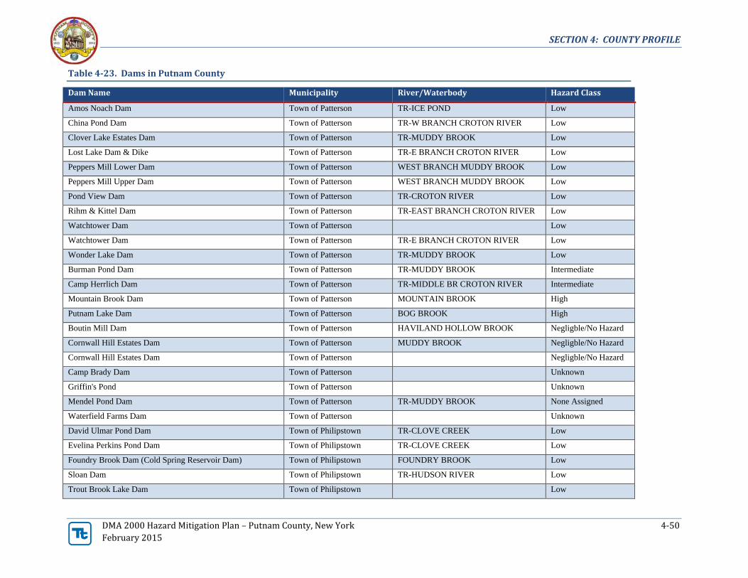
SECTION 4: COUNTY PROFILE
DMA 2000 Hazard Mitigation Plan – Putnam County, New York 4-50
February 2015
Table 4-23. Dams in Putnam County
Dam Name Municipality River/Waterbody Hazard Class
Amos Noach Dam Town of Patterson TR-ICE POND Low
China Pond Dam Town of Patterson TR-W BRANCH CROTON RIVER Low
Clover Lake Estates Dam Town of Patterson TR-MUDDY BROOK Low
Lost Lake Dam & Dike Town of Patterson TR-E BRANCH CROTON RIVER Low
Peppers Mill Lower Dam Town of Patterson WEST BRANCH MUDDY BROOK Low
Peppers Mill Upper Dam Town of Patterson WEST BRANCH MUDDY BROOK Low
Pond View Dam Town of Patterson TR-CROTON RIVER Low
Rihm & Kittel Dam Town of Patterson TR-EAST BRANCH CROTON RIVER Low
Watchtower Dam Town of Patterson Low
Watchtower Dam Town of Patterson TR-E BRANCH CROTON RIVER Low
Wonder Lake Dam Town of Patterson TR-MUDDY BROOK Low
Burman Pond Dam Town of Patterson TR-MUDDY BROOK Intermediate
Camp Herrlich Dam Town of Patterson TR-MIDDLE BR CROTON RIVER Intermediate
Mountain Brook Dam Town of Patterson MOUNTAIN BROOK High
Putnam Lake Dam Town of Patterson BOG BROOK High
Boutin Mill Dam Town of Patterson HAVILAND HOLLOW BROOK Negligble/No Hazard
Cornwall Hill Estates Dam Town of Patterson MUDDY BROOK Negligble/No Hazard
Cornwall Hill Estates Dam Town of Patterson Negligble/No Hazard
Camp Brady Dam Town of Patterson Unknown
Griffin's Pond Town of Patterson Unknown
Mendel Pond Dam Town of Patterson TR-MUDDY BROOK None Assigned
Waterfield Farms Dam Town of Patterson Unknown
David Ulmar Pond Dam Town of Philipstown TR-CLOVE CREEK Low
Evelina Perkins Pond Dam Town of Philipstown TR-CLOVE CREEK Low
Foundry Brook Dam (Cold Spring Reservoir Dam) Town of Philipstown FOUNDRY BROOK Low
Sloan Dam Town of Philipstown TR-HUDSON RIVER Low
Trout Brook Lake Dam Town of Philipstown Low

SECTION 4: COUNTY PROFILE
DMA 2000 Hazard Mitigation Plan – Putnam County, New York 4-51
February 2015
Table 4-23. Dams in Putnam County
Dam Name Municipality River/Waterbody Hazard Class
Weise Pond Dam Town of Philipstown TR-SAND SPRING BROOK Low
Colt Estate Dam Town of Philipstown TR-HUDSON RIVER Intermediate
Continental Village Dam Town of Philipstown Intermediate
East Mountain Lake Dam Town of Philipstown TROUT CREEK Intermediate
Jordan Pond Dam Town of Philipstown CLOVE CREEK Intermediate
Lake Surprise Dam Town of Philipstown BREAKNECK BROOK TR-HUDSON Intermediate
Lake Valhalla Dam Town of Philipstown TR-CLOVE CREEK Intermediate
Loch Lyall Dam Town of Philipstown INDIAN BROOK Intermediate
Perkins Estate Pond Dam Town of Philipstown CLOVE CREEK Intermediate
Cargill Reservoir Dam Town of Philipstown CARGILL BROOK High
Cold Spring Dam (lower) Town of Philipstown FOUNDRY BROOK High
Cold Spring Dam (upper) Town of Philipstown FOUNDRY BROOK High
Breakneck Brook Dam Town of Philipstown BREAKNECK BROOK Negligible/No Hazard
Camp Wiccopee Dam Town of Philipstown TROUT CREEK Negligible/No Hazard
Diamond Pond Dam Town of Philipstown FOUNDRY BROOK Negligible/No Hazard
Duck Pond Dam A & B Town of Putnam Valley TR-INDIAN BROOK Low
Frank & Cooper Pond Dam Town of Putnam Valley TR-TROUT CREEK Low
G L Lloyd Pond Dam Town of Putnam Valley PEEKSKILL HOLLOW CREEK Low
Hidden Lake Dam Town of Putnam Valley Low
Hollow Brook Dam Town of Putnam Valley TR-PEEKSKILL HOLLOW BROOK Low
Indian Lake Dam Town of Putnam Valley TR-CANOPUS CREEK Low
John Allen Pond Dam Town of Putnam Valley TR-CANOPUS CREEK Low
L Berman Pond Dam Town of Putnam Valley TR-PEEKSKILL HOLLOW CREEK Low
Oscawana Lake Dam Town of Putnam Valley OSCAWANA BROOK Low
Stillwater Pond Dam Town of Putnam Valley STILLWATER BROOK Low
Williams Pond Dam Town of Putnam Valley TR-CANOPUS CREEK Low
Floradan Estates Dam Town of Putnam Valley OSCAWANA CREEK Intermediate

SECTION 4: COUNTY PROFILE
DMA 2000 Hazard Mitigation Plan – Putnam County, New York 4-52
February 2015
Table 4-23. Dams in Putnam County
Dam Name Municipality River/Waterbody Hazard Class
Louis Enten Pond Dam #1 Town of Putnam Valley PEEKSKILL HOLLOW CREEK Intermediate
Pelton Pond Dam Town of Putnam Valley CANOPUS CREEK Intermediate
Lake Peekskill Dam Town of Putnam Valley HOLLOWBROOK High
Lower (south) Wiccopee Dam Town of Putnam Valley WICCOPEE BROOK High
Roaring Brook Dam Town of Putnam Valley ROARING BROOK High
Upper (north) Wiccopee Dam Town of Putnam Valley WICCOPEE BROOK High
Bog Brook Water Control Dam Town of Southeast BOG BROOK Low
Juengst Dam Town of Southeast EAST BRANCH CROTON RIVER Low
Lake Tonetta Dam Town of Southeast TONETTA BROOK Low
Lounsbury Wildlife Pond #1 Dam Town of Southeast TR-E BR CROTON RIVER Low
Lounsbury Wildlife Pond #2 Dam Town of Southeast TR-E BR CROTON RIVER Low
Milltown Estates Dam Town of Southeast SALMON'S DAILY BROOK Low
Mt Ebo Corporate Center Dam Town of Southeast TR-EAST BR CROTON RIVER Low
Bog Brook Dam #1 Town of Southeast TR-E BRANCH CROTON RIVER High
Bog Brook Dam #2 Town of Southeast TR-EAST BRANCH CROTON RIVER High
Diverting Reservoir Dam Town of Southeast EAST BRANCH CROTON RIVER High
Middle Branch Dam Town of Southeast MIDDLE BRANCH CROTON RIVER High
Sodom Dam (East Branch Reservoir) Town of Southeast EAST BRANCH CROTON RIVER High
Sussmeier Pond Dam Unknown TR-BEACON RESERVOIR Low
(213-0477) Unknown TR-PEEKSKILL HOLLOW CREEK Negligible/No Hazard
Lake Charles Dam Village of Brewster TR-E BR CROTON RIVER Intermediate
West Point Foundry Dam Village of Cold Spring Low
Sources: Input from Planning Committee, NYSGIS, USACENotes:

SECTION 4: COUNTY PROFILE
DMA 2000 Hazard Mitigation Plan – Putnam County, New York 4-53
February 2015
4.4.5 Other Facilities
The Planning Committee identified additional facilities (user-defined facilities) as critical including municipalbuildings and other government facilities. These facilities were included in the risk assessment conducted forthe County. Figure 4-17 shows the locations of these facilities in the County. Table 4-23 lists the other criticalfacilities, which were identified by Putnam County.

SECTION 4: COUNTY PROFILE
DMA 2000 Hazard Mitigation Plan – Putnam County, New York 4-54
February 2015
Figure 4-18. Other Facilities in Putnam County
Source: Putnam County

SECTION 4: COUNTY PROFILE
DMA 2000 Hazard Mitigation Plan – Putnam County, New York 4-55
February 2015
Table 4-24. Other Facilities in Putnam County
Name Municipality Type
Backup
Power
Tilly Foster Farm Town of Southeast Agriculture No
Brewster Village Hall Village of Brewster Government – Municipal No
Cap/County Office Building Village of Brewster Government – County No
Village Hall Village of Brewster Government No
Highway Department Village of Brewster Government Yes
Carmel Post Office Town of Carmel Government – Municipal No
County Court House Town of Carmel Government – County Yes
Historic Court House Town of Carmel Government No
County Office Building Town of Carmel Government - County No
Donald B. Smith Gov’t Campus Town of Carmel Government No
Government Town of Carmel Government
Highway 6N Garage & Storage Town of Carmel Government No
Putnam County Law Offices Town of Carmel Government - County No
Salt Shed (Old Route 6) Town of Carmel Government No
Salt Shed & Town Garage Town of Carmel Government No
Town Hall Town of Carmel Government – Municipal Yes
VFW Hall Town of Carmel Government No
Philipstown Town Hall Village of Cold Spring Government – Municipal No
Village Hall Village of Cold Spring Government – Municipal Yes
Police Town of Kent Government Yes
Town Hall Town of Kent Government Yes
Kent Public Library Town of Kent Government - Municipal Yes
Kent Town Hall Town of Kent Government - Municipal Yes
Lake Carmel Community Center Town of Kent Government No
Town Of Kent Highway Department. Town of Kent Government - Municipal Yes
Nelsonville Village Hall Village of Nelsonville Government - Municipal No
Courthouse Town of Patterson Government Yes
Fair St. Garage Town of Patterson Government - County Yes
Highway Department Town of Patterson Government - Municipal Yes
Patterson Highway Salt Shed Town of Patterson Government Yes
Patterson Library Town of Patterson Government - Municipal Yes
Patterson Town Hall Town of Patterson Government - Municipal Yes
PVMP Pavilion Town of Patterson Government No
Recreation Center Town of Patterson Government Yes
Recycling Center Town of Patterson Government No
Storage Town of Patterson Government No
Government Town of Philipstown Government

SECTION 4: COUNTY PROFILE
DMA 2000 Hazard Mitigation Plan – Putnam County, New York 4-56
February 2015
Table 4-24. Other Facilities in Putnam County
Name Municipality Type
Backup
Power
Government Town of Philipstown Government
Government Town of Putnam Valley Government
Government Town of Putnam Valley Government
Government Town of Putnam Valley Government
Government Town of Putnam Valley Government
Putnam Valley Town Hall Town of Putnam Valley Government - Municipal
Government- Post Office Town of Southeast Government - Municipal
Historical Building Town of Carmel Historic
Group Home Town of Patterson Institutional
Group Home Town of Patterson Institutional
Group Home Town of Patterson Institutional
Group Home Town of Patterson Institutional
NYSARC Group Home Town of Patterson Institutional Yes
Basketball Courts Town of Carmel Recreation
Crane Park Restrooms Town of Carmel Recreation
Open Pavilion Town of Carmel Recreation
Recreation Building Town of Carmel Recreation Yes
Recreation/Park Building Camp Sycamore Town of Carmel Recreation
Red Mills Park Town of Carmel Recreation
Red Mills Park Gazebo Town of Carmel Recreation
Skate Park Town of Carmel Recreation
Barn In Park Town of Kent Recreation
County Park Town of Kent Recreation
Farm House In Park Town of Kent Recreation
Pavilion Town of Kent Recreation
Bath House Town of Patterson Recreation
Rec Building Town of Patterson Recreation
St James Church Town of Carmel Religion No
Camp Wilbur Herrlich Town of Patterson Religion
Apartments Village of Brewster Residential
Apartments Village of Brewster Residential
Apartments Village of Brewster Residential
<Null> Town of Kent Residential

SECTION 4: COUNTY PROFILE
DMA 2000 Hazard Mitigation Plan – Putnam County, New York 4-57
February 2015
Table 4-24. Other Facilities in Putnam County
Name Municipality Type
Backup
Power
Dwelling Town of Patterson Residential
<Null> Village of Brewster UDF
<Null> Town of Carmel UDF
<Null> Town of Carmel UDF
<Null> Town of Carmel UDF
<Null> Town of Carmel UDF
<Null> Town of Carmel UDF
<Null> Town of Carmel UDF
<Null> Town of Carmel UDF
Othmer House Town of Carmel UDF
Personnel Town of Carmel UDF
Kern Building Town of Kent UDF
Maybrook E1 Route 164 Town of Patterson UDF
Sources: Putnam County