Section 38 Referral: Supporting Document
47
Broome Town Beach Seawall Section 38 Referral: Supporting Document Prepared for: Shire of Broome April 2018
Transcript of Section 38 Referral: Supporting Document

Broome Town Beach Seawall
Section 38 Referral:
Supporting
Document
Prepared for:
Shire of Broome
April 2018

360 Environmental Pty Ltd
Disclaimer
This report is issued in accordance with, and is subject to, the terms of the contract between the Client and 360 Environmental Pty Ltd, including, without limitation, the agreed scope of the report. To the extent permitted by law, 360 Environmental Pty Ltd shall not be liable in contract, tort (including, without limitation, negligence) or otherwise for any use of, or reliance on, parts of this report without taking into account the report in its entirety and all previous and subsequent reports. 360 Environmental Pty Ltd considers the contents of this report to be current as at the date it was produced. This report, including each opinion, conclusion and recommendation it contains, should be considered in the context of the report as a whole. The opinions, conclusions and recommendations in this report are limited by its agreed scope. More extensive, or different, investigation, sampling and testing may have produced different results and therefore different opinions, conclusions and recommendations. Subject to the terms of the contract between the Client and 360 Environmental Pty Ltd, copying, reproducing, disclosing or disseminating parts of this report is prohibited (except to the extent required by law) unless the report is produced in its entirety including this cover page, without the prior written consent of 360 Environmental Pty Ltd.
© Copyright 2018 360 Environmental Pty Ltd ACN 109 499 041
Document Reference
Revision Prepared by
Reviewed by
Admin Review
Submitted to Client
Copies Date
2583AD A INTERNAL DRAFT SS FJ SH 1 Electronic (email)
9/02/18
2583AD B CLIENT DRAFT 360 Shire of Broome
- 1 Electronic (email)
13/2/18
2583AD C CLIENT FINAL SS Shire of Broome
- 1 Electronic (email)
20/2/18
2583AD C CLIENT FINAL SS EPAS - 1 Electronic (email)
27/3/18
2583AD C CLIENT FINAL CM FJ - 1 Electronic (email)
10/4/18

2583AD Section 38 Referral – Supporting Document Broome Town Beach Seawall
Shire of Broome
360 Environmental Pty Ltd i
Table of Contents 1 Proponent and Key Proposal Characteristics ................................................ 1 1.1 The Proponent ........................................................................................................ 1 1.2 Key Proposal Characteristics ................................................................................. 1
2 General Description of Proposal ................................................................... 2 2.1 Location of the Proposal ........................................................................................ 2 2.2 Overview of the Proposal ....................................................................................... 2 2.3 Tenure .................................................................................................................... 4 2.4 Construction Materials and Method ...................................................................... 4 2.5 Proposed Disturbance ............................................................................................ 7 2.6 Alternative Options Considered ............................................................................. 8
3 Key Policy and Guidance .............................................................................. 9 4 Stakeholder Consultation ........................................................................... 11 4.1 Old Broome Development Strategy (2014) ......................................................... 11 4.2 Broome Townsite Coastal Hazard Risk Management and Adaptation Plan (2017) 12 4.3 EPA Services ........................................................................................................ 14
5 Assessment on Preliminary Key Environmental Factors .............................. 15 5.1 Preliminary Key Environmental Factors ................................................................ 15 5.2 Assessment of Preliminary Key Environmental Factors ....................................... 17
6 Other Environmental Factors ...................................................................... 35 7 Principles of the EP Act .............................................................................. 36 8 Conclusion.................................................................................................. 39 9 References ................................................................................................. 40 10 Limitations .................................................................................................. 42

2583AD Section 38 Referral – Supporting Document Broome Town Beach Seawall
Shire of Broome
360 Environmental Pty Ltd ii
List of Tables
Table 1 : Key Proposal Characteristics .............................................................................. 1
Table 2 : Proposal Construction Methods .......................................................................... 4
Table 3 : Alternative options considered ............................................................................ 8
Table 4: Consideration of EPA Policy and Guidance ......................................................... 9
Table 5: Preliminary Key Environmental Factors ............................................................. 16
Table 6: Benthic Communities and Habitats ................................................................... 18
Table 7 : Coastal Processes ............................................................................................ 25
Table 8: Marine Fauna ..................................................................................................... 28
Table 9: Flora and Vegetation ......................................................................................... 32
Table 10: Social Surrounds ............................................................................................. 33
Table 11: Principles of the EP Act ................................................................................... 36
List of Figures
Figure 1: Location of the Proposal Envelope ..................................................................... 3
Figure 2: Proposed seawall construction ........................................................................... 6
Figure 3: Draft engineering design for seawall in relation to mangroves ........................ 23
Figure 4: The locations of three long-term seagrass monitoring sites (from McKenzie et al. 2017) .............................................................................................................. 24

2583AD Section 38 Referral – Supporting Document Broome Town Beach Seawall
Shire of Broome
360 Environmental Pty Ltd 1
1 Proponent and Key Proposal Characteristics
1.1 The Proponent
The Shire of Broome is located in the south-west Kimberley in the far north of Western Australia. It covers approximately 56,000 square kilometres, boasting a coastline of 900 kilometres which includes the world famous Cable Beach.
Broome has experienced rapid and continued growth over the last decade to become one of the fastest growing towns in the State.
Major upgrades to Broome’s Town Beach are planned, including the development of precincts for heritage, youth and nature play areas, terraced viewing for the Staircase to the Moon, a look out and memorial, and expansion of the existing water park. The improvements are part of a Town Beach Precinct Master Plan drawn from the Old Broome Development Strategy that was produced following extensive consultation and input from the community.
1.2 Key Proposal Characteristics
Table 1 : Key Proposal Characteristics
SUMMARY OF THE PROPOSAL
Proposal Title Broome Town Beach Seawall Proponent Name Shire of Broome Short Description The seawall is proposed to mitigate the extreme level erosion
risk identified for the east side of the Town Beach foreshore reserve, Pioneer Cemetery and the Museum. It extends along approximately 400 m of shoreline and includes associated footpaths, drainage and lighting.
PHYSICAL ELEMENTS
Element Location Proposed extent Revetment wall Town Beach (Intertidal
Zone) Maximum disturbance area (footprint of seawall and adjacent construction areas): 1.30 ha
Onshore infrastructure (limestone block wall, concrete footpath, drainage, stairs, lighting)
Town Beach (On Shore) Maximum disturbance area (footprint of limestone wall and footpath plus adjacent construction areas): 1.60 ha

2583AD Section 38 Referral – Supporting Document Broome Town Beach Seawall
Shire of Broome
360 Environmental Pty Ltd 2
2 General Description of Proposal
2.1 Location of the Proposal
The proposed seawall has been designed to protect approximately 400 m of shoreline on the east side of the Town Beach foreshore reserve, Pioneer Cemetery and the Museum (Figure 1).
2.2 Overview of the Proposal
The proposed seawall forms part of the wider Coastal Hazard Risk Management Adaptation Plan (CHRMAP) that was adopted by the Shire of Broome Council in September 2017 and is part-funded by the Department for Planning, Lands and Heritage.
The disturbance area includes an area onshore, at the top of the cliff, including limestone block wall, concrete footpath, drainage, stairs and lighting plus adjacent construction areas, and an ‘offshore’ area including the footprint of seawall and adjacent construction areas.
The commencement of construction is nominally scheduled for April 2018.

CREATED APPROVED REVISIONCHECKED
ROBI
NSON
ST
HOPTON RD
HAME
RSLE
Y ST
SAVILLE ST
1055000
1055000
1055100
1055100
1055200
1055200
1055300
1055300
1055400
1055400
1055500
1055500
8005
200
8005
200
8005
300
8005
300
8005
400
8005
400
8005
500
8005
500
8005
600
8005
600
±
LegendProject EnvelopeNative Vegetation0.384Ha
Mangrove HabitatOutside Project Envelope 3.86 haWithin Project Envelope 0.06 ha
!(BROOME
LOCALITY MAP
DATEPROJECT ID
CM HT
- NOTE THAT POSITION ERRORS CAN BE >5M IN SOME AREAS- LOCALITY MAP SOURCED LANDGATE 2017- AERIAL PHOTOGRAPHY SOURCED LANDGATE 2017 (© Western Australian Land Information Authority 2017)
2
HORIZONTAL DATUM AND PROJECTION
Shire of BroomeBroome Town Beach Seawall Approvals
COPYRIGHT: THIS DOCUMENT IS AND SHALL REMAIN THE PROPERTY OF 360 ENVIRONMENTAL. THIS DOCUMENT MAY ONLY BE USED FOR THE PURPOSE FOR WHICH IT WAS COMMISSIONED AND IN ACCORDANCE WITH THE TERMS OF ENGAGEMENT FOR THE COMMISSION. 360 ENVIRONMENTAL DOES NOT HOLD ANY RESPONSIBILITY FOR THE MISUSE OF THIS DOCUMENT.
@ A41:2,750
Figure 1 Proposed Works
SL
0 25 50 75 100Meters
10/04/20182583
K:\Projects\9.0 APP\2583 Broome Seawall\Figures\2583 F2 Proposed Clearing Area.mxd
GDA 1994 MGA Zone 50
a 10 Bermondsey St, West Leederville, 6007 WAt (08) 9388 8360f (08) 9381 2360w www.360environmental.com.au

2583AD Section 38 Referral – Supporting Document Broome Town Beach Seawall
Shire of Broome
360 Environmental Pty Ltd 4
2.3 Tenure
The Proposal is located on Reserve 31340 (Lot 556 on Plan 77711). The Shire of Broome has a land management order over Reserve 31340 for the purpose of Drainage, Recreation, Historical and Cultural Display, Caravan Park and Café.
2.4 Construction Materials and Method
The design and construction method for the sea wall is simple and non-invasive. No blasting or marine piling is proposed. A Construction and Environmental Management Plan will be prepared and will be reviewed and approved by the Shire of Broome before the commencement of works. The Management Plan will include management and mitigation strategies to reduce potential environmental impacts of the proposed works.
Refer Figure 2 for an indicative cross-section of the proposed structure. Refer to Table 2 for an outline of the proposed construction methods and controls.
Table 2 : Proposal Construction Methods
ASPECT SUMMARY OF CONSTRUCTION METHODS
Survey The works will be continually set out using an Engineering Surveyor. The position, lines, levels, slopes and dimensions shall all be set out as shown on the design drawings.
Stockpiles A stockpile area will be set out within the Town Beach Reserve on a cleared area accessible by trucks. Stock piling shall not occur on any tree/vegetation protection zones.
Clearing and grubbing
The area to be cleared of vegetation will be clearly defined, including identifying vegetation and other items that are to be retained.
Topsoil removal Topsoil shall be cleared to the extent shown on the design drawings and stockpiled if suitable for respreading.
Mulch All cleared vegetation shall be mulched. Mulched vegetation and stripped topsoil shall be stockpiled to be used for respreading.
Piling Piles to support the staircase structures, to be driven into existing ground at the base of the cliff/top of the beach at low tide (when marine waters have receded).
Management All works will be carried out with procedures for control of Noise and Vibration, Dust Management, Weather and Sea State, Traffic Management, Workplace Health and Safety, Public Safety, and Protection of Vegetation.
Any imported fill will comprise clean pindan sand free of any organic or deleterious materials and will have a ‘fines’ content (particles <75 μm in diameter) of less than 4% (MP Rogers 2017).

2583AD Section 38 Referral – Supporting Document Broome Town Beach Seawall
Shire of Broome
360 Environmental Pty Ltd 5
The bedding Layer will consist of well-graded granite rock between 120 mm and 600 mm in diameter. The proportion of material under 200 mm in diameter (but greater than 120 mm) shall not be more than 20% by volume. Texcel 1200R filter cloth, or equivalent, will be used as the geotextile layer. Rock armour will be placed by crane or hydraulic excavator, with the toe of the seawall founded at a minimum depth of 1 mAHD (MP Rogers 2017).
Following completion of the seawall, any voids in the armour will be backfilled with the excavated beach sand to the pre-construction beach levels and all rock material larger than 40 mm in diameter will be removed from adjacent beach areas.

2583AD Section 38 Referral – Supporting Document Broome Town Beach Seawall
Shire of Broome
360 Environmental Pty Ltd 6
Figure 2: Proposed seawall construction

2583AD Section 38 referral – Supporting Document Broome Town Beach Seawall
Shire of Broome
360 Environmental Pty Ltd 7
2.5 Proposed Disturbance
The Project envelope (or ‘the Site’), defining the potential maximum extent of physical disturbance, and including construction areas and plant laydown areas, covers approximately 1.60 ha (onshore) and 1.30 ha (intertidal zone) (Figure 1).

2583AD Section 38 referral – Supporting Document Broome Town Beach Seawall
Shire of Broome
360 Environmental Pty Ltd 8
2.6 Alternative Options Considered
The Broome Coastal Vulnerability Study (Cardno 2015) noted that ‘The actively eroding Pindan Cliffs to the west of the groyne near the cemetery need to be stabilised.’ Without remediation, studies have determined that erosion will continue leading to public safety risks and a loss of public access to this section of Town Beach (Cardno 2015).
A summary of other options that were considered is provided in Table 3.
Table 3 : Alternative options considered
OPTION ISSUE WITH ALTERNATIVE OPTION
Sheet pile wall Unsightly and shorter design life, high maintenance requirements
Plant additional mangroves
Difficult to achieve high survivorship, long timescales to realise dense cover, unlikely to solve erosion issue
Reinstate eroded material (annually)
Costly, does not provide stable landform, does not address public safety issue
Offshore breakwater
Very costly, likely to cause greater loss of habitat than seawall
Do nothing Does not provide stable landform, does not address public safety issue

2583AD Section 38 referral – Supporting Document Broome Town Beach Seawall
Shire of Broome
360 Environmental Pty Ltd 9
3 Key Policy and Guidance
A summary of the relevant policies and guidance, and how these have been considered, is presented in Table 4.
Table 4: Consideration of EPA Policy and Guidance
EPA POLICY/GUIDANCE CONSIDERATION FOR PROPOSAL
General Guidance Statement of Environmental Principles, Factors and Objectives (EPA 2016a)
Referred to in the identification and assessment of Preliminary Key Environmental Factors
Instructions on how to prepare an Environmental Review Document (EPA 2016q)
Template completed and provided alongside this document
Instructions on how to define the key characteristics of a proposal (EPA 2016r)
This guidance was followed in the definition of the Proposal’s Key Characteristics
Guidance related to Environmental Factors Environmental Factor Guideline - Benthic Communities and Habitats (EPA 2016d)
This guidance was consulted in the consideration of potential direct and indirect impacts to Benthic Communities and Habitat (BCH) as a result of the Proposal.
Technical Guidance - Protection of Benthic Communities and Habitats (EPA 2016h)
This guidance was consulted in the assessment of potential impacts to BCH.
Environmental Factor Guideline – Coastal Processes (EPA 2016e)
This guidance was consulted in the consideration of potential impacts to geophysical processes and how these may impact natural coastal dynamics causing an impact to coastal ecosystems and associated values such as landforms, recreation and tourism.
Environmental Factor Guideline – Marine Fauna (EPA 2016g)
This guidance was consulted in the consideration of potential direct and indirect impacts on marine fauna as a result of the Proposal.
EPA 2016j, Environmental Factor Guideline: Flora and Vegetation, EPA, Western Australia.
Referred to in the assessment of potential impacts as a result of the Proposal

2583AD Section 38 referral – Supporting Document Broome Town Beach Seawall
Shire of Broome
360 Environmental Pty Ltd 10
EPA POLICY/GUIDANCE CONSIDERATION FOR PROPOSAL
EPA 2016p, Environmental Factor Guideline: Social Surroundings, EPA, Western Australia.
Referred to in the assessment of potential impacts as a result of the Proposal

2583AD Section 38 referral – Supporting Document Broome Town Beach Seawall
Shire of Broome
360 Environmental Pty Ltd 11
4 Stakeholder Consultation
A summary of stakeholder consultation undertaken to date is outlined below.
4.1 Old Broome Development Strategy (2014)
The Old Broome Development Strategy (OBDS) was adopted in November 2014. This sets out medium – long term planning directions for Old Broome over the next 10 – 15 years, a similar timeframe to that contemplated in the Local Planning Strategy.
Included in the strategy is a concept plan for Town Beach and the Conti Foreshore. The concept plan outlines improvements to infrastructure and facilities within the public realm, with a particular focus on the area surrounding Town Beach and the Conti Foreshore.
One of the key actions set out under the strategy was to construct a revetment wall to prevent further erosion of the pindan cliffs on the north side of the old jetty (the proposal).
A Community Engagement Plan was prepared for the OBDS and was adopted by Council at its March 2014 Ordinary Meeting. A 42 day consultation period, which concluded on 15 May 2014, included a variety of engagement activities including:
Letters posted to stakeholder groups, such as:
o 700 landowners (approximately)
o Relevant government agencies and local businesses
o Community groups situated within Old Broome
Online survey via ‘Survey Monkey’
Public Notice on Shire of Broome website and in the Broome Advertiser
Static public displays in the Shire Administration Office and Library
Fact sheets
Workshops with Broome residents, community groups, government departments and Nyamba Buru Yawuru Ltd representatives
Pop-up public displays at the Court House Markets and Broome Boulevard Shopping Centre
Advertising through media
Interviews on ABC and Goolari Radio with the Shire’s Director Development Services; and
Public enquiries (phone, e-mail and in-person) addressed by Shire planning staff.

2583AD Section 38 referral – Supporting Document Broome Town Beach Seawall
Shire of Broome
360 Environmental Pty Ltd 12
The few submissions related to environmental considerations associated with the proposed seawall were as follows:
Department of Water - Foreshore enhancement is identified as a key aspiration through this strategy, as well as stabilisation of eroded banks and better formalised public access. The strategy strongly recognises the existing values of the Ramsar listed Roebuck Bay and a desire to maintain these values. All new infrastructure of enhancement work should be undertaken with best practice foreshore management principles (refer to Operational Policy 4.3: Identifying and establishing waterways foreshore areas);
Environs Kimberley - Protection of mangroves: Some reference to the removal of mangroves has been made. Mangroves should not be removed due to their biological and aesthetic values;
Private stakeholder - Please do not interfere with the red pindan cliffs at the north of Town Beach or start growing more lawn or watering that area, you will cause the red cliffs to erode and fall into the sea even quicker. Please do not build structures around this fragile piece of dirt;
Private stakeholder – Plant mangroves;
Charter Property Group - Coastline Stability and revetment: Agree needed.
The Shire of Broome has designed the Proposal to minimise the loss of mangroves. The development will address the current erosion of the Pindan cliffs.
4.2 Broome Townsite Coastal Hazard Risk Management and Adaptation Plan (2017)
The purpose of the CHRMAP was to systematically identify coastal inundation and erosion hazards across the Broome townsite, and put in place controls to manage and mitigate the risk in association with the community and stakeholders.
Consultation for the CHRMAP included stakeholder workshops, community information days, as well as a formal advertising period for the draft CHRMAP:
Two Information Forums held in July 2016, which provided an overview of coastal planning policies in WA, the Broome Townsite Coastal Vulnerability Study and the process for the Broome Townsite CHRMAP. The level of engagement for the Information Forums was set at ‘Inform’;
Two Workshops held in August 2016, in which participants identified key coastal infrastructure and assets that hold economic, social and environmental value, discussed consequence scales for the identified coastal hazards, defined risk tolerances to the identified hazards and discussed adaptation options that could address the risks. The level of engagement for the Information Forums was set at ‘Involve’; and

2583AD Section 38 referral – Supporting Document Broome Town Beach Seawall
Shire of Broome
360 Environmental Pty Ltd 13
Interested parties who could not attend the Information Forums and/or Workshops were encouraged to make contact with Shire officers to seek information and share their thoughts.
To publicise the Information Forums and Workshops, the Shire employed the following methods:
Establishment of a dedicated CHRMAP webpage on the Shire’s website and CHRMAP email for project enquiries
Additional promotion though the ‘Latest News’ and ‘Have My Say’ sections of the website
Posts on the Shire’s Facebook page
Media Release and promotion in the ‘Shire News’ column (newspaper and email distribution)
Interview with the Shire’s Director Development Services on ABC Radio
A poster displayed in the Shire Administration Office and Broome Public Library; and
Letters of invitation including a FAQ Sheet sent to all landowners with property that will be affected by the CHRMAP and key stakeholder organisations.
The draft CHRMAP was adopted for the purposes of advertising on 30 March 2017. The extent of advertising included:
Letters sent to affected landowners and key stakeholder organisations
Updating the CHRMAP webpage with a summary of the process so far, a link to the draft CHRMAP, submission form, and links to an online feedback form
Display of the draft CHRMAP at Shire Administration Office with submission and feedback forms
Advert in the local paper
Media release; and
Social media posts via the Shire’s Facebook Page.
A single submission related to environmental considerations was as follows:
‘Roebuck Bay Caravan Park - There is also about 40 metres of pindan cliff south of the described area that is subject to erosion although this has been somewhat controlled by the Park Operators by selective fill and planting of vegetation. There is however a long term risk of significant erosion.’
The proposed seawall will not address the erosion at the Caravan Park, which is located to the south of the old jetty.

2583AD Section 38 referral – Supporting Document Broome Town Beach Seawall
Shire of Broome
360 Environmental Pty Ltd 14
4.3 EPA Services
The proposal key characteristics and a pre-referral table were submitted to the EPA on 23 January 2018. A response was received on 29 January 2018. The EPA requested minor amendments and additional information to be included within this Referral document on 29 March 2018.

2061AE Section 38 referral – Supporting Document Learmonth Bundle Site
Subsea 7
360 Environmental Pty Ltd 15
5 Assessment on Preliminary Key Environmental Factors
The referral form and this supporting document have been prepared in accordance with the EPA’s Environmental Impact Assessment (Part IV Divisions 1 and 2) Procedures Manual 2016 and take into account the guidance provided in the:
Instructions on how to prepare an Environmental Review Document (EPA 2016a)
Instructions for the referral of a Proposal to the Environmental Protection Authority under Section 38 of the Environmental Protection Act 1986 (EPA 2016b); and
Instructions on how to define the key characteristics of a proposal (EPA 2016c).
All other relevant EPA guidance material consulted in the development of the Proposal and in undertaking the environmental impact assessment are summarised in Table 4 of Section 4.
5.1 Preliminary Key Environmental Factors
On the basis of the EPA’s ‘Environmental Principles, Factors and Objectives’ guidance the following preliminary key environmental factors have been identified for the Proposal:
Benthic Communities and Habitats;
Coastal Processes;
Marine Fauna;
Flora and vegetation; and
Social Surrounds.
A table of the preliminary key environmental factors and environmental aspects of the Proposal with potential to have an impact on the environment are provided in Table 5.

2061AE Section 38 referral – Supporting Document Learmonth Bundle Site
Subsea 7
360 Environmental Pty Ltd 16
Table 5: Preliminary Key Environmental Factors
FACTOR ENVIRONMENTAL ASPECT IMPACT
Benthic Communities and Habitats (BCH)
Seawall construction Potential disturbance of isolated mangroves and intertidal sand habitat
Coastal Processes Presence of seawall Changes to local sediment transport
Marine Fauna Seawall construction Potential minor impacts to water quality (turbidity) due to sediment disturbance on beach (medium sand) during construction
Potential minor noise disturbance during construction (onshore construction only)
Flora and vegetation Seawall construction Direct loss of native vegetation within Project envelope (regrowth since the area was cleared in 1974) and weeds (up to 0.38 ha)
Social Surrounds Seawall construction Shell midden located at the top of the cliff in proximity to the proposed works.
2061AE Section 38 referral – Supporting Document Learmonth Bundle Site
Subsea 7
360 Environmental Pty Ltd 17
5.2 Assessment of Preliminary Key Environmental Factors
The following tables provide information specific to these preliminary key environmental factors, including:
An outline of the policy context against which the significance of the impacts can be assessed;
A summary of the potential impacts on the environment;
A summary of the proposed mitigation measures;
Details of how the proposed mitigation measures can be regulated; and
An assessment of whether the EPA objectives will be met.

2061AE Section 38 referral – Supporting Document Learmonth Bundle Site
Subsea 7
360 Environmental Pty Ltd 18
Table 6: Benthic Communities and Habitats
ENVIRONMENTAL
ASPECT INHERENT IMPACT MITIGATION
MEASURES TO
ADDRESS IMPACTS
PROPOSED
REGULATORY
MECHANISMS FOR
ENSURING
MITIGATION
OUTCOME TO MEET EPA
OBJECTIVE
EPA Objective: To protect benthic communities and habitats so that biological diversity and ecological integrity are maintained. EPA Policy and Guidance: Environmental Factor Guideline: Benthic Communities and Habitats (EPA 2016d) Technical guidance – Protection of Benthic Communities and Habitats (EPA 2016e) Existing Environment
Mapping of mangroves (360 Environmental, unpublished) is presented in Figure 1 (refer also Figure 3). No other vegetated BCH occurs within or immediately adjacent to the disturbance area. Intertidal sands extend offshore from the beach.
No seagrass has been mapped adjacent to the Proposal area.
The Broome Community Seagrass Monitoring Project (Environs Kimberley) has established sites at Town Beach, Demco and Port (Figure 4) to monitor the condition and status of Roebuck Bay’s seagrass meadows within the Kimberley Ports Authority waters. The description of the Town Beach sites is ‘Intertidal sand/mud flat. Approximately 640m from Town Beach boat ramp’. Seagrass abundance is seasonal, with higher % cover in late dry to early monsoon (October - December) and lower in late monsoon to dry (April - July). Seagrass abundance has varied markedly between years, with very low cover (<5%) in 2007, with a mean across all surveys of ~20% (Site RO1). The 2016 average was ~22% (McKenzie et al. 2017).
Seawall construction Disturbance of isolated mangroves (up to 0.06 ha) and intertidal sand habitat
Minimization of direct impacts to mangroves
Native Vegetation Clearing Permit
The total loss of mangroves is minor (up to 1.3% of the

2061AE Section 38 referral – Supporting Document Learmonth Bundle Site
Subsea 7
360 Environmental Pty Ltd 19
ENVIRONMENTAL
ASPECT INHERENT IMPACT MITIGATION
MEASURES TO
ADDRESS IMPACTS
PROPOSED
REGULATORY
MECHANISMS FOR
ENSURING
MITIGATION
OUTCOME TO MEET EPA
OBJECTIVE
No indirect impact to mangroves (i.e. no excavation or significant sediment accretion adjacent to mangroves beyond disturbance area)
No impact to seagrass (further offshore than Proposal area)
The depth of excavation is to 1 m AHD, equivalent to the Mean High Water Neaps tide.
(required for seawall foundations only)
No indirect impacts to mangroves expected.
Depth of excavation is only to 1m AHD
The contractor’s scope of works requires a Construction and Environmental Management Plan that will include
mangroves in the local area as depicted in Figure 1)
Biological diversity and ecological integrity of BCH will be maintained
If assessed purely by changes in land extent lying within a given vertical distance of Mean Sea Level, the available habitat for the Dampier Creek mangrove system will increase with sea level rise (Cardno 2015).

2061AE Section 38 referral – Supporting Document Learmonth Bundle Site
Subsea 7
360 Environmental Pty Ltd 20
ENVIRONMENTAL
ASPECT INHERENT IMPACT MITIGATION
MEASURES TO
ADDRESS IMPACTS
PROPOSED
REGULATORY
MECHANISMS FOR
ENSURING
MITIGATION
OUTCOME TO MEET EPA
OBJECTIVE
management and mitigation strategies to reduce the impacts to the mangroves. The Management Plan will be reviewed and approved by the Shire of Broome.
Works will mostly be undertaken above the water level and flexible working hours will be determined around tidal

2061AE Section 38 referral – Supporting Document Learmonth Bundle Site
Subsea 7
360 Environmental Pty Ltd 21
ENVIRONMENTAL
ASPECT INHERENT IMPACT MITIGATION
MEASURES TO
ADDRESS IMPACTS
PROPOSED
REGULATORY
MECHANISMS FOR
ENSURING
MITIGATION
OUTCOME TO MEET EPA
OBJECTIVE
movements.
Any construction works that could cause significant turbidity (such as mechanical excavation) will be scheduled for tide levels below the working depth.
Sand extracted to install the base of the seawall will be used as a temporary bund to control water ingress into the

2061AE Section 38 referral – Supporting Document Learmonth Bundle Site
Subsea 7
360 Environmental Pty Ltd 22
ENVIRONMENTAL
ASPECT INHERENT IMPACT MITIGATION
MEASURES TO
ADDRESS IMPACTS
PROPOSED
REGULATORY
MECHANISMS FOR
ENSURING
MITIGATION
OUTCOME TO MEET EPA
OBJECTIVE
works area during times of higher tides. The bund will assist in reducing water turbidity during high tides and reduce the risk of silting over the mangrove roots. This bund will be removed post construction of the seawall.

2061AE Section 38 referral – Supporting Document Learmonth Bundle Site
Subsea 7
360 Environmental Pty Ltd 23
Figure 3: Draft engineering design for seawall in relation to mangroves
Mangroves

2061AE Section 38 referral – Supporting Document Learmonth Bundle Site
Subsea 7
360 Environmental Pty Ltd 24
Figure 4: The locations of three long-term seagrass monitoring sites (from McKenzie et al. 2017)
Proposal area

2061AE Section 38 referral – Supporting Document Learmonth Bundle Site
Subsea 7
360 Environmental Pty Ltd 25
Table 7 : Coastal Processes
ENVIRONMENTAL
ASPECT INHERENT IMPACT MITIGATION
MEASURES TO
ADDRESS IMPACTS
PROPOSED
REGULATORY
MECHANISMS FOR
ENSURING
MITIGATION
OUTCOME TO MEET EPA
OBJECTIVE
EPA Objective: To maintain the geophysical processes that shape coastal morphology so that the environmental values of the coast are protected. EPA Policy and Guidance: Environmental Factor Guideline – Coastal Processes (EPA 2016f) Existing Environment
Significant erosion has been occurring at the Proposal location (Plate 1)
Seawall presence Proposed seawall will prevent the ongoing erosion of the cliffs at Town Beach, leading to changes to local sediment transport
None required None The proposal will result in overall benefit in relation to the EPA’s objective for coastal processes by rectifying the existing erosion. There will be negligible impact on the local shoreline given the groyne to the south and rocky geology and coastal protection measures to the north.
sediment beyond silt curtain

2061AE Section 38 referral – Supporting Document Learmonth Bundle Site
Subsea 7
360 Environmental Pty Ltd 26
ENVIRONMENTAL
ASPECT INHERENT IMPACT MITIGATION
MEASURES TO
ADDRESS IMPACTS
PROPOSED
REGULATORY
MECHANISMS FOR
ENSURING
MITIGATION
OUTCOME TO MEET EPA
OBJECTIVE
The social and environmental values of the coast will be protected.

2061AE Section 38 referral – Supporting Document Learmonth Bundle Site
Subsea 7
360 Environmental Pty Ltd 27
Plate 1: Proposal area showing eroding cliff

2061AE Section 38 referral – Supporting Document Learmonth Bundle Site
Subsea 7
360 Environmental Pty Ltd 28
Table 8: Marine Fauna
ENVIRONMENTAL
ASPECT INHERENT IMPACT MITIGATION MEASURES
TO ADDRESS IMPACTS PROPOSED REGULATORY
MECHANISMS FOR
ENSURING MITIGATION
OUTCOME TO MEET EPA
OBJECTIVE
EPA Objective: To protect marine fauna so that biological diversity and ecological integrity are maintained. EPA Policy and Guidance: Environmental Factor Guideline Factor – Marine Fauna (EPA 2016g) Existing Environment
The Roebuck Bay Ramsar site is an internationally important staging site for shorebirds migrating within the East-Asian Australasian Flyway. Many shorebirds also spend the austral summer there (i.e. October to March) and a significant proportion of young birds that remain in Australia during their first year use it in winter (i.e. April to September). Roebuck Bay meets waterbird criteria for Ramsar listing because of the high number of shorebirds present.
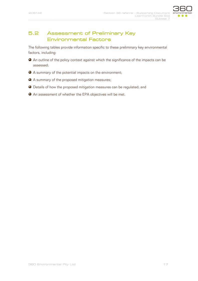
A total of 122 species of waterbirds (Birds Australia Atlas data) have been recorded for the whole of Roebuck Bay, including adjacent wetlands such as parts of Roebuck Plains, Kidney Bean Claypan and Dampier Creek. Of the waterbirds recorded at Roebuck Bay, 43 species are migratory (including 28 shorebirds), 7 species are resident shorebirds, 14 species are gulls and terns, 46 species are waterfowl and 5 species are raptors. The shoreline in the vicinity of the Proposal area is not identified as a key feeding or roosting site (Figure 5).
Three species of turtle frequent Roebuck Bay, including the Loggerhead Turtle (Caretta caretta), Green Turtle (Chelonia mydas) and Flatback Turtle (Natator depressus), which regularly nests in summer months around Cape Villaret near the southern end of Roebuck Bay. There are no published data on turtle populations within Roebuck Bay or their movements within the Ramsar site (Bennelongia 2009).
A 1984 report on numbers of Dugong (Dugong dugon) of the northern waters of Western Australia (Prince 1986) estimated that 50-100 Dugong was a likely population for Roebuck Bay, with the animals occurring in groups of six to eight. The population in Roebuck Bay was recorded feeding on seagrass beds in the northern areas of Roebuck Bay, often within the intertidal zone close to the township of Broome (Bennelongia 2009).

2061AE Section 38 referral – Supporting Document Learmonth Bundle Site
Subsea 7
360 Environmental Pty Ltd 29
ENVIRONMENTAL
ASPECT INHERENT IMPACT MITIGATION MEASURES
TO ADDRESS IMPACTS PROPOSED REGULATORY
MECHANISMS FOR
ENSURING MITIGATION
OUTCOME TO MEET EPA
OBJECTIVE
Dolphins, previously identified as the Irrawaddy Dolphin (Orcaella brevirostris) have been reported to occur in Roebuck Bay. These dolphins are now thought to be a species recently described from the Northern Territory as Orcaella heinsohni (Beasley et al. 2005). There are no published data on dolphin populations within Roebuck Bay or their movements within the Ramsar site (Bennelongia 2009).
Seawall construction Potential minor impacts to water quality (turbidity) due to sediment disturbance on beach (medium sand) during construction
Use of clean rock armour and fill material (low ‘fines’ content) The sand excavated to install the base of the seawall shall be used as a bund to control water ingress into the works area during higher tides. This will assist to reduce water turbidity during high tides and the risk of silting over the mangrove roots
Engineering specification Elevated turbidity is expected to be limited to the immediate surrounds (< 50 m) of the work site at high tide. Biological diversity and ecological integrity of marine fauna will be maintained.
Potential minor noise disturbance during construction (including onshore piling for a
The construction method avoids the use of potentially impacting activities such as marine
None Negligible risk of a significant impact given works will occur above the waterline.
2061AE Section 38 referral – Supporting Document Learmonth Bundle Site
Subsea 7
360 Environmental Pty Ltd 30
ENVIRONMENTAL
ASPECT INHERENT IMPACT MITIGATION MEASURES
TO ADDRESS IMPACTS PROPOSED REGULATORY
MECHANISMS FOR
ENSURING MITIGATION
OUTCOME TO MEET EPA
OBJECTIVE
maximum duration of 5 days)
piling
Figure 5: Map of the Roebuck Bay shorebird roosts, based on aerial photographs (from Bennelongia 2009)
Proposal area

2061AE Section 38 referral – Supporting Document Learmonth Bundle Site
Subsea 7
360 Environmental Pty Ltd 31

2061AE Section 38 referral – Supporting Document Learmonth Bundle Site
Subsea 7
360 Environmental Pty Ltd 32
Table 9: Flora and Vegetation
ENVIRONMENTAL
ASPECT INHERENT IMPACT MITIGATION MEASURES
TO ADDRESS IMPACTS PROPOSED REGULATORY
MECHANISMS FOR
ENSURING MITIGATION
OUTCOME TO MEET EPA
OBJECTIVE
EPA Objective: To protect flora and vegetation so that biological diversity and ecological integrity are maintained. EPA Policy and Guidance: Environmental Factor Guideline - Flora and Vegetation (EPA 2016h) Existing Environment
Some vegetation on the site is native, however it is regrowth following clearing in 1974.
Species present within proposal area: Acacia eriopoda, Buffel Grass (Cenchrus ciliaris), Pemna acuminate, Azidirachta indica.
The buffer for the ‘Monsoon Vine Thickets on the coastal sand dunes of Dampier Peninsula’ threatened ecological community (TEC) occurs across the Proposal area but this TEC is not present (nearest occurrence is ~1 km to the north east).
Seawall construction Direct loss of native vegetation regrowth (since 1974) and weeds (up to 0.38 ha)
Retention of native trees where possible
Plant and equipment certified weed free on arrival at site.
Clearing Permit conditions
Removal of weeds. No threatened or priority flora or communities within clearing area.

2061AE Section 38 referral – Supporting Document Learmonth Bundle Site
Subsea 7
360 Environmental Pty Ltd 33
Table 10: Social Surrounds
ENVIRONMENTAL
ASPECT INHERENT IMPACT MITIGATION MEASURES
TO ADDRESS IMPACTS PROPOSED REGULATORY
MECHANISMS FOR
ENSURING MITIGATION
OUTCOME TO MEET EPA
OBJECTIVE
EPA Objective: To protect social surroundings from significant harm EPA Policy and Guidance: Environmental Factor Guideline - Social Surroundings (EPA 2016i) Existing Environment
Four registered sites in the vicinity of the works (Broome Old Jetty; #12591, Red Bank; #12590, Reserve 21801; #13729, INTAPITJIN/LOT 2065 PORT Dr; # 12410).
The Pioneer Cemetery and the foreshore area in Town Beach Reserve are at erosional risk. The Broome Coastal Vulnerability Study (Cardno 2015) noted that ‘The actively eroding Pindan Cliffs to the west of the groyne near the cemetery need to be stabilised’.
The proposal aims to improve public access, and safety, to this section of the shoreline.
Seawall construction Potential disturbance of the Pioneer Cemetery and the foreshore area in Town Beach Reserve Potential disturbance of heritage site (shell midden)
The seawall design aims to reduce erosion rates and protect the cliff stability thus protecting the Pioneer Cemetery and the foreshore area.
Amendment of seawall design to take account of survey findings and stakeholder comments,
None It is expected the EPA objective can be met. The proposal is seeking to protect public safety and improve public access. Design will seek to minimise impact on heritage sites. The Shire has been in

2061AE Section 38 referral – Supporting Document Learmonth Bundle Site
Subsea 7
360 Environmental Pty Ltd 34
ENVIRONMENTAL
ASPECT INHERENT IMPACT MITIGATION MEASURES
TO ADDRESS IMPACTS PROPOSED REGULATORY
MECHANISMS FOR
ENSURING MITIGATION
OUTCOME TO MEET EPA
OBJECTIVE
including:
Large boab tree of cultural significance to be retained
Seawall to decrease in height at northern end to avoid/reduce impact to midden
Continued fishing access to be provided for in design; and
Drainage design to prevent additional runoff across midden
discussions with Yawuru throughout the process and will continue to seek their input. The Shire will continue to work with Yawuru and Department of Planning, Lands and Heritage to ensure compliance with Aboriginal Heritage Act 1972.

2061AE Section 38 referral – Supporting Document Learmonth Bundle Site
Subsea 7
360 Environmental Pty Ltd 35
6 Other Environmental Factors
The EPA Scoping Guidelines identifies ‘other’ environmental factors that are not considered key factors, but have the potential to be affected by the Proposal.
For this Proposal, no other factors are considered relevant.
The terrestrial vegetation to be cleared consists of an isolated, 0.38 ha, area of native vegetation regrowth (since 1974) and weeds. Due to the small size of the area the impact of the loss is deemed to be of low significance.
As the terrestrial vegetation is isolated from any larger remnant patches, and is in a poor/degraded state, it is unlikely to represent important terrestrial fauna habitat. The isolated mangroves are at the upper limit of their range and are similarly isolated from any larger remnant patches, so are unlikely to represent important marine or terrestrial fauna habitat.

2061AE Section 38 eferral – Supporting Document Learmonth Bundle Site
Subsea 7
360 Environmental Pty Ltd 36
7 Principles of the EP Act
Section 4A of the EP Act outlines the objective of the Act and the principles of environmental protection. This section describes how the five principles of the EP Act have been addressed by the Shire of Broome in the consideration and design of the Proposal. A description of these principles and how they have been considered is provided in Table 11.
Table 11: Principles of the EP Act
PRINCIPLE CONSIDERATION OF PRINCIPLE IN PROPOSAL
1. The Precautionary Principle Where there are threats of serious or irreversible damage, lack of full scientific certainty should not be used as a reason for postponing measures to prevent environmental degradation. In the application of the precautionary principle, decision should be guided by:
a. Careful evaluation to avoid, where practicable, serious or irreversible damage to the environment; and
b. An assessment of the risk-weighted consequences of various options.
The Proposal design has taken into account the existing environment, including the nearby Roebuck Bay Wetland and Monsoon Vine Thickets on the coastal sand dunes of Dampier Peninsula threatened ecological community (TEC).
Mangrove loss has been minimised to that required for the construction of the foot of the proposed seawall.
2. The Principle of intergenerational equity The present generation should ensure that the health, diversity and productivity of the environment is maintained or enhanced for the benefit of future generations.
The Proposal aims to prevent continued erosion of the coastal cliffs which is currently leading to adverse impacts to the environment.
The Proposal will enhance the value of the area for future generations.

2061AE Section 38 eferral – Supporting Document Learmonth Bundle Site
Subsea 7
360 Environmental Pty Ltd 37
PRINCIPLE CONSIDERATION OF PRINCIPLE IN PROPOSAL
3. The Principle of the conservation of biological diversity and ecological integrity
Conservation of biological diversity and ecological integrity should be a fundamental consideration
Impacts to marine or terrestrial vegetation, flora and fauna are not expected to be significant, or pose a risk of loss of biological diversity and ecological integrity.
4. Principles relating to improved valuation, pricing and incentive mechanisms a. Environmental factors should be included in the
valuation of assets and services b. The polluter pays principle – those who generate
pollution and waste should bear the cost of containment, avoidance or abatement.
c. The user of goods and services should pay prices based on the full life cycle costs of providing goods and services, including the use of natural resources and assets and the ultimate disposal of any wastes.
d. Environmental goals, having been established, should be pursued in the most cost effective way, by establishing incentive structures, including market mechanisms, which enable those best placed to maximise benefits and/or minimise costs to develop their own solutions and responses to environmental problems.
Where possible, The Shire of Broome will employ appropriately trained local personnel and source local goods and services.
The Shire of Broome will ensure leading best practice standards during construction to minimise emissions and discharges as far as possible and ensure no negative legacies are created.
Where possible the Shire of Broome will source goods and services that have the least environmental impact.

2061AE Section 38 eferral – Supporting Document Learmonth Bundle Site
Subsea 7
360 Environmental Pty Ltd 38
PRINCIPLE CONSIDERATION OF PRINCIPLE IN PROPOSAL
5. The principle of waste minimisation All reasonable and practicable measures should be undertaken to minimise the generation of waste and its discharge into the environment.
Waste generated from the Proposal will be minimised through the implementation of the hierarchy of waste controls; avoid, re-use, recycle, recover and dispose.

2061AE Section 38 Referral – Supporting Document Learmonth Bundle Site
Subsea 7
360 Environmental Pty Ltd 39
8 Conclusion
The Proposal is to construct a seawall to protect the east side of the Town Beach foreshore reserve, Pioneer Cemetery and the Museum; an approximately 400 m long section of the shoreline. The seawall is proposed to mitigate the extreme level erosion risk identified for this section of coast.
The Project envelope (or ‘the Site’), defining the potential maximum extent of physical disturbance, covers approximately 2.90 ha.
On the basis of the EPA’s ‘Environmental Principles, Factors and Objectives’ guidance the following preliminary key environmental factors have been identified for the Proposal:
Benthic Communities and Habitats;
Coastal Processes;
Marine Fauna;
Flora and vegetation; and
Social Surrounds.
The preliminary key environmental factors have been assessed against the EPA objectives and guidelines and it is considered that the Proposal will meet the EPA’s objectives for these factors given the following:
Direct impacts to BCH are limited to a minor area of isolated mangroves (up to 0.06 ha);
Any impacts to water quality during construction will be limited to local, short term impacts, unlikely to impact BCHs further offshore that are naturally tolerant to periodic high turbidity and suspended sediment concentrations;
Changes in coastal processes adjacent to the proposal area will be localised;
Marine fauna (including migratory birds) are known to be widespread and abundant within the wider Roebuck Bay area, but the proposal area does not represent key habitat, significant habitat loss of noise disturbance is not expected, and the risk of significant impact to marine fauna is low;
The terrestrial vegetation to be cleared consists of an isolated patch of native vegetation regrowth (since 1974) and weeds; and
Four registered Aboriginal heritage sites occur in the vicinity of the works, but none will be significantly impacted, and the design of the seawall has taken into account the comments from Yawuru Native Title Holders.
Significant community and stakeholder consultation has been undertaken.
2061AE Section 38 Referral – Supporting Document Learmonth Bundle Site
Subsea 7
360 Environmental Pty Ltd 40
9 References
Baird Australia Pty Ltd. 2017. Broome Townsite Coastal Hazard Risk Management and Adaptation Plan.
Bennelongia (2009). Ecological Character Description for Roebuck Bay. Report to the Department of Environment and Conservation. Bennelongia Pty Ltd, Jolimont.
Cardno. 2015. Broome Coastal Vulnerability Study. Final Report. 59914800. 14 May 2015.
EPA. 2016a. Instructions on how to prepare and Environmental Review Document, EPA, Western Australia.
EPA. 2016b. Instructions for the referral of a Proposal to the Environmental Protection Authority under Section 38 of the Environmental Protection Act 1986 (EPA 2016);
EPA. 2016c. Instructions on how to define the key characteristics of a proposal, EPA, Western Australia.
EPA 2016d, Environmental Factor Guideline: Benthic Communities and Habitats, EPA, Western Australia.
EPA 2016e, Technical Guidance – Protection of Benthic Communities and Habitats, EPA, Western Australia.
EPA 2016f, Environmental Factor Guideline: Coastal Processes, EPA, Western Australia.
EPA 2016g, Environmental Factor Guideline: Marine Fauna, EPA, Western Australia.
EPA 2016h, Technical Guidance – Protecting the Quality of Western Australia’s Marine Environment, EPA, Western Australia.
EPA 2016i, Environmental Factor Guideline: Flora and Vegetation, EPA, Western Australia.
EPA 2016j, Environmental Factor Guideline: Social Surroundings, EPA, Western Australia.
McKenzie, L.J., Yoshida, R.L., Langlois, L., Rau, J., Weatherall, K., Bishop, F., Bain, D., Ferguson, S. and Lindsay, M. (2017). Long‐term seagrass monitoring in Roebuck Bay, Broome: Report on the first 10 years. A report for the Broome Community Seagrass Monitoring Project, Environs Kimberley. Centre for Tropical Water & Aquatic Ecosystem Research (TropWATER) report 17/35. James Cook University, Cairns, Australia. 44 pp.

2061AE Section 38 Referral – Supporting Document Learmonth Bundle Site
Subsea 7
360 Environmental Pty Ltd 41
MP Rogers. 2017. Town Beach Seawall & Associated Works - Technical Specification. R911 Rev 4. December 2017.
Piersma, T., Pearson, G., Lavaleye, M., Hickey, R., Rogers, D., Holthuijsen, S., Marin-Estrella, S., de Goeij, P., Findlay, N., and Storey, A. 2016. Anna Plains and Roebuck Bay Benthic Invertebrate Mapping 2016.

2061AE Section 38 Referral – Supporting Document Learmonth Bundle Site
Subsea 7
360 Environmental Pty Ltd 42
10 Limitations
This report is produced strictly in accordance with the scope of services set out in the contract or otherwise agreed in accordance with the contract. 360 Environmental makes no representations or warranties in relation to the nature and quality of soil and water other than the visual observation and analytical data in this report.
In the preparation of this report, 360 Environmental has relied upon documents, information, data and analyses (“client’s information”) provided by the client and other individuals and entities. In most cases where client’s information has been relied upon, such reliance has been indicated in this report. Unless expressly set out in this report, 360 Environmental has not verified that the client’s information is accurate, exhaustive or current and the validity and accuracy of any aspect of the report including, or based upon, any part of the client’s information is contingent upon the accuracy, exhaustiveness and currency of the client’s information. 360 Environmental shall not be liable to the client or any other person in connection with any invalid or inaccurate aspect of this report where that invalidity or inaccuracy arose because the client’s information was not accurate, exhaustive and current or arose because of any information or condition that was concealed, withheld, misrepresented, or otherwise not fully disclosed or available to 360 Environmental.
Aspects of this report, including the opinions, conclusions and recommendations it contains, are based on the results of the investigation, sampling and testing set out in the contract and otherwise in accordance with normal practices and standards. The investigation, sampling and testing are designed to produce results that represent a reasonable interpretation of the general conditions of the site that is the subject of this report. However, due to the characteristics of the site, including natural variations in site conditions, the results of the investigation, sampling and testing may not accurately represent the actual state of the whole site at all points.
It is important to recognise that site conditions, including the extent and concentration of contaminants, can change with time. This is particularly relevant if this report, including the data, opinions, conclusions and recommendations it contains, are to be used a considerable time after it was prepared. In these circumstances, further investigation of the site may be necessary.
Subject to the terms of the contract between the Client and 360 Environmental Pty Ltd, copying, reproducing, disclosing or disseminating parts of this report is prohibited (except to the extent required by law) unless the report is produced in its entirety including this page, without the prior written consent of 360 Environmental Pty Ltd.

10 Bermondsey Street West Leederville WA 6007 t (+618) 9388 8360 f (+618) 9381 2360PO BOX 14, West Perth WA 6872
w 360environmental.com.au e [email protected]