Second World War anti-invasion defences in South and South-West ...
685
SECOND WORLD WAR ANTI-INVASION DEFENCES IN SOUTH AND SOUTH- WEST WALES: A COMPARATIVE CASE STUDY AREA BASED APPROACH By JONATHAN ANDREW BERRY A thesis submitted to the University of Birmingham for the degree of DOCTOR OF PHILOSOPHY Ironbridge International Institute for Cultural Heritage School of History and Cultures College of Arts and Law University of Birmingham JANUARY 2016
Transcript of Second World War anti-invasion defences in South and South-West ...
SECOND WORLD WAR ANTI-INVASION DEFENCES IN SOUTH AND SOUTH-
WEST WALES: A COMPARATIVE CASE STUDY AREA BASED APPROACH
By
JONATHAN ANDREW BERRY
A thesis submitted to the University of Birmingham for the degree of DOCTOR OF
PHILOSOPHY
Ironbridge International Institute for Cultural Heritage
School of History and Cultures
College of Arts and Law
University of Birmingham
JANUARY 2016

University of Birmingham Research Archive
e-theses repository This unpublished thesis/dissertation is copyright of the author and/or third parties. The intellectual property rights of the author or third parties in respect of this work are as defined by The Copyright Designs and Patents Act 1988 or as modified by any successor legislation. Any use made of information contained in this thesis/dissertation must be in accordance with that legislation and must be properly acknowledged. Further distribution or reproduction in any format is prohibited without the permission of the copyright holder.

ABSTRACT
Conflict archaeology is a popular subject of academic research. Within the topic of
British Second World War archaeology there are few studies examining anti-invasion
defences, and none relating to the evidence or its use. This research was influenced
by concepts in historical and conflict archaeology and the archaeologies of the recent
and contemporary past. It was undertaken to determine the extent of survival of
archaeological, documentary, aerial photographic and cartographic evidence for three
cases in south and south-west Wales. Case study method was used to identify, select
and analyse evidence. Grounded theory was used to induce meaning. The evidence
was given equal primacy, assessed critically and analysed for its role, value and
contribution. Official sources were used for their unique, informed and authoritative
content. Knowledge of military organisational practices and formation/unit identities
were required to use the evidence effectively. A rich but incomplete evidence base of
a complex character was identified. Evidence was found to be complementary and
inter-dependent, representing aspects of a common shared phenomenon. The diverse
sources could be used to induce meaningful narratives. The research suggested that
an archaeological approach was a valid and effective form of inquiry when applied to
cross-disciplinary evidence from the recent past.

Dedicated to Nigel Berry, 1945-2003.

ACKNOWLEDGEMENTS
I would like to express my sincere gratitude to Dr John Carman for his helpful
advice, understanding and encouragement throughout. This work benefitted from his
insightful comments and I could not wish for a better supervisor.
Many organisations provided access to data. I would like to thank Glamorgan-
Gwent Archaeological Trust, Dyfed Archaeological Trust and the Royal Commission
on the Ancient and Historical Monuments for Wales for access to their datasets. The
help of the archival staff at The National Archives, RAF Museum, Imperial War
Museum and local record offices in Wales is gratefully acknowledged. Nigel Williams
of the Llantwit Major Local History Society provided kind access to their collections,
for which I am very appreciative. I would also like to thank Derek Elliott, Tina
Moseley and Vivien Davies at Welsh Government’s Aerial Photography Unit for
access to their digitised aerial photography. I am very grateful to the landowners,
including the Ministry of Defence, who allowed me to visit sites on their land.
Many colleagues were very generous in commenting on my ideas. I am
particularly thankful to Roger J.C. Thomas and Wayne Cocroft of Historic England
and to colleagues involved with the Welsh Conflict Archaeology Advisory Panel and
the Modern Conflict Archaeology conference.
I would like to thank my family and friends for their support, without whose
encouragement and frequent prompting to go to the study, I would not have finished
this thesis.
I recognise that this research would not have been possible without the
financial assistance of Cadw. I really am very grateful.

TABLE OF CONTENTS
1. Introduction 1
1.1 Overview 1
1.2 Characterising the research context 2
1.3 Characterising the historical context 5
1.3.1 The developmental phases of inland defence preparation 5
1.3.2 The developmental phases of airfield defence preparation 9
1.3.3 The developmental phases of coast artillery defence preparation 13
1.4 Characterising the research resource 15
1.4.1 Defence posts 15
1.4.2 Linear defences 16
1.4.3 Airfield defences 17
1.4.4 Coast defences 18
1.5 Research problem 19
1.6 Research questions 20
1.7 Motivations for selecting the research topic 21
1.7.1 Personal experience 21
1.7.2 Professional experience 22
1.7.3 Absence of previous research 23
1.8 Relevance of the research topic 24
1.9 Research methodology 27
1.10 Limitations of the study 29
1.11 Summary of thesis structure 32
2. Literature review 34
2.1 Introduction 34
2.2 The wider interdisciplinary context 34
2.2.1 Second World War historiography 34
2.2.2 Twentieth-century Welsh conflict historiography 37
2.2.3 Military history 38
2.2.4 Military geographies 40
2.3 Conflict archaeology as historical and contemporary archaeology 41
2.4 Profiling historical archaeology 42
2.5 Documentary archaeology 47
2.5.1 Text-aided archaeology 49
2.5.2 Critiques of documentary archaeology 50
2.6 Archaeologies of the recent and contemporary pasts 52
2.7 Recent trends in conflict archaeology 56
2.8 Twentieth century or modern conflict archaeology 60
2.8.1 First World War archaeology 61
2.8.2 Cold War archaeology 64

2.9 Second World War archaeology 65
2.9.1 British Second World War archaeology 67
2.10 Anti-invasion defence archaeology in the United Kingdom 69
2.10.1 Enthusiast-led studies 69
2.10.1.1 The Home Front 70
2.10.1.2 Anti-invasion defences 71
2.10.1.3 Military airfields 74
2.10.1.4 Coastal artillery 75
2.10.2 Professional archaeological interest 76
2.11 Summary 90
3. Sources 92
3.1 Introduction 92
3.2 Overview of research sources 93
3.3 Archaeological evidence 93
3.3.1 Author, audience and social setting 94
3.3.2 Format 94
3.3.3 Content 94
3.3.4 Purpose 95
3.3.5 Status 95
3.3.6 Treatment 96
3.3.7 Contemporary meaning 96
3.4 Documentary evidence 96
3.4.1 Records preserved at The National Archives 97
3.4.2 War diaries preserved at The National Archives 98
3.4.2.1 Author, audience and social setting 98
3.4.2.2 Format 99
3.4.2.3 Content 100
3.4.2.4 Purpose 101
3.4.2.5 Status 102
3.4.2.6 Treatment 102
3.4.2.7 Contemporary meaning 103
3.4.3 Registered files 107
3.4.3.1 Author, audience and social setting 107
3.4.3.2 Format 107
3.4.3.3 Content 108
3.4.3.4 Purpose 109
3.4.3.5 Status 109
3.4.3.6 Treatment 109
3.4.3.7 Contemporary meaning 110
3.5 Aerial photographic evidence 110

3.5.1 Author, audience and social setting 111
3.5.2 Format 111
3.5.3 Content 112
3.5.4 Purpose 112
3.5.5 Status 113
3.5.6 Treatment 113
3.5.7 Contemporary meaning 114
3.6 Cartographic evidence 119
3.6.1 Author, audience and social setting 119
3.6.2 Format 120
3.6.3 Content 120
3.6.4 Purpose 122
3.6.5 Status 123
3.6.6 Treatment 124
3.6.7 Contemporary meaning 124
3.7 Summary 125
4. Methodology 127
4.1 Introduction 127
4.2 Methodology 127
4.2.1 Grounded theory method 130
4.3 Method 131
4.3.1 Preparation 132
4.3.1.1 Contextual research 132
4.3.1.2 Establishing military formation/unit presence and identity 133
4.3.2 Case study method 134
4.3.2.1 Justification 135
4.3.2.2 Critique 137
4.3.2.3 Design 138
4.3.2.4 Unit of analysis 138
4.3.2.5 Quality 140
4.3.2.6 Case selection 142
4.3.3 Data identification 145
4.3.4 Data selection criteria 147
4.3.4.1 Use of official sources 148
4.3.4.2 Archaeological data 150
4.3.4.3 Documentary data 150
4.3.4.4 Cartographic data 150
4.3.4.5 Aerial photographic data 151
4.3.4.6 Discounted forms of evidence 152
4.3.4.7 Final subject source selection 153

4.3.5 Data collection 153
4.3.5.1 Data collection principles with reference to the case method 153
4.3.6 Collection: archaeological data 155
4.3.6.1 HER/NMRW data 155
4.3.6.2 Fieldwork 155
4.3.6.3 Data organisation 156
4.3.7 Collection: documentary data 157
4.3.7.1 Data organisation 158
4.3.8 Collection: cartographic data 158
4.3.8.1 Data organisation 159
4.3.9 Collection: aerial photographic 159
4.3.9.1 Data organisation 160
4.3.10 Analysis 160
4.3.11 Analysis: archaeological data 161
4.3.12 Analysis: documentary data 161
4.3.12.1 Coding 161
4.3.12.2 Critique 163
4.3.13 Analysis: cartographic and aerial photographic data 163
4.3.14 Intra-case comparison 164
4.3.15 Inter-case cross-comparison 167
4.4 Limitations/Delimitations 167
4.5 Ethical statement 168
4.5.1 Fieldwork practice 168
4.5.2 Ethical dimensions to the archaeological study of warfare 168
4.6 Summary 171
5. Case Study 1: St Athan-Llandow 173
5.1 Introduction 173
5.2 Case study description 173
5.2.1 Topography, hydrology, geology and human geography 174
5.2.2 Landscape change 176
5.3 Existing source evidence 179
5.3.1 Known archaeological evidence 179
5.3.2 Published sources 182
5.3.2.1 Military airfields 182
5.3.2.2 Anti-invasion defences 184
5.3.3 Unpublished reports 184
5.3.3.1 Grey literature research from Public Record Office sources 184
5.3.3.2 Ministry of Defence commercial archaeological reports 185
5.3.3.3 Cadw-funded twentieth century military designation projects 186
5.3.3.4 Unpublished academic research 187

5.4 New source evidence 187
5.4.1 New archaeological results from rapid field observation 187
5.4.1.1 New defence sites 187
5.4.1.2 New understanding of existing sites 188
5.4.1.3 Sites not identified 190
5.4.2 New documentary source evidence 190
5.4.2.1 Missing files 190
5.4.3 Military administrative geography, formations and units 191
5.4.3.1 Military administrative geography: South Wales Area/District 191
5.4.3.2 Military units available for defence 193
5.4.3.3 Regular mobile Field Force troops 196
5.4.3.4 Static troops 198
5.4.3.5 Home Guard 200
5.4.3.6 10 Battalion Glamorgan Home Guard Defence Scheme 200
5.4.4 New documentary source evidence: sites 201
5.4.4.1 Severn Sub-Area Home Defence Scheme No. 2 201
5.4.4.2 10 Battalion Glamorgan Home Guard Defence Scheme 203
5.4.4.3 Airfield defence schemes 206
5.4.4.4 Minefields 207
5.4.4.5 Canadian pipe mines 208
5.4.4.6 Obstruction of landing grounds 209
5.4.4.7 Coast artillery 210
5.4.4.8 Defence batteries 210
5.4.4.9 Uninformative records 212
5.4.5 Aerial photographic source evidence 212
5.4.5.1 Coverage 214
5.4.5.2 Wartime low-level oblique 214
5.4.5.3 Wartime vertical (all scales) 215
5.4.5.4 Operation Revue (1945-1952) 216
5.4.6 Cartographic source evidence 216
5.4.6.1 Air Ministry Record Site Plans 217
5.4.6.2 ‘B’ Company, 10 Battalion, Glamorgan Home Guard plan 221
5.4.6.3 Welch Regiment Museum Home Guard Battalion areas plan 224
5.4.6.4 War Office Cassini mapping 224
5.4.6.5 Missing plans 225
5.5 Contribution and role of evidential sources 226
5.5.1 Archaeological evidence 226
5.5.2 Primary documentary evidence 228
5.5.3 Aerial photographic evidence 230
5.5.4 Cartographic evidence 233
5.6 Summary 236
6. Case Study 2: Swansea-Gower 238
6.1 Introduction 238
6.2 Case study description 238
6.2.1 Topography, hydrology, geology and human geography 239
6.2.1.1 Gower 240
6.2.1.2 Swansea 242
6.2.2 Industrial Swansea during the Second World War 243
6.2.3 Landscape change 245
6.3 Existing source evidence 246
6.3.1 Known archaeological evidence 246
6.3.2 Published sources 247
6.3.3 Unpublished reports 248
6.4 New source evidence 250
6.4.1 New archaeological results from rapid field observation 251
6.4.1.1 New defence sites 251
6.4.1.2 New understanding of existing sites 252
6.4.1.3 Demolition of previously recorded archaeological sites 252
6.4.2 New documentary source evidence 253
6.4.2.1 Military administrative geography, formations and units 253
6.4.2.2 Swansea Defence Scheme No. 2 254
6.4.2.3 Military administrative geography: Swansea Garrison 256
6.4.2.4 Military operational geography: Swansea Garrison 257
6.4.2.5 Military units available for defence 258
6.4.2.6 Defence arrangements for Swansea and the Gower 260
6.4.3 New documentary source evidence: sites 262
6.4.3.1 Swansea Garrison war diary 262
6.4.3.2 Swansea Defence Scheme No. 2 265
6.4.3.3 Airfield defence schemes 267
6.4.3.4 Minefields 270
6.4.3.5 Barrel flame traps 271
6.4.3.6 Roadblocks 271
6.4.3.7 Canadian pipe mines 272
6.4.3.8 Obstructions on the foreshore 273
6.4.3.9 Petroleum warfare defences 273
6.4.3.10 Coast artillery 274
6.4.3.11 Defence batteries 277
6.4.4 Aerial photographic source evidence 279
6.4.4.1 Wartime low-level oblique 279
6.4.4.2 Wartime vertical (all scales) 280
6.4.4.3 Operation Revue (1945-1952) 281

6.4.5 Cartographic source evidence 281
6.4.5.1 Air Ministry Record Site Plans 282
6.4.5.2 Swansea Garrison Headquarters war diary plans 283
6.4.5.3 Mumbles Island Fort Record Book plans 286
6.4.5.4 Mumbles Hill Fort Record Book plans 289
6.5 Contribution and role of evidential sources 291
6.5.1 Archaeological evidence 291
6.5.2 Primary documentary evidence 293
6.5.3 Aerial photographic evidence 295
6.5.4 Cartographic evidence 297
6.6 Summary 299
7. Case Study 3: Carmarthen Stop Line 301
7.1 Introduction 301
7.2 Case study description 301
7.2.1 Topography, hydrology, geology and human geography 302
7.2.2 The Carmarthen Stop Line 305
7.2.3 Landscape change 306
7.3 Existing source evidence 306
7.3.1 Known archaeological evidence 307
7.3.2 Published sources 309
7.3.3 Unpublished reports 312
7.4 New source evidence 314
7.4.1 New archaeological results from rapid field observation 314
7.4.1.1 New defence sites 315
7.4.1.2 New understanding of existing sites 316
7.4.1.3 Demolition of previously recorded archaeological sites 318
7.4.2 New documentary source evidence 318
7.4.2.1 Military administrative geography: South Wales Area/District 319
7.4.2.2 Military units available for defence 320
7.4.2.3 Static troops 323
7.4.2.4 Home Guard 324
7.4.3 New documentary source evidence: sites 328
7.4.3.1 The establishment of the Carmarthen Stop Line 328
7.4.3.2 Construction of defence works 331
7.4.3.3 Minefields 336
7.4.3.4 Canadian pipe mines 337
7.4.3.5 Obstruction of landing grounds 338
7.4.3.6 Coast artillery 339
7.4.3.7 Defence batteries 340
7.4.4 Aerial photographic source evidence 343

7.4.5 Cartographic source evidence 348
7.4.5.1 Ministry of Agriculture and Fisheries plans 349
7.4.5.2 Air Ministry Record Site Plans 352
7.4.5.3 War Office Cassini mapping 354
7.4.5.4 Admiralty plan for Milford Haven RN Mine Depot 355
7.4.5.5 Missing maps 355
7.5 Contribution and role of evidential sources 361
7.5.1 Archaeological evidence 361
7.5.2 Primary documentary evidence 363
7.5.2.1 Missing files 364
7.5.3 Aerial photographic evidence 365
7.5.4 Cartographic evidence 367
7.6 Summary 370
8 Discussion 372
8.1 Introduction 372
8.2 Discussion of case study results 373
8.2.1 Archaeological evidence 373
8.2.2 Primary documentary evidence 374
8.2.3 Aerial photographic evidence 377
8.2.4 Cartographic evidence 379
8.2.5 Use of the results 380
8.2.6 Review of case study chapters’ structure 382
8.3 Effectiveness of the methodology 382
8.3.1 Identification of new records 383
8.3.2 Identification of new anti-invasion defence sites 384
8.3.3 Identification of new types of anti-invasion defences 385
8.3.4 Placement of the defence arrangements in their original context 385
8.3.5 Production of holistic narrative accounts 387
8.3.6 Extent of wartime and post-war clearance and redevelopment 388
8.4 Comparison with other approaches 388
8.4.1 Dobinson’s documentary research 389
8.4.2 Redfern’s documentary research 391
8.4.3 Defence of Britain project 392
8.4.4 Defence Areas project 392
8.4.4.1 Relative advantages/disadvantages of each approach 393
8.4.4.2 Range of evidence 394
8.4.4.3 Results 394
8.5 Case study selection criteria 395
8.5.1 Case study selection strategies 395
8.5.1.1 Case study selection by historical documentation 396
8.5.1.2 Advantages of using a military area-based approach 397
8.5.1.3 Disadvantages of using a military area-based approach 398
8.5.1.4 Optimal case study size 399
8.5.2 A new way of framing anti-invasion defence research 400
8.6 Summary 401
9. Conclusions 406
9.1 Introduction 406
9.2 Research summary 406
9.3 Research constraints 410
9.3.1 Approach 411
9.3.2 Scope 411
9.3.3 Sources 412
9.4 Methodological evaluation 413
9.4.1 Dataset choice 414
9.4.2 Data collection 415
9.4.3 Usefulness of the data 416
9.4.4 Case study approach 417
9.4.5 Case study area selection 417
9.4.6 Developing insight 418
9.5 Original research contribution 418
9.5.1 New formalisation of the research topic 419
9.5.2 New knowledge about the research methodology 419
9.5.3 New empirical data 420
9.5.4 New knowledge about the research problem 421
9.5.5 New contribution to understanding 423
9.5.5.1 Archaeology alone cannot provide the entire story 423
9.5.5.2 Necessity of utilising a contextual approach 424
9.5.5.3 Evidence for the very recent past can be incomplete 425
9.5.5.4 Wales was not a military backwater 426
9.6 Next steps 426
9.6.1 Enhanced research engagement across Wales 427
9.6.2 Identification, cataloguing and analysis of source evidence 428
9.6.3 Expansion of research investigation to other types of records 428
9.6.4 Development of military administrative and operational narratives 429
9.6.5 Site gazetteers 429
9.6.6 Post-depositional processes 429
9.6.7 Interpreting the meaning of the defences outlined in this research 430
9.6.8 Application of GIS analysis 430
9.6.9 Identification of fieldworks 431
9.7 Research implications 431

LIST OF ILLUSTRATIONS
Figure Title Page
5.1 St Athan-Llandow case study area location 174
6.1 Swansea-Gower case study area location 239
7.1 Carmarthen Stop Line case study area location 302
Plate Title Page
1.1 Examples of common anti-invasion defences 6
3.1 Army Form C.2118. Western Command General Staff War Diary entry for 1-13 July 1940. Operation Instruction No. 7 of 5 July ordered the construction of the anti-invasion stop lines in Wales (TNA WO 166/94)
105
3.2 Appendix A to Western Command Operation Instruction No. 7 of 5 July 1940 listing the command stop lines to be constructed (TNA WO 166/94)
106
3.3 Example of the detail captured by a high quality vertical aerial photograph of East Blockhouse coast battery, Pembrokeshire taken with a camera with a 5-inch focal length at 6,000ft. Frame 10483, sortie 61/1, 24 June 1940. Copyright: Welsh Government Air Photographic Unit
115
3.4 Low-level oblique aerial photograph of a freshly excavated trench system at Barmouth, Merionethshire taken with a camera with a 5-inch focal length. Frame 40, sortie S/439, 24 August 1941. Copyright: Welsh Government Air Photographic Unit
116
3.5 Example of a Central Interpretation Unit plot showing the geographic footprint of each vertical image between Porthkerry and Porthcawl, Glamorgan. Sortie S/739, 15 January 1942. Copyright: Welsh Government Air Photographic Unit
117
3.6 A distribution plot of wartime reconnaissance sorties and aerial photographic coverage held by CRAPW. Copyright: Welsh Government Air Photographic Unit
118
5.1 Defence Posts sketch plan from ‘B’ Coy, 10 Bn Glamorgan Home Guard Defence Scheme, April 1943
223
6.1 1934 GWR plan of Swansea Harbour and Docks annotated in January 1942 (TNA WO 166/6880)
284
6.2 Map showing Swansea Garrison, Sub-Sector boundaries and defended localities (TNA WO166/6880)
285
6.3 Map showing the Mumbles Sub-Sector defences (Gower Defence Scheme), May 1943 (TNA WO166/6880)
288
6.4 299 Battery Defence Plan detailing defence arrangements for Mumbles Hill coast battery and Tutt’s Head Coast Guard Station as preserved in Mumbles Hill coast battery Fort Record Book (TNA WO 192/320)
290

7.1 Plan depicting natural defences, excavation, concrete cubes and block houses for southern (Pembrey – Ferryside) section of Carmarthen Stop Line (TNA MAF 112/204)
358
7.2 Plan depicting natural defences, excavation, concrete cubes and block houses for central (Carmarthen – Henllan) section of Carmarthen Stop Line (TNA MAF 112/204)
359
7.3 Plan depicting natural defences, excavation, concrete cubes and block houses for northern (Llangrannog – Aber-banc) section of Carmarthen Stop Line (TNA MAF 112/204)
360

LIST OF TABLES
Table Title Page
1.1 Known stop lines established in Wales listed by earliest identified documentary source
8
1.2 Dates of opening and initial functions of Second World War airfields in Wales
10
1.3 Known airfields within twenty miles of vulnerable ports in Wales as listed in the Taylor Report accompanying AM letter S 5342/DGD, 27/09/40 (TNA AIR 14/196)
12
1.4 Known existing port defences and newly established emergency coast defence batteries in Wales during the Second World War
14
1.5 Known vulnerable beaches defended in Wales listed by earliest identified documentary source
19
2.1 Published county-based surveys of anti-invasion defences 72
2.2 Publications written on Welsh wartime airfields 74
2.3 List of grey literature reports and publications arising from Colin Dobinson’s archival research for the English Heritage Monuments Protection Programme (after Dobinson 1998)
79
2.4 Numbers of defence sites identified per unitary authority in Wales excluding Wrexham as of 14/09/2001 (after Council for British Archaeology 2001)
82
2.5 Numbers of defence sites identified for three counties in England as of 14/09/2001 (after Council for British Archaeology 2001)
82
2.6 Numbers of defence sites identified per unitary authority in Wales as recorded on updated 2006 database. +/- change from 2001 results indicated in square brackets (Archaeological Data Service 2014)
83
2.7 Indicative list of key modern conflict reports commissioned by English Heritage (after English Heritage (2004) and Roger JC Thomas pers. comm.)
85
2.8 Cadw-funded reports written by the Welsh Archaeological Trusts on Welsh wartime airfields
89
4.1 Principal Army formations located in / responsible for Wales from September 1939 to December 1942 inclusive
133
4.2 Different types and examples of cases considered for this research 144
4.3 Summary of chosen case study areas and their selection attributes 145
4.4 Grading scales for categorising the value, role and contribution of evidence types and evidence sub-types
166
5.1 St Athan-Llandow case study area corner co-ordinates 173
5.2 Countryside Council for Wales’s LANDMAP geological evaluation classification data for the St Athan-Llandow case study area
175
5.3 Summary of twentieth century military records held by GGAT and the RCAHMW
179
5.4 Summary of twentieth century records held by GGAT for the Vale of Glamorgan and case study area by Site Type
180

5.5 Summary of twentieth century records held by the RCAHMW for the Vale of Glamorgan and case study area by Site Type
181
5.6 Comparison of HER and NMRW records for major defence groupings within St Athan-Llandow case study area
181
5.7 Defence sites in St Athan-Llantwit Major case study area identified by Redfern (1998b) in records at the PRO
185
5.8 Documentary sources of relevance to St Athan-Llantwit Major case study area preserved at The National Archives
192
5.9 Units located at RAF St Athan as described in Severn Sub-Area Home Defence Scheme No. 2, 14 December 1940 and subsequent amendments (TNA WO 166/1314)
194
5.10 Units located at RAF Llandow as described in Severn Sub-Area Home Defence Scheme No. 2, 14 December 1940 and subsequent amendments (TNA WO 166/1314)
195
5.11 Field Force provision in St Athan-Llandow case study area, 1939-42
197
5.12 Provision of static troops in St Athan-Llandow case study area, 1939-42
199
5.13 Locations of defence sites cited in Severn Sub-Area’s Home Defence Scheme No. 2 and subsequent amendments (TNA WO 166/1314)
202
5.14 Locations of defence sites cited in ‘B’ Coy, 10 Battalion, Glamorgan Home Guard Defence Scheme document, April 1943
204
5.15 Disposition of ‘B’ Company, 10 Battalion, Glamorgan Home Guard troops and weaponry in April 1943 as described in Defence Scheme documentation
205
5.16 Operations Record Books for RAF St Athan and RAF Llandow preserved at The National Archives
207
5.17 References to minefields within the St Athan-Llandow case study area, 1940 preserved at The National Archives
208
5.18 References to Canadian Pipe Mines within the St Athan-Llandow case study area, 1941 preserved at The National Archives
209
5.19 Land targets for engagement by six-inch guns at Nell’s Point 210
5.20 Activities and artillery emplacements of the 959 Defence Battery, RA in case study area during 1940-41 as described in the unit’s war diary
211
5.21 Records examined at The National Archives that did not yield information for the St Athan-Llandow case study area
212
5.22 Summary of quantities of aerial photographic frames collected for St Athan-Llandow case study area by year and by source
212
5.23 Summary of aerial photographic evidence for St Athan-Llandow case study area
213
5.24 Summary of cartographic evidence identified for St Athan-Llantwit Major case study area
217
5.25 Summary of cartographic evidence produced by the Air Ministry Works Directorate’s No. 19 Works Area identified for RAF St Athan and RAF Llandow at The National Archives
218

5.26 Summary of cartographic evidence identified for RAF St Athan and RAF Llandow at the RAF Museum
219
5.27 No. 1 Platoon defence post information contained within key of ‘B’ Coy 10 Bn, Glamorgan Home Guard Defence Posts sketch plan, April 1943
222
5.28 No. 2 Platoon defence post information contained within key of ‘B’ Coy 10 Bn, Glamorgan Home Guard Defence Posts sketch plan, April 1943
222
5.29 No. 3 Platoon defence post information contained within key of ‘B’ Coy 10 Bn, Glamorgan Home Guard Defence Posts sketch plan, April 1943
222
5.30 Summary of GSGS3906 and GSGS3907 maps identified in case study area
225
5.31 Summary of value, role and contribution of archaeological evidence for the St Athan-Llantwit Major case study area
226
5.32 Summary of value, role and contribution of primary documentary evidence for the St Athan-Llantwit Major case study area
228
5.33 Summary of value, role and contribution of aerial photographic evidence for the St Athan-Llantwit Major case study area
230
5.34 Summary of value, role and contribution of cartographic evidence for the St Athan-Llantwit Major case study area
233
6.1 Countryside Council for Wales’s LANDMAP geological evaluation classification data for Gower
241
6.2 Countryside Council for Wales’s LANDMAP geological evaluation classification data for Swansea
242
6.3 Summary of twentieth century military records held by GGAT and the RCAHMW
246
6.4 Documentary sources of relevance to Swansea-Gower case study area preserved at The National Archives
253
6.5 Recipients of Swansea Defence Scheme No. 2, January 1942 255
6.6 List of detailed appendices for Swansea Defence Scheme No. 2 and date of issue
256
6.7 Roles of static forces in Swansea-Gower case study area, 1942 257
6.8 List of troops available for defence of garrison area, January 1942 259
6.9 References to Mushroom and anti-tank minefields in the Swansea-Gower case study area (TNA WO 199/37)
270
6.10 References to works regarding installation of Canadian Pipe Mines in the Swansea-Gower case study area, 12/07/41 (TNA WO 199/52)
272
6.11 References to works regarding installation of Canadian Pipe Mines by No. 3 Section, 179 Special Tunnelling Company, RE in the Swansea-Gower case study area, 14/11/41 (TNA WO 166/3655)
272
6.12 References to prepared obstructions of the foreshore in the Swansea-Gower case study area, 26/02/43 (TNA WO 199/103)
273
6.13 References to petroleum warfare defences in the Swansea-Gower case study area, preserved in correspondence at The National Archives
274

6.14 Summary of wartime aerial photographic evidence for Swansea-Gower case study area. Presented in chronological order
279
6.15 Summary of quantities of aerial photographic frames collected for Swansea-Gower case study area by year and by source
281
6.16 Summary of cartographic evidence identified for Swansea-Gower case study area
282
6.17 Summary of cartographic evidence identified for RAF Fairwood Common
282
6.18 Summary of cartographic evidence identified from Swansea Garrison HQ war diary, 1942 (TNA WO 166/6880)
283
6.19 Summary of cartographic evidence identified from Mumbles Island Fort Record Book (TNA WO 192/156)
287
6.20 Summary of cartographic evidence identified from Mumbles Hill Fort Record Book (TNA WO 192/320)
289
6.21 Summary of value, role and contribution of archaeological evidence for the Swansea-Gower case study area
291
6.22 Summary of value, role and contribution of primary documentary evidence for the Swansea-Gower case study area
293
6.23 Distribution analysis of selected anti-invasion defences for Swansea-Gower case study area as identified from Swansea Garrison war diary
294
6.24 Summary of value, role and contribution of aerial photographic evidence for the Swansea-Gower case study area
295
6.25 Summary of value, role and contribution of cartographic evidence for the Swansea-Gower case study area
297
7.1 Carmarthen Stop Line case study area corner co-ordinates 301
7.2 Summary of twentieth century military records held by DAT and the RCAHMW
307
7.3 Summary of case study area Second World War gun emplacements after Wood (2012)
311
7.4 Selected formation and unit related entries from Carmarthen Sub-Area Headquarters War Diary, 08/40-12/41 (TNA WO 166/1270)
321
7.5 Selected formation and unit related entries from 2 / 47 (London) Infantry Division Headquarters War Diary, 08/40-02/41 (TNA WO 166/566)
322
7.6 Selected formation and unit related entries from 36 Independent Infantry Brigade Headquarters War Diary, 11/40-08/41 (TNA WO 166/950)
322
7.7 Selected formation and unit related entries from 31 Independent Brigade Group Headquarters War Diary, 07/40-12/41 (TNA WO 166/942)
323
7.8 Selected formation and unit related entries from Carmarthen Sub-Area Headquarters War Diary, 01-12/42 (TNA WO 166/6729)
323
7.9 Static troops listed in case study area by chronological date extracted from the Western Command General Staff War Diary from 09/39-12/40 (TNA WO 166/94)
324

7.10 Static troops listed in case study area by chronological date extracted from the Western Command General Staff War Diary from 01-12/42 (TNA WO 166/6025)
324
7.11 Home Guard battalions cited in the Home Guard List for Western Command for February 1941 (IWM 02(41).95 [Home Guard]/5-2)
325
7.12 Carmarthenshire Home Guard battalion and company locations identified in 3 Carmarthen Bn. Home Guard Operational Order No. 1, Appendix A: Static Troops Under Operational Comd. of Sub-Area in Bn. Area, 19 June 1941, (Carmarthenshire Archives CDX/429)
326
7.13 3 Bn, Carmarthenshire Home Guard defence site locations identified in Operational Instruction No. 3, Appendix J: Intercommunication, 17 July 1943, (Carmarthenshire Archives CDX/429)
326
7.14 Carmarthenshire Home Guard battalion and company locations identified in Carmarthen Defence Scheme, February 1944 at Carmarthenshire Archives (CDX/629).
327
7.15 Selected defence related entries from Carmarthen Sub Area Headquarters War Diary, 08/40-12/41 (TNA WO 166/1270)
332
7.16 Selected unit related entries from 502 Field Company Royal Engineers, (2 / 47 (London) Infantry Division) War Diary, 06/40-02/41 (TNA WO 166/3768)
332
7.17 3 Bn, Carmarthenshire Home Guard defence site locations identified in Operational Instruction No. 3, Appendix E: Partial invasion. Plan A, 17 July 1943, (Carmarthenshire Archives CDX/429)
333
7.18 3 Bn, Carmarthenshire Home Guard defence site locations identified in Operational Instruction No. 3, Appendix F: Invasion proper. Plan B, 17 July 1943, (Carmarthenshire Archives CDX/429)
334
7.19 3 Bn, Carmarthenshire Home Guard defence site locations identified in Operational Instruction No. 3, Appendix F: Invasion proper. Plan B, 16 June 1944, (Carmarthenshire Archives CDX/429)
334
7.20 3 Bn, Carmarthenshire Home Guard defence site locations identified in Operational Instruction No. 3, Appendix N: Fougasses and McNaughton Tubes, 17 July 1943, (Carmarthenshire Archives CDX/429)
335
7.21 1 Bn, Carmarthenshire Home Guard defence site locations identified in Carmarthen Defence Scheme, February 1944, (Carmarthenshire Archives CDX/629)
335
7.22 Selected minefield entries from Defences: Anti-tank Minefields registered file, 1940-44 (TNA WO 199/37)
337
7.23 Selected Canadian pipe mine entries from Defences: Roadblocks – McNaughton Tubes registered file, 1940-42 (TNA WO 199/52)
338
7.24 Selected entries from Charting Obstructions on the Foreshore registered file, 1943-45 (TNA WO 199/103)
338
7.25 Selected entries from various war diaries and registered files relating to Burry Port coast battery, Llanelly
339

7.26 Selected entries from 959 Defence Battery, RA war diary, 09/40-04/41 (TNA WO 166/2043)
341
7.27 Selected entries from 961 Defence Battery, RA war diary, 10/40-01/42 (TNA WO 166/2045)
342
7.28 Summary of aerial photographic evidence for Carmarthen Stop Line case study area. Presented in chronological order
343
7.29 Summary of quantities of wartime aerial photographic frames collected for Carmarthen Stop Line case study area by year and by source
345
7.30 Summary of Operation Revue aerial photographic sorties identified for Carmarthen Stop Line case study area
347
7.31 Summary of cartographic evidence identified for Carmarthen Stop Line case study area
349
7.32 Summary of cartographic evidence identified for RAF Pembrey and Aberporth
353
7.33 Summary of GSGS3906 and GSGS3907 maps identified in case study area
354
7.34 Summary of value, role and contribution of archaeological evidence for the Carmarthen Stop Line case study area
361
7.35 Summary of value, role and contribution of primary documentary evidence for the Carmarthen Stop Line case study area
363
7.36 Summary of value, role and contribution of aerial photographic evidence for the Carmarthen Stop Line case study area
365
7.37 Summary of value, role and contribution of cartographic evidence for the Carmarthen Stop Line case study area
367
1
1. INTRODUCTION
1.1 Overview
Many decades after their construction to counter an anticipated German
invasion of Britain, Second World War anti-invasion defences remain tangible
symbols of a determination to resist a potential invader whom threatened national
sovereignty (Wills 1985). Despite not being used for their intended purpose and their
subsequent partial removal through official and localised clearance schemes, these
monuments have survived in situ in sufficient numbers to be engaged with by the
public (for example Defence of Britain Project 1996; Denison 1995, 2002) and have
become the focal point for academic and professional archaeological research (Berry
2011b, 2013; Dobinson 1996b, 2000a, 2000d-e; Foot 2006a-b; Liddiard 2012b; Rowe
2012).
The approach of significant anniversaries associated with this conflict
(Dobinson 1998; Schofield 2004) and the rise of modern conflict archaeology as part
of the wider development of the sub-disciplines of conflict and historical archaeology
(Schofield 2005; Schofield et al. 2002) has prompted wider investigation of the
material legacy of this phenomenon from an archaeological perspective. Through
initiatives such as the Council for British Archaeology’s Defence of Britain and
Defence Areas projects increasing numbers of these monuments were added to
national and regional archaeological inventories and facilitated decision-making
regarding conservation, management, interpretation and legal designation.
The literature review in Chapter Two will demonstrate that the results of
investigative research in England and Scotland were particularly noteworthy in terms

2
of both the numbers of new defence sites identified and their recognition within
existing contemporary documentary, cartographic and aerial photographic sources.
In contrast, this research will identify that the investigation and research in Wales
was much less intensive, as the Defence of Britain project did not penetrate
significantly and there was no equivalent to the Defence Areas project. The data
published will be shown to be substantially incomplete, primarily empirical in
character and local in focus. The literature review will demonstrate that the majority
of published studies on Welsh defences originate from the enthusiast-led sector and
do not seek to move beyond basic low-level analysis of site identification and
description. Such works do not provide comprehensive thematic, spatial or
chronological coverage in Wales, and recognition of this situation provides the initial
impetus for this research.
The following sections of this chapter will introduce and characterise the
research context and resource. The research problem is established and the
research questions defined. The motivations for and the relevance of the research
are described. The limitations of the research are stated and the structure of the
thesis is established.
1.2 Characterising the research context
Anti-invasion defences feature in two relevant published national research
agendas. These are pertinent to this research and an analysis of their content is
presented here to set the immediate context for this study.

3
The national historic environment agencies co-published Modern Military
Matters, which attempted to summarise the state of knowledge and future research
priorities relating to twentieth-century military remains in Britain (Schofield 2004).
Three of the sub-themes identified within the theme of ‘operations’ in the assessment
of the known resource focused on anti-invasion, coast artillery and airfield defences
(2004: 24-29); these sub-themes form the scope of this research (see Plate 1.1 for
examples). Much of the content described in the sub-theme statements was Anglo-
centric in focus, reflecting the greater levels of research, fieldwork and assessment
undertaken in England. Few explicit statements related to the situation in Wales.
The stated research agenda objectives identified a range of site types for
continued primary investigation regarding what was built where and when, and what
form the sites took, but none of the three sub-themes identified above were included
in the list, as the Defence of Britain, Defence Areas and other projects had largely
completed this work for England and Scotland. The stated objectives presented a
potentially misleading articulation of research progress for Wales, and appeared to
imply that research in Wales was equally advanced. This is not the case and does
not appear to have been openly questioned before.
Additional advanced research and documentation in order to improve
understanding of the surviving resource was recommended for a number of sub-
themes including anti-invasion defences (but not coastal artillery or airfield defences).
Four specific areas of new research for anti-invasion defences were proposed
comprising:

4
A survey at The National Archives (TNA) to create a research catalogue;
Enhanced understanding of defence policy and its local implementation;
Investigation of the removal of defences during and after the war; and
Assessment of German aerial reconnaissance photographs, mapping and
associated documentation (2004: 42-43).
These additional research areas were primarily of interest to the research
context in England and Scotland. In contrast, the primary research objectives to
investigate what anti-invasion, coastal artillery and airfield defence sites were built
where and when, and what form the sites took in Wales were not defined.
The revised Research Framework for the Archaeology of Wales paper on the
industrial and modern (post-AD 1750) period reconfirms that the assessment of the
significance of military and defensive sites is a priority, but does not summarise
progress made, state how the research priority should be addressed nor cite any
relevant references in the associated bibliography (IFA Wales/Cymru 2015).
This discussion demonstrates that the two most significant research agendas
covering the investigation of anti-invasion, coastal artillery and airfield defence sites
do not present accurate summations of research progress or objectives in Wales: the
former could be interpreted as misleading and the latter as inadequate.
Consequently, the re-focusing of research objectives onto the evidence
sources, their character and to facilitate the identification of what was built where and
when, and what form the sites took in Wales are identified as key priorities to be
addressed by this research.

5
1.3 Characterising the historical context
It is important to establish the immediate historical framework for this research
in order to place it in its proper context and to provide an introduction for those
unfamiliar with the topic. Britain was faced with the imminent threat of an invasion
following the German military victories in Holland, Belgium and France and the
evacuation of the British Expeditionary Force from Dunkirk during May-June 1940
(Story 2006: 16-25).
Preliminary British anti-invasion defence planning commenced in April 1940
following the invasion of Norway, and the period May 1940 to September 1942
defined the main anti-invasion defence construction period (Dobinson 1996b). Anti-
invasion defences in Wales were established in order to counter the perceived threat
of a German invasion via Eire, which was neutral but seen by the British Government
as possibly pro-Nazi and therefore potentially hostile (Redfern 1999). The data in
Tables 1.1-4 are presented as informative wider background and was compiled from
broader aspects of this study.
1.3.1 The developmental phases of inland defence preparation
Dobinson characterised the successive phases of defence preparation
(1996b). The defence preparations undertaken by General Kirke, Commander-in-
Chief Home Forces in May 1940 were important and formed a crucial foundation on
which his successors built. He commenced the obstruction of landing grounds, a
review of fortification types, the inland defence of ports and the widespread
reconnaissance of beaches perceived to be vulnerable to invasion (1996b: 14-23).

6
Plate 1.1: Examples of common anti-invasion defences: FW3 Type 24 pillbox;
anti-tank block alignment; vertical anti-tank rails, beach defence gun house;
battle headquarters; Pickett-Hamilton fort; spigot mortar emplacement; and
roadblock sockets.

7
Kirke’s successor General Ironside was responsible for instigating the ‘national
defence plan’ from June 1940, which comprised the rapid establishment of a network
of largely anti-tank obstacles including the GHQ line, inland stop lines, nodal points,
coastal crust defences and the use of a depleted mobile GHQ Reserve force
(Dobinson 1996b: 24-40). A list of known stop lines in Wales identified through this
research is presented in Table 1.1. The GHQ line did not extend into Wales.
Ironside’s decisions created the majority of the anti-invasion infrastructure that
is familiar today. Research undertaken at TNA for this study demonstrates that all
elements were controlled within the existing Home Forces administrative command-
based structure (Command > Area > Sub-Area > Sector/Garrison), which retained
operational control over the subordinate military formations and units located within
its territorial responsibility (WO 166/94, /1247, /1270 and /1314).
This linear and nodal point-based defensive system was inherited by
Ironside’s successor General Brooke in July 1940. He quickly introduced economies
and adopted a more offensive stance from August 1940 (Dobinson 1996b: 40-53).
The defences became operational briefly during 7-9 September 1940 when the
codeword Cromwell was issued, indicating that an invasion was imminent.
Evidence from the war diaries consulted at TNA demonstrates that defence
preparations continued apace into the winter of 1940 (WO 166/1247, /1270 and
/1314). Units relocated to their winter quarters from November 1940 and planning
was undertaken for defence improvements during 1941. This involved completing
outstanding works from the revised schemes from the previous year and new
extensions to strengthen existing defences (WO 166/91).

8
Serial No.
Type Route Command Area Source
1 Command Line of R. Severn from Tewkesbury-Shrewsbury-Llandrinio
Central Midland North Wales
Western Command Operation Instruction 7, 05/07/40 (WO 166/94)
21 Command Rhyl-Corwen-Bala-Dolgelly-Machynlleth
North Wales Western Command Operation Instruction 7, 05/07/40 (WO 166/94)
22 Command Conway-Bettws-y-coed-Harlech
North Wales Western Command Operation Instruction 7, 05/07/40 (WO 166/94)
23 Command Bangor-Capel Currig-Portmadoc
North Wales Western Command Operation Instruction 7, 05/07/40 (WO 166/94)
24 Command Cardigan-Tenby South Wales Western Command Operation Instruction 7, 05/07/40 (WO 166/94)
25 Command Line of R. Loughor-Llandilo-Llandovery
South Wales Western Command Operation Instruction 7, 05/07/40 (WO 166/94)
26 Command Line of R. Usk-Brecon
South Wales Western Command Operation Instruction 7, 05/07/40 (WO 166/94)
27 Command Line of R. Wye from mouth-Hereford-Hay
South Wales North Wales
Western Command Operation Instruction 7, 05/07/40 (WO 166/94)
N.N. Command Line of R. Towy from its mouth-Carmarthen-thence R. Avon Gwili to Conwil Elvert-Rhos-Llangeler
South Wales Western Command Operation Instruction 13, 22/07/40 (WO 166/94)
N.N. Command Ammanford-Crosshands-Carmarthen
South Wales Western Command Operation Instruction 13, 22/07/40 (WO 166/94)
N.N. Sub-Area R. Taff South Wales Severn Sub-Area Defence Scheme 2, 14/12/40, (WO 166/1314)
N.N. Sub-Area Neath Valley South Wales Severn Sub-Area Defence Scheme 2, 14/12/40, (WO 166/1314)
N.N. Sub-Area Swansea Valley South Wales Severn Sub-Area Defence Scheme 2, 14/12/40, (WO 166/1314)
N.N. Sub-Area Gower South Wales Severn Sub-Area Defence Scheme 2, 14/12/40, (WO 166/1314)
N.N. N.N. Pembroke South Wales 17/02/41
N.N. Sub-Area Builth Wells-Caersws
North Wales North Wales Area Operation Instruction 13, 26/05/41 (WO 166/1245)
N.N. Sub-Area R. Dee North Wales Oswestry Sub-Area Defence Scheme 2, 19/07/41 (WO 166/1309)
N.N. Sub-Area Clwydian Range North Wales Oswestry Sub-Area Defence Scheme 2, 19/07/41 (WO 166/1309)
N.N. Sub-Area Canaston-Wiseman’s Bridge
South Wales Carmarthen Sub-Area Counter Invasion Scheme 2, 29/05/42 (WO 166/6729)
Table 1.1: Known stop lines established in Wales listed by earliest identified
documentary source.

9
From spring 1941 the principle of linear defence was increasingly abandoned
to be replaced by a scheme of robust beach defences and strongly defended towns
and villages on major transportation routes (Dobinson 1996b: 48).
The decision of the German high command to commit forces to the invasion of
the Soviet Union in June 1941 (Story 2006: 34-37) effectively ended the serious
invasion threat to British sovereignty, but this fact was unknown to the British general
staff at the time and defence preparation and improvement continued.
Documentary evidence from war diaries at TNA shows that an order from
Home Forces to cease the construction of pillboxes was issued on 23 February 1942
with instructions to replace them with earthwork positions capable of all round
defence (WO 199/1779). The requirements for training and other types of
construction took over as the key priority from defence site provision on 22 June
1942 (WO 32/10066) and the defence system reached its zenith in September 1942.
1.3.2 The developmental phases of airfield defence preparation
Airfields, as large military installations, received their own discrete and
specialised defence infrastructure, either added to inter-war period airfields or
incorporated into new wartime airfields from the beginning (Dobinson 2000e). A list
of major airfields built in Wales and their initial functions is presented in Table 1.2.

10
RAF airfield name Open Initial function
Sealand 1917 No. 3 Aircraft Storage Unit; No. 5 Flying Training School Nos. 30, 36 & 47 Maintenance Units, Maintenance Command
Pembroke Dock 01/30 Seaplane base, No. 15 (General Reconnaissance) Group, Coastal Command
Llandow 1937 No. 38 Maintenance Unit, No. 41 (Aircraft Storage) Group, Maintenance Command No. 53 Operational Training Unit, No. 81 (Training) Group, Fighter Command
Manorbier 1937 Anti-Aircraft Co-operation Unit, Army Co-operation Command for School of Anti-Aircraft Artillery, Manorbier
Pengam Moors / Cardiff
1937 Anti-Aircraft Co-operation Unit, Army Co-operation Command No. 52 Maintenance Unit, Maintenance Command
Hell’s Mouth 02/37 Relief landing ground for RAF Penrhos
Penrhos 02/37 No. 5 Armament Training Station, No. 25 Armament Group, Training Command No. 9 Air Observers School (later No. 9 Bombing and Gunnery School), 25 Armament Group, Training Command
St Athan 09/38 No. 4 School of Technical Training, No. 24 (Training) Group, Training Command No. 19 Maintenance Unit, No. 41 (Aircraft Storage) Group, Maintenance Command No. 32 Maintenance Unit, Maintenance Command
Pembrey 1939 No. 2 Air Armament School, Flying Training Command Sector Station, No. 10 Group, Fighter Command
Carew Cheriton 04/39 Anti-Aircraft Co-operation Unit, Army Co-operation Command for School of Anti-Aircraft Artillery, Manorbier Coastal Command Development Unit, No. 15 (General Reconnaissance) Group, Coastal Command
Newton / Stormy Down 04/39 No. 9 Armament Training Station, No. 25 Armament Group, Training Command
Hawarden 09/39 No. 48 Maintenance Unit, No. 41 (Aircraft Storage) Group, Maintenance Command No. 57 Operational Training Unit, No. 10 Group, Fighter Command
Towyn 1940 Anti-Aircraft Co-operation Unit, Army Co-operation Command for No. 7 Anti-Aircraft Practice Camp, Tonfanau
Aberffraw / Bodorgan 09/40 Anti-Aircraft Co-operation Unit, Army Co-operation Command for No. 4 Anti-Aircraft Practice Camp, Ty-Croes No. 15 Satellite Landing Ground for No. 48 Maintenance Unit at RAF Hawarden
Blaenannerch / Aberporth
12/40 Anti-Aircraft Co-operation Unit, Army Co-operation Command for No. 1 Anti-Aircraft Practice Camp, Aberporth and No.13 Anti-Aircraft Practice Camp, Aberaeron
St Brides 12/40 No. 6 Satellite Landing Ground for No. 19 Maintenance Unit at RAF St Athan
Rhosneigr / Valley 02/41 Sector Station, No. 9 Group, Fighter Command
Rudbaxton 04/41 No. 4 Satellite Landing Ground under No. 38 Maintenance Unit at RAF Llandow
RNAS Lawrenny Ferry 05/41 Seaplane training base, HMS Daedalus II
Fairwood Common 06/41 Fighter Station, No. 10 Group, Fighter Command
Llanbedr 06/41 Forward airfield under RAF Valley, No. 9 Group, Fighter Command
Wrexham 06/41 Satellite for No. 57 Operational Training Unit at RAF Hawarden
Chepstow 07/41 No. 7 Satellite Landing Ground for No. 19 Maintenance Unit at RAF St Athan
Llandwrog 07/41 No. 9 Air Gunnery School, No. 25 Armament Group, Flying Training Command
Angle 12/41 Forward airfield for No. 10 Group, Fighter Command
Rhoose 04/42 Satellite airfield for No. 53 Operational Training Unit at RAF Llandow
Dale 05/42 Satellite Landing Ground for RAF Talbenny, No. 19 (General Reconnaissance) Group, Coastal Command
Talbenny 05/42 No. 19 (General Reconnaissance) Group, Coastal Command No. 4 Armament Practice Camp, No. 25 Armament Group, Flying Training Command
Haverfordwest 11/42 No. 3 Operational Training Unit, No. 17 (Training) Group, Coastal Command
Heneglwys / Mona 12/42 No. 3 Air Gunnery School, No. 25 Armament Group, Flying Training Command
Templeton 01/43 No. 306 Ferry Training Unit, No. 17 (Training) Group, Coastal Command
St David’s 08/43 No. 19 (General Reconnaissance) Group, Coastal Command
Brawdy 02/44 Satellite Landing Ground for RAF St David’s, No. 19 (General Reconnaissance) Group, Coastal Command
Table 1.2: Dates of opening and initial functions of Second World War airfields in
Wales.

11
Airfield defence policy and practice was overseen by the Air Ministry and the
War Office. Airfield defence provision evolved in response to ongoing analysis of the
deployment of the new blitzkrieg tactics as utilised successfully in the Low Countries.
From April 1942 the RAF Regiment was responsible for airfield ground defence
(Oliver 2002).
Dobinson identified five structural phases of airfield defence development
(Dobinson 2000e: 47). The first phase from mid-May to mid-June 1940 was based
on simple weapon pits and Lewis gun emplacements for ground and air defence,
together with the use of light and heavy anti-aircraft guns depending on their
availability.
The second phase from mid-June to late September 1940 ran in parallel with
Ironside’s ‘national defence plan’ and equipped airfields with pillboxes, but as part of
locally-designed defence schemes.
The third phase from late September 1940 was characterised by the
implementation of the results of the Taylor Plan which assumed that airborne troops
would seize an airfield and then advance to a nearby port in order to establish a
bridgehead from which to launch a land assault. The report classed airfield defences
by their proximity to ports rather than function and established minimum defence
standards and recommended layouts (Dobinson 2000e: 47-55).
Table 1.3 demonstrates that the majority of airfields in Wales during
September 1940 were classified as Class I airfields located within twenty miles of a
vulnerable port and were consequently equipped with the highest densities of airfield

12
defences. The airfields at Aberporth and Fairwood Common had not opened
(McLelland 2012) and therefore did not feature in Taylor’s report.
The fourth phase from the autumn of 1941 was characterised by the
introduction of new types of defence posts, including battle headquarters and spigot
mortar emplacements. The use of pillboxes and static defences were abandoned
and an offensive infantry-based approach was adopted, characterised by the use of
defended localities, barbed wire entanglements, rifle section posts and machine gun
emplacements (Dobinson 2000e: 59-61).
RAF airfield name Taylor’s class Vulnerable ports
Cardiff Class I Barry, Cardiff, Newport, Penarth
Carew Cheriton Class I Milford Haven
Hawarden Class I Liverpool
Llanbedr Class III -
Llandow Class I Barry, Briton Ferry, Cardiff, Penarth, Port Talbot
Llandwrog Class I Holyhead
Manorbier Class I Milford Haven
Morfa Towyn Class I Portmadoc
Pembrey Class I Carmarthen / Llanelly
Penrhos Class I Portmadoc
Porthcawl Class I Barry, Briton Ferry, Port Talbot, Swansea
St Athan Class I Barry, Cardiff, Penarth, Port Talbot
Sealand Class I Liverpool
Table 1.3: Known airfields within twenty miles of vulnerable ports in Wales as listed in
the Taylor Report accompanying AM letter S 5342/DGD, 27/09/40 (TNA AIR 14/196).
This trend was consolidated in the final phase from summer 1942 when the
RAF Regiment established much wider and more mobile zones of operations within
airfield environs (Dobinson 2000e: 55-57).

13
1.3.3 The developmental phases of coast artillery defence preparation
The established policy of solely defending ports with coastal artillery was
replaced by a ‘continuous’ linear coastal defence frontier in May 1940 (Dobinson
2000a; Hogg 1974; Saunders 1989). This arose as the Navy could no longer
guarantee against the occurrence of seaborne landings (Dobinson 2000a; Saunders
1997). New emergency batteries were established equipped with guns on loan from
the Admiralty (Dobinson 2000a; Maurice-Jones 2005).
Documentary evidence at TNA reveals that orders were issued for new 6-in
emergency batteries in Wales at Penarth Head, Soldier’s Rock, Fishguard and
Holyhead on 8 June 1940 and for new 4-in emergency batteries at Port Talbot,
Llanelly and Caernarvon on 21 July 1940 (WO 166/11). Other coastal batteries were
also constructed at Mumbles Hill and Flat Holm (WO 192/155 and /320 respectively).
They supplemented existing port defences at Mumbles Island, Milford Haven
Nell’s Point and Lavernock. New dock defences were also built at Cardiff, Newport
and Swansea. The Coast Artillery School relocated to Llandudno (Hill 1999: 163).
The coast artillery network in Wales (see Table 1.4) reached its peak during
1941, from which point it shrank through the implementation of a series of national
restructuring exercises (Dobinson 2000a: 71-74). The Ebbtide scheme of August
1942 reduced the state of readiness of many batteries to release soldiers for other
duties. The Floodtide scheme of November 1943 resulted in the closure of a number
of batteries and the use of Home Guard personnel at others. The final Neaptide
scheme of August 1944 placed a further tranche of batteries into a care and
maintenance basis and the Home Guard ceased to staff such batteries.

14
Name Location Type Armament Source
Uskmouth Newport Emergency Anti-Motor Torpedo Boat Battery
?2 x 75mm QF
Flat Holm North Flat Holm Dual purpose heavy anti-aircraft and coast artillery
2 x 4.5-in Mk II dual purpose
WO 192/155
Flat Holm South Flat Holm Dual purpose heavy anti-aircraft and coast artillery
2 x 4.5-in Mk II dual purpose
WO 192/155
Cardiff Docks Cardiff Emergency Close Defence Battery
2 x 6-in Naval BL
Cardiff Docks Cardiff Emergency Anti-Motor Torpedo Boat Battery
2 x 75mm QF Mk I
Penarth Head Penarth Emergency Close Defence Battery
2 x 6-in Naval BL
Lavernock Point Lavernock Existing port defences 2 x 6-in Naval BL Mk XII WO 192/316
Nell’s Point Barry Existing port defences 1 x 4-in Naval BL 2 x 6-in BL Mk VII
Port Talbot Port Talbot No. 15 Emergency Close Defence Battery
2 x 4-in Naval BL QF Then 2 x 138mm
Mumbles Head Swansea No. 14 Emergency Close Defence Battery
2 x 6-in Naval BL Mk II WO 192/320
Mumbles Island Swansea Existing port defences 2 x 4.7-in QF Mk III WO 192/156
Swansea Docks Swansea Close Defence 2 x 4.7-in 2 x 4-in 2 x 12-pdr
Swansea East Jersey Marine
Emergency Close Defence Battery
2 x 6-in
Burry Port Llanelli No. 13 Emergency Close Defence Battery
2 x 4-in Naval BL QF Mk VII
East Blockhouse
Milford Haven
Existing port defences 2 x 6-in BL Mk VIIa 2 x 9.2-in BL Mk X 2 x Twin 6-pdr QF
WO 192/317
West Blockhouse
Milford Haven
Existing port defences 2 x 6-in BL WO 192/315
Soldier’s Rock Milford Haven
Emergency Close Defence Battery
2 x 6-in Naval BL Mk XII WO 192/160
Penrhyn Fishguard Emergency Close Defence Battery
2 x 6-in Naval BL Mk XII
Fort Belan Caernarfon Emergency Close Defence Battery
2 x 4-in Naval BL Mk VII
Llanfwrog Holyhead Emergency Close Defence Battery
2 x 6-in Naval BL Mk XII
Little Orme Llandudno Coast Artillery Practice Battery
2 x 6-in BL Mk VII 1 x 4-in BL Mk VII 1 x Twin 6-pdr QF
WO 192/158
Great Orme Llandudno Coast Artillery School 1 x 9.2-in BL 3 x 6-in BL 1 x 4.5-in BL 3 x 4-in BL 3 x 12-pdr QF 1 x Twin 6-pdr QF
WO 192/158
Table 1.4: Known existing port defences and newly established emergency coast
defence batteries in Wales during the Second World War.
15
1.4 Characterising the research resource
A review undertaken as part of this study into the published research
regarding Second World War anti-invasion defences in the United Kingdom will
reveal a rich and varied resource of different defence site types (Dobinson 1996b;
Foot 2004, 2006a; Lowry 1996; Osborne 2004, 2008; Ruddy 2003; Wills 1985).
This research will demonstrate that all defence posts were the product of – or
if pre-existing, utilised by – a defence scheme that originated with a military authority.
Although regularly revised, these defence schemes were subjected to senior
approval by higher authorities in the well-defined military hierarchy and once
constructed they were regularly inspected.
These activities were the subject of military record and in theory a
contemporary documentary (and/or cartographic and/or aerial photographic) audit
trail was created, which may have been preserved in an archive. Similarly, the
decommissioning of defence structures would have been documented and evidence
may also survive in archives.
1.4.1 Defence posts
Fieldwork undertaken for this research shows that defence posts ranged from
the commonplace excavated fieldwork slit trench designed to accommodate one or
two infantrymen, barbed wire entanglements and sandbagged infantry posts through
to more sophisticated and static hardened shelters such as pillboxes, and spigot
mortar and anti-tank emplacements designed to house specific weaponry.

16
Combinations of defence posts were inter-linked in networks to create defended
localities such as anti-tank islands, centres of resistance and nodal points.
Although much of the defence provision was new, significant numbers of sites
utilised existing infrastructure such as defended buildings, fortified houses and
loopholed walls. Many existing buildings also found new uses as military
headquarters, stores and accommodation. Identifying such changes can present a
considerable challenge.
1.4.2 Linear defences
A wider analysis of stop lines – notional defended lines of resistance –
undertaken as part of this research in Wales (see Table 1.1) demonstrates that these
features were established in combination often utilising existing linear geographical
features such as rivers and railways in order to hinder and delay advancing armoured
fighting vehicles (AFV). Documentary source evidence records that at least twenty
stop lines were planned for Wales (see Table 1.1), although research has not yet
determined the actual number built; three were trans-national in character.
Fieldwork visits undertaken as part of this research demonstrate that linear
defences for use either inland or in coastal environments and of varying lengths and
composition were created by the use of combinations of alignments of concrete anti-
tank blocks, steel RSJs and ditches together with existing features such as cliffs and
railway embankments. Networks of road and railblocks were established to prevent
movement along transportation routes, particularly where these routes passed stop
lines and the boundaries of defended localities. A variety of area denial weapons

17
were utilised including anti-personnel and anti-tank minefields, fougasse sites,
Canadian pipe mines and demolition sites. All such defence works were covered by
gun emplacements.
1.4.3 Airfield defences
As some of the largest and most complicated defence complexes airfields
were subjected to a phased development of defence provision (Dobinson 2000d-e;
Francis n.d., 2010). Air Ministry records at TNA establish that it developed its own
specific range of defences including pillboxes, battle headquarters, seagull trenches,
Pickett-Hamilton forts and Allan Williams’ turrets, deployed in varying numbers and
compositions depending on the importance and perceived vulnerability of a given
airfield. These records also show that the Pickett-Hamilton forts were authorised for
use in July 1940 and scheduled for installation for RAF stations at Cardiff, Porthcawl,
Llandow, St Athan, Pembrey, Carew Cheriton and Manorbier in January-February
1941 (AIR 2/5194).
As well as providing outward ground defence, provided largely by the Army
during the earlier part of the conflict, the sources examined in this study establish that
airfield defence provision was also equipped for inward ground and aerial defence
capabilities. Documentary records state that anti-landing obstacles were constructed
in open spaces within five miles of some vulnerable airfields from regularly spaced
earthworks, poles or stone cairns. Airfields were also defended with anti-aircraft and
searchlight emplacements.

18
1.4.4 Coast defences
Specialised forms of coastal defence already existed and were enhanced or
started afresh (Dobinson 2000a; Saunders et al. 2001). Coast artillery batteries
included anti-motor torpedo boat gun emplacements and larger calibre close defence
and counter-bombardment batteries, all supported by specialist architectural
infrastructure such as battery observation posts and coast artillery searchlights
(Lowry 1996; Maurice-Jones 2005).
Source evidence consulted during this research confirms that coast artillery
batteries – in common with other important and/or large static defence installations –
were protected by extensive areas of minefields, barbed wire entanglements and gun
posts. The coast batteries protected vulnerable docks, harbours and ports, together
with their examination anchorages.
Documentary records also demonstrate that additional protection was
provided by petroleum warfare sites (ADM 265/3-4), marine minefields and boom
defences. Threats were identified from combinations of radar, port war signal
stations and visual observation posts.
Beaches and inter-tidal areas defined by the military as being vulnerable to
sea and airborne landings (see Table 1.5) were defended by many of the
aforementioned defences, together with specific defences such as anti-boat and anti-
landing obstacles (WO 199/103) and Toadstool minefields (WO 199/94). This
research also established that beach defence gun emplacements were established at
Pembrey, Ferryside, Pendine and Gower (WO 166/2043, /2044 and /2045).

19
Location Command Area Source
Towy inlet-Pendine Sands-Saundersfoot-Tenby-Giltar Point
South Wales Western Command Operation Instruction 13, 22/07/40 (WO 166/94)
Llanelly-Pembrey-(excl.) Porthcawl-Mumbles Head
South Wales Western Command Operation Instruction 13, 22/07/40 (WO 166/94)
St Athan and St Donats South Wales Western Command Operation Instruction 16, 15/08/40 (WO 166/94)
Beaches within five miles of Tenby
South Wales Western Command Operation Instruction 16, 15/08/40 (WO 166/94)
Northern part of St Brides Bay and Whitesand Bay
South Wales Western Command Operation Instruction 16, 15/08/40 (WO 166/94)
Beaches within five miles of Fishguard
South Wales Western Command Operation Instruction 16, 15/08/40 (WO 166/94)
In Anglesey, Holyhead and the beaches within five miles of Cymyran Bay and Red Wharf Bay
North Wales Western Command Operation Instruction 16, 15/08/40 (WO 166/94)
Table 1.5: Known vulnerable beaches defended in Wales listed by earliest identified
documentary source.
1.5 Research problem
Given that the academic study of Second World War anti-invasion defences in
Wales is coming into vogue in archaeological terms and that it does not yet feature to
any great extent in current archaeological research frameworks the immediate
challenge in a Welsh context concerns how to identify, characterise, use and
evaluate the evidential sources for this type of archaeology and the content therein.
As archaeology has contributed relatively little to the debate to date in Wales,
the identification and collection of evidential sources and data will start almost from
the beginning. The known data will be shown to be slight, subject to pronounced
spatial and chronological biases and the source evidence not evaluated robustly.
The extent, content, limitations and associative relationships of surviving evidence for
Second World War anti-invasion defences in Wales need to be established before
any subsequent and meaningful advanced analysis can be undertaken.

20
1.6 Research questions
The primary aim of this research is to determine to what extent there is
evidence for Second World War anti-invasion defences in Wales.
The main research questions are:
To what extent does evidence survive for Second World War anti-invasion
defences in Wales?
What is the character (content, coverage and availability) of the selected
source evidence and the nature of the associative relationships between
the different types of evidential source? What are the benefits and pitfalls
of their use? Can their authority (value, role and contribution) be
established?
What information is required to use the source evidence effectively? Can
the diverse sources be integrated into meaningful narratives?
Can the choice of official source evidence be useful? Why?
Other subsidiary research questions include:
To what extent can the selected evidence enable understanding of what
was built, where, when, why, by whom and for what purpose in Wales?
Is an archaeological approach a legitimate form of inquiry when applied
across inter-disciplinary source evidence? Why?
How can case study area boundaries be most effectively framed? Why?

21
This work will be informed by research themes identified in the wider published
literature from the sub-disciplines of historical, documentary and conflict archaeology
and the archaeologies of the recent and contemporary past, as defined in Chapter
Two.
1.7 Motivations for selecting the research topic
It is important to situate how my interest in this research topic developed so
that other researchers can understand the explicit and implicit assumptions therein
and identify cultural biases. The prime reasons for undertaking this research are
threefold:
1.7.1 Personal experience
In some respects this work is a logical continuation of a long-standing personal
interest in this subject which is the result of growing up in Norfolk and Lincolnshire
where the large numbers of visible former military sites and structures had a profound
influence on the researcher.
Subsequently, family history research identified a series of fascinating stories
with significant familial resonance, including the family being twice bombed out of
successive homes during the London Blitz.
My paternal and maternal grandfathers were involved in the development of
radar and Mulberry harbours respectively, while a great uncle was a Royal Marine
Commando involved in the capture of important documentation and personnel in

22
front of the Allied advance for Berlin during 1945. Similarly, two great aunts were
involved with the work of the Secret Intelligence Service and the Imperial Prisoner of
War Committee respectively.
All were fortunate to survive the war and collectively their stories, documents
and artefacts handed down through generations contributed to an interest in the
Second World War; this awareness is characterised by a remarkable diversity of
involvement and experience on the one hand – demonstrating the impact of ‘total
war’ on a family – and the good fortune not to be shaped by the regret and sadness
of tragic personal loss on the other hand.
1.7.2 Professional experience
It is important to acknowledge that my professional career as an Inspector of
Ancient Monuments working for Cadw, the Welsh Government’s historic environment
service, has a considerable bearing on the conception, undertaking and production of
this research. This role includes ongoing responsibility for designing and
implementing Cadw’s twentieth-century military sites designation enhancement
programme.
This work comprises the commissioning of relevant thematic and threat-
related pan-Wales projects, analysis of the results and the subsequent assessment
and recommendation of candidate sites for legal designation. This role established
close professional relationships with staff at the regional Historic Environment
Records (HERs) and the National Monument Record Wales (NMRW) and legitimised
beneficial access to numerous Second World War anti-invasion defence sites across

23
Wales, many of which are not easily accessible to the general public. Collectively,
these factors form the basis for the development of a solid grounding for
understanding the number, range, location and type of defences that have been
identified to date within Wales.
My professional role also involves direct liaison with military and civilian
representatives of the armed forces and the Ministry of Defence in Wales, which
enabled me to develop a more informed understanding of the organisation and
activities of the military. In particular, professional relationships with personnel
responsible for the provision of archaeological advice, range safety and estate
management facilitated preferential access to the current defence estate in Wales.
This enabled privileged admission to controlled and restricted areas that had not
been the subject of previous archaeological investigation.
Finally, my professional position also enabled privileged access to some
sources of evidence, particularly within Welsh Government and at the RAF Museum,
the Cabinet War Rooms and TNA.
Through these statements it is important to record that this research benefits
significantly from such fortunate access arrangements. It means that a wider range
of official evidence can be examined, which will facilitate more extensive analysis and
more informed results and conclusions.
1.7.3 Absence of previous research
My professional work facilitated a close familiarity and understanding of the
development and the strengths and weaknesses of modern conflict archaeology in
24
Wales. This familiarity provides the context within which to identify the significant
absence of research into Second World War anti-invasion defences in Wales as an
important and meaningful research opportunity.
1.8 Relevance of the research topic
It is necessary to state why this research topic is of interest and why now.
There are eight primary reasons why this academic investigation is relevant:
Absence of previous research – the evidence presented in Chapter Two
and the individual case study chapters will demonstrate that only a very
minor amount of previous research has been undertaken in this topic area
in Wales. At the time of commencing this research very few defence sites
are recorded on the NMRW or the regional HERs. This gap offers a
legitimate research opportunity.
Contribute to the refinement of research objectives – some references
in the literature can be misconstrued as suggesting that the surviving
records are thorough and precise enough to record what anti-invasion
defences had been built when, where and why, and often how they were
used and by whom (Dobinson 1998: 2; Schofield 2005: 72). It is
considered important by the researcher to test this assertion for the Welsh
evidence to determine if the statement is accurate.

25
Identification and assessment of source evidence – it is considered
important to the researcher to begin to identify and evaluate the relevant
sources of evidence available for the study of this topic in Wales, together
with their respective merits and demerits, in order to combine and apply the
source evidence in a rigorous manner. The informed knowledge and use
of the sources will be a crucial first step prior to undertaking any other form
of research within this topic area in Wales and will also be useful to others
studying this subject in a Welsh context. Examination of the sources will
also maximise the identification of anti-invasion defence sites, and their
dates, locations and types.
Development of historical context – it is considered important to the
researcher to place the archaeological evidence into a wider historical
context in order to establish a more informed and holistic evidence-based
narrative, which has not been articulated for Wales. The researcher
regards this as being particularly important in order to establish a
comprehension of the developmental phases of defence provision, and to
identify the military operational and administrative organisational structure
that the defences were created within. The identification of phasing and
organisational evidence is required to inform the methodology and the
process of archaeological interpretation. It is also important to identify the
military formations and units responsible for authorising, constructing and
using the defences so that their war diaries can be identified and consulted
to determine whether they retain useful content to inform the answering of

26
the research questions. This identification process will also start to
address the often fundamentally anonymous character of these structures
and re-establish their biographical relationships with human agency.
Raise awareness of research potential – at the time of writing very few
academic studies of British anti-invasion defences have been undertaken.
Research into this topic will establish parity with other themes and topics
currently fashionable within modern conflict archaeology-focused studies,
and will raise awareness of the significant research opportunities available.
Inform archaeological heritage management strategies – as a known
depleted and threatened resource, an enhanced understanding of the
character of the physical evidence will inform the development of
appropriate archaeological heritage management strategies.
Characterising the research resource – new research will characterise
which types of known sources are present or absent for Wales, and how
plentiful and informative or otherwise they are. If the source evidence does
survive, it is uncertain whether the inter-relationships between the sources
are complementary or contradictory in character, or whether one source is
dominant leaving the other sources as supporting minor or redundant
constituents. The value, role and/or contribution of the sources are also
uncertain, as is their thematic, chronological and spatial coverage.

27
Contribute to wider research discussions – the research is also timely
when viewed as part of the wider development of research interests in
historical, documentary and conflict archaeology and the archaeologies of
the historical and recent past. The presentation of new data,
characterisation of the evidence and the examination of pertinent issues
could also potentially contribute to wider disciplinary debates regarding the
relationships between archaeology and history.
1.9 Research methodology
The methodology and method adopted in this research are described in detail
in Chapter Four. A brief overview is provided here. The research approach utilised
in this study is archaeologically-based throughout giving equal primacy to each
source, irrespective of the type of evidential source being examined. It draws heavily
from conflict archaeology and is also influenced by trends apparent within historical
and documentary archaeology and the archaeologies of the recent and contemporary
pasts. The theoretical trajectory adheres broadly to a qualitative approach, which
suits the subjective character of the study. The researcher accepts fully that the
results and conclusions reached within this study represent a construct that reflects
the individual selection, treatment and interpretation of the data.
The research methodology advocates going back to first principles owing to
the virtual lack of published research into this topic in Wales. An evidence-led
exploratory approach is adopted that seeks to identify the type, presence/absence,
value, role and contribution of the evidential sources. At all times an iterative
28
approach is utilised and content already identified is re-analysed in the light of
findings from new content to ensure that source evidence is treated consistently.
The findings are established through a series of incremental iterations.
The topic is scoped to include a limited sub-set of anti-invasion defences as
defined in the Defence of Britain Thesaurus (Historic England 2015), including
terrestrial and inter-tidal defence structures, coast artillery and airfield defence sites
(see List of Definitions). The research questions are framed with reference to
existing national research agendas.
The method adopted comprises the purposeful selection of a limited number of
different classes of source evidence for cross-comparison. Aspects of this are
influenced by Dobinson’s historical documentary research (1996b, 2000a and 2000d-
e) and Foot’s methodology for investigating defence areas (2006a-b). Data collection
and analysis at a national scale is deemed to be outside the scope of this research.
A case study-based approach is used in order to narrow the research field (Travers
2001; Yin 2009).
Archival work is undertaken to identify documentary, cartographic and aerial
photographic evidence within the case study areas. Rapid field observation is
undertaken within the case study areas to identify new defence sites. The data is
collected, organised and subjected to content analysis in order to draw out the
information contained within the source evidence. Cross comparison draws out
patterning regarding similarities and differences in the datasets.

29
1.10 Limitations of the study
The limited research undertaken to date within the chosen topic offers an
extensive range of potential research directions. Given the constraints of time and
resources imposed by the parameters of this study it is necessary to establish
research boundaries and to exclude some areas from study. It is recognised that
these areas contribute to the overall holistic understanding of anti-invasion defence
provision and are worthy of in-depth investigation in their own right by other
researchers. In many cases evidence from beyond these boundaries is examined
and informs the wider research process, but this broader evidence is not presented
within the thesis. Methodological limitations are discussed further in Chapter Four.
The areas explicitly excluded from the study are described below:
Spatial limitations – the adoption of a case study-based approach by
definition imposes spatial limitations on the geographical extent of the
study.
Temporal limitations – this research focuses primarily on the period AD
1940-42. Although some defence sites had existing defence functions
prior to the commencement of the conflict in September 1939, the majority
of anti-invasion defences were constructed from May 1940 onwards,
reaching their zenith by September 1942. From this date other activities
were prioritised and large parts of the defence network were removed,

30
particularly those elements that impeded transport and agriculture.
Thematic limitations – thematic boundaries are applied in order to focus
the scope of the research. Themes are limited to terrestrial and inter-tidal
anti-invasion, coastal artillery and airfield defence sites, together with the
armed forces (Army, Navy and the Royal Air Force) and civilian ministries
(War Office, Admiralty and Air Ministry) responsible for them. Research
into the Auxiliary Units is considered to be a specialist endeavour best
undertaken as a specific research project in its own right and is excluded
from this research (but see Atkin 2015; Lampe 2007; Lowry and Wilks
2007; Ward 1997). Similarly, while shore-based Admiralty defence
installations are considered, this research does not specifically examine
maritime minefields, ship deployments or examination anchorages (but
see Davies 2013; Grove 2005; Phillips 2010; Phillips 2011; Wilson 2013).
Source evidence limitations – the types and varieties of source evidence
utilised in the research are limited in order to keep the research
manageable. These limitations are detailed and justified in Chapter Four.
Language – this research focuses solely on English language material, as
English was the official language of the British armed forces and that used
in the official records. Wales was a bilingual country during the Second
World War and some Welsh language documentary evidence has been
identified relating to Home Guard activities in north Wales. It is considered

31
that this would benefit from specific study outside of this research.
Performance and effectiveness of the defences – a number of studies
attempted to model the performance and tactical effectiveness of static
anti-invasion defences (Lacey 2003; Rowe 2005). This approach is
considered to be a speculative endeavour more appropriate to a thesis on
predictive modelling or war-gaming. As the researcher does not possess
any direct military experience it is considered inappropriate to comment on
whether the built defences were tactically competent or otherwise.
Mobile defences – the archaeological investigation of portable weaponry
used by mobile armed forces is conceptually problematic, for example the
rifle, the Smith gun used by the Home Guard or the Bison mobile pillbox
utilised on airfields. Defence schemes usually reflected generalised initial
starting positions prior to an anticipated engagement after which the use of
pre-prepared positions would become less important. Subsequent
deployment would be determined by the course of the engagement. The
modelling of mobile defence provision under battlefield conditions is
outside the scope of this study.
Data – the primary research focus is to determine to what extent there is
evidence for Second World War anti-invasion defences in Wales, and to
explore the inter-relationships between the four selected sources of
evidence. The source evidence and defence sites identified are presented
32
in their respective appendices, but a narrative discussion of the
development and significance of the defence sites and military
administrative and operational data is omitted. The detailed development
of the military administrative and operational organisation in Wales during
1940-42 will be published (Berry forthcoming a). Similarly, detailed
discussions of the defence sites located during the case study
investigations will be published (Berry forthcoming b-d).
Conservation – notwithstanding my professional background in
archaeological heritage management consideration of issues relating to
the condition, conservation management or significance of defence sites
are excluded from this study. While these are important concerns, the
primary research priority is recognised as identifying and analysing the
content, character and inter-relationships of the evidential source evidence
and the defence-related content therein. Informed conservation decision-
making should be undertaken as a separate and subsequent activity.
1.11 Summary of thesis structure
This thesis is composed of nine themed chapters, including this introductory
chapter. Chapter One provides an introduction to the research topic and defines the
research questions. The motivations for and the relevance of the research have
been described. The limitations of the research have been stated and the structure
of the thesis is established.
33
Chapter Two presents the results of the literature review and looks at how the
research is situated within the overlapping academic disciplines of historical,
documentary and conflict archaeology and the archaeologies of the recent and
contemporary past. Influential themes are identified.
Chapter Three provides a descriptive overview of the origination, organisation,
content and survival of the source evidence employed in this study.
Chapter Four presents the methodology and methods used in the research.
Chapters Five, Six and Seven introduce the three selected case study areas
and presents the results from each. The identified evidence is described and
presented in terms of its type, presence/absence, value, role and contribution.
The discussion in Chapter Eight compares and contrasts the results from the
three cases and locates the research within the wider field of conflict archaeology.
The effectiveness of the methodology is discussed, together with case selection
issues. The associative relationships between the four selected classes of evidential
sources and wider pivotal themes arising from the research are identified and
discussed.
The conclusions and evaluation in Chapter Nine draw upon the entire thesis
tying up the various themes. The implications of the findings of the research into this
topic are discussed and areas for future research are identified.

34
2. LITERATURE REVIEW
2.1 Introduction
The academic study of British Second World War anti-invasion defences is an
under-developed topic that is situated within the rapidly expanding branch of conflict
archaeology. Conflict archaeology can be defined as the study of the material
remains arising from past inter-group hostilities spanning the entirety of human
history. While firmly rooted in the discipline of archaeology it also incorporates a
pronounced interdisciplinary character.
2.2 The wider interdisciplinary context
The study of conflict is not restricted to archaeological approaches and it is
important to examine briefly influences from history, military history and military
geography.
2.2.1 Second World War historiography
The Second World War was arguably the most important historical event of
the twentieth century and its study generates prolific publications, which are mostly
historical in character. It is important to review this aspect so that contributions and
gaps can be identified.
The majority of recent Second World War historiography is concerned with
grand strategy (French 2000; Mackenzie and Reid 1989; papers in Martel 2004;
McInnes and Sheffield 1988; Millet and Murray 1988; Reid 1998), with others

35
concentrating on training (Davis 2008; Liddiard and Sims 2012a), tanks (Larson
1984; Fletcher 1989, 1993; Harris 1995), social history (Gardiner 2005; Harris 1992;
Smith 1996; Wills 2007), the Allied strategic bombing campaign (Gray 2013; Overy
2014; Primoratz 2010), the Battle of Britain (Bungay 2009; Overy 2010) or the military
campaign in north-west Europe (Gardiner 1994; Hastings 1985; Wilson 1994;
Kaufmann and Kaufmann 2003). There has been a recent trend towards
rehabilitating the performance of the British army (Harrison Place 2000).
To the author’s knowledge there is an almost complete absence of published
historical work on British anti-invasion defences, the majority of research being
undertaken by professional archaeologists or those from the amateur tradition (see
below). A notable exception is the recent research undertaken on the anti-invasion
defences of Suffolk (Liddiard and Sims 2012b, 2014a-d). The authors stated that
Dobinson’s
‘recent pioneering work on documentary sources has been focused on the ‘macro’ level and ‘high order’ formations: the various army commands, corps and divisions’, and that ‘there is a pressing need for detailed local and regional surveys utilizing the war diaries of army units from further down the chain of command at brigade and battalion level’ (2012b: 404).
Liddiard commented that ‘the [documentary] material is so rich I can’t believe it
has not been rigorously studied by historians before’ (pers. comm., 4 November
2014).
The published wartime diaries of the successive Commanders-in-Chief, Home
Forces General Sir Edmund Ironside (Macleod and Kelly 1962) and General Alan
Brooke (Danchev and Todman 2001) offered vital historical context to the

36
development of defence preparations, but these works did not focus on the details of
defence provision.
The publication of a comprehensive series of official histories recording
aspects of the Second World War was a significant government preoccupation during
and after the war. Important volumes for the context of this research included the
defence provision for the British Isles (Collier 1956), military orders of battle (Joslen
2003), anti-aircraft defences (Ministry of Information 1943), the Air Ministry (Grey
1940), airfield-related construction (Air Ministry 1956) and, works and buildings
(Kohan 1952). While comprehensive these sources tended to promulgate a
particular perspective and did not provide the detail required for archaeological
investigation. They frequently omitted the use of bibliographic citation, relying on
their own inherent authority and truth. War Office military training manuals and
pamphlets comprised another useful form of official publication (for example War
Office 1925, 1933, 1935, 1936, 1938, 1939, 1942 and 1943).
The organisation of the British Army (Ellis and Chamberlain 1976; Forty 1998;
Gander 1995), Royal Air Force (Guiver 1994; Wragg 2007) and the Home Guard
(Carroll 1999; Longmate 2010; MacKenzie 1995, 1997; Yelton 1994) have been
published, but these are often generic works that do not focus on the experience in
Wales.
The above discussion highlighted the relative lack of engagement by
historians with the subject of local defence arrangements and a complete absence in
Wales.

37
2.2.2 Twentieth-century Welsh conflict historiography
As far as the author is aware the canon of welsh academic historiography has
not engaged substantively with the topic of anti-invasion defences, although there
was an increasing interest in the topic from the amateur and local traditions. The
author failed to identify any histories regarding the formations and units that served in
Wales. Formal academic publication more widely on the subject of the Second World
War in Wales has been infrequent, usually examining socio-historical aspects such
as women’s experience of the munitions factories (Williams 2002), the County War
Agricultural Executive Committees (Moore-Colyer 2005), the historiography of
wartime industrial mining relations (Gildart 2009) and the development of south
Wales’s military-industrial complex (Pincombe 2014), rather than the conflict’s
physical legacy.
Other conflict related research focused on First World War remembrance
(Gaffney 2000), and the welsh experience of life on the Western Front (Richards
2014) and the Spanish Civil War (Stradling 2004). There has also been limited
treatment of Cold War era topics including civil defence preparations in north-east
Wales (Jones 1998, 2000a-b), communications (Brown 2006) and the Welsh
experience of the American military (Whitham 2009).
Johnes recently commented on this deficiency when he stated that writing
about the twentieth century ‘history of Wales has been dominated by the domestic
political sphere… and is firmly skewed away from ordinary life’ (2011: 604).
Elsewhere, he attributed the lack of wider twentieth century historical engagement to
38
an overly narrow definition of welsh history comprising internal politics, nationalism
and welsh cultural institutions (Johnes 2012).
This literature review identified an undeveloped historiographical engagement
with the material legacy of twentieth century conflict in Wales. Despite the rich and
numerous primary sources relating to the Second World War defence preparations in
Wales the evidence has been consistently overlooked and the topic cannot be
discerned as part of the canon of welsh history. This is considered to be a significant
knowledge gap.
2.2.3 Military history
It is not the purpose of this literature review to focus in detail on military
history, but the work of Black is pertinent (2004). He observed that much of the
military history output has been criticised as being Eurocentric with a technological
bias while overly focusing on state-to-state conflict and leading powers at the
expense of discussions regarding political ‘tasking’ and an unhelpful separation
between terrestrial and maritime operations.
His analysis of the main themes in military history from 1914 identified the two
dominant narratives as the developments in Western-Soviet war-making and the
shifts in political control following the decline of European colonial powers. British
Home Front preparations and experiences did not feature in his review and it was
clear that Second World War anti-invasion defences fell outside of these dominant
narratives (2004: 207-219).
39
Newbold undertook a top-down military historical study of the actions and
decisions of the Commanders-in-Chief, Home Forces from September 1939 to
September 1940 (1988). He used a combination of primary historical and secondary
sources, together with limited oral testimony, to establish the chronological
framework of historical events and explain the decisions of Commanders-in-Chief.
Newbold also identified the changing disposition of the British Army’s formations,
their deficiencies in terms of personnel, arms and armour, and presented periodic
statistical accounts of their martial capability.
The usefulness of Newbold’s study was constrained by five factors. It was
geographically restricted to the south and east coasts of England and little of the
content was relevant to Western Command or Wales. It was temporally limited,
ceasing in September 1940. It focused solely on land forces ignoring Naval and
aerial contributions. The thesis was primarily a descriptive narrative account with
very limited analysis or discussion. Finally, it provided a limited consideration of the
actual anti-invasion defences erected; with one notable exception, Newbold did not
utilise any surviving evidence on the ground, despite being in correspondence with
Henry Wills. Newbold’s thesis remains influential, despite these weaknesses.
Other important Second World War historical research includes Levy’s
archive-based military historical strategic and operational assessment of the Royal
Navy in British waters (2001), Judkins’s study of the development of British radar
(2007) and Clarke’s re-evaluation of the effectiveness of Home Guard weaponry
(2010).

40
Looking more widely across the twentieth century Sparnon utilised an
evidential-based, inductive method to establish the parameters of his study of Cold
War airfields in East Anglia (2006) and Smith exploited in-depth archival analysis to
reveal the more complicated stories behind well-rehearsed debates in her study of
Cold War civil defence preparations (2009).
2.2.4 Military geographies
Geographical studies of militarisation, militarism and military activities and
landscapes are well-established (Brunn 1987; Pearson 2012; Woodward 2004;
2014). A range of themes of investigation were apparent including the impact of
militarisation (Blake 1969; Tivers 1999; Wilson 2011), and the demilitarisation and re-
use of former military areas (Doak 1999; Fisher 1993; Havlick 2011; Warf 1997).
Beyond familiar themes such as memorial landscapes geographers also investigated
environmental and pollution concerns (Dudley 2012; Fonnum et al. 1997; Walsh et al.
1999), the social effects of militarism (Cole 2010b; Robinson and Mills 2012), military
cartography (Fedman and Karacas 2012; Maddrell 2008; Rose and Clatworthy 2007)
and battlefield tourism (Dunkley, Morgan and Westward 2010). There were also
pronounced critical themes regarding gender, protest and anti-militarism (Belkin
2012; Enloe 1990; Megoran 2008, 2011; Williams and McConnell 2011; Woodward
2006).
In an important article Woodward identified emergent agendas for future
military geographic research. Her comments regarding the unseen or unseeable
character of many military landscapes, and the potential for some types of sites ‘to

41
inoculate us against [their] attention’ (2014: 49) were thought-provoking from a
methodological perspective. So too, was Woodward’s observation regarding
‘how landscapes bearing the imprint of now-obsolete military infrastructures, such as the ‘coastal crust’ fortifications of the Second World War around Britain, continue to assert these places as contributors to the war effort and thus militarize these spaces in the present despite their total obsolescence in military terms’ (2014: 53).
2.3 Conflict archaeology as historical and contemporary archaeology
Carman – one of the key thinkers in the field of conflict archaeology –
convincingly described the sub-division of conflict archaeology into three distinct
periods of study (2013; see also Freeman and Pollard 2001), discussed in further
detail below. The study of modern conflict archaeology can also be co-located within
the well-established and overlapping sub-disciplines of historical, documentary and
text-aided archaeology, and the archaeologies of the recent and contemporary pasts.
This research was influenced by ideas from these traditions, and this chapter
arranges these approaches into a hierarchical and nested structure of categories for
the purposes of clarity and to review the trends and gaps prevalent within each. It is
recognised that the distinctions between different categories were not strictly
necessary and that the terms used were convenient labels, which were really part of
a much wider and more complex articulated reality of inter-connected and
overlapping concepts.
The term historical archaeology is accepted ‘to refer broadly to the post-1500
period’ (Hicks and Beaudry 2006: 2). In addition, the ‘recent past’ has been defined
as the period from AD 1900 (Schofield and Johnson 2006; Stevenson 2001;

42
Wilkinson 2001) and the ‘contemporary past’ has been defined as being from AD
1950 onwards (Harrison and Schofield 2010), albeit noting the caveat regarding
chronological mobility with time that defies allocation to a lasting temporal range.
The contemporary past is rooted firmly in the developments of the recent past.
As modern conflict archaeology exists simultaneously within the adopted
chronological frameworks of historical archaeology and the archaeologies of the
recent and contemporary pasts it is appropriate to examine the literature from these
wider sub-disciplines before reviewing the literature from conflict – particularly
twentieth-century – archaeology.
2.4 Profiling historical archaeology
‘Historical archaeology’ is the term used for a well-established branch of
archaeology. A broad and literal interpretation could include any archaeology that
combined both archaeological and textual sources including Greek, Roman, biblical,
medieval and post-medieval, but the sub-discipline has imposed an AD 1500
onwards focus.
Orser stated that ‘because of the explosion of information and the need for
specialization, any overview or assessment of contemporary historical archaeology is
destined to be selective’ (2010: 112). Consequently, a full literature review of
historical archaeology is outside the scope of this research, but some trends can be
identified that helpfully set this research within a wider context.
Credited by some as the ‘father’ of historical archaeology, Noël Hume
established a rather awkward relationship between archaeology and history when he

43
described archaeology as ‘handmaiden to history’, rather than as a pursuit in its own
right (1964). While Cunliffe emphasised that the study of historic cultures had a well-
established world pedigree, particularly in Europe since the late eighteenth century
(2006: 314-315), much of the development of historical archaeology was undertaken
within a North American cultural anthropological-led context.
Hicks defined two brands of North American historical archaeology (2004:
101-102). For many, American historical archaeology was synonymous with the
Annapolis school, itself significantly aligned with the archaeology of capitalism
through the works of Leone (1988, 1995 and 1999) and Orser (1996). The lesser
known alternative tradition was concerned with the ‘construction of personal social
worlds and broader historical and geographical contexts…’ (for example Beaudry et
al. 1991; Deetz 1977) and combined, ‘… diverse sources of evidence to produce
fine-grained contextualised and nuanced studies of objects, places and people’
(Hicks 2004: 102). This ‘Deetzian’ interpretative and contextual tradition had much in
common with British post-processualism and was insightful for the purposes of this
research.
Hicks identified that the study of historical archaeology was shifting away from
structure, coherence and political purpose towards messier, incomplete and more
complex interpretations, and that British historical archaeology needed to define its
own direction (2004). Elsewhere, Hicks argued for the development of situational,
multi-vocal and inclusive archaeologies (2005).
Periodic progress summaries identified the main North American research
themes as historical supplementation and cultural reconstruction (Deagan 1982),
44
utilising textual analysis in archaeology and the impact of capitalist analyses (Little
1994), and the influence of post-processual thinking and trends toward power
relations, class, race and gender (Paynter 2000a-b).
Orser identified the pressing issues in current North American historical
archaeology to be analytical scale, capitalism, vectors of inequality, and heritage and
memory (2010: 116). His incitement ‘to envision the scale of archaeological research
as a continuum that extends from the household to the various interlinked, intra- and
transcontinental networks of interaction’ (2010: 117) parallels this research.
Little noted that the combination of documents and historical methods with
material culture could be difficult, but that the interplay of evidence types was
productive and could yield alternative and informed research questions to identify
structural issues (2007). Historical archaeology retained the potential to confirm,
challenge, correct or redefine history, and to (re-)create broader and more inclusive
documentary histories. Her statement that ‘archaeological and documentary
evidence are not equivalent. They are created over very different spans of time and
with very different intentions’ (Little 2007: 62) is thought-provoking; the evidential
sources utilised in this research were contemporaneous and bound to a very narrow
chronological range.
Historical archaeology, Little observed, offered a means to reconstruct the full
range of lives and pathways of individuals, particularly from the perspectives of
colonialism, migration, slavery and capitalism. Similar methodological approaches
may offer insight into the impact of government anti-invasion defences on local

45
families and communities, which could be considered to be a form of intra-national
colonialism – or the extension of the public into the private – in its own right.
Little also stated that ‘historical archaeological studies that contribute to
general archaeological method often take the form of cautionary tales to warn
colleagues about unexpected complexity in the archaeological record’ (2007: 37). As
one of the first specifically methodological studies of this topic, it is anticipated that
one of the outcomes of this research will be to establish such advice.
Wilkie argued that although historical archaeologists shared documentary
evidence in common with historians, the latter possessed a distinct focus, practice
and disciplinary gaze that gave pre-eminence to documentary evidence (2006). In
contrast, historical archaeologists gave equal primacy to multiple sources of
evidence. Such an approach underlies this research.
While the majority of historical archaeology literature emanated from the North
American tradition, Tarlow and West edited the first volume that applied this
approach to British post-medieval archaeology (1999), although it was striking that
industrial archaeology and technology were deliberately excluded (Tarlow 1999).
West criticised British post-medieval archaeology as a traditionalist pursuit focusing
on data retrieval and classification to answer low-level questions regarding quantities,
origins and typology at the expense of addressing high-level interpretative challenges
regarding social identities and multiple meanings within wider research frameworks
(1999). As discussed below, this problem is shared with anti-invasion defence
studies where most of the published output conforms to similar low-level analysis.

46
In his study of eighteenth century Bristol in the same volume Leech remarked
that one of the strengths of North American historical archaeology was the interplay
between material and documentary evidence, but he stated in the context of his
research that ‘archaeology below and above ground, linked when appropriate to the
use of documents, has a vital and as yet hardly fulfilled role in extending our
understanding’ (1999: 31). Leech also identified that the choice of informative
documentation was a key methodological problem. The same observations are
applicable to Second World War anti-invasion defences.
Tarlow and West’s volume contained one notable conflict archaeology paper
(Carman 1999). It addressed ‘battlefields as a particular category of place, and… as
a locale representing a very particular kind of experience which can in significant
ways be considered to differ with time and place’ (1999: 234). Carman’s ‘materialist’
analysis focused on the interaction of human flesh, bone and blood (the soldier),
technologies brought to the battlefield and the landscape over which the battle was
fought. This definition is challenging for the study of British Second World War anti-
invasion defences as the defences were prepared, but the battle was not fought.
Another recent overview that took a deliberately wider perspective (Hicks and
Beaudry 2006) focused on commonly encountered themes within historical
archaeology, including colonialism (Lawrence and Shepherd 2006), capitalism
(McGuire 2006), urban archaeology (O’Keeffe and Yamin 2006) and industrial
archaeology (Symonds and Casella 2006).
The absence of a dedicated conflict archaeology themed chapter was notable.
The few conflict archaeology-based exemplars were referenced within wider chapters
47
on heritage (Schofield and Johnson 2006), maritime archaeology (Flatman and
Staniforth 2006) and memory (Holtorf and Williams 2006). This was perhaps
demonstrative of an unfulfilled relationship between conflict and historical
archaeologies whereby conflict archaeology was used to illustrate, but was not
perceived as a prominent theme in its own right.
Within the context of this literature review conflict archaeology was not
identified as a discrete or frequently referenced topic within British or wider historical
archaeology. However, much of the methodological and theoretical insights was
considered to be relevant to the framework of this research.
2.5 Documentary archaeology
A significant theme of historical archaeology is the examination of how
documents should be used in, and integrated with, archaeology. Like much of
historical archaeology, the development of documentary archaeology had a strong
tradition in North America. Much research was undertaken in a New World context,
but the thinking is applicable to the study of UK-based Second World War
archaeology. Two early publications by Beaudry (1988) and Little (1992) were
influential, as they illustrated how archaeologists could use specific types of texts in
particular ways.
Beaudry introduced the term ‘documentary archaeology’ (Wilkie 2006: 13) and
asserted that documentary evidence provided historical archaeology with a
significant advantage over prehistory (Beaudry 1988). Rather than utilising historical
sites as test cases for prehistoric models or using archaeological evidence to

48
illustrate history, Beaudry stated that historical archaeologists must focus on the
totality of material culture incorporated within both the ground and the documentary
evidence. She stressed that ‘historical archaeologists must use historical sources
critically in order to offer insight into the recent past’ (Beaudry 1988: 3); such an
approach required different research strategies and problems distinct from prehistoric
archaeology and history.
Two of Beaudry’s contributors offered works of immediate interest to this
research. Seasholes reviewed the information that could be obtained from, and
outlined the pitfalls of using, historical maps emphasising issues relating to the
purpose, intended audience, compiler bias and cartographic accuracy of such
evidence (1988). Further studies assessing the contributions of cartographic
evidence within an historical archaeology context were undertaken by Shieles (2007)
and Rondelli et al. (2013).
The rare usage of military records by archaeologists, and their usefulness –
particularly for identifying patterning in the archaeological record, aiding
archaeological interpretation and providing a check on historical representation – was
described by Babits (1988). He observed that military documents could be used to
provide unique and informed information unavailable elsewhere, but that sometimes
insufficient quantities of documentation would make patterning harder to detect.
Babits concluded that ‘a combined approach to documentary analysis has
distinct advantages for regional site location studies’, and that information from
military documents provided a successful demonstration that the use of ignored
documents could add new dimensions to our understanding of the past (1988: 125).

49
2.5.1 Text-aided archaeology
Little developed an alternative ‘text-aided archaeology’ approach, which was
also North American-based and anthropologically-led (1992). It was more widely
defined than documentary archaeology to include documents, oral testimony and
ethnographic description. She posited an arena in which texts served archaeology,
inverting Noël Hume’s earlier observation. She explored the relationships between
different types of sources and addressed how historical documentation was used in
archaeology, including the focus on the techniques of data gathering and
methodologies to make sense of the data and the critical examination of how
historical documentation could be used to inform archaeological interpretation.
A comprehensive account of the wide range of documentary sources available
to the archaeologist was provided. Little examined the use of public and official
sources, identifying an expansive scope of contributions from the practical
identification of functions and organisation to the implicit explication of particular
world views.
The argument that the fundamental importance of defining the source and its
influence on a document’s intentionality, tone and coverage was persuasive, as
different types of documentary evidence embodied different priorities and opinions
that would affect the way in which they could be used.
Little also examined the range of potential relationships between documentary
and archaeological sources of evidence, observing that the association could be
interdependent and complementary or independent and contradictory. Anomalies
arising from the use of archaeological and documentary evidence could be used to

50
challenge existing historical interpretations and to generate further research
questions.
In contrast, complementary relationships could be used to create
interpretations that blended data from each source to fill the gaps in other sources.
Archaeological evidence could add new data that was unobtainable from
documentary evidence, and documentary evidence could supplement those aspects
unavailable in the archaeological record. Archaeological evidence could also refine
knowledge observed in the documentary evidence.
Little demonstrated that archaeology could suggest a more complex, dynamic
and accurate version of the past than history and that archaeological evidence could
raise questions regarding the purpose of history and selective writing about the past.
This complex and situational-specific relationship between archaeological and
documentary evidence and the primary need to understand the authority of the
sources were influential to this research.
2.5.2 Critiques of documentary archaeology
In a UK context, Moreland criticised the Annapolis School for not recognising
the full potential of texts, for perpetuating the subservient relationship between
archaeology and history, for an over-focus on the ‘poor’ and claims made regarding
the unique position of archaeology to write the histories of the forgotten (2001). He
argued that the major deficiency of historical archaeology was the treatment of
archaeology and documents as evidence about the past, rather than being seen as

51
being produced in the past and possessing efficacy in the production and
reproduction of structures of power.
Moreland’s statement that writing was not a neutral means of recording
events, perceptions and ideas opened up thought-provoking avenues concerning the
social control and restriction of the message and the medium, and the reinforcement
of group identity through written, spoken and material discourses. His argument for a
form of contextual archaeology with a close and detailed engagement with all types
of data and sources was compelling.
Wilkie also reviewed the history of how the relationship between documents
and material culture might be conceptualised (Beaudry 1988; Hall 2000; Little 1992;
Moreland 2001) and rejected those approaches that imposed ‘narrow theoretical or
methodological boundaries’ (2006: 33). Stating that documentary archaeology
shared an anthropological gaze with North American historical archaeology, Wilkie
and others (Hall 2000) argued that material culture, oral testimony and texts were
linked parts of a collective past that should be considered and interpreted together,
albeit understanding that distinct sources of evidence were shaped by varied
circumstances and differential preservation.
Key points of relevance in Wilkie’s work included the recognition that different
temporal and scalar resolutions were offered within the data, and that the diversity of
source material was a strength. Navigating between these sources required an
iterative approach to enable the researcher to move backwards and forwards in
temporal and spatial scale. Wilkie identified two main challenges for documentary
archaeology, comprising how to understand the relationships between the different

52
source evidence and how to integrate diverse sources into meaningful narratives
about the past. These were influential in this research.
2.6 Archaeologies of the recent and contemporary pasts
Archaeologists, historians, geographers and many others study the twentieth
and twenty-first centuries. During the last decade or so archaeological enquiry into
the recent and contemporary pasts has emerged at the disciplinary interfaces
between archaeology, anthropology, history and modern material culture studies (for
example Harrison and Schofield 2010; Holtorf and Piccini 2011; Tarlow and West
1999).
Two influential edited volumes (Buchli and Lucas 2001a; Graves-Brown 2000)
re-oriented research direction away from the dominant North American-led ethno-
archaeological approach of historical archaeology described above and established
the archaeology of the recent (AD 1900 onward) and contemporary (circa AD 1950
onward) past as a sub-discipline in its own right. Both were rooted in a British post-
processual archaeological context and focused on informing contemporary life, rather
than creating models for understanding the earlier past (Harrison and Schofield 2010:
30-31).
Contemporary archaeologies have sought to define their approach and
parameters, and while they have much in common with historical archaeology there
are issues, for example the impact of temporal proximity and the tensions of
disciplinary identity, which remain distinctive. This literature has the potential to
inform approaches to the investigation of the research questions. While some

53
authors focused on the primacy of historical documentation (Little 1994; Moreland
2001), others have also acknowledged the important contribution of oral traditions
(Lawrence and Shepherd 2006; Yentsch 1998).
Buchli and Lucas (2001b) discussed the development of ethno-archaeological
approaches since the 1970s (for example the Garbage Project (Rathje 1977, 2001))
and the renewed focus on modern material culture studies (for example Miller 1988).
They asserted that ‘archaeologists can bring unique contributions to the study of
modern material culture because of their methods and theoretical perspectives –
disciplinary divisions really do not matter’ (2001b: 8).
They observed that while traditional archaeology was temporally distant and
atextual, and the study of the recent past suited historical approaches, the
contemporary archaeology of ‘now’ or ‘us’ (cf. Gould and Schiffer 1981) was
assumed to be over-familiar and obscured by an overabundance of texts and
discourse.
Buchli and Lucas established a number of fundamental paired themes that
have influenced subsequent research including production/consumption,
remembering/forgetting, disappearance/disclosure and presence/absence (2001).
Accepting that texts could be deficient in information and excessive in number, they
developed the idea of the ‘absent present’ stating that a key role of contemporary
archaeology was the ‘presencing’ of absence i.e. the materialisation of the
contemporary past through the archaeological act. They argued that most
contemporary archaeology themes focused ‘upon the critical consequences of

54
presencing absence in the recent past – bringing forward or indeed materialising that
which is excessive, forgotten or concealed’ (Buchli and Lucas 2001c: 171).
This argument is compelling and in the absence of historiographical accounts
of the preparation and use of anti-invasion defences in Wales one of the aims of this
research was to undertake the ‘presencing of absence.’ As such this research falls
within a similar theoretical approach to that advocated by Buchli and Lucas, as it
seeks to make the non-discursive discursive and to enfranchise the unfamiliar and
forgotten.
Graves-Brown’s volume also established influential themes such as how the
study of modern material culture can make the familiar unfamiliar and the emphasis
on the human experience of technology and materiality (2000).
Given the complex relationships between the present and the recent past
Piccini and Holtorf defined contemporary archaeology as the marriage of
‘archaeology in the world with the archaeology of the modern world’ (2011: 16). The
need to convey narrative through material culture and not to reduce material culture
to an illustrative or explicative role was seen as paramount.
This concept overlapped with Harrison and Schofield’s work, whom argued
that an archaeology of the late modern period would allow us ‘to be more self-aware
and critically reflexive by understanding the nature of contemporary society and its
engagement with the material world, as well as our recent and deeper past’ (2010:
282). They further developed this idea by stating that ‘the role of the archaeology of
the contemporary past is to start in the present and work backwards in time, being
sensitive to the influence of the materiality of the past which constantly intervenes in

55
the present’ (2010: 283), akin to the physical process of excavation, but contrary to
the linear chronological interpretational framework commonly utilised in
archaeological narratives. A good example of this approach was English Heritage’s
Change and Creation programme which extended the archaeological gaze into the
present and assessed later twentieth century themes within the English landscape
(Bradley et al. 2004; Penrose 2007).
In examining the recent and contemporary past Stevenson concluded that ‘our
interpretations will be aided by the wealth of contextual material associated with the
contemporary past… [and] that archaeology can be a useful socio-historical tool in
telling the stories of the twentieth century’ (2001: 61).
Wilkie emphasised the proximity and shared experiences of the twentieth
century, observing that ‘the archaeology of the early twentieth century is truly the
archaeology of ‘us’ and the social and economic conflicts that have shaped our
recent history’ (2001: 108). Such an archaeology was multi-vocal and archaeologists
working in the recent past would be confronted by multiple voices, as different
generations sought to shape the manner in which their individual pasts were
constructed. In Wilkie’s opinion, the contextualisation of archaeological interpretation
facilitated richer social dialogue.
An influential theme emerging from much of the literature of the archaeologies
of the recent and contemporary past was the idea of the absent past whereby much
of the contemporary past was unknowable, as it was passively forgotten or actively
concealed. There was common agreement that archaeological investigation
becomes an active and conscious act of remembering.

56
2.7 Recent trends in conflict archaeology
Some authorities categorise modern conflict archaeology as part of the
archaeologies of the recent and contemporary past. Piccini and Holtorf identified the
study of twentieth-century conflict and military sites as one of a few overlapping
strands that characterised the emergent archaeologies of the contemporary world
(2011: 21). They noted both the expansive range of the research and the significant
interest of heritage managers in identifying, investigating, recording and preserving
these remains.
Harrison and Schofield critiqued the emergence of archaeological approaches
to the recent and contemporary past (2010: 21-53) and claimed that the archaeology
of the recent past commenced with a concentration on the First and Second World
Wars, and then the Cold War era (also Schofield 2005, but see Carman 2013: 5).
While some authors explicitly situated their research within this tradition the
results of this literature review would appear to suggest that such engagement was
rather more limited and others considered that modern conflict archaeology was
evolving as a relatively narrow and poorly connected subject that would benefit
immensely from wider academic engagement (Carman 2013: 88).
The most recent overview of conflict archaeology identified an endeavour that
was divided into three distinctive periods (prehistoric conflict, medieval battlefield and
modern conflict archaeology) and nationalist in focus, with a tendency towards
fragmentation (Carman 2013). In particular the characteristic rooting of prehistoric
conflict, battlefield archaeology and modern conflict archaeology in anthropological,
military historical and heritage management traditions respectively had created a

57
series of enclosed and self-referencing worlds which defined collectively a non-
uniform, dis-jointed and complex branch of archaeology.
Within prehistoric conflict Carman identified consistent themes relating to
human trauma (Wakely 1997), weaponry (Bridgford 1997; Randsborg 1995),
defences (Oosterbeek 1997) and the origins and practice of warfare (Keegan 1993;
Keeley 1996; Wileman 2009). He drew out issues concerning under- and over-
visibility of different categories of person in the archaeological record (for example
warriors), together with questions regarding what the presence and absence of
evidence in the archaeological record meant.
Carman stated that the practitioners of battlefield archaeology ‘have in general
been more concerned with issues of methodology than other aspects of the field’
(2013: 45), as demonstrated by the pioneering investigation of the Battle of the Little
Big Horn (Scott et al. 1989) and a recent resource assessment of English battlefields
(Foard and Morris 2012). He observed that research had been undertaken through
the pairing of archaeological and documentary evidence for seventeenth century
onwards battlefields, for example at Palo Alto (Haecker and Mauck 1997) and
Edgehill (Foard 2005), but also through primarily archaeological means at pre-
seventeenth century battlefields for example at Kalkriese (Rost 2007).
Carman also noted the prevalence of historical evidence as primary selection
criteria for site investigation and the dominant functionalist-processual mode of
analysis searching for battlefield sites and the patterning within them (Carman 2013).
He argued elsewhere as part of the Bloody Meadows Project for a purer post-
processual-inspired, landscape archaeology approach to facilitate examination of

58
battlefields as places and the underlying cultural imperatives guiding the practice of
warfare that created them (Carman 2005; Carman and Carman 2001, 2006).
Carman credited archaeological resource manager’s need to identify, record,
preserve and manage sites for developing academic interest in modern conflict
archaeology (Carman 2013; also Forbes et al. 2009; Schofield 2005). In contrast to
earlier periods he observed that battles from the twentieth century ‘are not only more
extensive than those of earlier periods with fighting persisting over a longer time…,
but are simultaneously and disconcertingly everywhere and nowhere, involving
everybody both at home and in the front line’ (Carman 2002: 17).
Noting the wide research interests he attributed the unhelpful developing trend
for the creation of individual archaeologies of internment, confinement, occupation
etc. as a reaction to the immediacy of the twentieth century and proposed a unified
approach (Carman 2013).
Carman identified that ‘conflict archaeology, as it has developed so far, has
the capacity to join in this wider endeavour [of historical archaeology]’ (2013: 88) and
move beyond the narrow study of warfare to engage with wider social relationships
that lie behind warfare and its practice. Gilchrist also advocated the development of
a ‘more holistic social archaeology of warfare’ (2003: 5).
Conflict archaeology also undertakes important political and social roles with
significant ethical considerations for example the investigation of twentieth-century
mass graves (Steele 2008; Sterenberg 2008), and the varying attitudes to recovering
the Civil War dead in Spain (Ballbé and Steadman 2008; Ferrándiz 2006), the
Disappeared in Argentina (Crossland 2000, 2002) or the consequences of

59
dictatorship (González-Ruibal 2009). In these circumstances, archaeology
functioned as a form of material witness and drew attention to the unarticulated, while
also undertaking a therapeutic role and offering the potential to bring healing,
reconciliation and closure to contested pasts.
While much of the content of conflict archaeology focused on military
structures there is an equally strong drive to investigate places used by non-
combatants. There has been a marked upsurge in the multi-disciplinary interest in
the materiality of violence relating to places of loss, fear, resistance, incarceration
and pilgrimage (for example McAtackney 2014; Purbrick et al. 2007). There has also
been an emerging concern with the archaeologies of internment and occupation (for
example Myers and Moshenska 2011; Carr 2010), together with interest in the
military exercise of social control as both a form of community (Anderton 2002;
Goldsworthy and Adams 1999) and the process of making soldiers (Berry 2014a;
Brown 2012; Treherne 1995). Social relationships between civilian and military
entities are also of interest more widely, including the disruption of civilian space by
military activity or its threat (see Cole 2010a; Egoz and Williams 2010; Wileman
2009).
Critiques examining the justifications for the use of particular preservation,
management or recording strategies were also prevalent, often authored by those
responsible for such activities (e.g. Baker 1993; Cocroft 2009; Fiorato 2007; Lake
2002; Libbrecht et al. 2009; Savini and Petrillo 2009; Schofield 2002, 2005; Talbot
and Bradley 2006; Whorton 2002).

60
In an earlier modern conflict archaeology overview, Schofield (2005) based
much of his discussions on the work of Virilio (1994), particularly the interplay
between space, memory and experience. He cautioned that researchers ‘need to be
aware of the benefits and pitfalls of sources’ (2005: 38), before concluding that such
records complemented the physical archaeological remains and that while the
sources were used in combination the approach was essentially an archaeological
one.
He went on to establish a binary opposition between Second World War and
Cold War archaeology, characterising the archaeology of the Second World War as
‘modern’, with ready access to archaeological, oral and documentary evidence. In
contrast, Schofield defined the Cold War as ‘prehistoric’ owing to the limiting
restrictions of the Official Secrets Act on oral testament and the extended closure on
archival documents (2005: 39-40), albeit amended since his publication. In
presenting this paradox of the Cold War as prehistory he would appear to suggest
that the Second World War – at least for England – was a known entity, stating that
the sources ‘cover what was built, where, when, why, and often also how sites were
used and by whom’ (2005: 72); one of the aims of this research will be to determine
how relevant this side of the binary opposition is in a Welsh context.
2.8 Twentieth century or modern conflict archaeology
Without perpetuating the artificial distinction between different conflict
archaeologies it is useful to review trends within the discrete archaeologies of the
First World War, Second World War and Cold War. The trends within First World
61
War and Cold War archaeologies are discussed first and then contrasted against
those prevalent in Second World War archaeology.
The degree to which modern conflict archaeology is an archaeological or
anthropological pursuit has been the subject of some debate. Saunders contrasted
modern conflict archaeology with battlefield archaeology (2010, 2012), stating that
‘they embody quite different approaches and agendas, both to the empirical data, and to the presence or absence of an acknowledged theoretical sophistication concerning the nature and meaning of objects and landscapes, and their relationships to people in the past and present’ (2012: xiii).
He located it strongly within an anthropological tradition insisting that it
comprised a ‘broader, anthropologically-informed, and theoretically aware approach
aimed at capturing many different kinds of evidence’ (2012: xiii). In contrast
Schofield argued that modern conflict archaeology was primarily an archaeological
concern (2005), while Carman described it as archaeological practice with an
anthropological perspective (Carman pers. comm.).
2.8.1 First World War archaeology
The study of First World War archaeology is advanced and embedded within
strong theoretical frameworks. Progress was summarised by Saunders (2007; 2009)
and Pollard and Banks (2008a). Much Great War archaeology focused on the
Western Front (Brown 2009; Brown and Osgood 2009; Fraser and Brown 2008;
Hanson 2011; Masters and Stichelbaut 2009; Price 2008; Robertson and Kenyon
2008; Saunders 2002a; Stichelbaut 2009). Research in Britain has examined the

62
Zeppelin menace (Castle 2008; Faulkner and Durrani 2008), training aids (Berry
2014b; Brown, Kincey and Nichol 2007; Brown 2012) and memorialisation (Gaffney
2000; King 1998). The centenary of the commencement of the conflict also initiated
a significant interest in the diverse archaeologies of the Home Front (Saunders,
Schofield and Glass 2014). First World War archaeology is often characterised by a
significant anthropological focus on modern material culture studies and memory
(Saunders 2001, 2002b, 2003, 2004). Wilson adopted a dedicated ethnographic
approach to investigate the archaeology of the Western Front through the concept of
‘embodied memory’ (2007).
A number of studies observed variable relationships between archaeology and
history. Banks’s study of the Battle of Kallaya in Libya highlighted the danger of
relying on accepted history, particularly when the archaeological data was not strong
enough to expose the historiographical limitations (2008: 25-26). In contrast, Fraser
and Brown demonstrated that historical research undertaken with forensic
archaeological techniques ‘can produce striking techniques’ (2008: 169-170).
Bagwell explored the interpretation of text by archaeology as material culture
through the ‘excavation’ of a family First World War diary seeking not to obtain
accurate historical data, but to connect with the experience of relatives in the past as
a form of personal social archaeology (2012).
Winterburn advocated the application of the concept of the ‘hierarchy of
conflict space’ to macro-linear features (i.e. linear features exceeding 50 kilometres
in length) in his study of the Hejaz Railway as a First World War defensive barrier in
Jordan (2012). He criticised traditional industrial archaeology and military historical
63
approaches as being too empirical and restrictive, and promoted a hierarchical
approach that when used with the concept of ‘degrees of freedom’ enabled the
mobility of forces to be assessed.
This approach was potentially attractive for studying Second World War stop
lines, but the classification of pillboxes as ‘essentially dimensionless’ features with no
freedom of movement (2012: 183), linear barriers as one dimensional features with
limited freedom of movement and mobile forces as possessing two dimensional and
enhanced freedom of movement was too simplistic. Pillboxes and outlying fieldworks
operated collectively in networks for defence in depth. Stop lines were not
impermeable linear barriers in the classic sense and were porous and complex
entities that occupied broad territories incorporating composite and sophisticated
troop movements.
In their study of the trenches in western Flanders de Meyer and Pype
specifically addressed the question concerning ‘what special role can archaeology
play in the study?’ (2009: 378). They concluded that while the subject attracted
much academic interest from historians even some of the best known battles were
unclear to scholars. Archaeological excavation was capable of revealing
‘a sometimes forgotten material reality… [making] the horrors of soldiers’ existence during the First World War more real and immediate than paper relics… [and revealed] a constantly and swiftly changing terrain where trenches and fortifications were continually adapted to new threats and needs…’
in contrast to the narrowly restricted snap shots provided by aerial
photographs and trench maps (de Meyer and Pype 2009: 378).

64
2.8.2 Cold War archaeology
The physical legacy of the Cold War, often comprising vast monumental
structures or spaces, proved particularly engaging for undertaking archaeological
research (Cocroft 2007; Cocroft and Thomas 2003; Fairclough 2007; Glass 2008;
Johnson 2002; Schofield, Klausmeier and Purbrick 2006). Schofield – a key thinker
in the field of modern conflict archaeology – emphasised the cultural legacy
contributions and reactions to them by consistently placing the study of twentieth
century, particularly Cold War, archaeology within the contemporary archaeology
project (Klausmeier, Purbrick and Schofield 2006; Schofield 2005, 2009; Schofield
and Cocroft 2007a, 2007b).
Fairclough stated that ‘the Cold War provides a particularly valuable and
relevant arena for reflexive analysis. This is partly because its study so readily
transcends the disciplinary barriers…, but mainly because it is such a recent past’
(2007: 19). It was also ‘the still-forming transition from the past to the future’ (2007:
21), therefore requiring a more conscious analysis to overcome issues relating to a
remembered past that was actually more complex, questionable and unknown than
anticipated.
Diverse topics such as – but not limited to – test and experimental sites (Beck
2002; Cocroft and Wilson 2006; Delgado 1996; Delgado, Lenihan and Murphy 1991;
Johnson and Beck 1998), the space race (Day 2000; Gorman 2011; Gorman and
O’Leary 2007), official infrastructure (Catford 2010; Dalton 2011) and the Berlin Wall
(Baker 1993; Dolff-Bonekämper 2002; Feversham and Schmidt 2007; Klausmeier
and Schmidt 2006) have been assessed through a range of investigative modes.
65
Nuanced counterpoints have also been developed through the study of protest
camps (Badcock and Johnston 2009; Beck, Drollinger and Schofield 2007; Beck,
Schofield and Drollinger 2011; Fiorato 2007; Schofield and Anderton 2000; Schofield,
Beck and Drollinger 2003) and retrospective artistic analysis of former military sites
(Boulton 2006, 2007a, 2007b, 2009; Buchinger and Metzler 2006; Cocroft and Wilson
2006; Watson 2004, 2007; Wilson 2007; Wilson 2011). Such studies were often
embedded explicitly in wider themes common to historical archaeology such as
colonialism (Smith 2007) and later twentieth century themes of interest to
contemporary archaeology such as consumption (Buchli 2007) and remembrance
(Fairclough 2007).
2.9 Second World War archaeology
The academic study of this conflict has a well-developed global pedigree, for
example being the subject of active investigation in the Pacific Theatre from both field
survey (Arnold 2011; Christiansen 2002; Denfeld 1979a, 1979b, 1981, 1988; Dixon,
Gilda and Bulgrin 2012; Price and Knecht 2012) and cultural resource management
perspectives (Spennemann 1992a, 1992b, 1998).
Many observations would appear to be transferable to the European theatre of
war. In his survey of military structures on the Marshall Islands Christiansen
commented on the tendency for ‘the [existing] material military structures… [to] only
represent a small part of what was originally there’ (2002: 62), primarily concrete with
a complete absence of wooden built defences.
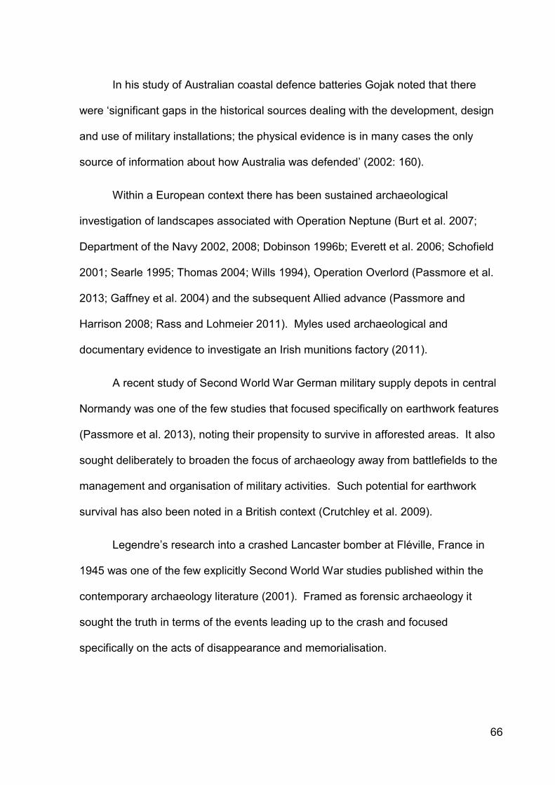
66
In his study of Australian coastal defence batteries Gojak noted that there
were ‘significant gaps in the historical sources dealing with the development, design
and use of military installations; the physical evidence is in many cases the only
source of information about how Australia was defended’ (2002: 160).
Within a European context there has been sustained archaeological
investigation of landscapes associated with Operation Neptune (Burt et al. 2007;
Department of the Navy 2002, 2008; Dobinson 1996b; Everett et al. 2006; Schofield
2001; Searle 1995; Thomas 2004; Wills 1994), Operation Overlord (Passmore et al.
2013; Gaffney et al. 2004) and the subsequent Allied advance (Passmore and
Harrison 2008; Rass and Lohmeier 2011). Myles used archaeological and
documentary evidence to investigate an Irish munitions factory (2011).
A recent study of Second World War German military supply depots in central
Normandy was one of the few studies that focused specifically on earthwork features
(Passmore et al. 2013), noting their propensity to survive in afforested areas. It also
sought deliberately to broaden the focus of archaeology away from battlefields to the
management and organisation of military activities. Such potential for earthwork
survival has also been noted in a British context (Crutchley et al. 2009).
Legendre’s research into a crashed Lancaster bomber at Fléville, France in
1945 was one of the few explicitly Second World War studies published within the
contemporary archaeology literature (2001). Framed as forensic archaeology it
sought the truth in terms of the events leading up to the crash and focused
specifically on the acts of disappearance and memorialisation.

67
Myers explored the tension between a text-centric historical approach and a
more holistic historical archaeological approach in his study of German concentration
camps. He concluded that ‘by its very nature narrative that is rooted exclusively in
textual sources is destined to be more linear, more univocal, and less equipped to
deal with the problematic’, instead advocating a ‘series of excavations: into the soil,
the texts, the imagery, the landscape and the memory’ (2008: 243).
2.9.1 British Second World War archaeology
Carr and McAtackney commented recently on ‘the wealth of current research
being undertaken on World War II’ (2011: 176), but this statement is misleading. The
subject is characterised by its seeming fragmentation into a series of individual
archaeologies of internment (Myers and Moshenska 2011; Mytum 2013, 2014),
occupation (Carr 2009, 2010a, 2010b, 2014), the Blitz (Moshenska 2008, 2010a,
2014), the Home Front (Glass 2012; Moshenska 2013) and the Holocaust (Sturdy
Colls 2012). All of these works are engaged theoretically, often situating
archaeological approaches to modern conflict within historical archaeology
frameworks of memory, narrative and oral history (for example Moshenska 2010b;
Myers 2008). The majority of studies of the British Home Front tended to focus on
the civilian experience of conflict, often adopting an anthropologically informed and
modern material culture studies approach.
The subject was also characterised by a virtual absence of explicitly
theoretically-grounded academic studies investigating anti-invasion defences. The
reasons for this lack of engagement remain unclear, but were perhaps related to

68
academic fashion or distaste with the actual practice of warfare. They may also be
viewed as a folly or an irrelevance, as one of the defining features of British Second
World War anti-invasion landscapes was that the defences were not used as
intended. This was in strong contrast with almost all other battlefield and modern
conflict archaeology (but see Martin 2001). As such they remained preparatory
landscapes and perhaps have more in common with studies focusing on military
infrastructure (for example Kirby et al. 2013; Sneddon 2008).
In 2008 Pollard and Banks were still able to state that ‘intervention by
archaeologists, however, although not unknown, is relatively rare in the case of these
[Second World War military defence] sites – at least within the British Isles’ (2008:
134), despite the impact of the Defence of Britain and related projects.
In a British academic context studies of the assessment of defensive
arrangements were limited. Rowe completed a study of the Stop Line Green anti-
invasion defences around Bristol (2005; 2014). He applied traditional invasive and
non-invasive archaeological techniques, a ‘fields of fire’ GIS analysis and a sensorial
experiential approach to three case study areas in order to determine whether the
archaeological data matched the documentary evidence, and whether they
conformed to War Office specifications. He also investigated the siting of defence
structures at Weymouth to inform ‘our understanding of the hypothetical strategic
effectiveness of these defences’ (2012: 200). Liddiard and Sims have investigated
aspects of the Second World War archaeology of Suffolk (2014a-d).
Both Spencer (2002) and Lewis (2013) studied aspects of wartime airfields in
Wales, and Lacey applied the use of GIS techniques to investigate the effectiveness

69
and coverage of specific types of weaponry using the concept of firesheds on a
section of the Taunton Stop Line (2003). Moshenska included a brief discussion on
the archaeology of stop lines in his recent popular overview of British Second World
War archaeology (2012) and Brockman examined defensive provisions at Shooter’s
Hill, London (2009).
Holyoak has argued that the RAF airfields comprised the front line during the
Second World War, as they saw combat unlike the anti-invasion defences, and that
in terms of analogy airfields were similar to First World War trenches regarding the
scale of human tragedy (2001: 253-4). He also noted that ‘although official
documentary source material contains some information [pertaining to construction
events], unravelling the sequence of development is often only possible
archaeologically’ (2001: 258). Anderton argued that the British Second World War
should be seen as part of the wider Battle for Britain, 1939-45 (2001).
2.10 Anti-invasion defence archaeology in the United Kingdom
The relative lack of academic engagement with Second World War anti-
invasion defences stands in marked contrast to the two intertwined strands of study
emanating from the enthusiast-led tradition and the heritage sector.
2.10.1 Enthusiast-led studies
The enthusiast-led sector pioneered an interest in military and aviation-related
sites from the mid- to late-1970s, which predated most professional archaeological

70
involvement by several decades. The Fortress Study Group (FSG) was founded in
1975 at a time of wider interest in military archaeology (Gander 1979), and its Pillbox
Study (sub-)Group was established in 1992 following new interest in anti-invasion
defences prompted by Wills’ innovative study (1985). Enthusiast interest in
aeronautical heritage dated back to the 1950s and recovery activities accelerated
from the 1960s (Robertson 1977). Interest in military airfields formalised with the
establishment of the Airfield Research Group in 1977.
This interest developed in parallel with a growing number of popular published
investigative and historical accounts focusing on the summer of 1940 (Fleming 1957;
Gillies 2006; Glover 1990; Longman 1993; Macksey 1980; Parkinson 1977; Ponting
1990; Robinson 2006; Rowe 2010; Smith 2000), its conspiracies (Haining 2004;
Hayward 2001) and the potential German invasion (Keiser 1997; Schenk 1990;
Wheatley 1958). There was also growing interest in the British resistance movement
(Lampe 2007; Lowry and Wilks 2007; Ward 1997; Warwicker 2002, 2008) and a
developing literature concerning alternate historical accounts of the fictional German
occupation of Britain (Cox 1974; Gilbert 1990; Longmate 2004; Marix Evans 2004;
Sheers 2008).
2.10.1.1 The Home Front
A small number of descriptive rather than analytical publications dealing with
the Home Front have been published in Wales, including Cardiff (Morgan 1998),
Pontypridd (Powell 1999), Chepstow (Chepstow Society 2000), Usk (Barrow 2006)
and Swansea (Bowler 2006). Similar works have been published for Wales

71
(Carradice 2003) and at county level for Anglesey (Chambers-Jones 2008; Dalton
2013), Ceredigion (Davies 2000) and Carmarthenshire (Carmarthenshire County
Museum 2006).
With the exception of Dalton’s publication on Anglesey, these works focused
on the impact of rationing, evacuation and bomb damage rather than on specific
defensive arrangements. While the Home Guard was usually referenced, it was rare
for organisational or detailed information to be presented, and any photographs
included tended to be formally-posed platoon or company images.
2.10.1.2 Anti-invasion defences
Much of the early published research relating to British anti-invasion defences
tackled the complex issues of pillbox classification (Burridge 1992; Osborne 1993a-d,
1994, 1995, 1997a, 2003, 2011; Dawes 1995; Ward 2005; Kolonko 2011). The data
was brought to a wider audience in four key publications (Lowry 1996; Osborne
2004a, 2008; Ruddy 2003).
Other types of anti-invasion defences received comparatively less
investigation (Clifford 1994, 1995, 1996; Dowdall-Brown 1994, 2003). Given that the
type and architectural detail of a specific emplacement was determined by the
tactical purpose and type of weaponry emplaced within, it is counter-intuitive that
comparatively little attention has been given to the armament to be mounted (Ward
1996; Sanderson 1998; Hellis 2002; Walker 2003; Schmidtke 2014).
A variety of analytical scales were demonstrated in the enthusiast-led
published literature. A number of studies focused on individual stop lines or parts

72
thereof, for example the GHQ line (Alexander 1998; Greeves 1993), the Staffordshire
stop line (Kerr 1993b), the Oxford canal line (Carvell 2006) and the Northumbrian
stop lines (Rudd and Clarke 1994, 1998; Rudd 2005), particularly the Coquet stop
line (Lewins 2011a-b, 2012, 2013a-c) and Bamburgh (Lewins 2013d). Other
approaches utilised smaller areas, for example around Bristol (Green and Plant
1993a-b, 1994; Green 1999).
In common with many traditional archaeological studies the use of county-
based surveys was commonplace and a series of county-based anti-invasion books
was prompted by the Defence of Britain and Defence Areas projects (see Table 2.1).
County-based surveys Author
Cambridgeshire Osborne (2001)
East Midlands Osborne (2004b)
Kent Burridge (1997)
Lincolnshire Osborne (1997b)
London Osborne (2006a)
Norfolk Osborne and Kerr (2008a); Iosson (1990); Bird (1991, 1992, 1995, 1999)
Pembrokeshire PLANED (2007-2010)
Somerset Brown (1999); Dawson, Hunt and Webster (2011)
Suffolk Osborne and Kerr (2008b)
Warwickshire Carvell (2007)
West Midlands Jones, Lowry and Wilks (2008)
Worcestershire Wilks (2007)
Table 2.1: Published county-based surveys of anti-invasion defences.
In contrast to England, very little was published relating to anti-invasion
defences within Wales. Journal articles were published on the stop lines at Rhos
Langeler (Glover 1990), and in the Neath (Locock 1994) and the Wye and Usk
valleys (Kerr 1994a). Notable concentrations of extant defences were investigated in
the Llantwit Major area (Berry 2013), Pembrokeshire (Knight 1995), Anglesey
(Chambers-Jones 2008; Dalton 2013; Harding 2001) and the Mawddach estuary
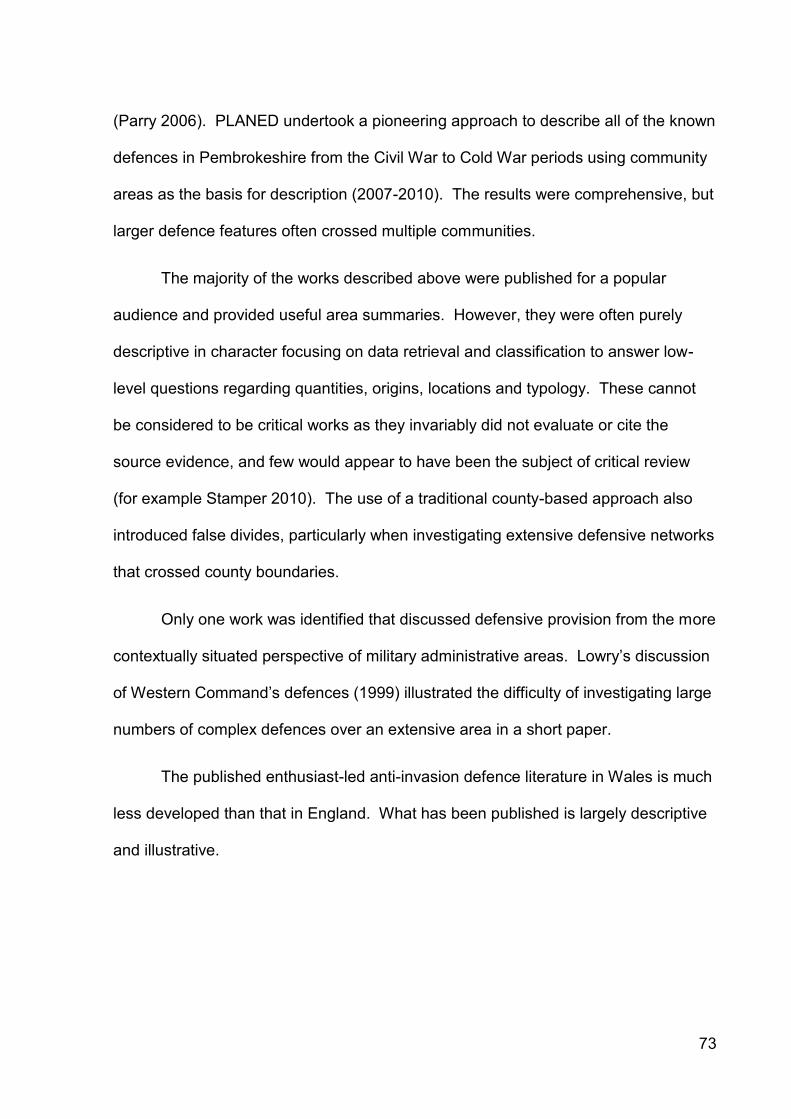
73
(Parry 2006). PLANED undertook a pioneering approach to describe all of the known
defences in Pembrokeshire from the Civil War to Cold War periods using community
areas as the basis for description (2007-2010). The results were comprehensive, but
larger defence features often crossed multiple communities.
The majority of the works described above were published for a popular
audience and provided useful area summaries. However, they were often purely
descriptive in character focusing on data retrieval and classification to answer low-
level questions regarding quantities, origins, locations and typology. These cannot
be considered to be critical works as they invariably did not evaluate or cite the
source evidence, and few would appear to have been the subject of critical review
(for example Stamper 2010). The use of a traditional county-based approach also
introduced false divides, particularly when investigating extensive defensive networks
that crossed county boundaries.
Only one work was identified that discussed defensive provision from the more
contextually situated perspective of military administrative areas. Lowry’s discussion
of Western Command’s defences (1999) illustrated the difficulty of investigating large
numbers of complex defences over an extensive area in a short paper.
The published enthusiast-led anti-invasion defence literature in Wales is much
less developed than that in England. What has been published is largely descriptive
and illustrative.

74
2.10.1.3 Military airfields
As noted above, military airfields have long been the subject of enthusiast
interest both at a UK level (Smith 1981; McLelland 2012; Willis and Holliss 1987) and
within Wales (Jones 2007a-b, 2008a; Phillips 2006, 2012; Pratt and Grant 2002,
2005; Sloan 1991, 1995; Thursby 2002). Many airfields attracted individual
publications (see Table 2.2).
Airfield Author
RAF Aberporth (formerly Blaenannerch)
RAF Angle Abraham (2002b)
RAF Bodorgan Abraham (2001d, 2001f, 2002a); Dalton (2013)
RAF / RNAS Brawdy Abraham (2002b); Phillips (2009)
RAF Carew Cheriton (formerly RNAS Milton) Brock (1989)
RAF Chepstow SLG Abraham (2001d, 2001f, 2002a)
RAF / RNAS Dale Abraham (2002b)
RAF Fairwood Common Jones (2000)
RNAS / RAF Fishguard Hale (2007)
RAF Haverfordwest
RAF Hawarden Abraham (2007); Barfield (2002); Smith (2005)
RAF Hell’s Mouth
RNAS Lawrenny Ferry Abraham (2002c); Hale (1995)
RAF Llanbedr Annand (1983); Mills (2002)
RAF Llandow Abraham (2001a)
RAF Llandwrog / Caernarfon Annand (1986); Dalton (2013); Doylerush (1994)
RAF Manorbier
RAF Mona Dalton (2013)
RAF Pembrey Lewis (2007)
RAF Pembroke Dock Evans (1993, 2001, 2004, 2005)
RAF Pengham Moors Jones (2008b)
RAF Penrhos Annand (1986)
RAF Rhoose Jones, G. (2011) Jones, I. (2008c)
RAF Rudbaxton Abraham (2001d, 2002a)
RAF St Athan Abraham (2001a); Bond (1988); Davies (2007)
RAF St Brides SLG Abraham (2001d, 2001e, 2002a)
RAF St David’s
RAF Sealand / Broughton Abraham (2001b, 2001c); Ferguson (1978, 2007)
RAF Stormy Down (formerly RAF Porthcawl) Cottrell (1993); Mansley (1994)
RAF Talbenny
RAF Templeton
RAF Valley Dalton (2013); Pritchard (2001)
RAF Wrexham / Borras Pratt and Grant (1999, 2000)
Table 2.2: Publications written on Welsh wartime airfields.

75
The majority of publications did not cite or evaluate their sources and tended
to focus on detailing the history of units or operations undertaken from particular
airfields. As complex entities a number of publications sought to organise and
classify the numerous airfield structures (Clarke 2008; Francis 1993, 1996; Innes
1995, 2000), and it is commonplace for the regional and airfield specific publications
to describe the main types of airfield buildings, for example watch offices and
hangars. These works routinely ignored airfield defences, although aspects of this
provision were detailed in separate publications, somewhat divorcing them from their
hosts (Purcell 1993, 1995, 1996 and 1999; Kerr 1993a, 1994b and 1995; Lowry
1998b and 2004; Ruddy 2006; Francis 2010).
The published enthusiast-led airfield literature for Wales is largely historical in
focus and does not include detailed archaeological description and analysis, or
discussion of airfield defences.
2.10.1.4 Coastal artillery
The study of coast artillery is well established in the UK, both in terms of its
history and the defensive capabilities of particular emplacements (Bowden and
Brodie 2011; Foster 2004; Hamilton-Baillie 2003; Hill 1999; Hogg 1974; Maurice-
Jones 2005; Saunders 1989, 1997). Wood produced a recent gazetteer of Second
World War emplacements in the United Kingdom and Ireland (2012). The defences
of the Welsh coast (Phillips 2010) and Welsh coast artillery batteries (Guy and
Dorman 2009a-b) have also been reviewed and there is a substantial literature on
the Victorian and Second World War forts in the Bristol Channel (Barrett 1992, 2003,
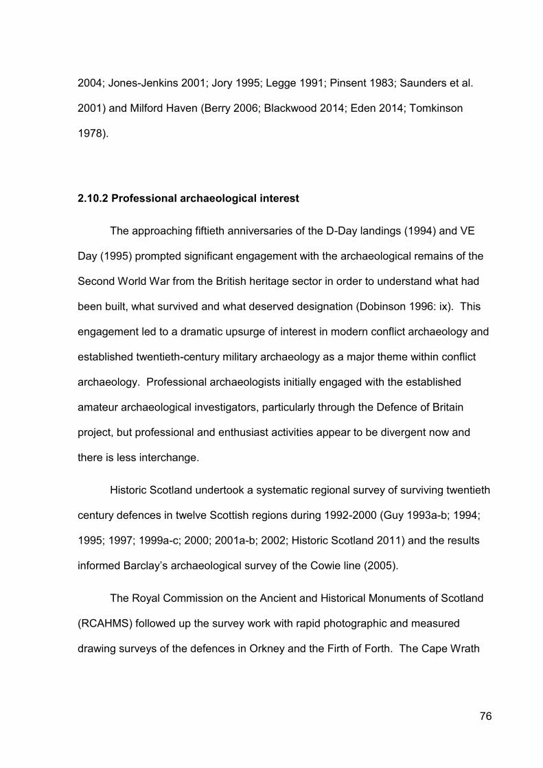
76
2004; Jones-Jenkins 2001; Jory 1995; Legge 1991; Pinsent 1983; Saunders et al.
2001) and Milford Haven (Berry 2006; Blackwood 2014; Eden 2014; Tomkinson
1978).
2.10.2 Professional archaeological interest
The approaching fiftieth anniversaries of the D-Day landings (1994) and VE
Day (1995) prompted significant engagement with the archaeological remains of the
Second World War from the British heritage sector in order to understand what had
been built, what survived and what deserved designation (Dobinson 1996: ix). This
engagement led to a dramatic upsurge of interest in modern conflict archaeology and
established twentieth-century military archaeology as a major theme within conflict
archaeology. Professional archaeologists initially engaged with the established
amateur archaeological investigators, particularly through the Defence of Britain
project, but professional and enthusiast activities appear to be divergent now and
there is less interchange.
Historic Scotland undertook a systematic regional survey of surviving twentieth
century defences in twelve Scottish regions during 1992-2000 (Guy 1993a-b; 1994;
1995; 1997; 1999a-c; 2000; 2001a-b; 2002; Historic Scotland 2011) and the results
informed Barclay’s archaeological survey of the Cowie line (2005).
The Royal Commission on the Ancient and Historical Monuments of Scotland
(RCAHMS) followed up the survey work with rapid photographic and measured
drawing surveys of the defences in Orkney and the Firth of Forth. The Cape Wrath
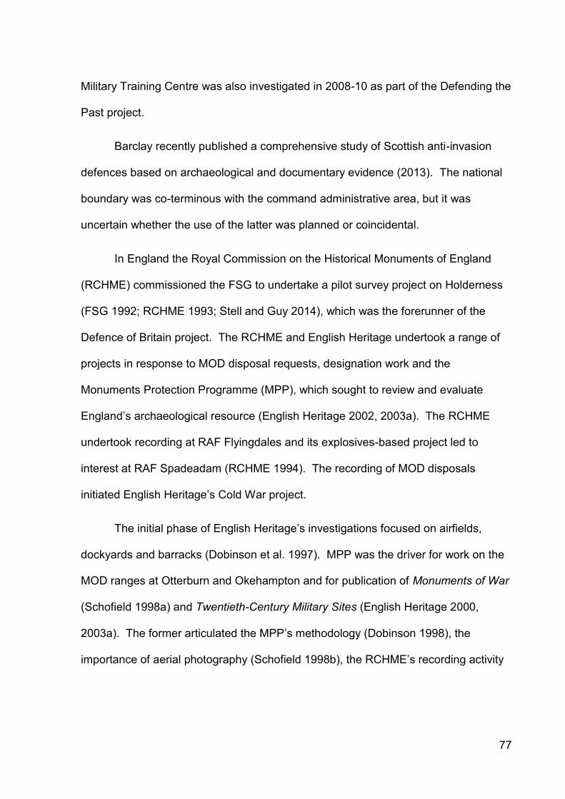
77
Military Training Centre was also investigated in 2008-10 as part of the Defending the
Past project.
Barclay recently published a comprehensive study of Scottish anti-invasion
defences based on archaeological and documentary evidence (2013). The national
boundary was co-terminous with the command administrative area, but it was
uncertain whether the use of the latter was planned or coincidental.
In England the Royal Commission on the Historical Monuments of England
(RCHME) commissioned the FSG to undertake a pilot survey project on Holderness
(FSG 1992; RCHME 1993; Stell and Guy 2014), which was the forerunner of the
Defence of Britain project. The RCHME and English Heritage undertook a range of
projects in response to MOD disposal requests, designation work and the
Monuments Protection Programme (MPP), which sought to review and evaluate
England’s archaeological resource (English Heritage 2002, 2003a). The RCHME
undertook recording at RAF Flyingdales and its explosives-based project led to
interest at RAF Spadeadam (RCHME 1994). The recording of MOD disposals
initiated English Heritage’s Cold War project.
The initial phase of English Heritage’s investigations focused on airfields,
dockyards and barracks (Dobinson et al. 1997). MPP was the driver for work on the
MOD ranges at Otterburn and Okehampton and for publication of Monuments of War
(Schofield 1998a) and Twentieth-Century Military Sites (English Heritage 2000,
2003a). The former articulated the MPP’s methodology (Dobinson 1998), the
importance of aerial photography (Schofield 1998b), the RCHME’s recording activity
78
(Thomas 1998), reviewed the MOD’s estate (Whitehead 1998) and discussed the
concept of ‘hot interpretation’ for Cold War sites (Uzzell 1998).
In 1994 English Heritage’s Monuments Protection Programme commissioned:
‘a large-scale survey of documentary records of the modern defence heritage… [consulting] papers of the armed forces and their parent ministries… [with] particular emphasis on WW2 but extending back to WW1 and before for selected categories of site and forward into the Cold War (to 1969) for others’ (Dobinson 1998: 2).
The work, known collectively as the Twentieth Century Fortifications in
England series, produced an in depth historical analysis across eleven themes and
resulted in dedicated grey literature reports with extensive site gazetteers (see Table
2.3). Each volume sought to quantify the original site populations, assessed the
structural character of the sites as built and set the sites in their historical context.
This was pioneering research and presented new sources, information and site
typological and distributional frameworks to a wider audience.
Funded by English Heritage by necessity the overwhelming majority of
information and sources presented were Anglo-centric in character and direct
references to Wales were few in number. The volumes identified many
developments and trends apparent in England, but the extent to which Dobinson’s
statements could be applied to Wales remained uncertain. Dobinson claimed that ‘in
reality, surviving records for most site types [in England] are thorough and precise:
sufficient to tell us what was built, when and why’ (1998: 2).

79
Phase Subject Report Publication
1: 1994-1996 Anti-aircraft artillery, 1914-46 Dobinson (1996a) Dobinson (2001)
1: 1994-1996 Anti-invasion defences, 1939-45 Dobinson (1996b)
1: 1994-1996 Bombing decoys, 1939-45 Dobinson (1996c) Dobinson (2000i)
1: 1994-1996 Operation Diver sites, 1944-45 Dobinson (1996d) Dobinson (in press)
1: 1994-1996 Operation Overlord embarkation
sites, 1944-45
Dobinson (1996e)
2: 1996-2000 Coast artillery, 1900-56 Dobinson (2000a)
2: 1996-2000 Acoustics and radar, 1937-45 Dobinson (2000b) Dobinson (2010)
2: 1996-2000 Civil defence, 1939-45 Dobinson (2000c)
2: 1996-2000 Airfield themes Dobinson (2000d)
2: 1996-2000 Airfield ground defences, 1939-45 Dobinson (2000e)
2: 1996-2000 The Cold War Dobinson (2000f)
2: 1996-2000 Searchlight sites Dobinson (2000g)
2: 1996-2000 Experimental and training sites Dobinson (2000h)
Table 2.3: List of grey literature reports and publications arising from Colin
Dobinson’s archival research for the English Heritage Monuments Protection
Programme (after Dobinson 1998).
In order to complement Dobinson’s historical research for England, Neil
Redfern was co-commissioned by Cadw to create thematic reviews out with England
(1998a) with specific site gazetteer volumes for Wales (1998b), Northern Ireland
(1998c) and Scotland (1998d-e). The work was narrower in scope and shallower in
depth than Dobinson’s reports, and lacked the historical narrative accounts that
made the latter so pioneering. Although this work was primarily historical in character
the brief and output were entirely archaeological in intention. The results were not
formerly published, although an overview was produced (Redfern 1999).
Almost in parallel with Dobinson’s work, the four UK historic environment
agencies participated in the HLF-funded and CBA-led Defence of Britain project
(1995-2001). It was described as an interdisciplinary project that aimed to ‘produce a
consistent record of Britain’s 20th century defences’ (Defence of Britain Project 1996:
2). Its objectives were to:

80
a) ‘Identify accurately the military structures of the 20th century; b) Provide evidence of the range of sites that survive, to enable a
representative selection to be identified and managed for future preservation;
c) Establish recording methods of adequate standard to ensure consistency in survey at whatever level of detail is necessary;
d) Enable better – in some cases new – comprehension of the range and phases of construction of military sites, and their historical significance; and
e) Stimulate public interest and foster widespread participation’ (Defence of Britain Project 1996: 3).
It was initiated as ‘primarily an archaeological survey, recording and evaluating
what still survives and in what condition’ (Saunders 1998: 7). With regard to the
opportunities offered by primary sources the revised project design stated that:
‘The potential contribution of original written sources was uncertain and (in some quarters) underestimated before the Project’s launch. The exploitation of documentary evidence was nevertheless provided for in the methodology of the original (1994) Project Design, although provisions for the resourcing of such work was not.
Documentary research has since proceeded under the aegis of English Heritage’s Monuments Protection Programme [i.e. Dobinson’s work]. This has confirmed that a large body of sites can be identified, located and dated via original records. Following completion of reports on the first five categories of site to be researched (expected July 1996), the results of the archive project will be available to inform the Defence of Britain’s fieldwork’ (Defence of Britain Project 1996: 7).
Despite the size of the project, it has not been subjected to formal academic
scrutiny, although an internal completion review document was published (Council for
British Archaeology 2002). Periodic project updates were published (Denison 1995;
Earle 1997; Lowry 1998a; Foot 1998, 2000), together with a brief report for Wales
(Parry 2002).

81
At a UK level the project was hindered by the late realisation that helpful
primary historical documentation survived and the subsequent lack of integration of
fieldwork and archival projects which were run as separate projects until 1998
(Council for British Archaeology 2002: 6-8). Dobinson’s anti-invasion defences report
for England was published in 1996, but the other relevant reports on coastal artillery
and airfield defences were not published until 2000.
It was also clear from the Defence of Britain database records that the
volunteer recorders had limited access to the results of Dobinson’s research, which
was available as hard copy reports in restricted circulation. Had the site gazetteers
been more readily available and earlier it is reasonable to suggest that the incidence
of new site identification by the Defence of Britain project would have been even
greater.
As the project itself conceded, it was only in 1998 that ‘the Project was
accordingly put on a new footing… [and] primary archive research was incorporated’
(2002: 8).
The project identified initially 12,499, 733 and 595 anti-invasion sites in
England, Scotland and Wales respectively (Council for British Archaeology 2001; and
see Table 2.4 for Welsh results).

82
Unitary authority 1940-41 anti-invasion sites Non anti-invasion sites Total
Anglesey, Isle of 11 1 12
Blaenau Gwent 0 1 1
Bridgend 10 5 15
Caerphilly 0 1 1
Cardiff 3 2 5
Carmarthenshire 170 14 184
Ceredigion 43 9 52
Conwy 4 7 11
Denbighshire 4 9 13
Flintshire 17 16 33
Glamorgan, Vale of 26 6 32
Gwynedd 40 22 62
Merthyr Tydfil 0 2 2
Monmouthshire 30 12 42
Neath Port Talbot 7 3 10
Newport 2 2 4
Pembrokeshire 201 24 225
Powys 13 24 37
Rhondda Cynon Taff 3 3 6
Swansea 11 6 17
Torfaen 0 1 1
Wrexham Not recorded Not recorded Not recorded
Totals 595 170 765
Table 2.4: Numbers of defence sites identified per unitary authority in Wales
excluding Wrexham as of 14/09/2001 (after Council for British Archaeology 2001).
A number of counties in England far exceeded the national total number of
defence sites identified in Wales (see Table 2.5).
County 1940-41 anti-invasion sites Non anti-invasion sites Total
Kent 1486 116 1602
Norfolk 884 110 994
Surrey 810 42 852
Table 2.5: Numbers of defence sites identified for three counties in England as of
14/09/2001 (after Council for British Archaeology 2001).
The Defence of Britain project was succeeded in England by the Defence
Areas project (2002-04), which sought to look in detail at a number of specific
'defence areas' across England (Foot 2001; 2003; 2006a-b; 2008). This created an
enhanced (2006) version of the Defence of Britain’s anti-invasion database, with

83
some additional records and considerable revision and updating of many other
records.
Interrogation of the enhanced Defence of Britain dataset clearly demonstrated
that data cleansing had been undertaken on the data for Wales, including the
addition of the Wrexham data (Archaeological Data Service 2014). The results for
almost half of the unitary authorities in Wales were amended, including downwards in
two cases (see Table 2.6). The overall number of anti-invasion sites in Wales was
reduced by 7.56% to 550 sites.
Unitary authority Anti-invasion sites Non anti-invasion sites Total
Anglesey, Isle of 25 [+14] 6 [+5] 31
Blaenau Gwent 0 1 1
Bridgend 10 5 15
Caerphilly 0 1 1
Cardiff 4 [+1] 2 6
Carmarthenshire 112 [-58] 14 126
Ceredigion 26 [-17] 9 35
Conwy 7 [+3] 7 14
Denbighshire 4 9 13
Flintshire 17 16 33
Glamorgan, Vale of 26 9 [+3] 35
Gwynedd 46 [+6] 22 68
Merthyr Tydfil 1 [+1] 2 3
Monmouthshire 30 12 42
Neath Port Talbot 7 3 10
Newport 5 [+3] 2 7
Pembrokeshire 187 [-14] 24 211
Powys 13 24 37
Rhondda Cynon Taff 3 3 6
Swansea 11 6 17
Torfaen 0 1 1
Wrexham 16 [+16] 8 [+8] 24
Totals 550 186 736
Table 2.6: Numbers of defence sites identified per unitary authority in Wales as
recorded on updated 2006 database. +/- change from 2001 results indicated in
square brackets (Archaeological Data Service 2014).
From 1999 English Heritage’s Military and Naval Strategy Group took
oversight of much of this military work in England (English Heritage 2004a) and was
84
responsible for co-publication of the Modern Military Matters research agenda
(Schofield 2004). A wide range of investigation was undertaken which utilised
archives, field survey and new thematic research, expressed as internal reports and
publications (see Table 2.7 for an indicative list).
The Defence Areas project built on the results of the Defence of Britain project
and Dobinson’s archival research attaining a more significant level of evidential
integration and holistic overview than had been achieved before. The project
adopted a similar multi-evidential and case study-based approach, but deployed it in
a different way with some important differences in terms of the number, size and
selection of cases, and the types and volumes of evidence used.
The project examined sixty-seven small-scale defence areas in England. This
approach was partly influenced by the need to assess distinct areas for statutory
protection. Foot stated that:
‘the defence areas were selected using the Defence of Britain Project data to identify discrete areas of good anti-invasion defence survival. An initial list of some 300 such areas was identified to which the following English Heritage criteria were then applied:
Areas representing a particular coherent defence construction, e.g. the GHQ Line;
Areas with good surviving documentary (or published) sources;
Areas with good inter-visibility, where the defence works can be seen within clear viewsheds;
Areas with very good survival of defence works, enabling them to be understood easily in their landscape context;
Areas with differing types of defence works;
Areas including rare types of defence works; and
Areas representing the different strategies of anti-invasion defence.

85
Year Origin Subject Internal report Publication
1994-2000
MPP Dobinson reports See Table 2.4 See Table 2.4
-1995 Thematic listing / MOD disposals
Pre-WW1 barracks Douet (1995) Douet (1998)
-1998 Thematic listing / MOD disposals
Military airfields Temple and Francis (1994)
Lake and Francis (1998)
-1998 Thematic listing / MOD disposals
Pre-WW1 Naval dockyards
Lake and Douet (1998)
-1999 MOD disposals Explosives Cocroft (2003) Cocroft (2000)
1999-2001
MPP / Dobinson Aerial photographic assessment of radar, bombing decoys, AA sites, Operation Diver and coast artillery
Anderton (1998a-c, 1999 and 2000)
-
1999-2000 (update 2003)
Thematic listing / MOD disposals
Thematic study of military airfields
Lake (2000a)
English Heritage 2003b); Lake (2000b, 2002, 2003a); Lake and Schofield (2000)
MPP Military aircraft crash sites
English Heritage (2002); Holyoak (2001, 2002, 2003)
Designation / MOD disposals
Cold War Cocroft (2010); Tuck and Cocroft (2004)
Cocroft (2007); Cocroft et al. (2003)
2000-2003
Designation Ordnance yards Magazine depots Steam Navy
Lake (2003b) Evans (2004; 2006); English Heritage (2005); Firth (2003)
2002 MPP Surviving military airfield defences
Francis (n.d.) -
2002-2004
Designation / DoB influenced
WW2 defence areas Foot (2004) Foot (2003, 2006a, 2006b, 2008)
2003 Designation / MOD disposals
Typological study of military airfields
Francis (n.d.) Lake et al. (2005)
2003 Designation / MPP
Prisoner of War camps, 1939-48
Thomas (2003a) Thomas (2003b)
2003 MPP Drill halls Osborne (2006b)
2003-2004
Thematic listing Bletchley Park survey and assessment
Monckton et al. (2004); Lake (2005)
-
2004-2005
MPP / Characterisation
Army camps (Phase 1 UK historical overview)
Evans (2005) Schofield et al. (2006)
2004-2005
MPP / Characterisation
Army camps (Phase 2 England site visits)
Foot (2005) Schofield et al. (2006)
2004 War art English Heritage (2004b)
Cocroft et al. (2006)
2001-2004
NMP Suffolk coast Hegarty and Newsome (2005)
Hegarty and Newsome (2007)
NHPP Coast war channels Firth (2014)
2013 MNSG/NHPP Wartime airfields for England
Francis, Flagg and Crisp (2013)
-
2014 NHPP ARP railway control centres
Francis, Bellamy and Crisp (2014)
-
MNSG/NHPP Support for the Fleet Coad (2014)
In press NHPP Civil defence
Table 2.7: Indicative list of key modern conflict reports commissioned by English
Heritage (after English Heritage (2004) and Roger JC Thomas pers. comm.).

86
The project was also interested in creating a selection of areas that included different regions of England; different types of landscape and topography; and those with good public access’ (2006a: 35).
The defence areas focused on coastal areas, small parts of stop lines and
other defence lines and area defences. Each entry included statements regarding
the landscape, defences, significance, public access, sources and a site gazetteer.
The smallest case study area measured approximately 300 square metres
(Breamore Mill, Hampshire), while the most extensive areas measured 3-4 square
kilometres (Saltfleetby, Lincolnshire and Semington-Whaddon, Wiltshire).
The defence areas selected by Foot included many areas of similar character
as covered by the cases in this research. The coastal areas included a variety of
scenarios such as invasion beaches (Cuckmere Haven, East Sussex), coastal bays
(Studland Bay, Dorset), rural beaches (Dunster Beach, Somerset) and docks (Barrow
Island, Cumbria). They also included river mouths (Walberswick, Suffolk), coastal
towns (Winterton-on-sea, Norfolk) and flood defences (Holbeach, Lincolnshire).
None of the cases included major coast artillery batteries.
The inland defence areas included a range of settlement types ranging from
hamlets (Wadbrook, Devon), villages (Weycroft, Devon) to small towns (Acle,
Norfolk). Only two defence areas dealt with urban or peri-urban environments
(Bromborough Pool, Wirral and Farthingloe, Dover respectively), and none covered
large urban settlements. Foot’s defence area selection included specific contexts
such as bridges (Chequers Bridge, Hampshire) and canals (Dunmill Lock, Berkshire),
all chosen for their ability to illustrate particular tactical challenges.
87
Elsewhere English Heritage utilised historic characterisation techniques to
record RAF Scampton (Atkins Heritage 2004), together with more traditional
archaeological photographic recording to record the closure of RAF Coltishall
(Cocroft and Cole 2007).
The National Mapping Programme (NMP) rapid coastal zone assessment
surveys undertaken at locations such as the Severn estuary (Crowther and Dickson
2008; Chadwick and Catchpole 2013) and the Suffolk coast (Hegarty and Newsome
2005) were notable for identifying extensive defence landscapes (Hegarty and
Newsome 2007; Newsome 2003; Newsome and Hegarty 2004).
Similar aerial photographic-based NMP work inland, for example in the Forest
of Dean, also identified the remnants of defence landscapes (Small and Stoertz
2006). The survey was based upon the interpretation of aerial photographs
supported by documentary sources and archives. A small number of new Second
World War sites was identified, which highlighted the weakness of not utilising
military records and undertaking archaeological survey, as a number of key sites
known to exist in documentary evidence were not identified.
The intensity of English Heritage’s military programme lessened considerably
recently and ongoing work is focused on supporting designation relating to the First
World War centenary commemorations and under-investigated Cold War topics
(pers. comm. Roger J.C. Thomas and Wayne Cocroft, Historic England).
In Wales there was no synthetic archaeological overview of the medieval,
post-medieval or contemporary eras (cf. Arnold and Davies 2000; Lynch, Aldhouse-
Green and Davies 2000). The standard texts on Welsh industrial archaeology did not
88
include any discussion of the wartime military-industrial archaeological contribution
(Rees 1969 and 1975). Cadw co-commissioned Roger J.C. Thomas to undertake an
investigation of nineteenth and twentieth century defences in Pembrokeshire (Knight
1993; Thomas 1993, 1994) using a methodology based upon the architectural
surveys of the Urban Development Corporation Areas (RCHME 1989). The objective
was to complete an assessment of the location and status of all of the known disused
military buildings, to identify their function, create a written and photographic record
and to assess their significance. This was ground-breaking work in a Welsh context
and was commissioned at a similar time to the FSG’s Holderness study and Historic
Scotland’s regional surveys of Scotland.
The low penetration of the Defence of Britain project in Wales did not generate
much momentum in terms of encouraging wider professional defence investigation.
A limited amount of archaeological defence recording and publication was
undertaken in Pembrokeshire (Thomas 1995a-b) and by Glamorgan-Gwent
Archaeological Trust (Locock 1994; 1995; 1996; 2000) and Cadw (Berry 2005, 2006,
2007, 2009, 2010, 2011a-b).
At the completion of the Defence of Britain project, the Ancient Monuments
Board for Wales adopted twentieth-century military sites as its annual theme in 2002-
03 in order to inform designation work (2003), leading to the publication of a ‘caring
for’ booklet (Cadw 2009). Significant building surveys were undertaken at the former
Royal Naval Propellant Factory, Caerwent (Tuck 2005a-b; Tuck and Riddett 2006)
and the former Ministry of Supply, Valley mustard gas facility at Rhydymwyn (Bone et
al. 2007; Litherland 2007 and Nichol; Litherland 2007). The former military rocket
range at Ynyslas was also archaeologically recorded (Parry and Groom 2010).

89
More recently Cadw commissioned the Welsh Archaeological Trusts to
undertake pan-Wales surveys on military aircraft crash sites (Huckfield and Burton
2013; Hankinson and Spencer 2014; Sage, Page and Pyper 2013; Steele 2012),
airfields (see Table 2.8) and WWI scoping projects (Crawford 2014; Evans 2014;
Pyper 2013, 2014; Spencer 2013, 2014).
Airfield Author
RAF Aberporth (formerly Blaenannerch) Pyper and Page (2012, 2014)
RAF Angle Pyper and Page (2012, 2014)
RAF Bodorgan Evans and Steele (2012); Evans (2013)
RAF / RNAS Brawdy Pyper and Page (2012, 2014) RAF Carew Cheriton (formerly RNAS Milton) Pyper and Page (2012, 2014) RAF Chepstow SLG Huckfield (2012a)
RAF / RNAS Dale Pyper and Page (2012, 2014)
RAF Fairwood Common Huckfield (2012a, 2013)
RNAS / RAF Fishguard Pyper and Page (2012, 2014) HMS Harrier / RNAS Kete Pyper and Page (2012, 2014) RAF Haverfordwest Pyper and Page (2012, 2014) RAF Hawarden Spencer and Hankinson (2012); Hankinson and
Spencer (2013)
RAF Hell’s Mouth Evans and Steele (2012); Evans (2013)
RNAS Lawrenny Ferry / HMS Daedalus II Pyper and Page (2012, 2014)
RAF Llanbedr Evans and Steele (2012); Evans (2013)
RAF Llandow Huckfield (2012a, 2013)
RAF Llandwrog / Caernarfon Evans and Steele (2012); Evans (2013)
RAF Manorbier Pyper and Page (2012, 2014)
RAF Mona Evans and Steele (2012); Evans (2013)
RAF Pembrey Pyper and Page (2012, 2014) RAF Pembroke Dock Pyper and Page (2012, 2014) RAF Pengham Moors Huckfield (2012a, 2013)
RAF Penrhos Evans and Steele (2012); Evans (2013)
RAF Rhoose Huckfield (2012a, 2013)
RAF Rudbaxton Pyper and Page (2012, 2014)
RAF St Athan Huckfield (2013)
RAF St Brides SLG Huckfield (2012a, 2013)
RAF St David’s Pyper and Page (2012, 2014)
RFC Shotwick / RAF Sealand / Broughton Spencer and Hankinson (2012); Hankinson and Spencer (2013)
RAF Stormy Down (formerly RAF Porthcawl) Huckfield (2012a, 2013)
RAF Talbenny Pyper and Page (2012, 2014) RAF Templeton Pyper and Page (2012, 2014) RAF Valley Evans and Steele (2012); Evans (2013)
RAF Wrexham / Borras Spencer and Hankinson (2012); Hankinson and Spencer (2013)
Table 2.8: Cadw-funded reports written by the Welsh Archaeological Trusts on Welsh
wartime airfields.

90
2.11 Summary
This chapter emphasised the interdisciplinary character of conflict
archaeology. Key outcomes were the recognition that very little has been published
on anti-invasion defences in Wales, and that Schofield’s assertion that archaeologists
are able to define what was built, where, when, why and often how sites were used
and by whom from documentary evidence should be tested in a Welsh context. The
review demonstrated that the material response to this conflict has not been studied
in detail in Wales and only infrequently and through other means in a British context.
There has been no systematic description or evaluation of the sources or their
interaction and how this affects methodological considerations. The knowledge gap
identified by the review represents a genuine research opportunity and can contribute
new insight into these areas.
The literature review situated conflict archaeology within historical archaeology
for its methodological insights, particularly the concept of equal primacy of all
evidence types and the requirement to move beyond low-level description. These
themes link through to the idea of the need to create situational archaeologies within
historical archaeology (Hicks 2005), a critical focus on source evidence (Beaudry
1988; Little 2007) and the validity of using an archaeological approach across
different types of source evidence (Leech 1999; Wilkie 2006).
Within the documentary and text-aided archaeology traditions, the review
identified how to integrate disparate types of evidence and the fundamental
prerequisite to ascertain the purpose, intended audience, compiler bias and coverage
of the evidence to identify bias. In particular, Little demonstrated the academic

91
acceptability of the critical use of official sources and signposted a framework for
characterising the interaction of disparate sources (interdependent/complementary or
independent/contradictory). Wilkie’s assertion that the different forms of evidence
are linked parts of a collective past that requires an iterative approach to analyse was
an influential concept.
The literature review also identified modern conflict archaeology as part of the
movements of the archaeologies of the recent and contemporary past. This research
is seen as part of the longer trajectory of heritage management-based interest in this
topic. At a broader level it links strongly with contemporary archaeology ideas of the
presencing of absence (Buchli and Lucas 2001) and conveying narrative through
material culture, not just history (Piccini and Holtorf 2011). The impact of temporal
proximity is acknowledged.
Finally, a (re-)focusing of research effort onto defensive structures will
harmonise British Second World War research with that elsewhere in the world, and
a more critical approach to evidence and methodology will synchronise the research
topic with those more theoretically-informed topics within modern conflict
archaeology.
The next chapter provides a descriptive overview of the origination,
organisation, content and survival of the source evidence employed in this study.

92
3. SOURCES
3.1 Introduction
One of the characteristics of conflict archaeology is the diverse range of
sources utilised. Given the research questions established in Chapter One it was
considered important by the researcher to critically assess the evidential sources
used in a dedicated chapter. The assessment in Chapter Two demonstrated that
background reading around the topic needed to be undertaken prior to evidential
source selection. The reasons for selecting specific classes and types of evidence
are outlined in Chapter Four.
Critical evaluation of sources was strongly emphasised within documentary
and text-aided archaeology (Beaudry 1988; Little 1992). Documentary sources
required rigorous assessment to establish their purpose, intended audience, compiler
bias, accuracy, trustworthiness and selectivity, as well as the author’s priorities and
opinions.
Following Little’s statement that ‘credible research judges the credibility of its
sources’ (2014: 422) this chapter seeks to establish the credibility of the evidence
used through a critical assessment of the sources. This is established by applying a
refinement of Little’s suggested criteria regarding author, audience and social setting,
format, content, purpose, status, treatment and contemporary meaning (2014: 422-
23).
The assessment in this chapter is based on the researcher’s experience and
reflection of using the different types of source evidence. As official military and
governmental sources, the researcher assessed the evidence as documents

93
produced in the past rather than documents produced about the past (Moreland
2001), and was mindful of their efficacy in reproducing particular structures of power
within a non-typical socio-political period.
3.2 Overview of research sources
The term ‘source’ is used to include any type of archaeological, documentary,
cartographic and aerial photographic item that is used to address the research
questions. No priority or preference is given to any particular type or class of source.
The specific evidential sources used for each case are discussed in Chapters Five,
Six and Seven.
There is no known published description and evaluation of the source
evidence for Wales, although Dobinson provided quite comprehensive and insightful
descriptive and evaluative summaries of the English sources for anti-invasion
defences (1996b: 3-9), coast artillery (2000a: 5-8), airfield themes (2000d: 8-11) and
airfield defences (2000e: 3). Redfern’s comments on the Welsh sources in Twentieth
Century Fortifications in the United Kingdom were very brief. He concluded that
‘official documents for Western Command do not survive in the quantity as they do
for other Commands’ at TNA and that ‘sources for Wales are limited’ (1998a: 39).
3.3 Archaeological evidence
The known archaeological evidence comprised the historic environment
datasets held by the RCAHMW’s NMRW and the Welsh Archaeological Trusts’

94
HERs. The specific characteristics of the datasets are assessed in the case study
chapters. This section provides a general assessment.
3.3.1 Author, audience and social setting
The anti-invasion defence-related records in the NMRW and the HERs were
composite collections derived from multiple authors. The majority of the NMRW data
originated from diverse volunteer recorders associated with the Defence of Britain
project and the data was edited to ensure conformity. In contrast the data recorded
in the HERs originated with professional archaeological curatorial or project staff.
3.3.2 Format
The diverse content incorporated into the NMRW and HERs was edited and
catalogued into a standardised series of database fields conforming to accepted
curatorial standards. It was rare for all of the fields to be completed and some fields
were sparsely populated.
3.3.3 Content
The content was restricted to a common set of field headings comprising
name, location, community, unitary authority, period, site type and NGR coordinates.
The remarks field was rarely completed. These datasets recorded the results of
primary fieldwork research, desk-based assessment and examination of published

95
secondary sources. The digital data was supported by physical archives comprising
original recording forms, reports, documents, notes, plans and photographs.
3.3.4 Purpose
The HERs provide a preserved record of investigation and an educational
resource of what has been found where; the information forms the basis for
management and development control advice and decisions. The information also
addresses objectives to improve access and engagement with the historic
environment and to foster public understanding.
The aim of the NMRW is to collect, maintain and make available a
comprehensive record of the archaeological, architectural and historical monuments
of Wales, including its territorial waters, from the earliest times to the present day.
3.3.5 Status
The information contained within the HERs comprises an official and curated
record of the known information about the historic environment in Wales. The data is
maintained for long-term public access and availability. The NMRW archive was
designated an approved place of deposit under the Public Records Act 1958.
Funded and enhanced through varying degrees of national and local
government support these records comprise some of the main resources for those
seeking information about the historic environment.

96
3.3.6 Treatment
In order to advance public understanding of archaeology and meet accepted
standards the HER records are created, maintained, updated, repaired, kept safe
and disseminated. To comply with the conditions of its Royal Warrant the NMRW is
obliged to care for, preserve, and add to the records in its charge, and to make these
collections available to the public. The care of its records must meet professional
archival standards and the records must be stored in optimum conditions.
3.3.7 Contemporary meaning
The content of the NMRW and HERs is edited and authorised by curatorial
staff. These staff were typically not in close proximity to the primary field data when it
was collected or the secondary sources when they were written. As consumers of
primary and secondary material the archives represent tertiary sources. The acts of
editing and selecting data from primary and secondary sources may highlight or
suppress data, which would influence interpretation.
3.4 Documentary evidence
The lack of published sources discussing the wartime military presence and
organisational structures in Wales meant that the source evidence needed to be
examined in detail. In order to assess the primary documentary evidence and
develop the administrative and operational narrative a sustained period of in-depth
archival research was undertaken at archives, museums and libraries. The pieces

97
consulted are recorded in the List of Primary Sources. Original place name spellings
are used.
3.4.1 Records preserved at The National Archives
The records can be categorised into war diaries and operational record books,
registered files, and miscellaneous papers. The individual documents are too
numerous to assess here and are assessed as appropriate in Chapters Five, Six and
Seven. An assessment of the principal categories of documentation is presented
below.
Contrary to early claims (Glover 1990; Wills 1985) relevant documents do
survive and those for Western Command were preserved from 1939-45. They are of
fundamental importance for understanding the context in which anti-invasion
defences were constructed. As observed by Redfern Western Command-related
records were less plentiful than the records for other Home Forces commands.
However, Redfern stated that the sources were limited, but the experience of
this research found the situation to be more positive. Redfern’s rapid review of the
Welsh material was undertaken in parallel with surveys of the Scottish and Northern
Irish material in a short period of time. The experience of this research identified that
while some classes of anticipated records were missing or depleted, other sources
could be brought into play that made up for deficiencies. It is suspected that Redfern
went straight to the obvious sources and on discovering an absence of material
concluded that the information was not present.

98
As different aspects of the same actions, decisions and events were routinely
recorded in multiple documentary locations, a widening of the search parameters to
connected diaries and files often located helpful information. Redfern did not have
the time or opportunity to undertake this and his conclusions were premature. This
research identified that a more exhaustive search was capable of bearing more
useful and nuanced results. Additional effort was required to ‘presence absence’
(Buchli and Lucas 2001). As Bird observed, the problem was in fact one of an over
rather than an under supply of documentary material (1995).
3.4.2 War diaries preserved at The National Archives
An overview assessment of war diaries and operational record books (ORBs)
is provided here. The Western Command area was the subject of record making
across a large number of war diaries and ORBs.
3.4.2.1 Author, audience and social setting
War diaries and ORBs represented the corporate memory of a particular
formation or unit. Entries were added on a daily basis by a junior officer and were
signed off by the Officer Commanding. Usually the signatures were illegible meaning
that unit identity subsumed individual identity. Completion of the task was a daily and
routine occurrence.
The command headquarters of an Army formation (command, corps, division
or brigade) was divided into different branches – General Staff, Chief Engineer,

99
Royal Artillery, Signals, etc. – and each bore responsibility for their respective
functions within the headquarters territory. Each branch was required to keep its own
war diary. At a unit level, all combat and combat support units were also required to
keep war diaries during wartime.
Much like the Army’s war diaries, the ORBs were created by commands,
groups, stations, wings, squadrons and all miscellaneous units of the RAF for the Air
Ministry. Completion and submission of the document was also a routine official
process.
There was a considerable expectation regarding the maintenance of a war
diary, which was codified as part of the military doctrinal obligation. Non-compliance
would result in disciplinary action, so the stationery can be seen as a physical
expression of social control.
3.4.2.2 Format
During wartime, war diaries were kept in duplicate from the first day of
mobilisation of an Army formation or unit. Entries were added to a standard
stationery recording form entitled Army Form C2118 (Plate 3.1). Supplies of this form
became scarce during 1940 and many headquarters replicated the forms on
available paper supplies.
The ORB was a formal piece of pre-printed official stationery that was
designed to receive a record of daily events for each RAF squadron or unit. It was
known as RAF Form 540. It recorded details of place, date and time and a summary

100
of events. Supporting appendices could be added. The reports were a mix of
handwritten and typed formats that are now bound into books available at TNA.
3.4.2.3 Content
War diaries contained information relating to formal military decisions made
and actions undertaken, rather than recording future plans. Detailed instructions
were issued by the War Office for the compilation of war diaries. Typical war diary
entries referred to conferences, visits, staff transfers, exercises, inspections, courses
and lectures. The assumption and relinquishment of posts was also recorded in
detail. It was also to include the detailed accounts of operations and exercises,
together with the nature and description of field engineering works constructed.
Changes in military establishment or strength and meteorological reports were also
included.
Specific guidance was also provided concerning the addition of appendices,
which had to include complete copies of orders, instructions and reports, together
with relevant sketches and maps. Each appendix was numbered sequentially and
submitted with the monthly war diary return (Plate 3.2). The evidence discussed in
the cases will demonstrate that the contents of the appendices (Appendix 3.1) were
some of the most informative documents used in this research.
The content of the ORBs is variable reflecting the diverse range of activities
across the RAF. It can include details of operational sorties, lists of aircraft,
operational orders, reports and telegraphed messages. They can include nominal

101
rolls, officer lists, and details of promotions, transfers and awards. Supporting
appendices might contain reports, orders, photographs and plans.
Dobinson stated that ‘key sources are the ORBs of stations, whose
appendices often contain successive copies of the station defence scheme, often
accompanied by plans of varying quality’ (2000e: 3).
War diaries and ORBs can be difficult to use. The text can be technical and
obscure, with frequent use of acronyms. It can be difficult to read and interpret,
compounded if it was written in difficult long hand rather than typed. The entries are
typically codified and formulaic, and sometimes very brief. As a general record
detailed information is rarely included, but the entries can give a good indication of
the major preoccupations of the time.
3.4.2.4 Purpose
Spencer stated that ‘from 1907, units on active service were required by the
Field Service Regulations Part II to keep a daily record of events. These records
were called War Diaries, or occasionally, Intelligence Summaries’ (2008b: 126). It
aimed to furnish a daily historical record of operations, recording important orders,
instructions, reports, messages, despatches and decisions taken.
As part of King’s Regulations of the RAF it was a requirement that all units
completed RAF Form 540 (Spencer 2008a). The Air Ministry’s ORBs were created to
keep an entire record of a RAF unit’s operations and activities from the time of its
formation.

102
3.4.2.5 Status
The war diary and ORB were an important and central record for every Army
and RAF formation and unit. Like most military documentation, the content was
sensitive and the documents were classified ‘secret.’ Used for internal business
purposes it was the main articulation of a unit’s activities.
The degree of self-censorship and restriction of the message on behalf of the
originators was difficult to determine. The entries were not neutral and were
consciously selective. They did not provide a full record of activity, so the possibility
of active suppression of a message through the medium is a potential weakness.
The monthly returns were submitted for purposes of historical record, and
while they were not used directly for propaganda purposes the content was used to
inform official histories and may have been used for other propaganda purposes.
Given that the entries were used to inform regimental and squadron histories, there is
the possibility that entries could have been written to present the unit’s activities in a
more favourable light.
3.4.2.6 Treatment
Monthly returns were sent to the Under Secretaries of State at the War Office
and Air Ministry for central filing and a receipt returned to acknowledge deposition.
Custody of records was the responsibility of a series of military Record Offices
established for groups of regiments and arms. The records were transferred to the
Public Records Office in regular tranches for official preservation.

103
The large numbers of military records produced that survived deliberate
destruction, lack of interest and inadequate storage to be transferred to the PRO
needed to be managed (Roper 1998: 284). Increasing controls for document
disposal were codified in a succession of schedules of proscribed rules. The Lord
Chancellor made use of special powers under the Public Records Act 1967 to open
all of the operational records from the Second World War in January 1972 (Roper
1998: 288).
3.4.2.7 Contemporary meaning
The authors were in close chronological, functional and spatial proximity to the
phenomena that they recorded. The diary entries were prepared as part of routine
service business. The authors had privileged intellectual access to the subject being
recorded and were expected to produce standardised records for operational
purposes.
As artificial constructs not all aspects that researchers are interested in were
recorded, or were not recorded to the required level of detail. It is clear from the
brevity and formulaic character of the war diary daily entries that they included
intentional bias. The content was highly selective. Significant amounts of activity
were not subject to formal reporting. Despite these shortcomings, their content
represents a direct, unique and authoritative account not available elsewhere.
The completion and submission of Army Form C2118 and RAF Form 540 was
a service requirement and comprised a form of social control that reproduced and
reinforced structures of power and social positions within a hierarchical framework on

104
a daily basis. The documentation is representative of both a collective and individual
maintenance of belief in an institutional goal and indicative of individual and group
willpower, self-discipline and obedience. This function also meant that the war diary
was active in reinforcing group identity and developing esprit de corps.

105
Plate 3.1: Army Form C.2118. Western Command General Staff War Diary entry for 1-13 July 1940. Operation Instruction No. 7 of 5 July ordered the construction of the anti-invasion stop lines in Wales. TNA Ref. WO 166/94.

106
Plate 3.2: Appendix A to Western Command Operation Instruction No. 7 of 5 July 1940 listing the command stop lines to be constructed. TNA Ref. WO 166/94.

107
3.4.3 Registered files
There were a significant number of registered files preserved at TNA that
contained defence-related papers of relevance to Western Command in Wales. They
usually focused on specific aspects of defence policy and practice. Their content
expanded on information held in the war diaries and ORBs.
3.4.3.1 Author, audience and social setting
The registered papers recorded the routine business of government. They
were created by civilian officials and military personnel within the relevant ministry.
The signing of certain types of letter making decisions or authorising actions or
payments was restricted to higher level officials and personnel. The details of the
sender and recipient of the correspondence and their departmental affiliations were
usually clearly identified. The correspondence of senior civil servants and officers
can be addressed using only forenames or nicknames, which can make identification
difficult.
3.4.3.2 Format
The papers mostly comprised foolscap paper in hand written or typed format
within registry file covers. The format can also include copies of papers produced
through the carbon paper, blue print, teleprinter, camera-based photocopying and
reflex copying processes. Many papers used standardised headed and printed
108
templates, and were stamped with the date and time of receipt. Some papers can be
faded and physically damaged i.e. incomplete.
The papers were organised in the traditional governmental registry file fashion
with documents such as incoming papers and draft replies numbered in date
sequence and fixed to the right-hand side of the file. The minutes conveying the
correspondence were hand written on specific minute sheets. Each was sequentially
numbered and cross referenced to the relevant document(s), and fixed to the left-
hand side of the file. Registry files have to be read in the particular manner in which
they were compiled. They cannot be read from front to back. Inter-document
referencing can be complex and the development of an idea or subject can be
difficult to reconstruct. This problem was compounded when pages have been
removed or are missing, or if the order of the papers was changed.
3.4.3.3 Content
These papers comprised correspondence, papers and minutes created by and
circulated amongst civilian and military branches of the War Office, Admiralty and Air
Ministry. The content ranged across all of the governmental department business
and activities. It could range from formalised letters to technical documents and
personal notes. The content can be highly technical and abbreviated which can
make it difficult to use. Some content was also drafted for a knowledgeable recipient
and abbreviations, oblique references, assumptions and/or omissions in
understanding and content were made that are difficult to interpret today.

109
3.4.3.4 Purpose
The papers recorded the full scope of proposals, reports, actions and
decisions relating to routine government business. The purpose of the files was to
keep linked information together in one place to improve efficiency and allow
effective evidence-based decision making.
3.4.3.5 Status
The records and their content dealt with highly confidential communications,
information and decisions pertaining to works of defence that were categorised as
prohibited places under the provisions of the Official Secrets Acts 1911-39. The
papers formed the basis for formal civil service advice to the British wartime
government, including the prime minister, cabinet and the treasury. Their access and
circulation was strictly restricted.
3.4.3.6 Treatment
The papers were organised by theme or subject through a registration system
operated by central registries. Each file was registered with a unique code and
codes were grouped into administratively linked series. The papers were transmitted
within and between departmental branches according to business requirements. The
registered papers were subject to the same custodial, selection and public access
processes as other official wartime documents.
110
3.4.3.7 Contemporary meaning
The papers were drafted by officials or service personnel who had intimate
and detailed knowledge and privileged access to the topic discussed. The content
was protected by the Official Secrets Act and was not anticipated to be made public,
so the content was not constrained. It was routine practice for draft correspondence
and reports to be amended and re-drafted by higher staff, but the draft and final
versions were preserved making the decision-making transparent.
3.5 Aerial photographic evidence
The use of wartime aerial photographic evidence is a common occurrence
within modern conflict archaeology. The history of the development of aerial
photography is well published (Nesbit 1996; Leaf 1997; Staerck 1998; Barber 2012),
as are accounts of the benefits and dis-benefits of using aerial imagery (Lueder
1959; Stanley 1991; Newsome and Hegarty 2004).
The use of the imagery would appear to be automatic in many cases and
without a clear critical basis. It might be used to illustrate context, add drama or to
illustrate a particular issue or structure. As with other evidence types, there is a
danger that research commences with a site in an image and tries to fit an
archaeological interpretation around it. A more critical approach is required.
111
3.5.1 Author, audience and social setting
Wartime aerial photography required collection and processing through very
specific channels, often involving inter-service cooperation. Imagery capture was
expensive, technical and time-consuming, and was consequently commissioned at
senior level for very specific purposes to address particular military issues.
The sorties employed in this research represented the combined activities of
Army Air Cooperation squadrons, Photographic Reconnaissance Units and from
February 1944 photographic reconnaissance undertaken by the USAAF. Individual
pilots were not identified, but their squadron identities were normally cited. The
imagery used in this research appears to have been used purely for internal military
purposes.
3.5.2 Format
The imagery was captured through aircraft-mounted cameras on wet film
which was developed into contact sheets and plates. The imagery could be collected
vertically at higher altitude (Plate 3.3) or in oblique format usually at low-level (Plate
3.4) to depict the subject in plan form. Often vertical imagery was collected at time
intervals that allowed sufficient overlap between prints to enable stereoscopic
viewing.
The imagery from each sortie is accompanied by a RAF Medmenham Central
Interpretation Unit report that stipulates the sortie number, date, time, altitude, scale
and GSGS map reference(s). The card also provided a cartographic depiction of the
location and extent of each frame (Plate 3.5).

112
The Operation Revue post-war RAF national aerial photographic survey
comprised vertical black and white imagery at a nominal 1:10,000 scale. It provided
near-complete coverage for Wales, albeit taken between the months of March and
July from 1945-52 rather than a single point in time (CRAPW n.d.).
3.5.3 Content
Plate 3.6 is a distribution plot of the extent of wartime sorties for Wales. It
demonstrated that Wales was not subjected to blanket wartime reconnaissance, but
rather very focused and small-scale coverage to collect imagery for specific
purposes. A catalogue of the sorties is presented in the List of Primary Sources.
Sorties collected imagery that could comprise single frames of subjects or a
series of continuous frames for an area. The imagery used in this research was all
monochrome.
3.5.4 Purpose
The purposes of military intelligence imagery are well described (Bewley 1994;
Hegarty and Newsome 2007) and can be used to select bombing targets, determine
bombing accuracy, assess bombing damage, determine orders of battle, analyse
equipment capability, pin-point defence positions or to search for indications of
initiatives or intentions over enemy territory.
The aerial reconnaissance over Wales was taken for other reasons including
stop line and coastal crust reconnaissance and heavy anti-aircraft gun site survey.
113
The subject of the visual content was dependent on the operational task required, but
could also include unintended content.
The Operation Revue imagery was undertaken by the RAF for the Ministry of
Town and Country Planning to aid post-war planning and reconstruction in the
absence of reliable up-to-date mapping (CRAPW n.d.).
3.5.5 Status
Detailed aerial photography would have been extremely sensitive. It was kept
in securely controlled environments and its status as a restricted medium would have
curtailed its access, availability and circulation. Most of the imagery was not
censored as it was for an internal military audience, although some frames had
sensitive installations highlighted by wartime censors. It was uncertain whether the
imagery had been subjected to screening and selection prior to public access at
places of archival deposit. The researcher is aware of modern day sensitivities
regarding access to wartime imagery of MOD establishments that are still in use on
security grounds. As far as can be determined no examples were used externally for
their propaganda value.
3.5.6 Treatment
All of the wartime aerial photography was commissioned for internal military
use. The results of aerial reconnaissance sorties across Wales are preserved at the
Welsh Government’s Central Register of Aerial Photographs for Wales (CRAPW).

114
The register was established to avoid duplication of aerial coverage by local and
national government in the immediate post-wartime period. The original prints were
professionally scanned as high resolution digital files.
3.5.7 Contemporary meaning
The photographers, through the instantaneous character of the technique,
were in close chronological, functional and spatial proximity to the phenomena that
they recorded. The imagery was produced as part of routine service business. The
photographers had privileged physical and intellectual access to the subject being
recorded.
The pilot, subject to atmospheric and technical constraints, was responsible
for consciously selecting the subject and composing the image. The image once
exposed contained less intentional bias than other evidence types as it captured the
subject as presented. The imagery represented a single moment in time, although
additional value could be obtained from working with successive iterations in order to
demonstrate site development and phasing.

115
Plate 3.3: Example of the detail captured by a high quality vertical aerial photograph of East Blockhouse coast battery, Pembrokeshire taken with a camera with a 5-inch focal length at 6,000ft. Frame 10483, sortie 61/1, 24 June 1940.

116
Plate 3.4: Low-level oblique aerial photograph of a freshly excavated trench system at Barmouth, Merionethshire taken with a camera with a 5-inch focal length. Frame 40, sortie S/439, 24 August 1941.

117
Plate 3.5: Example of a Central Interpretation Unit plot showing the geographic footprint of each vertical image between Porthkerry and Porthcawl, Glamorgan. Sortie S/739, 15 January 1942.
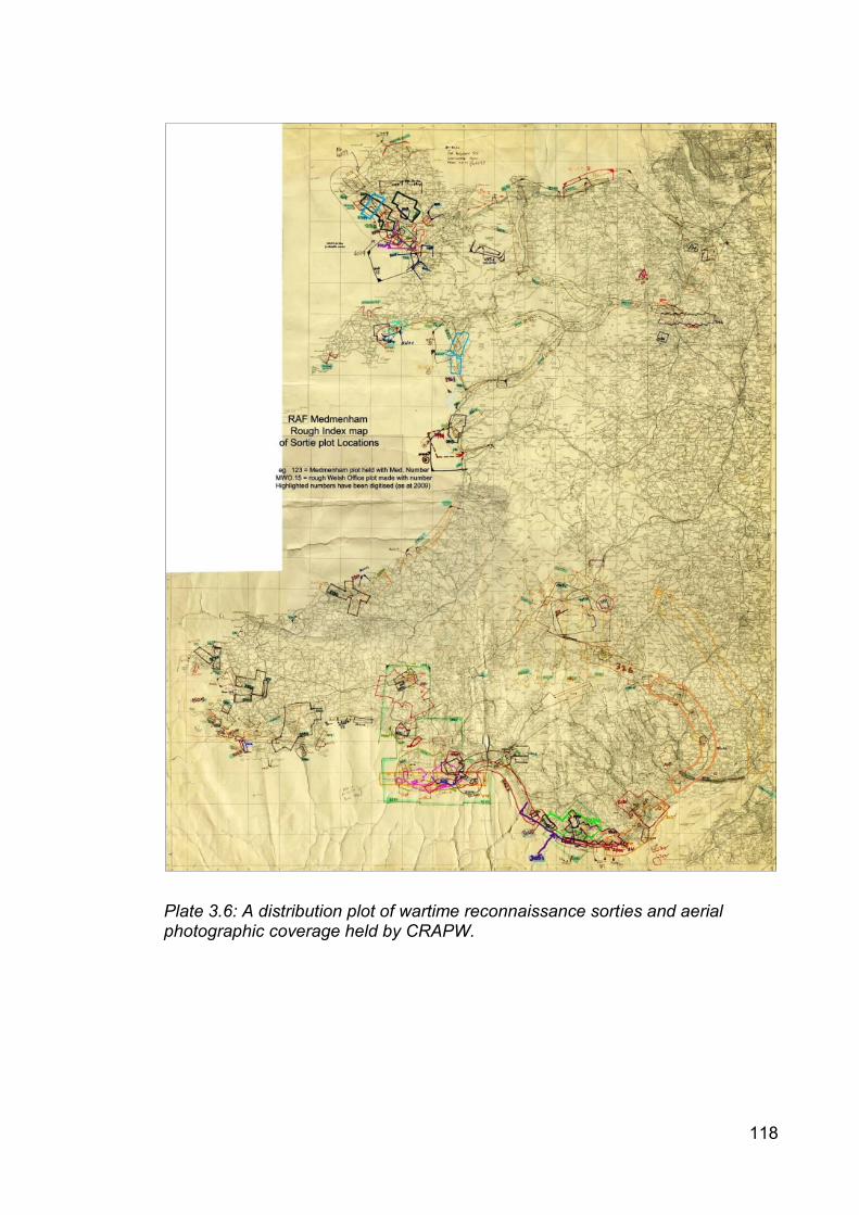
118
Plate 3.6: A distribution plot of wartime reconnaissance sorties and aerial photographic coverage held by CRAPW.
119
3.6 Cartographic evidence
The military has a longstanding interest in accurate mapping and their
respective histories are closely intertwined, as they both are with archaeological field
recording (Harley 1975; Phillips 1980; Oliver 1993; Hodson 1995; Ordnance Survey
2010). No known maps survived that depicted the locations of all anti-invasion
defence sites in Wales. TNA’s research guide on military maps of the Second World
War stated that ‘unit war diaries of the British Army often include maps, plans and
tracings, usually as appendices to the narrative’ (2013c: 3). This evidential class
incorporated a variety of different types of maps and plans, including:
Ordnance Survey one-inch to one-mile maps with military information
overprinted (GSGS3907 series maps)
Ordnance Survey six-inch to one-mile mapping reproduced at 1:25,000
scale by the Royal Engineers (GSGS3906 series maps)
Annotated overlays to the above
Site specific scaled site layout, building or engineering plans
Informal sketch plans
3.6.1 Author, audience and social setting
All military mapping was intended for use by service personnel in
headquarters and in the field for use in official military business. Work with maps
was a fundamental and commonly occurring military activity. Map creation was
undertaken at the request of military commanders in order to illustrate orders and
reports or provide a record. The formal measured maps and plans were produced or

120
amended by professional military cartographers or surveyors. Informal sketches
were produced by those parts of the military such as the Home Guard that wished to
convey a lot of detailed information quickly, but without the means to formalise it.
The names of individual cartographers were rarely recorded, but their unit identities
were sometimes stated.
3.6.2 Format
Military mapping was created in a large variety of sizes ranging from foolscap
to oversized documents measuring many metres in size for use in single or group
formats. The size of the map was determined by the scale required and subject size,
and also by practicalities such as the place of intended use. Larger maps tended to
be used at headquarters and smaller maps were used when mobility was required.
Maps were printed on specific chart paper, cloth-backed paper or grease-proof
paper. The map content could be depicted in multiple press colour inks, duo-chrome
or monochrome. Sketch plans could be very simple consisting of pencil on the back
of letter paper.
3.6.3 Content
Military cartography contained a variety of content, which was determined by
its intended purpose and user. Content ranged from simple colour civilian maps that
were overprinted with the War Office False Origin (WOFO) Cassini grid reference
system (GSGS3907 series mapping) to enable military orders to be interpreted and
installations located to more specialised versions of similar content at a larger

121
1:25,000 scale (GSGS3906 series mapping). The latter was monochrome with
contours depicted in brown to enable better comprehension of terrain.
The majority of military documents such as war diaries and operation
instructions cited locational references to the WOFO grid reference system, also
known as the Cassini or purple grid (Crawshaw 1991; Dobinson 1996b). The latter
name arose following the military practice of over-printing a purple coloured grid onto
civilian Ordnance Survey maps. The Geographical Section, General Staff (also
known as MI4) operated to the Director of Military Operations and Intelligence, and
was responsible for producing these secret maps (Hellyer and Oliver 2004). Systems
for manual transformations have been published (Burridge 1995; Redfern 1998a;
Penny 2000).
Other pre-existing civilian mapping was utilised by the military by the addition
of annotated symbols and text to show defence installation and organisational
boundaries.
Layout plans depicted the extent, location and identity of buildings and
structures at military installations such as airfields, camps and coast artillery
emplacements, usually accompanied by a numbered schedule of buildings. These
plans were usually at 1:2,500 scale. Location plans depicted the general
geographical location of a military establishment, often defining the formal boundary
with the civilian world. Technical and engineering plans depicted the information
required by tradesmen to maintain, alter and repair various types of infrastructure
such as telecommunication or sewerage systems.

122
The use of annotated semi-transparent overlays was often used as a means of
sending information through secure communications. These maps included
specifically marked grid line cross hairs that could be rectified with a base map to
convey the required information. This type of mapping only worked in combination
with the base map and was harder to interpret on its own.
The Air Ministry Record Site Plans dated to 1944-45 and omitted reference to
the majority of defensive structures from the beginning of the war. The richest
source of military cartography was preserved within the coast artillery Fort Record
Books.
Where maps were identified they were usually whole and complete. The
content of the war diaries and registered files made it clear that many maps cited in
those documents were no longer attached to those documents. It was not certain
whether the missing maps had been removed by the military prior to deposition or
whether archival staff separated material following deposition into other collections.
3.6.4 Purpose
Mapping commonly accompanied all aspects of military communication,
particularly issued orders and submitted reports. They were utilised for planning
work, monitoring progress and recording the presence and identity of military sites
and infrastructure. They were used for recording operational and tactical decision-
making and organising and delivering training.
The plans also formed part of the official documentation that was used in the
acquisition and requisition of civilian property and eventually formed part of the

123
considerations for repayment of war damages. Architectural, technical and
engineering drawings were used to identify, locate and characterise different aspects
of military infrastructure.
3.6.5 Status
The maps examined were classified documents and were originally kept
securely. They were often marked ‘secret’. The number of copies, access,
circulation and usage were restricted, often to officers and NCOs. Subordinates
were often ordered to destroy maps by fire when they were outdated or no longer
needed. Mapping was often earmarked to be issued on the event of an invasion to
retain control and avoid accidental losses or exposure.
The mapping was not censored as it was for an internal military audience, but
it was uncertain whether the mapping had been subjected to screening and selection
once opened for public access at places of archival deposit. In particular there might
be modern day sensitivities regarding free access to wartime mapping of MOD
establishments that are still in use on security grounds.
As pictorial representations of military planning, actions and records used by
the military for internal business purposes the mapping did not appear to have an
overt external propaganda value.

124
3.6.6 Treatment
The mapping was created first and foremost for military use. As a relatively
rare commodity during the early years of the war mapping was used sparingly and
often copied. Huge volumes of maps came to be produced and consumed by the
military as an everyday tool accompanying most tasks. As mentioned above, while
maps were restricted items, they were considered disposable through the correct
controlled channels unless they were specifically produced to create a permanent
record.
The majority of the maps that were accessed in this research were officially
deposited by the Ministry of Defence through established archival selection and
retention schedules that identified government business records for archival deposit
at the Public Records Office. Following deposit the maps were made publicly
accessible in 1972.
The large-format Air Ministry Record Site Plans are preserved at both TNA in
albums compiled by the Air Ministry during 1945 and the RAF Museum, Hendon.
3.6.7 Contemporary meaning
The cartographers were in close chronological, functional and spatial proximity
to the phenomena that they recorded and produced the maps as part of routine
service and official government business. They had privileged physical and
intellectual access to the subject being recorded and were expected to produce
professional and accurate records for operational purposes.
125
As artificial constructs not all aspects that researchers are interested in were
recorded or not recorded to the required level of detail. Apparently obvious content
was routinely omitted from military mapping if it did not form part of the intended
requirement. As consciously composed entities they were highly selective
representations and contained intentional bias. They recorded aspects of a fixed
point in time, although additional value could be obtained from working with
successive iterations in order to demonstrate site development and phasing.
3.7 Summary
This chapter provided a critical focus on the main categories of sources of
evidence to be used in this research (Beaudry 1988; Little 2007, 2014). It highlighted
a rich and diverse range of evidential sources that will support robust analysis and
facilitate nuanced results and interpretation. The assessment demonstrated that
sufficient amounts and types of evidence survive and that it will be possible to
undertake a comparative review of the role, value and contribution of the different
evidential classes. It also demonstrated that a comprehensive understanding of the
coverage, strengths and weaknesses of the origination, purpose and post-
depositional processes is required to use the source evidence critically.
The critical assessment identified a significant range of primary and unedited
official sources for internal government and military use. The documentary,
cartographic and aerial photographic evidence comprise a unique and informed
evidential base that is not available elsewhere. The content is useful and relevant to
the research questions. The preserved content is near-complete, although it is

126
uncertain to what extent the known evidence is representative of the original totality
as evidence for selectivity during record management and archiving was identified.
The authors, and their intentions, points of view and intended audience can be
determined. Compiler and selectivity bias were identified and assessed, but no
evidence of formal censoring or propaganda use was identified.
Mindful of the caveats above, the sources are regarded as a significant,
authoritative and authentic evidential base. The identified official sources are
important, reliable and trustworthy sources of data.

127
4. METHODOLOGY
4.1 Introduction
This chapter presents the methodology and method utilised in this study. A
mixed research methodology was used to induce concepts and theoretical
propositions from the datasets in order to maximise the creation of informed and
nuanced findings. The use of a grounded theory approach to frame the research and
a case study method to select and analyse data is explained and validated.
The methods of data identification, selection, collection, organisation and
analyses for the different types of source evidence are described and justified. The
potential weaknesses of the methods are identified and the tests to ensure reliable
and rigorous results are defined. The limitations of the study are presented together
with a statement of the researcher’s ethical position regarding fieldwork practice and
the investigation of conflict.
4.2 Methodology
Travers defined methodology as the ‘assumptions you have as a researcher,
which can be epistemological or political in character, or mean that you support the
view of the world promoted by a particular theoretical tradition’ (2001: vi).
As stated in Chapter One, the research approach utilised in this study was
archaeologically-based throughout giving equal primacy to each source, irrespective
of the type of evidential source being examined. This is an important distinction from
historical approaches which emphasise the primacy of the written record above other

128
types of evidential source. The approach drew heavily from conflict archaeology and
was also influenced by trends apparent within historical and documentary
archaeology and the archaeologies of the recent and contemporary pasts.
The theoretical trajectory adhered broadly to a mixed mode of enquiry of
observation and content analyses, which suited the subjective character of the study.
The approach arose out of aspects of archaeological heritage management. The
literature review identified that heritage management was a principal driver behind
much modern conflict archaeology (Carman 2013: 16-17; Schofield 2005). In
contrast, much of the anti-invasion study literature lacked an explicit foregrounding of
serious archaeological theoretical discourse, and adopted either a semi-atheoretical
or an implied empirical approach.
Travers described four main epistemological traditions comprising positivism,
interpretivism, realism and post-structuralism (2001: 9-12). All offered different views
on how or whether it is possible to obtain certain or objective knowledge about the
world, and as a doctoral study it was important for the researcher to be self-
conscious about epistemological assumptions made during the research process.
The literature review demonstrated that much of conflict archaeology was
positivist in character applying scientific empirical methods to establish quantitative
counts or distributions of site types or other occurrences to establish objective insight
into the world (see, for example Foard and Morris 2012). This work fell partly within
this tradition given the concerns to collect large amounts of data, to apply established
criteria, to undertake comparisons, and to ensure reliability and robustness. The use
of case study method and grounded theory adopted in this research were compatible
129
with this approach. However, some elements of this study were subjective in
character and had more in common with archaeological post-processual approaches.
Realist traditions such as Marxism and Feminism are popular and often take
up overtly critical political positions seeking to reveal concealed realities (Travers
2001: 10). In this researcher’s opinion this can lead to the over-applied assumption
that all phenomena are contested and a rather cynical view of the world. Although
conflict possesses strong explicit links with political and ideological considerations
and a number of studies discussed in the literature review have successfully adopted
this stance, the researcher did not assume this epistemological perspective as the
research questions address other issues that required a different outlook.
Interpretivist perspectives focus on how members of society understand their
own actions. This approach was not utilised as the ‘preference for conducting in-
depth ethnographies in one social setting’ (Travers 2001: 11) was not deemed
compatible with undertaking comparative studies on a greater range of settings. This
approach also raised questions concerning respondent selection within a society.
In contrast to the traditions above, post-structuralist interpretations contended
that ‘there is no such thing as objective truth’ and that knowledge was a means of
exercising power, and that method and reason were delusory (Travers 2001: 153).
This approach profoundly influenced archaeological thinking during the 1990s (post-
processualism), particularly developing emphases on subjectivity, agency and multi-
vocalism. Certain aspects of this approach such as an emphasis on context and
foregrounding the identity of human agency in relation to material culture were
influential to the thinking behind this research. As will be demonstrated throughout
130
the thesis, a major driver of this research is to place the evidence within its proper
historical context, albeit not necessarily through standard historical methods, and to
identify the military formations and units responsible for conceiving, building and
using the anti-invasion defences.
4.2.1 Grounded theory method
Much of this research was informed by the grounded theory approach that is
utilised in a number of academic fields including the social sciences, medicine and
management (Strauss 1987; Strauss and Corbin 1998). This approach seeks to
develop concepts and theories that are firmly grounded in data from which it has
been systematically gathered and analysed (Myers 2013). Strauss stated that:
‘the methodological thrust of grounded theory is toward the development of theory, without any particular commitment to specific kinds of data, lines of research, or theoretical interests... Rather it is a style of doing qualitative analysis that includes a number of distinct features… and the use of a coding paradigm to ensure conceptual development and density’ (1987: 5).
Myers identified six advantages of utilising this methodology (2013: 111-113).
The approach immerses the researcher in the data at a detailed level at an early
stage. It encourages systematic and detailed analysis and provides evidence to
substantiate claims. The iterative character of the approach is valuable as the
constant interplay between data collection and analysis enables known data to be re-
evaluated and developed in the light of findings from new data. The ability of the
method to allow for the emergence of original and rich findings that are closely tied to
the data is a recognised strength. Myers also states that grounded theory method is
131
especially useful for undertaking research that describes repeated procedures within
organisations; in this case the evidence embedded within different types of
communications processes (physical, textual, cartographic and photographic)
between different parts of the military and related ministries.
4.3 Method
Travers defined method as ‘the techniques used in collecting data’ (2001: vi)
i.e. how the research was carried out. This study adopted a mixed method design of
qualitative and quantitative approaches to collect a richer and stronger array of data
from diverse primary and secondary sources of evidence.
Case study method was used to define case boundaries, select evidence and
present results in a rigorous manner (Travers 2001; Yin 2009). Grounded theory
method (Strauss and Corbin 1998) was used to induce theory from the data as it was
collected and explored;
‘a distinctive feature of the method is that the collection and analysis of the data takes place simultaneously, with the aim of developing general concepts to organize data and then ‘integrating’ these into more general, formal set of theories’ (Travers 2001: 44).
Traditional archaeological desk-top and field survey methods were used to
identify surviving evidence of anti-invasion defences in the case study areas.
Documentary, cartographic and photographic evidence was subject to content
analysis and coding. The results within and between cases were cross-compared to
132
assess to what extent evidence survives for Second World War anti-invasion
defences in Wales.
The method adopted comprised the purposeful selection of a limited number
of different classes of source evidence for cross-comparison. Aspects of this were
influenced by previous practice identified within the literature review, particularly
Dobinson’s historical documentary research (1996b, 2000a and 2000d-e) and Foot’s
methodology for investigating defence areas (2006a-b). Data collection and analysis
at a national scale was deemed to be too big to undertake within this research.
4.3.1 Preparation
Careful preparation was required for data collection. Establishing an informed
understanding of the military and the identification of military units present in Wales
were key primary tasks, as the data identification and analysis would be poor without
a thorough contextual comprehension of the phenomenon being investigated.
4.3.1.1 Contextual research
The importance of developing a contextual understanding of the general
organisational structures, roles, terminology and inter-relationships of the wartime
armed forces and their parent civilian ministries was realised from the
commencement of the research. This information was obtained from a number of
sources (Davies 2013; Dobinson 1996b, 2000a, 2000d-e; Ellis and Chamberlain
1974; Forty 1998; Joslen 2003; Mills 2010; Wragg 2007). The development of this
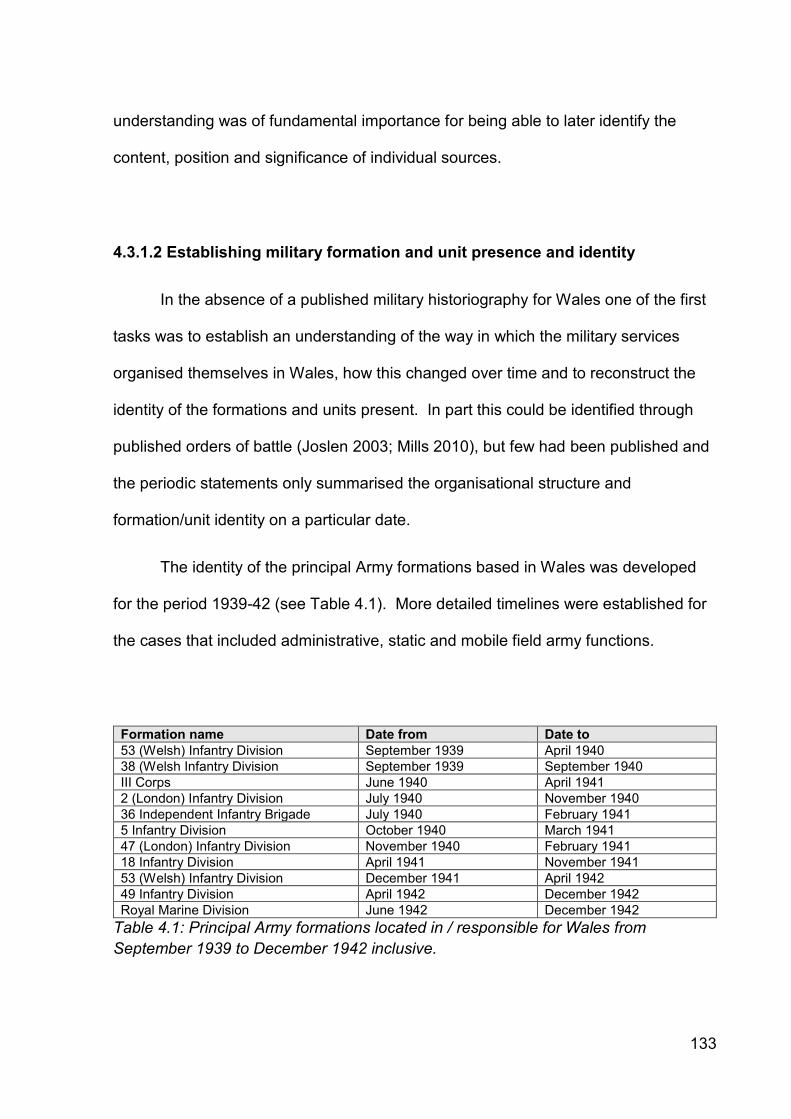
133
understanding was of fundamental importance for being able to later identify the
content, position and significance of individual sources.
4.3.1.2 Establishing military formation and unit presence and identity
In the absence of a published military historiography for Wales one of the first
tasks was to establish an understanding of the way in which the military services
organised themselves in Wales, how this changed over time and to reconstruct the
identity of the formations and units present. In part this could be identified through
published orders of battle (Joslen 2003; Mills 2010), but few had been published and
the periodic statements only summarised the organisational structure and
formation/unit identity on a particular date.
The identity of the principal Army formations based in Wales was developed
for the period 1939-42 (see Table 4.1). More detailed timelines were established for
the cases that included administrative, static and mobile field army functions.
Formation name Date from Date to
53 (Welsh) Infantry Division September 1939 April 1940
38 (Welsh Infantry Division September 1939 September 1940
III Corps June 1940 April 1941
2 (London) Infantry Division July 1940 November 1940
36 Independent Infantry Brigade July 1940 February 1941
5 Infantry Division October 1940 March 1941
47 (London) Infantry Division November 1940 February 1941
18 Infantry Division April 1941 November 1941
53 (Welsh) Infantry Division December 1941 April 1942
49 Infantry Division April 1942 December 1942
Royal Marine Division June 1942 December 1942
Table 4.1: Principal Army formations located in / responsible for Wales from
September 1939 to December 1942 inclusive.

134
These were established by examining the high level General Headquarters
and Western Command general operations, Royal Artillery and Royal Engineers war
diaries. These diaries included periodic lists that published the locations of all
formations and units within a particular administrative area at the time of publication.
The distribution lists attached to orders and correspondence, and the operational
instructions issued to particular formations also aided the identification of the military
administrative and operational organisational structure and identities of
formations/units in Wales and how this evolved through time.
The work to identify subordinate formations and units was undertaken in a top-
down hierarchical fashion, establishing as best as possible the identities, locations,
functions and durations of service within Wales. Once a new entity had been
identified, the war diary for that entity was sought and searched for evidence of
additional units. This was repeated again and again until all of the leads had been
exhausted. A partial complete organisational biographical framework was
established, which identified the administrative, static and field forces in a given
location at a given time. This work served two purposes: it identified relevant
evidential source material and provided an understanding of who was responsible for
authorising, constructing, using and decommissioning the anti-invasion defences.
4.3.2 Case study method
The case study method was used to organise the identification, selection, and
collection of data, undertake some analysis and report the results. This method
framed the research and facilitated the comparison of the content, coverage and

135
availability of the different evidential sources and their value, role and contribution
within and between cases in order to induce theories that addressed the research
questions.
4.3.2.1 Justification
Yin identified a range of different research methods that were suitable for
investigating phenomena in different situations, including experimentation, survey,
history and case studies (2009: 5-13). Each method suited a particular combination
of conditions regarding ‘(a) the type of research question posed, (b) the extent of
control an investigator has over behavioral events, and (c) the degree of focus on
contemporary as opposed to historical events’ (2009: 8).
Following Yin’s analysis a case study method was adopted in this research for
five reasons:
Fit – this method possessed the best fit with the ‘how’ and ‘why’ format of
the research questions.
Control – the researcher had little or no control over the behavioural
events under investigation. The evidential source material had already
been created and subjected to a variety of post-depositional processes.
Case study method was well-founded to investigate these circumstances.
Contemporaneity – case study method was well-placed to investigate
contemporary phenomena and events. Although the documents were
136
historic and situated in the recent past, the study was investigating to what
extent evidence survives for Second World War anti-invasion defences in
Wales, which was a contemporary issue/event.
Boundaries – the selection of cases imposed spatial boundaries on the
source evidence, enabling effective and efficient focusing of research effort
and time, and a deeper investigation of data within the boundaries.
Evidence beyond the boundaries was not ignored and could inform the
cases, but the evidence was not directly presented or considered.
Informing – the case study method informed the design and the
implementation of the research. It did not limit the number of cases that
could be investigated and could be applied to quantitative and qualitative
sources of evidence. The use of data triangulation made the conclusions
more robust and the method directly informed the research evaluation.
The method also offered the ability to set up comparisons and contrasts
within and between cases to identify similarities and differences.
The case study method was useful as it enabled exploration of complex and
commonly occurring phenomena in a real world context. It was a frequently used
and rigorous social science methodology for developing valid inferences for
qualitative and quantitative research from events outside of the scientific laboratory
(Yin 2009). Other methods of inquiry such as experiments, modelling, surveys and
137
histories were not considered to be as appropriate for addressing the research
questions.
The method also benefited from the ability to be robustly integrated with
fundamental best practice common to most research by being informed by a
thorough literature review, framed by carefully constructed research questions, the
definition of and adherence to formal procedures, maintaining an audit trail, and
seeking alternative explanations (Yin 2009). The use of cases also fitted well with
Mills’ recommendation that archaeological data collection should be multi-staged and
regionally-based in order to address pronounced biases in existing samples of
archaeological datasets including bias towards certain areas and types of site type
(1985).
4.3.2.2 Critique
Yin described four common concerns regarding the use of case study
research (2009: 14-16). He stated that a primary concern was the lack of rigour,
failure to adhere to systematic processes and the difficulty of removing bias from the
results and conclusions. Other concerns were that case studies provided a poor
foundation for scientific generalisation, took too long to complete and were unable to
examine causal relationships.
Early recognition of these potential weaknesses enabled the research method
to be constructed and reviewed in a manner that foregrounded these issues and
sought to ensure that they were addressed in a clear and robust manner.

138
4.3.2.3 Design
In contrast to other types of research method ‘case study research designs
have not been codified’, but careful design can enable more rigorous and
methodologically sound case studies to be established (Yin 2009: 26). The cases in
this research provided sufficient access to review documentation and make field
observations. The research questions cited in Chapter One were developed from the
literature review in Chapter Two, and the cases were selected to illuminate the
research questions.
Cases can be studied in singular or multiple manifestations. It was important
for the researcher to justify the number of cases used in order to establish their
purpose. A multiple-case design of three cases was adopted in this study. This
design required greater effort, resources and time, but benefited from the ability to
undertake replication between cases in order to compare and contrast, which
provided more compelling evidence and made the study’s findings more robust than
with the use of a single case (Yin 2009: 53). Three cases also enabled close study
of evidence over large spatial areas, but the addition of further cases was beyond the
scope of this study.
4.3.2.4 Unit of analysis
It is important to establish the unit(s) of analysis used in the cases in order to
justify them and to allow researchers to understand the parameters of the study. The
unit of analysis in this study was the case, which was used to narrow considerably
the available data and to establish a distinction between the phenomenon under
139
study in the cases and the wider external data that formed the background context.
Care was taken to ensure that the definition of the case was aligned with the
phenomenon being studied and did not slip focus (Yin 2009: 30).
The primary analysis sought to explore the dynamics of the inter-relationships
between the different evidential sources. In order to ensure that the cases were
efficacious, they were defined to address a real-life phenomenon, appropriate
sources of evidence were selected, and the cases were given strong time boundaries
to define the beginning and end of the case (Yin 2009: 32). The cases were also
similar to those identified in the literature review and were therefore comparable with
the findings from previous research.
The spatial, temporal, thematic and evidential limitations introduced in Chapter
One essentially formed embedded units of analysis within the cases regarding
selected areas, period, entity (anti-invasion defences) and sources. The following
case boundaries were adopted:
Areas – case study areas were purposefully selected on the basis of
known concentrations of archaeological, documentary, cartographic and
aerial photographic evidence identified during preliminary research to
ensure that the research questions can be illuminated. Case boundaries
were coterminous with known military administrative boundaries where
available or otherwise arbitrary areas that focused on known defensive
networks and their immediate environs.

140
Period – cases were temporally defined from September 1939 to
December 1942 inclusive, with the caveat that defence preparation prior to
and defence clearance operations subsequent to this period had important
contextual impact and consequences.
Theme – cases were thematically defined with regard to the preparation of
terrestrial and inter-tidal anti-invasion defences prepared by the three
armed services and their parent civilian ministries.
Sources – the sources used in this research were limited to contemporary
primary documentary, cartographic and aerial photographic evidence and
the surviving known archaeological resource. The use of sources was
primarily limited in scope by the spatial, temporal and thematic limitations
described above, but also by secondary decisions to focus on particular
sub-sets of evidence within the four categories.
4.3.2.5 Quality
It is important for the researcher to demonstrate that the research is valid,
credible and reliable, and not anecdotal or unsubstantiated. Different opinions exist
concerning which tests to use to establish criteria for judging the quality of the case
study design to ensure that the study is valid and robust.
Yin suggested reliability, internal and external validation and construct
validation as tests for empirical research (Yin 2009: 40-45). Rudestam and Newton
141
preferred credibility, transferability and dependability as tests for naturalistic research
(2014: 112). Three of Yin’s four common tests to establish the quality of case study
research were used as they best suit empirical research:
Construct validity – this concerns the failure of a researcher to establish
operational sets of measures and the subjective judgements used to collect
data. Yin stated that construct validity can be increased by the use of
multiple sources of evidence that demonstrate converging lines of inquiry
and the establishment of a chain of evidence during data collection.
Internal validity – this test was used for explanatory studies seeking to
explain causal effect. This test was not appropriate for this study, which
was exploratory in character.
External validity – Yin observed that external validity i.e. whether a
study’s findings are generalizable beyond the immediate case study was a
major barrier in case study research (2009: 43). He advocated the use of
replication logic to provide stronger support in which results were replicated
through the use of multiple case studies.
Reliability – this test concerned a later investigator being able to achieve
the same results for the same case with the same procedures and
evidence. Yin stated that the reliability test could be established through

142
the detailed documentation of procedures, adherence to the same protocol
across case studies, and the use of case study databases. Consistency
could be achieved through careful coding of data and content analysis.
The measures for construct validity, external validity and reliability are
discussed in further detail below and were employed and demonstrated in this study.
4.3.2.6 Case selection
The selected cases were purposefully chosen to illuminate the research
questions. Random selection was not used as the identified cases frequently did not
map onto discrete defence networks; this limited the ability of the method to answer
the research questions and constrained the usefulness of the study.
Some parameters relating to date, theme and period were established above,
but it was necessary to apply further selection criteria in order to identify the cases.
Three key issues related to the focus, location and spatial size and shape of the
cases.
Wales offers an infinite range of potential case study areas, covering a wide
variety of topographical environments. Such areas might be further characterised by
the presence of contiguous defence networks, the extent of previous investigation
and the availability of source evidence. The utilisation of original wartime military
administrative and/or operational area boundaries was also a possibility.

143
Table 4.2 presents the range of considered different scenarios available prior
to case selection, although as a simplification of real-world complexity influenced by
multiple factors compound combinations of the expressed geographic, evidential and
military attributes were more likely to form the cases.
The purposive selection of cases followed on from the preliminary contextual
work detailed above and contained a series of assumptions concerning the likely
presence or absence of evidence, expressed as advantages and disadvantages.
The areas selected were those with a greater incidence of evidence. Each case was
representative of a different type of defensive arrangement, within broadly similar
kinds of landscape.
Three in-depth case studies were selected. Table 4.3 identifies the chosen
cases and summarises their selection attributes (see Chapters Five, Six and Seven
for further details). They reflect areas with varying Defence of Britain project data
coverage and two where there were no existing archaeological syntheses. It is
important to acknowledge that the selected cases have a south and south-west
Wales lowland and coastal bias. As such, the adopted method may not automatically
transfer to the mountainous inland areas of mid and north Wales.

144
Scenario Type Examples Advantage Disadvantage
Urban / Industrial populated area
Geographic Cardiff, Newport, Swansea etc.
Higher chance of evidence creation
Lower chance of evidence survival
Rural under-populated area
Geographic Most of Wales Higher chance of evidence survival
Lower chance of evidence creation
Upland area Geographic Snowdonia, Brecon Beacons
Moderate chance of evidence creation
Higher chance of evidence survival
Coastal area Geographic Coastal fringe Moderate chance of evidence creation
Higher chance of evidence survival
Estuarine area Geographic Severn, Carmarthen Bay, Mawddach
Higher chance of evidence creation
Higher chance of evidence survival
Riverine area Geographic Wye, Usk, Taff, Tywi, Dee etc.
Higher chance of evidence creation
Moderate chance of evidence survival
Port / deep water harbour
Geographic Cardiff, Newport, Barry, Port Talbot, Swansea, Milford Haven, Holyhead
Higher chance of evidence creation
Lower chance of evidence survival
Existing synthesis
Evidential Pembrokeshire, Anglesey
Data available Not detailed or self-critical
Unknown areas Evidential Most of Wales Not researched No data
Known defence archaeology
Evidential Various types and combinations of anti-invasion defence
Data available Not complete coverage
Known documentary coverage
Evidential War diaries, orders, instructions, lists, correspondence
Data available Not complete coverage and not characterised
Known cartographic coverage
Evidential Official military maps and maps of defence installations
Data available Not complete coverage and not characterised
Known aerial photographic coverage
Evidential Black and white vertical and oblique coverage
Data available Not complete coverage and not characterised
Known stop line Defensive 20 known examples Higher chance of evidence creation
Only representative of one defence type
Known airfield Defensive 36 known examples Higher chance of evidence creation
Only representative of one defence type
Known coastal defences
Defensive Selected bays and beaches
Higher chance of evidence creation
Only representative of one defence type
Known anti-tank island, centre of resistance, or defended area
Defensive Focus on towns and villages, but few known examples
Higher chance of evidence creation
Only representative of one defence type
Known vulnerable point
Defensive Power stations, lock gates, factories etc.
Higher chance of evidence creation
Only representative of one defence type
Known military administrative or operational area
Defensive Swansea, Gower, some airfields
Informed case. Opportunity to try new analysis
Few known
Combinations of the above
All Compound Meaningful cases for research
Complexity
Table 4.2: Different types and examples of cases considered for this research.

145
Name Attributes
Geographical Evidential Defensive
St Athan-Llandow (Chapter Five)
Coastal / Estuarine Lowland Rural (towns / villages) Near a port
Presence of archaeological, documentary, cartographic and aerial photographic data
Two airfields Beach defences Vulnerable points
Swansea-Gower (Chapter Six)
Urban / rural Coastal / Estuarine Lowland Port / Industrial
Presence of archaeological, documentary, cartographic and aerial photographic data
Port defences Beach defences Airfield Stop line Vulnerable points Known military administrative or operational area
Carmarthen Stop Line (Chapter Seven)
Coastal / Estuarine Rural Lowland / Upland Riverine
Existing synthesis Presence of archaeological, documentary, cartographic and aerial photographic data
Stop line Two airfields Beach defences Vulnerable points
Table 4.3: Summary of chosen case study areas and their selection attributes.
Case size and therefore the scale of the cases was considered to be critical to
the success of the investigations. The case study areas selected were large enough
to contain the known extent of contiguous defensive entities such as stop lines,
airfields and military administrative areas. The Swansea-Gower case took
advantage of the known boundary of Swansea Garrison and Gower Sector.
4.3.3 Data identification
The literature review and Chapter Three identified a range of potential sources
that could be employed. This section describes the range of data sources identified
and how they were recognised.

146
To inform the development of the research design a preliminary pilot study
was undertaken to identify the location, type, content and availability of potential
datasets. The pilot involved reviewing guides to archival sources (Cantwell 1998;
RAF Museum 2005; Roper 1998; Spencer 2008a-b; Wilson 1982) and examining the
electronic catalogues of national and regional archives, museums and libraries.
Much of the published best practice guidance for archaeological archives
focused on archaeological assemblages (Brown 2011; Perrin et al. 2014). One
paper was identified that re-emphasised the value of archaeological documentary
material (Hicks et al. 2009).
Catalogues held by the Imperial War Museum, regimental museums in Wales,
the National Museum Wales, the National Archives, local record offices in Wales, the
Welsh Archaeological Trusts, the Royal Commission on the Ancient and Historical
Monuments of Wales (RCAHMW), the British Library and National Library of Wales
were consulted. The catalogues of specialist aerial photographic collections held by
Welsh Government, RCAHMW, the Aerial Reconnaissance Archives (TARA),
Cambridge University and the American National Archives were also consulted.
The catalogues were queried with a common set of search terms [airfield; anti-
invasion; army; battery; defence; emplacement; Home Front; Home Guard; Navy;
RAF; Royal Air Force; Second World War; stop line; World War Two; WW2].
A number of smaller repositories did not possess electronic catalogues, so
visits were made to undertake assessments of the collection holdings.

147
4.3.4 Data selection criteria
During the pilot study undertaken to identify the identity, content, location,
availability and restrictions of a diverse range of evidential source material an open
selection strategy was adopted in order to ensure a non-prejudicial approach.
As the study proceeded to the main survey the researcher utilised a more
selective and purposive selection strategy in order to increase the scope and range
of the data collected and in order to overcome the issue of suppressing deviant
cases or data outliers often encountered with qualitative random sampling. This
involved the use of selection criteria and carefully chosen subject evidential source
material that closely matched the spatial, temporal and thematic criteria of the topic
and the specific choice of case study areas. A deep level of investigation was
undertaken in order to saturate the cases and so that the emerging concepts and
their relationships to others could be explored comprehensively in a theoretically
meaningful manner.
It is important to review the reasons why particular types of source material
were used and why others were not. Two key decisions informed the selection of the
type of source evidence to utilise within the study. The first comprised the choice of
physical type of source evidence. The pilot study described above identified a
diverse and comprehensive range of potential types of primary and secondary source
evidence. These included written documentation such as official war diaries and
registered files, personal diaries and written archives, media, art, film, photography,
mapping, oral history testimony together with primary and secondary archaeological
site, artefactual and other archival evidence.

148
The decision to choose archaeological, documentary, cartographic and aerial
photographic types of source evidence was based on three reasons. The first reason
reflected the familiar and long-held use of this combination of evidence types within
the tradition of archaeology. The second reason focused on the expectation that the
chosen evidence could provide a strong methodological fit and lent itself to
corroborative triangulation (see ‘Data collection’ below). The inter-play of evidence
from different disciplines might also enlighten inter-disciplinary debates and provide
an illustrative case study in its own right. The third reason was a pragmatic response
based on a variety of factors including presence/amount of material, location, ease of
access, degree of cataloguing, format, ease of data capture, copyright and other
restrictions.
The second key decision comprised which specific collections to utilise within
the chosen types of evidence. Careful selection was necessary given the
comprehensive abundance of potential collections. The reasons for selecting each
evidence type are stated below.
4.3.4.1 Use of official sources
The pilot study identified a number of documentary, cartographic and
photographic classes of evidence that originated from official sources. These
records are a subset of those created by the civilian and military authorities
responsible for planning, commissioning, using and abandoning the anti-invasion
defences. The records were authoritative and presented a privileged means of
investigating activities that constituted controlled knowledge. As official records they

149
also benefited from transference to recognised places of archival deposit for long-
term preservation and public access.
As primary documentation, the data had not been subject to formal selection
and re-presentation as official history and was less susceptible to associated
weaknesses regarding objectivity (suppression), balance (distortion) and
independence (partisan) (Blumenson 1962-3; Spector 1990; Spiller 2006; Trask
1989). The writers of the documentary evidence were reporting/recording their own
activities and while the extent to which events were misrepresented or suppressed is
unknown, the evidence does not suffer from a preoccupation of one society
commenting upon and explaining another (Kaplan 2002). Kaplan identified
methodological concerns regarding the underpinning of archived state documents
and advocated exposure of the underlying social, political and cultural assumptions,
knowledge and meaning. Awareness of these issues informed this research.
At a time of restrictive and secretive wartime conditions, these official archive
collections were considered to represent the most informed, extensive and available
data for answering the research questions regarding to what extent evidence
survived and what type of anti-invasion defences were built where, when and by
whom. The content of the archival collections was anticipated to be complementary,
reflecting different perspectives of a common actuality. The use of official sources
also reflected the researcher’s employment as a civil servant and his inherent
familiarity with the practice, organisation and content of government records.

150
4.3.4.2 Archaeological data
The available secondary archaeological site data was very limited in terms of
quantity and diversity; the known data is self-selecting within the cases. Existing site
data was held at the NMRW and the Welsh Archaeological Trusts’ HERs. No unique
sources of archaeological site data were identified outside of Wales. Rapid field
observation was undertaken to identify new primary site data and supplement the
existing secondary data.
4.3.4.3 Documentary data
Dobinson (1996b, 2000a, 2000d-e), Redfern (1998a-b) and Foot (2004,
2006a-b) had all undertaken previous documentary based studies, which included
brief discussions of the type and value of source evidence used. This research was
informed by their work. Dobinson’s and Foot’s evaluations were the most thorough,
but did not extend to Wales; Redfern’s discussion included Wales, but was
comparatively underdeveloped and lacked the useful prepared archival lists of
pertinent archival pieces.
4.3.4.4 Cartographic data
Very few specific military map archives of relevance were identified. The RAF
Museum possesses a collection of airfield record site plans, but otherwise plans,
maps and sketch maps were identified on an individual basis primarily when looking

151
at other documentary collections. The pilot study identified very low numbers of
maps and the known examples found within the case study areas were self-selecting.
Incomplete collections of War Office GSGS3906 and 3907 series maps were
identified at the British Library and TNA. The primary value of these maps was the
inclusion of the WOFO grid that enabled the Cassini grid references in the
documentary sources to be located.
Copying restrictions at the former and access issues at the latter prompted the
researcher to purchase complete sets of the relevant sheets for each case study
area from cartographic dealers. These are held in the research archive.
4.3.4.5 Aerial photographic data
The pilot study identified a number of large aerial photographic archives. The
Aerial Photography Archive (TARA) held by RCAHMS is one of the largest collections
in the world, but it was not utilised as the service’s online catalogue did not indicate
any relevant content for Wales. Further enquiries were deterred by the commercial
fees required to commission imagery searches and to purchase digital imagery.
An important repository of Luftwaffe aerial photography is held at the American
National Archives. Its exact coverage and significance for Wales was not determined
owing to the considerable costs associated with obtaining the imagery.
The national collections of aerial photography pertaining to Wales are held by
the RCAHMW and the Welsh Government. Both repositories hold duplicate
collections of the wartime RAF Medmenham prints taken by the RAF and USAAF,

152
and the subsequent Operation Revue imagery taken during the national post-war
aerial photographic survey. The Welsh Government’s collection was selected as it
had been digitised to professional standards and was available without copyright and
access conditions.
4.3.4.6 Discounted forms of evidence
The literature review demonstrated that a wide range of methods and forms of
evidence had been employed to investigate the phenomenon of modern conflict
archaeology. Oral history testimony was widely adopted within historical archaeology
and by some conflict archaeologists. Moshenska advocated an interdisciplinary
approach ‘combining archaeological, historical and memory work on a specific
location to create and foster a public discourse of memory’ (Moshenska 2007: 91).
Irrespective of the perceived advantages or disadvantages of the method
(Barclay 2013; Hobsbawn 1997; Lan 2013: Moshenska 2007, 2010b), this type of
data was not collected for this study. This was a pragmatic decision, as to include a
fifth type of evidential source would have reduced the resources available to research
the other sources.
Further, Moshenska also stated that oral history was best employed at a site
scale, which did not match the intended scope of this study. The potential value of
this method to supply background research and complementary data is not disputed,
but this was considered best achieved outside of this study.
153
4.3.4.7 Final subject source selection
The process described above established a focus on official sources and
resulted in the selection of four types of source evidence: primary and secondary
archaeological site evidence, official wartime primary documentary evidence
comprising war diaries and registered files, official wartime cartographic evidence
and military wartime and post-war aerial photographic imagery.
These forms of evidence were considered to be the best placed to inform the
research questions. The implicit biases within the sources are acknowledged. The
evidence was formed for different purposes and by different audiences, albeit all
contemporary to the subject in question. It was more informed and participatory than
many other sources. The data used is considered appropriate and justified.
4.3.5 Data collection
This section describes how the data was collected and recorded in a
systematic manner. The process is described in detail so that it can be replicated.
4.3.5.1 Principles of data collection with reference to the case study method
Yin identified three principles of data collection (2009: 114). He stated that the
ability to use multiple sources of evidence was a major strength of case study
research. Multiple sources of evidence enabled data to be triangulated: facts
supported by more than one source of evidence facilitated converging lines of inquiry

154
that provided multiple measures of the same phenomenon. Findings are therefore
more convincing and accurate.
The use of triangulation in order to provide cross-checking and corroboration
of data and emerging themes, was an integral part of the research design. This
method was particularly informative regarding how much credibility to place on an
individual source of evidence. Sometimes it was uncertain whether a documentary
or cartographic reference was citing a proposed or extant defence post.
Triangulation with aerial photographic and field evidence could often, although not in
all cases, provide visual confirmation of a defence post’s existence.
Yin also advocated the use of a case study database to increase the reliability
of the case. A record of all stages of the process of the study was maintained in a
database, which forms part of the research archive. This included the raw data,
together with its modified forms through various stages of analysis and synthesis. A
journal of critical self-reflection was also maintained and used to record thoughts,
insights, suspicions and failures. Analysis of the content informed internal biases
and assumptions.
In this study, a GIS workspace within ESRI ArcGIS 10.0 was used to collect,
store and organise the data collected from the four different types of source
evidence. The records were organised spatially by unique defence post entries and
the citation of source evidence occurrences enabled the presence and/or absence of
a particular source evidence and the presence of triangulation to be established. As
an organisational tool the GIS tables also enabled the process of data collection and
analysis to be continued to the point of data saturation.

155
4.3.6 Collection: archaeological data
Secondary archaeological site data was collected from existing archaeological
data repositories and primary data was obtained from fieldwork.
4.3.6.1 HER/NMRW data
The HERs and NMRW were approached for copies of their digital datasets
pertaining to twentieth-century military sites during 2011. The data was exported and
supplied as Microsoft Excel spreadsheets using industry agreed ENDex data
exchange fields and standards. The NMRW dataset was provided in November
2011. Glamorgan-Gwent Archaeological Trust’s dataset was provided in January
2012. Dyfed Archaeological Trust’s dataset was provided in February 2012.
4.3.6.2 Fieldwork
The fieldwork was undertaken in discrete blocks of three to four week periods
on a case by case basis. Fieldwork for the St Athan-Llantwit Major, Swansea-Gower
and Carmarthen Stop Line case studies was undertaken in June 2012, August 2012
and March 2013 respectively. Additional site visits were undertaken at other times
when opportunities arose.
A desktop study of the known sites was undertaken for each case study area
and Ordnance Survey 1:25,000 maps were marked accordingly for use in the field.
Fieldwork was organised on an area basis and targeted areas of known and/or
suspected defences. Landowner permission was sought prior to undertaking visits

156
and these conversations often established multiple new leads. Site data was
collected on recording forms – similar to those used by the Defence of Britain project
– to a Level One standard, comprising a basic visual record supplemented by
minimal textual information sufficient to identify the site, location, age, type and group
affiliation (English Heritage 2006, 2007).
Fieldwork practice was organised and undertaken following well established
practice (Jesensky 1998; Ordnance Survey 1963; Royal Commission on the Ancient
and Historical Monuments of Scotland 2011; Taylor 1974). Rapid field observation
was undertaken to identify the presence or absence of Second World War anti-
invasion defence archaeological features or structures (Chartered Institute for
Archaeologists 2014). Each identified site was described textually, measured,
sketched, photographed and located using a handheld GPS device accurate to +/-
10m (Ainsworth and Thomason 2003).
The content of the recording sheets was added to the existing case Microsoft
Excel spreadsheet, with each new defence post forming a new record.
4.3.6.3 Data organisation
The archaeological site data from digital repositories was organised into a
separate Microsoft Excel spreadsheet for each case. All spreadsheets used
common fields and recording parlance. The data from the regional and national
repositories for a specific case were merged into a common format and field
structure. The datasets were ordered by national grid reference and assessed for

157
duplicates, errors and omissions. The reconciled data was then purged to remove all
non-anti-invasion defence record entries.
4.3.7 Collection: documentary data
The documentary evidence was sourced from a number of collections. The
largest collection was from TNA. Data collection was undertaken during a three
week period during 2009-10, identifying potentially relevant files, undertaking
preliminary sifts and recording. In total 394 files were examined and 161 files were
recorded digitally, comprising 8,629 pages (19.59 GB). These files are cited in the
List of Primary Sources.
Small batches of military war diaries and registered files were ordered
following identification on Discovery, the online search catalogue. Each file was
subject to an initial rapid visual sift to determine whether there was relevant content
within. Each page containing content pertaining to defence policy and practice, and
military operational and administrative organisational structure in Wales was digitally
recorded in colour using a twelve megapixel camera in JPEG format and a copy
stand. Authorisation to copy was obtained in advance from staff at TNA and a
copyright statement for academic use was completed. The digital files were backed
up in multiple locations.
Smaller amounts of documentary source material were obtained from local
records offices and local history society archives using the same data collection
method. Four files were obtained from Carmarthen Archives, two from West

158
Glamorgan Archives and one from the Llantwit Major Local History Society. No
relevant material was located at Ceredigion Archives or Glamorgan Archives.
4.3.7.1 Data organisation
The digital photographs of textual content were organised sequentially into a
file structure reflecting the organisation and naming conventions of the originals. The
photographs were printed onto A4 paper and stored in individual lever arch files for
ease of reference and manual coding.
4.3.8 Collection: cartographic data
The pilot study did not identify any specific collections of relevant cartographic
evidence. A small number of maps, plans and sketches were identified amongst the
documentary collections at TNA and were collected as described for that category
above. The greatest number were identified amongst the papers of the Fort Record
Books (WO 192), and a small number were identified within administrative war
diaries (WO 166). A very important series of large scale Record Site Plans for some
airfields were identified within Welsh Office files (BD 54). Oversized plans were
photographed in multiple sections to avoid distortion.
Although collections of original hardcopy wartime GSGS maps were identified
at the British Library and elsewhere, copyright restrictions limited opportunities for
digital recording. Instead the relevant sheets were identified and purchased from
cartographic dealers. Entire sets were obtained for two of the case study areas; the

159
Swansea-Gower case study was supplemented with 1:1 scale photocopies from the
National Library Wales. All of the known RAF Record Site Plans for the airfields
within the case study areas were purchased.
4.3.8.1 Data organisation
The cartographic evidence comprised a mix of digital photographs of original
archival maps, photocopies of original archival maps and actual wartime maps. All
physical maps were digitised using an A0 scanner as TIFF files. Oversized archival
maps subjected to multiple photographic recording were reassembled using
functionality and controls within Adobe Photoshop software.
4.3.9 Collection: aerial photographic
The overwhelming majority of the aerial photographic data was obtained from
the Central Register of Aerial Photography at Welsh Government in 2011. The prints
from each wartime sortie had already been scanned to a professional standard and
this data was obtained as high resolution TIFF files. Each sortie was accompanied
by a digitised version of the RAF Central Interpretation Unit’s record card which
recorded the sortie number, date, time, height, focal length, GSGS map reference
and scale together with a black and white cartographic plot of the sortie coverage.
The aerial photography was entirely monochrome in character, and the majority of
this data was vertical in coverage, with a small amount of oblique coverage
particularly of coastal areas. The Welsh Government collection was organised into
106 folders comprising 10,816 files (203 GB) compliant with published standards

160
(Bewley et al. 1999). The specific coverage of each case is described in the relevant
chapter.
Small amounts of additional aerial photographic data were identified within the
Fort Record Books series at TNA (WO 192). Each volume contained a small number
of unique wartime prints of coastal artillery batteries which were not contained in the
Welsh Government collection. The prints were digitally recorded as detailed for
documentary evidence above.
4.3.9.1 Data organisation
The aerial photographs were utilised solely in digital format. The original
Medmenham file structure and naming convention utilised by Welsh Government
was maintained. Selected elements of the Central Interpretation Unit sortie plot
cards (sortie ID name, date and location) were drawn together to create a catalogue
covering each sortie frame (see List of RAF Medmenham Aerial Photographs). Anti-
invasion defences visible on the frames were noted in each record entry as
appropriate.
4.3.10 Analysis
The different forms of data required different types of analysis that respected
their inherent characteristics. The first stage of analysis was to create case study
area boundaries for each case and to import all of the data into ArcGIS 10.0. The
methods are described below.
161
4.3.11 Analysis: archaeological data
The combined primary and secondary archaeological data for each case was
imported into ArcGIS 10.0 as separate Microsoft Excel tables and saved as the
primary data table to which other records from other sources would be added for that
case. This table formed the case study database.
Point data was spawned from the attribute table in order to provide a graphical
distribution and coded to enable different site types to be distinguished. Linear
defences such as anti-tank obstacles were created as separate polyline layers.
4.3.12 Analysis: documentary data
The documentary evidence represented a large and complex body of data that
had not been the subject of previous in-depth archaeological or historical research in
a Welsh context. Rather than approaching the dataset with pre-conceived ideas
using historical or textual analysis methods, a more open form of qualitative analysis
was undertaken.
4.3.12.1 Coding
Coding is a form of content analysis. Content analysis is a broad term for a
range of quantitative and qualitative methods for obtaining valid and trustworthy
information from documents: ‘content analysis has been defined as a systematic,
replicable technique for compressing many words of text into fewer content
categories based on explicit rules of coding’ (Stemler 2001). It is a rigorous way of

162
extracting standardised information from large datasets and allows contextualised
interpretation of documents (Krippendorff 2004; Neuendorf 2002). It involves
analysis of documentary content through categorisation and classification of selected
terms. Validity is assured by ensuring intra-coding consistency within and between
cases.
Content analysis was used to describe and make inferences about the
characteristics of communications in order to answer what?-type questions (Holsti
1969). It was also used to describe trends in communication content, relate known
characteristics of sources and compare communication content (Berelson 1952).
The successful compression of text into fewer content categories was based
on consistent application of appropriate coding. The coding employed in this
research involved the identification and recording of the occurrence of certain types
of vocabulary. This process was applied manually. Each page of text was examined
for references to the following information:
military administrative and operational organisational structures,
particularly formal names, roles, hierarchical relationships, locations,
spatial extents and boundaries, and dates
citations of formation/unit identity, including location, hierarchical
relationships, dates, duration and role
defence structures, including name, type, location, form, role, group
identity, association with military units
citations of Cassini grid references for defence posts, and Ordnance
Survey national grid references within Royal Artillery documentation

163
The data extracted from the content analysis via coding was added to the case
study database within ArcGIS 10.0 either as a new record, or adding additional
information to an existing record. All War Office False Origin (WOFO) grid
references within contemporary documents were transformed into Ordnance Survey
national grid references and added as point or polyline data into ArcGIS (Penny
2000).
4.3.12.2 Critique
Myers identified a number of potential disadvantages of adopting this
approach. The use of coding can be confusing and overwhelming, and rigorous
coding can be time consuming. Codes need to be applied consistently across
documents and cases to ensure consistency. An addition or evolution to the coding
structure usually requires re-assessment of previously viewed documents. Given the
large volume of data and the detailed analysis, it can also be difficult to induce
concepts (Myers 2013: 111-113).
4.3.13 Analysis: cartographic and aerial photographic data
The digital cartographic and vertical aerial photographic data was imported as
separate raster imagery layers within ArcGIS 10.0. The imagery was transformed
into new geo-referenced raster imagery using the geo-referencing function. The
transformation was undertaken to third-order polynomial standard.

164
The new imagery was geo-referenced onto modern Ordnance Survey
MasterMap base mapping at a scale of 1:400 using well-defined objects common to
both base mapping and imagery, such as the corners of buildings. Control points
were added until the RMS error was acceptable at which point the raster dataset was
permanently transformed using the rectify function.
Detailed visual inspection of each frame using the magnification function
enabled visible anti-invasion defences to be transcribed as point, polyline or polygon
features and recorded in attribute tables within the case study database. Large
areas such as airfields and administrative boundaries were added as polygons in
separate layers.
4.3.14 Intra-case comparison
In order to address the research questions the relative role, value and
contribution of the different types of evidence within a case were assessed. Gaps in
the evidence were also identified. Once all of the data from the different cases had
been imported into the GIS and added to the case study database an analysis was
undertaken in order to qualify values for these attributes on an evidence sub-type by
evidence sub-type basis.
Simple quantitative counts of presence or absence were not used as this did
not enable the significance of the content to be assessed or allow informed and
detailed concepts to be induced from the data. Instead judgement based on
personal experience and observation and interpretation of the data was employed to
award each type of evidence sub-type a rating on grading scales as shown in the

165
assessment schema in Table 4.4. Care was taken to include grades for all types of
data occurrence and the preliminary identified grades evolved in an iterative manner
as the data was processed into their final form. Consistency was ensured by re-
assessing grades following schema changes.
Although this was not an objective method the experience gained in handling
the evidence enabled this subjective method to attribute relative scores based on the
subtle details observed, which were summarised in tabular form. This process was
similar to that used to identify the value of assets in heritage impact assessments for
cultural world heritage properties (ICOMOS 2011).
The subjective nature of the analysis enabled nuances and absences to be
observed in the data and enabled results and theoretical insights to be induced. A
prime purpose of the assessment was to determine the presence or absence of data
that would address the research questions. This included data that contained
information relating to military identities, administrative and operational arrangements
and defence posts within the cases. Items such as complete defence schemes
would have high value, whereas brief or incomplete references in war diary returns
would have low value. The assessment of role was based on a wider analysis of the
overall evidence for that class. The evidence with significant quantities, detailed
and/or unique data was assessed as having a primary role, whereas evidence with
tangential or minor data was scored lower. The contribution was a qualitative
response that enabled the different types of data occurrence to be described in a
standardised manner that facilitated cross-comparison.

166
Making use of subjectivity within a research setting can be problematic,
particularly as many methods seek to control or eliminate this variable in order to
achieve objective science. Risks included subjective projection on behalf of the
researcher and limitations owing to unseen blind spots.
The researcher aimed to maximise the provision of informed, rich and
nuanced understanding and viewed subjectivity analysis as a valuable approach as it
could help understand the object under study, as such impressions were a
representation of the object of study. It also gave the researcher better leverage in
order to understand the object of study. In this sense the research process was
constructionistic (Smith and Heshusius 1986). Valid controls were imposed through
the use of triangulation and multiple-case testing to ensure that subjectivity was
explored and penetrated as much as possible.
Scale Attributes
Value Role Contribution
Grading structure Very high High Medium Low Negligible Mixed
Primary Moderate Minor Negligible None Variable Enabling Retrospective Illustrative Contextual
Qualitative textual response based on evidence
Table 4.4: Grading scales for categorising the value, role and contribution of
evidence types and evidence sub-types.

167
4.3.15 Inter-case cross-comparison
The decision to examine the standardised types and sub-types of evidence
between cases allowed direct comparison and contrast between cases. This
enabled trends, gaps, similarities and differences to be observed in terms of
evidential availability and content, and their value, role and contribution. These
observations are discussed in Chapter Eight.
4.4 Limitations/Delimitations
The series of self-imposed deliberate restrictions on the research design were
described in Chapter One. These delimitations comprised spatial, temporal,
thematic, and source limitations which were implemented to focus the study within
the available time and resources. The imposition of such delimitations restricted the
populations to which the results of the study can be generalised.
There were a number of limitations on the study over which the researcher
had no control. The primary limitation within the chosen source evidence categories
was the availability of source evidence. For the documentary, cartographic and
aerial photographic forms of evidence the availability was determined by a
combination of major factors including the specific individual act to record and
therefore create evidence, subsequent decisions regarding whether the source was
deliberately destroyed or preserved, and the ability to identify relevant data within an
archived collection.
A number of minor factors also limited the use of particular types of evidence.
The ability to undertake content analysis on aerial photographic evidence for

168
example was the result of a subtle inter-play of factors including the presence or
absence of physical damage, obscuration by cloud, smoke, shade,
camouflage/concealment and/or vegetation, and recording artefacts such as image
resolution, exposure and negative scratching.
The primary limitations when undertaking the rapid field observation was
obtaining landowners’ consent to enter the land and undertake field survey, and the
time required to undertake intensive reconnaissance. In a small number of cases
landowners were content to admit access, but prohibited photographic recording.
4.5 Ethical statement
4.5.1 Fieldwork practice
This study did not involve human subject research, although it did include
interaction with landowners and tenants during fieldwork. Efforts were undertaken to
identify and contact owners prior to visitation. If owners could not be contacted the
sites were not visited. Sites that were visited were investigated and photographed;
forced access to closed structures was not attempted following the non-maleficence
‘do no harm’ principle.
4.5.2 Ethical dimensions to the archaeological study of warfare
Coates stated that ‘military affairs are more heavily burdened with ethical and
moral concerns than most other areas [of life]’ (1989: 149). Although the ethical
challenges of undertaking research with human subjects in conflict or post-conflict

169
environments (for example Campbell 2010; Goodhand 2000; Wood 2006), military-
funded research (Rizzuto 2003; Vitale 1985), military medical ethics (Gordon 2014;
Jotkowitz 2008) and the relative merits of research for the development of weapons
of mass destruction (Cole 1989; Liebman 1989) have been the subject of ethical
review, the explicit ethical discussion concerning the role of archaeology and its
wider relationship with military affairs would appear to be limited.
Evans, when referring to archaeology, stated that ‘there has been little
recognition of the degree to which ‘militarism’ influenced it’ (2014: 1). This might be
considered counter-intuitive given the well-known military careers of many famous
archaeologists (for example Major-General William Roy, General Augustus Pitt
Rivers and Brigadier Sir Mortimer Wheeler).
There has been a significant recent focus on the impact of contemporary
military activities on cultural property by archaeologists provoked by wars in
Afghanistan, Iraq, Libya and Syria (Emberling 2008; Hamilakis 2009; Piscopia 2013;
Price 2011; papers in Rush 2010 and Stone 2011). Piscopia, for example, explored
if, when, and under what circumstances, archaeologists should get involved with the
military to protect cultural heritage. In contrast, Hamilakis openly rejected
archaeological collaboration with the military describing the relationship in critical
terms as participation in the ‘military-archaeology complex.’
The issue continues to be politically and morally divisive and prompted a
passionate but relatively limited ethical debate without permeating the wider
discipline. As far as could be determined the explicit treatment of the ethical
relationship between archaeology and the wider study of warfare appears to remain
170
peripheral to the discipline, although it is discussed within the context of other
cognate disciplines such as military geography (Coates et al. 2011) and anthropology
(Lucas 2009; Network of Concerned Anthropologists 2009).
It is considered important to define the researcher’s ethical position given that
this study focuses on, and is permeated throughout by, military matters, and that it is
facilitated in part by access to the military estate. It is believed impossible to adopt a
rational or objective distance from the situation, even though the researcher has no
direct personal experience of military service or conflict. Inexorably, this ‘otherness’
creates an intellectual detachment between actuality and academic speculation.
The adoption of the research topic, and a wider interest in conflict
archaeology, does not infer an automatic indifference to – or endorsement of – the
brutality of conflict and its consequential human suffering. In the author’s opinion,
research into conflict does not provide academic legitimisation of the prosecution of
conflict. At the other extreme it should seek to avoid a nostalgic, overly romanticised
and nationalistic perspective driven by ‘our finest hour’ type interpretations.
Rather it demonstrates a commitment to, and an informed comprehension of,
the diverse array of fundamental effects and consequences arising from conflict
situations that are actively represented within the archaeological record and therefore
a legitimate subject of archaeological inquiry.
Irrespective of the legality or justness of any particular conflict, the dogmatic
adoption of a strongly critical and ideologically-informed anti-conflict position is
deemed to be theoretically restrictive and ethically unjustified. A constructive and
non-ideological approach designed to maximise engagement and maintain a critical

171
openness to all perspectives while still maintaining moral integrity underlies this
research.
Consequently, the researcher’s personal moral value system focuses on
continuous critical evaluation and evolves informed by experience and reflection. All
academic decision-making is informed by a strong sense of moral awareness and an
ongoing open approach towards the appropriate management of ethically sensitive
situations.
4.6 Summary
This chapter described the methodology and methods used in this
investigation. It established that case study method can be used to address the
research questions and induce concepts about the phenomenon under study. This
approach can be applied in a robust manner that meet established tests, particularly
the use of multiple sources of evidence, data triangulation and multiple-case
replication. Each type of data can be described and analysed to facilitate discussion
concerning how each piece of evidence contributes to the overall condition.
Thoughtful design, self-reflection and continuous questioning and improvement of
research practice is required to undertake effective research.
It asserts that official wartime primary source evidence is an important and
useful source of data providing that the author’s intention, its purpose and intended
audience can be established, and that it can be combined effectively with
archaeological fieldwork sourced data. These sources should be seen as different
forms of communication representing diverse manifestations of the same entity.

172
The adoption of a method that emphasises deep investigation of a defined
number of limited sources of evidence within a small number of case study areas is
considered to be sufficient to ensure that adequate data is obtained, confirmed and
understood.
The purposeful selection of cases and the types of source evidence together
with the comprehensive and consistent sampling of the data through coding and
content analysis ensure that the data is saturated and confirms emerging concepts.
The theoretical requirements of the study are appropriate.
Case study research offers the opportunity to utilise a wide range of source
evidence from different environments. It involves the development of bespoke data
identification, selection, collection and management protocols that respect the
characteristics of different types of data and the recognition of bias in order to
standardise data collection across the three case studies, thereby maximising the
reliability of the research. The content of different forms of evidence can be analysed
and combined into useful conceptual models that inform the research questions.
Themes in this chapter reprised issues identified in the literature review, and
establish that a critical focus on source evidence is required (Beaudry 1988; Little
2007) and that there is validity in using an archaeological approach across different
types of source evidence (Leech 1999; Wilkie 2006). The results obtained from the
analysis of the evidence in the three cases are presented in the next three chapters.

173
5. CASE STUDY 1: ST ATHAN-LLANDOW
5.1 Introduction
This chapter presents the evidence and results of the first case study. It is
divided into four sections. The first section describes the case study’s
characteristics, the second section reviews the known source evidence, the third
section presents the newly identified source evidence and the final section analyses
the value, role and contribution of the evidential sources.
5.2 Case study description
The case comprised an arbitrary rectangular shape within the county of
Glamorgan, now the Vale of Glamorgan unitary authority (Figure 5.1 and Table 5.1).
It measured twelve kilometres north-south by ten kilometres transversely, covering an
area of 120 square kilometres, although at least seventeen square kilometres of this
total comprised the Bristol Channel. The area was bounded by the coastal margin to
the south, the River Thaw to the east and the Afon Alun and its tributaries to the
north-west. It included the towns of Cowbridge and Llantwit Major, together with
significant villages such as Wick, St Hilary and St Athan (see Map 1 in end papers).
Location National Grid Reference
NW corner 292000, 175000
NE corner 304000, 175000
SW corner 292000, 165000
SE corner 304000, 165000
Table 5.1: St Athan-Llandow case study area corner co-ordinates.

174
Figure 5.1: St Athan-Llandow case study area location. Base map depicts
administrative counties of Wales as of 1931. Scale = 1:1,250,000.
5.2.1 Topography, hydrology, geology and human geography
The RCAHMW described the Vale of Glamorgan as ‘a dissected plateau,
within which streams and small rivers create an undulating landscape of low hills and
valleys’ (1988: 3). The regional Landscape Character Area entry for the Vale of
Glamorgan described the area as ‘an undulating lowland landscape between
adjacent uplands, coastline and urban areas... largely comprising a rolling plateau of
Blue Lias limestone... [with] melting piedmont ice deposited glacial till across the
landscape... [and] rivers fringed by alluvial deposits’ (Countryside Council for Wales
2009: 37).

175
The former Countryside Council for Wales’s LANDMAP database recorded
nine geological aspect areas within the case study (Table 5.2).
Area Unique ID Area Name Classification
VLFGLGL221 Ogmore-Nash-Breaksea Erosional coastline
VLFGLGL863 Llantwit-St Athan Lowland, dissected coastal plateau
VLFGLGL953 Llanbethery Blue Lias plateau
VLFGLGL614 Coed Hills Blue Lias plateau
VLFGLGL514 Thaw-Waycock Dendritic river-flood plain system
VLFGLGL658 Penllyn Moor Upper river-flood plain system
VLFGLGL282 St Hilary Undulating lowland hill and valley
VLFGLGL492 Ewenny-Penllyn Low, broad limestone ridge
VLFGLGL885 Alun-Ewenny Lowland river and drainage system
Table 5.2: Countryside Council for Wales’s LANDMAP geological evaluation
classification data for the St Athan-Llandow case study area.
LANDMAP recorded the indented coast between St Donat’s and Breaksea
Point as part of the erosional ‘Ogmore-Nash-Breaksea’ coastline, comprising a
narrow band of tall, sheer cliffs of alternating limestone and shales of the Portkerry
Member of the Lower Lias Formation, with dominantly rocky foreshore. They were
incised by small, steep-sided river valleys known as cwms with occasional wider and
gentler bays (see Map 4 in end papers for exemplar of historic mapping).
The area north of the coastline comprised the ‘Llantwit-St Athan’ plateau of
lowland hills and valleys, which occupied the majority of the case study, including the
two RAF airfields. It consisted of a broad, lowland, dissected coastal plateau
underlain by Blue Lias (Lower Jurassic) geology. The plateau continued into the
‘Llanbethery’ and ‘Coed Hills’ areas, which were located on the eastern edge and
north-eastern corner of the case study respectively. The latter possessed distinctive
tabular hills with scarp faces.

176
The ‘Thaw-Waycock’ dendritic river-flood plain system of steep-sided narrow
valleys occupied the east side of the case study. The Rills Valley penetrated the
south-east corner of RAF St Athan. The wartime estuary of the River Thaw featured
salt marsh and burrows, but was significantly modified by industrial activity into a
non-natural estuary. The upper course of the ‘Penllyn Moor’ river-flood plain system
flowed south through Cowbridge on the northern edge of the case study.
The ‘St Hilary’ area of undulating lowland hill and valley terrain on the northern
edge of the case study comprised a continuation of a Carboniferous massif ridge
within the Cowbridge Anticline, with an Old Red Sandstone (Devonian) core and
flanking Triassic-Jurassic marginal deposits. The ‘Ewenny-Penllyn’ low, broad ridge
of Carboniferous limestone extended westwards along the northern edge of the case
study.
The north-west corner of the case study was penetrated by the ‘Alun-Ewenny’
lowland river and drainage systems. Its upper reaches extended southwards to the
northern side of RAF Llandow.
5.2.2 Landscape change
Arable and pastoral agricultural practices continue to be the predominant land
use within the case study. The landscape was enclosed by field systems of varying
patterns and sizes, usually bounded by hedgerows, and with a marked occurrence of
limestone-built walls towards the coast.
The landscape depicted in wartime imagery was subjected to considerable
post-war land use change. The fundamental infrastructure of settlement,

177
communications and topographic features remained intact, but the towns of
Cowbridge and Llantwit Major, and their outlying villages grew in size due to
development. Both towns were bypassed, extensive suburbs constructed and
unoccupied areas infilled. The field boundary network changed markedly with fields
being agglomerated into a smaller number of larger fields reflecting increased
mechanisation. Many hedgerows increased in width following the change from
manual to mechanical cutting.
The RAF airfields changed through extensive post-war re-modelling. RAF
Llandow closed and was broken up into light industrial estates and a karting track, or
returned to agriculture. The extensive dispersed sites to the south-west of the airfield
were mostly removed.
In contrast, RAF St Athan remained a Ministry of Defence facility and the
majority of the wartime layout and many of the buildings and features survived.
Changes included several phases of demolition and re-building on East Camp,
runway extensions, construction of additional hangarage and a change to Army
usage on West Camp. The RAF hospital and the dispersed sites were demolished.
Extensive developments of service family accommodation were constructed at
Eglwys Brewis, West Camp and East Camp.
Elsewhere, the Royal Army Service Corps camp at Gileston was demolished
and there was little evidence of the temporary headquarters associated with St
Donat’s Castle. A number of searchlight and anti-aircraft gun emplacements were
built within the study area, but none survived intact.
178
Transport-related developments can also be identified. The Vale of
Glamorgan Railway was utilised by the Air Ministry when selecting airfield locations
during the 1930s and the railway’s embankments and cuttings were absorbed into
the defences on the west and south sides of RAF Llandow and the south side of RAF
St Athan. Subsequent maintenance altered many of the railway bridges, which
would have been the location for airfield defences.
The Taff Vale Railway Cowbridge-Aberthaw section comprised a single-line
branch and linked Aberthaw with the Great Western Railway at Llantrisant (Barrie
1980; Chapman 1984). The Cowbridge-Aberthaw section closed in 1932 and the
track was lifted in 1947 (Barrie n.d.). The railway ran north-south along the Thaw
valley and its cuttings, embankments and bridges were utilised in defence schemes.
The main St Athan-Llantwit Major road that passed through the southern
grounds of RAF St Athan was diverted south of the airfield perimeter in 1951 as the
modern B4265. The road corridor, including new cuttings, embankments and
junctions, possessed a significant footprint and a number of defence structures were
demolished in advance of construction.
Elsewhere, the widening, straightening and re-surfacing of roads and
associated junction improvements removed, reduced or hid evidence of defence
sites, particularly roadblocks and fieldworks.
The predominant wartime industry within the case study was the Aberthaw
and Bristol Channel Portland Cement Company works at Aberthaw (Harris 2001;
Tofton 2012). It provided much of the cement utilised in local defence construction.
The associated quarry subsequently grew significantly in size.

179
The most significant post-war industrial development was the construction of
Aberthaw ‘A’ Power Station by the Central Electricity Generating Board at the Leys in
1956. Construction of Aberthaw ‘B’ followed in 1963 (Etherington 2001). Located
between Gileston and West Aberthaw, the development levelled all of the existing
features on the site’s footprint and involved the canalisation of the River Thaw. A
large ash mound was established to the east of the power station.
5.3 Existing source evidence
5.3.1 Known archaeological evidence
Existing archaeological datasets for the case study were identified at GGAT’s
HER and the RCAHMW’s NMRW. The latter incorporated the Defence of Britain
Project data.
Source Total No. of C20 Military Records
No. of C20 Military Records in Vale of Glamorgan
No. of C20 Military Records in Case Study Area
GGAT HER 186 56 30
RCAHMW NMRW 569 31 29
Table 5.3: Summary of twentieth century military records held by GGAT and the RCAHMW.
Table 5.3 demonstrated that GGAT’s HER held more site records for the Vale
of Glamorgan, but that both the HER and NMRW held comparable numbers of
records for the case study.
GGAT’s HER data for the Vale of Glamorgan unitary authority was restricted
regarding the number of sites and range of site types recorded. Only two site types
were recorded within the case study, comprising a misidentified air raid shelter and a

180
number of pillboxes, including an anti-tank emplacement (Table 5.4). This was
surprising given the known militarisation of the area.
The dataset suggested that GGAT’s identification and recording practises to
that date were the result of opportunistic identification and recording of hardened
defence structures as part of regional studies rather than dedicated thematic
investigation. Fieldworker familiarity with this type of archaeological evidence was
acknowledged to be limited (Paul Huckfield 2012 pers. comm.).
GGAT Site Type No. of Site Type Records in Vale of Glamorgan
No. of Site Type Records in Case Study Area
Anti-Aircraft Emplacement 3 0
Searchlight Emplacement 3 0
Air Raid Shelter 3 1
Gun Battery 2 0
Pillbox 37 28
Sea Defences 3 0
Bombing Decoy 1 0
Camp 1 0
Military Aircraft Crash Site 1 0
Building [Unspecified] 2 1
Total 56 30
Table 5.4: Summary of twentieth century records held by GGAT for the Vale of Glamorgan and case study area by Site Type.
The RCAHMW’s NMRW dataset recorded a similarly narrow range of defence
site types, particularly if the four pillbox-related categories were agglomerated
together (Table 5.5). Most of the RCAHMW’s records originated from the Defence of
Britain project. Pillboxes comprised 83% of the examples recorded, again reflecting
bias in fieldwork collection methodologies.
The virtual absence of new records being added to the NMRW for the case
study in the decade since the cessation of the Defence of Britain project in 2002 was

181
indicative of the RCAHMW’s traditional subject interests and survey coverage bias
(Medwyn Parry 2012 pers. comm.).
RCAHMW Site Type
No. of Site Type Records in Vale of Glamorgan
No. of Site Type Records in Case Study Area
No. of Records in Case Study Area Identified by Defence of Britain
Pillbox (Variant) 6 6 6
Pillbox (FW3/22) 5 5 5
Pill Box 12 12 11
Pickett Hamilton Fort
1 1 1
Tank Trap 1 1 0
Cube 4 4 4
Searchlight Battery
1 0 0
Fort 1 0 0
Total 31 29 27
Table 5.5: Summary of twentieth century records held by the RCAHMW for the Vale of Glamorgan and case study area by Site Type.
GGAT and the RCAHMW recorded fifty-nine records in the case study, but
thirteen were duplicates providing a total of forty-six unique records (Table 5.6). This
was a low baseline given the existence of two airfields and coastal defences.
Defence Groupings No. of HER Records No. of NMRW Records Records in Common
RAF Llandow Defences 1 8 1
RAF St Athan Defences 8 8 2
Tresilian Bay Defences 6 6 6
Limpert Bay Defences 7 6 3
Anti-tank Sites 1 1 1
Other 7 0 0
Total 30 29 13
Table 5.6: Comparison of HER and NMRW records for major defence groupings within St Athan-Llandow case study area.
182
5.3.2 Published sources
The case study was rich in previous archaeological investigations that focused
on traditional prehistoric, Roman and medieval research (RCAHMW 1976; Driver
1995; Evans 2001; Sherman and Evans 2004; Gwilt, Lodwick and Deacon 2006).
The absence of defence-related research was associated with the self-imposed
traditional boundaries of the discipline of archaeology, notwithstanding several
projects in restricted areas (Fox 1943; Barber, Cox and Hancocks 2006).
The published literature in the case study was meagre, dominated by airfield-
focused sources, with few details regarding defence arrangements or units.
5.3.2.1 Military airfields
Willis and Hollis included both airfields in their national gazetteer (2002). It
noted the airfields’ technical and domestic facilities, location, plan and recorded
personnel strength on 1 December 1944, but not the defensive arrangements.
Published guides and surveys of Glamorgan’s military airfields ignored defensive
arrangements, focusing instead on squadron histories or airfield buildings (Jones
2007a; McLelland 2012; Phillips 2006; Smith 1981; Thursby 2002).
One publication focusing on RAF St Athan was identified. None were
identified for RAF Llandow. Bond published a history of RAF St Athan to celebrate
its fiftieth anniversary (1988). It stated that ‘ground defence consisted of a handful of
[RAF] volunteers, who... had a number of lorries fitted with three Lewis gun
mountings, and manned by a gunner and loader, who had been given a short Lewis
course’ (Bond 1988: 15). The grass-covered E-Type hangar roofs were utilised as

183
elevated defence positions. Bond also noted the arrival of the first RAF Regiment
detachment at RAF St Athan in early 1943 (1988: 28). They taught battle drill to the
station staff and South Wales Borderers. The author did not date these occurrences
and it was difficult to attribute them to particular locations or phases of airfield
defence.
Both airfields had a RAF Regiment home defence presence, subsequently
being retrained in a LAA role. Barrass noted that No. 847 (2847 from 1 February
1942) Squadron formed at Llandow on 19 December 1941 and No. 2850 Squadron
moved to St Athan in 1942 (Barrass 2014). Both units converted to a LAA role in
May 1943 and October 1942 respectively. Oliver stated that No. 2955 LAA Squadron
was formed at RAF St Athan in June 1943 for home defence purposes (2002: 32).
Kerr published an article dealing with airfield defensive structures (1994b),
noting eight pillboxes at RAF St Athan and four pillboxes at RAF Llandow. Locational
grid references were provided. Those at Llandow were identified, but only four
pillboxes at RAF St Athan were recognised. The author conceded that the locations
of the remaining pillboxes were erroneous (Alastair Graham Kerr 2010 pers. comm.).
Aspects of airfield infrastructure were published, including the system of inter-
connected dispersals between the two airfields (Abraham 2001) and a survey of
wartime buildings prior to their demolition (Davies 2007). Brief histories also featured
in local history publications (Awbury 1959; Breverton 2000) and specialist articles
focusing on radar (Kendal 1993; Putley 1985; Zimmerman 2008).

184
5.3.2.2 Anti-invasion defences
The only anti-invasion defence-related publications identified comprised a brief
mention of two pillboxes being built in St Hilary, one of which was extant (Thomas
2000) and an article written on the anti-invasion defences for the area as part of this
research (Berry 2013).
5.3.3 Unpublished reports
A number of grey literature reports were identified, including the results of
archaeological research, desk-based assessments and fieldwork.
5.3.3.1 Grey literature research from Public Record Office sources
Redfern’s documentary research for Wales at the Public Records Office (PRO)
(1998a) and associated site gazetteer (1998b) identified a narrow range of site types
pertinent to the case study (Table 5.7). His research was limited, but confirmed that
documentary evidence survived and could contribute understanding. The results
were not circulated widely and few sites were added to archaeological records.

185
Location Site Type Date Source Notes
St Athan Beach defences
15/08/40 WO 166/94 Ordered built in Western Command Operation Instruction No. 16
St Donat’s Beach defences
15/08/40 WO 166/94 Ordered built in Western Command Operation Instruction No. 16
St Athan at crossing of River Thaw
6-pdr A/T gun emplacement
14/12/40 WO 166/1314
Recorded as being emplaced in Severn Sub-Area Home Defence Scheme No. 2
Gigman Mill at crossing of River Thaw
6-pdr A/T gun emplacement
14/1240 WO 166/1314
Recorded as being emplaced in Severn Sub-Area HDS No. 2
RAF St Athan environs
LAA gun emplacements x8
14/12/40 WO 166/1314
Recorded as Vulnerable Point No. 443 in a General Staff letter from Severn Sub-Area Gun site nos. 30-37
Boverton, south of RAF St Athan
HAA gun emplacements x4
22/06/41 WO 166/1314 AIR 2/4768
Known as site K1 from AA Cmd. letter AAC/40265/G/Ops
Tresilian Bay Canadian Pipe Mine
12/07/41 WO 199/52 Recorded as projected for emplacement in ACRWC NoS/2945/G(O)
Limpert Bay Canadian Pipe Mine
12/07/41 WO 199/52 Recorded as projected for emplacement in ACRWC NoS/2945/G(O)
Col-Hugh Point
Canadian Pipe Mine
12/07/41 WO 199/52 Recorded as projected for emplacement in ACRWC NoS/2945/G(O)
Table 5.7: Defence sites in St Athan-Llantwit Major case study area identified by Redfern (1998b) in records at the PRO.
5.3.3.2 Ministry of Defence commercial archaeological reports
Archaeological reports were commissioned by the Ministry of Defence to
inform proposed developments at RAF St Athan. A heritage assessment was
undertaken at St Athan, Flemingston, Llanmaes, Gileston and part of Llantwit
Major/Boverton (Cotswold Archaeological Trust Ltd 2001). Investigations examined
Eglwys Brewis (Cotswold Archaeology 2002; Stratascan 2003a; Cotswold
Archaeology 2003a) and the DARA site (Stratascan 2003b; Cotswold Archaeology
2003b). No new wartime defence sites were identified.
Many surveys were commissioned following the Defence Training Review
Rationalisation Programme’s decision to open a defence training academy at RAF St
186
Athan in 2007 (abandoned in 2010). Reports included preparation of a development
brief (Entec UK Ltd 2006), an archaeological desk-based assessment (Cotswold
Archaeology 2007), a geophysical reconnaissance survey (Geotec 2008; Young
2009) and archaeological investigation project designs (Entec UK Ltd. 2009a and
2010), subsequently undertaken by Wessex Archaeology (2010). An historic
environment baseline formed part of the planning application Environment Statement
(Entec UK Ltd. 2009b). No new wartime defence sites were identified.
Following the decision to build the training academy, Cadw undertook an
extensive field survey of the surviving defences (Berry 2008). It identified nineteen
extant, two destroyed and eight tentative defence structures. The majority comprised
pillboxes from the inner and outer defensive perimeters (Dobinson 2000e: 47-55),
and two of the three Pickett-Hamilton forts.
5.3.3.3 Cadw-funded twentieth century military designation projects
In 2011 Cadw funded the Welsh Archaeological Trusts to survey military
airfields. The 2011-12 projects focused on the airfield core and technical buildings as
depicted on Air Ministry Record Site Plans.
GGAT surveyed the former RAF airfields in south-east Wales except for RAF
St Athan and reported a number of previously unrecorded defences (Huckfield
2012a-b). The survey identified four pillboxes within the Air Ministry site boundary,
together with the probable site of the Battle Headquarters at RAF Llandow. The
pillboxes were incorrectly identified as War Office FW3/22 type or variant pillboxes,
but were Air Ministry designs.
187
The 2012-13 GGAT project focused on the hinterlands of the military airfields
surveyed in 2011-12 (Huckfield 2013). Huckfield visited six pillboxes on the western
and southern sides of RAF Llandow. Three, forming part of the outer external
defensive ring, comprised War Office FW3/24 designs, but the pillboxes described as
FW3/22 designs were Air Ministry designs. No other defence sites were identified.
5.3.3.4 Unpublished academic research
A thesis focusing on the dispersal areas and the St Athan-Llandow taxiway
was identified (Lewis 2013), but it did not identify any new defence posts.
5.4 New source evidence
This section presents new information obtained from the archaeological,
documentary, aerial photographic and cartographic source evidence.
5.4.1 New archaeological results from rapid field observation
Rapid field observation identified new defence sites and established new
understanding of known defences. A range of anticipated defences were not
identified.
5.4.1.1 New defence sites
Rapid survey successfully identified fifty-two new defence sites, which
clustered into four groups. The first group comprised the surviving pillboxes erected

188
as part of the coastal crust defences. Two concentrations were identified at Tresilian
Bay and Limpert Bay. Established above the high tide mark and associated with
linear anti-tank obstacles or cliffs these sites were easily identified.
The second group comprised the outer ring defences at RAF Llandow and
RAF St Athan. As Class 1 airfields they were equipped with the highest densities of
pillboxes. The original population was incomplete. These were identifiable as
concrete FW3/24 pillboxes, usually set in open locations and sometimes associated
with defence party huts.
The third group comprised the inner ring airfield defences. These were Air
Ministry-pattern pillboxes of various shapes and sizes, but sharing common features
such as red clay brick shuttering, Turnbull mountings and wide stepped embrasures.
They were often located in hedge boundaries and were difficult to locate.
The final group consisted of specialist defences such as Pickett-Hamilton forts,
roadblocks and a FW3/28 anti-tank emplacement. The recognition of the backfilled
roadblock sockets at Gileston Bridge due to differential frost thaw demonstrated the
ephemeral character of some of the surviving evidence.
The number, extent and variety of the original defences was partly determined
and it is anticipated that future research will identify additional defences.
5.4.1.2 New understanding of existing sites
As large sites of strategic importance located close to the sea the airfields
were equipped with large numbers of defences to provide defence in depth. Unlike
189
other airfields in Wales such as Pembrey, the pillboxes at St Athan and Llandow did
not possess dual-function ground and LAA defence roles. The pillboxes were of an
infantry type for rifles and machine guns. Given the importance of the airfields, they
were equipped with their own LAA emplacements.
Only 20% of the identified pillboxes conformed to designs issued by the War
Office’s Directorate of Fortifications and Works or the Air Ministry’s Works
Directorate. The majority were of unknown designs, possibly indicating the work of a
localised design office.
The surviving coastal crust pillboxes at Limpert Bay possessed an unusual
spatial arrangement deployed along the line of the anti-tank defences. In some
cases the pillboxes actually incorporated the anti-tank cubes into their construction,
indicating that the anti-tank cubes were in place prior to the pillboxes being built. In
one unusual case a FW3/22 pillbox was built in front of the anti-tank cube alignment
to cover dead ground where the beach was greater in height.
This arrangement did not provide defence in depth and may be illustrative of
the scarcity of construction materials within Western Command during 1940 (WO
199/48, Defence Works, June 1940-February 1941). Other examples of this form of
construction were known elsewhere for example at Swansea Bay, Fairbourne and
Rhos-Llangeler. This direct association may reflect a pragmatic arrangement specific
to Western Command.
The surviving defences represented the activities of the regular Army and RAF
defence forces. Home Guard established defences were not identified suggesting
that they were less formal structures.

190
5.4.1.3 Sites not identified
The discussion demonstrated a bias towards the survival and identification of
hardened defence structures around the perimeters of the airfields and along the
coast. Few examples were identified outside of these areas and no fieldworks were
identified. Anticipated defences associated with airfields such as seagull trenches
and Allan William turrets were not recognised. The cartographic and secondary
sources indicated defence posts established within the interior of RAF St Athan, but
none were identified. The RAF Llandow internal defence arrangements beyond the
Pickett-Hamilton provision was not identified.
The research did not recognise evidence for later airfield defence types such
as spigot mortars at either airfield (cf. RAF Carew Cheriton). With the exception of
Old Mill, the locations of the 6-pdr and 13-pdr artillery emplacements described in the
war diaries at St Athan were not identified.
5.4.2 New documentary source evidence
An abundance of primary documentary evidence for the case study was
identified at TNA (Table 5.8), comprising registered files and war diaries and their
associated appendices.
5.4.2.1 Missing files
A number of anticipated registered files were not identified at TNA, including
those for the Glamorgan coastal defences and anti-landing obstacles. Other files
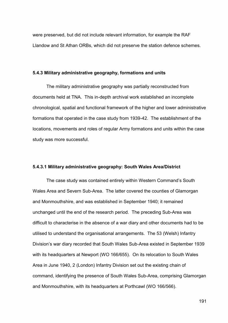
191
were preserved, but did not include relevant information, for example the RAF
Llandow and St Athan ORBs, which did not preserve the station defence schemes.
5.4.3 Military administrative geography, formations and units
The military administrative geography was partially reconstructed from
documents held at TNA. This in-depth archival work established an incomplete
chronological, spatial and functional framework of the higher and lower administrative
formations that operated in the case study from 1939-42. The establishment of the
locations, movements and roles of regular Army formations and units within the case
study was more successful.
5.4.3.1 Military administrative geography: South Wales Area/District
The case study was contained entirely within Western Command’s South
Wales Area and Severn Sub-Area. The latter covered the counties of Glamorgan
and Monmouthshire, and was established in September 1940; it remained
unchanged until the end of the research period. The preceding Sub-Area was
difficult to characterise in the absence of a war diary and other documents had to be
utilised to understand the organisational arrangements. The 53 (Welsh) Infantry
Division’s war diary recorded that South Wales Sub-Area existed in September 1939
with its headquarters at Newport (WO 166/655). On its relocation to South Wales
Area in June 1940, 2 (London) Infantry Division set out the existing chain of
command, identifying the presence of South Wales Sub-Area, comprising Glamorgan
and Monmouthshire, with its headquarters at Porthcawl (WO 166/566).
192
Piece No. Title Content
AIR 2/4768 Decoy sites: operational co-operation with Anti-Aircraft Command
Listed RAF St Athan HAA site
WO 166/94 Western Command (G) War Diary, 09/39-12/40 Listed defended beaches
WO 166/103 Western Command (G) War Diary, 01-12/41 Operation Instructions
WO 166/204 III Corps GS War Diary, 01/40-12/41 Army defence arrangements
WO 166/465 18th Inf. Div. GS War Diary, 01-12/41 Army defence arrangements
WO 166/482 38th Inf. Div. GS War Diary, 09/39-12/41 Army defence arrangements
WO 166/566 2nd (London) Inf. Div. GS War Diary, 06-12/40 Army defence arrangements
WO 166/605 49th Inf. Div. GS War Diary, 08-39-04/41 Army defence arrangements
WO 166/655 53rd Inf. Div. GS War Diary, 09/39-12/40 Army defence arrangements
WO 166/656 53rd Inf. Div. GS War Diary, 01-12/41 Army defence arrangements
WO 166/971 73rd Ind. Inf. Bde. War Diary, 03-12/41 Army defence arrangements
WO 166/1314 Severn Sub-Area HQs War Diary, 12/40-12/41 Home Defence Scheme
WO 166/2043 959th Defence Battery, RA HQ War Diary Gun emplacement positions
WO 166/3655 179 Tunnelling Coy, RE War Diary, 1940-41 Locations of CPOs
WO 166/3768 502 Field Company, RE War Diary, 10/39-12/41
Anti-invasion defence preparation
WO 166/3769 503 Field Company, RE War Diary, 09/39-12/41
Anti-invasion defence preparation
WO 166/6025 Western Command (G) War Diary, 01-12/42 Operation Instructions
WO 166/6771 Severn Sub-Area HQs War Diary, 01-12/42 Counter Invasion Scheme
WO 192/321 Nell’s Point Coast Battery, RA FRB, 1939-55 Landward targets
WO 199/37 Defences: Anti-tank Minefields, 07/40-03/44 Locations of minefields
WO 199/38 Anti-tank Mines: Clearance, 02-08/44 Correspondence
WO 199/52 Roadblocks: McNaughton Piping, 08/40-10/42 Locations of CPOs
WO 199/103 Charting of Obstructions on the Foreshore, 02/43-01/45
Locations of pole ALOs
WO 199/336 Obstruction of Landing Grounds, Western Command, 05/40-05/42
Correspondence
Table 5.8: Documentary sources of relevance to St Athan-Llantwit Major case study area preserved at The National Archives.
Severn Sub-Area’s Counter-Invasion Scheme of September 1942 detailed the
Sub-Area’s organisation (WO 166/6771). Appendix A recorded that Glamorgan was
sub-divided into Neath, Pontypridd, East Glamorgan and South Glamorgan Sectors.
Garrisons were located at Cardiff, Barry and Swansea. The defence scheme for ‘B’
Company, 10 (Cowbridge) Battalion, Glamorgan Home Guard cited the continued
existence of South Glamorgan Sector in April 1943. The South Glamorgan Sector
and Barry Garrison war diaries were not identified at TNA.

193
5.4.3.2 Military units available for defence
A variety of military units were available for defence duties in the case study
between September 1939-December 1942, changing significantly through time.
Regular army formations and units were present from June 1940-May 1941. They
covered extensive geographical areas as counter-attack forces, and were mobile to
reinforce static troops and Home Guard units. As the latter improved and airfields
established their own arrangements defence organisation became more localised
and regular forces were located further afield.
Severn Sub-Area’s war diaries were an important source of documentary
evidence. While the Sub-Area’s 1940 war diary that would have contained a copy of
Home Defence Scheme No. 1 dated 9 September 1940 was not preserved at TNA,
Home Defence Scheme No. 2 of 14 December 1940 was preserved in the 1941 war
diary, together with its appendices and ten of the twelve amending documents (see
Appendix 5.1 for the defence scheme text). It was detailed, but not fully
comprehensive.
The appendices and updates provided detailed information regarding the
presence of regular forces under Severn Sub-Area’s command or located within the
Sub-Area. These included field force, static, mobile columns and aerodrome guards
in the case study. Tables 5.9 and 5.10 demonstrated that the airfields possessed
their own RAF defence forces, but were also reliant on local Royal Artillery and
Pioneer Corps units, with mobile column support from Porthcawl and St Donat’s
Castle via a succession of regular army battalions responsible for the defence of the
coast between the River Ogmore and Cold Knap Point.

194
Unit Location / Role Date Reference
RAF Defence Coy. RAF station: Aerodrome guard 14/12/40-24/06/41
SSA HDS No. 2.
959 Bty., RA RAF station and to NE and SE: artillery support and aerodrome guard
14/12/40-12/04/41
SSA HDS No. 2.
164 LAA Tp., LAA In RAF station environs: LAA and aerodrome guard
14/12/40-12/04/41
SSA HDS No. 2.
70 Bn., Welch Unknown: Aerodrome guard 14/12/40 SSA HDS No. 2.
16 Bn., Welch Unknown: Aerodrome guard 14/12/40 SSA HDS No. 2.
AMPC Det. Unknown: Aerodrome guard 14/12/40 SSA HDS No. 2.
Royal Dutch Det. Unknown: Aerodrome guard 14/12/40 SSA HDS No. 2.
1 Coy, 18 Bn. Welch Mobile Column from St Donat’s Castle 14/12/40-22/01/41
SSA HDS No. 2.
72 Coy, Pioneer Corps, 17 (HD) Gp.
Unknown: Aerodrome guard 22/01/41-01/06/41
SSA HDS No. 2, Amendment No. 2.
Det. 178 Pioneer Corps
Unknown: Aerodrome guard 22/01/41-27/02/41
SSA HDS No. 2, Amendment No. 2.
1 Coy, 18 Bn. Royal Fusiliers
Mobile Column from St Donat’s Castle 27/02/41-01/06/41
SSA HDS No. 2, Amendment No. 3.
960 Bty., RA RAF station and to NE and SE: artillery support and aerodrome guard
01/06/41 SSA HDS No. 2, Amendment No. 6.
166 Tp, 63 LAA Bty, RA
In RAF station environs: LAA and aerodrome guard
01/06/41 SSA HDS No. 2, Amendment No. 6.
1 Coy, 70 Bn. Royal Warwicks.
Mobile Column from St Donat’s Castle 24/06/41 SSA HDS No. 2, Amendment No. 7.
2 Bn. South Staffs, 31 Ind. Inf. Bde.
Mobile Column from St Donat’s Castle 11/09/41-09/01/42
SSA HDS No. 2, Amendment No. 10.
1 Bn. Belgian Fusiliers / Belgian Fd. Arty. Bty.
Mobile Column from Crickhowell to support 31 Inf. Bde. Gp. to relieve RAF St Athan and Llandow
11/09/41 SSA HDS No. 2, Amendment No. 10.
Table 5.9: Units located at RAF St Athan as described in Severn Sub-Area Home Defence Scheme No. 2, 14 December 1940 and subsequent amendments (TNA WO 166/1314).
Amendment No. 12 to Severn Sub-Area’s Home Defence Scheme No. 2 of 9
January 1942 ordered the deletion of all references to the 2 Battalion South
Staffordshire Regiment. The identity of the unit responsible for the defence of the
coastline in the case study area and the occupying unit of St Donat’s Castle from this
date could not be determined.
The Sub-Area did not issue further instructions following Amendment No. 12
and while the monthly diary returns recorded significant changes to the defences

195
within the case study, it was harder to identify the field force and static military units
undertaking defence duties.
Unit Location / Role Date Reference
RAF Defence Coy. Unknown: Aerodrome guard 14/12/40-24/06/41
SSA HDS No. 2.
16 Bn., Welch Unknown: Aerodrome guard 14/12/40 SSA HDS No. 2.
18 Bn., Welch Unknown: Aerodrome guard 14/12/40 SSA HDS No. 2.
1 Coy., 10 Bn. Glosters
Mobile Column from Porthcawl 14/12/40-22/01/41
SSA HDS No. 2.
24 Coy., Pioneer Corps, 17 (HD) Gp.
Unknown 22/01/41-01/06/41
SSA HDS No. 2, Amendment. No. 2.
1 Coy., 18 Bn. Royal Fusiliers
Mobile Column from St Donat’s Castle 27/02/41-01/06/41
SSA HDS No. 2, Amendment. No. 3.
1 Coy., 70 Bn. Royal Warwicks
Mobile Column from St Donat’s Castle 24/06/41 SSA HDS No. 2, Amendment. No. 7.
2 Bn. South Staffs, 31 Ind. Inf. Bde.
Mobile Column from St Donat’s Castle 11/09/41 SSA HDS No. 2, Amendment. No. 10.
1 Bn. Belgian Fusiliers / Belgian Fd. Arty. Bty.
Mobile Column from Crickhowell to support 31 Inf. Bde. Gp. to relieve RAF St Athan and Llandow
11/09/41 SSA HDS No. 2, Amendment. No. 10.
Table 5.10: Units located at RAF Llandow as described in Severn Sub-Area Home Defence Scheme No. 2, 14 December 1940 and subsequent amendments (TNA WO 166/1314).
Severn Sub-Area issued the replacement Counter-Invasion Scheme No. 1 on
15 September 1942. It was a much less helpful document than the Home Defence
Scheme when trying to identify the identity, presence and role of the field force and
static military units within the case study as it did not contain location statements.
It was informative that the Home Guard did not appear to possess a formal
role in the defence of the airfields in 1940 (although the Home Guard took over the 6-
pdr anti-tank emplacements in 1941 and companies of the Home Guard were
allocated to the specific defence of the airfields by 1943).

196
5.4.3.3 Regular mobile Field Force troops
Table 5.11 summarised the regular field force provision for the case study
identified from war diary records at TNA. It demonstrated that defence was initially
the responsibility of local Welsh Infantry Divisions until June 1940. Thereafter
defence became the responsibility of the 2 (London) Infantry Division, particularly its
5 (London) Infantry Brigade. The formation’s war diary record was piecemeal, but
illustrated the work undertaken. The brigade came under the temporary direct
command of South Wales Area until the divisional headquarters was established at
Whitney-on-Wye, Herefordshire in August 1940.
The division’s RE companies were responsible for the construction of defence
works within the case study, but the exact works were not identified. It was
considered a strong probability that the 503 Field Company, Royal Engineers was
the unit responsible for the construction of the coastal defences at Limpert Bay and
Tresilian Bay during August-October 1940.
This field force formation was replaced by 212 Independent Infantry Brigade
(with static defence duties) from October 1940-February 1941 and then by the newly
raised 73 Independent Brigade from March-May 1941.
Thereafter regular army formations with direct defence duties ceased to be
located within the case study and defence became the responsibility of static troops
and Home Guard units with a number of absentee Infantry Divisions given roles to
provide mobile counter-attack columns from afar if required.

197
Formation Location Role Date Reference
53 (Welsh) Inf. Div. Pan-Wales. HQs. at Saundersfoot.
Home defence duties. 09/39-04/40
WO 166/655
38 (Welsh) Inf. Div. Pan-Wales. HQs. at Cardiff.
Home defence duties. 04/40-06/40
WO 166/482
2/47 (London) Inf. Div.
South Wales Area WC mobile reserve force countering enemy landings.
06/40-02/41
WO 166/566
III Corps Pan-Wales. War training. 07/40-04/41
WO 166/204
5 (London) Inf. Bde., 2 (London) Inf. Div.
Porthcawl-Cowbridge area.
Order for relief of 113 Inf. Bde, 38 (Welsh) Inf. Div. by the 5 (London) Inf. Bde.
31/07/40 OI No. 1, WO 166/566
503 Fd. Coy., RE Glamorgan. Engaged on unspecified coast defence works.
04/08/40-14/10/40
WO 166/3769
5 (London) Inf. Bde.
Glamorgan. Defence of beaches and RAF St Athan and Llandow.
12/08/40 HDS No. 4, WO 166/566
212 Ind. Inf. Bde. Porthcawl-Cowbridge area.
Relief of 5 Lon. Inf. Bde. Defence of beaches held.
10/40-02/41
WO 166/566
18 Bn. Welch, 212 Ind. Inf. Bde.
Beaches from Loughor Bridge to Cold Knap Point.
Defence of beaches with 2-in mortars, A/T rifles and .300 Vickers.
14/12/40 SSA HDS No. 2, WO 166/1314
689 Gen. Con. Coy., RE
71 Eastgate St, Cowbridge.
Part of Royal Engineer presence.
14/12/40 SSA HDS No. 2, WO 166/1314
178 Coy., AMPC 71 Eastgate St, Cowbridge.
Part of Royal Engineer presence.
14/12/40-11/04/41
SSA HDS No. 2, WO 166/1314
502 Fd. Coy., RE Porthcawl area. Unspecified defence works. 01/12/40-10/02/41
WO 166/3768
31 Inf. Bde. Gp. Hereford-Monmouth-Pontypool-Hay-on-Wye area.
WC mobile reserve force countering enemy within Severn Sub-Area, chiefly in Swansea and Gower.
02-12/41 SSA HDS No. 2, WO 166/1314
73 Ind. Inf. Bde. Porthcawl, Glamorgan.
Assist SWA with training and defence preparation.
03-05/41 WO 166/971
18 Bn. Royal Fusiliers, 73 Ind. Inf. Bde.
St Donat’s Castle. Defence of beaches. Mobile column relief of RAF St Athan and Llandow
27/02/41-01/06/41
SSA HDS No. 2, WO 166/1314
50 Inf. Div. Gloucestershire, Southern Comd.
Reinforce troops in SWA against enemy landings.
03/41-? WO 166/605
18 Inf. Div. Role in SW and S Wales from 08/41.
Counter enemy landings. 04/41-10/41
WO 166/465
70 Bn. Royal Warwicks
St Donat’s Castle. Beach Defence. Mobile column relief of RAF St Athan and Llandow
24/06/41 SSA HDS No. 2, WO 166/1314
2 Bn. South Staffs, 31 Ind. Inf. Bde.
St Donat’s Castle. Mobile column relief of RAF St Athan and Llandow
04/09/41-09/01/42
SSA HDS No. 2, WO 166/1314
1 Bn. Belgian Fus. / Belgian Fd. Arty. Bty.
Glanusk Park, Crickhowell.
SWA mobile reserve to aid 31 Inf. Bde. Gp. to relieve RAF St Athan and Llandow
11/09/41 SSA HDS No. 2, WO 166/1314
54 Inf. Bde. Gp. Hereford-Ross-Monmouth area.
Offensive action in Severn Sub Area as required.
11/09/41 SSA HDS No. 2, WO 166/1314
53 (Welsh) Inf. Div. Pan-Wales. 160 Inf. Bde. Gp. to defend Severn Sub-Area.
11/41-? WO 166/656
Table 5.11: Field Force provision in St Athan-Llandow case study area, 1939-42.

198
5.4.3.4 Static troops
Static troops were those allocated to a particular geographical locality, often a
military camp, headquarters or fixed gun emplacement and with responsibility for
defence of that area. Table 5.12 summarised the static troops identified as present
within the case study from a combination of records held by TNA and the Welch
Regimental Museum. The Western Command General Staff War Diary for 1940
included periodic lists of static troops within South Wales Area (WO 166/94).
From October 1940-February 1941, 212 Infantry Brigade was responsible for
static defence duties in the Llantwit Major-Swansea area and the brigade’s 18
Battalion, The Welch Regiment was located at St Donat’s Castle and Llantwit Major.
This included the defence of the coast between the River Ogmore and Cold Knap
Point, Barry, together with providing a company-sized mobile column to relieve
attacks against RAF St Athan. Other Welch Regiment Home Defence Battalions
were also active in the case study from 1939-42.
The 10 Battalion, The Gloucestershire Regiment was not located within the
case study, but was responsible for sending a company-sized mobile column to
relieve attacks against RAF Llandow.
During February 1941, 212 Independent Infantry Brigade left the case study
and 18 Battalion, Royal Fusiliers, 73 Independent Infantry Brigade took over 18
Battalion, The Welch Regiment’s location at St Donat’s Castle and its beach defence
and mobile column duties.

199
Unit Location Role Date Reference
Group 106 National Defence Company
South Wales Home defence duties guarding airfields, HQs etc.
1939 Army Council Instruction No. 742 of 02/11/39
1/5 Bn., Welch Regt.
Cowbridge Regular infantry unit training
09-10/39
Welch Regiment Museum records
2/5 Bn., Welch Regt., 113 Inf. Bde., 38 Inf. Div.
Llantwit Major-Porthcawl coastline
Coast defence duties
09/39-05/40
Welch Regiment Museum records
16 (Home Defence) Bn., Welch Regt.
Rifle Coy. each at RAF St Athan and RAF Llandow
Home defence Bn. for airfield defence
11/39-40
Welch Regiment Museum records
15 (Home Defence) Bn., Welch Regt., 113 Inf. Bde., 38 (Welsh) Inf. Div.
Bn. HQs at Llantwit Major. Two rifle Coys each at RAF St Athan and RAF Llandow
Home defence Bn. for airfield and coast defence and beach patrols
06-08/40
Welch Regiment Museum records
1 Bn., 12 Trg. Gp. [9 Bn, Royal Sussex Regt?]
To relocate from Ross-on-Wye to St Donat’s
Static SWA Troops 09/40-? Western Command Operation Instruction No. 20 of 05/09/40
212 Ind. Inf. Bde. (Home)
Regular Home Defence under SWA command
10/40-02/41
SSA HDS No. 2, WO 166/1314
18 (Home Defence) Bn., Welch Regt., 212 Inf. Bde.
Bn. HQs and Coy. at St Donat’s Castle. Other Coys. in Llantwit Major-Porthcawl area
Home defence Bn. prepared coastal defences.
11/40-02/41
Welch Regiment Museum records
18 Bn. Royal Fusiliers
St Donat’s Castle Beach defence; Mobile column relief of RAF St Athan and Llandow
02/41-06/41
SSA HDS No. 2, Amendment. No. 3, WO 166/1314
No. 32 DID; No. 20 Fd. Bakery; Nos. 8 & 12 Fd. Butchery
Gileston RASC camp Service and combat duties
02/41 SSA HDS No. 2, Amendment. No. 3, WO 166/1314
Nos. 20 & 33 Fd. Bakery; No. 8 Fd. Butchery
Gileston RASC camp Service and combat duties
03/41 SSA HDS No. 2, Amendment. No. 4, WO 166/1314
70 Bn. Royal Warwicks.
St Donat’s Castle Mobile column relief of RAF St Athan and Llandow
24/06/41 SSA HDS No. 2, Amendment. No. 7, WO 166/1314
Nos. 5 & 6 Base Petrol Filling Centres; Nos. 60 & 73 DID
Gileston RASC camp Service and combat duties
04/09/41 SSA HDS No. 2, Amendment. No. 8, WO 166/1314
2 Bn. South Staffs, 31 Ind. Inf. Bde.
St Donat’s Castle Mobile column relief of RAF St Athan and Llandow
04/09/41 SSA HDS No. 2, Amendment. No. 8, WO 166/1314
60 (Welch) Holding Bn. 30 Bn., South Wales Borderers
1 Coy. at Cardiff 1 Coy. at Newport
Mobile column relief of RAF St Athan and Llandow
13/06/42 WC OC No. 42, Amendment No. 23
Table 5.12: Provision of static troops in St Athan-Llandow case study area, 1939-42.

200
5.4.3.5 Home Guard
The number of Home Guard battalions and the locations of their inter-battalion
and company boundaries were not determined from the documentary evidence. The
presence of the 10 (Cowbridge) and 5 (Barry) Battalions of the Glamorgan Home
Guard were identified in the Severn Sub-Area war diaries respectively for 1940-42,
but the earlier and later arrangements were not observed except for the company
arrangements described below.
5.4.3.6 10 Battalion Glamorgan Home Guard Defence Scheme
The Llantwit Major Local History Society’s archive contained the entire
Defence Scheme for ‘B’ Company, 10 (Cowbridge) Battalion, Glamorgan Home
Guard. It included a detailed list and annotated map of the defence posts, allocated
weaponry and troops located in the Llantwit Major-Boverton-St Athan village area in
April 1943 (Berry 2013). The written text of the defence scheme is presented in
Appendix 5.2.
This document was important as it described the defensive arrangements
between the coastal crust defences and the airfields at this time. These avoided the
airfields and coastal areas, suggesting strongly that these remained the responsibility
of other regular army or RAF and Home Guard units. The earlier and later defence
iterations for the ‘B’ Coy defence area remain unknown.
The document also described the company and platoon arrangements for
Llantwit Major, Boverton and St Athan village. It recorded that ‘A’, ‘D’ and ‘E’

201
Companies were responsible for the defence of Cowbridge, Llandow aerodrome and
St Athan aerodrome respectively.
5.4.4 New documentary source evidence: sites
Redfern’s PRO-based study was the only known account of documentary
source evidence in the St Athan-Llandow case study (1998b). During this research,
additional documentary sources were identified that provided both new and additional
site information. Most sources were located at TNA, but valuable information was
also located at the Llantwit Major Local History Society. No new site data was
identified at Glamorgan Archives.
5.4.4.1 Severn Sub-Area Home Defence Scheme No. 2
Severn Sub-Area’s Home Defence Scheme No. 2 of 14 December 1940 and its
associated appendices and amendments identified the additional defence sites
presented in Table 5.13. The civilian infrastructure such as the ROC post and the
coast guard stations were not armed, but undertook observation and reporting
functions. The searchlight and anti-aircraft batteries created individual defence
schemes for areas around their emplacements.

202
Date Name Location Cassini Ref.
Site Type Source
14/12/40 F2 Llantwit Major 415909 ROC Post SSA HDS No. 2, Appendix G
14/12/40 Llantwit Major
Llantwit Major HM Coast Guard Station
SSA HDS No. 2, Appendix I
14/12/40 Breaksea Point
Breaksea Point
Auxiliary Coast Guard Station
SSA HDS No. 2, Appendix I
14/12/40 Monastery Nash Manor 400950 Searchlight Emplacement
SSA HDS No. 2, Appendix J
14/12/40 Llancaldo [Llancadle]
Llancadle 475903 Searchlight Emplacement
SSA HDS No. 2, Appendix J
14/12/40 Cowbridge Beaupre 448954 Searchlight Emplacement
SSA HDS No. 2, Appendix J
14/12/40 Boverton N of Boverton 420905 Searchlight Emplacement
SSA HDS No. 2, Appendix J
14/12/40 St Donat’s St Donat’s 376901 Searchlight Emplacement
SSA HDS No. 2, Appendix J
27/02/41 K1 Boverton 422896 Heavy Anti-Aircraft Battery
SSA HDS No. 2, Amendment No. 2, Appendix K
27/02/41 K38 Nash Manor 410943 Light Anti-Aircraft Battery
SSA HDS No. 2, Amendment No. 2, Appendix K(2)
27/02/41 K39 Siginston 414935 Light Anti-Aircraft Battery
SSA HDS No. 2, Amendment No. 2, Appendix K(2)
27/02/41 K40 Pwll-helyg 407928 Light Anti-Aircraft Battery
SSA HDS No. 2, Amendment No. 2, Appendix K(2)
27/02/41 K41 Brynsych 400923 Light Anti-Aircraft Battery
SSA HDS No. 2, Amendment No. 2, Appendix K(2)
27/02/41 K42 Six Wells 399936 Light Anti-Aircraft Battery
SSA HDS No. 2, Amendment No. 2, Appendix K(2)
27/02/41 K43 Railway 394927 Light Anti-Aircraft Battery
SSA HDS No. 2, Amendment No. 2, Appendix K(2)
27/02/41 K44 Tyn-y-cau 390943 Light Anti-Aircraft Battery
SSA HDS No. 2, Amendment No. 2, Appendix K(2)
27/02/41 K45 Rectory 397949 Light Anti-Aircraft Battery
SSA HDS No. 2, Amendment No. 2, Appendix K(2)
11/04/41 CLO1/2 Summerhouse Point
435881 Searchlight Emplacement
SSA HDS No. 2, Amendment No. 5, Appendix J
01/06/41 K30 Flemingston 452914 Light Anti-Aircraft Battery
SSA HDS No. 2, Amendment No. 6, Appendix K
01/06/41 K31 Eglwys Brewis 461909 Light Anti-Aircraft Battery
SSA HDS No. 2, Amendment No. 6, Appendix K
01/06/41 K32 Beggars Pound
460900 Light Anti-Aircraft Battery
SSA HDS No. 2, Amendment No. 6, Appendix K
01/06/41 K33 West Orchard 453893 Light Anti-Aircraft Battery
SSA HDS No. 2, Amendment No. 6, Appendix K
01/06/41 K34 Batsley 443889 Light Anti-Aircraft Battery
SSA HDS No. 2, Amendment No. 6, Appendix K
01/06/41 K35 Boverton 430899 Light Anti-Aircraft Battery
SSA HDS No. 2, Amendment No. 6, Appendix K
01/06/41 K36 Fisher’s Bridge
431909 Light Anti-Aircraft Battery
SSA HDS No. 2, Amendment No. 6, Appendix K
01/06/41 K37 Picketston 435914 Light Anti-Aircraft Battery
SSA HDS No. 2, Amendment No. 6, Appendix K
Table 5.13: Locations of defence sites cited in Severn Sub-Area’s Home Defence
Scheme No. 2 and subsequent amendments (TNA WO 166/1314).

203
Severn Sub-Area’s 1942 war diary contained Amendment No. 12 to Home
Defence Scheme No. 2, and Counter-Invasion Scheme No. 1 and its subsequent
amending document. None of the documents contained lists of defence sites, other
than the anti-aircraft, coast watching and ROC posts in the area. The documents’
appendices provided policy statements on the use of mobile columns and the
defence of airfields, but did not retain data on defence posts.
5.4.4.2 10 Battalion Glamorgan Home Guard Defence Scheme
This ‘B’ Company, 10 (Cowbridge) Battalion, Glamorgan Home Guard defence
scheme was the sole identified defence scheme for the case study. It recorded
defence sites (Table 5.14) and characterised the defending force (Table 5.15). The
defence scheme was assessed as being of primary significance in the context of the
case study, as it was the only example of its type identified, and of the thirty-five
defence posts recognised, twenty-six (74%) were unique citations to the written
defence scheme.
The defence scheme contained inherent weaknesses and contradictions. It
named two different locations for the No. 2 and No. 3 platoon headquarters in
Appendix A and Appendix C. As the Cassini grid references were not provided it did
not prove possible to identify which location was correct or the reason for the
difference between the two appendices. The Cassini grid reference for the ‘B’ Coy
Signal Station at the Old Watch Tower, Boverton was erroneous and could not be
located.

204
Site Location Cassini Grid Ref
Source
10 Bn. HQs. & BHQs. 44 High Street, Cowbridge Appendix A, C
‘A’ Coy, 10 Bn. HQs. 71 Eastgate Street, Cowbridge Appendix C
‘B’ Coy, 10 Bn. HQs. & BHQs. Town Hall, Llantwit Major Appendix A, C
No. 1 Pl, ‘B’ Coy, 10 Bn. HQs. Town Hall, Llantwit Major Appendix A, C
No. 1 Pl, ‘B’ Coy, 10 Bn. BHQs. Great House, Llantwit Major Appendix A
No. 2 Pl, ‘B’ Coy, 10 Bn. HQs. Boverton Place or Boverton Castle
Appendix A Appendix C
No. 2 Pl, ‘B’ Coy, 10 Bn. BHQs. Boverton Castle Appendix A
No. 3 Pl, ‘B’ Coy, 10 Bn. HQs. Stratford Café, St Athan or Co-op Shop, St Athan
Appendix A Appendix C
No. 3 Pl, ‘B’ Coy, 10 Bn. HQs. Three Horse Shoes Inn, St Athan Appendix A
‘C’ Coy, 10 Bn. HQs. Unemployed Hall, Llantrisant Appendix A
‘D’ Coy, 10 Bn. HQs. Llandow Aerodrome Appendix A
‘E’ Coy, 10 Bn. HQs. St Athan Aerodrome Appendix A
Cowbridge Rd Roadblock Llantwit Major 408909 Appendix B
Wick Rd Roadblock Llantwit Major 406908 Appendix B
Dimlands Rd Roadblock Llantwit Major 405904 Appendix B
Boverton Roadblock Boverton 424900 Appendix B
St Athan Roadblock St Athan 458894 Appendix B
Searchlight post Summerhouse, Boverton 448949 Appendix C
Fougasse emplacement Gileston Rise 459886 Appendix C
McNaughton Tube Colhugh Point 398891 Appendix C
McNaughton Tube The Leys 464877 Appendix C
McNaughton Tube Limpert Bay 462878 Appendix C
HM Coast Guard Llantwit Major Coast Guard Station, Llantwit Major
Appendix C
HM Coast Guard St Athan Breaksea Point Appendix C
Royal Observer Corps Post 415909 Appendix C
Minefield Colhugh Point 3989 Appendix C
Minefield Summerhouse Point, Boverton 435830 Appendix C
HG Explosive Shed Cowbridge Road 409908 Appendix D
HG Explosive Shed Boverton 424898 Appendix D
HG Explosive Shed St Athan 458897 Appendix D
Battalion Signal Station Stalling Down 456954 Appendix I
‘B’ Coy Signal Station Old Watch Tower, Boverton 429000 Appendix I
Vital Undertaking Llantwit Major Telephone Exchange
Appendix K
Vital Undertaking St Athan Telephone Exchange Appendix K
‘B’ Coy POW Collecting Station Old Place Ward, Llantwit Major 408907 Appendix M
Table 5.14: Locations of defence sites cited in ‘B’ Coy 10 Battalion, Glamorgan Home Guard Defence Scheme document, April 1943.
The description of roadblocks was inconsistent. It did not cite three additional
roadblocks depicted on the defence scheme map, and cited two roadblocks that were
not depicted. The text and map were not in direct conflict in terms of the numbers

205
and locations of the roadblocks, but they did not equate and this inconsistency
introduced an element of doubt concerning use of the evidence.
Defence positions
Pl. N
o.
Qu
ota
BB
NP
LM
G
HM
G
F
StG
Sm
G
FT
Rif
le
E.Y
. R
ifle
Roadblocks: Cowbridge Road, Wick, Dimlands Road; Mobile Section, Reserve Company; 10 OR in charge of CSM at Company HQs
No. 1 2 officers 100 OR
2 3 2 1 0 14 1 0 .300 x 51 .303 x 3
7
Roadblock, Boverton; No. 2 Section Company Reserve
No. 2 1 officer 48 OR
0 1 2 0 0 8 0 2 .300 x 16
5
Roadblock, St Athan; Canadian Pipe Mine
No. 3 1 officer 46 OR
2 0 2 1 1 8 0 2 .300 x 16
5
Table 5.15: Disposition of ‘B’ Company, 10 Battalion Glamorgan Home Guard troops and weaponry in April 1943 as described in Defence Scheme documentation [BB = Blacker Bombard; NP=Northover Projector; LMG=Light Machine Gun; HMG=Heavy Machine Gun; F=Fougasse; StG=Sten Gun; SmG=Smith Gun; FT=Flame Thrower; E.Y. Rifle= Rifle grenade launcher].
The scheme was published in 1943. The Home Guard was a well-equipped
and trained force by this date, but the nature of the threat had changed from dealing
with a potential invasion to nuisance and diversionary raids. It was questionable how
much of the scheme and the defences therein could be projected back to earlier
years of the war.
It could be argued that the defence scheme was a source of moderate rather
than primary importance as it focused on the area between the airfields and the coast
in a small part of the case study. This assessment contended that the defence
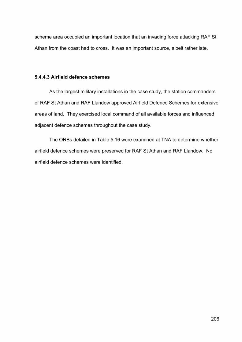
206
scheme area occupied an important location that an invading force attacking RAF St
Athan from the coast had to cross. It was an important source, albeit rather late.
5.4.4.3 Airfield defence schemes
As the largest military installations in the case study, the station commanders
of RAF St Athan and RAF Llandow approved Airfield Defence Schemes for extensive
areas of land. They exercised local command of all available forces and influenced
adjacent defence schemes throughout the case study.
The ORBs detailed in Table 5.16 were examined at TNA to determine whether
airfield defence schemes were preserved for RAF St Athan and RAF Llandow. No
airfield defence schemes were identified.

207
Airfield Document Title Dates Reference
RAF St Athan Air Navigation School, Andover, became School of Air Navigation at Manston and St Athan; moved to Port Albert, Canada, in 09/40.
09/19-09/40 AIR 29/598
RAF St Athan No. 19 [Maintenance Unit], St Athan 02/39-12/45 AIR 29/979
RAF St Athan No. 32 [Maintenance Unit], St Athan 08/39-12/45 AIR 29/995
RAF St Athan 5 Air Stores Park including 2 Supply and Transport Section, Advanced Air Striking Force; formed at St Athan and moved to France 09/39.
09/39-06/40 AIR 29/781
RAF St Athan RAF Hospital, St. Athan. 07/40-12/45 AIR 29/944
RAF St Athan 31 Air Navigation School. Moved from St Athan to Port Albert (Canada) in 10/40.
10/40-11/44 AIR 29/600
RAF St Athan RAF Czechoslovak Depot. Moved to St Athan in 02/42.
12/40-04/44 AIR 29/495
RAF St Athan 4 School of Technical Training, Henlow and St Athan.
01/41-12/49 AIR 29/737
RAF St Athan 2850 Squadron RAF Regiment. Reformed in 06/43 at St Athan from 4216, 4266 and 4288 Anti-Aircraft Flights.
04/42-10/43 AIR 29/114
RAF St Athan 2955 Anti-Aircraft Squadron RAF Regiment. Formed at St Athan from 4154, 4158 and 4163 Anti-Aircraft Flights.
06/43-04/45 AIR 29/136
RAF St Athan 12 Radio School, St Athan. 09/43-06/44 AIR 29/726
RAF St Athan 14 Radio School, St Athan. 06/44 AIR 29/502
RAF Llandow No. 38 [Maintenance Unit], Llandow 04/40-12/45 AIR 29/1000
RAF Llandow 53 Operational Training Unit (OTU). Formed at Heston in 02/41. Moved to Llandow in 07/41 and Kirton-in-Lindsey in 05/43.
02/41-05/45 AIR 29/681
RAF Llandow 2847 (Anti-Aircraft) Squadron RAF Regiment (previously 847 Defence Squadron). Formed at Llandow in 02/42, then moved around other UK stations.
12/42-12/45 AIR 29/113
RAF Llandow RAF Station Llandow, later became 3 Overseas Aircraft Preparation Unit (OAPU).
05/43-09/45 AIR 29/472
Table 5.16: Operations Record Books for RAF St Athan and RAF Llandow preserved at The National Archives.
5.4.4.4 Minefields
Regular returns throughout October-November 1940 charted the installation of
a minefield at Limpert Bay-Breaksea Point (Table 5.17). They recorded the presence
of Mushroom and anti-tank minefields.
208
Date Location Comment Source
01/10/40 N/A No minefields laid, being laid or for recce completed in case study
Mushroom Minefields Return, 01/10/40, WO 199/37
16/10/40 Limpert Bay and Breaksea Point 464870 to 462876
Set No. 6 – 500 Mushroom mines laid or being laid in two or three rows to the south-east of the anti-tank blocks
Return of Mushroom Minefields, 16/10/40, WO 199/37
19/11/40 Limpert Bay and Breaksea Point
In Serial 6 Limpert Bay and Breaksea point Anti-Tank Mines are being laid instead of Mushrooms
Mushroom Minefields, 19/11/40, WO 199/37
25/11/40 Limpert Bay and Breaksea Point 463877 to 464874
Set No. 1 – 500 A/T mines, Mk II laid or being laid
Return of Anti-Tank Minefields, 18/11/40, WO 199/37
30/11/40 Limpert Bay and Breaksea Point 463877 to 464874
Set No. 1 – 500 A/T mines, Mk II laid and completed
Return of Anti-Tank Minefields, 30/11/40, WO 199/37
Table 5.17: References to minefields within the St Athan-Llandow case study area, 1940 preserved at The National Archives.
Correspondence dated 19 November 1940 stated that ‘recent storms
accompanied by unusually high tides have shown that certain sites which had been
selected for these minefields have now been found to be unsuitable... [and] had to be
modified’. The mushrooms at Limpert Bay-Breaksea Point were replaced with the
A/T Mine G.S. Mk II version.
Beach minefields were cleared from 1944 and following clearance an official
certificate was issued (WO 199/38). While some clearance certificates were
preserved at TNA, that for Limpert Bay-Breaksea Point was not, so the date of final
removal remains unknown.
5.4.4.5 Canadian pipe mines
The war diary for 179 Special Tunnelling Company, RE recorded that Nos. 1
and 3 Sections were ordered to move to South Wales Area on 9 May 1941 (WO
166/3655). Diary entries noted that there were very few regular troops in the area

209
and that the Home Guard undertook most defensive duties. Extracts of the Officer
Commanding’s monitoring visit reports are presented in Table 5.18.
Date Location Comment Source
12/07/41 Tresilian Bay 389894 Col-Hugh Point 398891 Limpert Bay 462878
Actual locations of work either in hand or projected
Canadian Pipe Obstacle, C.R.W.C. No. S/2943/G(O), 12/07/41, WO 199/52
17/11/41 Col-Hugh Point Limpert Bay
Work had been completed on the 40ft obstacle at Col Hugh Point. A projected 30ft obstacle was to be installed at Limpert Bay
Memorandum No. 8: Visiting Sections, STC/SEC/P/9, 19/11/41, WO 166/3655
Table 5.18: References to Canadian pipe mines within the St Athan-Llandow case study area, 1941 preserved at The National Archives.
5.4.4.6 Obstruction of landing grounds
Given the German success of utilising transport aircraft and glider-borne
troops to facilitate invasion in Belgium in 1940 and Greece in 1941, the obstruction of
potential landing grounds in the UK was a significant concern (WO 199/336). HQ
Western Command wrote to all Area Commands in May 1940 and instructed that:
‘All possible steps will be taken immediately... to make possible [aircraft] landing grounds other than recognised RAF and civilian aerodromes difficult or unusable, priority being accorded to open spaces within a few miles of really vital objectives [original emphasis].’ (Home Security, C.R.W.C. No.S/440(G), 30/05/40, WO 199/336).
This was achieved by sub-dividing possible landing areas so as to preclude a
landing run of more than 250 yards through the positioning of old cars, farm
machinery and wire fences on short poles.
A second wave of obstructing possible landing grounds commenced in
February 1941 on landing sites within five miles of a RAF station. Twelve vulnerable

210
RAF stations were identified in Wales. The report confirmed that three possible
landing grounds identified for RAF Llandow and four identified for RAF St Athan had
all been obstructed, but did not cite the locations (Obstruction of Landing Grounds,
C.R.W.C. No.S/1210/G(O), 26/02/41, WO 199/336).
5.4.4.7 Coast artillery
Although located outside of the case study, the Nell’s Point coast artillery
battery Fort Record Book contained a list of land targets which the battery’s two six-
inch guns could engage (Land Targets, undated, WO 192/321). Two targets were
located within the case study (Table 5.19).
Target Location Range (Yards) Bearing
No. 1 Limpert Bay 13,000-10,500 270˚ 02’ - 268˚ 13’
No. 2 Thaw Estuary 10,500-6,500 265˚ 45’ - 264˚ 36’
Table 5.19: Land targets for engagement by six-inch guns at Nell’s Point.
5.4.4.8 Defence batteries
The 959 Defence Battery, RA war diary for 1940-41 (WO 166/2043) stated
that the battery was present in the St Athan area from November 1940-April 1941
(Table 5.20). During this period it operated four six-pounder Hotchkiss gun
emplacements that were tasked to fire across RAF St Athan’s landing ground (Nos. 1
and 2 guns) and to command bridges over the River Thaw (Nos. 3 and 4 guns).
The Nos. 1 and 2 6-pdr Hotchkiss guns were replaced by 13-pdr guns, which
were tasked with firing upon key road junctions around RAF St Athan. Operational
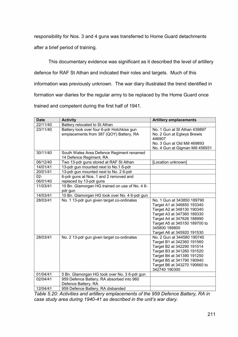
211
responsibility for Nos. 3 and 4 guns was transferred to Home Guard detachments
after a brief period of training.
This documentary evidence was significant as it described the level of artillery
defence for RAF St Athan and indicated their roles and targets. Much of this
information was previously unknown. The war diary illustrated the trend identified in
formation war diaries for the regular army to be replaced by the Home Guard once
trained and competent during the first half of 1941.
Date Activity Artillery emplacements
22/11/40 Battery relocated to St Athan
23/11/40 Battery took over four 6-pdr Hotchkiss gun emplacements from 387 (QOY) Battery, RA
No. 1 Gun at St Athan 439897 No. 2 Gun at Eglwys Brewis 446907 No. 3 Gun at Old Mill 469893 No. 4 Gun at Gigman Mill 456931
30/11/40 South Wales Area Defence Regiment renamed 14 Defence Regiment, RA
06/12/40 Two 13-pdr guns stored at RAF St Athan [Location unknown]
14/01/41 13-pdr gun mounted next to No.1 6-pdr
20/01/41 13-pdr gun mounted next to No. 2 6-pdr
02-06/01/40
6-pdr guns at Nos. 1 and 2 removed and replaced by 13-pdr guns
11/03/41 10 Bn. Glamorgan HG trained on use of No. 4 6-pdr gun
14/03/41 10 Bn. Glamorgan HG took over No. 4 6-pdr gun
28/03/41 No. 1 13-pdr gun given target co-ordinates No. 1 Gun at 343850 189790 Target A1 at 346850 193340 Target A2 at 348130 190340 Target A3 at 347360 189330 Target A4 at 347626 188990 Target A5 at 345150 189700 to 345800 189800 Target A6 at 345920 191530
28/03/41 No. 2 13-pdr gun given target co-ordinates No. 2 Gun at 344580 190740 Target B1 at 342360 191560 Target B2 at 342290 191014 Target B3 at 341260 191520 Target B4 at 341390 191250 Target B5 at 341790 190940 Target B6 at 343270 190660 to 342740 190300
01/04/41 5 Bn. Glamorgan HG took over No. 3 6-pdr gun
02/04/41 959 Defence Battery, RA absorbed into 960 Defence Battery, RA
12/04/41 959 Defence Battery, RA disbanded
Table 5.20: Activities and artillery emplacements of the 959 Defence Battery, RA in case study area during 1940-41 as described in the unit’s war diary.
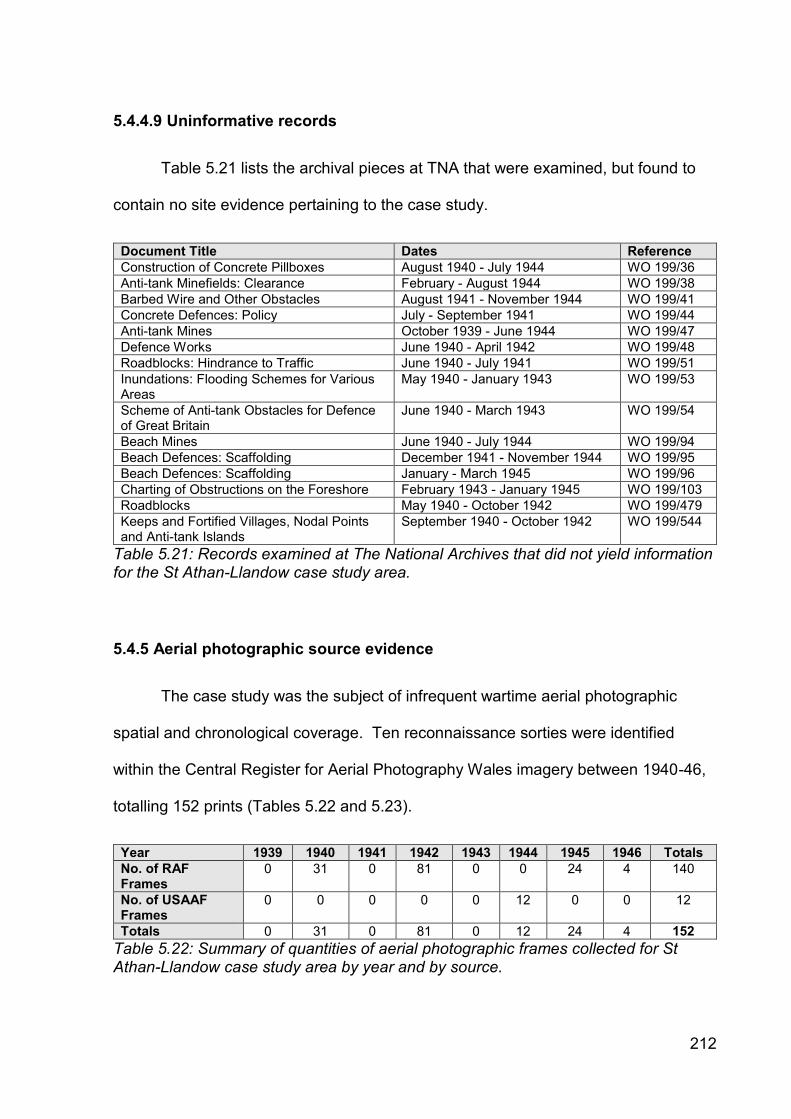
212
5.4.4.9 Uninformative records
Table 5.21 lists the archival pieces at TNA that were examined, but found to
contain no site evidence pertaining to the case study.
Document Title Dates Reference
Construction of Concrete Pillboxes August 1940 - July 1944 WO 199/36
Anti-tank Minefields: Clearance February - August 1944 WO 199/38
Barbed Wire and Other Obstacles August 1941 - November 1944 WO 199/41
Concrete Defences: Policy July - September 1941 WO 199/44
Anti-tank Mines October 1939 - June 1944 WO 199/47
Defence Works June 1940 - April 1942 WO 199/48
Roadblocks: Hindrance to Traffic June 1940 - July 1941 WO 199/51
Inundations: Flooding Schemes for Various Areas
May 1940 - January 1943 WO 199/53
Scheme of Anti-tank Obstacles for Defence of Great Britain
June 1940 - March 1943 WO 199/54
Beach Mines June 1940 - July 1944 WO 199/94
Beach Defences: Scaffolding December 1941 - November 1944 WO 199/95
Beach Defences: Scaffolding January - March 1945 WO 199/96
Charting of Obstructions on the Foreshore February 1943 - January 1945 WO 199/103
Roadblocks May 1940 - October 1942 WO 199/479
Keeps and Fortified Villages, Nodal Points and Anti-tank Islands
September 1940 - October 1942 WO 199/544
Table 5.21: Records examined at The National Archives that did not yield information for the St Athan-Llandow case study area.
5.4.5 Aerial photographic source evidence
The case study was the subject of infrequent wartime aerial photographic
spatial and chronological coverage. Ten reconnaissance sorties were identified
within the Central Register for Aerial Photography Wales imagery between 1940-46,
totalling 152 prints (Tables 5.22 and 5.23).
Year 1939 1940 1941 1942 1943 1944 1945 1946 Totals
No. of RAF Frames
0 31 0 81 0 0 24 4 140
No. of USAAF Frames
0 0 0 0 0 12 0 0 12
Totals 0 31 0 81 0 12 24 4 152
Table 5.22: Summary of quantities of aerial photographic frames collected for St Athan-Llandow case study area by year and by source.
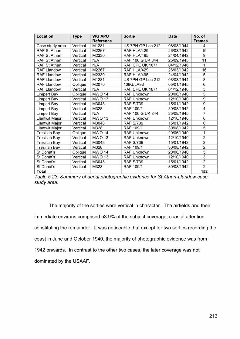
213
Location Type WG APU Reference
Sortie Date No. of Frames
Case study area Vertical M1281 US 7PH GP Loc 212 08/03/1944 4
RAF St Athan Vertical M2267 RAF HLA/429 26/03/1942 19
RAF St Athan Vertical M2330 RAF HLA/495 24/04/1942 9
RAF St Athan Vertical N/A RAF 106 G UK 844 25/09/1945 11
RAF St Athan Vertical N/A RAF CPE UK 1871 04/12/1946 1
RAF Llandow Vertical M2267 RAF HLA/429 26/03/1942 16
RAF Llandow Vertical M2330 RAF HLA/495 24/04/1942 5
RAF Llandow Vertical M1281 US 7PH GP Loc 212 08/03/1944 8
RAF Llandow Oblique M2070 106G/LA93 05/01/1945 6
RAF Llandow Vertical N/A RAF CPE UK 1871 04/12/1946 3
Limpert Bay Oblique MWO 14 RAF Unknown 20/06/1940 5
Limpert Bay Vertical MWO 13 RAF Unknown 12/10/1940 9
Limpert Bay Vertical M3048 RAF S/739 15/01/1942 9
Limpert Bay Vertical M328 RAF 109/1 30/08/1942 4
Limpert Bay Vertical N/A RAF 106 G UK 844 25/09/1945 7
Llantwit Major Vertical MWO 13 RAF Unknown 12/10/1940 6
Llantwit Major Vertical M3048 RAF S/739 15/01/1942 6
Llantwit Major Vertical M328 RAF 109/1 30/08/1942 5
Tresilian Bay Oblique MWO 14 RAF Unknown 20/06/1940 1
Tresilian Bay Vertical MWO 13 RAF Unknown 12/10/1940 2
Tresilian Bay Vertical M3048 RAF S/739 15/01/1942 2
Tresilian Bay Vertical M328 RAF 109/1 30/08/1942 2
St Donat’s Oblique MWO 14 RAF Unknown 20/06/1940 5
St Donat’s Vertical MWO 13 RAF Unknown 12/10/1940 3
St Donat’s Vertical M3048 RAF S/739 15/01/1942 2
St Donat’s Vertical M328 RAF 109/1 30/08/1942 2
Total 152
Table 5.23: Summary of aerial photographic evidence for St Athan-Llandow case study area.
The majority of the sorties were vertical in character. The airfields and their
immediate environs comprised 53.9% of the subject coverage, coastal attention
constituting the remainder. It was noticeable that except for two sorties recording the
coast in June and October 1940, the majority of photographic evidence was from
1942 onwards. In contrast to the other two cases, the later coverage was not
dominated by the USAAF.

214
5.4.5.1 Coverage
Over 95% of the case study was subjected to coverage during at least one
photographic event. Only small areas at Tair Onen in the north-east corner and
South Lodge and the sea around the caisson in the south-east corner of the case
study were not subjected to any aerial photography. The coastline was the most
frequently recorded area.
There was no aerial photographic coverage in the case study during 1941 or
1943. The 1942 coverage extended across approximately 80% of the case study
area except for the Stalling Down, Llantwit Major and St Athan village areas. The
USAAF coverage in 1944 provided almost complete coverage of the case study.
5.4.5.2 Wartime low-level oblique
Only two sorties recorded low-level oblique photography, comprising 11.2% of
the total. Discrete areas around St Donat’s and Limpert Bay-East Aberthaw were
recorded in June 1940 (MWO14). No specific anti-invasion defences were
identifiable at Breaksea Point, but the RASC Camp at Gileston was visible. A large
number of military tents were visible at St Donat’s Castle, together with possible
defensive structures in the fields to the north and east. The pillboxes at Tresilian Bay
had not been constructed.
The oblique coverage of RAF Llandow in January 1945 (M2070) captured a lot
of detail related to the airfield, including a number of previously known defence posts,
but did not lead to the identification of any new defences.
215
5.4.5.3 Wartime vertical (all scales)
The entire coast line in the case study was subjected to vertical coverage in
October 1940 (MWO13). The photographs captured the coastal crust defences in
construction and early completion. The pillboxes on the cliffs on either side of
Tresilian Bay were recorded, together with the searchlight battery north of St Donat’s
Castle. A further searchlight emplacement was visible at Summerhouse Camp. The
pillbox and anti-tank block alignment at Limpert Bay had been fully constructed by
October. Frame A19 showed a mechanical excavator digging the anti-tank ditch
immediately west of Ocean House Hotel. The anti-tank ditch at the west end of the
anti-tank block alignment had not been excavated. The former lime kiln converted
into a machine gun post was clearly defined to the north-west of Ocean House Hotel
and the now ruined octagonal-shaped pillbox on the beach was visible as a bright
spot beyond the south end of the anti-tank ditch.
The January 1942 sortie of the coastal area (M3048) was taken through haze
and light cloud, which obscured much of the finer detail. The frames showed the
completed section of anti-tank ditch from the west end of the anti-tank block
alignment to Summerhouse Point. The emplacements at Summerhouse Point and St
Donat’s Castle had been removed. St Donat’s Castle was recorded again at the end
of the same month (M3051), but no further defence posts were identified.
An extensive sortie around the central and northern parts of the case study in
March 1942 (M2267) identified sets of simple earthwork anti-landing obstacles on
Flemingston Moor (frame 6029) and east of Nash Manor (frame 6057). The HAA
battery at Boverton was also captured (frame 6045). A further sortie in April (M2330)
216
revealed a third set of anti-landing obstacles south-east of Ysgubor y Parcau (frame
1012).
Of the four vertical frames taken by the USAAF in March 1944 (M1281) three
of the frames suffered from over-exposed elements, but frame 1003 provided almost
complete coverage of the case study area. Taken from 30,000 ft. through haze the
resolution was not sufficient to identify small defence works, although the airfields
were captured well.
5.4.5.4 Operation Revue (1945-1952)
The vertical Operation Revue imagery covered the entire case study, but
additional defence sites were not identified. The coverage of Limpert Bay in
September 1945 (RAF 106 G UK 844, frames 3094-3100) appeared to show the
eastern anti-tank ditch by Ocean House Hotel in a backfilled state, indicated by a
bright white linear anomaly indicative of freshly disturbed sand.
5.4.6 Cartographic source evidence
Seven collections of cartographic evidence were identified in the case study
(Table 5.24). The majority were preserved at TNA, but pieces were located in other
local and national collections. The defensive arrangements for RAF St Athan and the
surrounding area were best evidenced, particularly by information held in the ‘B’
Company, 10 (Cowbridge) Battalion, Glamorgan Home Guard Defence Scheme plan
and the four large-scale sheets of the Air Ministry Works Directorate’s No. 19 Works

217
Area plan SA.2215-8 for RAF St Athan. Less evidence for RAF Llandow and the
coastal defences was identified. Most identified maps were viewed.
Source Title Date No. of Plans Reference
RAF Museum Air Ministry Record Site Plans
1945 3 N/A
The National Archives
Air Ministry Works Directorate’s No. 19 Works Area plans
1942-45 2 5
BD 54/6 BD 54/15
Llantwit Major Local History Society
‘B’ Company, 10 (Cowbridge) Battalion, Glamorgan Home Guard Defence Scheme plan
1943 1 N/A
Welch Regiment Museum, Cardiff
Annotated One-Inch Map of Great Britain, Cardiff Sheet 154
Unknown 1 N/A
Personal collection
GSGS3906 1:25,000 maps
1943 2 N/A
Personal collection
GSGS3907 1 inch to 1 mile maps
1942 1 N/A
Table 5.24: Summary of cartographic evidence identified for St Athan-Llantwit Major case study area.
5.4.6.1 Air Ministry Record Site Plans
A number of measured record site plans relating to the RAF airfields were
identified at TNA (Table 5.25) and the RAF Museum (Table 5.26). The plans from
the former were preserved in Welsh Office files and were produced by the Air
Ministry Works Directorate’s No. 19 Works Area depot at St Mellons, Cardiff. They
pre-dated the better known series of generic Air Ministry plans preserved at the RAF
Museum.
The LW.902 and LW.903 plans for RAF Llandow and its dispersed sites pre-
dated the generic Air Ministry plans 5098/45 and 5099/45 by two months and
contained the same cartographic information.

218
Title Date Scale Source Notes
St Athan: Location Plan
21/11/42 6ins to 1 mile
SA.2076 [TNA Ref. BD 54/15]
Depicted location and boundary of airfield and dispersed sites.
St Athan: Record Site Plan Sheet No. 1
05/44 1:2,500 SA.2215 [TNA Ref. BD 54/15]
One of four plans. Covered West Camp, the landing ground, ‘C’ Site and ‘D’ Site. Included schedule of buildings. Depicted 12 gun posts at West Camp and 1 gun post at ‘D’ Site.
St Athan: Record Site Plan Sheet No. 2
05/44 1:2,500 SA.2216 [TNA Ref. BD 54/15]
One of four plans. Covered East Camp, Site ‘B’, Communal Site, Site Nos. 1 and 2. Included schedule of buildings. Depicted 20 gun posts on East Camp and 1 gun post at Communal Site. BHQ located S of main East Camp entrance.
St Athan: Record Site Plan Sheet No. 3
05/44 1:2,500 SA.2217 [TNA Ref. BD 54/15]
One of four plans. Covered Site ‘A’ and the R&D Park. Included schedule of buildings for Sheets Nos. 3 and 4. Depicted 1 gun post on ‘A’ Site and 1 gun post at R&D Park. Depicted 3 gun posts around the BHQ, but not the BHQ site itself.
St Athan: Record Site Plan Sheet No. 4
05/44 1:2,500 SA.2218 [TNA Ref. BD 54/15]
One of four plans. Covered the dispersals area north of Llanmaes.
Llandow: Record Site Plan. Aerodrome Site
n.d. Unknown LW.873 Cited in LW.902, but drawing not seen.
Llandow: Record Site Plan. Aerodrome Site (superseded Drg. No. LW.873)
04/10/45 1:2,500 LW.902 [TNA Ref. BD 54/6]
Depicted locations and extent of airfield site. 3 pillboxes, 3 Pickett-Hamilton forts and Type 11008/41 Battle Headquarters depicted.
Llandow: Layout of Dispersed sites
N.d. Unknown LW.872 Cited in LW.903, but drawing not seen.
Llandow: Layout of Dispersed sites (superseded Drg. No. LW.872)
29/09/45 Unknown LW.903 [TNA Ref. BD 54/6]
Depicted 13 dispersed sites, but no defence posts.
Table 5.25: Summary of cartographic evidence produced by the Air Ministry Works Directorate’s No. 19 Works Area identified for RAF St Athan and RAF Llandow at The National Archives.
It would appear that the plans drawn up by No. 19 Works Area depot and
preserved at TNA were published as generic Air Ministry plans, before being
transferred to the RAF Museum. Plans LW.902 and LW.903 superseded earlier
drawings, but they were not located.

219
Title Date Scale Reference Notes
St Athan: Record Site Plan
Unknown Not stated 96&97/45 Scaled plan. Depicted extent and boundary of airfield and disperse sites.
St Athan [title unknown]
Unknown Unknown 4360/46 Not seen: content unknown.
St Athan [title unknown]
Unknown Unknown 4369/46 Not seen: content unknown.
St Athan [title unknown]
Unknown Unknown 4370/46 Not seen: content unknown.
Llandow: Record Site Plan. Airfield Site
November 1945
1:2,500 5098/45 Scaled plan. Depicted locations and extent of airfield site. 3 pillboxes, 3 Pickett-Hamilton forts and Type 11008/41 Battle Headquarters depicted.
Llandow: Record Site Plan. Dispersed Sites
November 1945
1:2,500 5099/45 Scaled plan. Depicted 13 dispersed sites, but no defence posts.
Table 5.26: Summary of cartographic evidence identified for RAF St Athan and RAF Llandow at the RAF Museum.
Both sets of record site plans for the airfield and dispersed sites retained their
building schedules, but did not offer any additional information. No defence posts
were depicted on the dispersed sites plans, and only seven defence posts were
depicted on the airfield record site plans. These comprised three machine gun posts
(West Site Building No. 76, Site ‘A’ Building No. 130 and Site ‘D’ Building No. 91), the
Type 11008/41 Battle Headquarters building and three Pickett-Hamilton forts (West
Site Buildings Nos. 79-81).
The RAF Museum was known to retain a number of plans for RAF St Athan,
but because it remains an operational site only one plan was released on request.
Of unknown date, it was an amalgam of two earlier 1945-dated plans, which were not
seen. This plan was of limited use as although the buildings depicted were
numbered it lacked the schedule of buildings. Buildings could not be identified,
220
although the identity of three structures were confirmed at locations known to be
occupied by extant pillboxes.
The three 1946-dated Record Site Plans held by the RAF Museum were not
released. The large linen-backed Air Ministry plan of the airfield of unknown date
and retained by Defence Infrastructure Organisation at MOD St Athan was not seen.
The content of these plans was not considered in this research.
The identification of five plans relating to RAF St Athan in Welsh Office files
preserved at TNA was fortuitous, as they made up for deficiencies in other
cartographic sources. The series did not appear to have been identified by other
aviation researchers and the content was presented here for the first time. A
locational plan did not retain any defence post information. Given the large size of
RAF St Athan the airfield was covered by a series of four large 1:2,500 plans. The
schedule of buildings and structures was preserved, allowing confident identification.
The plans described a level of defence post provision that was suspected, but
previously unevidenced by any other source. The locations of thirty-nine ‘gun posts’
(denoted by ‘G.P.’) were illustrated, comprising a ring of posts around the boundary
perimeter together with a number of posts amongst the dense concentrations of
buildings on East and West Camps. The Pickett-Hamilton forts were not illustrated.
The known Type 11008/41 Battle Headquarters was not shown, but a second
Battle Headquarters (local Drg. No. SA.2063; building No. 13) was depicted south of
the main East Camp entrance, suggesting that the original structure had been
abandoned.

221
The plans were published late in the war and illustrated the 1944 defence
arrangements. It was uncertain to what extent this layout represented earlier phases
of defence provision. Some defence posts were located at positions known to have
existed at earlier periods through the survival of archaeological and aerial
photographic evidence, but many others were not and their dates of construction,
occupation and abandonment, and their constructional detail remain unknown.
5.4.6.2 ‘B’ Company, 10 Battalion, Glamorgan Home Guard plan
The only identified defence plan was that attached to the ‘B’ Company, 10
Battalion, Glamorgan Home Guard Defence Scheme of April 1943 (see Plate 5.1).
Preserved in the Llantwit Major Local History Society archives it comprised a pen
sketch that had been traced from a contemporary map. It depicted the road and
railway network for Llantwit Major and the villages of Boverton and St Athan.
Annotations marked the defence posts and roadblocks. A key recorded the weapon
types, map references, platoon allocations and annotations (Tables 5.27-29).
A wide range of different types of weaponry were described, but this undated
sketch plan did not contain all of the defensive provision for the area, as additional
information regarding minefields etc. was contained in the defence plan document
itself. Conversely, the defence scheme sketch plan identified eight roadblocks
compared to the five listed in Appendix ‘B’ of the Defence Scheme. Each source
identified a range of new defence posts, but the overall totality and an understanding
of the map’s date was only achieved by using the sources in a complimentary
fashion.
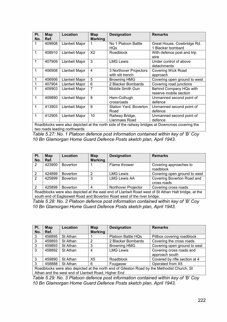
222
Pl. No.
Map Ref.
Location Map Marking
Designation Remarks
1 409908 Llantwit Major 1 No 1 Platoon Battle HQs
Great House, Cowbridge Rd. 1 Blacker bombard
1 408910 Llantwit Major X2 Roadblock With defence post and trip wire
1 407909 Llantwit Major 3 LMG Lewis Under control of above detachments
1 406908 Llantwit Major 4 3 Northover Projectors with slit trench
Covering Wick Road approach
1 406906 Llantwit Major 5 Browning HMG Covering open ground to west
1 407904 Llantwit Major 6 2 Blacker Bombards Covering road junctions
1 409903 Llantwit Major 7 Mobile Smith Gun Behind Company HQs with reserve mobile section
1 409890 Llantwit Major 8 Ham-Colhugh crossroads
Unmanned second point of defence
1 413903 Llantwit Major 9 Station Yard, Boverton Road
Unmanned second point of defence
1 412905 Llantwit Major 10 Railway Bridge, Llanmaes Road
Unmanned second point of defence
Roadblocks were also depicted at the north side of the railway bridges at Downcross covering the two roads leading northwards
Table 5.27: No. 1 Platoon defence post information contained within key of ‘B’ Coy 10 Bn Glamorgan Home Guard Defence Posts sketch plan, April 1943.
Pl. No.
Map Ref.
Location Map Marking
Designation Remarks
2 423900 Boverton 1 Flame thrower Covering approaches to roadblock
2 424899 Boverton 2 LMG Lewis Covering open ground to west
2 425899 Boverton 3 LMG Lewis AA Covering Boverton Road and cross roads
2 425899 Boverton 4 Northover Projector Covering cross roads
Roadblocks were also depicted at the east end of Llantwit Road west of St Athan Halt bridge, at the south end of Eagleswell Road and Boverton Road west of the river bridge.
Table 5.28: No. 2 Platoon defence post information contained within key of ‘B’ Coy 10 Bn Glamorgan Home Guard Defence Posts sketch plan, April 1943.
Pl. No.
Map Ref.
Location Map Marking
Designation Remarks
3 458895 St Athan 1 Platoon Battle HQs Pillbox covering roadblock
3 459893 St Athan 2 2 Blacker Bombards Covering the cross roads
3 459893 St Athan 3 Browning HMG Covering open ground to east
3 458892 St Athan 4 LMG Lewis Covering cross roads and approach south
3 459890 St Athan X5 Roadblock Covered by rifle section at 4
3 458888 St Athan 6 Fougasse Operated from X5
Roadblocks were also depicted at the north end of Gileston Road by the Methodist Church, St Athan and the west end of Llantwit Road, Higher End
Table 5.29: No. 3 Platoon defence post information contained within key of ‘B’ Coy 10 Bn Glamorgan Home Guard Defence Posts sketch plan, April 1943.

223
Plate 5.1: Defence Posts sketch plan from ‘B’ Coy, 10 Bn Glamorgan Home Guard Defence Scheme, April 1943.

224
5.4.6.3 Welch Regiment Museum Home Guard Battalion areas plan
The archive of the Welch Regiment Museum at Cardiff Castle (now at Brecon
Barracks) held an undated One-Inch Map of Great Britain, Cardiff Sheet 154
annotated with the Glamorgan Home Guard battalion areas. It demonstrated that the
bulk of the case study area was occupied by the southern portion of the 10
(Cowbridge) Battalion, Glamorgan Home Guard. The area to the west of an
approximate line north from Tresilian Bay via the railway along the west side of RAF
Llandow was occupied by the 3 (Bridgend) Battalion, Glamorgan Home Guard. The
area to the east of the river Thaw from the coast north as far as Gigman Mill and then
north-east to St Nicholas was occupied by the 5 (Barry) Battalion, Glamorgan Home
Guard.
The plan was the sole example that provided information regarding the military
organisational structure for the case study. Although it was an important survival its
significance should not be over-stated as it was not dated and had lost its specific
historical context.
5.4.6.4 War Office Cassini mapping
The fourth major collection of cartographic evidence comprised the
GSGS3906 1:25,000 and GSGS3907 one-inch to one mile (1:63,360) scale maps. A
complete series of both sets of mapping was identified for the case study (Table
5.30). None of the individual map sheets were annotated with any form of defensive
depiction and other than providing geographical context their chief importance was in
facilitating the identification of the locations of defensive structures cited using the
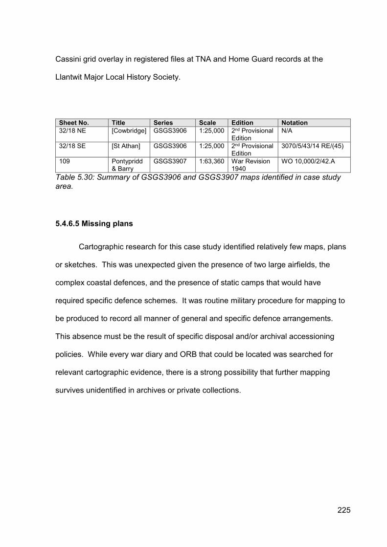
225
Cassini grid overlay in registered files at TNA and Home Guard records at the
Llantwit Major Local History Society.
Sheet No. Title Series Scale Edition Notation
32/18 NE [Cowbridge] GSGS3906 1:25,000 2nd Provisional Edition
N/A
32/18 SE [St Athan] GSGS3906 1:25,000 2nd Provisional Edition
3070/5/43/14 RE/(45)
109 Pontypridd & Barry
GSGS3907 1:63,360 War Revision 1940
WO 10,000/2/42.A
Table 5.30: Summary of GSGS3906 and GSGS3907 maps identified in case study area.
5.4.6.5 Missing plans
Cartographic research for this case study identified relatively few maps, plans
or sketches. This was unexpected given the presence of two large airfields, the
complex coastal defences, and the presence of static camps that would have
required specific defence schemes. It was routine military procedure for mapping to
be produced to record all manner of general and specific defence arrangements.
This absence must be the result of specific disposal and/or archival accessioning
policies. While every war diary and ORB that could be located was searched for
relevant cartographic evidence, there is a strong possibility that further mapping
survives unidentified in archives or private collections.
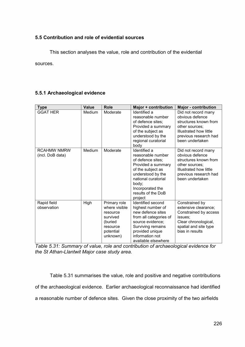
226
5.5 Contribution and role of evidential sources
This section analyses the value, role and contribution of the evidential
sources.
5.5.1 Archaeological evidence
Type Value Role Major + contribution Major - contribution
GGAT HER Medium Moderate Identified a reasonable number of defence sites; Provided a summary of the subject as understood by the regional curatorial body
Did not record many obvious defence structures known from other sources; Illustrated how little previous research had been undertaken
RCAHMW NMRW (incl. DoB data)
Medium Moderate Identified a reasonable number of defence sites; Provided a summary of the subject as understood by the national curatorial body; Incorporated the results of the DoB project
Did not record many obvious defence structures known from other sources; Illustrated how little previous research had been undertaken
Rapid field observation
High Primary role where visible resource survived (buried resource potential unknown)
Identified second highest number of new defence sites from all categories of source evidence; Surviving remains provided unique information not available elsewhere
Constrained by extensive clearance; Constrained by access issues; Clear chronological, spatial and site type bias in results
Table 5.31: Summary of value, role and contribution of archaeological evidence for the St Athan-Llantwit Major case study area.
Table 5.31 summarises the value, role and positive and negative contributions
of the archaeological evidence. Earlier archaeological reconnaissance had identified
a reasonable number of defence sites. Given the close proximity of the two airfields

227
and the known coastal crust defences it was surprising that the area had not been
the focus of greater archaeological research. Field observation associated with this
research identified a further thirty-six defence posts. Collectively, archaeological
evidence contributed the second highest number of new defence site identifications.
Archaeological fieldwork was a primary source of new defence site
identification, but successful research could not rely on the sole use of archaeological
evidence to identify the original anti-invasion defence site population. Many of the
hardened defence sites had been comprehensively demolished and cleared following
disuse. The fieldworks had either been marked out but not excavated, or had been
excavated and backfilled as impediments following disuse. These post-depositional
factors meant that these structures could not be recognised during the observation
survey.
Field observation confirmed that the Defence of Britain project had a minor
impact within the case study and that many visible defence sites were not observed.
The defence provision inland away from the coastal crust defences and the airfields
and in urban areas remained poorly understood and it was not certain whether this
reflected an original lower density of defence sites, aggressive post-depositional
factors or poor survey methodology.
Where defence sites survived, the archaeological evidence took on a primary
role in terms of its ability to provide a physical constructional and spatial expression
of the defence site by providing a level of detail and comprehension rarely obtainable
from the other source types. In this case study it was clear that archaeological
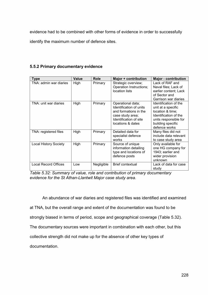
228
evidence had to be combined with other forms of evidence in order to successfully
identify the maximum number of defence sites.
5.5.2 Primary documentary evidence
Type Value Role Major + contribution Major - contribution
TNA: admin war diaries High Primary Strategic overview; Operation Instructions; location lists
Lack of RAF and Naval files; Lack of earlier content; Lack of Sector and Garrison war diaries
TNA: unit war diaries High Primary Operational data; Identification of units and formations in the case study area; Identification of site locations & dates
Identification of the unit at a specific location & time; Identification of the units responsible for building specific defence works
TNA: registered files High Primary Detailed data for specialist defence works
Many files did not include data relevant to case study area
Local History Society High Primary Source of unique information detailing type and locations of defence posts
Only available for one HG company for 1943; earlier and wider provision unknown
Local Record Offices Low Negligible Brief contextual Lack of data for case study
Table 5.32: Summary of value, role and contribution of primary documentary evidence for the St Athan-Llantwit Major case study area.
An abundance of war diaries and registered files was identified and examined
at TNA, but the overall range and extent of the documentation was found to be
strongly biased in terms of period, scope and geographical coverage (Table 5.32).
The documentary sources were important in combination with each other, but this
collective strength did not make up for the absence of other key types of
documentation.

229
The documentation provided a partial understanding of the military
administrative and operational organisation arrangements from 1939 to 1942. While
the establishment of a limited narrative must be considered a significant success in
contrast to the previous lack of any description, it was recognised that there was
considerable opportunity for future enhancement of the arrangements.
The research of documentary sources achieved a good understanding of the
dates and roles of the regular army formations and units present and/or with
responsibilities within the case study. The data facilitated understanding of detailed
nuances such as the division between field force and static troops and the trend
through time whereby regular forces handed over responsibility for defence to Home
Guard units and were required to function in a counter-attack role from increasingly
distant geographical locations. It was anticipated that further research would refine
this narrative further.
In contrast the role, development and territorial responsibilities of the Home
Guard units was not satisfactorily determined from the documentary sources
examined. The key source identified in the archives of the Llantwit Major Local
History Society was dated April 1943 and it was uncertain how far back the detail in
the defence scheme could be projected. A greater understanding of the three Home
Guard battalions present within the case study would be beneficial.
The ‘B’ Company, 10 Battalion Glamorgan Home Guard defence scheme
recorded a significant number of newly identified defence sites located within the
area between the coastal crust defences and the airfield perimeter defences.
Unfortunately the Home Guard defence site data could not be integrated together

230
with the coastal crust and airfield defence data, as the chronological span differed.
The presence of a sophisticated defence scheme in 1943 could not be taken to infer
elements of the scheme in 1940-41.
The most significant weakness identified within the documentary sources was
the absence of the defence schemes for the coastal crust and airfield ground
defences between mid-1940 and the end of 1942. As the most important
components of the regional defence scheme within the case study the lack of this
documentation meant that the number, extent and role of the defence posts could not
be identified. Similarly, their tactical intention was not clear, although the brief
references preserved within the Western Command and South Wales Area war
diaries and the coast artillery and defence battery documentation hinted at the
complexity of the arrangements.
5.5.3 Aerial photographic evidence
Type Value Role Major + contribution Major - contribution
Wartime low-level oblique
Low Usually non-contributory, but a primary role where present
Where present can provide high levels of detail and 3D perspective
Significant lack of spatial and chronological coverage
Wartime vertical (all scales)
High - Moderate
Primary source of evidence & context
Almost complete spatial coverage. Sole source for identifying some defence posts or characterising extent of part destroyed defences
Lack of chronological coverage Not able to capture small defence works
Operation Revue (1945-1952)
Moderate Important retrospective source
Complete coverage for case study area
Too late – major post-War reconstruction underway
Table 5.33: Summary of value, role and contribution of aerial photographic evidence for the St Athan-Llantwit Major case study area.
231
Aerial photographic sources were highly variable in their role and contribution
depending on their type, date, quantity, quality and coverage (see Table 5.33). Early
wartime (1940-41) coverage of the case study was extremely limited and restricted to
coastal areas prior to anti-invasion defence construction. This type of evidence was
of low value and made a minor contribution. Few areas were photographed on more
than one occasion, limiting the evidence type’s ability to aid phasing and dating.
Wartime oblique photography, with the advantage of being taken from low
altitudes and offering the prospect of unrivalled detail, made a negligible contribution,
constrained by the lack of coverage. New sources identified in the future may
improve the value, role and contribution of this evidence type.
The vertical photography was the most commonly occurring and extensive
type and made important contributions for a number of defence site types either in a
unique or complementary supporting role.
It was the unique source for identifying the presence, extent and construction
of the anti-tank ditches at Limpert Bay. It was the sole authority for identifying the
location, extent and form of anti-landing obstacles in the case study, particularly as
these features were quickly backfilled.
It was the only source to identify the original location, form, complement and
extent of the anti-tank block alignment and pillboxes at Limpert Bay, and
demonstrated that the extant remains were considerably remodelled. Aerial
photography also provided the spatial layout for the HAA battery at Boverton,
otherwise only known from documentary sources.
232
There were a range of defence site types that the aerial photography did not
identify, despite the defences being known to have been constructed. These
included minefields and fieldworks. The resolution of the photography was
insufficient to be able to identify small individual fieldworks and this must be accepted
as a limitation of this form of evidence. Larger structures such as pillboxes were hard
to detect, even when their presence was known on the ground. Pillboxes tended to
display most clearly when the upper surfaces were depicted as white tonal ‘spots’
that contrasted with their surroundings or stood proud and cast a shadow.
The later wartime American vertical photography was often captured from
higher altitudes in order to gain a wider field of view and while utilising improved
technology, the output was not found to offer any particular advantage in use, other
than covering most of the case study. Despite careful examination additional
defence structures were hard to identify. The post-war RAF vertical photography
offered the capacity to be more useful as it was taken from lower altitudes facilitating
better image resolution, but its contribution was limited as it recorded post anti-
invasion defence landscapes after many of the defences had been cleared away.
For some defence posts, this source of evidence was fundamental, while for
others that were known to have been built the method was unresponsive. This form
of evidence was akin to geophysical survey results and must be treated with the
same caveats. It was considered that aerial photographic evidence would have to be
present in much greater spatial and chronological quantities in order to assume a
more significant role for this case study.
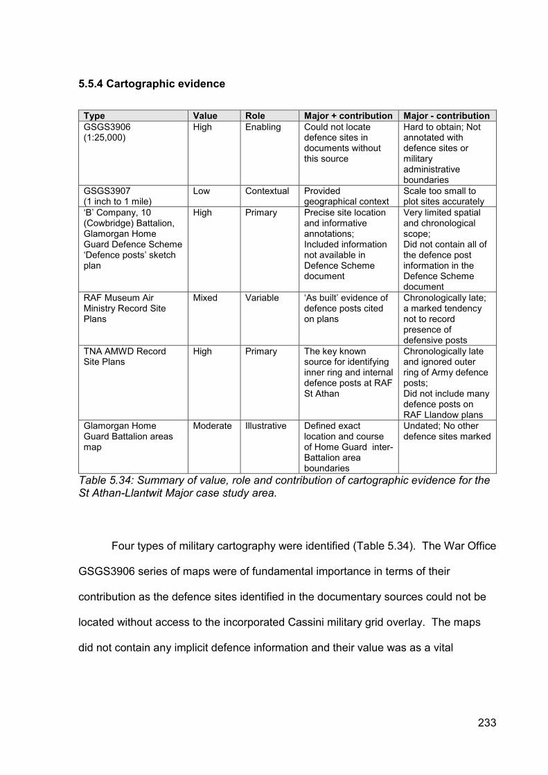
233
5.5.4 Cartographic evidence
Type Value Role Major + contribution Major - contribution
GSGS3906 (1:25,000)
High Enabling Could not locate defence sites in documents without this source
Hard to obtain; Not annotated with defence sites or military administrative boundaries
GSGS3907 (1 inch to 1 mile)
Low Contextual Provided geographical context
Scale too small to plot sites accurately
‘B’ Company, 10 (Cowbridge) Battalion, Glamorgan Home Guard Defence Scheme ‘Defence posts’ sketch plan
High Primary Precise site location and informative annotations; Included information not available in Defence Scheme document
Very limited spatial and chronological scope; Did not contain all of the defence post information in the Defence Scheme document
RAF Museum Air Ministry Record Site Plans
Mixed Variable ‘As built’ evidence of defence posts cited on plans
Chronologically late; a marked tendency not to record presence of defensive posts
TNA AMWD Record Site Plans
High Primary The key known source for identifying inner ring and internal defence posts at RAF St Athan
Chronologically late and ignored outer ring of Army defence posts; Did not include many defence posts on RAF Llandow plans
Glamorgan Home Guard Battalion areas map
Moderate Illustrative Defined exact location and course of Home Guard inter-Battalion area boundaries
Undated; No other defence sites marked
Table 5.34: Summary of value, role and contribution of cartographic evidence for the St Athan-Llantwit Major case study area.
Four types of military cartography were identified (Table 5.34). The War Office
GSGS3906 series of maps were of fundamental importance in terms of their
contribution as the defence sites identified in the documentary sources could not be
located without access to the incorporated Cassini military grid overlay. The maps
did not contain any implicit defence information and their value was as a vital

234
enabling locational tool in a complementary role with documentary resources. The
GSGS3907 maps were less useful as they were a smaller scale.
The second type of cartographic evidence comprised the sole identified
example of a defence scheme-related map. The plan was co-produced with the
associated textual defence scheme and the two sources were highly cross-
referenced, creating a strongly collaborative pairing. The plan’s strength was as the
sole visual expression of the location of a wide range of different defence site types
demonstrating how strongly defended the area covered was. It also retained unique
defence post information not evidenced in the associated document.
In contrast, the plan’s weakness was its spatial limitation to the Llantwit Major-
Boverton-St Athan area, as the plan did not detail the defence provision on the coast,
at either of the airfields or around Cowbridge. It also did not illustrate the full range of
defence posts evidenced in the associated document. These areas would have been
the responsibility of other units and their organisation expressed in other plans. For
the purposes of understanding defensive arrangements across the case study, a
number of such plans would need to be identified from a similar time period, an
occurrence considered to be improbable in a large case study.
The third type of cartographic evidence comprised the Air Ministry Record Site
Plans preserved at TNA. The annotated plans were of fundamental importance for
identifying the location, type, number and extent of individual defence posts within
RAF St Athan, allowing part of the defensive arrangements for 1944 to be
reconstructed with a high degree of confidence. However, it was uncertain whether
the Gun Posts marked recorded all or just the main defence posts and whether any

235
of these were fieldworks rather than pillboxes. The Army outer defensive ring
pillboxes were not depicted on the plan, so our knowledge of the holistic defensive
arrangements for the airfield and its immediate environs was incomplete; how
incomplete remains unknown.
It was uncertain how the 1944 layout correlated with earlier distributions.
Despite these concerns, the RAF St Athan plans were thought to be the most
detailed cartographic description of defensive arrangements known to survive from
any wartime airfield in Wales. The equivalent plans for RAF Llandow and the generic
Air Ministry plans from the RAF Museum collections contained far fewer sites and
were consequently of more limited use.
The lack of plans showing the military administrative and operational
organisational structures within the case study for the regular army was detrimental
to the research process, as the lack of comprehension limited interpretation of sites
identified through other sources. In particular, the lack of understanding of army
sector and sub-sector boundaries and RAF airfield coverage hindered the
identification of authorities responsible for ordering the construction of particular
defence posts. The Home Guard battalion areas plan was illustrative, but as it was
undated it was of limited use. Collectively, the absence of such plans limited
understanding of the military administrative and operational geography of the case
study.
Research did not identify a sole map of all of the defences constructed within
the case study and the overall contribution of mapping was limited by its low
occurrence, intermittent presence, date, purpose, geographical coverage and scale.
236
The lack of cartographic evidence for 1940-41 was prominent and meant that other
evidential sources were required to reconstruct this period.
5.6 Summary
This chapter set out the Second World War defensive arrangements within the
St Athan-Llandow case study as known from the assessed evidence. A modest
amount of information had been recorded and published prior to this research, but
there was no historical narrative, and significant areas were completely unknown.
No previous conflict archaeology research was identified in the case study and
earlier archaeological fieldwork had been recorded in an ad hoc manner. There had
been no systematic and detailed attempt to assess the surviving documentary
sources in local, regional or national archives. The published military historiography
was significantly incomplete and no understanding of the military administrative and
operational arrangements or the formations and units involved had been published.
The composition, site types, location and extent of the defences was not understood.
This research examined and assessed all of the identified evidence. It
identified new sources of evidence across all four evidence classes, and combined
them to present an original and cohesive understanding of the development of the
role and contribution of the different evidential source types, together with a more
developed but still incomplete comprehension of the case study’s defensive
arrangements. The research highlighted complex coastal defence arrangements and
the frequent replacement of military units. Significant evidential gaps were identified,
particularly concerning the airfield defence schemes, the defensive arrangements

237
between the coast and the airfields, and urban defence provision during the 1940-42
period.
This chapter reviewed the available evidence for the defensive arrangements
prepared within the St Athan-Llandow case study. The next two chapters analyse
the situation in the Swansea-Gower and Carmarthen Stop Line areas, which form the
second and third case studies respectively.

238
6. CASE STUDY 2: THE SWANSEA-GOWER AREA
6.1 Introduction
This chapter presents the assessment and results for the second case study.
It is divided into four sections. The first section describes the case study’s
characteristics, the second section reviews the known source evidence, the third
section presents the newly identified source evidence and the final section analyses
the role, value and contribution of the evidential sources. There is an enhanced
discussion of the primary documentation given its dominant contribution compared to
the other evidential sources.
6.2 Case study description
The case study comprised an arbitrary shape within the unitary authority of the
City and Council of Swansea that was coterminous with the boundary of
Headquarters Swansea Garrison in 1942 (Figure 6.1). It comprised the entire Gower
peninsula and the town of Swansea (see Map 2 in end papers). The southern,
western and north-western boundaries were formed by the coastline. The northern
terrestrial boundary ran eastwards from Island House to Cadle where it followed the
borough boundary in a north-easterly direction to Pant-lasau and then an arbitrary
line east to the Ynysforgan railway viaduct. It followed the borough boundary
southwards along the River Tawe and then the railway embankment to the south-
east to take in the Peniel railway tunnel at Lonlas. From Lonlas, the boundary
followed the borough limit southwards crossing Crymlyn Bog before meeting the
coast east of Queen’s Dock.

239
Fig.6.1: Swansea-Gower case study area location. Base map depicts
administrative counties of Wales as of 1931. Scale = 1:1,250,000.
6.2.1 Topography, hydrology, geology and human geography
The case study overlies two of CCW’s regional Landscape Character Areas
(rLCAs) as defined in the draft Landscape Character Map for Wales. The Gower
rLCA covered the west-facing peninsula to the west of Swansea. The Swansea Bay
rLCA lies to the north and east of the Gower rLCA and covered the coastline and
immediate terrestrial interior from Llanelli to Port Talbot, including the city of
Swansea.

240
6.2.1.1 Gower
Gower comprised a self-contained geographical unit and was described as a
‘rural, hilly, agricultural coastal peninsula, with smooth low hills and unenclosed
heaths’ (Countryside Council for Wales 2009: 40). The dispersed scattered
settlements were linked by a network of often straight rural roads. Mixed agricultural
practices imposed a strong pattern of medium to large-sized fields bounded by
hedgebanks (see Map 5 in end papers for exemplar of historic mapping).
CCW’s LANDMAP geological evaluation map divided the Gower into thirty-
three aspect areas. It was beyond the scope of this research to describe each area
in detail; a summary is presented in Table 6.1 together with a narrative overview.
Gower’s geology is dominated by a Carboniferous Limestone plateau that is
intersected by a prominent west-north-west – east-south-east aligned lowland
escarpment ridge of Devonian Quartz Conglomerate called Cefn Bryn.
The lowland plateau featured well-defined escarpments in the east, and was
surrounded by undulating lowland hill terrain. A band of Millstone Grit divided the
limestone from the Carboniferous Coal Measures to the north-east.
The northern side of the peninsula, known as Llanrhidian Sands, was bounded
by the Burry Inlet, which included extensive areas of mudflats, fringed by saltmarsh
and sand dunes that transformed into semi-enclosed flood plain as the inlet
narrowed. Sand dunes extended north to Whiteford Point at the mouth of Burry Inlet.

241
Area Unique ID Area Name Classification
SWNSGL001 Oxwich Burrows Active sand dune
SWNSGL002 Reynoldston Undulating lowland hill terrain
SWNSGL003 Horton Lowland plateau
SWNSGL004 Port Eynon Bay, North foreshore Wave-cut platform
SWNSGL005 Port Eynon Bay Sand beach
SWNSGL006 Port Eynon Triassic Other
SWNSGL007 Port Eynon Point Wave-cut platform
SWNSGL008 Henllys Lowland plateau
SWNSGL009 Port Eynon – Rhossili Cliffs Rock cliff
SWNSGL010 Rhossili Lowland plateau
SWNSGL011 Worms Head Wave-cut platform
SWNSGL012 Rhossili Down Scarp slope
SWNSGL013 Llangennith Moors Saltmarsh
SWNSGL014 Whiteford Sands – Rhossili Bay Sand dune
SWNSGL015 Burry Holm Wave-cut platform
SWNSGL016 Coety Green Undulating lowland hill terrain
SWNSGL017 Llanmadoc Hill Other
SWNSGL018 Cefn Bryn Lowland escarpment
SWNSGL019 Llanrhidian Lowland plateau
SWNSGL020 Llethryd Lowland plateau
SWNSGL021 Pennard Burrows Stabilised sand dune
SWNSGL022 Pebbles Beach – Langland Rock cliff and shore
SWNSGL023 Mumbles Head Rock cliff and shore
SWNSGL024 Fairwood Common Lowland plateau
SWNSGL025 Cil Ifor Top Undulating lowland hill terrain
SWNSGL026 Welsh Moor Undulating lowland hill terrain
SWNSGL027 Landimore Coastal slope
SWNSGL028 Llanrhidian Marsh-Loughor Saltmarsh
SWNSGL029 Penclawdd Lowland escarpment
SWNSGL030 Cockett Lowland escarpment
SWNSGL031 Loughor, Lliw Flood plain
SWNSGL032 Loughor Lowland escarpment
SWNSGL033 Penllergaer Lowland escarpment
Table 6.1: Countryside Council for Wales’s LANDMAP geological evaluation
classification data for the Gower.
Post-glacial isostatic readjustment created sheer cliffs, shores and raised
beaches at Mumbles Head, Langland and between Rhossili and Port Eynon. There
were areas of stabilised and active sand dunes, for example at Oxwich Bay. The
western side of Gower comprised Rhossili Bay’s flat sandy beaches fringed by the
Whiteford Sands-Rhossili Bay sand dune system, overlooked by the scarp slope of
Rhossili Down. The bay is bounded by the wave-cut platforms of Worm’s Head to

242
the south and Burry Holms to the north. GGAT’s historic landscape characterisation
for Gower noted that:
‘The natural process of coastal erosion and be-sandment has had an overriding impact on Gower; accumulations of windblown sand have formed considerable areas of littoral dunes at a number of points..., with their distribution primarily controlled by coastal topography and by the prevailing westerly winds. They are commonly found in bays; their extent limited by the size of the bay and the relief of the hinterland’ (GGAT 2013).
6.2.1.2 Swansea
The eastern side of the case study was dominated by the modern city of
Swansea. It overlay the southern central portion of the Swansea Bay rLCA and was
characterised as a major urban and industrial region located on the coastal plain and
a focus for the region’s transportation routes, with upland areas to the north.
CCW’s LANDMAP methodology did not extend to urban areas, so the majority
of Swansea was not characterised. Two aspect areas intersected with the eastern
case study boundary (Table 6.2).
Kilvey Hill comprised a north-east – south-west aligned sandstone ridge of
dissected lowland plateau dominated by Productive Coal Measures. It formed the
east-facing slopes to Crymlyn Bog, which was a broad low lying marsh area between
the Tawe and Neath valleys, located north of the coastal dune belt.
Area Unique ID Area Name Classification
SWNSGL047 Kilvey Hill Lowland plateau
SWNSGL048 Crymlyn Bog Coastal flat
Table 6.2: Countryside Council for Wales’s LANDMAP geological evaluation
classification data for Swansea.

243
6.2.2 Industrial Swansea during the Second World War
Wartime Swansea was a large town undertaking strategically important
economic functions. It comprised river mouth dock complexes, the heavily
industrialised lower Swansea Valley and the pre-industrial agricultural field systems
to the west of Swansea at Killay and Dunvant.
Swansea’s port developed where the River Tawe emerged from the gorge
between Townhill and Kilvey Hill. The lower Swansea Valley to the north comprised
a flat marshy plain bounded by hills. The town was compact and nineteenth century
urban development was confined to Manselton, Mount Pleasant and Sandfields
(Robins 1993: 5). Extensive council estates developed at Morriston, Townhill and
Llanerch during the 1930s, together with linear development along arterial roads.
Swansea was renowned for its copper smelting and coal trade. Balchin
characterised Swansea at the beginning of the Second World War as ‘still retaining a
nineteenth-century form [with] coal mining and metal working providing over half the
employment and... the new manufacturing industries of the twentieth century... [were]
hardly represented’ (1971: 255).
The last copper smelting occurred in 1921 (Hughes and Reynolds 1988: 11),
but copper rolling was still undertaken at the ICI-owned Vivian and Foster copper
works at Hafod and Morfa during the 1940s. Two non-ferrous smelting concerns
were also active in 1939 (Balchin 1971: 263).
The Beaufort Tinplate Works was a significant concern at Llansamlet, but
government intervention concentrated wartime tin-plate production into a smaller
number of productive plants, requisitioning and modifying many of the older works for

244
the storage of matériel and induced a considerable contraction in activity (Balchin
1971: 263-267; Baber and Thomas 1980: 535).
The coal industry was important and from 1922 the Great Western Railway
Company initiated a period of thorough modernisation of Swansea’s harbour facilities
(Baber and Thomas 1980: 547). They extended over 224 acres (90 hectares). The
Anglo-Persian Oil Company refinery at Llandarcy was the first large-scale
commercial refinery in Britain and was of vital wartime strategic importance (Baber
and Thomas 1980: 535; Balchin 1971: 269). Other industries included limestone
extraction (Toft 1988a; Toft 1988b) and brick-making (Baber 1980: 220; Thomas
1969).
The wartime government’s policy of industrial dispersal to western Britain
prompted the establishment of new factories including a carbon black plant near
Swansea docks, aluminium works at Waunarlwydd and Port Tennant, and some
chemical production (Balchin 1971: 260). A shadow factory producing pressed metal
components was established for the Mettoy Company at Fforestfach and the Ministry
of Supply established a depot at Penclawdd (Baber and Thomas 1980: 564).
A number of industrial and transportation facilities were defended as
Vulnerable Points, including dock gates, the Ynysforgan railway viaduct, the
Llangyfelach and Peniel railway tunnels, the Swansea Gas Company’s works at
Morriston and the electricity power stations at the Strand and Tir John. The latter
was the most advanced in Wales.
245
6.2.3 Landscape change
Post-war Swansea was extensively redeveloped. By the 1930s much of the
heavy industry had contracted sharply (Morgan Rees 1975: 25), and a programme of
slum clearance had commenced (Balchin 1971: 186). The town centre was
extensively blitzed in February 1941 (Bowler 2006). Public sector-led slum clearance
recommenced in the mid-1950s and 290 acres of central Swansea affected by the
Blitz was pronounced a Declaratory Area for reconstruction (Balchin 1971: 187).
Post-war redevelopment expanded many Gower villages as dormitory
suburbs, while private sector-led housing development schemes significantly
expanded the western urban fringe, particularly at Sketty and Killay-Dunvant.
The docks were extensively redeveloped. South Dock was developed during
the 1980s into residential accommodation, a marina and commercial businesses.
Similar redevelopment occurred at the Prince of Wales Dock. King’s Dock remained
the principal commercial dock. Large parts of the former industrial area at Jersey
Marine were cleared for redevelopment.
The lower Swansea Valley of the 1960s was described by Balchin as,
‘probably then the most extensive contiguous area of industrial dereliction to be
found anywhere in the United Kingdom’, covering 1174 acres (570 hectares) (1971:
368). Hughes observed that,
‘the pioneering reclamation of the lower Swansea Valley in the 1960s destroyed many of the then surviving industrial monuments, and the subsequent development of the Enterprise Park, the creation of areas of urban woodland, the construction of housing and roads, and the recovery of derelict land will soon complete the process’ (2000: vii).

246
Subsequent wide-scale reclamation removed millions of tons of industrial
debris, restored land and re-developed new facilities. This destroyed much of the
original urban fabric and the associated anti-invasion defence landscape.
6.3 Existing source evidence
This section summarises the evidence located prior to undertaking the
research for this case study.
6.3.1 Known archaeological evidence
Existing archaeological datasets were identified as being held by GGAT’s
HER and the RCAHMW’s NMRW. The latter incorporated the Defence of Britain
project dataset.
Source Total No. of C20 Military Records
No. of C20 Military Records in Swansea UA
No. of C20 Military Records in Case Study Area
GGAT HER 186 58 54
RCAHMW NMRW 569 15 11
Table 6.3: Summary of twentieth century military records held by GGAT and the
RCAHMW.
Table 6.3 highlighted the low number of records held by the HER and NMRW.
The majority of these were identified by two recorders during the Defence of Britain
project. In both datasets, the records were a mixture of gun emplacements,
pillboxes, anti-tank obstacles and anti-aircraft defences. There was little overlap
between the two datasets and only four sites were duplicated.

247
GGAT’s HER recorded a few earthwork defences, but overall the range and
number of defences was not as anticipated and tended to focus on hardened
structures at the exclusion of other types. Only a narrow range of anti-invasion site
types were identified and recorded. As with the first case study, the low number of
sites was indicative of opportunistic rather than purposeful recording.
6.3.2 Published sources
The published literature relating to wartime Swansea and Gower was modest.
It comprised biographical narratives (Bowler 2006; Carter 1988; Elliott, Powell and
Powell 2005; Elliott Jones and Cope 2010) or pictorial-led content (Arthur 1988;
Robins 1993). The February 1941 Blitz was well documented (Alban 1994; Roberts
2011). Some of the reminiscences were useful as they recorded anecdotal evidence
relating to beach defences, and coast and anti-aircraft artillery (Elliott, Powell and
Powell 2005).
The literature did not cover the identity or organisation of the military, but did
provide reasonable coverage of the Mumbles Island and Mumbles Hill coast artillery
batteries. Hogg did not discuss Swansea’s provision in his area-based narratives
and provided brief details for two batteries in his site gazetteer (1974). Saunders
omitted any reference to fortifications in Glamorgan (1989). The RCAHMW provided
an historical and architectural description of Mumbles Island and a brief overview of
its Second World War occupation (Saunders et al. 2001). Wood’s recent coast
defence gazetteer (2012) based on fieldwork and archival research by the UK Forts
Society cited four coast artillery batteries at Mumbles Island, Mumbles Hill, Swansea
248
East Battery and Swansea Docks Battery, but each description was very brief. A
beach defence flank battery of one or two 6-pdr guns was identified at Whit[e]ford
Sands, but no specific location or citation was provided. Arthur referred to a Royal
Artillery Proving Range at Salthouse Point, and ‘on the high ground above Berth-lwyd
a 6-in Coastal Defence gun, set in a concrete emplacement, (which is still in
existence) dominated the Burry Estuary and the vast expanse of Llanrhidian Sands’
(1988: 16). Wills’ gazetteer was contradictory: the map indicated seven pillboxes in
the case study, but only two were cited in his gazetteer (1985). Osborne’s county-
based 20th Century Defences in Britain series has not covered Wales.
Jones (2007b), McLelland (2012), Phillips 2006 and Smith (1981) discussed
the operational history of RAF Fairwood Common and the squadrons based there,
but did not provide constructional or architectural histories. The Airfield Review
bibliography for 1978-2010 (Flagg 2010) indicated one published article on RAF
Fairwood Common (Jones 2000), which did not inform this research.
6.3.3 Unpublished reports
The archaeological grey literature for Swansea and Gower was extensive, but
twentieth century military sites were referenced infrequently. The National Trust
undertook National Archaeological Surveys of its extensive Gower holdings during
1986-87 (Plunkett-Dillon and Latham 1986a-b; 1987a-d) and 2003-04 (Poucher
2003a-b; 2004a-b). GGAT undertook similar archaeological assessment surveys of
Gower as part of the Gower Commons Initiative (Howell 2001a-h). From 1999,
GGAT undertook historic landscape characterisation of Gower, dividing the area into

249
eighty-seven historic landscape characterisation areas (Glamorgan-Gwent
Archaeological Trust 2014). GGAT also completed a series of archaeological
watching briefs at the former RAF Fairwood Common airfield in advance of
development (Howell and Lawler 2003, 2004).
Specific twentieth century military grey literature reports were few, but
informative when present. Redfern’s defence study for Wales (1998b) recognised a
range of defence sites including the Gower and Swansea Valley stop lines, coast
artillery batteries at Mumbles Island and Mumbles Hill, heavy, light and Z anti-aircraft
emplacements, together with bombing decoys. The stop line-related information was
brief, consisting of a single line of descriptive text and map co-ordinates for both ends
of the stop lines. The positions of two 6-pdr gun emplacements were noted for the
Gower stop line. Information for the coast artillery positions was more detailed and
included OS NGRs for the individual gun emplacements at Mumbles Island and
Mumbles Hill. An additional OS NGR described as ‘Swansea – general’ located a
third emplacement on the Eastern Breakwater of Swansea docks, but provided no
further details. The locations and known dates of operation were provided for the
anti-aircraft batteries and bombing decoys. The gazetteer served as an effective
locational index to a subset of the defence sites in the Swansea region, but lacked
the detailed analysis of these complex and extensive sites. Redfern did not provide
the detailed chronological and situational narrative placing the sites in their defence
context.
GGAT’s Cadw-funded study of the wartime airfields of south-east Wales
looked specifically at the archaeological evidence of the airfield core and technical
buildings at former RAF Fairwood Common, as defined by the Air Ministry’s own

250
record site plan (Huckfield 2012). Although unable to access the operational area of
the civilian airport, Huckfield’s intensive walk-over survey of the remainder of the
aerodrome recognised a range of surviving structures, including extant airfield
defences: ‘running in a zigzag pattern across the open moorland at the northern end
of runway 33/15 are at least seven submerged brick and concrete lined gunpits or
infantry trenches’ (2012: 52). No other defence features were observed on the
airfield.
The second year of the project examined the hinterland of the airfield and
Huckfield reported the location of an incomplete network of earthen anti-landing
obstacles located around the northern and eastern edges of the airfield and a newly
identified infantry slit trench at the west end of runway 29/11 (Huckfield 2013). The
anti-landing obstacles may actually represent an earlier bombing decoy site (Ivor
Jones pers. comm.), as the airfield’s perimeter track and taxi ways overlaid the
structures.
6.4 New source evidence
This section describes and assesses the new evidence for the case study that
was identified during this research.

251
6.4.1 New archaeological results from rapid field observation
Rapid field observation was undertaken to identify new defence sites and to
enhance understanding of known defence sites. The demolition of previously
recorded structures was noted to inform assessment of post-depositional factors.
6.4.1.1 New defence sites
Despite extensive rapid field observation during summer 2012 very few new
defensive sites were located. Reconnaissance along the Gower stop line identified a
number of new pillboxes, which were subsequently confirmed by textual descriptions
in the Swansea Defence Scheme No. 2 and a spigot mortar emplacement, which
was not. A small roadblock comprising anti-tank cubes was also identified at
Swansea Docks. Otherwise, the fieldwork essentially confirmed the existence of
defences identified through previous fieldwork or from other evidential sources.
The lack of newly identifiable sites was notable, and contrasted with the other
case studies. The phenomenon in urban and peri-urban Swansea must be partly
due to the extensive clearance and redevelopment schemes.
The reasons for the lack of evidence on Gower is more perplexing as a better
degree of site preservation and therefore identification was anticipated in a rural
setting. The documentary and cartographic evidence (see below) suggested that
inland Gower defences were strongly clustered around defended localities, but rapid
observation demonstrated that the majority of defence sites had been removed, with
the surviving examples largely restricted to marginal areas. One reason for this loss

252
may be the declaration of Gower as an Area of Outstanding Natural Beauty in 1956
and the subsequent campaigns to remove ‘eyesores’ to improve tourism.
6.4.1.2 New understanding of existing sites
Visits to previously identified sites demonstrated the variety and scope of the
defences, but added little to the physical resource’s understanding, particularly when
compared to the contributions made by other evidential classes of evidence. The key
outcome was a powerful testimony of just how many of the defences had been
demolished. This recognition meant that the other evidence classes would need to
‘presence absence.’
6.4.1.3 Demolition of previously recorded archaeological sites
The fieldwork did not identify any previously recorded defence sites that had
been destroyed, although the defences, unless statutorily designated or in
sympathetic ownership, remain vulnerable to removal.
The results of the rapid archaeological survey suggested that a more intensive
and longer-term investigation would be required to identify further defence sites,
perhaps using additional prospective techniques such as geophysical survey and
LiDAR around known clusters of defence sites. It is beyond the scope of this
research to comment on the survival of buried defence archaeology, but there is
strong potential for future archaeological excavations to identify additional defence
sites.

253
6.4.2 New documentary source evidence
An abundance of primary documentary evidence was identified at TNA for the
case study (Table 6.4). It comprised a combination of registered files and war diaries
together with their associated appendices. A number of registered files known to
have been produced do not appear to have been preserved at TNA, including the
registered files for the Gower and Swansea Valley stop lines. Other files were
incomplete, for example the RAF Fairwood Common ORB which did not preserve the
station’s defence scheme.
Piece No. Title Content
AIR 13/63 Siting of Balloons, Swansea Barrage balloon site positions
ADM 265/3 ‘F’ Schemes Location of dock flame defences
WO 192/156 Fort Record Book: Mumbles Island Armament and defence scheme
WO 192/ Fort Record Book: Mumbles Hill Armament and defence scheme
WO 166/2043 959 Defence Battery, RA war diary Gun emplacement positions
WO 166/2044 960 Defence Battery, RA war diary Gun emplacement positions
WO 166/6880 Swansea Garrison HQ war diary Defence scheme; Administrative structure; Operational structure; Formations and units; Home Guard disposition
WO 199/37 Defences: Anti-tank Minefields Locations of minefields
WO 199/52 Roadblocks - McNaughton Tubes Locations of CPMs
WO 199/103 Charting of Obstructions on the Foreshore Locations of pole ALOs
Table 6.4: Documentary sources of relevance to Swansea-Gower case study area preserved at The National Archives.
6.4.2.1 Military administrative and operational geography, formations and units
The documentary and cartographic evidence contributed all of the new
findings relating to the garrison’s administrative and operational organisational
structure. Documentary evidence was the sole source of evidence concerning the
presence and location of military formations and units. The contemporary aerial

254
photographic and archaeological site evidence sources did not contribute information
to the construction of this narrative.
The Swansea Defence Scheme No. 2 was the primary source for the case
study’s military administrative geography, given the scope and detail of the
information preserved within. The Mumbles Island and Mumbles Hill Fort Record
Books made important contributions for understanding Mumbles Sub-Sector. A
range of other war diaries and registered files also contributed specialist content.
6.4.2.2 Swansea Defence Scheme No. 2
Swansea Defence Scheme No. 2 was issued by the Garrison Commander on
1 January 1942 and replaced an earlier scheme of 15 January 1941. Its circulation
was restricted and the distribution list identified the scheme’s military and civilian
recipients. It also identified the military administrative and operational forces at the
time of issue (Table 6.5).
The Defence Scheme comprised a fourteen-page document that provided an
overview of the military situation and current defence arrangements (Appendix 6.1).
It explained the defence scheme’s coverage and extent, and the roles of the military,
Home Guard, civil and police authorities.
It was supported by eighteen subject-based appendices (Table 6.6), although
two were not issued or at least preserved at TNA. Four were updated and re-issued.
The contents were updated and corrected by nine successively issued amending
letters during 1942. The documentation was large and complex to understand.

255
Copy No.
Recipient Status
1 HQs South Wales District Military
2 HQs Severn Sub-Area Military
3-4 E Group Glamorgan Home Guard Military
5 12 Bn. Glam Home Guard Military
6 14 Bn. Glam Home Guard Military
7 15 Bn. Glam Home Guard Military
8 18 (Post Office) Bn. Glam Home Guard Military
9 D Sector, Glam Home Guard Military
10 Naval Officer, Swansea Naval
11 OC Docks Sector Military
12 Town Clerk, Swansea Civilian
13 Chief Constable, Swansea Civilian
14 559 Coast Regt, RA Military
15 Experimental Station, Penclawdd Military
16 35 Group, PC Military
17 294 Coy, PC Military
18 Spare N/A
19 ‘D’ Coy. 30 Bn, SWBs Military
20 HQs Movement Control, Swansea Military
21 RASC (CSD Swansea) Military
22 HQs. 61 AA Bde. Military
23 RAF Station Fairwood RAF
24 958 Squadron RAF RAF
25 District Officer, HM Coastguard Civilian
26 Garrison Engineer, Swansea Military
27 Camp Reception Station Military
28 Tyneside Scottish (Black Watch) Military
29-30 War Diary Military
31 File Military
32 Garrison Commander Military
33 Garrison Adjutant Military
34-37 Spare N/A
Table 6.5: Recipients of Swansea Defence Scheme No. 2, January 1942.
Appendices A-F and their re-issues provided the most information on the
defensive arrangements for Swansea Garrison and the content has been presented
in Appendices 6.2 (pillboxes and fieldworks), 6.3 (minefields, Canadian Pipe Mines
and fougasse sites) and 6.4 (roadblocks). The re-issue of updated appendices
covering the list of AA, searchlight and balloon sites (Appendix D, then C) and the
location list (Appendix A) were useful as they indicated that the change was
sufficiently significant to require the re-issue of an entire appendix rather than the

256
more usual amendment letter. The provision of two location lists enabled the
identification of units and their locations through time.
6.4.2.3 Military administrative geography: Swansea Garrison
The Swansea Garrison HQ war diary was the primary source of information
regarding the identification of the military administrative organisational structure in
1942. The upper chain of command comprised: GHQ Home Forces > Western
Command > South Wales Area / District > Severn Sub-Area > Swansea Garrison.
Serial Appendix Name Date of Issue No. of pages Date of Re-issue
A Location List 01/01/1942 5 11/11/1942
B Details by Sectors and Sub-Sectors 01/01/1942 35
C List of Roadblocks Unissued 0
C List of AA, Searchlight and Balloon Sites 19/09/1942
D List of AA, Searchlight and Balloon Sites 01/01/1942 2
D List of Roadblocks 21/05/1942 2
E Minefields, McNaughton Tubes, Flame Fougasse etc.
01/01/1942 3
F List of Coastguard Stations 01/01/1942 2
G States of Readiness 01/01/1942 3
H Code Words (General) 01/01/1942 1
I Intercommunication by Light Signals 01/01/1942 1 11/11/1942
J Intercommunication between Troops and RAF
01/01/1942 1
K Intercommunication between Troops on the Ground
01/01/1942 1
L Visual Signalling between Navy and Army 01/01/1942 1
M Communications (General) 01/01/1942 3
N Communications (Detail) Not recorded
O Medical Arrangements Not recorded
P Swansea Police Organisation 01/01/1942 1
Q Liaison between Military, Police and Civil Defence
20/02/1942 3
R Issue of Code Words 14/02/1942 1 09/06/1942
Table 6.6: List of detailed appendices for Swansea Defence Scheme No. 2 and date of issue.

257
Administrative duties included all those military activities undertaken by the
garrison staff during non-operational periods, including liaison with higher level
formations and lower level units on a wide range of issues including accommodation
and personnel matters. Administrative duties also comprised the physical planning,
creation and updating of the defence schemes, the arrangement and oversight of the
construction and maintenance of the required defensive positions and the training of
military personnel to ensure that effective and successful defence would be
achieved. Such activity and progress was recorded in the war diary and its
appendices, including the definition of roles (Table 6.7). Day-to-day correspondence
does not appear to have been preserved at TNA.
Force Role
Army Defence of Penclawdd Experimental Establishment
Army Defence of Oxwich Point and Rhossili radar stations
Army Defence of coast artillery batteries
Army Defence of HAA and LAA gun batteries
Royal Marines Defence of HMS Lucifer HQ, Swansea docks
RAF Defence of RAF Fairwood Common and its approaches
RAF Defence of Barrage Balloon sites
Home Guard Reconnaissance and defence of platoon and company areas
Table 6.7: Roles of static forces in Swansea-Gower case study area, 1942.
6.4.2.4 Military operational geography: Swansea Garrison
The Commander, Swansea Garrison was responsible for the operational
control of all regular Army troops placed under his command including those Home
Guard battalions located in the defence scheme area. The commander possessed a
small general staff, including two Garrison Engineers organised on an east-west
geographical basis. On receipt of Action Stations, the Home Guard would have
become an integral part of the Garrison headquarters and defence forces.

258
The defence scheme stated that the garrison was divided into four Sectors
comprising No. 1 Swansea Sector, No. 2 Swansea Sector, Docks Sector and Gower
Sector. Each Sector was subdivided into a number of Sub-Sectors, each containing
a number of Defended Localities. A Defended Locality comprised an area with fixed
defences that was designed to act as a focal point for an allocated defending force
and its weaponry. The scheme carefully articulated most of the internal spatial
territories and their interfaces, often in detail. Each Sector and Sub-Sector area was
commanded and defended by Home Guard personnel, whom were responsible for
defending the majority of defence posts. It identified the lower chain of command as:
Swansea Garrison > Sector Command > Sub-Sector Command > Defended Locality.
6.4.2.5 Military units available for defence
The scheme also identified four distinct types of troops available for garrison
defence (Table 6.8), but the source was not helpful in defining the units’ associated
spatial territories.
Table 6.8 demonstrated that the majority of the troops comprised static troops,
which were those responsible for undertaking a particular task at a fixed location.
These troops were responsible for the landward defence of their facilities, but if their
primary role was no longer possible they would become part of the primary defence
force. The static troops were divided into those under the direct command of
Swansea Garrison and those that came under the direct instruction of other
commands, for example ADGB and RAF Balloon Command.
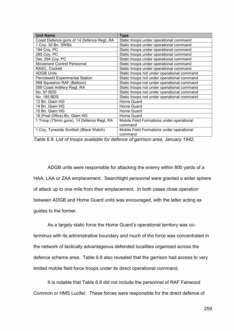
259
Unit Name Type
Coast Defence guns of 14 Defence Regt, RA Static troops under operational command
1 Coy. 30 Bn. SWBs Static troops under operational command
194 Coy, PC Static troops under operational command
285 Coy, PC Static troops under operational command
Det, 294 Coy, PC Static troops under operational command
Movement Control Personnel Static troops under operational command
RASC, Cockett Static troops under operational command
ADGB Units Static troops not under operational command
Penclawdd Experimental Station Static troops not under operational command
958 Squadron RAF (Balloon) Static troops not under operational command
559 Coast Artillery Regt, RA Static troops not under operational command
No. 97 BDS Static troops not under operational command
No. 165 BDS Static troops not under operational command
12 Bn. Glam HG Home Guard
14 Bn. Glam HG Home Guard
15 Bn. Glam HG Home Guard
18 (Post Office) Bn. Glam HG Home Guard
1 Troop (75mm guns), 14 Defence Regt, RA Mobile Field Formations under operational command
1 Coy, Tyneside Scottish (Black Watch) Mobile Field Formations under operational command
Table 6.8: List of troops available for defence of garrison area, January 1942.
ADGB units were responsible for attacking the enemy within 800 yards of a
HAA, LAA or ZAA emplacement. Searchlight personnel were granted a wider sphere
of attack up to one mile from their emplacement. In both cases close operation
between ADGB and Home Guard units was encouraged, with the latter acting as
guides to the former.
As a largely static force the Home Guard’s operational territory was co-
terminus with its administrative boundary and much of the force was concentrated in
the network of tactically advantageous defended localities organised across the
defence scheme area. Table 6.8 also revealed that the garrison had access to very
limited mobile field force troops under its direct operational command.
It is notable that Table 6.8 did not include the personnel of RAF Fairwood
Common or HMS Lucifer. These forces were responsible for the direct defence of

260
particular establishments and while the daily war diary entries demonstrate that there
was a detailed and ongoing liaison between the Army, RAF and Naval base
commanders, ultimate authority for their defence lay elsewhere, hence their
omission.
6.4.2.6 Defence arrangements for Swansea and the Gower
The Swansea Defence Scheme No. 2 stated that its intention was ‘to resist
invasion in all its forms, whether air-borne or sea-borne and to destroy the enemy in
detail where-ever he may affect a landing.’ The defence plan strategy was
articulated in detail:
(a) ‘To prevent the landing of a sea-borne force by defence works along certain beaches, and by defence of the Docks. To prevent the landing of an air-borne force by the external defence of Fairwood Aerodrome and by obstructing possible landing grounds (The internal defence of Fairwood Common is the responsibility of the RAF Station Commander).
(b) If, however, despite these measures the enemy succeeds in affecting a landing then it will be the duty of the static troops in the area affected to pin them to the ground and hold up their advance until mobile columns, and if necessary and possible, field formations can be brought to destroy them. With this object in view various defensive localities and Stop-Lines have been constructed.
I. Gowerton-Blackpill Stop Line - From Island House 022190 - Gowerton-Dunvant-Killay-Blackpill - 063128 all inclusive. (Island House locality will be manned by both 8 and 12 Bns Glam HG.
II. Defence of Swansea from the West - Extension of Swansea Valley Stop Line 125220-085192-072183-067155-070134.
III. Defence of Swansea from the North - General line Lonlas-Llansamlet-Ynysforgan-Fforestfach-Waunarlwydd-Gowerton-Island House all inclusive.
IV. Defence of Gower Peninsula - including the external defence of Fairwood Common.’

261
The basis of the defence scheme was also described and it is worth
presenting this in its entirety:
(i) ‘The basis of defence is a network of defended localities by which the enemy is bound to be contacted no matter in what direction he may seek to advance, so that whichever way he turns he will be met by small arms fire, flame throwers, bombs, tank traps, booby traps and the like in every direction.
(ii) Pill Boxes are only placed to form the skeleton of the defence. In no case should more than 2 or at the most 3 men remain in pill boxes. The remainder of the garrison of the site should be in houses, slit trenches, behind banks etc., around the pill boxes. All dead ground near pillboxes will be covered by fire or by mines.
(iii) On enemy paratroops landing they will be engaged with the utmost speed by patrols sent out from neighbouring defended localities. They will be rounded up and prevented from concentrating into larger bodies. The utmost vigour will be employed in dealing with these.
(iv) It is essential that ground forward of, and between, these localities should be continuously patrolled. It is the responsibility of the Home Guard manning the localities to carry out this patrolling. It will be made impossible for any party of the enemy to approach any defended locality unobserved.
(v) Where detachments have been given tasks at outposts forward of stop lines or perimeter defences their duty is:- (i) to send back early information of the presence and general direction of advance of the enemy, (ii) to ambush small parties of his leading troops and (iii) to delay the enemy by opening fire on large bodies at long range so as to make him deploy early. It is not intended that outposts should resist to ‘the last man and the last round’ but if hardly pressed they should retire on the main defences behind them. However, if passed or over-run they should hide and come up again to harass the enemy following the advanced attackers. If the enemy succeeds in penetrating the defences he will be attacked ruthlessly wherever he appears. House tops, windows, alley ways will be used from which to harry his flanks and rear and he will be engaged mercilessly with every weapon and bomb available. For distribution of men and arms by localities see Appendix ‘B’.’
This detailed expression of the defence scheme strategy provided an
appropriate context in which to consider the defence sites. This was a rare
articulation of a defence scheme at a local level, as this degree of information is not
usually present in known Welsh sources. The overall strategy identified the principal
262
defensive locations, but it was clear from the quotation above that while there was an
extensive and detailed list of defence sites provided in Appendix B, the totality of
defence provision was not recorded in the documentary evidence. In particular, the
local networks of additional defensive posts adopted around the immediate vicinity of
pillboxes were not recorded in the defence scheme, probably being recorded in
specific registered files or in Home Guard records that were not identified.
6.4.3 New documentary source evidence: sites
The Swansea Garrison HQ war diary for 1942 and its associated Swansea
Defence Scheme No. 2 and appendices provided the majority of information
pertaining to new defence sites within the case study. The source was excellent for
reconstructing developments in 1942, but the lack of apparent preservation of
Swansea Defence Scheme No. 1 for 1941 and the earlier scheme(s) for 1940 within
archival repositories meant that the early character and evolution of the defences
could not be described in the same detail. It was difficult to determine at which date
the defences described in the 1942 war diary were established.
6.4.3.1 Swansea Garrison war diary
The defence site information cited in the war diary was variable in quality and
usefulness (Appendix 6.5), but it remained a fundamental source of evidence as it
provided new or additional information on defence sites that had not been located
amongst the other evidential sources. The dates of defence site reconnaissance,
construction and hand over to a particular unit were often referenced, helping

263
establish a chronological narrative of defence structure development and evolution
throughout 1942. Each reference had to be assessed on an individual basis and
used with caution as it was often unclear whether a defence site was being
considered, being built, had been established or abandoned.
Defences cited within the war diary entries were routinely described by locality
name, for example Dunvant, Rhossili etc., rather than by Cassini grid reference. This
meant that defence sites that were uniquely cited by this source could not be located
precisely.
Important and unique references to defence posts that did not occur
elsewhere included the planned location of rail blocks at Killay, Dunvant and Cockett
on 9 March 1942, the presence of a scaffolding barrage at Burry Port on 16 June
1942 and the failing of part of the anti-tank cube alignment at Blackpill, Swansea Bay
on 8 July 1942. The planning and construction of a significant number of static
Blacker Bombard (spigot mortar) emplacements was also evident throughout the war
diary. Emplacements were known to have been constructed at Gowerton, Gorseinon
Road and Cockett (and widely beyond the garrison area), but their exact locations
were not recorded. The defences of the radar station at Oxwich were recorded as
being improved with wire and undefined defence positions on 22 May 1942 and 24
November 1942 respectively. The wiring of the CHL Station at Rhossili was recorded
as being held up through lack of Dannert wire on 15 June 1942. The arrival of US
troops prompted the use of Defensively Equipped Merchant Ships (DEMS) within
Queen’s Dock for anti-aircraft duties from 13 August 1942.
264
The civilian contractors responsible for constructing some of the defence posts
were identified (Mr Griff Davies at Llansamlet, Mr Isaac Jones at Mynydd Cadle
Common and Mr James for static Blacker Bombard emplacements) and it was
interesting to note that there was obvious dissatisfaction from the military authorities
concerning the standard of some of the work produced. Nos. 285 and 294 Coys,
Pioneer Corps worked across the garrison area producing a wide range of defence
posts and slit trenches, but the exact locations and types of defences were not
detailed. Specialist works were undertaken by the Royal Engineers; local minefields
were established by Nos. 165 and 16 Bomb Disposal Sections, RE and 179
Tunnelling Company, RE constructed the beach flame barrage at Jersey Marine.
The war diary illustrated a close relationship between the Garrison
Commander and the station commander at RAF Fairwood Common. Such a
preoccupation must partly have been driven by the airfield’s vulnerable location to the
west of the Gower stop line. The airfield defences were recorded as being under the
command of the Local Defence Authority (LDA) who was responsible for the ground
defence of the airfield and its approaches. The war diary recorded the presence of a
unit of the RAF Regiment, which was to act as a mobile strike force. The airfield’s
defences were strengthened during summer and December 1942. From August the
defences were completely reorganised following the results of Exercise David III,
which had tested the airfield’s defensive capabilities. The improvements were not
detailed. A war diary reference in November 1942 noted arrangements for the
passage of military traffic through the airfield in an emergency and identified the
presence of road barriers to the north and south of the airfield.

265
The war diary was silent on a range of issues including the use and location of
anti-tank obstacles, roadblocks, gun emplacements and minor fieldworks and coastal
defence sites, although many of these categories were mentioned within the Defence
Scheme’s appendices.
The war diary provided a good overview of the scope and intensity of defence
post construction in 1942 and the personal interest that the Garrison Commander
and his staff undertook in this matter. It demonstrated conclusively that pillbox
defences were still being constructed within the garrison during the first half of 1942,
post-dating the GHQ Home Forces order to cease such activity by some margin.
It also demonstrated that Swansea Garrison was able to take advantage of the
latest military innovations as they became available, for example the spigot mortar
emplacements and the beach flame barrage. For some defences such as the beach
flame barrage installation at Jersey Marine, numerous references allowed a picture of
the reconnaissance, construction and operational capability of the defence in
question to be described in some detail. The value of the diary is that it
demonstrated that the defence of the garrison area was still being actively planned,
added to and improved throughout 1942.
6.4.3.2 Swansea Defence Scheme No. 2
Swansea Defence Scheme No. 2’s Appendix B provided the single most
informative account of the number, type, location and distribution of defence sites
across the defence scheme area. The list cited the location of 144 pillboxes, seventy
fieldworks, five defended or fortified buildings, four loopholed walls and three infantry
266
posts (Appendix 6.2). It also identified the unit, administrative unit and weaponry
allocated to each post. The scope and depth of information preserved in this source
is thought to be unparalleled in Wales.
The war diary entries suggested that there was a degree of aspiration within
the list, as it cited defence posts not yet built or in the process of survey and
construction, for example at Mynydd Cadle Common, Llansamlet and Waunarlwydd.
An entry dated 3 February 1942 stated that the agreement on new defences at
Mynydd Newydd were ‘the first to be commenced under the new Swansea Defence
Scheme dated 01/01/1942.’ These defences were cited within the defence site list
and the associated allocation of grid reference, personnel and weaponry would have
been highly convincing of the position’s establishment had the war diary not stated
otherwise.
The degree the list recorded aspirational or completed defence works was not
clear from the documentation. The war diary recorded the reconnaissance and
construction of new defence works throughout 1942, but the document did not give
the impression that all of the defence posts cited on the list were to be agreed and
constructed. Conversely, it did not state which defence posts were pre-existing.
As such the ratio of built to non-built defence sites during 1942 cannot be
determined and the inability to accurately characterise the status of the individual
defence works introduced a fundamental element of uncertainty in the data’s use,
particularly as the total population of defence sites was not recorded elsewhere and
was known not to survive given the extensive re-development within Swansea.
Given that the defence scheme was current for the remainder of the year, it was also
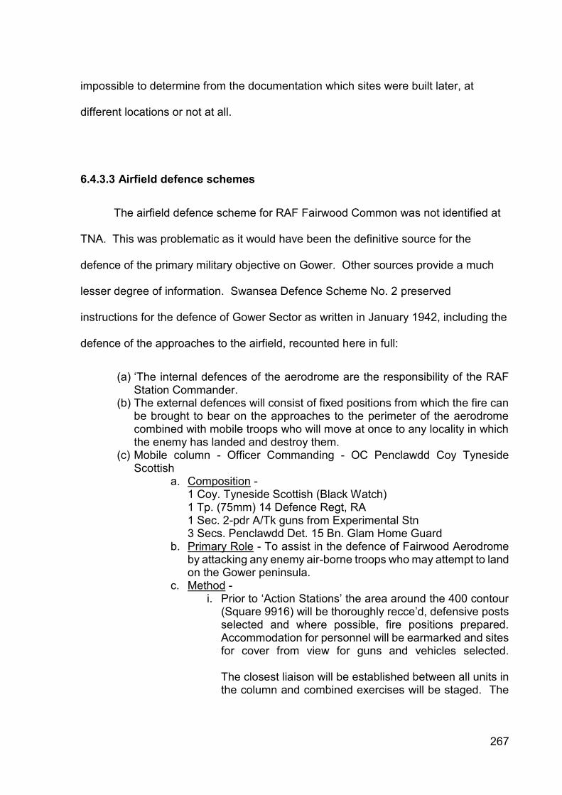
267
impossible to determine from the documentation which sites were built later, at
different locations or not at all.
6.4.3.3 Airfield defence schemes
The airfield defence scheme for RAF Fairwood Common was not identified at
TNA. This was problematic as it would have been the definitive source for the
defence of the primary military objective on Gower. Other sources provide a much
lesser degree of information. Swansea Defence Scheme No. 2 preserved
instructions for the defence of Gower Sector as written in January 1942, including the
defence of the approaches to the airfield, recounted here in full:
(a) ‘The internal defences of the aerodrome are the responsibility of the RAF Station Commander.
(b) The external defences will consist of fixed positions from which the fire can be brought to bear on the approaches to the perimeter of the aerodrome combined with mobile troops who will move at once to any locality in which the enemy has landed and destroy them.
(c) Mobile column - Officer Commanding - OC Penclawdd Coy Tyneside Scottish
a. Composition - 1 Coy. Tyneside Scottish (Black Watch) 1 Tp. (75mm) 14 Defence Regt, RA 1 Sec. 2-pdr A/Tk guns from Experimental Stn 3 Secs. Penclawdd Det. 15 Bn. Glam Home Guard
b. Primary Role - To assist in the defence of Fairwood Aerodrome by attacking any enemy air-borne troops who may attempt to land on the Gower peninsula.
c. Method - i. Prior to ‘Action Stations’ the area around the 400 contour
(Square 9916) will be thoroughly recce’d, defensive posts selected and where possible, fire positions prepared. Accommodation for personnel will be earmarked and sites for cover from view for guns and vehicles selected. The closest liaison will be established between all units in the column and combined exercises will be staged. The

268
OC [Mobile] Column will be thoroughly conversant with the details of the internal defence of the aerodrome.
ii. On ‘Action Stations’ OC Mobile Column will send forward a recce group to establish a report centre near cross roads 011164 [Poundffald] to which orders and reports for them can be sent. The Killay Troop, RA will move immediately to this report centre where it will join the Penclawdd Coy. Tyneside Scottish and then proceed together to the area of the 400 ring contour in square 9916.
iii. On codeword ‘Oliver’ being received the Sec. 2-pdr A/Tk guns from the Experimental Station will report to HQs Penclawdd Coy. Home Guard. Together with three Sections of this Coy. they will proceed immediately to join the rest of the Mobile Column near the 400 ring contour.
iv. Enemy landing to the north of the Killay-Llanrhidian Road and west of the Gower Stop Line will be immediately engaged so as to assist in the defence of Fairwood Aerodrome. In the event of the enemy being in overwhelming numbers the column will take up a defensive position in the area indicated in i) above and will hamper his means by every means possible.
v. The OC Experimental Station has agreed to site 2 25-pdr guns after ‘Oliver’ has been received so that they can bring fire to bear on the Fairwood Aerodrome area. He will arrange for the OP to be established immediately near the 400 ring contour in square 9916. This OP will be protected by a defended locality established by 3 Sections of the Llanmorlais Home Guard. Telephone communication will be established between the OP and the gun positions and with the OC Mobile Column by instruments and wire provided by OC Experimental Station.
vi. The Column will be under the operational control of Commander, Swansea Garrison but in the event of urgent necessity the AOC Fairwood Aerodrome can call direct on the Column, informing the Commander, Swansea Garrison of the action taken.’
Amendment No. 3 of 9 June 1942 deleted the references to 1 Coy. Tyneside
Scottish (Black Watch) and 1 Tp. (75mm) 14 Defence Regt, RA suggesting that these
units had relocated by this time. The 15 Bn. Glamorgan Home Guard took on the
leadership of the Mobile Column. It was interesting to note that grid square 9916
does not contain the 400 ring contour cited in the text. Grid square 9915 contained a

269
400 ring contour; this was located one kilometre north-west of Fairwood Lodge on the
north side of the airfield.
A briefer Gower Sector defence scheme was re-issued on 30 July 1942. The
absence of regular army units prompted replacement of an independent Mobile
Column concept by the decision to vest all control of military forces in Station
Commander, RAF Fairwood. It stated that the following troops would be placed
under his command in addition to RAF and RAF Regiment personnel:
2 Pls. and 1 Sec. Smith Guns (2) 294 Coy, PC for defence of locality and
high ground around 995133 (to be called Quarry Locality).
3 Secs. Parkmill Det. 15 Bn. Glam HG for defence of locality round Court
House Farm (005123). To be called Court House Farm Locality.
2 Secs. Bishopston Det. 15 Bn. Glam HG for defence of locality around old
BHQs (019129).
S/L canopy sites 1-6 within his area.
The documentary evidence demonstrated a simplification of defence planning
through 1942 as available resources changed and the Home Guard developed a
leading role in the defence of Gower. The RAF Regiment formed on 5 February
1942 and units arrived at RAF Fairwood Common by July demonstrating the
perceived vulnerability of the Sector Station.

270
6.4.3.4 Minefields
The Swansea Defence Scheme described nineteen small minefields that were
used, often in clusters, to block beach exits, but also at either end of the Gower stop
line and to protect the northern flank of the coastal battery at Jersey Marine
(Appendix 6.3). Four linear minefields were deployed to block beach egress at
Whiteford Point and Oxwich Bay. The Bishwell Common area was also bisected by a
linear minefield located on the west side of the Gower stop line. Other minefields
were deployed in coastal dune areas and alongside important roads near roadblocks.
Shortages ensured that minefields were constrained both in numbers of sites and
extent. They were not as common as anticipated.
A registered file at TNA preserved remarks concerning the preparation of
minefields (Table 6.9). It was clear that different types of mine were used, but the
evidence is not precise enough to discern the type, number and purpose of the
minefields at all locations.
Date Serial Cassini Location Remark
01/10/40 - 101/142148 - 166147
Jersey Marine Beach from Baldwin’s Cottages to River Neath
Mushroom minefield reconnaissance completed. Number not settled
01/10/40 - 100/9609 Oxwich Bay Mushroom minefield reconnaissance completed
16/10/40 7 101/142148 Jersey Marine Beach 60 Mushroom mines from Baldwin’s Cottages 200 yards westward, two rows
16/10/40 1 100/9609 Oxwich Bay Mushroom minefield proposed
22/08/41 100/063125 Blackpill Minefield mentioned in correspondence
Table 6.9: References to Mushroom and anti-tank minefields in the Swansea-Gower case study area (TNA WO 199/37).

271
6.4.3.5 Barrel flame traps
Twelve barrel flame traps, also known as flame fougasse sites, were recorded
in the Swansea Defence Scheme (Appendix 6.3). This was not a high occurrence
and reflected the specific topographical circumstances when it would have been
used, requiring steep inclines and sharp bends to slow vehicular traffic down. Two-
thirds of the defences were located within 7km of the town centre and they were
deployed on their own or in combination with other types of defences. They were a
feature of the eastern part of the case study. This site type was not identified from
other forms of evidence.
6.4.3.6 Roadblocks
The Swansea Defence Scheme was a unique source for the identification of
seventy-six roadblocks in the case study (Appendix 6.4). On Gower, the roadblocks
were sited either at prominent inland road junctions or blocking beach exits in
conjunction with minefields. Roadblocks were not emplaced on western Gower in
1942.
The two most noticeable concentrations of roadblocks were the swathe of
thirteen in front of, on and behind the general defensive line defending Swansea from
the west and the twelve roadblocks defending the dockyards. Eight roadblocks were
also associated with the Gower stop line. Together with pillboxes, the roadblocks
were the most commonly occurring defensive site types within urban Swansea. The
documentary source did not identify the type of roadblock in use, but did identify the
Home Guard unit responsible for operating it.

272
6.4.3.7 Canadian pipe mines
The Swansea Defence Scheme preserved a list of thirty locations protected by
Canadian pipe mines, not known from other evidence (Appendix 6.3). This defence
was utilised to block the roads from beaches vulnerable to invasion and to block
roads at crucial locations if threatened by AFVs, transport or large parties of the
enemy. Additional documentary sources at TNA provided insight into the progress
and phasing of installing this form of defence (Tables 6.10 and 6.11).
Location Cassini Remark
Oxwich Bay 100/947099 Completed or now in hand
Oxwich Bay 100/946093 Completed or now in hand
Oxwich Bay 100/945085 Completed or now in hand
Pwlldu Bay 100/019092 Completed or now in hand
Loughor Bridge 100/009201 Work projected
Pontarddulais Bridge 100/033260 Work projected
Pontarddulais Bridge 100/033259 Work projected
Pontarddulais Bridge 100/033261 Work projected
Table 6.10: References to works regarding installation of Canadian pipe mines in the Swansea-Gower case study area, 12/07/41 (TNA WO 199/52).
Location Map Ref. Tubes Complete
Loaded Wired Handed Over
Obstacle Job No.
Parkmill 100/990111 Yes Yes No No 30 8a
Weobley Castle
100/921149 Yes Yes No No 20 20
Dunvant Road
100/138169 Yes Yes No No 35 BP12
Langland Bay
100/052094 Yes Yes No No 35 LBE1
Langland Bay
100/049094 Yes Yes No No 20 LBP2
Langland Bay
to Yes Yes No No 15 LBP4
Langland Bay
100/051094 Yes Yes No No 20 LBP3
Table 6.11: References to works regarding installation of Canadian pipe mines by No. 3 Section, 179 Special Tunnelling Company, RE in the Swansea-Gower case study area, 14/11/41 (TNA WO 166/3655).

273
6.4.3.8 Obstructions on the foreshore
The Swansea Defence Scheme documentation did not refer to defensive
foreshore obstruction, possibly as these early installations were not considered part
of the 1942 defence arrangements. A registered file at TNA preserved a list of such
extant obstructions in Wales (Table 6.12). It indicated that extensive use of vertical
poles was made in order to protect gently shelving sand beaches from aircraft and/or
glider landings during low tide. Rhossili Beach, which is known to have been
defended with vertical pole defences (Paul Huckfield pers. comm.), was not
mentioned, demonstrating that such inventories should be used with caution and not
treated as definitive lists recording every instance of a particular construction.
The list also referred to two tubular scaffolding installations at the west end of
the Burry Inlet, confirming the aerial photographic and archaeological evidence. The
document referred to the site location as the Loughor Estuary, demonstrating how
naming conventions can be misleading.
Serial Location Cassini From Cassini To Type of Construction
7 Jersey Marine 101/168149 101/147147 Vertical Poles
8 Swansea Bay 101/105136 100/065107 Vertical Poles
16 Loughor Estuary 100/881221 100/885216 Tubular Scaffolding
17 Loughor Estuary 100/892188 100/888202 Tubular Scaffolding
Table 6.12: References to prepared obstructions of the foreshore in the Swansea-Gower case study area, 26/02/43 (TNA WO 199/103).
6.4.3.9 Petroleum warfare defences
A variety of documentary sources referred to the installation of petroleum
warfare sites in the case study (Table 6.13). These sites were previously unknown.
References to the construction of a beach flame barrage were contained within the

274
Swansea Garrison HQ war diary, but it would appear that its completion post-dated
the end of the 1942 war diary; the subsequent diary was not preserved at TNA. The
Admiralty sources were the only evidence for the Heavy ‘F’ Scheme flame defence
installation at Swansea Docks. A site visit and examination of the relevant aerial
photography failed to identify this facility. This emphasised the importance of using
multiple sources, even of one type, and spending sufficient time in archives to locate
small complementary references.
Location Type Source Remark
Swansea ‘F’ Scheme, Heavy Pump Type
ADM 265/3 Serial No. 25
Swansea Beach Flame Barrage
ADM 265/4 08/07/42: Visit to installations under construction at Swansea
Swansea ‘F’ Scheme, Heavy Pump Type
ADM 265/10 Reference to C.E. in C. Dg. No. 1100/42 showing modifications to pipework in pump house
Jersey Marine Beach
Beach Flame Barrage
WO 166/6880 26/05/1942: Garrison Comdr. visited Jersey Marine Beach with a view to siting Beach Flame Barrage
Jersey Marine Beach
Beach Flame Barrage
WO 166/6880 30/06/1942: Mr Cameron 179 Tunnelling Coy, RE visited Garrison Commander and discussed siting of Flame Beach Barrage, Jersey Marine
Jersey Marine Beach
Beach Flame Barrage
WO 166/6880 18/07/1942: Garrison Commander visited 179 Tunnelling Coy, RE and inspected work on Flame Beach Barrage - Jersey Marine
Jersey Marine Beach
Beach Flame Barrage
WO 166/6880 17/09/1942: Garrison Engineer visited 179 Tunnelling Coy, RE and inspected progress of work on Flame Beach Barrage
Jersey Marine Beach
Beach Flame Barrage
WO 166/6880 17/11/1942: Garrison Commander sites OPs for Flame Beach Barrage, Jersey Marine - work to be carried out by 179 (S) Tunnelling Coy, RE
Table 6.13: References to petroleum warfare defences in the Swansea-Gower case
study area, preserved in correspondence at The National Archives.
6.4.3.10 Coast artillery
The identification of the Fort Record Books (FRB) for Mumbles Island and
Mumbles Hill at TNA was fortuitous, as only a small number survive for Wales, and

275
their contribution is enhanced when used with other documentary records. The
evidence enabled detailed biographies of the sites’ development to be constructed.
The Mumbles Island FRB stated it was occupied by 299 ‘B’ Coast Battery, RA
and was armed with two QF 4.7-in BL Mk III guns on Mk IV CP Mountings. Erection
of the battery’s barbed wire entanglement commenced on 10 September 1939
(Glamorgan Fortress Company, RA war diary, WO 166/3547).
It undertook a Close Defence role for Swansea docks and acted as the
merchant shipping examination battery until 299 ‘A’ Coast Battery was operational at
Mumbles Hill. When 146 Coast Battery arrived at Mumbles Island, the Mumbles Hill
battery was re-named 299 Coast Battery. Thereafter Mumbles Island performed a
secondary examination role in poor visibility. It was equipped with two Projectors,
Fort 90cm Mk V CASL emplacements, installed by the Garrison Engineer in
November 1939 (Glamorgan Heavy Regiment, RA war diary, WO 166/1877). During
1942, the fort undertook landward defence duties and was allocated nine inland
transport and infrastructure targets.
Mumbles Hill was an emergency Close Defence coast battery equipped with a
pair of 6-in Mk VII Naval guns on Mk II mountings in single emplacements. The FRB
recorded that the battery’s position was selected by the Inspector of Fixed Defences
on 11 June 1940. By 30 June 1940 the holdfasts had been emplaced; Nos. 1 and 2
guns were mounted on 9 and 4 July respectively. Both guns were proofed and
operational by 1 August 1940.
It was originally designed to replace the Mumbles Island battery, but given the
invasion threat both batteries were left operational. Mumbles Hill battery could bring

276
fire to bear in Swansea Bay and its approaches within the limits of its depression
rangefinder (10,000 yards or 9,144 metres) and within an arc of fire from Swansea
Docks to the coastline west of the battery. The battery’s CASLs were co-located with
the Port War Signal Station and Coastguard Station at Tutt’s Head. Five landward
targets (King’s Dock lock gates and swing bridge, a chemical works, Halfway House
road junction and Jersey Marine) were identified. The content of the associated
Mumbles Sub-Sector defence scheme map, which described the ground defences of
both batteries, is discussed below.
The Mumbles Island FRB described two additional coast batteries at Swansea
East Pier and Port Talbot, but did not give precise locations. Swansea East Pier
comprised two 75mm guns on fixed mountings operated by 431 Coast Battery. A
reconnaissance report for the installation of AMTB defences at Swansea was
forwarded to the War Office on 23 November 1940 (WO 166/11).
The second battery was the emergency coast battery constructed at Port
Talbot on the east side of Swansea Bay and operated by 422 Coast Battery. A pair
of French Canon de 138mm Modèle 1910 Naval guns was mounted in 1942 to
replace the 4-in Naval guns of 401 Coast Battery emplaced in August 1940 (WO
166/11) and the weapon’s 11,000 yard (10,058 metre) range included part of
Swansea’s examination anchorage. The guns were removed in November 1943
(WO 199/1175).
The 559 Coast Regiment, RA war diary recorded the completion of 12-pdr gun
emplacements and an observation post at Swansea on 30 November 1941 (WO
166/1758). Work on the searchlight emplacements, engine house and shelters were

277
noted as progressing. The post was occupied by 431 Coast Battery from 15
December 1941 and regimented with 559 Coast Regiment, RA.
It is uncertain whether the FRB and Coast Regiment documents were referring
to one or two coast batteries operated by 431 Coast Battery. Wood (2012) referred
to both Swansea Docks and Swansea East batteries. The common unit name and
role suggested that these might be different names for the same battery, but it was
considered unlikely that there would be such a gap between reconnaissance and
installation. The evidence is not definitive. Two batteries were considered most
likely, but the location of Swansea East battery is unknown.
6.4.3.11 Defence batteries
The documentary sources discussed the garrison’s field artillery provision.
The Swansea Defence Scheme No. 2, stated that
‘two 4.7 guns and two 13-pdr guns of the 960 Battery, RA, the projectors of 113 AA ‘Z’ Battery, RA together with strongly defended localities of pillboxes and defence works manned by static units will prevent any attempted landings by sea [in the Docks Sector].’
The two 4.7-in guns were Close Defence static mountings located to the south
of South Dock and adjacent to emplacement Q4 on the south side of Queen’s Dock
respectively. The locations of the two 13-pdr guns were not described, but the 960
Defence Battery, RA war diary recorded the takeover of four 13-pdr guns from 13
Defence Regiment, RA on 17 March 1941. These were mobile anti-tank guns and it

278
is possible that they formed part of a mobile reserve for deployment to temporary
firing positions as required.
The 960 Defence Battery, RA was responsible for a number of 4-in, 4.7-in and
6-pdr positions in Swansea and Gower during 1940-42. The unit’s war diary
recorded that it was responsible for three single 4-in Close Defence Naval gun
emplacements during 1940-41 (WO 166/2044). One extant emplacement was
located at Berthlwyd on the north Gower coast. The other two emplacements were
located in the Docks Sector. One was positioned immediately to the east of the
Anglo-Persian Oil Company’s remote oil tank farm to the south of Baldwin’s
Crescent; it was demolished during the post-war extension of the oil tank farm. The
other 4-in gun emplacement was located between the foreshore and the engine shed
and railways sidings complex to the south of HMP Swansea. It was demolished in
advance of the new council offices. The war diary documented the dismantling of the
4-in guns from these positions and their return to FOGMO, Cardiff by 30 April 1941;
the emplacements may have been unarmed during 1942.
The defence battery also operated two 6-pdr anti-tank gun emplacements at
Fforestfach and at Stafford Common to protect key approaches to the north of
Swansea. Both were in use by November 1940 and were maintained during 1942,
but it is uncertain whether the 6-pdr guns were mounted. Two additional
emplacements were occupied at Killay and Gowerton in March and April 1941
respectively, but the location, type of weapon or period were not stated.
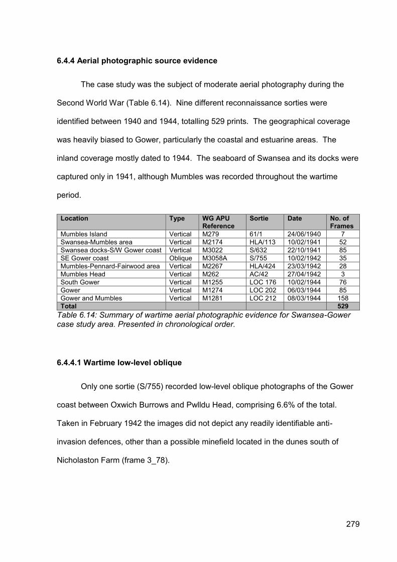
279
6.4.4 Aerial photographic source evidence
The case study was the subject of moderate aerial photography during the
Second World War (Table 6.14). Nine different reconnaissance sorties were
identified between 1940 and 1944, totalling 529 prints. The geographical coverage
was heavily biased to Gower, particularly the coastal and estuarine areas. The
inland coverage mostly dated to 1944. The seaboard of Swansea and its docks were
captured only in 1941, although Mumbles was recorded throughout the wartime
period.
Location Type WG APU Reference
Sortie Date No. of Frames
Mumbles Island Vertical M279 61/1 24/06/1940 7
Swansea-Mumbles area Vertical M2174 HLA/113 10/02/1941 52
Swansea docks-S/W Gower coast Vertical M3022 S/632 22/10/1941 85
SE Gower coast Oblique M3058A S/755 10/02/1942 35
Mumbles-Pennard-Fairwood area Vertical M2267 HLA/424 23/03/1942 28
Mumbles Head Vertical M262 AC/42 27/04/1942 3
South Gower Vertical M1255 LOC 176 10/02/1944 76
Gower Vertical M1274 LOC 202 06/03/1944 85
Gower and Mumbles Vertical M1281 LOC 212 08/03/1944 158
Total 529
Table 6.14: Summary of wartime aerial photographic evidence for Swansea-Gower case study area. Presented in chronological order.
6.4.4.1 Wartime low-level oblique
Only one sortie (S/755) recorded low-level oblique photographs of the Gower
coast between Oxwich Burrows and Pwlldu Head, comprising 6.6% of the total.
Taken in February 1942 the images did not depict any readily identifiable anti-
invasion defences, other than a possible minefield located in the dunes south of
Nicholaston Farm (frame 3_78).

280
6.4.4.2 Wartime vertical (all scales)
The majority of the sorties were vertical in character. Sortie S/632 in late 1941
was the earliest comprehensive reconnaissance of Swansea and the south-eastern
portion of Gower. Frame 34 is the only known visual evidence for the alignment of
anti-tank cubes and associated pillboxes running south along the coast from
Blackpill, together with an inline pillbox. The southern end of the alignment is tree
obscured. It also recorded the ZAA and HAA batteries at Singleton. The results from
sortie HLA/113 of a similar area in early 1941 were rendered unusable due to cloud
obscuration.
Sortie 61/1 depicted Mumbles Island artillery battery and Mumbles Hill prior to
that battery being constructed. Sortie AC42 captured Tutt’s Head and Mumbles Hill
battery, depicting the barber wire defences and CASL emplacements of the former
and part of the barbed wire defences of the latter, including a rare set of trenches
above Mumbles Road at Bracelet Bay (frame 2). The HLA/424 sortie captured much
of the defensive arrangements at RAF Fairwood Common and Mumbles.
Analysis shows that 60.3% of the frames were collected by US Army
reconnaissance sorties in early 1944 (Table 6.15), which reflected the American use
of Gower for training prior to D-Day. The American photography was from high
altitude and detail was hard to determine. The perimeter defences of the CD/CHL
stations at Oxwich and Rhossili were depicted (Sortie LOC 176, frames 7009 and
7014 respectively).

281
Year 1939 1940 1941 1942 1943 1944 Totals
No. of RAF Frames 0 7 137 66 0 0 210
No. of US Army Frames 0 0 0 0 0 319 319
Totals 0 7 137 66 0 319 529
Table 6.15: Summary of quantities of aerial photographic frames collected for Swansea-Gower case study area by year and by source.
6.4.4.3 Operation Revue (1945-1952)
The immediate post-war aerial photography provided almost complete
coverage of the case study. The resolution was not sufficient to identify smaller
defence structures, but captured larger structures, particularly those with
characteristic linear morphology, where the defences had not already been
dismantled. The photography recorded the removal of defence structures, such as
the intermittent removal of anti-tank blocks from the Blackpill alignment (RAF
106.GUK1625 frame 2266, 7 July 1946) and then their complete removal (RAF CPE
UK 2264, 27 August 1947).
6.4.5 Cartographic source evidence
Four collections of cartographic evidence were identified for the case study
(Table 6.16). The majority were preserved at TNA. The FRBs for Mumbles Island
and Mumbles Hill coast defence batteries preserved the largest and most relevant
collections. All were viewed.

282
Source Title Date No. of Plans Reference
RAF Museum Air Ministry Record Site Plan 1944 N/A
TNA Swansea Garrison HQ War Diary 1942 2 WO 166/6880
TNA Fort Record Book: Mumbles Island 1791-1943 9 WO 192/156
TNA Fort Record Book: Mumbles Hill 1939-1955 9 WO 192/320
Table 6.16: Summary of cartographic evidence identified for Swansea-Gower case study area.
6.4.5.1 Air Ministry Record Site Plans
Four Air Ministry record site plans for RAF Fairwood Common were identified
(Table 6.17), but were dated 1945 and portrayed the airfield at its most developed.
No earlier plans were identified. Airfield plans were known not to be definitive,
reflecting structures that were actually in use or recently abandoned. The only
recorded defence structure was the Type 11008/41 Battle Headquarters. The
perimeter defence sites would have been abandoned for a few years before the
plans were drafted and it would appear that they were deliberately disregarded.
Title Date Scale Reference Notes
Fairwood Common: Record Site Plan of Dispersed Sites
April 1945 1:2,500 FC.565 [TNA Ref. BD 54/3]
Scaled plan. Depicted locations and extent of 13 dispersed sites and the operations block. No defence posts depicted.
Fairwood Common: Record Site Plan of Aerodrome Site
March 1945
1:2,500 FC.566 [TNA Ref. BD 54/3]
Scale plan. Depicted location of Type 11008/41 Battle Headquarters. No other defence sites.
Fairwood Common: Record Site Plan of Aerodrome Site
May 1945 1:2,500 2056/45 Scaled plan. Depicted location of Type 11008/41 Battle Headquarters. No other defence sites.
Fairwood Common: Record Site Plan of Dispersed Sites
May 1945 1:2,500 2057/45 Scaled plan. Depicted locations and extent of 13 dispersed sites and the operations block. No defence posts depicted.
Table 6.17: Summary of cartographic evidence identified for RAF Fairwood Common.
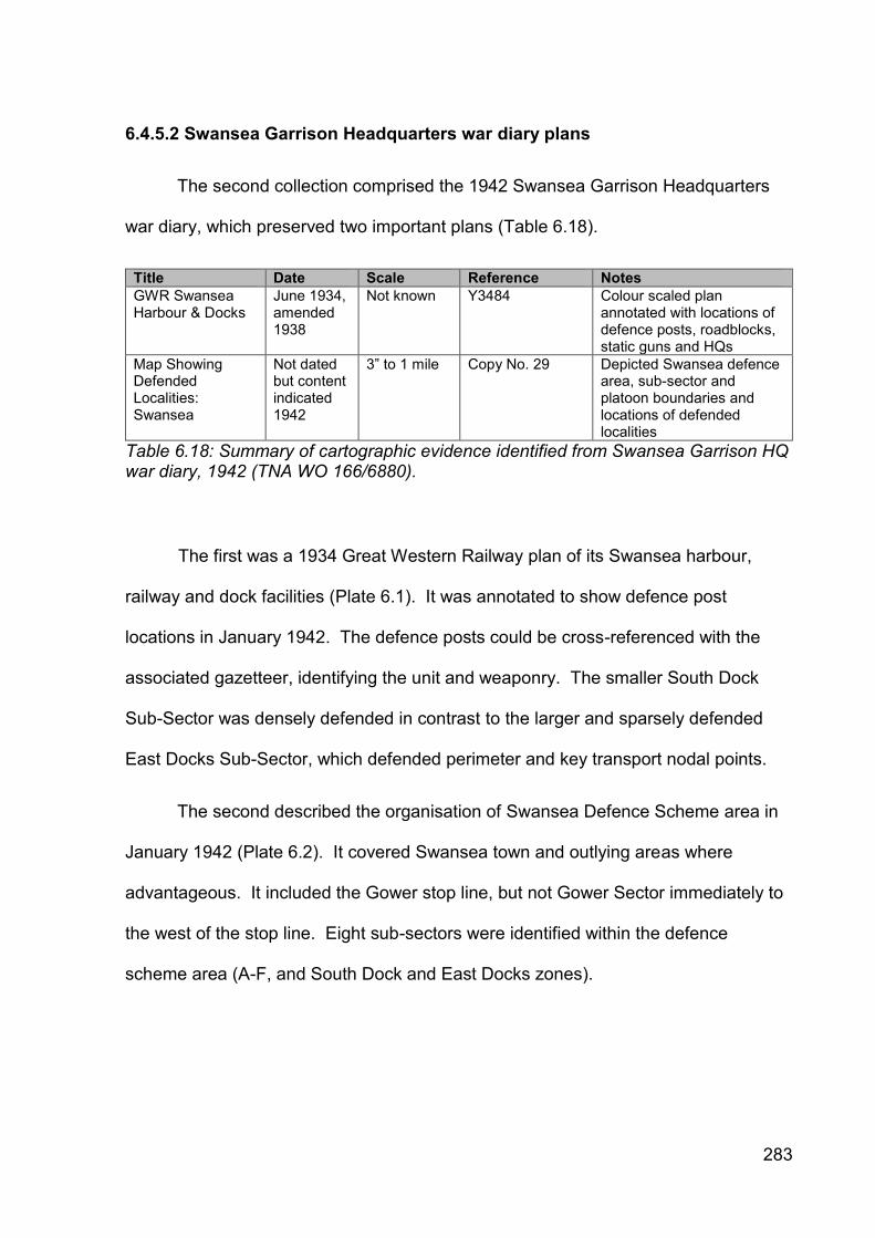
283
6.4.5.2 Swansea Garrison Headquarters war diary plans
The second collection comprised the 1942 Swansea Garrison Headquarters
war diary, which preserved two important plans (Table 6.18).
Title Date Scale Reference Notes
GWR Swansea Harbour & Docks
June 1934, amended 1938
Not known Y3484 Colour scaled plan annotated with locations of defence posts, roadblocks, static guns and HQs
Map Showing Defended Localities: Swansea
Not dated but content indicated 1942
3” to 1 mile Copy No. 29 Depicted Swansea defence area, sub-sector and platoon boundaries and locations of defended localities
Table 6.18: Summary of cartographic evidence identified from Swansea Garrison HQ war diary, 1942 (TNA WO 166/6880).
The first was a 1934 Great Western Railway plan of its Swansea harbour,
railway and dock facilities (Plate 6.1). It was annotated to show defence post
locations in January 1942. The defence posts could be cross-referenced with the
associated gazetteer, identifying the unit and weaponry. The smaller South Dock
Sub-Sector was densely defended in contrast to the larger and sparsely defended
East Docks Sub-Sector, which defended perimeter and key transport nodal points.
The second described the organisation of Swansea Defence Scheme area in
January 1942 (Plate 6.2). It covered Swansea town and outlying areas where
advantageous. It included the Gower stop line, but not Gower Sector immediately to
the west of the stop line. Eight sub-sectors were identified within the defence
scheme area (A-F, and South Dock and East Docks zones).

284
Pla
te 6
.1: 1
93
4 G
WR
pla
n o
f S
wan
sea
Ha
rbo
ur
and
Do
cks a
nn
ota
ted
in
Ja
nua
ry 1
94
2 (
TN
A W
O 1
66/6
88
0).

285
Pla
te 6
.2: M
ap
sh
ow
ing
Sw
an
se
a G
arr
ison
, su
b-s
ecto
r b
oun
da
rie
s a
nd
de
fen
ded
lo
ca
litie
s.

286
Named defended localities were depicted for Sub-Sectors A-E, annotated with
section allocations. It recorded that fifty defended localities were defended by 178
sections. These details were not recorded for Sub-Sector F or the dock areas.
6.4.5.3 Mumbles Island Fort Record Book plans
The third collection comprised nine plans preserved within the Mumbles Island
coast battery FRB. They encompassed early fort plans, contextual maps, detailed
communications schematics and two defence plans (Table 6.19). The first defence
plan was a War Office GSGS3906 map of Swansea annotated with nine land targets
for 146 Coast Battery at Mumbles Island. The map was undated, but 146 Coast
Battery arrived at Mumbles on 28 May 1941 (WO 166/1758), remaining until
transferred to Flat Holm on 7 December 1942 (WO 166/7278).
The second plan illustrated the defence scheme for Mumbles Sub-Sector in
May 1943 (Plate 6.3). Located within Gower Sector it adjoined the west side of
Swansea Garrison. It was of the utmost significance as it located all of the defence
posts surrounding Mumbles Island and Mumbles Hill coast batteries and the Tutt’s
Head Coast Guard Station. Annotations identified the weapons at each defence post
and their arcs of fire.
The plan illustrated the intensive defence arrangements organised for the
coast artillery emplacements and associated infrastructure located within a relatively
small sub-sector of fundamental importance for the anti-invasion defence of
Swansea. Areas of Home Guard responsibility were also indicated on the flanks of
the main defences.

287
Title Date Scale Reference Notes
299 ‘B’ Coast Battery RA: PAD Scheme
24/04/1942 N/A N/A Annotated plan of battery buildings indicating Passive Air Defence arrangements
299 ‘B’ Battery: Neighbouring Forts
Not known, but 1940+
N/A N/A Map adhered to Part I of Fort Record Book showing neighbouring batteries: 299 A Battery at Mumbles Hill, 299 B Battery at Mumbles Island, 431 Battery (2 x 75mm) at Swansea East Pier and 422 Battery at Port Talbot
Communications July 1942 N/A N/A Schematic of telephone, R/T net, alarm and voice circuits at Mumbles Island battery and with neighbouring batteries
Alarm Circuits Not Known N/A N/A Schematic of alarm circuits at Mumbles Island battery
Cable Routes for CASLs
Not known N/A N/A Indicative plan of cable routes for Coast Artillery Search Lights at Mumbles Island battery
146 Coast Battery Land Targets
Period 28/05/1941 -07/12/1942
1:25,000 GSGS3906 OS map annotated with locations of nine land targets to be engaged by Mumbles Island battery. 146 Battery arrived at Mumbles from Orkney on 28/05/1941 and departed for Flat Holm on 07/12/1942
Mumbles Battery N/A 1:500 N/A Early plan, section and elevation of Mumbles Island battery
Severn Defences: Mumbles Battery, Plan of
21/12/1904 1” to 10’ N/A Plan and section Mumbles Island battery magazine
Mumbles Sub-Sector (Gower Defence Scheme)
20/05/1943 1:2,500 Copy No. 2 To scale plan of Mumbles Island, Mumbles Hill and Tutt’s Head area showing close defence arrangements for rifle, machine gun, field gun and Blacker Bombard, including pillbox and slit trench positions and directions of fire
Table 6.19: Summary of cartographic evidence identified from Mumbles Island Fort
Record Book (TNA WO 192/156).

288
Pla
te 6
.3: M
ap
sh
ow
ing
the
Mu
mb
les S
ub
-Secto
r d
efe
nce
s (
Go
wer
Defe
nce
Sche
me
), M
ay 1
943
.

289
6.4.5.4 Mumbles Hill Fort Record Book plans
The final collection of nine plans was preserved in the Mumbles Hill coast
battery FRB (Table 6.20). The contents were similar to those described for Mumbles
Island. The key document was an undated measured sketch plan of the 229 Battery
defence scheme (Plate 6.4). It provided additional details for Mumbles Hill coast
battery and Tutt’s Head Coast Guard Station to that depicted in the Mumbles Sub-
Sector defence scheme plan. It identified the slit trenches and Blacker Bombard
emplacements, but also identified additional pillboxes and defence posts.
Title Date Scale Reference Notes
Communications: 299 Coast Battery RA
Not known, but 1940+
N/A None Indicative wiring plan for Mumbles Hill coast battery
Plan of Mumbles Battery
Not known, but 1940+
Not known Copy of 13/S/8 V Section K Sheet 1 of 3
Semi-annotated copy of original scale plan showing battery layout
Mumbles Battery Not known, but 1940+
Not known Copy of 13/S/8 V Section K Sheet 2 of 3
Semi-annotated copy of original scale plan showing close up of battery layout
Mumbles Coast Guard Station
Not known, but 1940+
Not known Copy of 13/S/8 V Section K Sheet 3 of 3
Semi-annotated copy of original scale plan showing Coast Guard Station layout at Tutt’s Head and Nos. 1 and 2 CASLs
299 Battery Defence Plan
Not known, but 1940+
Not known Sketch A Indicated locations of pillboxes, slit trenches, defence posts and Blacker Bombards
Mumbles C.D. Batteries: Signal Communications Circuit Diagram
10/06/1942 N/A FSS DRG No. 304/2
Indicative wiring plan for Tutt’s Head, Mumbles Island and Mumbles Hill
Site SA.5 Mumbles Hill
Not known 1:2,500 OS Glamorgan Sheets XXXII 3478
Bespoke OS map extract showing area to be sterilised for further building and camp area
Mumbles C.D. Batteries: Cable Route Plan
17/06/1942 25” to 1 mile
FSS DRG No. 315/1
Scaled tracing showing locations and routes of GPO, magslip and signals cables
Record Plan: CD Battery Mumbles Hill Top
24/08/1945 1” to 30’ DRG No. 396/1 Scaled tracing showing battery and camp accommodation with schedule and construction history
Table 6.20: Summary of cartographic evidence identified from Mumbles Hill Fort
Record Book (TNA WO 192/320).

290
Plate 6.4: 299 Battery Defence Plan detailing defence arrangements for
Mumbles Hill coast battery and Tutt’s Head Coast Guard Station as preserved
in Mumbles Hill coast battery Fort Record Book (TNA WO 192/320).

291
6.5 Contribution and role of evidential sources
This section assesses the value, role and contribution of the evidential
sources.
6.5.1 Archaeological evidence
Type Value Role Major + contribution
Major - contribution
GGAT HER Low Minor Summary of known information
Too few defence sites recorded Illustrates how little research undertaken
RCAHMW NMRW (incl. DoB data)
Low Minor Summary of known information
Too few defence sites recorded Illustrates how little research undertaken
Rapid field observation Low Negligible, but primary role where survives (buried resource potential unknown)
Surviving remains provide unique information not available elsewhere
Lack of visible sites identified Constrained by extensive clearance
Table 6.21: Summary of value, role and contribution of archaeological evidence for the Swansea-Gower case study area.
Table 6.21 summarises the value, role and positive and negative contributions
of the archaeological evidence. This evidence type identified few sites historically
and new field observation identified limited additional defence posts. It was a minor
source of low value for locating new sites when compared to other types of evidence.
It was the only source to identify the specific location of a spigot mortar emplacement
on the Gower stop line (the Swansea Garrison war diary mentioned their
construction, but not their locations) and a roadblock in Swansea docks that had not

292
been cited in the documentary or cartographic evidence. The success rate in
identifying new defence sites was low.
In this case study it was clear that successful research could not rely on the
sole use of archaeological evidence to identify the original anti-invasion defence site
population or even a small subset of it. The value of the archaeological evidence in
this case study was less concerned with being a primary source of new site
identification, but rather in providing information relating to the character of some of
the defence sites located through other sources of evidence, for example the gun
emplacement at Berth-lwyd.
In these circumstances, field observation confirmed the presence and exact
location of these defence sites and where these survived, the archaeological
approach then took on a primary role in terms of its ability to provide a constructional
and spatial expression of the defence site by providing a level of detail and
comprehension rarely obtainable from the other source types. In this case study it
was clear that archaeological evidence had to be combined with other forms of
evidence in order to successfully address the research questions.
Some historians have reduced archaeology to a subservient role in terms of
identifying whether sites mentioned in documentary evidence, were built or not,
thereby informing whether the documentary source described sites as built or not yet
implemented. In this case study, archaeological enquiry through rapid site
observation was not able to undertake this subservient role, given the widespread
clearance of anti-invasion defences.

293
Rather the contribution of the archaeological approach was negative in
character as it identified a widespread absence of evidence rather than an evidence
of absence. It demonstrated the powerful nature of post-depositional processes and
transferred the expectation of holistic understanding to other classes of evidence.
6.5.2 Primary documentary evidence
Type Value Role Major + contribution Major - contribution
TNA: admin war diaries High Primary Strategic overview; Operation Instructions; location lists
Lack of RAF and Naval files; Lack of earlier content
TNA: unit war diaries High Primary Operational data; site locations and dates
Identifying the unit at a specific location and time
TNA: registered files High Primary Detailed data for specialist defence works
Lack of stop line files
LROs Low Negligible Brief contextual Lack of data for case study
Table 6.22: Summary of value, role and contribution of primary documentary evidence for the Swansea-Gower case study area.
The numerous, rich and diverse collection of war diaries and registered files at
TNA were the key evidence type for understanding the anti-invasion defences in the
Swansea-Gower case study (Table 6.22). The Swansea Garrison war diary was of
fundamental importance for the positive identification of the majority of the defence
works (Table 6.23) and a range of specialist documentary sources provided more
detailed information that collaboratively provided an expanded understanding of
defence provision. The local records office did not hold relevant content, which
emphasised the importance of looking beyond the case study.

294
Defence site type Swansea Garrison Gower Sector Total
Pillboxes 119 0 119
Fieldworks 66 0 66
Defended Localities 0 14 14
Platoon areas 53 0 53
Minefields 5 19 24
Canadian Pipe Mines 8 22 30
Fougasses 8 4 12
Roadblocks 56 18 74
Coast artillery 5 1 6
Total 320 78 398
Table 6.23: Distribution analysis of selected anti-invasion defences for Swansea-Gower case study area as identified from Swansea Garrison war diary.
The combination of formation headquarters war diaries and papers with war
diaries from those units undertaking the defence work construction provided an
unparalleled and comprehensive, but incomplete understanding of defence
preparations during 1942. All but a small number of defence posts were cited by the
collective documentary sources, but their locations could not be identified without the
GSGS Cassini maps. The complementary use of the documentary and cartographic
evidence was a pre-requisite for success and without one of the sources the defence
posts could not be located.
The documentary sources also provided the fundamental understanding of the
military administrative and operational structures, which enabled further war diaries to
be identified and the essential military context to be appreciated. They were the key
to understanding the changing military unit presence within the case study.
Although the documentary sources were responsible for the identification of
the overwhelming majority of new defence sites, there were identifiable gaps that
instilled weaknesses in understanding the total population of defence works planned
and built, how those built developed and declined over time, and the interactions

295
between different defence types. The lack of identified Swansea Garrison war
diaries for 1940 and 1941 prohibited a longitudinal analysis of the development of the
defence schemes and their respective defence posts.
The Swansea Defence Scheme stated that each pillbox and fieldwork was
supported by at least two supporting fire trenches. The number and locations were
not listed suggesting that another c. 500 earthwork defences were unaccounted for.
The Gower Sector Defence Scheme was inconsistent in conveying the range
and number of defence posts constructed. In combination with other specialist
registered files it noted the locations of a range of defence sites including defended
localities, minefields, Canadian pipe mines, roadblocks and coastal observation
posts, but did not list pillbox or fieldwork locations.
6.5.3 Aerial photographic evidence
Type Value Role Major + contribution
Major - contribution
Wartime low-level oblique
Negligible Usually non-contributory, but a primary role where present
Where present can provide high levels of detail and 3D perspective
Significant lack of spatial and chronological coverage
Wartime vertical (all scales)
High – Moderate
Primary source of evidence and context
Almost complete coverage
Not able to capture small defence works Infrequent temporal coverage
Operation Revue (1945-1952)
Moderate Important retrospective source
Complete coverage for case study area
Too late – major post-War reconstruction underway
Table 6.24: Summary of value, role and contribution of archaeological evidence for the Swansea-Gower case study area.

296
Aerial photographic sources were highly variable in their role and contribution
depending on their type, date, quantity, quality and coverage (Table 6.24). Early
wartime coverage was intermittent and often of poor resolution. Few areas were
photographed on more than one occasion, limiting the ability to date and phase.
Wartime oblique photography made a negligible contribution, constrained by
the lack of coverage and number of frames. The vertical photography was the most
common and extensive type and made important contributions for a number of
defence site types either in a unique or complementary role combined with other
evidence types.
It was the unique source for identifying the presence of a number of anti-
landing obstacles and bombing decoys, together with the original extent of the anti-
tank block alignment and ditch at Blaen-lwyd. It was also the principal source for
identifying the location and extent of barbed wire entanglements used around
minefields and larger installations.
The later wartime American vertical photography was captured from higher
altitudes in order to gain a wider field of view and while utilising improved technology,
the output was not found to offer any particular advantage in use, other than covering
all of the case study. Careful examination did not identify further defence structures.
The post-war RAF vertical photography was more useful as it was taken from lower
altitudes facilitating better image resolution, but its contribution was limited as it
recorded post anti-invasion defence landscapes after many of the defences had been
cleared away.

297
For some sites aerial photography was of fundamental importance depicting
and describing the defences comprehensively in a way that other sources could not
achieve. Elsewhere the absence of photography or the existence of poor
photography was frustrating. The evidential source cannot be ignored and the
photography for each defence structure required appraisal on an individual basis.
6.5.4 Cartographic evidence
Type Value Role Major + contribution
Major - contribution
GSGS3906 (1:25,000)
High Enabling Cannot locate defence sites in documents without them
Hard to obtain and series incomplete for case study area
GSGS3907 (1 inch to 1 mile)
Low Contextual Provide geographical context
Scale too small to plot sites
Defence scheme maps High Primary Precise site location and informative annotations
Very limited spatial and chronological scope
Table 6.25: Summary of value, role and contribution of cartographic evidence for the Swansea-Gower case study area.
Research did not identify a sole map of all of the defences constructed within
the case study and the overall contribution of mapping was limited by its intermittent
presence, date, purpose, geographical coverage and scale. The lack of cartographic
evidence for 1940-41 was striking and meant that other evidential sources were
required to engage this period.
Two types of military cartography were identified (Table 6.25). The War Office
GSGS maps were of fundamental importance in terms of their enabling contribution
as the defence sites identified in the documentary sources could not be located

298
without access to the incorporated Cassini military grid overlay. The maps did not
contain any defence information and their value was as an enabling locational tool in
a complementary role with documentary resources. In one exceptional case, an
annotated GSGS3906 map of central Swansea preserved within a FRB depicted
landward targets to be engaged by Mumbles Island coast battery, providing
information not recorded elsewhere.
The second class of cartographic evidence comprised a small number of
defence scheme-related maps, including annotated plans showing defence
arrangements at particular establishments and plans depicting the military
administrative and operational geography of the case study.
The annotated plans were of fundamental importance for identifying the
location, type, number and extent of individual small-scale defence posts within
Mumbles Sub-Sector and Swansea Docks, allowing both to be reconstructed with
high degrees of confidence. The inclusion in the former of the location of all of the
rifle pits and machinegun emplacements suggested that this small sub-sector was
the best understood defended area in terms of its defence provision in Wales for any
time during the wartime period.
The three inch to one mile overlay plan depicted the spatial extent of the
Swansea Garrison HQ area, its boundaries and sub-divisions, together with
associated defended localities in January 1942. At the time of writing, this plan was
thought to be a unique survival for Wales.

299
6.6 Summary
This study set out to determine the wartime defensive arrangements within the
case study, where very little was known. A low number of defence sites had been
identified through archaeological fieldwork, but no attempt had been made to identify
and assess the surviving documentary sources. The published military
historiography was limited and there was no understanding of the military
organisational arrangements and no comprehension of the formations and units
involved. Understanding of the development, phasing and use of the defensive
schemes and their content, coverage and detail was absent.
This research has drawn together and reviewed all of the identifiable
evidence. It identified new sources of evidence, particularly documentary, and
combined them with archaeological, cartographic and aerial photographic evidence
to present a more sophisticated understanding of the development of the role and
contribution of the different evidential source types, together with the case study’s
defensive arrangements. The evidence indicated variety and sophistication in the
defensive arrangements, and challenged the often verbally expressed assertion that
the defences were not as refined as those built on the south and east coasts of
England. New source evidence increased the number of known defence sites ten-
fold. Significant evidential gaps were identified. In particular the evidence identified
for 1942 demonstrated the inadequacy of understanding for the 1940-41 period.
This and the previous chapter reviewed the available evidence for the
defensive arrangements prepared within the St Athan-Llandow and Swansea-Gower

300
case studies. The next chapter assesses the situation in the Carmarthen Stop Line
area, which forms the final case study assessment.

301
7. CASE STUDY 3: THE CARMARTHEN STOP LINE
7.1 Introduction
This chapter presents the results and findings of the third case study. It is
divided into four sections. The first section describes the case study’s
characteristics, the second section reviews the known source evidence, the third
section presents the newly identified source evidence and the final section assesses
the role, value and contribution of the evidential sources.
7.2 Case study description
The case study comprised an arbitrary rectangular shape that bisected the
Dyfed peninsula in south-west Wales (Table 7.1 and Figure 7.1). It measures fifty-
eight kilometres north-south by twenty-one kilometres east-west, covering a notional
area of 1,218 square kilometres, although significant areas in the south-western and
north-western regions comprised the sea (see Map 3 in end papers). It incorporated
the Ceredigion and Carmarthenshire coastlines and the route of the north-south
aligned Carmarthen Stop Line, together with broad areas on either side. It contained
the major settlement of Carmarthen (see Map 6 in end papers for exemplar of historic
mapping), and the smaller towns of Newcastle Emlyn, St Clears, Kidwelly and part of
Burry Port.
Location National Grid Reference
NW corner 224000, 256900
NE corner 245000, 256900
SW corner 224000, 198900
SE corner 245000, 198900
Table 7.1: Carmarthen Stop Line case study area corner co-ordinates.

302
Figure 7.1: Carmarthen Stop Line case study area location. Base map depicts
administrative counties of Wales as of 1931. Scale = 1:1,250,000.
7.2.1 Topography, hydrology, geology and human geography
Given the larger size of the case study compared to the other cases, it was
beyond the scope of this research to describe in detail every individual aspect area
as depicted on CCW’s LANDMAP geological evaluation map. A broad summary is
provided utilising CCW’s regional Landscape Character Areas (rLCAs) as defined in
the draft Landscape Character Map for Wales (Countryside Council for Wales 2009).
The case study incorporated elements of eight rLCAs.
The ‘Taf, Tywi and Gwendraeth Estuaries’ rLCA covers the southern coastal
area and is characterised by the confluence of three major estuaries (Taf, Tywi and

303
Gwendraeth) and the lower courses of the rivers, which flow south into Carmarthen
Bay. The greater part is underlain by Old Red Sandstone formations, with coastal
limestone cliffs exposed near Pendine (2009: 46). The estuary mouth is defined by a
pair of opposed major sand spit structures at Cefn Sidan and Pendine. The river
valleys were drowned by post-glacial rising sea levels and formed a ria. The
intertidal zones are dominated by broad and extensive sandy foreshores at Pendine-
Laugharne and Cefn Sidan, separated from broad flat areas of saltmarsh and
reclaimed marsh by low stabilised dune ridges. The marshes are sub-divided by
rectilinear drainage ditches and other boundaries. Settlement pattern is dispersed
and often linear in character. An undulating lowland hill terrain dissected by valleys
rises sharply from the coast and flanks the estuary as far north as Carmarthen, cut by
the broad flood plain of the River Taf.
The south-eastern corner of the case study includes the western extremity of
the ‘Gwendraeth Vales’ rLCA. This is a rolling lowland landscape of settlement,
dispersed hills and vales, with medium-sized enclosed fields and small valleys
feeding the River Gwendraeth (2009: 34).
The eastern portion of the ‘Taf and Cleddau Vales’ rLCA is located to the north
of the ‘Taf, Tywi and Gwendraeth Estuaries’ rLCA. It comprises a ‘gentle, rolling
inland landscape, rural and agricultural… underlain by Ordovician shales, mudstones
and sandstones’ (2009: 45). Mixed agriculture is practiced amongst a scattered
settlement of villages and hamlets, and medium-sized field systems. There is a
broad valley system with adjacent side cwms to the west of Carmarthen, with areas
of upland and lowland plateaux located to the north-east and north-west respectively.

304
The major town of Carmarthen is located at the western end of the ‘Tywi
Valley’ rLCA, which is ‘a major, rural, lowland valley’ (2009: 42), aligned roughly east-
west and containing strategic road and rail routes.
The case study’s central band is dominated by the ‘Pembroke and
Carmarthen Foothills’ rLCA, which comprises a spine of upland Ordovician
formations between the adjacent Cambrian and Mynydd Preseli uplands (2009: 43).
The principal land use is livestock grazing, with uplands characterised by open rough
grazing. Valley sides are often thickly wooded. The steep-sided and incised lowland
gorge of Afon Duad is a distinctive topographical feature between Carmarthen and
Cwmduad, and cuts through the undulating terrain of Upper Ordovician slatey-
mudrocks around Cynwyl Elfed. To the north lies an extensive upland plateau
around Rhos, which is deeply incised by branching river valleys.
North of this the land drops through undulating lowland hill terrain to the active
lowland major mature river system of the ‘Teifi Valley’ rLCA, characterised by a broad
flood plain and meandering channel (2009: 41). The valley serves as an important
communications corridor with major settlements established at over-bridging points,
for example at Newcastle Emlyn and Llandysul.
The ‘Ceredigion’ rLCA, is located north of the ‘Teifi Valley’ rLCA and
comprises an extensive massif of Ordivician plateau characterised by ‘a hilly inland
lowland farmland landscape, margining on upland character in places’ (2009: 26),
with steep-sided dendritic river valleys north of Henllan.
This area drops northwards to an extensive area of undulating lowland Silurian
hills and valleys in the Brynhoffnant and Pontgarreg area, comprising the ‘Ceredigion
305
Coast’ rLCA. A large number of narrow and wooded river valleys emerge on the
gentle sweep of Cardigan Bay, with extensive sea cliffs, exposed headlands,
sheltered coves and small coastal villages. The area between Pontgarreg and
Llangrannog is defined by a steep-sided coastal L-shaped valley.
7.2.2 The Carmarthen Stop Line
The case study’s prime focus is the Carmarthen Stop Line, one of a number of
stop lines established throughout Western Command. It measured seventy-eight
kilometres in length and was aligned north-south, extending from Llangrannog on the
Ceredigion coast south via Rhydlewis, Drefach and Cynwyl Elfed to Carmarthen and
then along the River Towy’s east bank via Kidwelly to the Pembrey coast.
In May 1942, Carmarthen Sub-Area headquarters described the geography in
the following terms:
‘The Sub-Area has a Coast Line of 200 miles and covers an area of 2,500 square miles. It is mountainous in the East, sloping gradually to the coast in CARMARTHENSHIRE and PEMBROKESHIRE. It is some 12 to 18 hrs journey by sea from Occupied France and about 200 miles by air from the NORMANDY coast. Airborne landings are possible almost anywhere throughout the Sub-Area. There are however few objectives of military value except MILFORD HAVEN, the industrial area of LLANELLY and the bottle neck for communications at CARMARTHEN and LLANDOVERY… On the South and West Coast lines of the Sub-Area from PEMBREY to ST DAVID’S HEAD there are numerous beaches suitable for seaborne or airborne landings’ (Carmarthen Sub-Area Counter-Invasion Scheme No. 2, 29 May 1942, WO 166/6729).

306
7.2.3 Landscape change
This area is predominantly rural and characterised by pastoralism and forestry.
There was limited large-scale post-war landscape change compared to the other
cases. The pre-war field system pattern survives largely intact. Post-war changes
included the addition of suburbs and retail areas to Carmarthen, together with the
creation of infill and small housing estates in small towns and villages. Linear
housing estates developed alongside some main roads. The road network was
upgraded through widening, provision of bypasses and junction improvements.
Elements of the railway network closed. Pembrey and Aberporth airfields were the
focus of brownfield re-development.
Landscape change was incremental and piecemeal rather than large-scale,
but the cumulative impact of development and clearance significantly reduced the
anti-invasion defence landscape to a point where the original population cannot be
estimated from physical evidence alone. Extant structures tend to survive in
marginal areas, where their presence has not yet required intervention.
7.3 Existing source evidence
This section summarises the evidence located prior to undertaking the
research for this case study.

307
7.3.1 Known archaeological evidence
Existing archaeological datasets for the case study were identified as being
held by Dyfed Archaeological Trust’s (DAT) HER and the RCAHMW’s NMRW. The
latter incorporated the Defence of Britain project dataset.
Source Total No. of C20 Military Records in Dyfed
No. of C20 Military Records in Case Study
No. of Individual C20 Anti-invasion Defence Records in Case Study
DAT HER 192 59 58
RCAHMW NMRW 353 170 92
Table 7.2: Summary of twentieth century military records held by DAT and the
RCAHMW.
Table 7.2 revealed the low number of records held by the NMRW and HER for
the case study. Both dataset records were a mixture of large gun emplacements,
pillboxes, obstacles and anti-aircraft defences.
The NMRW’s records derived primarily from Defence of Britain project data.
Seventy-nine entries for the stop line were identified by four recorders. Examination
demonstrated that seventy-one records were created by Roger J.C. Thomas in seven
field visits from 1994-99, with five additional records being created by three other
recorders. Only three stop line defence sites were recorded on DAT’s HER.
In common with the other cases, very few new records from the case study
were added following the completion of the Defence of Britain project. It was
uncertain whether the reluctance to record modern defence structures reflected a
lack of survey interest/activity or a failure to upload data to the NMRW.
The suggested NMRW figure of 170 known sites for the case study was
misleading. Close examination identified the usage of multiple records for single
sites, usually linear defences. For example sixty-six records were used to indicate
308
ten sections of anti-tank ditch. Eleven records were used to indicate three lengths of
anti-tank cube alignments. Fifteen records were used to indicate two minefields.
The data also included three duplications of site level and collection level entries.
Ninety-two unique sites were identified.
A second issue with the NMRW data concerned positional inaccuracy. The
locations for the coast defence battery at Burry Port were some forty kilometres north
of their true position. Pillboxes at Cynwyl Elfed were also mislocated. Each site was
identified and given a correct grid reference obtained from site visit and GIS data.
The fifty-eight unique defence records from DAT’s HER were dominated by
twenty-seven pillbox records. The remaining records comprised a wider range of site
types than those identified by the RCAHMW. There was little overlap between the
two datasets and only twenty-five sites duplicate records. The HER dataset recorded
a low number of fieldworks.
The HER data possessed strong patterning, recording a cluster of defences
along the stop line south of Kidwelly. The area was archaeologically surveyed by
DAT (Page 1996). Very few structures were recorded along the stop line north of
Kidwelly. It was notable that none of the pillboxes to the west of Carmarthen or any
of the anti-tank obstacles to the north of Kidwelly were recorded on the HER. The
other recorded sites were prompted by notifications from Cadw’s designation activity.
The RCAHMW and DAT’s datasets were complimentary with little duplication.
In combination, both datasets identified 130 unique sites mostly located along the
stop line or associated airfield or coastal crust defences.

309
7.3.2 Published sources
The published post-war historiography for Carmarthenshire and Ceredigion
largely ignored the Second World War, dealing with the subject in a detached
manner. Many published accounts overlooked the war entirely (Lodwick and
Lodwick 1994; James 1991; Jenkins 2005) or did not engage with its physical
manifestation (Rees 2006: 143-45). Cardiganshire in Modern Times recorded a
positive wartime impact on agriculture, but an adverse impact on the Welsh language
(Jenkins and Jones 1998).
Research identified five relevant published articles in addition to specialist
works. The Carmarthenshire Antiquarian Society commemorated the fiftieth
anniversary of the end of the Second World War by holding a day school on the
subject and publishing a summary (Anon 1995). The President’s address referred to
the existence of, and some of the detail in, the records of the 3 Battalion,
Carmarthenshire Home Guard preserved in the then Carmarthenshire Records
Office. The focus was on the Home Guard and Auxiliary Units, and the defence
infrastructure was not discussed in detail (1995: 102-3). A brief reference to the
defences at Pembrey observed that:
‘Buried in the sandbanks off Pembrey are the remains of the anti-invasion stockades set up to protect the coast against possible enemy landings. Although the beach defences have long sunk into the sands, there remain a few pillboxes, including one at the junction of Trimsaran Road and Pinged Road’ (1995: 115).
It was uncertain whether the stockades were the anti-landing poles erected on
the beach or barbed wire entanglements around the dunes.

310
Carmarthenshire County Museum published a booklet on the county’s wartime
experience (2006), but no new defence sites were identified. A similar survey based
on primary and secondary historical sources was undertaken for Ceredigion (Davies
2000), but it did not refer to anti-invasion defences.
Glover’s article on the Rhos Llangeler section of the Carmarthen Stop Line
(1990) predated the Defence of Britain project. It was a work of its time, following
Wills’ erroneous assumption that the Western Command documentation had not
survived (1985) and instead inferred from Southern Command documentation.
Glover incorrectly located the stop line’s northern terminus at New Quay rather than
Llangrannog and extended the southern extent to Swansea.
Given that the Carmarthen Stop Line was one of the principal anti-invasion
defences in Wales it is surprising that it had not attracted further publication interest
until Thomas’s brief article for the Fortress Study Group’s annual conference in 2013
(2014). The reason for this absence is unknown, but possibly reflects a lack of
interest by national and regional archaeological organisations, academia, and
enthusiasts.
The specialist military historical literature focused on coast artillery and
aviation archaeology. Wills’ gazetteer map indicated sixteen pillboxes in the case
study, but twenty were cited in the gazetteer list (1985). Osborne’s county-based
20th Century Defences in Britain series has not yet covered Wales.
The Carmarthenshire coastline possessed an emergency coast battery at
Burry Port and a number of smaller beach defence emplacements. Hogg did not
discuss this provision in his area-based narratives and provided brief details for Burry

311
Port in his gazetteer (1974). Saunders omitted any reference to fortifications in the
case study (1989). Wood’s recent coast defence gazetteer (2012) cited four coast
artillery batteries equipped with 4-in Naval guns at Ferryside, Llanelly, Pembrey and
Pendine, with a fifth potential battery at Laugharne. The information in Table 7.3 was
derived from Wood’s gazetteer and the incomplete series of FRBs at TNA.
The entry for Pembrey was interesting as it was the sole authority that
identified the concrete emplacement at Tywyn Burrows as a 4-in gun battery
operated by soldiers from No. 13 Emergency Battery, RA, which was located at
Llanelly (Burry Port), and then by the RAF Regiment. The record cited one 4-in gun
emplaced at the site.
Name Location Armament Occupation Notes
St Ishmael Ferryside 1 x 4-in BL Mk9 (No. 3652) 08/40 - ?/41 Beach defence battery
Llanelly Burry Port 2 x 4-in BL Mk9 (Nos. 976 and 1101)
08/40 - ? No. 13 Emergency Battery
Pembrey Tywyn Dunes 1 x 4-in BL Mk9 Uncertain No. 13 Emergency Battery, then RAF Regiment (Wood)
Pendine Laugharne Burrows
1 x 4-in BL Mk9 (No. 3657) 08/40 – 03/43
Beach defence battery
Laugharne Unknown Unknown Unknown Postulated by Woods but may be a duplication of Pendine
Table 7.3: Summary of case study area Second World War gun emplacements after
Wood (2012).
A number of publications provided operational and squadron histories for RAF
Pembrey and RAF Aberporth (Jones 2007b; Phillips 2006; McLelland 2012; Smith
1981), but none commented on airfield defences. The master index list to Airfield
Review for 1978-2010 (Flagg 2010) indicated only one published article on RAF
Pembrey (Lewis 2007).

312
7.3.3 Unpublished reports
There is an extensive archaeological report literature for the counties of
Ceredigion and Carmarthenshire arising from Cadw-funded thematic assessment
and development control reporting. The majority make no reference to wartime anti-
invasion defences. The sole twentieth century military report arose from the
RCAHMW’s survey of a former rocket projectile development site at Ynyslas (2010),
which was unrelated to this research.
DAT noted that the surviving concentrations of anti-invasion defences
contributed to the character of the Taf and Towy Estuary, Towy Valley and Drefach-
Felindre historic landscape character areas, but did not describe the defences in
detail (Murphy 1999; Murphy and Ludlow 2000).
Redfern’s archive-based defence study for Wales (1998b) recognised a range
of defence sites within the case study including:
the Carmarthen (cited as the Rivers Towy and Avon Gwili) and
Carmarthen-Ammanford Stop Lines
a coast artillery battery at Burry Port (recorded as Llanelly)
heavy and light anti-aircraft emplacements at Pembrey
bombing decoys at Pembrey
beach defences at Pembrey Beach and Pendine Sands
nodal points along the Carmarthen Stop Line in Ceredigion
Redfern’s information for the Carmarthen Stop Line was drawn from the
Ministry of Agriculture and Fisheries registered file preserved at TNA (MAF112/204).
The contents of the file and Redfern’s use of it are discussed below. His information

313
for the Carmarthen-Ammanford Stop Line was brief, and drawn from two
documentary references at TNA, dating from July 1940 and May 1942. Redfern’s
report stated that the stop line formed part of the defences for operations against
Milford Haven, Port Talbot and Swansea. The map co-ordinates for both ends of the
stop line were provided and the route was described as being from Carmarthen to
Ammanford via Llanddarog, Porthyrhyd and Cross Hands. The report noted that a
number of unnamed defensive localities were established along the stop line.
The coast artillery battery at Llanelly was cited in Redfern’s index of coast
artillery (1998b: 52), but not supported by evidence. Redfern cited a GHQ Home
Forces letter from March 1943 (letter HF/CRWC No S3050/G (O) in WO 199/103, f
7a), which described that Pembrey Beach and Pendine Sands were the subject of
extensive vertical pole type defences.
Redfern also cited the Carmarthen Sub-Area Counter-Invasion Scheme No 2
of 29 May 1942 (in WO 166/6729) as the source identifying three islands of
resistance along the Carmarthen Stop Line in Ceredigion at New Inn (Brynhoffnant),
Rhydlewis and Henllan.
The gazetteer provided an incomplete summary of the major defensive
features within the case study, and omitted airfield, mine and beach defence gun-
related defences. The data lacked the supporting detailed analysis and background
present in Dobinson’s reports.
Cadw funded DAT to undertake a range of twentieth century military projects,
including airfields (Pyper and Page 2012), airfield hinterlands (Pyper and Page

314
2014), military aircraft crash sites (Sage et al. 2013) and World War I (Pyper 2013,
2014).
DAT’s study of wartime airfields looked specifically at the surviving
archaeological evidence of the airfield core and technical buildings at former RAF
Pembrey and RAF Aberporth. The survey of Aberporth’s defences identified the
pillboxes already designated by Cadw, but did not observe any additional defensive
features (Pyper and Page 2012: 10-17). A similar survey at Pembrey (Pyper and
Page 2012: 68-77) identified the two known Pickett-Hamilton forts, but again no new
defence features were observed.
The second phase of the project included an examination of the hinterlands of
the two airfields (Pyper and Page 2014: 7-28 and 111-133), but no new defences
were located.
7.4 New source evidence
This section presents new evidence identified from fieldwork, archives, and
aerial photographic and cartographic collections.
7.4.1 New archaeological results from rapid field observation
Rapid field observation was undertaken along the length of the Carmarthen
Stop Line and provided information on new sites, generated new understanding for
known sites and identified the demolition of known defence sites.

315
7.4.1.1 New defence sites
Fieldwork had the greatest success in identifying new defence sites in areas
not previously subject to survey. The coastal dunes and reclaimed salt marsh within
the modern Pembrey Air Weapons Range preserved three large machine gun
pillboxes, together with the demolished remains of a fourth. They were of a unique
type not seen before in Wales. Open slit trenches were also identified in the dunes,
which were unusual as most have been backfilled.
South of the range, the road between Tywyn Camp and the Pembrey air
bombing range preserved scars in its concrete surface depicting the location of
vertical rail roadblocks. Evidence for other roadblocks were located near
Werncorgam Fawr, including two metal covers set in concrete foundations at the side
of a minor road to block access through a field gate that formed part of the course of
the stop line. The remains of a second roadblock were located at the entrance of a
track way into Allt Werncorgam wood, comprising fixed vertical set steel rails still in
situ with the mobile rails lying adjacent.
An important discovery was the identification of Bron-y-Dre, Penllwyn Park
which housed the Carmarthen Sub-Area Headquarters responsible for designing the
defences within the case study.
The location of defence sites could also be identified by the remains left
behind post-demolition or by the influence that the structure had on its immediate
environment. The locations of a number of former pillboxes along the stop line were
identified by their remains, for example the neatly stacked bricks from a pillbox that
had been used to repair the hole its construction had created in a hedge line to the
316
north-west of Castell Howell and the broken remains of a pillbox pushed down a
steep slope to the east of Clynmelyn. The course of the infilled anti-tank ditch was
obvious where it crossed field boundaries, as the hedge would not be as dense or as
tall or had been replaced by a different species. Elsewhere the course could be
traced as a shallow linear depression.
Rapid field observation also confirmed the survival of a low number of defence
structures that had been previously recorded as destroyed, for example two of the
Pickett-Hamilton forts at RAF Pembrey and the Type 24 pillbox at the bascule bridge
in Carmarthen.
7.4.1.2 New understanding of existing sites
Site visits to known defence structures cast new understanding on their use
and purpose. Inspection revealed that the utilisation of different types of linear anti-
tank defence was best interpreted as a combination of approaches based on
pragmatism, exploitation and available resources. Where possible, existing natural
and anthropomorphic features such as river courses, steep valley sides, afforested
areas, sand dunes, coastline, railway embankments, cuttings and overbridging points
were utilised, particularly in combination to provide defence in depth. Existing natural
features with defensive potential such as Swan Pool Drain were enhanced artificially
by dredging, widening and side steepening to perform a defensive function. Site
visits also hinted that some hill slopes may have been artificially steepened in the
Pontgarreg area.

317
Where a natural or anthropomorphic barrier was not available the usual
response was to excavate an anti-tank ditch, even across high-value agricultural
land. Approximately twenty-one kilometres of anti-tank ditch defences were
excavated along the stop line.
Anti-tank block alignments demanded the most time and resources to
construct and a combined length of c. 2.3 kilometres of this obstacle was built. As
such they were used sparingly and were located to create tactical advantage, being
found at only three locations along the stop line, with the major concentration
deployed around RAF Pembrey airfield at the south end of the stop line. At Pembrey
anti-tank block alignments of 1,550m were erected to the north, east and south of the
airfield. The longest alignment ran in a north-south alignment at the toe of the
western side of the railway embankment, serving to reinforce the difficulty of scaling
this obstacle. A short length of anti-tank blocks projecting south from the east end of
Banc-y-lord was used to reinforce access to a tunnel beneath the railway and were
unusual as the blocks were cast incorporating railway lines at their bases in order to
provide structural stability on marshy ground. A short alignment of 200m of anti-tank
blocks was also utilised to provide flank defence to the northern terminus of the
Carmarthen ring anti-tank ditch at its junction with the A484, and 564m was
constructed in conjunction with shell-proof walled Type 24 pillboxes and minefields at
the road crossing the junction at Carn-Wern.
Field survey also provided an opportunity to examine the boundaries between
different forms of linear anti-tank defences. At Banc-y-lord, parallel twin rows of
vertical RSJs were utilised between a pillbox and the terminus of the anti-tank ditch
to the north, and a similar arrangement of RSJs, albeit in an L-shape in plan form,

318
was employed to the south where the anti-tank-ditch and block alignments joined.
The L-shape enabled the accommodation of the anti-tank ditch, which tucked in
behind the anti-tank block alignment, a clear sign of defensive precedence.
7.4.1.3 Demolition of previously recorded archaeological sites
A small number of defence sites recorded through the Defence of Britain
project were found to have been demolished, indicating that the slow process of
resource erosion was a continuous practice. Lengths of anti-tank ditch had been
built over for small housing developments at Bronwydd and a well preserved
roadblock at a bridge crossing the course of the stop line to the south of Waundolau,
which had retained its steel anti-tank rails set in the hedges to either side of the road,
on the eastern side of the bridge, had been completely removed following the
construction of a new bridge. Loss at this defence site had been incremental, as first
the associated pillbox had been demolished, followed by the obscuration of the
original sockets to take the rails in the road surface by road re-surfacing before 1998.
7.4.2 New documentary source evidence
A profusion of primary documentary evidence was identified at TNA for the
case study. It comprised a combination of registered files and war diaries together
with their associated appendices.
319
7.4.2.1 Military administrative geography: South Wales Area/District
The General Staff headquarters war diaries for South Wales Area in late 1940-
41 (WO 166/1247) and South Wales District in 1942 (WO 166/6840) were preserved
at TNA, but they were limited in their size and contribution. The 1940 war diary
survived in only the briefest form and none of the contents shed any light on
administrative organisation, which was unfortunate as in Western Command’s
opinion, the area of coast between Pembrokeshire and the Gower was the most
likely to witness an enemy invasion within the whole of the Command’s area.
The monthly diary returns for South Wales District HQ in 1942 were
completely preserved, but no references were made to the issuing of operation
instructions, orders or defence schemes. This responsibility would appear to have
been delegated to the sub-area level. The war diary contained few appendices and
most referred to command area exercises. One useful appendix entitled
Appreciation General Officer Commanding, South Wales District of 8 January 1942
set out the expected German objectives and plan, the responsibility of Sub-Area
Commanders and the anti-invasion plan. A second appendix entitled GHQ
Vulnerable Point Policy of 13 October 1942, recorded the locations of all VPs in the
command, together with those units responsible for defending them.
A rudimentary description of the command organisation for the case study in
summer 1940 could be ascertained from formation war diaries. The 2 (London)
Infantry Division’s Home Defence Scheme No. 3 (WO 166/566) was issued on 3 July
1940 to familiarise the Division on its move to South Wales Area, and it highlighted
the existence of the Carmarthen-based South West Wales Sub-Area covering

320
Pembrokeshire, Carmarthenshire and Cardiganshire. The war diary for this Sub-
Area had not survived and the 2 (London) Infantry Division’s war diary recorded the
existence of Carmarthen Sub-Area by 20 July 1940. Given that the territory had not
changed, it was assumed that Carmarthen Sub-Area was a re-titled continuity of the
predecessor body.
Carmarthen Sub-Area issued Counter-Invasion Scheme No. 2 on 5 June
1942, which recorded that it formed part of South Wales District (WO 166/6729).
Appendix A stated that Cardiganshire was sub-divided into Aberystwyth, Aberayron
and Aberporth Sectors to facilitate command. Sector commands were responsible
for the co-ordination of all counter-invasion plans within their purview. Similarly,
Carmarthenshire was sub-divided into Carmarthen, Llandilo and Llanelly Sectors.
The Sector war diaries for Carmarthen, Llanelly and Aberporth are not known to
survive.
7.4.2.2 Military units available for defence
Archived war diaries provided an insight into the identification of the military
formations and units present in the case study through time, together with an
indication of their roles. Tables 7.4-8 present selected entries from formation and
unit war diaries detailing the presence, chronology, duration, spatial coverage and
role of those cited. The tables demonstrated that the 2 (London) Infantry Division
and its subservient units were located in and responsible for the defence of
Carmarthenshire from August 1940 to February 1941, from which date lesser

321
formations such as brigades and brigade groups had responsibility often from further
afield.
Date Note
29/08/40 Comd. visited ROF Pembrey with OC 9 Bn. Gloucester Regt. to inspect position of gun emplacements, pillboxes and general defence arrangements
27/09/40 1 Coy. Belgians moved from Tenby to Llanelly to be attached to 9 Bn. Gloucester Regt.
30/09/40 Troops from 1 S/L Regt at Kidwelly
04/10/40 2/9 Bn. Manchester Regt. detachment at Pendine
09/10/40 9 Bn. Gloucester Regt. left the Sub-Area
12/10/40 9 Bn. N. Staffs. Regt. arrived at Carmarthen
15/10/40 Comd. visited Pendine with OC 9 Bn. N. Staffs. Regt.
21/10/40 Comd. went to Pembrey to see 19 Bn. Welch Regt.
29/10/40 Comd. inspected 240 Coast Battery at Burry Port [240 is erroneous; should read 402]
31/10/40 Comd. visited 38 Coy, A.M.P.C. at Laugharne
18/11/40 Comd. visited Pendine to see disposition of 72 Coy, A.M.P.C.
28/11/40 Comd. visited Ystrad Camp, Carmarthen
04/12/40 Comd. went to Pembrey and Llanelly and visited OC 19 Bn. Welch Regt.
04/01/41 Comd. visited Pendine with Garrison Engineer and met OC 961 Defence Battery
10/01/41 72 Coy, A.M.P.C. relieved by 17 (HD) Bn. Welch Regt. at Pendine
11/01/41 A Coy, 9 Bn. N. Staffs. Regt. moved to Laugharne
01/02/41 C-in-C, Western Command visited Llanelly and Pembrey. Called at this HQ, also Comd. 224 Ind. Inf. Bde. and OC 9 Bn. N. Staffs. Regt.
19/02/41 224 Ind. Inf. Bde. left the sub-area
19/02/41 9 Bn. N. Staffs. Regt. left the sub-area
20/02/41 1 Bn. Belgian Fusiliers arrived at Ystrad Camp, Carmarthen
20/02/41 12 Bn. Worcester Regt. arrived at Llanelly
21/02/41 19 Bn. Welch Regt. left the sub-area
08/03/41 Comd. went to Pendine to meet Comd. 36 Ind. Inf. Bde.
14/03/41 Comd. went to Burry port to inspect 402 Battery, R.A.
18/03/41 1 Bn. Belgian Fusiliers carried out practice occupation of Carmarthen west defences
27/03/41 GSO III met Comd. 36 Ind. Inf. Bde. to discuss Belgian Carmarthen west defences
31/03/41 Comd. met Comd. 36 Ind. Inf. Bde. re Belgian position at Green Castle, Carmarthen
08/04/41 Comd. visited Ferryside to visit A troop of 961 Bty., R.A.
27/04/41 Comd. visited 2 Bn. Cardiganshire Home Guard at Rhydlewis
30/05/41 Comd. visited Llanelly to bid farewell to 12 Bn. Worcester Regt.
03/06/41 Comd. went to Pembrey and called on OC 18 Bn. Royal Fusiliers
23/07/41 Mr Gwynne Jones, Ministry of Security, called re Urdd Camp, Llangrannog
11/08/41 Comd. went to Saundersfoot to bid farewell to 36 Ind. Inf. Bde.
19/08/41 Comd. visited 402 Coast Battery at Burry Port
06/09/41 OC 6 Bn. RIF and OC 35 Gp. P.C. called to discuss conduct of defence works after 01/10/41. HQ, SWA notified pioneer labour required after 01/10/41
Table 7.4: Selected formation and unit related entries from Carmarthen Sub-Area
Headquarters War Diary, 08/40-12/41 (TNA WO 166/1270).

322
Date Note
19/07/40 2 London Division Operation Order No. 9 ordered 4 (London) Infantry Brigade to relocate to the Carmarthen-Tenby-Saundersfoot-Pembroke area to counteract any attack from Swansea or Milford Haven
20/07/40 2 London Division Home Defence Scheme No. 3 Amendment No 8 order stated that the role of 2 London Infantry Division was to act as Western Command’s Mobile Reserve force and clarified that as the Division was spread over such a large geographical area, Brigade Groups were expected to act independently and on their own initiative
12/08/40 The 2 London Division Home Defence Scheme No. 4 order stated that 4 (London) Infantry Brigade Group was located in the Swansea-Carmarthen-Pembroke-Tenby area and was prepared to counter an attack from Milford Haven or Swansea
11/11/40 2 London Division Move Order No. 1 ordered that 4 (London) Infantry Brigade Group and 36 Infantry Brigade Group relieve each other in their present areas on 18-19/11/40
21/11/40 Letter from the War Office noted that the Division was to be re-designated as the 47 (London) Infantry Division. At the same time, the 4 (London) Infantry Brigade was renamed the 140 Infantry Brigade and the 5 (London) Infantry Brigade was renamed as the 141 Infantry Brigade
13-19/02/41
47 (London) Infantry Division replaced by the 31 Infantry Brigade Group
Table 7.5: Selected formation and unit related entries from 2 / 47 (London) Infantry
Division Headquarters War Diary, 08/40-02/41 (TNA WO 166/566).
Date Note
17/11/40 The Brigade HQ relocated from Malvern to Saundersfoot and units occupied the surrounding area at Tenby, Haverfordwest, Pembroke and Llandilo
01/12/40 Home Defence Scheme No. 4 published and described the general defence situation in Pembrokeshire as far east as Pembrey, the two stop lines within the Brigade area and the defence of beaches. The composition and location of Brigade units was stated, together with their roles within Carmarthen Sub-Area and the availability of other troops
11/02/41 Western Command Operation Instruction 41 stated that the Brigade was not responsible for defence works, but would take on the command of all troops within Carmarthen Sub-Area if there was an invasion. The Brigade was ordered to be active in Pembrokeshire and Carmarthenshire against landings at Milford Haven
18/04/41 War diary stated that with the relocation of III Corps to Northern Ireland, the Brigade came under the command of Western Command for operational and administrative purposes
18/04/41 Brigade became responsible for 1 Bn. Belgian Fusiliers
12-17/08/41
Brigade replaced by 31 Infantry Brigade Group
Table 7.6: Selected formation and unit related entries from 36 Independent Infantry
Brigade Headquarters War Diary, 11/40-08/41 (TNA WO 166/950).

323
Date Note
16/02/41 Brigade Group arrived in the Monmouthshire-Herefordshire area and established its HQ at Govilon
13-19/02/41
Brigade Group relieved 47 (London) Infantry Division
17/02/41 Western Command Operation Instruction 45 stated that the Brigade Group formed part of the Field Force and was ordered to move and destroy the enemy within Severn Sub-Area, particularly the Swansea and Gower areas. It was also assigned to aid 36 Independent Infantry Brigade with landings in Pembrokeshire and southern Carmarthenshire
01/08/41 Western Command Operation Instruction 84 stated that the Brigade Group was to relocate to south-west Wales against landings in southern Pembrokeshire, Carmarthenshire and Gower
13/08/41 Brigade Group relocated to Taliaris near Llandilo
01/11/41 Brigade Group allocated a new role as an Airborne Brigade and left South Wales Area between 01-10/12/41
Table 7.7: Selected formation and unit related entries from 31 Independent Brigade
Group Headquarters War Diary, 07/40-12/41 (TNA WO 166/942).
Date Note
05/01/42 Comd. 70 Ind. Inf. Bde. called re arrival of unit in Carmarthen
20/02/42 Comd. 70 Bde. called to bid farewell on departure of Bde. from Sub-Area
08/03/42 Comd. to 402 Coast Battery
04/04/42 1 Bn. Belgian Fusiliers arrived at Ystrad Camp, Carmarthen from Hereford
06/06/42 Carmarthen Sub-Area Counter-Invasion Scheme of 05/06/42 issued
29/12/42 Units of 49 Div move into Sub-Area
31/12/42 Advanced parties of 70 Inf. Bde. arrive in the Carmarthen area
Table 7.8: Selected formation and unit related entries from Carmarthen Sub-Area
Headquarters War Diary, 01-12/42 (TNA WO 166/6729).
7.4.2.3 Static troops
The units mentioned above undertook a transient existence as part of the
mobile regular field force, as dictated by the needs of training, relief and interchange
responsibilities. Units could also perform static duties fixed to a specific location.
The Welch Regiment Museum recorded the existence of the 17/31 (Home Defence)
Battalion, The Welch Regiment. Formed as 106C Group National Defence Company
in 1939, ‘F’ Coy. was located at Carmarthen. The unit was transferred to The Welch
Regiment and re-designated as the 17 (Home Defence) Battalion on 20 December
1939. The unit undertook roles defending the coast and installations at ROF
Pembrey, RAF Pembrey, Towy Bridge (Carmarthen), Llanelli and Aberporth. It was

324
re-designated as 31 (Home Defence) Battalion on 5 December 1941 and disbanded
in 1943. A number of TNA sources illustrated the presence of these units in the case
study (Tables 7.9-10).
Date Note
11/09/39 Anti-Aircraft Practice Camp, Aberporth
05/09/40 9 (Garrison) Bn. Gloucester Regt., Llanelly
14/09/40 50 Bn. The Welch Regt., Llanelly
07/12/40 72 Coy., Auxiliary Military Pioneer Corps, Laugharne
07/12/40 Anti-Aircraft Practice Camp, Aberporth
07/12/40 Headquarters, 224 Infantry Brigade, Carmarthen
07/12/40 19 Bn. The Welch Regt., 224 Infantry Brigade, Pembrey
07/12/40 9 Bn. North Staffordshire Regt., 224 Infantry Brigade, Carmarthen
Table 7.9: Static troops listed in case study area by chronological date extracted from
the Western Command General Staff War Diary from 09/39-12/40 (TNA WO 166/94).
Date Note
13/06/42 1 Coy from Anti-Aircraft Practice Camp, Aberporth for relief of RAF Aberporth
13/06/42 1 Coy from Anti-Aircraft Practice Camp, Aberporth as required in Aberporth Sector
Table 7.10: Static troops listed in case study area by chronological date extracted
from the Western Command General Staff War Diary from 01-12/42 (TNA WO
166/6025).
7.4.2.4 Home Guard
The Home Guard List for Western Command for February 1941 identified that
Carmarthen Sub-Area was divided into three county-based Zones, which in turn were
sub-divided into Home Guard battalion areas, usually centred on prominent
settlements (Table 7.11). The War Office biography is held at the Imperial War
Museum, but was subsequently published (Mills 2003). A third battalion, the 3
(Lampeter) Battalion, Cardiganshire Home Guard was established in February 1942
(Davies and Lloyd 1947).

325
Date Note
02/41 Carmarthenshire Zone comprised: - 1 (Carmarthen) Bn., Carmarthenshire Home Guard - 2 (Llanelly) Bn., Carmarthenshire Home Guard - 3 (Llanelly) Bn., Carmarthenshire Home Guard - 4 (Llandilo) Bn., Carmarthenshire Home Guard - 5 (Henllan) Bn., Carmarthenshire Home Guard
02/41 Cardiganshire Zone comprised: - 1 (Aberystwyth) Bn., Cardiganshire Home Guard - 2 (Cardigan) Bn., Cardiganshire Home Guard
Table 7.11: Home Guard battalions cited in the Home Guard List for Western
Command for February 1941 (IWM 02(41).95 [Home Guard]/5-2).
It was unusual for Home Guard records to be preserved at TNA; such records
tend to be preserved, if at all, at local record offices or in private collections. The
northern end of the stop line from Llangrannog to Henllan was located within the 2
(Cardigan) Battalion, Cardiganshire Home Guard area, but no related published or
primary documentary Home Guard records other than two formal group photographs
taken at Aberbanc in 1943 (Ceredigion Archives ADX/870/7/3/4/2) were located.
In the Carmarthenshire Zone, records preserved at Carmarthen Archives
demonstrated that the 1 (Carmarthen), 3 (Llanelly) and 5 (Henllan) Battalions had
roles defending the stop line and adjacent areas (Tables 7.12-13). Such references
provide an indication of the location of battalion and company headquarters as well
as an indication of the territorial areas they were responsible for, although inter-
company and battalion boundaries were not often cited. These records can be
comprehensive where identified, but insufficient of these documents survived to
reconstruct the changing character of all spatial and chronological related change
throughout the case study.

326
Date Note
19/06/41 Battalion locations:
- Carmarthenshire Home Guard Zone Commander at 6 Stepney St, Llanelly - No. 1 Battalion at The Barracks, Carmarthen - No. 2 Battalion at 50 Market Street, Llanelly - No. 3 Battalion at Drill Hall Llanelly - No. 4 Battalion at Drill Hall, Llandilo
19/06/41 Company locations:
- A Coy., Cliffe Cottage, Pembrey - B Coy., Paris House, Kidwelly - C Coy., 3 Brynyfer, Llannon Road, Pontyberem - D Coy., Police Station, Porthyrhyd - E Coy., Y Garreg Lwyd, Drefach - F Coy., Cefncoed, Cross Hands - G Coy., ROF, Pembrey
Table 7.12: Carmarthenshire Home Guard battalion and company locations identified
in 3 Carmarthen Bn., Home Guard Operational Order No. 1, Appendix A: Static
Troops Under Operational Comd. of Sub-Area in Bn. Area, 19 June 1941,
(Carmarthenshire Archives CDX/429).
Date Note
17/07/43 Sub-District HQ at Bron-y-dre, Penllwyn Park, Carmarthen Sector HQ at 6 Stepney Street, Llanelly 3 Carmarthenshire Home Guard Bn. Commander at Coalbrook House, Pontyberem 3 Carmarthenshire Home Guard Bn. HQ at The Drill Hall, Murray St, Llanelly 3 Carmarthenshire Home Guard Bn. BHQ at Pentremawr Colliery, Pontyberem
17/07/43 - A Coy. HQ, Bacus Garage, Burry Port - B Coy. HQ, 21 Station Road, Kidwelly - C Coy. HQ, The Square, Pontyberem - D Coy., Pontyates - E Coy., Y Garreg Lwyd, Drefach - F Coy., Oxford House, Cross Hands - G Coy., ROF, Pembrey
Table 7.13: 3 Bn. Carmarthenshire Home Guard defence site locations identified in
Operational Instruction No. 3, Appendix J: Intercommunication, 17 July 1943,
(Carmarthenshire Archives CDX/429).

327
Date Note
02/44 Platoon headquarters: - HQ & Nos. 1, 3 & 4 Pls., A Coy. HQ, 26 Quay Street, Carmarthen, 89.858422 - No. 2 Pl., A Coy. HQ, Mount Hill, 89.864413 - No. 5 Pl., A Coy. HQ, Carmarthen Railway Station, 89.858428 - HQ, B Coy., The Laundry Priory Street, 89.862425 - No. 1 Pl., B Coy. HQ, Tanerdy Guard Room, 89.872433 - No. 2 & 3 Pls., B Coy., Pentrepoeth Schools, 89.858436 - No. 4 Pl., B Coy., Priory Street School, 89.863426 - HQ, C Coy., Arosfa, Conwil - No. 1 Pl, C Coy., Newton Park, 89.818503 - No. 2 Pl., C Coy., Bryn Eryl, Conwil, 89.811477 - No. 3 Pl., C Coy., Danallty-gog Camp, 89.823492 - No. 4 Pl., C Coy., Rest House, Conwil - HQ, D Coy., 18 Water Street - No. 1 Pl., D Coy., Johnstown , 89.846420 - No. 2 Pl., D Coy., Park Pavilion - No. 3 Pl., D Coy., Girls High School - No. 4 Pl., D Coy., 18 Water Street - HQ, E Coy., The Cow & Gate Factory, Carmarthen, 89.847415 - Field HQ, E Coy., The Bungalow, Llanstephan, 100.799325 - No. 1 Pl., E Coy., Rhydygors, 89.850413 - No. 2 Pl., E Coy., The Green, Llanstephan, 100.797334 - No. 3 Pl., E Coy., Plas Stables, Llanstephan, 100.795333 - No. 4 Pl., E Coy., Cow & Gate Factory, Carmarthen, 89.847415
02/44 A Coy., 1 Bn. detailed to defend Carmarthen Keep, bridge defences, east side of Bascule bridge and GWR station and junction
02/44 B Coy., 1 Bn. as Bn. mobile column reserve within Carmarthen Keep at Pentre Poeth School
02/44 ½ C Coy., 1 Bn. at Conwil Elvet defended locality to undertake delaying action on northern approach to Carmarthen
02/44 ½ C Coy., 1 Bn. detailed to defend Carmarthen including Abergwili and Tanerdy crossroads
02/44 D Coy., 1 Bn. detailed to defend Carmarthen including gas works, Trinity College and Girls High School
02/44 ½ E Coy., 1 Bn. at Llanstephan defended locality to undertake delaying action on Llanstephan approach to Carmarthen and to patrol beaches and OPs on Llansteffan peninsula
½ E Coy., 1 Bn. detailed to defend Cow & Gate, Rhyd-y-Gors, ammunition dump and bascule bridge
02/44 3 Bn. at Llanelly
02/44 6 Bn. at St Clears
Table 7.14: Carmarthenshire Home Guard battalion and company locations identified
in Carmarthen Defence Scheme, February 1944 at Carmarthenshire Archives
(CDX/629).

328
7.4.3 New documentary source evidence: sites
A variety of sources provided the majority of information pertaining to new
defence sites within the case study.
7.4.3.1 The establishment of the Carmarthen Stop Line
The exact date of establishment of this defensive line was unknown. The first
tranche of stop lines for which there was historical evidence in Wales was
established by order of Western Command on 5 July 1940 (Operation Instruction No.
7 in the 1939-1940 Western Command ‘G’ War Diary, WO 166/94). It included an
Appendix ‘A’ that identified six stop lines wholly located in Wales and a further three
that crossed the national boundary with England. The Carmarthen Stop Line was not
listed although Stop Line No. 24 was established on a similar alignment further west
between Cardigan and Tenby. On the matter of stop lines Western Command
stated:
‘Certain Command lines along which defensive posts, roadblocks and A/Tk obstacles will be constructed under the direction of Area Comdr. concerned are shown on Appendix ‘A’ hereto. The object is to extend throughout the vulnerable parts of the Command a number of lines which an enemy advancing, with or without tanks, and from East or West, will find no gaps or weak places whatever and against which he will be held firm until mobile troops can attack and destroy him. The selection and arrangements of defensive lines within the above will be so made by Area Comdr. that groups of ports already co-ordinated will be connected to one another. In nearly all cases these lines will have to be manned by L.D.Vs. who will be drawn from villages or portions of towns as close as possible to the ports for which these men will be responsible…
In South Wales the South is considered to be the more dangerous direction; while in North Wales the lines nearer the centre of England are the most important, although the stopping lines in the N.W. require immediate attention.
In the particular circumstances of Western Command and before the enemy has exposed his hand towards Gt. Britain, it is difficult to lay down any priority in the

329
above, nor is it really needed since work should go on upon the whole through R.E., H.D. Bn., L.D.V. and contractors simultaneously. But if any priority is needed, e.g., such as where labour or material may be insufficient, it is most important that the lines which present immediate ingress into our vital areas must be strong, continuous and backed up by depth in the defence.’
The first reference to the establishment of the Carmarthen Stop Line was
recorded in Western Command’s Operation Instruction No. 13 of 22 July 1940
concerning the South Wales Area. The instruction stated that ‘information from all
sources indicates that the South Coast of South Wales is the most likely area in the
Western Command for a hostile sea-borne landing.’ The document identified the
best facilities for an enemy landing between the Towy Inlet and Giltar Point for
operations against Milford Haven and from Pembrey to Mumbles Head for operations
against Port Talbot and Swansea.
Section 4 of Operation Instruction No. 13 concerned defensive lines and
stated:
‘Work will be completed on the following defensive lines (laid down in Western Command Operation Instruction No. 2 as amended by Amendment No. 2)
(a) Line of R. Towy from its mouth – Carmarthen – thence R. Avon Gwili to Conwil Elvet N8350 – Rhos N8357 – Llangeller N8163.
(b) Ammonford O.0735 – Crosshands O.0235 – Carmarthen. (c) Line of R. Usk – Brecon.
Within the area formed by these lines, you will take advantage of the natural difficulties of the country in S. Wales to give depth to the defensive positions referred to above.’
The statement clearly identified that work on the Carmarthen Stop Line was
underway by 22 July and that Amendment No. 2 to Operation Instruction No. 2 was
the document responsible for establishing the Carmarthen Stop Line as an entity,

330
together with the stop line from Carmarthen to Ammanford. This instruction was
issued on 5 June 1940, but the Western Command war diary does not preserve a
copy of the amendment (or Amendment No. 1) and nor is the issue of either
amendment recorded in the war diary monthly returns for June or July 1940, although
the issue of other Amendments for other Operation Instructions were recorded. That
the amending instruction or the record of its issue were not preserved or recorded
was anomalous. It was routine practice for all instructions and amendments to be
recorded and military administrative convention also required the detachment and
return of Army Form A.16 from the instruction or amendment in order for the recipient
to acknowledge safe receipt to the issuing authority; all other such instances were
preserved in the war diary.
It was considered highly unlikely that the Carmarthen Stop Line was initiated in
the period between 5 June and 5 July (i.e. the period between the issue of Operation
Instructions Nos. 2 and 7), otherwise the Carmarthen Stop Line would have been
listed in Operation Instruction No. 7’s Appendix ‘A’ of defensive stop lines, and the
only work undertaken in Western Command in this period was the tactical and
engineering reconnaissance work required for siting defence works. Rather, the
establishment of the stop line must date to the period after the issue of Operation
Instruction No. 7 on 5 July and before the issue of Operation Instruction No. 13 on 22
July, which stated that work was to be completed on it.
A further Operation Instruction No. 16 on defensive works was issued by
Western Command on 15 August 1940. Section 3 focused on stop lines as defined
by Operation Instruction No. 7’s list in Appendix ‘A’. The construction of stop lines
was ordered into five prioritised groupings. Stop Line No. 24 (Cardigan-Tenby) was

331
ranked in the highest priority grouping, as was Stop Line No. 24A, which was not
cited in the original list (similarly, Stop Line No. 30 was not listed and its location
presumed unknown). While there were no other known other references to Stop Line
No. 24A and its identity remains unknown, the fact that is was given the same serial
number as the Cardigan-Tenby stop line may suggest that it was in close physical
proximity; it is suggested here that there is a strong possibility that Stop Line 24A
may be serial number of the Carmarthen Stop Line. Stop Line No. 30 may be the
Carmarthen-Ammanford Stop Line.
7.4.3.2 Construction of defence works
The Carmarthen Sub-Area and unit war diaries provided a small and important
number of references to the construction of defences (Tables 7.14-15), which
collectively provided a basic chronological overview of their production. Occasionally
specific units could be identified as the creators of particular anti-invasion defences,
but more often units were not named, and the description of the exact works could be
frustratingly elusive.

332
Date Note
20/08/40 RE Works – progressing with excavation of A/T ditches – Pembrey-Nant y Ci-Blaen Nantgwyn-Brithvir Mill. Pillboxes in construction through whole line. Limited output owing to shortage of cement. Roadblock on A/T line vertical rail 4’ 0 centre 14’ 0 depth, staggered type started today
21/08/40 Inspection of pillboxes and A/T blocks in Pembrey aerodrome neighbourhood. CO raised question of enlarging landing ground by removing fences. A/T ditches and pillbox construction making progress
29/08/40 Comd. visited ROF Pembrey with OC 9 Bn. Gloucester Regt. to inspect position of gun emplacements, pillboxes and general defence arrangements
06/09/40 Rhydlewis defences (pillboxes, A/T ditch, dragons teeth & sandbagged emplacements)
16/09/40 Comd. visited stop line and inspected pillboxes and roadblocks at Carmarthen
17/09/40 Position of guns and pillboxes at on shore at Burry Port discussed
14/11/40 Comd. visited Pembrey to inspect pillbox sites
18/11/40 Comd. visited Pendine to see disposition of 72 Coy, A.M.P.C.
04/01/41 Comd. visited Pendine with Garrison Engineer and met OC 961 Defence Battery
15/01/41 Comd. inspected A/T ditch at Nant-y-Ci
11/03/41 GSO III accompanied GSO II (Ops), South Wales Area to site 13-pdr. guns
18/03/41 1 Bn. Belgian Fusiliers carried out practice occupation of Carmarthen west defences
27/03/41 GSO III met Comd., 36 Ind. Inf. Bde. to discuss Belgian Carmarthen west defences
31/03/41 Comd. met Comd. 36 Ind. Inf. Bde. re Belgian position at Green Castle, Carmarthen
26/07/41 Comd. visited Pembrey Beaches to meet the CRE re erection of pillboxes
06/09/41 OC 6 Bn. RIF and OC 35 Gp. P.C. called to discuss conduct of defence works after 01/10/41. HQ, SWA notified pioneer labour required after 01/10/41
12/09/41 Major Clifton Brown (MLO, Western Approaches) called re tubular scaffolding, Llanelly
15/11/41 Examination of Ground Defence Squadron officers at RAF Pembrey
Table 7.15: Selected defence related entries from Carmarthen Sub-Area
Headquarters War Diary, 08/40-12/41 (TNA WO 166/1270).
Date Note
28/09/40- 18/10/40
No. 1 Section was engaged on stop line defences at Conwil Elvert
28/09/40-18/10/40
Nos. 2 and 3 Sections were engaged on unspecified defence works around the Kidwelly area
Table 7.16: Selected unit related entries from 502 Field Company Royal Engineers,
(2 / 47 (London) Infantry Division) War Diary, 06/40-02/41 (TNA WO 166/3768).
The Home Guard-related records could also be rich sources of defence site
information. Often these records contained unique information at a scale not known
from other sources (Tables 7.17-7.21), which was commensurate with their localised
role. On occasion, an initially promising source might not contain the desired
information owing to matters of secrecy. For example, the 3 Battalion,
Carmarthenshire Home Guard’s Operational Order No. 1 of 19 June 1941 marked

333
particular appendices with the letter ‘N’, indicating that they would only be issued with
the Newton code word. Newton was not issued, so the appendices were not
preserved.
Date Note
17/07/43 Roadblocks at: - Pembrey, 100.8725 (A Coy.) - Kidwelly, 100.8529 (B Coy.) - Pontyates, 100.9130 (D Coy.) - Pontyberem, 100.9433 (C Coy.) - Drefach, 89.9735 (E Coy.) - Cross Hands, 89.0034 (F Coy.)
17/07/43 Observation posts at: - Pembrey, 100.857244 (A Coy.) - Cross Hands, 100.906234 (A Coy.) - Llansaint, 100.8330 (B Coy.) - Ferryside, 100.809313 (B Coy.) - Llandefeilog, 89.858345 (D. Coy) - Meinciau, 100.9032 (D Coy.) - Crwbin, 89.9135 (C Coy.) - Chapel, 100/944325 (C Coy.) - Llanddarog, 89.9438 (E Coy.) - Voel Gastell, 89.987368 (F Coy.) - Pt. 663, 89.9934 (F coy.) - Reservoir, 100.9932 (E Coy.)
17/07/43 Vulnerable Points at: - GPO Burry Port - GPO Ferryside - GPO Tumble - GPO Pontyates - New Lodge electricity station, Burry Port - Pontyates electricity station - Tumble electricity station - Kidwelly pumping station - Pembrey pumping station
Table 7.17: 3 Bn. Carmarthenshire Home Guard defence site locations identified in
Operational Instruction No. 3, Appendix E: Partial invasion. Plan A, 17 July 1943,
(Carmarthenshire Archives CDX/429).

334
Date Note
17/07/43 Pembrey centre of resistance, 100.8723 (A Coy.). Delay post locations: - 100.861251 - 100.865245 - 100.873238
17/07/43 Kidwelly centre of resistance, 100.8529 (B Coy.). Delay post locations: - 100.8630 (pumping station) - 100.875302 (cross roads)
17/07/43 Bn. HQ Pontyberem centre of resistance (C Coy.)
17/07/43 Cynheidre centre of resistance, 100.9328 (D Coy.). Delay post locations: - 100.936295 (cross roads) - 915304 (Pontyates)
17/07/43 Llannon centre of resistance100.9830 (E Coy.). Delay post locations: - 100.985308 - 100.9829 (Pontmorlais)
17/07/43 Cross Hands centre of resistance, 89.0034 (F Coy.). Delay post locations: - 89.9935 (Cefneithin) - 89.0135 (Gorslas) - 100.0132 (Rhydsarnau) - 100.9933 (cross roads)
17/07/43 ROF Pembrey centre of resistance, 100.8522 (G Coy.). Delay post location: - 100.8623 (Halt area)
17/07/43 Kidwelly will organise a ‘keep’
Table 7.18: 3 Bn. Carmarthenshire Home Guard defence site locations identified in
Operational Instruction No. 3, Appendix F: Invasion proper. Plan B, 17 July 1943,
(Carmarthenshire Archives CDX/429).
Date Note
16/06/44 ROF Pembrey centre of resistance with G Coy., 100.8522 (A Coy.). Delay post location:
- 100.862243
16/06/44 Kidwelly centre of resistance, 100.8529 (B Coy.). Delay post locations: - 100.864308 (pumping station) - 100.875302 (cross roads)
16/06/44 Bn. HQ Llannon centre of resistance (C Coy.)
16/06/44 Cynheidre centre of resistance, 100.937288 (D Coy.). Delay post locations: - 100.930290 (road junction) - 916303 (Pontyates) - 100.9327 (Five Roads)
16/06/44 Llannon centre of resistance100.9830 (E Coy.). Delay post location: - 100.986308
16/06/44 Cross Hands centre of resistance, 89.0034 (F Coy.). Delay post locations: - 89.997358 (Cefneithin) - 89.0135 (Gorslas) - 100.017321 (cross roads) - 100.992337 (Tumble)
16/06/44 ROF Pembrey centre of resistance, 100.8522 (G Coy.)
16/06/44 Kidwelly will organise a ‘keep’
Table 7.19: 3 Bn. Carmarthenshire Home Guard defence site locations identified in
Operational Instruction No. 3, Appendix F: Invasion proper. Plan B, 16 June 1944,
(Carmarthenshire Archives CDX/429).

335
Date Note
17/07/43 Fougasses at: - Pembrey House, 100.867237 (A Coy.) - Broomhill, Kidwelly, 100.855297 (B Coy.)
17/07/43 McNaughton Tube at: - Bridge, Kidwelly, 100.852292 (B Coy.)
Table 7.20: 3 Bn. Carmarthenshire Home Guard defence site locations identified in
Operational Instruction No. 3, Appendix N: Fougasses and McNaughton Tubes, 17
July 1943, (Carmarthenshire Archives CDX/429).
Date Note
02/44 Vital points recorded at bascule railway bridge, town river bridge, GPO, petrol depot, electric power station and gas works
02/44 HQ at 26 Quay Street, BHQ at Ivy Bush Royal Hotel
02/44 Observation posts located at: - Mental hospital, 89.839427 (D Coy) - Penlan ROC post, 89.858436 (C Coy) - Penlan-ffos Farm, 89.862445 (C Coy) - Llwynmeredith Hill, 89.863433 (C Coy) - Bolahual, 89.870410 (A Coy) - Allt-y-cnap, 89.835408 (E Coy) - OPs at Llansteffan Castle, 100.795325 (E Coy) - Blaenycoed ROC post, 89.796497 (C Coy) - Crynfryn, 89.814479 (C Coy) - Llwynconwil Hill, 89.827498 (C Coy)
02/44 Defence posts cited in Conwil approaches (Route 1 via Rock & Fountain) to Carmarthen: Vital points at:
- Railway bridge over River Gwili, 833487 - Reservoir, 832487 - Pumping station from River Gwili
Tank ambush: - Rail roadblock at 837483 - Rear seal at 832487 - Roadblocks between Rock and Fountain and 873434 crossroads
Observation posts at: - ‘717’, 8248 - Visual contact with Crynfryn OP, 815482 - 840487
02/44 Defence posts cited in Conwil approaches (Route 2 via Bwlchnewydd) to Carmarthen: Vital point:
- Road junction at 812482 Tank ambush along Blaenycoed – Crynfryn Road:
- Road rail blocks covering all approached to at Crynfryn crossroads, 812482 - Rear seal at 810486
Tank ambush along Conwil – Crynfryn Road: - Road rail blocks covering all approached to at Crynfryn crossroads, 812482 - Rear seal at 813484 - Small arms weapons at 811483
Observation posts: - 815483 (in visual contact with OP ‘717’) - ROC Post at Blaenycoed, 796497
Table 7.21: 1 Bn. Carmarthenshire Home Guard defence site locations identified in
Carmarthen Defence Scheme, February 1944, (Carmarthenshire Archives CDX/629).

336
It was interesting to note that the Home Guard records recorded the demolition
of some types of defence works and salvage thereof before the end of the war. A
letter from 3 Battalion, Carmarthenshire Home Guard entitled Road and Railway
Blocks of 6 January 1943 to all companies forwarded on instructions from South
Wales District via Carmarthen Sub-Area. The letter referred to the Sub-Area’s
instruction of 29 December 1942 stating that ‘NO new defence works will be
undertaken in this Sub-Area’. The letter also stated:
‘The shortage of steel is serious. Changes in defence policy involving the concentration of defences at Centre of Resistance have rendered very many roadblocks redundant. Western Command is pressing for the salvage of every unwanted rail’ (Carmarthen Archives CDX/553/1).
A second letter from 3 Bn. Carmarthenshire Home Guard entitled Pillboxes -
Removal of 19 September 1944 to all companies forwarded on instructions from the
County Surveyor of Carmarthenshire via Carmarthen Sub-District. It stated:
‘I have received a circular on the above matter from the Divisional Road Engineer of the Ministry of War Transport requesting me to proceed with the demolition of all of the above items.
Before I commence to demolish the pillboxes I shall be very glad if you will remove any guns, ammunition or other military stores that may be kept in them…
Similar requests may be expected in due course from the County Surveyors in Cardiganshire and Pembrokeshire’ (Carmarthen Archives CDX/553/3).
7.4.3.3 Minefields
The known documentary references to minefields that were established in the
case study are summarised in Table 7.22. All of the minefields were located on the
coastal margins of the Taf estuary, either protecting beach exits (Laugharne and

337
Pembrey) or gun emplacements (Pembrey). The very modest number of mines laid
(1223) over such a large area was representative of supply problems and the
prioritisation of beaches in other command areas. As such, minefields were laid at
locations considered most vulnerable to challenge where reinforcement was
required. A dummy minefield was mentioned at Laugharne, but it was not known
whether other examples were established in the case study. In contrast with some
other minefields, clearance certificates for minefields in the case study do not appear
to have survived (WO 199/38).
Date Note
01/10/40 Return of Mushroom Minefields described minefield Serial No. 8 comprising of 500 anti-tank mines being laid at Pembrey at co-ordinate 8722, which is in the Lifeboat Plantation area
23/11/40 Return of Mushroom Minefields described minefields Serial No. 4 and 4A comprising of 851 mines laid in an irregular triple row pattern north and south of road at 100. 8324 – 8224 area, which is in the Pembrey Forest area
0/11/40 Return of Anti-tank Minefields described proposal to lay 90 mines at Laugharne to convert the present dummy minefield (30yds x 20 yds) at 100.7433
08/12/40 Return of Mushroom Minefields described minefields Serial No. 4 and 4A comprising of 851 mines laid in an irregular triple row pattern north and south of road at 100. 8324 – 8224 area, which is in the Pembrey Forest area
08/01/41 Letter entitled Beach Mine Fields revised number of mines at Pembrey Serial 4 and 4A to 633
04/02/41 Letter entitled Anti-Tank Minefields amended return proposing to lay 90 mines at Laugharne to convert the present dummy minefield (30yds x 20 yds) at 100.7433
Table 7.22: Selected minefield entries from Defences: Anti-tank Minefields registered
file, 1940-44 (TNA WO 199/37).
7.4.3.4 Canadian pipe mines
The documentary evidence recorded the installation of Canadian pipe mines
(Table 7.23). The first phase focused on preparing the roads around Laugharne and
a key steep gradient at Pendine. The positions and date were identifiable. Additional
phases of work were proposed at Kidwelly and along the course of the stop line, but
there was no documentary evidence that these schemes were completed.

338
Date Note
12/07/41 Work noted as completed or now in hand on installation of McNaughton Tubes at:
- Vicinity of Laugharne at 100.064128 [actually Blackpill, Swansea] - Vicinity of Laugharne at 100.745328 - Vicinity of Laugharne at 100.744331 - Vicinity of Laugharne at 100.745332 - Vicinity of Laugharne at 100.746332 - Vicinity of Laugharne at 100.733319 - Vicinity of Pendine at 100.677308
24/07/41 Work proposed re installation of McNaughton Tubes at:
- Vicinity Kidwelly Bridge at 100.852291
13/05/42 Letter Canadian Pipes: 1942 Programme approved Western Command’s proposed work programme to install McNaughton tubes on roads between Llangrannog and the estuary of the river Towy
Table 7.23: Selected Canadian pipe mine entries from Defences: Roadblocks –
McNaughton Tubes registered file, 1940-42 (TNA WO 199/52).
7.4.3.5 Obstruction of landing grounds
The file provided very important documentary evidence of extensive vertical
pole defences at Pembrey and Pendine (Table 7.24). This form of defence was
difficult to identify in contemporary aerial photography and the recent clearance at
Pendine emphasised the unique character of this evidence. In contrast the poles
were known to survive at the north end of Pembrey Beach, being revealed in
abundance during the winter storms in 2014, but the distribution further south had
been removed to allow for a RAF Temporary Landing Zone and tourism. The
documentation did not record when this form of defence was erected, or the
arrangement or breadth of the defensive corridor.
Date Note
Unknown but after 26/02/43
South Wales District’s Obstructions on the Foreshore return recorded:
- Vertical poles at Pembrey Beach from 100.835230-801286 - Vertical poles at Pendine Sands from 100.765320-682302 (nearly cleared) - Tubular scaffolding at Loughor Estuary from 100.881221-885216
Table 7.24: Selected entries from Charting Obstructions on the Foreshore registered
file, 1943-45 (TNA WO 199/103).

339
7.4.3.6 Coast artillery
The only coast artillery battery in the case study was located at Burry Port,
although it was often referred to as Llanelly battery. The battery was planned to
mount a pair of 6-in guns, but was equipped with a pair of 4-in guns. The long-term
resident unit was 402 Coast Battery, RA, but its war diary was not preserved at TNA.
Fortunately it was possible to reconstruct its biography through other war diaries and
registered files (Table 7.25).
Date Note
20/07/40 100 4in Naval guns were transferred from the Admiralty to GHQ Home Forces [WO 166/11]
12/06/40 Western Command CD selected site for No. 13 Emergency 6in battery at Llanelly [WO 166/1877]
19/07/40 51 Medium Regt., RA to be responsible for 4in emergency batteries as a temporary measure [WO 166/11]
10-11/08/40
Noted 2 x 4in guns mounted Burry Port, Llanelly [WO 166/2067]
10/08/40 51 Medium Regt., RA dispatched to Burry Port to take command of Emergency Battery [WO 166/1877]
14/08/40 The 4in battery at Llanelly reported operational [WO 166/11]
17/08/40 Noted guns at Burry Port taken over by 51 Medium Regt., RA from construction until 402 Coast Battery ready [WO 166/2067]
29/11/40 402 Coast Battery took over guns at Burry Port battery [WO 166/1758]
14/01/41 GHQ Home Forces proposed reduced state of readiness at Llanelly battery amongst others [WO 166/11]
31/01/41 402 Coast Battery noted at Burry Port battery [WO 166/1758]
09/07/41 GHQ Coast Artillery Operation Instruction No. 2 issued, setting out the role, tasks and operational control of coast artillery establishments. Coast artillery batteries at minor defended ports, including Llanelly, were tasked to engage enemy transport and landing craft, engage light naval forces attacking the port, support the Examination Service where appropriate and engage targets on landing beaches in the vicinity of the port. Naval guns located to cover landing beaches were responsible for engaging enemy transport and landing craft, engaging light forces attacking shore defences and engaging targets on the landing beaches. Coast artillery batteries in Western Command were under the direct operational command of Command HQ [WO 166/11]
16/12/41 Order of Battle of Non-Field Force Units in the United Kingdom for Coast Artillery and Defence Troops, Royal Artillery noted 402 Coast Battery, Burry Port, Llanelly as part of 559 Special Coast Regiment (Swansea) (WO 33/1897)
Table 7.25: Selected entries from various war diaries and registered files relating to
Burry Port coast battery, Llanelly.

340
7.4.3.7 Defence batteries
Two war diaries survived which illustrated the changing and complex
arrangements undertaken to provide artillery defence in the case study (Tables 7.26
and 7.27). The sources also illustrated the relatively rapid re-naming of units that
occurred as the military organisational structures evolved.
Although 959 Defence Battery was located in the St Athan area, it formed part
of the South Wales Area Defence Regiment. Its war diary preserved copies of orders
that were issued to other units, including 961 Defence Battery, which was located
within the case study. These orders were not preserved in the latter unit’s war diary.
On two occasions, the orders included artillery emplacement location lists held by
961 Defence Battery, which would not otherwise by known.
In the context of this research these references were unique and highly
significant. The November 1940 list located six 4-in and three 6-pdr gun
emplacements, of which only four of the former and none of the latter were known
from other sources. None of the four 13-pdr gun sites in the March 1941 list were
known from other sources. This list possessed added value as it demonstrated that
the guns were not solely used to cover the beaches, but were also deployed inland.
The content of 961 Defence Battery’s war diary (Table 7.27) provided
additional complementary information pertaining to the location of gun emplacements
and their usage. Again much of this content was unique. It identified new 6-pdr gun
emplacements at Causeway and Kidwelly, together with an additional 75mm gun
emplacement at St Ishmael. It also clarified that the 6-pdr guns were handed over to
the local Home Guard battalion, although their subsequent location and use was

341
unknown, and that the 6-pdr emplacements were replaced by different 13-pdr
emplacements.
Collectively, the two war diaries referred to twenty individual gun
emplacements, many of which were occupied simultaneously. Such a concentration
of artillery was unparalleled in south Wales and emphasised the strategic importance
and perceived military vulnerability of Carmarthen Bay.
Date Note
03/09/40 146 (Cardiganshire) Fd. Regt. of 38 Inf. Div. ordered to form a new battery for HD
18/09/40 959 Defence Bty., RA established at Knutsford, Cheshire
29/10/40 Bty. detached from 146 Fd. Regt. and attached to 92 Fd. Regt., 5 Inf. Div.
08/11/40 War diary letter Defence Batteries stated 959, 960 and 961 Defence Btys. had relieved 97 (Kent Yeomanry) Fd. Regt. in south Wales
10/11/40 Bty. came under operational command of 15 Defence Regt., RA
12/11/40 War diary letter recorded that 959, 960 and 961 Defence Btys. were established as South Wales Area Defence Regt., RA with HQ at St Andrews Hall, St Helens Road, Swansea
17/11/40 War diary letter Relief of 97 (Kent Yeo) Regiment, RA by South Wales Area Defence Regiment, RA recorded orders for South Wales Area Defence Regt., RA: 961 Defence Bty. HQ at Llwyn-du, Llangain, Carmarthenshire. Took over following gun emplacements from 385 (Duke of Connaught's Own Yeomanry) Fd. Bty.: - 4-in at 678 303 [Pendine] - 4-in at 758 301 [Pendine East] - 4-in at 807 304 [St Ishmael] - 4-in at 812 269 [Range Tower, Pembrey] - 4-in at 822 248 [Tywyn Camp, Pembrey] - 4-in at 832 235 [ROF, Pembrey] - 6-pdr at 705 315 [Westmead Farm, Pendine] - 6-pdr at 818 255 [Tywyn Camp, Pembrey] - 6-pdr at 829 245 [Tywyn Burrows, Pembrey]
18/11/40 15 Defence Regt. renamed South Wales Area Defence Regt., RA
22/11/40 Bty. Relocated to south Wales
30/11/40 South Wales Area Defence Regt. renamed 14 Defence Regt., RA
10/03/41 14 Defence Regt. informed Defence Btys. that WC ordered that they would take over 13-pdr guns at locations [within case study area] to be reconnoitred as followed:
1. 961 Bty. at Kidwelly Bridge at about 100.852 292 2. 961 Bty. at Johnstown, Carmarthen at about 89.845 420 3. 961 Bty. at Laugharne at about 100.747 332 4. 961 Bty. at Carmarthen at about 89.861 420 covering the road bridge over the
River Towy
Table 7.26: Selected entries from 959 Defence Battery, RA war diary, 09/40-04/41
(TNA WO 166/2043).

342
Date Note
01/10/40 Noted that 961 Home Defence Battery HQ was based at Carmarthen
01/11/40 Bty. HQ re-opened at Tenby
19/11/40 War diary noted unit travelled to 385 (Duke of Connaught's Own Yeomanry) Fd. Bty., RA for instruction on the gun sites at Pembrey and Pendine
21/11/40 Bty. changed name to 961 Defence Regiment, RA
03/12/40 Bty. took over BHQ at Llwyn-du, Llangain from 385 (Duke of Connaught's Own Yeomanry) Fd. Bty., RA and standing orders issued for gun emplacements at Pembrey, Ferryside, Island (St Catherine’s Fort, Tenby) and Pendine
09/01/41 War diary named A1, A2, B1, B2 and B3 positions at Pembrey and differentiated between Pendine and Pendine East positions
17/02/41 Noted 6-pdr gun sited at Causeway
02/03/41 Bty. received warning order to hand over 6-pdr guns to HG
22/03/41 Bty. ordered by CSA HQ to hand over three 13-pdr to HG when suitably trained
24/03/41 Three detachments of 1 Bn. Carmarthenshire Home Guard commenced 13-pdr training
02/04/41 Bty. made arrangements with GE to site 13-pdr gun at Kidwelly
11/04/41 Bty. made arrangements to site 13-pdr guns at Pembrey
17/04/41 Received order to send 4-in Naval gun at St Ishmael to Navy and replaced by 75mm
30/04/41 CSA ordered all 6-pdr guns to be withdrawn and 13-pdr guns to beach areas
04/05/41 4-in Naval gun at St Ishmael sent to RN Cardiff by rail
14/05/41 6-pdr guns at B1 and A2, Pembrey handed over to HG and replaced by two 13-pdrs from Carmarthen
19/05/41 6-pdr at Kidwelly taken over by HG, leaving 13-pdr at Kidwelly
19/05/41 6-pdr guns from Westmead and A3, Pembrey handed over to HG
22/05/41 13-pdr guns at Kidwelly and Carmarthen removed leaving only one 13-pdr in area
27/05/41 Bty. selected a new site for 13-pdr gun at the Causeway, Pendine, as original site had too much depression as selected for a 6-pdr gun
28/05/41 Selected new site for 75mm gun at St Ishmael that is to come. Bty. received 13-pdr gun from 960 Defence Battery. New 13-pdr site at Causeway agreed
16/06/41 GE selected site for 75mm at St Ishmael which is on a mounting
10/07/41 Noted inspection of A1, A2, B2, B3 and A3 guns at Pembrey
04/08/41 Bty. attached to 14 Defence Regt., RA
19/08/41 75mm at St Ishmael sent to Pembroke Dock
25/09/41 BHQ relocated to Carmarthen
01/01/42 Advised that 4-in guns to be sent to 559 Coast Defence Battery at Port Talbot
11/01/42 Pendine and Pembrey guns taken over by 558 Coast Defence Regt., RA
12/01/42 Bty. disbanded
Table 7.27: Selected entries from 961 Defence Battery, RA war diary, 10/40-01/42
(TNA WO 166/2045).

343
7.4.4 Aerial photographic source evidence
This large case study was the subject of variable aerial photographic coverage
during the Second World War (Tables 7.28-29). Over two-thirds of the case study
was not recorded. Other areas were subject to multiple surveys, typically the RAF
airfields, the beaches at Pendine and Pembrey, and Carmarthen. Fourteen separate
reconnaissance sorties were identified in the case study from 1940-44, totalling 269
prints. They were generally in focus, exposed correctly and free from cloud
obscuration and physical damage. The majority were vertical in character; only four
sorties recorded low-level oblique photographs, comprising 20% of the total. Oblique
photography recorded beaches at invasion risk during 1940 and Carmarthen.
Location Type WG APU Reference
Sortie Date No. of Frames
Tresaith Beach Oblique MWO12 RAF Unknown
16/06/40 4
Pembrey Beach Oblique MWO17 RAF Unknown
01/07/40 19
Pendine Beach Oblique MWO19 RAF Unknown
01/07/40 18
Burry Port Vertical M328 RAF 110/1 30/08/40 6
Carmarthen Vertical M298 RAF 78/1 20/03/41 18
RAF Aberporth Vertical M224 RAF 6/1 09/05/41 10
Pendine-Laugharne sands Vertical M3009 RAF S/606 10/10/41 34
RAF Pembrey Vertical M2267 RAF HLA/429
26/03/42 18
Brynhoffnant-Beulah, Pontgarreg-Glasnant and RAF Aberporth area
Vertical M2324 RAF HLA/489
15/04/42 31
Blaenporth area Vertical M2330 RAF HLA/495
24/04/42 6
Carmarthen Hospital Oblique M1468 USAAF LOC/C4
02/03/44 13
Carmarthen Hospital Vertical M1470 USAAF LOC/E2
04/03/44 2
Carmarthen and RAF Pembrey Vertical M1272 USAAF LOC/200
05/03/44 44
Carmarthen area and Burry Port area
Vertical M1281 USAAF LOC/212
08/03/44 46
Total 269
Table 7.28: Summary of aerial photographic evidence for Carmarthen Stop Line case study area. Presented in chronological order.
344
The early RAF coverage was heavily biased towards recording potential
invasion beaches (MWO12, MWO 17, MWO19 and M328) and the 1940 coverage
represented reconnaissance surveys prior to beach defences being installed. These
were therefore limited in help in reconstructing the anti-invasion defence landscape,
although they did illustrate the areas of interest and gave a pictorial context to the
beach environments. There were examples of the routes of stop lines being
recorded at this time elsewhere in Wales (for example sortie 13N/UK746 on 4
September 1940 (RAF Medmenham No. M326), which surveyed the course of the
River Usk Stop Line in Monmouthshire), and the apparent absence of
reconnaissance or monitoring photography along the Carmarthen Stop Line is a
notable absence. The RAF reconnaissance coverage during 1941 and 1942 focused
on the two RAF airfields (M224, M2267, M2324 and M2330) and a single beach
sortie at Pendine (M3009). The area coverage at RAF Aberporth also captured the
northern end of the Carmarthen Stop Line.
The archive did not retain any aerial photographic activity in the case study
during 1943. During 1944 RAF aerial photography was apparently absent, but the
USAAF undertook four separate sorties during March 1944. Two of these sorties
focused on recording the newly established US Army trial expeditionary hospital at
Carmarthen (M1468 and M1470), the third sortie surveyed the Carmarthen area and
RAF Pembrey (M1272), and the fourth sortie (M1281) reconnoitred the Carmarthen
and Burry Port areas. The archive did not retain any aerial photographic activity in
the case study during 1945.

345
Year 1939 1940 1941 1942 1943 1944 Totals
No. of RAF Frames 0 47 62 55 0 0 164
No. of USAAF Frames 0 0 0 0 0 105 105
Totals 0 47 62 55 0 105 269
Percentage 0 17.5% 23% 20.5% 0 39% 100
Table 7.29: Summary of quantities of wartime aerial photographic frames collected for Carmarthen Stop Line case study area by year and by source.
In terms of defence structures, the emergency coast defence artillery battery
at Burry Port was not depicted. A variety of military structures on the dune edge at
Cefn Sidan were photographed during 1940 (MWO17) and added to the known
extent and character of the defensive arrangements. The route of the Carmarthen
Stop Line was captured unintentionally by the RAF on a number of sorties (to the
west of Carmarthen in 1941 (M298); the northern end between Pontgarreg-
Brynhoffnant in 1942 (M2324); and to the east of RAF Pembrey in 1942 (M2267)).
Parts of the southern section of the stop line between Carmarthen and Pembrey
were also recorded by the USAAF on a number occasions in 1944 (to the north and
south-west of Carmarthen (M1272); from the west of Carmarthen south to the stop
line’s junction with the River Tywi (M1281); east of RAF Pembrey (M1272); and at its
southern terminus on Pembrey Burrows (M1281)).
Usually this additional coverage amounted to no more than one or two frames
of interest per defence site per sortie, but these rare survivals do add to the
understanding of the anti-invasion defence landscape. For example frame 1006 of
USAAF sortie 7PH GP LOC200 on 5 March 1944 showed an alignment of fifty-seven
concrete anti-tank blocks aligned corner-to corner flanking the western side of the
A484 and projecting south from the terminal end of the earthen anti-tank ditch to the
east of Pante farm. The presence of the anti-tank blocks was hinted at by the map
346
contained within TNA MAF 112/204, but the exact location, orientation, number and
extent was unknown.
The RAF airfields at Pembrey and Aberporth and their immediate environs
were also recorded in detail. RAF Pembrey was overflown by the RAF in March
1942 (M2267) and the USAAF in 1944 (M1272). The 1942 coverage depicted the
airfield, its visible defences and those of the adjacent stop line and coastal defences.
Pembrey was host to Flying Training Command’s No. 1 Bombing and Gunnery
School at this time and it was unclear to what extent the activities of this unit
interacted with the defensive layout, which would have been at its most developed.
The USAAF imagery was clear and recorded the airfield prior to the arrival of the jet
Operational Conversion Unit during the 1950s, but did not add any new information.
RAF Aberporth opened in December 1940 as an Anti-Aircraft Co-operation
Unit base to serve the gunnery ranges on Cardigan Bay. It was surveyed in its
entirety by the RAF in 1941 and the north-eastern corner was overflown in 1942.
Somewhat unusually, the airfield was encircled by five FW3 style and ten Air Ministry
style pillboxes, but was not apparently equipped with a battle headquarters. The
defensive perimeter of pillboxes was visible on both sets of imagery.
The town of Carmarthen was the location of the regional army headquarters
for Carmarthen Sub-Area and also possessed a barracks. Located on the A40 main
road at the lowest crossing of the River Towy Carmarthen represented a strategic
communications location. The town and its immediate environs were surveyed by
the RAF in March 1941 (M298) and twice by the USAAF in March 1944 (M1272 and
M12781). The RAF imagery appeared to show an entrenched position to the south

347
of the barracks on Picton Terrace with a crenelated trace; this had been infilled on
the 1944 imagery. It was uncertain whether this represented a training facility or a
defensive position. The USAAF imagery also depicted a series of small rectangular
buildings built along the hedge line to the north of the Carmarthen Sub-Area’s
headquarters.
The evidence did not reveal much in the way of defence structures. The
known pillbox on the eastern abutment of the bascule bridge was visible and a bright
hexagonal structure located on a roundabout on Pensarn Road (7PH GP LOC200
frame 1015, 5 March 1944) might represent a FW3/22 or dummy pillbox; the latter
was not visible on the March 1941 imagery and may have been camouflaged, but a
shadow was not visible. These potentially represented part of the eastern town
defences and suggested that the eastern approaches to the town were fortified to
create an anti-tank island. Close examination of the imagery did not reveal any
evidence for the western terminus of the Carmarthen-Ammanford Stop Line at
Carmarthen.
The post-war aerial photography could also be invaluable, particularly the RAF
Operation Revue coverage. Within the context of this study, a number of sorties
during 1946 covered most, but not all of the case study. The coverage along the
Carmarthen Stop Line is presented in Table 7.30.
Location Type Operation Revue Sortie No. Date
Pembrey area Vertical 106GUK/1400 11/04/46
Aberbarre to Nantygronw area Vertical 106GUK/1471 04/05/46
Cwmduad to Llangain area Vertical 106GUK/1625 07/07/46
Morfa Uchaf to Kidwelly area Vertical 106GUK/1629 08/07/46
Table 7.30: Summary of Operation Revue aerial photographic sorties identified for Carmarthen Stop Line case study area.

348
This source of aerial photography, as attested in the other case studies,
demonstrated how quickly the anti-invasion defence landscape was dismantled. The
near-complete coverage of the post-war aerial photography also provided another
valuable opportunity to record structures that were either not built and/or surveyed
during the war and that were demolished in the following decades. A good example
was the emergency coast battery built at Burry Port. Although disused and probably
on a care and maintenance basis on the date of the photograph on 8 July 1946, the
frame (RAF 106GUK/1629 frame 2145) clearly depicted the location, extent and
character of the two gun emplacements, the technical buildings and supporting
camp, together with the coast artillery search light emplacement and pillbox at the
end of the breakwater.
7.4.5 Cartographic source evidence
The cartographic evidence identified for this case study was limited in quantity.
None of the records were directly related to the creation of the defence networks,
although one set was related to the removal of defences. The absence of maps from
contexts from which they might be expected to have been preserved was perhaps
the most notable characteristic of this evidence class for the case study. However,
given that there were so many opportunities to create maps, the absence should
perhaps be interpreted as being indicative of the high potential that this evidence
type retains overall to contribute to the understanding of this anti-invasion landscape.

349
The records were held in national archive or personal collections. Four
generic collections of cartographic evidence pertaining to the case study were
identified (Table 7.31). All maps and plans were viewed.
Source Title Date No. of Plans Notes
RAF Museum Air Ministry Record Site Plans
1944-54 4 N/A
MAF 112/204, The National Archives
Removal of defence works and other obstacles in the interest of food production
1946 3
Admiralty Drawing No. 127/42, Private collection
Milford Haven RN Mine Depot - Camp Site - Burry Port
? 1
Personal collection
GSGS3906 1:25,000 maps
1940-43 11
Personal collection
GSGS3907 1 inch to 1 mile maps
1940 3
Table 7.31: Summary of cartographic evidence identified for Carmarthen Stop Line case study area.
7.4.5.1 Ministry of Agriculture and Fisheries plans
The most important series of plans comprised those filed within a Ministry of
Agriculture and Fisheries registered file preserved at TNA (MAF112/204). Rather
than focusing on the construction of the defences, the file was concerned with the
removal of temporary defence works on private land in order that land requisitioned
under Defence Regulations 50 and 51 might be reinstated and rehabilitated for
agricultural usage under the provisions of the Requisitioned Land and War Works Act
1945.
The registered file was first described in Redfern’s entry for the River Towy
and River Gwili Stop Line (1998b: 85-89). While the plans were identified as the key
source of information for plotting the location of the stop line’s defensive components,

350
no appraisal of the contribution of the source was undertaken. Redfern listed the
defence components from south to north and provided six-figure OS coordinates for
each example. He stated that ‘the features have been given 1:50,000 grid
references by enlarging the traces and matching them up with the 1:50,000 scale OS
map’ (1998b: 85). It was unfortunate that Redfern did not match the traces to the
contemporary GSGS3907 series of maps, which possess a different map projection
to that utilised by modern OS mapping. While Redfern acknowledged that ‘the grid
references have been chosen by the author and represent an outline of the stop line
and its make-up only’ (1998b: 85), the use of the incorrect base mapping would
explain the errors present in the distribution of blockhouses when plotted on GIS.
The file contained three tracings covering the length of the Carmarthen Stop
Line, which were designed to be used as overlays with the appropriate GSGS3907
one-inch to one mile map sheets (78, 89 and 100). The colour-coded legend
distinguished between natural, excavated and concrete cube forms of defence and
also marked the location of blockhouses (pillboxes). It depicted eleven lengths of
excavation, five lengths of anti-tank cube alignment and nine lengths of natural
defence respectively, together with at least 72 pillboxes.
The excavations and anti-tank cube alignments were annotated ‘A’, ‘B’ and ‘C’
in accordance with the Ministry of Works’ Temporary Defence Works Committee
Instruction No. 2 of August 1946, which classified temporary defence works under
three categories: (a) those the removal of which is urgently necessary; (b) those the
removal of which is necessary at some future date; and (c) those the removal of
which is not required in the Public Interest (letter from the Secretary of the Temporary

351
Defence Works Committee, Ministry of Works to the Land Commissioner,
Aberystwyth, 8 August 1946).
The areas annotated for rehabilitation (Plates 7.1-7.3) comprised those
lengths of anti-tank ditch earmarked for infilling, which would explain the survival of
most of the anti-tank concrete cube alignments, particularly at Carn Wen and
Pembrey. It was apparent that while the infilling of the anti-tank ditch, which often cut
across and bisected fields, was seen as an absolute priority, the removal of the
concrete anti-tank defences that usually followed field boundaries was not seen in
the same light. The removal of short lengths and the partial removal of longer
lengths of the latter type of defences were most probably undertaken by landowners.
The importance of the use of sources in combination was paramount in this
context to gain the maximum amount of information from them. While the plans were
important in their own right as the sole near-contemporaneous plan of the stop line
and provide data pertaining to the course and constitution of the defences, the
purpose, origination, context and date of the plans were unknown without the
supporting documentary evidence. The explanation for the ‘A’, ‘B’ and ‘C’ notation
from the documentary source was also of crucial importance when trying to
reconstruct the site biographies of the individual defence structures following their
abandonment.
An awareness of the official clearance and rehabilitation policy and its
implementation informed the rapid field observation strategy, as did an awareness of
the distribution of pillboxes along the length of the stop line. For example, the
northernmost plan did not depict the presence of any pillboxes to the north of the

352
concentration at Rhydlewis. While it was unclear whether this was a representation
of the original defence distribution or the altered reality of a phase of previous
clearance activity, it would appear to be an accurate reflection of the situation as it
was recorded in 1946.
7.4.5.2 Air Ministry Record Site Plans
The second collection of plans comprised the known catalogued Air Ministry
record site plans for RAF Pembrey and RAF Aberporth (Table 7.32) preserved at the
RAF Museum Hendon and TNA. Three record site plans were known to survive for
Pembrey showing the development of the airfield from 1944-54. As such they
portrayed the airfield at its most developed towards the end of the war and in the
immediate post-war period. Use of these plans was aided by the survival of the
associated schedules of buildings, which facilitated precise building identification,
description and location, together with the use of a standardised key, which included
an icon depicting the location of gun posts. No earlier Air Ministry plans were
identified, although they must have been produced.
In common with other similar dated plans, these examples did not record the
airfield defence arrangements from 1940-42. The only defence structure listed with
certainty from this early wartime period was the Type 11008/41 Battle Headquarters;
in contrast the defensive perimeter pillboxes and Pickett-Hamilton forts known to be
constructed were conspicuous by their absence. Their omission was probably due to
their early abandonment and the adoption of a more mobile and extensive form of
offensive defence. It was uncertain whether the depiction of four gun posts at RAF
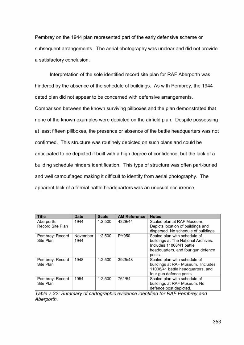
353
Pembrey on the 1944 plan represented part of the early defensive scheme or
subsequent arrangements. The aerial photography was unclear and did not provide
a satisfactory conclusion.
Interpretation of the sole identified record site plan for RAF Aberporth was
hindered by the absence of the schedule of buildings. As with Pembrey, the 1944
dated plan did not appear to be concerned with defensive arrangements.
Comparison between the known surviving pillboxes and the plan demonstrated that
none of the known examples were depicted on the airfield plan. Despite possessing
at least fifteen pillboxes, the presence or absence of the battle headquarters was not
confirmed. This structure was routinely depicted on such plans and could be
anticipated to be depicted if built with a high degree of confidence, but the lack of a
building schedule hinders identification. This type of structure was often part-buried
and well camouflaged making it difficult to identify from aerial photography. The
apparent lack of a formal battle headquarters was an unusual occurrence.
Title Date Scale AM Reference Notes
Aberporth: Record Site Plan
1944 1:2,500 4329/44 Scaled plan at RAF Museum. Depicts location of buildings and dispersed. No schedule of buildings.
Pembrey: Record Site Plan
November 1944
1:2,500 PY950 Scaled plan with schedule of buildings at The National Archives. Includes 11008/41 battle headquarters, and four gun defence posts.
Pembrey: Record Site Plan
1948 1:2,500 3925/48 Scaled plan with schedule of buildings at RAF Museum. Includes 11008/41 battle headquarters, and four gun defence posts.
Pembrey: Record Site Plan
1954 1:2,500 761/54 Scaled plan with schedule of buildings at RAF Museum. No defence post depicted.
Table 7.32: Summary of cartographic evidence identified for RAF Pembrey and Aberporth.

354
7.4.5.3 War Office Cassini mapping
The third major collection of cartographic evidence comprised the GSGS3906
1:25,000 and GSGS3907 one-inch to one mile (1:63,360) scale maps (Table 7.33).
A complete series of both sets of mapping was identified for the case study. None of
the individual map sheets were annotated with any form of defensive depiction and
other than providing geographical context their chief importance was in facilitating the
identification of the locations of defence structures cited using the Cassini grid
overlay in registered files at TNA and Home Guard records at Carmarthenshire
Archives.
Sheet No. Title Series Scale Edition Notation
26/22 NW&SW [Pendine] GSGS3906 1:25,000 2nd Provisional Edition
2,000/6/43/14 RE
26/22 NE [Ferryside] GSGS3906 1:25,000 2nd Provisional Edition
2,500/10/42/520 RE
26/22 SE [Pembrey] GSGS3906 1:25,000 2nd Provisional Edition
2,500/8/42/520 RE
26/24 NW [Llanfyrnach] GSGS3906 1:25,000 2nd Provisional Edition
2,500/40
26/24 NE [Rhos] GSGS3906 1:25,000 2nd Provisional Edition
2,500/40
26/24 SW [Llanboidy] GSGS3906 1:25,000 Provisional Edition
2,500/3/41/520 Corps Fd Svy Coy RE
26/24 SE [Carmarthen] GSGS3906 1:25,000 2nd Provisional Edition
2,000/41
26/26 NW [Aberporth] GSGS3906 1:25,000 2nd Provisional Edition
2,500/40
26/26 NE [Pont-garreg] GSGS3906 1:25,000 2nd Provisional Edition
2,000/41
26/26 SW [Cardigan] GSGS3906 1:25,000 2nd Provisional Edition
2,500/3/41/520 Corps Fd Svy Coy RE
26/26 SE [Henllan] GSGS3906 1:25,000 2nd Provisional Edition
2,000/41
78 Lampeter GSGS3907 1:63,360 War Revision 1940
WO 6,000/40
89 Carmarthen GSGS3907 1:63,360 War Revision 1940
WO 20,000/40
100 Llanelly GSGS3907 1:63,360 War Revision 1940
WO 20,000/40
Table 7.33: Summary of GSGS3906 and GSGS3907 maps identified in case study area.

355
7.4.5.4 Admiralty plan for Milford Haven RN Mine Depot
This plan was held in the personal collection of Roger JC Thomas, but was not
viewed. It was produced by the Admiralty and depicted the accommodation camp
site at Burry Port which supported Milford Haven Royal Naval Mine Depot. The
accommodation utilised the buildings constructed for the former Emergency Coast
Battery at Burry Port. The plan depicted the gun emplacements and the associated
technical buildings common to these types of establishments.
7.4.5.5 Missing maps
Despite the range of defensive site types and military establishments within
the case study that were known to generate cartographic records in other contexts,
the lack of these records was frustrating. The larger establishments such as the
airfields at Pembrey and Aberporth and the coast artillery battery at Burry Port would
have generated multiple copies and revisions of many maps and plans. While the
airfields’ ORBs were preserved at TNA, the defence schemes and associated
mapping were not. The FRB for the Burry Port emergency coast battery was not
preserved at TNA. The cumulative impact of these cartographic absences was that
the defences at these locations were poorly depicted and understood. This source of
evidence was often the best means of identifying the location and character of the
smaller defensive fieldworks. At these locations other sources must be used to
rectify the apparent absence.
It was clear from the surviving documentary records that the Home Guard
defence schemes held at Carmarthenshire Archives were richly furnished with maps,

356
plans and sketches. The text of the 1 Battalion, Carmarthenshire Home Guard
defence scheme document of February 1944 (CDX/629) referred to sketches in
Appendices A and B depicting the locations of slit trenches, tank ambush areas and
the siting for sub-artillery positions, a map in Appendix H that depicted the
arrangements for Carmarthen keep and the locations of observation posts and
sketch maps in Appendix I with Annexures 1 and 2 marking the positions of
weapons, squad and battle platoon areas. None of these maps, plans or sketches
were preserved suggesting a deliberate separation of the written and cartographic
records, for unknown purposes.
A covering minute from the Officer Commanding accompanying the issue of
the 3 Battalion, Carmarthenshire Home Guard Operational Order No. 1 of 19 June
1941 stated:
‘I enclose herewith Copy No. 9 of the above. You are personally responsible for its safe custody… Certain appendices marked ‘N’ are held at Battalion Headquarters and will be issued to you only on receipt of ‘NEWTON’. This applies to all copies below Copy No. 7… Copies of Battalion Operational Orders issued on January 1941 will be destroyed by fire and a certificate that it has been done will be rendered to this HQ.’ (CDX429).
The document was helpful in explaining military practice surrounding the
issue, circulation and destruction of information in a tightly controlled manner. A
distribution list at the end of the Operational Order recorded the issue of twenty-four
uniquely numbered copies of the document to formation and unit commanders within
and adjacent to the defence scheme area. The document was issued with fourteen
supporting appendices, but three entitled Beaches, Harbours and Aerodromes in the
Battalion area, Field Formations in the Battalion area and Inter-communication and

357
Light Signals were considered to be so sensitive that they would only be issued to
the majority of recipients on the issue of the Newton code word indicating that the
invasion was believed imminent. As the version preserved at Carmarthenshire
Archives was number nine it did not contain these appendices or the accompanying
maps and plans, and explained how in some cases the missing maps occurred. It
was important to understand the consequences of the practice of restricting important
plans, maps and sketches to headquarters. This would have reduced the number in
circulation and focused them into one archive. If the archive was not deposited at a
local or national level, the opportunity to source them from another source was
limited.
The reference to the practice of burning superseded instructions and orders,
together with associated maps and being required to officially record this action
would help to explain the very low incidence of known defence scheme maps that
have been identified in Wales. It was assumed that this practice was undertaken to
ensure that only one set of orders was available at any one time to ensure
compliance with the latest defence plan and to reduce opportunities for the German
armed forces to gain an oversight of the general defence strategy from outdated
orders held in multiple dispersed headquarters locations should they have invaded
Wales. In this context, the information contained within the associated sources very
clearly explained some of the factors for the paucity of maps.

358
Plate 7.1: Plan depicting natural defences, excavation, concrete cubes and block houses for southern (Pembrey-Ferryside) section of Carmarthen Stop Line (TNA MAF 112/204).

359
Pla
te 7
.2: P
lan
dep
icting
natu
ral de
fen
ce
s, e
xca
va
tion
, con
cre
te c
ube
s a
nd
blo
ck h
ou
se
s for
ce
ntr
al (C
arm
art
hen
-Hen
llan
) se
ctio
n o
f C
arm
art
he
n S
top
Lin
e (
TN
A M
AF
11
2/2
04
).

360
Pla
te 7
.3: P
lan
dep
icting
natu
ral de
fen
ce
s, e
xca
va
tion
, con
cre
te c
ube
s a
nd
blo
ck h
ou
se
s for
no
rth
ern
(L
lang
ran
nog
Abe
r-
ba
nc)
se
ctio
n o
f C
arm
art
he
n S
top
Lin
e (
TN
A M
AF
11
2/2
04
).

361
7.5 Contribution and role of evidential sources
This section assesses the value, role and contribution of the evidential
sources.
7.5.1 Archaeological evidence
Type Value Role Major + contribution
Major - contribution
DAT HER Low Minor Summary of previous knowledge
Illustrates how little research undertaken Too few defence sites recorded
RCAHMW NMRW (incl. DoB data)
Medium Moderate Drew together most previous research
Too few defence sites recorded; Multiple point data records for single linear and polygonal features
Rapid field observation Medium Primary role where survives (buried resource potential unknown)
Some new sites Surviving remains provide unique information not available elsewhere
Constrained by extensive clearance
Table 7.34: Summary of value, role and contribution of archaeological evidence for the Carmarthen Stop Line case study area.
The archaeological evidence was the unique source for identifying a number
of previously unknown defence posts, but its cumulative value was moderate and its
role variable (Table 7.34). It was the only source to identify the presence and
location of the unusually designed pillboxes at Pembrey Sands Air Weapons Range
and evidence preserved in road surfaces for a number of roadblocks between Tywyn
Camp and the bombing range at Pembrey Forest, and at Werncorgam. The course
of the various lengths of anti-tank ditch, now infilled but still visible as shallow linear
features, was also best understood from an archaeological perspective. Conversely,

362
archaeological survey also confirmed that the anti-tank ditch did not continue in
afforested areas, which were often located on steep local slopes where the
combination of trees and topography was considered to form an effective defence
against AFVs.
It was a modest but important contributory source of evidence for a range of
sites that were identified in other existing sources, including the large number of
hardened defence works including pillboxes along the Carmarthen Stop Line and the
beach defence gun houses at Cefn Sidan and the airfield perimeter defences at RAF
Pembrey and Aberporth.
As demonstrated in the other two case studies, the archaeological evidence
could not be relied upon alone to identify the original anti-invasion defence site
population in this case study. The role of archaeology as a means of locating new
anti-invasion defence sites was most successfully demonstrated in this case study.
Partly this was a function of the successive periods of fieldwork survey by different
individuals that have been undertaken since the 1990s. The rapid field observation
undertaken during this research demonstrated that a variety of sites ranging from
small features such as earthwork slit trenches and roadblocks to larger hardened
structures such as pillboxes and gun emplacements could also be identified anew.
Many of these features and structures were identified in locations where public
access was not routine or in marginal locations. Elsewhere, site visits on to private
and previously un-surveyed land identified a number of structures along the course of
the stop line.
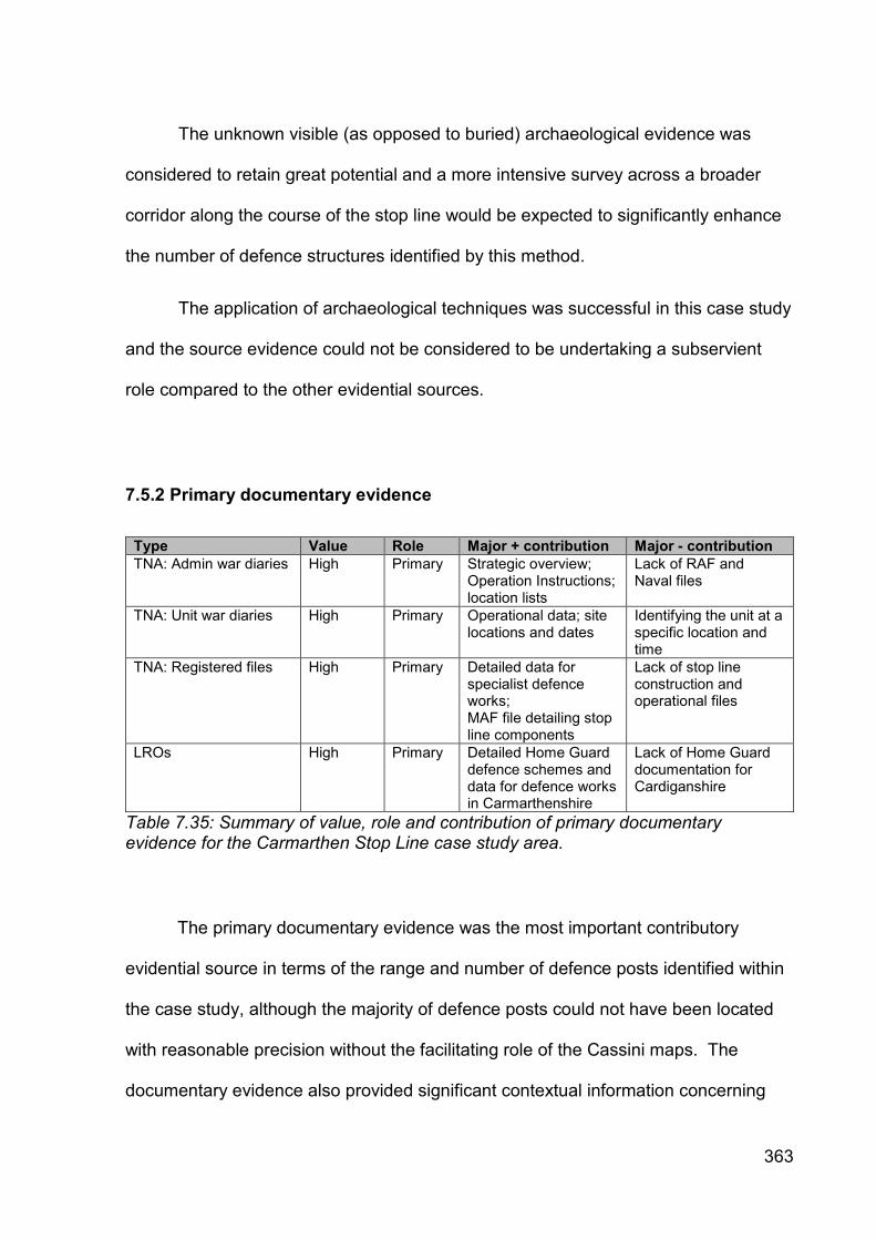
363
The unknown visible (as opposed to buried) archaeological evidence was
considered to retain great potential and a more intensive survey across a broader
corridor along the course of the stop line would be expected to significantly enhance
the number of defence structures identified by this method.
The application of archaeological techniques was successful in this case study
and the source evidence could not be considered to be undertaking a subservient
role compared to the other evidential sources.
7.5.2 Primary documentary evidence
Type Value Role Major + contribution Major - contribution
TNA: Admin war diaries High Primary Strategic overview; Operation Instructions; location lists
Lack of RAF and Naval files
TNA: Unit war diaries High Primary Operational data; site locations and dates
Identifying the unit at a specific location and time
TNA: Registered files High Primary Detailed data for specialist defence works; MAF file detailing stop line components
Lack of stop line construction and operational files
LROs High Primary Detailed Home Guard defence schemes and data for defence works in Carmarthenshire
Lack of Home Guard documentation for Cardiganshire
Table 7.35: Summary of value, role and contribution of primary documentary evidence for the Carmarthen Stop Line case study area.
The primary documentary evidence was the most important contributory
evidential source in terms of the range and number of defence posts identified within
the case study, although the majority of defence posts could not have been located
with reasonable precision without the facilitating role of the Cassini maps. The
documentary evidence also provided significant contextual information concerning

364
the military administrative and operational organisational structure and an indication
of the formations and units present, together with statements concerning their roles
and activities. On rare occasions a unit was cited as constructing a particular
defensive component on a particular date, but this combination of information was
not readily identifiable in the documentary evidence. The documentary evidence
concerning the regular forces at TNA and the Home Guard at Carmarthenshire
Archives blended well to establish an informative narrative of the military’s presence,
identity, organisation and activities with a depth that was not regularly encountered
elsewhere in Wales.
7.5.2.1 Missing files
While the surviving primary documentary evidence could be detailed and
useful, and undertook a primary role in terms of value, role and contribution to
understanding the defensive arrangements within the case study, this form of
evidence was not complete and there were significant gaps that impeded further
comprehension.
The failure to locate records detailing the construction, extent, occupation and
amendment of the stop line, the arrangement of defence schemes for the airfields,
the regular army and Home Guard defence schemes from 1940 and 1941, and the
FRB for Burry Port Emergency Battery were all substantial omissions. Entire classes
of anti-invasion site type, for example petroleum warfare sites or spigot mortar
emplacements, were not referred to and it was uncertain whether this represented an
evidence of absence or an absence of evidence. Similarly, there were important

365
continuity breaks in the administrative files, for example a complete lack of sector
and garrison files. The future identification of any one or more of these sources has
the potential to both significantly enhance and/or contradict the documentary-based
evidence discussed in this chapter.
7.5.3 Aerial photographic evidence
Type Value Role Major + contribution
Major - contribution
Wartime low-level oblique
Low Minor Can provide high levels of detail and 3D perspective; Good source for identifying small structures
Almost complete lack of spatial coverage; tended to predate anti-invasion defence construction
Wartime vertical (all scales)
Medium Primary source of evidence and context
A unique source of evidence for structures not cited in other sources; Limited repeat sorties can provide phasing evidence
Significant gaps in spatial coverage; most coverage is limited to one sortie only and cannot provide phasing evidence; Smaller and/or camouflaged structures are hard to identify
Operation Revue (1945-52)
High Important retrospective source
Almost complete coverage for case study area; Provides an immediate post-War benchmark
Smaller and/or camouflaged structures are hard to identify Coverage taken after clearance
Table 7.36: Summary of value, role and contribution of aerial photographic evidence for the Carmarthen Stop Line case study area.
The contribution of wartime aerial photography was variable in this case study,
and less useful than in the other two case studies (Table 7.36). At its best,
successive sorties over an area recorded clear photographic evidence through time
providing some insight into the phased development of defence systems, but often
the resolution of the imagery was incapable of capturing the smaller defence

366
structures. These opportunities were rare and focused on Carmarthen and the RAF
airfields.
Wartime aerial photographic coverage did not make any contribution to over
two-thirds of the case study as it was not subjected to aerial reconnaissance. Such a
significant absence severely curtailed the contribution and role of this form of
evidence. The absence of wartime aerial photography was particularly noted along
the course of the Carmarthen Stop Line, particularly the areas from Brynhoffnant-
Carmarthen, to the west of Carmarthen and from Carmarthen-Pembrey (excluding
the airfield).
The Operation Revue imagery was more useful and contributed near-
complete coverage of the case study as photographed in May and July 1946. Like
the wartime vertical coverage it was not a strong source for capturing the smaller
defensive structures, as many pillboxes could not be identified, but it did provide an
invaluable benchmark of the immediate post-war landscape. In particular the course
and extent of the Carmarthen Stop Line’s anti-tank ditch could be traced prior to its
infilling during the late 1940s, but the majority of defence posts along its length could
not be identified.
In combination, the vertical imagery was the unique source of evidence for a
number of defence site types, including identification of the barbed wire
entanglements at Pendine and Laugharne Burrows, identification of the anti-tank
block alignment at Pante Farm, and the principal source for identifying the presence,
location and extent of the Admiralty Z1 scaffolding at Burry Port. Aerial photography
was also the only available source to identify the location, form, vertical plan and

367
extent of the emergency defence coast battery at Burry Port in the absence of being
able to view the plan.
7.5.4 Cartographic evidence
Type Value Role Major + contribution
Major – contribution
GSGS3906 (1:25,000)
High Enabling Cannot locate defence sites in documents without them; Complete series for case study area
Hard to obtain No defence sites
GSGS3907 (1 inch to 1 mile)
Low Contextual Provide geographical context
Scale too small to plot sites
Air Ministry Record Site Plans
Medium Minor Depicts Air Ministry boundary, BHQ and some defence sites
Most defence structures are not shown; Plans for 1940-43 do not appear to survive
MAF clearance plans High Primary 1:25,000 scale tracing of main linear and pillbox defences
Medium is fragile and opaque and cannot easily be used with GSGS3906 maps; Pillbox locations hard to plot; Does not include all defence posts
Table 7.37: Summary of value, role and contribution of cartographic evidence for the Carmarthen Stop Line case study area.
The cartographic evidence presented in Table 7.37 made a moderate
cumulative contribution to enhancing understanding of the defensive arrangements of
the case study, mostly through undertaking enabling or confirmatory roles, with one
important piece contributing significant and unique information in its own right. The
Carmarthen Stop Line case study was notable for the lack of identified defence
scheme maps and plans that illustrated the military organisational structure of the
region. The lack of these types of cartographic evidence significantly weakened the

368
contribution of this class of evidence in this case study, particularly when compared
to the Swansea-Gower case study. Consequently much of the fine detail was
missing and knowledge induction more generalised.
A complete coverage of the two types of military cartography identified in the
other two case study areas was identified for the Carmarthen Stop Line case study
and the same general observations regarding their role and contribution applied. The
same general observations expressed for this source type elsewhere also applied to
the Air Ministry Record Site Plans, which were late in date and omitted the details of
most defensive structures.
The most important piece of cartographic evidence was the series of three
Ministry of Agriculture and Fisheries overlay plans that depicted the component parts
of the stop line prior to its demolition immediately after the war. The plans, despite
their weaknesses in terms of difficulty of use, lack of detail, being drafted for non-
military purposes and possessing an unknown level of accuracy, represented the
sole known example of such a plan for a stop line in Wales. No other stop line in
Wales was known to have a plan that depicted the course, linear components and
locations of pillboxes. As such this evidence was unique and a cartographic source
of high importance. Despite its importance the contribution of the content of the plan
was fairly limited, in part because of its function to identify the parts of the stop line to
be reinstated and in which priority, and because it was not undertaken to produce a
comprehensive record of all of the component parts of the stop line.
The role and contribution of the plans were complex. They were silent on the
matter of many types of defence structure such as roadblocks, fougasse sites, mines

369
etc., so its contribution for these structures was negligible. The plan depicted the
locations of 74 pillboxes, but it was uncertain whether those shown represented the
entire built population, those that were present at the time of the survey or just those
that were considered to be a nuisance. The distribution given must be considered to
be of prime importance, but it was difficult to attribute the level of confidence in its
use. Many of the pillbox locations depicted correlate broadly with known
archaeological evidence on the ground, but those where there was no known
evidence presented more of a problem as there was insufficient confidence to
precisely locate a defence structure other than to state that there might be a pillbox
near point A, between pillboxes X and Y. An important use of the plan was that it
could be used to focus rapid field observation and/or examination of aerial
photographic evidence in order to try and identify the site. It was interesting to note
that some care appeared to have been demonstrated in the placement of the
pillboxes, with some being located along the alignment, and others being located to
the east and west of the central alignment.
The Admiralty plan of Burry Port coast battery, which was located in a private
collection, was not viewed and consequently the role, value and contribution of this
plan could not been determined. It was not included in Table 7.37.
370
7.6 Summary
This study set out to determine the Second World War defensive
arrangements and evidential contributions within the case study. Prior to undertaking
this research, not much was known about the defensive arrangements in the case
study. A small number of defence sites had been identified through archaeological
fieldwork, sometimes based on aerial photographic evidence or on records available
in the local record office. The results had been incorporated into the NMRW,
whereas the HER tended to reactively record the results of designation work. An
attempt had been made to describe the components of the stop line from the Ministry
of Agriculture and Fisheries plan preserved at TNA.
Despite being the subject of ongoing research, very little had been published.
There was no identifiable understanding of the military administrative and operational
arrangements and no comprehension of the formations and units involved. The
development, phasing and use of the defensive schemes and their location,
composition and extent was also poorly understood.
This research drew together and reviewed all of the identifiable evidence. It
identified new sources of evidence, particularly documentary, and to a lesser extent
archaeological, and combined them with cartographic and aerial photographic
evidence to present a new and integrated understanding of the development of the
role and contribution of the different evidential source types, together with the case
study’s defensive arrangements. The complexity of the defensive arrangements was
clear, and challenges the often verbally expressed notion that the defences were

371
simple as they were built quickly. Significant evidential gaps were identified. New
discoveries will further enhance understanding.
The last three chapters reviewed the available evidence for the defensive
arrangements prepared within three case studies. These assessments raised a
number of important issues and questions regarding the use, role and significance of
the different types of evidential source which will be addressed in the next chapter.

372
8. DISCUSSION
8.1 Introduction
Previous chapters introduced the research question, reviewed the published
literature, developed a methodology, described and critiqued the available evidential
sources and then identified and analysed the significance, role and contributions of
archaeological, documentary, aerial photographic and cartographic evidence for the
study of Second World War anti-invasion defences in three case studies in south and
south-west Wales.
This chapter locates the research within the wider fields of archaeology
discussed in Chapter Two and draws together the previous chapters to address the
research questions. It comprises three parts. The first part compares and contrasts
the results from the three cases. It seeks to identify how similarities and differences
were expressed and the reasons why. It reviews the structures within each case
study and examines the reasons for consistency and/or variability and determines
whether the results were sufficiently comparable to produce a robust synthesis. The
second part discusses the effectiveness of the methodology. It compares the
adopted methodology to other approaches and states how it compared with the
broader academic field.
The third part discusses issues regarding the choices involved with selecting
cases. It examines whether the choice of case represents a fundamental difference
from other periods and whether there are implications arising from this research for
an emergent conflict archaeology that seeks to cross disciplinary boundaries.

373
8.2 Discussion of case study results
Distinct patterning was observed within the case datasets concerning the
types of evidence used and their contributions. This section reviews the similarities
and/or differences arising from the cases, their consistency and/or variability and the
reasons why.
8.2.1 Archaeological evidence
The archaeological evidence performed in a variable manner. The data
preserved within the HERs and the NMRW were found to be of low-moderate value,
while the contribution of rapid field observation varied in each case.
The information preserved within HERs at the beginning of the research was
found to be of low value, except for in the St Athan-Llandow case study, where it was
of moderate value. In all cases the numbers of recorded sites were low and
misattributed site types were common. The data reflected under-recording of the
modern defence heritage, which was considered to be illustrative of the prioritisation
of more ‘traditional’ archaeological subjects and the palpable absence of active
recording projects within the cases.
The data preserved within the NMRW contained all of the records from the
Defence of Britain project, but no new additional data had been added within the
cases subsequently, again indicating a lack of active research in these areas. The
NMRW data was found to be internally inconsistent particularly regarding the
allocation of site type categories, grid reference accuracy and the confusing practice

374
of using collective site and site-based records in an inconsistent way. The lack of
shared records common to both the NMRW and the HERs was notable.
The contribution of rapid field observation was found to be highly variable. It
was of low value in the Swansea-Gower case, where the clearance of anti-invasion
defences had been widespread and well documented. The approach was found to
be of high value in the St Athan-Llandow case, where a number of new anti-invasion
defences were identified. The results for the Carmarthen Stop Line case were of
moderate value, given the historically attested clearance activities, but some
interesting new sites were identified. The impact of the fieldwork was diluted by the
sheer length of the stop line and the complexity of the adjacent defences. Although
over three weeks of fieldwork was undertaken in this area, given the terrain, multiple
land ownership and the ephemeral character of much of the evidence future research
in this case would benefit from dividing it into smaller sub-areas.
In all cases, the fieldwork results were subjected to a strong degree of bias as
the majority of the new anti-invasion defence sites identified were hardened concrete
structures. A less rapid and more intensive form of field observation in combination
with other sources and techniques was considered to offer the best opportunity for
addressing this bias in future fieldwork.
8.2.2 Primary documentary evidence
The documentary evidence was obtained from national and local sources.
The evidence from national archives performed in a consistent way across all three
cases with good preservation of records facilitating enhanced analysis. In all three

375
cases, the primary historical evidence was of high value, and although incomplete,
performed a primary role in identifying defence arrangements. In contrast the
evidence obtained from local archives performed in a variable manner.
TNA preserved significant numbers of war diaries (WO 166) and registered
files (WO 199) relevant to the three cases. The upper echelon Command and Area
war diaries were found to be preserved consistently, providing information on
operational level matters.
The regional Sub-Areas were responsible for organising defence
arrangements in their respective areas and their war diaries preserved home defence
and counter-invasion schemes, together with distribution lists, unit location lists,
operational instructions and reports. These sources enabled the creation of relatively
detailed narratives regarding defence provision, military organisation and the identity
of the formations and units present. Such narratives were weak for 1940-41, but
improved from 1942. In no one location was a complete narrative established.
Lower level echelon records for Sector, Sub-Sector and OC Troops
administrative areas were not identified with the notable exception of the Swansea
Garrison war diary, which included the Swansea Garrison and Gower Sector defence
schemes. The level of detail preserved within this source was comparatively high
and it made a major contribution to the understanding of this case.
The majority of the war diaries for the military formations and units located
within the cases were identified and found to retain moderate levels of information
relating to their date and duration of presence, location and role. In some cases the
records of Royal Engineer and home defence battery units preserved enhanced

376
information regarding an initiating unit’s identity and dates of construction for anti-
invasion defences.
The registered files preserved at TNA also influenced site discovery illustrating
the construction of minefields, Canadian pipe mines and foreshore obstacles; these
were informative to the same degree across all cases. Primary categories of record
omission for all cases were identified for the construction and operation of road
blocks, nodal points, stop lines and airfield defence schemes, although it was
uncertain whether this was just a characteristic of the three cases or an artefact of
the wider Welsh evidence.
The contribution of locally sourced records was found to be variable. The
local record offices covering the St Athan-Llandow and Swansea-Gower cases were
examined, but were not found to contain records pertaining to the regular army and
only a few records of negligible value concerning the Home Guard.
In contrast the local records office for the southern part of the Carmarthen
Stop Line case preserved a quantity of relevant and detailed records relating to
Home Guard defensive arrangements, including the use of the Carmarthen Stop Line
itself. Similarly, the Llantwit Major Local History Society preserved a detailed Home
Guard defence scheme for part of the St Athan-Llandow case. These records made
valuable contributions, but were restricted in the spatial and chronological coverage
and therefore their ultimate holistic contribution. The survival of such sources
suggested that the search strategy for records within a case should be conducted at
local, regional and national archival repositories in order to maximise record retrieval.

377
A critical awareness and application of documentary evidence was required to
maximise understanding from the past (Beaudry 1988; Little 1992, 2014). Some of
the evidence provided unique and detailed information not available elsewhere
(Babits 1988). These records should be used more often to add to our
understanding of the recent past.
8.2.3 Aerial photographic evidence
The aerial photographic evidence performed consistently across all three
cases. The low-level oblique photography lacked spatial and chronological impact
owing to the physically low incidence of frames. While this evidence type retained
the potential to provide unprecedented levels of detail concerning the location and
construction of all types and sizes of anti-invasion defences, it was the experience of
this research that this form of aerial photography contributed rarely to new defence
identification. In most cases key areas of anti-invasion defences were not captured
in this format and the evidence performed a secondary and contextual role. The
fundamental issue lay with the low number of frames taken in Wales, and unless
significant amounts of new imagery were identified, the evidential source was
considered to be of relatively low contributory value for future anti-invasion defence
research in Wales.
The experience of using wartime vertical aerial photography was more positive
and it was of moderate-high value in terms of identifying new defence works across
the three cases. Almost complete coverage of the smaller cases was available, but
the coverage was usually from one sortie and with the exception of a few areas

378
repeat photography was not available therefore limiting the value of this evidence for
phasing construction. Only a third of the Carmarthen Stop Line case was covered,
which curtailed the usefulness and application of this form of evidence. In contrast to
the clear and detailed wartime imagery from elsewhere in the UK (as used by Foot in
his Defence Areas study (2006a)), much of the imagery in the cases was more
difficult to use. The imagery was constrained by its lack of clarity and resolution,
meaning that many smaller defence works known to exist were often difficult to
identify.
This format of aerial photography was best used for the identification of larger
defences such as anti-tank and anti-landing obstacles, and was often the unique
identifier. The later USAAF imagery benefitted from much higher resolution, but this
was found to be counteracted by the capture from higher altitudes in order to record
a greater land mass in each frame. Many types of anti-invasion defence had also
been dismantled prior to this time. Wartime vertical photography performed a
primary role where present and should be considered a key source for anti-invasion
defence in Wales, subject to application limitations.
The post-war Operation Revue imagery was available across all of the cases.
The high resolution imagery depicted a landscape in a rapid state of change. While it
was a key source for defence site identification in some areas, it was found to be too
late to record defences in other areas where clearance schemes had been underway
since 1942-43.
Aerial photography could be very useful on occasion, but generally its
contribution was found to be much less useful and direct than had been anticipated

379
prior to the research commencing, particularly when compared with some of the
applications used in England and Scotland.
8.2.4 Cartographic evidence
The cartographic evidence divided into two types and performed and
contributed in different ways. The creator, purpose, audience and bias needed to be
understood to maximise use of this source (Seasholes 1988). The GSGS3906 and
3907 mapping performed consistently across all of the cases. The former was of
high value and while it did not contribute direct evidence for new sites in its own right,
the presence of the large-scale mapping with the over-printed WOFO grid was found
to be crucial for plotting the War Office co-ordinates cited in defence schemes and
registered files. The GSGS3907 was too small-scale to plot War Office co-ordinates
accurately and its role was restricted to offering contextual geographic information.
Maps appended to defence schemes were rare occurrences, but where they
were present the evidence preserved within was of fundamental importance. The
usefulness of mapping for defining military organisational areas was also constrained
by its limited availability. This form of evidence when present performed a primary
role and contributed profoundly to understanding the defence arrangements at the
date of the plan. Ultimately, the usefulness of this form of evidence was constrained
by its lack of availability and limited spatial and chronological coverage.
The lack of such plans was in striking contrast to the abundance identified
within Foot’s Defence Areas project. The virtual lack of plans relating to stop lines

380
and airfield defences retarded further understanding of these important site types.
Provision for coast artillery batteries was better, particularly if the FRBs were located.
The stop line clearance plan created by the Ministry of Agriculture and
Fisheries for the Carmarthen Stop Line is thought to be a unique survival for Wales,
but the records of the War Agricultural Executive Committees have not been
searched and it is considered that there is potential for similar information to be
preserved in those records.
The information preserved within the Air Ministry Record Site Plans for
airfields and their usefulness was variable. Those preserved at the RAF Museum
were found to largely ignore airfield defensive arrangements due to their late date
(1944-45) when invasion was less of a concern. The plans preserved within Welsh
Office records at TNA were found to be of variable use, as the plan for RAF Llandow
depicted very few airfield defences. In contrast, the plans for RAF St Athan provided
evidence of what must have been almost a complete defensive scheme. As with
many types of evidential source for Wales, sources could not be assumed to perform
in a standard fashion and it was imperative to check all available sources for the
possibility that useful information was preserved within.
8.2.5 Use of the results
Following the above discussion, it was considered important to determine
whether the results of the three cases bore comparable results that were capable of
producing a synthesis or whether they rather formed a series of unique individual
statements that made synthesis problematic.
381
The results of this research suggested strongly that the three cases shared
sufficient in common to have successfully produced a new, evidence-based and
informative collective synthesis in terms of establishing the military organisational and
defensive arrangements. Following Little’s framework (1992, 2014) the evidence and
the trends identified within the data was characterised as collaborative and
complementary in character, rather than contradictory. It is anticipated that this
synthesis would be enriched by the identification of additional source evidence,
rather than requiring fundamental re-assessment.
Certain caveats must be respected, particularly when examining defences at a
local level as the chronological range was incomplete and it was important to avoid
drawing generalising statements concerning defence provision from the presence of
structures that formed part of a network whose construction, development and role
was only partially understood.
It was important to determine how far the synthesis could be projected to other
areas of Wales. As the three cases shared similar geographical environments, were
co-located in relative close spatial proximity within the same military Area command it
was considered that the synthesis from the three cases would be capable of
application to other lowland urban and rural areas within the same Area command in
south and south-west Wales. The ability to project the synthesis into north Wales or
into other parts of Western Command in England was uncertain and would need to
be tested in order to establish the extent of its application.

382
8.2.6 Review of case study chapters’ structure
The case chapters benefitted from being structured in the same way. The
purposeful selection and the use of the same types of data from the four evidential
classes in each case meant that the results could be described, analysed and
compared directly with each other in a meaningful way. The variety and inter-
disciplinary evidence enabled narrative understanding to be induced. As suggested
by Hicks (2004), critical assessment of the sources and recognition of variations in
emphasis and absences within the overall datasets for each case enabled the
development of new and informative accounts that were nuanced and rigorous.
8.3 Effectiveness of the methodology
The technique of undertaking an extensive and widespread examination of
local, regional and national data repositories for content relevant to the three cases
was found to work well. It revealed a passively forgotten world that required a
conscious act of foregrounding (Buchli and Lucas 2001c). Each relevant record was
identified and described, and its potential contribution assessed to identify wider
patterns.
As an approach combining archaeology with readily available categories of
official evidence created by the military it was considered appropriate that similar
work on other topics could be reported in a similar way.
It was considered likely that the strength of the approach would be weakened
when applied to some areas of twentieth century and earlier conflict research, as for
example very few First World War aerial photographs survive for Wales and many of
383
the key primary documents required to interpret Cold War subjects at TNA are closed
for reasons of national security. In these scenarios, other approaches would need to
be defined, although a collaborative multi-evidential methodology would still be
effective.
The known existing base line of anti-invasion defence-related evidential
sources for Wales at the beginning of the research was ill-defined and under-
developed. This research identified new sources, assessed their strengths and
weaknesses, and allowed them to be used in an informed and appropriate manner.
The adopted technique was successful in the following ways:
8.3.1 Identification of new records
Significant numbers of new records regarding the four chosen evidential
classes were identified for each of the cases. The amount and character of the
original source evidence produced and its modern day availability was defined and its
role, value and contribution was articulated. Significant gaps and weaknesses were
identified, particularly in terms of early wartime thematic, spatial and chronological
coverage. This reflected the findings from Wilkie’s work (2006).
In addition, some of the newly identified records were found to be highly
detailed in terms of the content contained within. The defence schemes produced by
administrative formations and by operational formations and units were found to be
key sources. However their infrequent survival did not facilitate the construction of
complete narratives. The records were useful for reconstructing the forgotten wider
social relationships behind the defences, addressing deficiencies in the social

384
archaeology of warfare (Carman 2013; Gilchrist 2003). It was clear that the evidence
was active in the past in the production of the phenomenon under study (Moreland
2001), and that it possessed efficacy in the maintenance and reproduction of specific
structures of power. Clear examples of reinforcement of group identity and social
control were identified.
8.3.2 Identification of new anti-invasion defence sites
The discovery of new evidential source material resulted in the identity and
location of new anti-invasion defences being identified for the first time. The new
data demonstrated that the defence arrangements in south and south-west Wales
were complex and subject to continuous improvement and revision over time.
Certain types of documentary sources were found to be very useful in
identifying new anti-invasion defence sites, particularly defence scheme plans and
specialist registered files, but this was found to be a frustrating process, as in many
cases documents known to be produced could not be located. The lack of stop line
and airfield defence scheme-related documentation common to all of the cases
placed this research at a considerable disadvantage compared to those areas where
this material is known to survive in abundance (for example the Scottish stop line
registered files (Redfern 1998d-e) and successive copies of English RAF station
defence schemes (Dobinson 2000e: 3).
The value of the aerial photographic evidence was found to be constrained by
its lack of spatial and chronological coverage and its poor resolution.
385
Low numbers of defence-related cartographic evidence were identified for
each of the cases. The evidence was found to be the least numerous and when it
did exist invariably late in date. It made little direct contribution to understanding the
defence arrangements during 1940-41. Despite the source’s general low impact, the
evidence type retained the ability to provide powerful testament regarding the micro-
defence arrangements of a static defence site (for example the Mumbles Head coast
artillery battery) or a defence area (for example the ‘B’ Company, 10 (Cowbridge)
Battalion, Glamorgan Home Guard defence scheme map). Such contributions were
rare, but made a significant impact when identified.
8.3.3 Identification of new types of anti-invasion defences
The source evidence led to new types of anti-invasion defence sites being
identified in an act of ‘presencing’ absence (Buchli and Lucas 2001). Compared to
the relatively restricted series of site types identified in the NMRW and the HERs for
the three cases at the commencement of this research, this technique facilitated an
expansion in understanding of the range of anti-invasion defences constructed. The
documentary sources made the greatest contribution, for example confirming the
existence of Naval mine fields, anti-boat scaffolding, petroleum warfare harbour
defences, Canadian pipe obstacles, headquarters and home defence batteries.
8.3.4 Placement of the defence arrangements in their original context
Chapter Two demonstrated that other than a number of popular and amateur
publications, particularly focusing on aspects of military airfields, very little academic

386
research had been undertaken on conflict archaeology or anti-invasion defences in
Wales. A detailed narrative account of the organisation, presence, location, role and
change through time of the army in Wales was not identified for the 1940-42 period.
Similarly, few of the secondary sources provided more than a fleeting account of
defensive arrangements or attempted to place the defence arrangements into their
military context. Very few sources attempted to couple the defences with military
organisation or identify the formations and units responsible for their conception,
construction, alteration, occupation or abandonment. Despite these absences, this
past was presented as familiar and known. However, following Graves-Brown’s
assertion this past was in fact mostly unknown and it needed to be made unfamiliar
in order to assess it critically (2000).
The thorough identification and analysis of the sources, particularly at TNA,
successfully enabled detailed, but incomplete military narrative accounts within the
cases to be established. This in-depth archival analysis also facilitated the
construction of the strategic, operational and sometimes tactical military context for
the cases.
The ability to reconnect sites and people regarding the defence arrangements,
military formations and units connected to them was considered to be a strong
advantage of this technique (Hicks 2004). Establishing the link between physical
evidence and human agency provided fundamental and enriching contextual
grounding (Wilkie 2001). Although it required extensive resources to undertake this
type of analysis, it was considered worthwhile as it provided a more detailed and
nuanced understanding of the roles of the source evidence and the development and
context of the defensive arrangements. The approach enabled a robust treatment of

387
the subject and moved beyond the purely descriptive approach utilised by most of the
secondary sources (Tarlow 1999).
8.3.5 Production of holistic narrative accounts
Developing on methodological concerns defined by Beaudry (1988) and Wilkie
(2006) different forms of evidence were treated as inter-linked aspects of a common
totality. This research established the first description and evaluation of the types of
evidential sources and their uses, levels of survival and usefulness in Wales. As
Buchli and Lucas argued (2001b), the integration of diverse evidence created
meaningful narratives about the past which transcended accounts available from
looking at one form of evidence and unique contributions were formed. Although the
different forms of evidence were shaped by different degrees of preservation and
coverage, the evidence blended to provide complementary narratives (Little 1992,
2014).
The complementary combination of the four types of source evidence
successfully produced holistic, robust and integrated narrative accounts for the three
cases. The results acted as a cautionary tale to inform others wishing to undertake
similar work in this field (Little 2007), highlighting benefits and pitfalls (Schofield
2005). The work also acted as a caveat concerning the presence and absence of the
evidential sources and their strengths and weaknesses, and identified a methodology
for adoption elsewhere. Indeed, as Stevenson (2001) asserted archaeological
approaches were useful for telling the stories of the twentieth century, even when
historical approaches might appear more obvious.

388
8.3.6 Extent of wartime and post-war clearance and redevelopment
Rapid field observation confirmed that the sites known to have been built and
identified from defence schemes and cartographic sources could not usually be
identified as surviving visible remains on the ground. This outcome confirmed Piccini
and Holtorf’s characterisation of the relationship between the present and recent past
as being a complex one and that sources should not be reduced to an illustrative role
(2011).
The fact that so few of the defence posts from the original population were
identified was demonstrative of the extensive clearance and re-development
activities that took place from 1942-43 onwards, particularly in the post-war period. It
was a powerful example of an unknowable contemporary past (Buchli and Lucas
2001). It was also a striking illustration of the need to employ archaeological
approaches as an act of conscious remembrance and to undertake the ‘presencing’
of absence. The character of any sub-surface surviving remains and the reasons
and methods for post-depositional destruction were beyond the scope of this
research.
8.4 Comparison with other approaches
The three cases formed the most intensively studied, described and
understood areas in Wales in terms of the evidential sources, the numbers and types
of anti-invasion defences identified and their military organisational context. While
not resulting in complete accounts of the defensive arrangements, the technique was
shown to be effective and it was considered suitable for application to other cases.
389
Collating data from all of the sources produced a very different depiction from that
known previously (making the familiar unfamiliar), though the overall picture was of
necessity a preliminary one.
It was important to compare the approach used in this research with that of
others. Given the extensive resource implications of the technique particularly
regarding the documentary research it was important to determine whether other
approaches achieved similar or different results and if so to determine why.
Within the context of Second World War anti-invasion defence research four
major studies were identified as being appropriate for comparison. These comprised
Dobinson’s in depth historical research and analysis of eleven themes at the Public
Records Office undertaken as part of English Heritage’s Monuments Protection
Programme (1994-2000). Redfern undertook a smaller one year documentary
evidence-based research project for Wales, Northern Ireland and Scotland (1997-
98). Running in parallel to the primary documentary historical studies were two
archaeological fieldwork-based projects comprising the UK-wide Defence of Britain
project (1995-2001) and English Heritage’s Defence Areas project (2002-04), which
continued the fieldwork element and enhanced the results of the former project in
England.
8.4.1 Dobinson’s documentary research
In contrast to Dobinson’s conclusion that ‘in reality, surviving records for most
site types [in England] are thorough and precise: sufficient to tell us what was built,
when and why’ (1998: 2), the results of this research into three cases in south and

390
south-west Wales demonstrated that the documentary record, while of a similar
quality and detail where it was known to survive, was incomplete and less useful.
Researchers would appear not to be able to readily identify what was built, when and
why with confidence, particularly for the key 1940-41 period. Where records did
survive, significant categories appeared to be depleted of potentially useful
appendices.
The reasons for the paucity of the documentary record were uncertain. It was
considered unlikely that Western Command and its subsidiary administrative
echelons recorded such information to a lesser standard, as the known material was
comparable to that from other English and Scottish-based commands. Large
quantities of wartime records would have been available for transfer from the War
Office, the Admiralty and the Air Ministry to the Public Record Office. The National
Archives suggested that some of the records may have been lost in a fire in 1940,
while others may not have been selected for preservation by their parent ministry or
were selected for destruction as part of routine archival practices (McGrady 2014,
pers. comm.).
Dobinson’s research was purely historical in character and while important it
did not engage directly with other types of sources or evaluate their potential
contribution. These findings corresponded with concepts expressed by Moreland
(2001) and Hicks (2004), as it was clear that the multi-source technique with a close
and detailed engagement with all sources on an equal footing advocated in this study
was more successful than just applying a unique historical documentary approach.

391
8.4.2 Redfern’s documentary research
In contrast to Dobinson’s study, Redfern’s research was narrower in scope,
almost as geographically extensive, but undertaken in one year (Redfern 1998a-e;
1999). The work comprised pure historical research and did not involve additional
analyses based on data from site visits, existing archaeological records or aerial
photography.
The research produced a series of short contextual and site anatomy
statements for each of the themes (Redfern 1998a) and partially complete gazetteers
of defence sites for a very limited range of site types based on a very limited number
of sources. At best the results for Wales (Redfern 1998b) should be treated as an
imprecise indication of the potential of the sources rather than a definitive account.
Given the time constraints Redfern was not able to confirm or refute whether
Dobinson’s extended narrative historical analyses were appropriate for application in
Wales or otherwise.
In comparison with Redfern’s approach, the methodology adopted in this
research was considered to offer much better results. The selection of
geographically smaller cases rather than undertaking a national level survey enabled
the implementation of a geographical frame that acted to filter in or out records,
effectively and efficiently reducing the totality of the records to be interrogated.
Spatial limitations facilitated more in-depth resource identification and assessment.
The use of defined areas also meant that it was easier to drill down into relevant
records, particularly when using formation and unit records to identify other military
records of relevance and to establish the presence, location, role and duration of the

392
military. The use of smaller cases enabled the effective identification of military units
from formation records. It was also considered easier to develop and maintain an
effective historical narrative account.
As with the comments for Dobinson’s work above, the adoption of a multi-
source-based approach enabled a fuller picture of the defence provisions to be
established than by just using historical documentary sources.
8.4.3 Defence of Britain project
The approach adopted in this research was more robust and integrated. The
methodology adopted a multi-disciplinary approach from its commencement. This
was felt to be a significant improvement, as it enabled the development of historical
narratives that placed the defences in their military and historical context.
Additionally, the adoption of an approach advocating thorough research in smaller
cases was determined to be more successful than a poorly resourced, targeted and
executed pan-Wales survey.
8.4.4 Defence Areas project
Foot’s research was the nearest comparator to the research undertaken in this
study. There were key differences in approach, which are drawn out below.
393
8.4.4.1 Relative advantages/disadvantages of each approach
While Foot’s methodology was able to illustrate a number of small-scale
tactical situations across England, it was felt that the approach utilised in this
research offered a number of additional advantages. Rather than creating a
dispersed and unlinked range of cases, the selection of three large cases enabled
more of the defensive networks to be articulated and for different types of defence to
be examined in a cohesive manner. The larger cases enabled the entire military
administrative area of Swansea Garrison and Gower Sector to be examined. The
selection of larger cases also facilitated the research of physically bigger defence
systems such as entire stop lines and airfield perimeter defences, rather than just
sub-sections of them. This approach enabled a holistic overview of military
administrative and operational arrangements to be developed.
Examination of Foot’s site gazetteers demonstrated that 1,791 anti-invasion
defence sites were identified, of which 832 were extant. The average number of anti-
invasion defence sites per defence area was twelve, but ranged from four (Breamore
Mill, Hampshire) to eighty-eight (Weybourne, Norfolk). As larger cases, this research
identified significantly greater numbers of anti-invasion defence sites per case, but
was not able to extend to national coverage in the same way. It was interesting to
note that Foot’s claim of undertaking a national survey was undermined by the fact
that most of his cases were located in the southern and eastern counties of England.
Very few cases were selected from the western counties with, for example only one
case study being selected from Cheshire and Gloucestershire while none were
selected from Herefordshire or Shropshire.

394
Foot’s use of small areas was considered to be appropriate for the analysis of
small defence areas such as vulnerable points to facilitate the capture of fine detail.
Given the low base of known anti-invasion defence sites in Wales this method was
deemed to be inappropriate when a more extensive area was required for primary
defence site identification. It was considered that the scale of analysis adopted by
the Defence Areas project would be suitable for more refined secondary analysis in a
Welsh context.
8.4.4.2 Range of evidence
Foot’s research utilised a greater range of evidential sources from a wider
array of archival sources. As Foot did not stipulate the individual contribution of each
source no direct comparison with this research could be made. His use of German
mapping of British defences, particularly from collections held by the British Library
Map Library, the Bodleian Library and the Bundesarchiv-Militärarchiv, Freiburg, was
not utilised in this research. The coverage of these archives for Wales remains
unknown, but these repositories potentially hold information that could contribute to
understanding of defence provision in Wales.
8.4.4.3 Results
The most striking comparison, despite the different sizes of case study
analysis used in both studies, were the common conclusions that significant
proportions of the original defence populations had been destroyed and that the
surviving remains were dominated by hardened concrete built site types. The

395
identification of small fieldworks, defended houses, fortified buildings, road blocks
and those anti-invasion defences made from metal was problematic to both studies.
Consideration should be given to how research methodologies can be amended to
enhance the ability of these sites to be identified. For example, is further
documentary and cartographic research required to identify these site types? Or are
these sites in fact lost to research, unless revealed through invasive archaeological
investigation?
8.5 Case study selection criteria
The section above began to explore themes emerging from the choice of case
study selection. The use of cases was a central part of this research and it was
important to review their selection and use. This third section discusses issues
regarding the choices involved with selecting cases including the disciplinary grounds
for selection. It examines whether the choice of case represented a fundamental
difference from other periods and whether there are implications arising from this
research for an emergent conflict archaeology that seeks to cross period boundaries.
8.5.1 Case study selection strategies
It was important to review the strategies employed when selecting cases. This
research based two arbitrary cases on known discrete concentrations of anti-invasion
defences linked by a common theme. The St Athan-Llandow case focused on the
two wartime airfields and the Carmarthen Stop Line case was set around the
defensive line of the same name. As physical manifestations extant in the landscape

396
this approach was primarily archaeological in character. The boundaries were set
with the intention of being able to capture associated data of interest, but not so large
to exceed the requirements of this research.
The archaeological-based selection approach can be seen to have worked for
both cases, but the lack of detail in the information pertaining to how the defence
structures related to each other and the military administrative and operational
hierarchies meant that the case results were not as complete, embedded or
integrated as they could have been.
This approach is routinely deployed in all types of archaeology (alongside
thematic selection) and was evidence-led. Other relevant examples included studies
on the Taunton Stop Line (Hellis 1992; Warren 2000), Foot’s Defence Areas project
(2006a) and the photographic characterisation of RAF Coltishall (Cocroft and Cole
2007). Location-based or ‘situated’ studies were also very common within the wider
conflict archaeology discipline including for example studies on the battle of Towton
(Sutherland 2000), the siege of Haddington (Cooper 2009) or the Long Kesh/Maze
prison (McAtackney 2014).
8.5.1.1 Case study selection by historical documentation
In contrast the Swansea-Gower case was selected on historical grounds. The
case boundary was co-terminous with that of the Swansea Garrison and Gower
Sector military administrative areas, which were described in detail within surviving
documentation at TNA. In many ways this approach was similar to many
397
archaeological studies that utilised the political borders of particular counties to frame
their research, for example the medieval mills of Anglesey (Davidson 2001).
A key difference that distinguished the approach adopted in this case from
others was that the military administrative boundary was not abstract. It was created
by the same authority that was responsible for preparing the defence arrangements
that were the subject of this research, and was embedded within the research
subject.
Rather than selecting a case based on visible groupings of anti-invasion
defences without knowing where the military administrative and operational
boundaries and therefore the authorities for their construction were located, this
research benefitted from the certainty that all of the defences were party to a
common defensive scheme. As a unified area component this enabled simplification
when handling evidence and facilitated more effective and efficient contrast and
comparison between cases.
The literature review did not identify any other examples of the use of this type
of case selection and as far as the author is aware, this is the first time that this type
of approach has been applied within Second World War conflict archaeology. The
advantages and disadvantages of this approach are discussed below.
8.5.1.2 Advantages of using a military area-based approach
The employment of military administrative areas offered a potentially useful
way of framing anti-invasion research because, as administrative areas, they were
fixed and not prone to frequent alteration. The territorial units ranged from national to

398
regional, sub-regional and local areas in size. The administrative areas were
developed as a logical hierarchical system ensuring that all areas were covered by a
mutually interlinking system of areas through which commands and reports could
flow with common boundaries covering the whole of Wales. The areas were also
nested so that a specific location would exist simultaneously within Western
Command’s area, an Area command, and a Sub-Area command. Depending on
local arrangements such as population density and the anti-invasion threat Sub-
Areas might also be sub-divided into Garrisons, Officer Commanding Troop’s areas
and from November 1941 Sector and possibly Sub-Sector commands.
This hierarchical complexity was conceived to provide different command
structures at different geographical scales and possessed the added advantage of
providing a series of interlinked scalable and readymade cases. The variation in size
and coverage meant that it was theoretically possible to select an appropriately sized
case of a particular size depending on research needs.
8.5.1.3 Disadvantages of using a military area-based approach
A disadvantage of using military administrative areas was that the allocation of
the entire hierarchical distribution was not spatially or temporally uniform. While the
higher levels in the hierarchy were always present, the presence of lower level i.e.
smaller hierarchical areas was uncommon during the early part of the Second World
War and irregularly applied thereafter. Therefore, depending on the geographical
location of the area of research interest it would not always be possible to adopt a
smaller case for all areas of Wales. This difficulty was compounded by further

399
problems when trying to identify the presence of a lower level military administrative
area, as the extent and/or boundary of the desired area might not be known or
mentioned in the evidential sources.
8.5.1.4 Optimal case study size
The Sub-Area might be considered to be the optimal level on which to base a
case from the perspective of undertaking anti-invasion defence research, as this level
of command was responsible for determining the anti-invasion scheme for that area,
had control over the anti-invasion defences constructed and maintained within it and
controlled the majority of the subservient levels below. The defences shared a
common primary initiating authority which linked most of the defences together into a
unified defence scheme with a common purpose.
In practice the Sub-Area commands enclosed areas that covered two or three
counties (Carmarthen Sub-Area = 5,760 square kilometres; Severn Sub-Area =
3,481 square kilometres) and the amount of work required to identify all of the
relevant sources was considered excessive for this study. Instead smaller
administrative areas within Sub-Areas were preferred. Future research might select
other static military administrative areas for example those occupied by specific
Home Guard units or defence entities such as airfields.
In contrast the use of the areas occupied by mobile field force formations and
units was determined to be unhelpful and too difficult to use effectively. These areas
were ill-defined in contemporary surviving documentary and cartographic evidence,
and could not be located with precision. The units were also peripatetic and moved

400
locations often. The resultant changing kaleidoscope of shifting identities and
responsibilities was too difficult to recreate with sufficient detail to be useful when
considering individual defence structures.
8.5.2 A new way of framing anti-invasion defence research
The above discussion demonstrated that the selection of cases can be made
on historical and archaeological grounds. The use of historical grounds does not
represent a fundamental difference from research in other periods (for example
parish-based archaeological studies of the medieval period are common), but it is
thought to be the first time that this approach has been applied to Home Defence
during the Second World War. Such an approach should be transferable to studying
physical evidence emerging from other highly organised and hierarchical societies in
the recent historical era.
The key implication for the emergent sub-discipline of conflict archaeology was
that no one evidential source type was capable of describing all of the wartime anti-
invasion defence arrangements within any of the cases. A purely archaeological
evidence-based approach would not enable the complexity of the subject to be
adequately identified, described, analysed or placed in its proper context. Similarly,
purely historical documentary, aerial photographic or cartographic approaches could
not produce complete summations. Although the archaeological evidence alone
could not sustain a robust interpretation, the application of archaeology as an
approach to cross-disciplinary evidence was well placed to induce nuanced
narratives as it treated all evidence equally as material culture of the same totality.

401
Instead multiple, relevant and critically assessed sources of evidence must be
identified and used through the adoption of a collaborative evidential mode of
analysis in order to understand this rich, but incomplete material legacy. It was found
to be insufficient to just identify defence posts from the source evidence. Two
additional elements were required. The first comprised the development of an in
depth understanding of the interplay between the different forms of source evidence
and their potential usage (cf. Leech 1999). The second comprised the re-embedding
or re-socialising of this material back into the society that was responsible for creating
and using it, rather than treating it as an abstract subject (cf. Carman 2013, Gilchrist
2003).
The defensive remains identified were an expression of how a society
organised itself for defence against perceived aggression. It was therefore important
to define the social relationships of the creators and users of the defences both in
organisational and material terms in order to produce an informed, robust and
nuanced narrative.
8.6 Summary
This chapter made the main points and claims of this research and located it
within the sub-discipline of conflict archaeology. The three cases added to the
breadth and depth of an evolving conflict archaeology and facilitated comparison to
enable the identification of cross-cultural similarities and differences.
The research found that evidence did survive for Second World War anti-
invasion defences in Wales and that the study of this topic was a valid and rewarding

402
enterprise. The extent of survival was variable across the cases. The evidence
interplayed in a complex way regarding the temporal, spatial and thematic content
and was determined by the particular characteristics of the case. At its best the
evidence focused to provide comprehensive information regarding a particular
locality and time, whereas in other situations there might only be one form of
evidence, which reduced information and interpretation. Evidence could be depleted
or incomplete. Cumulatively the evidence collaborated to enable the induction of
new narratives for the cases of a standard and detail not previously seen in Wales. It
was important to recognise that these narratives were incomplete and should be
regarded as preliminary statements to be enhanced in the future.
The research suggested that the character of the selected evidential sources
in the cases was complex and required critical assessment in order to fully
understand their strengths, weaknesses and application. It suggested that the
archaeological, documentary, aerial photographic and cartographic sources were all
incomplete to varying degrees and that the associative relationships between the
different types of evidence (primarily their common conception, creation and use by
the military as different manifestations of a common phenomenon) enabled a
collaborative use of the evidence to make up for some of these deficiencies. The
research emphasised that Second World War anti-invasion defence studies needed
to be situated into a diverse range of evidential sources to maximise understanding
and determine their context.
Significant spatial, temporal and thematic limitations were identified within the
sources. Important biases were present at multiple levels regarding previous

403
research, source survival and content, site types and visibility. Evidential gaps,
inconsistencies and weaknesses were described. Where the evidence survived it
was shown to be complementary and inter-dependent. The archaeological evidence
could be successfully combined with the official source evidence. Patterning present
within the evidential classes was capable of suggesting trends. The content was
able to identify and locate an undetermined proportion of the original defensive
scheme and set them within their partial contemporary military organisational context
and social identities. Assessment demonstrated that a comprehensive
understanding of the coverage, strengths and weaknesses of the origination, purpose
and post-depositional processes was required to use the source evidence robustly.
The research suggested that a knowledge of the military organisational
practices and identities of the formations/units involved were fundamental
prerequisites required to use the source evidence effectively. A critical
understanding of the evidence was also required. With this knowledge the diverse
sources could be integrated into meaningfully informed and holistic narratives. Such
knowledge was also a requirement for re-engaging the physical evidence with human
agency.
The research suggested that the choice of official source evidence could be
useful because it provided access to unique, authoritative and informed content. The
content was reliable and trustworthy as it was prepared for internal military audiences
and had not been censored or used for propaganda purposes. No instances of
deliberate attempts to mislead or supress information were identified. As with any

404
document, compiler selectivity and bias were identified, but its documentation
informed the usefulness and application of the evidence.
On limited occasions the selected evidence was able to provide an
understanding of what was built, where, when, why, by whom and for what purpose
in Wales. This occurrence did not achieve the frequency reported in England
(Dobinson 1998; Schofield 2005) and Scotland (Barclay 2013) owing to the absence
or limitations of the evidence. As far as can be determined the documentary, aerial
photographic and cartographic evidence in the cases would appear to be less
commonly occurring and complete in Wales than in England or Scotland. However,
the situation was not as adverse as suggested by Redfern’s study (1998a). The
research was able to characterise the type, presence, strengths, limitations and
applications (value, role and contributions) of the evidence for the cases in Wales.
The research suggested that an archaeological approach was a legitimate
form of inquiry when applied across inter-disciplinary source evidence because the
approach gave equal primacy to all of the evidence in a neutral and critical way.
Archaeology was well placed to undertake this study as the evidence was
approached as different but linked facets of material culture from a common shared
past. In contrast to the discipline of history no evidence was given primacy. The
application of an archaeological approach to the recent past demonstrated that
archaeology was not a subservient handmaiden to history and was capable of
making a unique and informed contribution in its own right. Archaeology is a valid
alternative approach to purely historiographical approaches. As a result a more
balanced and contextual narrative could be induced. Furthermore, studies in conflict

405
archaeology can inform wider disciplinary debates by providing new data and cases
for historical archaeology and the archaeologies of the recent and contemporary
past.
The research suggested that case study boundaries were best framed in a
pragmatic way depending on the available evidence. Small-scale military
administrative boundaries provided useful study areas with the benefit of all of the
defences within being commissioned by one authority to a common defence scheme.
Otherwise the purposeful selection of linked defence features or networks could also
provide intellectually coherent entities. While it was recognised that a boundary had
to be drawn somewhere and it was inevitable that the boundaries could never be
functionally, temporally or spatially absolute the identification of administrative or
defence-based boundaries was rational and defensible.
The case study method and grounded theory approach of inducing meaning
from data were found to be effective methods for establishing to what extent the
evidence survived, as well as establishing anti-invasion defence narratives for the
cases. This approach could be applied elsewhere.
The final chapter draws out the original research contribution of this work in
detail. It summarises what has been done and what has not been attempted, and
gives the reasons why. The chapter suggests future directions for research that build
on the findings of this chapter.

406
9. CONCLUSIONS
9.1 Introduction
This concluding chapter is divided into six parts. The first part comprises a
research summary that describes what was accomplished and the second part
summarises the research constraints. The third part comprises a methodological
evaluation, including limitations, and the fourth part identifies the original research
contribution of this work. The fifth part recommends a range of future areas of
potential research activity. The final part describes the wider implications of this
research.
9.2 Research summary
It is important and necessary for the researcher to document and reflect upon
the research process as experienced. Following the initial decision to undertake
research into an aspect of British Second World War archaeology the preliminary
reading quickly ascertained that this was an under-investigated subject area,
particularly within Wales. In contrast to the situation in England and Scotland, there
had not been an intensive pan-Wales investigation into the surviving physical
remains of this conflict and the dataset of known archaeological evidence was very
modest. There was little knowledge or understanding about the type, location,
content and usefulness of evidential sources that might be utilised to inform
subsequent research.
Many of the adopted parameters for this research were imposed by the very
limited state of knowledge regarding the potential sources, history and development

407
of Welsh anti-invasion defences prevalent at the research’s inception in 2008. The
research situation in England had benefitted enormously from multiple thorough
archaeological and historical research projects and an active research community
based in both professional and amateur archaeological traditions; to a similar extent
this was also true in Scotland, although since enhanced by Barclay (2013).
In contrast, in a Welsh context there was a fundamental lack of knowledge at
practically every level. There was an almost total absence of information and
awareness regarding the types of evidence available and their locations, or critique
regarding their content in terms of chronological and spatial coverage, their potential
contributions and limitations, and how all of this compared and contrasted with
experience elsewhere.
Initially this research aimed to examine the use of the landscape by anti-
invasion defences. At an early stage it was recognised that the defence site dataset
was significantly under-developed for Wales. This prompted a review of alternative
sources of evidence in order to increase the size of the dataset. A preliminary
examination of the sources quickly identified that a detailed investigation of the
content and usefulness of the sources was a central and priority research objective
that needed to be undertaken before an informed landscape-scale study could
commence. The research was therefore re-oriented to achieve the former. Four
fundamental and different types of evidential source were identified as being able to
recognise defence sites and to understand who built them, when and why. All
sources were linked by a common commissioning authority.

408
Rather than undertaking a broad and shallow study on a national basis, it was
decided to adopt a comparative case study approach to enable smaller areas to be
studied more intensively, in order to set boundaries to the research and to act as a
filter (i.e. in or out of scope) when examining the source evidence.
While obtaining the known sites recorded within the regional and national
archaeological records was a relatively simple task, the identification and evaluation
of the usefulness of primary documentary, aerial photographic and cartographic
source evidence was much more prolonged and complicated. This was an iterative
process, as new understanding about the circumstances of the creation and purpose
of individual types of records prompted re-assessment of those already examined,
including in other cases.
The most important source for primary documentary records was the War
Office WO 166 and 199 series of records at TNA. The WO 166 war diaries for
Western Command headquarters were examined first in order to identify the context
at that hierarchical level, and the information therein identified subservient
administrative formations at both Area and Sub-Area levels. The war diaries for
these records were examined in turn and relevant information pertaining to defence
schemes and networks, and the identification of field force, static formations and
units was extracted.
A less intensive process was undertaken with the WO 199 registered files from
the Home Forces military headquarters, which recorded policy, planning and
administrative papers.

409
The wartime collection of RAF and USAAF aerial photography for Wales
owned by Welsh Government had been scanned to make high resolution digital
versions of each sortie frame, but the content of the collection had not been
catalogued or assessed for its contribution to the recognition of anti-invasion
defences. Analytical cataloguing of this collection formed part of the research.
Accessible areas within the cases were subjected to rapid field observation in
order to identify additional unrecorded defence sites. Field visits were organised
often guided by knowledge of existing defence structures, for example the course of
the Carmarthen Stop Line and through conversations with land owners and
occupiers.
During the course of the data identification and cataloguing phase it became
apparent that the types, survival and coverage of the evidential sources were
markedly different in character to those that had been discussed for England and
Scotland.
Having assessed critically the character and availability of the four chosen
different types of source evidence available for the study of Second World War anti-
invasion defences in Wales, the prime objective of this study was to determine to
what extent the evidence survived and to characterise it and its inter-evidential
associative relationships in terms of their role, value and contribution within the
cases. The aim to identify new defence posts and to induce their meaning into
holistic narratives was a secondary and related objective.
Once summaries of the role, value and contribution of each of the four
evidential sources had been determined for each case, a critical cross-comparative

410
analysis was undertaken between the cases in order to identify the strengths, trends,
weaknesses and gaps within the sources and to draw conclusions regarding the
provision of Second World War anti-invasion defences in Wales.
As far as could be determined, this research was the first in-depth and
systematic comparative study of the role, value and contribution of the four classes of
evidential sources for Second World War anti-invasion defences. The results
identified new information and understanding into the usefulness of the source
evidence and the cases represented the most developed descriptions of anti-invasion
defence provision in Wales.
9.3 Research constraints
When utilising an inter-disciplinary approach there were a great variety of
potential research directions and approaches that could be adopted. In order to
establish reasonable boundaries for the purposes of this research there were a
number of potential areas and approaches that were deliberately excluded from the
beginning. This was not because the excluded areas and approaches were thought
to be inappropriate or of limited value, but rather in order to ensure that the main
focus of the research had sufficient room for development and articulation within the
thesis. The wider reading and the experience of undertaking this research identified
a number of potential directions for future research which will be reviewed later in this
chapter.

411
9.3.1 Approach
Although this research adopted an archaeological approach, it utilised a cross-
disciplinary evidential base as often adopted within the canons of historical
archaeology and the archaeologies of the recent and contemporary past. The
research focused on establishing fundamental information and understanding, and
did not seek to deploy traditional methods of archaeological invasive and non-
invasive enquiry other than rapid field observation for comparative purposes.
Given the paucity of available data, this research was more akin to an in depth
and critical desk-based assessment utilising a range of evidential sources and the
employment of archaeological investigative techniques was considered more
appropriate to a later phase of research. The lack of availability of defence post data
also precluded the development of a detailed GIS-based investigative approach.
In contrast to many studies of this type and period, this research did not focus
on the military tactical intent of the defences or how successful they might have been
in their primary anti-invasion role. The author possessed no direct military
experience and deferred to more informed authorities on this matter. The latter was
considered to comprise speculative modelling that was beyond the scope of this
research. Rather this study focused on the identification, role and uses of the
evidence upon which such accounts should be based.
9.3.2 Scope
The selection of a case study approach meant by necessity that those areas
outside of the cases were not subjected to detailed research reporting, although by

412
definition these areas formed the linked contextual background to the cases and
were researched but not as intensively as the cases. This was considered to be an
acceptable feature of the research.
It was thought inappropriate to include a heritage management element as this
was primarily an academic investigation. Therefore the condition of individual
defence sites were not recorded and no attempt was made to identify management
proscriptions.
Much recent research activity focused on the wartime Auxiliary Units, also
sometimes referred to as the British Resistance Army, but their activity was not
included within the remit of this research. These units undertook a different, but
linked role, and their primary documentary records at TNA were embargoed until
2045.
9.3.3 Sources
The range, quantity and variety of locations of primary historical evidence
relevant to Wales meant that a meaningful and purposeful subset needed to be
identified. As the relevant military, naval and aviation-related war diaries and
registered files for Wales had not been subjected to in-depth scrutiny it was decided
to focus on these records, together with any similar content from unitary authority
archival repositories. These records were identified as key informed and
authoritative accounts of fundamental importance, but their use meant that other
categories of potentially useful records such as those pertaining to the activities of

413
the county war agricultural executive committees or land valuers were not examined
during this research.
Although Wales was (and is) a bilingual country, the wartime British armed
forces did not commonly use the Welsh language in their record keeping, although
some Welsh language Home Guard records were recognised in north Wales. No
formal military, naval or air force records in the Welsh language were identified in this
research. Personal recollections, newspapers and documents in the Welsh language
were not examined.
Moshenska emphasised the importance of oral history testimony as a
fundamental approach within Second World War archaeology and particularly
stressed its time-bound availability from the diminishing numbers of people who
experienced the conflict (2012). An early decision was taken to exclude this
approach in this study, in order to focus on the inter-play between the four selected
types of evidential source. The selected types of sources were anticipated to provide
precise information regarding times and places, which would be crucial to discovering
the complexity of the archaeological phasing. In contrast, the potential data offered
by oral history testimony was considered to be less specific (Calder 1992).
9.4 Methodological evaluation
It is necessary to consider the strengths and weaknesses of the adopted
methodology, and to describe those areas that were problematic. To the author’s
knowledge, the methodology employed had not been used in this manner for this
topic before. The methodology utilised a qualitative approach to induce meaning

414
from data using the grounded theory approach. Understanding grew through
iteration. The evidence was identified and selected using case study method and
coded through content analysis. Case study method facilitated a cross-comparative
analysis that drew out similarities and differences within and between cases.
Elements of the method were informed by Dobinson’s in-depth archival documentary
research and Foot’s Defence Areas project. This approach was thought to provide
the strongest opportunity for identifying to what extent evidence survived for Second
World War anti-invasion defences in Wales and to characterise its role, value and
contribution.
Given the deficiencies in producing rigorous studies outlined at the beginning
of this chapter, the single most significant problem was the development of a suitable
methodological approach and method that would enable researchers to move
beyond the preparation of simplistic low-level descriptive accounts. This research
demonstrated a methodology that facilitated the identification and evaluation of four
different types of available evidence in an informed and critical manner.
9.4.1 Dataset choice
A wide range of potential source evidence was identified, but three key types
were chosen in order to keep the task manageable within the bounds of this
research. Given that the armed forces were responsible for the construction and use
of the anti-invasion defences it was decided to focus on the records created by these
organisations. Where present, the evidence was found to be rich and informative,
although subject to biases, selectivity and incompleteness.

415
Selection was influenced by availability and initial assessments of their
potential contribution. The wartime aerial photographic collection at Welsh
Government was chosen as each frame had been digitally scanned and was readily
available. The decision to include material in local collections was self-selecting on
the basis of presence or absence.
The selection of primary documentary, aerial photographic and cartographic
sources was found to work well. The content was highly complementary and inter-
dependent. It was not contradictory, but rather capable of enhancing the value of
other sources to establish more informative descriptions and nuanced narratives.
Deficiencies in one source could often be addressed by using other sources.
Frequently defence sites and organisational arrangements would be evidenced in
multiple sources and multiple places, providing data triangulation which enhanced
the validity of the research.
An important limitation of this aspect of the study was that the source evidence
selected provided weak thematic, spatial and temporal coverage for 1940-41, which
was a period of key importance for this research. It was unfortunate that this study
did not include much evidence from this period; alternative data selections could
resolve this issue.
9.4.2 Data collection
The identification of the primary documentary data was relatively
straightforward, using online search facilities where the material was catalogued at
collection level. Identification of cartographic evidence was more difficult, as the

416
occurrences were not stated on most search catalogues. Their identification was
more serendipitous than controlled. The digital photographic recording and re-
printing of all examined sources was considered to be advantageous as it meant that
source material could be re-examined away from the archive.
The digital wartime aerial photography was easily accessible, although initially
uncatalogued (resolved during this research). Identification of sites through rapid
field observation met with varying degrees of success, influenced by land access,
vegetation coverage and post-depositional processes.
9.4.3 Usefulness of the data
The contribution of the aerial photographic evidence was much weaker than
had been anticipated owing to its extremely limited spatial and temporal coverage. A
lack of repeated photography meant that the source could rarely be used for
archaeological phasing purposes. The early imagery was of a poor resolution and
the post-war imagery, although of better quality, was too late to capture complete
defensive networks.
The study of the contribution of the cartographic material was limited by the
low number of examples identified. Three examples provided unique and very
detailed defence information, and it would be interesting to assess the effects of
additional examples.
The results of the rapid field survey demonstrated that additional site data
could be identified in the field. The current study targeted particular areas within the
cases, and it would be interesting to assess both a wider deployment of this method

417
and the selected use of intensive reconnaissance in areas of known defence site
clusters.
The primary documentary evidence was the most numerous and useful source
for identifying new defence sites and for placing them in their military historical,
administrative and operational contexts. The lack of 1940-41 defence schemes,
certain types of registered files and the inability to locate airfield defence schemes
were identified as major weaknesses.
9.4.4 Case study approach
It was decided that the most appropriate method to adopt for this investigation
was to undertake a comparative case study approach. Although Chapter Four
highlighted certain problems with the use of case studies, this approach allowed
similarities, differences, trends and data gaps between the chosen cases to be
compared and contrasted. The approach was found to be effective in cases that had
seen little or no previous research and practical as the use of case boundaries acted
as effective evidential filters.
9.4.5 Case study area selection
The adoption of a case study approach was found to work well deployed
purposefully in either an arbitrary fashion focusing on known grouped concentrations
of military defences (St Athan-Llandow and Carmarthen Stop Line cases) or by
utilising available contemporary military administrative sub-divisions (Swansea-

418
Gower case). The piloting of the latter approach was regarded as a real success of
this study, as it was respectful of the initiating authority and had the potential to
provide national coverage combined with scalability.
9.4.6 Developing insight
Due to its exploratory nature and notwithstanding the inherent limitations
described in Chapter Four, this methodological approach offered some valuable
insights into the investigation of Second World War anti-invasion defences in Wales.
The study suggested that an archaeological approach utilising multiple sources of
cross-disciplinary evidence in a rigorous way had the best chance of maximising
reliable knowledge induction and enhancing understanding of both the source
evidence and the topic itself.
As far as could be determined, this research was the first time that the
available archaeological, primary documentary, aerial photographic and cartographic
sources had been described, assessed and analysed in detail to establish their
spatial and chronological coverage, role, contribution and usefulness within a British
context.
9.5 Original research contribution
This research made original contributions to knowledge and understanding in
a number of ways. As well as formalising the research topic within an academic
framework, the study generated new empirical data, developed a method,
419
established new knowledge regarding the research problem and contributed to a new
understanding of the topic.
9.5.1 New formalisation of the research topic
The literature review demonstrated that while there was an increasing
abundance of academic modern conflict archaeology-related literature very little
engaged with British Second World War archaeology or the topic of anti-invasion
defences despite a number of high-profile initiatives.
Only a relatively small amount of formal academic publication on the topic was
identified and in the literature review little was relevant to Wales. Most of the
publications were popular in origination and were not peer-reviewed. Elsewhere
research was undertaken or commissioned by professional archaeologists with
different outcomes in mind. Therefore this research represented a method by which
the topic was introduced formally into academia.
9.5.2 New knowledge about the research methodology
An existing published methodology was not applied in this research. A new
composite approach for investigating the topic was developed, which situated the
research within the canons of historical archaeology and the archaeologies of the
contemporary and recent pasts. The method drew on practices and concerns
expressed within documentary and text-aided archaeology, as well as Dobinson’s
historical archival and Foot’s Defence Areas methodologies. A case study method

420
was used to identify, select and analyse data and a grounded theory approach was
used to induce meaning from data in a rigorous manner, which met established tests
for good qualitative research through the use of multiple cases and data triangulation.
The focus on evidence determined the role, value and contribution of four different
types of sources.
A new scalable framework for case study selection based on the identification
and use of military administrative areas was proposed, as used in the Swansea-
Gower case. As far as can be determined, this was the first use of wartime military
administrative areas for framing the extent of a case study.
The detailed discussion of the spatial and temporal coverage, usefulness of
the sources and their role, contribution and significance should aid future researchers
studying this topic. This thesis therefore made a methodological contribution to
knowledge regarding the investigative approach of Second World War anti-invasion
defences using multi-disciplinary sources.
9.5.3 New empirical data
The research provided two types of new empirical data i.e. that which was
obtained from direct observation. The first category involved the identification of all
of the known relevant individual evidential records from within the four types of
evidential source examined by the researcher for the three cases.
While the known archaeological evidence was recorded within the HERs and
NMRW, the identification and collation of the primary documentary, aerial
photographic and cartographic evidence from local, regional and national archival

421
repositories was entirely new. These were described in detailed (see appendices)
and represented a new contribution to empirical data.
The second category of new empirical data arose out of the first and
comprised the totality of the new anti-invasion defence sites identified within the four
classes of evidential sources for the three cases. The large numbers of defence
sites extracted from these sources facilitated the establishment of the most
developed and extensive summations of defence arrangements known in Wales.
These sources also presented new data regarding the character of military
organisation and the identity of military units present within the cases.
9.5.4 New knowledge about the research problem
This research was undertaken into a particularly under-investigated topic of
academic enquiry, particularly within a Welsh context. It represented new research
activity in south Wales and developed on previous investigations in south-west
Wales.
The fundamental new knowledge about the research problem that was
identified was that evidence did survive for Second World War anti-invasion defences
in Wales and that its character was complex and variable depending on specific
combinations of circumstances. However, insufficient and incomplete evidence
survived to be able to confidently state what was built, where, when, why, by whom
and for what purpose in contrast to claims made elsewhere. The interplay of the
evidential sources was collaborative and often weaknesses in one source could be
overcome by strengths in another source. The combination of sources used in this

422
research should be approached as different manifestations of a common
phenomenon. The use of official sources was beneficial and did not appear to retain
the disadvantages described by other commentators. An in depth understanding of
the way the sources were created, used and their subsequent biographies was a
prerequisite for using the evidence effectively, as was knowledge concerning the
military organisational arrangements and the identity of the military units therein.
Cumulatively, the evidence was able to induce new and nuanced, but incomplete
narratives for the cases. The evidence required critical assessment and familiarity
with its strengths, weaknesses, trends and omissions in order to use it effectively.
While research from England and Scotland pointed to an abundance of
evidence, the experience for these cases was different. Those key documents such
as defence schemes and counter-invasion plans that were identified were as detailed
as examples elsewhere, but the prime constraint was the intermittent identification of
these records. In particular the primary documentary evidence for the principal
period of 1940-41 was substantially incomplete and key classes of documents such
as airfield defence plans could not be identified.
Cumulatively, this was a major limitation to understanding anti-invasion
defence preparations in Wales. The usefulness of cartography was curtailed by its
very limited occurrence and the aerial photography was limited by both its lack of
spatial and chronological coverage, and it could not be used for archaeological
phasing.
423
As far as could be determined, this was the first time that the detailed
limitations of the sources and their impact on interpretation had been defined and this
represented new knowledge about the research problem.
9.5.5 New contribution to understanding
This research contributed to new understanding relating to the methodological
approaches employed and insights regarding the topic itself.
9.5.5.1 Archaeology alone cannot provide the entire story
The research highlighted that a purely archaeological fieldwork method of
inquiry would be unlikely to identify and understand the totality of the phenomenon in
question. Similarly, the sole reliance on one of the other sources would also render
an incomplete narrative account. However, the research suggested that the use of
an archaeological approach was legitimate when applied across inter-disciplinary
source evidence because it gave equal primacy to all of the evidence in a neutral and
critical way. Archaeological approaches provided a valid alternative approach to
historical approaches in the recent past.
Integration of evidence was key, rather than starting with one type of evidence
and trying to fit the other types of evidence in. On some occasions there was a
greater reliance on documentary sources, but as different aspects of the same totality
this was not seen to be problematic. This research provided compelling evidence
that a complementary multi-evidential source approach was required in order to

424
identify as much of the original anti-invasion defence site population as possible
within a given case, and to place the known sites in their original military historical,
administrative and operational context.
9.5.5.2 Necessity of utilising a contextual approach
This research emphasised the fundamental importance of understanding the
historical, administrative and operational context of the relevant armed services and
their identities in order to understand the anti-invasion defences and the source
evidence about them. At a practical level the rapid replacement of units and the
regular issuing of orders relating to changes in defence schemes meant that a
detailed understanding of the units present was required in order to identify whether
a war diary survived. On a philosophical level the re-unification of the anti-invasion
defences with the military formations and units responsible for their conception,
construction and use provided greater nuanced understanding. In this military
context, all of the evidence was produced in the past and possessed an efficacy in
the maintenance and reproduction of very particular forms of structures of power.
Social control and group identity were important aspects of military life and this was
palpable in all forms of evidence. Recognition of this occurrence aided the creation
of a socially-aware conflict archaeology.
Use of the evidential sources also emphasised the importance of approaching
the Second World War as a series of short rapid events compressed into a narrow
temporal period, rather than as a single monolithic event. As the conflict developed
through time, the perceived threat, the resources available and the ability to counter
425
that threat changed on a frequent basis within the context of the cases. As such,
1940-42 should be seen as a period of rapid successive ‘micro-events’ that
generated immediate and short-term physical manifestations.
9.5.5.3 Evidence for the very recent past can be incomplete
This research highlighted that our understanding of part of the very recent past
was substantially incomplete and difficult to reconstruct. Superficially the recent past
appeared reassuringly known and familiar, but critical assessment identified
absences that challenged this familiarity. Much of the documentary, aerial
photographic and cartographic evidence for the 1940-41 period was not identified
and it was not known whether it was ever created, was created and destroyed, or
whether it survived, but had not been accessioned, catalogued, identified or
accessed within an archive.
Specific attempts to ‘presence’ absence were required. The research
demonstrated that very intensive effort using multiple sources was required to
achieve even an incomplete and partial understanding of the topic within the cases.
It was considered unlikely that a complete or total account in terms of identifying and
understanding all of the relevant evidential sources for a similar case could be
achieved in Wales. By implication, it was also considered unlikely that a complete
understanding of the total population of anti-invasion defence posts and their
construction, organisation, occupational history, use and abandonment could be
established for large cases. Additional types of evidence would need to be
investigated.

426
This finding challenged accepted convention that everything was known about
the recent past. It demonstrated that archaeology was a valid mode of research for
this period and that the study of the twentieth century had much in common with
other established areas of historical archaeological inquiry.
9.5.5.4 Wales was not a military backwater
This research demonstrated that Wales was not a quiet wartime backwater
and that the defence arrangements undertaken were a sophisticated response
illustrating how a society organised itself for defence against perceived aggression.
9.6 Next steps
The results arising from this research were not a definitive statement on the
topic. While insightful indications were gained, the weaknesses in the source
evidence and our knowledge of the defence systems and those who built and used
them meant that our understanding of this phenomenon was very much partial and
incomplete. This research must be seen as a preliminary statement pending (and
prompting) further investigation. A number of areas of uncertainty were revealed by
this research. Typically the uncertainty was caused by evidential gaps created by the
previous lack of research and weaknesses inherent in the evidential sources. Nine
potential future research opportunities were identified.

427
9.6.1 Enhanced research engagement across Wales
The research identified an almost total absence of previous academic
engagement with this topic across Wales. Amateur involvement was limited and
often defence site location-oriented or aviation-focused. Large geographical areas
remained unexplored and obvious prominent defence arrangements such as entire
stop lines had not been subjected to the intensive recording and analysis
commonplace elsewhere.
The repeated research focus on the defences of Pembrokeshire and
Carmarthenshire created a strong bias in understanding this subject at a national
level and deflected attention from the deficit of research in other areas.
Similar work using this methodology should be undertaken for cases in other
parts of Wales (and Western Command) in order to build up a comparative national
baseline, particularly in those Welsh unitary authorities that did not feature within the
Defence of Britain project (Blaenau Gwent, Caerphilly and Torfaen) or where very
few defence sites were recorded (for example Merthyr Tydfil, Denbighshire and
Rhondda Cynon Taf).
A greater number of cases would enable stronger conclusions to be drawn
from cross-analysis and the identification of trends, similarities and differences. It
would quantify the survival of different types and amounts of evidence in new areas
in order to further assess whether the trends identified in the three cases examined
during this research were indicative of national trends or part of a more complex
reality. It would be useful to determine whether other lower level military

428
administrative areas could be identified in order to understand whether this approach
was capable of wider application.
9.6.2 Identification, cataloguing and analysis of source evidence
The research found that it was extremely rare for the primary documentary,
aerial photographic and cartographic evidence to have been identified, listed and
used in a systematic manner. Hand lists identifying and describing archival sources
were not available. Further work should be undertaken at archival repositories to
catalogue the availability of different types of source evidence relevant to the topic.
9.6.3 Expansion of research investigation to other types of records
The investigation of primary historical documents should be expanded to
include other categories in which useful information may be preserved. In particular,
those records relating to the removal of, or compensation for, defence works
possessed significant potential to retain detailed information pertaining to the
presence, type and location of anti-invasion defences. A scoping exercise might help
determine whether records created by the county war agricultural executive
committees, the War Office’s Lands Branch and Defence Lands Service, and local
authority land agents and valuers preserved relevant material.
429
9.6.4 Development of military administrative and operational narratives
The literature review failed to identify a detailed military narrative account of
the presence, organisation and role of the armed forces, or their change through
time, for the Second World War in Wales.
Detailed research should be undertaken with the War Office, Admiralty and Air
Ministry war diaries and registered files at TNA in order to identify the changing
military administrative and operational arrangements relating to Wales for the Second
World War period, particularly the presence, identity, location and role of the armed
forces. This framework would enable the possibility of identifying those units that
commissioned, constructed and used specific anti-invasion defences.
9.6.5 Site gazetteers
The research identified that the national and regional archaeological records
held very few records relating to Second World War anti-invasion defences in Wales.
It demonstrated that the Defence of Britain project did not penetrate significantly in
Wales compared to England and Scotland, and that it identified fewer sites within a
lesser site type range. A comprehensive effort to identify all instances of all classes
of anti-invasion defence site types in Wales would be beneficial.
9.6.6 Post-depositional processes
This research clearly demonstrated that significant proportions of the original
populations of both the defence documentation and defence sites were not identified.

430
The archaeological and archival post-depositional processes and their individual and
combined effects were poorly understood and often based on conjecture rather than
evidence. The reasons why this deficiency occurred in such a short period of time,
the mechanisms and the extent of the loss needs to be understood, perhaps through
the development of site biographies and quantitative analysis, so that bias can be
identified and accounted for in the evidence.
9.6.7 Interpreting the meaning of the defences outlined in this research
One of the disadvantages of choosing to undertake an evidence-based
assessment was that there was insufficient scope within the bounds of this research
to undertake the more familiar form of archaeological and/or landscape analysis and
discussion of the anti-invasion defence networks and sites identified within the cases.
The identified networks and clusters of anti-invasion defences, while lacking
totality in terms of their complete site populations and their histories of construction,
development, usage and abandonment, would benefit from detailed large-scale
description and interpretation (cf. Foot 2006a).
9.6.8 Application of GIS data analysis
Following the identification of significant clusters of anti-invasion defences it
would be useful to undertake GIS data analysis to examine their firesheds (cf. Lacey
2003) and their locations within, and their use of, the landscape (cf. Rowe 2014).

431
9.6.9 Identification of fieldworks
The research highlighted difficulties identifying the presence of fieldworks such
as slit trenches and weapon pits owing to their small physical size, and lack of
referencing in the majority of documentary, aerial photographic and cartographic
sources. It would be helpful to investigate methods for successfully identifying these
fundamentally important, but ephemeral features.
9.7 Research implications
As well as making an original contribution to knowledge and understanding,
the outcomes of this research retained the potential to produce a wider range of
effects and consequences in the future.
Although the study drew attention to the lack of earlier research in this topic
area, it demonstrated that Second World War archaeology was a viable and
engaging subject area for research. An implication of this was the possibility that this
examination could promote, and signpost directions for, greater academic
engagement with this subject, especially as it continued to grow in popularity. In
particular, this study emphasised the importance of in depth archival research and
the information and understanding arising from it could help to develop the emerging
modern conflict archaeology research agenda for Wales.
Another implication of this research was the possibility that it might stimulate a
re-engagement between professional, academic and amateur archaeologists through
the dissemination of the evidence discovered and the ways in which it could be used
(Berry forthcoming a-d).

432
One of the issues that arose from these findings was that it was not possible
to rely solely on existing archaeological evidence to characterise Second World War
anti-invasion defences across large cases in Wales in a meaningful way. Instead the
results demonstrated that a collaborative cross-disciplinary evidential base and an in
depth understanding of the contributions and limitations of the source evidence would
be more successful.
The literature review demonstrated that UK-based academics expressed a
significant archaeological interest in the First World War and earlier battlefield
archaeology, but that this interest was less popular for the British Second World War
Home Front. The reasons for this lack of engagement warrant further investigation to
assure that modern conflict archaeology is reflective, inclusive and can remove self-
bias.
Potential reasons for this preference might be because the Second World War
was too recent and lacked the generational chronological separation attested by the
First World War; the latter is sometimes perceived as being more worthy, authentic
and acceptable of research attention. Alternatively, Second World War archaeology
may just be unfashionable, and some have expressed concern regarding the
appropriation of Second World War iconography by right wing political parties
(Brockman 2009 pers. comm.).
The results of this study and the methodology utilised may help to broaden
and mature the discourse and practice of Second World War archaeology, which was
characterised in Chapter Two as being fragmented into a series of standalone
archaeologies. Existing studies demonstrated that the conflict’s impact on civilians,

433
internees and prisoners was important and the investigations produced rich and
interesting archaeological evidence and artefactual assemblages that contributed to
the multi-vocal experience of conflict in a Second World War context.
However, the anti-invasion defences imposed on landscapes and communities
provided some of the most distinctive, extensive, intrusive, visible and well known
archaeological evidence and it was important that these were investigated in an
academically rigorous way as well. Human experience of anti-invasion defences
would have been as common and recognisable as the effects of rationing and the
blackout. Therefore this methodology may have important implications for
developing an additional strategy for investigating modern conflict archaeology in
addition to the anthropologically-informed material culture and cultural memory
perspectives that have often dominated in much of the published British twentieth
century conflict archaeology.
It is hoped that the most significant implication of this research will be to
energise a more rigorous form of Second World War anti-invasion defence study in
Wales and beyond, potentially inspiring the undertaking of new studies to develop a
canon of cases to inform cross-comparative study.

LIST OF END PAPERS
List of Abbreviations
List of Code Words
List of Definitions
List of Maps
List of Appendices
List of Primary Sources
List of pieces consulted at The National Archives
List of pieces identified at local record offices
List of RAF Medmenham aerial photographs consulted
Bibliography
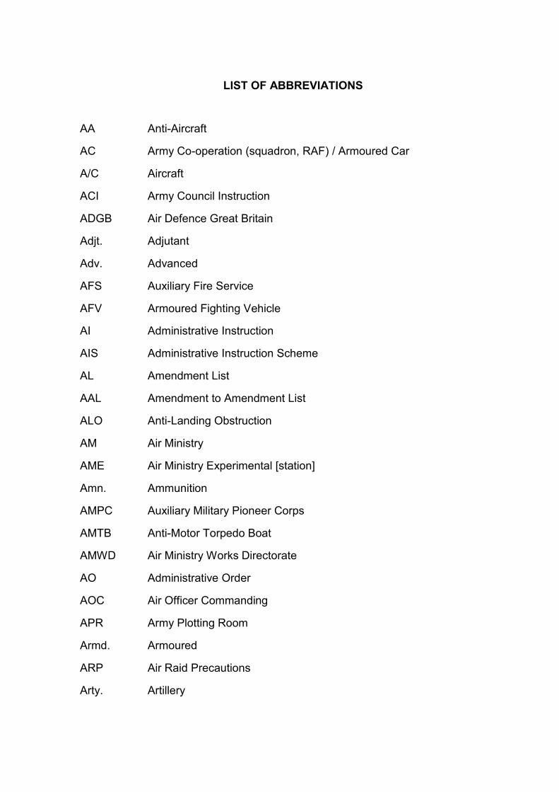
LIST OF ABBREVIATIONS
AA Anti-Aircraft
AC Army Co-operation (squadron, RAF) / Armoured Car
A/C Aircraft
ACI Army Council Instruction
ADGB Air Defence Great Britain
Adjt. Adjutant
Adv. Advanced
AFS Auxiliary Fire Service
AFV Armoured Fighting Vehicle
AI Administrative Instruction
AIS Administrative Instruction Scheme
AL Amendment List
AAL Amendment to Amendment List
ALO Anti-Landing Obstruction
AM Air Ministry
AME Air Ministry Experimental [station]
Amn. Ammunition
AMPC Auxiliary Military Pioneer Corps
AMTB Anti-Motor Torpedo Boat
AMWD Air Ministry Works Directorate
AO Administrative Order
AOC Air Officer Commanding
APR Army Plotting Room
Armd. Armoured
ARP Air Raid Precautions
Arty. Artillery

ASU Aircraft Storage Unit
A/T Anti-Tank
AW (A/W) Allan-Williams turret
BB Blacker Bombard (the 29mm spigot mortar)
BC Battery Commander
BD(S) Bomb Disposal (Section)
Bde. Brigade
BEF British Expeditionary Force
BHQ(s) Battle Headquarters
BL Breech Loading
Bn. Battalion
BOP Battery Observation Post
BPR Battery Plotting Room
BSA Brecon Sub-Area
Bty. Battery
Btys. Batteries
CA Coast Artillery
C&M Care and Maintenance
CASL Coast Artillery Searchlight
CB Counter Bombardment
CBA Council for British Archaeology
CCA Corps Coast Artillery
CCW Countryside Council for Wales (now Natural Resources Wales)
CD Close Defence
CD/CHL Coast Defence / Chain Home Low (radar)
CE Chief Engineer
CFD Commander Fixed Defences
CID Committee for Imperial Defence

C-in-C Commander-in-Chief
CIS Counter Invasion Scheme
CMP Corps of Military Police
Comd. Command
Comdr. Commander
Comn(s). Communication(s)
Con. Construction
COS Chiefs of Staff
Coy. Company
CP Command Post
CPAT Clwyd-Powys Archaeological Trust
CPM Canadian Pipe Mine (also known as the McNaughton Tube)
CRA Commander Royal Artillery
CRAPW Central Register of Aerial Photographs for Wales
CR Centre of Resistance
CRE Commander Royal Engineers
CSA Carmarthen Sub-Area or Cambrian Sub-Area
CW Chemical Warfare
DAT Dyfed Archaeological Trust
DCRE Deputy Commander Royal Engineers
DEL Defence Electric Light
DEMS Defensively Equipped Merchant Ship
Det. Detachment
DF Defensive Fire
DFW Directorate of Fortifications and Works (War Office)
DIO Defence Infrastructure Organisation (Ministry of Defence)
Div. Division
DL Defended Locality
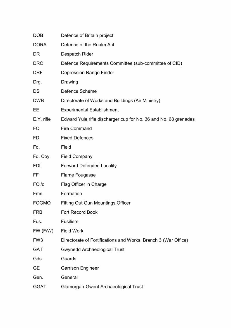
DOB Defence of Britain project
DORA Defence of the Realm Act
DR Despatch Rider
DRC Defence Requirements Committee (sub-committee of CID)
DRF Depression Range Finder
Drg. Drawing
DS Defence Scheme
DWB Directorate of Works and Buildings (Air Ministry)
EE Experimental Establishment
E.Y. rifle Edward Yule rifle discharger cup for No. 36 and No. 68 grenades
FC Fire Command
FD Fixed Defences
Fd. Field
Fd. Coy. Field Company
FDL Forward Defended Locality
FF Flame Fougasse
FOi/c Flag Officer in Charge
Fmn. Formation
FOGMO Fitting Out Gun Mountings Officer
FRB Fort Record Book
Fus. Fusiliers
FW (F/W) Field Work
FW3 Directorate of Fortifications and Works, Branch 3 (War Office)
GAT Gwynedd Archaeological Trust
Gds. Guards
GE Garrison Engineer
Gen. General
GGAT Glamorgan-Gwent Archaeological Trust

GHQ General Headquarters
Gn. Garrison
GP Gun Post
Gp. Group
GRO General Routine Order
GS General Staff or General Service
GSGS Geographical Section, General Staff
GSO III / G3 General Staff Officer responsible for operations planning and training
HAA Heavy Anti-Aircraft
HD Home Defence
HDS Home Defence Scheme
HE High Explosive
HER Historic Environment Record
HF Harassing Fire or High Frequency
HG Home Guard
HM His Majesty’s
HMG Heavy Machine Gun
HPDC Home Ports Defence Committee
HQ(s) Headquarters
Hy. Heavy
i/c In charge
In. Inch
Incl. Inclusive
Ind. Independent
Inf. Infantry
ITC Infantry Training Centre
JIC Joint Intelligence Committee
KSA Kinmel Sub-Area

KOSB King’s Own Scottish Borderers
LA Light Automatic
LAA Light Anti-Aircraft
Lancs. Lancashire
LDA Local Defence Advisor (Army officer advising on airfield defence)
LDC Local Defence Commander
LDV Local Defence Volunteers
LMG Light Machine Gun
LMSR London, Midland and Scottish Railway
LRO Local Record Office
MG Machine Gun
MI Movement Instruction
MLO Military Liaison Officer
MMG Medium Machine Gun
MOD Ministry of Defence
MU Maintenance Unit (RAF)
NCO Non-Commissioned Officer
NMRW National Monuments Record of Wales
N.N. Nomen Nescio (name unknown)
NOi/c Naval Officer in Charge
NOR National Oil Refinery
NP Nodal Point
NWA North Wales Area
NWD North Wales District
OAPU Overseas Aircraft Preparation Unit
O(s)C Officer(s) Commanding
OI Operation Instruction
OO Operation Order

OP Observation Post
Ops. Operations
OR(s) Other Rank(s)
ORB Operational Records Book (RAF)
OS Operations Scheme or Ordnance Survey
OSA Oswestry Sub-Area
OTU Operational Training Unit (RAF)
PADS Passive Air Defence Scheme/Site
PB (P/B) Pillbox
PC Pioneer Corps
Pdr. Pounder
Pl. Platoon
Pnr. Pioneer
PRO Public Records Office (now The National Archives)
PWSS Port War Signal Station
QF Quick-Firing
QM Quarter Master
QOY Queen’s Own Yeomanry
R Rifle
R&D Research and Development
RA Royal Artillery
RAF Royal Air Force
RASC Royal Army Service Corps
RCAHMS Royal Commission on the Ancient & Historical Monuments of Scotland
RCAHMW Royal Commission on the Ancient & Historical Monuments of Wales
RCE Royal Canadian Engineers
RE Royal Engineers
Regt. Regiment

RM Royal Marine
RN Royal Navy
RNAD Royal Navy Armaments Depot
RNO Royal Naval Officer
ROF Royal Ordnance Factory
RSJ Rolled Steel Joist
SAA Small Arms Ammunition
SAA Arty. School of Anti-Aircraft Artillery
Sec. Section
SIP Self-Igniting Phosphorus (grenade)
S/L Searchlight
S-mine Shrapnel Mine
SO Standing Order
SSA Severn Sub-Area or Shropshire Sub-Area
Sta. Station
Staffs. Staffordshire
Svy. Survey
SWA South Wales Area
SWB South Wales Borderers
SWD South Wales District
TA Territorial Army
TEWT Tactical Exercise Without Troops
TG Tommy gun (Thompson submachine gun)
TNA The National Archives
Tps. Troops
Trg. Training
USAAF United States Army Air Forces
VP Vulnerable Point

WAAF Women’s Auxiliary Air Force
WBSA Welsh Border Sub-Area
WC Western Command
WD War Department
WE War Establishment
WO War Office
WOFO War Office False Origin
W/T Wireless telegraphy
ZAA Rocket-equipped anti-aircraft battery

LIST OF CODE WORDS
Arras Western Command code word for ‘state of extreme tension exists’
Barbarossa German code word for the operation to invade the Soviet Union
BEETLE Western Command code word for an inter-service wireless system
Cromwell Home Forces code word for an imminent German invasion
Culverin Western Command code word for invasion use of training artillery
Ebbtide First plan to reduce British Second World War coast artillery layout
Floodtide Second plan to reduce British Second World War coast artillery layout
Mushroom Home Forces code word for the Naval Beach Mine ‘B’, Type ‘C’
Neaptide Third plan to reduce British Second World War coast artillery layout
Newton Western Command code word for ‘invasion believed imminent’
Oliver Western Command code word for ‘hostile action has occurred’
PANDA Code word for Army W/T communication system with RAF aerodromes
Sealion German code word for the operation to invade the UK
Toadstool Home Forces code word for the Naval Beach Mine ‘B’, Type ‘C’
Ypres Western Command code word for an imminent German invasion

LIST OF DEFINITIONS
The following list of 134 definitions is a sub-set of the terms used in the
English Heritage Defence of Britain Thesaurus (Historic England 2015).
Term Definition
Airfield Defence Site A site or building associated with active or passive defence of the landing ground and buildings of an airfield
Allan Williams Turret A rotating, domed, steel turret set over a circular pit used as a gun emplacement
Anti-Aircraft Battery A site containing one or more artillery pieces and/or rocket launchers for firing at enemy aircraft
Anti-Boat Landing Obstacle
Obstacles, including scaffolding and anti-tank blocks designed to impede an enemy's attempts to land forces onto open beaches
Anti-Invasion Defence Site
Sites, buildings and structures associated with the defence of the British Isles against invasion from seaborne or airborne forces
Anti-Landing Obstacle
Obstacles placed in open spaces and alongside roads designed to prevent the successful landing of enemy airborne forces
Anti-Landing Trench A purpose built trench designed to prevent the successful landing of enemy glider-borne and airborne forces
Anti-Motor Torpedo Boat Battery
A coastal battery containing one or more artillery pieces to defend the coast against hostile motor torpedo boats
Anti-Seaplane Obstacle
A purpose built obstruction placed in a stretch of water to prevent the landing of seaplanes or flying boats
Anti-Submarine Defence
Defence sites and structures including passive and active defences such as netting, chain booms and mines designed to prevent submarines approaching strategic ports
Anti-Tank Block A reinforced concrete block designed to obstruct the progress of a tank or armoured vehicle. Use more specific type where known (Buoy, Caltrop, Coffin, Cone, Cube, Cylinder, Pimple, Tetrahedron)
Anti-Tank Ditch A ditch designed to obstruct the progress of a tank or armoured vehicle. Use more specific type where known
Anti-Tank Ditch (Artificial)
A man made ditch designed to obstruct the progress of a tank or armoured vehicle. Ditches were often revetted with concrete or wood
Anti-Tank Ditch (Natural Improved)
A natural ditch the depth and/or width of which has been increased so as to prevent the progress of a tank or armoured vehicle
Anti-Tank Girder A metal girder, usually of iron or steel, embedded in the ground designed to obstruct the progress of hostile tanks or armoured vehicles
Anti-Tank Gun Emplacement
A defensive structure or site where an anti-tank gun is situated
Anti-Tank Hairpin A road block formed by placing curved rails, ‘hairpins’, in sockets in the road surface
Anti-Tank Island A designated area within a town or village with fixed defences such as pillboxes, anti-tank ditches and gun emplacements, designed to threaten the flanks of an enemy force which had broken through a stop line
Anti-Tank Obstacle Obstacles, usually constructed of concrete and/or metal, designed to prevent the advance of enemy armoured divisions in the event of a successful invasion
Anti-Tank Scaffolding Scaffolding intended to impede the advance of enemy armoured divisions. Often found in association with ‘one way’ anti-tank ditches
Anti-Tank Vertical Rail
A road block formed by placing rails or girders in an upright position in sockets in the road surface, forming a moveable barrier (hedgehog)
Anti-Tank Wall A wall, usually of reinforced concrete, designed to obstruct the progress of a tank or armoured vehicle

Barbed Wire Entanglement
One or more coils of barbed wire intended to impede the advance of hostile troops
Barrel Flame Trap An anti-personnel device consisting of a 40 gallon fuel drum placed on top of an explosive charge and detonator. When detonated the barrel would explode sending burning fuel over the intended target. Use for flame fougasse
Battery Observation Post
A building used to observe the movements of hostile aircraft or shipping
Battle Headquarters (11008/41)
A concrete structure, based on drawing number (11008/41), intended to be the headquarters for the coordination of an airfield's defences. Constructed partially underground it was considered less vulnerable than the (3329/41)
Battle Headquarters (3329/41)
A structure, based on drawing number (3329/41), intended to be the headquarters for the coordination of an airfield's defences. Constructed above ground this design was found to be vulnerable and was superseded by the (11008/41)
Beach Defence Battery
A battery, usually a single gun often in a pillbox, situated so as to provide enfilading fire along a beach to prevent hostile forces from advancing inland
Beach Defence Light A searchlight battery used to light a beach
Beach Scaffolding Scaffolding erected on a beach and in the surf so as to prevent hostile forces from landing
Bison Mobile Pillbox A flatbed lorry with a concrete defensive position fitted on the back enabling the ‘pillbox’ to be driven to where it was most needed in the event of an airborne force landing on the airfield
Boom Defence A bar, chain or other obstruction stretched across a waterway to obstruct navigation
Buoy Blocks of solid concrete, in the shape of a round bottomed cone usually 2 feet 6 inches across x 2 feet 9 inches high. Buoys were mainly used in road blocks intended to impede enemy movement in the event of invasion
Cable A cable, usually erected between posts, used to prevent the landing of hostile aircraft
Caltrop Blocks of concrete with four protruding arms so that, whichever way up the caltrop is placed, one arm will always point upward. Used in imitation of the iron caltrops thrown on the ground to impede cavalry
Canadian Pipe Mine A steel pipe driven into the ground at a shallow, oblique angle and packed with explosives. They were intended to be detonated on the approach of a hostile armoured vehicle or tank in order to create an obstacle directly in its path (use for McNaughton Tube)
Centre of Resistance An area, often a village, with fixed defences such as pillboxes, anti-tank ditches and gun emplacements, designed to stop the advance of an enemy force and to hold out for an agreed period of time
Close Defence Battery
A coastal battery designed for use in short range engagements with enemy vessels, minelayers, blockships and torpedo craft
Coast Artillery Battery
A defensive battery positioned facing out to sea enabling the guns to be brought to bear on enemy shipping and amphibious craft
Coast Artillery Searchlight
A searchlight battery, which faces out to sea, used to locate and illuminate enemy shipping
Coast Battery Gun Site
A gun emplacement associated with a coastal battery
Coast Defence Chain Home Low Station
A radar station with sets operating on a wavelength of 1.5m established to provide radar plotting of both shipping and aircraft movements
Coastal Battery A site including artillery pieces and associated structures directed out to sea to engage enemy shipping and defend the coastline. Use more specific term where known
Coastal Observation Post
A building, situated on the coast, used for observing the movements of shipping

Coffin Rectangular slabs of concrete with a sloping top usually with sides of 5 feet by 3 feet and 3 feet high which when placed in rows were intended to form a substantial barrier to enemy armoured divisions in the event of invasion
Cone Cones of solid concrete usually 3 feet 6 inches in diameter x 2 feet high which, when placed in rows or groups were intended to form a substantial barrier to enemy armoured divisions in the event of invasion
Counter Bombardment Battery
A coastal battery used for delivering fire at long distance thus forcing a warship threatening or bombarding shore installations to withdraw out of range
Cube Cubes of solid concrete, usually with sides of 3 feet 6 inches or 5 feet which when placed in rows were intended to form a substantial barrier to enemy armoured divisions in the event of invasion
Cylinder Blocks of solid concrete, in the form of cylinders usually 2 feet across x 2 feet 6 inches or 3 feet high. Cylinders were mainly used in road blocks intended to impede enemy movement in the event of invasion
Dannert Wire Barbed wire in the form of a coil which could be extended concertina-like to form a barrier to impede the movement of hostile troops
Defence Line A system of defensive works such as anti-tank obstacles, ditches and pillboxes, designed to stop the advance of an enemy. Defence lines were constructed across and around strategic areas of ground and sites such as industrial towns
Defended Building A building which has been altered to increase its defensive characteristics. Use more specific term where known (Fortified House, Loopholed Wall, Section Post)
Defended Locality An area, with fixed defences, designed to act as a focal point for a defending force
Demolition Chamber A chamber built into a structure, such as a bridge, in which an explosive, demolition charge could be placed. The charge could then be inserted in the event of an invasion
Demolition Charge Site
A site used for the placing of an explosive, demolition charge. Many types of structures were prepared for demolition in the event of an invasion in order to cause the maximum disruption to the advance of hostile forces. Use more specific type where known (Canadian Pipe Mine, Demolition Chamber, Mined Road, Mined Bridge)
Emergency Coast Defence Battery
A coastal battery constructed at short notice usually mounting a variety of artillery pieces
Extended Defence Officers Post
An observation post for a naval officer in charge of a marine minefield
Fieldwork A usually temporary earthwork or fortification, constructed by military forces operating in the field. Use more specific type where known (Infantry Post, Rifle Pit, Trench, Weapons Pit)
Fortified House A house which bears signs of fortification often including the addition of loopholes
Fougasse A pit filled with rocks and metal, designed to be fired with an explosive charge
Gun Emplacement A fortified site in which a gun, mortar or cannon is positioned
Gun Emplacement (Type 55414)
A fortified site in which a gun, mortar or cannon is positioned and which conforms to Department of Fortification and Works drawing number 55414
Gun Emplacement (Type 55415)
A fortified site in which a gun, mortar or cannon is positioned and which conforms to Department of Fortification and Works drawing number 55415
Gun Emplacement (Type 55422)
A gun emplacement which conforms to Department of Fortification and Works drawing number 55422
Gun Emplacement (Type 55483)
A gun emplacement which conforms to Department of Fortification and Works drawing number 55483
Gun Emplacement (Type 55491)
A gun emplacement which conforms to Department of Fortification and Works drawing number 55491

Gun Emplacement (Type 55503)
A gun emplacement which conforms to Department of Fortification and Works drawing number 55503
Headquarters A building used for the daily administration of an organisation or military force
Heavy Anti-Aircraft Battery
An anti-aircraft battery usually mounting weapons with a larger calibre ammunition such as the QF 3.75 inch (94mm) gun
Home Guard Headquarters
A building used as the headquarters for the Home Guard during the Second World War
Home Guard Observation Post
An observation post used by members of the Home Guard
Infantry Post A defensive position, often constructed from sandbags, designed to protect a group of infantry (use for rifle post)
Keep An existing building which has been designated as the last point of defence in a defended locality, nodal point or centre of resistance. If all else failed the Keep would be used as a last ditch defence
Light Anti-Aircraft Battery
An anti-aircraft battery usually mounting smaller, faster weapons such as Bofors guns, intended to engage fast low flying aircraft
Loopholed Wall A wall containing apertures to allow a weapon to be fired through it
Lyon Light Emplacement
An emplacement mounting a small, portable electrically-powered searchlight
Machine Gun Emplacement
A structure, usually concrete or sandbags, in which a machine gun was emplaced
Machine Gun Post An open walled structure built of concrete, brick or sandbags which enclosed one or more machine-guns mounted on pintels for light anti-aircraft and ground defence
Mined Bridge A bridge which has had mines placed within its structure to enable it to be destroyed in the event of an invasion
Mined Road A road which has had mines placed within its structure to enable it to be destroyed in the event of an invasion
Minefield An area of ground or water containing explosive mines
Minewatcher’s Post A building with small observation ports used for plotting mines dropped by parachute
Nodal Point A designated area, usually sited at a strategic crossroads, with fixed defences such as pillboxes, anti-tank ditches and gun emplacements, designed to act as a rallying point for defenders
Observation Post A building or site for watching specific military activities or the movement of enemy forces, etc.
Pedestal A concrete, cylindrical pedestal on which a spigot mortar was mounted. The pedestal is often the only evidence for a Spigot Mortar emplacement to survive
Petroleum Warfare Site
A site, usually including fuel tanks, pipe works and control buildings, where flaming petroleum was intended to be used as a weapon against a hostile invasion
Pickett Hamilton Fort A sunken, circular, concrete pillbox used on airfields. They remained flush with the surface to permit the free movement of aircraft, but if attack threatened, could be raised, hydraulically or by a counterbalance, and manned to give covering fire
Pillbox An often squat building with thick, loopholed walls and a flat roof, designed to accommodate a variety of weapons, usually strategically positioned to cover a vulnerable point in a defensive system
Pillbox (Air Ministry Pattern)
A pillbox built to a design drawn up by the Air Ministry. Usually found near airfields
Pillbox (Cantilevered) A pillbox in which the roof is detached from the walls and supported by a central pillar, thus leaving an embrasure allowing a 360 degree field of fire
Pillbox (Modified) A pillbox which has been modified from a standard Directorate of Fortifications and Works design. Double index with specific type where known

Pillbox (Prefabricated)
A pillbox constructed of prefabricated concrete panels. Double index with specific type where known
Pillbox (Shellproof) A pillbox with walls that have been thickened to protect against shells. Double index with specific type where known
Pillbox (Type CE391) A pillbox built to a design drawn up by the chief engineer of GHQ Home Forces
Pillbox (Type CE124/41)
A pillbox built to a design drawn up by the chief engineer of South-Eastern Command
Pillbox (Type CE2717)
A pillbox built to a design drawn up by the chief engineer of Scottish Command
Pillbox (Type CE2843)
A pillbox built to a design drawn up by the chief engineer of Scottish Command
Pillbox (Type CE390) A pillbox built to a design drawn up by the chief engineer of GHQ Home Forces
Pillbox (Type CP/6/40/111)
A circular pillbox, usually consisting of a concrete pipe with a timber and corrugated iron roof, surrounded and covered by earth and sandbags. Built to a design by Norcon Ltd, a company dealing in concrete pipes
Pillbox (Type CRE TL62)
A pillbox built to a design drawn up by the commander of the Royal Engineers in Southern Area (Taunton Stop Line)
Pillbox (Type CRE1094)
A pillbox built to a design by the commander of the Royal Engineers for the Colchester Garrison
Pillbox (Type CRE1116)
A pillbox built to a design by the commander of the Royal Engineers for the Colchester Garrison
Pillbox (Type FW3/22)
A hexagonal pillbox, with an internal anti-ricochet wall and loopholes for five Light Machine Guns and one rifle. Originally designed to have 15in bulletproof walls many were built with 42in thick shellproof walls. Designed by DFW branch 3
Pillbox (Type FW3/23)
A rectangular pillbox with an enclosed square plan section for three Light Machine Guns and an adjacent open area housing a mounting for a Light Anti-Aircraft weapon. Designed by DFW branch 3
Pillbox (Type FW3/24)
A hexagonal pillbox with an internal anti-ricochet wall and the rear wall lengthened to take two rifle loopholes in addition to five Light Machine Gun loopholes. Both 15in and 42in thick walls are common. Designed by DFW branch 3
Pillbox (Type FW3/25)
A circular pillbox designed by the Engineering and Metals Company using 'Armco' corrugated iron sheets as the inner and outer skins into which concrete was poured, giving a 12in wall thickness. The design was taken up by DFW and assigned a drawing number
Pillbox (Type FW3/26)
A square pillbox with loopholes for four Light Machine Guns and walls 18in thick. Probably designed by DFW branch 3 although it may have been adapted from an external source as Southern Command correspondence refer to the type as 'Stento'
Pillbox (Type FW3/27)
A large octagonal pillbox, with a projecting entrance, equipped with loopholes for eight Light Machine Guns and a Light Anti-Aircraft mounting sited in a central well which was accessed from inside the pillbox. Designed by DFW branch 3
Pillbox (Type FW3/28)
A square pillbox with walls up to 48in thick, designed to emplace a 2 pounder anti-tank gun. A large opening in the back allowed the gun to be wheeled into position at the large embrasure in the front wall. Designed by DFW branch 3
Pillbox (Type FW3/28A)
A large, rectangular pillbox based on the FW3/28 with the addition of a small infantry chamber to one side of the main gun chamber
Pillbox (Type FW3/45)
A pillbox design, assigned a drawing number by DFW branch 3
Pillbox (Type FW3/46)
A pillbox design, assigned a drawing number by DFW branch 3

Pillbox (Type PD541) A circular pillbox designed by the Croft Granite, Brick and Concrete Company, with six loopholes. With no roof or door access was gained through the roof
Pillbox (Variant) A pillbox which varies from the standard designs
Pimple Blocks of solid concrete in the form of truncated pyramids usually 3 feet square x 2 feet high which could be placed in rows to impede enemy movement in the event of invasion. Pimples were recommended for use on soft ground. (Use for Dragons Teeth and Sharks Teeth)
Pole A telegraph pole, tree trunk or similar erected on the side of a road, or in an open space, to prevent the landing of hostile aircraft
Railblock Obstacles, often semi-permanent, which are placed on railway lines to prevent the enemy from using them. Set up during the defence of Britain
Rifle Pit A pit dug to protect a small group of infantry men
Roadblock A combination of obstructions, used either to stop enemy forces or force them off the road
Ruck Machine Gun Post
A machine gun post designed by James Ruck constructed from hollow concrete blocks and prefabricated concrete sheeting with loopholes allowing for a garrison of eight
Seagull Trench A trench in the form of a flattened 'W' with a flat concrete roof covered in turf, supported on concrete pillars. The name derives from the resemblance to a child's drawing of a seagull in flight
Section Post A large pillbox-like structure, often L-shaped or angular, with numerous loopholes used as a defensive position
Slit Trench A short trench used to protect troops or to provide defensive fire from, often dug for practice purposes
Spigot Mortar Emplacement
A pit or emplacement surrounding a concrete pedestal, or 'thimble', which was used to mount a spigot mortar. Deployed by the Home Guard during WWII as an anti-invasion measure
Stop Line A notional line of resistance defined by anti-tank obstacles, pillboxes and gun emplacements
Strongpoint A fortified position, often including fieldworks or defensive structures, designed to keep enemy forces engaged to allow reinforcements to be mobilized
Tetrahedron Triangular concrete pyramids with 6 feet long sides and 5 feet high, intended to impede enemy movement in the event of invasion. Thought to be confined geographically to Southern Command
Tett Turret A small concrete turret placed on top of a standard 4ft diameter concrete pipe sunk into the ground intended for use in defending road junctions
Torpedo Station A land based establishment armed with torpedoes and used to defend the coast from enemy shipping
Trench A linear fieldwork dug as a means of concealment, protection or both
Vickers Machine Gun Emplacement
A square, concrete pillbox-like structure with 36in thick walls and a single large embrasure used to emplace a Vickers Medium Machine Gun. The entrance was protected by an external blast wall
Vulnerable Defile A pass, vulnerable to attack from the enemy but essential for the movement of troops and which, if captured, could divide a defending force. As a result such passes are defended with anti-invasion defences such as pillboxes
Weapons Pit Usually a small, two or three man trench, dug as an isolated fieldwork rather than as part of a defensive system. A WWI and WWII feature
Z Battery An anti-aircraft battery armed with 3 inch rockets with a ceiling of 22,000 feet. Both single and multiple launchers were designed. Single launchers being used to defend vulnerable points such as coastal batteries with multiple launchers defending towns

LIST OF MAPS
Map 1: St Athan-Llandow Case Study (1:100,000)
Map 2: Swansea-Gower Case Study (1:200,000)
Map 3: Carmarthen Stop Line Case Study (1:300,000)
Map 4: Limpert Bay Linear Defences (1:20,000)
Map 5: RAF Fairwood Common (Air Ministry Record Site Plan) (1:20,000)
Map 6: Carmarthen Defences (1:30,000)
Copyright acknowledgement
Maps 1-3 utilise Ordnance Survey digital mapping. © Crown Copyright and
Database Rights 2016. Ordnance Survey (Digimap Licence)
Maps 4-5 utilise Landmark Epoch 3 Second County Series Revision digital mapping
(1904-39). © Crown Copyright and Landmark Information Group Limited 2016. All
rights reserved (Digimap Licence)
Map 6 utilises Landmark Epoch 2 First County Series Revision digital mapping
(1891-1912). © Crown Copyright and Landmark Information Group Limited 2016. All
rights reserved (Digimap Licence)


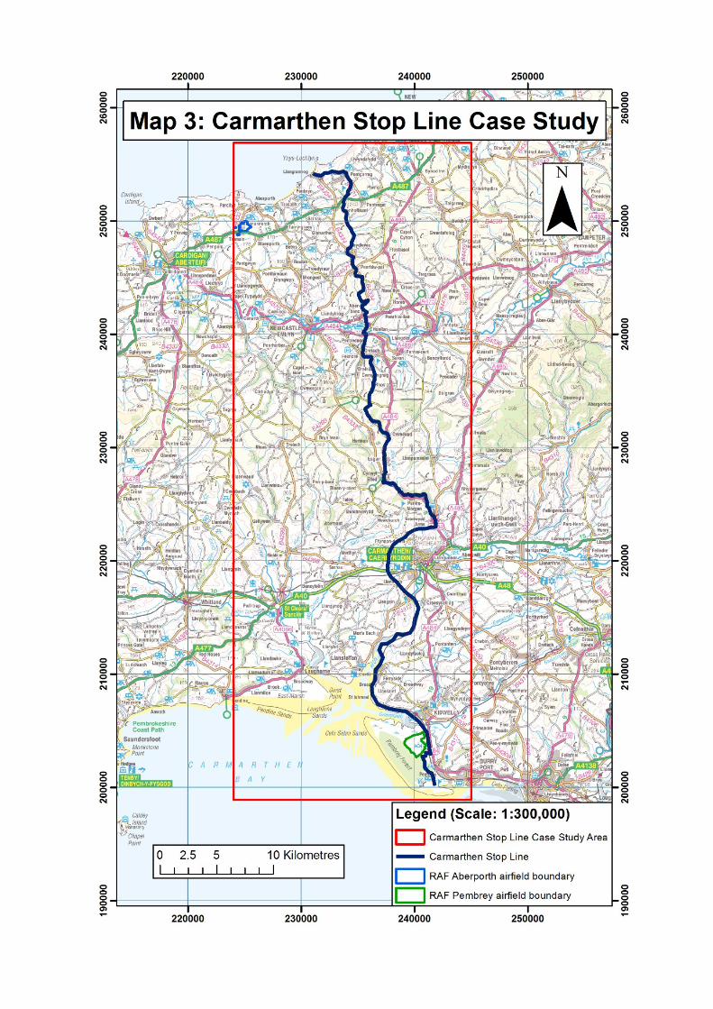
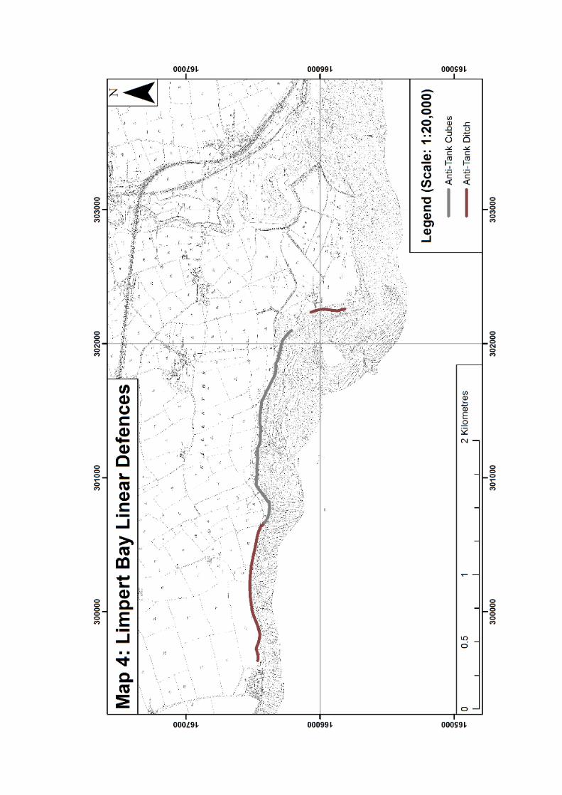


LIST OF APPENDICES
Appendix 3.1: List of Command, Area/District, Sub-Area and Garrison Operation
Instructions, Orders and Schemes for Wales 1940-42.
Appendix 5.1: Text of Severn Sub-Area Home Defence Scheme No. 2 as preserved
at The National Archives (WO 166/1314)
Appendix 5.2: Text of 10 (Cowbridge) Battalion, Glamorgan Home Guard Defence
Scheme as preserved at Llantwit Major Local History Society
Appendix 5.3: List of identified defence sites for St Athan-Llandow case study
Appendix 6.1: Text of Swansea Defence Scheme No. 2 as preserved in Swansea
Garrison HQ war diary at The National Archives (WO 166/6880)
Appendix 6.2: Defence Posts listed in Swansea Defence Scheme No. 2, Swansea
Garrison HQ war diary, 1942 (WO 166/6880)
Appendix 6.3: Minefields, Canadian pipe mines and flame fougasse sites listed in
Swansea Defence Scheme No. 2, Swansea Garrison HQ war diary, 1942 (WO
166/6880)
Appendix 6.4: Roadblock sites listed in Swansea Defence Scheme No. 2, 21 May
1942, Swansea Garrison HQ war diary, 1942 (WO 166/6880)
Appendix 6.5: Selected extracts from Swansea Garrison HQ war diary, 1942 (WO
166/6880)
Appendix 6.6: List of identified defence sites for Swansea-Gower case study
Appendix 7.1: Text of Counter-invasion Scheme No. 2 as preserved in Carmarthen
Sub-Area HQ war diary at The National Archives (WO 166/6729)
Appendix 7.2: Selected extracts from Carmarthen Sub-Area HQ war diaries, 08/40-
12/41 (WO 166/1270) and 01-12/42 (WO 166/6729)
Appendix 7.3: List of identified defence sites for Carmarthen Stop Line case study

Appendix 3.1: List of Command, Area/District, Sub-Area and Garrison
Operation Instructions, Orders and Schemes for Wales 1940-42.
Western Command General Staff operation instructions and amendments
The following Operation Instructions, Artillery Instructions and Movement Instructions, together with their subsequent amendments are preserved in the Western Command General Staff war diaries for 1939-40 (WO 166/94), 1941 (WO 166/103) and 1942 (WO 166/6025) at The National Archives.
Date Number Title
12/04/40 Western Command Home Security Scheme, 1940
15/05/40 Western Command Scheme for Defence Against Enemy Landings
04/06/40 Western Command Scheme for Defence Against Enemy Landings: amendment
05/06/40 WC OI 2 [Defence of Liverpool]
09/06/40 WC OI 3 [Western Command Defence Scheme]
10/06/40 WC OI 3 A 1
18/06/40 WC OI 4 [Relaxation of state of alert to allow training]
28/06/40 WC OI 3 A 2 [Disturbance of crops]
29/06/40 WC OI 5 [Mobile columns]
04/07/40 WC OI 6 Intelligence and inter-communication
05/07/40 WC OI 7 Co-ordination of defence [and stop line list]
09/07/40 WC OI 8 [Information to HQ III Corps]
10/07/40 WC OI 9 [Information to HQ 23 Tank Brigade]
14/07/40 WC OI 10 Immediate operations
19/07/40 WC OI 11 [Movement of 4 London Inf. Bde. Gp. to SW Wales]
20/07/40 WC OI 12 Armed personnel in training and other establishments and units in Western Command: policy in event of invasion
22/07/40 WC OI 13 Comd. South Wales Area
22/07/40 WC OI 14 Comd. North Wales Area
24/07/40 WC OI 15 Comdr. III Corps
08/08/40 AA protection of merchant shipping
15/08/40 WC OI 16 Defensive works
22/08/40 WC OI 17 Action to deal with parachutes
? WC OI 18 [Unknown content]
31/08/40 WC OI 19 Action to be taken by troops on receipt of red air raid warning
03/09/40 WC OI 21 Roadblocks
05/09/40 WC OI 20 Preliminary movement or troops to Winter dispositions
19/08/40 WC AI 6 A 2 [6-pdr mobile guns]
06/09/40 WC AI 6 A 3 [6-pdr mobile guns]
?06/09/40 WC OI 22 Comd. 2 London Div.
12/09/40 WC OI 23 Comd. 38 Div.
14/09/40 WC OI 24 Movement of Fd. units to Winter dispositions
14/09/40 WC OI 20 A 1 [New appendices]
15/09/40 WC OI 26 Comdr. III Corps
17/09/40 WC OI 25 Home Guards: code words
17/09/40 WC OI 27 Air support and co-operation in the event of active operations in Western Command
26/09/40 WC OI 28 Comd. West Lancs. Area
02/10/40 WC OI 20 A 3 [New appendix]
07/10/40 WC OI 29 States of readiness of Tps. guarding RAF aerodromes
14/10/40 WC OI 30 States of readiness of Tps. guarding RAF aerodromes [WC OI 29 cancelled]
25/10/40 WC OI 31 Relief of 38 Div. by 5 Div.
01/11/40 WC OI 32 Comd. 5 Division

11/11/40 WC OI 33 Command of field formations
11/11/40 WC OI 34 Code words
16/11/40 WC OI 35 Comd. South Wales Area
07/12/40 WC OI 36 Comd. 47 Div [WC OI 22 cancelled]
16/12/40 WC OI 37 Intelligence and intercommunication
30/01/41 WC OI 38 [Movements from, to and within the Command]
31/01/41 WC OI 38 A 1
01/02/41 WC OI 38 A 2
03/02/41 WC OI 38 A 3
03/02/41 WC OI 38 A 4
? WC OI 38 A 5 [Unknown content]
08/02/41 WC OI 38 A 6
08/02/41 WC OI 39 Movement of 47 Div. to South Eastern Command
08/02/41 WC OI 39 A 1
09/02/41 WC OI 39 A 2
10/02/41 WC OI 39 A 4
10/02/41 WC OI 40 Home Guard: state of readiness and code words
11/02/41 WC OI 41 Instructions to Comd. South Wales Area
11/02/41 WC OI 42 Mobile columns and local defences
12/02/41 WC OI 43 Immobilisation of ports and vessels
13/02/41 WC OI 39 A 5
13/02/41 WC OI 44 Home Guards: feeding when mustered
15/02/41 WC OI 43 A 1
17/02/41 WC OI 45 Instructions to Comd. 31 Inf. Bde. Gp.
18/02/41 WC OI 46 [Statement on status of Command Instructions]
18/02/41 WC OI 43 A 2
20/02/41 WC OI 47 Instructions to Comd. Central Midland Area
21/02/41 WC OI 48 Instructions to Comd. East Lancs. Area
21/02/41 WC OI 49 Instructions to Comd. West Lancs. Area [WC OI 28 cancelled]
21/02/41 WC OI 50 Instruction to formation Comds. 11 Armd. Div.
21/02/41 WC OI 51 Instructions to Comd. North Wales Area
21/02/41 WC OI 46 A 1
24/02/41 WC OI 52 Vulnerable points and static guards
24/02/41 WC OI 54 Protection of aerodromes
28/02/41 WC OI 53 States of readiness, code words and intercom signals
03/03/41 WC OI 43 A 3 New appendix
04/03/41 WC OI 55 Organisation III Corps
09/03/41 WC OI 56 Demolitions and air landing obstacles
10/03/41 WC OI 57 Role of 50 Div. if allotted
10/03/41 WC OI 58 Irish refugees, aliens at large and suspicious persons
10/03/41 WC OI 59 Reports on the use of gas
14/03/41 WC OI 60 Procedure at roadblocks
16/03/41 WC OI 61 Instructions to 59 Div.
16/03/41 WC OI 62 Instructions to Comd. 73 Ind. Bde.
16/03/41 WC OI 63 Defence measures
16/03/41 WC OI 64 Denial of petrol resources
17/03/41 WC OI 65 Command reserves
18/03/41 WC OI 66 Restrictions on roads and vehicles
18/03/41 WC OI 67 Intercommunication and liaison
21/03/41 WC OI 68 Immobilisation of motor vehicles
26/03/41 WC OI 69 [Motor transport on action stations]
30/03/41 WC OI 70 Action against parachutists
30/03/41 WC OI 71 Relief of 5 Div. by 18 Div.
31/03/41 WC OI 72 Denial of food resources
? [WC OI 57 cancelled]

01/04/41 WC OI 73 Instructions to III Corps
01/04/41 WC OI 71 A 1
02/04/41 WC OI 74 Roles of 54 Div. within Western Command
03/04/41 WC OI 75 RAF support and co-operation
03/04/41 WC OI 76 BEETLE [inter-service wireless system]
01/04/41 AL 1 Amendments to WC OIs 37, 40, 43, 46, 53, 58, 63, 64, 66, 67 and 69
10/04/41 AAL 1 Amendments to WC OI 58 and 64
13/04/41 WC OI 77 Measures to minimise effects of enemy air action
13/04/41 WC OI 78 Comd. 18 Div.
07/05/41 AL 2 Amendment to WC OI 53
18/05/41 AL 3 Amendment to WC OIs 53, 58 and 76. WC OIs 55, 62 and 73 cancelled
26/05/41 AL 4 Amendment to WC OI 53
28/05/41 AL 5 Amendment to WC OI 53
10/06/41 AL 6 Amendment to WC OI 65
11/06/41 AL 7 Amendment to WC OIs 53 and 63
11/06/41 WC OI 79 Denial of petrol resources
27/06/41 WC OI 80 Military road movement in operations
03/07/41 AL 8 Amendments to WC OIs 43, 53, 58, 61, 65, 67, 72, 74, 75, 76 and 78. WC OIs 32 and 71 cancelled
05/07/41 AAL 8 Amendment to WC OI 58
09/07/41 WC OI 81 W/T Comn. to aerodromes (PANDA scheme)
10/07/41 WC OI 82 [Repositioning of formations]
16/07/41 AL 9 Amendments to WC OIs 41, 43, 45 and 76
28/07/41 WC OI 76 A
28/07/41 AL 10 Amendments to WC OIs 63, 67, 76, 79 and 82
29/07/41 WC OI 81 A 1 New appendix
29/07/41 AL 11 Amendments to WC OI 80
01/08/41 WC OI 83 Role of 18 Div.
01/08/41 WC OI 84 Instructions to 31 Ind. Bde. Gp.
04/09/41 WC OI 85 Supply of stores for engineer requirements in case of operations
07/09/41 WC OI 86 Employment of liaison officers
09/09/41 AL 12 Amendments to WC OIs 53, 61, 63, 67 and 77
14/09/41 WC OI 87 Reports on the use of gas
22/09/41 WC OI 88 Immobilisation of vehicles
22/09/41 WC OI 89 Restrictions on roads
27/09/41 AL 13 Amendments to WC OI 79
03/10/41 AL 14 Amendments to WC OI 79
06/10/41 WC OI 90 States of readiness and local protection Winter 1941-42
08/10/41 WC OI 91 Use of AA Comns. by Home Forces units in Western Command
07/11/41 AL 15 Amendments to WC OIs 43, 53, 58, 65, 83, 88 and 90
10/11/41 WC OI 92 Organisation within Sub-Areas
13/11/41 AL 16 Amendment to WC OI 79
20/11/41 WC OI 93 Miscellaneous points
22/11/41 WC OI 94 Types and scales of likely attacks
08/12/41 WC OI 95 Instructions to Comd. West Lancs. District
08/12/41 WC OI 96 Instructions to Comd. South Wales District
08/12/41 WC OI 97 Instructions to Comd. Central Midland District
08/12/41 WC OI 98 Instructions to Comd. North Wales District
08/12/41 WC OI 99 Instructions to Comd. East Lancs. District
11/12/41 AL 17 Amendments to WC OIs 42, 43, 52, 53, 56, 58, 63, 69, 75, 77, 83, 88 and 90
27/12/41 WC OI 100 Instructions to Comd 53 Div.
28/12/41 WC OI 101 Home Guard: states of readiness and code words
09/01/42 WC OI 102 BEETLE inter-service wireless system
16/01/42 AL 18 Amendments to WC OIs 21 and 53
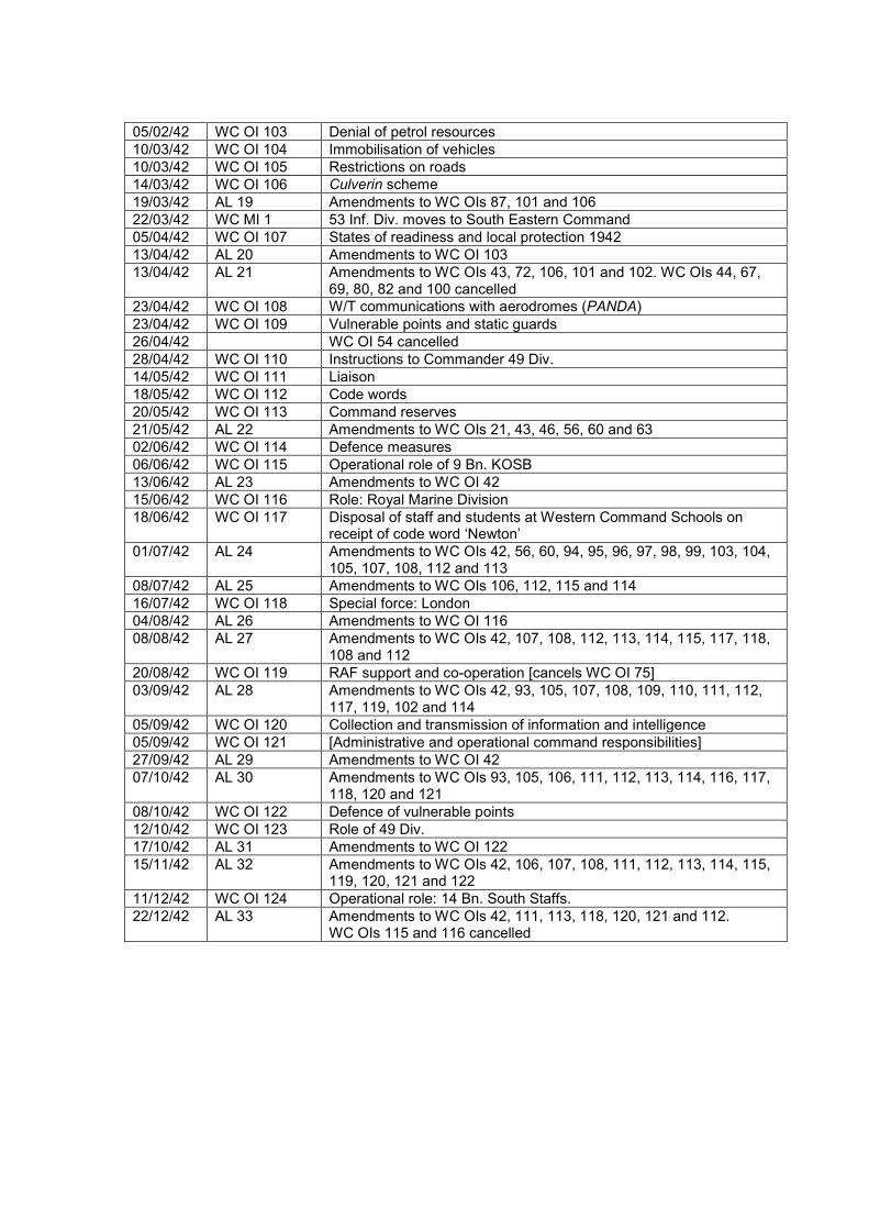
05/02/42 WC OI 103 Denial of petrol resources
10/03/42 WC OI 104 Immobilisation of vehicles
10/03/42 WC OI 105 Restrictions on roads
14/03/42 WC OI 106 Culverin scheme
19/03/42 AL 19 Amendments to WC OIs 87, 101 and 106
22/03/42 WC MI 1 53 Inf. Div. moves to South Eastern Command
05/04/42 WC OI 107 States of readiness and local protection 1942
13/04/42 AL 20 Amendments to WC OI 103
13/04/42 AL 21 Amendments to WC OIs 43, 72, 106, 101 and 102. WC OIs 44, 67, 69, 80, 82 and 100 cancelled
23/04/42 WC OI 108 W/T communications with aerodromes (PANDA)
23/04/42 WC OI 109 Vulnerable points and static guards
26/04/42 WC OI 54 cancelled
28/04/42 WC OI 110 Instructions to Commander 49 Div.
14/05/42 WC OI 111 Liaison
18/05/42 WC OI 112 Code words
20/05/42 WC OI 113 Command reserves
21/05/42 AL 22 Amendments to WC OIs 21, 43, 46, 56, 60 and 63
02/06/42 WC OI 114 Defence measures
06/06/42 WC OI 115 Operational role of 9 Bn. KOSB
13/06/42 AL 23 Amendments to WC OI 42
15/06/42 WC OI 116 Role: Royal Marine Division
18/06/42 WC OI 117 Disposal of staff and students at Western Command Schools on receipt of code word ‘Newton’
01/07/42 AL 24 Amendments to WC OIs 42, 56, 60, 94, 95, 96, 97, 98, 99, 103, 104, 105, 107, 108, 112 and 113
08/07/42 AL 25 Amendments to WC OIs 106, 112, 115 and 114
16/07/42 WC OI 118 Special force: London
04/08/42 AL 26 Amendments to WC OI 116
08/08/42 AL 27 Amendments to WC OIs 42, 107, 108, 112, 113, 114, 115, 117, 118, 108 and 112
20/08/42 WC OI 119 RAF support and co-operation [cancels WC OI 75]
03/09/42 AL 28 Amendments to WC OIs 42, 93, 105, 107, 108, 109, 110, 111, 112, 117, 119, 102 and 114
05/09/42 WC OI 120 Collection and transmission of information and intelligence
05/09/42 WC OI 121 [Administrative and operational command responsibilities]
27/09/42 AL 29 Amendments to WC OI 42
07/10/42 AL 30 Amendments to WC OIs 93, 105, 106, 111, 112, 113, 114, 116, 117, 118, 120 and 121
08/10/42 WC OI 122 Defence of vulnerable points
12/10/42 WC OI 123 Role of 49 Div.
17/10/42 AL 31 Amendments to WC OI 122
15/11/42 AL 32 Amendments to WC OIs 42, 106, 107, 108, 111, 112, 113, 114, 115, 119, 120, 121 and 122
11/12/42 WC OI 124 Operational role: 14 Bn. South Staffs.
22/12/42 AL 33 Amendments to WC OIs 42, 111, 113, 118, 120, 121 and 112. WC OIs 115 and 116 cancelled

South Wales Area / District HQ Operation Instructions
NB. No Operation Instructions or Defence Schemes survive within the South Wales Area HQ war diary
for 1939-41 (WO 166/1247) or the South Wales District HQ war diary for 1942 (WO 166/6840) at The
National Archives.
Early Sub-Area HQ Operation Instructions and Amendments
NB. The Sub-Area HQ war diaries for Cardiff Sub-Area, Glamorgan Sub-Area, Monmouth Sub-Area,
Brecon Sub-Area, South Wales Sub-Area and South West Wales Sub-Area do not appear in the
catalogue of The National Archives and the researcher was unable to determine whether they survive.
Severn Sub-Area HQ operation instructions and amendments
The following Home Defence Scheme and subsequent amendments are preserved in the Severn Sub-Area HQ war diaries for 1940-41 (WO 166/1314) and 1942 (WO 166/6771) at The National Archives.
Date Number Title
14/12/40 HDS 2 Severn Sub-Area Home Defence Scheme No. 2
22/01/41 HDS 2 A2 Severn Sub-Area Home Defence Scheme No. 2
27/02/41 HDS 2 A3 Severn Sub-Area Home Defence Scheme No. 2
23/03/41 HDS 2 A4 Severn Sub-Area Home Defence Scheme No. 2
11/04/41 HDS 2 A5 Severn Sub-Area Home Defence Scheme No. 2
01/06/41 HDS 2 A6 Severn Sub-Area Home Defence Scheme No. 2
24/06/41 HDS 2 A7 Severn Sub-Area Home Defence Scheme No. 2
07/07/41 HDS 2 A8 Severn Sub-Area Home Defence Scheme No. 2
04/09/41 HDS 2 A9 Severn Sub-Area Home Defence Scheme No. 2
11/09/41 HDS 2 A10 Severn Sub-Area Home Defence Scheme No. 2
09/01/42 HDS 2 A12 Updates, including replacement Appendix Y: immobilisation of ports and new Appendix ZK: miscellaneous points
01/09/42 CIS Issue
09/11/42 CIS A2 Updated appendices
Carmarthen Sub-Area HQ operation instructions and amendments
NB. No Operation Instructions or Defence Schemes survive within the Carmarthen Sub-Area HQ war
diary for 1940-41 (WO 166/1270) preserved at The National Archives.

Carmarthen Sub-Area HQ operation instructions and amendments
The Carmarthen Sub-Area Counter Invasion Scheme is preserved within the war diary for 1942 (WO 166/6729) at The National Archives.
Date Number Title
05/06/42 CIS Carmarthen Sub-Area Counter Invasion Scheme
21/07/42 CIS A2 Significant updates
Swansea Garrison HQ defence scheme and amendments
The following Defence Scheme and subsequent amendments are preserved in the Swansea
Garrison HQ war diary for 1942 (WO 166/6880) at The National Archives.
Date Number Title
15/01/41 DS 1 Swansea Defence Scheme No. 1
01/01/42 DS 2 Swansea Defence Scheme No. 2
20/02/42 DS 2 A1 Amendment included Appendix D naming all roadblocks
21/05/42 DS 2 A2 Minor updates
09/06/42 DS 2 A3 Amendment included Appendix R: code words
30/07/42 DS 2 A4 Amendment included update to Appendix B: Gower Defence Scheme
05/09/42 DS 2 A5 Minor updates
? DS 2 A6 Not included in war diary
19/09/42 DS 2 A7 Minor updates
07/10/42 DS 2 A8 Minor updates
11/11/42 DS 2 A9 Amendment included updated Appendix A: location list and Appendix I: light signals
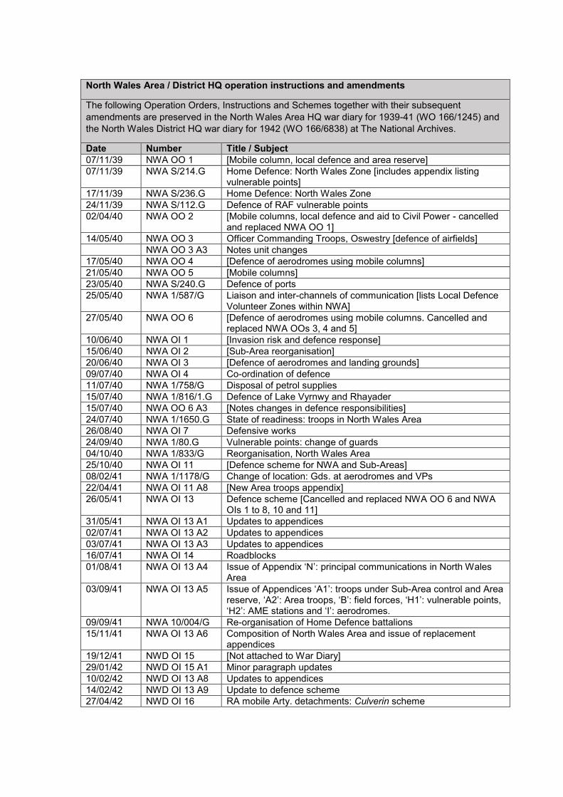
North Wales Area / District HQ operation instructions and amendments
The following Operation Orders, Instructions and Schemes together with their subsequent
amendments are preserved in the North Wales Area HQ war diary for 1939-41 (WO 166/1245) and
the North Wales District HQ war diary for 1942 (WO 166/6838) at The National Archives.
Date Number Title / Subject
07/11/39 NWA OO 1 [Mobile column, local defence and area reserve]
07/11/39 NWA S/214.G Home Defence: North Wales Zone [includes appendix listing vulnerable points]
17/11/39 NWA S/236.G Home Defence: North Wales Zone
24/11/39 NWA S/112.G Defence of RAF vulnerable points
02/04/40 NWA OO 2 [Mobile columns, local defence and aid to Civil Power - cancelled and replaced NWA OO 1]
14/05/40 NWA OO 3 Officer Commanding Troops, Oswestry [defence of airfields]
NWA OO 3 A3 Notes unit changes
17/05/40 NWA OO 4 [Defence of aerodromes using mobile columns]
21/05/40 NWA OO 5 [Mobile columns]
23/05/40 NWA S/240.G Defence of ports
25/05/40 NWA 1/587/G Liaison and inter-channels of communication [lists Local Defence Volunteer Zones within NWA]
27/05/40 NWA OO 6 [Defence of aerodromes using mobile columns. Cancelled and replaced NWA OOs 3, 4 and 5]
10/06/40 NWA OI 1 [Invasion risk and defence response]
15/06/40 NWA OI 2 [Sub-Area reorganisation]
20/06/40 NWA OI 3 [Defence of aerodromes and landing grounds]
09/07/40 NWA OI 4 Co-ordination of defence
11/07/40 NWA 1/758/G Disposal of petrol supplies
15/07/40 NWA 1/816/1.G Defence of Lake Vyrnwy and Rhayader
15/07/40 NWA OO 6 A3 [Notes changes in defence responsibilities]
24/07/40 NWA 1/1650.G State of readiness: troops in North Wales Area
26/08/40 NWA OI 7 Defensive works
24/09/40 NWA 1/80.G Vulnerable points: change of guards
04/10/40 NWA 1/833/G Reorganisation, North Wales Area
25/10/40 NWA OI 11 [Defence scheme for NWA and Sub-Areas]
08/02/41 NWA 1/1178/G Change of location: Gds. at aerodromes and VPs
22/04/41 NWA OI 11 A8 [New Area troops appendix]
26/05/41 NWA OI 13 Defence scheme [Cancelled and replaced NWA OO 6 and NWA OIs 1 to 8, 10 and 11]
31/05/41 NWA OI 13 A1 Updates to appendices
02/07/41 NWA OI 13 A2 Updates to appendices
03/07/41 NWA OI 13 A3 Updates to appendices
16/07/41 NWA OI 14 Roadblocks
01/08/41 NWA OI 13 A4 Issue of Appendix ‘N’: principal communications in North Wales Area
03/09/41 NWA OI 13 A5 Issue of Appendices ‘A1’: troops under Sub-Area control and Area reserve, ‘A2’: Area troops, ‘B’: field forces, ‘H1’: vulnerable points, ‘H2’: AME stations and ‘I’: aerodromes.
09/09/41 NWA 10/004/G Re-organisation of Home Defence battalions
15/11/41 NWA OI 13 A6 Composition of North Wales Area and issue of replacement appendices
19/12/41 NWD OI 15 [Not attached to War Diary]
29/01/42 NWD OI 15 A1 Minor paragraph updates
10/02/42 NWD OI 13 A8 Updates to appendices
14/02/42 NWD OI 13 A9 Update to defence scheme
27/04/42 NWD OI 16 RA mobile Arty. detachments: Culverin scheme

20/05/42 NWD SO Standing orders for routine daily activities
30/05/42 NWD SO A1 Amendment to medical arrangements
18/06/42 NWD SO A2 [Not attached to War Diary]
22/06/42 NWD DS 1 Defence scheme for HQ, Shrewsbury
22/06/42 NWD SO Additional sections issued
23/06/42 NWD SO A3 [Not attached to War Diary]
06/06/42 NWD OS 1 Instructions to Sub-Area Commanders [concerning defence]. Also cancelled NWD OIs 13, 14, 15 and 16
06/06/42 NWD OI 2 District organisation
06/06/42 NWD OI 3 Operational role of regular troops
06/06/42 NWD OI 4 Home Guard
06/06/42 NWD OI 5 Defence works
06/06/42 NWD OI 6 Defence of aerodromes and RAF support
06/06/42 NWD OI 7 Vulnerable points and static guards
06/06/42 NWD OI 8 Denial of resources to the enemy
06/06/42 NWD OI 9 Code words and signals
06/06/42 NWD OI 10 Cooperation with AA and SL units
06/06/42 NWD OI 11 RN and HM Coastguard co-operation
06/06/42 NWD OI 12 Royal Observer Corps: liaison
06/06/42 NWD OI 13 Civil authorities, co-operation with
06/06/42 NWD OI 14 Intelligence
14/07/42 NWD SO A4 Rules for transport for administrative purposes
07/08/42 NWD OI 15 Communications
07/08/42 NWD OS A2 [Not attached to War Diary]
20/08/42 NWD AO 3 Unit movements
20/08/42 NWD AO 4 Unit movements
06/09/42 NWD OI 16 Traffic routes
06/09/42 NWD OI 500 Administrative organisation
06/09/42 NWD OI 501 [Not attached to War Diary]
06/09/42 NWD OI 502 [Not attached to War Diary]
06/09/42 NWD OI 503 [Not attached to War Diary]
06/09/42 NWD OI 504 [Not attached to War Diary]
06/09/42 NWD OI 505 [Not attached to War Diary]
06/09/42 NWD OI 506 [Not attached to War Diary]
06/09/42 NWD OI 507 [Not attached to War Diary]
06/09/42 NWD OI 508 [Not attached to War Diary]
06/09/42 NWD OI 509 [Not attached to War Diary]
06/09/42 NWD OI 510 Refugees from Ireland, aliens at large and suspects
06/09/42 NWD OI 511 [Not attached to War Diary]
06/09/42 NWD OI 512 [Not attached to War Diary]
07/09/42 NWD OS A2 Updates
23/09/42 NWD AO 5 Unit movements
26/09/42 NWD SO A8 Updated Section 1: Organisation of North Wales District
30/09/42 NWD SO A9 [Not attached to War Diary]
11/10/42 NWD OI 17 Operational role of schools and training units and establishments
13/10/42 NWD OI 514 Home Guard feeding arrangements [not attached to War Diary]
18/10/42 NWD OI 5 A
23/10/42 NWD OS A3 Updated, including to NWD OI 5, Appendix B: minefields and NWD OI 4, Appendix A: Home Guard general policy
28/10/42 NWD OS A4 [Not attached to War Diary]
26/11/42 NWD AO 10 [Not attached to War Diary]
29/11/42 NWD AO 11 [Not attached to War Diary]
07/12/42 NWD SO A10 [Not attached to War Diary]
09/12/42 NWD OS A5 Updated, including NWD OI 2, Appendix A: Sector and Sub-Sector HQs; NWD OI 3, Appendix B: mobile columns; NWD OI 6,

Appendix A: airfields in NWD; and NWD OI 7: defence of vulnerable points
31/12/42 NWD CLR Consolidated list of returns

Kinmel Sub-Area HQ operation instructions and amendments
The following Operation Orders together with subsequent amendments are preserved in the Kinmel
Sub-Area HQ war diary (WO 166/1290) for 1940 at The National Archives.
Date Number Title
28/05/40 OO 1 Kinmel Sub-Area Operation Order No. 1
31/05/40 OO 1 A1 Kinmel Sub-Area Operation Order No. 1
01/06/40 OO 1 A2 Kinmel Sub-Area Operation Order No. 1
01/06/40 OO 1 A3 Kinmel Sub-Area Operation Order No. 1
06/06/40 OO 1 A4 Kinmel Sub-Area Operation Order No. 1
08/06/40 OO 1 A5 Kinmel Sub-Area Operation Order No. 1
11/06/40 OO 1 A6 Kinmel Sub-Area Operation Order No. 1
14/06/40 OO 1 A7 Kinmel Sub-Area Operation Order No. 1
22/06/40 OO 2 Kinmel Sub-Area Operation Order No. 2
30/06/40 OO 2 A1 Kinmel Sub-Area Operation Order No. 2
02/07/40 OO 2 A2 Kinmel Sub-Area Operation Order No. 2
05/07/40 OO 2 A3 Kinmel Sub-Area Operation Order No. 2
08/07/40 OO 2 A4 Kinmel Sub-Area Operation Order No. 2
12/07/40 OO 2 A5 Kinmel Sub-Area Operation Order No. 2
14/07/40 OO 2 A6 Kinmel Sub-Area Operation Order No. 2
25/07/40 OO 2 A7 Kinmel Sub-Area Operation Order No. 2
31/07/40 OO 3 Kinmel Sub-Area Operation Order No. 3
02/08/40 OO 3 A1 Kinmel Sub-Area Operation Order No. 3
05/08/40 OO 3 A2 Kinmel Sub-Area Operation Order No. 3
09/08/40 OO 3 A3 Kinmel Sub-Area Operation Order No. 3
10/08/40 OO 3 A4 Kinmel Sub-Area Operation Order No. 3
13/08/40 OO 3 A5 Kinmel Sub-Area Operation Order No. 3
13/08/40 OO 3 A6 Kinmel Sub-Area Operation Order No. 3
16/08/40 OO 3 A7 Kinmel Sub-Area Operation Order No. 3
19/08/40 OO 3 A8 Kinmel Sub-Area Operation Order No. 3
20/08/40 OO 3 A9 Kinmel Sub-Area Operation Order No. 3
21/08/40 OO 3 A10 Kinmel Sub-Area Operation Order No. 3
22/08/40 OO 3 A11 Kinmel Sub-Area Operation Order No. 3
24/08/40 OO 3 A12 Kinmel Sub-Area Operation Order No. 3
29/08/40 OO 3 A13 Kinmel Sub-Area Operation Order No. 3
03/09/40 OO 3 A14 Kinmel Sub-Area Operation Order No. 3
15/09/40 OO 3 A15 Kinmel Sub-Area Operation Order No. 3
16/09/40 OO 3 A16 Kinmel Sub-Area Operation Order No. 3
18/09/40 OO 3 A17 Kinmel Sub-Area Operation Order No. 3
19/09/40 OO 3 A18 Kinmel Sub-Area Operation Order No. 3
25/09/40 OO 3 A19 Kinmel Sub-Area Operation Order No. 3
27/09/40 OO 3 A20 Kinmel Sub-Area Operation Order No. 3
10/10/40 OO 3 A21 Kinmel Sub-Area Operation Order No. 3
15/10/40 OO 3 A22 Kinmel Sub-Area Operation Order No. 3
Welsh Border Sub-Area HQ operation instructions and amendments
NB. The Welsh Border Sub-Area HQ war diary for 1940 is not preserved at The National Archives.
No Operation Instructions or Defence Schemes survive within the Welsh Border Sub-Area HQ war
diaries for 1941 (WO 166/1327) or 1942 (WO 166/6783) at The National Archives.
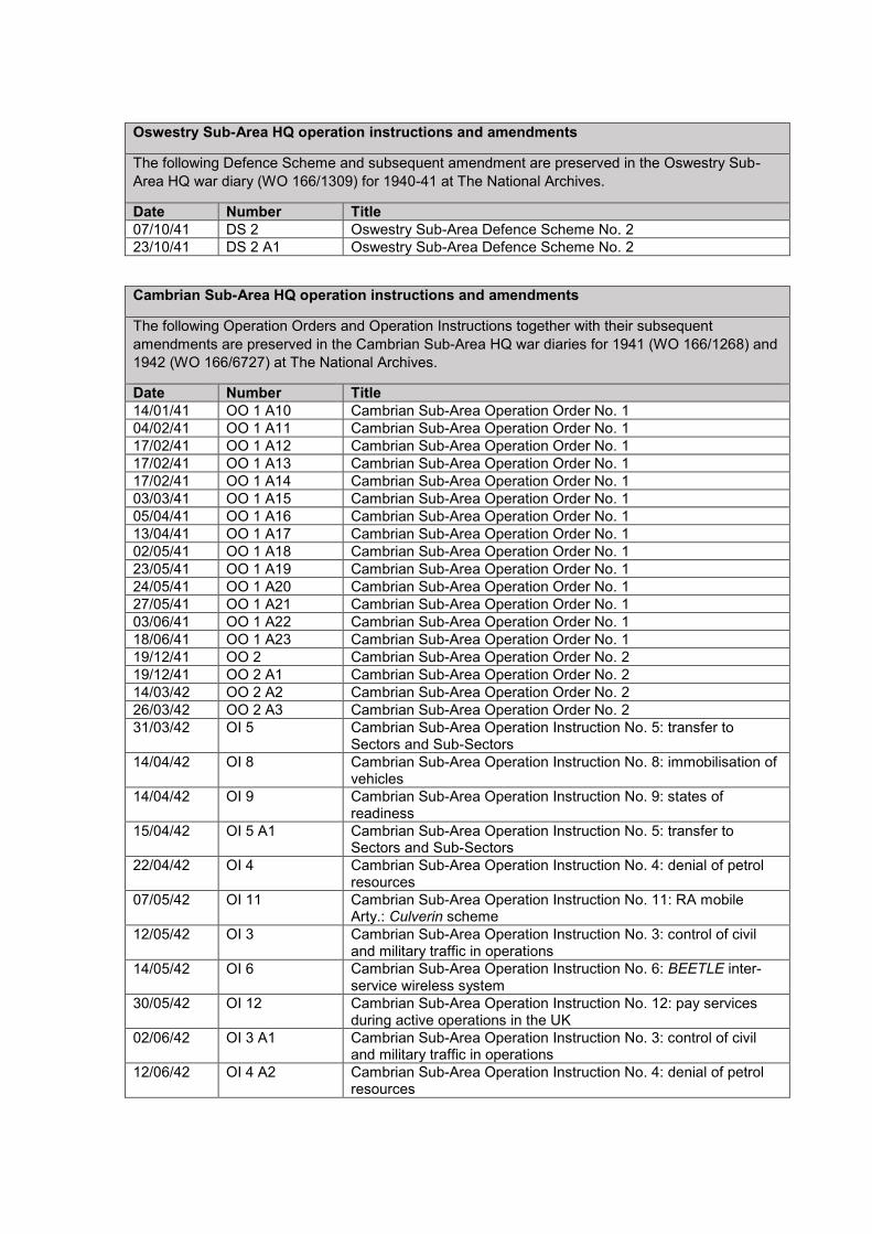
Oswestry Sub-Area HQ operation instructions and amendments
The following Defence Scheme and subsequent amendment are preserved in the Oswestry Sub-
Area HQ war diary (WO 166/1309) for 1940-41 at The National Archives.
Date Number Title
07/10/41 DS 2 Oswestry Sub-Area Defence Scheme No. 2
23/10/41 DS 2 A1 Oswestry Sub-Area Defence Scheme No. 2
Cambrian Sub-Area HQ operation instructions and amendments
The following Operation Orders and Operation Instructions together with their subsequent
amendments are preserved in the Cambrian Sub-Area HQ war diaries for 1941 (WO 166/1268) and
1942 (WO 166/6727) at The National Archives.
Date Number Title
14/01/41 OO 1 A10 Cambrian Sub-Area Operation Order No. 1
04/02/41 OO 1 A11 Cambrian Sub-Area Operation Order No. 1
17/02/41 OO 1 A12 Cambrian Sub-Area Operation Order No. 1
17/02/41 OO 1 A13 Cambrian Sub-Area Operation Order No. 1
17/02/41 OO 1 A14 Cambrian Sub-Area Operation Order No. 1
03/03/41 OO 1 A15 Cambrian Sub-Area Operation Order No. 1
05/04/41 OO 1 A16 Cambrian Sub-Area Operation Order No. 1
13/04/41 OO 1 A17 Cambrian Sub-Area Operation Order No. 1
02/05/41 OO 1 A18 Cambrian Sub-Area Operation Order No. 1
23/05/41 OO 1 A19 Cambrian Sub-Area Operation Order No. 1
24/05/41 OO 1 A20 Cambrian Sub-Area Operation Order No. 1
27/05/41 OO 1 A21 Cambrian Sub-Area Operation Order No. 1
03/06/41 OO 1 A22 Cambrian Sub-Area Operation Order No. 1
18/06/41 OO 1 A23 Cambrian Sub-Area Operation Order No. 1
19/12/41 OO 2 Cambrian Sub-Area Operation Order No. 2
19/12/41 OO 2 A1 Cambrian Sub-Area Operation Order No. 2
14/03/42 OO 2 A2 Cambrian Sub-Area Operation Order No. 2
26/03/42 OO 2 A3 Cambrian Sub-Area Operation Order No. 2
31/03/42 OI 5 Cambrian Sub-Area Operation Instruction No. 5: transfer to Sectors and Sub-Sectors
14/04/42 OI 8 Cambrian Sub-Area Operation Instruction No. 8: immobilisation of vehicles
14/04/42 OI 9 Cambrian Sub-Area Operation Instruction No. 9: states of readiness
15/04/42 OI 5 A1 Cambrian Sub-Area Operation Instruction No. 5: transfer to Sectors and Sub-Sectors
22/04/42 OI 4 Cambrian Sub-Area Operation Instruction No. 4: denial of petrol resources
07/05/42 OI 11 Cambrian Sub-Area Operation Instruction No. 11: RA mobile Arty.: Culverin scheme
12/05/42 OI 3 Cambrian Sub-Area Operation Instruction No. 3: control of civil and military traffic in operations
14/05/42 OI 6 Cambrian Sub-Area Operation Instruction No. 6: BEETLE inter-service wireless system
30/05/42 OI 12 Cambrian Sub-Area Operation Instruction No. 12: pay services during active operations in the UK
02/06/42 OI 3 A1 Cambrian Sub-Area Operation Instruction No. 3: control of civil and military traffic in operations
12/06/42 OI 4 A2 Cambrian Sub-Area Operation Instruction No. 4: denial of petrol resources

04/07/42 OI 4 A3 Cambrian Sub-Area Operation Instruction No. 4: denial of petrol resources
14/07/42 OI 5 A2 Cambrian Sub-Area Operation Instruction No. 5: transfer to Sectors and Sub-Sectors
21/07/42 OO 2 A6 Cambrian Sub-Area Operation Order No. 2
29/07/42 OI 13 Cambrian Sub-Area Operation Instruction No. 13: destruction of Llandulais jetties
30/07/42 OO 2 A7 Cambrian Sub-Area Operation Order No. 2
03/09/42 OI 4 A4 Cambrian Sub-Area Operation Instruction No. 4: denial of petrol resources
06/09/42 OO 2 A8 Cambrian Sub-Area Operation Order No. 2
06/09/42 OI 5 A3 Cambrian Sub-Area Operation Instruction No. 5: transfer to Sectors and Sub-Sectors
17/09/42 OO 2 A9 Cambrian Sub-Area Operation Order No. 2
Shropshire Sub-Area HQ operation instructions and amendments
The following Defence Schemes, Operation Instructions and Administrative Instructions, together
with their subsequent amendments are preserved in the Shropshire Sub-Area HQ war diaries for
1941 (WO 166/1315) or 1942 (WO 166/6774) at The National Archives.
Date Number Title
07/10/41 DS 2 Oswestry Sub-Area Defence Scheme No. 2
30/10/41 DS 2 A1 Oswestry Sub-Area Defence Scheme No. 2
17/11/41 DS 1 Shropshire Sub-Area Defence Scheme No. 1
23/01/42 DS 1 A1 Shropshire Sub-Area Defence Scheme No. 1
17/02/42 DS 1A Shropshire Sub-Area Defence Scheme No. 1A
23/02/42 AI 1 Shropshire Sub-Area Administrative Instruction No. 1
25/02/42 DS 1 A2 Shropshire Sub-Area Defence Scheme No. 1
04/04/42 DS 1 A3 Shropshire Sub-Area Defence Scheme No. 1
16/04/42 DS 1A A1 Shropshire Sub-Area Defence Scheme No. 1A
29/05/42 DS 1 A5 Shropshire Sub-Area Defence Scheme No. 1
02/07/42 AI 1 A1 Shropshire Sub-Area Administrative Instruction No. 1
09/07/42 OI 1 Shropshire Sub-Area Operation Instruction No. 1: 30 Bn. King’s Shropshire Light Infantry
17/07/42 OI 2 Shropshire Sub-Area Operation Instruction No. 2: 9 Bn. King’s Shropshire Light Infantry
28/08/42 OI 3 Shropshire Sub-Area Operation Instruction No. 3: 20 Infantry Training Centre
31/08/42 OI 4 Shropshire Sub-Area Operation Instruction No. 4: 5 Infantry Depot
08/09/42 AO 1 Shropshire Sub-Area Administrative Order No. 1
11/09/42 AIS 1 Shropshire Sub-Area Administrative Instruction Scheme No. 1
18/09/42 OI 6 Shropshire Sub-Area Operation Instruction No. 6: Troops, Donnington
20/09/42 OI 5 Shropshire Sub-Area Operation Instruction No. 5: Troops, Oswestry
23/09/42 OI 6 A1 Shropshire Sub-Area Operation Instruction No. 6: Troops, Donnington
28/09/42 OI 5 A1 Shropshire Sub-Area Operation Instruction No. 5: Troops, Oswestry
05/10/42 OI 4 A1 Shropshire Sub-Area Operation Instruction No. 4: 5 Infantry Depot
22/10/42 OS 2 Shropshire Sub-Area Operation Scheme No. 2
21/11/42 OI 7 Shropshire Sub-Area Operation Instruction No. 7: South-West Sector
08/12/42 AI 2 Shropshire Sub-Area Administrative Instruction No. 2
19/12/42 OS 2 A1 Shropshire Sub-Area Operation Scheme No. 2
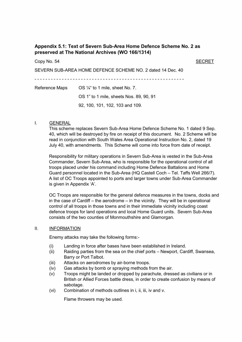
Appendix 5.1: Text of Severn Sub-Area Home Defence Scheme No. 2 as
preserved at The National Archives (WO 166/1314)
Copy No. 54 SECRET
SEVERN SUB-AREA HOME DEFENCE SCHEME NO. 2 dated 14 Dec. 40
- - - - - - - - - - - - - - - - - - - - - - - - - - - - - - - - - - - - - - - - - - - - - - - - - - - - - - -
Reference Maps OS ¼“ to 1 mile, sheet No. 7.
OS 1” to 1 mile, sheets Nos. 89, 90, 91
92, 100, 101, 102, 103 and 109.
I. GENERAL
This scheme replaces Severn Sub-Area Home Defence Scheme No. 1 dated 9 Sep.
40, which will be destroyed by fire on receipt of this document. No. 2 Scheme will be
read in conjunction with South Wales Area Operational Instruction No. 2, dated 19
July 40, with amendments. This Scheme will come into force from date of receipt.
Responsibility for military operations in Severn Sub-Area is vested in the Sub-Area
Commander, Severn Sub-Area, who is responsible for the operational control of all
troops placed under his command including Home Defence Battalions and Home
Guard personnel located in the Sub-Area (HQ Castell Coch – Tel. Taffs Well 266/7).
A list of OC Troops appointed to ports and larger towns under Sub-Area Commander
is given in Appendix ‘A’.
OC Troops are responsible for the general defence measures in the towns, docks and
in the case of Cardiff – the aerodrome – in the vicinity. They will be in operational
control of all troops in those towns and in their immediate vicinity including coast
defence troops for land operations and local Home Guard units. Severn Sub-Area
consists of the two counties of Monmouthshire and Glamorgan.
II. INFORMATION
Enemy attacks may take the following forms:-
(i) Landing in force after bases have been established in Ireland.
(ii) Raiding parties from the sea on the chief ports – Newport, Cardiff, Swansea,
Barry or Port Talbot.
(iii) Attacks on aerodromes by air-borne troops.
(iv) Gas attacks by bomb or spraying methods from the air.
(v) Troops might be landed or dropped by parachute, dressed as civilians or in
British or Allied Forces battle dress, in order to create confusion by means of
sabotage.
(vi) Combination of methods outlines in i, ii, iii, iv and v.
Flame throwers may be used.

Enemy Dispositions as far as is known.
About forty German Divisions have been lately located in the Northern parts of
France and invasion of these Islands can undoubtedly be mounted at short
notice.
Description of country.
(i) In addition to the docks and contingent industrial areas, coal, steel and other
factories extend up the valleys in a northerly direction from Cardiff and
Newport, towards the Brecon hills. Owing to their steepness these valleys can
be blocked at their northern and southern exits against the passage of troops.
North of the Abergavenny-Merthyr-Swansea road the country is open moor
and grass land, much of it suitable for parachute or troop carrier aeroplane
landings.
Generally speaking, the country south of this road is not suitable for tanks,
though the Gower Peninsula presents no obstacle and would be easily
passable for tracked vehicles.
The Rivers Wye and Usk are only partially tank obstacles and can be crossed
in several places. In wet weather, however, they rise rapidly and become
impassable.
(ii) The coast line has a few well defined stretches of open beach suitable for
landings of both sea and air-borne troops and vehicles in barges. Such are
Margam Sands and the Swansea Bay beaches. Other parts of the coast
though unpromising at low tide present a very different picture at high tide.
These places then present no obstacles to tanks and landings could be made
at certain times dependent on the state of the tide. Such are the stretch of
coast between Newport and Cardiff and between Aberthaw and
Summerhouse Point. Other parts are bound by cliffs and protected by rocks
and landings would be difficult and hazardous.
A 6” to 1 mile map is kept at Sub-Area HQ, on which the defences, wiring,
position of beach mines, and nature of the beaches along the whole front can
be seen.
(iii) The main military (Red and Blue) traffic routes are:
1. The Hereford-Abergavenny-Pontypool-Aberdare-Neath-Carmarthen road.
2. The Ross-Monmouth-Newport-Cardiff-Bridgend-Neath road.
And roads running north from Aberdare to Brecon, and Neath through
Pontardawe to Llandilo.
These must at all costs be kept open to military traffic.
Localities that are liable to attack are as follows:-

Cardiff Docks and City
Swansea Docks and Town
Gower Peninsula
Newport Docks and Town
Burry Port and Port Talbot
Chief factories, industrial plants and other installations.
Recce shows that the Loughor Estuary and the beach from Breaksea Point to
Summerhouse Point (OS 1” sh.109, 465870 – 435878) are important
objectives liable to enemy attack. Special measures are, therefore, required
for the defence of these localities.
Enemy attacks, regardless of loss, pressed with great daring and
determination are to be expected on RAF Stations at St Athan, Cardiff,
Newton Down (Porthcawl) and Llandow, and on above mentioned objectives.
Own Troops
Troops under Command of Severn Sub-Area for operations in an emergency
are shown in Appendix ‘A’. Location statement of all troops in the two
counties is shown in Appendix ‘B’.
III. INTENTION
The enemy will be attacked and destroyed at the earliest possible opportunity,
preferably, in the case of a sea landing, on the beaches, where he is most vulnerable.
It is essential that the enemy be attacked before he has time to consolidate his
position in any sector of the two counties. There will be no withdrawal from Ports or
beaches. Os. C. Units in the Sub-Area will give all possible assistance to
neighbouring units to attain this end and, in co-operation with HG Units. In an
emergency the role of the HG will be static; see para. VII.
IV. PLAN
General organisation of the defensive system in the Sub-Area is as follows:-
(i) Os. C. Troops in Ports and Towns are responsible for the defence of the inner
and outer perimeters of their localities and for beach defence and other
commitments as shown in Appendix ‘O’, which outlines separate sectors and
boundaries between units in the Sub-Area.
(ii) Two Stop Lines have been completed on the lines of the Rivers Wye and Usk,
that on the Wye to meet an attack from the east, that on the Usk to meet an
attack from the south and west. Prepared positions are ready for occupation
by reinforcements in case of large scale enemy landings. Prior to the arrival
of reinforcements these localities will be defended by HG Units who will
reconnoitre the actual posts to be occupied.
(iii) The 212 Inf. Bde. has commitments on the beaches in the Bde. Area, i.e.
(excl.) Loughor Sta. 008200 to Cold Knap Point 545880. Bde. Troops have
operational commitments on aerodromes and provide Mobile Columns.
(iv) Details of Coast defences are given in Appendix ‘O’.

(v) O.C. 100 Army Fd. Coy, RE, Monmouth, is responsible for the all-round
defence of Monmouth and will co-operate with neighbouring HG Units.
(vi) To provide for the defence of the Loughor Estuary co-operation with the Navy
has been arranged. A strong point has been established on the Old
Lighthouse jetty, near Burry Port. The Estuary will be netted and mined at an
early date.
(vii) In foggy weather very active patrolling of beaches will be carried out and
sentry posts will be increased as necessary.
Os.C Units will ensure that the defences in their localities are progressively
improved and maintained. Particular attention will be paid to camouflage.
Defence will be organised in depth by the construction of strong points in the
rear of the forward line of defended localities. It is emphasised that these
strong points like all other defences in the area must have all-round defence.
Defences will be progressively developed during the winter months by field
works and wire, particularly areas of possible landing grounds and for the
protection of the rear of the zones of beach defences.
Os.C. Infantry units in the Sub-Area will ensure close liaison with Battery
Comdrs. Responsible for coastal defence.
(viii) Under normal conditions defence measures will be entrusted to Comdr.
Severn Sub-Area. After the issue of ‘NEWTON’ or an enemy landing,
operational command will be exercised by the Comdr. South Wales Area
through the following subordinates:-
(1.) In the Swansea Bay and Gower portions of Severn Sub-Area by Comdr.
212 Inf. Bde.
(2.) In the remainder of Severn Sub-Area by the Sub-Area Comdr., the 2 Bns.
of 212 Inf. Bde. coming directly under his command.
In the event of large scale operations, command will pass to the Comdr. 47
(Lond) Div. who will assume operational control of all troops in South Wales
Area.
The Comdr. III Corps will take charge of further operations in the event of
invasion assuming major proportions.
Mobile Columns.
Units providing mobile columns are as shown in Appendix ‘L’.
State of readiness of these troops is shown in Appendix ‘P’.
These columns are available for reconnaissance, tank hunting, and
operational roles, and may be held in reserve to give immediate support to
static units in difficulties.
Mobile columns will be under the operational control of the Sub-Area
Commander in case of military necessity, but in the case of those allocated for
defence of aerodromes, the AOC each aerodrome can call direct on the
mobile column concerned, informing Sub-Area Comdr. of the action taken.
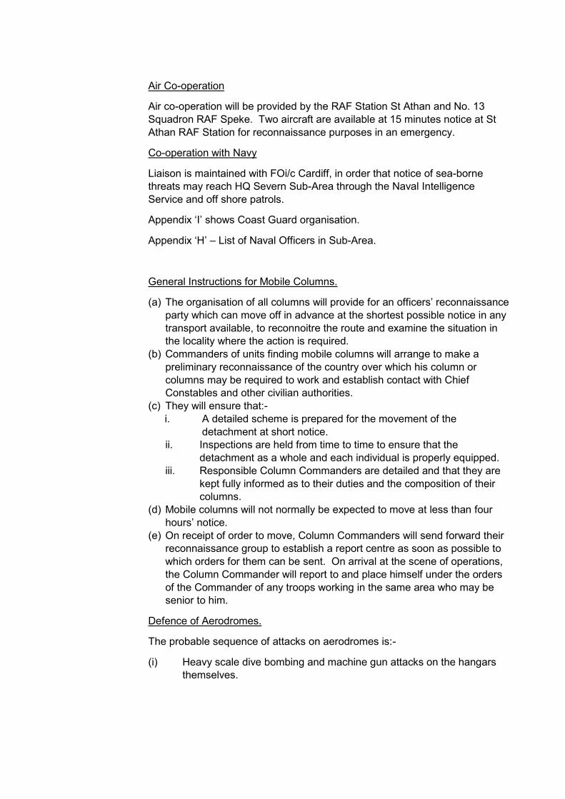
Air Co-operation
Air co-operation will be provided by the RAF Station St Athan and No. 13
Squadron RAF Speke. Two aircraft are available at 15 minutes notice at St
Athan RAF Station for reconnaissance purposes in an emergency.
Co-operation with Navy
Liaison is maintained with FOi/c Cardiff, in order that notice of sea-borne
threats may reach HQ Severn Sub-Area through the Naval Intelligence
Service and off shore patrols.
Appendix ‘I’ shows Coast Guard organisation.
Appendix ‘H’ – List of Naval Officers in Sub-Area.
General Instructions for Mobile Columns.
(a) The organisation of all columns will provide for an officers’ reconnaissance
party which can move off in advance at the shortest possible notice in any
transport available, to reconnoitre the route and examine the situation in
the locality where the action is required.
(b) Commanders of units finding mobile columns will arrange to make a
preliminary reconnaissance of the country over which his column or
columns may be required to work and establish contact with Chief
Constables and other civilian authorities.
(c) They will ensure that:-
i. A detailed scheme is prepared for the movement of the
detachment at short notice.
ii. Inspections are held from time to time to ensure that the
detachment as a whole and each individual is properly equipped.
iii. Responsible Column Commanders are detailed and that they are
kept fully informed as to their duties and the composition of their
columns.
(d) Mobile columns will not normally be expected to move at less than four
hours’ notice.
(e) On receipt of order to move, Column Commanders will send forward their
reconnaissance group to establish a report centre as soon as possible to
which orders for them can be sent. On arrival at the scene of operations,
the Column Commander will report to and place himself under the orders
of the Commander of any troops working in the same area who may be
senior to him.
Defence of Aerodromes.
The probable sequence of attacks on aerodromes is:-
(i) Heavy scale dive bombing and machine gun attacks on the hangars
themselves.

(ii) Landing of about 500 parachute troops equipped with automatics, sub-
machine guns and grenades, outside the perimeter and attack inwards
towards the aerodrome.
(iii) Landing of troop-carrying aircraft.
(iv) Capture of aerodrome – fighter protection being provided by the
enemy.
Details concerning the defence of the four aerodromes in the Sub-Area
is as shown in Appendix ‘M’.
Responsibility for the defence of aerodromes and the country within a
radius of 5 miles is that of RAF Comdrs. This will include the
construction of pill boxes and defence posts, and wiring, and also
provision of accommodation for the military garrison. They will receive
every assistance from the Military Comdrs. providing the garrison.
Royal Ordnance Factories.
ROFs situated at Glascoed and Bridgend are defended by local HG
Units provided by the 9 Bn Mon HG (Glascoed) and the 3 Bn Glam HG
(Bridgend).
AA troops and WD Constabulary will co-operate with HG Units in an
emergency.
VI ADMINISTRATION.
All administrative arrangements are the responsibility of the Units Commanders
concerned.
There is a reserve of ammunition at Castell Coch (.300 and .303. and SIP Grenades).
Prisoners of War Cages are located at Cardiff and Port Talbot.
VII HOME GUARD.
The principle of Home Guard defence is a static one and HG Units should operate
within a short distance of their homes. With this end in view, islands of defence or
localities must be prepared for occupation in an emergency, and these positions must
be held to delay the enemy till the last round or the arrival of reinforcements.
In addition to the issue of light automatics, a certain number of medium machine guns
have been allotted to Bns., and positions must be sited for these guns in pairs, arcs of
fire prepared, and alternative positions dug.
The action of the Home Guard in emergency on receipt of Code Words is laid down in
Appendix ‘P’.
In each sector of defence, local arrangements must be made for the supply of
ammunition, bombs and rations. During active operations it may be necessary to call
on the nearest military unit for emergency rations. Plans will be made to meet this
contingency.

VIII. INTERCOMMUNICATION
All Os.C. Units will acquaint themselves with the BEETLE System of wireless
communication and, if possible, provide themselves with a wireless receiving set (see
Appendices ‘P, Q, R, S, T and U’ for details of code and other means of
communication).
Appendix ‘N’ shows channels through which orders will be transmitted and through
which reports will be submitted.
In the event of active operations it is probable that telephone communication will fail.
Os.C. Units and HG Comdrs. will therefore arrange alternative means of
communication. Group Comdrs. HG will establish a report centre to which all reports
from Bns. in their groups will be sent. DRs. will be used by HG Bns.
Group Comdrs. HG will despatch one DR to report to HQ Severn Sub-Area for the
use of the Sub-Area Comdr.
Os.C. Troops, Chepstow, Newport, Cardiff, Barry, Port Talbot and Swansea, and
Os.C Units providing Mobile Columns (excluding 9 R. Sussex and 6 SWB) will also
despatch one DR to report to this HQ upon receipt of Code Word ‘NEWTON’, or prior
to the issue of Code Words should local Comdrs. consider that the local situation
warrants this action.
All reports by HG Bns will be submitted through Group Comdrs. to HQ Severn Sub-
Area.
All reports by troops under operational control of Os.C. Troops will be submitted
through Os.C. Troops. All Infantry Brigade units will submit their reports through Bde.
HQ.
In the event of active operations it is expected that a wireless transmitter will operate
from Castell Coch on a certain wave length. Transmission can be picked up on
civilian wireless sets having short wavelengths.
HB Trevor Cox.
Captain, General Staff,
For Commander, Severn Sub-Area.
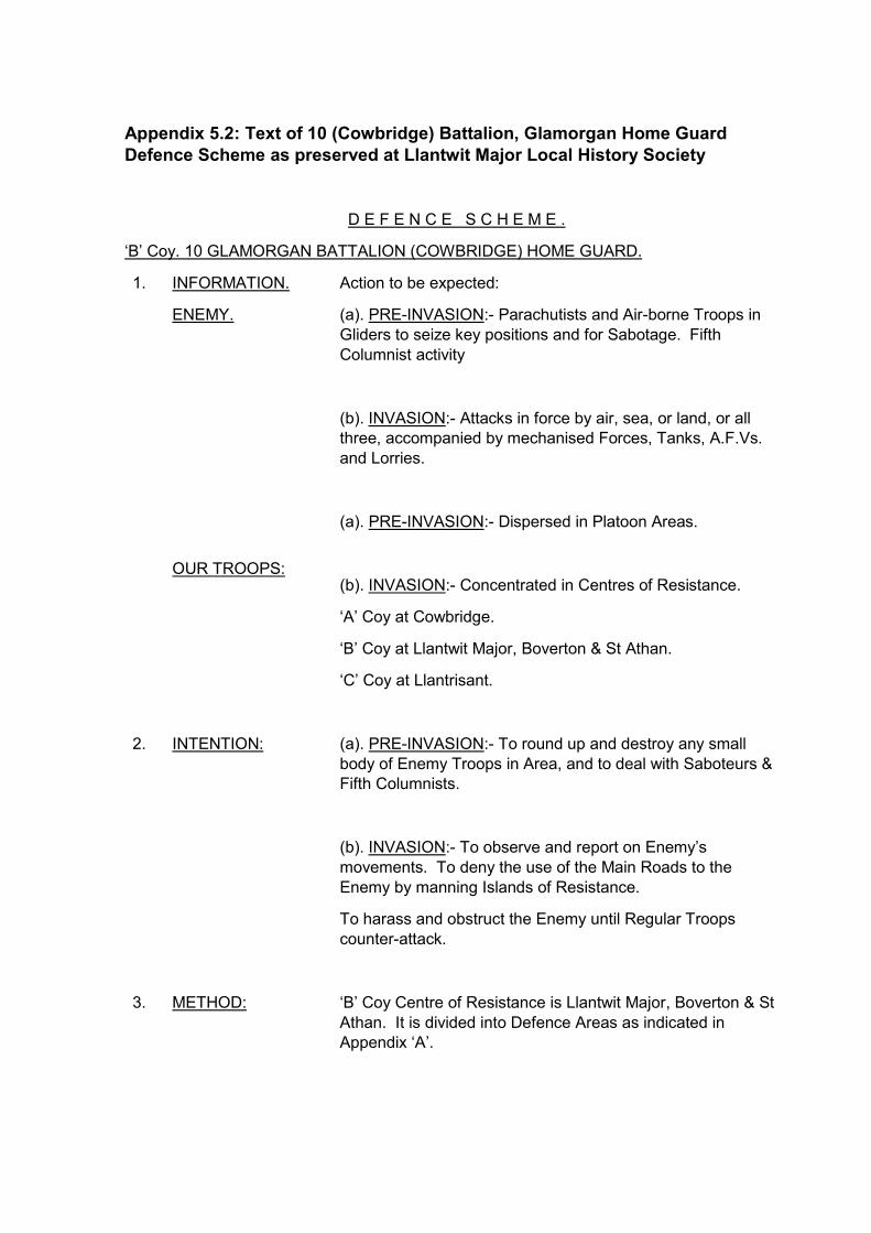
Appendix 5.2: Text of 10 (Cowbridge) Battalion, Glamorgan Home Guard
Defence Scheme as preserved at Llantwit Major Local History Society
D E F E N C E S C H E M E .
‘B’ Coy. 10 GLAMORGAN BATTALION (COWBRIDGE) HOME GUARD.
1. INFORMATION.
ENEMY.
OUR TROOPS:
Action to be expected:
(a). PRE-INVASION:- Parachutists and Air-borne Troops in
Gliders to seize key positions and for Sabotage. Fifth
Columnist activity
(b). INVASION:- Attacks in force by air, sea, or land, or all
three, accompanied by mechanised Forces, Tanks, A.F.Vs.
and Lorries.
(a). PRE-INVASION:- Dispersed in Platoon Areas.
(b). INVASION:- Concentrated in Centres of Resistance.
‘A’ Coy at Cowbridge.
‘B’ Coy at Llantwit Major, Boverton & St Athan.
‘C’ Coy at Llantrisant.
2. INTENTION: (a). PRE-INVASION:- To round up and destroy any small
body of Enemy Troops in Area, and to deal with Saboteurs &
Fifth Columnists.
(b). INVASION:- To observe and report on Enemy’s
movements. To deny the use of the Main Roads to the
Enemy by manning Islands of Resistance.
To harass and obstruct the Enemy until Regular Troops
counter-attack.
3. METHOD: ‘B’ Coy Centre of Resistance is Llantwit Major, Boverton & St
Athan. It is divided into Defence Areas as indicated in
Appendix ‘A’.

Each Platoon has been allocated a definite part of the
Defence Area, and will occupy positions prepared for all-
round Defence and mutual support.
Within their defined areas Platoons will establish Observation
Posts and employ Fighting Patrols. The Defence must be
aggressive at all times.
Infiltration by Tanks and Enemy Infantry must be accepted,
but Islands of Resistance will be held to the last. The Enemy
will be harassed by night and day. The denial of Roads to his
Supply Columns will bring his A.F.Vs. to a standstill.
Close liaison will be maintained with other Units in Coy. Area
or on its flanks, and arrangements made for their co-
operation.
(See Location Statement, Appendix ‘C’).
Mobile Units may be ordered by Higher Command to operate
in the Coy. Area. Guides will be supplied by the Coy. to pilot
Troops passing through the Area.
The closest liaison will be maintained with the Police, Civil
Defence Services, Red Cross Detachment, Fire Brigade and
other Services. Plans are ready to use the civil population to
prepare additional Defence Works, and to increase the
resistance and to maintain the morale.
4. ADMINISTRATION: Appendix ‘A’ – Company and Platoon Locations.
Appendix ‘B’ – Platoon Strengths, Weapons & Defence
Positions.
Appendix ‘C’ – Telephone Numbers.
Appendix ‘D’ – Disposal of Arms and Ammunition.
Appendix ‘E’ – Call-out System.
Appendix ‘F’ – Catering Arrangements.
Appendix ‘G’ – Medical Arrangements.
Appendix ‘H’ – Transport Arrangements.
Appendix ‘I’ – Communications and Guides.
Appendix ‘J’ – Immobilisation of Petrol and Plant.
Appendix ‘K’ – Vital Undertakings.
Appendix ‘L’ – Evacuation.

Appendix ‘M’ – Prisoners of War, etc.
Appendix ‘N’ – Miscellaneous.
5. ACTION STATIONS: Upon receipt of ‘Action Stations’ the Company Commander,
2nd i/c., Lt. Quartermaster, Q.M. Sergeant, Armourer and
Signals, Cook, First-Aid and Transport N.C.Os. forming Coy.
H.Q. Section will establish themselves at Coy. H.Q., Town
Hall, Llantwit Major.
The Arms and other equipment will be prepared for instant
use.
It will be the duty of Platoon Commanders to detail a similar
H.Q. Section to report and make the required arrangements
at their respective Platoon H.Qs. and care must be taken in
preparing this detail that members whose employment places
them in Category II are not called upon to report at this stage.
All other ranks will be warned to be on the alert and prepared
to report with all possible speed on receipt of the recognised
signal.
Major. P.J. Smith
O.C., ‘B’ Coy.
1 APR 1943

Appendix 5.3: List of identified defence sites for St Athan-Llandow case study
Name Location Site Type Group E N Evidence
Arc
h
Do
c
AP
Cart
o
Breaksea Point Pillbox
Breaksea Point Pillbox (Variant) Limpert Bay Defences
302263 165776
Old Lime Kiln Machine Gun Post
Limpert Defended Building
Limpert Bay Defences
302193 166171
Limpert Pillbox Limpert Bay Pillbox (Variant) Limpert Bay Defences
301996 166287
W of Limpert Pillbox
Limpert Bay Pillbox (Variant) Limpert Bay Defences
301778 166330
The Walls E Pillbox
The Walls Pillbox (Type FW3/22)
Limpert Bay Defences
301339 166413
The Walls W Pillbox
The Walls Pillbox (Variant) Limpert Bay Defences
301026 166469
Tidal Pond Pillbox
Tidal Pond Pillbox (Variant) Limpert Bay Defences
300823 166379
Penry Bay Pillbox
Penry Bay Pillbox (Variant) Limpert Bay Defences
300305 166503
Summerhouse Bay Pillbox
Summerhouse Bay
Pillbox (Variant) Limpert Bay Defences
300014 166502
The Leys Canadian Pipe Mine
The Leys Canadian Pipe Mine
Limpert Bay Defences
302307 166141
Limpert Bay Canadian Pipe Mine
Limpert Canadian Pipe Mine
Limpert Bay Defences
302131 166190
Col-Hugh Point Canadian Pipe Mine
Col-Hugh Point Canadian Pipe Mine
Llantwit Major Defences
295689 167445
Tresilian Bay Canadian Pipe Mine
Tresilian Bay Canadian Pipe Mine
Tresilian Bay Defences
294796 167757
No. 1 6-pdr Gun (St Athan)
Llantwit Road Anti-Tank Gun Emplacement
RAF St Athan Defences
299785 168086
No. 2 6-pdr Gun (Eglwys Brewis)
Eglwys Brewis Anti-Tank Gun Emplacement
RAF St Athan Defences
300450 169155
No. 3 6-pdr Gun (Old Mill)
East Orchard Wood
Anti-Tank Gun Emplacement
RAF St Athan Defences
302892 167659
No. 4 6-pdr Gun (Gigman Mill)
Gigman Mill Anti-Tank Gun Emplacement
RAF St Athan Defences
301477 171514
No. 1 13-pdr Gun
Llantwit Road Anti-Tank Gun Emplacement
RAF St Athan Defences
299663 168125
No. 1 13-pdr Gun Target A1
Cross Inn cross roads
Artillery Target RAF St Athan Defences
302692 171774
No. 1 13-pdr Gun Target A2
Road junction NE of Llancadle
Artillery Target RAF St Athan Defences
303992 168791
No. 1 13-pdr Gun Target A3
B4265 - Llancadle road junction
Artillery Target RAF St Athan Defences
303224 167776
No. 1 13-pdr Gun Target A4
East Aberthaw - Burton - Fonmon road junction
Artillery Target RAF St Athan Defences
303509 167433
No. 1 13-pdr Gun Target A5
St John's Valley, N of St Athan
Artillery Target RAF St Athan Defences
301355 168297
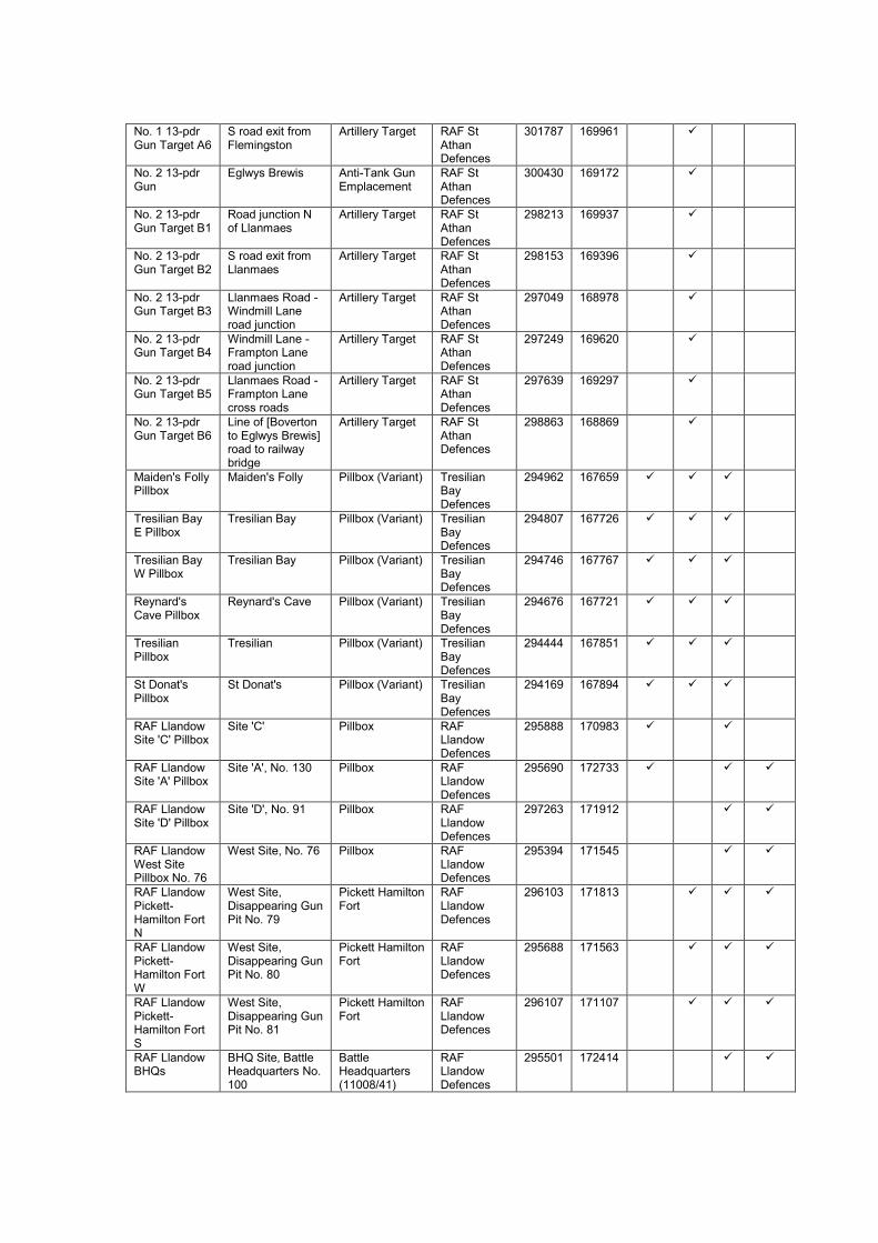
No. 1 13-pdr Gun Target A6
S road exit from Flemingston
Artillery Target RAF St Athan Defences
301787 169961
No. 2 13-pdr Gun
Eglwys Brewis Anti-Tank Gun Emplacement
RAF St Athan Defences
300430 169172
No. 2 13-pdr Gun Target B1
Road junction N of Llanmaes
Artillery Target RAF St Athan Defences
298213 169937
No. 2 13-pdr Gun Target B2
S road exit from Llanmaes
Artillery Target RAF St Athan Defences
298153 169396
No. 2 13-pdr Gun Target B3
Llanmaes Road - Windmill Lane road junction
Artillery Target RAF St Athan Defences
297049 168978
No. 2 13-pdr Gun Target B4
Windmill Lane - Frampton Lane road junction
Artillery Target RAF St Athan Defences
297249 169620
No. 2 13-pdr Gun Target B5
Llanmaes Road - Frampton Lane cross roads
Artillery Target RAF St Athan Defences
297639 169297
No. 2 13-pdr Gun Target B6
Line of [Boverton to Eglwys Brewis] road to railway bridge
Artillery Target RAF St Athan Defences
298863 168869
Maiden's Folly Pillbox
Maiden's Folly Pillbox (Variant) Tresilian Bay Defences
294962 167659
Tresilian Bay E Pillbox
Tresilian Bay Pillbox (Variant) Tresilian Bay Defences
294807 167726
Tresilian Bay W Pillbox
Tresilian Bay Pillbox (Variant) Tresilian Bay Defences
294746 167767
Reynard's Cave Pillbox
Reynard's Cave Pillbox (Variant) Tresilian Bay Defences
294676 167721
Tresilian Pillbox
Tresilian Pillbox (Variant) Tresilian Bay Defences
294444 167851
St Donat's Pillbox
St Donat's Pillbox (Variant) Tresilian Bay Defences
294169 167894
RAF Llandow Site 'C' Pillbox
Site 'C' Pillbox RAF Llandow Defences
295888 170983
RAF Llandow Site 'A' Pillbox
Site 'A', No. 130 Pillbox RAF Llandow Defences
295690 172733
RAF Llandow Site 'D' Pillbox
Site 'D', No. 91 Pillbox RAF Llandow Defences
297263 171912
RAF Llandow West Site Pillbox No. 76
West Site, No. 76 Pillbox RAF Llandow Defences
295394 171545
RAF Llandow Pickett-Hamilton Fort N
West Site, Disappearing Gun Pit No. 79
Pickett Hamilton Fort
RAF Llandow Defences
296103 171813
RAF Llandow Pickett-Hamilton Fort W
West Site, Disappearing Gun Pit No. 80
Pickett Hamilton Fort
RAF Llandow Defences
295688 171563
RAF Llandow Pickett-Hamilton Fort S
West Site, Disappearing Gun Pit No. 81
Pickett Hamilton Fort
RAF Llandow Defences
296107 171107
RAF Llandow BHQs
BHQ Site, Battle Headquarters No. 100
Battle Headquarters (11008/41)
RAF Llandow Defences
295501 172414

RAF Llandow Pillbox S of Bryn-sych
S of Bryn-sych Pillbox (Type FW3/24)
RAF Llandow Defences
295804 170645
RAF Llandow Pillbox E of Broadlands
E of Broadlands Pillbox (Air Ministry Pattern)
RAF Llandow Defences
294718 172355
RAF Llandow Pillbox S of Broadlands
S of Broadlands Pillbox (Air Ministry Pattern)
RAF Llandow Defences
294857 172177
RAF Llandow Pillbox SW of Tynycaia
SW of Tynycaia Pillbox RAF Llandow Defences
294634 172490
RAF Llandow Pillbox E of Tynycaia
E of Tynycaia Pillbox RAF Llandow Defences
294818 172511
RAF Llandow Pillbox Site 'A'
Site 'A' Pillbox RAF Llandow Defences
295480 172958
RAF Llandow Pillbox NW of Bryn-y-fro
NW of Bryn-y-fro Pillbox (Type FW3/24)
RAF Llandow Defences
295599 173387
RAF Llandow Pillbox NE corner of Site 'D'
NE corner of Site 'D'
Pillbox RAF Llandow Defences
296747 171977
RAF Llandow Pillbox S Side of Site 'D'
S side of Site 'D' Pillbox RAF Llandow Defences
296757 171717
RAF St Athan Pillbox S of Whangarei
S of Whangarei Pillbox (Type FW3/24)
RAF St Athan Defences
301952 169372
RAF St Athan Pillbox Golf Course
RAF St Athan Golf Course
Pillbox RAF St Athan Defences
301855 169137
RAF St Athan Pillbox SE of Ty Newydd Farm
SE of Ty Newydd Farm
Pillbox (Type FW3/24)
RAF St Athan Defences
301043 169754
RAF St Athan BHQs
Picketston Battle Headquarters (11008/41)
RAF St Athan Defences
300160 169445
RAF St Athan Pillbox
Picketston Pillbox (Air Ministry Pattern)
RAF St Athan Defences
300091 169476
RAF St Athan Pillbox
Picketston Pillbox (Air Ministry Pattern)
RAF St Athan Defences
300175 169413
RAF St Athan Pillbox
Picketston Pillbox (Air Ministry Pattern)
RAF St Athan Defences
300198 169480
RAF St Athan Pillbox S of Loughor Place
S of Loughor Place
Pillbox (Type FW3/24)
RAF St Athan Defences
301244 167584
RAF St Athan Pillbox W of Beggars Pound
W of Beggars Pound
Pillbox (Air Ministry Pattern)
RAF St Athan Defences
301140 168369
RAF St Athan Pillbox St John's Valley (No. 261Q Gun Post)
St John's Valley Pillbox (Air Ministry Pattern)
RAF St Athan Defences
300941 168307
RAF St Athan Pillbox S of West Farm
S of West Farm Pillbox (Air Ministry Pattern)
RAF St Athan Defences
300972 168019
RAF St Athan Pillbox N of Briarbank
N of Briarbank Pillbox (Air Ministry Pattern)
RAF St Athan Defences
300664 168065
RAF St Athan Pillbox E of Batslays Farm
E of Batslays Farm
Pillbox (Variant) RAF St Athan Defences
300217 167894

RAF St Athan Pillbox SE of Batslays Farm
SE of Batslays Farm
Pillbox (Air Ministry Pattern)
RAF St Athan Defences
300194 167701
RAF St Athan Pillbox N of B4265
N of B4265 Pillbox (Type FW3/24)
RAF St Athan Defences
299317 167906
RAF St Athan Pillbox S of B4265
S of B4265 Pillbox (Type FW3/24)
RAF St Athan Defences
298924 168194
RAF St Athan Pillbox W of Picketston
W of Picketston Pillbox (Type FW3/24)
RAF St Athan Defences
299310 169983
RAF St Athan Pillbox R&D Park
R&D Park Pillbox (Air Ministry Pattern)
RAF St Athan Defences
299705 169462
RAF St Athan Pickett Hamilton Fort S
S of DARA Building
Pickett Hamilton Fort
RAF St Athan Defences
300413 168513
RAF St Athan Pickett Hamilton Fort N
W of DARA Building
Pickett Hamilton Fort
RAF St Athan Defences
300175 168950
RAF St Athan Pillbox Dyffryn House
Dyffryn House Pillbox (Air Ministry Pattern)
RAF St Athan Defences
301084 168141
RAF St Athan Pillbox N of West Farm
N of West Farm Pillbox (Air Ministry Pattern)
RAF St Athan Defences
300997 168166
RAF St Athan Anti-Tank Cubes W of Fro Chapel
W of Fro Chapel Anti-Tank Cubes
RAF St Athan Defences
299132 169090
RAF St Athan Pillbox Black Bridge
Black Bridge Pillbox RAF St Athan Defences
300489 167602
RAF St Athan Pillbox S of Groswen Farm
S of Groswen Farm
Pillbox Llantwit Major Defences
296605 169363
10 Bn. Glam HG HQ
44 High Street, Cowbridge
Headquarters Cowbridge Defences
299444 174658
10 Bn. Glam HG Signal Station
Stalling Down, Cowbridge
Home Guard Observation Post
Cowbridge Defences
301463 173900
‘A’ Coy, 10 Bn. Glam HG HQ
71 Eastgate Street, Cowbridge
Home Guard Headquarters
Cowbridge Defences
299748 174529
No. 1 Pl, ‘B’ Coy, 10 Bn. Glam HG BHQ
Great House Home Guard Headquarters
Llantwit Major Defences
296691 169225
No. 1 Pl, ‘B’ Coy, 10 Bn. Glam HG HQ
Town Hall Home Guard Headquarters
Llantwit Major Defences
296727 168715
No. 1 Pl, ‘B’ Coy, 10 Bn. Glam HG Explosive Shed
Cowbridge Road, Llantwit Major
Home Guard Store
Llantwit Major Defences
296707 169196
‘B’ Coy, 10 Bn. Glam HG HQ & BHQ
Town Hall Home Guard Headquarters
Llantwit Major Defences
296744 168720
No. 1 Pl, ‘B’ Coy, 10 Bn. Glam HG Cowbridge Road Roadblock
Cowbridge Road, Llantwit Major
Roadblock Llantwit Major Defences
296607 169394

No. 1 Pl, ‘B’ Coy, 10 Bn. Glam HG Frampton Road Roadblock
Frampton Road, Llantwit Major
Roadblock Llantwit Major Defences
296721 169329
No. 1 Pl, ‘B’ Coy, 10 Bn. Glam HG Wick Road Roadblock
Wick Road, Llantwit Major
Roadblock Llantwit Major Defences
296447 169192
No. 1 Pl, ‘B’ Coy, 10 Bn. Glam HG Dimlands Road Roadblock
Dimlands Road, Llantwit Major
Roadblock Llantwit Major Defences
296358 168797
No. 1 Pl, ‘B’ Coy, 10 Bn. Glam HG Ogney Brook Machine Gun Emplacement
Ogney Brook Machine Gun Emplacement
Llantwit Major Defences
296498 169308
No. 1 Pl, ‘B’ Coy, 10 Bn. Glam HG The Meadows Anti-Tank Gun Emplacement
The Meadows Anti-Tank Gun Emplacement
Llantwit Major Defences
296450 169142
No. 1 Pl, ‘B’ Coy, 10 Bn. Glam HG N of Westfield House Machine Gun Emplacement
N of Westfield House
Machine Gun Emplacement
Llantwit Major Defences
296423 168980
No. 1 Pl, ‘B’ Coy, 10 Bn. Glam HG Anti-Tank Gun Emplacement
Rose Cottage Anti-Tank Gun Emplacement
Llantwit Major Defences
296513 168877
No. 1 Pl, ‘B’ Coy, 10 Bn. Glam HG Ham-Colhugh Crossroads Anti Invasion Defence Site
Ham-Colhugh crossroads
Anti-Invasion Defence Site
Llantwit Major Defences
296789 168339
No. 1 Pl, ‘B’ Coy, 10 Bn. Glam HG Station Yard Anti Invasion Defence Site
Station Yard, Boverton Road
Anti-Invasion Defence Site
Llantwit Major Defences
297205 168720
No. 1 Pl, ‘’B Coy, 10 Bn. Glam HG Railway Bridge Anti Invasion Defence Site
Railway Bridge, Llanmaes Road
Anti-Invasion Defence Site
Llantwit Major Defences
296989 168942
No. 2 Pl, ‘B’ Coy, 10 Bn. Glam HG HQ & BHQ
Boverton Castle/Place, Boverton
Home Guard Headquarters
Boverton Defences
298270 168455
No. 2 Pl, ‘B’ Coy, 10 Bn. Glam HG Explosive Shed
Boverton Home Guard Store
Boverton Defences
298253 168210
No. 2 Pl, ‘B’ Coy, 10 Bn.
Boverton Brook Petroleum Warfare Site
Boverton Defences
298031 168496

Glam HG Boverton Brook Petroleum Warfare Site
No. 2 Pl, ‘B’ Coy, 10 Bn. Glam HG S of River Hodnant Machine Gun Emplacement
S of River Hodnant
Machine Gun Emplacement
Boverton Defences
297981 168333
No. 2 Pl, ‘B’ Coy, 10 Bn. Glam HG Boverton Park House Machine Gun Emplacement
Boverton Park House
Machine Gun Emplacement
Boverton Defences
298358 168351
No. 2 Pl, ‘B’ Coy, 10 Bn. Glam HG Causeway Anti-Tank Gun Emplacement
The Causeway Anti-Tank Gun Emplacement
Boverton Defences
298286 168418
No. 2 Pl, ‘B’ Coy, 10 Bn. Glam HG Boverton Road Roadblock, Boverton
Pentyla Roadblock Boverton Defences
298167 168482
No. 2 Pl, ‘B’ Coy, 10 Bn. Glam HG Eagleswell Road Roadblock, Boverton
High Meadow Roadblock Boverton Defences
298203 168514
No. 2 Pl, ‘B’ Coy, 10 Bn. Glam HG Llantwit Road Roadblock, Boverton
Llantwit Road Roadblock Boverton Defences
298844 168392
No. 3 Pl, ‘B’ Coy, 10 Bn. Glam HG HQs
St Athan Home Guard Headquarters
St Athan Defences
301699 167985
No. 3 Pl, ‘B’ Coy, 10 Bn. Glam HG HQ
Co-op Shop/Stratford Cafe, St Athan
Home Guard Headquarters
St Athan Defences
301655 168014
No. 3 Pl, ‘B’ Coy, 10 Bn. Glam HG BHQ
Three Horse Shoes Inn, St Athan
Home Guard Headquarters
St Athan Defences
301661 167971
No. 3 Pl, ‘B’ Coy, 10 Bn. Glam HG Explosive Shed
St Athan Home Guard Store
St Athan Defences
301689 168112
No. 3 Pl, ‘B’ Coy, 10 Bn. Glam HG Anti-Tank Gun Emplacement
St Athan Anti-Tank Gun Emplacement
St Athan Defences
301705 167772
No. 3 Pl, ‘B’ Coy, 10 Bn. Glam HG Machine Gun Emplacement
St Athan Machine Gun Emplacement
St Athan Defences
301793 167777
No. 3 Pl, ‘B’ Coy, 10 Bn. Glam HG
St Athan Machine Gun Emplacement
St Athan Defences
301465 167633

Machine Gun Emplacement
No. 3 Pl, ‘B’ Coy, 10 Bn. Glam HG Gileston Rise Fougasse
Gileston Church Fougasse St Athan Defences
301820 167055
No. 3 Pl, ‘B’ Coy, 10 Bn. Glam HG X5 Roadblock, St Athan (Gileston Railway Bridge)
Gileston Anti-Tank Vertical Rail
St Athan Defences
301747 167456
No. 3 Pl, ‘B’ Coy, 10 Bn. Glam HG Gileston Road Roadblock, St Athan
The Forge Roadblock St Athan Defences
301737 167900
No. 3 Pl, ‘B’ Coy, 10 Bn. Glam HG Llantwit Road Roadblock, St Athan
Wyndham House Roadblock St Athan Defences
301449 168020
St Athan HAA No. K1
Boverton Heavy Anti-Aircraft Battery
RAF St Athan Defences
298156 167945
St Athan LAA No. 30
W of Flemingston Light Anti-Aircraft Battery
RAF St Athan Defences
301048 169838
St Athan LAA No. 31
S of Flemingston Light Anti-Aircraft Battery
RAF St Athan Defences
301991 169299
St Athan LAA No. 32
NE of Methodist Chapel
Light Anti-Aircraft Battery
RAF St Athan Defences
301878 168463
St Athan LAA No. 33
S of West Orchard
Light Anti-Aircraft Battery
RAF St Athan Defences
301188 167715
St Athan LAA No. 34
SW of Seaview Light Anti-Aircraft Battery
RAF St Athan Defences
300195 167337
St Athan LAA No. 35
W of Boverton Farm
Light Anti-Aircraft Battery
RAF St Athan Defences
298868 167284
St Athan LAA No. 36
N of Splott Cottage
Light Anti-Aircraft Battery
RAF St Athan Defences
298954 169296
St Athan LAA No. 37
E of Llanmaes Light Anti-Aircraft Battery
RAF St Athan Defences
299367 169815
Llandow LAA No. 37
SE of Nash Manor
Light Anti-Aircraft Battery
RAF Llandow Defences
296828 172689
Llandow LAA No. 39
Sigingstone Light Anti-Aircraft Battery
RAF Llandow Defences
297279 171877
Llandow LAA No. 40
WSW of Sigingstone
Light Anti-Aircraft Battery
RAF Llandow Defences
296538 171156
Llandow LAA No. 41
SE of Bryn-sych Light Anti-Aircraft Battery
RAF Llandow Defences
295845 170662
Llandow LAA No. 42
SE of Parc Bach Light Anti-Aircraft Battery
RAF Llandow Defences
295750 171969

Llandow LAA No. 43
NE of Cae-Bush Light Anti-Aircraft Battery
RAF Llandow Defences
293975 171229
Llandow LAA No. 44
NNE of Ty'n-y-Caeau
Light Anti-Aircraft Battery
RAF Llandow Defences
294819 172648
Llandow LAA No. 45
E of Rectory Light Anti-Aircraft Battery
RAF Llandow Defences
295568 173244
Col-Hugh Point Minefield
Col-Hugh Point Minefield Llantwit Major Defences
295680 167465
Summerhouse Point Minefield
Summerhouse Point
Minefield Limpert Bay Defences
299395 166407
Limpert-Breaksea Point Minefield
Limpert-Breaksea Point
Minefield Limpert Bay Defences
302217 136010
Summerhouse Point Searchlight Post
Summerhouse Point
Searchlight Battery
RAF St Athan Defences
299588 166447
St Athan HM Coast Guard Post
Breaksea Point Observation Post
St Athan Defences
302349 165689
Llantwit Major HM Coast Guard Station
Llantwit Major Observation Post
Llantwit Major Defences
296780 167222
RASC Gileston Camp
Gileston Headquarters 302072 166695
RAF Station St Athan
St Athan Airfield RAF St Athan Defences
300300 168750
RAF Station Llandow
Llandow Airfield RAF Llandow Defences
296000 171800
Limpert Bay Limpert Bay Artillery Target Limpert Bay Defences
301985 166219
Thaw Estuary Thaw Estuary Artillery Target St Athan Defences
303417 166157
St Hilary Pillbox
St Hilary Pillbox 301717 173242
St Donat's Castle
St Donat's Headquarters 293468 168076
St Donat's Castle Searchlight Post
St Donat's Searchlight Battery
293353 168491
RAF St Athan Site 'D' Gun Post
Site 'D' Airfield Defence Post
RAF St Athan Defences
300559 168227
RAF St Athan Married Officers Quarters Gun Post
West Camp Airfield Defence Post
RAF St Athan Defences
299161 168316
RAF St Athan Sergeants Mess Gun Post
West Camp Airfield Defence Post
RAF St Athan Defences
299176 168352
RAF St Athan YMCA Building Gun Post
West Camp Airfield Defence Post
RAF St Athan Defences
298906 168426
RAF St Athan Bethesda Chapel Gun Post
West Camp Airfield Defence Post
RAF St Athan Defences
299184 169006
RAF St Athan MT Storage
West Camp Airfield Defence Post
RAF St Athan Defences
299306 169004

Shed W Gun Post
RAF St Athan Oil Paint & Dope Store Gun Post
West Camp Airfield Defence Post
RAF St Athan Defences
299589 169107
RAF St Athan Pyrotechnic Store Gun Post
West Camp Airfield Defence Post
RAF St Athan Defences
299828 169086
RAF St Athan MT Storage Shed S Gun Post
West Camp Airfield Defence Post
RAF St Athan Defences
299384 168862
RAF St Athan Fire Party House Gun Post
West Camp Airfield Defence Post
RAF St Athan Defences
299444 168584
RAF St Athan Electrical Distribution House N Gun Post
West Camp Airfield Defence Post
RAF St Athan Defences
299548 168828
RAF St Athan Electrical Distribution House S Gun Post
West Camp Airfield Defence Post
RAF St Athan Defences
299687 168590
RAF St Athan No. 167 Machine Gun Post
East Camp - Eglwys Brewis
Airfield Defence Post
RAF St Athan Defences
300432 169206
RAF St Athan No. 168 Gun Post Disused
East Camp - Eglwys Brewis
Airfield Defence Post
RAF St Athan Defences
300445 169141
RAF St Athan No. 261A Gun Post
East Camp - Eglwys Brewis
Airfield Defence Post
RAF St Athan Defences
300641 169090
RAF St Athan No. 261B Gun Post
East Camp Airfield Defence Post
RAF St Athan Defences
300951 169296
RAF St Athan No. 261C Gun Post
East Camp Airfield Defence Post
RAF St Athan Defences
301240 169309
RAF St Athan No. 261D Gun Post
East Camp Airfield Defence Post
RAF St Athan Defences
301435 169165
RAF St Athan No. 261E Gun Post
East Camp Airfield Defence Post
RAF St Athan Defences
301440 169038
RAF St Athan No. 261F Gun Post
East Camp Airfield Defence Post
RAF St Athan Defences
301523 168899
RAF St Athan No. 261G Gun Post
East Camp Airfield Defence Post
RAF St Athan Defences
300889 168345
RAF St Athan No. 261H Gun Post
East Camp Airfield Defence Post
RAF St Athan Defences
300842 169117
RAF St Athan No. 261I Gun Post
East Camp Airfield Defence Post
RAF St Athan Defences
300941 168786
RAF St Athan No. 261J Gun Post
East Camp Airfield Defence Post
RAF St Athan Defences
301052 168790
RAF St Athan No. 261K Gun Post
East Camp Airfield Defence Post
RAF St Athan Defences
301157 168788
RAF St Athan No. 261L Gun Post
East Camp Airfield Defence Post
RAF St Athan Defences
301293 168513

RAF St Athan No. 261M Gun Post
East Camp Airfield Defence Post
RAF St Athan Defences
301318 169095
RAF St Athan No. 261N Gun Post
Communal Site Airfield Defence Post
RAF St Athan Defences
301931 168601
RAF St Athan No. 261O Gun Post
East Camp Airfield Defence Post
RAF St Athan Defences
301523 168621
RAF St Athan No. 261P Gun Post
East Camp Airfield Defence Post
RAF St Athan Defences
300971 168470
RAF St Athan No. 261R Gun Post
East Camp Airfield Defence Post
RAF St Athan Defences
300891 168913
RAF St Athan No. 261S Gun Post
East Camp - 'B' Site
Airfield Defence Post
RAF St Athan Defences
301161 168389
RAF St Athan No. 261T Gun Post
Officers' Accommodation Site
Airfield Defence Post
RAF St Athan Defences
301627 169590
RAF St Athan No. 261U Gun Post
East Camp - 'B' Site
Airfield Defence Post
RAF St Athan Defences
301526 168391
RAF St Athan No. 264 AA Gun Post
East Camp Airfield Defence Post
RAF St Athan Defences
300890 169113
RAF St Athan R&D Park Gun Post
R&D Park Airfield Defence Post
RAF St Athan Defences
299877 169508
RAF St Athan Site 'A' Gun Post
Site 'A' Airfield Defence Post
RAF St Athan Defences
300075 169691
St Athan Defence Party Hut
S of St Athan Airfield Defence Party Hut
RAF St Athan Defences
301227 167649
Ty Newydd Defence Party Hut
S of Ty Newydd Farm
Airfield Defence Party Hut
RAF St Athan Defences
300995 169838
Froglands Defence Party Hut
NE of Froglands Airfield Defence Party Hut
RAF St Athan Defences
299361 169873
Anti-Landing Obstacle NW of Llandow
NW of Llandow Village
Anti-Landing Obstacle
293226 174049
Anti-Landing Obstacle E of Nash Manor
Nash Manor Anti-Landing Obstacle
296829 173020
Flemingston Moor Anti-Landing Obstacle
Flemingston Moor Anti-Landing Obstacle
302080 170246
Breaksea Point Anti-Tank Ditch
Breaksea Point Anti-Tank Ditch Limpert Bay Defences
302254 165945
Penry Bay Anti-Tank Ditch
Penry Bay Anti-Tank Ditch Limpert Bay Defences
300100 166521
Limpert Anti-Tank Block Alignment
Limpert Anti-Tank Block Limpert Bay Defences
301964 166293
The Walls East Anti-Tank Block Alignment
The Walls Anti-Tank Block Limpert Bay Defences
301405 166447
The Walls West Anti-Tank Block Alignment
The Walls Anti-Tank Block Limpert Bay Defences
300857 166415

Appendix 6.1: Text of Swansea Defence Scheme No. 2 as preserved in
Swansea Garrison HQ war diary at The National Archives (WO 166/6880)
S E C R E T
Copy No. 29
SWANSEA DEFENCE SCHEME No. 2 date1.1.42
Reference Maps O.S.1” to 1 Mile. Sheets 100 & 101
1. GENERAL This scheme replaces Swansea Defence Scheme dated 15
January 1941, which will be destroyed by fire upon receipt of this document.
The Scheme will come into force on the date of receipt. The Swansea area
covered by this scheme includes all ground WEST and SOUTH of the
following boundaries:
The East boundary is the Borough boundary from 144128 to – incl LONLAS –
along NORTH SIDE of road to Railway at 140197 – along Railway to R. Tawe
at 128211 – up the River to horizontal grid line – across to incl PONTLASSAU
– down Borough boundary to CADLE 068192 and from thence due WEST to
000192.
Responsibility for Military operation in the above area is vested in the
COMMANDER, SWANSEA GARRISON who is responsible for the operational
control of all troops place under his command including HOME GUARD
BATTALIONS and HOME GUARD PERSONNEL located in the above area.
On “ACTION STATIONS” E Group H.Qs. will become an integral part of
Swansea Garrison H.Qs.
The Group Commander will act as principal Staff Officer to the Garrison
Commander. He will be responsible for all matters dealing with feeding
arrangements, casualties, ammunition supply, accommodation of Home Guard
Units.
He will ensure that Liaison is working satisfactorily between H.G. Sector and
Sub-Sector Commanders and Civil and Police authorities.
2. INFORMATION
Types of attack to be expected.
(a) Parachute landings possibly followed by other air-borne troops with the
object of:-
i. Seizing or destroying important places such as FAIRWOOD
AERODROME, N.O.R. at LLANDARCY, SWANSEA DOCKS, etc.
ii. Dislocation of communications.
iii. Attacks in rear of beach defences in conjunction with

iv. Sea-borne landings.
v. Drawing off reserves from elsewhere.
vi. Causing panic and confusion among civil population.
(b) Gas attack by bomb or spray from the air, or cloud gas from the sea.
(c) Small sea-raids with the object of seizing or destroying FAIRWOOD
AERODROME, EXPERIMENTAL STATIONS, Factories etc.
(d) Larger sea-borne and air-borne landings with tanks as a preliminary to an
advance on the industrial area of Glamorgan and then to Birmingham and
the Midlands.
DESCRIPTION OF COUNTRY
(a) From Swansea the industrial area runs in a N.E. direction along the valley
of the RIVER TAWE.
This river is tidal as far as Landore. Except after heavy rain and at high
tide it is not a tank obstacle and can be crossed at most places.
(b) To the East of Swansea, Kilvey Hill entirely dominates the Docks and the
town of Swansea. On its summit A/C could make crash landings, and
parachute landings would be simple.
(c) The Gower Peninsula would present no obstacle and would be easily
passable for track vehicles. Landings by air-borne troops would be
possible on many points of the peninsula especially in the neighbourhood
of FAIRWOOD AERODROME.
(d) The coastline has a few well defined stretches of open beach suitable for
landing of both sea and air-borne troops and vehicles from barges. Such
are – Swansea Bay beaches, Oxwich Bay, Rhossili Bay and the Loughor
Estuary. At low tide the beach of Rhossili Bay would afford perfect landing
for almost unlimited aircraft.
LOCALITIES WHICH ARE LIABLE TO ATTACK are as follows:-
Swansea Docks and Town.
Gower Peninsula.
Chief Factories, industrial plants and other installations.
Enemy attacks, regardless of loss, pressed with great daring and determination
are to be expected on the R.A.F. Station at FAIRWOOD COMMON and in the
above mentioned objectives.
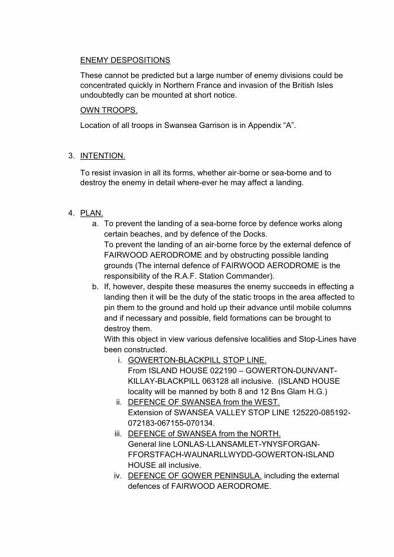
ENEMY DESPOSITIONS
These cannot be predicted but a large number of enemy divisions could be
concentrated quickly in Northern France and invasion of the British Isles
undoubtedly can be mounted at short notice.
OWN TROOPS.
Location of all troops in Swansea Garrison is in Appendix “A”.
3. INTENTION.
To resist invasion in all its forms, whether air-borne or sea-borne and to
destroy the enemy in detail where-ever he may affect a landing.
4. PLAN.
a. To prevent the landing of a sea-borne force by defence works along
certain beaches, and by defence of the Docks.
To prevent the landing of an air-borne force by the external defence of
FAIRWOOD AERODROME and by obstructing possible landing
grounds (The internal defence of FAIRWOOD AERODROME is the
responsibility of the R.A.F. Station Commander).
b. If, however, despite these measures the enemy succeeds in effecting a
landing then it will be the duty of the static troops in the area affected to
pin them to the ground and hold up their advance until mobile columns
and if necessary and possible, field formations can be brought to
destroy them.
With this object in view various defensive localities and Stop-Lines have
been constructed.
i. GOWERTON-BLACKPILL STOP LINE.
From ISLAND HOUSE 022190 – GOWERTON-DUNVANT-
KILLAY-BLACKPILL 063128 all inclusive. (ISLAND HOUSE
locality will be manned by both 8 and 12 Bns Glam H.G.)
ii. DEFENCE OF SWANSEA from the WEST.
Extension of SWANSEA VALLEY STOP LINE 125220-085192-
072183-067155-070134.
iii. DEFENCE of SWANSEA from the NORTH.
General line LONLAS-LLANSAMLET-YNYSFORGAN-
FFORSTFACH-WAUNARLLWYDD-GOWERTON-ISLAND
HOUSE all inclusive.
iv. DEFENCE OF GOWER PENINSULA. including the external
defences of FAIRWOOD AERODROME.

c. For OPERATIONAL COMMAND the area will be divided into four
Sectors (vide Appendix “E”). Sectors will be divided into Sub-Sectors.
Each Sub-Sector will have a number of Defended Localities.
The Sub-Sectors in No. 2 Swansea Sector coincide with Police Sub-
Sectors so as to facilitate co-operation.
d. TROOPS AVAILABLE for the defence of these Sectors.
i. Static Troops under operational command.
Certain Coast Defence guns of 14 Defence Regt. R.A.
1 Coy. 30 Bn. South Wales Borderers.
194 Coy., Pioneer Corps
285 Coy., Pioneer Corps
Det., 294 Coy., Pioneer Corps
Movement Control Personnel.
R.A.S.C., Cockett.
ii. Static Troops not under operational Command:-
A.D.G.B. Units.
Penclawdd Experimental Station.
958 Squadron R.A.F. (Balloon)
559 Coast Artillery Regt., R.A.
No. 97 Bomb Disposal Section
No. 165 Bomb Disposal Section.
iii. Home Guard
12 Bn. Glam H.G.
14 Bn. Glam H.G.
15 Bn. Glam H.G.
18 (Post Office) Bn. Glam H.G.
iv. Mobile Field Formations under Operational Command.
1 Troop (75 mm Guns) of 14 Defence Regt., R.A.
1 Coy. Tyneside Scottish (Black Watch)
e. BASIS OF DEFENCE
i. The basis of defence is a network of defended localities by which
the enemy is bound to be contacted no matter in what direction
he may seek to advance, so that whichever way he turns he will
be met by small arms, fire, flame throwers, bombs, tank traps,
booby traps and the like from every direction.
ii. Pill Boxes are only placed to form the skeleton of the defence. In
no case should more than 2 or at the most 3 men remain in pill
boxes. The remainder of the garrison of the site should be in
houses, slit trenches, behind banks etc, around the pill boxes.
All dead ground near pill boxes will be covered by fire or by
mines. The keys

for the doors of pill boxes will be held by the N.C.O. i/c of the
Sections detailed to occupy them. Duplicate keys will be held at
Sub-Sector H.Qs.
iii. On enemy paratroops landing they will be engaged with the
utmost speed by patrols sent out from neighbouring defended
localities. They will be rounded up and prevented from
concentrating into larger bodies. The utmost vigour will be
employed in dealing with them.
iv. It is essential that ground forward of, and between, these
localities should be continuously patrolled. It is the responsibility
of the Home Guard manning the localities to carry out this
patrolling. It will be made impossible for any party of the enemy
to approach any defended locality unobserved.
v. Where detachments have been given tasks as outposts forward
of Stop Lines or perimeter defences their duty is:
1. To send back early information of the presence and
general direction of advance of the enemy.
2. To ambush small parties of his leading troops.
3. To delay the enemy by opening fire on large bodies at
long range so as to make him deploy early.
It is not intended that outposts should resist to “the last man and
the last bullet” but if hardly pressed they should retire on the main
defences behind them. However, if passed or over-run they
should hide and come up again to harass the enemy following the
advanced attackers.
If the enemy succeeds in penetrating the defences he will be
attacked ruthlessly wherever he appears. House tops, windows,
alley ways will be used from which to harry his flanks and rear and
he will be engaged mercilessly with every weapon and bomb
available.
For distribution of men and arms by localities see Appendix “B”.

f. Role of A.D.G.B. Units
The role of Heavy, Light AA and “Z” Units will be confined to such
action as is necessary for their own protection. This will include the
organisation and preparation of a defensive position to bring fire on all
ground in the vicinity of the site, and readiness to attack the enemy
within 800 yards of the defensive position. Arrangements will be made
to patrol any dead ground in the vicinity of the site which cannot be
covered by fire.
Searchlight Units will, in addition to organising a defensive position at or
near the site:-
i. Watch and report all enemy movement within one mile of the
site.
ii. Snipe, stalk and destroy small parties of the enemy within one
mile of the site. (Armoured cars, tanks, despatch riders and
H.Qs. of Armoured Units and formation when halted are
particularly vulnerable to this form of attack).
The closest liaison will be established between H.G. localities and
A.D.G.B. Units. The H.G. should know the layout of site defences of
A.D.G.B. units and vice versa.
Where Searchlight units send out parties to carry out role above the
H.G. should invariably provide guides to assist with their special
knowledge of the local geography.
g. Defence of CHL and CD/CHL Stations
The local defences of these stations is the responsibility of the Senior
Army or R.A.F. officer in the Stations.
h. In foggy weather very active patrolling of beaches will be carried out by
those units responsible for beach defences. The closest liaison will be
established between these unit and H.M. Coastguard Stations. For
details of these Stations and R.A.F. Observation Posts see Appendix
“D”.
i. Mines and Obstacles
i. Mine fields have been placed as detailed in Appendix “E”. All
beach minefields will be securely wired in and the

ingress by dogs will be prevented by the erection of rabbit wire
netting.
A Home Guard unit will be detailed to be responsible in each
locality for:-
a. General supervision of field.
b. Removal of red warning notices.
As regards a). The unit detailed will make weekly inspections
from outside the minefields with a view to seeing whether mines
are unduly exposed or are covered up by sand. Any minefield
needing attention will be reported immediately to Garrison H.Qs.
via Battalion and E Group H.Qs. On no account will minefields
be entered by H.G. personnel.
As regards b). Red warning notices will be taken down on
“Action Stations” or before if ordered by the Commander,
Swansea Garrison.
ii. McNaughton tubes have been placed as detailed in Appendix
“E”. The necessary fuzes etc., will be held by the units detailed
to blow these tubes. These units will detail certain men to be
trained in operating the tubes. The instruction will be carried out
by the unit instructors specially trained for the purpose. All tubes
will be fuzed on “Action Stations”. The policy is that the tubes
will not be blown except on the immediate presence of the
enemy. Tubes blocking the exits from beaches will be blown if
the enemy attempts to land on the beach concerned. The tubes
blocking the roads at 990113, 974134 and 038170 will only be
blown if enemy A.F.Vs., transport or large parties of the enemy
approach these sites. They will NOT be blown if only small
parties of enemy on foot approach which can be dealt with by
troops defending the site.
iii. ANTI-TANK MINES
Certain defended localities detailed in Appendix “E” will hold
Anti-Tank mines to assist in the defence of the localities
concerned. These mines will be stored under cover as near as
possible to where they are to be sited.

The mines will not be laid prior to “Action Stations” as they are
inclined to deteriorate if exposed to the weather. The sites
selected for these mines will be just outside the protective wire.
When positioned steps will be taken to prevent our own troops
from walking on them. The necessary Dannert wire will be held
at each site for this purpose.
iv. Flame Fougasse Barrels will be situated the enemy as detailed
in Appendix “E”. Special men will be detailed to fire these
barrels. They will only be fired on the immediate presence of the
enemy.
v. Shrapnel and Anti-tank mines will be held by localities as
detailed in Appendix “B”. Sites will be prepared beforehand but
mines will not be laid until the enemy are approaching the
neighbourhood. The location of these mines will be made known
to all troops in the locality and every care will be taken to prevent
the civilian population and refugees from approaching them. The
responsibility for deciding when the mines are to be laid rests
with the Sub-Sector Commanders.
j. ROAD BLOCKS
i. Appendix “D” gives lists of road blocks.
It is essential that traffic on the roads is not held up by premature
closing of blocks. Roads will not be completely blocked except
on orders from SWANSEA GARRISON HEADQUARTERS.
ii. The NEATH-LONLAS-MORRISTON-LLANGYFELACH road is a
RED ROUTE (essential Main traffic) and traffic on it will be in no
way restricted until the last possible moment.
The MORRISTON-CLYDACH road is a YELLOW ROUTE (for
refugee traffic). Traffic on it crossing the RED ROUTE will be
controlled by the BOROUGH CONSTABULARY.
iii. On “ACTION STATIONS”, or before if ordered by the Garrison
Commander, all Blocks, other than the above RED AND
YELLOW ROUTES, will be erected sufficiently across the road to
allow room for only one-way traffic. Rail or concrete cylinders to
complete blocks will be put handy

so that there is the minimum delay in entirely closing roads. The
Home Guard units responsible for covering the blocks will carry
out this work.
iv. On the Home Guard being mustered there will be the smallest
delay possible in manning posts covering blocks.
v. When roads have been completely blocked the obstruction will
not be removed except for military traffic or essential civil cars;
these latter are marked with E.L. labels prominently displayed.
vi. All personnel detailed to cover road blocks will be thoroughly
instructed in the methods employed for:-
a. Keeping Block under fire.
b. Dealing with enemy vehicles stopped by a block.
c. Checking the bona fides of personnel passing
through blocks. In this respect emphasis will be
laid on the necessity for the credentials of D.Rs.,
Staff Officers etc., being checked only at the first
set of blocks.
vii. The responsibility for traffic control is mainly the duty of the
Police and they should be given every possible help. Local
requests for assistance from a responsible police officer will be
met unhesitatingly if the military situation allows.
k. Anti-aircraft Small Arms fire
Home Guard personnel manning defended localities will be prepared to
engage low flying enemy aircraft with all of the L.As. and Rifles
available.
The strictest fire discipline will be maintained.
The L.As. of Sections held in reserve will be grouped where possible in
batteries of 4 and fire will be controlled by an officer.
In order to guard against sudden surprise attacks and also to provide
for detachments every A.A L/A will be aimed at EVERY AEROPLANE
which flies within range, whatever its nationality.
As the enemy may be expected to fly over defences in order to find out
the exact position of the defences fire will not be opened unless a
hostile act is performed.

l. Co-operation with Civil Authorities
It is to be expected that any attack on the SWANSEA AREA will be
accompanied by heavy aerial bombing of the Town. This will have the
effect of:-
i. Blocking communications.
ii. Putting numbers of civilian refugees on the roads,
iii. Destroying telephone lines.
iv. Reducing morale of civil population.
This will have an adverse effect on the defensive arrangements, unless
Troops and Home Guard give all the help in their power to the Civil
Authorities in restoring communications by filling in craters and
removing obstructions. They will also assist the Police, if called upon,
in controlling and collecting refugees, and getting them off the main
roads.
A list of Police Stations, posts and telephone boxes is given in
Appendix “F”.
Prior to operations commencing Sector and Sub-Sector Commanders
will establish the closet touch with all civil authorities in their Sectors or
Sub-Sectors, i.e. with the Police, A.F.S., A.R.P., Food Centres, F.A.Ps.
etc.
When operations commence these authorities will be kept posted with
the military situation as it affects them and given a brief verbal
appreciation of how it is likely to develop.
m. Ringing of Church Bells.
The ringing of Church Bells denotes the landing of parachutists or air-
borne troops in that area.
Except in the Gower Sector the order to ring Church Bells will not be
given by an officer under the rank of Bn. Commander and then only
after intelligence concerning the landing has been most carefully
verified.
The order to ring the bells must be given verbally to the Sexton
concerned by the officer authorised or by written order over his
signature.

In the case of the GOWER the following officers only are permitted to
order bells to be rung:-
Belfrey at. Officer authorised 022114 Bishopston ) O.C. 15 Bn. Glam H.G. 009108 Pennard ) 993169 Penclawdd Lt. J. Guy, 15 Bn. Glam. H.G. 923122 Reynoldston ) 903112 Llandewi ) 908078 Port Eynon ) Major 15 Bn. Glam. H.G. 860103 Rhossili ) 875138 Llangennith ) 894154 Llanmadoc ) 941144 Llanrhidian )
n. Guards and Security
i. Guard for Garrison Headquarters.
On “ACTION STATIONS” O.C. 12 Bn. Glam H.G. will detail a
guard of 1 N.C.O. and 10 men to report daily to act as a guard
on Garrison H.Qs. The guard will check the credentials of all
persons desiring to enter Headquarters.
ii. Guards for other Headquarters.
Arrangements will be made by Sector Commanders for suitable
guards to be mounted on Sector and Sub-Sector Headquarters.
Sentries should not be placed so that they give away the fact
that a certain building is being use as a H.Qs. They should be
able to see and to shoot but not be seen or shot at. The
necessary cover from fire should be provided.
iii. Telephone security.
All orders and messages received over the telephone should be
treated with suspicion. If the Sender’s voice is not recognised
and the receiver has reason to doubt his bona fides the
procedure to be adopted is for the Sender to be asked for his
telephone number and to hang up his instrument and wait for the
receiver to ring him up.
iv. Security Officers.
Each Sector Commander will appoint a Security Officer. His
duty before operations commence will be to supervise all
security arrangements in his Sector. He will visit periodically the
various H.Qs. in order to check whether all possible steps are
taken to

safeguard secret and security documents.
In the event of H.Qs. being bombed arrangements will be made
to guard the site till salvage parties arrive.
He will arrange for secret documents to be taken over when
salvaged. He will make arrangements that if the enemy lands,
all maps, Defence Schemes and other secret documents likely to
fall into enemy hands are burnt.
o. GAS
i. Every precaution will be taken to avoid being surprised by the
use of enemy gas. The strictest gas discipline will be maintained
at all times.
ii. It is the duty of all units to ensure that the information regarding
the use of gas by the enemy is speedily transmitted to Garrison
Headquarters.
Messages on the following subjects will be regarded as very
urgent and will be marked “Emergency Operations”
a. First use of gas by the enemy.
b. Suspected new gas.
c. New weapons or new method of use.
d. Heavy casualties due to failure of our defence
measures.
iii. Such reports should always include:-
a. Place and time of attack.
b. Weapon used (e.g. air or mortar bombs, shells,
high or low spray, generators)
c. Type of gas (Blister, choking, nose, tear)
d. Casualties to troops or civilians.
e. Prevailing conditions of weather and ground.
p. PRISONERS OF WAR
i. Swansea Garrison collecting point will be the Civil Prison on
OYSTERMOUTH ROAD.
The Security Control Officer (Colonel T.D. Benyon Winsor) will
be in charge of the Collecting Point and will have under him his
S.C. Staff and all C.M.P. personnel in Swansea. Additional
guards will be furnished as the situation demands.
ii. Persons captured wearing British, Allied, or other non-enemy
uniforms or wearing civilian clothes who appear to have landed
in this country by sea or by air for the purposes of espionage or
sabotage.
a. Before “ACTION STATIONS”
Will be handed over to the Police
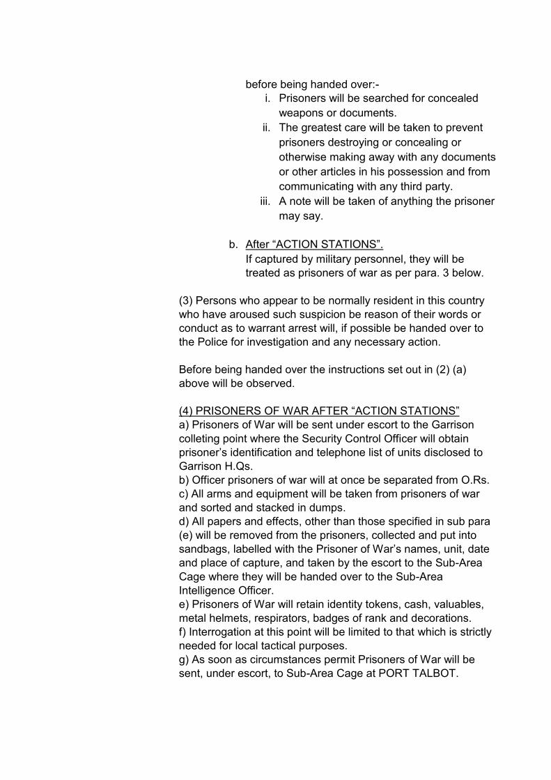
before being handed over:-
i. Prisoners will be searched for concealed
weapons or documents.
ii. The greatest care will be taken to prevent
prisoners destroying or concealing or
otherwise making away with any documents
or other articles in his possession and from
communicating with any third party.
iii. A note will be taken of anything the prisoner
may say.
b. After “ACTION STATIONS”.
If captured by military personnel, they will be
treated as prisoners of war as per para. 3 below.
(3) Persons who appear to be normally resident in this country
who have aroused such suspicion be reason of their words or
conduct as to warrant arrest will, if possible be handed over to
the Police for investigation and any necessary action.
Before being handed over the instructions set out in (2) (a)
above will be observed.
(4) PRISONERS OF WAR AFTER “ACTION STATIONS”
a) Prisoners of War will be sent under escort to the Garrison
colleting point where the Security Control Officer will obtain
prisoner’s identification and telephone list of units disclosed to
Garrison H.Qs.
b) Officer prisoners of war will at once be separated from O.Rs.
c) All arms and equipment will be taken from prisoners of war
and sorted and stacked in dumps.
d) All papers and effects, other than those specified in sub para
(e) will be removed from the prisoners, collected and put into
sandbags, labelled with the Prisoner of War’s names, unit, date
and place of capture, and taken by the escort to the Sub-Area
Cage where they will be handed over to the Sub-Area
Intelligence Officer.
e) Prisoners of War will retain identity tokens, cash, valuables,
metal helmets, respirators, badges of rank and decorations.
f) Interrogation at this point will be limited to that which is strictly
needed for local tactical purposes.
g) As soon as circumstances permit Prisoners of War will be
sent, under escort, to Sub-Area Cage at PORT TALBOT.
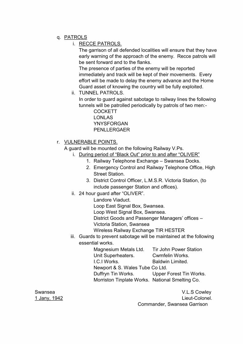
q. PATROLS
i. RECCE PATROLS.
The garrison of all defended localities will ensure that they have
early warning of the approach of the enemy. Recce patrols will
be sent forward and to the flanks.
The presence of parties of the enemy will be reported
immediately and track will be kept of their movements. Every
effort will be made to delay the enemy advance and the Home
Guard asset of knowing the country will be fully exploited.
ii. TUNNEL PATROLS.
In order to guard against sabotage to railway lines the following
tunnels will be patrolled periodically by patrols of two men:-
COCKETT
LONLAS
YNYSFORGAN
PENLLERGAER
r. VULNERABLE POINTS.
A guard will be mounted on the following Railway V.Ps.
i. During period of “Black Out” prior to and after “OLIVER”
1. Railway Telephone Exchange – Swansea Docks.
2. Emergency Control and Railway Telephone Office, High
Street Station.
3. District Control Officer, L.M.S.R. Victoria Station, (to
include passenger Station and offices).
ii. 24 hour guard after “OLIVER”.
Landore Viaduct.
Loop East Signal Box, Swansea.
Loop West Signal Box, Swansea.
District Goods and Passenger Managers’ offices –
Victoria Station, Swansea
Wireless Railway Exchange TIR HESTER
iii. Guards to prevent sabotage will be maintained at the following
essential works.
Magnesium Metals Ltd. Tir John Power Station
Unit Superheaters. Cwmfelin Works.
I.C.I Works. Baldwin Limited.
Newport & S. Wales Tube Co Ltd.
Duffryn Tin Works. Upper Forest Tin Works.
Morriston Tinplate Works. National Smelting Co.
Swansea V.L.S Cowley
1 Jany, 1942 Lieut-Colonel.
Commander, Swansea Garrison

Appendix 6.2: Defence Posts listed in Swansea Defence Scheme No. 2,
Swansea Garrison HQ war diary, 1942 (WO 166/6880)
Defence Post No.
Cassini
Sector Sub-Sector
Locality Unit Remarks
PB001 152 192 1 Swansea A Lonlas 14 Bn Glam HG
Road Block
FW001 152 192 1 Swansea A Lonlas 14 Bn Glam HG
PB002 148 192 1 Swansea A Lonlas 14 Bn Glam HG
PB003 141 197 1 Swansea A Peniel Green Tunnel
14 Bn Glam HG
Mines on either side of railway embankment
FW002 140 198 1 Swansea A Peniel Green Tunnel
14 Bn Glam HG
FW003 143 198 1 Swansea A Peniel Green Tunnel
14 Bn Glam HG
PB004 132 199 1 Swansea A Llansamlet Church
14 Bn Glam HG
FW004 131 198 1 Swansea A Llansamlet Church
14 Bn Glam HG
Mines in dead ground to W
PB005 132 196 1 Swansea A Llansamlet Church
14 Bn Glam HG
Mines in dead ground to W
PB006 132 195 1 Swansea A Llansamlet Square
14 Bn Glam HG
PB007 132 194 1 Swansea A Llansamlet Square
14 Bn Glam HG
PB008 131 195 1 Swansea A Llansamlet Square
14 Bn Glam HG
128 193 1 Swansea A Llansamlet Square
14 Bn Glam HG
To assist in local protection of E.A.M. (132 195)
PB009 137 183 1 Swansea A Halfway Inn 14 Bn Glam HG
FW005 138 183 1 Swansea A Halfway Inn 14 Bn Glam HG
H 138 184 1 Swansea A Halfway Inn 14 Bn Glam HG
Local reserve in houses
PB010 127 184 1 Swansea A Winch Wen 14 Bn Glam HG
PB011 125 183 1 Swansea A Winch Wen 14 Bn Glam HG
Mines in dead ground to W
FW006 125 183 1 Swansea A Winch Wen 14 Bn Glam HG
RESERVES 128 190 1 Swansea A RESERVES 14 Bn Glam HG
Balloon Site mans FW at 146 183)
RESERVES 138 183 1 Swansea A RESERVES 14 Bn Glam HG
RESERVES 135 192 1 Swansea A RESERVES 14 Bn Glam HG
PB012 123 169 1 Swansea B Bonymaen 14 Bn Glam HG
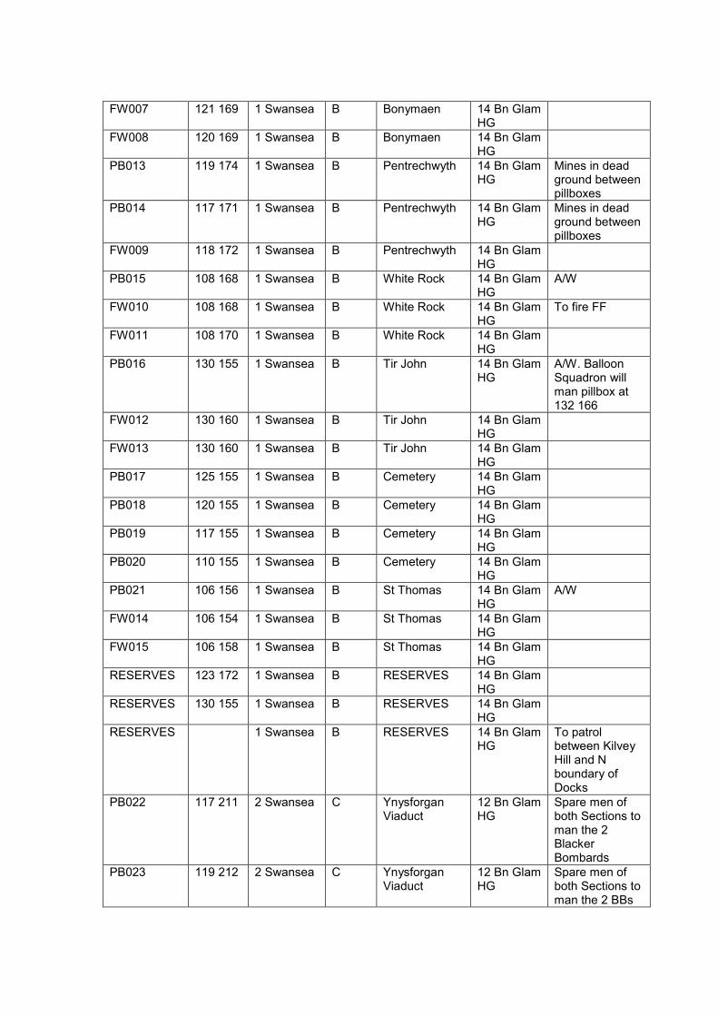
FW007 121 169 1 Swansea B Bonymaen 14 Bn Glam HG
FW008 120 169 1 Swansea B Bonymaen 14 Bn Glam HG
PB013 119 174 1 Swansea B Pentrechwyth 14 Bn Glam HG
Mines in dead ground between pillboxes
PB014 117 171 1 Swansea B Pentrechwyth 14 Bn Glam HG
Mines in dead ground between pillboxes
FW009 118 172 1 Swansea B Pentrechwyth 14 Bn Glam HG
PB015 108 168 1 Swansea B White Rock 14 Bn Glam HG
A/W
FW010 108 168 1 Swansea B White Rock 14 Bn Glam HG
To fire FF
FW011 108 170 1 Swansea B White Rock 14 Bn Glam HG
PB016 130 155 1 Swansea B Tir John 14 Bn Glam HG
A/W. Balloon Squadron will man pillbox at 132 166
FW012 130 160 1 Swansea B Tir John 14 Bn Glam HG
FW013 130 160 1 Swansea B Tir John 14 Bn Glam HG
PB017 125 155 1 Swansea B Cemetery 14 Bn Glam HG
PB018 120 155 1 Swansea B Cemetery 14 Bn Glam HG
PB019 117 155 1 Swansea B Cemetery 14 Bn Glam HG
PB020 110 155 1 Swansea B Cemetery 14 Bn Glam HG
PB021 106 156 1 Swansea B St Thomas 14 Bn Glam HG
A/W
FW014 106 154 1 Swansea B St Thomas 14 Bn Glam HG
FW015 106 158 1 Swansea B St Thomas 14 Bn Glam HG
RESERVES 123 172 1 Swansea B RESERVES 14 Bn Glam HG
RESERVES 130 155 1 Swansea B RESERVES 14 Bn Glam HG
RESERVES 1 Swansea B RESERVES 14 Bn Glam HG
To patrol between Kilvey Hill and N boundary of Docks
PB022 117 211 2 Swansea C Ynysforgan Viaduct
12 Bn Glam HG
Spare men of both Sections to man the 2 Blacker Bombards
PB023 119 212 2 Swansea C Ynysforgan Viaduct
12 Bn Glam HG
Spare men of both Sections to man the 2 BBs

PB024 123 212 2 Swansea C Ynysforgan Viaduct
12 Bn Glam HG
PB025 111 212 2 Swansea C Chemical Road
12 Bn Glam HG
PB026 113 211 2 Swansea C Chemical Road
12 Bn Glam HG
FW016 110 213 2 Swansea C Chemical Road
12 Bn Glam HG
PB027 113 214 2 Swansea C School 12 Bn Glam HG
FW017 113 216 2 Swansea C School 12 Bn Glam HG
FW018 113 217 2 Swansea C School 12 Bn Glam HG
FW019 107 207 2 Swansea C Golf Links 12 Bn Glam HG
FW020 108 206 2 Swansea C Golf Links 12 Bn Glam HG
FW021 108 208 2 Swansea C Golf Links 12 Bn Glam HG
PB028 112 202 2 Swansea C Pentrepoeth 12 Bn Glam HG
FW022 111 206 2 Swansea C Pentrepoeth 12 Bn Glam HG
Reinforced garden wall
FW023 111 205 2 Swansea C Pentrepoeth 12 Bn Glam HG
Reinforced garden wall
PB029 114 202 2 Swansea C Chris Williams 12 Bn Glam HG
PB030 116 203 2 Swansea C Chris Williams 12 Bn Glam HG
PB031 114 203 2 Swansea C Chris Williams 12 Bn Glam HG
PB032 112 202 2 Swansea C Chris Williams 12 Bn Glam HG
PB033 118 198 2 Swansea C Fforest Bridge 12 Bn Glam HG
PB034 110 197 2 Swansea C Fforest Bridge 12 Bn Glam HG
PB035 116 199 2 Swansea C Fforest Bridge 12 Bn Glam HG
PB036 113 190 2 Swansea C Duke Hotel 12 Bn Glam HG
PB037 113 193 2 Swansea C Duke Hotel 12 Bn Glam HG
PB038 114 192 2 Swansea C Duke Hotel 12 Bn Glam HG
FW024 113 190 2 Swansea C Duke Hotel 12 Bn Glam HG
PB039 108 196 2 Swansea C Bryn Rock 12 Bn Glam HG
FW025 108 194 2 Swansea C Bryn Rock 12 Bn Glam HG
PB040 107 192 2 Swansea C Bryn Rock 12 Bn Glam HG
PB041 107 196 2 Swansea C Bryn Rock 12 Bn Glam HG

PB042 103 220 2 Swansea C Pontlassau 12 Bn Glam HG
FW026 102 220 2 Swansea C Pontlassau 12 Bn Glam HG
FW027 103 222 2 Swansea C Pontlassau 12 Bn Glam HG
PB043 091 210 2 Swansea C Llangyfelach 12 Bn Glam HG
FW028 090 209 2 Swansea C Llangyfelach 12 Bn Glam HG
FW029 091 212 2 Swansea C Llangyfelach 12 Bn Glam HG
PB044 096 194 2 Swansea C Mynydd-bach 12 Bn Glam HG
FW030 095 196 2 Swansea C Mynydd-bach 12 Bn Glam HG
FW031 098 196 2 Swansea C Mynydd-bach 12 Bn Glam HG
FW032 097 196 2 Swansea C Mynydd-bach 12 Bn Glam HG
PB045 097 190 2 Swansea C Mynydd-bach 12 Bn Glam HG
PB046 091 191 2 Swansea C Mynydd Cadle Common
12 Bn Glam HG
FW033 091 192 2 Swansea C Mynydd Cadle Common
12 Bn Glam HG
PB047 090 188 2 Swansea C Mynydd Cadle Common
12 Bn Glam HG
PB048 088 187 2 Swansea C Mynydd Cadle Common
12 Bn Glam HG
FW034 091 187 2 Swansea C Mynydd Cadle Common
12 Bn Glam HG
PB049 083 186 2 Swansea C Mynydd Newydd Colliery
12 Bn Glam HG
FW035 084 186 2 Swansea C Mynydd Newydd Colliery
12 Bn Glam HG
FW036 083 183 2 Swansea C Mynydd Newydd Colliery
12 Bn Glam HG
FW037 082 184 2 Swansea C Mynydd Newydd Colliery
12 Bn Glam HG
FW038 082 183 2 Swansea C Mynydd Newydd Colliery
12 Bn Glam HG
PB050 080 183 2 Swansea C Ravenhill 12 Bn Glam HG
PB051 082 180 2 Swansea C Ravenhill 12 Bn Glam HG
A/W This post will be manned by men of A/A Repair Workshop
PB052 086 176 2 Swansea C Ravenhill 12 Bn Glam HG

FW039 086 176 2 Swansea C Ravenhill 12 Bn Glam HG
RESERVES 2 Swansea C RESERVES 12 Bn Glam HG
Sub-Sector Reserves
PB053 078 180 2 Swansea D Fforestfach 12 Bn Glam HG
Mines to be placed in hedges to prevent enemy getting off road
PB054 072 183 2 Swansea D Fforestfach 12 Bn Glam HG
6-pdr detachment
PB055 073 183 2 Swansea D Fforestfach 12 Bn Glam HG
PB056 074 178 2 Swansea D Fforestfach 12 Bn Glam HG
Mines in dead ground behind slag heaps
FW040 073 172 2 Swansea D White City 12 Bn Glam HG
PB057 076 174 2 Swansea D Cockett 12 Bn Glam HG
A/W Mines in gardens and in cemetery
FW041 075 176 2 Swansea D Cockett 12 Bn Glam HG
Mines between slag heaps
PB058 076 171 2 Swansea D Cockett 12 Bn Glam HG
PB059 073 172 2 Swansea D Cockett 12 Bn Glam HG
Mines on S side of Road
PB060 068 192 2 Swansea D Cadle 12 Bn Glam HG
FW042 067 193 2 Swansea D Cadle 12 Bn Glam HG
FW043 066 187 2 Swansea D Cadle 12 Bn Glam HG
PB061 023 193 2 Swansea D Island House 12 Bn Glam HG
To be manned by 8 Glam HG
FW044 023 194 2 Swansea D Island House 12 Bn Glam HG
To be manned by 8 Glam HG
FW045 023 192 2 Swansea D Island House 12 Bn Glam HG
PB062 028 187 2 Swansea D New Elba Colliery
12 Bn Glam HG
PB063 028 186 2 Swansea D New Elba Colliery
12 Bn Glam HG
PB064 027 186 2 Swansea D New Elba Colliery
12 Bn Glam HG
FW046 027 186 2 Swansea D New Elba Colliery
12 Bn Glam HG
PB065 033 187 2 Swansea D Elba Works 12 Bn Glam HG
PB066 032 186 2 Swansea D Elba Works 12 Bn Glam HG
PB067 032 187 2 Swansea D Elba Works 12 Bn Glam HG
PB068 033 183 2 Swansea D Elba Works 12 Bn Glam HG
PB069 035 185 2 Swansea D Gowerton Station
12 Bn Glam HG

PB070 036 184 2 Swansea D Gowerton Station
12 Bn Glam HG
PB071 035 183 2 Swansea D Gowerton Station
12 Bn Glam HG
PB072 036 182 2 Swansea D Gowerton Station
12 Bn Glam HG
FW047 039 182 2 Swansea D Winder Terrace
12 Bn Glam HG
Same Section defend FW047 and FW048
FW048 039 181 2 Swansea D Winder Terrace
12 Bn Glam HG
Same Section defend FW047 and FW048
PB073 038 179 2 Swansea D Winder Terrace
12 Bn Glam HG
Same Section defend PB073 and PB074
PB074 039 180 2 Swansea D Winder Terrace
12 Bn Glam HG
Same Section defend PB073 and PB074
PB075 040 179 2 Swansea D Winder Terrace
12 Bn Glam HG
PB076 038 177 2 Swansea D Winder Terrace
12 Bn Glam HG
Same Section defend PB076 and PB077
PB077 038 177 2 Swansea D Winder Terrace
12 Bn Glam HG
Same Section defend PB076 and PB077
PB078 039 176 2 Swansea D Winder Terrace
12 Bn Glam HG
FW049 032 177 2 Swansea D Gorwydd 12 Bn Glam HG
FW050 023 180 2 Swansea D Allt-wen 12 Bn Glam HG
FW051 055 179 2 Swansea D Waunarlwydd 12 Bn Glam HG
FW052 055 176 2 Swansea D Waunarlwydd 12 Bn Glam HG
FW053 058 176 2 Swansea D Waunarlwydd 12 Bn Glam HG
RESERVE 2 Swansea D RESERVES 12 Bn Glam HG
FW054 039 170 2 Swansea E Gowerton - Dunvant Road
12 Bn Glam HG
PB079 041 164 2 Swansea E Brickworks 12 Bn Glam HG
PB080 041 163 2 Swansea E Brickworks 12 Bn Glam HG
FW055 040 163 2 Swansea E Brickworks 12 Bn Glam HG
PB081 040 158 2 Swansea E Dunvant Post Office
12 Bn Glam HG
Mines in hollows between slag heaps
PB082 039 158 2 Swansea E Dunvant Post Office
12 Bn Glam HG
Mines between pillbox and railway crossing
PB083 038 157 2 Swansea E Dunvant Post Office
12 Bn Glam HG

PB084 039 157 2 Swansea E Dunvant Post Office
12 Bn Glam HG
FW056 038 157 2 Swansea E Dunvant Post Office
12 Bn Glam HG
FW057 038 158 2 Swansea E Dunvant Post Office
12 Bn Glam HG
PB085 044 155 2 Swansea E Dunvant Parish Hall
12 Bn Glam HG
PB086 043 155 2 Swansea E Dunvant Parish Hall
12 Bn Glam HG
PB087 043 153 2 Swansea E Dunvant Parish Hall
12 Bn Glam HG
PB088 045 141 2 Swansea E Killay 12 Bn Glam HG
Same Section defend PB088 and PB089
PB089 044 141 2 Swansea E Killay 12 Bn Glam HG
Same Section defend PB088 and PB089
FW058 045 140 2 Swansea E Killay 12 Bn Glam HG
PB090 043 142 2 Swansea E Killay 12 Bn Glam HG
PB091 043 143 2 Swansea E Killay 12 Bn Glam HG
Same Section defend PB091 and PB092
PB092 041 144 2 Swansea E Killay 12 Bn Glam HG
Same Section defend PB091 and PB092
PB093 043 146 2 Swansea E Killay 12 Bn Glam HG
PB094 045 148 2 Swansea E Killay 12 Bn Glam HG
FW059 044 145 2 Swansea E Killay 12 Bn Glam HG
PB095 050 145 2 Swansea E Race Course 12 Bn Glam HG
A/Tk mines in protective wire. S mines in wood
FW060 051 144 2 Swansea E Race Course 12 Bn Glam HG
A/Tk mines in protective wire
PB096 059 136 2 Swansea E Clyne Valley Colliery
12 Bn Glam HG
FW061 058 136 2 Swansea E Clyne Valley Colliery
12 Bn Glam HG
PB097 057 124 2 Swansea E Clyne Valley Colliery
12 Bn Glam HG
PB098 062 124 2 Swansea E Blackpill 12 Bn Glam HG
Same Section defend PB098 and PB099. This Section will fire a FF in Mayals Road
PB099 063 125 2 Swansea E Blackpill 12 Bn Glam HG
Same Section defend PB098 and PB099
PB100 063 126 2 Swansea E Blackpill 12 Bn Glam HG
Same Section defend PB100 and PB101

PB101 063 128 2 Swansea E Blackpill 12 Bn Glam HG
Same Section defend PB100 and PB101
PB102 063 128 2 Swansea E Blackpill 12 Bn Glam HG
Same Section defend PB102, PB103 and PB104
PB103 062 127 2 Swansea E Blackpill 12 Bn Glam HG
Same Section defend PB102, PB103 and PB104
PB104 063 127 2 Swansea E Blackpill 12 Bn Glam HG
Same Section defend PB102, PB103 and PB104
PB105 062 129 2 Swansea E Blackpill 12 Bn Glam HG
Same Section defend PB105 and PB106
PB106 062 129 2 Swansea E Blackpill 12 Bn Glam HG
Same Section defend PB105 and PB106
H 062 126 2 Swansea E Blackpill 12 Bn Glam HG
Section in houses to deal with any enemy vehicles stopped by road block
FW062 054 127 2 Swansea E Clyne Farm 12 Bn Glam HG
FW063 052 128 2 Swansea E Clyne Farm 12 Bn Glam HG
FW064 050 130 2 Swansea E Clyne Farm 12 Bn Glam HG
PB107 067 155 2 Swansea E Sketty 12 Bn Glam HG
FW065 067 151 2 Swansea E Sketty 12 Bn Glam HG
Loop holed wall
PB108 068 147 2 Swansea E Sketty 12 Bn Glam HG
A/W
PB109 070 150 2 Swansea E Sketty 12 Bn Glam HG
PB110 067 144 2 Swansea E Sketty 12 Bn Glam HG
PB111 070 135 2 Swansea E Singleton 12 Bn Glam HG
Same Section defend PB111 and PB112
PB112 070 134 2 Swansea E Singleton 12 Bn Glam HG
Same Section defend PB111 and PB112
PB113 069 132 2 Swansea E Singleton 12 Bn Glam HG
Section to man Ryder Flare post
PB114 074 135 2 Swansea E Singleton 12 Bn Glam HG
Section to man Ryder Flare post

PB115 077 138 2 Swansea E Singleton 12 Bn Glam HG
Section to man Ryder Flare post
RESERVE 2 Swansea E Olchfa Sub-Sector Reserve
12 Bn Glam HG
RESERVE 2 Swansea E Sketty Park Sub-Sector Reserve
12 Bn Glam HG
PB116 073 155 2 Swansea F Western edge of Town
12 Bn Glam HG
PB117 073 154 2 Swansea F Western edge of Town
12 Bn Glam HG
PB118 071 163 2 Swansea F Western edge of Town
12 Bn Glam HG
PB119 070 140 2 Swansea F Western edge of Town
12 Bn Glam HG
FW066 085 142 2 Swansea F Western edge of Town
12 Bn Glam HG
Loop holed wall of St Helens Ground
RESERVES 2 Swansea F No 1 Pl 12 Bn Glam HG
Mines to be available for booby traps
RESERVES 2 Swansea F No 2 Pl 12 Bn Glam HG
Mines to be available for booby traps
RESERVES 2 Swansea F No 3 Pl 12 Bn Glam HG
Mines to be available for booby traps
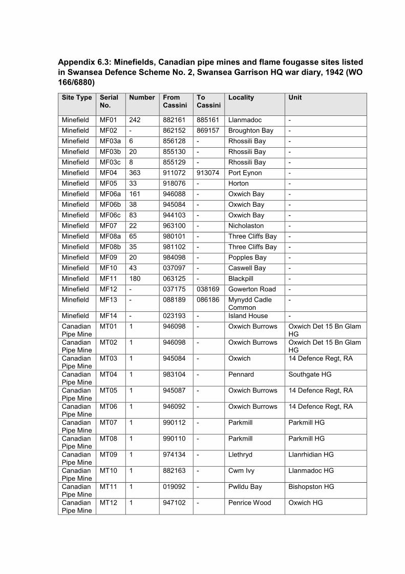
Appendix 6.3: Minefields, Canadian pipe mines and flame fougasse sites listed
in Swansea Defence Scheme No. 2, Swansea Garrison HQ war diary, 1942 (WO
166/6880)
Site Type Serial No.
Number From Cassini
To Cassini
Locality Unit
Minefield MF01 242 882161 885161 Llanmadoc -
Minefield MF02 - 862152 869157 Broughton Bay -
Minefield MF03a 6 856128 - Rhossili Bay -
Minefield MF03b 20 855130 - Rhossili Bay -
Minefield MF03c 8 855129 - Rhossili Bay -
Minefield MF04 363 911072 913074 Port Eynon -
Minefield MF05 33 918076 - Horton -
Minefield MF06a 161 946088 - Oxwich Bay -
Minefield MF06b 38 945084 - Oxwich Bay -
Minefield MF06c 83 944103 - Oxwich Bay -
Minefield MF07 22 963100 - Nicholaston -
Minefield MF08a 65 980101 - Three Cliffs Bay -
Minefield MF08b 35 981102 - Three Cliffs Bay -
Minefield MF09 20 984098 - Popples Bay -
Minefield MF10 43 037097 - Caswell Bay -
Minefield MF11 180 063125 - Blackpill -
Minefield MF12 - 037175 038169 Gowerton Road -
Minefield MF13 - 088189 086186 Mynydd Cadle Common
-
Minefield MF14 - 023193 - Island House -
Canadian Pipe Mine
MT01 1 946098 - Oxwich Burrows Oxwich Det 15 Bn Glam HG
Canadian Pipe Mine
MT02 1 946098 - Oxwich Burrows Oxwich Det 15 Bn Glam HG
Canadian Pipe Mine
MT03 1 945084 - Oxwich 14 Defence Regt, RA
Canadian Pipe Mine
MT04 1 983104 - Pennard Southgate HG
Canadian Pipe Mine
MT05 1 945087 - Oxwich Burrows 14 Defence Regt, RA
Canadian Pipe Mine
MT06 1 946092 - Oxwich Burrows 14 Defence Regt, RA
Canadian Pipe Mine
MT07 1 990112 - Parkmill Parkmill HG
Canadian Pipe Mine
MT08 1 990110 - Parkmill Parkmill HG
Canadian Pipe Mine
MT09 1 974134 - Llethryd Llanrhidian HG
Canadian Pipe Mine
MT10 1 882163 - Cwm Ivy Llanmadoc HG
Canadian Pipe Mine
MT11 1 019092 - Pwlldu Bay Bishopston HG
Canadian Pipe Mine
MT12 1 947102 - Penrice Wood Oxwich HG

Canadian Pipe Mine
MT13 1 946100 - S of Penrice Wood
Oxwich HG
Canadian Pipe Mine
MT14 1 907078 - Port Eynon Port Eynon HG
Canadian Pipe Mine
MT15 1 921149 - Weobley Castle Experimental Station
Canadian Pipe Mine
MT16 1 044141 - Killay Killay HG
Canadian Pipe Mine
MT17 1 045141 - Killay Killay HG
Canadian Pipe Mine
MT18 1 039146 - Killay Killay HG
Canadian Pipe Mine
MT19 1 038172 - Bishwell Common
Dunvant HG
Canadian Pipe Mine
MT20 1 038173 - Bishwell Common
Dunvant HG
Canadian Pipe Mine
MT21 1 038169 - Bevexe-fach Dunvant HG
Canadian Pipe Mine
MT22 1 023191 - Island House Gowerton HG
Canadian Pipe Mine
MT23 1 023192 - Island House Gowerton HG
Canadian Pipe Mine
MT24 1 049093 - Langland Bay 194 Coy, Pioneer Corps
Canadian Pipe Mine
MT25 1 049094 - Langland Bay 194 Coy, Pioneer Corps
Canadian Pipe Mine
MT26 1 050094 - Langland Bay 194 Coy, Pioneer Corps
Canadian Pipe Mine
MT27 1 049094 - Langland Bay 194 Coy, Pioneer Corps
Canadian Pipe Mine
MT28 1 049094 - Langland Bay 194 Coy, Pioneer Corps
Canadian Pipe Mine
MT29 1 051094 - Langland Bay 194 Coy, Pioneer Corps
Canadian Pipe Mine
MT30 1 052094 - Langland Bay 194 Coy, Pioneer Corps
Fougasse FF01 1 068192 - Cadle 12 Bn Glam HG
Fougasse FF02 1 055153 - Olchfa 12 Bn Glam HG
Fougasse FF03 1 060125 - Black Pill 12 Bn Glam HG
Fougasse FF04 1 108168 - Whiterock 14 Bn Glam HG
Fougasse FF05 1 982110 - Parkmill 15 Bn Glam HG
Fougasse FF06 1 073159 - Cockett 12 Bn Glam HG
Fougasse FF07 1 091290 - Llangyfelach 12 Bn Glam HG
Fougasse FF08 1 104221 - Pant-Iasau 12 Bn Glam HG
Fougasse FF09 1 038157 - Dunvant 12 Bn Glam HG
Fougasse FF10 1 072094 - Mumbles Head 12 Bn Glam HG
Fougasse FF11 1 032017 - Caswell Bay 15 Bn Glam HG
Fougasse FF12 1 000167 - Wernbwll 15 Bn Glam HG

Appendix 6.4: Roadblock sites listed in Swansea Defence Scheme No. 2, 21
May 1942, Swansea Garrison HQ war diary, 1942 (WO 166/6880)
Sub-Sector Reference Cassini Location
A A1 152191 Neath Road at Borough Boundary nr Bowen
A A2 141198 N of Peniel Tunnel
A A3 131199 E of Llansamlet Church
B B1 139149 Crymlyn Burrows Road, King’s Dock Level Crossing B.4290
B B2 108167 Foxhole Road, White Rock Works
B B3 127149 Crymlyn Burrows Road, East Abutment New Canal Bridge
C C1 104219 Maesygernon Road, nr Pontlassau Cross Roads
C C2 104221 Rhydypandy Road nr Pontlassau Cross Roads
C C3 105221 Gelliwastad nr Pontlassau Cross Roads
C C4 103219 Gorsllan Road nr Pontlassau Cross Roads
C C5 114192 Dolphin Bridge A.4067
C C6 116198 Clase Road, at Canal Bridge A.48
C C7 114193 Trewyddfa Common, Neath Road, south of junction with Martin Street, adjoining Harris’ Garage A.4067
C C8 111206 Morriston – Vicarage Road
C C9 118198 -
C C10 109203 -
C C11 109196 -
C C12 113211 -
C C13 112198 -
C C14 113213 -
C C15 111215 -
C C16 092120 Llangyfelach
C C17 099178 Brynhyfryd Square
C C18 099178 Brynhyfryd Square
C C19 095196 Mynydd Bach
C C20 083184 Mynydd Newydd Colliery
D D1 068191 Pontardulais Road nr Cadle Bridge A.483
D D2 070182 Carmarthen Road in front of gun
D D3 072182 Middle Road nr Cadle Schools
D D4 036184 Gorwydd Road, Gowerton B.4295 (nr Police Station)
D D5 032183 Sterry Road, Gowerton B.4295 (Junc. B42)
D D6 027186 In front of New Elba Colliery locality
D D7 072173 Cockett-Waunarlwydd Road
E E1 062124 Mumbles Road, Blackpill A.4067
E E2 056152 Gower Road, nr Olchfa Bridge A.4118
E E3 078139 Brynmill Lane at junction with Mumbles Road
E E4 063127 Mumbles Road at LMS Railway Bridge Blackpill A.4067
E E5 037157 Dunvant Station west side of Bridge
E E6 037156 Dunvant Station east side of Bridge
E E7 041144 Near Killay Railway Bridge A.4118
E E8 067155 Cross Road by School
E E9 038165 Dunvant-Gowerton Road
F F1 084143 Recreation Ground at top of path leading to Bryn Road at St Gabriel’s Church
F F2 087143 Mumbles Road, nr St Helens Football Ground A.4067
Docks Docks 1 104148 Somerset Place nr Old Guildhall
Docks Docks 2 104147 Pier Street, nr South Dock Approach
Docks Docks 3 104146 Cambrian Place, nr South Dock Approach
Docks Docks 4 102147 Victoria Road at junction with York Street B.4290
Docks Docks 5 102148 Wind Street junction with Harbour Trust Road A.48

Docks Docks 6 103145 Burrows Place South Dock Entrance
Docks Docks 7 104145 Gloucester Place at South Dock Entrance
Docks Docks 8 102145 Road to South Dock between Museum Building and Victoria Station boundary wall
Docks Docks 9 119148 Burrows Inn, Canal Bridge Approach (demolished by enemy action during air raid on 28.11.41)
Docks Docks 10 118148 Burrows Inn under Railway Bridge. Entrance to King’s Dock
Docks Docks 11 107151 Prince of Wales Dock Entrance Arch occupied by Lyons Ltd.
Docks Docks 12 106151 Prince of Wales Dock. Entrance RSEB Railway Station
Gower Gower 1 066096 Mumbles Road at Southend B.4433
Gower Gower 2 037097 Caswell Road nr Caswell Bay A.4067
Gower Gower 3 053095 Langland Bay Road
Gower Gower 4 993111 Gower Road, Parkmill
Gower Gower 5 985179 Penclawdd W of Ship & Anchor public house
Gower Gower 6 989112 At Parkmill
Gower Gower 7 946093 At Oxwich Burrow
Gower Gower 8 944086 At Oxwich, road to Oxwich Green
Gower Gower 9 943087 At Oxwich, road to Pitt
Gower Gower 10 942141 At Llanrhidian
Gower Gower 11 009166 At Poundffald, road to Penclawdd (will not be closed until the Penclawdd Mobile Column has passed through)
Gower Gower 12 010167 At Poundffald, road running north (will not be closed until the Penclawdd Mobile Column has passed through)
Gower Gower 13 010165 At Poundffald, above fork (will not be closed until the Penclawdd Mobile Column has passed through)
Gower Gower 14 975134 At Llethryd
Gower Gower 15 034097 At Caswell Bay West
Gower Gower 16 018114 At Kittle B.4436
Gower Gower 17 985178 Near School, Penclawdd B.4295
Gower Gower 18 063093 Western Approaches to Mumbles 559 Coast Regt., RA

Appendix 6.5: Selected extracts from Swansea Garrison HQ war diary, 1942
(WO 166/6880)
Date Entry
03/02/1942 Lt-Col. Cowley, Capt. Pictor (Garrison Engineer) and Contractors visited Mynydd Newydd locality and arranged for work on 2 Allan Williams Pill Boxes, 5 P/Bs and 3 Fieldworks to commence immediately. These defence works are the first to be commenced under the new Swansea Defence Scheme dated 01/01/1942.
04/02/1942 Instructions issued for a ‘survey of all beaches in Gower and Swansea with a view to possible sea landings.’
05/02/1942 Recce of all beaches in Gower, and Experimental Station Salthouse Point.
09/02/1942 Garrison Commander showed contractors exact positions of defensive works to be built in Swansea area. Work to commence immediately.
20/02/1942 Templets (sic) on P/B sites under construction on Mynyddbach and Mynydd Cadle Common areas. Found that no work had been started.
06/03/1942 Garrison Commander (Lt-Col. Cowley) visited two P/B sites at Llansamlet with Mr Griff Davies (Contractor) and explained position of loopholes.
09/03/1942 Garrison Commander (Lt-Col. Cowley) visited with Engineer of LMSR and representatives of RE (South Wales District) and explained the exact sites for railblocks at Killay, Dunvant and Cockett.
13/03/1942 Inspected work on Gower Stop Line which has been carried out by Bomb Disposal Section.
19/03/1942 Garrison Commander met representatives of Borough Engineers’ Dept. regarding P/B by ARP Shelter Colony at Llansamlet.
23/03/1942 Garrison commander inspected work done by contractor (Mr Isaac Jones) at Mynydd Cadle Common.
24/03/1942 Accompanied by Adjt., 12 Bn. Glam HG, Garrison Commander reconnoitred for defensive positions to be manned by ICI Waunarlwydd detachment.
24/03/1942 Garrison Commander interviews Contractor (Mr Griff Davies) regarding giving up remainder of construction of defence works.
27/03/1942 Garrison Commander inspected mines at Rhossili and work done at Penclawdd, also inspected A Sub-Sector defences.
28/03/1942 Garrison Commander inspected defence works at Gowerton. Arranged for further tasks to commence on 31/03/1942.
31/03/1942 Garrison Commander met Lt. Douglas, RE 165 BDS and showed him the site for new fieldworks in connection with the Defence Scheme.
02/04/1942 Garrison Commander discussed on the ground with OC 77 S/L Regt. AA the question of defence of roadblocks at Parkmill. Arranged with him to take over this task.
03/04/1942 Garrison Commander inspected Defence Works being constructed by contractors. Discovered very inferior work and reported same to Garrison Engineer who inspected work and took appropriate action to have it rectified.
16/04/1942 Flt/Lt. Patterson, RAF Fairwood and LDA Fairwood discussed external defence of Fairwood Aerodrome. Approval given for three parties of RAF Regiment to engage the enemy outside the perimeter of the aerodrome at all times.
17/04/1942 Garrison Commander inspected area to select sites for new roadblocks, and later visited Parkmill and Gowerton in order to show Lt. Douglas, RE sites for new minefields.
25/04/1942 Garrison Commander visited 12 Bn. area with OC 12 Bn. Glam HG to decide details of new defended localities.
27/04/1942 Garrison Commander and GSO III visited CD/CHL Stations at Oxwich and Rhossili accompanied by Garrison Engineer (Mr Fry) Garrison Commander sited defence positions for both Oxwich and Rhossili.
28/04/1942 Garrison Commander saw Group Captain Atcherley (Stn. Comdr. Fairwood) an agreed with him that the numbers available for defence of Gower and Fairwood were totally inadequate.
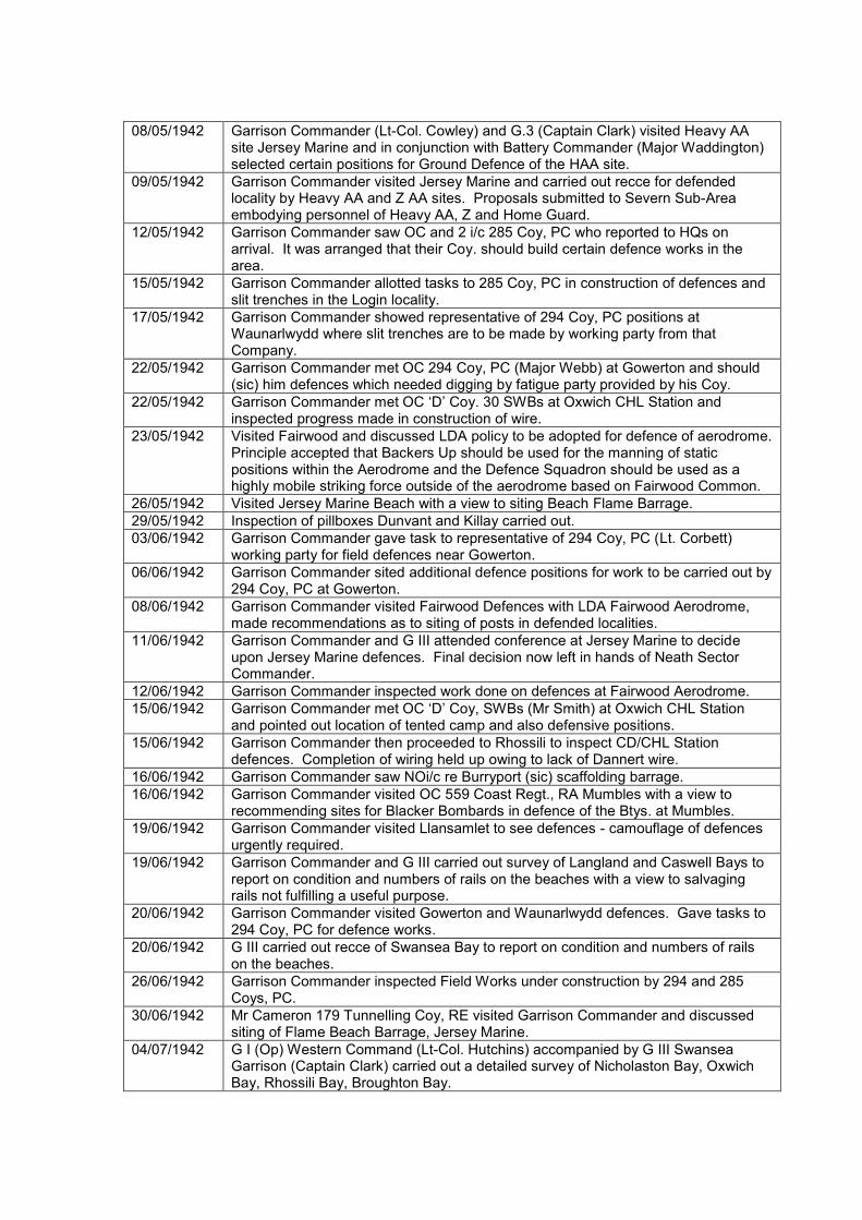
08/05/1942 Garrison Commander (Lt-Col. Cowley) and G.3 (Captain Clark) visited Heavy AA site Jersey Marine and in conjunction with Battery Commander (Major Waddington) selected certain positions for Ground Defence of the HAA site.
09/05/1942 Garrison Commander visited Jersey Marine and carried out recce for defended locality by Heavy AA and Z AA sites. Proposals submitted to Severn Sub-Area embodying personnel of Heavy AA, Z and Home Guard.
12/05/1942 Garrison Commander saw OC and 2 i/c 285 Coy, PC who reported to HQs on arrival. It was arranged that their Coy. should build certain defence works in the area.
15/05/1942 Garrison Commander allotted tasks to 285 Coy, PC in construction of defences and slit trenches in the Login locality.
17/05/1942 Garrison Commander showed representative of 294 Coy, PC positions at Waunarlwydd where slit trenches are to be made by working party from that Company.
22/05/1942 Garrison Commander met OC 294 Coy, PC (Major Webb) at Gowerton and should (sic) him defences which needed digging by fatigue party provided by his Coy.
22/05/1942 Garrison Commander met OC ‘D’ Coy. 30 SWBs at Oxwich CHL Station and inspected progress made in construction of wire.
23/05/1942 Visited Fairwood and discussed LDA policy to be adopted for defence of aerodrome. Principle accepted that Backers Up should be used for the manning of static positions within the Aerodrome and the Defence Squadron should be used as a highly mobile striking force outside of the aerodrome based on Fairwood Common.
26/05/1942 Visited Jersey Marine Beach with a view to siting Beach Flame Barrage.
29/05/1942 Inspection of pillboxes Dunvant and Killay carried out.
03/06/1942 Garrison Commander gave task to representative of 294 Coy, PC (Lt. Corbett) working party for field defences near Gowerton.
06/06/1942 Garrison Commander sited additional defence positions for work to be carried out by 294 Coy, PC at Gowerton.
08/06/1942 Garrison Commander visited Fairwood Defences with LDA Fairwood Aerodrome, made recommendations as to siting of posts in defended localities.
11/06/1942 Garrison Commander and G III attended conference at Jersey Marine to decide upon Jersey Marine defences. Final decision now left in hands of Neath Sector Commander.
12/06/1942 Garrison Commander inspected work done on defences at Fairwood Aerodrome.
15/06/1942 Garrison Commander met OC ‘D’ Coy, SWBs (Mr Smith) at Oxwich CHL Station and pointed out location of tented camp and also defensive positions.
15/06/1942 Garrison Commander then proceeded to Rhossili to inspect CD/CHL Station defences. Completion of wiring held up owing to lack of Dannert wire.
16/06/1942 Garrison Commander saw NOi/c re Burryport (sic) scaffolding barrage.
16/06/1942 Garrison Commander visited OC 559 Coast Regt., RA Mumbles with a view to recommending sites for Blacker Bombards in defence of the Btys. at Mumbles.
19/06/1942 Garrison Commander visited Llansamlet to see defences - camouflage of defences urgently required.
19/06/1942 Garrison Commander and G III carried out survey of Langland and Caswell Bays to report on condition and numbers of rails on the beaches with a view to salvaging rails not fulfilling a useful purpose.
20/06/1942 Garrison Commander visited Gowerton and Waunarlwydd defences. Gave tasks to 294 Coy, PC for defence works.
20/06/1942 G III carried out recce of Swansea Bay to report on condition and numbers of rails on the beaches.
26/06/1942 Garrison Commander inspected Field Works under construction by 294 and 285 Coys, PC.
30/06/1942 Mr Cameron 179 Tunnelling Coy, RE visited Garrison Commander and discussed siting of Flame Beach Barrage, Jersey Marine.
04/07/1942 G I (Op) Western Command (Lt-Col. Hutchins) accompanied by G III Swansea Garrison (Captain Clark) carried out a detailed survey of Nicholaston Bay, Oxwich Bay, Rhossili Bay, Broughton Bay.

06/07/1942 Garrison Commander handed over Waunarlwydd defended area defence works to No. 4 Coy, 12 Bn. Glam Home Guard.
07/07/1942 Garrison Commander inspected Popples Bay and 3 Cliffs Bay Minefields and submitted report to SAA re condition of mines.
08/07/1942 Garrison Commander, accompanied by DCRE (Major Pictor), met representatives of South Wales Transport Coy. and discussed question of incorporating Anti-Tank Blocks, which had fallen down, in the sea wall which they are building. Permission given for the Blocks to be made part of the new sea wall.
09/07/1942 Garrison Commander handed over field works in Windsor Terrace area (constructed by 294 Coy, PC) to No. 4 Coy, 12 Bn. Glam Home Guard.
10/07/1942 Garrison Commander took Colonel Davies (OC 12 Bn. Glam Home Guard) over ICI Gowerton defences and explained requirements for construction of fieldworks.
13/07/1942 Garrison Commander took Works Officer (Lt. Evans) to Fairwood Aerodrome and put him in charge of work being carried out by Contractor on Fairwood Defences.
14/07/1942 Garrison Commander inspected minefields at Port Eynon and Horton Bay.
16/07/1942 Provisional scheme for defence of Gower approved by Severn Sub-Area.
18/07/1942 Garrison Commander visited 179 Tunnelling Coy, RE and inspected work on Flame Beach Barrage - Jersey Marine.
20/07/1942 Garrison Commander proceeded to Fairwood Aerodrome and gave tasks for construction of fieldworks to Major Fry, RE Construction Coy.
22/07/1942 Garrison Commander visited Fairwood Aerodrome accompanied by LDA and Lt. Evans and selected positions to be built by RE in No. 9 Locality.
27/07/1942 Garrison Commander showed G III twelve sites chosen for Blacker Bombard Static Positions.
30/07/1942 G III, together with Mr Phillips (Rep. of Garrison Engineer) and Mr James (Rep. Term Contractor) pegged four positions for Static Blacker Bombard positions.
04/08/1942 G III (Captain Clark) took Mr Phillips (Representing Garrison Engineer West) and Mr James (Contractor) round Blacker Bombard positions in Gowerton, Gorseinon Road and Cockett areas. Static positions all pegged.
05/08/1942 G III showed Major Llewellyn, HG and Capt. Hayes (Adjt. 12 Bn. Glam HG) new positions constructed by 285 Coy, PC in the Gipsy Cross Locality for six sections. The 6-pdr gun at Fforestfach was also inspected.
06/08/1942 G III and Adjt. 12 Bn. Glam HG inspected Blackpill minefield.
11/08/1942 Garrison Commander visited Ynysforgan Viaduct for meeting with GWR Engineer regarding subsidence caused by construction of defence works. Agreed that a small retaining wall should be constructed.
11/08/1942 Major Hudson (OC 559 Coast Regt, RA) visited Garrison HQs and discussed Newton Pl. Home Guard who are to be used as Coastal Defence gunners.
13/08/1942 O i/c USA Movement Control detachment called on Garrison Commander regarding operational role. Detachment placed at disposal of DEMS for use on ships in Queen’s Dock in the event of enemy attack.
13/08/1942 LDA Fairwood (Major Bamford) visited Garrison Commander to discuss lessons learnt during ‘DAVID III’, and the re-organisation of defensive measures at the aerodrome.
20/08/1942 Garrison Commander proceeded to Slade Bay (Gower Peninsula) to visit 2847 Squadron RAF Regiment from Llandow who are in camp there.
24/08/1942 Squadron Leader Frogley, 2847 Squadron RAF visited Garrison HQs and was allotted an operational role for his detachment during period at Slade.
25/08/1942 Garrison Commander took OC 16 BD Coy, RE round positions to be constructed on [Fairwood] aerodrome.
27/08/1942 Major Edmund, OC 559 Coast Regt, RA called at Garrison HQs on assuming command. Operational role as OC Mumbles Sub-Sector explained to him.
28/08/1942 Garrison Commander conducted TEWT at Ring Contour 400 locality Fairwood.
30/08/1942 Garrison Commander took contractor round Blacker Bombard positions [at Jersey Marine].
06/09/1942 Garrison Commander and G3 accompanied Contractor (Mr James) to inspect work done on Blacker Bombards in Swansea area.

07/09/1942 Garrison Commander called on LDA Fairwood (Major Colebourne) to discuss defences in No. 7 locality.
15/09/1942 Garrison Commander visited Port Eynon to inspect minefields.
17/09/1942 Garrison Engineer inspected Static BB sites at Cwmbwrla, and later visited 179 Tunnelling Coy, RE and inspected progress of work on Flame Beach Barrage.
24/09/1942 Accompanied by OC 294 Coy, PC (Major Webb) and LDA Fairwood (Major Colebourne) GC visited Quarry Locality with view to transferring responsibility of this defence to the Aerodrome Backers Up.
28/09/1942 Garrison Commander inspected defences of 431 Bty, RA Swansea Docks.
02/10/1942 Garrison Commander took Garrison Engineer East to Jersey Marine to show him sites for new Blacker Bombards.
16/10/1942 Garrison Commander took LDA (Major Colebourne) to defences at Cockett and Tir Hester.
19/10/1942 Severn Sub-Area Commander (Col. Robb) visited ICI Landore and Waunarlwydd regarding AA defence.
04/11/1942 Garrison Comdr. visited defences Tir John with OC ‘C’ Coy, 14 Bn. Glam HG.
07/11/1942 Col. Robb ordered OC 559 Coast Regt, RA (Major Edmonds) to draw up Ground Defence Scheme as soon as possible and carry out necessary work in digging slit trenches and preparing defended localities.
09/11/1942 G III (Capt. Clark) visited CD/CHL Station at Rhossili and CHL Station at Oxwich to report on position as to Ground Defence after removal of ‘B’ Coy, 30 SWBs from these stations on 07/11/1942. Position at Oxwich fairly satisfactory; position at Rhossili far from satisfactory.
13/11/1942 G3 Swansea Garrison carried out inspection of all poles on Gower Peninsula originally placed in position as obstruction for landing grounds. Only those poles in Singleton Camp recommended for use as pit props.
17/11/1942 Garrison Commander visited 559 Coast Regt, RA and sited all ground defence positions for Btys. at Mumbles.
17/11/1942 Garrison Commander sites OPs for Flame Beach Barrage, Jersey Marine - work to be carried out by 179 (S) Tunnelling Coy, RE.
21/11/1942 G3 inspected Blacker Bombard sites for Static Mountings at Clydach - Aberdulais, Neath, Briton Ferry, Pontardawe.
24/11/1942 Garrison Commander showed OC Bomb Disposal Section, RE (Lt. Douglas) particulars of defence works required at CHL Station, Oxwich.
25/11/1942 Garrison Commander visited Station Commander Fairwood Airfield regarding passage of traffic through airfield in an emergency. Mutual arrangements arrived at whereby N & S barriers are made passable for Military traffic until such time as the airfield is attacked.
27/11/1942 Garrison Commander and G3 inspected work on defences being carried out by BDS at Oxwich.
14/12/1942 Garrison Commander (Lt-Col. Phillips) inspected No. 1 Coy, 12 Bn. Glam HG area - Morriston, Ynysforgan, Pont-lassau, Llangyfelach area.
21/12/1942 Garrison Commander accompanied by Adjt. 15 Bn. Glam HG (Capt. Simons) recce’d Ring Contour 400 and selected localities for HQs and 3 Pls. of Penclawdd Coy.
28/12/1942 Garrison Commander, Adjt. 15 Bn. Glam HG and a representative of LDA Fairwood, carried out a recce of Court Farm area and selected Pl. and Section Areas for 1 Pl. of 15 Bn. and 1 Flight of Aerodrome personnel.
30/12/1942 Garrison Commander inspected defences at New Cut Bridge, and Jersey Marine.

Appendix 6.6: List of identified defence sites for Swansea-Gower case study
Name Location Site Type Group E N Evidence
Arc
h
Do
c
AP
Cart
o
PB001 Lonlas Pillbox 1/A Swansea Sub-Sector Defences
270817 197238
FW001 Lonlas Fieldwork 1/A Swansea Sub-Sector Defences
270845 197238
PB002 Lonlas Pillbox 1/A Swansea Sub-Sector Defences
270406 197259
PB003 Peniel Green Tunnel
Pillbox 1/A Swansea Sub-Sector Defences
269629 197814
FW002 Peniel Green Tunnel
Fieldwork 1/A Swansea Sub-Sector Defences
269555 197941
FW003 Peniel Green Tunnel
Fieldwork 1/A Swansea Sub-Sector Defences
269858 197875
PB004 Llansamlet Church
Pillbox 1/A Swansea Sub-Sector Defences
268779 197996
FW004 Llansamlet Church
Fieldwork 1/A Swansea Sub-Sector Defences
268619 197995
PB005 Llansamlet Church
Pillbox 1/A Swansea Sub-Sector Defences
268744 197686
PB006 Llansamlet Square
Pillbox 1/A Swansea Sub-Sector Defences
268721 195774
PB007 Llansamlet Square
Pillbox 1/A Swansea Sub-Sector Defences
268730 197436
PB008 Llansamlet Square
Pillbox 1/A Swansea Sub-Sector Defences
268653 197554
RESERVES Llansamlet Square
Ancillary Building 1/A Swansea Sub-Sector Defences
268368 197380
PB009 Halfway Inn Pillbox 1/A Swansea Sub-Sector Defences
269287 196347
FW005 Halfway Inn Fieldwork 1/A Swansea Sub-Sector Defences
269387 196347
H Halfway Inn Fortified House 1/A Swansea Sub-Sector Defences
269438 196424
PB010 Winch Wen Pillbox 1/A Swansea Sub-Sector Defences
268345 196502
PB011 Winch Wen Pillbox 1/A Swansea Sub-Sector Defences
268038 196237
FW006 Winch Wen Fieldwork 1/A Swansea Sub-Sector Defences
268055 196257
RESERVES RESERVES Ancillary Building 1/A Swansea Sub-Sector Defences
268351 197052
RESERVES RESERVES Ancillary Building 1/A Swansea Sub-Sector Defences
269287 196357

RESERVES RESERVES Ancillary Building 1/A Swansea Sub-Sector Defences
269043 197246
PB012 Bonymaen Pillbox 1/B Swansea Sub-Sector Defences
268000 194974
FW007 Bonymaen Fieldwork 1/B Swansea Sub-Sector Defences
267662 194892
FW008 Bonymaen Fieldwork 1/B Swansea Sub-Sector Defences
267562 194892
PB013 Pentrechwyth Pillbox 1/B Swansea Sub-Sector Defences
267410 195460
PB014 Pentrechwyth Pillbox 1/B Swansea Sub-Sector Defences
267190 195211
FW009 Pentrechwyth Fieldwork 1/B Swansea Sub-Sector Defences
267318 195295
PB015 White Rock Pillbox 1/B Swansea Sub-Sector Defences
266401 194881
FW010 White Rock Fieldwork 1/B Swansea Sub-Sector Defences
266411 194891
FW011 White Rock Fieldwork 1/B Swansea Sub-Sector Defences
266432 195030
PB016 Tir John Pillbox 1/B Swansea Sub-Sector Defences
268477 193552
FW012 Tir John Fieldwork 1/B Swansea Sub-Sector Defences
268555 194154
FW013 Tir John Fieldwork 1/B Swansea Sub-Sector Defences
268532 194147
PB017 Cemetery Pillbox 1/B Swansea Sub-Sector Defences
268040 193553
PB018 Cemetery Pillbox 1/B Swansea Sub-Sector Defences
267563 193563
PB019 Cemetery Pillbox 1/B Swansea Sub-Sector Defences
267306 193543
PB020 Cemetery Pillbox 1/B Swansea Sub-Sector Defences
266611 193543
PB021 St Thomas Pillbox 1/B Swansea Sub-Sector Defences
266173 193606
FW014 St Thomas Fieldwork 1/B Swansea Sub-Sector Defences
266189 193404
FW015 St Thomas Fieldwork 1/B Swansea Sub-Sector Defences
266179 193817
RESERVES RESERVES Ancillary Building 1/B Swansea Sub-Sector Defences
267873 195295
RESERVES RESERVES Ancillary Building 1/B Swansea Sub-Sector Defences
268521 193644
RESERVES RESERVES Ancillary Building 1/B Swansea Sub-Sector Defences
Not cited Not cited

PB022 Ynysforgan Viaduct
Pillbox 2/C Swansea Sub-Sector Defences
267285 199152
PB023 Ynysforgan Viaduct
Pillbox 2/C Swansea Sub-Sector Defences
267555 199239
PB024 Ynysforgan Viaduct
Pillbox 2/C Swansea Sub-Sector Defences
267840 199216
PB025 Chemical Road Pillbox 2/C Swansea Sub-Sector Defences
266655 199189
PB026 Chemical Road Pillbox 2/C Swansea Sub-Sector Defences
266825 199099
FW016 Chemical Road Fieldwork 2/C Swansea Sub-Sector Defences
266470 199280
PB027 School Pillbox 2/C Swansea Sub-Sector Defences
266847 199470
FW017 School Fieldwork 2/C Swansea Sub-Sector Defences
266856 199619
FW018 School Fieldwork 2/C Swansea Sub-Sector Defences
266838 199717
FW019 Golf Links Fieldwork 2/C Swansea Sub-Sector Defences
266216 198734
FW020 Golf Links Fieldwork 2/C Swansea Sub-Sector Defences
266316 198573
FW021 Golf Links Fieldwork 2/C Swansea Sub-Sector Defences
266370 198856
PB028 Pentrepoeth Pillbox 2/C Swansea Sub-Sector Defences
266800 198250
FW022 Pentrepoeth Loopholed Wall 2/C Swansea Sub-Sector Defences
266654 198633
FW023 Pentrepoeth Loopholed Wall 2/C Swansea Sub-Sector Defences
266664 198477
PB029 Chris Williams Pillbox 2/C Swansea Sub-Sector Defences
267018 198177
PB030 Chris Williams Pillbox 2/C Swansea Sub-Sector Defences
267184 198334
PB031 Chris Williams Pillbox 2/C Swansea Sub-Sector Defences
266946 198288
PB032 Chris Williams Pillbox 2/C Swansea Sub-Sector Defences
266719 198154
PB033 Fforest Bridge Pillbox 2/C Swansea Sub-Sector Defences
267315 197801
PB034 Fforest Bridge Pillbox 2/C Swansea Sub-Sector Defences
266584 197719
PB035 Fforest Bridge Pillbox 2/C Swansea Sub-Sector Defences
267176 197963
PB036 Duke Hotel Pillbox 2/C Swansea Sub-Sector Defences
266905 197002

PB037 Duke Hotel Pillbox 2/C Swansea Sub-Sector Defences
266889 197338
PB038 Duke Hotel Pillbox 2/C Swansea Sub-Sector Defences
266928 197275
FW024 Duke Hotel Fieldwork 2/C Swansea Sub-Sector Defences
266905 197022
PB039 Bryn Rock Pillbox 2/C Swansea Sub-Sector Defences
266404 197632
FW025 Bryn Rock Fieldwork 2/C Swansea Sub-Sector Defences
266413 197404
PB040 Bryn Rock Pillbox 2/C Swansea Sub-Sector Defences
266314 197226
PB041 Bryn Rock Pillbox 2/C Swansea Sub-Sector Defences
266285 197609
PB042 Pontlassau Pillbox 2/C Swansea Sub-Sector Defences
265819 200042
FW026 Pontlassau Fieldwork 2/C Swansea Sub-Sector Defences
265590 200106
FW027 Pontlassau Fieldwork 2/C Swansea Sub-Sector Defences
265847 200225
PB043 Llangyfelach Pillbox 2/C Swansea Sub-Sector Defences
264683 198899
FW028 Llangyfelach Fieldwork 2/C Swansea Sub-Sector Defences
264545 198874
FW029 Llangyfelach Fieldwork 2/C Swansea Sub-Sector Defences
264651 199207
PB044 Mynyddbach Pillbox 2/C Swansea Sub-Sector Defences
265222 197431
FW030 Mynyddbach Fieldwork 2/C Swansea Sub-Sector Defences
265048 197579
FW031 Mynyddbach Fieldwork 2/C Swansea Sub-Sector Defences
265382 197566
FW032 Mynyddbach Fieldwork 2/C Swansea Sub-Sector Defences
265281 197566
PB045 Mynyddbach Pillbox 2/C Swansea Sub-Sector Defences
265279 197002
PB046 Mynydd Cadle Common
Pillbox 2/C Swansea Sub-Sector Defences
264648 197083
FW033 Mynydd Cadle Common
Fieldwork 2/C Swansea Sub-Sector Defences
264648 197195
PB047 Mynydd Cadle Common
Pillbox 2/C Swansea Sub-Sector Defences
264660 196790
PB048 Mynydd Cadle Common
Pillbox 2/C Swansea Sub-Sector Defences
264421 196696
FW034 Mynydd Cadle Common
Fieldwork 2/C Swansea Sub-Sector Defences
264690 196709

PB049 Mynydd Newydd Colliery
Pillbox 2/C Swansea Sub-Sector Defences
263852 196625
FW035 Mynydd Newydd Colliery
Fieldwork 2/C Swansea Sub-Sector Defences
263970 196625
FW036 Mynydd Newydd Colliery
Fieldwork 2/C Swansea Sub-Sector Defences
263881 196293
FW037 Mynydd Newydd Colliery
Fieldwork 2/C Swansea Sub-Sector Defences
263730 196418
FW038 Mynydd Newydd Colliery
Fieldwork 2/C Swansea Sub-Sector Defences
263730 196318
PB050 Ravenhill Pillbox 2/C Swansea Sub-Sector Defences
263582 196363
PB051 Ravenhill Pillbox 2/C Swansea Sub-Sector Defences
263747 195951
PB052 Ravenhill Pillbox 2/C Swansea Sub-Sector Defences
264211 195569
FW039 Ravenhill Fieldwork 2/C Swansea Sub-Sector Defences
264201 195569
RESERVES RESERVES Ancillary Building 2/C Swansea Sub-Sector Defences
Not cited Not cited
PB053 Fforestfach Pillbox 2/D Swansea Sub-Sector Defences
263397 196030
PB054 Fforestfach Anti-Tank Gun Emplacement
2/D Swansea Sub-Sector Defences
262770 196262
PB055 Fforestfach Pillbox 2/D Swansea Sub-Sector Defences
262867 196262
PB056 Fforestfach Pillbox 2/D Swansea Sub-Sector Defences
263014 195776
FW040 White City Fieldwork 2/D Swansea Sub-Sector Defences
262897 195224
PB057 Cockett Pillbox 2/D Swansea Sub-Sector Defences
263217 195451
FW041 Cockett Fieldwork 2/D Swansea Sub-Sector Defences
263060 195703
PB058 Cockett Pillbox 2/D Swansea Sub-Sector Defences
263141 195106
PB059 Cockett Pillbox 2/D Swansea Sub-Sector Defences
262897 195234
PB060 Cadle Pillbox 2/D Swansea Sub-Sector Defences
262390 197213
FW042 Cadle Fieldwork 2/D Swansea Sub-Sector Defences
262254 197296
FW043 Cadle Fieldwork 2/D Swansea Sub-Sector Defences
262201 196694
PB061 Island House Pillbox 2/D Swansea Sub-Sector Defences
257863 197216

FW044 Island House Fieldwork 2/D Swansea Sub-Sector Defences
257860 197329
FW045 Island House Fieldwork 2/D Swansea Sub-Sector Defences
257840 197123
PB062 New Elba Colliery
Pillbox 2/D Swansea Sub-Sector Defences
258367 196673
PB063 New Elba Colliery
Pillbox 2/D Swansea Sub-Sector Defences
258429 196542
PB064 New Elba Colliery
Pillbox 2/D Swansea Sub-Sector Defences
258330 196536
FW046 New Elba Colliery
Fieldwork 2/D Swansea Sub-Sector Defences
258330 196546
PB065 Elba Works Pillbox 2/D Swansea Sub-Sector Defences
258907 196710
PB066 Elba Works Pillbox 2/D Swansea Sub-Sector Defences
258734 196559
PB067 Elba Works Pillbox 2/D Swansea Sub-Sector Defences
258734 196659
PB068 Elba Works Pillbox 2/D Swansea Sub-Sector Defences
258897 196258
PB069 Gowerton Station
Pillbox 2/D Swansea Sub-Sector Defences
259078 196475
PB070 Gowerton Station
Pillbox 2/D Swansea Sub-Sector Defences
259148 196366
PB071 Gowerton Station
Pillbox 2/D Swansea Sub-Sector Defences
259075 196228
PB072 Gowerton Station
Pillbox 2/D Swansea Sub-Sector Defences
259161 196153
FW047 Winder Terrace Fieldwork 2/D Swansea Sub-Sector Defences
259496 196188
FW048 Winder Terrace Fieldwork 2/D Swansea Sub-Sector Defences
259496 196088
PB073 Winder Terrace Pillbox 2/D Swansea Sub-Sector Defences
259418 195867
PB074 Winder Terrace Pillbox 2/D Swansea Sub-Sector Defences
259490 195938
PB075 Winder Terrace Pillbox 2/D Swansea Sub-Sector Defences
259594 195849
PB076 Winder Terrace Pillbox 2/D Swansea Sub-Sector Defences
259386 195613
PB077 Winder Terrace Pillbox 2/D Swansea Sub-Sector Defences
259398 195613
PB078 Winder Terrace Pillbox 2/D Swansea Sub-Sector Defences
259496 195554
FW049 Gormwydd Fieldwork 2/D Swansea Sub-Sector Defences
258791 195616

FW050 Allt-wen Fieldwork 2/D Swansea Sub-Sector Defences
257868 195931
FW051 Waunarlwydd Fieldwork 2/D Swansea Sub-Sector Defences
261097 195857
FW052 Waunarlwydd Fieldwork 2/D Swansea Sub-Sector Defences
261124 195562
FW053 Waunarlwydd Fieldwork 2/D Swansea Sub-Sector Defences
261359 195555
RESERVES RESERVES Ancillary Building 2/D Swansea Sub-Sector Defences
Not cited Not cited
FW054 Gowerton - Dunvant Road
Fieldwork 2/E Swansea Sub-Sector Defences
259465 194895
PB079 Brickworks Pillbox 2/E Swansea Sub-Sector Defences
259704 194360
PB080 Brickworks Pillbox 2/E Swansea Sub-Sector Defences
259704 194260
FW055 Brickworks Fieldwork 2/E Swansea Sub-Sector Defences
259577 194251
PB081 Dunvant Post Office
Pillbox 2/E Swansea Sub-Sector Defences
259600 193717
PB082 Dunvant Post Office
Pillbox 2/E Swansea Sub-Sector Defences
259500 193717
PB083 Dunvant Post Office
Pillbox 2/E Swansea Sub-Sector Defences
259411 193637
PB084 Dunvant Post Office
Pillbox 2/E Swansea Sub-Sector Defences
259500 193617
FW056 Dunvant Post Office
Fieldwork 2/E Swansea Sub-Sector Defences
259411 193647
FW057 Dunvant Post Office
Fieldwork 2/E Swansea Sub-Sector Defences
259398 193749
PB085 Dunvant Parish Hall
Pillbox 2/E Swansea Sub-Sector Defences
259981 193436
PB086 Dunvant Parish Hall
Pillbox 2/E Swansea Sub-Sector Defences
259881 193436
PB087 Dunvant Parish Hall
Pillbox 2/E Swansea Sub-Sector Defences
259904 193250
PB088 Killay Pillbox 2/E Swansea Sub-Sector Defences
260149 192102
PB089 Killay Pillbox 2/E Swansea Sub-Sector Defences
260088 192115
FW058 Killay Fieldwork 2/E Swansea Sub-Sector Defences
260119 191938
PB090 Killay Pillbox 2/E Swansea Sub-Sector Defences
259918 192172
PB091 Killay Pillbox 2/E Swansea Sub-Sector Defences
259918 192272

PB092 Killay Pillbox 2/E Swansea Sub-Sector Defences
259716 192414
PB093 Killay Pillbox 2/E Swansea Sub-Sector Defences
259906 192563
PB094 Killay Pillbox 2/E Swansea Sub-Sector Defences
260166 192750
FW059 Killay Fieldwork 2/E Swansea Sub-Sector Defences
260015 192427
PB095 Race Course Pillbox 2/E Swansea Sub-Sector Defences
260625 192504
FW060 Race Course Fieldwork 2/E Swansea Sub-Sector Defences
260742 192391
PB096 Clyne Valley Colliery
Pillbox 2/E Swansea Sub-Sector Defences
261542 191527
FW061 Clyne Valley Colliery
Fieldwork 2/E Swansea Sub-Sector Defences
261442 191527
PB097 Clyne Valley Colliery
Pillbox 2/E Swansea Sub-Sector Defences
261313 191367
PB098 Blackpill Pillbox 2/E Swansea Sub-Sector Defences
261797 190306
PB099 Blackpill Pillbox 2/E Swansea Sub-Sector Defences
261889 190412
PB100 Blackpill Pillbox 2/E Swansea Sub-Sector Defences
261889 190512
PB101 Blackpill Pillbox 2/E Swansea Sub-Sector Defences
261889 190712
PB102 Blackpill Pillbox 2/E Swansea Sub-Sector Defences
261879 190712
PB103 Blackpill Pillbox 2/E Swansea Sub-Sector Defences
261843 190688
PB104 Blackpill Pillbox 2/E Swansea Sub-Sector Defences
261943 190688
PB105 Blackpill Pillbox 2/E Swansea Sub-Sector Defences
261850 190855
PB106 Blackpill Pillbox 2/E Swansea Sub-Sector Defences
261850 190875
H Blackpill Fortified House 2/E Swansea Sub-Sector Defences
261887 190599
FW062 Clyne Farm Fieldwork 2/E Swansea Sub-Sector Defences
261067 190690
FW063 Clyne Farm Fieldwork 2/E Swansea Sub-Sector Defences
260834 190750
FW064 Clyne Farm Fieldwork 2/E Swansea Sub-Sector Defences
260628 190941
PB107 Sketty Pillbox 2/E Swansea Sub-Sector Defences
262295 193502
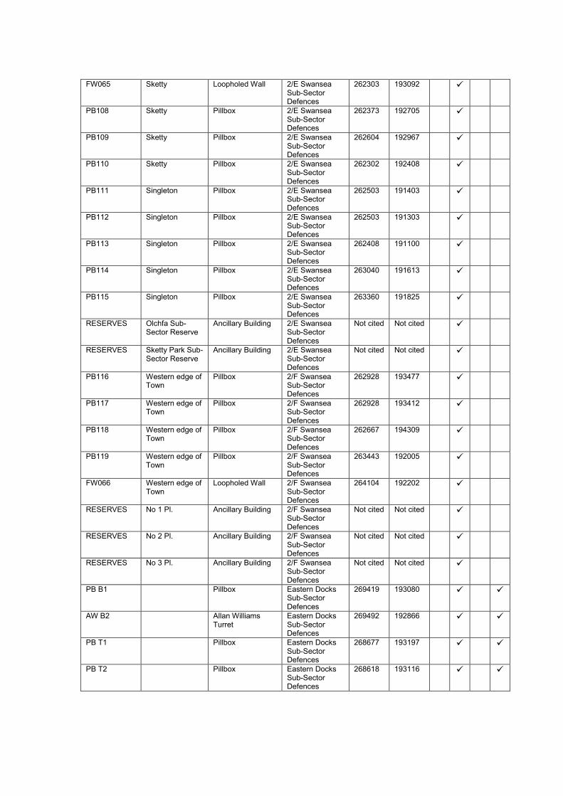
FW065 Sketty Loopholed Wall 2/E Swansea Sub-Sector Defences
262303 193092
PB108 Sketty Pillbox 2/E Swansea Sub-Sector Defences
262373 192705
PB109 Sketty Pillbox 2/E Swansea Sub-Sector Defences
262604 192967
PB110 Sketty Pillbox 2/E Swansea Sub-Sector Defences
262302 192408
PB111 Singleton Pillbox 2/E Swansea Sub-Sector Defences
262503 191403
PB112 Singleton Pillbox 2/E Swansea Sub-Sector Defences
262503 191303
PB113 Singleton Pillbox 2/E Swansea Sub-Sector Defences
262408 191100
PB114 Singleton Pillbox 2/E Swansea Sub-Sector Defences
263040 191613
PB115 Singleton Pillbox 2/E Swansea Sub-Sector Defences
263360 191825
RESERVES Olchfa Sub-Sector Reserve
Ancillary Building 2/E Swansea Sub-Sector Defences
Not cited Not cited
RESERVES Sketty Park Sub-Sector Reserve
Ancillary Building 2/E Swansea Sub-Sector Defences
Not cited Not cited
PB116 Western edge of Town
Pillbox 2/F Swansea Sub-Sector Defences
262928 193477
PB117 Western edge of Town
Pillbox 2/F Swansea Sub-Sector Defences
262928 193412
PB118 Western edge of Town
Pillbox 2/F Swansea Sub-Sector Defences
262667 194309
PB119 Western edge of Town
Pillbox 2/F Swansea Sub-Sector Defences
263443 192005
FW066 Western edge of Town
Loopholed Wall 2/F Swansea Sub-Sector Defences
264104 192202
RESERVES No 1 Pl. Ancillary Building 2/F Swansea Sub-Sector Defences
Not cited Not cited
RESERVES No 2 Pl. Ancillary Building 2/F Swansea Sub-Sector Defences
Not cited Not cited
RESERVES No 3 Pl. Ancillary Building 2/F Swansea Sub-Sector Defences
Not cited Not cited
PB B1 Pillbox Eastern Docks Sub-Sector Defences
269419 193080
AW B2 Allan Williams Turret
Eastern Docks Sub-Sector Defences
269492 192866
PB T1 Pillbox Eastern Docks Sub-Sector Defences
268677 193197
PB T2 Pillbox Eastern Docks Sub-Sector Defences
268618 193116

PB T3 Pillbox Eastern Docks Sub-Sector Defences
268737 193107
PB T4 Pillbox Eastern Docks Sub-Sector Defences
268724 193047
PB T5 Pillbox Eastern Docks Sub-Sector Defences
268622 193039
PB T6 Pillbox Eastern Docks Sub-Sector Defences
268720 192976
SBP T7 Infantry Post Eastern Docks Sub-Sector Defences
268884 192853
PB Q1 Queen's Dock Pillbox Eastern Docks Sub-Sector Defences
267280 191830
PB Q2 Queen's Dock Pillbox Eastern Docks Sub-Sector Defences
267625 1921951
PB Q3 Queen's Dock Pillbox Eastern Docks Sub-Sector Defences
268035 192096
SBP Q4 Queen's Dock Gun Emplacement Eastern Docks Sub-Sector Defences
268370 192227
PB Q5 Queen's Dock Pillbox Eastern Docks Sub-Sector Defences
268934 192776
PB Q6 Queen's Dock Pillbox Eastern Docks Sub-Sector Defences
269068 192931
PB P1 Prince of Wales Dock
Pillbox Eastern Docks Sub-Sector Defences
266253 193059
PB P2 Prince of Wales Dock
Pillbox Eastern Docks Sub-Sector Defences
266362 193113
RH P3 Prince of Wales Dock
Defended Building Eastern Docks Sub-Sector Defences
266866 193083
AW P4 Prince of Wales Dock
Allan Williams Turret
Eastern Docks Sub-Sector Defences
267490 193033
PB P5 Prince of Wales Dock
Pillbox Eastern Docks Sub-Sector Defences
267450 192924
PB P6 Prince of Wales Dock
Pillbox Eastern Docks Sub-Sector Defences
267557 192930
PB P7 Prince of Wales Dock
Pillbox Eastern Docks Sub-Sector Defences
Not cited Not cited
PB K1 King's Dock Pillbox Eastern Docks Sub-Sector Defences
266604 192513
PB K3 King's Dock Pillbox Eastern Docks Sub-Sector Defences
266886 192781
PB K4 King's Dock Pillbox Eastern Docks Sub-Sector Defences
266821 192257
PB K8 King's Dock Pillbox Eastern Docks Sub-Sector Defences
Not cited Not cited
SBP S1(W) South Dock Infantry Post South Dock Sub-Sector Defences
265436 192384

SBP S1(E) South Dock Infantry Post South Dock Sub-Sector Defences
265452 192393
S2 South Dock Defended Building South Dock Sub-Sector Defences
265491 192536
PB S3 South Dock Pillbox South Dock Sub-Sector Defences
265541 192493
PB S4 South Dock Pillbox South Dock Sub-Sector Defences
265744 192597
PB S5 South Dock Pillbox South Dock Sub-Sector Defences
265794 192636
PB S6 South Dock Pillbox South Dock Sub-Sector Defences
265934 192630
PB S7 South Dock Pillbox South Dock Sub-Sector Defences
265976 192640
PB S8 South Dock Pillbox South Dock Sub-Sector Defences
266038 192655
PB S9 South Dock Pillbox South Dock Sub-Sector Defences
266064 192485
PB S10 South Dock Pillbox South Dock Sub-Sector Defences
266306 192693
BT S11 South Dock Rifle Pit South Dock Sub-Sector Defences
266326 192639
AW S12 South Dock Allan Williams Turret
South Dock Sub-Sector Defences
266125 192901
PB S13 South Dock Pillbox South Dock Sub-Sector Defences
266140 192960
S14 South Dock Defended Building South Dock Sub-Sector Defences
265926 192930
S15 South Dock Rifle Pit South Dock Sub-Sector Defences
265929 192812
Gun No. 7. 4-in gun emplacement
East of shoreline APOC oil storage tanks
Beach Defence Battery
Eastern Docks Sub-Sector Defences
269580 192715
Gun No. 6. 4.7-in gun emplacement
East of Q4 Beach Defence Battery
Eastern Docks Sub-Sector Defences
268377 192235
Gun No. 5. 4.7-in gun emplacement
South of South Dock
Beach Defence Battery
South Dock Sub-Sector Defences
265520 192281
Gun No. 4. 4-in gun emplacement
West of South Dock
Beach Defence Battery
South Dock Sub-Sector Defences
265224 192277
Flame Fougasse 01
Cadle Barrel Flame Trap 262346 197083
Flame Fougasse 02
Olchfa Barrel Flame Trap 261096 193207
Flame Fougasse 03
Blackpill Barrel Flame Trap 261619 190599
Flame Fougasse 04
Whiterock Barrel Flame Trap 266400 194847
Flame Fougasse 05
Parkmill Barrel Flame Trap 253843 188950
Flame Fougasse 06
Cockett Barrel Flame Trap 262898 193925
Flame Fougasse 07
Llangyfelach Barrel Flame Trap 264679 198882

Flame Fougasse 08
Pont-Iasau Barrel Flame Trap 265958 200089
Flame Fougasse 09
Dunvant Barrel Flame Trap 259413 193699
Flame Fougasse 10
Mumbles Head Barrel Flame Trap 262871 187428
Flame Fougasse 11
Caswell Bay Barrel Flame Trap 258806 187702
Flame Fougasse 12
Wernbwll Barrel Flame Trap 255588 194668
Roadblock A1 Lonlas Roadblock 1/A Swansea Sub-Sector Defences
270759 197165
Roadblock A2 Peniel Green Roadblock 1/A Swansea Sub-Sector Defences
269656 197855
Roadblock A3 Llansamlet Roadblock 1/A Swansea Sub-Sector Defences
268776 197989
Canadian Pipe Mine 01
Oxwich Bay Canadian Pipe Mine
250264 187634
Canadian Pipe Mine 02
Oxwich Bay Canadian Pipe Mine
250267 187665
Canadian Pipe Mine 03
Oxwich Bay Canadian Pipe Mine
250146 186331
Canadian Pipe Mine 04
Pennard Burrows
Canadian Pipe Mine
253960 188293
Canadian Pipe Mine 05
Oxwich Burrows Canadian Pipe Mine
250199 186572
Canadian Pipe Mine 06
Oxwich Burrows Canadian Pipe Mine
250281 187456
Canadian Pipe Mine 07
Parkmill Canadian Pipe Mine
254638 189165
Canadian Pipe Mine 08
Parkmill Canadian Pipe Mine
254650 188910
Canadian Pipe Mine 09
Llethryd Canadian Pipe Mine
253081 191361
Canadian Pipe Mine 10
Cwm Ivy Canadian Pipe Mine
243774 194065
Canadian Pipe Mine 11
Pwlldu Bay Canadian Pipe Mine
257496 187208
Canadian Pipe Mine 12
Penrice Wood Canadian Pipe Mine
250342 188077
Canadian Pipe Mine 13
Penrice Wood Canadian Pipe Mine
250278 187867
Canadian Pipe Mine 14
Port-Eynon Canadian Pipe Mine
246443 185592
Canadian Pipe Mine 15
Weobley Castle Canadian Pipe Mine
247716 192793
Canadian Pipe Mine 16
Killay Canadian Pipe Mine
260091 192124
Canadian Pipe Mine 17
Killay Canadian Pipe Mine
260195 192124
Canadian Pipe Mine 18
Killay Canadian Pipe Mine
259520 192618
Canadian Pipe Mine 19
Bishwell Common
Canadian Pipe Mine
259420 195168
Canadian Pipe Mine 20
Bishwell Common
Canadian Pipe Mine
259432 195268
Canadian Pipe Mine 21
Bevexe-fach Canadian Pipe Mine
259394 194842
Canadian Pipe Mine 22
Island House Canadian Pipe Mine
257946 197041
Canadian Pipe Mine 23
Island House Canadian Pipe Mine
257931 197142
Canadian Pipe Mine 24
Langland Bay Canadian Pipe Mine
260570 187250
Canadian Pipe Mine 25
Langland Bay Canadian Pipe Mine
260570 187350
Canadian Pipe Mine 26
Langland Bay Canadian Pipe Mine
260670 187350
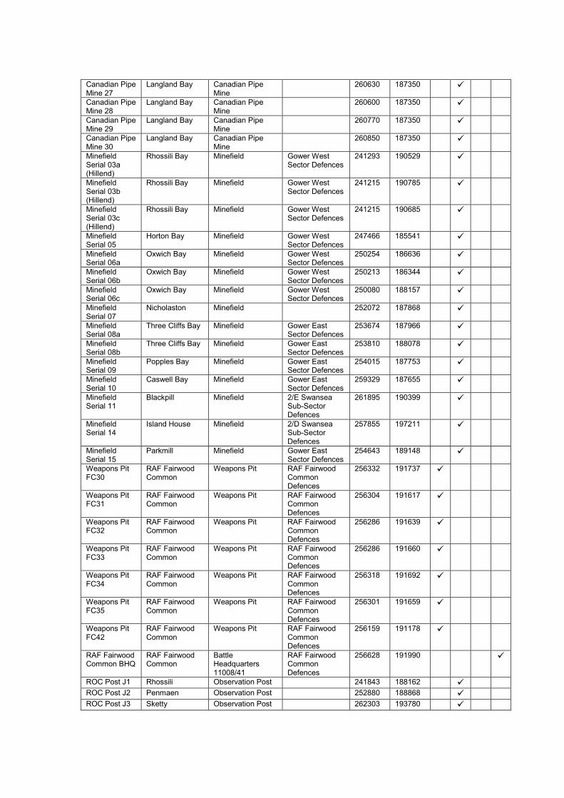
Canadian Pipe Mine 27
Langland Bay Canadian Pipe Mine
260630 187350
Canadian Pipe Mine 28
Langland Bay Canadian Pipe Mine
260600 187350
Canadian Pipe Mine 29
Langland Bay Canadian Pipe Mine
260770 187350
Canadian Pipe Mine 30
Langland Bay Canadian Pipe Mine
260850 187350
Minefield Serial 03a (Hillend)
Rhossili Bay Minefield Gower West Sector Defences
241293 190529
Minefield Serial 03b (Hillend)
Rhossili Bay Minefield Gower West Sector Defences
241215 190785
Minefield Serial 03c (Hillend)
Rhossili Bay Minefield Gower West Sector Defences
241215 190685
Minefield Serial 05
Horton Bay Minefield Gower West Sector Defences
247466 185541
Minefield Serial 06a
Oxwich Bay Minefield Gower West Sector Defences
250254 186636
Minefield Serial 06b
Oxwich Bay Minefield Gower West Sector Defences
250213 186344
Minefield Serial 06c
Oxwich Bay Minefield Gower West Sector Defences
250080 188157
Minefield Serial 07
Nicholaston Minefield 252072 187868
Minefield Serial 08a
Three Cliffs Bay Minefield Gower East Sector Defences
253674 187966
Minefield Serial 08b
Three Cliffs Bay Minefield Gower East Sector Defences
253810 188078
Minefield Serial 09
Popples Bay Minefield Gower East Sector Defences
254015 187753
Minefield Serial 10
Caswell Bay Minefield Gower East Sector Defences
259329 187655
Minefield Serial 11
Blackpill Minefield 2/E Swansea Sub-Sector Defences
261895 190399
Minefield Serial 14
Island House Minefield 2/D Swansea Sub-Sector Defences
257855 197211
Minefield Serial 15
Parkmill Minefield Gower East Sector Defences
254643 189148
Weapons Pit FC30
RAF Fairwood Common
Weapons Pit RAF Fairwood Common Defences
256332 191737
Weapons Pit FC31
RAF Fairwood Common
Weapons Pit RAF Fairwood Common Defences
256304 191617
Weapons Pit FC32
RAF Fairwood Common
Weapons Pit RAF Fairwood Common Defences
256286 191639
Weapons Pit FC33
RAF Fairwood Common
Weapons Pit RAF Fairwood Common Defences
256286 191660
Weapons Pit FC34
RAF Fairwood Common
Weapons Pit RAF Fairwood Common Defences
256318 191692
Weapons Pit FC35
RAF Fairwood Common
Weapons Pit RAF Fairwood Common Defences
256301 191659
Weapons Pit FC42
RAF Fairwood Common
Weapons Pit RAF Fairwood Common Defences
256159 191178
RAF Fairwood Common BHQ
RAF Fairwood Common
Battle Headquarters 11008/41
RAF Fairwood Common Defences
256628 191990
ROC Post J1 Rhossili Observation Post 241843 188162
ROC Post J2 Penmaen Observation Post 252880 188868
ROC Post J3 Sketty Observation Post 262303 193780

ROC Post J4 Penclawdd Observation Post 253115 195581
HAA Regt Battery HQ
Morriston Army Headquarters
Swansea Gun Defended Area
266248 198724
HAA Regt Battery HQ
Jersey Marine Army Headquarters
Swansea Gun Defended Area
271335 193481
HAA Regt Battery HQ
Sketty Army Headquarters
Swansea Gun Defended Area
262204 191711
Swansea Heavy Anti-Aircraft Battery N.1
Morriston Heavy Anti-Aircraft Battery
Swansea Gun Defended Area
269458 198360
Swansea Heavy Anti-Aircraft Battery N.3
Jersey Marine Heavy Anti-Aircraft Battery
Swansea Gun Defended Area
271255 193404
Swansea Heavy Anti-Aircraft Battery N.23
Jersey Marine Heavy Anti-Aircraft Battery
Swansea Gun Defended Area
271250 193400
Swansea Heavy Anti-Aircraft Battery N.4
Ravenhill Heavy Anti-Aircraft Battery
Swansea Gun Defended Area
264250 196302
Swansea Heavy Anti-Aircraft Battery N.5
Mumbles Heavy Anti-Aircraft Battery
Swansea Gun Defended Area
262232 187586
Swansea Heavy Anti-Aircraft Battery N.6
Sketty Heavy Anti-Aircraft Battery
Swansea Gun Defended Area
262290 191610
Swansea Heavy Anti-Aircraft Battery N.26
Sketty Heavy Anti-Aircraft Battery
Swansea Gun Defended Area
262300 191610
LAA Regt Battery HQ
Jersey Marine Army Headquarters
271345 193702
Fairwood Common Light Anti-Aircraft Battery N.46
Runway Light Anti-Aircraft Battery
RAF Fairwood Common Defences
257225 192533
Fairwood Common Light Anti-Aircraft Battery N.47
Tower Light Anti-Aircraft Battery
RAF Fairwood Common Defences
257567 191524
Fairwood Common Light Anti-Aircraft Battery N.48
Command Light Anti-Aircraft Battery
RAF Fairwood Common Defences
257379 190713
Fairwood Common Light Anti-Aircraft Battery N.49
Lakemoor Light Anti-Aircraft Battery
RAF Fairwood Common Defences
256875 190052
Fairwood Common Light Anti-Aircraft Battery N.50
Court House Light Anti-Aircraft Battery
RAF Fairwood Common Defences
256109 190386
Fairwood Common Light Anti-Aircraft Battery N.51
Copse Light Anti-Aircraft Battery
RAF Fairwood Common Defences
256101 191246
Fairwood Common Light Anti-Aircraft Battery N.52
The Mound Light Anti-Aircraft Battery
RAF Fairwood Common Defences
256220 191437
Fairwood Common Light Anti-Aircraft Battery N.53
Hill Light Anti-Aircraft Battery
RAF Fairwood Common Defences
256436 191894
AA Z Regt Battery HQ
Neath Army Headquarters
275728 196729

AA Z Regt Battery HQ
Sketty Army Headquarters
Swansea Gun Defended Area
261800 191064
Swansea Z Anti-Aircraft Battery K.70
South Dock Z Battery Swansea Gun Defended Area
266252 192510
Swansea Z Anti-Aircraft Battery K.71
King's Dock Z Battery Swansea Gun Defended Area
266845 192059
Swansea Z Anti-Aircraft Battery K.73
Blackpill Burrows
Z Battery Swansea Gun Defended Area
262408 191317
Swansea Z Anti-Aircraft Battery K.74
Jersey Marine Z Battery Swansea Gun Defended Area
271942 193324
Searchlight Regt Battery HQ
Britton Ferry Army Headquarters
Swansea Gun Defended Area
269143 197239
Searchlight Serial 6A4 (later S/L B1 (Troop HQ))
Dunvant Searchlight Emplacement
Swansea Gun Defended Area
259625 193739
Searchlight Serial 7D4
Hareslade Searchlight Emplacement
Swansea Gun Defended Area
258147 187747
Searchlight Serial No Name
Penclawdd Searchlight Emplacement
Swansea Gun Defended Area
253315 195284
Searchlight Serial 6A5 (later S/L B6)
Limeslade Searchlight Emplacement
Swansea Gun Defended Area
256234 187090
Searchlight Serial B2 (later S/L B4)
Port Tennant Searchlight Emplacement
Swansea Gun Defended Area
269651 192703
Searchlight Serial A6 (later S/L B3)
Morriston Searchlight Emplacement
Swansea Gun Defended Area
265857 197676
Searchlight Serial B3
St Helens Searchlight Emplacement
Swansea Gun Defended Area
264445 192457
Searchlight Serial A1 (Troop HQ)
Brynmoel Searchlight Emplacement
RAF Fairwood Common Defences
258045 191120
Searchlight Serial A2
Kittle Hill Searchlight Emplacement
RAF Fairwood Common Defences
256838 190263
Searchlight Serial A3
Court House Farm
Searchlight Emplacement
RAF Fairwood Common Defences
255768 190393
Searchlight Serial A4
Fairwood Common
Searchlight Emplacement
RAF Fairwood Common Defences
255621 191790
Searchlight Serial A5
Fairwood Corner Searchlight Emplacement
RAF Fairwood Common Defences
256921 192453
Searchlight Serial A6
Upper Killay Searchlight Emplacement
RAF Fairwood Common Defences
257864 192301
Searchlight Serial B2
Penllergaer Searchlight Emplacement
Swansea Gun Defended Area
261996 198769
Searchlight Serial B5
Singleton Searchlight Emplacement
Swansea Gun Defended Area
262725 192140
Mumbles Port War Signal Station
Tutt’s Head Coastal Observation Post
HM Coastguard 262737 187042
Langland Bay Coast Watching Post
Langland Bay Coastal Observation Post
HM Coastguard 260744 187422
Caswell Bay Coast Watching Post
Caswell Bay Coastal Observation Post
HM Coastguard 259197 187701
Pwlldu Coast Watching Post
Pwlldu Coastal Observation Post
HM Coastguard 257380 187010

Hunts Bay Coast Watching Post
Hunts Bay Coastal Observation Post
HM Coastguard 256344 186875
Great Tor Coast Watching Post
Great Tor Coastal Observation Post
HM Coastguard 252985 187713
Oxwich Coast Guard Station
Oxwich Coastal Observation Post
HM Coastguard 250301 186556
Port Eynon Slade Coast Watching Post
Port Eynon Slade
Coastal Observation Post
HM Coastguard 248724 185581
Port Eynon Point Coast Watching Post
Port Eynon Point Coastal Observation Post
HM Coastguard 246763 184432
Mewslade Bay Coast Watching Post
Mewslade Bay Coastal Observation Post
HM Coastguard 242098 187228
Rhossili Coastguard Station
Rhossili Coastal Observation Post
HM Coastguard 241545 188070
Broughton Bay-Whiteford Sands Coast Watching Post
Broughton Bay-Whiteford Sands
Coastal Observation Post
HM Coastguard 242676 193656
Roadblock B1 Roadblock 1/B Swansea Sub-Sector Defences
269520 193034
Roadblock B2 Roadblock 1/B Swansea Sub-Sector Defences
266405 194694
Roadblock B3 Roadblock 1/B Swansea Sub-Sector Defences
268285 192940
Roadblock C1 Pont-Iasau Roadblock 2/C Swansea Sub-Sector Defences
265954 199948
Roadblock C2 Pont-Iasau Roadblock 2/C Swansea Sub-Sector Defences
265953 200111
Roadblock C3 Pont-Iasau Roadblock 2/C Swansea Sub-Sector Defences
266038 200127
Roadblock C4 Pont-Iasau Roadblock 2/C Swansea Sub-Sector Defences
265831 199908
Roadblock C5 Morriston Roadblock 2/C Swansea Sub-Sector Defences
267030 197408
Roadblock C6 Morriston Roadblock 2/C Swansea Sub-Sector Defences
267239 197921
Roadblock C7 Morriston Roadblock 2/C Swansea Sub-Sector Defences
266943 197306
Roadblock C8 Morriston Roadblock 2/C Swansea Sub-Sector Defences
266643 198653
Roadblock C9 Morriston Roadblock 2/C Swansea Sub-Sector Defences
267368 197880
Roadblock C10
Morriston Roadblock 2/C Swansea Sub-Sector Defences
266441 198362
Roadblock C11
Morriston Roadblock 2/C Swansea Sub-Sector Defences
266466 197624
Roadblock C12
Morriston Roadblock 2/C Swansea Sub-Sector Defences
266829 199109

Roadblock C13
Morriston Roadblock 2/C Swansea Sub-Sector Defences
266745 197763
Roadblock C14
Morriston Roadblock 2/C Swansea Sub-Sector Defences
266958 199421
Roadblock C15
Morriston Roadblock 2/C Swansea Sub-Sector Defences
266655 199539
Roadblock C16
Llangyfelach Roadblock 2/C Swansea Sub-Sector Defences
264577 199051
Roadblock C17
Brynhyfryd Roadblock 2/C Swansea Sub-Sector Defences
265419 195796
Roadblock C18
Brynhyfryd Roadblock 2/C Swansea Sub-Sector Defences
265472 195834
Roadblock C19
Mynydd-bach Common
Roadblock 2/C Swansea Sub-Sector Defences
265117 197677
Roadblock C20
Mynydd-Newydd Colliery
Roadblock 2/C Swansea Sub-Sector Defences
263806 196418
Roadblock D1 Cadle Roadblock 2/D Swansea Sub-Sector Defences
262417 197053
Roadblock D2 Cadle Roadblock 2/D Swansea Sub-Sector Defences
262562 196280
Roadblock D3 Cadle Roadblock 2/D Swansea Sub-Sector Defences
262773 196196
Roadblock D4 Gowerton Roadblock 2/D Swansea Sub-Sector Defences
259280 196192
Roadblock D5 Gowerton Roadblock 2/D Swansea Sub-Sector Defences
258779 196311
Roadblock D6 Gowerton Roadblock 2/D Swansea Sub-Sector Defences
258295 196493
Roadblock D7 Forest-fach Roadblock 2/D Swansea Sub-Sector Defences
262755 195157
Roadblock D8 Cadle Roadblock 2/D Swansea Sub-Sector Defences
262772 196264
Roadblock E1 Blackpill Roadblock 2/E Swansea Sub-Sector Defences
261780 190303
Roadblock E2 Olchfa Roadblock 2/E Swansea Sub-Sector Defences
261209 193180
Roadblock E3 Brynmill Roadblock 2/E Swansea Sub-Sector Defences
263491 191935
Roadblock E4 Black Pill Roadblock 2/E Swansea Sub-Sector Defences
261958 190767
Roadblock E5 Dunvant Roadblock 2/E Swansea Sub-Sector Defences
259394 193712
Roadblock E6 Dunvant Roadblock 2/E Swansea Sub-Sector Defences
259366 193740
Roadblock E7 Killay Roadblock 2/E Swansea Sub-Sector Defences
259721 192415
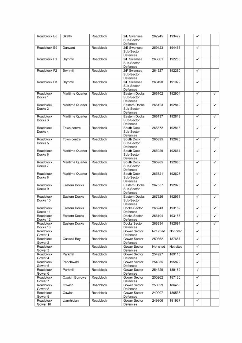
Roadblock E8 Sketty Roadblock 2/E Swansea Sub-Sector Defences
262245 193422
Roadblock E9 Dunvant Roadblock 2/E Swansea Sub-Sector Defences
259423 194455
Roadblock F1 Brynmill Roadblock 2/F Swansea Sub-Sector Defences
263801 192268
Roadblock F2 Brynmill Roadblock 2/F Swansea Sub-Sector Defences
264327 192280
Roadblock F3 Brynmill Roadblock 2/F Swansea Sub-Sector Defences
263490 191929
Roadblock Docks 1
Maritime Quarter Roadblock Eastern Docks Sub-Sector Defences
266102 192904
Roadblock Docks 2
Maritime Quarter Roadblock Eastern Docks Sub-Sector Defences
266123 192849
Roadblock Docks 3
Maritime Quarter Roadblock Eastern Docks Sub-Sector Defences
266137 192813
Roadblock Docks 4
Town centre Roadblock South Dock Sub-Sector Defences
265872 192813
Roadblock Docks 5
Town centre Roadblock South Dock Sub-Sector Defences
265895 192920
Roadblock Docks 6
Maritime Quarter Roadblock South Dock Sub-Sector Defences
265929 192661
Roadblock Docks 7
Maritime Quarter Roadblock South Dock Sub-Sector Defences
265985 192680
Roadblock Docks 8
Maritime Quarter Roadblock South Dock Sub-Sector Defences
265821 192627
Roadblock Docks 9
Eastern Docks Roadblock Eastern Docks Sub-Sector Defences
267557 192978
Roadblock Docks 10
Eastern Docks Roadblock Eastern Docks Sub-Sector Defences
267526 192958
Roadblock Docks 11
Eastern Docks Roadblock Docks Sector Defences
266243 193182
Roadblock Docks 12
Eastern Docks Roadblock Docks Sector Defences
266194 193183
Roadblock Docks 13
Eastern Docks Roadblock Docks Sector Defences
268834 192691
Roadblock Gower 1
Roadblock Gower Sector Defences
Not cited Not cited
Roadblock Gower 2
Caswell Bay Roadblock Gower Sector Defences
259362 187687
Roadblock Gower 3
Roadblock Gower Sector Defences
Not cited Not cited
Roadblock Gower 4
Parkmill Roadblock Gower Sector Defences
254927 189110
Roadblock Gower 5
Penclawdd Roadblock Gower Sector Defences
254035 195872
Roadblock Gower 6
Parkmill Roadblock Gower Sector Defences
254529 189182
Roadblock Gower 7
Oxwich Burrows Roadblock Gower Sector Defences
250262 187160
Roadblock Gower 8
Oxwich Roadblock Gower Sector Defences
250029 186456
Roadblock Gower 9
Oxwich Roadblock Gower Sector Defences
249907 186538
Roadblock Gower 10
Llanrhidian Roadblock Gower Sector Defences
249806 191967

Roadblock Gower 11
Poundffald Roadblock Gower Sector Defences
256487 194490
Roadblock Gower 12
Poundffald Roadblock Gower Sector Defences
256575 194618
Roadblock Gower 13
Poundffald Roadblock Gower Sector Defences
256637 194408
Roadblock Gower 14
Llethryd Roadblock Gower Sector Defences
253096 191374
Roadblock Gower 15
Caswell Bay Roadblock Gower Sector Defences
259001 187728
Roadblock Gower 16
Bishopston Roadblock Gower Sector Defences
257459 189318
Roadblock Gower 17
Penclawdd Roadblock Gower Sector Defences
254187 195700
Roadblock Gower 18
Roadblock Gower Sector Defences
Not cited Not cited
958 Barrage Balloon Squadron HQ
Sketty Air Force Headquarters
RAF Balloon Sites
262353 192887
958 Barrage Balloon Squadron 'A' Flight HQ
Swansea Air Force Headquarters
RAF Balloon Sites
263947 192682
958 Barrage Balloon Squadron 'B' Flight HQ
Neath Air Force Headquarters
RAF Balloon Sites
275859 198705
958 Barrage Balloon Squadron 'A' Flight Site No. 02
Palmer's Dry Dock
Barrage Balloon Mooring
RAF Balloon Sites
267123 192140
958 Barrage Balloon Squadron 'A' Flight Site No. 03
Graigola Works, King's Dock
Barrage Balloon Mooring
RAF Balloon Sites
267852 192534
958 Barrage Balloon Squadron 'A' Flight Site No. 04
Old Arsenic Works, Port Tennant
Barrage Balloon Mooring
RAF Balloon Sites
267409 192829
958 Barrage Balloon Squadron 'A' Flight Site No. 05
Transit Site, King's Dock
Barrage Balloon Mooring
RAF Balloon Sites
268869 192861
958 Barrage Balloon Squadron 'A' Flight Site No. 13
GWR Strand, Swansea
Barrage Balloon Mooring
RAF Balloon Sites
265868 193627
958 Barrage Balloon Squadron 'A' Flight Site No. 14
Fish Docks, Swansea
Barrage Balloon Mooring
RAF Balloon Sites
266155 192458
958 Barrage Balloon Squadron 'A' Flight Site No. 17
West of King's Dock, Swansea
Barrage Balloon Mooring
RAF Balloon Sites
266852 192306
958 Barrage Balloon Squadron 'A' Flight Site No. 18
West Pier Barrage Balloon Mooring
RAF Balloon Sites
266570 191902
958 Barrage Balloon Squadron 'A' Flight Shore
West of King's Dock, Swansea
Barrage Balloon Centre
RAF Balloon Sites
266852 192290

Servicing Station
958 Barrage Balloon Squadron 'A' Flight Site No. 06
Tir John Power Station
Barrage Balloon Mooring
RAF Balloon Sites
269164 193608
958 Barrage Balloon Squadron 'A' Flight Site No. 08
Elba Barrage Balloon Mooring
RAF Balloon Sites
269911 193214
958 Barrage Balloon Squadron 'A' Flight Site No. 11
William Street Barrage Balloon Mooring
RAF Balloon Sites
265313 192738
958 Barrage Balloon Squadron 'A' Flight Site No. 12
Grammar School
Barrage Balloon Mooring
RAF Balloon Sites
265336 193407
958 Barrage Balloon Squadron 'A' Flight Site No. 15
Maesteg Park, Swansea
Barrage Balloon Mooring
RAF Balloon Sites
266700 193412
958 Barrage Balloon Squadron 'A' Flight Site No. 16
Jersey Park Barrage Balloon Mooring
RAF Balloon Sites
267238 193403
958 Barrage Balloon Squadron 'B' Flight Site No. 01
Near Tir-gwylt Barrage Balloon Mooring
RAF Balloon Sites
268126 194286
958 Barrage Balloon Squadron 'B' Flight Site No. 07
Cefn Hengoed Barrage Balloon Mooring
RAF Balloon Sites
268503 195567
958 Barrage Balloon Squadron 'B' Flight Site No. 09
Trallion, Llansamlet
Barrage Balloon Mooring
RAF Balloon Sites
269357 196378
958 Barrage Balloon Squadron 'B' Flight Site No. 10
Pentwyn Farm, Lonlas
Barrage Balloon Mooring
RAF Balloon Sites
270741 196976
958 Barrage Balloon Squadron 'B' Flight Site No. 19
West of Crymlyn Bog
Barrage Balloon Mooring
RAF Balloon Sites
268790 194667
958 Barrage Balloon Squadron 'B' Flight Site No. 20
South of Pentre-dwr
Barrage Balloon Mooring
RAF Balloon Sites
269288 195985
958 Barrage Balloon Squadron 'B' Flight Site No. 21
Crymlyn Farm, Llansamlet
Barrage Balloon Mooring
RAF Balloon Sites
270040 196577
958 Barrage Balloon Squadron 'B' Flight Site No. 22
Cefn-yr-Eskyn Barrage Balloon Mooring
RAF Balloon Sites
271271 197076

Bishopston Church Belfry
Bishopston Gower East Sector Defences
257781 189362
Pennard Church Belfry
Pennard Gower East Sector Defences
256541 188740
Penclawdd Church Belfry
Penclawdd Gower East Sector Defences
254851 194828
Reynoldston Church Belfry
Reynoldston Gower West Sector Defences
247940 190025
Llandewi Church Belfry
Llandewi Gower West Sector Defences
245998 189052
Port Eynon Church Belfry
Port Eynon Gower West Sector Defences
246675 185381
Rhossili Church Belfry
Rhossili Gower West Sector Defences
241658 188081
Llangennith Church Belfry
Llangennith Gower West Sector Defences
242861 191415
Llanmadoc Church Belfry
Llanmadoc Gower West Sector Defences
243883 193434
Llanrhidian Church Belfry
Llanrhidian Gower West Sector Defences
249660 192252
HQ Swansea Garrison
Swansea Army Headquarters
264221 192639
Swansea Garrison Alternative Operational HQ
Sketty Army Headquarters
262081 192341
Swansea Garrison Alternative Operational HQ
Hafod Army Headquarters
266045 194882
‘D’ Coy, 30 Bn. South Wales Borderers HQ
Queens Dock Army Headquarters
268908 192833
194 Coy, Pioneer Corps HQ
Mumbles Army Headquarters
259675 187953
285 Coy, Pioneer Corps HQ
Jersey Marine Army Headquarters
270346 192986
Det 294 Coy, Pioneer Corps HQ
Prince of Wales Dock
Army Headquarters
267352 192747
RASC Command Supply Depot
Cockett Army Headquarters
262935 195157
14 Defence Regt HQ
Sketty Green Army Headquarters
262969 192748
Royal Marine Light Infantry
Swansea Royal Naval Base 266085 192934
559 Coast Regt HQ
Mumbles Army Headquarters
263278 187512
97 Bomb Disposal Section
Mumbles Army Headquarters
261029 187959
165 Bomb Disposal section
Mumbles Army Headquarters
261151 187497
Experimental Station Penclawdd
Penclawdd Army Headquarters
252473 195422
6 Det 39 Maritime AA Regt, RA HQ
King's Dock Army Headquarters
266861 192180
294 (F) Coy Pioneer Corps HQ
Swansea Army Headquarters
263438 193346

318 (F) Coy. Pioneer Corps HQ
Jersey Marine Army Headquarters
270336 192996
Camp Reception Station
Swansea Army Headquarters
263763 192231
Swansea Group Glamorgan Home Guard HQ
Swansea Army Headquarters
262336 192777
12 Bn. Glamorgan Home Guard HQ
Swansea Army Headquarters
262336 192797
14 Bn. Glamorgan Home Guard HQ
Swansea Army Headquarters
264174 192627
15 Bn. Glamorgan Home Guard HQ
Bishopston Army Headquarters
257910 189121
18 (PO) Bn. Glamorgan Home Guard HQ
Jersey Marine Army Headquarters
265359 193103
‘H’ Coy, 4 Bn. Glamorgan Home Guard HQ (operational only)
Jersey Marine Army Headquarters
270036 193266
HMS Lucifer, Naval Base Swansea
Swansea Royal Naval Base 266075 192924
RAF Station Fairwood Common
Fairwood Common
Royal Air Force Base
256837 191331
Bishopston Pillbox
Bishopston Pillbox (Type FW3/24)
259730 192420
Rhossili Down Gun Emplacement
Rhossili Gun Emplacement 241490 188470
Observation Post
Swansea Docks Observation Post 266748 192697
Whiteford Burrows Range Quadrant Tower
Whiteford Bombing Range Tower
Llanrhidian Artillery Ranges
244523 195726
Gun No. 1. 4-in Gun Emplacement (Maes-y-gwaelod Battery (Berth-lwyd))
Berth-lwyd Beach Defence Battery
Coastal Defences
256235 196306
Oxwich CD/CHL Radar Station
Oxwich Point Coast Defence Chain Home Low Station
250883 184932
Port Eynon Pillbox
Port Eynon Pillbox 246421 185824
Port Eynon Pillbox
Port Eynon Pillbox 246385 185720
Mynydd Carn-goch Anti-Landing Trench
Llwchwr Anti-Landing Trench
260400 197300
Mynydd Carn-goch Anti-
Llwchwr Anti-Landing Trench
260690 197269

Landing Trench
Mynydd Carn-goch Anti-Landing Trench
Llwchwr Anti-Landing Trench
260940 197250
Llangennith Beach Obstacles
Llangennith Beach
Anti-Landing Obstacle
Coastal Defences
240800 190600
Swansea Bay Anti-Landing Obstacles
Swansea Bay Anti-Landing Obstacle
Coastal Defences
263646 290990
Rhossili CHL Radar Station
Rhossili Down Chain Home Low Station
241830 189940
Llanrhidian Sands Range Quadrant Tower
Llanrhidian Sands
Bombing Range Tower
Llanrhidian Artillery Ranges
247264 194910
Dunvant Spigot Mortar Emplacement
Dunvant Spigot Mortar Emplacement
259579 194074
Tutt's Head: Coast Artillery Searchlight Emplacement No. 1
Tutt's Head Coast Artillery Searchlight
Gower Mumbles Sector Defences
262736 186967
Tutt's Head: Coast Artillery Searchlight Emplacement No. 2
Tutt's Head Coast Artillery Searchlight
Gower Mumbles Sector Defences
262772 186974
Mumbles Island Coast Artillery Battery: Coast Artillery Searchlight Emplacement No. 3
Mumbles Island Coast Artillery Searchlight
Gower Mumbles Sector Defences
263490 187146
Mumbles Island Coast Artillery Battery: Coast Artillery Searchlight Emplacement No. 4
Mumbles Island Coast Artillery Searchlight
Gower Mumbles Sector Defences
263503 187191
Mumbles Island Coast Artillery Battery: No. 1 4.7-in Gun Emplacement
Mumbles Island Coast Battery Gun Site
Gower Mumbles Sector Defences
263494 187158
Mumbles Island Coast Artillery Battery: No. 2 4.7-in Gun Emplacement
Mumbles Island Coast Battery Gun Site
Gower Mumbles Sector Defences
263495 187174
Mumbles Island Coast Artillery Battery: Battery Observation Post
Mumbles Island Battery Observation Post
Gower Mumbles Sector Defences
263484 187167
Mumbles Island Coast Artillery Battery: New Battery
Mumbles Island Battery Observation Post
Gower Mumbles Sector Defences
263487 187159

Observation Post
Mumbles Island Coast Artillery Battery: Landward Target No. 1
Blackpill Landward Target 261964 190763
Mumbles Island Coast Artillery Battery: Landward Target No. 2
Singleton Park Landward Target 262711 191501
Mumbles Island Coast Artillery Battery: Landward Target No. 3
Swansea Gas Works
Landward Target 265468 192652
Mumbles Island Coast Artillery Battery: Landward Target No. 4
Victoria Station Landward Target 265810 192734
Mumbles Island Coast Artillery Battery: Landward Target No. 5
South Dock Lock Gate
Landward Target 266306 192672
Mumbles Island Coast Artillery Battery: Landward Target No. 6
Prince of Wales Dock Lock Gate
Landward Target 266924 192762
Mumbles Island Coast Artillery Battery: Landward Target No. 7
Electric Generating Station
Landward Target 267006 192785
Mumbles Island Coast Artillery Battery: Landward Target No. 8
King's Dock Locks
Landward Target 266978 192304
Mumbles Island Coast Artillery Battery: Landward Target No. 9
Hydraulic Power Station
Landward Target 268437 192927
Mumbles Hill Coast Artillery Battery: No. 1 6-in Gun Emplacement
Mumbles Hill Coast Battery Gun Site
Gower Mumbles Sector Defences
262613 187422
Mumbles Hill Coast Artillery Battery: No. 2 6-in Gun Emplacement
Mumbles Hill Coast Battery Gun Site
Gower Mumbles Sector Defences
262659 187387
Mumbles Hill Coast Artillery Battery: Battery Observation Post
Mumbles Hill Battery Observation Post
Gower Mumbles Sector Defences
262659 187472

Mumbles Hill Coast Artillery Battery: Landward Target No. 1
King's Dock Lock Gates
Landward Target 266721 192810
Mumbles Hill Coast Artillery Battery: Landward Target No. 2
King's Dock Swing Bridge
Landward Target 266927 192775
Mumbles Hill Coast Artillery Battery: Landward Target No. 3
Chemical Works Landward Target Not cited Not cited
Mumbles Hill Coast Artillery Battery: Landward Target No. 4
Halfway House Road Junction
Landward Target 269226 196338
Mumbles Hill Coast Artillery Battery: Landward Target No. 5
Jersey Marine Landward Target 271196 193865
Port Tennant Heavy Anti-Aircraft Battery
Port Tennant Heavy Anti-Aircraft Battery
Neath Sector Defences
271259 193391
Crymlyn Ridge Searchlight Emplacement
Crymlyn Ridge Searchlight Emplacement
Neath Sector Defences
269914 194254
Crymlyn Ridge Gun Emplacement
Crymlyn Ridge Gun Emplacement Neath Sector Defences
269831 194205
Crymlyn Ridge Gun Emplacement
Crymlyn Ridge Gun Emplacement Neath Sector Defences
269824 194304
Crymlyn Ridge Gun Emplacement
Crymlyn Ridge Gun Emplacement Neath Sector Defences
270001 194231
Rhossili Down Anti-Aircraft Battery
Rhossili Down Anti-Aircraft Battery
241830 189940
Clyne Valley Pillbox
Clyne Valley Pillbox 260087 192099
Railway Pillbox
Eastern Docks Pillbox (Type FW3/24)
268780 193070
Whiteford Point Anti-Boat Landing Obstacle
Whiteford Point Anti-Boat Landing Obstacle
244612 196950
Rhossili Down CD/CHL Barbed Wire Entanglement
Rhossili Down Barbed Wire Entanglement
241816 189919
Oxwich Point CD/CHL Barbed Wire Entanglement
Oxwich Point Barbed Wire Entanglement
250817 184943
RAF Fairwood Common Barbed Wire Entanglement 1
RAF Fairwood Common – E side
Barbed Wire Entanglement
RAF Fairwood Common Defences
257445 191621
RAF Fairwood Common Barbed Wire Entanglement 2
RAF Fairwood Common – N side
Barbed Wire Entanglement
RAF Fairwood Common Defences
257318 192420

RAF Fairwood Common Barbed Wire Entanglement 3
RAF Fairwood Common – NW side
Barbed Wire Entanglement
RAF Fairwood Common Defences
256622 192185
RAF Fairwood Common Barbed Wire Entanglement 4
RAF Fairwood Common – W side
Barbed Wire Entanglement
RAF Fairwood Common Defences
256373 191621
Tutt’s Head PWSS Barbed Wire Entanglement
Tutt’s Head Barbed Wire Entanglement
Gower Mumbles Sector Defences
262714 186958
Mumbles Hill Coast Artillery / HAA Barbed Wire Entanglement
Mumbles Hill Barbed Wire Entanglement
Gower Mumbles Sector Defences
262507 187451
Mumbles Hill Road Camp Barbed Wire Entanglement
Mumbles Hill Road
Barbed Wire Entanglement
Gower Mumbles Sector Defences
262731 187197
Halfway House Anti-Tank Block Alignment
Halfway House Anti-Tank Block 256723 196622
Swansea Docks East Anti-Tank Block Alignment
Swansea Docks Anti-Tank Block 268851 192690
Blackpill Anti-Tank Block Alignment
Blackpill Anti-Tank Block 261816 190220
West Cross Anti-Tank Block Alignment
West Cross Anti-Tank Block 261502 189141
George Bank Anti-Tank Block Alignment
George Bank Anti-Tank Block 262282 187767
Halfway House Anti-Tank Ditch N
Halfway House Anti-Tank Ditch Gower Sector Defences
256722 196734
Halfway House Anti-Tank Ditch S
Halfway House Anti-Tank Ditch Gower Sector Defences
256731 196551
Llanmorlais Defended Locality
Llanmorlais Defended Locality Gower Sector Defences
252894 194656
Penclawdd Defended Locality
Penclawdd Defended Locality Gower Sector Defences
254147 195769
Poundffald Defended Locality
Poundffald, Three Crosses
Defended Locality Gower Sector Defences
256605 194502
Upper Killay Defended Locality
Upper Killay Defended Locality Gower Sector Defences
258456 192647
Llanrhidian Defended Locality
Llanrhidian Defended Locality Gower Sector Defences
249714 192148
Llanmadoc Defenced Locality
Llanmadoc Defended Locality Gower Sector Defences
243996 193366
Llangennith Defended Locality
Llangennith Defended Locality Gower Sector Defences
242874 191482

Rhossili Defended Locality
Rhossili Defended Locality Gower Sector Defences
241624 188070
Reynoldston Defended Locality
Reynoldston Defended Locality Gower Sector Defences
248211 189976
Port-Eynon Defended Locality
Port-Eynon Defended Locality Gower Sector Defences
246737 185409
Oxwich Bay Defended Locality
Oxwich Bay Defended Locality Gower Sector Defences
251383 187406
Parkmill-Southgate Defended Locality
Parkmill-Southgate
Defended Locality Gower Sector Defences
255022 188548
Bishopston Defended Locality
Bishopston Defended Locality Gower Sector Defences
257919 189414
Newton Defended Locality
Newton Defended Locality Gower Sector Defences
260077 188308
Lonlas Defended Locality
Lonlas Defended Locality Swansea – A Sub-Sector Defences
270637 197400
Peniel Green Tunnel Defended Locality
Peniel Green Tunnel
Defended Locality Swansea – A Sub-Sector Defences
269766 197630
Llansamlet Church Defended Locality
Llansamlet Church
Defended Locality Swansea – A Sub-Sector Defences
268625 197874
Llansamlet Square Defended Locality
Llansamlet Square
Defended Locality Swansea – A Sub-Sector Defences
268613 197398
Halfway Inn Defended Locality
Halfway Inn Defended Locality Swansea – A Sub-Sector Defences
269227 196339
Winch Wen Defended Locality
Winch Wen Defended Locality Swansea – A Sub-Sector Defences
268353 196348
Bonymaen Defended Locality
Bonymaen Defended Locality Swansea – B Sub-Sector Defences
267836 195100
Pentrechwyth Defended Locality
Pentrechwyth Defended Locality Swansea – B Sub-Sector Defences
266977 195050
White Rock Defended Locality
White Rock Defended Locality Swansea – B Sub-Sector Defences
266285 194823
Tir John Defended Locality
Tir John Defended Locality Swansea – B Sub-Sector Defences
268778 193681
Cemetery Defended Locality
Cemetery Defended Locality Swansea – B Sub-Sector Defences
267580 193491
St Thomas Defended Locality
St Thomas Defended Locality Swansea – B Sub-Sector Defences
266342 193801
Ynysforgan Viaduct Defended Locality
Ynysforgan Viaduct
Defended Locality Swansea C – Sub-Sector Defences
267637 199193
Chemical Road Defended Locality
Chemical Road Defended Locality Swansea C – Sub-Sector Defences
266835 199096

School Defended Locality
Cwmrhydyceirw Defended Locality Swansea C – Sub-Sector Defences
266739 199562
Golf Links Defended Locality
Golf Links Defended Locality Swansea C – Sub-Sector Defences
265936 199247
Pentrepoeth Defended Locality
Pentrepoeth Defended Locality Swansea C – Sub-Sector Defences
266633 198619
Chris Williams Defended Locality
Chris Williams Defended Locality Swansea C – Sub-Sector Defences
267018 198308
Fforest Bridge Defended Locality
Fforest Bridge Defended Locality Swansea C – Sub-Sector Defences
267305 198083
Duke Hotel Defended Locality
Duke Hotel Defended Locality Swansea C – Sub-Sector Defences
266912 197275
Bryn Rock Defended Locality
Bryn Rock Defended Locality Swansea C – Sub-Sector Defences
266433 197501
Pontlassau Defended Locality
Pontlassau Defended Locality Swansea C – Sub-Sector Defences
265927 200043
Llangyfelach Defended Locality
Llangyfelach Defended Locality Swansea C – Sub-Sector Defences
264668 198776
Mynyddbach Defended Locality
Mynyddbach Defended Locality Swansea C – Sub-Sector Defences
264868 197587
Mynydd Cadle Common Defended Locality
Mynydd Cadle Common
Defended Locality Swansea C – Sub-Sector Defences
264296 196950
Mynydd Newydd Colliery Defended Locality
Mynydd Newydd Colliery
Defended Locality Swansea C – Sub-Sector Defences
263932 196453
Ravenhill Defended Locality
Ravenhill Defended Locality Swansea C – Sub-Sector Defences
263747 195942
Fforestfach Defended Locality
Fforestfach Defended Locality Swansea D – Sub-Sector Defences
262916 195942
White City Defended Locality
White City Defended Locality Swansea D – Sub-Sector Defences
262670 195665
Cockett Defended Locality
Cockett Defended Locality Swansea D – Sub-Sector Defences
263151 195077
Cadle Defended Locality
Cadle Defended Locality Swansea D – Sub-Sector Defences
262416 197057
Island House Defended Locality
Island House Defended Locality Swansea D – Sub-Sector Defences
257932 197146
New Elba Colliery
New Elba Colliery
Defended Locality Swansea D – Sub-Sector Defences
258364 196612
Elba Works Defended Locality
Elba Works Defended Locality Swansea D – Sub-Sector Defences
258793 196639
Gowerton Station Defended Locality
Gowerton Station
Defended Locality Swansea D – Sub-Sector Defences
259262 196415
Winder Terrace Defended Locality
Winder Terrace Defended Locality Swansea D – Sub-Sector Defences
259492 195927
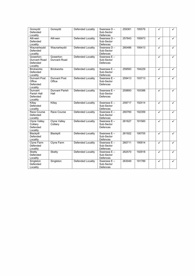
Gorwydd Defended Locality
Gorwydd Defended Locality Swansea D – Sub-Sector Defences
259361 195576
Allt-wen Defended Locality
Allt-wen Defended Locality Swansea D – Sub-Sector Defences
257843 195973
Waunarlwydd Defended Locality
Waunarlwydd Defended Locality Swansea D – Sub-Sector Defences
260486 195413
Gowerton-Dunvant Road Defended Locality
Gowerton-Dunvant Road
Defended Locality Swansea E – Sub-Sector Defences
Brickworks Defended Locality
Brickworks Defended Locality Swansea E – Sub-Sector Defences
259583 194229
Dunvant Post Office Defended Locality
Dunvant Post Office
Defended Locality Swansea E – Sub-Sector Defences
259413 193713
Dunvant Parish Hall Defended Locality
Dunvant Parish Hall
Defended Locality Swansea E – Sub-Sector Defences
259893 193388
Killay Defended Locality
Killay Defended Locality Swansea E – Sub-Sector Defences
259717 192414
Race Course Defended Locality
Race Course Defended Locality Swansea E – Sub-Sector Defences
260760 192359
Clyne Valley Colliery Defended Locality
Clyne Valley Colliery
Defended Locality Swansea E – Sub-Sector Defences
261627 191560
Blackpill Defended Locality
Blackpill Defended Locality Swansea E – Sub-Sector Defences
261922 190705
Clyne Farm Defended Locality
Clyne Farm Defended Locality Swansea E – Sub-Sector Defences
260711 190914
Sketty Defended Locality
Sketty Defended Locality Swansea E – Sub-Sector Defences
262570 192918
Singleton Defended Locality
Singleton Defended Locality Swansea E – Sub-Sector Defences
263049 191789

Appendix 7.1: Text of Counter-invasion Scheme No. 2 as preserved in
Carmarthen Sub-Area HQ war diary at The National Archives (WO 166/6729)
S E C R E T
CARMARTHEN SUB-AREA
COUNTER-INVASION SCHEME No. 2. Our ref S/0.1/
Ref. Map O.S. 1” to 1 mile sheets 68, 69, 78, 79, 88, 90, 100, 101.
PART I.
APPRECIATION.
1. OBJECT
To attack enemy arriving in the Sub-Area by sea or air, harass and delay him until the
arrival of Field Formations.
2. FACTORS.
i) Carmarthen Sub-Area is a part of South Wales District and consists of the
Counties of CARMARTHENSHIRE, CARDIGANSHIRE and
PEMBROKESHIRE, the Southern part of PEMBROKESHIRE being separated
from the rest of that County by MILFORD HAVEN, the River DAUCLEDDAU
and its tributary the EASTEN CLEDDAU.
ii) The Sub-Area is mainly agricultural and sparsely populated with the exception
of the LLANELLY (100/9522)-AMMANFORD (89/0734) industrial areas,
MILFORD HAVEN (99/3528) and PEMBROKE DOCK (99/4025) areas, and
the following towns: CARMARTHEN (89/8542), TENBY (99/5723) (with
SAUNDERSFOOT 99/5827), HAVERFORDWEST (99/4038), FISHGUARD
(88/4059), CARDIGAN (88/6268) and ABERYSTWYTH (68/0303).
3. GEOGRAPHY.
The Sub-Area has a Coast Line of 200 miles and covers an area of 2,500 square
miles. It is mountainous in the East, sloping gradually to the coast in
CARMARTHENSHIRE and PEMBROKESHIRE. It is some 12 to 18 hrs journey by
sea from Occupied France and about 200 miles by air from the NORMANDY Coast.
Airborne landings are possible almost anywhere throughout the Sub-Area. There are
however few objectives of military value except MILFORD HAVEN, the industrial area
of LLANELLY and the bottleneck for communications at CARMARTHEN and
LLANDOVERY (90/2052).
BEACHES
On the South and West Coast Lines of the Sub-Area from PEMBREY 100/8723 to
ST. DAVID’S HEAD 88/1751 there are numerous beaches suitable for seaborne or
airborne landings.
4. ANCHORAGES.
The deep water anchorage extending from MILFORD HAVEN to PEMBROKE DOCK
is of great importance.

5. COMMUNICATIONS.
Road communications North and South throughout the Sub-Area are good but in
many cases too narrow for large vehicles. Communications from West to East are
restricted to the following main routes:
a) FISHGUARD – CARDIGAN – ABERYSTWYTH and thence to SHROPSHIRE and
the MIDLANDS or NORTH WALES and CHESTER.
b) HAVERFORDWEST – CARMARTHEN – LLANDOVERY and thence either to
BUILTH WELLS and SHREWSBURY or to BRECON – ABERGAVENNY.
c) CARMARTHEN – SWANSEA – NEATH – CARDIFF.
Communications are vulnerable at CARMARTHEN and LLANDOVERY.
6. RAILWAYS.
The Main Line runs from SWANSEA through CARMARTHEN to WHITLAND 99/6439.
From WHITLAND branches run to a) TENBY and PEMBROKE DOCK, b)
HAVERFORDWEST – NEYLAND 99/4127, c) FISHGUARD, d) CARDIGAN.
Railway communication west of CARMARTHEN depends on the one bascule bridge
at CARMARTHEN.
Other Railway Lines are:–
CARMARTHEN – BUILTH WELLS – CRAVEN ARMS.
CARMARTHEN – ABERYSTWYTH – (Branches to NEWCASTLE EMLYN 89/7563
and ABERAYRON 78/9085).
Branch Lines in the Industrial Area of LLANELLY.
7. AERODROMES
Aerodromes in the Sub-Area are:-
ANGLE 99/3025 (Fighter Comd. 10 Gp.)
PEMBREY (Training Comd. 25 Gp.)
CAREW CHERITON 99/4925 (Coastal Comd. 19 Gp.)
PEMBROKE DOCK (Sea Plane Base, Coastal Comd. 19 Gp.)
ABERPORTH 78/7073 (Army Co-op. 70 Gp.)
MANORBIER 99/5120
HAVERFORDWEST and TEMPLETON 99/5534 (Bomber Comd. 7 Gp.) Under Con.
TALBENNY 99/2834 and DALE 99/2528 (Coastal Comd. 19 Gp.) Under Con.
Of the above ANGLE is classed as the most important by the RAF.
8. TPS AVAILABLE.
a) Tps whose location in the Sub-Area may be classed as permanent and who are
under operational command of Comd. Sub-Area.
31 Welch.
35 Gp. HQ and 3 Coys. Pioneer Corps.
Ten Home Guard Bns.
12 Fd. Trg. Regt, RA.
532 Coast Regt, RA. (under operational command only in regard to Land
defence).

30 E. Lancs.
13 LAA Trg. & Practice Camp.
1 HAA Trg. & Practice Camp.
SAA Arty, (MANORBIER).
3 HAA Trg. & Practice Camp.
AFV Range.
RAF Defence Squadrons.
Various Maintenance and other small Units.
Armed Coast Watchers.
b) Troops whose location in the Sub-Area is permanent, but who are NOT under
operational control:-
61 AA Bde.
c) Tps at present in Sub-Area which may or may not be available:-
9 KOSB [Subsequently struck out]
15 RM
18 RM
178 Fd. Regt, RA [Subsequently struck out]
Certain Fd. and other RE Coys.
Belgian Contingent. [Subsequently struck out]
36 Bde. RASC
31 Motor Coach Coy. RASC. [Subsequently struck out]
Also – certain Royal Naval Personnel.
d) Field force tps. training in the District:-
49 Div. (which includes 70 Inf. Bde. & 2 Kensingtons in this Sub-Area
[Subsequently struck out]
RM Div. (101 & 102 Bdes. and certain Div. Tps.) in this Sub-Area.
9. DEDUCTIONS.
a) Owing to distance alone, Invasion without warning is improbable, but raids with
limited objectives are very possible at any time.
b) Seaborne invasion in force is possible in so far as the Coast Line and suitable
objectives are concerned, and is unlikely only for so long as the situation in South
Ireland remains as at present.
c) Owing to distance air invasion in force is unlikely except as a diversion in
connection with the main attack elsewhere or in circumstances envisaged in b)
above. Air Landings are possible in many places other than on Aerodromes.
10. POSSIBLE OBJECTIVES FOR ENEMY ATTACK.
a) As part of a full scale Invasion plan enemy may endeavour to:-
i) Capture MILFORD HAVEN and/or PEMBROKE DOCK and establish a
Bridgehead in South PEMBROKESHIRE.
ii) Capture CARMARTHEN and possibly LLANDOVERY, thus cutting the
main artery of communications.
iii) Capture PEMBREY (Aerodrome and ROF) and LLANELLY as a
preliminary to an attack on SWANSEA and the industrial area of South
Wales.

(Combination of any or all of the above are possible).
iv) Create a diversion as part of a major operation elsewhere by widespread
air attack and landing of airborne tps in various Localities.
b) Raids on Military objectives are likely to include:-
i) Aerodromes – more especially ANGLE.
ii) AME Stations – especially those near the Coast.
iii) Coast Btys – especially those covering the entrance to MILFORD HAVEN.
iv) Industrial areas – LLANELLY and the LOUGHOR Valley.
v) Bottle Necks on Lines of Communication, i.e. (CARMARTHEN
(LOUGHOR BRIDGE
(LLANDOVERY.
vi) Certain vulnerable VPs. other than AME Stations.
11. PLAN ADOPTED TO MEET POSSIBLE ENEMY ACTIONS.
Certain Harbours are protected by fixed defences, those Btys. being capable of
defending themselves from Land attack for a considerable period.
The general plan is
a) To hold Columns ready to attack enemy wherever he may land whether by sea or
air to destroy, harass or delay him until the arrival of re-enforcements.
b) To obtain early information by watching Beaches and Coast Line in conjunction
with Coast Watchers, by co-ordination of all means of communication and close
Liaison with HM Coastguards, Royal Observer Corps, HG Patrols and OPs,
Police, etc.
c) To prepare for occupation certain defensive positions to prevent any further
breakthrough of enemy who may succeed in landing.
d) To prepare “Islands of Resistance” mainly along Lines of Communication which
the enemy cannot by-pass, these “Islands of Resistance” being garrisoned in
strength primarily by the HG.
METHOD.
12. ORGANISATION.
To facilitate Comd the Sub-Area is divided into nine Sectors under Sector Comds –
details in Appendix “A”.
Sector Comds are responsible for the co-ordination of all counter invasion plans in
their Sector.
13. MOBILE COLUMNS.
All units will maintain Mob. Columns at the state of readiness laid down from time to
time by SOUTH WALES DISTRICT.
Whenever personnel and equipment make it practicable, each Mob. Column will
approximate as nearly as possible to that of an Inf. Bn. Mob. Colm., i.e.
1 rifle coy.

1 Sec. Carriers
Det. 3” Mortars
This does NOT apply to cols. furnished by AFV Range and Special Bns.
The larger Columns have been given definite primary Tasks - See Appendix “C”.
Normally Mob. Columns will receive orders to move from Sub-Area HQ but Comds. in
emergency will act on their own initiative reporting immediately to this HQ. Units
providing Mob. Cols. for the relief of Aerodromes (see para. “Aerodromes and VPs.”)
will answer calls from PANDA CONTROLS or from the Aerodrome Garrison. (For
complete details see this HQ. S/A.11/12 dated 4 May 42) which gives separate
instructions to units concerned).
14. AERODROMES AND VPs.
Mob. Cols. are detailed with the Primary task of relief to aerodromes in event of
attack as under:
Aerodrome. Mob Column from unit
located at:
Name of present Unit
ANGLE AFV Range,
CASTLEMARTIN,
PEMBROKE
3 Tps. from AFV Range
and Column from:
8 RM PEMBROKE DOCK
CAREW CHERITON PENALLY Camp
[subsequently
HOLLOWAY CAMP]
18 RM (primary role)
PEMBREY CARMARTHEN and
LLANELLY
1 Blg. Fus.
Belgian AC Sq.
[subsequently 5 RM]
PEMROKE DOCK Llanion Bks.,
PEMBROKE DOCK,
PEMBROKE
8 RM PEMBROKE DOCK
ABERPORTH ABERPORTH 1 HAA Trg. & Practice
Camp
MANORBIER MANORBIER 3 HAA Trg. & Practice
Camp
HAVERFORDWEST (and
RUDBAXTON)
HAVERFORDWEST 2 RM
HAVERFORDWEST
TEMPLETON TENBY 10 RM
TALBENNY / DALE MILFORD HAVEN 31 Welch
HAVERFORDWEST
[subsequently 2 RM and
30 E. Lancs.]
15. VPs.

Immediate assistance to VPs will be given in emergency on orders from Sub-Area
HQ.
TRECWN RNA Depot Unit stationed at FISHGUARD or
HAVERFORDWEST [subsequently ST.
DOGMAELS].
PEMBREY ROF Unit stationed at LLANELLY
[subsequently YSTRAD CAMP,
CARMARTHEN].
16. AME Stations.
A list is given in Appendix “H”.
Comd. officers will maintain close liaison with all AME Stations within 10 miles of their
Stations and will be prepared to send immediate aid in the event of a raid or call for
help.
AME Stations near the coast are particularly vulnerable to raids.
17. DEFENSIVE MEASURES.
a) CANASTON – TEMPLETON – WISEMANS BR defences.
A series of defended localities have been prepared on the general line:-
CANASTON BRIDGE 99/5137 – TEMPLETON 99/5534 – STEPASIDE 99/5830 –
WISEMANS BRIDGE 99/5928.
to prevent infiltration Eastwards of enemy landing in South PEMBROKESHIRE.
Garrison, HG and such other units as may be detailed at the time.
b) CARMARTHEN – HENLLAN – LLANGRANOG defences.
A series of Localities on the Line:-
LLANGRANOG 78/7676 – RHYD LEWIS 78/7969 – HENLLAN 89/8062 –
CONVIL ELVET 89/8249 – CARMARTHEN 89/8342 – FERRYSIDE 100/8132.
Garrison HG.
c) CARMARTHEN – AMMANFORD defences.
A series of Localities on the Line:-
CARMARTHEN – LLANDAROG 89/9438 – PORTH Y RHYD 89/9638 –
AMMANFORD and thence PONTARDDULAIS – LOUGHOR against a landing in
South CARMARTHENSHIRE.
18. ISLANDS OF RESISTANCE.
Home Guard Bns. have prepared defence schemes and allotted garrisons for the
defence of certain important localities which include the following:

PEMBROKESHIRE.
1 PEMS HG TENBY 99/5723
CANASTON BRIDGE 99/512378
ROBESTON WATHEN 00531384
STEPASIDE 99/5830
TEMPLETON 99/5534
WISEMANS BRIDGE 99/5928
2 PEMS HG Exits to FISHGUARD 88/4060
MILFORD HAVEN 99/3528
Road Blocks nr. TALBENNY 99/285348
Road Blocks nr. DALE 99/255288
HAVERFORDWEST 99/4038
NEWPORT (Pem) 88/5061
CARMARTHENSHIRE.
1 CARMS HG CARMARTHEN 89/8542
ST CLEARS 89/7238
LAUGHARNE 100/7433
CONWIL ELVET 89/8249
WHITLAND 99/6439
2 CARMS HG LOUGHOR BRIDGE 100/006202
LLANELLY )FURNACE 100/949238
)CWM BACH 100/933242
)PWLL 100/926234
FELINFOEL 100/964242
PEMBERTON 100/9722
3 CARMS HG KIDWELLY 100/8529
DREFACH 89/972355
Crossings of GWENDRAETH RIVER noted by OC 3 CARMS.
4 CARMS HG LLANDOVERY 90/2156
LLANDILO 89/0744
LLANDYBIE 89/063374
AMMANFORD 89/0734
LLANGADOCK 90/1550
5 CARMS HG NEWCASTLE EMLYN 89/7562
LLANYBYTHER 78/9766
CARDIGANSHIRE.
1 CARDS HG ABERYSTWYTH 68/0304
PONTERWYD 68/2002
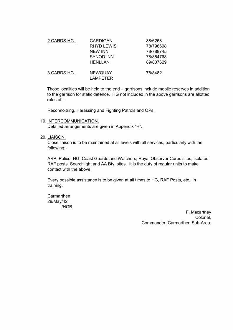
2 CARDS HG CARDIGAN 88/6268
RHYD LEWIS 78/796698
NEW INN 78/788745
SYNOD INN 78/854768
HENLLAN 89/807629
3 CARDS HG NEWQUAY 78/8482
LAMPETER
Those localities will be held to the end – garrisons include mobile reserves in addition
to the garrison for static defence. HG not included in the above garrisons are allotted
roles of:-
Reconnoitring, Harassing and Fighting Patrols and OPs.
19. INTERCOMMUNICATION.
Detailed arrangements are given in Appendix “H”.
20. LIAISON.
Close liaison is to be maintained at all levels with all services, particularly with the
following:-
ARP, Police, HG, Coast Guards and Watchers, Royal Observer Corps sites, isolated
RAF posts, Searchlight and AA Bty. sites. It is the duty of regular units to make
contact with the above.
Every possible assistance is to be given at all times to HG, RAF Posts, etc., in
training.
Carmarthen
29/May/42
/HGB
F. Macartney
Colonel,
Commander, Carmarthen Sub-Area.

Appendix 7.2: Selected extracts from Carmarthen Sub-Area HQ war diaries,
08/40-12/41 (WO 166/1270) and 01-12/42 (WO 166/6729)
Date Note
20/08/40 RE Works – progressing with excavation of A/T ditches – Pembrey – Nant y Ci – Blaen Nantgwyn – Brithvir Mill. Pillboxes in construction through whole line. Limited output owing to shortage of cement. Roadblock on A/T line vertical rail 4’ 0 centre 14’ 0 depth, staggered type started today.
21/08/40 Inspection of pillboxes and A/T blocks in Pembrey aerodrome neighbourhood. OC raised question of enlarging landing ground by removing fences. A/T ditches and pillbox construction making progress.
29/08/40 Comdr. visited ROF Pembrey with OC 9 Bn. Gloucester Regt. to inspect position of gun emplacements, pillboxes and general defence arrangements.
06/09/40 Rhydlewis defences (pillboxes, A/T ditch, dragons teeth & sandbagged emplacements).
16/09/40 Comdr. visited stop line and inspected pillboxes and roadblocks at Carmarthen.
17/09/40 Position of guns and pillboxes at on shore at Burry Port discussed.
27/09/40 1 Coy. Belgians moved from Tenby to Llanelly to be attached to 9 Bn. Gloucester Regt.
30/09/40 Troops from 1 S/L Regt. at Kidwelly.
04/10/40 2/9 Bn. Manchester Regt. detachment at Pendine.
09/10/40 9 Bn. Gloucester Regt. left the Sub-Area.
12/10/40 9 Bn. N. Staffs. Regt. arrived at Carmarthen.
15/10/40 Comdr. visited Pendine with OC 9 Bn. N. Staffs. Regt.
21/10/40 Comdr. went to Pembrey to see 19 Bn. Welch Regt.
29/10/40 Comdr. inspected 240 Coast Battery at Burry Port.
31/10/40 Comdr. visited 38 AMPC Coy. at Laugharne.
14/11/40 Comdr. visited Pembrey to inspect pillbox sites.
18/11/40 Comdr. visited Pendine to see disposition of 72 Coy, AMPC.
28/11/40 Comdr. visited Ystrad Camp, Carmarthen.
04/12/40 Comdr. went to Pembrey and Llanelly and visited OC 19 Bn. Welch Regt.
04/01/41 Comdr. visited Pendine with Garrison Engineer and met OC 961 Defence Battery.
10/01/41 72 Coy, AMPC relieved by 17 (HD) Bn. Welch Regt. at Pendine.
11/01/41 A Coy, 9 Bn. N. Staffs. Regt. moved to Laugharne.
15/01/41 Comdr. inspected A/T ditch at Nant-y-Ci.
01/02/41 C-in-C, Western Command visited Llanelly and Pembrey. Called at this HQ, also Comdr. 224 Ind. Inf. Bde. and OC 9 Bn. N. Staffs Regt.
19/02/41 224 Ind. Inf. Bde. left the Sub-Area.
19/02/41 9 Bn. N. Staffs Regt. left the Sub-Area.
20/02/41 1 Bn. Belgian Fusiliers arrived at Ystrad Camp, Carmarthen.
20/02/41 12 Bn. Worcester Regt. arrived at Llanelly.
21/02/41 19 Bn. Welch Regt. left the Sub-Area.
08/03/41 Comdr. went to Pendine to meet Comd. 36 Ind. Inf. Bde.
11/03/41 GSO III accompanied GSO II (Ops), South Wales Area to site 13-pdr. Guns.
14/03/41 Comdr. went to Burry Port to inspect 402 Battery, RA.
18/03/41 1 Bn. Belgian Fusiliers carried out practice occupation of Carmarthen west defences.
27/03/41 GSO III met Comdr., 36 Ind. Inf. Bde. to discuss Belgian Carmarthen west defences.
31/03/41 Comdr. met Comdr. 36 Ind. Inf. Bde. re Belgian position at Green Castle, Carmarthen.
08/04/41 Comdr. visited Ferryside to visit a troop of 961 Bty., RA.
27/04/41 Comdr. visited No. 2 Bn. Cardiganshire Home Guard at Rhydlewis.
30/05/41 Comdr. visited Llanelly to bid farewell to 12 Bn. Worcester Regt.
03/06/41 Comdr. went to Pembrey and called on OC 18 Bn. Royal Fusiliers.
23/07/41 Mr Gwynne Jones, Ministry of Security, called re Urdd Camp, Llangrannog.
26/07/41 Comdr. visited Pembrey Beaches to meet the CRE re erection of pillboxes.
11/08/41 Comdr. went to Saundersfoot to bid farewell to 36 Ind. Inf. Bde.
19/08/41 Comdr. visited 402 Coast Battery at Burry Port.

06/09/41 OC 6 Bn. RIF and OC 35 Gp. PC called to discuss conduct of defence works after 01/10/41. HQ, SWA notified pioneer labour required after 01/10/41.
12/09/41 Major Clifton Brown (MLO, Western Approaches) called re tubular scaffolding, Llanelly.
15/11/41 Examination of Ground Defence Squadron officers at RAF Pembrey.
05/01/42 Comdr. 70 Ind. Inf. Bde. called re arrival of unit in Carmarthen.
20/02/42 Comdr. 70 Bde. called to bid farewell on departure of Bde. from Sub-Area.
08/03/42 Comdr. to 402 Coast Battery.
04/04/42 1 Bn. Belgian Fusiliers arrived at Ystrad Camp, Carmarthen from Hereford.
06/06/42 Carmarthen Sub-Area Counter Invasion Scheme of 05/06/42 issued.
29/12/42 Units of 49 Div. move into Sub-Area.
31/12/42 Advanced parties of 70 Inf. Bde. arrive in the Carmarthen area.

Appendix 7.3: List of identified defence sites for Carmarthen Stop Line case
study
Name Location Site Type Group E N Evidence
Arc
h
Do
c
AP
Cart
o
Burry Port Coast Artillery Battery
Old Coastguard, Pembrey Harbour, Burry Port
Coast Artillery Searchlight
Burry Port Emergency Coast Battery
243665 199896
Burry Port Coast Artillery Battery
Old Coastguard, Pembrey Harbour, Burry Port
Pillbox Burry Port Emergency Coast Battery
243678 199899
Burry Port Coast Artillery Battery
Old Coastguard, Pembrey Harbour, Burry Port
Gun Emplacement
Burry Port Emergency Coast Battery
243645 200144
Burry Port Coast Artillery Battery
Old Coastguard, Pembrey Harbour, Burry Port
Coast Artillery Battery
Burry Port Emergency Coast Battery
243631 200154
Burry Port Coast Artillery Battery
Old Coastguard, Pembrey Harbour, Burry Port
Gun Emplacement
Burry Port Emergency Coast Battery
243614 200160
S end of stop line Pillbox
West end of Pembrey Burrows
Pillbox (Type FW3/24)
Carmarthen Stop Line
241814 200163
‘G’ Coy, 3 Carms. Bn. HG Picquet
ROF Pembrey Observation Post
240700 200200
Burry Port Coast Artillery Battery
Old Coastguard, Pembrey Harbour, Burry Port
Battery Observation Post
Burry Port Emergency Coast Battery
243544 200205
Burry Port Coast Artillery Battery
Old Coastguard, Pembrey Harbour, Burry Port
Army Camp Burry Port Emergency Coast Battery
243554 200269
Slit trenches at Pembrey Burrows
Pembrey Burrows
Slit Trench Coastal Defences
242510 200215
ROF Pembrey Vulnerable Point
ROF Pembrey Vulnerable Point
240800 200300
Burry Port RN Mine Depot
Old Coastguard, Pembrey Harbour, Burry Port
Controlled Minefield
243490 200310
‘G’ Coy, 3 Carms. Bn. HG HQ
ROF Pembrey Headquarters 240900 200400
ROF Pembrey Centre of Resistance
ROF Pembrey Centre of Resistance
240600 200500
Pillbox at ROF Pembrey
ROF Pembrey Pillbox (Type FW3/23)
ROF Pembrey Defences
240882 200553
Pillbox at ROF Pembrey
ROF Pembrey Pillbox ROF Pembrey Defences
239911 200277
Pillbox at ROF Pembrey
ROF Pembrey Pillbox ROF Pembrey Defences
239760 200631
Pillbox at ROF Pembrey
ROF Pembrey Pillbox ROF Pembrey Defences
240179 200576
Anti-tank cubes at ROF Pembrey
ROF Pembrey Anti-Tank Block
ROF Pembrey Defences
239923 201057

Halt Area Delay Post
ROF Pembrey Defence Work 241147 200589
Bombing Range Quadrant Shelter No. 1
Cefn Sidan Sands South
Quadrant Shelter
Aerial Bombing Range
239215 200703
‘A’ Coy, 3 Carms. Bn. HG HQ
Bacus Garage, Burry Port
Headquarters 244740 200755
‘A’ Coy, 3 Carms. Bn. HG Picquet
Bacus Garage, Burry Port
Observation Post
244746 200761
‘A’ Coy, 3 Carms Bn. HG Mobile Column
Burry Port Headquarters 244800 200800
GPO Burry Port Vulnerable Point
Burry Port Vulnerable Point
244845 200820
Pembrey Coastguard Station Observation Post
Pembrey Observation Post
HM Coastguard 242154 200383
Pembrey Pumping Station Vulnerable Point
Pembrey Vulnerable Point
242469 201392
Bombing Range Searchlight Platform
Cefn Sidan Dunes
Searchlight Emplacement
Aerial Bombing Range
237834 202366
Roadblock in Pembrey Forest 1
Pembrey Forest Anti-Tank Vertical Rail
237952 202665
Roadblock in Pembrey Forest 2
Pembrey Forest Anti-Tank Vertical Rail
238117 202808
Roadblock in Pembrey Forest 3
Pembrey Forest Anti-Tank Vertical Rail
238125 202815
Roadblock in Pembrey Forest 4
Pembrey Forest Anti-Tank Vertical Rail
238134 202820
Bombing Range Control
Cefn Sidan Dunes
Observation Post
Aerial Bombing Range
237735 202482
Bombing Range Searchlight Platform
Cefn Sidan Dunes
Searchlight Emplacement
Aerial Bombing Range
237628 202620
Wing Markers Shelter No. 1
Cefn Sidan Dunes
Observation Post
Aerial Bombing Range
237388 202988
Tywyn Burrows 4-inch Beach Defence Gun House
Tywyn Burrows Gun Emplacement
Coastal Defences
237068 203531
Wing Markers Shelter No. 2
Cefn Sidan Dunes
Observation Post
Aerial Bombing Range
237053 203515
Main Markers Shelter
Tywyn Burrows Observation Post
Aerial Bombing Range
237229 203262
Rhiwlas Searchlight Battery
Rhiwlas, Mynydd Pen-bre
Searchlight Battery
244973 203304
Military Structure
Tywyn Burrows Coastal Defences
237139 203404
AWR Pembrey Pillbox 1
ESE of AWR Pembrey Range Tower
Pillbox Coastal Defences
236502 204349

4-in Beach Defence Gun House
N of AWR Pembrey Range Tower
Gun Emplacement
Coastal Defences
236401 204503
AWR Pembrey Pillbox 2
W of northern dive bombing range
Pillbox Coastal Defences
236165 205283
AWR Pembrey Pillbox 3
W side of headland
Pillbox Coastal Defences
236161 205881
AWR Pembrey Pillbox 4
N of northern dive bombing range
Pillbox Coastal Defences
236452 205694
Tywyn Burrows Slit Trench
Tywyn Burrows Slit Trench Coastal Defences
236182 205242
Meusydd Bridge Pillbox
Meusydd Bridge, Meusydd, Pembrey
Pillbox (Type FW3/24)
Carmarthen Stop Line
241678 200786
Meusydd Bridge Roadblock
Meusydd Bridge, Meusydd, Pembrey
Roadblock Carmarthen Stop Line
241678 200798
Pillbox SW of Penybedd Wood
Swan Pool Drain, Penybedd, Pembrey
Pillbox (Type FW3/24)
Carmarthen Stop Line
241267 201350
Pillbox W of Penybedd Wood
Swan Pool Drain, Penybedd, Pembrey
Pillbox (Type FW3/24)
Carmarthen Stop Line
240920 201720
Pillbox W of Penybedd Farm
Swan Pool Drain, Penybedd, Pembrey
Pillbox (Type FW3/24)
Carmarthen Stop Line
240700 202716
Pillbox NW of Penybedd Farm
Penybedd, Pembrey
Pillbox (Type FW3/24)
Carmarthen Stop Line
241007 203056
Pillbox NE of Brooklands
Brooklands, Pembrey
Pillbox (Type FW3/24)
Carmarthen Stop Line
241338 203230
Pillbox N of Brooklands
Brooklands, Pembrey
Pillbox (Type FW3/24)
Carmarthen Stop Line
241147 203652
Roadblock N of Brooklands
Brooklands, Pembrey
Roadblock Carmarthen Stop Line
241249 203616
Pillbox E of Glanrhyd Farm
Glanrhyd Farm, Pembrey
Pillbox (Type FW3/24)
Carmarthen Stop Line
241183 204067
Pillbox NE of Glanrhyd Farm
Glanrhyd Farm, Pembrey
Pillbox (Type FW3/24)
Carmarthen Stop Line
241137 204402
Pillbox NNE of Glanrhyd Farm
Glanrhyd Farm, Pembrey
Pillbox (Type FW3/24)
Carmarthen Stop Line
241083 204997
Anti-Tank Girder NNE of Glanrhyd Farm 1
Glanrhyd Farm, Pembrey
Anti-Tank Girder
Carmarthen Stop Line
241106 204846
Anti-Tank Girder NNE of Glanrhyd Farm 2
Glanrhyd Farm, Pembrey
Anti-Tank Girder
Carmarthen Stop Line
241081 205003
Pembrey HG Observation post
Pembrey Observation Post
241270 202143
Pembrey House Fougasse
Pembrey Fougasse 243405 201261
Pembrey Centre of Resistance
Western exit of Pembrey village
Centre of Resistance
242361 201401
Pembrey Delay Post 1
Pembrey Defence Work 241558 202844

Pembrey Delay Post 2
Pembrey Defence Work 241990 202264
Pembrey Delay Post 3
Pembrey Defence Work 242789 201590
RAF Pembrey Pembrey Airfield 240100 203558
RAF Pembrey Battle Headquarters
Pembrey Battle Headquarters
RAF Pembrey Defences
240120 202830
Pillbox SE of Pen-yr-heol
Pinged Pillbox 242696 203895
Eastern pillbox on Banc-y-Lord sea wall
RAF Pembrey Pillbox (Type FW3/23)
RAF Pembrey Defences
240693 204886
Western pillbox on Banc-y-Lord sea wall
RAF Pembrey Pillbox (Type FW3/23)
RAF Pembrey Defences
239974 204641
Possible pillbox on Banc-y-Lord sea wall
RAF Pembrey Pillbox RAF Pembrey Defences
238860 204280
RAF Pembrey Gun Post
RAF Pembrey Airfield Defence Site
RAF Pembrey Defences
240299 203895
RAF Pembrey Gun Post
RAF Pembrey Airfield Defence Site
RAF Pembrey Defences
240309 203895
RAF Pembrey Gun Post
RAF Pembrey Airfield Defence Site
RAF Pembrey Defences
240327 203935
RAF Pembrey Gun Post
RAF Pembrey Airfield Defence Site
RAF Pembrey Defences
239957 204009
RAF Pembrey Pickett Hamilton Fort
RAF Pembrey Pickett Hamilton Fort
RAF Pembrey Defences
240517 203379
RAF Pembrey Pickett Hamilton Fort
RAF Pembrey Pickett Hamilton Fort
RAF Pembrey Defences
240223 204147
‘B’ Coy, 3 Carms Bn. HG Mobile Column
Trimsaran Headquarters 244233 205377
Trimsaran Pillbox (F)
Trimsaran Road, Pen-y-bont
Pillbox (Type FW3/24)
243803 205606
Trimsaran Road Roadblock
Trimsaran Road, Pen-y-bont
Roadblock 243797 205598
Pillbox W of Commissioners' Bridge
Kidwelly Pillbox (Type FW3/24)
Carmarthen Stop Line
240658 205815
Pillbox on N bank of Gwendraeth Fawr
Dinas, Kidwelly Pillbox (Type FW3/24)
Carmarthen Stop Line
240122 205742
Kidwelly Railway Station Pillbox
Kidwelly Railway Station, Kidwelly
Pillbox (Type FW3/24)
Carmarthen Stop Line
239935 206574
Kidwelly Keep Kidwelly Keep 240772 207097
‘B’ Coy, 3 Carms Bn. HG HQ
21 Station Road, Kidwelly
Headquarters 240590 206682
ROC Post No Q4
Gwendraeth Stores, Lady Street, Kidwelly
Headquarters 240920 206730
Kidwelly Centre of Resistance
Kidwelly Centre of Resistance
240752 206737
‘B’ Coy, 3 Carms Bn. HG Picquet
The Bridge, Kidwelly
Observation Post
240683 206864
Rhiwlon Farm Home Guard
Rhiwlon Farm, Kidwelly
Observation Post
240300 207300

Observation Post
Mynyddygarreg Home Guard Observation Post
Mynyddygarreg, Kidwelly
Observation Post
243100 208400
Broomhill Fougasse, Kidwelly
Kidwelly Fougasse 241184 207596
Bridge McNaughton Tube, Kidwelly
Kidwelly Canadian Pipe Mine
240687 206853
Rogerlay Ambush Site
Rogerlay, Kidwelly
Anti-Invasion Defence Site
241610 208100
Meinciau Road Roadblock
Mynyddygarreg, Kidwelly
Roadblock 242975 207933
River Roadblock
The River Bridge, Bridge Street, Kidwelly
Roadblock 240695 206841
Trimsaran Road Roadblock
Trimsaran Road, Kidwelly
Roadblock 241282 206514
Broadford Farm Roadblock
Roadblock 241997 207785
Kidwelly Pumping Station Vulnerable Point
Kidwelly Vulnerable Point
240519 207456
Kidwelly Pumping Station Delay Post
Kidwelly Defence Work 240533 207302
St Ishmael Coastguard Station
St Ishmael Observation Post
HM Coastguard 236404 207741
Kidwelly Cross Roads Delay Post
Mynyddygarreg, Kidwelly
Defence Work 242966 207932
Llansaint Home Guard Observation Post
Llansaint, Kidwelly
Observation Post
238459 208050
St Ishmael Weapons Pit
St Ishmael Weapons Pit Coastal Defences
236206 208166
St Ishmael 4-inch Beach Defence Gun House
St Ishmael Gun Emplacement
Coastal Defences
236199 208209
Nimpwll Pillbox (K)
Nimpwll, Llansaint, Kidwelly
Pillbox (Type FW3/22)
239274 208498
Glantaf Home Guard Observation Post
Glantaf, Ferryside
Observation Post
236390 208960
Ferryside Home Guard Observation Post 1
Ferryside Observation Post
236357 208982
Ferryside Home Guard Observation Post 2
Ferryside Observation Post
237277 210195
GPO Ferryside Vulnerable Point
Ferryside Vulnerable Point
236643 210343

Pillbox at Fountain Inn
Laugharne Pillbox 230075 210731
Defended Building at the Mill, Laugharne
Laugharne Defended Building
230083 210753
Cwmffrwd Pillbox
Llwyn-yr-eos, Cwmffrwd, Carmarthen
Pillbox (Type FW3/26)
242606 216584
Llansteffan Road Roadblock
S of Towy Lodge Roadblock Carmarthen Stop Line
239137 217302
Anti-Tank Vertical Rail W of Werncorgam Farm
Werncorgam, Heol Smyrna, Llangain
Anti-Tank Vertical Rail
Carmarthen Stop Line
238401 218134
Pillbox WNW of Werncorgam Farm
Werncorgam, Heol Smyrna, Llangain
Pillbox (Type FW3/24)
Carmarthen Stop Line
238333 218236
Anti-Tank Vertical Rail NW of Werncorgam Farm
Werncorgam, Heol Smyrna, Llangain
Anti-Tank Vertical Rail
Carmarthen Stop Line
238331 218312
Pillbox in SW corner of Cattle Market
Glyn-siw, Llanllwch
Pillbox Carmarthen Stop Line
237760 218880
Bascule Bridge Pillbox
Towy Railway Bridge Embankment, Pensarn
Pillbox (Type FW3/24)
Carmarthen Keep
240607 219192
1 Carms. Bn. Home Guard HQ
The Barracks, Carmarthen
Headquarters 240368 219945
Carmarthen Sub-Area/District HQ
Bronydre, Penllwyn Park, Carmarthen
Headquarters 240255 219975
Pillbox on Llysonen Road
Llysonen Road, Llanllwch
Pillbox (Type FW3/24)
Carmarthen Stop Line
237568 219155
Roadblock on Llysonen Road
Llysonen Road, Llanllwch
Roadblock Carmarthen Stop Line
237570 219162
Roadblock S of Waundolau
Waundolau, Travellers' Rest, Carmarthen
Anti-Tank Vertical Rail
Carmarthen Stop Line
237665 219669
Pillbox S of Waundolau
Waundolau, Travellers' Rest, Carmarthen
Pillbox (Type FW3/24)
Carmarthen Stop Line
237660 219680
Pillbox ESE of Fynnonsaint
Pentre'r-hydd, Pentremeurig Road
Pillbox (Type FW3/24)
Carmarthen Stop Line
237790 220790
Roadblock SE of Nantyci
Bridge on Pentremeurig Road
Roadblock Carmarthen Stop Line
238007 221209
Pillbox NE of Nantyci
Pentre'r-hydd, Pentremeurig Road
Pillbox (Type FW3/24)
Carmarthen Stop Line
238100 221520
Pillbox S of Foelcwan
Foelcwan, Newchurch
Pillbox Carmarthen Stop Line
238773 221844
Roadblock SE of Foelcwan
Foelcwan, Newchurch
Roadblock Carmarthen Stop Line
239034 221916
Pillbox SE of Foelcwan
Foelcwan, Newchurch
Pillbox Carmarthen Stop Line
239045 221921
Pillbox ENE of Foelcwan
Foelcwan, Newchurch
Pillbox Carmarthen Stop Line
239184 222331
Pillbox SW of Pistyllgwion
Foelcwan, Newchurch
Pillbox (Type FW3/24)
Carmarthen Stop Line
239320 222430

Roadblock S of Pistyllgwion
Pistyllgwion Roadblock Carmarthen Stop Line
239629 222531
Pillbox SE of Clynmelyn
Cwmdu, Carmarthen
Pillbox (Type FW3/24)
Carmarthen Stop Line
240980 222830
Pillbox E of Pante
Pante, Bronwydd Arms
Pillbox (Type FW3/24)
Carmarthen Stop Line
241999 223065
Roadblock E of Pante
Pante, Bronwydd Arms
Roadblock Carmarthen Stop Line
242002 223060
Pillbox at Bronwydd Arms
Bronwydd Arms Pillbox Carmarthen Stop Line
241770 223610
Observation post at spot height 717
Ty Cwm Tawel Observation Post
Carmarthen Stop Line
237581 225796
Observation post near Crynfryn
Crynfryn Observation Post
Carmarthen Stop Line
236730 225883
Observation post N of Allt Pen-llwyn-iorwg
Ty Cwm Tawel Observation Post
Carmarthen Stop Line
239231 226393
Vital point at railway bridge over river
Cynwyl Station Vulnerable Point
Carmarthen Stop Line
238539 226429
Vital point at reservoir
Ty Cwm Tawel Vulnerable Point
Carmarthen Stop Line
238446 225701
Vital point at Crynfryn
Crynfryn Vulnerable Point
Carmarthen Stop Line
236402 225802
Rear seal at Crynfryn
Crynfryn Roadblock Carmarthen Stop Line
236239 226326
Roadblocks at Crynfryn
Crynfryn Roadblock Carmarthen Stop Line
236381 225814
Observation post at Blaenycoed
Blaenycoed Observation Post
Carmarthen Stop Line
234857 227351
Pillbox at Ty Cwm Tawel
Ty Cwm Tawel Pillbox (Type FW3/24)
Carmarthen Stop Line
238972 225882
Rear seal at Cwm-coy
Cynwyl Station Roadblock Carmarthen Stop Line
238479 226391
Roadblock at Ty Cwm Tawel
Ty Cwm Tawel Anti-Tank Vertical Rail
Carmarthen Stop Line
238920 225855
Railblock at Ty Cwm Tawel
Ty Cwm Tawel Railblock Carmarthen Stop Line
238984 225913
Rock & Fountain Barbed Wire Entanglement
Ty Cwm Tawel Barbed Wire Entanglement
Carmarthen Stop Line
238956 225914
Strongpoint at Ty Cwm Tawel
Ty Cwm Tawel Defended Building
Carmarthen Stop Line
238972 225894
Cynwyl Elfed Searchlight Battery
Cynwyl Elfed Searchlight battery
237560 227020
Pillbox at Danallt-y-gog 1
Cynwyl Elfed Pillbox (Type FW3/24)
Carmarthen Stop Line
237356 227079
Pillbox at Danallt-y-gog 2
Cynwyl Elfed Pillbox (Type CP/6/40/111)
Carmarthen Stop Line
237375 227055
Pillbox at Danallt-y-gog 3
Cynwyl Elfed Pillbox (Type CP/6/40/111)
Carmarthen Stop Line
237262 227089
Pillbox at Danallt-y-gog 4
Cynwyl Elfed Pillbox (Type CP/6/40/111)
Carmarthen Stop Line
237341 227121
Pillbox at Bronllwyn
Cynwyl Elfed Pillbox (Type FW3/24)
Carmarthen Stop Line
237496 227312
Roadblock at Pont Cynwyl
Cynwyl Elfed Roadblock Carmarthen Stop Line
237303 227469
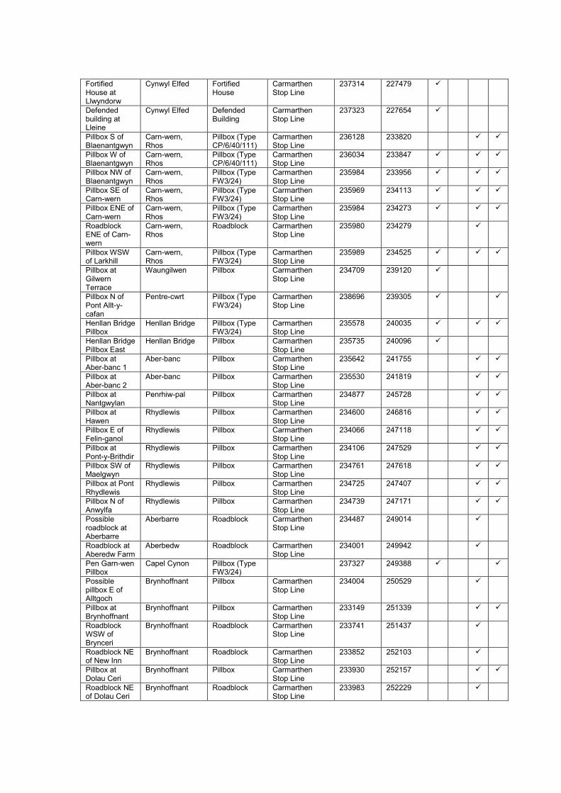
Fortified House at Llwyndorw
Cynwyl Elfed Fortified House
Carmarthen Stop Line
237314 227479
Defended building at Lleine
Cynwyl Elfed Defended Building
Carmarthen Stop Line
237323 227654
Pillbox S of Blaenantgwyn
Carn-wern, Rhos
Pillbox (Type CP/6/40/111)
Carmarthen Stop Line
236128 233820
Pillbox W of Blaenantgwyn
Carn-wern, Rhos
Pillbox (Type CP/6/40/111)
Carmarthen Stop Line
236034 233847
Pillbox NW of Blaenantgwyn
Carn-wern, Rhos
Pillbox (Type FW3/24)
Carmarthen Stop Line
235984 233956
Pillbox SE of Carn-wern
Carn-wern, Rhos
Pillbox (Type FW3/24)
Carmarthen Stop Line
235969 234113
Pillbox ENE of Carn-wern
Carn-wern, Rhos
Pillbox (Type FW3/24)
Carmarthen Stop Line
235984 234273
Roadblock ENE of Carn-wern
Carn-wern, Rhos
Roadblock Carmarthen Stop Line
235980 234279
Pillbox WSW of Larkhill
Carn-wern, Rhos
Pillbox (Type FW3/24)
Carmarthen Stop Line
235989 234525
Pillbox at Gilwern Terrace
Waungilwen Pillbox Carmarthen Stop Line
234709 239120
Pillbox N of Pont Allt-y-cafan
Pentre-cwrt Pillbox (Type FW3/24)
Carmarthen Stop Line
238696 239305
Henllan Bridge Pillbox
Henllan Bridge Pillbox (Type FW3/24)
Carmarthen Stop Line
235578 240035
Henllan Bridge Pillbox East
Henllan Bridge Pillbox Carmarthen Stop Line
235735 240096
Pillbox at Aber-banc 1
Aber-banc Pillbox Carmarthen Stop Line
235642 241755
Pillbox at Aber-banc 2
Aber-banc Pillbox Carmarthen Stop Line
235530 241819
Pillbox at Nantgwylan
Penrhiw-pal Pillbox Carmarthen Stop Line
234877 245728
Pillbox at Hawen
Rhydlewis Pillbox Carmarthen Stop Line
234600 246816
Pillbox E of Felin-ganol
Rhydlewis Pillbox Carmarthen Stop Line
234066 247118
Pillbox at Pont-y-Brithdir
Rhydlewis Pillbox Carmarthen Stop Line
234106 247529
Pillbox SW of Maelgwyn
Rhydlewis Pillbox Carmarthen Stop Line
234761 247618
Pillbox at Pont Rhydlewis
Rhydlewis Pillbox Carmarthen Stop Line
234725 247407
Pillbox N of Anwylfa
Rhydlewis Pillbox Carmarthen Stop Line
234739 247171
Possible roadblock at Aberbarre
Aberbarre Roadblock Carmarthen Stop Line
234487 249014
Roadblock at Aberedw Farm
Aberbedw Roadblock Carmarthen Stop Line
234001 249942
Pen Garn-wen Pillbox
Capel Cynon Pillbox (Type FW3/24)
237327 249388
Possible pillbox E of Alltgoch
Brynhoffnant Pillbox Carmarthen Stop Line
234004 250529
Pillbox at Brynhoffnant
Brynhoffnant Pillbox Carmarthen Stop Line
233149 251339
Roadblock WSW of Brynceri
Brynhoffnant Roadblock Carmarthen Stop Line
233741 251437
Roadblock NE of New Inn
Brynhoffnant Roadblock Carmarthen Stop Line
233852 252103
Pillbox at Dolau Ceri
Brynhoffnant Pillbox Carmarthen Stop Line
233930 252157
Roadblock NE of Dolau Ceri
Brynhoffnant Roadblock Carmarthen Stop Line
233983 252229

Pillbox at Pontgarreg
Pontgarreg Pillbox Carmarthen Stop Line
233933 254212
RAF Blaenannerch / Aberporth
Aberporth Airfield 224860 249470
Aberporth Beach Pillbox
Aberporth Pillbox Coastal Defences
225863 251482
RAF Blaenannerch Pillbox 01
Aberporth Pillbox (Air Ministry Pattern)
RAF Blaenannerch Perimeter Defences
225026 248883
RAF Blaenannerch Pillbox 02
Aberporth Pillbox (Type FW3/22)
RAF Blaenannerch Perimeter Defences
224690 249180
RAF Blaenannerch Pillbox 03
Aberporth Pillbox (Type FW3/24)
RAF Blaenannerch Perimeter Defences
225276 249319
RAF Blaenannerch Pillbox 04
Aberporth Pillbox (Air Ministry Pattern)
RAF Blaenannerch Perimeter Defences
225372 249363
RAF Blaenannerch Pillbox 05
Aberporth Pillbox (Air Ministry Pattern)
RAF Blaenannerch Perimeter Defences
225599 249596
RAF Blaenannerch Pillbox 06
Aberporth Pillbox (Air Ministry Pattern)
RAF Blaenannerch Perimeter Defences
225382 249628
RAF Blaenannerch Pillbox 07
Aberporth Pillbox (Type FW3/24)
RAF Blaenannerch Perimeter Defences
225196 249754
RAF Blaenannerch Pillbox 08
Aberporth Pillbox (Air Ministry Pattern)
RAF Blaenannerch Perimeter Defences
225265 249865
RAF Blaenannerch Pillbox 09
Aberporth Pillbox (Air Ministry Pattern)
RAF Blaenannerch Perimeter Defences
224975 249905
RAF Blaenannerch Pillbox 10
Aberporth Pillbox (Air Ministry Pattern)
RAF Blaenannerch Perimeter Defences
224821 249772
RAF Blaenannerch Pillbox 11
Aberporth Pillbox (Air Ministry Pattern)
RAF Blaenannerch Perimeter Defences
224768 249975
RAF Blaenannerch Pillbox 12
Aberporth Pillbox (Type FW3/24)
RAF Blaenannerch Perimeter Defences
224624 249774
RAF Blaenannerch Pillbox 13
Aberporth Pillbox (Air Ministry Pattern)
RAF Blaenannerch Perimeter Defences
224445 249726
RAF Blaenannerch Pillbox 14
Aberporth Pillbox (Air Ministry Pattern)
RAF Blaenannerch Perimeter Defences
224515 249355
Possible pillbox at RAF Blaenannerch
Aberporth Pillbox RAF Blaenannerch Perimeter Defences
225210 249220
Pillbox at Synod Inn
Synod Inn Pillbox 240363 254348
6-pdr Gun Emplacement
Tywyn Burrows Gun Emplacement
Coastal Defences
238424 202900
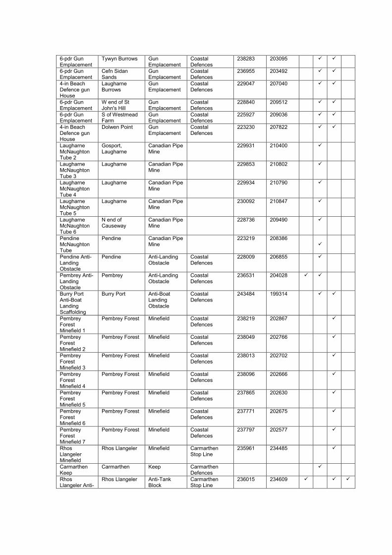
6-pdr Gun Emplacement
Tywyn Burrows Gun Emplacement
Coastal Defences
238283 203095
6-pdr Gun Emplacement
Cefn Sidan Sands
Gun Emplacement
Coastal Defences
236955 203492
4-in Beach Defence gun House
Laugharne Burrows
Gun Emplacement
Coastal Defences
229047 207040
6-pdr Gun Emplacement
W end of St John's Hill
Gun Emplacement
Coastal Defences
228840 209512
6-pdr Gun Emplacement
S of Westmead Farm
Gun Emplacement
Coastal Defences
225927 209036
4-in Beach Defence gun House
Dolwen Point Gun Emplacement
Coastal Defences
223230 207822
Laugharne McNaughton Tube 2
Gosport, Laugharne
Canadian Pipe Mine
229931 210400
Laugharne McNaughton Tube 3
Laugharne Canadian Pipe Mine
229853 210802
Laugharne McNaughton Tube 4
Laugharne Canadian Pipe Mine
229934 210790
Laugharne McNaughton Tube 5
Laugharne Canadian Pipe Mine
230092 210847
Laugharne McNaughton Tube 6
N end of Causeway
Canadian Pipe Mine
228736 209490
Pendine McNaughton Tube
Pendine Canadian Pipe Mine
223219 208386
Pendine Anti-Landing Obstacle
Pendine Anti-Landing Obstacle
Coastal Defences
228009 206855
Pembrey Anti-Landing Obstacle
Pembrey Anti-Landing Obstacle
Coastal Defences
236531 204028
Burry Port Anti-Boat Landing Scaffolding
Burry Port Anti-Boat Landing Obstacle
Coastal Defences
243484 199314
Pembrey Forest Minefield 1
Pembrey Forest Minefield Coastal Defences
238219 202867
Pembrey Forest Minefield 2
Pembrey Forest Minefield Coastal Defences
238049 202766
Pembrey Forest Minefield 3
Pembrey Forest Minefield Coastal Defences
238013 202702
Pembrey Forest Minefield 4
Pembrey Forest Minefield Coastal Defences
238096 202666
Pembrey Forest Minefield 5
Pembrey Forest Minefield Coastal Defences
237865 202630
Pembrey Forest Minefield 6
Pembrey Forest Minefield Coastal Defences
237771 202675
Pembrey Forest Minefield 7
Pembrey Forest Minefield Coastal Defences
237797 202577
Rhos Llangeler Minefield
Rhos Llangeler Minefield Carmarthen Stop Line
235961 234485
Carmarthen Keep
Carmarthen Keep Carmarthen Defences
Rhos Llangeler Anti-
Rhos Llangeler Anti-Tank Block
Carmarthen Stop Line
236015 234609

Tank Cube Alignment 1
Rhos Llangeler Anti-Tank Cube Alignment 2
Rhos Llangeler Anti-Tank Block
Carmarthen Stop Line
235991 234402
Rhos Llangeler Anti-Tank Cube Alignment 3
Rhos Llangeler Anti-Tank Block
Carmarthen Stop Line
235977 234193
Henallt Fawr Anti-Tank Cube Alignment 1
Bronwydd Arms Anti-Tank Block
Carmarthen Stop Line
242002 223031
Henallt Fawr Anti-Tank Cube Alignment 2
Bronwydd Arms Anti-Tank Block
Carmarthen Stop Line
242046 222924
Banc-y-Lord Anti-Tank Cube Alignment
Banc-y-Lord Anti-Tank Block
Carmarthen Stop Line
241097 204926
Pembrey Industrial Estate Anti-Tank Cube Alignment
Pembrey Industrial Estate
Anti-Tank Block
Carmarthen Stop Line
241213 203785
Brooklands Farm Anti-Tank Cube Alignment
Brooklands Farm
Anti-Tank Block
Carmarthen Stop Line
241323 203293
Gwendraeth Fawr estuary Anti-Tank Ditch
Commissioner's Bridge
Anti-Tank Ditch (Natural Improved)
Carmarthen Stop Line
240987 205294
Swan Pool Drain Anti-Tank Ditch
Pembrey Anti-Tank Ditch (Natural Improved)
Carmarthen Stop Line
240909 201735
Anti-Tank Ditch SE of Carmarthen Agricultural Showground
Carmarthen Anti-Tank Ditch (Natural Improved)
Carmarthen Stop Line
237815 218707
Pembrey Burrows Anti-Tank Ditch
Pembrey Burrows
Anti-Tank Ditch
Carmarthen Stop Line
241739 200424
Pembrey Industrial Estate Anti-Tank Ditch
Pembrey Industrial Estate
Anti-Tank Ditch
Carmarthen Stop Line
241154 204325
Pwlldu Anti-Tank Ditch
Pwlldu Anti-Tank Ditch
Carmarthen Stop Line
239373 217092
Anti-Tank Ditch S of Werncorgam
Werncorgam Anti-Tank Ditch
Carmarthen Stop Line
238818 217527
Anti-Tank Ditch W of Werncorgam
Werncorgam Anti-Tank Ditch
Carmarthen Stop Line
238531 217990
Anti-Tank Ditch W of Werncorgam Fawr
Werncorgam Fawr
Anti-Tank Ditch
Carmarthen Stop Line
238334 218222
Anti-Tank Ditch N of Allt Werncorgam
Allt Werncorgam
Anti-Tank Ditch
Carmarthen Stop Line
237899 218507
Carmarthen Agricultural Showground Anti-Tank Ditch
Carmarthen Anti-Tank Ditch
Carmarthen Stop Line
237697 219016
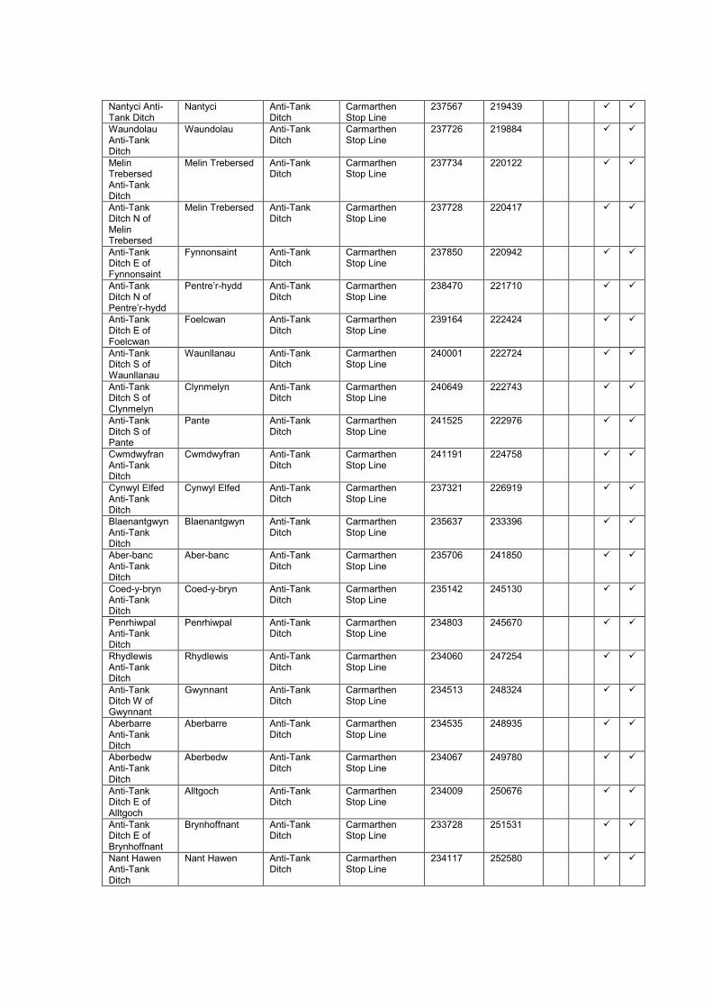
Nantyci Anti-Tank Ditch
Nantyci Anti-Tank Ditch
Carmarthen Stop Line
237567 219439
Waundolau Anti-Tank Ditch
Waundolau Anti-Tank Ditch
Carmarthen Stop Line
237726 219884
Melin Trebersed Anti-Tank Ditch
Melin Trebersed Anti-Tank Ditch
Carmarthen Stop Line
237734 220122
Anti-Tank Ditch N of Melin Trebersed
Melin Trebersed Anti-Tank Ditch
Carmarthen Stop Line
237728 220417
Anti-Tank Ditch E of Fynnonsaint
Fynnonsaint Anti-Tank Ditch
Carmarthen Stop Line
237850 220942
Anti-Tank Ditch N of Pentre’r-hydd
Pentre’r-hydd Anti-Tank Ditch
Carmarthen Stop Line
238470 221710
Anti-Tank Ditch E of Foelcwan
Foelcwan Anti-Tank Ditch
Carmarthen Stop Line
239164 222424
Anti-Tank Ditch S of Waunllanau
Waunllanau Anti-Tank Ditch
Carmarthen Stop Line
240001 222724
Anti-Tank Ditch S of Clynmelyn
Clynmelyn Anti-Tank Ditch
Carmarthen Stop Line
240649 222743
Anti-Tank Ditch S of Pante
Pante Anti-Tank Ditch
Carmarthen Stop Line
241525 222976
Cwmdwyfran Anti-Tank Ditch
Cwmdwyfran Anti-Tank Ditch
Carmarthen Stop Line
241191 224758
Cynwyl Elfed Anti-Tank Ditch
Cynwyl Elfed Anti-Tank Ditch
Carmarthen Stop Line
237321 226919
Blaenantgwyn Anti-Tank Ditch
Blaenantgwyn Anti-Tank Ditch
Carmarthen Stop Line
235637 233396
Aber-banc Anti-Tank Ditch
Aber-banc Anti-Tank Ditch
Carmarthen Stop Line
235706 241850
Coed-y-bryn Anti-Tank Ditch
Coed-y-bryn Anti-Tank Ditch
Carmarthen Stop Line
235142 245130
Penrhiwpal Anti-Tank Ditch
Penrhiwpal Anti-Tank Ditch
Carmarthen Stop Line
234803 245670
Rhydlewis Anti-Tank Ditch
Rhydlewis Anti-Tank Ditch
Carmarthen Stop Line
234060 247254
Anti-Tank Ditch W of Gwynnant
Gwynnant Anti-Tank Ditch
Carmarthen Stop Line
234513 248324
Aberbarre Anti-Tank Ditch
Aberbarre Anti-Tank Ditch
Carmarthen Stop Line
234535 248935
Aberbedw Anti-Tank Ditch
Aberbedw Anti-Tank Ditch
Carmarthen Stop Line
234067 249780
Anti-Tank Ditch E of Alltgoch
Alltgoch Anti-Tank Ditch
Carmarthen Stop Line
234009 250676
Anti-Tank Ditch E of Brynhoffnant
Brynhoffnant Anti-Tank Ditch
Carmarthen Stop Line
233728 251531
Nant Hawen Anti-Tank Ditch
Nant Hawen Anti-Tank Ditch
Carmarthen Stop Line
234117 252580

Pontgarreg Anti-Tank Ditch
Pontgarreg Anti-Tank Ditch
Carmarthen Stop Line
233825 254295
Pendine Barbed Wire Entanglement 1
Pendine Burrows
Barbed Wire Entanglement
Coast Defences 225547 207574
Pendine Barbed Wire Entanglement 2
Pendine Burrows
Barbed Wire Entanglement
Coast Defences 225658 207564
Pendine Barbed Wire Entanglement 3
Pendine Burrows
Barbed Wire Entanglement
Coast Defences 226726 207298
Pendine Barbed Wire Entanglement 4
Pendine Burrows
Barbed Wire Entanglement
Coast Defences 227472 207138
Pembrey Barbed Wire Entanglement
Pembrey Sands Barbed Wire Entanglement
Coast Defences 237509 202758

LIST OF PRIMARY SOURCES
List of pieces consulted at The National Archives
List of war diaries located and examined at The National Archives
Piece No. War diary name Year Date examined
GHQ Home Forces
WO 166/12 Chief Engineer 1940-41 14/10/2010
Western Command
WO 166/94 Western Command General Staff 1939-40 02/06/2009
WO 166/96 Western Command Quartermaster (Ops.) 1940 02/06/2009
WO 166/97 Western Command Royal Artillery 1940 01/06/2010
WO 166/98 Western Command Chief Engineer 1940 15/04/2010
WO 166/103 Western Command General Staff 1941 15/04/2010
WO 166/107 Western Command Royal Artillery 1941 01/06/2010
WO 166/108 Western Command Chief Engineer 1941 15/04/2010
WO 166/6025 Western Command General Staff 1942 15/04/2010
WO 166/6029 Western Command Royal Engineers 1942 15/04/2010
WO 166/6030 Western Command Royal Artillery 1942 15/04/2010
WO 199/33 Western Command Counter-attack Battalions 1941-43 02/06/2010
South Wales Area and Sub-Areas
WO 166/1247 South Wales Area HQ 1939-41 02/06/2009
WO 166/6840 South Wales District HQ 1942 12/10/2010
WO 166/1314 Severn Sub-Area HQ 1940-41 02/06/2009
WO 166/6771 Severn Sub-Area HQ 1942 12/10/2010
WO 166/1270 Carmarthen Sub-Area HQ 1940-41 02/06/2009
WO 166/6729 Carmarthen Sub-Area HQ 1942 13/10/2010
North Wales Area and Sub-Areas
WO 166/1245 North Wales Area HQ 1939-41 02/06/2009
WO 166/6838 North Wales District HQ 1942 12/10/2010
WO 166/1309 Oswestry Sub-Area HQ 1940-41 02/06/2009
WO 166/1327 Welsh Border Sub-Area HQ 1941 02/06/2009
WO 166/6783 Welsh Border Sub-Area HQ 1942 12/10/2010
WO 166/1315 Shropshire Sub-Area HQ 1941 12/10/2010
WO 166/6774 Shropshire Sub-Area HQ 1942 12/10/2010
WO 166/1290 Kinmel Sub-Area HQ 1940 12/10/2010
WO 166/1268 Cambrian Sub-Area HQ 1941 12/10/2010
WO 166/6727 Cambrian Sub-Area HQ 1942 12/10/2010
III Corps
WO 166/204 III Corps General Staff 1940-41 15/04/2010
WO 166/208 III Corps Royal Artillery 1939-41 01/06/2010
WO 166/210 III Corps Chief Engineer 1940-41 15/04/2010
WO 166/211 III Corps Commander Royal Engineers 1940-41 15/04/2010
WO 166/3683 III Corps 214 Army Field Coy., RE 1939-41 01/06/2010
WO 166/3685 III Corps 216 Army Field Coy., RE 1940-41 01/06/2010
WO 166/3686 III Corps 217 Army Field Coy., RE 1939-41 01/06/2010
WO 166/3762 III Corps 293 Field Park Coy., RE 1940-41 01/06/2010

53 (Welsh) Infantry Division
WO 166/655 53 Inf. Division General Staff 1939-40 12/10/2010
WO 166/656 53 Inf. Division General Staff 1941 12/10/2010
WO 166/658 53 Inf. Division Commander Royal Artillery 1939-41 12/10/2010
WO 166/659 53 Inf. Division Commander Royal Engineers 1939-41 12/10/2010
WO 166/3713 53 Inf. Division 244 Field Coy., RE 1939-41 12/10/2010
WO 166/3751 53 Inf. Division 282 Field Coy., RE 1939-41 12/10/2010
WO 166/3793 53 Inf. Division 555 Field Coy., RE 1939-41 12/10/2010
WO 166/3754 53 Inf. Division 285 Field Park Coy., RE 1939-41 12/10/2010
38 (Welsh) Infantry Division
WO 166/482 38 Inf. Division General Staff 1939-41 15/04/2010
WO 166/485 38 Inf. Division Commander Royal Engineers 1939-41 15/04/2010
WO 166/3752 38 Inf. Division 283 Field Coy., RE 1939-41 01/06/2010
WO 166/3753 38 Inf. Division 284 Field Coy., RE 1939-41 01/06/2010
WO 166/3799 38 Inf. Division 561 Field Coy., RE 1940-41 01/06/2010
5 Infantry Division
WO 166/419 5 Inf. Division General Staff 1939-41 01/06/2010
WO 166/421 5 Inf. Division Commander Royal Artillery 1940-41 01/06/2010
WO 166/422 5 Inf. Division Commander Royal Engineers 1939-41 01/06/2010
WO 166/3714 5 Inf. Division 245 Field Coy., RE 1939-41 14/10/2010
WO 166/3721 5 Inf. Division 252 Field Coy., RE 1939-41 01/06/2010
WO 166/3767 5 Inf. Division 501 Field Coy., RE 1939-41 14/10/2010
2 / 47 (London) Infantry Division
WO 166/566 2 / 47 London Inf. Div. General Staff 1939-40 01/06/2010
WO 166/567 47 London Inf. Division General Staff 1941 01/06/2010
WO 166/3691 47 London Inf. Division 222 Field Coy., RE 1940-41 01/06/2010
WO 166/3768 47 London Inf. Division 502 Field Coy., RE 1939-41 01/06/2010
WO 166/3769 47 London Inf. Division 503 Field Coy., RE 1939-41 01/06/2010
18 (East Anglian) Infantry Division
WO 166/465 18 Inf. Division General Staff 1941 12/10/2010
WO 166/467 18 Inf. Division Commander Royal Artillery 1939-41 12/10/2010
WO 166/468 18 Inf. Division Commander Royal Engineers 1939-41 12/10/2010
WO 166/3756 18 Inf. Division 287 Field Coy., RE 1939-41 12/10/2010
WO 166/3757 18 Inf. Division 288 Field Coy., RE 1939-41 12/10/2010
WO 166/3798 18 Inf. Division 560 Field Coy., RE 1940-41 02/06/2010
WO 166/3720 18 Inf. Division 251 Field Park Coy., RE 1939-41 12/10/2010
49 (West Riding) Infantry Division
WO 166/8197 49 Inf. Division 294 Field Coy., RE 1942 12/10/2010
WO 166/8325 49 Inf. Division 756 Field Coy., RE 1942 12/10/2010
WO 166/8326 49 Inf. Division 757 Field Coy., RE 1942 12/10/2010
WO 166/8195 49 Inf. Division 289 Field Park Coy., RE 1942 12/10/2010
50 (Northumbrian) Infantry Division
WO 166/605 50 Inf. Division General Staff 1939-41 12/10/2010
54 (East Anglian) Infantry Division
WO 166/674 54 Inf. Division General Staff 1941 12/10/2010
36 Independent Infantry Brigade

WO 166/950 36 Inf. Brigade HQ 1939-41 12/10/2010
31 Independent Brigade Group
WO 166/942 31 (Ind.) Brigade Group HQ 1940-41 12/10/2010
WO 166/3706 31 Ind. Bde. Gp. 237 Field Coy., RE 1940-41 02/06/2010
73 Independent Infantry Brigade
WO 166/971 73 Ind. Inf. Bde. HQ 1941 13/10/2010
Other units
WO 166/3654 173 Special Tunnelling Coy., RE 1940-41 02/06/2010
WO 166/3655 179 Special Tunnelling Coy., RE 1940-41 02/06/2010
WO 166/3600 100 Army Field Coy., RE 1940-41 02/06/2010
WO 166/2043 959 Defence Battery (Mobile), RA 1940-41 13/10/2010
WO 166/2044 960 Defence Battery (Mobile), RA 1940-41 13/10/2010
WO 166/2045 961 Defence Battery (Mobile), RA 1940-42 02/06/2010
WO 166/1921 51 Medium Regt., RA 1940-41 14/10/2010
WO 166/1971 3 Survey Regt., RA 1939-41 02/06/2010
WO 166/3539 Royal Engineers: Fortress Companies: Carmarthen Fortress Company
1939-40 13/10/2010
WO 166/3547 Royal Engineers: Fortress Companies: Glamorgan Fortress Company
1939-40 13/10/2010
WO 166/ 6880 HQ Swansea Garrison 1942 14/10/2010
Royal Artillery Coast Defence Fort Record Books
WO 192/155 Flat Holm Fort Record Book 1737-1944
13/10/2010
WO 192/156 Mumbles Island Fort Record Book 1791-1943
02/06/2010
WO 192/158 Coast Artillery School, Llandudno Fort Record Book 1940-45 02/06/2009
WO 192/160 West Blockhouse Battery Fort Record Book [Incorrectly named as contents relate to Watch House Point Battery]
1940-44 14/10/2010
WO 192/315 West Blockhouse Fort Record Book 1904-54 02/06/2009
WO 192/316 Lavernock Point Fort Record Book 1916-56 01/06/2010
WO 192/317 Lavernock Battery Fort Record Book [Incorrectly named as contents relate to East Blockhouse Battery]
1918-55 14/10/2010
WO 192/320 Mumbles Hill Fort Record Book 1939-55 01/06/2010
WO 192/321 Nell’s Point Fort Record Book 1939-55 02/06/2009
WO 192/323 St Anne’s Head FC Post Fort Record Book 1914-49 02/06/2009
Royal Artillery Coast Regiment and Fixed Defences War Diaries
WO 166/1877 Glamorgan Heavy Regiment, RA 1939-40 13/10/2010
WO 166/2067 Swansea Fixed Defences 1939-40 02/06/2009
WO 166/2065 531 Coast Regt. / Cardiff Fixed Defences 1940-41 02/06/2009
WO 166/1733 531 Coast Regt. HQ / Cardiff Fire Command 1941-42 02/06/2009
WO 166/7153 531 Coast Regt. / Cardiff Fire Command 1942 02/06/2009
WO 166/7278 Fixed Defences Severn HQ 1942 13/10/2010
WO 199/1175 Fixed Defences: Severn 1943-45 13/10/2010
WO 166/1734 532 Coast Regt. HQ 1940-41 02/06/2009
WO 166/2066 Milford Haven Fixed Defences 1941 13/10/2010
WO 166/7154 532 Coast Regt. [Milford Haven] 1942 13/10/2010
WO 166/1758 21 Coast Arty. Group / 559 Coast Regt. HQ 1940-41 02/06/2009
WO 166/1759 22 Coast Arty. Group / 560 Coast Regt. HQ 1940-41 02/06/2009
WO 199/1174 Fixed Defences: Milford Haven 1941-45 02/06/2009

Royal Artillery Coast Battery War Diaries
WO 166/1769 130 Coast Battery, RA [Nell’s Point] 1941 02/06/2009
WO 166/7191 130 Coast Battery, RA [Nell’s Point] 1942 13/10/2010
WO 166/7195 170 Coast Battery, RA [Nell’s Point] 1942 13/10/2010
WO 166/1774 145 Coast Battery, RA [Lavernock Point] 1940-41 02/06/2009
WO 166/1843 366 Coast Battery, RA [Cardiff] 1941 13/10/2010
Royal Artillery Coast Artillery: Other
WO 33/1897 Coast artillery and AA defence of merchant shipping: Order of Battle
1941 13/10/2010
WO 33/1969 Coast artillery and AA defence of merchant shipping: Order of Battle
1942 13/10/2010
WO 32/10051 Coast artillery: reorganisation of headquarters formations
1941-42 13/10/2010
WO 33/306 Western District Defence Scheme 1904 14/10/2010
List of anti-invasion defence registry files located and examined at The National Archives
Piece No. File name Year Date examined
Admiralty ‘F’ (Oil Fire Defence) Schemes
ADM 265/3 Schemes Nos. 1-43 1941-42 02/06/2010
ADM 265/4 Proposals for schemes at twenty-two further sites 1941-42 02/06/2010
ADM 265/10 Layout schemes 1941-43 02/06/2010
ADM 265/15 Flame throwers for harbour defence 1941-42 02/06/2010
Minefields
WO 199/37 Anti-tank minefields 1940-44 02/06/2010
WO 199/38 Anti-tank minefields: clearance 1944 02/06/2010
WO 199/39 Standing instructions for home defence minefields 1941-44 02/06/2010
WO 199/47 Defences: anti-tank mines 1939-44 14/10/2010
WO 199/94 Beach mines 1940-44 02/06/2010
WO 199/98 Minefield clearance certificates 1944-45 02/06/2010
Anti-invasion defences
WO 199/36 Defences: pillboxes 1940-44 02/06/2010
WO 199/40 Employment of tunnelling companies 1942-43 02/06/2010
WO 199/41 Defences: barbed wire and other obstacles 1941-44 14/10/2010
WO 199/44 Defences: concrete defences, policy 1941 14/10/2010
WO 199/48 Defence works 1940-42 02/06/2009
WO 199/51 Defences: roadblocks 1940-41 14/10/2010
WO 199/52 Defences: roadblocks - McNaughton tubes 1940-42 14/10/2010
WO 199/53 Inundation: flood schemes 1940-43 02/06/2010
WO 199/54 Scheme of anti-tank obstacles for defence of Great Britain
1940-43 02/06/2010
WO 199/95 Beach defences: scaffolding 1941-44 14/10/2010
WO 199/96 Beach defences: scaffolding 1945 14/10/2010
WO 199/103 Charting of obstructions on foreshore 1943-45 02/06/2009
WO 199/336 Obstruction of landing grounds: Western Command
1940-42 02/06/2009
WO 199/479 Roadblocks 1940-42 14/10/2010
WO 199/544 Keeps and fortified villages, nodal points and anti-tank islands
1940-42 02/06/2010
WO199/657 Vulnerable points: lists 1942 14/10/2010
WO 199/1735 Construction of GHQ Zones: River Wye defences 1941-42 02/06/2009

MAF 112/204 Removal of defence works and other obstacles in the interest of food production
1944-50 14/10/2010
Directorate of Military Training: Pamphlets
WO 231/146 Military Training Pamphlet No. 15: Notes on defence (provisional)
1939 14/10/2010
WO 231/164 Military Training Pamphlet No. 23: Operations. Part II: Defence
1940 14/10/2010
WO 231/178 Military Training Pamphlet No. 26: Notes on concealment and camouflage
1939 14/10/2010

List of pieces identified at local record offices
Ref. code Content Date Date examined
Anglesey Archives
Includes programme of winter drills for Anglesey Home Guard to Sergeant J. C. Parry.
n.d. Not viewed
Bangor University Archives
Eight Home Guard instructional and training pamphlets.
n.d. Not viewed
Carmarthenshire Archive Service
CDX/429 Kidwelly-Pembrey Home Guard: defence schemes and correspondence.
1941-42 19/08/2010
CDX/553 3 Bn., Carmarthenshire Home Guard: correspondence
1943-45 19/08/2010
CDX/629 1 Bn., Carmarthenshire Home Guard: Passive Air Defence Scheme
1944 19/08/2010
Ceredigion Archives
ADX/1150
3 Bn., Cardiganshire Home Guard: photocopy of a handbook detailing the unit’s history. It includes a map and some photographs and many details of the Home Guard activities in the local area.
1947 Not viewed
DSO/93 1 Bn., Cardiganshire Home Guard: (1) Lists of those serving in the Home Guard stationed in Aberystwyth (15 items) (2) Operational notes and instructions relating to Home Guard Training exercises in Aberystwyth and Devil's Bridge areas (3) Correspondence relating to the Home Guard including two personal letters to Major W.G. Rowlands (3 items)
1941-44 1941-42 1942-44
Not viewed
MUS/83/1 1 Bn., Cardiganshire Home Guard: Scrapbook-style book [photographs & duplicated typed notes]. Contains a history, information on individuals in the regiment, an illustration of the command structure and a number of photographs.
n.d. Not viewed
MUS/83/2 Photocopy of the same scrapbook as MUS/83/1. Also copy of newspaper cutting re the Battalion and copy of Certificate of Appreciation awarded to Lt. Col. D. C. Lewis, the Battalion’s Commanding Officer, by Western Command.
01/01/45
Not viewed
ADX/1024 1 Bn., Cardiganshire Home Guard: records including lists of members, operational notes relating to training in Aberystwyth area
1941-44 Not viewed
ADX/1031 Copies of wartime papers: 1. Certificate given to the depositor's father at the end of his Home Guard duties 2. Special Order of the Day (relating to the Home Guard) 3. Message from Lieut. Col. Ernest Evans, Cardiganshire Sector, Home Guard
03/12/44 03/12/44
Not viewed
PRO/C/1 Handwritten transcripts of speeches by E R D Prosser. 2 documents. Includes one given to the Home Guard concerning the role of searchlights in
1943 Not viewed

national defence and the daily duties of a searchlight detachment, and another given to Sarn Young People’s Guild entitled ‘Somewhere in Windland’ recounting his three years in the searchlight detachment.
ADX/71 Papers of I.T. Hughes. 1. Folder stamped '2 Bn., Cardiganshire Home Guard, B Company Headquarters, Albion House, Llandyssul' and labelled 'Operation Role 1943' includes Battalion orders, operational orders for combined exercises and for the defence and invasion schemes, notes on guerrilla tactics and duties of personnel, scheme for mobile columns, report on sources of German power (energy) as bombing targets, forms of Government in the Commonwealth, proficiency tests including lists of entrants, map of Llandyssul 2. Papers of Peterwell Masonic Lodge. Folder of Home Guard papers including weekly and monthly time tables for ‘B’ Coy.; muster numbers, duties of sentries and post commanders, rifle numbers, operational orders for exercises, lecture notes on various topics
1942-45 1941-44
Not viewed
ARD/9/2 3 Bn., Cardiganshire Home Guard: Correspondence files for Gwendraeth area
1943-45 Not viewed
Denbighshire Record Office
DRO DD/DM/913/1
Notebook of G.F. Wilkinson of Acrefair, instructor in the Home Guard
1940 Not viewed
DRO NTD/572 Memorandum from commander of Denbighshire Home Guard concerning parachutists
1940 Not viewed
DRO DD/DM/874/1-6
9 Bn., Denbighshire Home Guard: circulars, training manuals, etc. of member No. 5 Pl., ‘B’ Coy. - Pentrecelyn/ Ruthin
1940-44 Not viewed
DRO DD/DM/815/1-2
2 Bn., Denbighshire Home Guard: battalion roll, photographs, correspondence and papers
1940-45 Not viewed
DRO DD/DM/1402/29
Notes of service in the Home Guard 1942 Not viewed
DRO DD/DM/757/12-13
ABC for special constable and police war reserves, and Home Guard certificate of proficiency
1942-44 Not viewed
DRO DD/DM/1546/1-2
4 Bn., Merionethshire Home Guard: part II Orders, ‘A’ Coy. armoury, Corwen
1943-44 Not viewed
DRO DD/DM/99 9 Bn., Denbighshire Home Guard: menu card, public notice and badges
1944 Not viewed
DRO PCD/89/73 7 Bn., Denbighshire/Flintshire Home Guard: 'A brief history of 7 Den Flint Battalion Home Guard'
1945 Not viewed
DRO NTD/1567 Photograph of ‘F’ Coy., Home Guard, and staff on railway platform, Rhyl
1945-46 Not viewed
DRO NCD/405 Photograph of Wrexham Home Guard n.d. Not viewed
DRO NCD/969 Photographs of 'Wings for Victory' parade and member of the Home Guard with Sten gun, Colwyn Bay
c. 1943 Not viewed
Flintshire Record Office

D/HA/1753-5 Miscellaneous papers of Home Guard in Hawarden area
1941-44 Not viewed
D/CK/694 Enrolment book of Connah's Quay Home Guard 1941-43 Not viewed
D/DM/584/15 Home Guard pamphlets and training manuals 1942-55 Not viewed
D/DM/1090/4 Home Guard proficiency certificate 1943 Not viewed
D/DM/1271/1 Photograph of Home Guard (5 Battalion Royal Welch Fusiliers) in Hawarden Park
1943 Not viewed
Papers of Tom Jones, 1874-1990, including Home Guard
1940-44 Not viewed
Glamorgan Archives
D184 21 Bn., Glamorgan Home Guard 1941-56 12/08/2010
D509 16 (Cardiff) Bn., Glamorgan Home Guard: Includes ‘E’ Coy. defence scheme Plan and papers for Penarth and Sully.
23/01/42 1942-45
12/08/2010
D882/4 22 Bn., Glamorgan Home Guard: photograph of Western Mail and Echo, S.A. Brain and Co., and Glamtax Ltd. platoons.
1944 12/08/2010
DCAEHS/7/1/94 Photograph of Home Guard mounted patrol at Groeswen, Caerphilly
1940-44 12/08/2010
DHG 1-25 6, 8 and 11 Bns., Glamorgan Home Guard: membership records, and of other unidentified battalions
1940-46 12/08/2010
DHG/24 186 (101 Glamorgan HQ) ‘M; rocket anti-aircraft battery. No. 4 relief list for Cardiff, Rhondda, Pentyrch and Whitchurch
13/11/44 12/08/2010
DLL/E/349/47-50 3 (Bridgend) Bn., Glamorgan Home Guard: papers and accounts
1940-46 12/08/2010
DX47 Reminiscences of the Home Guard 1975 12/08/2010
DX 391/1-2 Home Guard: Penarth and Sully 1940-44 12/08/2010
DX618/1 Home Guard, Melingriffith: Film of manoeuvres 1940-44 12/08/2010
DXFC/22/10/1-2 Photograph of Home Guard mounted patrol at Groeswen, Caerphilly
1942 12/08/2010
DXFX2/1-3 Glamorgan Home Guard Pictorial 1943-44 12/08/2010
DXJ13 3 Bn., Glamorgan Home Guard: ‘A’ Coy., Pencoed 1944 12/08/2010
Gwent Archives
D3132.3 Papers relating to the Home Guard and Civil Defence
24/08/2010
D3132.4 6 Bn., Monmouthshire Home Guard: history booklet 1939-44 24/08/2010
D4321 Maps of the Ebbw Vale area showing Home Guard activities
1940-41 24/08/2010
Gwynedd Archives
XD/32/1199 4 Bn., Caernarvonshire Home Guard: ‘D’ Coy. history
n.d. Not viewed
XM/1301 3 Bn., Caernarvonshire Home Guard: includes files, booklets, maps, catalogues and programmes (96 items)
1940-44 Not viewed
XS2009/69 Lloyd George reviewing the Home Guard n.d. Not viewed
XS/3066/218 Bangor Home Guard [photo] 1940 Not viewed
XS/3318/1 Members of Caernarvon Home Guard n.d. Not viewed
XS/1077/10/8 Home Guard at ?Bangor 1939-45 Not viewed
Records of the Merioneth Home Guard and Merioneth and Montgomery Territorial and Auxiliary Forces Association, including handbooks and
1931-67 Not viewed

regulations, 1935-55; personnel records, 1940; financial records, 1942-55; correspondence, 1940-1967; magazines, 1942; notebooks, 1942-43; and miscellaneous papers, 1931-55
ZDDW Merioneth Home Guard: company rolls and list of members, correspondence and notes relating to home defence matters
1940-57 Not viewed
Llantwit Major Local History Society
None 10 (Cowbridge) Bn., Glamorgan Home Guard: ‘B’ Coy. defence scheme
1943 17/06/2009
National Library of Wales: Department of Collection Services
1 Bn., Carmarthenshire Home Guard: transfer register
1940-45 Not viewed
3 Bn., Pembrokeshire Home Guard: ‘A’, ‘D’, ‘E’ and ‘F’ Coy. rolls
1940-45 Not viewed
6 Bn., Denbighshire Home Guard: papers, mostly relating to 'D' Coy.
1940-42 Not viewed
Pembrokeshire Record Office
D/MOR/15 Ledger containing information on Home Guard shelters built in the Fishguard area
1943-44 10/09/2010
D/ROC/428 1 Bn., Pembrokeshire Home Guard: file on Home Guard (Pembroke area)
1940-43 10/09/2010
DFC/M/7/115 Letters re use of Jeffreyston Methodist Hall by Home Guard
1943 10/09/2010
HDX/58/57 Notes on the Home Guard in Pembrokeshire [photocopy]
1943 10/09/2010
HDX/443/4 2
Bn., Pembrokeshire Home Guard: official programme of the final parade, Haverfordwest
1944 10/09/2010
HDX/1101/40 Photograph of Carew Home Guard (not in uniform, but partly named) [photocopy]
n.d. 10/09/2010
HDX/1520 Pembrokeshire Home Guard, ‘E’ Coy.: company roll 1940-44 10/09/2010
Powys County Archives Office
M/B/WE65-72a Wartime matters including evacuation, billeting, civil casualties, and the Home Guard
1938-47 Not viewed
R/SOC/5/157-185 Radnor Home Guard papers 1940-57 Not viewed
R/X/63/1/1-48 2 Bn., Radnorshire Home Guard: bundle of miscellaneous papers
1944-48 Not viewed
R/X/63/2/1 Photograph of group of officers at Army and Home Guard conference
1944 Not viewed
R/X/63/2/2-3 Photograph of Home Guard Signallers, taken during conference
1944 Not viewed
R/X/63/3/1 Exercise messages 1942-44 Not viewed
West Glamorgan Archive Service
D/D Z 402/1/1-26 4 (Neath) Bn., Glamorgan Home Guard: Battalion orders, with papers including details of exercises, 1940-44; details of competitions, 1941 and 1943; Special Army Order: message from His Majesty The King to Home Guard, 14 Nov 1944; account of ceremonial parade at Hyde Park, London, on 3 Dec 1944. 22 May 1940 – 7 Dec 1944 and n.d. [1 volume, 25 papers]
1940-44 24/09/2010

D/D Z 402/2 4 (Neath) Bn., Glamorgan Home Guard: programme of final inter-platoon competition and military, Home Guard and AFS displays held at Neath football field [1 paper]
13/09/41 24/09/2010
D/D Z 402/3/1,2 Programme of Neath and District Salute the Soldier week [2 papers]
22-29/04/44
24/09/2010
D/D Z 402/4/1,2 Programme of Home Guard, South Wales District, weapons meeting at Black Mountain range [2 papers]
17/09/44 24/09/2010
D/D Z 402/5 Programme of complimentary smoking concert to Lt-Col C. Leslie Thomas, Commanding 4 (Neath) Bn., Glamorgan Home Guard and Captain S. Donaldson, Adjutant 4 (Neath) Bn., Glamorgan Home Guard, given by Company commanders and officers of Battalion at British Legion Club and Institute, Eastland Road, Neath [1 card]
11/11/44 24/09/2010
D/D Z 402/6/1-46 4 (Neath) Bn., Glamorgan Home Guard: photographs of activities and personnel including Bryncoch battle course competition held on 26 Sep 1942; Neath and District Salute the Soldier week, Apr 1944; ‘I’ Coy. bomb disposal unit, Dec 1944; Lieutenant-Colonel C. Leslie Thomas, Commanding Officer of Battalion. [46 photographs]
1941-44 and n.d.
24/09/2010
D/D Z 402/7 Illustrated including article and photographs concerning competition held over battle course of Battalion at Bryncoch. [1 volume]
17/10/42 24/09/2010
D/D Z 402/8/1-6 Souvenir of Home Guard Stand Down concert given by Daily Mail, Sunday Dispatch and Evening News at the Royal Albert Hall with reports on visit to London to attend Stand Down Parade 1944. [1 booklet, 5 papers]
03/12/44 24/09/2010
D/D Z 402/9 Home Guard Humour [1 booklet] Post-05/ 1945
24/09/2010
D/D Z 712/1-2 Swansea Home Guard register and related papers 1940-44 24/09/2010

List of RAF Medmenham aerial photographs consulted at the Aerial
Photographs Unit, Welsh Government
Catalogue organised by Welsh Government Aerial Photographs Unit library
reference (M) number. RAF sortie number, date, frames and locational information
provided where known.
Catalogue of high-resolution scans created as part of this research
28/12/2011-25/01/2012. High-resolution imagery scanned in 2009.
Date Sortie ID Frames Subject
M220
27/05/41 2/3 5 oblique frames (1-5) Military convoy at unknown location, possibly Llandegla, Denbighshire
09/05/41 2/5 2 oblique frames (12940-12941)
West Blockhouse coast battery, Pembrokeshire
09/05/41 2/5 1 oblique frame (12942) East Blockhouse coast battery, Pembrokeshire
09/05/41 2/5 3 oblique frames (12943-12945)
Railway and camp W of Carmarthen, Carmarthenshire
09/05/41 2/5 3 oblique frames (12947-12950)
Sennybridge Camp, Brecknockshire
26/05/41 2/2 4 oblique frames (A1-A4) Vehicles N of Llandegla, Denbighshire
M221
27/05/41 3/4 5 vertical frames (A1-A5) N of Llandegla, Denbighshire
M224
09/05/41 6/1 17 vertical frames (1-17) Towyn, Merionethshire. [Includes RAF Towyn]
09/05/41 6/1 10 vertical frames (18-27) Aberporth, Cardiganshire
09/05/41 6/1 7 vertical frames (28-34) Manorbier area, Pembrokeshire
12/06/41 5/4 19 vertical frames (39-57) Brecon area, Brecknockshire
26/05/41 6/3 5 vertical frames (A3-A7) N of Llandegla, Denbighshire
M225a
20/06/41 9/2 4 vertical frames (12-15) Abergavenny, Monmouthshire
20/06/41 9/2 16 vertical frames (16-31) Crickhowell, Monmouthshire
20/06/41 9/2 2 vertical frames (32-33) Llanvihangel Gobion, Monmouthshire
20/06/41 9/2 4 vertical frames (34-37) Usk, Monmouthshire
M229
21/07/41 13/2 8 oblique frames (1-8) Area N of Llanfilhangel Nant Bran, Brecknockshire

21/07/41 13/2 20 oblique frames (9-34) Llanfilhangel Nant Bran, Brecknockshire
09/07/41 12/1 12 vertical frames (117-128) Llangollen E along Vale of Llangollen to Cefn Mawr, Denbighshire
M261
27/04/42 AC/40 3 oblique frames (1-3) Unknown airfield
27/04/42 AC/40 2 oblique frames (4-5) Wynnstay, near Ruabon, Denbighshire
27/04/42 AC/41 8 vertical frames (1-8) HAA site E of Hundleton, Pembrokeshire
27/04/42 AC/41 3 vertical frames (9-11) RAF Angle, Pembrokeshire
27/04/42 AC/41 8 vertical frames (12-19) Pennar, Pembrokeshire
27/04/42 AC/43 1 oblique frame (1) Nell’s Point, Barry, Glamorgan
27/04/42 AC/39 7 vertical frames (51-57) Military camp at Ty Croes, Anglesey
M262
27/04/42 AC/42 3 vertical frames (1-3) Mumbles Head, Swansea, Glamorgan
27/04/42 AC/42 3 vertical frames (4-6) HAA site and GL mat at Neath Abbey, Glamorgan
27/04/42 AC/42 4 vertical frames (7-10) HAA site E of Cwmavon, Glamorgan
27/04/42 AC/42 4 vertical frames (11-14) HAA site and GL mat at Jersey Marine, Swansea, Glamorgan
27/04/42 AC/42 3 vertical frames (15-17) HAA site and anti-landing trenches at Porthkerry, Glamorgan
27/04/42 AC/42 2 vertical frames (18-19) HAA site and GL mat at Sully, Glamorgan
27/04/42 AC/42 2 vertical frames (20-21) HAA site at Llandough, Glamorgan
27/04/42 AC/42 6 vertical frames (22-27) HAA site at Ely, Cardiff, Glamorgan
27/04/42 AC/42 4 vertical frames (28-31) HAA site, GL mat and roadblock at Llandaff, Cardiff, Glamorgan
27/04/42 AC/42 5 vertical frames (32-36) HAA site at Penylan, Cardiff, Glamorgan
27/04/42 AC/42 2 vertical frames (37-38) HAA site at Lamby, Cardiff, Glamorgan
M279
24/06/40 61/1 6 vertical frames (10429, 10475-10479)
West Blockhouse coast battery, Pembrokeshire
24/06/40 61/1 6 vertical frames (0480-0485) East Blockhouse coast battery, Pembrokeshire
24/06/40 61/1 7 vertical frames (0486-0492) Mumbles Island coast battery, Glamorgan
24/06/40 61/1 6 vertical frames (0493-0498) Nell’s Point coast battery, Glamorgan
M286
01/07/40 68/1 16 oblique frames (A1-A16) N side of River Dovey estuary from Aberdovey E to Pennal, Merionethshire
01/07/40 68/1 17 oblique frames (B1-B17) S side of River Dovey estuary from Dovey Station W to Ynyslas, Cardiganshire
01/07/40 68/1 8 oblique frames (C1-C8) Ynyslas S to Borth, Cardiganshire
01/07/40 68/1 3 oblique frames (D1-D3) Barmouth, Merionethshire
01/07/40 68/1 9 oblique frames (E1-E9) N side of River Mawddach estuary from Aberdovey E to Pennal, Merionethshire
01/07/40 68/1 6 oblique frames (F1-F6) N side of River Dovey Valley E to Dolgellau, Merionethshire
01/07/40 68/1 12 oblique frames (G1-G12) S side of River Dovey estuary W to Arthog, Merionethshire
01/07/40 68/1 15 oblique frames (H1-H12) Barmouth Junction Station S via Fairbourne to Llwyngwril, Merionethshire
01/07/40 68/1 3 oblique frames (J1-J3) Coast at Newport, Pembrokeshire
01/07/40 68/1 1 oblique frame (K10322) Coast at Aber Mawr, Granston, Pembrokeshire

01/07/40 68/1 1 oblique frame (K10325) Coast at Abereiddy Bay, Pembrokeshire
M296
31/03/41 1/5 2 vertical frames (A1(N15063)-A2(N15064))
River Usk at Llangattock, Monmouthshire
31/03/41 Unknown 1 vertical frame (N15062) Unknown location
M298
14/03/41 78/3 9 vertical frames (A1-A5, B1-B4)
ROF Glascoed, Monmouthshire
14/03/41 78/3 3 vertical frames (4273-4275) Brecon, Brecknockshire
20/03/41 78/1 18 vertical frames (4342-4360)
Carmarthen, Carmarthenshire
14/03/41 78/3 2 vertical frames (C1-C2) Holyhead emergency coast battery, Anglesey
M326
04/09/40 13N/ UK746
24 vertical frames (B1-B20) Abergavenny NW along Usk Valley to Brecon, Monmouthshire & Brecknockshire
04/09/40 13N/ UK746
1 oblique frame (B21) W along Usk Valley from Brecon, Brecknockshire.
M327
13/03/41 108/4 8 vertical frames (A1-A8) St Brides SE to St Ishmaels, Pembrokeshire
13/03/41 108/4 9 vertical frames (B1-B9) Nab Head SE to Watch House Point, Pembrokeshire
13/03/41 108/4 7 vertical frames (C1-C7) Marloes SE to Dale, Pembrokeshire
13/03/41 108/4 7 vertical frames (AA1-AA7) Newgale Beach, Pembrokeshire
13/03/41 108/4 5 vertical frames (BB1-BB5) Newgale Beach, Pembrokeshire
13/03/41 108/4 6 vertical frames (CC1-CC6) Newgale Beach, Pembrokeshire
M328
30/08/40 110/1 6 vertical frames (11695-11700)
Burry Port, Carmarthenshire
30/08/40 109/1 4 vertical frames (11701-11704)
Porthcawl, Glamorgan
30/08/40 109/1 3 vertical frames (11705-11707)
Ogmore to Glan-y-Mor, Glamorgan
30/08/40 109/1 2 vertical frames (11708-11709)
Dunraven Castle, Glamorgan
30/08/40 109/1 12 vertical frames (11710-11721)
St Donats E to Limpert Bay, Glamorgan
M330
08/09/40 111/6 3 oblique frames (A1-A3) Dunraven Castle, Glamorgan
08/09/40 111/6 3 oblique frames (B1-B3) Coast from Ogmore to Ogmore-by-Sea, Glamorgan
08/09/40 111/6 7 oblique frames (C1-C7) Ogmore-by-Sea, Glamorgan
08/09/40 111/6 6 oblique frames (D1-D6) Sandy Bay and Trecco Bay, Porthcawl, Glamorgan
M331
14/06/40 112/5 32 oblique frames (A1-A32) Coast from Point of Air W to Rhyl, Flintshire
14/06/40 112/5 16 oblique frames (B1-B16) Mostyn Beach N to Point of Air, Flintshire

M341 / MWO 1
11/06/40 Unknown 18 oblique frames (A1-A18) Dwygyfylchi via Penmaenmawr and Llanfairfechan to Talybont, Caernarvonshire
M1255
10/02/44 LOC/176 76 vertical frames (7001-7016, 7019-7031, 8001-8047)
South Gower, Glamorgan
M1272
05/03/44 LOC/200 2 vertical frames (1001-1002) Unknown reservoir
05/03/44 LOC/200 3 vertical frames (1003-1005) Llandeilo, Carmarthenshire
05/03/44 LOC/200 33 vertical frames (1006-1039)
Carmarthen, Carmarthenshire
05/03/44 LOC/200 11 vertical frames (1040-1050)
RAF Pembrey, Carmarthenshire
05/03/44 LOC/200 3 vertical frames (3001-3003) Llandeilo, Carmarthenshire
05/03/44 LOC/200 3 vertical frames (4001-4003) Llandeilo, Carmarthenshire
M1274
06/03/44 LOC/202 85 vertical frames (1001-1013, 12001-12039, 13001-13033)
Inland and coastal areas of the Gower, Glamorgan
M1281
08/03/44 LOC/212 4 vertical frames (1001-1004) RAF St Athan and RAF Llandow, Glamorgan
08/03/44 LOC/212 4 vertical frames (1005-1008) Oxwich Bay, Glamorgan N to Llanelli, Carmarthenshire
08/03/44 LOC/212 6 vertical frames (1009-1014) Llanmadoc S to Rhossili, Gower, Glamorgan
08/03/44 LOC/212 20 vertical frames (1015-1034)
Carmarthen area, Carmarthenshire
08/03/44 LOC/212 7 vertical frames (1035-1041) Worm’s Head E to Mumbles, Glamorgan. [Includes RAF Fairwood Common]
08/03/44 LOC/212 4 vertical frames (3001-3004) RAF Llandow, Glamorgan
08/03/44 LOC/212 16 vertical frames (3005-3020)
Oxwich Bay N to Llanelli, Carmarthenshire
08/03/44 LOC/212 13 vertical frames (3021-3033)
Burry Port, Carmarthenshire S to Port Eynon, Gower, Glamorgan
08/03/44 LOC/212 13 vertical frames (3034-3046)
Coast from Rhossili N to Bury Holmes, Gower, Glamorgan
08/03/44 LOC/212 24 vertical frames (3047-3070)
Carmarthen area, Carmarthenshire
08/03/44 LOC/212 36 vertical frames (3071-3106)
Worm’s Head E to Mumbles, Glamorgan
08/03/44 LOC/212 4 vertical frames (4001-4004) RAF Llandow, Glamorgan
08/03/44 LOC/212 14 vertical frames (4005-4018)
Three Cliffs Bay, Gower, Glamorgan N via Crofty to Llanelli, Carmarthenshire
08/03/44 LOC/212 13 vertical frames (4019-4031)
Burry Port, Carmarthenshire S to Port Eynon, Gower, Glamorgan
08/03/44 LOC/212 14 vertical frames (4032-4045)
Pilton N to Whitford Point, Gower, Glamorgan
08/03/44 LOC/212 25 vertical frames (4066-4090)
Worm’s Head E to Oxwich Point, Gower, Glamorgan

M1302
24/03/44 LOC/253 30 oblique frames (0001-0030)
Area around Neath and Briton Ferry, Glamorgan
24/03/44 LOC/253 23 vertical frames (1001-1023)
Area around Neath and Briton Ferry, Glamorgan
24/03/44 LOC/253 22 oblique frames (2001-2022)
Area around Neath and Briton Ferry, Glamorgan
M1404
24/08/44 LOC/393 39 vertical frames (8001-8039)
Area from Beacons Reservoir WSW to Onllwyn, Brecknockshire
M1407
11/09/44 LOC/417 4 vertical frames (5001-5004) Cwmbran area, Monmouthshire
11/09/44 LOC/417 28 vertical frames (5005-5033)
Ebbw Vale, Blaina, Bryn Mawr and Beaufort areas, Monmouthshire
M1468
02/03/44 LOC/C4 13 oblique frames (0001-0013)
Carmarthen Hospital, Carmarthenshire
M1470
04/03/44 LOC/E2 2 vertical frames (0024-0025) Carmarthen Hospital, Carmarthenshire
M1494
12/04/44 LOC/31 29 vertical frames (0001-0029)
Sennybridge Infantry Range, Brecknockshire
M1497
22/04/44 LOC/37A 171 vertical frames (1003-1016, 1025-40, 1042-54, 1057-87, 1098-1107, 2003-2015, 2025-2040, 2042-2054, 2057-2087, 2098-2111)
Sennybridge Infantry Range, Brecknockshire
M1505
26/04/44 LOC/35 51 vertical frames (0001-0051)
Haverfordwest and area to south including Milford Haven, Neyland, Lawrenny, Pembroke Docks to St Anne’s Head. [Includes RAF Talbenny (0020-0021), RAF Carew Cheriton (0034-0035), RAF Dale (0046-0048) and Pembroke Dock (0039-0040)]
M2070
05/01/45 106G/ LA93
9 oblique frames (0001-0006, 1, 3, 5)
RAF Llandow, Glamorgan
M2074
14/01/45 106G/ LA97
15 vertical frames (1002-1014)
Area between Lavan Sands (S of Beaumaris, Anglesey) ESE to Bwlch-y-Ddeufaen, Caernarvonshire
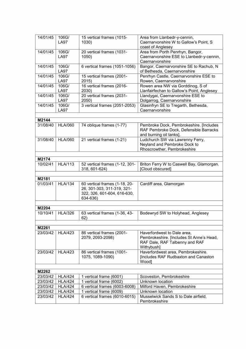
14/01/45 106G/ LA97
15 vertical frames (1015-1030)
Area from Llanbedr-y-cennin, Caernarvonshire W to Gallow’s Point, S coast of Anglesey
14/01/45 106G/ LA97
20 vertical frames (1031-1050)
Area from Porth Penrhyn, Bangor, Caernarvonshire ESE to Llanbedr-y-cennin, Caernarvonshire
14/01/45 106G/ LA97
6 vertical frames (1051-1056) Bangor, Caernarvonshire SE to Rachub, N of Bethesda, Caernarvonshire
14/01/45 106G/ LA97
15 vertical frames (2001-2015)
Penrhyn Castle, Caernarvonshire ESE to Rowen, Caernarvonshire
14/01/45 106G/ LA97
16 vertical frames (2016-2030)
Rowen area NW via Gorddinog, S of Llanfairfechan to Gallow’s Point, Anglesey
14/01/45 106G/ LA97
20 vertical frames (2031-2050)
Llandygai, Caernarvonshire ESE to Dolgarrog, Caernarvonshire
14/01/45 106G/ LA97
3 vertical frames (2051-2053) Glasinfryn SE to Tregarth, Bethesda, Caernarvonshire
M2144
31/08/40 HLA/060 74 oblique frames (1-77) Pembroke Dock, Pembrokeshire. [Includes RAF Pembroke Dock, Defensible Barracks and burning oil tanks].
31/08/40 HLA/060 21 vertical frames (1-21) Ludchurch SW via Lawrenny Ferry, Neyland and Pembroke Dock to Rhoscrowther, Pembrokeshire
M2174
10/02/41 HLA/113 52 vertical frames (1-12, 301-318, 601-624)
Briton Ferry W to Caswell Bay, Glamorgan. [Cloud obscured]
M2181
01/03/41 HLA/134 60 vertical frames (1-18, 20-26, 301-303, 311-319, 321-322, 326, 601-604, 616-630, 634-636)
Cardiff area, Glamorgan
M2204
10/10/41 HLA/326 63 vertical frames (1-36, 43-62)
Bodewryd SW to Holyhead, Anglesey
M2261
23/03/42 HLA/423 86 vertical frames (2001-2079, 2093-2098)
Haverfordwest to Dale area, Pembrokeshire. [Includes St Anne’s Head, RAF Dale, RAF Talbenny and RAF Withybush]
23/03/42 HLA/423 86 vertical frames (1001-1075, 1089-1090)
Haverfordwest area, Pembrokeshire. [Includes RAF Rudbaxton and Canaston Wood]
M2262
23/03/42 HLA/424 1 vertical frame (6001) Scoveston, Pembrokeshire
23/03/42 HLA/424 1 vertical frame (6002) Unknown location
23/03/42 HLA/424 6 vertical frames (6003-6008) Milford Haven, Pembrokeshire
23/03/42 HLA/424 1 vertical frame (6009) Unknown location
23/03/42 HLA/424 6 vertical frames (6010-6015) Musselwick Sands S to Dale airfield, Pembrokeshire

23/03/42 HLA/424 28 vertical frames (6016-6049)
Mumbles NW to Fairwood Common and Pennard S to sea, Glamorgan. [Includes anti-landing obstacles on 6018 and RAF Fairwood Common]
M2267
26/03/42 HLA/429 6 vertical frames (6001-6006) Aberthaw Cement Works NE to Moulton, Glamorgan
26/03/42 HLA/429 6 vertical frames (6007-6012) Llancarfan SE to Tredogan, Glamorgan
26/03/42 HLA/429 6 vertical frames (6013-6018) Northcliff SW to Rhoose, Glamorgan
26/03/42 HLA/429 7 vertical frames (6019-6025) Moulton SE to Barry, Glamorgan
26/03/42 HLA/429 6 vertical frames (6026-6031) Treguff SW to St Athan, Glamorgan, Glamorgan
26/03/42 HLA/429 6 vertical frames (6032-6037) St Mary Church S to St Athan, Glamorgan
26/03/42 HLA/429 8 vertical frames (6038-6045) Llanbethery SW to Trebeferad, Glamorgan
26/03/42 HLA/429 9 vertical frames (6046-6054) Colwinston SE to Llanmaes, Glamorgan
26/03/42 HLA/429 7 vertical frames (6055-6061) Llanblethian SW to Monkton, Glamorgan. [Above includes RAF St Athan, RAF Llandow]
26/03/42 HLA/429 9 vertical frames (6062-6070) Gowerton S to Ilston, Gower, Glamorgan
26/03/42 HLA/429 9 vertical frames (6071-6079) Clyne Wood W to Llethryd, Gower, Glamorgan
26/03/42 HLA/429 7 vertical frames (6080-6086) Park Woods NE to Gowerton, Gower, Glamorgan
26/03/42 HLA/429 7 vertical frames (6087-6093) Three Crosse S to Barland Common, Gower, Glamorgan
26/03/42 HLA/429 18 vertical frames (6094-611) RAF Pembrey, Carmarthenshire
M2324
15/04/42 HLA/489 1 vertical frame (1 1) Location unknown
15/04/42 HLA/489 1 vertical frame (1 2) Location unknown
15/04/42 HLA/489 11 vertical frames (1 3-1 13) Rhosgadfan, Caernarvonshire W via Llanwnda to Morfa Dinlle, Caernarvonshire
15/04/42 HLA/489 6 vertical frames (1 14-1 19) Sea and part of RAF Llandwrog, Caernarvonshire
15/04/42 HLA/489 3 vertical frames (1 20-1 22) Llandwrog and Dinas Dinlle, Caernarvonshire
15/04/42 HLA/489 3 vertical frames (1 23-1 25) Sea
15/04/42 HLA/489 7 vertical frames (1 26-1 32) Coast from Llanddwyn Island, NW along Newborough Warren, to Afon Cefni and Malltraeth Sands, Anglesey
15/04/42 HLA/489 4 vertical frames (1 33-1 36) Llangwyfan ESE via Aberffraw to Llangadwaladr, Anglesey. [Includes anti-landing obstacles on flood plain of Afon Ffraw W of Llangadwaladr]
15/04/42 HLA/489 7 vertical frames (1 37-1 43) Llanfaelog NW via Rhosneigr to W side of RAF Valley, Anglesey
15/04/42 HLA/489 13 vertical frames (1 44-1 53) RAF Valley, Anglesey
15/04/42 HLA/489 9 vertical frames (1 54-1 63) Capel Mawr NW to Gwalchmai, Anglesey
15/04/42 HLA/489 11 vertical frames (1 70-1 80) Morfa Harlech, Merionethshire S to Llanbedr, Merionethshire
15/04/42 HLA/489 5 vertical frames (1 81-1 85) Morfa Dyffryn N to RAF Llanbedr, Merionethshire
15/04/42 HLA/489 2 vertical frames (1 86-1 87) Foel Wyllt NE of Towyn, Merionethshire

15/04/42 HLA/489 11 vertical frames (1 94-1103)
Brynhoffnant, Cardiganshire SW to Beulah, Cardiganshire. [Includes Carmarthen Stop Line anti-tank ditch]
15/04/42 HLA/489 11 vertical frames (2 3-2 13) Waunfawr W to Foryd Bay on Afon Gwyrfai, Caernarvonshire
15/04/42 HLA/489 6 vertical frames (2 14-2 25) Sea
15/04/42 HLA/489 8 vertical frames (2 26-2 32) Penrhyn NW via Newborough to Malltraeth Sands, Anglesey
15/04/42 HLA/489 7 vertical frames (2 33-2 36) Cribinau ESE via Aberffraw Sands to Newborough Burrows, Anglesey. [Includes possible anti-landing obstacles behind Aberffraw Sands]
15/04/42 HLA/489 7 vertical frames (2 37-2 43) Pencarnisiog NW to RAF Valley, Anglesey
15/04/42 HLA/489 10 vertical frames (2 44-2 53) Rhoscolyn area SE via Rhosneigr to Llangwyfan, Anglesey
15/04/42 HLA/489 10 vertical frames (2 54-2 63) Afon Cefni and Malltraeth Marsh NW via Cerrigceinwen to Gwalchmai, Anglesey. [Includes RAF Mona under construction]
15/04/42 HLA/489 7 vertical frames (2 64-2 70) Gwalchmai SE to RAF Mona, Anglesey
15/04/42 HLA/489 10 vertical frames (2 71-2 80) Coast line from Morfa Harlech S via Llanfair to Llandanwg, Merionethshire
15/04/42 HLA/489 5 vertical frames (2 81-2 85) Coed Ystumgwern S following GWR railway to estuary of Afon Ysgethin W of Talybont, Merionethshire
15/04/42 HLA/489 7 vertical frames (2 86-2 92) Abertrinant to Towyn, Merionethshire
15/04/42 HLA/489 11 vertical frames (2 93-2103)
Pontgarreg SW to Glasnant (SE of Blaenporth), Cardiganshire
15/04/42 HLA/489 9 vertical frames (2104-2111) Hafod N to Aberporth, Cardiganshire. [Includes part of RAF Blaenannerch/Aberporth and Royal Aircraft Establishment Aberporth]
M2327
16/04/42 HLA/492 1 vertical frame (1 15) Unknown location [includes practice trenches]
16/04/42 HLA/492 1 vertical frame (1 45) Unknown location
M2330
24/04/42 HLA/495 5 vertical frames (1 1-1 5) Ogmore SE to Wick, Glamorgan
24/04/42 HLA/495 7 vertical frames (1 6-1 12) Flemingston NW to Colwinston, Glamorgan. [Includes anti-landing obstacles, RAF St Athan and RAF Llandow]
24/04/42 HLA/495 5 vertical frames (1 18-1 24) Landshipping E to Templeton, Pembrokeshire. [Includes RAF Templeton]
24/04/42 HLA/495 6 vertical frames (1 25-1 30) Redberth W via Carew Cheriton to Milton, Pembrokeshire. [Includes RAF Carew Cheriton]
24/04/42 HLA/495 6 vertical frames (1 31-1 36) Lamphey N to Lawrenny, Pembrokeshire
24/04/42 HLA/495 5 vertical frames (2 1-2 5) Dunraven SE to Monknash, Glamorgan
24/04/42 HLA/495 5 vertical frames (2 6-2 12) St Hilary NW to Crack Hill, Glamorgan. [Includes anti-landing obstacles on 2 9 and 2 10]
24/04/42 HLA/495 1 vertical frame (2 18) Manorbier, Pembrokeshire
24/04/42 HLA/495 5 vertical frames (2 19-2 25) Lawrenny E to Loveston, Pembrokeshire. [Includes part of RAF Templeton under construction]

24/04/42 HLA/495 6 vertical frames (2 26-2 31) Jeffreyston W via Carew to Upton, Pembrokeshire
24/04/42 HLA/495 6 vertical frames (2 32-2 37) Carew Cheriton, Pembrokeshire. [Includes RAF Carew Cheriton]
24/04/42 HLA/495 7 vertical frames (2 38-2 44) Yerbeston W to Loveston, Pembrokeshire
24/04/42 HLA/495 6 vertical frames (2 45-2 50) Area N of St David’s, Pembrokeshire
24/04/42 HLA/495 5 vertical frames (2 51-2 55) Solva N to Abereiddy Bay, Pembrokeshire
24/04/42 HLA/495 6 vertical frames (2 56-2 61) Nolton Haven E to Camrose, Pembrokeshire
24/04/42 HLA/495 6 vertical frames (2 62-2 67) Treffgarne S to Pelcomb Bridge, Pembrokeshire
24/04/42 HLA/495 5 vertical frames (2 68-2 72) Sutton W to Broad Haven, Pembrokeshire
24/04/42 HLA/495 4 vertical frames (2 73-2 76) Ripperston S to Watch House Point, Pembrokeshire. [Includes RAF Talbenny and Watch House Point coast battery]
24/04/42 HLA/495 9 vertical frames (2 77-2 85) Area S of Pembroke NE to Broadmoor, Pembrokeshire
24/04/42 HLA/495 5 vertical frames (2 86-2 90) Llanygwydd N to Blaenporth, Cardiganshire
24/04/42 HLA/495 4 vertical frames (2 91-2 94) Coast W of Parcllyn S to Upton, Cardiganshire
24/04/42 HLA/495 5 vertical frames (2 95-2 99) Beulah NW to RAF Blaenannerch, Cardiganshire
24/04/42 HLA/495 4 vertical frames (2100-2103) Ferwig SE to Penparc, Cardiganshire
M2392
01/06/42 HLA/557 75 vertical frames (6 1- 6 75) GWR railway from Newport E via Caldicot to Portskewett, Monmouthshire. [Includes W portal to Severn Tunnel]
M2413
05/06/42 HLA/578 24 vertical frames (1 1-1 24) Llangadwaladr S via Malltraeth Sands to Llanddwyn Island E via Newborough Warren, N to Newborough and W to Llangadwaladr, Anglesey
05/06/42 HLA/578 1 oblique frame (1 14) Looking W across RAF Llandwrog airfield, Caernarvonshire
05/06/42 HLA/578 4 vertical frames (1 62-1 65) Llanegryn area N of Towyn, Merionethshire
05/06/42 HLA/578 13 vertical frames (2 1-2 13) Aberffraw area, Anglesey. [Includes anti-landing obstacles on frames 2 3 and 2 4]
05/06/42 HLA/578 1 oblique frame (2 14) Looking SE across Llandwrog area, Caernarvonshire
05/06/42 HLA/578 1 oblique frame (2 15) Looking S across Llanfaglan area, Caernarvonshire
05/06/42 HLA/578 2 vertical frames (2 16-2 17) River bank opposite Caernarvon, Caernarvonshire
05/06/42 HLA/578 1 oblique frame (2 18) Looking NE across Penmynydd area, Anglesey
05/06/42 HLA/578 2 vertical frames (2 19-2 20) Railway crossing Malltraeth Marsh, SE of Trefdraeth, Anglesey
05/06/42 HLA/578 1 oblique frame (2 21) Looking N across Trefdraeth area, Anglesey
05/06/42 HLA/578 3 vertical frames (2 22-2 24) Llangadwaladr area, Anglesey
05/06/42 HLA/578 8 vertical frames (2 62-2 69) Coast from Llangelynin S to Tonfanau, Merionethshire

M2578
22/04/42 NLA/35 22 vertical frames (11-18, 21-28, 51-56)
Holyhead, Anglesey
M2594
13/11/42 NLA/53 7 vertical frames (1001-1007) Cymyran Bay N to Llyn Penrhyn, Anglesey. [Includes RAF Valley]
13/11/42 NLA/53 3 vertical frames (1008-1010) Llangadwaladr S to Malltraeth Sands, Anglesey
13/11/42 NLA/53 4 vertical frames (1011-1014) RAF Penrhos, Caernarvonshire
13/11/42 NLA/53 8 vertical frames (1015-1022) Wrexham, Denbighshire. [Includes RAF Wrexham]
13/11/42 NLA/53 7 vertical frames (2001-2007) Rhosneigr N to Llanfihangel yn Nhowyn, Anglesey. [Includes RAF Valley]
13/11/42 NLA/53 3 vertical frames (2008-2010) Aberffraw S to Dinas Bach, Anglesey
13/11/42 NLA/53 4 vertical frames (2011-2014 Rhydyclafdy S to Llanbedrog, Caernarvonshire
13/11/42 NLA/53 2 vertical frames (2021-2022) Part of RAF Wrexham, Denbighshire
13/11/42 NLA/53 9 vertical frames (5001-5009) RAF Valley, Anglesey
13/11/42 NLA/53 4 vertical frames (5010-5013) Area E and SE of Aberffraw, Anglesey
13/11/42 NLA/53 6 vertical frames (5014-5019) Rhydyclafdy S to Llanbedrog, Caernarvonshire
13/11/42 NLA/53 12 vertical frames (5020-5031)
Wrexham, Denbighshire. [Includes RAF Wrexham]
12/08/43 AC/33 1 vertical frame (5028) RAF Wrexham, Denbighshire
M2630
16/04/42 AC/31 42 vertical frames (1-21, 42-46, 49, 51-65)
Conwy, Maenan, Trefriw, Llanrwst, Betws-y-coed, Caernarvonshire
M2659
12/12/42 AC/47 97 vertical frames (5001-5097)
Mynydd Epynt and Builth Wells area, Brecknockshire
M2660
30/12/42 AC/149 37 vertical frames (5001-5037)
Cefn Cantref, Brecknockshire N via Brecon and Builth Wells to Newbridge-on-Wye, Radnorshire
30/12/42 AC/149 18 vertical frames (5038-5055)
Area from Llanafan Fawr, Brecknockshire S via Llanafan Fechan to Fan Fawr, Brecknockshire
30/12/42 AC/149 28 vertical frames (5056-83) Area from Glyntawe, Brecknockshire N via Cray Reservoir, Trecastle and Llanwrtyd Wells to Beulah, Brecknockshire
30/12/42 AC/149 14 vertical frames (5084-5097)
Area from Llanwrtyd, Brecknockshire S to Cray Reservoir, Brecknockshire
30/12/42 AC/149 17 vertical frames (5098-5114)
Area from Esgair Ddu N to E of Llandovery, Carmarthenshire
M2869
27/06/41 S/261 6 vertical frames (2-7) Coastal area N of Lavernock Point to Penarth, Glamorgan
M2934
10/08/41 S/389 12 oblique frames (4-40) Coastal area from Llanbadrig W to Cemaes Bay, Anglesey
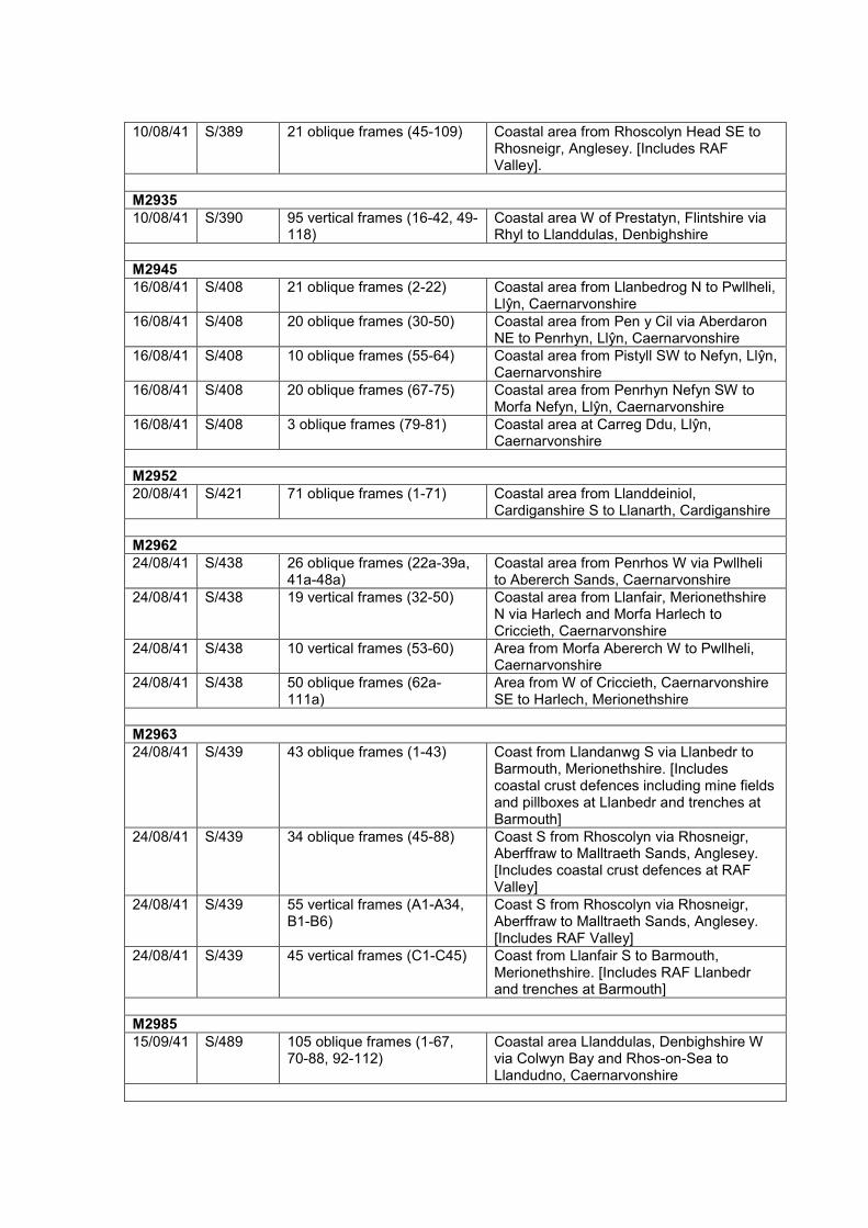
10/08/41 S/389 21 oblique frames (45-109) Coastal area from Rhoscolyn Head SE to Rhosneigr, Anglesey. [Includes RAF Valley].
M2935
10/08/41 S/390 95 vertical frames (16-42, 49-118)
Coastal area W of Prestatyn, Flintshire via Rhyl to Llanddulas, Denbighshire
M2945
16/08/41 S/408 21 oblique frames (2-22) Coastal area from Llanbedrog N to Pwllheli, Llŷn, Caernarvonshire
16/08/41 S/408 20 oblique frames (30-50) Coastal area from Pen y Cil via Aberdaron NE to Penrhyn, Llŷn, Caernarvonshire
16/08/41 S/408 10 oblique frames (55-64) Coastal area from Pistyll SW to Nefyn, Llŷn, Caernarvonshire
16/08/41 S/408 20 oblique frames (67-75) Coastal area from Penrhyn Nefyn SW to Morfa Nefyn, Llŷn, Caernarvonshire
16/08/41 S/408 3 oblique frames (79-81) Coastal area at Carreg Ddu, Llŷn, Caernarvonshire
M2952
20/08/41 S/421 71 oblique frames (1-71) Coastal area from Llanddeiniol, Cardiganshire S to Llanarth, Cardiganshire
M2962
24/08/41 S/438 26 oblique frames (22a-39a, 41a-48a)
Coastal area from Penrhos W via Pwllheli to Abererch Sands, Caernarvonshire
24/08/41 S/438 19 vertical frames (32-50) Coastal area from Llanfair, Merionethshire N via Harlech and Morfa Harlech to Criccieth, Caernarvonshire
24/08/41 S/438 10 vertical frames (53-60) Area from Morfa Abererch W to Pwllheli, Caernarvonshire
24/08/41 S/438 50 oblique frames (62a-111a)
Area from W of Criccieth, Caernarvonshire SE to Harlech, Merionethshire
M2963
24/08/41 S/439 43 oblique frames (1-43) Coast from Llandanwg S via Llanbedr to Barmouth, Merionethshire. [Includes coastal crust defences including mine fields and pillboxes at Llanbedr and trenches at Barmouth]
24/08/41 S/439 34 oblique frames (45-88) Coast S from Rhoscolyn via Rhosneigr, Aberffraw to Malltraeth Sands, Anglesey. [Includes coastal crust defences at RAF Valley]
24/08/41 S/439 55 vertical frames (A1-A34, B1-B6)
Coast S from Rhoscolyn via Rhosneigr, Aberffraw to Malltraeth Sands, Anglesey. [Includes RAF Valley]
24/08/41 S/439 45 vertical frames (C1-C45) Coast from Llanfair S to Barmouth, Merionethshire. [Includes RAF Llanbedr and trenches at Barmouth]
M2985
15/09/41 S/489 105 oblique frames (1-67, 70-88, 92-112)
Coastal area Llanddulas, Denbighshire W via Colwyn Bay and Rhos-on-Sea to Llandudno, Caernarvonshire
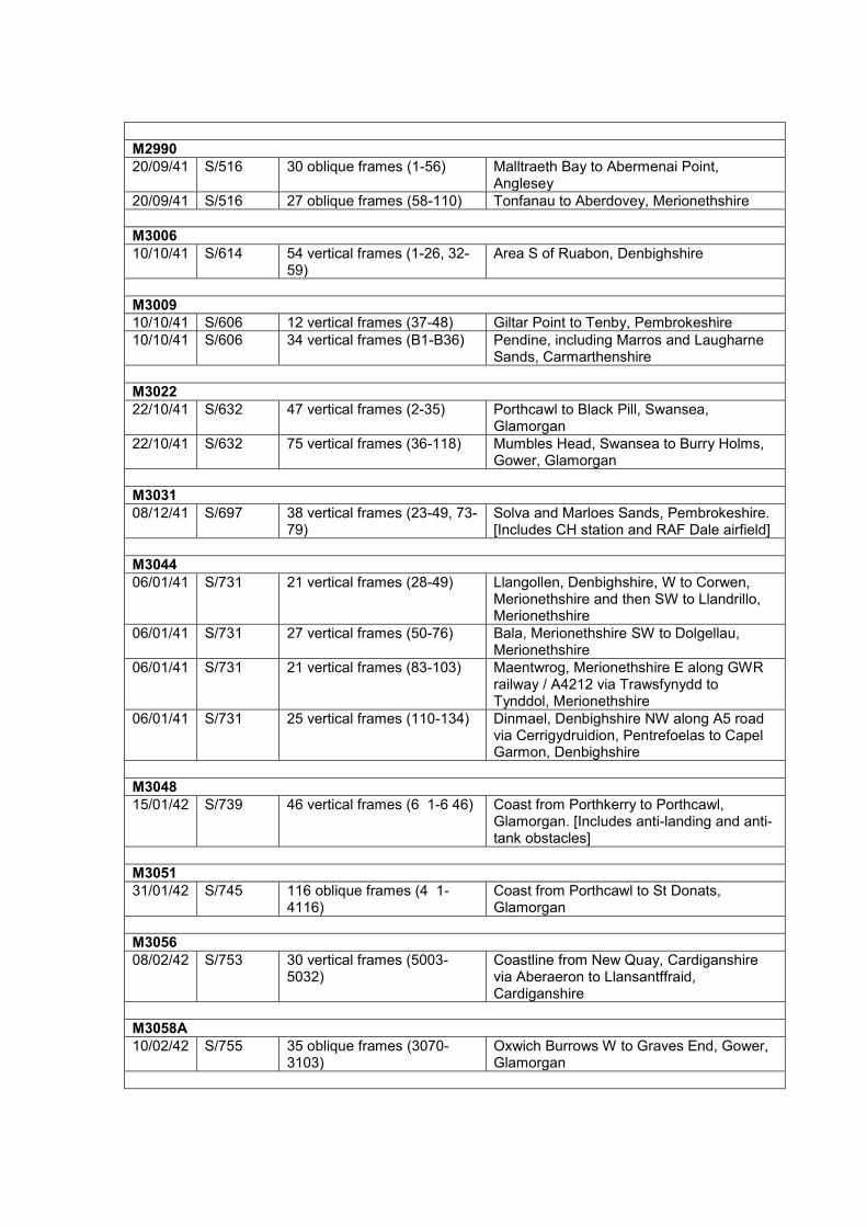
M2990
20/09/41 S/516 30 oblique frames (1-56) Malltraeth Bay to Abermenai Point, Anglesey
20/09/41 S/516 27 oblique frames (58-110) Tonfanau to Aberdovey, Merionethshire
M3006
10/10/41 S/614 54 vertical frames (1-26, 32-59)
Area S of Ruabon, Denbighshire
M3009
10/10/41 S/606 12 vertical frames (37-48) Giltar Point to Tenby, Pembrokeshire
10/10/41 S/606 34 vertical frames (B1-B36) Pendine, including Marros and Laugharne Sands, Carmarthenshire
M3022
22/10/41 S/632 47 vertical frames (2-35) Porthcawl to Black Pill, Swansea, Glamorgan
22/10/41 S/632 75 vertical frames (36-118) Mumbles Head, Swansea to Burry Holms, Gower, Glamorgan
M3031
08/12/41 S/697 38 vertical frames (23-49, 73-79)
Solva and Marloes Sands, Pembrokeshire. [Includes CH station and RAF Dale airfield]
M3044
06/01/41 S/731 21 vertical frames (28-49) Llangollen, Denbighshire, W to Corwen, Merionethshire and then SW to Llandrillo, Merionethshire
06/01/41 S/731 27 vertical frames (50-76) Bala, Merionethshire SW to Dolgellau, Merionethshire
06/01/41 S/731 21 vertical frames (83-103) Maentwrog, Merionethshire E along GWR railway / A4212 via Trawsfynydd to Tynddol, Merionethshire
06/01/41 S/731 25 vertical frames (110-134) Dinmael, Denbighshire NW along A5 road via Cerrigydruidion, Pentrefoelas to Capel Garmon, Denbighshire
M3048
15/01/42 S/739 46 vertical frames (6 1-6 46) Coast from Porthkerry to Porthcawl, Glamorgan. [Includes anti-landing and anti-tank obstacles]
M3051
31/01/42 S/745 116 oblique frames (4 1-4116)
Coast from Porthcawl to St Donats, Glamorgan
M3056
08/02/42 S/753 30 vertical frames (5003-5032)
Coastline from New Quay, Cardiganshire via Aberaeron to Llansantffraid, Cardiganshire
M3058A
10/02/42 S/755 35 oblique frames (3070-3103)
Oxwich Burrows W to Graves End, Gower, Glamorgan
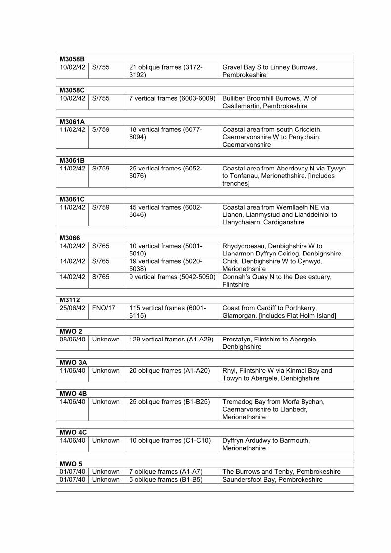
M3058B
10/02/42 S/755 21 oblique frames (3172-3192)
Gravel Bay S to Linney Burrows, Pembrokeshire
M3058C
10/02/42 S/755 7 vertical frames (6003-6009) Bulliber Broomhill Burrows, W of Castlemartin, Pembrokeshire
M3061A
11/02/42 S/759 18 vertical frames (6077-6094)
Coastal area from south Criccieth, Caernarvonshire W to Penychain, Caernarvonshire
M3061B
11/02/42 S/759 25 vertical frames (6052-6076)
Coastal area from Aberdovey N via Tywyn to Tonfanau, Merionethshire. [Includes trenches]
M3061C
11/02/42 S/759 45 vertical frames (6002-6046)
Coastal area from Wernllaeth NE via Llanon, Llanrhystud and Llanddeiniol to Llanychaiarn, Cardiganshire
M3066
14/02/42 S/765 10 vertical frames (5001-5010)
Rhydycroesau, Denbighshire W to Llanarmon Dyffryn Ceiriog, Denbighshire
14/02/42 S/765 19 vertical frames (5020-5038)
Chirk, Denbighshire W to Cynwyd, Merionethshire
14/02/42 S/765 9 vertical frames (5042-5050) Connah’s Quay N to the Dee estuary, Flintshire
M3112
25/06/42 FNO/17 115 vertical frames (6001-6115)
Coast from Cardiff to Porthkerry, Glamorgan. [Includes Flat Holm Island]
MWO 2
08/06/40 Unknown : 29 vertical frames (A1-A29) Prestatyn, Flintshire to Abergele, Denbighshire
MWO 3A
11/06/40 Unknown 20 oblique frames (A1-A20) Rhyl, Flintshire W via Kinmel Bay and Towyn to Abergele, Denbighshire
MWO 4B
14/06/40 Unknown 25 oblique frames (B1-B25) Tremadog Bay from Morfa Bychan, Caernarvonshire to Llanbedr, Merionethshire
MWO 4C
14/06/40 Unknown 10 oblique frames (C1-C10) Dyffryn Ardudwy to Barmouth, Merionethshire
MWO 5
01/07/40 Unknown 7 oblique frames (A1-A7) The Burrows and Tenby, Pembrokeshire
01/07/40 Unknown 5 oblique frames (B1-B5) Saundersfoot Bay, Pembrokeshire

MWO 6
16/06/40 Unknown 5 oblique frames (D1-D5) Poppit Sands and mouth of River Teifi, Cardiganshire
MWO 7
11/06/40 Unknown 14 oblique frames (A1-A14) Tywyn from Tonfanau to Aberdovey, Merionethshire
14/06/40 Unknown 27 oblique frames (D1-D27) Tywyn from Tonfanau to Aberdovey, Merionethshire
MWO 8
11/06/40 Unknown 7 oblique frames (A1-A7) River Dovey mouth and Borth Sands, Cardiganshire
MWO 9
11/06/40 Unknown 16 oblique frames (A1-A16) Morfa Bychan, Caernarvonshire S to Harlech, Merionethshire
MWO 10
17/08/40 Unknown 10 vertical frames (A1-A10) River Usk Valley between Abergavenny and Usk, Monmouthshire
MWO 11
14/06/40 Unknown 9 oblique frames (A1-A9) South Beach, Pwllheli, Caernarvonshire
MWO 12
16/06/40 Unknown 4 oblique frames (C1-C4) Tresaith Beach E of Aberporth, Cardiganshire
MWO 13
12/10/40 Unknown 21 vertical frames (A1-A21) Nash Point to River Thaw mouth, Glamorgan
MWO 14
20/06/40 Unknown 4 oblique frames (A1-A4) Porthkerry Beach, Glamorgan. [Includes search light emplacement]
20/06/40 Unknown 8 oblique frames (B1-B8) Aberthaw from Breaksea Point to Watch House Point, Glamorgan. [Incudes E side of RAF St Athan and RASC camp at Gileston]
20/06/40 Unknown 6 oblique frames (C1-C6) St Donats including Tresilian Bay, Glamorgan
MWO 15
16/06/40 Unknown 4 oblique frames (A1-A4) Aberaeron, Cardiganshire
16/06/40 Unknown 6 oblique frames (B1-B6) New Quay Bay and Little Quay Bay, Cardiganshire
MWO 16
28/06/40 Unknown 3 oblique frames (A1-A3) Whitesands Bay, St David’s, Pembrokeshire
28/06/40 Unknown 6 oblique frames (B1-B6) Newgale Sands, Pembrokeshire
28/06/40 Unknown 5 oblique frames (C1-C5) The Burrows between Tenby and Penally, Pembrokeshire
28/06/40 Unknown 1 oblique frame (D1) Broad Haven, Pembrokeshire
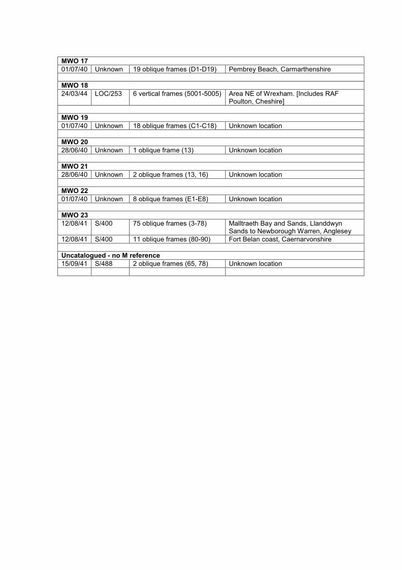
MWO 17
01/07/40 Unknown 19 oblique frames (D1-D19) Pembrey Beach, Carmarthenshire
MWO 18
24/03/44 LOC/253 6 vertical frames (5001-5005) Area NE of Wrexham. [Includes RAF Poulton, Cheshire]
MWO 19
01/07/40 Unknown 18 oblique frames (C1-C18) Unknown location
MWO 20
28/06/40 Unknown 1 oblique frame (13) Unknown location
MWO 21
28/06/40 Unknown 2 oblique frames (13, 16) Unknown location
MWO 22
01/07/40 Unknown 8 oblique frames (E1-E8) Unknown location
MWO 23
12/08/41 S/400 75 oblique frames (3-78) Malltraeth Bay and Sands, Llanddwyn Sands to Newborough Warren, Anglesey
12/08/41 S/400 11 oblique frames (80-90) Fort Belan coast, Caernarvonshire
Uncatalogued - no M reference
15/09/41 S/488 2 oblique frames (65, 78) Unknown location

BIBLIOGRAPHY
2 Military Intelligence Company. (1995) Exercise Welsh Barrier. Unpublished report
for the Imperial War Museum.
Abraham, B. (2001a) St Athan-Llandow dispersals. Airfield Review 90: 26-29.
Abraham, B. (2001b) Sealand. Airfield Review 90: 18.
Abraham, B. (2001c) More on Sealand. Airfield Review 91: 51.
Abraham, B. (2001d) Satellite landing grounds. Airfield Review 91: 58-63.
Abraham, B. (2001e) Satellite landing grounds directory. Airfield Review 91: 64-80.
Abraham, B. (2001f) Satellite landing grounds directory II. Airfield Review 92: 117-
134.
Abraham, B. (2002a) Satellite landing grounds IV. Airfield Review 95: 58-67.
Abraham, B. (2002b) Fleet Air Arm bases II – 1939 to date. Airfield Review 96: 91-
125.
Abraham, B. (2002c) Fleet Air Arm bases III – 1939 to date. Airfield Review 97: 146-
179.
Abraham, B. (2007) Hawarden aerodrome. Airfield Review 115: 82.
Ainsworth, S. and Thomason, B. (2003) Where on Earth are we? The Global
Positioning System (GPS) in archaeological field survey. Swindon: English
Heritage.
Air Historical Branch (RAF). (1997) The Royal Air Force builds for war: a history
of design and construction in the RAF 1935-1945. London: The Stationery Office.
Alban, J.R. (1994) The three nights’ Blitz: select contemporary reports relating
to Swansea’s air raids of 1941. Swansea: City of Swansea.
Alexander, C. (1998) Ironside’s lines. Storrington: Historic Military Press.
Ancient Monuments Board for Wales. (2003) Protecting twentieth-century military
structures in Wales. 49th annual report 2002-03. Cardiff: Cadw.
Anderton, A.J. (2001) ‘The Battle for Britain: WWII and the larger than life battlefield.’
In: Freeman, P.W.M. and Pollard, A. (eds.) Fields of conflict: progress and
prospect in battlefield archaeology. Proceedings of a conference held in the
Department of Archaeology, University of Glasgow, April 2000. BAR international
series 958. Oxford: Archaeopress, 265-268.

Anderton, M.J. (1998a) Twentieth century military recording project: heavy anti-
aircraft batteries. Royal Commission on the Historical Monuments of England
unpublished report.
Anderton, M.J. (1998b) Twentieth century military recording project: light anti-
aircraft batteries. Royal Commission on the Historical Monuments of England
unpublished report.
Anderton, M.J. (1998c) Twentieth century military recording project: Operation
Diver batteries. Royal Commission on the Historical Monuments of England
unpublished report.
Anderton, M.J. (1999) Twentieth century military recording project: World War
Two bombing decoy sites. Royal Commission on the Historical Monuments of
England unpublished report.
Anderton, M.J. (2000) Twentieth century military recording project: World War
Two radar stations. Royal Commission on the Historical Monuments of England
unpublished report.
Anderton, M.J. (2002) ‘Social space and social control: analysing movement and
management on modern military sites.’ In: Schofield, J., Johnson, W.G. and Beck,
C.M. (eds.) Matériel culture: the archaeology of twentieth century conflict.
London: Routledge, 189-198.
Annand, D. (1983) RAF Llanbedr 1941-45. Tywyn: David Annand.
Annand, D. (1986) RAF Penrhos, near Pwllheli, 1937-45, and RAF Llandwrog,
near Caernarvon, 1940-45. Tywyn: David Annand.
Archaeological Data Service. (2014) Defence of Britain archive [online]. Available
from: http://archaeologydataservice.ac.uk/archives/view/dob/ai_q.cfm [Accessed:
20/08/2015].
Arnold, C.J. and Davies, J.L. (2000) Roman and early medieval Wales. Stroud:
Sutton Publishing Limited.
Arnold, W.S. (2011) Investigations in invasion innovation: the archaeological and
historical study of a WWII Landing Vehicle Tracked in Saipan. Australian
Archaeology 72: 63.
Arthur, N. (1988) Swansea at war: a pictorial account 1939-45. Urmston: Archive
Publications.
Atkin, M. (2015) Fighting Nazi occupation: British resistance 1939-1945.
Barnsley: Pen and Sword Military.

Awbery, S. (1959) The story of St Athan and Aberthaw. Barry: Barry and District
News.
Baber, C. (1980) ‘The subsidiary industries, 1760-1914.’ In: John, A.H. and Williams,
G. (eds.) Glamorgan county history, volume 5: industrial Glamorgan from 1700
to 1970. Cardiff: Glamorgan County History Trust Limited, 211-275.
Baber, C. and Thomas, D. (1980) ‘The Glamorgan economy, 1914-1945.’ In: John,
A.H. and Williams, G. (eds.) Glamorgan county history, volume 5: industrial
Glamorgan from 1700 to 1970. Cardiff: Glamorgan County History Trust Limited,
519-579.
Babits, L.E. (1988) ‘Military records and historical archaeology.’ In: Beaudry, M.C.
(ed.) Documentary archaeology in the New World. Cambridge: Cambridge
University Press, 119-125.
Badcock, A. and Johnston, R. (2009) Placemaking through protest: an archaeology
of the Lees Cross and Endcliffe Protest Camp, Derbyshire, England. Archaeologies
5 (2): 306-322.
Bagwell, M.N. (2012) ‘The diary of an American ‘Doughboy’: interpreting a textual
artefact of the First World War.’ In: Saunders, N.J. (ed.) Beyond the dead horizon:
studies in modern conflict archaeology. Oxford: Oxbow Books, 43-53.
Baker, F. (1993) The Berlin Wall: production, preservation and consumption of a 20th-
century monument. Antiquity 67: 709-733.
Balchin, W.G.V. (1971) Swansea and its region. Swansea: University College of
Swansea on behalf of the British Association for the Advancement of Science.
Ballbé, E.G. and Steadman, D.W. (2008) The political, social and scientific contexts
of archaeological investigations of mass graves in Spain. Archaeologies 4 (3): 429-
444.
Banks, I. (2008) ‘Ghosts in the desert: the archaeological investigation of a sub-
Saharan battlefield.’ In: Pollard, T. and Banks, I. (eds.) Scorched earth: studies in
the archaeology of conflict. Leiden: Brill NV, 1-28.
Barber, A., Cox, S. and Hancocks, A. (2006) A late Iron Age and Roman farmstead
at RAF St Athan, Vale of Glamorgan. Evaluation and excavation, 2002-03.
Archaeologia Cambrensis 155: 49-115.
Barber, M. (2012) A history of aerial photography and archaeology: Marta Hari’s
glass eye and other stories. Swindon: English Heritage.
Barclay, G.J. (2005) The Cowie Line: a Second World War 'stop line' west of
Stonehaven, Aberdeenshire. Proceedings of the Society of Antiquaries of
Scotland 135: 119-161.

Barclay, G.J. (2013) If Hitler comes: preparing for invasion – Scotland 1940.
Edinburgh: Birlinn Limited.
Barfield, N. (2002) Broughton: from Wellington to Airbus. Stroud: Tempus
Publishing.
Barrass, M. (2014) RAF Regiment Squadrons 2700-2850 [online]. Available from:
http://www.rafweb.org/Organsation/Regiment2.htm [Accessed 20/08/2015].
Barrett, J. (1992) Flat Holm during World War 2. Bristol: John Barrett.
Barrett, J. (2003) Flat Holm during World War 2: the threats, military occupation,
air war, war artists, prisoners of war and post war. Bristol: John Barrett.
Barrett, J. (2004) A history of maritime forts in the Bristol Channel, 1866-1900.
Bristol: J.H. Barrett.
Barrie, D.S.M. (n.d.) The Taff Vale Railway [online]. Available from:
http://www.trackbed.com/companies/t/tvr/dsmbarrie/tvr_dsmbarrie.htm [Accessed
20/08/2015].
Barrie, D.S.M. (1980) A regional history of the railways of Britain, volume 12:
south Wales. Newton Abbot: David and Charles.
Barrow, J. (2006) Usk at war. Usk: Jan Barrow.
Beaudry, M.C. (ed.) (1988) Documentary archaeology in the New World.
Cambridge: Cambridge University Press.
Beaudry, M.C., Cook, L.J. and Mrozowski, S.A. (1991) ‘Artifacts and active voices:
material culture as social discourse.’ In: McGuire, R.H. and Paynter, R. (eds.) The
archaeology of inequality. Oxford: Blackwell, 150-191.
Beck, C.M. (2002) ‘The archaeology of scientific experiments at a nuclear testing
ground.’ In: Schofield, J., Johnson, W.G. and Beck, C.M. (eds.) Matériel culture: the
archaeology of twentieth century conflict. London: Routledge, 65-79.
Beck, C.M., Drollinger, H. and Schofield, J. (2007) ‘Archaeology of dissent:
landscape and symbolism at the Nevada Peace Camp.’ In: Schofield, J. and Cocroft,
W.D. (eds.) A fearsome heritage: diverse legacies of the Cold War. Walnut
Creek, CA: Left Coast Press, Inc., 297-320.
Beck, C.M., Schofield, J. and Drollinger, H. (2011) ‘Archaeologists, activists and a
contemporary peace camp.’ In: Holtorf, C. and Piccini, A. (eds.) Contemporary
archaeologies: excavating now. Frankfurt am Main: Peter Lang, 95-111.
Belkin, A. (2012) Bring me men: military masculinity and the benign façade of
American empire, 1898-2001. London: Hurst.

Berelson, B. (1952) Content analysis in communication research. Glencoe, Ill:
Free Press.
Berry, J. (2005) To rise again? Heritage in Wales 30: 14-16.
Berry, J. (2006) Military might in the Haven. Heritage in Wales 34: 14-18.
Berry, J. (2007) The twentieth-century military sites in Wales project. CBA Wales
Newsletter 33: 3-5.
Berry, J. (2008) St Athan WWII ground defence structures gazetteer. Cadw
unpublished report for Defence Estates.
Berry, J. (2009) The secret site. Heritage in Wales 42: 18-21.
Berry, J. (2010) Khaki dragons! Twentieth-century military sites in Wales. The
Archaeologist 75: 42-43.
Berry, J. (2011a) Desperately seeking Sea Slug. Context 122: 19-21.
Berry, J. (2011b) Dragon’s teeth: the archaeology of Second World War anti-invasion
defences in Wales. Rosetta [online] 9 (5): 7-15. Available from:
http://www.rosetta.bham.ac.uk/colloquium2011/berry_defences.pdf [Accessed
20/08/2015].
Berry, J. (2013) Defending Llantwit. Llantwit Major: Aspects of its History 13: 5-36.
Berry, J. (2014a) How Great War soldiers were made. Western Mail [online] 16
October 2014. Available from: http://www.walesonline.co.uk/lifestyle/nostalgia/welsh-
history-month-how-great-7944929 [Accessed 20/08/2015].
Berry, J. (2014b) The trenches reconsidered. Heritage in Wales 59: 22-23.
Berry, J. (forthcoming a) The contribution of military records for understanding
Second World War anti-invasion archaeology: description and evaluation.
Berry, J. (forthcoming b) The archaeological and primary documentary evidence for
the Second World War anti-invasion defences on the Carmarthen Stop Line: survey
and results.
Berry, J. (forthcoming c) The archaeological and primary documentary evidence for
the Second World War anti-invasion defences in Swansea and on Gower: survey and
results.
Berry, J. (forthcoming d) The archaeological and primary documentary evidence for
the Second World War anti-invasion defences at St Athan and Llandow, Vale of
Glamorgan: survey and results.
Bewley, B. (1994) The challenge: defining aerial photography. AARG News [online]
9: 21-22. Available from:

http://www.univie.ac.at/aarg/files/03_Publications/AARG%20News/AARG%20News%
2009.PDF [Accessed 20/08/2015].
Bird, C. (1991) The fixed defences of north and east Norfolk in the two World Wars: a
modern survey, part 1. Journal of the Norfolk Industrial Archaeological Society 5
(1): 5-33.
Bird, C. (1992) The fixed defences of north and east Norfolk in the two World Wars: a
modern survey, part 2. Journal of the Norfolk Industrial Archaeological Society 5
(2): 57-93.
Bird, C. (1995) Norfolk’s fixed defences in the two World Wars: a sequel. Journal of
the Norfolk Industrial Archaeology Society 5 (5): 295-343.
Bird, C. (1999) Silent sentinels: the story of Norfolk’s fixed defences during the
twentieth century. Dereham: Larks Press.
Black, J. (2004) Rethinking military history. London: Routledge.
Blackwood, C. (2014) Chapel Bay Fort, 1891-2014. Casemate 100: 16-17.
Blake, R.N.E. (1969) The impact of airfields on the British landscape. Geographical
Journal 135 (4): 508-528.
Blumenson, M. (1963) Can official history be honest history? Military Affairs 26 (4):
153-161.
Bond, S.J. (1988) Royal Air Force St Athan: a history, 1938-1988. Corby: Services
Publishing Services.
Bone, P., Nichol, K., Pearson, N. and Peters, T. (2007) The Valley Site,
Rhydymwyn, Flintshire: historic environment management plan, volume 1
[online]. Available from:
https://www.rhydymwynvalleyhistory.co.uk/documents/PN_1377_Rhyd_Vol_1.pdf
[Accessed 20/08/2015]. Birmingham Archaeology unpublished report number 1377.
Boulton, A. (2006) ‘Film making and photography as record and interpretation.’ In:
Schofield, J., Klausmeier, A. and Purbrick, L. (eds.) Re-mapping the field: new
approaches to conflict archaeology. Berlin and Bonn: Westkreuz-Verlag, 39-42.
Boulton, A. (2007a) Restricted areas / Zapretnye zony / Sperrgebiete.
Manchester: Manchester Institute for Research and Innovation in Art and Design,
Manchester Metropolitan University and the Wapping Project.
Boulton, A. (2007b) ‘Cood bay Forst Zinna.’ In: Schofield, J. and Cocroft, W. (eds.) A
fearsome heritage: diverse legacies of the Cold War. Walnut Creek, CA: Left
Coast Press, Inc., 181-192.

Boulton, A. (2009) ‘Cood bay Forst Zinna’: film, art and technology.’ In: Forbes, N.,
Page, R. and Pérez, G. (eds.) Europe’s deadly century: perspectives on 20th
century conflict heritage. Swindon: English Heritage, 12-17.
Bowden, M. and Brodie, A. (2011) Defending Scilly. Swindon: English Heritage.
Bowler, S. (2006) Swansea at war. Stroud: Sutton Publishing Limited.
Bradley, A., Buchli, V., Fairclough, G., Hicks, D., Miller, J. and Schofield, J. (2004)
Change and creation: historic landscape character 1920-2000 [online]. London:
English Heritage. Available from: https://content.historicengland.org.uk/images-
books/publications/change-and-creation-historic-landscape-
character/changecreationhistoriclandscapecharacter.pdf/ [Accessed 20/08/2015].
Breverton, T. (2000) The secret Vale of Glamorgan. Cowbridge: Glyndwr
Publishing.
Bridgford, S. (1997) ‘Mightier than the pen? An edgewise look at Irish Bronze Age
swords.’ In: Carman, J. (ed.) Material harm: archaeological studies of war and
violence. Glasgow: Cruithne Press, 95-115.
Brock, D. (1989) Wings over Carew. Pembroke: Deric Brock.
Brockman, A. (2009) Shooters Hill: digging up Dad’s Army. Current Archaeology
228: 35-42.
Brockman, A. (2009) Personal communication. ‘Looking between the lines:
developing a methodology for investigating the conflict archaeology of urban
landscapes in WW2’, paper given at Conflict Archaeology of the Modern Era
conference, University of Bristol, 24/10/2009.
Brown, D. (1999) Somerset v Hitler: secret operations in the Mendips, 1939-
1945. Newbury: Countryside Books.
Brown, D.H. (2011) Archaeological archives: a guide to best practice in creation,
compilation, transfer and curation [online]. Available from:
http://www.archaeologyuk.org/archives/aaf_archaeological_archives_2011.pdf .
[Accessed 20/08/2015].
Brown, M. (2009) ‘Strange meetings: archaeology on the Western Front.’ In: Forbes,
N., Page, R. and Pérez, G. (eds.) Europe’s deadly century: perspectives on 20th
century conflict heritage. Swindon: English Heritage, 59-64.
Brown, M. (2012) ‘The battlefield in miniature, or the multi-locational town of
Messines.’ In: Saunders, N.J. (ed.) Beyond the dead horizon: studies in modern
conflict archaeology. Oxford: Oxbow, 71-84.
Brown, M., Kincey, M. and Nichol, K. (2007) Messines model, Cannock Chase,
Staffordshire: monument assessment. Staffordshire County Council unpublished
report number 1735.
Brown, M. and Osgood, R. (2009) Digging up Plugstreet: the archaeology of a
Great War battlefield. Sparkford: Haynes Publishing.
Brown, S.F. (2006) Criggion radio station 1942-2003. Montgomeryshire Collections
94: 91-102.
Brunn, S.D. (1987) A world of peace and military landscapes. Journal of Geography
86 (6): 253-262.
Buchinger, M-L. and Metzler, M. (2006) ‘The Soviet murals in Forst Zinna near
Jϋterborg (Germany), a cycle of paintings in the barracks of the 57th Construction
Battalion.’ In: Schofield, J., Klausmeier, A. and Purbrick, L. (eds.) Re-mapping the
field: new approaches to conflict archaeology. Berlin and Bonn: Westkreuz-
Verlag, 28-34.
Buchli, V. (2007) ‘Cold War on the domestic front.’ In: Schofield, J. and Cocroft, W.
(eds.) A fearsome heritage: diverse legacies of the Cold War. Walnut Creek, CA:
Left Coast Press, Inc., 211-220.
Buchli, V. and Lucas, G. (eds.) (2001a) Archaeologies of the contemporary past.
London: Routledge.
Buchli, V. and Lucas, G. (2001b) ‘The absent present: archaeologies of the
contemporary past.’ In: Buchli, V. and Lucas, G. (eds.) Archaeologies of the
contemporary past. London: Routledge, 3-18.
Buchli, V. and Lucas, G. (2001c) ‘Presencing absence.’ In: Buchli, V. and Lucas, G.
(eds.) Archaeologies of the contemporary past. London: Routledge, 171-174.
Bungay, S. (2009) The most dangerous enemy: a history of the Battle of Britain.
London: Aurum.
Burridge, D. (1992) The Dover quads. Loopholes 2: 13-15.
Burridge, D. (1995) WOFO. Loopholes 13: 24-26.
Burridge, D. (1997) 20th century defences in Britain: Kent. London: Brassey’s
Limited.
Burt, R., Bradford, J., Dickson, B., Everett, M.E., Warden, R. and Woodcock, D.
(2007) ‘Pointe-du-Hoc battlefield, Normandy, France.’ In: Scott, D., Babits, L. and
Haeker, C. (eds.) Fields of conflict: battlefield archaeology from the Roman
Empire to the Korean War. Westport: Praeger, 383-397.

Butler, J.R.M. (1958) The British official military history of the Second World War.
Military Affairs 22 (3): 149-151.
Cadw. (2009) Caring for military sites of the twentieth century [online]. Nantgarw:
Cadw. Available from:
http://cadw.wales.gov.uk/docs/cadw/publications/Caring_for_Military_Sites_EN.pdf
[Accessed 20/08/2015].
Calder, A. (1992) The people’s war: Britain 1939-45. London: Pimlico.
Campbell, S.P. (2010) Ethics of research in conflict and post-conflict
environments [online]. Available from: http://www.susannacampbell.com/wp-
content/uploads/2013/06/Campbell-Ethics-Lit-Review-14-01-10-Cite.pdf . [Accessed:
20/08/2015].
Cantwell, J.D. (1998) The Second World War: a guide to documents in the Public
Record Office (PRO handbook number 15). Richmond: Public Record Office.
Caponni, N. (2008) Clio, Mars and wine: tracking down military documents in Italy.
Journal of Military History 72 (4): 1249-1256.
Carman, J. (1997) ‘Approaches to violence.’ In: Carman, J. (ed.) Material harm:
archaeological studies of war and violence. Glasgow: Cruithne Press, 1-23.
Carman, J. (1999) ‘Bloody meadows: the places of battle.’ In: Tarlow, S. and West, S.
(eds.) The familiar past? Archaeologies of later historical Britain. London:
Routledge, 233-245.
Carman, J. (2002) ‘Paradox in places: twentieth-century battlefield sites in long-term
perspective.’ In: Schofield, J., Johnson, W.G. and Beck, C.M. (eds.) Matériel
culture: the archaeology of twentieth century conflict. London: Routledge, 9-21.
Carman, J. (2005) Battlefields as cultural resources. Post-Medieval Archaeology 39
(2): 215-223.
Carman, J. (2013) Archaeologies of conflict. London: Bloomsbury.
Carman, J. and Carman, P. (2001) ‘Beyond military archaeology: battlefields as a
research resource.’ In: Freeman, P.W.M. and Pollard, A. (eds.) Fields of conflict:
progress and prospect in battlefield archaeology. Proceedings of a conference
held in the Department of Archaeology, University of Glasgow, April 2000. BAR
international series 958. Oxford: Archaeopress, 275-281.
Carman, J. and Carman, P. (2006) Bloody meadows: investigating landscapes of
battle. Stroud: Sutton Publishing Limited.
Carman, J. and Carman, P. (2009) ‘Mustering landscapes: what historic battlefields
share in common.’ In: Scott, D., Babits, L. and Haeker, C. (eds.) Fields of conflict:

battlefield archaeology from the Roman Empire to the Korean War. Westport:
Praeger, 39-49.
Carmarthenshire County Museum. (2006) Carmarthenshire’s war, 1939-1945.
Carmarthen: Carmarthenshire County Council.
Carmarthenshire in wartime: memories of members and friends. (1995)
Carmarthenshire Antiquary 31: 98-121.
Carr, G. (2009) ‘Landscapes of occupation: a case study from the Channel Islands.’
In: Forbes, N., Page, R. and Pérez, G. (eds.) Europe’s deadly century:
perspectives on 20th century conflict heritage. Swindon: English Heritage, 35-43.
Carr, G. (2010a) The archaeology of occupation, 1940-2009: a case study from the
Channel Islands. Antiquity 84: 161-174.
Carr, G. (2010b) The archaeology of occupation and the V-sign campaign in the
Channel Islands during WWII. International Journal of Historical Archaeology 14
(4): 575-592.
Carr, G. (2012) Of coins, crests and kings: symbols of identity and resistance in the
occupied Channel Islands. Journal of Material Culture 17 (4): 327-344.
Carr, G. (2014) Legacies of occupation: archaeology, heritage and memory in
the Channel Islands. New York: Springer.
Carr, G. and McAtackney, L. (2011) Beyond Normandy in World War 2: occupation,
resistance and remembrance. Journal of Conflict Archaeology 6 (2): 173-176.
Carr, G. and Mytum, H. (eds.) (2012) Cultural heritage and prisoners of war:
creativity behind barbed wire. New York: Routledge.
Carradice, P. (2003) Wales at war. Llandysul: Gomer Press.
Carroll, D. (1999) The Home Guard. Stroud: Sutton Publishing Limited.
Carter, N. (1988) Memories of Swansea at war. Urmston: Archive Publications.
Carvell, S. (2006) The Oxford Canal Stop Line: an illustrated survey. Fort 34: 159-
162.
Carvell, S. (2007) Twentieth-century defences in Warwickshire. Stroud: Tempus
Publishing Limited.
Castle, I. (2008) London 1914-17: the Zeppelin menace. Oxford: Osprey
Publishing.
Catford, N. (2010) Subterranean Britain: Cold War bunkers. Monkton Farleigh:
Folly Books Limited.
Central Register for Aerial Photographs Wales. (2009) Brief overview [online].
Available from: http://aerial.rcahms.gov.uk/crapw.pdf [Accessed 04/03/2013].
Chadwick, A. and Catchpole, T. (2013) Severn Estuary Rapid Coastal Zone
Assessment Survey: phase 2 fieldwork report [online]. Available from:
https://content.historicengland.org.uk/images-books/publications/severn-estuary-
rczas-phase2/3885_Vol_1_main_text_v3_FINAL.pdf/ [Accessed 20/08/2015].
Chambers Jones, R. (2008) Anglesey and Gwynedd: the war years, 1939-45.
Wrexham: Bridge Books.
Chapman, C. (1984) The Cowbridge railway. Poole: Oxford Publishing.
Chartered Institute for Archaeologists. (2014) Standard and guidance:
archaeological field evaluation [online]. Available from:
http://www.archaeologists.net/sites/default/files/CIfAS&GFieldevaluation_1.pdf.
[Accessed 20/08/2015].
Chartered Institute for Archaeologists Wales/Cymru. (2015) A research framework
for the archaeology of Wales [online]. Available from:
http://www.archaeoleg.org.uk/index.html [Accessed 20/08/2015].
Chepstow Society. (2000) Wartime memories: the Home Front in Chepstow,
1939-1945. Chepstow: The Chepstow Society.
Christiansen, H. (2002) ‘Forgotten and refound military structures in the Central
Pacific: examples from the Marshall Islands.’ In: Schofield, J., Johnson, W.G. and
Beck, C.M. (eds.) Matériel culture: the archaeology of twentieth century conflict.
London: Routledge, 58-64.
Churchill, W.S. (1943) The end of the beginning. London: Cassell.
City and County of Swansea. (1997) The story of Swansea during the Second
World War. Swansea: City and Council of Swansea.
Clarke, B. (2008) The archaeology of airfields. Stroud: Tempus Publishing.
Clarke, D.M. (2010) Arming the British Home Guard, 1940-1944. PhD thesis,
Cranfield University.
Clifford, P. (1994) Road sockets and other things. Loopholes 10: 6-7.
Clifford, P. (1995) Love, hate and the Spigot Mortar. Loopholes 14: 23-25.
Clifford, P. (1996) Road blocks and their development. Loopholes 17: 17-18.
Coates, J. (1989) The ethics of corporate and academic commitments to military
research. Annals of the New York Academy of Sciences 577 (1): 149-153.

Coates, P., Cole, T., Dudley, M. and Pearson, C. (2011) Defending nation, defending
nature? Militarized landscapes and military environmentalism in Britain, France, and
the United States. Environmental History 16 (3): 456-491.
Cocroft, W.D. (2000) Dangerous energy: the archaeology of gunpowder and
military explosives manufacture. Swindon: English Heritage.
Cocroft, W.D. (2003) Chilworth Gunpowder Works, Surrey. Archaeological
Investigation report series number AI/20/2003. Swindon: English Heritage.
Cocroft, W.D. (2004) Atomic Weapons Research Establishment Foulness,
Essex. . Archaeological Investigation report series number AI/21/2004. Swindon:
English Heritage.
Cocroft, W.D. (2007) ‘Defining the national archaeological character of Cold War
remains.’ In: Schofield, J. and Cocroft, W. (eds.) A fearsome heritage: diverse
legacies of the Cold War. Walnut Creek, CA: Left Coast Press, Inc., 107-127.
Cocroft, W.D. (2009) ‘Recording landscapes of war.’ In: Forbes, N., Page, R. and
Pérez, G. (eds.) Europe’s deadly century: perspectives on 20th century conflict
heritage. Swindon: English Heritage, 18-26.
Cocroft, W.D. (2010) Fort Halstead, Dunton Green, Sevenoaks, Kent: a brief
assessment of the role of Fort Halstead in Britain’s early rocket programmes
and the atomic bomb project. Research Department report series number 49-2010.
Portsmouth: English Heritage.
Cocroft, W.D. and Cole, S. (2007) RAF Coltishall, Norfolk: a photographic
characterisation. Research Department report series number 68/2007. Cambridge:
English Heritage.
Cocroft, W.D., Devlin, D., Schofield, J. and Thomas, R.J.C. (2006) War art - murals
and graffiti: military life, power and subversion. York: Council for British
Archaeology.
Cocroft, W.D., Thomas, R.J.C. and Barnwell, P.S. (2003) Cold War: building for
nuclear confrontation, 1946-1989. Swindon: English Heritage.
Cocroft, W.D. and Wilson, L.K. (2006) ‘Archaeology and art at Spadeadam Rocket
Establishment (Cumbria).’ In: Schofield, J., Klausmeier, A., and Purbrick, L. (eds.)
Re-mapping the field: new approaches to conflict archaeology. Berlin and Bonn:
Westkreuz-Verlag, 15-21.
Cole, L. (1989) Ethics and biological warfare research. Annals of the New York
Academy of Sciences 577 (1): 154-163.

Cole, T. (2010a) ‘A picturesque ruin? Landscapes of loss at Tyneham and the Epynt.’
In: Pearson, C., Coates, P. and Cole, T. (eds.) Militarized landscapes: from
Gettysburg to Salisbury Plain. London: Continuum, 95-110.
Cole, T. (2010b) Military presences, civilian absences: battling nature at the
Sennybridge Training Area, 1940-2008. Journal of War and Culture Studies 3:
215-235.
Collier, B. (1956) The defence of the United Kingdom [2004]. Uckfield: Naval and
Military Press.
Cooper, J. (2009) What’s missing here? Homing in on Haddington’s lost defences.
Journal of Conflict Archaeology 5 (1): 141-162.
Corbin, J. and Strauss, A. (2008) Basics of qualitative research: techniques and
procedures for developing grounded theory. Third edition. Thousand Oaks, CA:
Sage Publications, Inc.
Cotswold Archaeological Trust Limited. (2001) Aerospace St Athan, Vale of
Glamorgan: cultural heritage assessment. Cotswold Archaeological Trust
unpublished report number 01121.
Cotswold Archaeology. (2002) Land at Eglwys Brewis, RAF St Athan, Vale of
Glamorgan: archaeological evaluation. Cotswold Archaeology unpublished report
number 03025.
Cotswold Archaeology. (2003a) Land at Eglwys Brewis, RAF St Athan, Vale of
Glamorgan: stage II archaeological evaluation. Cotswold Archaeology
unpublished report number 03025.
Cotswold Archaeology. (2003b) Proposed DARA hanger site, RAF St Athan, Vale
of Glamorgan: archaeological evaluation [online]. Available from:
http://reports.cotswoldarchaeology.co.uk/content/uploads/2014/07/1503-DARA-
Hangar-Eval-03026-complete.pdf [Accessed 20/08/2015].
Cotswold Archaeology. (2007) MoD St Athan, Vale of Glamorgan: historic
environment assessment. Cotswold Archaeology unpublished report number
07178.
Cottrell, R.E. (1993) Semper Alacer: the story of a south Wales wartime training
aerodrome, Stormy Down. [s.l.: s.n.].
Council for British Archaeology. (2001) Record count [online]. Available from:
http://old.britarch.ac.uk/projects/dob/recordcount.html [Accessed 20/08/2015].
Council for British Archaeology. (2002) A review of the Defence of Britain project
[online]. Available from: http://old.britarch.ac.uk/projects/dob/review/index.html
[Accessed 20/08/2015].
Countryside Council for Wales. (2009) Regional Landscape Character Areas
(rLCAs) in Wales [online]. Available from:
http://www.ccw.gov.uk/idoc.ashx?docid=dc3096a3-4149-409d-8a45-
50ffc1ad72b&version=-1 [Accessed 03/02/2013].
Countryside Council for Wales. (2013a) LANDMAP - the landscape atlas [online].
Available from: http://www.ccgc.gov.uk/landscape--wildlife/protecting-our-
landscape/landmap.aspx [Accessed 27/12/2014].
Countryside Council for Wales. (2013b) LANDMAP coverage [online]. Available
from: http://www.ccgc.gov.uk/landscape--wildlife/protecting-our-
landscape/landmap/landmap-coverage.aspx [Accessed 27/12/2014].
Cox, R. (1974) Operation Sealion. London: Thornton Cox Limited.
Crawford, J. (2014) First World War scoping study: Glamorgan and Gwent.
Glamorgan-Gwent Archaeological Trust unpublished report number 2014/025 for
Cadw.
Crawshaw, A. (1991) Wartime map references. AARG News [online] 2: 31. Available
from:
http://www.univie.ac.at/aarg/files/03_Publications/AARG%20News/AARG%20News%
2002.PDF [Accessed 20/08/2015].
Crew, P. and Musson, C. (1996) Snowdonia from the air: patterns in the
landscape. Penrhyndeudraeth: Snowdonia National Park Authority.
Crossland, Z. (2000) Buried lives: forensic archaeology and Argentina’s
Disappeared. Archaeological Dialogues 7 (2): 146-159.
Crossland, Z. (2002) ‘Violent spaces: conflict over the reappearance of Argentina’s
Disappeared.’ In: Schofield, J., Johnson, W.G. and Beck, C.M. (eds.) Matériel
culture: the archaeology of twentieth century conflict. London: Routledge, 115-
131.
Crowther, S. and Dickson, A. (2008) Severn Estuary Rapid Coastal Zone
Assessment Survey: National Mapping Programme [online]. Available from:
https://content.historicengland.org.uk/images-books/publications/severn-estuary-
rczas-nmp/Severn_Estuary_RCZAS_NMP_web.pdf/ [Accessed 20/08/2015].
Crutchley, S., Small, F. and Bowden, M. (2009) Savernake Forest: a report for the
National Mapping Programme. English Heritage Research Department report
number 29. Portsmouth: English Heritage.
Cunliffe, B. (2006) ‘Afterword: historical archaeology in the wider discipline.’ In: Hicks,
D. and Beaudry, M.C. (eds.) The Cambridge companion to historical
archaeology. Cambridge: Cambridge University Press, 314-319.

Dalton, M. (2011) The Royal Observer Corps underground monitoring posts.
Monkton Farleigh: Folly Books Limited.
Dalton, M. (2013) Defending Anglesey. Monkton Farleigh: Folly Books Limited.
Danchev, A. and Todman, D. (eds.) (2001) War diaries 1939-1945: Field Marshal
Lord Alanbrooke. London: Phoenix.
Davidson, A. (2001) The medieval mills of Anglesey. Gwynedd Archaeological
Trust unpublished report for Cadw.
Davies, G. (2000) Ceredigion in the Second World War. Ceredigion (Journal of the
Cardiganshire Antiquarian Society) 13 (4): 81-93.
Davies, J. and Lloyd, J.E. (1947) 3rd Cards. Battalion Home Guard. Lampeter: J.D.
Lewis and Sons.
Davies, J.D. (2013) Britannia’s dragon: a naval history of Wales. Stroud: The
History Press.
Davies, T.C. (2007) St Athan photo album. Airfield Review 116: 104-105.
Davis, G.T. (2008) The General Staff’s series of Military Training Pamphlets
1938-1948, volume 1: the pre-war pamphlets, numbers 1 to 23. Toddington: G.
Thomas Davis.
Dawes, G. (1995) Prefabricated pillboxes. Loopholes 14: 15-17.
Dawson, D., Hunt, D. and Webster, C. (2011) Somerset and the defence of the
Bristol Channel in the Second World War. Taunton: Somerset Archaeological and
Natural History Society.
Day, D.A. (2000) Relics of the Space Age: space archaeology at Vandenberg Air
Force Base, part 1. Spaceflight 42: 59-62.
De Meyer, M. and Pype, P. (2009) ‘Scars of the Great War (Western Flanders,
Belgium).’ In: Scott, D., Babits, L. and Haeker, C. (eds.) Fields of conflict:
battlefield archaeology from the Roman Empire to the Korean War. Westport:
Praeger, 359-382.
Deagan, K. (1982) Avenues of inquiry in historical archaeology. Advances in
Archaeological Method and Theory 5: 151-177.
Deetz, J. (1977) In small things forgotten. New York: Doubleday.
Defence of Britain Project. (1996) Revised project design. Council for British
Archaeology unpublished report.
Delgado, J.P. (1996) Ghost fleet: the sunken ships of Bikini Atoll. Honolulu:
University of Hawaii Press.

Delgado, J.P., Lenihan, D.J. and Murphy, L.E. (1991) Archaeology of the atomic
bomb: a submerged cultural resources assessment of the sunken fleet of
Operation Crossroads at Bikini and Kwajalein Atoll lagoons, Republic of the
Marshall Islands. Southwestern Cultural Resources Centre professional papers
number 37. Santa Fé, New Mexico: Southwestern Cultural Resources Centre.
Denfeld, D.C. (1979a) Field survey of Ponape: World War II features. Micronesian
Archaeological Survey report number 2. Saipan: Historic Preservation Office, Trust
Territory of the Pacific Islands.
Denfeld, D.C. (1979b) Field survey of Truk: World War II features. Micronesian
Archaeological Survey report number 6. Saipan: Historic Preservation Office, Trust
Territory of the Pacific Islands.
Denfeld, D.C. (1981) Japanese fortifications and other military structures in the
Central Pacific. Micronesian Archaeological Survey report number 9. Saipan:
Historic Preservation Office, Trust Territory of the Pacific Islands.
Denfeld, D.C. (1988) Peleliu revisited: an historical and archaeological survey of
World War II sites on Peleliu Island. Micronesian Archaeological Survey report
number 24. Saipan: Historic Preservation Office, Commonwealth of the Northern
Mariana Islands.
Denison, S. (1995) Tracing the relics of wartime defence. British Archaeology 3: 8-
9.
Denison, S. (2002) Fortress Britain. British Archaeology 65: 8-11.
Department of the Navy. (2002) Archaeological remote sensing of Operation
Neptune: The D-Day landings at Omaha and Utah beaches, Normandy, France.
Field season 2001. Washington, DC: Naval Historical Center, Underwater
Archaeology Branch.
Department of the Navy. (2008) Archaeological remote sensing of the D-Day
landings: Utah and Omaha beaches, Normandy, France. Washington, DC: Naval
Historical Center, Underwater Archaeology Branch.
Dixon, B., Gilda, L. and Bulgrin, L. (2012) The archaeology of World War II Japanese
stragglers on the island of Guam and the Bushido Code. Asian Perspectives 51 (1):
110-127.
Doak, J. (1999) Planning for the reuse of redundant defence estates: disposal
processes, policy frameworks and development impacts. Planning Practice and
Research 14 (2): 211-224.
Dobinson, C.S. (1996a) Twentieth century fortifications in England, volume 1:
anti-aircraft artillery, 1914-46. Council for British Archaeology unpublished report
for English Heritage.
Dobinson, C.S. (1996b) Twentieth century fortifications in England, volume 2:
anti-invasion defences of WWII. Council for British Archaeology unpublished report
for English Heritage.
Dobinson, C.S. (1996c) Twentieth century fortifications in England, volume 3:
bombing decoys of WWII: England’s passive air defence, 1939-45. Council for
British Archaeology unpublished report for English Heritage.
Dobinson, C.S. (1996d) Twentieth century fortifications in England, volume 4:
Operation Diver. Council for British Archaeology unpublished report for English
Heritage.
Dobinson, C.S. (1996e) Twentieth century fortifications in England, volume 5:
Operation Overlord. Council for British Archaeology unpublished report for English
Heritage.
Dobinson, C.S. (1998) ‘Twentieth-century fortifications in England: the MPP
approach.’ In: Schofield, J. (ed.) Monuments of war: the evaluation, recording and
management of twentieth-century military sites. London: English Heritage, 2-6.
Dobinson, C.S. (2000a) Twentieth century fortifications in England, volume 6:
coast artillery, 1900-56. Council for British Archaeology unpublished report for
English Heritage.
Dobinson, C.S. (2000b) Twentieth century fortifications in England, volume 7:
acoustics and radar. Council for British Archaeology unpublished report for English
Heritage.
Dobinson, C.S. (2000c) Twentieth century fortifications in England, volume 8:
civil defence in WWII. Council for British Archaeology unpublished report for English
Heritage.
Dobinson, C.S. (2000d) Twentieth century fortifications in England, volume 9:
airfield themes - studies in the evolution of Britain’s military airfields, 1918-45.
Council for British Archaeology unpublished report for English Heritage.
Dobinson, C.S. (2000e) Twentieth century fortifications in England, volume 10:
airfield defences in WWII - policy and fabric for the defence of airfields, 1940-
45. Council for British Archaeology unpublished report for English Heritage.
Dobinson, C.S. (2000f) Twentieth century fortifications in England, volume 11:
the Cold War. Council for British Archaeology unpublished report for English
Heritage.
Dobinson, C.S. (2000g) Twentieth century fortifications in England, supporting
paper AA/1: searchlight sites in WWII - a sample list. Appendices. Council for
British Archaeology unpublished report for English Heritage.
Dobinson, C.S. (2000h) Twentieth century fortifications in England,
supplementary study: experimental and training sites: an annotated handlist.
Council for British Archaeology unpublished report for English Heritage.
Dobinson, C.S. (2000i) Fields of deception: Britain’s bombing decoys of World
War II. London: Methuen.
Dobinson, C.S. (2001) AA Command: Britain’s anti-aircraft defences of World
War II. London: Methuen.
Dobinson, C.S. (2010) Building radar: forging Britain’s early warning chain,
1935-45. London: Methuen.
Dobinson, C.S. (in press) Operation Diver: guns, V1 flying bombs and
landscapes of defence 1944-45. London: Methuen.
Dobinson, C.S., Lake, J. and Schofield, J. (1997) Monuments of war: defining
England’s twentieth century defence heritage. Antiquity 71 (272): 288-299.
Dolff-Bonekämper, G. (2002) ‘The Berlin Wall: an archaeological site in progress.’ In:
Schofield, J., Johnson, W.G. and Beck, C.M. (eds.) Matériel culture: the
archaeology of twentieth century conflict. London: Routledge, 236-248.
Douet, J. (1995) Homes fit for heroes: English barracks 1660-1914. English
Heritage unpublished report.
Douet, J. (1998) British barracks 1660-1914: their architecture and role in
society. London: The Stationery Office.
Dowdall-Brown, G. (1994) Irish bridges and groins. Loopholes 10: 2-5.
Dowdall-Brown, G. (2003) Snares, fires and brimstone upon the ungodly. Loopholes
26: 4-10.
Doylerush, E. (1994) The legend of Llandwrog: the story of an airfield and the
birth of the RAF Mountain Rescue Service. Leicester: Midland Counties
Publications.
Driver, T.G. (1995) New crop mark sites at Aberthaw, South Glamorgan.
Archaeology in Wales 35: 3-9.
Driver, T.G. (2007) Pembrokeshire: historic landscapes from the air.
Aberystwyth: Royal Commission on the Ancient and Historical Monuments of Wales.

Driver, T.G. and Davis, O. (2012) Historic Wales from the air. Aberystwyth: Royal
Commission on the Ancient and Historical Monuments of Wales.
Dudley, M. (2012) An environmental history of the UK defence estate: 1945 to
the present. London: Continuum.
Dunkley, R., Morgan, N. and Westwood, S. (2010) Visiting the trenches: exploring
meanings and motivations in battlefield tourism. Tourism Management 32: 860-868.
Earle, J. (1997) The peculiar ways of defending Britain. British Archaeology 26: 8-9.
Eden, B. (2014) Saint Catherine’s Fort, Tenby, south Wales. Casemate 100: 28-31.
Egoz, S. and Williams, T. (2010) ‘Coexistent landscapes: military integration and
civilian fragmentation.’ In: Pearson, C., Coates, P. and Cole, T. (eds.) Militarized
landscapes: from Gettysburg to Salisbury Plain. London: Continuum, 59-79.
Elliott, K., Powell, C. and Powell, J. (2005) Memories of Mumbles at war, 1939-
1945. Swansea: Mumbles Development Trust and Oystermouth Historical
Association.
Elliott Jones, K. and Cope, W. (2010) The Swansea wartime diary of Laurie
Latchford, 1940-41. Newport: South Wales Records Society.
Ellis, C. and Chamberlain, P. (1976) Handbook of the British Army 1943. London:
Arms and Armour Press.
Emberling, G. (2008) Archaeologists and the military in Iraq, 2003-2008: compromise
or contribution? Archaeologies 4 (3): 445-459.
Emery, F.V. (1969) The world’s landscapes, volume 2: Wales. Harlow: Longmans.
English Heritage. (2000) Twentieth-century military sites. Swindon: English
Heritage.
English Heritage. (2002) Military aircraft crash sites: archaeological guidance on
their significance and future management [online]. Available from:
https://www.historicengland.org.uk/images-books/publications/military-aircraft-crash-
sites/ [Accessed 20/08/2015].
English Heritage. (2003a) Twentieth-century military sites: current approaches to
their recording and conservation [online]. Available from:
https://www.historicengland.org.uk/images-books/publications/twentieth-century-
military-sites/ [Accessed 20/08/2015].
English Heritage. (2003b) Historic military aviation sites: conservation
management guidance. London: English Heritage.

English Heritage. (2004a) Recent military heritage: a review of progress 1994-
2004 - a report for Research and Strategy [online]. Available from:
https://www.historicengland.org.uk/images-books/publications/recent-military-
heritage/ [Accessed: 20/08/2015].
English Heritage. (2004b) Military wall art: guidelines on its significance,
conservation and management. London: English Heritage.
English Heritage. (2005) Our naval heritage. Swindon: English Heritage.
English Heritage. (2006) Understanding historic buildings: a guide to good
recording practice [online]. Available from:
https://www.historicengland.org.uk/advice/technical-advice/recording-
heritage/recording-buildings/ . [Accessed: 20/08/2015].
English Heritage. (2007) Understanding the archaeology of landscapes [online].
Available from: https://www.historicengland.org.uk/advice/technical-advice/recording-
heritage/recording-buildings/ . [Accessed: 20/08/2015].
Enloe, C. (1990) Bananas, beaches and bases: making feminist sense of
international politics. Berkeley: University of California Press.
Entec UK Limited. (2006) St Athan development brief [online]. Available from:
https://www.valeofglamorgan.gov.uk/files/Living/Planning/Policy/Development/St_Ath
an_Development_Brief.pdf [Accessed 20/08/2015].
Entec UK Limited. (2009a) Ministry of Defence (MoD), Metrix Ltd. and Sodexo Ltd
/ Welsh Assembly Government Defence Technical College and Aerospace
Business Park - St Athan: project design for archaeological investigation
[online]. Available from:
http://www.valeofglamorgan.gov.uk/Documents/Living/Planning/2009_500/DTC_ABP
_Archaeological_Investigation.pdf [Accessed 20/08/2015].
Entec UK Limited. (2009b) Ministry of Defence (MoD), Metrix Ltd. and Sodexo Ltd
/ Welsh Assembly Government Defence Technical College and Aerospace
Business Park - St Athan: environmental statement [online]. Available from:
http://www.valeofglamorgan.gov.uk/en/living/planning_and_building_control/planning
_applications/major_applications/defence_technical_college/environmental_statemen
t.aspx [Accessed 20/08/2015].
Entec UK Limited. (2010) Ministry of Defence (MoD), Metrix Ltd. and Sodexo Ltd /
Welsh Assembly Government Redevelopment of MoD St Athan: draft written
scheme of investigation and project design for archaeological works. Entec UK
unpublished draft report.
Etherington, J. (2001) Aberthaw power stations. The Llancarfan Society Newsletter
[online] 104: 13-14. Available from:

http://www.llancarfansociety.org.uk/newsletter/314aa/pdf/nl104.pdf [accessed
27/12/2014].
Evans, C. (2014) Soldiering archaeology: Pitt Rivers and ‘militarism’. Bulletin of the
History of Archaeology 24 (4): 1-20.
Evans, D. (2004) Building the steam Navy: dockyards, technology and the
creation of the Victorian battle fleet 1830-1906. London: Conway Maritime Press.
Evans, D. (2005) Army camps: history and development, 1858-2000. English
Heritage unpublished report.
Evans, D. (2006) Arming the fleet: the development of the Royal Ordnance
Yards, 1770-1945. Gosport: Explosion! Museum of Naval Firepower.
Evans, E. (2001) Romano-British south east Wales settlement survey: final
report. Glamorgan-Gwent Archaeological Trust unpublished report number 2001/023
for Cadw.
Evans, J. (1993) The Sunderland flying-boat queen, volume 2. Pembroke Dock:
Paterchurch Publications.
Evans, J. (2001) Flying boat haven. Pembroke Dock: Paterchurch Publications.
Evans, J. (2004) The Sunderland flying-boat queen, volume 3. Pembroke Dock:
Paterchurch Publications.
Evans, J. (2005) The Sunderland flying-boat queen, volume 1. Revised edition.
Pembroke Dock: Paterchurch Publications.
Evans, R. (2013) 20th century military structures, scheduling enhancement.
Military airfield environs: part 1 – report and gazetteer. Gwynedd Archaeological
Trust unpublished report number 1132 for Cadw.
Evans, R. (2014) World War I military structures in Gwynedd: gazetteer and
assessment. Gwynedd Archaeological Trust unpublished report number 1178 for
Cadw.
Evans, R. and Steele, N. (2012) 20th century military airfields in Gwynedd. Part 1:
report and gazetteer. Gwynedd Archaeological Trust unpublished report number
1053 for Cadw.
Everett, M.E., Pierce, C.J., Save, N., Warden, R.R., Dickson, D.B., Burt, R.A. and
Bradford, J.C. (2006) Geophysical investigation of the June 6, 1944 D-Day invasion
site at Pointe du Hoc, Normandy, France. Near Surface Geophysics 4 (5): 289-304.
Fairclough, G. (2007) ‘The Cold War in context: archaeological explorations of
private, public and political complexity.’ In: Schofield, J. and Cocroft, W.D. (eds.) A

fearsome heritage: diverse legacies of the Cold War. Walnut Creek, CA: Left
Coast Press, Inc., 19-32.
Faulkner, N. and Durrani, N. (2008) In search of the Zeppelin war: the
archaeology of the first Blitz. Stroud: Tempus.
Fedman, D. and Karacas, C. (2012) A cartographic fade to black: mapping the
destruction of urban Japan during World War II. Journal of Historical Geography
38: 306-328.
Ferguson, A.P. (1978) A history of Royal Air Force Sealand. Liverpool: Merseyside
Aviation Society Limited.
Ferguson, A.P. (2007) RAF Sealand: a short history. Rapide 13: 20-23.
Ferrándiz, F. (2006) The return of Civil War ghosts: the ethnography of exhumations
in contemporary Spain. Anthropology Today 22 (3): 7-12.
Feversham, P. and Schmidt, L. (2007) ‘The Berlin Wall: border, fragment, world
heritage?’ In: Schofield, J. and Cocroft, W.D. (eds.) A fearsome heritage: diverse
legacies of the Cold War. Walnut Creek, CA: Left Coast Press, Inc., 193-209.
Filer, J.M. (1997) ‘Ancient Egypt and Nubia as a source of information for violent
cranial injuries.’ In: Carman, J. (ed.) Material harm: archaeological studies of war
and violence. Glasgow: Cruithne Press, 47-74.
Fiorato, V. (2007) ‘Greenham Common: the conservation and management of a Cold
War archetype.’ In: Schofield, J. and Cocroft, W.D. (eds.) A fearsome heritage:
diverse legacies of the Cold War. Walnut Creek, CA: Left Coast Press, Inc., 129-
154.
Firth, A. (2003) Dockyard archaeology: the Royal Naval Bases at Portsmouth
and Devonport. Conservation Bulletin 44: 36.
Firth, A. (2014) East coast war channels in the First and Second World Wars
[online]. Available from: https://content.historicengland.org.uk/images-
books/publications/east-coast-war-channels-first-and-second-world-
wars/East_Coast_War_Channels.pdf/ [Accessed 20/08/2015].
Fisher, B. (1993) Seizing the opportunity in military base closures. Urban Land 52
(8): 11-15.
Flagg, R. (2010) Master index list of Airfield Review. Supplement to Airfield Review
126.
Flatman, J. and Staniforth, M. (2006) ‘Historical maritime archaeology.’ In: Hicks, D.
and Beaudry, M.C. (eds.) The Cambridge companion to historical archaeology.
Cambridge: Cambridge University Press, 168-188.

Fleming, P. (1957) Invasion 1940: an account of the German preparations and
the British counter-measures. London: Rupert Hart-Davis.
Fletcher, D. (1989) The great tank scandal: British armour in the Second World
War, part 1. London: HMSO.
Fletcher, D. (1993) The universal tank: British armour in the Second World War,
part 2. London: HMSO.
Foard, G. (2005) History from the field: the Edgehill battlefield survey. London:
Battlefields Trust.
Foard, G. (2008) Integrating documentary and archaeological evidence in the
investigation of battlefields: a case from seventeenth-century England. PhD
thesis, University of East Anglia.
Foard, G. and Morris, R. (2012) The archaeology of English battlefields: conflict
in the pre-Industrial landscape. CBA research report 168. York: Council for British
Archaeology.
Fonnum, F., Paukštys, B, Zeeb, B. and Reimer, K.J. (1997) (eds.) Environmental
contamination and remediation practices at former and present military bases.
Dordrecht: Kluwer.
Foot, W. (1998) The lost defensive ditches of wartime. British Archaeology 37: 10-
11.
Foot, W. (2000) Landscape of war. British Archaeology 54: 18-23.
Foot, W. (2001) Second World War defence landscapes in England: report for
English Heritage on a pilot project. York: Council for British Archaeology.
Foot, W. (2003) Public archaeology: defended areas of World War II. Conservation
Bulletin 44: 8-11.
Foot, W. (2004) Defence areas: a national study of Second World War anti-
invasion landscapes in England [online]. Available from:
http://archaeologydataservice.ac.uk/archives/view/defended_cba_2005/index.cfm
[Accessed 20/08/2015].
Foot, W. (2005) Army camps: survival – stage 2 of the English Heritage project.
English Heritage unpublished report.
Foot, W. (2006a) Beaches, fields, streets and hills… the anti-invasion
landscapes of England, 1940. Council for British Archaeology research report 144.
York: Council for British Archaeology.
Foot, W. (2006b) The battlefields that nearly were: defended England 1940.
Stroud: Tempus Publishing Limited.

Foot, W. (2008) Defended England 1940: the South-west, Midlands and North.
Stroud: The History Press Limited.
Forbes, N., Page, R. and Pérez, G. (eds.) (2009) Europe’s deadly century:
perspectives on 20th century conflict heritage. Swindon: English Heritage.
Fortress Study Group. (1992) Final report on the Holderness Pilot Study,
undertaken by the Fortress Study Group Database Group (FSGDG) between the
9th and 12th April 1992. Fortress Study Group unpublished report for the Royal
Commission on the Historical Monuments of England.
Forty, G. (1998) British Army handbook 1939-45. Stroud: Sutton Publishing
Limited.
Foster, J. (2004) The guns of the north-east: coastal defences from the Tyne to
the Humber. Barnsley: Pen and Sword Books Limited.
Fox, C. (1943) A Bronze Age barrow (Sutton '268'), in Llandow parish, Glamorgan.
Archaeologia 89: 89-126.
Francis, P. (1993) Control towers: the development of the control tower on RAF
stations in the United Kingdom. Ware: Airfield Research Publishing.
Francis, P. (1996) British military airfield architecture: from airships to the Jet
Age. Sparkford: Patrick Stephens Limited.
Francis, P. (n.d.) A survey of WW2 airfield defences in England. English Heritage
unpublished report.
Francis, P. (2010) 20th century military archaeology, issue 1: airfield defences.
Rotherham: ARP.
Francis, P., Bellamy, P. and Crisp, G. (2014) 20th century air-raid precaution
railway control centres. Airfield Research Group unpublished report for English
Heritage.
Francis, P., Flagg, R. and Crisp, G. (2013) Nine thousand miles of concrete: a
review of Second World War temporary airfields in England. Airfield Research
Group unpublished report for English Heritage.
Fraser, A.H. and Brown, M. (2008) ‘Mud, blood and missing men: excavations at
Serre, Somme, France.’ In: Pollard, T. and Banks, I. (eds.) Scorched earth: studies
in the archaeology of conflict. Leiden: Brill NV, 147-171.
Freeman, P.W.M. and Pollard, A. (eds.) (2001) Fields of conflict: progress and
prospect in battlefield archaeology. Proceedings of a conference held in the
Department of Archaeology, University of Glasgow, April 2000. BAR international
series 958. Oxford: Archaeopress.

French, D. (2000) Raising Churchill’s army: the British Army and the war
against Germany, 1919-45. Oxford: Oxford University Press.
Gabb, G. (2002) Swansea: the concise history. Cardiff: Welsh Academic Press.
Gaffney, A. (2000) Aftermath: remembering the Great War in Wales. Cardiff:
University of Wales Press.
Gaffney, C., Gater, J., Saunders, T. and Adcock, J. (2004) Geophysical investigation
of a World War II German site in Normandy, France. Archaeological Prospection
11: 121-128.
Gander, T. (1979) Military archaeology: a collector’s guide to 20th century war
relics. Cambridge: Patrick Stephens Limited.
Gander, T. (1995) Britain’s modern army. Sparkford: Patrick Stephens Limited.
Gardiner, J. (1994) D-Day: those who were there. London: Collins and Brown.
Gardiner, J. (2005) Wartime Britain 1939-1945. London: Review.
Geotec. (2008) RAF St Athan geophysical survey trial report. Geotec unpublished
report number 0804s008.
Gilbert, A. (1990) Britain invaded: Hitler's plans for Britain, a documentary
reconstruction. London: Century Hutchinson Limited.
Gilchrist, R. (2003) Introduction: towards a social archaeology of warfare. World
Archaeology 35 (1): 1-6.
Gildart, K. (2009) Coal strikes on the Home Front: miners’ militancy and socialist
politics in the Second World War. Twentieth Century British History 20 (2): 121-
151.
Gillies, M. (2006) Waiting for Hitler: voices from Britain on the brink of invasion.
London: Hodder and Stoughton Limited.
Glamorgan Archives. (n.d.) Collections held at the Glamorgan Record Office
containing World War II material [online]. Available from:
http://www.glamro.gov.uk/adobe/collections%20with%20wwii%20material.pdf
[Accessed 04/03/2013].
Glamorgan-Gwent Archaeological Trust. (2013) Gower: historical themes,
processes and background [online]. Available from:
http://www.ggat.org.uk/cadw/historic_landscape/gower/english/Gower_Features.htm
[Accessed 27/12/2014].
Glamorgan-Gwent Archaeological Trust. (2014) Historic landscape
characterisation [online]. Available from:

http://www.ggat.org.uk/cadw/historic_landscape/main/english/historical.htm
[Accessed 27/12/2014].
Glass, E.J. (2008) A very concrete legacy: an investigation into the materiality
and mentality of Communist bunkers in Albania. MA thesis, University of Bristol.
Glass, E.J. (2012) ‘‘Hitler loves Musso’, and other wartime civilian sentiments: the
archaeology of Second World War air-raid shelters and their graffiti.’ In: Saunders,
N.J. (ed.) Beyond the dead horizon: studies in modern conflict archaeology.
Oxford: Oxbow Books, 130-145.
Global and Local Worlds of Welsh Copper Project. (2013) History [online]. Available
from: http://www.welshcopper.org.uk/en/copper-guides_lsvp_history.htm [Accessed
20/08/2015].
Glover, D.G. (1990) A command stop line on Rhos Llangeler with further references
to Pembrey and Burry Port. Carmarthenshire Antiquary 26: 81-90.
Glover, M. (1990) Invasion scare 1940. London: Leo Cooper.
Gojak, D. (2002) ‘So suspicious of enemies: Australia’s late nineteenth- and
twentieth-century coastal defences, their archaeology and interpretation.’ In:
Schofield, J., Johnson, W.G. and Beck, C.M. (eds.) Matériel culture: the
archaeology of twentieth century conflict. London: Routledge, 159-171.
Goldsworthy, A. and Adams, C. (eds.) (1999) The Roman Army as a community:
including papers of a conference held at Birkbeck College, University of
London, on 11th – 12th January 1997. Journal of Roman Archaeology
supplementary series number 34. Portsmouth, RI: Journal of Roman Archaeology.
González-Ruibal, A. (2009) ‘Topography of terror or cultural heritage? The
monuments of Franco’s Spain.’ In: Forbes, N., Page, R. and Pérez, G. (eds.)
Europe’s deadly century: perspectives on 20th century conflict heritage.
Swindon: English Heritage, 65-72.
Goodhand, J. (2000) Research in conflict zones: ethics and accountability. Forced
Migration Review 8: 12-15.
Gordon, S. (2014) The military physician and contested medical humanitarianism: a
duelling identity? Social Science and Medicine 120: 421-429.
Gorman, A. (2011) ‘Beyond the Space Race: the material culture of space in a new
global context.’ In: Holtorf, C. and Piccini, A. (eds.) Contemporary archaeologies:
excavating now. Frankfurt am Main: Peter Lang, 161-180.
Gorman, A. and O’Leary, B. (2007) ‘An ideological vacuum: the Cold War in outer
space.’ In: Schofield, J. and Cocroft, W. (eds.) A fearsome heritage: diverse
legacies of the Cold War. Walnut Creek, CA: Left Coast Press, Inc., 73-92.
Gould, R.A. and Schiffer, M.B. (eds.) (1981) Modern material culture studies: the
archaeology of us. New York: Academic Press.
Graves-Brown, P. (2000) Matter, materiality and modern culture. London:
Routledge.
Gray, P. (2013) A culture of official squeamishness? Britain’s Air Ministry and the
strategic air offensive against Germany. Journal of Military History 77 (4): 1349-
1377.
Green, M. (1999) War walks: Stop Line Green. Cheltenham: Reardon Publishing.
Green, M. and Plant, J. (1993a) The Bristol outer defences on the Cotswold plateau,
part 1. Loopholes 4: 2-7.
Green, M. and Plant, J. (1993b) The Bristol outer defences on the Cotswold plateau,
part 2. Loopholes 5: 2-6.
Green, M. and Plant, J. (1994) Bristol outer defences: Annexe. Loopholes 7: 26-30.
Greeves, I.D. (1993) The construction of the GHQ Stop-Line: Eridge to Newhaven,
June-November 1940. Fortress 16: 52-61.
Grey, C.G. (1940) A history of the Air Ministry. London: George Allen and Unwin
Limited.
Grove, E.J. (2005) The Royal Navy since 1815. Basingstoke: Palgrave Macmillan.
Guiver, P.F. (1994) Britain’s modern Royal Air Force. Sparkford: Patrick Stephens
Limited.
Guy, J. (1993a) Orkney Islands. World War One and Two defences. Historic
Scotland unpublished report.
Guy, J. (1993b) Grampian. World War One and Two defences of Grampian.
Historic Scotland unpublished report.
Guy, J. (1994) Fife. World War One and Two defences. Historic Scotland
unpublished report.
Guy, J. (1995) Shetland Islands. A survey of the 20th century defences of the
Shetland Islands. Historic Scotland unpublished report.
Guy, J. (1997) Lothian region. A survey of 20th century defences in the Lothian
region. Historic Scotland unpublished report.
Guy, J. (1999a) Borders region. A survey of 20th century defences in the
Borders region. Historic Scotland unpublished report.

Guy, J. (1999b) Central region. A survey of 20th century defences in the Central
region. Historic Scotland unpublished report.
Guy, J.A. (1999c) Dumfries and Galloway. A survey of the 20th century
defences. Historic Scotland unpublished report.
Guy, J. (2000) Tayside region. A survey of the 20th century defences. Historic
Scotland unpublished report.
Guy, J. (2001a) Strathclyde region. A survey of the 20th century defences.
Historic Scotland unpublished report.
Guy, J. (2001b) Highland region. A survey of the 20th century defences. Historic
Scotland unpublished report.
Guy, J. (2002) Western Isles region. A survey of the 20th century defences.
Historic Scotland unpublished report.
Guy, J. and Dorman, J. (2009a) The later coast batteries of Wales. Casemate 85:
19-21.
Guy, J. and Dorman, J. (2009b) The Coast Defence Artillery School on Great Orme,
Llandudno. Casemate 86: 34-37.
Gwilt, A., Lodwick, M. and Deacon, J. (2006) Excavations at Llanmaes, Vale of
Glamorgan. Archaeology in Wales 46: 42-48.
Haecker, C.M. and Mauck, J.G. (1997) On the prairie of Palo Alto: historical
archaeology of the US-Mexican war battlefield. College Station, TX: Texas A&M
University Press.
Haining, P. (2004) Where the eagle landed: the mystery of the German invasion
of Britain 1940. London: Robson Books.
Hale, M. (1995) Royal Naval Air Service Lawrenny Ferry. [s.l.: s.n.].
Hale, M. (2007) Fishguard’s Great War seaplanes. Pembroke Dock: Paterchurch
Publications.
Hall, M. (2000) Archaeology and the modern world: colonial transcripts of South
Africa and the Chesapeake. London: Routledge.
Hamilakis, Y. (2009) The ‘War on Terror’ and the military-archaeology complex: Iraq,
ethics, and neo-colonialism. Archaeologies 5 (1): 39-65.
Hamilton-Baillie, J.R.E. (2003) A history of fortification in the United Kingdom, 1870-
1955. Fort 31: 6-40.

Hankinson, R. and Spencer, J. (2013) Twentieth century military airfield
hinterlands. Clwyd-Powys Archaeological Trust unpublished report number 1194 for
Cadw.
Hankinson, R. and Spencer, J. (2014) Military aircraft crash sites. Clwyd-Powys
Archaeological Trust unpublished report number 1249 for Cadw.
Hanson, J. (2011) Assessing the potential contribution of airborne Light
Detection and Ranging (LiDAR) towards the archaeological prospection of
twentieth-century landscapes of conflict. MSc thesis, University of Birmingham.
Harding, J. (2001) ‘The mini castles of Wales': pillboxes in Anglesey. Transactions
of the Anglesey Antiquarian Society and Field Club: 59-70.
Harley, J.B. (1975) Ordnance Survey maps: a descriptive manual. Southampton:
Ordnance Survey.
Harris, D. (2001) Aberthaw cement works. The Llancarfan Society Newsletter
[online] 101: 1-3. Available from:
http://www.llancarfansociety.org.uk/newsletter/314aa/pdf/nl101.pdf [accessed
27/12/2014].
Harris, J. (1992) War and social history: Britain and the Home Front during the
Second World War. Contemporary European History 1 (1): 17-35.
Harris, J.P. (1995) Men, ideas and tanks: British military thought and armoured
forces, 1903-1939. Manchester and New York: Manchester University Press.
Harrison, R. and Schofield, J. (2010) After modernity: archaeological approaches
to the contemporary past. Oxford: Oxford University Press.
Harrison Place, T. (2000) Military training in the British Army, 1940-1944: from
Dunkirk to D-Day. London: Routledge.
Hastings, M. (1985) OVERLORD: D-Day and the Battle for Normandy. London:
Pan.
Havlick, D. (2011) Disarming nature: converting military lands to wildlife refuges. The
Geographical Review 101: 183-200.
Hayward, J. (2001) The bodies on the beach: Sealion, Shingle Street and the
burning sea myth of 1940. Dereham: CD41 Publishing.
Hegarty, C. and Newsome, S. (2005) The archaeology of the Suffolk coast and
inter-tidal zone: a report for the National Mapping Programme [online]. Swindon:
English Heritage. Available from: https://content.historicengland.org.uk/images-
books/publications/suffolk-coast-nmp/suffolk-coast-nmp-internal-report.pdf/
[Accessed 20/08/2015].

Hegarty, C. and Newsome, S. (2007) Suffolk’s defended shore: coastal
fortifications from the air. Swindon: English Heritage.
Hellis, J. (1992) The Taunton Stop-Line. Fortress 14: 39-47.
Hellis, J. (2002) The 6pdr gun. Loopholes 22: 7-9.
Hellyer, R. and Oliver, R. (2004) Military maps: the One-Inch Series of Great
Britain and Ireland. London: Charles Close Society.
Hicks, D. (2004) Historical archaeology and the British. Cambridge Archaeological
Journal 14 (1): 101-106.
Hicks, D. (2005) ‘Places for thinking’ from Annapolis to Bristol: situations and
symmetries in ‘world historical archaeologies’. World Archaeology 37 (3): 373-391.
Hicks, D. and Beaudry, M.C. (eds.) (2006) The Cambridge companion to historical
archaeology. Cambridge: Cambridge University Press.
Hicks, D., Milne, G., Shepherd, J. and Skeates, R. (2009) Excavating the archives:
archive archaeology and the Higher Education sector [online]. Guidelines for
teaching and learning number 7. Available from: http://www-
new1.heacademy.ac.uk/assets/hca/documents/guides/Archaeology_teaching_and_le
arning_guides/archive.pdf [Accessed 20/08/2015].
Higham, R. (1964) The history of the Second World War British Official Series.
Library Quarterly 34 (3): 240-248.
Hill, T. (1999) Guns and gunners at Shoeburyness. Buckingham: Baron Books.
Historic England. (2015) English Heritage Defence of Britain thesaurus [online].
Available from: http://thesaurus.historicengland.org.uk/thesaurus.asp?thes_no=365
[Accessed 20/08/2015].
Historic Scotland. (2011) Wartime defences [online]. Available from:
http://www.historic-scotland.gov.uk/wartime-defences.pdf [Accessed 20/08/2015].
Hobsbawn, E. (1997) On history. London: Weidenfeld and Nicholson.
Hodson, A.Y. (1995) The Ordnance Survey Popular One-Inch Map of England
and Wales (1919-1942): a cartographic anatomy. PhD thesis, Birkbeck College,
University of London.
Hogg, I.V. (1974) Coast defences of England and Wales, 1856-1956. Newton
Abbot: David and Charles.
Holsti, O.R. (1969) Content analysis for the Social Sciences and Humanities.
Reading, MA: Addison-Wesley.

Holtorf, C. and Piccini, A. (eds.) (2011) Contemporary archaeologies: excavating
now. Second edition. Frankfurt am Main: Peter Lang.
Holtorf, C. and Williams, H. (2006) ‘Landscapes and memories.’ In: Hicks, D. and
Beaudry, M.C. (eds.) The Cambridge companion to historical archaeology.
Cambridge: Cambridge University Press, 235-254.
Holyoak, V. (2001) ‘Airfields as battlefields, aircraft as an archaeological resource:
British military aviation in the first half of the C20th.’ In: Freeman, P.W.M. and Pollard,
A. (eds.) Fields of conflict: progress and prospect in battlefield archaeology.
Proceedings of a conference held in the Department of Archaeology, University of
Glasgow, April 2000. BAR international series 958. Oxford: Archaeopress, 253-264.
Holyoak, V. (2002) Out of the blue: assessing military aircraft crash sites in England,
1912-1945. Antiquity 76 (293): 657-663.
Holyoak, V. (2003) Military aircraft crash sites: management guidance. Conservation
Bulletin 44: 34-35.
Howe, G.M. (1966) Wales from the air: a survey of the physical and cultural
landscape. Cardiff: University of Wales Press.
Howell, J.K. (2001a) Fairwood Common, Gower, Swansea: archaeological
assessment for the Gower Commons Initiative. Glamorgan-Gwent Archaeological
Trust unpublished report number GGAT 2001/071.
Howell, J.K. (2001b) Hardings Down, Gower, Swansea: archaeological
assessment for the Gower Commons Initiative. Glamorgan-Gwent Archaeological
Trust unpublished report number GGAT 2001/075.
Howell, J.K. (2001c) Langland Cliffs, Gower, Swansea: archaeological
assessment for the Gower Commons Initiative. Glamorgan-Gwent Archaeological
Trust unpublished report number GGAT 2001/081.
Howell, J.K. (2001d) Pengwern Common, Gower, Swansea: archaeological
assessment for the Gower Commons Initiative. Glamorgan-Gwent Archaeological
Trust unpublished report number GGAT 2001/087.
Howell, J.K. (2001e) Pennard Cliffs and Burrows, Gower, Swansea:
archaeological assessment for the Gower Commons Initiative. Glamorgan-
Gwent Archaeological Trust unpublished report number GGAT 2001/088.

Howell, J.K. (2001f) Llanmadoc Hill and Tankeylake Moor, Gower, Swansea:
archaeological assessment for the Gower Commons Initiative. Glamorgan-
Gwent Archaeological Trust unpublished report number GGAT 2001/082.
Howell, J.K. (2001g) Newton and Summerland Cliffs, Gower, Swansea:
archaeological assessment for the Gower Commons Initiative. Glamorgan-
Gwent Archaeological Trust unpublished report number GGAT 2001/086.
Howell, J.K. (2001h) Gower Commons, Swansea: archaeological watching brief
interim report for the Gower Commons Initiative. Glamorgan-Gwent
Archaeological Trust unpublished report number GGAT 2001/092.
Howell, J.K. and Lawler, M. (2003) Swansea Airport, Swansea: archaeological
watching brief, stages one and two. Glamorgan-Gwent Archaeological Trust
unpublished report number GGAT 2003/036.
Howell, J.K. and Lawler, M. (2004) Swansea Airport, Swansea: archaeological
watching brief, final report. Glamorgan-Gwent Archaeological Trust unpublished
report number GGAT 2004/062.
Huckfield, P.W. (2012a) Second World War military airfields of south Wales: year
1 - airfield core and technical buildings. Glamorgan-Gwent Archaeological Trust
unpublished report number 2012/32 for Cadw.
Huckfield, P.W. (2012b) Second World War military airfields of south Wales: RAF
Llandow. Glamorgan-Gwent Archaeological Trust unpublished report number
2012/32 for Cadw.
Huckfield, P.W. (2013) Second World War military airfields of south Wales: year
2 - airfield hinterland. Glamorgan-Gwent Archaeological Trust unpublished report
number 2013/024 for Cadw.
Huckfield, P.W. and Burton, J. (2013) Southeast Wales military aircraft crash
sites. Glamorgan-Gwent Archaeological Trust unpublished report number 2013/042
for Cadw.
Hughes, S. (2000) Copperopolis: landscapes of the early industrial period in
Swansea. Aberystwyth: Royal Commission on the Ancient and Historical Monuments
of Wales.
Hughes, S. and Reynolds, P. (1988) A guide to the industrial archaeology of the
Swansea region. Telford: Association for Industrial Archaeology / Royal Commission
on the Ancient and Historical Monuments of Wales.

ICOMOS. (2011) Guidance on heritage impact assessments for cultural world
heritage properties [online]. Available from:
http://www.icomos.org/world_heritage/HIA_20110201.pdf [Accessed 20/08/2015].
Innes, G.B. (1995) British airfield buildings of the Second World War, volume 1.
Sandbach: Graham Buchan Innes.
Innes, G.B. (2000) British airfield buildings, volume 2: the expansion and inter-
war periods. Leicester: Midland Publishing.
Iosson, E. (1990) North west Norfolk coastal defences: a study of selected post-
medieval sites. Journal of the Norfolk Industrial Archaeological Society 4 (5):
187-197.
James, H. (1991) Sir Gâr: studies in Carmarthenshire history - essays in
memory of W.H. Morris and M.C.S. Evans. Carmarthenshire Antiquarian Society
Monograph Series, volume 4. Carmarthen: Carmarthenshire Antiquarian Society.
Jenkins, G.H. and Jones, I.G. (1988) Cardiganshire in modern times.
Cardiganshire county history, volume 3. Cardiff: University of Wales Press.
Jenkins, J.G. (2005) Ceredigion: interpreting an ancient county. Llanrwst: Gwasg
Carreg Gwalch.
Jesensky, V. (1998) Systematic continuous heritage recording in the field.
International Journal of Heritage Studies 4 (3-4): 187-196.
Johnes, M. (2011) Wales, history and Britishness. Welsh History Review 25 (4):
596-619.
Johnes, M. (2012) Wales since 1939. Manchester: Manchester University Press.
Johnson, W.G. and Beck, C. (1998) ‘Nevada Test Site.’ In: Schofield, J. (ed.)
Monuments of war: the evaluation, recording and the management of twentieth
century defences. London: English Heritage, 20.
Johnson, W.G. (2002) ‘Archaeological examination of Cold War architecture: a
reactionary cultural response to the threat of nuclear war.’ In: Schofield, J., Johnson,
W.G. and Beck, C.M. (eds.) Matériel culture: the archaeology of twentieth
century conflict. London: Routledge, 227-235.
Jones, C., Lowry, B. and Wilks, M. (2008) 20th century defences in Britain: the
West Midlands area. Woonton, Almeley: Logaston Press.
Jones, G. (2011) Cardiff airport at Rhoose: 70 years of aviation history. Stroud:
The History Press.
Jones, I. (2000) RAF Fairwood Common - Swansea Airport. Airfield Review 87: 28-
32.

Jones, I. (2007a) Airfields and landing grounds of Wales: South. Stroud: Tempus
Publishing Limited.
Jones, I. (2007b) Airfields and landing grounds of Wales: West. Stroud: Tempus
Publishing.
Jones, I. (2008a) Airfields and landing grounds of Wales: North. Stroud: The
History Press.
Jones, I. (2008b) RAF Cardiff / Pengham Moors ST215770. Airfield Review 121:
121-125.
Jones, I. (2008c) RAF Rhoose / Cardiff International Airport. Airfield Review 121:
142-149.
Jones, T.L. (1998) Living with the bomb: civil defence in Denbighshire. Denbighshire
Historical Society Transactions 47: 136-175.
Jones, T.L (2000a) Preparing for the worst: civil defence in Flintshire. Journal of the
Mold Civic Society 2: 42-60.
Jones, T.L. (2000b) A comparative study of local authority preparations for nuclear
war in North-Eastern Wales, 1948-1968. Welsh History Review 20 (1): 89-115.
Jones-Jenkins, C. (2001) A short history of the fortifications at Lavernock Point.
Barry: The Vale of Glamorgan Council with the assistance of the Fortress Study
Group.
Jory, B. (1995) Flat Holm: Bristol Channel island. Wincanton, Wincanton Press.
Joslen, H.F. (2003) Orders of battle in the Second World War 1939-1945. Uckfield:
Naval and Military Press.
Josselson, R. and Lieblich, A. (2003) ‘A framework for narrative research proposals
in psychology.’ In: Josselson, R., Lieblich, A. and McAdams, D.P. (eds.) Up close
and personal: the teaching and learning of narrative research. Washington, DC:
American Psychological Association. 259-274.
Jotkowitz, A (2008) The Holocaust and medical ethics: the voices of the victims.
Journal of Medical Ethics 34 (12): 869-870.
Judkins, P.E. (2007) Making vision into power: Britain’s acquisition of the
world’s first radar-based integrated air defence system 1935-1941. PhD thesis,
Cranfield University.
Kaplan, S. (2002) Documenting history, historicizing documentation: French military
officials’ ethnological reports on Cilicia. Comparative Studies in Society and
History 44 (2): 344-369.
Kaufmann, J.E. and Kaufmann, H.W. (2003) Fortress Third Reich: German
fortifications and defence systems in World War II. Cambridge, MA: Da Capo.
Keegan, J. (1993) A history of warfare. London: Hutchinson.
Keeley, L.H. (1996) War before civilization: the myth of the peaceful savage.
Oxford and New York: Oxford University Press.
Kerr, A.G. (1993a) Turnbull gun mounts. Loopholes 6: 2-7.
Kerr, A.G. (1993b) The Tamworth to Burton-upon-Trent stop line. Loopholes 6: 11-
15.
Kerr, A.G. (1994a) Defence of the Wye and Usk valleys. Loopholes 9: 2-4.
Kerr, A.G. (1994b) Pillbox defence of south Wales aerodromes. Ravelin: The
Journal of the Kent Defence Research Group 39: 11-12.
Kerr, A.G. (1995) The Pickett Hamilton fort. Loopholes 12: 17-19.
Kieser, E. (1997) Operation Sea Lion: the German plan to invade Britain, 1940.
London: Arms and Armour Press.
King, A. (1998) Memorials of the Great War in Britain: the symbolism and
politics of remembrance. Oxford: Berg.
Kirby, M., Ross, A. and Anderson, S. (2013) The excavation of a World War II army
camp at Mortonhall, Edinburgh. Journal of Conflict Archaeology 8 (2): 106-135.
Klausmeier, A., Purbrick, L. and Schofield, J. (2006) ‘Reflexivity and record: re-
mapping conflict archaeology.’ In: Schofield, J., Klausmeier, A. and Purbrick, L. (eds.)
Re-mapping the field: new approaches to conflict archaeology. Berlin and Bonn:
Westkreuz-Verlag, 5-8.
Klausmeier, A. and Schmidt, L. (2006) ‘Commemorating the uncomfortable: the
Berlin Wall.’ In: Schofield, J., Klausmeier, A. and Purbrick, L. (eds.) Re-mapping the
field: new approaches to conflict archaeology. Berlin and Bonn: Westkreuz-
Verlag, 22-27.
Knight, J.K. (1993) Survey of Second World War remains. Cadw unpublished
report for the Ancient Monuments Board Wales.
Knight, J.K. (1995) Pembrokeshire's defences. Heritage in Wales 1: 18-19.
Kohan, C.M. (1952) Works and buildings. History of the Second World War. United
Kingdom Civil Series, Hancock, W.K. (ed.). London: HMSO and Longmans, Green
and Co.
Kolonko, C. (2011) The lozenge pillbox. Loopholes 52: 14-21.
Krippendorff, K. (2004) Content analysis: an introduction to its methodology.
Second edition. Thousand Oaks, CA: Sage Publications, Inc.
Lacey, C. (2003) Fireshed: the application of GIS techniques to historic military
data. MSc thesis, University of Southampton.
Lake, J. (2000a) Survey of military aviation sites and structures – summary
report: thematic listing programme. English Heritage unpublished report.
Lake, J. (2000b) Conserving military airfields. Context [online] 66. Available from:
http://ihbc.org.uk/context_archive/66/airfields/airfields.html [Accessed 20/08/2015].
Lake, J. (2002) ‘Historic airfields: evaluation and conservation.’ In: Schofield, J.,
Johnson, W.G. and Beck, C.M. (eds.) Matériel culture: the archaeology of
twentieth century conflict. London: Routledge, 172-188.
Lake, J. (2003a) Airfields and aviation buildings: a national assessment.
Conservation Bulletin 44: 28-31.
Lake, J. (2003b) Thematic survey of the ordnance yards and magazine depots –
summary report: thematic listing programme [online]. Available from:
https://content.historicengland.org.uk/images-books/publications/thematic-survey-
ordnance/thematic-survey-ordnance.pdf/ [Accessed 20/08/2015].
Lake, J. (2005) The national and international value of Bletchley Park: a
platform for discussion and its future. English Heritage unpublished report.
Lake, J., Dobinson, C. and Francis, P. (2005) ‘The evaluation of military aviation sites
and structures in England.’ In: Hawkins, B., Lechner, G. and Smith, P. (eds.) Historic
airports. Proceedings of the international 'L'Europe de l'Air' conferences on
aviation architecture. London: English Heritage, 23-34.
Lake, J. and Douet, J. (1998) Thematic survey of English Naval dockyards –
summary [draft] report: thematic listing programme [online]. Available at:
https://content.historicengland.org.uk/images-books/publications/thematic-survey-
navy/thematic-survey-navy.pdf/ [Accessed 20/08/2015].
Lake, J. and Francis, P. (1998) ‘Thematic reviews: military aviation sites and
structures.’ In: Schofield, J. (ed.) Monuments of war: the evaluation, recording
and management of twentieth-century military sites. London: English Heritage,
13-17.
Lake, J. and Schofield, J. (2000) ‘Conserving the remains of The Battle.’ In: Addison,
P. and Crang, J.A. (eds.) The burning blue: a new history of the Battle of Britain.
London: Pimlico, 229-242.
Lampe, D. (2007) The last ditch: Britain's secret resistance and the Nazi
invasion plan. London: Greenhill Books.

Lan, S.M. (2013) (Re-)writing history of the Second World War: forgetting and
remembering the Taiwanese-native Japanese soldiers in postwar Taiwan. Positions:
East Asia Cultures Critique 25 (4): 801-851.
Larson, R.H. (1984) The British Army and the theory of armoured warfare, 1918-
40. London: Associated University Press.
Lawrence, S. and Shepherd, N. (2006) ‘Historical archaeology and colonialism.’ In:
Hicks, D. and Beaudry, M.C. (eds.) The Cambridge companion to historical
archaeology. Cambridge: Cambridge University Press, 69-86.
Leaf, E. (1997) Above all unseen: the Royal Air Force’s photographic
reconnaissance units 1939-1945. Sparkford: Patrick Stephens Limited.
Leech, R. (1999) ‘The processional city: some issues for historical archaeology.’ In:
Tarlow, S. and West, S. (eds.) The familiar past? Archaeologies of later historical
Britain. London: Routledge, 19-34.
Legendre, J.-P. (2001) ‘Archaeology of World War 2: the Lancaster bomber of
Fléville (Meurthe-et-Moselle, France).’ In: Buchli, V. and Lucas, G. (eds.)
Archaeologies of the contemporary past. London: Routledge, 126-137.
Legg, R. (1991) Steep Holm at war. Wincanton: Wincanton Press.
Leone, M.P. (1988) ‘The Georgian order as the order of merchant capitalism in
Annapolis, Maryland.’ In: Leone, M.P. and Potter, P.B. (eds.) The recovery of
meaning in historical archaeology. Washington, DC: Smithsonian Institution Press,
235-261.
Leone, M.P. (1995) A historical archaeology of capitalism. American
Anthropologist 97 (2): 251-268.
Leone, M.P. (1999) ‘Setting some terms for historical archaeologies of capitalism.’ In:
Leone, M.P. and Parker, P.B. (eds.) Historical archaeologies of capitalism. New
York: Plenum, 3-20.
Levy, J. (2001) Holding the line: the Royal Navy’s Home Fleet in the Second
World War. PhD thesis, University of Wales.
Lewins, S. (2011a) The Coquet stopline. Loopholes 52: 21-27.
Lewins, S. (2011b) The Coquet stopline (part II). Loopholes 53: 21-27.
Lewins, S. (2012) The Coquet line (part III). Loopholes 54: 24-27.
Lewins, S. (2013a) Coquet stopline (part IV). Loopholes 55: 23-25.
Lewins, S. (2013b) Coquet stopline (part V). Loopholes 56: 12-19.
Lewins, S. (2013c) Coquet stopline (part VI). Loopholes 57: 13-17.
Lewins, S. (2013d) Bamburgh, Northumberland WW2 defences. Loopholes 57: 20-
29.
Lewis, A. (2013) The evolution of aircraft storage dispersals at RAFs Llandow
and St Athan in the Vale of Glamorgan, during the course of the Second World
War. BA thesis, University of Wales, Newport.
Lewis, D. (2007) Find at Pembrey airfield. Airfield Review 117: 149.
Libbrecht, H., Verbeken, J., van Damme, S. and Baert, G. (2009) ‘Conservation of
First World War landscapes: a landscape architecture perspective.’ In: Forbes, N.,
Page, R. and Pérez, G. (eds.) Europe’s deadly century: perspectives on 20th
century conflict heritage. Swindon: English Heritage, 134-149.
Liddiard, R. ([email protected]) (4 November 2014) RE: WW2 Guidebook
request via Suffolk Heritage Explorer website. Email to J. Berry
Liddiard, R. and Sims, D. (2012a) A hedgehog on the heath: the Second World War
landscape of Exercise 'Kruschen', Dunwich, Suffolk. Archaeological Journal 169:
519-549.
Liddiard, R. and Sims, D. (2012b) A piece of coastal crust: the origins of a Second
World War defence landscape at Walberswick, Suffolk. History 97 (327): 402-429.
Liddiard, R. and Sims, D. (2014a) A guide to Second World War archaeology in
Suffolk, guide 1: Lowestoft to Southwold. Norwich: University of East Anglia.
Liddiard, R. and Sims, D. (2014b) A guide to Second World War archaeology in
Suffolk, guide 2: Walberswick to Aldeburgh. Norwich: University of East Anglia.
Liddiard, R. and Sims, D. (2014c) A guide to Second World War archaeology in
Suffolk, guide 3: Orford to Felixstowe. Norwich: University of East Anglia.
Liddiard, R. and Sims, D. (2014d) A guide to Second World War archaeology in
Suffolk, guide 4: stop lines. Norwich: University of East Anglia.
Liebman, S.A. (1989) Ethical elements of chemical/biological defense research.
Annals of the New York Academy of Sciences 577(1): 164-171.
Litherland, S. (2007) The Valley Site, Rhydymwyn, Flintshire: historic
environment management plan, volume 2 [online]. Available from:
https://www.rhydymwynvalleyhistory.co.uk/documents/PN_1377_Rhyd_Vol_2.pdf
[Accessed 20/08/2015]. Birmingham Archaeology unpublished report number 1377.
Little, B.J. (ed.) (1992) Text-aided archaeology. Boca Raton, FL: CRC Press, Inc.
Little, B.J. (1994) People with history: an update on historical archaeology in the
United States. Journal of Archaeological Method and Theory 1 (1): 5-40.
Little, B.J. (2007) Historical archaeology: why the past matters. Walnut Creek,
CA: Left Coast Press, Inc.
Little, B.J. (2014) ‘Historical sources.’ In: Balme, J. and Paterson, A. (eds.)
Archaeology in practice: a student guide to analyses. Chichester: John Wiley and
Sons Limited. 415-433.
Locock, M. (1994) The Neath Valley defences. Loopholes 7: 17-21.
Locock, M. (1995) A Second World War anti-aircraft battery near Newport, Gwent: an
archaeological survey. Fort 23: 127-137.
Locock, M. (1996) The archaeology of the Second World War in Gwent.
Monmouthshire Antiquary 12: 68-72.
Locock, M. (2000) An Auxiliary Unit ‘hide’ (operational base) at Cilybebyll, Neath Port
Talbot. Archaeology in Wales 40: 57-59.
Lodwick, J. and Lodwick, V. (1994) The story of Carmarthen. Carmarthen: St
Peter’s Press.
Longman, N. (1993) Island fortress: the defence of Great Britain, 1603-1945.
London: Grafton.
Longmate, N. (2004) If Britain had fallen: the real Nazi occupation plans. London:
Greenhill Books.
Longmate, N. (2010) The real Dad’s Army: the story of the Home Guard. Stroud:
Amberley Publishing.
Lowry, B. (ed.) (1996) 20th century defences in Britain: an introductory guide.
Practical Handbooks in Archaeology number 12. Second edition. York: Council for
British Archaeology.
Lowry, B. (1998a) Hunting the survivors of Dad’s Army. British Archaeology 40: 10-
11.
Lowry, B. (1998b) The Hispano canon: from aircraft gun to LAA weapon. Loopholes
21: 12-15.
Lowry, B. (1999) The anti-invasion defences of Western Command in 1940. Fort 27:
159-178.
Lowry, B. (2004) Airfield defences. Loopholes 28: 13-14.
Lowry, B. and Wilks, M. (2007) The Mercian maquis: the secret resistance
organisation in Herefordshire and Worcestershire during World War II.
Woonton, Almeley: Logaston Press.

Lucas, G.R. (2009) Anthropologists in arms: the ethics of military anthropology.
Plymouth: Altamira Press.
Ludlow, N. (1999) Burry Port harbour: an initial archaeological assessment.
Dyfed Archaeological Trust unpublished report.
Lueder, D.R. (1959) Aerial photographic interpretation: principles and
applications. New York: McGraw-Hill.
Lynch, F., Aldhouse-Green, S. and Davies, J.L. (2000) Prehistoric Wales. Stroud:
Sutton.
MacKenzie, J.J.G. and Reid, B.H. (eds.) (1989) The British Army and the
operational level of war. London: Tri-Service Press.
MacKenzie, S.P. (1995) The Home Guard: a political and military history. Oxford:
Oxford University Press.
MacKenzie, S.P. (1997) ‘The real Dad’s Army: the British Home Guard.’ In: Addison,
P. and Calder, A. (eds.) Time to kill: the soldier’s experience of war in the West,
1939-1945. London: Pimlico.
MacLeod, R. and Kelly, D. (1962) The Ironside diaries 1937-40. London: Constable.
McAtackney, L. (2011) Peace maintenance and political messages: the significance
of walls during and after the ‘Troubles’ in Northern Ireland. Journal of Social
Archaeology 11 (1): 77-98.
McAtackney, L. (2014) An archaeology of the Troubles: the dark heritage of
Long Kesh/Maze prison. Oxford: Oxford University Press.
McGrady, M. ([email protected]) (30/09/2014) RE:
TNA140120904: Research/records advice. Email to J. Berry
McGuire, R. (2006) ‘Marxism and capitalism in historical archaeology.’ In: Hicks, D.
and Beaudry, M.C. (eds.) The Cambridge companion to historical archaeology.
Cambridge: Cambridge University Press, 123-142.
McInnes, C. and Sheffield, G.D. (eds.) (1988) Warfare in the twentieth century:
theory and practice. London: Unwin Hyman.
McLelland, T. (2012) Action stations revisited, volume 5: Wales and the
Midlands. Manchester: Crecy Publishing.
McLeod, R. and Kelly, D. (eds.) (1962) The Ironside diaries, 1937-40. London:
Constable.

McOmish, D., Field, D. and Brown, G. (2002) The field archaeology of Salisbury
Plain Training Areas. Swindon: English Heritage.
Macksey, K. (1980) Invasion: the German invasion of England July 1940.
London: Arms and Armour Press.
Maddrell, A. (2008) The ‘Map Girls’: British women geographers’ war work, shifting
gender boundaries and reflections on the history of geography. Transactions of the
Institute of British Geographers 33: 127-148.
Mansley, M. (1994) Porthcawl at war 1939-1945. Porthcawl: Michael J. Mansley.
Marix-Evans, M. (2004) Invasion! Operation Sealion, 1940. Harlow: Pearson
Education Limited.
Martel, G. (ed.) (2004) The World War Two reader. Abingdon and New York:
Routledge.
Martin, C. (2001) ‘Before the battle: undeployed battlefield weaponry from the
Spanish Armada, 1588.’ In: Freeman, P.W.M. and Pollard, A. (eds.) Fields of
conflict: progress and prospect in battlefield archaeology. Proceedings of a
conference held in the Department of Archaeology, University of Glasgow, April
2000. BAR international series 958. Oxford: Archaeopress, 73-86.
Masters, P. and Stichelbaut, B. (2009) From the air to beneath the soil: revealing and
mapping Great War trenches at Ploegsteert (Comines-Warneton), Belgium.
Archaeological Prospection 16: 279-285.
Maurice-Jones, K.W. (2005) The history of coast artillery in the British Army.
Uckfield: Naval and Military Press in association with Firepower, the Royal Artillery
Museum.
Megoran, N. (2008) Militarism, realism, just war, or nonviolence? Critical geopolitics
and the problem of normativity. Geopolitics 13 (3): 473-497.
Megoran, N. (2011) War and peace? An agenda for peace research and practice in
geography. Political Geography 30: 178-189.
Miller, D. (ed.) (1988) Material cultures. London: University College London Press.
Millet, A.R. and Murray, W. (eds.) (1988) Military effectiveness, volume 3: the
Second World War. London: Unwin Hyman.
Mills, J. (ed.) (2010) Home Guard list 1941: Western Command. London:
Savannah Publications.
Mills, J.W.F. (2002) Target rolling: a history of Llanbedr airfield. Hinckley: Midland
Publishing.

Mills, N. (1985) ‘Sample bias, regional analysis and fieldwalking in British
archaeology.’ In: Haselgrove, C., Millett, M. and Smith, I. (eds.) Archaeology from
the ploughsoil: studies in the collection and interpretation of field survey data.
Sheffield: University of Sheffield. 39-47.
Ministry of Information. (1943) Roof over Britain: the official story of Britain’s
anti-aircraft defences 1939-1942. London: HMSO.
Monckton, L., Williams, A., Grundon, I., Barrett, N. and Morrison, K. (2004) Bletchley
Park. Building Report Series, 4 volumes. Cambridge: English Heritage.
Moore-Colyer, R.J. (2005) The County War Agricultural Executive Committees: the
Welsh experience, 1939-1945. Welsh History Review 22 (3): 558-587.
Moreland, J. (2001) Archaeology and text. London: Gerald Duckworth and
Company Limited.
Morgan, D. (1998) Cardiff: a city at war. Cardiff: Dennis Morgan.
Morgan Rees, D. (1975) The industrial archaeology of Wales. Newton Abbot:
David and Charles.
Moshenska, G. (2007) Oral history in historical archaeology: excavating sites of
memory. Oral History 35 (1): 91-97.
Moshenska, G. (2008) A hard rain: children's shrapnel collections in the Second
World War. Journal of Material Culture 13 (1): 107-125.
Moshenska, G. (2010a) Charred churches or iron harvests? Counter-monumentality
and the commemoration of the London Blitz. Journal of Social Archaeology 10 (1):
5-27.
Moshenska, G. (2010b) Working with memory in the archaeology of modern conflict.
Cambridge Archaeological Journal 20 (1): 33-48.
Moshenska, G. (2012) The archaeology of the Second World War: uncovering
Britain’s wartime heritage. Barnsley: Pen and Sword Archaeology.
Moshenska, G. (2014) ‘Children in ruins: bombsites as playgrounds in Second World
War Britain.’ In: Pétursdóttir, Þ. and Olsen, B. (eds.) Ruin memories: materiality,
aesthetics and the archaeology of the recent past. Abingdon: Routledge, 230-
249.
Murphy, K. (1999) Upland Ceredigion: historic landscape characterisation. Dyfed
Archaeological Trust unpublished report for Cadw: Welsh Historic Monuments.
Murphy, K. and Ludlow, N. (2000) Carmarthenshire historic landscape
characterisation: characterisation of the four landscapes on the Register of

Landscapes of Outstanding Historic Interest in Wales. Dyfed Archaeological
Trust unpublished report.
Musson, C. (1994) Wales from the air: patterns of past and present. Aberystwyth:
Royal Commission on the Ancient and Historical Monuments of Wales.
Musson, C. (2011) Montgomeryshire past and present from the air. Welshpool:
The Powysland Club / Clwyd-Powys Archaeological Trust.
Musson, C. (2013) Radnorshire from above: images of landscapes and
archaeology. Aberystwyth: Royal Commission on the Ancient and Historical
Monuments of Wales.
Myers, A.T. (2008) Between memory and materiality: an archaeological approach to
studying the Nazi concentration camps. Journal of Conflict Archaeology 4 (1): 231-
245.
Myers, A.T. and Moshenska, G. (eds.) (2011) Archaeologies of internment. New
York: Springer.
Myers, M.D. (2013) Qualitative research in business and management. Second
edition. London: Sage Publications Limited.
Myles, F. (2011) The Research and Production Plant, Parkgate, Dublin:
archaeological investigations of a World War II munitions facility. Journal of Conflict
Archaeology 6 (2): 73-96.
Mytum, H. (2013) ‘Prisoner of war archaeology in an interdisciplinary context.’ In:
Mytum, H. and Carr, G. (eds.) Prisoners of war: archaeology, memory and
heritage of 19th- and 20th-century mass internment. New York: Springer, 300-
310.
Mytum, H. (2014) ‘Internment and prisoners of war’. In: Smith, C. (ed.)
Encyclopaedia of global archaeology. New York: Springer, 4006-4011.
National Archives, The. (2013a) British Army operations in the Second World
War (Military Records Information 68) [online]. Available from:
http://www.nationalarchives.gov.uk/help-with-your-research/research-guides/british-
army-operations-second-world-war/ [Accessed 20/08/2015].
National Archives, The. (2013b) The Cabinet and its committees (Domestic
Records Information 22) [online]. Available from:
http://www.nationalarchives.gov.uk/help-with-your-research/research-guides/cabinet-
and-committees/ [Accessed 20/08/2015].
National Archives, The. (2013c) Military maps of the Second World War (Military
Records Information 40) [online]. Available from:

http://www.nationalarchives.gov.uk/help-with-your-research/research-guides/military-
maps-second-world-war/ [Accessed 20/08/2015].
National Archives, The. (2013d) Royal Navy operations in the Second World War
(Military Records Information 69) [online]. Available from:
http://www.nationalarchives.gov.uk/help-with-your-research/research-guides/royal-
navy-operations-second-world-war/ [Accessed 20/08/2015].
Nesbit, R.C. (1996) Eyes of the RAF: a history of photo-reconnaissance. Stroud:
Bramley Books.
Network of Concerned Anthropologists. (2009) The counter-counterinsurgency
manual: or, notes on demilitarizing American society. Chicago: Prickly Paradigm
Press.
Neuendorff, K.A. (2002) The content analysis guidebook. Thousand Oaks, CA:
Sage Publications, Inc.
Newbold, D.J. (1988) British planning and preparations to resist invasion on
land, September 1939 – September 1940. PhD thesis, King’s College, University of
London.
Newsome, S. (2003) Coastal landscapes of Suffolk during the Second World War.
Landscapes 4 (2): 42-58.
Newsome, S. and Hegarty, C. (2004) Stories from the seaside: the results of coastal
NMP in Suffolk. AARG News [online] 29: 13-19. Available from:
http://www.nationalarchives.gov.uk/documents/research-guides/royal-navy-
operations-1939-1945.pdf [Accessed 27/12/2014].
Nichol, K. and Litherland, S. (2007) The Valley Site, Rhydymwyn, Flintshire:
historic environment management plan, volume 3 [online]. Available from:
https://www.rhydymwynvalleyhistory.co.uk/documents/PN_1377_Rhyd_Vol_3.pdf
[Accessed 20/08/2015]. Birmingham Archaeology unpublished report number 1377.
Noël Hume, I. (1964) Handmaiden to history. North Carolina Historical Review 41
(2): 215-225.
O’Keeffe, T. and Yamin, R. (2006) ‘Urban historical archaeology.’ In: Hicks, D. and
Beaudry, M.C. (eds.) The Cambridge companion to historical archaeology.
Cambridge: Cambridge University Press, 87-103.
Oliver, K.O. (2002) The RAF Regiment at war, 1942-1946. Barnsley: Leo Cooper.
Oliver, R. (1993) Ordnance Survey maps: a concise guide for historians. London:
Charles Close Society.

Oosterbeek, L. (1997) ‘War in the Chalcolithic? The meaning of the west
Mediterranean hillforts.’ In: Carman, J. (ed.) Material harm: archaeological studies
of war and violence. Glasgow: Cruithne Press, 116-132.
Ordnance Survey. (2010) A guide to coordinate systems in Great Britain: an
introduction to mapping coordinate systems and the use of GPS datasets with
Ordnance Survey mapping [online]. Available from:
http://www.ordnancesurvey.co.uk/oswebsite/gps/docs/A_Guide_to_Coordinate_Syst
ems_in_Great_Britain.pdf [Accessed 04/03/2013].
Orser, C.E. (1996) A historical archaeology of the modern world. New York:
Plenum.
Orser, C.E. (2010) Twenty-first-century historical archaeology. Journal of
Archaeological Research 18: 111-150.
Osborne, B.D. (2009) The people’s army: Home Guard in Scotland 1940-1944.
Edinburgh: Birlinn.
Osborne, M. (1993a) Pillbox typology, part 1: type FW3/22 pillbox. Loopholes 3: 2-7.
Osborne, M. (1993b) Pillbox typology, part 2: types FW3/24 and FW3/29. Loopholes
4: 17-22.
Osborne, M. (1993c) Pillbox typology, part 3: square and rectangular types.
Loopholes 5: 22-32.
Osborne, M. (1993d) Pillbox typology, part 4: circular and other rounded types.
Loopholes 6: 23-28.
Osborne, M. (1994) Pillbox typology, part 5: gunhouses. Loopholes 8: 29-34.
Osborne, M. (1995) Pillbox typology, part 6: irregular designs. Loopholes 11: 23-27.
Osborne, M. (1997a) The magic mushroom: FC Construction pillboxes. Loopholes
20: 7-14.
Osborne, M. (1997b) 20th century defences in Britain: Lincolnshire. London:
Brassey’s Limited.
Osborne, M. (2001) 20th century defences in Britain: Cambridgeshire including
Peterborough and Huntingdon. Market Deeping: Concrete Publications.
Osborne, M. (2003) The double-decker pillbox. Loopholes 25: 12-15.
Osborne, M. (2004a) Defending Britain: twentieth-century military structures in
the landscape. Stroud: Tempus Publishing Limited.

Osborne, M. (2004b) 20th century defences in Britain: the east Midlands:
Derbyshire, Leicestershire, Lincolnshire, Northamptonshire, Nottinghamshire
and Rutland. Market Deeping: Concrete Publications.
Osborne, M. (2006a) 20th century defences in the London area: London within
the M25, Berkshire, Buckinghamshire, Hertfordshire and Oxfordshire. Market
Deeping: Concrete Publications.
Osborne, M. (2006b) Always ready: the drill halls of Britain’s Volunteer Forces.
Leigh-on-sea: Partizan Press.
Osborne, M. (2008) Pillboxes of Britain and Ireland. Stroud: Tempus Publishing.
Osborne, M. (2011) A modification to the standard anti-tank emplacement: another
FWD3 drawing number identified. Loopholes 50: 19-21
Osborne, M. and Kerr, A.G. (2008a) 20th century defences in Norfolk. Market
Deeping: Concrete Publications.
Osborne, M. and Kerr, A.G. (2008b) 20th century defences in Suffolk. Market
Deeping: Concrete Publications.
Overy, R.J. (2010) The Battle of Britain: the myth and the reality. London:
Penguin Books.
Overy, R.J. (2014) The bombing war: Europe, 1939-1945. London: Penguin Books.
Page, N. (1996) Kidwelly and Pembrey marshes: archaeological assessment of
a wetland landscape. Dyfed Archaeological Trust unpublished report.
Parkinson, R. (1977) Dawn of our darkness: the summer of 1940. London:
Granada Publishing.
Parry, M. (2002) The Defence of Britain: the Welsh aspect. Council for British
Archaeology Wales Newsletter [online] 23. Available from:
http://www.archaeologyuk.org/cbacymru/Newsletters/newsletter23/newsletter23.html
[Accessed 20/08/2015].
Parry, M. (2006) WWII defences on the shores of the Mawddach estuary. Royal
Commission on the Ancient and Historical Monuments of Wales unpublished report.
Parry, M. and Groom, D. (2010) Rockets on the beach: military archaeology at
Ynyslas and the surrounding area. Royal Commission on the Ancient and
Historical Monuments of Wales unpublished report.
Passmore, D. and Harrison, S. (2008) Landscapes of the Battle of the Bulge: WW2
field fortifications in the Ardennes forests of Belgium. Journal of Conflict
Archaeology 4: 87-108.

Passmore, D., Tunwell, D.C. and Harrison, S. (2013) Landscapes of logistics: the
archaeology and geography of WWII German military supply depots in central
Normandy, north-west France. Journal of Conflict Archaeology 8 (3): 165-192.
Paynter, R. (2000a) Historical and anthropological archaeology: forging alliances.
Journal of Archaeological Research 8 (1): 1-37.
Paynter, R. (2000b) Historical archaeology and the post-Columbian world of North
America. Journal of Archaeological Research 8 (3): 169-217.
Pearson, A. (2003) Fairwood Common, Gower, Swansea: building recording for
the Gower Commons Initiative. Glamorgan-Gwent Archaeological Trust
unpublished report number GGAT 2003/063.
Pearson, C. (2012) Researching militarised landscapes: a literature review on war
and the militarization of the environment. Landscape Research 37: 115-133.
Penny, J. (2000) Straight to the point, right on time. The Regional Historian: The
Newsletter of the Regional History Centre at the University of the West of
England, Bristol 5: 10-15.
Penrose, S. (2007) Images of change: an archaeology of England’s
contemporary landscape. Swindon: English Heritage.
Perrin, K., Brown, D.H., Lange, G., Bibby, D., Carlsson, A., Degraeve, A., Kuna, M.,
Larsson, Y., Pálsdóttir, S., Stoll-Tucker, B., Dunning, C. and Rogalla von Bieberstein,
A. (2014) A standard and guide to best practice for archaeological archiving in
Europe [online]. Available from:
http://archaeologydataservice.ac.uk/arches/attach/The%20Standard%20and%20Gui
de%20to%20Best%20Practice%20in%20Archaeological%20Archiving%20in%20Eur
ope/ARCHES_V1_GB.pdf . [Accessed: 20/08/2015].
Phelps, M. (1999) Defence and defiance: the 4 Glamorgan (Neath) Battalion Home
Guard and the threat of invasion in the Second World War. Annual Report of the
County Archivist 1998-1999. Swansea: West Glamorgan Archive Service.
Phillips, A. (2006) The military airfields of Wales. Wrexham: Bridge Books.
Phillips, A. (2009) Brawdy: stronghold in the west. Stroud: The History Press.
Phillips, A. (2010) Defending Wales: the coasts and sea lanes in wartime. Stroud:
Amberley Publishing.
Phillips, A. (2012) Welsh military airfields through time. Stroud: Amberley
Publishing.
Phillips, C.W. (1980) Archaeology in the Ordnance Survey, 1791-1965. London:
Council for British Archaeology.

Phillips, L. (2011) Royal Navy day by day. Stroud: The History Press.
Piccini, A. and Holtorf, C. (2011) ‘Introduction: fragments from a conversation about
contemporary archaeologies.’ In: Holtorf, C. and Piccini, A. (eds.) Contemporary
archaeologies: excavating now. Frankfurt am Main: Peter Lang, 9-29.
Pincombe, I. (2014) The emergence and development of South Wales’s military-
industrial complex, c. 1930s-1950s. Welsh History Review 27 (2): 338-367.
Pinsent, M. (1983) The defences of the Bristol Channel in the last two centuries. Fort
11: 63-76.
Piscopia, P. (2013) The archaeologists, the military, and the law. Archaeologies 9
(1): 71-90.
PLANED. (2007-2010) A guide to the military heritage of Pembrokeshire. 4
volumes. Narberth: PLANED.
Plunkett-Dillon, E. and Latham, J. (1986a) The National Trust archaeological
survey: the southwest Gower properties, part 1: Thurba Head, Pitton Cliff,
Paviland Cliff, Port Eynon Point, Pitton Cross and Pilton Green. National Trust
unpublished report.
Plunkett-Dillon, E. and Latham, J. (1986b) The National Trust archaeological
survey: the southwest Gower properties, part 2: Worms Head, Rhossili Beach
and Mewslade. National Trust unpublished report.
Plunkett-Dillon, E. and Latham, J. (1987a) The National Trust archaeological
survey: Nicholaston Burrows and Cefn Bryn. National Trust unpublished report.
Plunkett-Dillon, E. and Latham, J. (1987b) The National Trust archaeological
survey: the southwest Gower properties, part 3: Rhossili Down. National Trust
unpublished report.
Plunkett-Dillon, E. and Latham, J. (1987c) The National Trust archaeological
survey: Pennard Cliffs and Bishopston Valley. National Trust unpublished report.
Plunkett-Dillon, E. and Latham, J. (1987d) The National Trust archaeological
survey: the north Gower properties: Whiteford Burrows, Llanrhidian Marsh, the
Bulwark, Ryer's Down and Welsh Moor. National Trust unpublished report.
Pollard, T. and Banks, I. (2008a) ‘Editorial: not so quiet on the Western Front:
progress and prospect in the archaeology of the First World War.’ In: Pollard, T. and
Banks, I. (eds.) Scorched earth: studies in the archaeology of conflict. Leiden:
Brill NV, vii-xx.

Pollard, T. and Banks, I. (2008b) Archaeological investigation of military sites on
Inchkeith Island. Journal of Conflict Archaeology 4 (1-2): 109-136.
Ponting, C. (1990) 1940: myth and reality. London: Hamish Hamilton.
Poucher, P. (2003a) The National Trust archaeological survey: Pennard and
Bishopston. National Trust unpublished report.
Poucher, P. (2003b) The National Trust archaeological survey: north Gower
properties, Whiteford Burrows, Llanrhidian Marsh, The Bulwark, Ryer's Down
and Welsh Moor. National Trust unpublished report.
Poucher, P. (2004a) The National Trust archaeological survey: the south Gower
coastal properties: Mewslade-Port Eynon, Pilton Green, Pitton Cross and
Oxwich. National Trust unpublished report.
Poucher, P. (2004b) The National Trust archaeological survey: the Southwest
Gower properties: Rhossili-Mewslade. National Trust unpublished report.
Powell, D. (1999) Pontypridd at war, 1939-45: the Second World War at home.
Cardiff: Merton Priory Press.
Pratt, D. and Grant, M. (1999) From fighter station to gravel pit: RAF Wrexham – the
early years. Tarmac Papers 3: 301-324.
Pratt, D. and Grant, M. (2000) From fighter station to gravel pit: RAF Wrexham – the
war years 1942-46. Tarmac Papers 4: 137-168.
Pratt, D. and Grant, M. (2002) Wings across the border: a history of aviation in
north Wales and the northern Marches, volume 2. Wrexham: Bridge Books.
Pratt, D. and Grant, M. (2005) Wings across the border: a history of aviation in
north Wales and the northern Marches, volume 3. Wrexham: Bridge Books.
Price, J. (2008) ‘The Devonshires hold this trench, they hold it still: cultural
landscapes of sacrifice and the problem of the sacred ground of the Great War,
1914-1918.’ In: Smith, A. and Gazin-Schwartz, A. (eds.) Landscapes of clearance:
anthropological and archaeological perspectives. Walnut Creek, CA: Left Coast
Press, Inc., 180-189.
Price, J. (2011) Archaeology, cultural property, and the military. Public Archaeology
10 (3): 180-183.
Price, N. and Knecht, R. (2012) Peleliu 1944: the archaeology of a South Pacific D-
Day. Journal of Conflict Archaeology 7 (1): 5-48.
Primoratz, I. (ed.) (2010) Terror from the sky: the bombing of German cities in
World War II. New York: Berghahn.
Pritchard, D.W. (2001) A history of RAF Valley and No. 4 Flying Training School.
Valley: Valley Aviation Society.
Purbrick, L., Aulich, J. and Dawson, G. (eds.) (2007) Contested spaces: sites,
representations and histories of conflict. Basingstoke and New York: Palgrave
Macmillan.
Purcell, S. (1993) Airfield battlefield headquarters. Loopholes 5: 18-19.
Purcell, S. (1995) Battle headquarters: further observations. Loopholes 14: 10-14.
Purcell, S. (1996) Airfield defence. Loopholes 17: 2-4.
Purcell, S. (1999) Airfield defence, part 2. Loopholes 22: 3-8.
Putley, E.H. (1985) History of research laboratories 2: the history of the RSRE.
Physics in Technology 16 (13): 13-18.
Pyper, A. (2013) First World War scoping study [Pembrokeshire]. Dyfed
Archaeological Trust unpublished report number DAT 2012/69 for Cadw.
Pyper, A. (2014) First World War scoping study: Carmarthenshire and
Ceredigion. Dyfed Archaeological Trust unpublished report number DAT 2014/19 for
Cadw.
Pyper, A. and Page, M. (2012) Twentieth century military sites: airfields. A
threat-related assessment 2011-2012. Dyfed Archaeological Trust unpublished
report number DAT 2011/48 for Cadw.
Pyper, A. and Page, M. (2014) Twentieth century military sites: airfields –
dispersed sites and defences. Dyfed Archaeological Trust unpublished report
number DAT 2014/21 for Cadw.
RAF Museum. (2005) Aerial photographs. Information sheet no. 6. London: RAF
Museum.
Randsborg, K. (1995) Hjortspring: warfare and sacrifice in early Europe. Aarhus:
Aarhus University Press.
Rass, C. and Lohmeier, J. (2011) Transformations: post-battle processes on the
Hϋrtgenwald battlefield. Journal of Conflict Archaeology 6 (3): 179-199.
Rathje, W.L. (1977) ‘In praise of archaeology: le projet du garbàge.’ In: Ferguson,
L.G. (ed.) Historical archaeology and the importance of material things: papers
of the thematic symposium, eighth annual meeting of the Society for Historical

Archaeology; Charleston, South Carolina, January 7-11, 1975. Society for
Historical Archaeology, Special Publications 2, 36-42.
Rathje, W.L. (2001) ‘Integrated archaeology.’ In: Buchli, V. and Lucas, G. (eds.)
Archaeologies of the contemporary past. London: Routledge, 63-76.
Redfern, N.I. (1998a) Twentieth century fortifications in the United Kingdom,
volume 1: introduction and sources. Council for British Archaeology unpublished
report.
Redfern, N.I. (1998b) Twentieth century fortifications in the United Kingdom,
volume 2: site gazetteers: Wales. Council for British Archaeology unpublished
report.
Redfern, N.I. (1998c) Twentieth century fortifications in the United Kingdom,
volume 3: site gazetteers: Northern Ireland. Council for British Archaeology
unpublished report.
Redfern, N.I. (1998d) Twentieth century fortifications in the United Kingdom,
volume 4: site gazetteers: Scotland (i). Council for British Archaeology
unpublished report.
Redfern, N.I. (1998e) Twentieth century fortifications in the United Kingdom,
volume 5: site gazetteers: Scotland (ii). Council for British Archaeology
unpublished report.
Redfern, N.I. (1999) Anti-invasion defence of Scotland, Wales and Northern Ireland,
1939-45: insights and issues. Defence Lines [online] 12: 6-9. Available from:
http://old.britarch.ac.uk/projects/dob/dl12b.html [Accessed 20/08/2015].
Rees, D. (2006) Carmarthenshire: the concise history. Cardiff: University of Wales
Press.
Rees, D.M. (1969) Mines, mills and furnaces: an introduction to the industrial
archaeology of Wales. London: HMSO.
Rees, D.M. (1975) The industrial archaeology of Wales. Newton Abbot: David and
Charles.
Reid, B.H. (1998) Studies in British military thought: debates with Fuller and
Liddell Hart. Lincoln: University of Nebraska Press.
Richards, J. (2014) Wales on the Western Front. Cardiff: University of Wales Press.
Rizzuto, D. (2003) Military-funded research is not unethical. Nature 424 (6947): 369.
Roberts, D. (2011) Swansea’s burning: remembering the three nights’ Blitz.
Neath: Bryngold Books Limited.

Robertson, A. and Kenyon, D. (2008) Digging the trenches: the archaeology of
the Western Front. Barnsley: Pen and Sword Military.
Robertson, B. (1977) Aviation archaeology: a collector’s guide to aeronautical
relics. Cambridge: Patrick Stephens Limited.
Robins, N.A. (1993) The eye of the eagle: the Luftwaffe aerial photographs of
Swansea. Swansea: Tawe History.
Robinson, D. (2006) Invasion, 1940. London: Robinson.
Robinson, J. and Mills, S. (2012) Being observant and observed: embodied
citizenship training in the Home Guard and the Boy Scout movement, 1907-1945.
Journal of Historical Geography 38: 412-423.
Rondelli, B., Stride, S. and García-Granero, J.J. (2013) Soviet military maps and
archaeological survey in the Samarkand region. Journal of Cultural Heritage 14:
270-276.
Roper, M. (1998) Records of the War Office and related departments 1660-1964
(Public Record Office Handbooks 29). Richmond: Public Record Office.
Rose, E.P.F. and Clatworthy, J.C. (2007) Specialist maps of the Geological Section,
Inter-Service Topographical Department: aids to British military planning during World
War II. Cartographic Journal 44: 13-43.
Rost, A. (2007) ‘Characteristics of ancient battlefields: the battle of Varus AD 9.’ In:
Scott, D., Babits, L. and Haecker, C. (eds.) Fields of conflict: battlefield
archaeology from the Roman Empire to the Korean War. Westport, CT: Praeger,
50-57.
Rowe, M. (2010) Don’t panic: Britain prepares for invasion 1940. Stroud: The
History Press.
Rowe, P.R. (2005) A landscape study into the perceived effectiveness of the
‘Stop Line Green’ anti-invasion defence. MA thesis, University of Bristol.
Rowe, P.R. (2012) ‘Churchill’s ‘silent sentinels’: an archaeological spatial evaluation
of Britain’s Second World War coastal defences at Weymouth, Dorset, c. 1940.’ In:
Saunders, N.J. (ed.) Beyond the dead horizon: studies in modern conflict
archaeology. Oxford: Oxbow Books, 188-202.
Rowe, P.R. (2014) ‘We shall defend our island’ – investigating a forgotten
militarised landscape. PhD thesis, University of Southampton.
Royal Commission on the Ancient and Historical Monuments of Scotland. (2011) A
practical guide to recording archaeological sites. Edinburgh: Royal Commission
on the Ancient and Historical Monuments of Scotland.
Royal Commission on the Ancient and Historical Monuments of Wales. (1976) An
inventory of the ancient monuments in Glamorgan, volume 1: Pre-Norman, part
1, the Stone and Bronze Ages. Cardiff: HMSO.
Royal Commission on the Historical Monuments of England. (1989) An architectural
survey of Urban Development Corporation Areas: Sheffield. Royal Commission
on the Historical Monuments of England unpublished report.
Royal Commission on the Historical Monuments of England. (1993) Holderness at
war. Newsletter 9: 2.
Royal Commission on the Historical Monuments of England. (1994) Golf balls and
rocket launchers. Newsletter 13: 2-3.
Rudd, A. (2005) The Wansbeck stop line. Loopholes 31: 5-7.
Rudd, A. and Clarke, D. (1994) Northumberland stop lines: Wooler to Belford.
Loopholes 8: 2-9.
Rudd, A. and Clarke, D. (1998) Northumberland stop lines 2: Wooler to Alnwick.
Loopholes 21: 9-11.
Ruddy, A.J. (2003) British anti-invasion defences 1940-1945: a pocket reference
guide. Storrington: Historic Military Press.
Ruddy, A.J. (2006) Further observations on 'aerodrome defence'. Loopholes 35: 10-
15.
Rudestam, K.E. and Newton, R.R. (2014) Surviving your dissertation: a
comprehensive guide to content and process. Fourth edition. Thousand Oaks,
CA: Sage Publications, Inc.
Rush, L. (ed.) (2010) Archaeology, cultural property, and the military. Heritage
Matters volume 3. Woodbridge: Boydell Press.
Sage, F., Page, M. and Pyper, A. (2013) Military aircraft crash sites in south-west
Wales. Dyfed Archaeological Trust unpublished report number DAT 2012/5 for
Cadw.
Sanderson, I. (1998) Notes on the Smith Gun. Loopholes 21: 20-21.
Saunders, A. (1989) Fortress Britain: artillery fortification in the British Isles and
Ireland. Liphook: Beaufort Publishing Limited.
Saunders, A. (1997) Channel defences. London: Batsford and English Heritage.
Saunders, A. (1998) ‘The Defence of Britain project.’ In: Schofield, J. (ed.)
Monuments of war: the evaluation, recording and management of twentieth-
century military sites. London: English Heritage, 7-9.

Saunders, A., Spurgeon, C.J., Thomas, H.J. and Roberts, D.J. (2001) Guns across
the Severn: the Victorian fortifications of Glamorgan. Aberystwyth: Royal
Commission on the Ancient and Historical Monuments of Wales.
Saunders, N.J. (2001) ‘Matter and memory in the landscapes of conflict: the Western
Front 1914-1999.’ In: Bender, B. and Winer, M. (eds.) Contested landscapes:
movement, exile and place. Oxford: Berg, 37-53.
Saunders, N.J. (2002a) Archaeology and the Great War, 1914-2001. Antiquity 76:
101-108.
Saunders, N.J. (2002b) ‘The ironic ‘culture of shells’ in the Great War and beyond.’
In: Schofield, J., Johnson, W.G. and Beck, C.M. (eds.) Matériel culture: the
archaeology of twentieth century conflict. London: Routledge, 22-40.
Saunders, N.J. (2003) Trench art: materialities and memories of war. Oxford:
Berg.
Saunders, N.J. (ed.) (2004) Matters of conflict: material culture, memory and the
First World War. London: Routledge.
Saunders, N.J. (2007) Killing time: archaeology and the First World War. Stroud:
The History Press.
Saunders, N.J. (2009) Launching the new discipline of modern conflict archaeology.
Current Archaeology 235: 35-40.
Saunders, N.J. (2010) Worlds apart: modern conflict archaeology and battlefield
archaeology. Arheo 27: 45-55.
Saunders, N.J. (ed.) (2012) Beyond the dead horizon: studies in modern conflict
archaeology. Oxford: Oxbow Books.
Saunders, N.J., Bourgeois, J., Stichelbaut, B. and Chielens, P. (eds.) (2009) Images
of conflict: military aerial photography and archaeology. Newcastle-upon-Tyne:
Cambridge Scholars Press.
Saunders, N.J., Schofield, J. and Glass, E.J. (2014) The Home Front (1914-1918)
and its legacies: a pilot study for a national public archaeology recording
project of First World War legacies in Britain: 2014-2018. Final report [online].
English Heritage report. Available from:
https://content.historicengland.org.uk/images-books/publications/home-front-1914-
1918-and-its-legacies/Home_Front_Legacies.pdf/ [Accessed 20/08/2015].
Savini, A. and Petrillo, M. (2009) ‘Seascapes of war: investigating with marine
geophysics.’ In: Forbes, N., Page, R. and Pérez, G. (eds.) Europe’s deadly century:
perspectives on 20th century conflict heritage. Swindon: English Heritage, 27-34.

Schenk, P. (1990) Invasion of England, 1940: the planning of Operation Sealion.
London: Conway.
Schmidtke, D. (2014) The British 9.2-in breech-loading coast defence gun.
Casemate 99: 29-37.
Schofield, J. (ed.) (1998a) Monuments of war: the evaluation, recording and the
management of twentieth century defences. London: English Heritage.
Schofield, J. (1998b) ‘Aerial photography in MPP site evaluations.’ In: Schofield, J.
(ed.) Monuments of war: the evaluation, recording and the management of
twentieth century defences. London: English Heritage, 6.
Schofield, J. (2001) D-Day sites in England: an assessment. Antiquity 75: 77-83.
Schofield, J. (2002) ‘Monuments and the memories of war: motivations for preserving
military sites in England.’ In: Schofield, J., Johnson, W.G. and Beck, C.M. (eds.)
Matériel culture: the archaeology of twentieth century conflict. London:
Routledge, 143-158.
Schofield, J. (2004) Modern military matters: studying and managing the
twentieth-century defence heritage in Britain - a discussion document. York:
Council for British Archaeology.
Schofield, J. (2005) Combat archaeology: matérial culture and modern conflict.
London: Gerald Duckworth and Company Limited.
Schofield, J. (2009) Aftermath: readings in the archaeology of recent conflict.
New York: Springer.
Schofield, J. (2012) Reflections on monuments of war. Fort 40: 37-44.
Schofield, J. and Anderton, M. (2000) The queer archaeology of Green Gate:
interpreting contested space at Greenham Common airbase. World Archaeology 32
(2): 236-251.
Schofield, J., Beck, C. and Drollinger, H. (2003) The archaeology of opposition:
Greenham Common and Peace Camp, Nevada. Conservation Bulletin 44: 47-49.
Schofield, J. and Cocroft, W.D. (eds.) (2007a) A fearsome heritage: diverse
legacies of the Cold War. Walnut Creek, CA: Left Coast Press, Inc.
Schofield, J. and Cocroft, W.D. (2007b) ‘Introduction: Cold War, diversity and
contemporary archaeology.’ In: Schofield, J. and Cocroft, W.D. (eds.) A fearsome
heritage: diverse legacies of the Cold War. Walnut Creek, CA: Left Coast Press,
Inc., 13-17.
Schofield, J., Evans, D., Foot, W. and Going, C. (2006) ‘Thematic characterisation:
recording England’s army camps, 1858-2000.’ In: Schofield, J., Klausmeier, A. and

Purbrick, L. (eds.) Re-mapping the field: new approaches to conflict
archaeology. Berlin and Bonn: Westkreuz-Verlag, 58-63.
Schofield, J. and Johnson, W.G. (2006) ‘Archaeology, heritage and the recent and
contemporary past.’ In: Hicks, D. and Beaudry, M.C. (eds.) The Cambridge
companion to historical archaeology. Cambridge: Cambridge University Press,
104-122.
Schofield, J., Johnson, W.G. and Beck, C.M. (eds.) (2002) Matériel culture: the
archaeology of twentieth century conflict. London: Routledge.
Schofield, J., Klausmeier, A. and Purbrick, L. (eds.) (2006) Re-mapping the field:
new approaches to conflict archaeology. Berlin and Bonn: Westkreuz-Verlag.
Scott, D.D., Fox, R.A., Connor, M.A. and Harmon, D. (1989) Archaeological
perspectives on the Battle of the Little Big Horn. Norman, Okla.: University of
Oklahoma Press.
Searle, A. (1995) PLUTO: pipe-line under the ocean. Shanklin: Shanklin Chine.
Seasholes, N.S. (1998) ‘On the use of historical maps.’ In: Beaudry, M.C. (ed.)
Documentary archaeology in the New World. Cambridge: Cambridge University
Press, 92-118.
Sheers, O. (2008) Resistance. London: Faber and Faber.
Sherman, A. and Evans, E. (2004) Roman roads in southeast Wales. Glamorgan-
Gwent Archaeological Trust unpublished report number 2004/073 for Cadw.
Shiels, D. (2007) Battle and siege maps of Elizabethan Ireland: blueprint for
archaeologists? Journal of Conflict Archaeology 3 (1): 217-232.
Sloan, R. (1991) Wings of war over Gwynedd: aviation in Gwynedd in World War
II. Capel Garmon: Gwasg Carreg Gwalch.
Sloan, R. (1995) Anglesey airfields during the Second World War. Transactions of
the Anglesey Antiquarian Society: 57-73.
Small, F. and Stoertz, C. (eds.) (2006) Forest of Dean National Mapping
Programme report [online]. Available from:
https://content.historicengland.org.uk/images-books/publications/forest-of-dean-
mapping-project-nmp/FoD_Final_Doc_web.pdf/ [Accessed 20/08/2015].
Smith, A. (2007) ‘Colonialism and the bomb in the Pacific.’ In: Schofield, J. and
Cocroft, W. (eds.) A fearsome heritage: diverse legacies of the Cold War. Walnut
Creek, CA: Left Coast Press, Inc., 51-71.
Smith, D.J. (1981) Action stations 3: military airfields in Wales and the North
West. Cambridge: Patrick Stephens Limited.

Smith, D.J. (2005) No. 3 Ferry Pilots Pool, Hawarden. Rapide 11: 20-22.
Smith, H.L. (1996) Britain in the Second World War: a social history. Manchester:
Manchester University Press.
Smith, M. (2000) Britain and 1940: history, myth and popular memory. Abingdon:
Routledge.
Smith, M.J. (2009) Planning for the last time: government science, civil defence
and the public, 1945-68. PhD thesis, University of Manchester.
Smith, J.K. and Heshusius, L. (1986) Closing down the conversation: the end of the
qualitative-quantitative debate amongst educational inquirers. Educational
Researcher 15: 4-12.
Sneddon, D. (2008) ‘Newfoundlanders in a highland forest during WWII.’ In: Pollard,
T. and Banks, I. (eds.) Scorched earth: studies in the archaeology of conflict.
Leiden: Brill NV, 233-266.
Stone, P. (2011) Cultural heritage, ethics, and the military. Heritage Matters,
volume 4. Woodbridge: Boydell Press.
Summerfield, P. and Peniston-Bird, C. (2007) Contesting home defence: men,
women and the Home Guard in the Second World War. Manchester: Manchester
University Press.
Sparnon, N.C. (2006) Eastern Front: the USAF, RAF and East Anglia, 1946-1964.
PhD thesis, Anglia Ruskin University.
Spector, R.H. (1990) An improbable success story: official military histories in the
twentieth century. The Public Historian 12 (1): 25-30.
Spencer, J. (2002) Three airfields of the RAF in northwest Wales: the
perception, protection and management of 20th century military remains. MA
Thesis, University of Wales, Lampeter.
Spencer, J. (2013) First World War scoping study. Clwyd-Powys Archaeological
Trust unpublished report number 1226 for Cadw.
Spencer, J. (2014) Bodelwyddan Castle Park trenches and Kinmel Park Camp
scoping study. Clwyd-Powys Archaeological Trust unpublished report number 1255
for Cadw.
Spencer, J. and Hankinson, R. (2012) Twentieth century military airfields. Clwyd-
Powys Archaeological Trust unpublished report number 1128 for Cadw.
Spencer, W. (2008a) Air force records: a guide for family historians. Richmond:
The National Archives.

Spencer, W. (2008b) Army records: a guide for family historians. Richmond: The
National Archives.
Spennemann, D.H.R. (1992a) Apocalypse now?–the fate of World War II sites on the
Central Pacific Islands. Cultural Resources Management 15 (2): 15-16, 22.
Spennemann, D.H.R. (1992b) World War II remains on Central Pacific Islands:
perceptions of heritage versus priorities of preservation. The Pacific Review 5 (3):
278-290.
Spennemann, D.H.R. (1998) Cultural heritage management of unexploded
ammunition. CRM Bulletin 21 (8): 48-51.
Spiller, R. (2006) Military history and its fictions. Military History 70 (4): 1081-1097.
Staerck, C. (1998) Allied photo reconnaissance of World War II. San Diego, CA:
Parkgate Books.
Stamper, P. (2010) 20th century defences in Britain: the West Midlands area, by Colin
Jones, Bernard Lowry and Mick Wilks. Reviewed in: Transactions of the
Shropshire Archaeological and Historical Society 83: 115.
Stanley, R.M. (1981) World War II photo intelligence. New York: Scribner.
Steele, C. (2008) Archaeology and the forensic investigation of mass graves: ethical
issues for a new practice of archaeology. Archaeologies 4 (3): 414-428.
Steele, N. (2012) Military aircraft crash sites in north-west Wales. Gwynedd
Archaeological Trust unpublished report number 1038 for Cadw.
Stell, G. and Guy, J. (2014) The FSG Holderness Pilot Study, 1992. Casemate 100:
18-22.
Stemler, S. (2001) An overview of content analysis [online]. Practical Assessment,
Research & Evaluation 7 (17). Available from:
http://pareonline.net/getvn.asp?v=7&n=17 . [Accessed 20/08/2015].
Sterenberg, J. (2008) Forensic archaeology, anthropology and the investigation
of mass graves. International forensic science and investigation series. London:
Taylor and Francis.
Stevenson, G. (2001) ‘Archaeology as the design history of the everyday.’ In: Buchli,
V. and Lucas, G. (eds.) Archaeologies of the contemporary past. London:
Routledge, 51-62.
Stichelbaut, B. (2006) The application of First World War aerial photography to
archaeology: the Belgian images. Antiquity 80 (307): 161-172.

Stichelbaut, B. (2009) World War One aerial photography: an archaeological
perspective. PhD thesis, University of Gent.
Stichelbaut, B. (2011) The first thirty kilometres of the Western Front 1914-1918: an
aerial archaeological approach with historical remote sensing data. Archaeological
Prospection 18 (1): 57-66.
Stichelbaut, B. and Bourgeois, J. (2009) The aerial imagery of World War One: a
unique source for conflict and landscape archaeology. Photogrammetrie -
Fernerkundung - Geoinformation 3: 235-244.
Story, R. (2006) Concise historical atlas of World War Two. Oxford: Oxford
University Press.
Stradling, R.A. (2004) Wales and the Spanish Civil War. Cardiff: University of
Wales Press.
Stratascan. (2003a) Geophysical survey at Eglwys Brewis, St Athan, Vale of
Glamorgan. Stratascan unpublished report number 1715.
Stratascan. (2003b) Geophysical survey carried out at DARA, St Athan, Vale of
Glamorgan. Stratascan unpublished report number 1726.
Strauss, A. (ed.). (1987) Qualitative analysis for social scientists. Cambridge:
Cambridge University Press.
Strauss, A. and Corbin, J. (1998) Basics of qualitative research: grounded theory
procedures and techniques (Second edition). Newbury Park, CA: Sage.
Sturdy-Colls, C. (2012) Holocaust archaeology: archaeological approaches to
landscapes of Nazi genocide and persecution. Journal of Conflict Archaeology 7
(2): 70-104.
Sutherland, T. (2000) ‘The archaeological investigation of the Towton battlefield.’ In:
Fiorato, V., Boyleston, A. and Knϋsel, C. (eds.) Blood red roses: the archaeology
of a mass grave from the Battle of Towton AD 1461. Oxford: Oxbow Books, 155-
168.
Symonds, J. and Casella, E.C. (2006) ‘Historical archaeology and industrialisation.’
In: Hicks, D. and Beaudry, M.C. (eds.) The Cambridge companion to historical
archaeology. Cambridge: Cambridge University Press, 143-167.
Talbot, G. and Bradley, A. (2006) ‘Characterising Scampton.’ In: Schofield, J.,
Klausmeier, A. and Purbrick, L. (eds.) Re-mapping the field: new approaches to
conflict archaeology. Berlin and Bonn: Westkreuz-Verlag, 43-48.
Tarlow, S. (1999) ‘Strangely familiar.’ In: Tarlow, S. and West, S. (eds.) The familiar
past? Archaeologies of later historical Britain. London: Routledge, 263-272.
Tarlow, S. and West, S. (eds.) (1999) The familiar past? Archaeologies of later
historical Britain. London: Routledge.
Temple, J.C. and Francis, P. (1994) New guidelines for listing military airfield
buildings in England – 1994. English Heritage unpublished report.
Thomas, H. (2000) St Hilary: a history of the place and its people. St Hilary,
Cowbridge: St Hilary 2000.
Thomas, R.J.C. (1993) Survey of 19th and 20th century military buildings of
Pembrokeshire: preliminary report. Pembrokeshire Coast National Park
unpublished report.
Thomas, R.J.C. (1994) Survey of 19th and 20th century military buildings of
Pembrokeshire. Pembrokeshire Coast National Park unpublished report.
Thomas, R.J.C. (1995a) Castlemartin’s little bit of Tobruk. Sanctuary 24: 42-43.
Thomas, R.J.C. (1995b) ‘Modern military archaeology of the Castlemartin Royal
Armoured Corps Range.’ In: Coulson, M.G. and Baldwin, H. (eds.) Proceedings of
the international symposium on the environment and defence, Swansea 13-15
September 1995. Swansea: University of Wales, Swansea, 350-358.
Thomas, R.J.C. (1998) ‘RCHME recording programmes: monuments of the Cold
War.’ In: Schofield, J. (ed.) Monuments of war: the evaluation, recording and the
management of twentieth century defences. London: English Heritage, 10-12.
Thomas, R.J.C. (2003a) Twentieth century military recording project: prisoner of
war camps (1939-1948) [online]. Available from:
https://content.historicengland.org.uk/images-books/publications/prisoner-of-war-
camps/prisoner-of-war-camps.pdf/ [Accessed 20/08/2015].
Thomas, R.J.C. (2003b) POW camps: what survives and where. Conservation
Bulletin 44: 18-21.
Thomas, R.J.C. (2004) D-Day sixty years on [online]. English Heritage. Available
from: https://content.historicengland.org.uk/images-books/publications/dday-sixty-
years-on/dday_sixtyyearson.pdf/ [Accessed 20/08/2015].
Thomas, R.J.C. (2014) Expedition ‘stop-line’, Monday 9 September. Casemate 99:
18-19.
Thomas, W.G. (1969) The coal mining industry in West Glamorgan. Glamorgan
Historian 6: 201-227.
Thursby, R.C. (2002) Glamorgan aviation. Stroud: Tempus Publishing Limited.

Tivers, J. (1999) ‘The home of the British Army’: the iconic construction of military
defence landscapes. Landscape Research 24: 303-319.
Toft, L.A. (1988a) Lime burning on the Gower peninsula's limestone belt. Industrial
Archaeology Review 11: 75-85.
Toft, L.A. (1988b) The Gower lime industry, 1800-1960. Gower 39: 64-79.
Tofton, R. (2012) Aberthaw Works centenary, 1912-2012. East Aberthaw: Lafarge
Cement UK.
Tomkinson, J. (1978) The open battery of Hubberston. Fort 5: 65-74.
Trask, D.F. (1989) Does official history have a future? The Public Historian 11 (2):
47-52.
Travers, M. (2001) Qualitative research through case studies. London: Sage
Publications.
Treherne, P. (1995) The warrior’s beauty: the masculine body and self-identity in
Bronze Age Europe. Journal of European Archaeology 3 (1): 105-144.
Tuck, C. and Cocroft, W.D. (2004) Spadeadam Rocket Establishment, Cumbria.
Archaeological investigation report series number AI/20/2004. Swindon: English
Heritage.
Tuck, M. (2005a) Caerwent Training Area, Army Training Estate,
Monmouthshire: desk-based survey. Glamorgan-Gwent Archaeological Trust
unpublished report number 2005/001 for Defence Estates.
Tuck, M. (2005b) Caerwent Training Area, Army Training Estate,
Monmouthshire: archaeological survey. Glamorgan-Gwent Archaeological Trust
unpublished report number 2005/078 for Defence Estates.
Tuck, M. and Riddett, R. (2006) Caerwent Training Area, Army Training Estate,
Monmouthshire: building survey. Glamorgan-Gwent Archaeological Trust
unpublished report number 2006/076 for Defence Estates.
United Kingdom official histories of the Second World War: a progress report and
bibliography. (1949) Military Affairs 13 (3): 170-176.
Uzzell, D. (1998) ‘The hot interpretation of the Cold War.’ In: Schofield, J. (ed.)
Monuments of war: the evaluation, recording and the management of twentieth
century defences. London: English Heritage, 18-21.
Virilio, P. (1994) Bunker archaeology. New York: Princeton Architectural Press.

Vitale, B. (1985) Military funded research: the institution of science and the military.
Current Research on Peace and Violence 8 (2): 65-73.
Wakely, J. (1997) ‘Identification and analysis of violent and non-violent head injuries
in osteo-archaeological material.’ In: Carman, J. (ed.) Material harm:
archaeological studies of war and violence. Glasgow: Cruithne Press, 24-46.
Walker, D. (2003) Fougasse. Loopholes 26: 11-13.
Walsh, M.R., Walsh, M.E. and Collins, C.M. (1999) Remediation methods for white
phosphorus contamination in a coastal salt marsh. Environmental Conservation 26
(2): 112-124.
War Office. (1925) Manual of field works (all arms). London: HMSO.
War Office. (1933) Manual of field engineering, volume 1: (all arms). London:
HMSO.
War Office. (1935) Field service regulations, volume 2. London: HMSO.
War Office. (1936) Manual of field engineering, volume 2: (Royal Engineers).
London: HMSO.
War Office. (1938) Coast artillery training, volume 1: training. London: HMSO.
War Office. (1939) Military training pamphlet, number 23: operations, part 2 - the
defence. London: HMSO.
War Office. (1942) Military training pamphlet, number 23: operations, part 2 - the
infantry division in defence. London: HMSO.
War Office. (1943) Military training pamphlet, number 3: the defence. London:
HMSO.
Ward, A. (1997) Resisting the Nazi invader. London: Constable.
Ward, W. (1996) Pillbox armament. Loopholes 17: 14-16.
Ward, W. (2005) A 'new' type of pillbox. Loopholes 32: 7-14.
Warf, B. (1997) The geopolitics/geoeconomics of military base closure in the USA.
Political Geography 16 (7): 541-563.
Warren, D. (2000) Now you see it – then you didn’t: the inter-channel stop line
of 1940. Taunton: Somerset Industrial Archaeological Society.

Warwicker, J. (ed.) (2002) With Britain in mortal danger: Britain’s most secret
army in WWII. Leigh Woods, Bristol: Cerberus.
Warwicker, J. (2008) Churchill's underground army: a history of the Auxiliary
Units of WW II. Barnsley: Frontline Books.
Watson, F. (2004) The hush house: Cold War sites in England. London: Hush
House Publications.
Watson, F. (2007) ‘The noise of war, the silence of the photograph.’ In: Schofield, J.
and Cocroft, W. (eds.) A fearsome heritage: diverse legacies of the Cold War.
Walnut Creek, CA: Left Coast Press, Inc., 239-251.
Way, T. (1997) ‘The victim or the crime: park focused conflict in Cambridgeshire and
Huntingdonshire 1200-1556.’ In: Carman, J. (ed.) Material harm: archaeological
studies of war and violence. Glasgow: Cruithne Press, 143-166.
Weber, R.P. (1990) Basic content analysis. Second edition. Newbury Park, CA:
Sage Publications, Inc.
Wertsch, J.V. (2001) Narratives as cultural tools in sociocultural analysis: official
history in Soviet and post-Soviet Russia. Ethos 28 (4): 511-533.
Wessex Archaeology. (2010) Defence Technical College and Aerospace
Business Park, St Athan, Glamorgan: archaeological evaluation report. Wessex
Archaeology unpublished report.
West, S. (1999) ‘Introduction.’ In: Tarlow, S. and West, S. (eds.) The familiar past?
Archaeologies of later historical Britain. London: Routledge, 1-15.
Wheatley, R. (1958) Operation Sea Lion: German plans for the invasion of
England. Oxford: Clarendon Press.
Whitehead, T. (1998) ‘The Ministry of Defence estate.’ In: Schofield, J. (ed.)
Monuments of war: the evaluation, recording and the management of twentieth
century defences. London: English Heritage, 14-17.
Whitham, C. (2009) Sheep, subs and showcases: the American military in Brawdy,
1974-1994. Welsh History Review 24 (4): 168-186.
Whorton, M. (2002) ‘Evaluating and managing Cold War era historic properties: the
cultural significance of US Air Force defensive radar systems.’ In: Schofield, J.,
Johnson, W.G. and Beck, C.M. (eds.) Matériel culture: the archaeology of
twentieth century conflict. London: Routledge, 216-226.
Wileman, J. (2009) War and rumours of war: the evidential base for the
recognition of warfare and prehistory. BAR international series 1984. Oxford:
Archaeopress.
Wilkie, L. (2001) ‘Black sharecroppers and white frat boys: living communities and
the appropriation of their archaeological pasts.’ In: Buchli, V. and Lucas, G. (eds.)
Archaeologies of the contemporary past. London: Routledge, 108-118.
Wilkie, L.A. (2006) ‘Documentary archaeology.’ In: Hicks, D. and Beaudry, M.C.
(eds.) The Cambridge companion to historical archaeology. Cambridge:
Cambridge University Press, 13-33.
Wilks, M. (2007) The defence of Worcestershire and the southern approaches to
Birmingham in World War II. Woonton, Almeley: Logaston Press.
Williams, G. (ed.) (1990) Swansea: an illustrated history. Swansea: Christopher
Davies.
Williams, M.A. (2002) A forgotten army: female munition workers of south
Wales, 1939-1945. Cardiff: University of Wales Press.
Williams, P. and McConnell, F. (2011) Critical geographies of peace. Antipode 43:
927-931.
Willis, S. and Holliss, B. (1987) Military airfields in the British Isles, 1939-1945.
Newport Pagnell: Enthusiasts Publications.
Wills, C. (2007) That neutral island: a history of Ireland during the Second World
War. London: Faber and Faber Limited.
Wills, H. (1985) Pillboxes: a study of UK defences 1940. London: Leo Cooper.
Wills, H. (1994) Archaeological aspects of D-Day. Antiquity 68 (261): 843-845.
Wilson, B. (2013) Empire of the deep: the rise and fall of the British Royal Navy.
London: Weidenfeld and Nicolson.
Wilson, D.R. (1982) Air photo interpretation for archaeologists. London: Batsford
Limited.
Wilson, L.K. (2007) ‘Out to the waste: Spadeadam and the Cold War.’ In: Schofield,
J. and Cocroft, W.D. (eds.) A fearsome heritage: diverse legacies of the Cold
War. Walnut Creek, CA: Left Coast Press, Inc., 155-180.
Wilson, L.K. (2011) ‘Notes on a record of fear: on the threshold of the audible.’ In:
Holtorf, C. and Piccini, A. (eds.) Contemporary archaeologies: excavating now.
Frankfurt am Main: Peter Lang, 113-128.
Wilson, R.J. (2007) Archaeology on the Western Front: memory, narrative,
identity. PhD thesis, University of York.
Wilson, R.J. (2011) Tommifying the Western Front, 1914-1918. Journal of Historical
Geography 37: 263-306.
Wilson, T.A. (1994) D-Day, 1944. Lawrence, KS: University Press of Kansas.
Winterburn, J.B. (2012) ‘Hadrian and the Hejaz Railway: linear features in conflict
landscapes.’ In: Saunders, N.J. (ed.) Beyond the dead horizon: studies in modern
conflict archaeology. Oxford: Oxbow Books, 172-187.
Wood, D. (ed.) (2012) Coastal defence batteries of England, Wales, Scotland,
Ireland and Isle of Man in the Second World War. Ipswich: David Wood.
Wood, E.J. (2006) The ethical challenges of field research in conflict environments.
Qualitative Sociology 29: 373-386.
Woodward, R. (2004) Military geographies. Oxford: Blackwell Publishing.
Woodward, R. (2006) ‘Warrior heroes and little green men: soldiers, military training
and the construction of rural masculinities.’ In: Bell, M.M., Campbell, H. and Finney,
M. (eds.) Country boys: masculinity and rural life. University Park, PA: Penn State
University Press, 235-250.
Woodward, R. (2014) Military landscapes: agendas and approaches for future
research. Progress in Human Geography 38 (1): 40-61.
Wragg, D. (2007) RAF handbook 1939-1945. Stroud: Sutton Publishing Limited.
WS Atkins plc. (2004) RAF Scampton: historic characterisation [online]. WS
Atkins unpublished report for English Heritage. Available from:
https://www.historicengland.org.uk/images-books/publications/raf-scampton-historic-
characterisation/ [Accessed 20/08/2015].
Yelton, D.K. British public opinion, the Home Guard and the defence of Great Britain,
1940-1944. Journal of Military History 58: 461-480.
Yentsch, A.E. (1998) ‘Farming, fishing, whaling, trading: land and sea as resource on
eighteenth-century Cape Cod.’ In: Beaudry, M.C. (ed.) Documentary archaeology
in the New World. Cambridge: Cambridge University Press, 138-160.
Yin, R.F. (2009) Case study research: design and methods. Fourth edition.
Thousand Oaks, CA: Sage Publications, Inc.
Young, T. (2009) Report on the EM38 magnetic susceptibility survey with
recommendations for the initial phase 2 magnetometer surveys, DTRP, St
Athan, Vale of Glamorgan. GeoArch unpublished report number 2009/03.
Zimmerman, D. (1998) British radar organization and the failure to stop the night‐time
Blitz. Journal of Strategic Studies 21 (3): 86-106.