Second United Nations International UN-SPIDER Jan... · Second United Nations International...
67
Prof. Dr. Jan Sopaheluwakan Deputy Chairman for Scientific Services Indonesian Institute of Sciences (LIPI) Chairman ICG/IOTWS – IOC‐UNESCO Second United Nations International UN-SPIDER Bonn Workshop: “Disaster Management and Space Technology - Bridging the Gap” Bonn, October 13 – 15, 2008
-
Upload
nguyentruc -
Category
Documents
-
view
221 -
download
0
Transcript of Second United Nations International UN-SPIDER Jan... · Second United Nations International...

Prof. Dr. Jan SopaheluwakanDeputy Chairman for Scientific ServicesIndonesian Institute of Sciences (LIPI)
Chairman ICG/IOTWS – IOC‐UNESCO
Second United Nations International UN-SPIDERBonn Workshop: “Disaster Management and
Space Technology - Bridging the Gap”Bonn, October 13 – 15, 2008

Talk OutlineTalk Outline1.
Introduction
Nature of natural disasters2.
Rapid‐
and slow‐onset and human induced
ecological (response) disasters3.
Development of tsunami warning and
mitigation system in Indonesia4.
The way forward
Needs and gapsStrategies: towards a sustainable disaster resilient community
5.
Closing
October 13, 2008 2Bonn UN-SPIDER Workshop - Jan Sopaheluwakan

Simplisistic typology and Simplisistic typology and character of natural disasterscharacter of natural disasters
Natural processes:Natural processes:Instantaneous:Instantaneous: earthquakeearthquake, , tsunamitsunamiGradual:Gradual: global warming, global warming, abrasion, landslide, droughtabrasion, landslide, droughtPeriodic: Periodic: earthquake, earthquake, volcanic eruption, flood, volcanic eruption, flood, drought, forest firedrought, forest fireIrregular: Irregular: earthquakeearthquake, , tsunamitsunami
Man Man –– nature interaction:nature interaction:Global warming, landslide, Global warming, landslide, coastal and river abrasion, coastal and river abrasion, flood, droughtflood, drought
Single Multiple
Periodic
Volcanic Volcanic eruption, eruption, earthquake, earthquake, landslidelandslide
Landslide, Landslide, flood, flood, drought, drought, forest fireforest fire
Irregular (time, place)
EarthquakeEarthquake Landslide, Landslide, tsunami, tsunami, drought, drought, forest fire, forest fire, globalglobal warmingwarming, , abrasionabrasion
October 13, 2008Bonn UN-SPIDER Workshop - Jan Sopaheluwakan 3
OriginOrigin
Per
iodi
city
Per
iodi
city

October 13, 2008Bonn UN-SPIDER Workshop - Jan Sopaheluwakan 4

October 13, 2008Bonn UN-SPIDER Workshop - Jan Sopaheluwakan 5
BMGBMG
TSUNAMI EFFECT IN BANDA ACEHTSUNAMI EFFECT IN BANDA ACEH 250 KM NORTH EAST OF EPICENTER250 KM NORTH EAST OF EPICENTER

October 13, 2008 Bonn UN-SPIDER Workshop - Jan Sopaheluwakan 6
SHORE LINE BEFORE TSUNAMI
Population in Banda Aceh was 270.000
Satellite Image of BANDA ACEH(courtesy Digital Globe)
BAKORNAS PBPBAKORNAS PBP--LIPILIPI
AB
D
C
Satellite Image of BANDA ACEH(courtesy Digital Globe)SHORELINE AFTER TSUNAMISHORELINE AFTER TSUNAMI
Satellite Image of BANDA ACEH(courtesy Digital Globe)
AB
C
D
Coastal permanent subsidence (1 – 2 m) in Banda Aceh

Tsunami in Aceh (24 Dec 2004)Tsunami in Aceh (24 Dec 2004)

Merapi Volcano ActivityMerapi Volcano Activity (Apr(April il –– August August 2006)2006)
SRTM SRTM –– 90m90m SPOT 4 SPOT 4 –– 10m10m SPOT 5 SPOT 5 –– 2.5m2.5m
PALSAR/ALOS PALSAR/ALOS –– 50m50m PALSAR/AVNIR PALSAR/AVNIR –– 10m10m IKONOS IKONOS –– 1m1m

Coastal Coastal (multi) (multi) DisastersDisasters
October 13, 2008 Bonn UN-SPIDER Workshop - Jan Sopaheluwakan 9
Rapid onsetRapid onset(tsunami, storm surge)(tsunami, storm surge)
Slow onsetSlow onset(climate change, sea level rise)(climate change, sea level rise)
Balancing processesBalancing processes(eutrophication, red tide)(eutrophication, red tide)
+ human+ human--induced disastersinduced disasters

October 13, 2008Bonn UN-SPIDER Workshop - Jan Sopaheluwakan 10
October 13, 2008Bonn UN-SPIDER Workshop - Jan Sopaheluwakan 11
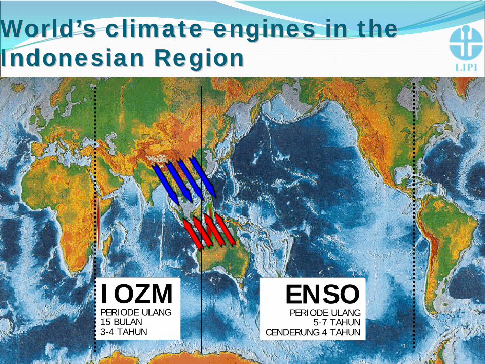
WorldWorld’’s climate engines in the s climate engines in the Indonesian RegionIndonesian Region
IOZMPERIODE ULANG15 BULAN 3-4 TAHUN
ENSOPERIODE ULANG
5-7 TAHUNCENDERUNG 4 TAHUN

October 13, 2008Bonn UN-SPIDER Workshop - Jan Sopaheluwakan 12

October 13, 2008Bonn UN-SPIDER Workshop - Jan Sopaheluwakan 13

October 13, 2008Bonn UN-SPIDER Workshop - Jan Sopaheluwakan 14
WS HantoroWS Hantoro
8 Oct’ 97
INDIAN OCEAN - SOUTH CHINASEA POLE
Gambar 4 Kondisi perairan Samudra Hindia saat terjadi coupling antara Indian Ocean Dipole dengan El Nino 199

October 13, 2008Bonn UN-SPIDER Workshop - Jan Sopaheluwakan 15
WS HantoroWS Hantoro
Gambar 8. Peta anomali suhu muka laut dan sebaran asap dan jelaga kebakaran pada tahun 1997

Impact of global warming on sea level Impact of global warming on sea level PossiblePossible average sea level rise (average sea level rise (low low –– highhigh emission GHG scenarios, 2080)emission GHG scenarios, 2080)
Estimated Lost of landEstimated Lost of landof total land area of the of total land area of the
above mapabove map
MaximumMaximum 5.71 %5.71 %
Best guessBest guess 0.75 %0.75 %
October 13, 2008Bonn UN-SPIDER Workshop - Jan Sopaheluwakan 16
Global temperature
Average Sea level rise
October 13, 2008Bonn UN-SPIDER Workshop - Jan Sopaheluwakan 17
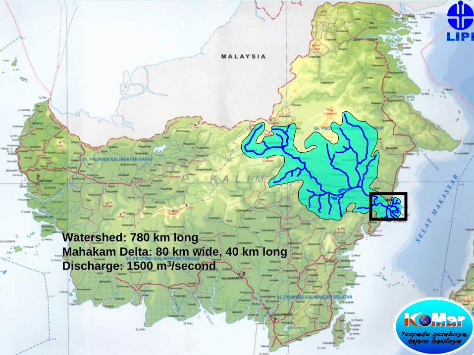
Watershed: 780 km longWatershed: 780 km longMahakam Delta: 80 km wide, 40 km longMahakam Delta: 80 km wide, 40 km longDischarge: 1500 mDischarge: 1500 m33/second/second

October 13, 2008Bonn UN-SPIDER Workshop - Jan Sopaheluwakan 18
Alluvial valleyAlluvial valley
DistributaryDistributary
Delta
pla
inDe
lta p
lain
ShelfShelf
ProdeltaProdelta
00 4040kmkm
L. JempangL. Jempang
L. SemayangL. Semayang
L. MelintangL. Melintang
•• The Mahakam river discharges on the order of 1000The Mahakam river discharges on the order of 1000--3000 m3000 m33/s /s of waterof water
•• A mean annual sediment transport of about 8 x 10A mean annual sediment transport of about 8 x 1066 mm33
•• 80 x 40 km80 x 40 km22
•• 150.000 ha fluvial dominated delta on a shallow shelf150.000 ha fluvial dominated delta on a shallow shelf•• ++ 75.000 ha of Nypa75.000 ha of Nypa•• 90.000 ha has been exploited, > 40.000 ha for shrimp pond90.000 ha has been exploited, > 40.000 ha for shrimp pond•• Low gradient, mud dominatedLow gradient, mud dominated•• Regional asymmetry of suspended sediment influx from the Regional asymmetry of suspended sediment influx from the
southern distributary zonesouthern distributary zone

Prior (1986)Prior (1986)
October 13, 2008 Bonn UN-SPIDER Workshop - Jan Sopaheluwakan 19
CIRAD, 2003
Blast (1999)Blast (1999)
Peak (2001)Peak (2001)

October 13, 2008Bonn UN-SPIDER Workshop - Jan Sopaheluwakan 20
SamarindaSamarindaTenggarongTenggarong
Loa KuluLoa Kulu
LoabukitLoabukit
SebuluSebulu
Muara BadakMuara Badak
SalikiSaliki
SungaimariamSungaimariam
200020002003
2003
Saltwater encroachment in Mahakam Delta
Loa JananLoa Janan
LouiseLouise 00 2020kmkm

Land cover and land use change Land cover and land use change (1992 (1992 –– 2001)2001)
October 13, 2008 Bonn UN-SPIDER Workshop - Jan Sopaheluwakan 21
Degraded forestDegraded forest
Freshwater mangroveFreshwater mangrove
Pure nypaPure nypa
All other mangroveAll other mangrove
All pondsAll ponds
PriorPrior 19921992 19961996 19991999 20012001
70%70%60%60%50%50%40%40%30%30%20%20%10%10%
0%0%
CIRAD, 2003

October 13, 2008 Bonn UN-SPIDER Workshop - Jan Sopaheluwakan 22
Sustainable systemSustainable system
““Ecological FootprintEcological Footprint”” linelineShrimp Pond/MangroveShrimp Pond/Mangrove
““Ecological FootprintEcological Footprint””Transgression 1997Transgression 1997
UnsustainableUnsustainablesystemsystem
Prior 19921992 1996 1999 2001
500%
400%
300%
200%
100%
0%
CIRAD, 2003
Ratio Shrimp Ratio Shrimp PPond/Mangroveond/Mangrove

(Western) Indonesian (Western) Indonesian TEWSTEWS
October 13, 2008 Bonn UN-SPIDER Workshop - Jan Sopaheluwakan 23
Bottom pressure
gauge
Buoy
Lempeng TektonikSamudera Hindia
Satellite
Satellite
Seismograph Seismograph ((Daerah)Daerah)
Tide gauge GPS
BMG Pusat
???
1. Seismograph Data
2. Ocean surface data / Confirmation
3. Tide and GPS Data
Sirine signal
•
Location: at Sea…..? •
Magnitude: > 6.3 SR..?•
Depth: < 70km…?•
Tsunami potential !
TSUNAMI
!!

Seismic BuoysTide Gauges EO Data
GPSMonitoring Systems
The Concept: DECISION SUPPORT SYSTEM
Simulation
Risk- & Vulnerability Modelling Geospatial Data Repository
DisseminationSystem
DECISION
Observations
October 13, 2008 24Bonn UN-SPIDER Workshop - Jan Sopaheluwakan

25October 13, 2008 25
Bonn UN-SPIDER Workshop - Jan Sopaheluwakan

Warning information flow to the publicInfrastruc
turesGSM
Phone/Fax /sat phone
GTS
RANET
FMRDS/ALERTUS
Dedicated line
Internet
TV/Radio
HF Radio
Interface Institution
Police
ARMY
Port Authority
Airport
BMG
stations
BMG regional
Nat. Disaster Mgt. Agency
Local Govts
P U B L I C
B M G
Public
instruments
Sirine
TV/Radio
SMS
FMRDS ALERTUS
receiver
Other public alert
sound instruments
Police sirenes
October 13, 2008 26Bonn UN-SPIDER Workshop - Jan Sopaheluwakan


RANET in Local Gov offices and BMG RANET in Local Gov offices and BMG stationsstations
Earthquake/Tsunami warningWeather forecastClimate forecast
FDRS
BMG
BMG
BMG 46 unitLoc.Gov 75 unitcoastal radio office 5 unit
October 13, 2008 28Bonn UN-SPIDER Workshop - Jan Sopaheluwakan

Tsunami Tsunami SirSireene ne networknetworkSirene Federal Signal Sirene Sanken/Milano
(TELKOMSEL)Plan
6 tower
6 tower
6 tower
2 tower
3 tower
3 tower3 tower
6 tower
1 tower
2 tower4 tower
2 tower
Gorontalo
NTT
October 13, 2008 29Bonn UN-SPIDER Workshop - Jan Sopaheluwakan

BMG JAKARTA
LAN
COM. SERVERCOM. SERVER
Jaringan Data Jaringan Data
PSTNGSMTel. SatL. Band
Massage HandlingServer
BMG
MEDAN PEMDA NADPADANG PEMDA SUMBARDENPASAR PEMDA BALI
SIRENE
NETWORK
Tsunami Drill
October 13, 2008 30Bonn UN-SPIDER Workshop - Jan Sopaheluwakan

Disasters are rarely accidental or sudden...

October 13, 2008 Bonn UN-SPIDER Workshop - Jan Sopaheluwakan 32

October 13, 2008Bonn UN-SPIDER Workshop - Jan Sopaheluwakan 33
Tsunami prone coasts in Indonesia and Tsunami prone coasts in Indonesia and destructive earthquake and tsunami during the destructive earthquake and tsunami during the last decadelast decade
Tsunami prone coasts
2004
2004
1994
1992
1996
1998
2000
••Distance to the closest shore: 10 Distance to the closest shore: 10 –– 200 km200 km••Tsunami lead time: 5 Tsunami lead time: 5 –– 40 menit40 menit••Seismic wave propagation: 3 Seismic wave propagation: 3 –– 30 seconds30 seconds••Early warning system in 5 minutes Early warning system in 5 minutes ??!!
© Jan Sopaheluwakan, 2005
2006

Earthquake epicenters of Sumatra (Natawidjaja, 2002)Earthquake epicenters of Sumatra (Natawidjaja, 2002)
October 13, 2008Bonn UN-SPIDER Workshop - Jan Sopaheluwakan 34
Earthquake +Tsunami:1381 (coral reef), 1608 (coral reef)Earthquake +Tsunami:1381 (coral reef), 1608 (coral reef)1833 (coral reef &book), 1833 (coral reef &book), 20042004Interval 200Interval 200--220 years (Natawidjaja, 2000, LIPI 220 years (Natawidjaja, 2000, LIPI –– Caltech)Caltech)
20042004
20042004
18331833
19351935
18831883
Bathymetry around Sumatera
5,2 cm/year
Cyclic recurrent of Mentawai earthquakes
around 200 years 6 cm/year
18611861
© Jan Sopaheluwakan, 2005

Subsided and heavily inundated Subsided and heavily inundated western coast of Sumatra western coast of Sumatra
October 13, 2008Bonn UN-SPIDER Workshop - Jan Sopaheluwakan 35
BeforeBefore AfterAfter

October 13, 2008Bonn UN-SPIDER Workshop - Jan Sopaheluwakan 36
Rising island creating new land in Simelue during Aceh- Andaman earthquake
Old beachNew coast line

October 13, 2008Bonn UN-SPIDER Workshop - Jan Sopaheluwakan 37
Intertidal reefs were out of the water and died

October 13, 2008Bonn UN-SPIDER Workshop - Jan Sopaheluwakan 38
Haloban inBanyak IslandSinked about 30 cm

October 13, 2008Bonn UN-SPIDER Workshop - Jan Sopaheluwakan 39
Desa HALOBAN, P. Tuanku, Kep. Banyak

October 13, 2008Bonn UN-SPIDER Workshop - Jan Sopaheluwakan 40
Tsunami animation (Tsunami Research Group
Marine Research Center, Bandung Institute of Technol.)
The 2004 Aceh Tsunami andvertical displacement of seafloor
Hirata et al. [2005] from satellite altimetry data.

October 13, 2008Bonn UN-SPIDER Workshop - Jan Sopaheluwakan 41

Structure of surveys / questionnaires
- More than 2000 households
(400 for physical assessment)
- 500 buildings- 200 critical facilities - More than 500
households(400 for physical
assessment)- 500 buildings- 100 critical
facilities
-More than 2000 households
- 100 buildings- 100 critical
facilities
B. Household survey1. Socio-economic properties2. Pattern of behaviour of daily activities
(dynamic exposure)3. Knowledge about Tsunamis and early
warning4. Receiving and understanding the warning5. Evacuation decision and behaviour6. Rehabilitation and recovery
C. Critical facilities and infrastructure / economic sectors1. Amount of staff and customers for
different times of day / occupancy rates2. Receiving of warning3. Decision to evacuate 4. Catastrophe precautions5. Suitability for evacuation
Time frame for surveysMarch 2008 - End June 2008
A. Building evaluation1. Function, height, accessibility of building2. Structural properties (material, structure,
column, hammer and ferro-scan test)3. Engineered building4. Condition of foundation5. Suitablility for evacuation, capacity
Pilot areasPilot areas
October 13, 2008 42Bonn UN-SPIDER Workshop - Jan Sopaheluwakan

October 13, 2008 Bonn UN-SPIDER Workshop - Jan Sopaheluwakan 43
Padang
Tsunami prone coastal plain in West Sumatra
(red tinted)

October 13, 2008 Bonn UN-SPIDER Workshop - Jan Sopaheluwakan 44Vulnerable coast
DTM of PadangDTM of Padang

Critical FacilitiesCritical Facilities
•Position
•Name
•Address
Criteria
• School
• Hospital
• Government Facilities
• Shelter
• Fire Brigade
• Police StationOctober 13, 2008 45Bonn UN-SPIDER Workshop - Jan Sopaheluwakan
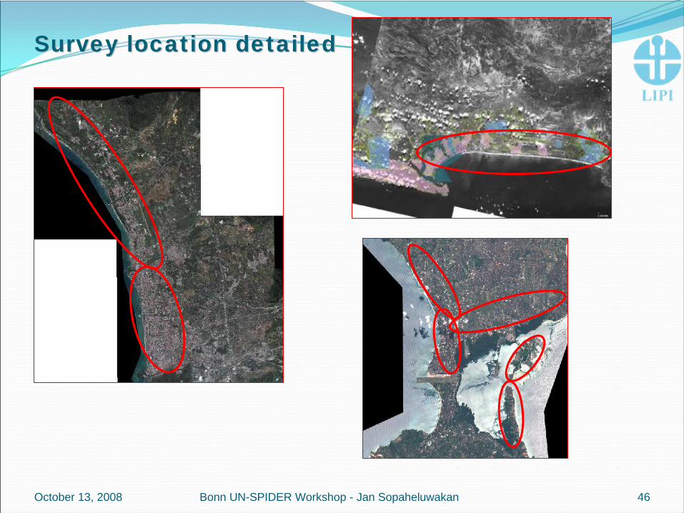
Survey location detailedSurvey location detailed
October 13, 2008 46Bonn UN-SPIDER Workshop - Jan Sopaheluwakan

HAZARD HAZARD PROJECTION AT PROJECTION AT PADANG CITYPADANG CITY
October 13, 2008 47Bonn UN-SPIDER Workshop - Jan Sopaheluwakan

Hazard Map Hazard Map ApplicationApplication
October 13, 2008 48Bonn UN-SPIDER Workshop - Jan Sopaheluwakan

HazardHazard1:25000 map examples Padang – Cilacap – Bali
BUT: Will be improved soon through detailed simulation GKSS / DHI
October 13, 2008 49Bonn UN-SPIDER Workshop - Jan Sopaheluwakan

Dynamic exposure Dynamic exposure –– people day and nightpeople day and night
DAY NIGHT
October 13, 2008 50Bonn UN-SPIDER Workshop - Jan Sopaheluwakan

Improvement of population distributionImprovement of population distribution
+Population from census data Landuse
=
Improvement of population distribution
October 13, 2008 51Bonn UN-SPIDER Workshop - Jan Sopaheluwakan

Needs Needs and gapsand gaps
October 13, 2008 52Bonn UN-SPIDER Workshop - Jan Sopaheluwakan

Needs and Needs and gapsgapsUnintegrated space based information(high) Cost incurred in the data transmissionTailor made products for end usersDistributed but integrated system of systems like GEOSS
October 13, 2008 53Bonn UN-SPIDER Workshop - Jan Sopaheluwakan

Developing countries Developing countries perspectiveperspective
54
Surface Station
Satellites
Aircraft
Radio & Radar
Weather Radar
Observers
Ships, Buoys, Automatic Stations
Global Networks
Energy
Disaster Preparation
Agriculture Water Industry
Construction
AviationShipping
Recreation & Tourism
Legal &Insurance
Warnings
DefenseLocal Info &
Forecasts
Proto
cols,
Stan
dard
s, Int
egra
ting T
echn
ologie
s
Conferences
Telephone
Fax
Internet
Broadcast
Printed Media
SMS
Observations Process
Media & Telecoms
Health
Surface Station
Satellites
Aircraft
Radio & Radar
Weather Radar
Observers
Ships, Buoys, Automatic Stations
Global Networks
Satellites
Aircraft
Radiosonde& Radar
Weather Radar
Observers
Ships, Buoys, Automatic Stations
Global Networks
Energy
Disaster Preparation
Agriculture Water Industry
Construction
AviationShipping
Recreation & Tourism
Legal &Insurance
Warnings
DefenseLocal Info &
Forecasts
Proto
cols,
Stan
dard
s, Int
egra
ting T
echn
ologie
s
Com
pute
r for
ecas
tm
odel
s an
d hu
man
fo
reca
ster
s
Conferences
Telephone
Fax
Internet
Broadcast
Printed Media
SMS
Media & Telecoms
Health
Users
Improvement of accuracy and reliability to help us deal with climate change and climate variability Improvement of accuracy and reliability to help us deal with climate change and climate variability
Improve quality and quantityImprove quality and quantity
Applied research& techniquesInterpretation Into impacts
Applied research& techniquesInterpretation Into impacts
Improve & betterdecision makingImprove & betterdecision making
Awareness& understandingIMPACTS
Awareness& understandingIMPACTS

StrategiesStrategiesParadigm shifts
From response to preparednessFrom government driven to community driven initiatives5 principles
Centralization – decentralization synergyPublic participation Integrated coordination Comprehensive approachPartnership at all levels
Public – privateScientists‐engineers – decision makers
October 13, 2008 55Bonn UN-SPIDER Workshop - Jan Sopaheluwakan

StrategiesStrategiesObserve and monitor: learn from the past and and get ready for the future
Use of space based information for multiple approachMultidisciplinaryMultisectoralMultiplatformsMultitemporal and multispatialMultiusers
Combined space based and field studies information for simulation, modeling and scenarios development predictive capability and capacitiesCost effective, mobile, user friendly space and air based technology and information
Combined use of HAA for end‐to‐end disaster management and other user communities
User friendly – tailor made information products for end users
October 13, 2008 56Bonn UN-SPIDER Workshop - Jan Sopaheluwakan

October 13, 2008Bonn UN-SPIDER Workshop - Jan Sopaheluwakan 57
Environmental Environmental SphereSphere
Social SphereSocial Sphere
Economic SphereEconomic Sphere
Exposed andExposed andvulnerable vulnerable elementselements
Coping
Coping
capa
city
capa
city
HAZARDHAZARD
Risk Management (t=0)
Preparedness
FEEDBACKFEEDBACK
Risk Management (t=1)
Disaster / EmergencyManagement
Actuation Actuation
SystemSystem
Bogardi, Birkmann, 2004
e.g. Coastal Zone e.g. Coastal Zone
ManagementManagement
e.g. Ocean monitoringe.g. Ocean monitoring
e.g. Early Warninge.g. Early Warning
e.g. Tsunami Preparednesse.g. Tsunami Preparedness
Environmental Environmental RiskRisk
Social RiskSocial Risk
Economic RiskEconomic Risk
RISKRISKVULNERABILITYVULNERABILITY

July 31, 2007Indonesia - Germany Workshop on Vulnerability and Risk Assessment 58
Jayapura
Manado
Maumere
Kuta
SurabayaJogyakarta
BandungJakarta
PangandaranCilacap
Anyer
Bengkulu
PadangSolok
Banda Aceh
Pariaman
P. Breuh, Lhok Nga, Banda Aceh
Post Disaster Assessment
Public Education & Awareness
Exhibition
Bathymetry
Infrastructure
Vulnerability & Risk Modeling
Social Economy
Paleotsunami & Environment
Tsunami Modeling
Engineering geology, groundwater
Pangandaran
Anyer, lampung
GMT341 map

59
Social EconomicSocial EconomicVulnerabilityVulnerability
Research and SurveyResearch and Survey
PhysicalPhysical SocialSocialEconomyEconomy
Phys.Phys.VulnerabilityVulnerability
EnvironmentalEnvironmental
Environ.Environ.VulnerabulityVulnerabulity
PubedPubed CompressCompress
Disaster riskDisaster riskPubedPubed
CompressCompress
SurveySurveyResearchResearch
Risk
TotalTotalVulnerabilityVulnerability
October 13, 2008 Bonn UN-SPIDER Workshop - Jan Sopaheluwakan

October 13, 2008
““The last mileThe last mile”” in INA endin INA end--toto-- end warning system end warning system
Bonn UN-SPIDER Workshop - Jan Sopaheluwakan 60
EQEQNo No
tsunamigenictsunamigenicAutomaticAutomaticProcessingProcessing(1(1stst warning)warning)
TsunamiTsunamigenic genic
Back toBack tonormalnormal
Storage Storage
EQEQRecordRecord
ModelsModels--scenariosscenarios SOPsSOPs
ContingencyContingencyplanplan
WarningWarningEvacuateEvacuate EmergencyEmergency
reliefrelief
RecoveryRecovery--reconstructionreconstruction
MitigationMitigation--preparednesspreparedness
GeohazardsGeohazardsAssessmentAssessment
GeohazardsGeohazardsIdentification Identification
GeohazardsGeohazardsBehaviourBehaviour
Geodynamics,Geodynamics,seismotectonicsseismotectonics
RiskRiskAssessmentAssessment
SocialSocial--econecon--institut.institut.vulnerabilityvulnerability
SocialSocial--economiceconomic--institut. assessment institut. assessment
SocialSocial--economiceconomicInstitut. fabricInstitut. fabric
Local SosialLocal Sosial--economic dynamicseconomic dynamics
Historical EQHistorical EQ--Tsunami studiesTsunami studies
Target GroupTarget GroupMappingMapping
Public Education and Public Education and Preparedness TrainingPreparedness Training
Vulnerable Groups, Vulnerable Groups, Infrastructures, SectorsInfrastructures, Sectors
Tide gageTide gageBuoysBuoys

October 13, 2008Bonn UN-SPIDER Workshop - Jan Sopaheluwakan 61
2010?
2010?
Decision pointDecision point
ResponseResponse2007
2007
Science and Technology Predictive Capability
C o m m u n i t i e s
2007
2007
Focus, integration, priorityFocus, integration, priority

July 31, 2007Indonesia - Germany Workshop on Vulnerability and Risk Assessment 62
Compress
Compress
PubedPubed
SurveySurvey
Rese
arch
Rese
arch
Principal reference to vulnerability and risksPrincipal reference to vulnerability and risks
Compress
Compress
PubedPubed
Y1Y1--L1L1 Y1Y1--L2L2Y3Y3--L1L1Y2Y2--L1L1
Compress
Compress
PubedPubed

63
COMPONENTS OF THE GOSCOMPONENTS OF THE GOS

64
The spacedThe spaced-- based systembased system

GEOSS: the topGEOSS: the top--down provisiondown provisionA distributed system of systems like GEOSS (Global Earth Observation System of Systems)
Improve coordination of strategies and observation systemsLinks all platforms: in situ, aircrafts, and satellitesIdentifies gaps in our global capacityFacilitates exchange of data and informationImproves decision maker’s ability to address pressing policy issues
October 13, 2008 Bonn UN-SPIDER Workshop - Jan Sopaheluwakan 65

October 13, 2008
High altitude airshipHigh altitude airship
KrakatauKrakatau
Tsunami Tsunami BouyBouy
BinuangeunBinuangeunFishery IndustryFishery Industry
NaturalNaturalReserveReserve
UAVUAV
UAVUAV
66Bonn UN-SPIDER Workshop - Jan Sopaheluwakan

CClosing remarkslosing remarksThe 261204 Indian Ocean tsunami has changed totally the way we look at disasterWe need a global and distributed system of systems and robust, cost effective space based technology and information to address both rapid‐and slow‐onset disastersThe highly diverse geographic setting of Indonesian Maritime Continent bears also all sorts of rapid‐ and slow‐onset disastersThe global cooperation in contributing the Indonesian experience in building “home grown” tsunami warning system has been a remarkable best practice to be implemented elsewhere in the world
October 13, 2008 Bonn UN-SPIDER Workshop - Jan Sopaheluwakan 67


![76004 Spider-Man: Spider-Cycle Chase [Marvel]](https://static.fdocuments.us/doc/165x107/577cc35c1a28aba71195cd3a/76004-spider-man-spider-cycle-chase-marvel.jpg)