Seattle Design APPROVED Commission Mitra Dennis Ryan Darrell Vange Seattle Design Commission, Mayor...
20
Page 1 of 20 APPROVED MINUTES OF THE MEETING 18 August 2005 Projects Reviewed Convened: 8:30am SR 520 Improvement Project Street Use Permit/Design Review Planning Division Update King Street Station Improvements Magnolia Elementary Pla yfield Improvements Van Asselt Community Center Expansion Adjourned: 4:30pm Commissioners Present Staff Present David Spiker, Chair Guillermo Romano Charles Anderson Layne Cubell Karen Kiest Emily Podolak Hannah McIntosh Tom Iurino Anindita Mitra Dennis Ryan Darrell Vange Seattle Design Commission Gregory J. Nickels, Mayor David Spiker Chair Charles Anderson Pam Beyette Karen Kiest Anindita Mitra Sheri Olson Nic Rossouw Dennis Ryan Darrell Vange Guillermo Romano, Executive Director Layne Cubell, Commission Coordinator Department of Planning and Development P. O. Box 34019 700 5th Avenue, 19 th Floor Seattle, WA 98124-4019 phone 206/233-7911 fax 206/288-7883 printed on recycled paper
Transcript of Seattle Design APPROVED Commission Mitra Dennis Ryan Darrell Vange Seattle Design Commission, Mayor...

Page 1 of 20
APPROVED
MINUTES OF THE MEETING
18 August 2005 Projects Reviewed Convened: 8:30am SR 520 Improvement Project Street Use Permit/Design Review Planning Division Update King Street Station Improvements Magnolia Elementary Playfield Improvements Van Asselt Community Center Expansion Adjourned: 4:30pm Commissioners Present Staff Present David Spiker, Chair Guillermo Romano Charles Anderson Layne Cubell Karen Kiest Emily Podolak Hannah McIntosh Tom Iurino Anindita Mitra Dennis Ryan Darrell Vange
Seattle Design
Commission
Gregory J. Nickels, Mayor
David Spiker Chair
Charles Anderson
Pam Beyette
Karen Kiest
Anindita Mitra
Sheri Olson
Nic Rossouw
Dennis Ryan
Darrell Vange
Guillermo Romano, Executive Director
Layne Cubell, Commission Coordinator
Department of Planning and Development
P. O. Box 34019
700 5th Avenue, 19th Floor Seattle, WA 98124-4019
phone 206/233-7911 fax 206/288-7883
printed on recycled paper

Page 2 of 20
18Aug 2005 Project: SR 520 Improvement Project Phase: Design Update Previous Reviews: 02 June 2005 (Design Update); 15 July 2004, 2 October 2003, 7 March
2002, 16 October 2002; (Courtesy Briefings) Presenters: John Milton, Washington Department of Transportation David Allen, Department of Transportation Michael Horntvedt, Parametrix Susan Westman, Parametrix Mark Hinshaw, LMN Architects Brian Jarr, EnviroIssues David Graves, Seattle Parks Department Attendees: Lyle Bicknell, Department of Planning and Development Time: 1 hour (SDC Ref. # 221 DC00262) Summary: The Commission appreciates the opportunity to play an advisory role on this
important project and looks forward to further presentations and continuing conversations, and
• commends proponents for today’s presentation of the traffic analysis, the approach to project aesthetics, and impacts on and opportunities for the adjacent Parks Department landholdings;
• appreciates the responses to several questions posed by the Commission during the last presentation held in June 2005;
• asks that, in future presentations, the proponents bring relevant graphics and information from past meetings to refresh earlier conversations and to guide Commissioners and public attendees who were not present at past meetings;
• appreciates the traffic analysis presentation and is quite surprised that the predictions for the year 2030 show that the 4-lane and 6-lane options seem not to be that distinct from one another;
• asks that the proponents use this information as a way to gauge their selection process of a preferred option;
• continues to believe that the 4-lane option has tremendous merit and should be studied fully with all amenities amongst other options and designs;
• appreciates that WSDOT is addressing issues of contextual and aesthetic design at this early phase in the project and looks forward to future presentations of 3D modeling of bridge aesthetics and updates on the Bridge Corridor Aesthetic Guideline Handbook;
• supports the underlying concept that transportation corridors should have good manners in addressing their surrounding context;
• In terms of the Parks Department’s workshops on preferred park concepts, realizes that the work is very preliminary and dependent on the chosen option for the bridge;

Page 3 of 20
• reminds proponents that one key concept to keep in mind is that the view from below the bridge is as important as the view from above.
Proponent Presentation Addressing three topics:
1. Traffic Analysis and Pacific Street Interchange 2. Corridor Aesthetics 3. Park Workshops
Based on the vulnerability of the bridge structure, proponents are beginning a planning effort for if bridge fails. The bridge can fail in two ways: 1) damage to the columns caused by large seismic event causing hollow columns to implode, and 2) waves crashing into roadway; it is presumed that the bridge can handle a 20 year storm without suffering major damage. The main objectives for the SR-520 bridge improvements include, reducing the expanded bridge width impacts, increasing the livability along the corridor and providing improvements to the structure. Proponents are currently investigating four options for Environmental Impact Statement (EIS), which include 4-Lane, 6-Lane, 6-Lane Alternative and No Build. The details for these options could include: 4-Lane
• rebuilds 3 transit stops on the outside • adds HOV ram access to I-5 express lanes during AM peak traffic • builds a bike/pedestrian trail on the north side of the bridge • builds sound walls • includes water quality improvements • builds larger pontoons to accommodate future HCT ?
6 Lane is the same as the 4 lane except:
• adds 1 HOV lane in each direction • rebuilds 3 transit stops on the inside • includes 5 lidded sections • adds reversible HOV access to I-5 express lanes
6 Lane Alternative includes the following options
• removes the Montlake Freeway Transit Stop • which allows narrowing footprint through Montlake by approximately 40 feet and as a
result reroutes transit service • adds a second Montlake bascule bridge across the Montlake cut • which removes the Montlake Freeway Transit Stop • Builds new Pacific Interchange • Removes Montlake Interchange and the Montlake Freeway Transit Stop • Builds new bridge across Union Bay to Pacific Street • Increases access to UW and ST Link Station

Page 4 of 20
• Narrows footprint through Montlake and Portage Bay • Allows a high-level or low-level profile • Moves bike/pedestrian path to the north on the Eastside creating a continuous path on the
north side of the corridor • Removes the Evergreen Point Freeway Transit Stop • Narrows the footprint through Medina and reroutes the transit service • Adds S. Kirkland Park and Ride Transit Access • Makes improvement to 108th or Bellevue Way to provide better transit access
Traffic Analysis Proponents presented their traffic analysis, and acknowledged that there is a balancing act between added road capacity, and drivers’ behavior in regards to road choices, tolls, and levels of congestion. The traffic analys is found that compared to the no build option, the other three options predict that the daily vehicle trips decrease and person trips increase, the route diversion is low, and the shift to HOV and transit is high. The peak traffic decreases in the 4-Lane and increases in the 6-Lane, and the person movement is highest in the 6-Lane. The rebuild options will improve corridor safety and reliability for general passenger, HOV, transit and freight traffic. They also do not add general passenger traffic to I-5 compared to the No Build Option. The 6-Lane options would decreases transit/HOV travel time by up to 80% and ensure reliability The traffic analysis shows that the SR-520 PM Peak Performance for the
• 4-Lane Option - draws 7% more person trips in 13% fewer vehicles than the No Build Option
• 6-Lane Options - draws 25% more person trips in 3% more vehicles than the No Build Option
Corridor Aesthetics Proponents plan to perform various 3-D models that will create real-time drive-through models and walk-through models for selected locations in the corridor and illustrate locations for aesthetic treatments. The effort will also include the creation of the Corridor Aesthetics Framework Handbook which will describe opportunities for aesthetic treatments that could express corridor-wide coherence and local community individuality, present and illustrate aesthetic principles and standards for the corridor, and assemble illustrative design examples from other places that may serve as inspiration for the future design of corridor elements. It will be a resource for interdisciplinary design teams and the public when they work together to integrate aesthetic values into the design of the corridor. It is built on past community feedback and will be used for future public involvement. The timeline for the Corridor Aesthetics efforts includes plans for open houses with jurisdictions and communities this fall, early community engagement beginning in January, community review in spring, the creation of the draft handbook in spring 2006 and the final in June 2006
Page 5 of 20
Parks Department Workshop WSDOT convened and led a workshop which included staff from the Seattle Parks Department, University of Washington and the Arboretum. Held in Spring 2005, the workshop was based on the 6 lane option; the 6 lane alternative was just being revealed at the time of the workshop. The workshop resulted in concepts for three areas around the SR-520 corridor: 1) the north part of the arboretum, 2) East Montlake Park (MOHAI) and 3) the WSDOT peninsula located near the arboretum. The Parks Department currently does not have a preferred option for the project but does have reservations about the 6 lane alternative’s Pacific Interchange because of its location above the wetlands surrounding Foster Island. WSDOT, Seattle Parks Department, the University of Washington and the Arboretum will reconvene for future workshops once the preferred alternative is chosen. Project Timeline The SR-520 Improvement project has laid out the following timeline
• Jurisdictional briefings before exec committee meeting on June 22, 2005, followed by the selection of the preferred option
• Corridor Design Aesthetics and Parks Workshops this fall and spring • October Community Open Houses • And hope that by the end of the year 2005 the preferred option for the project will be
selected Commissioner Questions and Comments § Asks if the pacific interchange is only possible with the six lane alternative or could it
also work for four lane alternative, has it been assessed
o Have not looked at it, is it possible yes
§ Reminds proponents that it was a comment from Commission during last presentation, everyone recognizes that EIS is underway but from common sense place there is the desire to know the possibility for four lane alternative
o As to the EIS process, it would not review the option but by reviewing the six lane it will cover possibility of the four lane alternative
§ Asks if there is the possibility of one HOV lane and one general passenger lane as approaches I-5
o During study period an alternative proposed convert a lane, ran traffic analysis, real large effect on congestion because it takes away capacity, 3000 vehicles traveling per hour definitely a two lane traffic, difference would be 1000 cars in back up.
§ Asks, from WSDOT perspective , does the increase in volume and the reduction of the travel time between the four lane and the six lane justify in your minds going to the six lane

Page 6 of 20
o The difference is between the person moving capacity, six lane does not push more vehicles through, but it allows HOV lane to be reliable, travel time lanes is significant
§ Comments that it seems that if there is short travel time in HOV lanes the lane would fill up from other traffic over I-90 until the traffic got to a point that it wasn’t attractive anymore
o It may happen but in HOV lane, if speed drops between 45 mph during the peak period they have opportunity to change the occupancy requirement and manage flow
§ Asks city lia ison to clarify the city’s position, specifically the four representatives on the executive committee and the council’s recent principles, what are their endorsements for preferred option
o The mayor’s position has been clear for a number of years that no more than six lanes run through Seattle and that includes when there is a train moving across 520, which means by definition four lanes and then transit. The interpretation of the Council’s opinion is that they are a little more open to discussing principles, not as much choosing four or six but rather based on the type of facility preferred
§ Asks that didn’t four representatives sign some memo or letter a year ago before the Pacific Interchange was introduced that unified them on a position
o There was a vote at that time preferring four lanes, but the Council has not been as direct as the Mayor to state only four lanes
§ States for the record that the majority of the Commission (8 support, 1 dissent) has previous ly supported the four lane option
§ Comments that based on the numbers doesn’t see reason to bother with the six lane at all, it doesn’t justify the additional expense
o Yes, it certainly does on person capacity moving
§ Expresses skepticism on proponent’s assumptions regarding how many people are going to move out of their one person occupied car to HOV or transit, hopes proponents are right, but are showing a huge percentage increase that hasn’t happened in the last 20 or 30 years, and don’t see it happening in the next 20 or 30 years
o The one primary difference between what is happening of recent in the 520 corridor is that the HOV reliability is none existent, one can’t plan to be anywhere at a specific time and has to add a ½ hour lead way; the 6 lane allows this reliability
§ Expresses agreement, personally lives on the East side and used to take the express bus, but commute was 1 ½ to 2 hours and would rather take car if it takes that long regardless
§ Asks why there needs to be shoulders on both sides of the road
o It is currently not a safe or reliable corridor, the benefit of wider shoulders is a significant reduction of overall accidents both from the accidents occurring and the back up accidents that occur; helps remediate a secondary impact of cars stalling in lanes or accidents, can move off to the side and allow traffic to continue
§ But both sides, seems like over design

Page 7 of 20
o From our perspective, putting those in creates a 3 to 7 percent reduction in those lanes because there is space for avoiding accidents.
§ There are state standards that the state is compelled to use to bring highways up to certain level, and it is a general question of do we need all that stuff, of course we don’t, have to go back and question methodology and that is a different conversation
§ Thinks that pacific interchange idea is exciting, and am attracted to the way the idea has caught on and impacted the design process, thinks there is something just beyond this idea might be possible, seems like got idea, organize in relation to idea and then process seems to stop, encourage proponents to keep pushing analysis and ideas, urge further study on which movements really need to be there and which can be rethought
§ Looking at it as a signalized intersection, which seems like a backwards way to look at it, why not look at it as continuous off and on ramps as any standard highway system would use, that way would not need four lanes on the ramp at the top
o We did that, it comes back to balance, building a free flow right turn lane and an interchange the other direction it is also a lot of structure, and bringing it all together before it gets to the cut is a challenge, in the balancing effort, it came down to the environmental effect, the proposed shrinks it up
§ But stop and go ends up with multiple lanes, may be decreasing overall coverage but increasing horizontal concrete
o It may be the case, but again its about balance
§ Reminds that the EIS process is a snapshot in time, not stopping iterative process of how to improve and community feedback, it all still continues
§ Recommend bringing past drawings for comparisons
§ Possibility to reverse lanes, share express lane
o Currently traffic goes both directions equally
§ Expresses frustration with not being able to be part of the value decision-making, every project decisions are based on value judgments, and proponents obviously applying certain values to presenting certain schemes, would be nice to see past studies might help us support you as you go along
o Difficult from our perspective when we have so much information trying to decide what to provide, try to offer opportunities to participate in different committees

Page 8 of 20
18 Aug2005 Project: Street Use Permit/Design Review Phase: Staff Briefing Previous Reviews: 04 August 2005 (staff briefing) Presenters: Layne Cubell, Design Commission Lyle Bicknell, Department of Planning and Development Attendees: None Time: 1 hour (SDC Ref. # 170) Street Use Permit/Design Review The Commission continued its discussion from last meeting on thresholds, guiding principles and their role in reviewing street design issues. They reviewed with staff a proposed one-pager that would be used to communicate with proponents and City departments. The Commission re-confirmed its desire to review street design projects and issues in regular full meetings and no longer as an administrative review process, conducted by staff in consultation with the Chair alone. Staff will begin to bring projects to the Commission this fall following this new approach.

Page 9 of 20
18 Aug 2005 Project: Planning Division Update Phase: Bi-Monthly Update Previous Reviews: 16 June 2005 (update) and several previous Presenters: John Rahaim, Department of Planning and Development Gary Johnson, Department of Planning and Development Attendees: none Time: 1 hour (SDC Ref. # 220) Summary: The Commission thanks John Rahaim and Gary Johnson, Project Manager for the Center City Strategy, for their updates on the Center City Strategy and the Central Waterfront Plan. The Commission appreciates that the Center City Strategy will address downtown livability, design’s critical role in encouraging vibrant streetscapes and public realm improvements, public safety issues, and the perceived incompatibility of uses between the entertainment and residential sectors. They acknowledge the potential of the Mayor’s proposed Open Space Impact Fee to maximize partnerships between the city, the county, and the private development sector in order to achieve an integrated open space system in downtown. The Waterfront Plan discussion focused on the Commission’s recent letter supporting Department of Planning and Development’s continued leadership and the timing, coordination and direction of the Plan. City staff noted their desire to create a larger public realm plan, but that it will be difficult to accomplish due to lack of funding. While funding is available for individual projects, it is not yet available for an overall plan of the public realm. Staff is considering using sustainability as a vehicle to seek private foundation money to help fund the overall planning project. The Commission stressed the importance of key projects along the waterfront, specifically the Sculpture Park at the northern terminus, Colman Dock at the southern terminus, and the Aquarium and connection to Pike Place Market as the central focal point. The Commission urges City staff to continue to explore creative solutions and encourages them to hold a limited design competition. The Commission challenges itself to become more proactive on the issue, beyond just sending letters, and will look for opportunities to visit Councilmembers and other officials to express their thoughts regarding the Waterfront’s future.

Page 10 of 20
18Aug 2005 Project: King Street Station Improvements Phase: Design Briefing Previous Reviews: None Presenters: Ron Sheck, Washington Department of Transportation Kevin Daniels, Nitze-Stagen Allen Cornell, Nitze-Stagen Peter Watson, OTAK Attendees: Gordon Clowers, Department of Planning and Development Time: 1 hour (SDC Ref. # 122) Summary: The Commission appreciates and recognizes WSDOT’s efforts to consider the
transportation demands of the region and supports the expansion of rail service as an essential transportation mode, and
• commends WSDOT’s design and restoration efforts at King Street Station and support the emphasis on “de -modernization” and restoration of transportation programs as the basic project objective;
• commends WSDOT for taking on the role of being the linchpin and organizer of a true inter- modal, multi-modal transit plan for King Street Station;
• endorses the concepts of relocating the inner city bus terminal to the King Street Station area from the current Denny Triangle location and using the 3rd Avenue right of way for a plaza and as a vertical connection between the different transit layers ;
• asks that if building a lid over the tracks is being considered by BNSF, that WSDOT push for inter-modal transportation uses to be given a priority for this space over commercial, office, and residential uses, recognizing that the Station area must work as a transportation district.
Presentation
King Street Station is a steel and masonry building completed in 1906 by the same architects as the New York City Grand Central Station and Tacoma Union Station., Washington Department of Transportation got involved in the project early in the 1990s when it became a multi modal transportation agency sponsoring intercity rail passenger service with Amtrak.
King Street Station is in appropriate location for a multi modal facility because it lines up with the bus tunnel, the light rail tunnel, monorail, and is near the freeway system.
Page 11 of 20
Track Capacity - Important issue facing King Street Station During World War II, at its peak, King Street Station was served by 40 trains a day. Today, there are currently 24 trips per day. This number is expected to increase to 40 trains a day by 2007 and is anticipated to reach 60 to 80 trains a day in the future, in excess of current track and platform capacity at the station. Over the last three years, WSDOT, lead agency for the station redevelopment, has developed a program that has two phases of work for , track and platform capacity improvements. The legislature has provided $15 million dollars to start the work. The total bill is estimated to be $48 million dollars because in doing the track capacity expansion, proponents will have to rebuild the 2nd Avenue extension bridge and the Jackson St. Bridge, which are old and need to be replaced. The $15 million dollars, to be spent over the next three biennia, will complete track work on the south end of the station. WSDOT is now moving into final engineering, collaborating with Sound Transit who has agreed to share in the investment to improve track capacity. This work will begin in the spring of 2006. Phase I – Short Term Renovation - making station more comfortable, convenient , safe, secure and in general, user-friendly The estimated cost for the near term King Street Station rehabilitation is $16.8 million dollars, which will be carried out with a combination of state and federal, and stakeholder funds. In order to use the state and federal funds allotted for the project, the proponents have been working on a lease with BSNF Railroad which they hope to finalize in next few weeks, which will give control to WSDOT for the next 40 years and will satisfy the agencies request for control of facility in the future. They currently have been using Amtrak money to work on Phase I while finalizing this agreement with BSNF. The project has spent Amtrak’s $2.5 million contribution funds for:
• Redoing the restrooms. • Working on ceiling, pilasters, columns, windows, and marble in to restore the Compass
Room entry way to its original 1906 appearance. • Reopening and expanding the north end of the waiting room • Replacing exterior canopies on the south and west sides of the building • Replacing metal doors with wooden ones • Opening windows in the main waiting room that have been boarded up for over 40 years.
Work still to be done for Phase I includes • Relocating ticket office to north end of the building • Removing the ugly drop ceiling and restore to original condition the main waiting room.. • Renovating downstairs area, (Amtrak offices behind current ticket counter will be
plumbed for future food services area.) • Restoring grand staircase • Removing 1950s brick and glass addition that housed the electric staircase that has not
functioned for at least 20 years. Work on the exterior of the building through the Sound Transit Commuter Rail Program in 1999-2000 has included the replacement of the canopies. Next steps will include replacement of the roof, improve the roof drainage system, restore the clock, clean the granite, brick, and terra cotta surfaces, repair windows, and improve sidewalks and redo the Jackson Street parking area to be a

Page 12 of 20
pedestrian, or pedestrian and auto drop off plaza. WSDOT will work and work with SDOT and King County to improve traffic circulation. Phase 2 – Full build-out of the King Street Transportation Center Track capacity improvements $65 to $85 million (preliminary estimate) Building rehabilitation and other transit elements - $60-$80 million (preliminary estimate) This long term vision has been explored only conceptually, but could include a series of bridges, platforms, and an inter-city bus terminal. Planned components include
• Improved physical and informational connections between the various transportation modes and expand the range of facilities
• Rehabilitated train station • Proposed new intercity bus terminal • New pullout bus transit waiting areas • Relocated and extended streetcar service • Better links to the International District transit station used by buses and future LINK
light rail • A station for the planned Seattle Monorail green line • Space for transportation center amenities, including food service, car rentals, automobile
parking and bicycle storage • Major new signage and wayfinding elements • Improved pedestrian and bicycle access to the South Downtown, Pioneer Square and
International District neighborhoods • Upgraded tracks to allow rail service expansion • Other enhancements and improvements to be defined during the planning stage
Rehabilitation of the railroad station will include
• Seismic Upgrades • Cleaning of exterior surfaces • New electrical systems • New plumbing • Heating, ventilation, and air conditioning upgrades • Rebuilding of public areas • Safety and security upgrades • Better external access • Accessibility improvements and ADA compliance elements
Proponents are developing a concept plan for integrating all elements together. One element of the long term vision is looking at the idea of taking parking lot at 4th Ave. and Jackson Street and extending it in part over 3rd Avenue, wrapping it to extend over the tracks to provide a plaza/pedestrian space and perhaps a pull in/pull out space for taxis and metro buses.
Page 13 of 20
Commissioner Questions and Comments § Asks what is time frame for Phase 1 and Phase 2
o Phase 1 will be wrapped up in the next 15-16 months and then will start thinking about Phase 2; there is a question about whether it will address only facilities related to transportation or other development options for 2nd and 3rd floor; Phase 2 will probably be 3-5 years down the road
§ Asks if there is an authority being established to maintain effort over time when it is all done
o WSDOT is the lead agency for track improvements, BSNF owns it long term but WSDOT is currently leasing 1st floor
§ Asks if any connections are required to accommodate transferring passengers from commuter rail to light rail would occur Jackson street surface level across 4th to Union Station
o Will look at in phase 2 design study
§ Comments that years ago there were grand visions of building housing, retail, etc. in the area, asks if those ideas are gone
o The focus is to make this work as a multi-modal transportation facility first but also will consider other amenities
§ Asks if working with SDOT on any changes to street alignments (closing and opening streets)
o Currently in discussion
§ Asks to verify if there are plans to extend the trolley up Jackson, and if existing bridges can’t accommodate the weight, asks how it fits into the work the proponents are doing
o Do not know if the weight constraint is true, they supported trolleys up until 1940s. However, if proponents replace them they will be strong enough
§ Asks to clarify efforts to reinstate grid
o Using 3rd as the monorail alignment, the idea is to recreate the street grid of 2nd, 3rd, Weller and Lane streets to provide opportunities for circulation at the king street elevation.
§ Endorses plaza concept
§ Requests that in future presentations proponents address their North Lot right of way issues so that Commission can have a better understanding of requirements when discussing this site
§ Believes that 3rd Ave Plaza idea is an interesting possibility because it is one place that transition can be made between the two levels in the future if decking could be done on part of the North Lot
Page 14 of 20
18Aug 2005 Project: Magnolia Elementary Playfield Improvements Phase: Schematic Design Previous Reviews: None Presenters: Cathy Tuttle, Seattle Parks Department Mark Brands, Site Workshop Joe Herrin, Heliotrope Architects Attendees: None Time: 1 hour (SDC Ref. # 169 DC00???) Action: The Commission recommends approval of schematic design by a vote of 6 to 1 in
favor and strongly commends the overall design, specifically its simplicity and spareness, and
• appreciates the proponents’ strategic approach to how best to utilize limited project funding;
• encourages the proponents to continue their good thinking and consider the practical needs of user groups and the potential conflicts in their use of the play space, and the design of the vehicle turnaround and whether or not it affords access or encourages people to linger;
• In addition, feels that the view edge needs more attention, and that it might be worthwhile to consider diverting some of the project’s limited resources in that direction;
• expresses concern that invasive vegetation (Himalayan blackberries) will take hold along the new slopes generated by earthwork disturbance, and encourage proponents to continue thinking about how to best plant and manage the area;
• one Commissioner did not recommend approval of schematic design out of concern that the planting design called for too much turf area that would pose a maintenance challenge and encouraged the use of native woody plantings instead.
Proponent Presentation The 2.4 acre site is located on the bluff of Magnolia looking out towards Interbay, offering views of downtown and Mount Rainier. Included in the Pro Parks Levy, the project is given $1.4 million to develop the site to the east of the school into a park, with consideration for the development of a playfield, gathering area and other park amenities. It has an ambitious design program relative to the funding allotted. The site was discovered by the athletic fie ld community who asked for the Pro Parks funding. The surrounding neighborhood wanted a neighborhood project not an athletic field project. A compromise was found between the two interest groups. Seattle Parks Department felt that there were sufficient fields in the neighborhood. The area is very residential and the demographics are swinging to majority of younger families.
Page 15 of 20
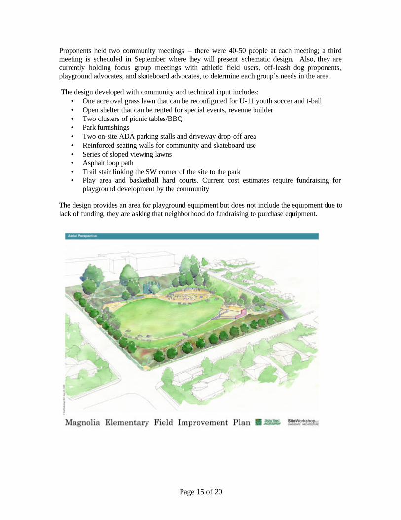
Proponents held two community meetings – there were 40-50 people at each meeting; a third meeting is scheduled in September where they will present schematic design. Also, they are currently holding focus group meetings with athletic field users, off-leash dog proponents, playground advocates, and skateboard advocates, to determine each group’s needs in the area. The design developed with community and technical input includes:
• One acre oval grass lawn that can be reconfigured for U-11 youth soccer and t-ball • Open shelter that can be rented for special events, revenue builder • Two clusters of picnic tables/BBQ • Park furnishings • Two on-site ADA parking stalls and driveway drop-off area • Reinforced seating walls for community and skateboard use • Series of sloped viewing lawns • Asphalt loop path • Trail stair linking the SW corner of the site to the park • Play area and basketball hard courts. Current cost estimates require fundraising for
playground development by the community
The design provides an area for playground equipment but does not include the equipment due to lack of funding, they are asking that neighborhood do fundraising to purchase equipment.

Page 16 of 20
Based on the site analysis , the design concept is to accentuate transparency and existing views. Proponents are considering a vegetation management plan to help maintain the views. The site is level but there are steep slopes on the 26th Street side, and it is difficult to get up to the site from the houses below. There are a couple of existing ramps not to code that are 7% slope and don’t have hand rails.
The design includes maintaining the path’s location but building an appropriate hill climb assist to access the park. The current 1 to 1 slope will be decreased to a 2 to 1 slope through terraces and will also allow visual access to downhill side. A combination of ramp and stairs will be used for the hill climb assist which will decrease cost, and raising funds for construction could be a volunteer effort if not affordable at this time. Volunteer efforts will also be used to raise money for the playground equipment and park furnishings believing that it is easier to raise money for these projects rather than for the shelter; and will also consider neighborhood matching funds for these elements of the project. The design includes a large green play area that is not field turf, is not permanently delineated and will not have field lights. The field has a back drop of a grass amphitheater on its northeast side which allows space for adult viewing of the field and the playground area located in located in the northwest center of the site. The design preserves the northeast corner of the park with basketball courts and the WPA-era existing scissor ramps connecting the school to the fields and the courts. The design adds a small access point off of McGraw Street and a promenade circles the central field. The design originally had more concrete walls for seating and skateboarding but they were reduced to stay within budget. The edges of the concrete benches will be reinforced like to allow skateboarding. Commissioner Questions and Comments § Asks if the playfields are delineated
o No, unlined fields with U-11 sizing meet community needs best. Fields are an ideal 2% turtle back slope towards the view. View terrace of 6% slope is behind field.
§ Questions whether the proposed change in slope will make that big of difference on site access and if it is worth the cost
Page 17 of 20
o It will not cost a lot of money because there is a balance of cut and fill throughout the site
§ Expresses concern with the revegetation of the slope, suggests using native plantings possibly vine maples over hydro seed
§ Asks what vegetation management consists of
§ Includes the hydro seed for erosion control and geo-textile to keep out invasive plants. Proponents are currently working with Seattle Parks and Recreation about how to back plant; the area does get a lot of sun, so the plant selection will be important. Believes that the hydro seed will out compete invasive blackberries
§ Expresses disagreement, believes that the only way to get rid of blackberries is to constantly mowing and the area planting proposed is at a slope difficult to mow, encourages more native, woody plantings
§ Agrees that design has too much grass, believing it needs more native plantings along the perimeter, and that maintenance would be a lot less than grass
§ Recognizes conflict of interest between ball players and skateboards and asks that proponents explore how to manage this conflict, and also balls running off of slope, suggests possible fences as ways to keep activities contained
o Trying to avoid fencing but might be necessary
§ Disagrees with use of fences, just let the balls go
§ Believes that the viewpoint is understated, and more planting should be used to draw attention
o There has been a lot of interest from community in creating terrace gardens but Parks is concerned with their maintenance given the low budget
§ Recommends using mulch instead of grasses because of mowing complications
o Disagrees believes that hydro seed tall native grasses as easiest for maintenance
§ Asks if replacing sidewalks around the park
o If sidewalks remain in decent shape after construction, Parks will maintain existing sidewalks
§ Comments that there should be a concrete wall to lean against at the view point
o There was and it was removed to meet budget
§ Suggests that proponents to focus on aligning sidewalks and crossings with the neighboring blocks’ sidewalks instead of putting in mid block access points
§ Suggests street trees on the north side of the lot
o Neighbors don’t want views blocked
§ Appreciates the sparseness of design
§ Thinks that the walk up the hill is important and should be maintained in the budget
§ Suggests possibly moving viewpoint shelter to give more presence to edge and view
§ Suggests that proponents could reduce number of street trees, because it is not city-like grid and it could be a way to cut cost

Page 18 of 20
18 Aug 2005 Project: Van Asselt Community Center Expansion Phase: Design Development Previous Reviews: 19 May 2005 (revised schematic design update) 18 Nov 2004 (design development) 15 July 2004 (concept design) Presenters: Dan Johnson, Seattle Parks Department Ron Wright, Ron Wright and Associates Emma Nolan, Ron Wright and Associates Denise Dana, Ron Wright and Associates Attendees: None Time: 1 hour (SDC Ref. # 169 DC00335) Action: The Commission recommends final approval of design development, and
• thanks the proponents for bringing full drawings of the site and context and samples of proposed materials to answer questions from the last presentation;
• commends the proponents’ focused efforts on shaping the building and site to be more harmonious with one another and their surroundings ;
• appreciates the proponents’ reorganization of the site and the simplification of its circulation and commend the ir efforts to complement the neighboring New Holly Community Center development in terms of its programming and access;
• asks that the proponents consider reorganizing the tree planting design and add trees along the curve of the curb to strengthen the sense of entry to the building from the parking lot;
• asks that proponents continue to investigate ways to make the lawn between the building and the wading pool larger and able to accommodate more people and larger events.
Proponent Presentation The project is one of the last 1999 Community Center Levy projects to be built out of a total of eight projects. The project’s budget is $2.4 million dollars and should be in construction early next year. The comments received from the Commission previously were very helpful and shaped the direction and design of the building and the site. Proponents brought a site context map based on the comments received by Commissioners at the last meeting to better understand circulation patterns, the building location and site uses. The main design challenge is to relate the upper part of the site with the lower part. The gymnasium is the separation between the two levels and there are vegetation and access ramps on either side of the building. The site usage, is generally either on upper or lower site, they exist separate from one another. The proponents are working on how to integrate the two sections, through an organizing structure.

Page 19 of 20
The proposed site plan primarily deals with the upper part of the site at the primary access point from the New Holly neighborhood. The existing basketball courts will be relocated to the tennis court location which will allow a front lawn and entry plaza to the community center building and direct access to the field area. An open slope allows views down on to the activities of the lower field area. The existing play area will be demolished and removed and somehow rebuilt and integrated into the existing wading pool area which will allow the building more space.
The proposed building is organized on a large central spine as a corridor connecting the rooms of the building, including two strong massing rooms of the multipurpose room and the after school program. Outdoor courtyards are adjacent to the two large massings of the building and connect
the building to the rest of the site. The building has two glass entries on either end of the spine. A large entry space and a controlled entry exists on New Holly side of building. A lounge area is connected by stairs and an elevator to lower level and access to gym. Proponents are maintaining the existing gymnasium; the proposed expansion is two inches from the existing building. Expansion also includes a kitchen and restrooms.

Page 20 of 20
Commissioner Questions and Comments § Believes that they have made a lot of progress, commends
§ Suggests using trees to arch and accentuate the entry to and from parking lot
§ Expresses approval for the forced perspective on entry sequence
§ Suggests that proponents continue to investigate ways to make the lawn between the
building and the wading pool larger