
SEASONAL VARIATION OF SALINITY IN WATER …ijrar.com/upload_issue/ijrar_issue_803.pdfPlant Based...
7
[VOLUME 5 I ISSUE 2 I APRIL – JUNE 2018] e ISSN 2348 –1269, Print ISSN 2349-5138 http://ijrar.com/ Cosmos Impact Factor 4.236 Research Paper IJRAR- International Journal of Research and Analytical Reviews 371 SEASONAL VARIATION OF SALINITY IN WATER BODIES IN NORTH 24 PARGANAS DISTRICT, WEST BENGAL, INDIA Dr. Sourama Saha Assistant Professor Department of Geography, Barasat Govt. College. Received: March 09, 2018 Accepted: April 12, 2018 ABSTRACT Salinity in water bodies specially bheri-water is sourced from saline sea-water entered through rivers and canals. Production of different types of aqua-crops in bheri is conditioned with different degree of salinity. An attempt has been made to show spatio-seasonal variation in bheri in North 24 Parganas district through field investigation during 2012-13. For the present study, 46 sites were selected in the sample survey over 12 blocks in the district. Variation of salinity in bheri took place from one location to another and season to season. Assessment of such spatio-seasonal variation would help in maintaining proper water management in bheri for the sake of extracting optimum outcome from bheri-culture in North 24 Parganas. Keywords: saline water, tiger shrimp, employment generation, nutritional security. I. Introduction Bheri (local name in West Bengal, India) is a unique and typical type of culture-fishery. This type of fishery is generally practiced in low land in which the water depth seldom exceeds 1.00 metre (Ghosh, 2002) impounded with earthen embankments all round. Water is ingressed into the impounded area through typically built channel at convenient time-interval. In India, it is found to be farmed all over the coastal states spreading over 3,00,000 ha estuaries (Sugunan, 2003) along the 5,600 KM coast line and even all over the globe though with different local names maintaining particular procedures during operation. In India, different agency and organization like Central Marine Fishery Research Institute (CMFRI), National Commission on Agriculture (NCA), Indian Institute of Management (IIM) etc had estimated the resource in India time to time and they found varied figures. However, India has an estimated potential area of 12,40,000 hectares for brackishwater aquaculture, of which only 1, 57,000 hectares (13%) was utilized for the purpose in 2001-02 (Central Pollution Control Board, Govt. of India). This culture-based water impoundment is locally known as bhasabadha, gheri, jalkar or bheri in West Bengal (30,000 ha), pokkali in Kerala (6,400 ha), gazanis in Karnataka (4,800 ha), Kazanas in Goa (1,200 ha) and Saltpans or kharland in Maharastra (1,800 ha) (Biswas et. al., 1991 and Ghosh, 1990). In West Bengal, bheri-fishery is in existence from time immemorial in the Hooghly-Matlah estuarine systems though beginning of scientific culture is a recent phenomena (mid 80’s and by mid 90’s) (NABARD’s Initiatives, 2007) and the dominant product is Peneaus mondon or tiger shrimp i.e, bagda chingri . In West Bengal brackishwater resource is estimated to be in the tune of 2,10,000 ha of which approximately a total of 50,000 ha (i.e. 23.81%) has presently been brought under culture-fishery. This type of aquaculture mostly exists in North 24 Pargana and then in South 24 Parganas (10,000 ha) and Purba Medinipur district (4,000 ha) in terms of area. However, the bheri-fishery takes a significant part in food and nutritional security particularly in rural Bengal and broadly in rural India. They also help in earning considerable foreign currency by exporting shrimps, ample employment generation, environmental reclamation, flood control etc.The bheries may be fed either with saline or non-saline water depending on the accessibility and/or availability and of course based on the type of farming procedure. However, almost all the bheries in India are of saline water type.Salinity is a general term for water containing dissolved salts expressed usually in parts per million (ppm) or parts per thousand (ppt). Types of aqua-crops cultured in saline water bheries in all estuarine zones depend on the degree of salinity since a particular degree of salinity is suitable for proper sustenance and growth of a particular specie of fishes and prawns. Operational procedure and productivity also, to some extent, vary depending on the intensity of salinity. However, bheri-culture has a considerable effect on the people’s way of life vis-a-vis agricultural activities. Hence, it is felt imperative to make an overview of such spatio-seasonal variation of salinity in bheri water. Bheri-culture is practiced almost all over the coastal states in India, though with different local names and in different procedures. However, for easy and convenient approach the present study is limited to the saline water bheries in North Twenty 24 Parganas, West Bengal, India. The district is located in the south eastern part of the state West Bengal (India) adjoining Bangladesh and almost in the heart of Bengal Delta
Transcript of SEASONAL VARIATION OF SALINITY IN WATER …ijrar.com/upload_issue/ijrar_issue_803.pdfPlant Based...

[VOLUME 5 I ISSUE 2 I APRIL – JUNE 2018] e ISSN 2348 –1269, Print ISSN 2349-5138
http://ijrar.com/ Cosmos Impact Factor 4.236
Research Paper IJRAR- International Journal of Research and Analytical Reviews 371
SEASONAL VARIATION OF SALINITY IN WATER BODIES IN NORTH 24 PARGANAS DISTRICT, WEST BENGAL, INDIA
Dr. Sourama Saha Assistant Professor
Department of Geography, Barasat Govt. College.
Received: March 09, 2018 Accepted: April 12, 2018
ABSTRACT Salinity in water bodies specially bheri-water is sourced from saline sea-water entered through rivers and canals. Production of different types of aqua-crops in bheri is conditioned with different degree of salinity. An attempt has been made to show spatio-seasonal variation in bheri in North 24 Parganas district through field investigation during 2012-13. For the present study, 46 sites were selected in the sample survey over 12 blocks in the district. Variation of salinity in bheri took place from one location to another and season to season. Assessment of such spatio-seasonal variation would help in maintaining proper water management in bheri for the sake of extracting optimum outcome from bheri-culture in North 24 Parganas.
Keywords: saline water, tiger shrimp, employment generation, nutritional security.
I. Introduction
Bheri (local name in West Bengal, India) is a unique and typical type of culture-fishery. This type of fishery is generally practiced in low land in which the water depth seldom exceeds 1.00 metre (Ghosh, 2002) impounded with earthen embankments all round. Water is ingressed into the impounded area through typically built channel at convenient time-interval. In India, it is found to be farmed all over the coastal states spreading over 3,00,000 ha estuaries (Sugunan, 2003) along the 5,600 KM coast line and even all over the globe though with different local names maintaining particular procedures during operation. In India, different agency and organization like Central Marine Fishery Research Institute (CMFRI), National Commission on Agriculture (NCA), Indian Institute of Management (IIM) etc had estimated the resource in India time to time and they found varied figures. However, India has an estimated potential area of 12,40,000 hectares for brackishwater aquaculture, of which only 1, 57,000 hectares (13%) was utilized for the purpose in 2001-02 (Central Pollution Control Board, Govt. of India). This culture-based water impoundment is locally known as bhasabadha, gheri, jalkar or bheri in West Bengal (30,000 ha), pokkali in Kerala (6,400 ha), gazanis in Karnataka (4,800 ha), Kazanas in Goa (1,200 ha) and Saltpans or kharland in Maharastra (1,800 ha) (Biswas et. al., 1991 and Ghosh, 1990). In West Bengal, bheri-fishery is in existence from time immemorial in the Hooghly-Matlah estuarine systems though beginning of scientific culture is a recent phenomena (mid 80’s and by mid 90’s) (NABARD’s Initiatives, 2007) and the dominant product is Peneaus mondon or tiger shrimp i.e, bagda chingri . In West Bengal brackishwater resource is estimated to be in the tune of 2,10,000 ha of which approximately a total of 50,000 ha (i.e. 23.81%) has presently been brought under culture-fishery. This type of aquaculture mostly exists in North 24 Pargana and then in South 24 Parganas (10,000 ha) and Purba Medinipur district (4,000 ha) in terms of area. However, the bheri-fishery takes a significant part in food and nutritional security particularly in rural Bengal and broadly in rural India. They also help in earning considerable foreign currency by exporting shrimps, ample employment generation, environmental reclamation, flood control etc.The bheries may be fed either with saline or non-saline water depending on the accessibility and/or availability and of course based on the type of farming procedure. However, almost all the bheries in India are of saline water type.Salinity is a general term for water containing dissolved salts expressed usually in parts per million (ppm) or parts per thousand (ppt). Types of aqua-crops cultured in saline water bheries in all estuarine zones depend on the degree of salinity since a particular degree of salinity is suitable for proper sustenance and growth of a particular specie of fishes and prawns. Operational procedure and productivity also, to some extent, vary depending on the intensity of salinity. However, bheri-culture has a considerable effect on the people’s way of life vis-a-vis agricultural activities. Hence, it is felt imperative to make an overview of such spatio-seasonal variation of salinity in bheri water. Bheri-culture is practiced almost all over the coastal states in India, though with different local names and in different procedures. However, for easy and convenient approach the present study is limited to the saline water bheries in North Twenty 24 Parganas, West Bengal, India. The district is located in the south eastern part of the state West Bengal (India) adjoining Bangladesh and almost in the heart of Bengal Delta

[ VOLUME 5 I ISSUE 2 I APRIL – JUNE 2018] E ISSN 2348 –1269, PRINT ISSN 2349-5138
372 IJRAR- International Journal of Research and Analytical Reviews Research Paper
bounded by the river Hooghly and Nadia district to the west, Bangladesh and Nadia to the north, Bangladesh to the east, South 24 Parganas to the south and Kolkata to the south-west. It lies within 22o11’06’’N to 23o01’02’’N latitudinal extensions and 88o20’E to 89o05’E longitudes covering an area of 4,094 sq Km and a population of 89,30,295 (2001 Census). In North 24 Parganas district, brackishwater bheries cover an area of about 34,000 ha in the twelve blocks vide Barasat-II, Deganga, Rajarhat, Baduria, Haroa, Minakhan, Hasnabad, Hingalgunj, Sandeshkhali-I, Sandeshkhali-II, Bashirhat-I and Bashirhat-II as has been depicted in map 1. However, all the bheries in the district are of saline water type with varying degree of salinity-concentration except in Rajarhat and Barrackpur-I blocks where a very small area of sewage-fed bheri exists. Saline water bheries are cultured in low lands of the district’s south and eastern parts. The areas are criss-crossed by innumerous tidal rivers and tributaries and literally characterized by delta formation. In some bheries, paddy is cultivated during monsoon seasons. Contributors to Spatio-seasonal Variation of Salinity in Water bodies (Bheri ) in North 24 Parganas: All the bheries in North 24 Pargana district (except some sewage-fed bheries in Rajarhat and Barrackpur-I blocks) are recognized in the tidally flooded stretches over the estuarine low lands. Hence, they are saline or brackish in nature. Such brackish water bheries constitute the largest area in bheri-farming in North 24 Pargana and in West Bengal as a whole. The tidal brackish water from the nearest and feasible sources is ingressed into the bheries as per requirement and necessary operation is carried out. Once, the water is stocked within the impoundments, it gets evaporated naturally with varying rates depending on various factors and the depth of bheri-water falls down. Consequently,brackishness of the impounded water goes up. When tidal water is let into the bheries salinity of bheri-water goes down as nearer to the ingressed tidal water. That is, in general salinity-concentration of bheri-water remains high before letting into tidal water and less after letting into.Again bheri stretches a long areas right from the southern-most corner of the district (Hingalgunj block) to the middle of the district (Baduria block). Along the east-west direction, bheri stretches from Barasat-II block to Hingalgunj block. Along this vast stretches, the tidal water cannot reach with equal magnitudes. As the tidal water goes to the north, its influencing-strength falls down due to north-south slopping of the land-form, narrowness of the rivers in the north etc. At the same time, local sweet water floods the rivers. Hence, in the areas where tidal action is weak, the river water and hence the bheri-water remains less brackish round the year in general as compared to the areas where tidal action is strong.Further, there occurs round the year seasonal variation of salinity-concentration in each and every bheri of the district. Salinity remains minimum during monsoons due to its characteristic precipitation, gets maximum in hot summer for resultant maximum evaporation and moderate in winter or post monsoon in all the bheries irrespective of geographical locations. The above mentioned factors can mainly be attributed for spatio-seasonal variation of salinity of brackish water bheries in the district. II. Literature Review The complex nature of the estuarine bheri-fishery implies that multi-disciplinary academicians are involved in its study. Right from the basic streams like Geography, Economics, Sociology etc. to the specialized disciplines such as Fishery Sciences, Ecological Sciences, Environmental Studies, Population Studies, Estuarine Geography, Forestry etc. contribute to make an attempt to understand its in-depth characteristics. Though, in the context of this work the researcher could not cover all of them with equal endeavor and the books directly related to the present topic is not adequately available to her. Hence, various reports of different Govt. and non-Govt. organizations, relevant papers of multi-disciplinary scientists, research fellows, academicians etc. published in different journals have mainly been reviewed. However, some of them are briefly described below:- Central Institute of Brackish water Aquaculture (CIBA), Kakdweep, WB and Central Inland Fishery Research Institute (CIFRI), Barrackpur, WB are the two pioneering research institutes in this state in the related fields and have published so many books, journals, bulletins etc. Several related articles in the bulletin numbers 46, 109, 11, 113, 115, 125, 130 etc. and policy paper nos. 1, 2 etc. of CIFRI, Barrackpur describe preparation, operation and management, ecological impacts etc of bheries in the district. A good number of scientists of CIFRI such as V.V. Sugunan, B.C. Jha, M.K. Das, T. Rajyalakshmi, H.C. Karmakar, A.K. Ghosh and others have outlined in different journals the various aspects related to bheri-farming like environments, diseases, pin-collections, supplementary feeds, cost involvement, hazards coming out of bheri- cultivation etc. Mukherjee, Apurba et. al of Department of Zoology, University of Calcutta, 35, B.C. Road, Kolkata- 700 019; in vol 9(3), P 629-34, 1991 Asim K. Nath and Samir Banerjee of Aquaculture Research Unit, Department of Zoology, Calcutta University, 35 Ballygunge Circullar Road, Calcutta- 700 019, India discussed various topics and they are ‘Effect of Some Physico- Chemical Parameters on the Abundance of Cladocerans in a Brakishwater Impoundment of West Bengal, India’; ‘Physico-Chemical

[VOLUME 5 I ISSUE 2 I APRIL – JUNE 2018] e ISSN 2348 –1269, Print ISSN 2349-5138
http://ijrar.com/ Cosmos Impact Factor 4.236
Research Paper IJRAR- International Journal of Research and Analytical Reviews 373
Characteristics of Sewage Polluted Kulti Estuary, West Bengal, India’; ‘Culture of Penaeus Mondon Using Plant Based Additives in Indian Sunderbans’;‘Exploitation of Natural Resources of Fish and Prawn Seeds in Estuarine Areas of West Bengal’ respectively. Singh, Ram (2007) Geographical Review of India 69(4), December, has described the growth and consumption of fish in India through GIS. In a topic entitled ‘Combating Disaster: Perspective in the New Millenium’ edited by Antara Banerjee (acb Publication, 2005) has described about environmental degradation due to shrimp farming in 24 Parganas (North & South). The department of Fishery, Government of West Bengal in its various Administrative Reports has mentioned the status of pisciculture in WB including North 24 Parganas. An outline on status of different types of bheri-cultivation and its modernization and potential in WB including North 24 Parganas have been depicted in ‘NABARD’s Initiative in Development of Fishery Sector of WB’. III. OBJECTIVES The major objectives of this paper are- i. To show the locational pattern of water bodies specially bheries of North 24 parganas. To show spatio-seasonal variation of salinity in bheri in North 24 Parganas and related issues.
IV. MATERIAL AND METHODS The saline water bheries have been identified in the district from IRS P6 (Resource Sat-I), LISS-III dated 03.02.12. The map has been taken from National Atlas and Thematic Mapping Organisation (NATMO), India. The data related to degree of salinity has been found from the primary survey made by the author during 2014-15 over different seasons.
Locations of the Sample Sites: The tidal bheries in the district are situated besides the rivers or canals cut off from the convenient river. Their spreadization is generally cluster in physical existence and not scattered. Due to such cluster-nature of bheries the sites were selected on cluster-basis i.e. usually one site against one cluster assuming that the salinity-concentration remains almost same in all the bheries over a particular cluster. Number of clusters varies from block to block; hence varies the number of sample-site. In case of bigger cluster, more than one site were taken for, as the researcher deemed suitable. A distant factor was considered in that case. Some clusters were taken divided into sub-clusters which means that they are in some way separated from the other and may be with the boundary of block, canal, sluice gates, villages, roads or something like that and one site was chosen against one sub-cluster. Block has been considered as the lowest administrative unit. All total 46 numbers of sites have been considered in this work to get an overview of salinity concentration of bheri-water all over the district and they have been mentioned in the table 1 showing latitudes and longitudes, salinity-concentration etc.
Map No.-1

[ VOLUME 5 I ISSUE 2 I APRIL – JUNE 2018] E ISSN 2348 –1269, PRINT ISSN 2349-5138
374 IJRAR- International Journal of Research and Analytical Reviews Research Paper
Table 1: Location-wise and Season-wise Distribution of Salinity in Bheri Water in North 24 Parganas
Sample LONGITUDE LATITUDE SALINITY in ppt Degree
of Site No. Salinity
Pre Monsoon Monsoon Post monsoon
1 88.8428°E 22.6798°N 10.67 3.03 6.88 M
2 88.8378°E 22.5773°N 9.10 3.53 5.69 L
3 88.7322°E 22.5064°N 11.58 2.81 4.40 M
4 88.7962°E 22.5254°N 12.41 3.21 5.23 M
5 88.8823°E 22.3951°N 15.17 5.79 8.20 M
6 88.7549°E 22.7309°N 8.61 2.1 4.13 L
7 88.7681°E 22.6865°N 8.65 2.26 4.38 L
8 88.8084°E 22.7348°N 10.51 5.3 6.68 M
9 88.8695°E 22.4875°N 15.48 5.3 8.22 M
10 88.8477°E 22.4751°N 16.15 5.57 8.67 M
11 88.919°E 22.5319°N 13.92 4 6.77 M
12 88.8111°E 22.6473°N 10.98 1.88 1.79 M
13 88.7089°E 22.5513°N 8.92 3.21 3.04 L
14 88.8382°E 22.5184°N 14.93 5.58 6.39 M
15 88.612°E 22.6°N 8.84 1.8 2.31 L
16 88.5573°E 22.6197°N 8.05 1.74 1.87 L
17 88.6619°E 22.57°N 8.70 2.1 2.97 L
18 88.6928°E 22.4697°N 11.85 2.96 4.42 M
19 88.6834°E 22.5295°N 10.20 3.44 4.86 M
20 88.6584°E 22.6059°N 5.07 1.46 2.28 L
21 88.575°E 22.6766°N 7.00 1.17 1.51 L
22 88.7695°E 22.648°N 12.45 3.27 4.76 M
23 88.5908°E 22.6442°N 3.99 1.15 1.42 L
24 88.7391°E 22.6261°N 9.03 2.18 3.84 L
25 88.6999°E 22.5753°N 7.84 3.21 3.75 L
26 88.702°E 22.6917°N 8.42 2.2 4.13 L
27 88.6314°E 22.6956°N 8.23 2.32 4.30 L
28 88.6522°E 22.6507°N 3.92 1.19 1.38 L
29 88.6242°E 22.6536°N 4.02 1.18 1.43 L
30 88.7752°E 22.5858°N 9.10 3.55 5.06 L
31 88.7377°E 22.5704°N 9.58 3.49 5.60 L
32 88.7882°E 22.564°N 9.10 3.48 5.67 L
33 88.9701°E 22.2437°N 15.19 5.27 8.20 M
34 89.0006°E 22.2105°N 15.41 5.86 8.53 M
35 89.0179°E 22.2971°N 15.70 5.92 8.10 M
36 88.9355°E 22.411°N 14.83 4.63 7.26 M
37 88.8336°E 22.4217°N 15.19 5.67 9.12 M
38 88.7695°E 22.4707°N 15.46 6.19 8.59 M
39 88.7701°E 22.3925°N 16.08 6.79 8.81 M
40 88.7679°E 22.4385°N 14.60 5.61 9.17 M
41 88.9234°E 22.3034°N 16.17 6.39 7.16 M

[VOLUME 5 I ISSUE 2 I APRIL – JUNE 2018] e ISSN 2348 –1269, Print ISSN 2349-5138
http://ijrar.com/ Cosmos Impact Factor 4.236
Research Paper IJRAR- International Journal of Research and Analytical Reviews 375
42 88.8296°E 22.3806°N 15.15 5.51 8.62 M
43 88.8225°E 22.3101°N 15.41 5.49 8.15 M
44 88.9539°E 22.6946°N 11.36 3.25 7.21 M
45 88.8163°E 22.6126°N 9.46 3.26 6.16 L
46 88.5243°E 22.6457°N 8.20 1.61 1.98 L
Source: Primary survey, 2013-14 L= Low Salinity M=Medium Salinity H=High Salinity
Sample Collection and Testing: Water-samples were collected from a depth of about 0.5m measured from the surface of the water and approximately 10m away from the bheri-bank so as to avoid any contaminations. Again sufficient distance from the ‘goipath’ (i.e., entry point of water into the bheri) has been maintained during collection of sample to avoid salinity-contribution of recently ingressed water, if any. That is, the samples have been kept free from any contamination in respect of the parameter to be measured and with a view to represent it as the whole bheri-water in terms of salinity. Samples were collected from 2 to 5 numbers of nearby bheries against a particular site and the average value of salinity-concentration of all those bheries has been taken for representing concentration of that site. And almost the middle position of all those sample-locations was considered for representing latitude and longitude of that particular site. This method had been adopted pre-assuming that salinity may vary from one bheri to another depending on the degree of evaporation, frequency and quantum of water ingressed just earlier to collection of samples etc, even though they are situated in the same cluster or sub-cluster. The samples were collected from the same bheries during each of the three seasons viz. pre-monsoon, monsoon and post-monsoon over the year 2012-13 and the values of salinity-concentration in those three seasons have been considered for analyzing and showing spatio-seasonal variation of salinity against each site individually. In the survey, latitudes and longitudes were measured by the GPS machine of model German eTrex-H and salinity was measured with the help of digital salinity meter, model 671E in the laboratory, department of Geography, University of Calcutta.
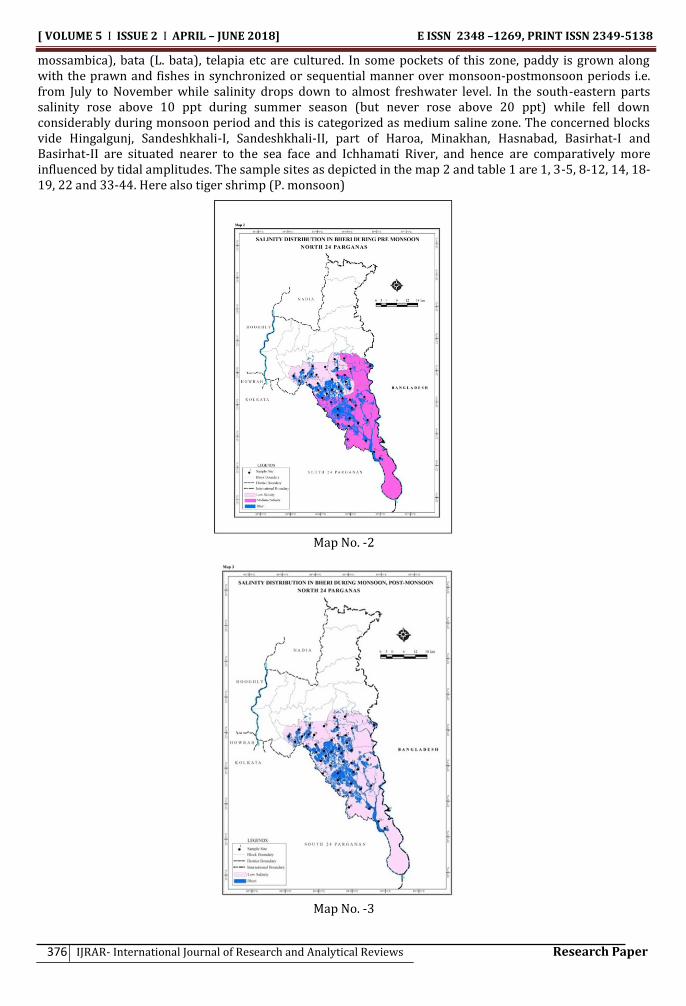
Classification: The salinity-concentrations of bheri-water of 46 sites over the district show that salinity ranges from 1.15 ppt (sample site no. 23, monsoon season) to 16.17 ppt (sample site no. 41, pre-monsoon season). This range of salinity has been classified in following three groups as per Saha et. al., (1986).
i) Low saline bheries: where salinity remains below 10 ppt and ii) Medium saline bheries: where salinity does not generally exceeds 20 ppt iii) High Saline Bheries: where salinity rises above 20 ppt.
Salinity distribution in respect of all the 46 sites based on those three categories has been depicted in the maps 2 and 3 showing locations of bheries as per satellite image. The data of table 1 shows that against sample sites 2, 6-7, 13, 15, 16-17, 20, 21, 23-32, 45 and 46, salinity did not rise above 10 ppt during pre-monsoon period, whereas against sample sites 3-5, 8-12, 14, 18-19, 22 and 33-44 salinity rose above 10 ppt (but remained below 20 ppt). Map 2 shows that the first series of sites are situated in Barasat-II, Deganga, part of Haroa, Minakhan, Hasnabad, Basirhat-I and Basirhat-II blocks and are farthest from the sea face, and hence are less influenced by tidal actions. This is the low saline bheri zone during pre-monsoon. The second series are situated in the blocks Hingalgunj, Sandeshkhali-I, Sandeshkhali-II, part of Haroa, Minakhan, Hasnabad, Basirhat-I and Basirhat-II and are nearer to the sea face and Ichhamati River, and hence are comparatively more influenced by tidal amplitudes. This is designated as medium saline zone during pre-monsoon. During monsoon period salinity fell down substantially against all the 46 sites and salinity did not cross the 10 ppt limit.The entire district fell in low saline zone during monsoon period. The same characteristic is observed during post-monsoon also.
Now, if the three seasons are considered together, the salinity distribution looks like that during pre-monsoon season i.e., like map 2 where north-western track is low saline zone and the south-eastern track is medium saline zone. Within the low saline zone, both fresh and brackish water fishes and prawns are cultivated simultaneously or separately. Here bagda chingri i.e., tiger shrimp (P. monodon) and Parse (L. parsia) are most extensively cultured. Besides these, other prawns like galda chingri (P. indicus), hanne chingri, chhati chingri etc, Indian major carps (L. rohita, C. catla, C. mrigala etc), Indian minor carps (T.
[ VOLUME 5 I ISSUE 2 I APRIL – JUNE 2018] E ISSN 2348 –1269, PRINT ISSN 2349-5138
376 IJRAR- International Journal of Research and Analytical Reviews Research Paper
mossambica), bata (L. bata), telapia etc are cultured. In some pockets of this zone, paddy is grown along with the prawn and fishes in synchronized or sequential manner over monsoon-postmonsoon periods i.e. from July to November while salinity drops down to almost freshwater level. In the south-eastern parts salinity rose above 10 ppt during summer season (but never rose above 20 ppt) while fell down considerably during monsoon period and this is categorized as medium saline zone. The concerned blocks vide Hingalgunj, Sandeshkhali-I, Sandeshkhali-II, part of Haroa, Minakhan, Hasnabad, Basirhat-I and Basirhat-II are situated nearer to the sea face and Ichhamati River, and hence are comparatively more influenced by tidal amplitudes. The sample sites as depicted in the map 2 and table 1 are 1, 3-5, 8-12, 14, 18-19, 22 and 33-44. Here also tiger shrimp (P. monsoon)
Map No. -2
Map No. -3

[VOLUME 5 I ISSUE 2 I APRIL – JUNE 2018] e ISSN 2348 –1269, Print ISSN 2349-5138
http://ijrar.com/ Cosmos Impact Factor 4.236
Research Paper IJRAR- International Journal of Research and Analytical Reviews 377
is the most favourable crop though parse (L. parsia), L. tade, L. calcarifer, Mystus sp., E.tetradactylum etc and other prawns like galda chingri (P. indicus), M. monoceros etc are cultured. Here carps are less cultured. Some bheries located on both sides of the Bidyadhari River after Kulti Lock Gate near Machhibhanga, Haroa, Minakhan, Malancha etc, which fall in this class, are fed with sewages disposed of by Kolkata city. However, no bheri in the district fell under high saline category during the study period.
V. Conclusion Salinity of bheri-water in the district gradually increases from south-east to north-west direction in general, though not uniformly. Weakening of tidal influences to such direction as moving far from the Bay of Bengal is mainly responsible for the same. In both low and medium salinity zones Bagda chingri (P. monodon) is the most costly and hence preferred product irrespective of degree of salinity-concentration, geographical location and season, though other varieties of prawns are reared up. Also various sweet water fishes like Indian major and minor carps, tilapia, bata etc are grown up particularly where salinity is comparatively less. The share of low salinity area is less than that of medium salinity. Of course, the salinity regime in spatio-seasonal perspective is not constant and may vary from year to year. References 1. Biswas C. R. et. al.(1991). Prospects and Retrospects of Paddy-cum-fish Farming in Coastal Low Land Rice Fields. J.
Indian Soc. Coastal Agri. Res. 9(1/2), pp. 93-97. 2. Central Pollution Control Board, Ministry of environment and Forests, Govt of India. COPOCS/31/2005-06, April
2005. Pollution Potential from Coastal Aquaculture. pp. 1, 23. Census of India 2001 3. Ghosh A. (2002). Ecology and Fisheries of Estuarine Wetlands of West Bengal. Central Inland Fishery Research
Institute (CIFRI) Bulletin No. 111. pp. 1-2. 4. Ghosh A. (1990). Culture Prospects of Brackishwater Finfish and Shellfish and Their Economics. In Technologies
for Inland Fisheries Development Ed. by Sugunan, V.V. and Bhowmik, U. Central Inland Fishery Research Institute (CIFRI), Barrackpur and Department of Fisheries, Government of West Bengal.NABARD’s Initiatives, 2007.
5. Saha G. N., et. al.(1986). Ecology and Fishery Management of Brackishwater Bheries in West Bengal. CIFRI Bulletin No. 46. pp.5-6.
6. Sugunan V. V. (2003). Inland Aquatic Resources of India and Their Relevance to Fisheries Development. CIFRI Bulletin No 115, p. 2.
7. Ghosh A., 1990: "Culture Prospects of Brackishwater Finfish and Shellfish and Their Economics " published in the book "Technologies for Inland Fisheries Development” Edited by VV Sugunan and Utpal Bhowmik, Central Inland Fishery Research Institute (CIFRI), Barrackpur and Department of Fisheries, Government of WB.
Your thoughts are the architects of your destiny.
~ David O. McKay

![[ VOLUME 5 I ISSUE 1 I JAN. MARCH 2018] E ISSN …ijrar.com/upload_issue/ijrar_issue_651.pdf · women’s labour force participation rates (Boserup, 1970; Fatima and Sultana, 2009;](https://static.fdocuments.us/doc/165x107/5b7bdd4a7f8b9a004b8d9a78/-volume-5-i-issue-1-i-jan-march-2018-e-issn-ijrarcomuploadissueijrarissue651pdf.jpg)


![[VOLUME 4 ISSUE 4 OCT. DEC 2017] e ISSN 2348 1269, …ijrar.com/upload_issue/ijrar_issue_556.pdf · introduction of Indian philosophies of Vedanta and Yoga to the "Western" World,](https://static.fdocuments.us/doc/165x107/5ab15f187f8b9ad9788c2fcf/volume-4-issue-4-oct-dec-2017-e-issn-2348-1269-ijrarcomuploadissueijrarissue556pdfintroduction.jpg)


![[VOLUME 5 ISSUE 2 APRIL JUNE 2018] e ISSN 2348 …ijrar.com/upload_issue/ijrar_issue_843.pdfaffirmative action by the state towards unequals by providing facilities and opportunities.8](https://static.fdocuments.us/doc/165x107/5b1a4fee7f8b9a19258d89b9/volume-5-issue-2-april-june-2018-e-issn-2348-ijrarcomuploadissueijrarissue843pdfaffirmative.jpg)
![[ VOLUME 5 I ISSUE 3 I JULY SEPT 2018] E ISSN 2348 1269 ...ijrar.com/upload_issue/ijrar_issue_1314.pdf · goes to state that Psorinum and Sulphur helps in treatment of Recurrent URTI.](https://static.fdocuments.us/doc/165x107/5c78fae609d3f2cb498c5a52/-volume-5-i-issue-3-i-july-sept-2018-e-issn-2348-1269-ijrarcomuploadissueijrarissue1314pdf.jpg)
![[ VOLUME 5 I ISSUE 4 I OCT. DEC. 2018] E ISSN 2348 1269 ...ijrar.com/upload_issue/ijrar_issue_20542206.pdf · [volume 5 i issue 4 i oct. – dec. 2018] e issn 2348 –1269, print](https://static.fdocuments.us/doc/165x107/5c6ac7ca09d3f2b2078d2b0c/-volume-5-i-issue-4-i-oct-dec-2018-e-issn-2348-1269-ijrarcomuploadissueijrarissue.jpg)

![[ VOLUME 5 I ISSUE 3 I JULY SEPT 2018] E ISSN 2348 1269 ...ijrar.com/upload_issue/ijrar_issue_1529.pdf · This thesis introduces multiple KDM to handle the data with different access](https://static.fdocuments.us/doc/165x107/5c9d5cc788c99392348c9c06/-volume-5-i-issue-3-i-july-sept-2018-e-issn-2348-1269-ijrarcomuploadissueijrarissue1529pdf.jpg)

![[ VOLUME 5 I ISSUE 2 I APRIL JUNE 2018] E ISSN 2348 1269 ...ijrar.com/upload_issue/ijrar_issue_1057.pdf · main objective of this project. ... The machine named òVELOCITY CONTROLLED](https://static.fdocuments.us/doc/165x107/5b4f28167f8b9a2a6e8badba/-volume-5-i-issue-2-i-april-june-2018-e-issn-2348-1269-ijrarcomuploadissueijrarissue1057pdf.jpg)
![[VOLUME 5 ISSUE 2 APRIL JUNE 2018] e ISSN 2348 1269, …ijrar.com/upload_issue/ijrar_issue_820.pdf · For the best utilization of wind turbines, ... 2 Failure Modes and Effects Analysis](https://static.fdocuments.us/doc/165x107/5b38fce27f8b9a310e8df328/volume-5-issue-2-april-june-2018-e-issn-2348-1269-ijrarcomuploadissueijrarissue820pdf.jpg)
![[VOLUME 4 ISSUE 4 OCT. DEC 2017] e ISSN 2348 1269 ...ijrar.com/upload_issue/ijrar_issue_543.pdfYayati's story begins with his wife, Devayani, the daughter of Shukracharya, the guru](https://static.fdocuments.us/doc/165x107/5af0ef4b7f8b9aa9168e7db0/volume-4-issue-4-oct-dec-2017-e-issn-2348-1269-ijrarcomuploadissueijrarissue543pdfyayatis.jpg)
