SEASIDE: SEAVIEW TO EASTVILLE STATION Northampton … · SEASIDE: SEAVIEW TO EASTVILLE STATION...
5
SEASIDE: SEAVIEW TO EASTVILLE STATION Northampton County Growing Area # 094 Shoreline Sanitary Survey Date: 14 January 2014 Survey Period: December 3, 2013 – December 16, 2013 Total Number of Properties Surveyed: 169 Surveyed By: R.F. Sloan SECTION A: GENERAL This survey area extends from Reference Point 93 at the end of Rt. 690 (extended to the shore) to Reference Point 94 at the end of Rt. 631 (extended to the shore), including the Atlantic Ocean shoreline between these two points, New Inlet, Red Drum Drain, the northern shoreline of South Bay (Shell Creek, New Marsh Channel, and Two Mouths Creek), Mockhorn Channel, (Newhall Channel, Point of Rock Channel, and Narrow Channel), the northern shoreline of Mockhorn Bay (The Thorofare, Newhall Channel Drain, Point of Rock Drain, Narrow Channel Branch, and Mill Creek with Oyster Slip), the south shore of Sand Shoal Channel (Two Mouths Creek, Running Channel, and Man and Boy Channel), Sand Shoal Inlet, Cobb Bay (Loon Channel, Mittigy Channel, Black Perch Creek, S. Creek, Eckichy Channel, and Cockle Point Creek), Ramshorn Channel, Brockenberry Bay (Brockenberry Creek, Spady Creek, and Wilkins Creek), the south shore of Ramshorn Bay (The Thorofare, Thomas Creek, Taylor Creek, Crow Bay, and Cedar Creek), Shallow Bay, Spidercrab Bay, the south shore of Hog Island Bay (Rowes Hole Channel and Second Channel), Great Machipongo Inlet, and all of their tributaries. See map for current boundary. The topography of the area is characterized by an extensive barrier island chain with broad salt water marshes interspersed with a network of bay, streams, and channels. Inland elevations rise from sea level to between 25’ and 38’ at the headwaters of the watershed. Population is sparse in the survey area except for small concentrations around the communities of Oyster and Eastville Station. The economy of the area is based primarily on agriculture and the seafood industry. Meteorological data indicated that 2.63” of rain fell during the survey period. A monthly breakdown follows: December 3-16 2.63” Boating activity has dropped from five facilities to four facilities due to the closing of some seafood processing plants in Oyster. Industrial wastes have decreased from seven to five sources and solid waste dumpsites have decreased slightly from three to one source. Animal pollution sources have increased from one to two sources. Current condemnation notices and maps are available via the internet at www.vdh.virginia.gov/shellfish/ .
Transcript of SEASIDE: SEAVIEW TO EASTVILLE STATION Northampton … · SEASIDE: SEAVIEW TO EASTVILLE STATION...
SEASIDE: SEAVIEW TO EASTVILLE STATION Northampton County Growing Area # 094
Shoreline Sanitary Survey Date: 14 January 2014 Survey Period: December 3, 2013 – December 16, 2013 Total Number of Properties Surveyed: 169 Surveyed By: R.F. Sloan
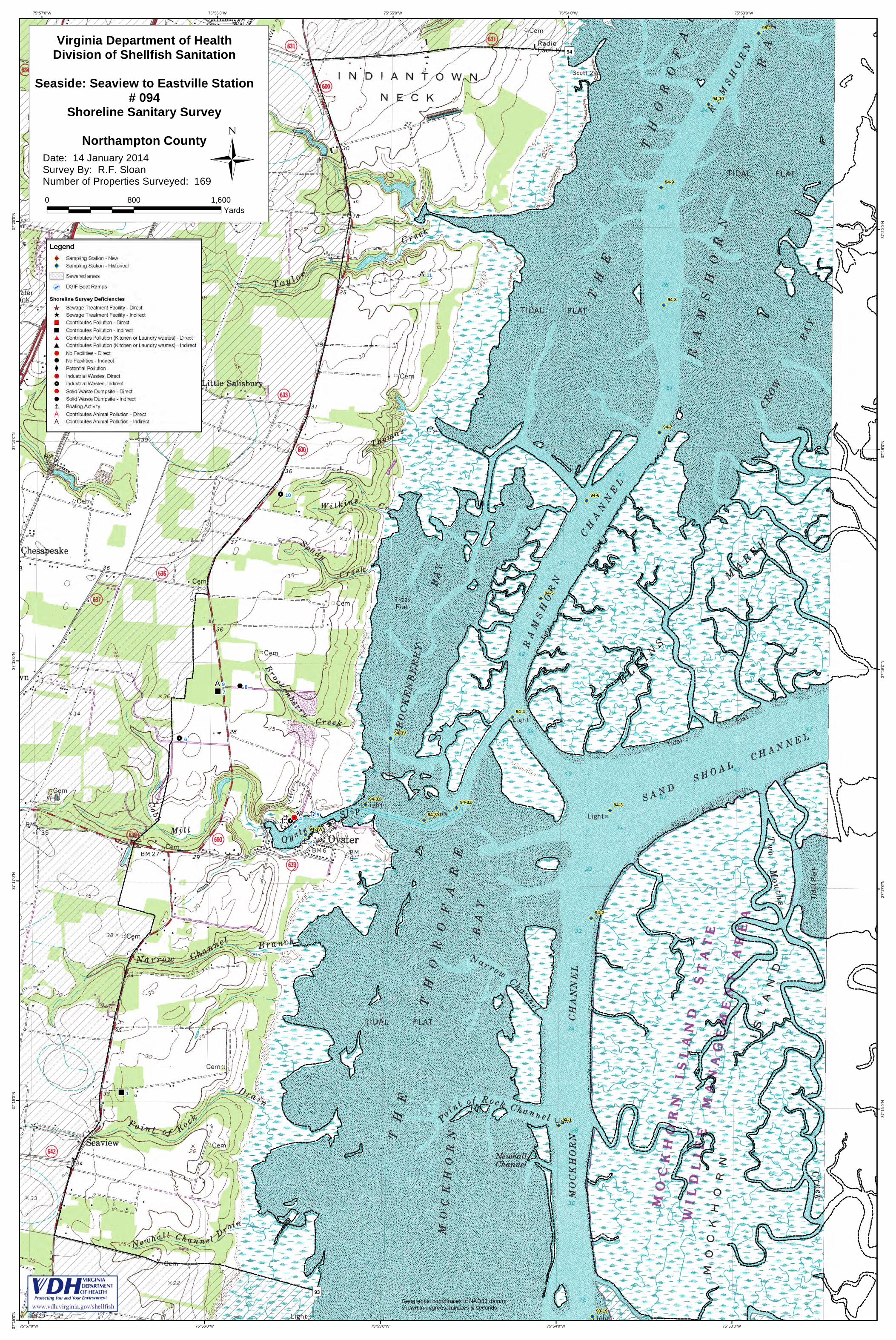
SECTION A: GENERAL This survey area extends from Reference Point 93 at the end of Rt. 690 (extended to the shore) to Reference Point 94 at the end of Rt. 631 (extended to the shore), including the Atlantic Ocean shoreline between these two points, New Inlet, Red Drum Drain, the northern shoreline of South Bay (Shell Creek, New Marsh Channel, and Two Mouths Creek), Mockhorn Channel, (Newhall Channel, Point of Rock Channel, and Narrow Channel), the northern shoreline of Mockhorn Bay (The Thorofare, Newhall Channel Drain, Point of Rock Drain, Narrow Channel Branch, and Mill Creek with Oyster Slip), the south shore of Sand Shoal Channel (Two Mouths Creek, Running Channel, and Man and Boy Channel), Sand Shoal Inlet, Cobb Bay (Loon Channel, Mittigy Channel, Black Perch Creek, S. Creek, Eckichy Channel, and Cockle Point Creek), Ramshorn Channel, Brockenberry Bay (Brockenberry Creek, Spady Creek, and Wilkins Creek), the south shore of Ramshorn Bay (The Thorofare, Thomas Creek, Taylor Creek, Crow Bay, and Cedar Creek), Shallow Bay, Spidercrab Bay, the south shore of Hog Island Bay (Rowes Hole Channel and Second Channel), Great Machipongo Inlet, and all of their tributaries. See map for current boundary. The topography of the area is characterized by an extensive barrier island chain with broad salt water marshes interspersed with a network of bay, streams, and channels. Inland elevations rise from sea level to between 25’ and 38’ at the headwaters of the watershed. Population is sparse in the survey area except for small concentrations around the communities of Oyster and Eastville Station. The economy of the area is based primarily on agriculture and the seafood industry. Meteorological data indicated that 2.63” of rain fell during the survey period. A monthly breakdown follows: December 3-16 2.63” Boating activity has dropped from five facilities to four facilities due to the closing of some seafood processing plants in Oyster. Industrial wastes have decreased from seven to five sources and solid waste dumpsites have decreased slightly from three to one source. Animal pollution sources have increased from one to two sources. Current condemnation notices and maps are available via the internet at www.vdh.virginia.gov/shellfish/.

Shoreline Survey #094 Page 2
This report lists only those properties which have a sanitary deficiency or have other environmental significance. “DIRECT” indicates that the significant activity or deficiency has a direct impact on shellfish waters. Individual field forms with full information on properties listed in this report are on file in the Richmond Office of the Division of Shellfish Sanitation and are available for reference until superseded by a subsequent resurvey of the area. Data in the report is also made available to local health departments and other agencies to address items that may be out of compliance with their regulatory programs.
SECTION B: SEWAGE POLLUTION SOURCES
SEWAGE TREATMENT FACILITIES -None-
ON-SITE SEWAGE DEFICIENCES
1. CONTRIBUTES POLLUTION – 5430 Copes Lane, Cape Charles 23310. Dwelling –
cream vinyl siding doublewide house trailer with white trim. No contact. Septic tank lid appeared to be damaged and covered with plywood. Sanitary Notice issued 12-20-13 to Field # 11.
7. CONTRIBUTES POLLUTION – 20372 Seaside Road, Cheriton 23316. Dwelling – gold
and white house trailer. No contact. 2 inch PVC pipe extended from under the trailer to the front yard. Sanitary Notice issued 12-20-13 to Field # 138.
POTENTIAL POLLUTION
-None-
SECTION C: NONSEWAGE WASTE SITES
INDUSTRIAL WASTES 3. Anheuser-Busch Coastal Research Center, 6364 Cliff’s Road, Cheriton 23316. Located
on property was one 500 gallon above ground fuel tank without a berm. 4. DIRECT – R&C Seafood, 6396 Cliff’s Road, Cheriton 23316. Owner: Charles Churn &
J.J. Restein, III, P.O. Box 476, Eastville 23347. Business – shellfish processing plant. 4 employees. Processing and washdown wastes from floor drains discharge to Oyster Harbor. Has VPDES Permit # VAG523008 from the Department of Environmental Quality.
6. 21024 Seaside Road, Cheriton 23116. Agriculture- farm buildings include a large
aluminum workshop, and white office trailer. No contact. Located on property were five 1000 gallon above ground diesel fuel tanks and one 500 gallon fuel tank without berms.
10. C & E Farms, 19319 Seaside Road, Cheriton 23316. Agriculture – large cream
aluminum packing house. 2 persons. Green beans are washed and hydro cooled before packing. Waste water discharge in Unknown.
Shoreline Survey #094 Page 3
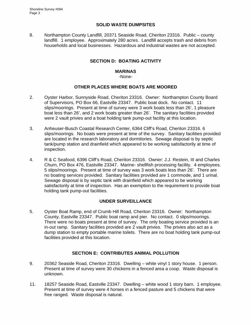
SOLID WASTE DUMPSITES 8. Northampton County Landfill, 20371 Seaside Road, Cheriton 23316. Public – county
landfill. 1 employee. Approximately 280 acres. Landfill accepts trash and debris from households and local businesses. Hazardous and industrial wastes are not accepted.
SECTION D: BOATING ACTIVITY
MARINAS -None-
OTHER PLACES WHERE BOATS ARE MOORED
2. Oyster Harbor, Sunnyside Road, Cheriton 23316. Owner: Northampton County Board
of Supervisors, PO Box 66, Eastville 23347. Public boat dock. No contact. 11 slips/moorings. Present at time of survey were 3 work boats less than 26’, 1 pleasure boat less than 26’, and 2 work boats greater than 26’. The sanitary facilities provided were 2 vault privies and a boat holding tank pump-out facility at this location.
3. Anheuser-Busch Coastal Research Center, 6364 Cliff’s Road, Cheriton 23316. 6
slips/moorings. No boats were present at time of the survey. Sanitary facilities provided are located in the research laboratory and dormitories. Sewage disposal is by septic tank/pump station and drainfield which appeared to be working satisfactorily at time of inspection.
4. R & C Seafood, 6396 Cliff’s Road, Cheriton 23316. Owner: J.J. Restein, III and Charles
Churn, PO Box 476, Eastville 23347. Marine- shellfish processing facility. 4 employees. 5 slips/moorings. Present at time of survey was 3 work boats less than 26’. There are no boating services provided. Sanitary facilities provided are 1 commode, and 1 urinal. Sewage disposal is by septic tank with drainfield which appeared to be working satisfactorily at time of inspection. Has an exemption to the requirement to provide boat holding tank pump-out facilities.
UNDER SURVEILLANCE
5. Oyster Boat Ramp, end of Crumb Hill Road, Cheriton 23316. Owner: Northampton
County, Eastville 23347. Public boat ramp and pier. No contact. 0 slips/moorings. There were no boats present at time of survey. The only boating service provided is an in-out ramp. Sanitary facilities provided are 2 vault privies. The privies also act as a dump station to empty portable marine toilets. There are no boat holding tank pump-out facilities provided at this location.
SECTION E: CONTRIBUTES ANIMAL POLLUTION 9. 20362 Seaside Road, Cheriton 23316. Dwelling – white vinyl 1 story house. 1 person.
Present at time of survey were 30 chickens in a fenced area a coop. Waste disposal is unknown.
11. 18257 Seaside Road, Eastville 23347. Dwelling – white wood 1 story barn. 1 employee.
Present at time of survey were 4 horses in a fenced pasture and 5 chickens that were free ranged. Waste disposal is natural.

Shoreline Survey #094 Page 4
SUMMARY
Growing Area # 094 Seaside: Seaview to Eastville Station 14 January 2014 SECTION B: SEWAGE POLLUTION SOURCES 1. SEWAGE TREATMENT FACILITIES 0 – DIRECT – None 0 – INDIRECT – None 0 – B.1. TOTAL 2. ON-SITE SEWAGE DEFICIENCIES – Correction of deficiencies in this section is the
responsibility of the local health department. 0 – CONTRIBUTES POLLUTION, DIRECT – None 2 – CONTRIBUTES POLLUTION, INDIRECT – #1, 7 0 – CP (Kitchen or Laundry Wastes), DIRECT – None 0 – CP (Kitchen or Laundry Wastes), INDIRECT – None 0 – NO FACILITES, DIRECT – None 0 – NO FACILITES, INDIRECT – None 2 – B.2. TOTAL 3. POTENTIAL POLLUTION – Periodic surveillance of these properties will be maintained to
determine any status change. 0 – POTENTIAL POLLUTION – None SECTION C: NON-SEWAGE WASTE SITES 1. INDUSTRIAL WASTE SITES 1 – DIRECT – # 4 3 – INDIRECT – # 3, 6, 10 4 – C.1. TOTAL 2. SOLID WASTE DUMPSITES 0 – DIRECT – None 1 – INDIRECT – # 8 1 – C.2. TOTAL SECTION D: BOATING ACTIVITY 0 – MARINAS – None 3 – OTHER PLACES WHERE BOATS ARE MOORED – # 2, 3, 4 1 – UNDER SURVEILLANCE - # 5 4 – D. TOTAL SECTION E: CONTRIBUTES ANIMAL POLLUTION 0 – DIRECT – None 2 – INDIRECT – # 9, 11 2 – E. TOTAL
[dÎÎ
"
Î
!.!.
Î
!.
"%A
!.
A
!A
!A
!A
!A
!A
!A
!A
!A
!A
!A
!A
!A
!A
!A
!A
!A
!A
!A
!A
!A!A
!A
!A
")
")
")
")
")
")
")
")
9 87
6
543
2
1
11
10
94-9
94-8
94-7
94-6
94-5
94-4
94-3
94-2
94-1
95-1
93-19
94-3W
94-3X
94-3Y
94-3Z
94-10
94-3V
94
93
75°53'0"W
75°53'0"W
75°54'0"W
75°54'0"W
75°55'0"W
75°55'0"W
75°56'0"W
75°56'0"W
75°57'0"W
75°57'0"W37
°20'
0"N
37°2
0'0"
N
37°1
9'0"
N
37°1
9'0"
N
37°1
8'0"
N
37°1
8'0"
N
37°1
7'0"
N
37°1
7'0"
N
37°1
6'0"
N
37°1
6'0"
N
37°1
5'0"
N
Date: 14 January 2014Survey By: R.F. SloanNumber of Properties Surveyed: 169
Virginia Department of HealthDivision of Shellfish Sanitation
Seaside: Seaview to Eastville Station# 094
Shoreline Sanitary SurveyNorthampton County
0 800 1,600
Yards
Geographic coordinates in NAD83 datum;shown in degrees, minutes & seconds.